Embed Size (px)
Citation preview
MINERALOGICAL SOCIETY OF AMERICA, SPECIAL PAPER 1, 1963
INTERNATIONALMINERALOGICALASSOCIATION,PAPERS, THIRD GENERAL MEETING
THE MUSKOX INTRUSION, A RECENTLY DISCOVERED LAYERED INTRUSION IN THECOPPERMINE RIVER AREA, NORTHWEST TERRITORIES, CANADAl
CHARLES H. SMITH AND H. E. KAPP
Geological Survey of Canada, Ottawa, Ontario, Canada
ABSTRACT
The Muskox intrusion is a Precambrian layered basic pluton, 74 miles in length, which is dike-like in plan and funnel-shaped in cross-section. Its internal structure is divided into four principal units-a feeder, marginal zones, a central lay-ered series and an upper border group. The feeder contains bronzite gabbro and picrite in zones parallel to the nearlyvertical walls. The marginal zones parallel the walls of the intrusion which dip inward at angles of 23 to 57°, and grade in-ward from bronzite gabbro at the contact through picrite and feldspathic peridotite, to peridotite and, in places, dunite. Thecentral layered series is 8500 feet thick and contains 38 main layers of dunite, peridotite, pyroxenites and gabbros whichvary in thickness from 10 to 1800 feet. These layers are nearly flat-lying and discordant to the marginal zones. The upperborder group is 200 feet thick and is characterized by an upward gradation from granophyre-bearing gabbro to granophyre.Preliminary calculations indicate that the Muskox intrusion has a higher olivine content than would normally be expectedfrom a magma chemically similar to its chill facies and it is concluded that the chill phase only represents the fluid portion
of the solid (olivine)-fluid magma.
INTRODUCTION
The Muskox Intrusion is a new addition to thegrowing family of layered intrusions. It has certainunique features which distinguish it from otherlayered intrusions such as the presence of a feeder,and the fact that its base, walls and roof are all ex-posed. This paper will deal with only one aspect ofthe intrusion-the apparent difference between thebulk composition of the intrusion and its chill phase.The intrusion is under study as part of the Canadianprogram for the International Upper Mantle Proj-ect and aeromagnetic, gravity and drilling programsare planned in addition to the detailed petrologic,mineralogical and chemical studies.
LOCATION AND PREVIOUS WORK
The Muskox Intrusion outcrops in the north-western corner of the Canadian Shield (Fig. 1). Itcrosses the Arctic Circle at a point about 90 mileseast of Port Radium on Great Bear Lake.
The intrusion was discovered by H. Vuori of theCanadian Nickel Company in 1956, and was mappedby Smith in 1959, assisted by Kapp in 1960, on ascale of 1 inch to 1000 feet. The mapping data issummarized on five sheets published at a scale of 1inch to t mile (Smith, 1962). The regional geologywas mapped by a helicopter-supported geologicalsurvey led by J. A. Fraser (1960) in 1959, and anaeromagnetic survey was completed by the Geo-logical Survey in 1961.
1 Canadian Contribution to the International Upper MantleProject No.5. Published by permission of the Director, Geological
Survey of Canada.
REGIONAL GEOLOGY
The Muskox Intrusion outcrops in a basementcomplex of steeply dipping gneiss and metasedi-mentary rocks having a dominant north-northweststructural grain. The basement is cut by granodioritewhich has a K/ Ar age on biotite of 1765 m.y.
The basement is overlain unconformably by asequence of sandstone, dolomite and basaltic flowswhich dip gently to the north, where they form acover over the older basement. All the rocks of thearea are cut by north-northwest-trending diabasedikes.
The Muskox Intrusion follows the grain of thebasement rocks, but at the unconformity it hasspread out to develop its funnel-shaped cross-section.The roof has barely penetrated the sandstone mem-ber of the cover, fragments of which are included inthe granophyre of the upper border group. TheMuskox Intrusion is dated, from biotite in picriteof the marginal zone, at 1155 m.y.
STRUCTURAL FORM
External form. The Muskox Intrusion is 74 mileslong, is dike-like in plan and funnel-shaped in cross-section. Its structural form is analogous to that of asailing ship with a deep keel, plunging at an angle ofless than 5° toward the north. The southern half(Fig. 2), which outcrops for 37 miles, represents thedeep keel or feeder extension, exposed at the sur-face. The northern half represents the hull, and theextreme north the deck or roof, plunging under thecover rocks.
The symmetry of the intrusion in plan is broken
30

THE MUSKOX INTRUSION
.....,
.:r, :
CORDILLERANREGION
ULTRAMAFIC ROCKSIN CANADA
31
SCALE OF MILESo 300 600
---..J
FIG. 1. Index map, showing location of the Muskox Intrusion.
by a northerly-trending fault which cuts the westernside of the intrusion. The fault has a horizontal dis-placement of 5 miles. When the displacement alongthe fault is restored (in Fig. 2, A' moves to A, andB' moves to B) the intrusion is seen to be symmetri-cal in plan with two northward projecting limbsformed as its syncline-shaped roof plunges under thecover rocks.
The feeder of the in trusion is dike-like and verti-cally dipping, similar in attitude to the satellitediabase dikes. It is 500 to 1800 feet wide, somewhatwider than the diabase dikes which have an averagewidth of about 100 feet. The northern half of theintrusion has inward-dipping sides, whose dips havebeen calculated from drill holes and are summarizedin Fig. 2. They vary from 58° on the south to 220at the extreme northeast end.
Internal units. The internal structure of the intrusionis divided into four principal units-the feeder, themarginal zones, the central layered series and theupper border group.
Thefeeder is distinctive in having units of bronzitegabbro and picrite parallel to the nearly verticalwalls. The southern end of the feeder is filled withgabbro but, as it is traced northward, picrite occursfirst as pods and then as a continuous band along thecenter. On approaching the Coppermine River, twobands of picrite are found, bounded on both sides bygabbro. The latter is chilled against the countryrocks, but not against the picrite. The picrite doesnot appear to represent a separate intrusion, but asegrega tion in the center of the feeder.
The marginal zones parallel the inward dippingwalls of the intrusion and are from 200 to 1200 feetthick. They grade inward from hypersthene gabbroat the contact through picrite and feldspathic perido-tite, to peridotite and, in places, dunite. In otherwords, the marginal zones are gradational zones inwhich plagioclase decreases, and olivine increases,inward. Accompanying this change in mineral abun-dance is a change in mineral composition, with olivinebecoming more magnesian, and plagioclase becom-ing more calcic, inward. Nickel-copper sulfides and

32
NORTH HALF
N
tC. H. SMITH AND H. E. KAPP
SOUTH HALF
o 5 10
N
tUPPER BORDER GROUPJ<Iil GRANOPHYRIC BEARING~ GABBRO TO GRANOPHYRE
CENTRAL LAYERED SERIES§ GABBRO•PYROXENITE
OLIVINE -RICH PHASES
MARGINAL SERIESrn PERIDOTITE TO NORITE
FEEDERW PICRITE TO NORITE
DIP OF INTRUSIVECONTACT .
MILES
... )"'25
G 5 C
FIG. 2. Structural units of the Muskox Intrusion.
pyrrhotite occur sporadically along the wall of theintrusion.
The central layered series is approximately 8500feet thick. It has 38 main layers, varying in thick-ness from 10-1850 feet. Small scale layering is pres-ent, but uncommon. The series contains alternatinglayers of dunite (serpentinized), peridotite, Ield-spathic peridotite, picrite, olivine clinopyroxenite,websterite, orthopyroxenite, troctolite, olivine gab-bro, gabbro, norite and anorthositic gabbro. Thelayers have sharply defined contacts, in contrastto those of the marginal zones. They dip gently tothe north at a similar angle to the overlying coverrocks and are thus discordant to the marginal zones.Chromite occurs in one pyroxenite horizon and con-tains disseminated copper-nickel sulfides and plati-num group metals.
The upper border group is arbitrarily defined bythe appearance of granophyric intergrowths and
quartz in the upper gabbro units. The rock unitsare not sharply defined but grade upward, within athickness of 200 feet, from granophyre-bearinggabbro to mafic granophyre, granophyre and intru-sive breccia. In a mineralogical sense, the upper bor-der group is a zone in which granophyric inter-growths and quartz increase upward at the expenseof mafic minerals.
SOME QUANTITATIVE CONSIDERATIONS
OF THE MUSKOX MAGMA
It is possible to construct a fairly accurate com-posi te cross-section of the Muskox Intrusion. Theextension of the feeder is exposed, the inward dipsof the walls are known, the roof is exposed, the thick-ness of many of the layered units can be measureddirectly in the field, and the plunge of the intrusioncan be determined both by calculating the plunge of

THE MUSKOX INTRUSION
GSC
FIG. 3. Typical cross-section of the Muskox Intrusion.
the intersection of the walls and by measuring thedip of layers in the field.
Cross-sections of the form shown in Fig. 3 havebeen prepared on a scale of 1 inch to 1000 feet, andthe relative cross-sectional area of each map-unitdetermined. Only the eastern half of the cross-sectionhas been used in the volume calculations, since thewestern side is faulted. The symmetry of the in-trusion in plan and the similar inward dip of theopposite margins indicate that this assumption isvalid.
Figure 3 shows the disposition of the layered se-ries in rela tion to the margins of the in trusion. Noticehow the layers approach, but do not reach, the mar-gins of the intrusion, and are discordant in a tti tudeto the margins. From a cross-section of this type thecomposition of the Muskox magma was calculated,and the approximate proportion of rock types is:
Ultramific rocks (including dunite, peridotite,pyroxenites and picrite)
Gabbro
TABLE I. CHEMICAL COMPOSITION OF MUSKOX CHILL PHASE
COMPAREDTO OTHER LAYERED INTRUSIONS
Bushveld! Stillwater' Skaergaard 3 Muskox'----- ---_ -----SiO, 51.45 50.68 47.97 50.68A]'03 18.67 17.64 18.32 13.55Fe,03 0.28 0.26 1.23 1.17FeO 9.04 9.88 8.58 9.08MgO 6.84 7.67 8.09 9.70CaO 10.95 10.47 10.77 11.22Na,O 1.58 1.87 2.42 1. 79K,O 0.14 0.24 0.21 0.63H,O+ 0.34 0.42 0.61 0.53H,O- 0.03 0.06 0.09 0.06P,05 0.09 0.09 0.08 0.10TiO, 0.34 0.45 1.32 1.06MnO 0.47 0.15 0.12 0.18-_ -- -- --
100.22 99.88 99.81 99.75
MgO-- 0.76 0.78 0.94 1.07FeO
GranophyreRock fragments
approx.75%approx.15%approx. 8%approx, 2%
1 Daly, 1928, quoted by Hess, 1960, p. 152.2 Hess, 1960, p. 152.3 Wager, 1960, p. 375.
• Average of 2 analyses by S. Courville, Geological Survey ofCanada.
This calculation, although approximate, indicatesthe extremely ultramafic composition of the Muskoxmagma.
33
34 C. H. SMITH AND H. E. KAPP
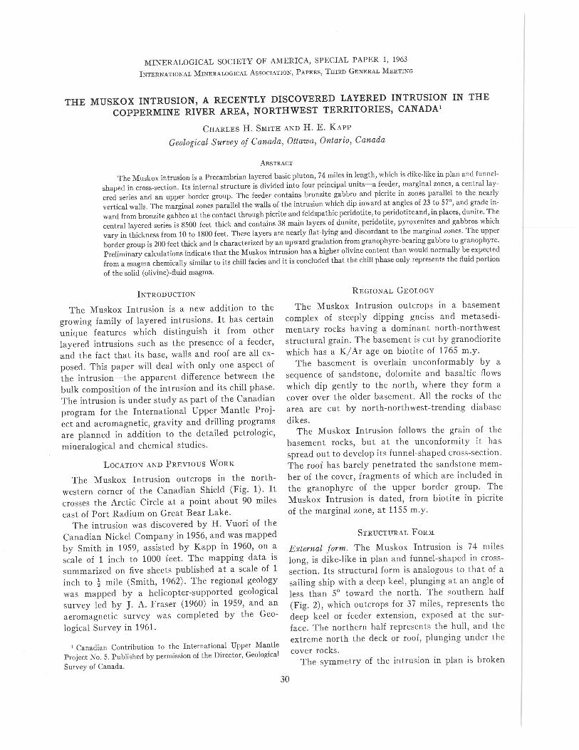
OLIVINE COMPOSITION IN MUSKOX INTRUSION
.: ..........,~ .
<,~
<,<,
<,<,
'\IIIII·
I j;'I ;,I 'I t II .', I
l·l'I II
I ~II~II~I1'1I
_....../
[SJ 80-85 % FORSTERITE
b§3 75-80 % "• 70-75 % II
.60-70% II
SAMPLE LOCATION ..
SCALE0 'Il I MILE
GSC
FIG. 4. Olivine variations in the Muskox Intrusion.
Similar calculations can be made of the mineralabundance in the intrusion based upon the cross-sectional areas of rock units and their modal analyses.These calculations indicate that the olivine content ofthe intrusion is of the order of 58%.
In order to learn whether the cryptic variationsamong mineral phases indicated significant discon-tinuities in the layered sequence that might be con-sidered evidence for multiple intrusion, studies ofolivine compositions are underway. The results todate indicate the simple overall pattern shown inFig. 4. Olivine with a forsterite composition over80% occurs in the core of the intrusion, throughoutmost of the layered series. Within individual layersin the layered series the variation in olivine composi-tion is small, less than 2-3%. Olivines between 70-
80% forsterite occur toward the top, sides, and intothe feeder. Olivines with a composition of less than70% forsterite are restricted to the roof and themargins of the intrusion. The symmetry of this pat-tern suggests that the greater abundance of ultra-mafic rocks in the intrusion is not related to succes-sive injections of unrelated magmas but that theyformed during a single cooling process.
Table I shows the composition of the Muskoxchill phase compared with the chill phases of otherlayered intrusions. The Muskox chill is slightlymore mafic than that of the other intrusions, butnot sufficiently to account for the high olivine con-tent calculated for the intrusion itself.
The conclusion to be drawn from the Muskoxstructural data is that the chill phase is not repre-

THE MUSKOX INTRUSION
sentative of the bulk composition of the intrusion.Various explanations could be used to try to explainaway the difference between the chill phase and bulkcomposition.
Hess (1960, p. 166) has commented on the absenceof a thick zone of feldspa thic rocks in the GreatDike to compensate for the thick ultramafic portionand assumes the feldspathic component had a widelateral extent. This explanation cannot apply to theMuskox in trusion, for the lateral extent is limitedby the exposed walls. One might assume the feld-spathic phase changes in abundance along the longaxis, either up-dip where it has been eroded away ordown-dip where it can only be found by drilling.This explanation does not seem probable.
The interpretation that the chill phase representsthe composition of an intrusion is a basic assumptionin any quantitative study of layered intrusions. Inmost instances it is not possible to assume otherwise,since intrusions are generally not well exposed even
REFERENCESFRASER, J. A. (1960) North-central District of MacKenzie,
Northwest Territories. Geol.Surv. Canada, Map 18-1960.HESS, H. H. (1960) Stillwater igneous complex, Montana. Geol,
Soc. Am. Mem. 80.JAMBOR, J. L. ANDCHARLES H. SMITH (1963) Accurate determina-
tion of olivine composition using standard small diameter x-raypowder cameras. Mineral. Mag. (in press).
35
in two dimensions. The Muskox Intrusion is com-pletely exposed in two dimensions, that is its base,sides and top are exposed, and here the imbalancebetween intrusion composition and chill phase isseen. The explanation may depend on the propertiesof solid-liquid mixtures, during the intrusion of whichthe liquid portion lubricates the margins and formsthe chill phase while the solids (olivine crystals) arerelatively concentrated away from the walls andthus are not frozen into the chilled sample. Suchsegregation is known to take place during the trans-port of solid-fluid mixtures in pipe lines. At anyrate it is apparent that the relation of chill phasesto bulk magma composition requires critical reviewbefore being used as a basis for interpreting the geo-chemistry and cooling history of layered intrusions.This is a field of petrologic research which will haveto be evaluated by laboratory studies on intrusionmechanics.
SMITH, C. H. (1962) Notes on the Muskox Intrusion, CoppermineRiver area, District of MacKenzie. Geol, Surv. Canada, Paper61-25.
WAGER, L. R. (1960) The major element variation of the Skaer-gaard Intrusion and a re-estimation of average composition ofthe hidden layered series and of the successive residual magmas.Jour. Petrol. 1,364-398.


![[Type text] Doing Research in the Northwest Territories Scientific Training Program (NSTP) ... Doing Research in the Northwest Territories. Doing Research in the Northwest Territories](https://img.dokumen.tips/doc/110x75/5add27847f8b9a213e8c7cb5/type-text-doing-research-in-the-northwest-scientific-training-program-nstp-.jpg)