Embed Size (px)
Citation preview

Coordinated Determination of National Register Eligibility—Revised March 31, 2004 1
COORDINATED DETERMINATION OF NATIONAL REGISTER ELIGIBILITY—WORLD TRADE CENTER SITE NEW YORK CITY, NEW YORK, MARCH 31, 2004
I. INTRODUCTION This document has been prepared pursuant to Section 106 of the National Historic Preservation Act in association with proposed reconstruction and redevelopment in the area of the approximately 16-acre World Trade Center superblock (WTC Site), bounded generally by Vesey Street on the north, Liberty Street on the south, Route 9A/West Street on the west and Church Street on the east.
The Federal Transit Administration (FTA), Federal Highway Administration (FHWA), and Lower Manhattan Development Corporation (LMDC), as a recipient of funds from U.S. Department of Housing and Urban Development (HUD), are coordinating the Section 106 processes for several proposed undertakings on or adjacent to the WTC Site: Permanent World Trade Center PATH Terminal (FTA with the Port Authority of New York and New Jersey [Port Authority]), World Trade Center Memorial and Redevelopment Plan (LMDC with HUD funding), and Route 9A Reconstruction (FHWA with New York State Department of Transportation [NYSDOT]). The substance of this document will be incorporated by each of the agencies into their respective environmental review documents.
Section 106 requires federal agencies to identify historic properties (e.g. buildings, structures, sites, objects and districts listed in or eligible for inclusion in the National Register of Historic Places) that may be affected by a proposed undertaking. This document focuses on the WTC Site.
Each of these undertakings is subject to environmental review under the National Environmental Policy Act (NEPA) and to review under Section 106. Environmental impact statements are being prepared for each of these independent undertakings. Because each of the undertakings is different and may have different effects, different Areas of Potential Effect (APEs) have been or will be defined for each undertaking. Identification of historic properties elsewhere in the various projects’ APEs and the analysis of potential effects on those properties are being conducted separately.
This document includes information gathered in the NEPA scoping processes for the projects and in meetings with the consulting parties held in the offices of the LMDC at One Liberty Plaza, New York, New York, on January 6, 2004, and on February 2, 2004, as well as written comments received by the coordinating agencies through March 8, 2004.
This document is not intended to be an exhaustive history of the development of Lower Manhattan, the WTC, the events that lead up to September 11, 2001, the horrific events of September 11, or the rescue and recovery operations in the wake of those events. There is substantial and ongoing documentation of those events elsewhere in the numerous articles, books, films, and television reports and productions. This document is intended to express why the coordinating agencies have made a determination that the WTC Site is eligible for listing on the National Register of Historic Places. Each agency’s environmental review document will include information relating to its specific project site and additional historical information relating to each project.
The coordinating agencies recognize however, that the WTC Site has been substantially altered since the attacks and collapses on September 11 and include an Appendix relating to artifacts removed from the WTC Site and a discussion regarding the current state of the WTC Site.

Coordinated Determination of National Register Eligibility—Revised March 31, 2004 2
II. HISTORICAL INFORMATION
A. BACKGROUND
Prior to European contact in the early 17th century, Native Americans speaking a Munsee dialect of the Eastern Algonquin language inhabited Manhattan Island. Native Americans referred to the island of Manhattan as “Minna-atn” which meant “Island of Hills.” The first contacts between Native Americans and Europeans occurred when early explorers began to trade with the native population. Dutch trading expeditions had been visiting the Hudson River for many years prior to the founding of New Amsterdam at the southern tip of Manhattan in 1626. These groups made contact with the native population; Robert Juet, who traveled with Henry Hudson on his 1609 voyage, provides in his journal a description of the native population and their trading practices. Dutch colonization in Manhattan began in earnest in 1625 when an expedition of farmers from the Dutch West India Company arrived at the southern tip of Manhattan with the purpose of building a fort and laying out nine Company farms.
Wall Street was once the northern line of land fortification for the settlement and Pearl Street, to the east of the WTC Site, formed the eastern edge of the island. The Hudson River waterfront ran along the approximate location of Greenwich Street today. Because it was a high bluff, shipping and piers were located along the East River. Blocks were largely formed in an irregular pattern as former farms were developed, giving the area its characteristically winding and narrow system of streets. By the end of the 18th century, the island’s shoreline had been extended with new land created on fill. The city’s waterfront, particularly around the southern portion of the island, was its important trade and business area. Residential areas, concentrated both inland and farther north including Tribeca, were located away from the commercial and industrial uses.
Tribeca is a neighborhood in Lower Manhattan, generally bounded by Canal Street to the north, Broadway to the east, Barclay Street to the south and the Hudson River to the west. The area’s name was adopted by real-estate developers in the mid-1970s and stands for “triangle below Canal.” Originally farmland, Tribeca was transformed into a residential neighborhood in the early 1800s, including an enclave of stately brick residences surrounding St. John’s Park (subsequently redeveloped with a freight depot and now the site of St. John’s Rotary and the exit of the Holland Tunnel) on Hudson Street. Bear Market, a fruit and produce market (which became known as Washington Market), opened at the western end of the neighborhood in 1813, and became one of the city’s key food suppliers. It came to occupy a full block along Washington Street between Fulton, Vesey, and West Streets, now part of the WTC Site. However, the neighborhood remained primarily residential until the 1840s, when shipping and commerce in Lower Manhattan intensified, attracting business and making the area a major point of transfer. By the 1860s, the area had become a commercial district as the city’s commercial core stretched north. The western portion, containing the Washington Market district, became New York’s wholesale food center, covering roughly the western half of what is Tribeca today. In 1872, the New York Mercantile Exchange, known first as the Butter and Cheese Exchange of New York, was founded by dairy merchants seeking to standardize the wholesale business. Booming business necessitated the construction of a new structure for the Exchange at the corner of Hudson and Harrison Streets in 1882; the Exchange occupied this location until its move to a larger space in the WTC in 1977 and then again to Battery Park City (BPC). During the 1880s, new warehouses were built to house mercantile exchanges dealing in butter, cheese, and eggs. At the time of construction of the 1884 Washington Market building, a time capsule containing business cards and a note in remembrance of the construction of the market signed by 32 businessmen was buried; this was discovered at the excavation for the WTC. The eastern portion of Tribeca became a central transfer point for textiles and dry goods by the middle of the century, with new stores, factories, and storage houses built to house those uses.
The development of Lower Manhattan as a shipping and mercantile district continued through the late 19th century. At the same time, banks, investment companies, and brokerage firms built corporate offices in Lower Manhattan to be near the trading activity of the New York Stock Exchange (NYSE) and other

Coordinated Determination of National Register Eligibility—Revised March 31, 2004 3
financial and trading institutions, creating what is known to this day as New York City’s Financial District. Construction of the Brooklyn Bridge was completed in 1883 to link the cities of Brooklyn and New York and to serve a growing Brooklyn population which until then could only travel to Manhattan by ferry. In addition, the bridge opened up trade routes to Brooklyn, Queens, and the remainder of Long Island, which were primarily farmland. At the turn of the century, tall towers began to appear on the Lower Manhattan skyline. In 1898, 15 Park Row became the world’s tallest office tower. Subsequently, other large buildings were erected during the first half of the 20th century—among them the Equitable Building, the Woolworth Building, 70 Pine Street, and 40 Wall Street.
During the first half of the 20th century, Tribeca, including the Washington Market, remained a vital commercial district. However, in the 1950s and 1960s, the Tribeca area underwent yet another transformation. Shifts in market and economic trends resulted in the moving away and/or closure of wholesale business, leaving the many warehouses in the area empty. In the 1960s, the city established the Washington Street Urban Renewal Area (WSURA), which transformed Tribeca and adjacent neighborhoods from failing wholesale and industrial uses to new residential and office uses with schools to serve the new community. Artists were the first to make use of the available spacious and lit buildings, with many factories and warehouses converted to residential lofts. Today Tribeca is a fashionable residential district that includes art galleries, upscale shops, and restaurants.
B. THE WORLD TRADE CENTER
The WTC was originally conceived in the early 1960s by the Downtown-Lower Manhattan Development Association. Chase Manhattan Bank chairman David Rockefeller, founder of the development association, and his brother, New York governor Nelson Rockefeller, pushed hard for the project, insisting it would benefit the entire city. In 1962, the States of New York and New Jersey authorized and directed the Port of New York Authority, now known as the Port Authority of New York and New Jersey (the Port Authority), to acquire the Hudson & Manhattan (H&M) Railroad, an interstate public transit system (now known as PATH). That same year, the Port Authority began plans to build the WTC, and selected architect Minoru Yamasaki to design the project, architects Emery Roth & Sons to handle production work, and, at the request of Yamasaki, the firm of Skilling, Helle, Christiansen and Robertson to serve as engineers. The Port Authority envisioned a project with a total of 10 million square feet of office space. To achieve this, Yamasaki considered more than a hundred different building configurations before settling on the concept of twin towers and three lower-rise structures.
A 12-block area was cleared to create the WTC Site. Five city streets were closed, buildings on the site were demolished, and the site was extensively excavated, especially the area west of the No. 1/9 IRT subway line where the “bathtub” that became the base for the Twin Towers was created. The WTC Site, including the Twin Towers, was built around the Hudson Tubes of the H&M Railroad, which traversed the bathtub, without any interruption of train service. A new PATH Terminal and tracks were constructed at a lower level in the bathtub, replacing the Hudson Terminal of the H&M Railroad on Church Street.
STRUCTURAL AND BUILDING FEATURES
Several structural and building features made the construction of the WTC possible. These features are described below and involved the foundations, elevators and structural system.
Foundations
Much of the ground on which the WTC would be located lay on landfill, which had extended the west side of Lower Manhattan into the Hudson River. Roughly half of the WTC would be located where the Hudson River once flowed. As over a million cubic yards of fill would need to be excavated to set the WTC on bedrock, at issue was how to keep the waters of the Hudson River out. John M. Kyle Jr., chief engineer at the Port Authority, is credited with developing a solution by suggesting the use of the slurry trench method. With this method, excavating machines dug a three-foot-wide trench down to bedrock,

Coordinated Determination of National Register Eligibility—Revised March 31, 2004 4
roughly 70 feet below street level. These trenches were dug in 22-foot-wide sections. As fill was removed from each section, a slurry of water and bentonite (an expansive clay) was pumped in. The clay naturally plugged any holes in the sides of the dirt walls. A giant reinforcing steel cage was then lowered into the trench with attachment points for reinforcing tiebacks that were later anchored to bedrock outside the wall. Then, concrete was poured into the trench which forced out the temporary slurry as it rose from the bottom up. These three-foot-thick wall sections became known as the bathtub, although it was meant to keep water out, not in. Once the wall was complete, earth from within the bathtub was removed, and was used as fill on which BPC was later built. When the infrastructure inside the bathtub was complete, the tiebacks were severed.
Elevators
A second feature associated with the Twin Towers was the design of express and local elevators. Although the invention of elevators made skyscrapers possible, elevators were thought to limit how high skyscrapers could go—the higher the building, the more people in the building and, therefore, a greater number of elevators would be needed. Additional elevators would occupy more floor space, thus leaving less floor space available to rent. This dilemma was a limiting factor in the development of skyscrapers and is why most skyscrapers seldom climbed beyond 80 stories. In order to maximize floor space and provide enough elevators to support all the office workers, the Twin Towers were divided into three zones for vertical transportation needs. Local elevators for each of these zones were stacked vertically in the core of the building serving the floors within the zone. Large express elevators traveled up to “skylobbies” on the 44th and 78th floors. At these floors passengers would exit the elevators on the side opposite from where they had entered and would cross the lobby to utilize local elevators. Each tower also had two express elevators that went all the way to the top from street level, and a freight elevator that went all the way to the top from the bottom subgrade level. This skylobby system, by separating express and local elevators, maximized efficiency of transport and economy of space.
Structural System
Tube-style construction was used for the Twin Towers whereby structural steel columns were located only along the exterior wall and around the central core of elevator shafts, stairwells and bathrooms. Thus, the exterior walls would carry the vertical loads as well as resisting all lateral winds. This construction method was made possible by the use of high-strength steels that had not been available previously. The vertical load bearing columns were closely spaced and also served as frames for the narrow floor-to-ceiling windows.
The perimeter columns of the Twin Towers extended vertically into the concrete floor of the bathtub, although in certain areas the perimeter column loads were transferred to span over bottom level infrastructure, including the PATH tracks. Therefore, not all of the perimeter columns in the concrete floor of the bathtub were aligned with the actual façade perimeters of the Twin Towers that were visible at grade.
COMPLETION OF WTC
The WTC represented major urban renewal planning of the 1960s. It comprised six buildings, including the 110-story Twin Towers (1 and 2 WTC). These buildings rose over 1,350 feet and were the two tallest buildings in the world when completed in December 1970 and April 1972. The roof of 1 WTC also had a 351.5-foot mast supporting television and FM radio antennae for major public and private broadcasters in New York City. Occupancy of the Twin Towers began in December 1970 at 1 WTC and in April 1972 at 2 WTC.
The WTC also included Four and Five World Trade Center (4 and 5 WTC), both of which were nine-story buildings; the eight-story United States Customs House (6 WTC); and a 22-story hotel (3 WTC), all of which surrounded the Austin J. Tobin Plaza (the Plaza). Directly below the Plaza was the Concourse,

Coordinated Determination of National Register Eligibility—Revised March 31, 2004 5
which consisted of a retail mall and transportation hub that provided pedestrian connections to the PATH trains to New Jersey and several subway lines operated by MTA/NYCT. There were six below-grade floors in the bathtub and three below-grade levels on the east side of the WTC Site, providing parking for approximately 2,000 cars, a system of freight servicing and loading, and significant infrastructure and utilities supporting the operation of the WTC’s buildings and transportation facilities, including PATH. The six below-grade floor slabs also provided critical lateral stability for the slurry wall of the bathtub. This subgrade area in the bathtub contained various central plant and services and a grid of columns (30-foot by 30-foot in most areas) to support these subgrade slabs and buildings. Certain structural columns, particularly those adjacent to the north and south slurry walls, were placed in accordance with the contours of the bathtub, the PATH tracks, and other infrastructure components. Thus, there were notable exceptions and an irregular pattern in the areas of the PATH tracks at the north and south ends of the WTC bathtub.
Historically, Lower Manhattan’s skyline was developed with the most technologically advanced buildings of the time. As skyscraper technology allowed taller buildings to be built, many pioneering buildings were erected in Lower Manhattan, several of which were intended to be—and were—the tallest building in the world, such as the Woolworth Building. These modern skyscrapers were often constructed alongside older low buildings. By the mid 20th-century, the Lower Manhattan skyline was a mix of historic and modern, low and hi-rise structures, demonstrating the evolution of building technology, as well as New York City’s changing and growing streetscapes. Although many skyscrapers were located in the immediate vicinity, the new WTC introduced structures of a much larger scale. When completed, the Twin Towers were the most prominent features of the new WTC and Lower Manhattan’s skyline
The large volume of soil excavated for the WTC became fill that began the creation of BPC. BPC was originally conceived around the construction of a seven-story megastructure containing urban functions and amenities, including shops, restaurants, schools, parks, rapid transit, utilities, and public and recreational facilities. A partly glassed-in, partly open service spine was designed to run through the length of BPC connecting all the buildings. The BPC area of 23.5 acres was deeded to New York City.
POST WTC COMPLETION
Shortly after the WTC opened, the recession of the mid-1970s began, the local real estate market collapsed, and plans for BPC were halted. However, a movement to reuse old industrial and commercial buildings was well underway to the north in the newly named SoHo neighborhood, a trend which moved to other industrial and commercial districts, including Tribeca. Attracted by spacious floors, large windows, and low rents—and aided by tax abatement—artists led what became a strong trend of converting former industrial space to residential use.
In the late 1970s, the financial industry rebounded. As the real estate market recovered, space, so plentiful a few years earlier, became scarce. A new wave of office construction began. This activity was accompanied by a new Master Plan for BPC in 1979 that would create a mixed commercial and residential development. The 1979 plan introduced sidewalks and extended the street grid toward the Hudson River. The commercial center was moved from the southern end of the WTC Site up to the middle, tying it to the WTC, with residential developments planned to the north and south.
Pursuant to an agreement between the Port Authority and New York State’s Battery Park City Authority (BPCA), a climate-controlled pedestrian bridge was built connecting the northern part of the WTC Site with the commercial core of BPC constructed by the BPCA west of the WTC. North of the 16-acre WTC Site proper was Seven World Trade Center (7 WTC), a 47-story office building completed in 1987 over two electrical substations occupied by Consolidated Edison Company of New York, Inc. (Con Edison). 7 WTC was connected to the WTC Site by a pedestrian bridge over Vesey Street.

Coordinated Determination of National Register Eligibility—Revised March 31, 2004 6
South of the WTC Site the two blocks fronting Liberty Street between Greenwich Street and Route 9A were occupied by a 39-story office building at 130 Liberty Street, the Church of St. Nicholas at 155 Cedar Street and a parking lot surrounding the church.
On February 26, 1993, at 12:18 pm, a terrorist truck bomb was set off in the public parking garage underneath the WTC killing six individuals, including a pregnant woman, and causing extensive damage to subgrade infrastructure and the hotel (3 WTC). Following the bombing, public parking was eliminated and a security improvements (capital upgrade) program, as well as certain operational security measures were implemented. In 1995, the Port Authority erected a public “World Trade Center Memorial” on the plaza level of the WTC above the blast site and a private memorial area was established in a subgrade level.
By the turn of the 20th century, the WTC was more than 95 percent occupied and a major economic driver in Lower Manhattan and the Twin Towers were symbols of commercial vitality, representing the strength of the Financial District and New York City as a world leader in trade and finance. The WTC also was a symbol of the rebirth of the downtown. The Twin Towers were the most prominent buildings at the WTC and had become cultural icons and important symbols of the nation’s global economic power. The sheer height and scale of the towers was a bold architectural statement. The Twin Towers were also one of the country’s most widely recognized architectural symbols. Located at the heart of the nation’s third-largest business district, the WTC employed over 42,000 workers, and contained approximately 12 million square feet of commercial office space within the Twin Towers and four adjacent office buildings, as well as hotel and conference facilities, open space, and one of the most successful enclosed specialty retail centers in the country.
C. SEPTEMBER 11, 2001
THE ATTACKS
On September 11, 2001, terrorists hijacked three commercial jetliners (two of which departed from Logan International Airport and one of which departed from Washington Dulles International Airport) and used them to destroy the WTC and damage the Pentagon, respectively. An additional commercial jetliner (which departed from Newark Liberty International Airport) was hijacked and subsequently crashed in Pennsylvania.
At 8:46 am, American Airlines Flight 11 carrying 92 people struck the north tower (1 WTC) between floors 94 and 98, with the impact roughly centered on the north face. Almost immediately, national and international media coverage began. At 9:03 am, United Airlines Flight 175 carrying 65 people struck the south tower (2 WTC) between floors 78 and 84 toward the east side of the south face. Each plane banked steeply as it was flown into a tower, causing damage across multiple floors. As the aircraft impacted the buildings, fireballs erupted and jet fuel spread across the impact floors and down interior shaftways, igniting fires.
As the resulting fires raged throughout the upper floors of the two towers, thousands attempted to evacuate the buildings. Anecdotes taken from survivors indicate heroic behavior was commonly displayed. Some mobility-impaired occupants were carried down many flights of stairs by other occupants. There were numerous reports of people frequently stepping aside and temporarily stopping their evacuation to let burned and badly injured occupants pass by. As the occupants evacuated down and out of the buildings, firefighters and first responders were working their way up the stairways toward the fires.
THE COLLAPSES, DESTRUCTION, AND LOSS OF LIFE
At 9:59 am, 56 minutes after it was struck, the south tower collapsed. The north tower continued to stand until 10:29 am when it, too, collapsed.

Coordinated Determination of National Register Eligibility—Revised March 31, 2004 7
The collapses of the towers caused destruction of or extensive damage to all the other buildings on the WTC Site as well as several adjacent buildings. Portions of the south tower (2 WTC) fell on the hotel (3 WTC) at the corner of Liberty Street and Route 9A, on the building at the corner of Liberty and Church Streets (4 WTC), on the central plaza and on the surrounding streets and the area south of Liberty Street, including the building and plaza at 130 Liberty Street just to the south of the WTC. When the north tower (1 WTC) collapsed portions fell on 6 WTC, on 5 WTC, on the plaza, and on the surrounding streets and structures west of Route 9A and north of Vesey Street. All mass transit stations and facilities at the WTC Site were destroyed, and service on several lines was shut down until new connections could be established. The aftermath left victims, human remains, building materials and burning debris covering the entire WTC Site (see Photo 1).
Images of these events were broadcast and were recorded by the media as well as by eyewitnesses. These images were seared in the minds of those who survived the events as well as those who witnessed them in person or on television.
North of the WTC Site, damage to 7 WTC resulted in its collapse later that day. South of the WTC Site, the Church of St. Nicholas was destroyed; 130 Liberty Street was severely damaged, and its two-level plaza along Liberty Street was destroyed. Other buildings surrounding the WTC Site, including the Hilton Hotel, Century 21 Department Store and the Federal Office Building/U.S. Post Office on Church Street, Fiterman Hall on Barclay Street, 90 West Street and the Barclay-Vesey (Verizon) Building on Route 9A, and the Winter Garden, the World Financial Center, and Gateway Plaza in BPC were also severely damaged. Material covered a larger area, with the bulk in the immediate area extending north to Chambers Street, east to Nassau/Broad Streets, south to the Battery, and west to the Hudson River waterfront.
While an estimated 15,000 people were evacuated from the WTC Site, approximately 2,749 people in and around the WTC lost their lives including workers, commuters, residents, visitors, those on the hijacked airliners, and rescue personnel. This death toll number includes 343 New York City fire fighters, 23 New York City police officers, 37 members of the Port Authority Police Department, 92 passengers on American Airlines Flight 11 and 65 passengers on United Airlines Flight 175. Tens of thousands of others were evacuated from the immediate area. There was no loss of life in the PATH system, as PATH trains were directed to not offload passengers at the WTC, and service to the WTC was suspended.
THE AFTERMATH, RESCUE AND RECOVERY OPERATIONS
Shortly after the two attacks on the WTC, all flights in the United States were grounded by the order of the Federal Aviation Administration (FAA). The Port Authority of New York and New Jersey Police Department (PAPD) and other Port Authority employees, the New York City Police Department (NYPD), the Fire Department of the City of New York (FDNY), other emergency response personnel, and concerned citizens rushed to respond to these attacks.
In recognition of the disastrous impact of the terrorist attacks, President George W. Bush declared Lower Manhattan a national disaster area and $21 billion in aid was approved by the United States Congress for the repair, restoration, and recovery efforts. These funds were allocated to the Federal Emergency Management Agency (FEMA), FTA, and HUD for specific objectives and grants, to be separately administered by each of the agencies and local project sponsors.
In November 2001, the New York State Urban Development Corporation d/b/a Empire State Development Corporation (ESDC) established the LMDC, to oversee the revitalization and rebuilding of Lower Manhattan. Eight of the 16 members of the Board of Directors of LMDC are nominated by the Governor of the State of New York and eight are nominated by the Mayor of the City of New York. LMDC’s activities, including the currently proposed WTC Memorial and Redevelopment Plan, are being funded through grants from HUD made possible under a $2.783 billion appropriation from the United States Congress for the purpose.

Coordinated Determination of National Register Eligibility—Revised March 31, 2004 8
The effects of the terrorist attacks were felt throughout the region and the country, leading to an outpouring of support from local, national, and international levels for the physical, financial, and emotional recovery efforts that continue to this day. Roughly 1,600 FEMA workers were dispatched to Lower Manhattan to assist in the recovery effort. Thousands of volunteers came to the area to assist. In the aftermath, the image of the Twin Towers became a symbol of antiterrorist resolve and the collective determination of the city, the state, and the nation called for rebuilding to restore the iconic center of the Financial District and to honor those who died there on September 11, 2001 and on February 26, 1993.
Much of Lower Manhattan south of Houston Street became a restricted area and was cordoned off in the weeks following the attacks for security and recovery reasons. Large streets and parks, including Route 9A, Battery Park, and the Hudson River Park below Houston Street, were taken over by safety installations, emergency vehicles, recovery equipment, and rescue and recovery facilities for extended periods of time. Some streets remain closed or occupied by safety installations and construction equipment. Many of the businesses and residents in the surrounding area were temporarily displaced, and some have not returned. The building at 130 Liberty Street remains standing, damaged and vacant.
The WTC Site as it existed as of noon on September 11 was transformed yet again by the rescue and recovery operations that began immediately after the attacks under the direction of the FEMA and the New York City Department of Design and Construction (DDC). Work continued 24 hours a day, seven days a week. Initial efforts were tremendous and focused on human rescue operations; only eighteen people were rescued from the ruins of the WTC, two of them were injured police officers discovered in the underground retail concourse. The remaining sixteen were all found among the ruins of 1 WTC. Fourteen of them, twelve firefighters, one police officer and one civilian office worker, were found largely unscathed in an intact stairwell section between the second and fourth floors, sandwiched between collapses. The remaining two rescued were two Port Authority employees recovered in the rubble of the north Tower. The second of these two was rescued approximately 27 hours after the collapse and was the last person to emerge alive from the ruins. As the days passed, the likelihood of successful rescue diminished. As of January 2004, the New York City Office of the Chief Medical Examiner (OCME) confirmed the deaths of 2,749 individuals. Nearly 20,000 human remains have been recovered to date, some of which have not been identified. The unidentified remains have been preserved by the OCME. There are more than 1,200 victims for whom no remains have been identified.
Following September 11, 2001, the City of New York maintained primary responsibility for the recovery efforts and coordinated its efforts with other private and governmental entities until June 30, 2002, when recovery efforts concluded and DDC returned the WTC Site to Port Authority control. Approximately 1.8 million tons of damaged structures and materials were removed through the fall, winter, and spring of 2001-2002. Damaged portions of the lower facades of the Twin Towers that were still intact in the aftermath were cut and removed to allow the recovery of human remains. On the east side of the WTC Site, the standing portions of 4 WTC and 5 WTC were demolished with wrecking balls and removed. Removal of the material from building structures above and below ground exposed the 70 foot deep bathtub within the western portion of the WTC Site which had contained the bases of the Twin Towers, the hotel (3 WTC) and the U.S. Customs House (6 WTC) as well as the PATH Terminal and supporting facilities including the parking garage where the explosives were detonated in the 1993 terrorist attack on the WTC.
As material was removed from areas near the WTC and the near-term stability of standing structures was verified, workers and residents were generally allowed to return to the surrounding area. By the beginning of 2002, the restricted area was pushed back west of Broadway and south of Barclay Street and a public viewing platform was constructed on Fulton Street just east of Church Street. The platform remained in place until Church Street was opened and a wide sidewalk/viewing area on the west side of the street (on the eastern edge of the WTC Site) was created. While Liberty, Vesey, and Barclay Streets surrounding the WTC Site remain closed to vehicular traffic, pedestrian paths have been created across Vesey and Liberty Streets from Church Street to Route 9A. Route 9A was re-opened on March 29, 2002, after construction

Coordinated Determination of National Register Eligibility—Revised March 31, 2004 9
of an interim roadway allowing the re-opening of the Brooklyn Battery Tunnel. However, some buildings to both the south and the north of the WTC Site remain unoccupied. Most are being repaired or reconstructed. The fate of Fiterman Hall, a building on the north side of Barclay Street being renovated for use by the Borough of Manhattan Community College before September 11, is uncertain.
In order to stabilize and conserve what remained of the WTC Site as well as to protect the health and safety of rescue workers, necessary infrastructure repairs were undertaken concurrently with the recovery efforts, including the temporary stabilization of the slurry wall with over a thousand steel cable tiebacks and flood-proofing portions of the WTC Site primarily along the south, east and west portions of the WTC bathtub. Structural slabs in the northern portion of the bathtub (underneath 6 WTC) were left for interim stabilization of the northern slurry wall. Recovery efforts concluded as of June 30, 2002 when the WTC Site was returned to Port Authority control. MTA/NYCT completed reconstruction of the No. 1/9 subway tunnel in September 2002 and service resumed on that subway line to Lower Manhattan. The Cortlandt Street station within the WTC Site remains closed.
In order to restore service to a major regional transit hub, construction of a temporary WTC PATH station by the Port Authority began in July 2002 upon conclusion of the recovery operations. The station opened for service in November 2003. The temporary WTC PATH station was constructed in substantially the same configuration that existed on the morning of September 11, except that the tracks and platforms are not fully enclosed, and were built to an eight-car length (and not the original 10-car length), and the station is not heated or air-conditioned, has fewer pedestrian and transit connections, and has only one entrance/exit located on Church Street near Vesey Street.
South of the WTC Site, 130 Liberty Street remains vacant and shrouded in black netting. Its plaza and the supporting structure for the plaza were removed, leaving a deep hole in the ground. To the west, the block formerly occupied by St. Nicholas Church and the parking lot was repaved and has been used for site access and construction staging.
Most of the structural steel from the WTC was removed and distributed for recycling under recovery contracts let by DDC. Major pieces of steel from the towers and 7 WTC were taken to the National Institute of Standards and Technology in Gaithersburg, Maryland for analysis. In addition, selected building remnants (structural steel, building materials, and building components including portions of the structural tridents at the lobby level of the North Tower) and artifacts (including crushed emergency and private vehicles, trackage from the PATH and No. 1/9 lines, and a bicycle rack,) were salvaged for possible memorial and museum use and stored by the Port Authority in Hangar 17 at John F. Kennedy International Airport. In October 2002, the Port Authority Board formally acted to approve a program and funding to protect, catalog and store these artifacts. Other artifacts were salvaged by the New York State Museum and are stored at their facility in Albany. The New York State Museum also gave salvaged artifacts to other museums and institutions in New York and New Jersey. (Appendix A discusses artifacts that were removed from the WTC Site, including those stored at the New York State Museum in Albany, NY and at Hangar 17.)
On March 11, 2002, six months after the attacks on WTC, LMDC, the Port Authority, and the City of New York, established an Interim Memorial in Battery Park. The centerpiece of the memorial is the damaged Sphere, a bronze sculpture that had stood in the center of the WTC plaza and made available as a result of a donation by the AXA Art Insurance Corporation. Also on March 11, 2002, Governor Pataki and Mayor Bloomberg dedicated the Tribute in Light, two banks of 44 spotlights which projected light almost one mile into the night sky near the location of the Twin Towers. The Tribute in Light was the result of collaboration between civic organizations and artists from a broad range of disciplines, and could be seen from up to 25 miles around Lower Manhattan. The lighting of the Tribute in Light was one of many ceremonies held across the United States that day and continued to illuminate the night sky for 32 days.

Coordinated Determination of National Register Eligibility—Revised March 31, 2004 10
Government programs aimed at providing assistance to individuals affected by the events of September 11 were also established in the months following. The Victim Compensation Fund provides economic compensation to families and dependents of victims in lieu of pursuing a civil court case for damages; the Small Business Administration offered low-interest loans to eligible individuals to repair or replace damaged property and personal belongings not covered by insurance; FEMA’s Disaster Housing Program made funds and services available to individuals whose homes were uninhabitable, while FEMA and New York State also provided cash grants to those who did not qualify for the Small Business Administration loans; Department of Labor also made funds available for extension of unemployment assistance. Financial assistance provided by individuals and nonprofit organizations such as the American Red Cross, September 11th Fund, Twin Towers Fund, and New York State World Trade Center Relief Fund also proved invaluable in the recovery efforts.
Following July 1, 2002, the Port Authority continued site stabilization measures including necessary slurry wall repairs, structural shoring, de-watering systems, and other work and structural monitoring. The Port Authority also constructed perimeter walkways and a perimeter fence with information panels describing the history of the WTC Site and the area for the thousands of daily visitors to the WTC Site.
In August 2002, Congress appropriated $4.55 billion in federal funding to be provided through FEMA and the FTA for transportation projects in Lower Manhattan. FTA, the lead federal agency, continues to work with the governor of New York and state and local agencies to identify and develop projects using this federal aid.
III. RESOURCE DESCRIPTION The WTC Site is located on the west side of Lower Manhattan. Occupying approximately 16 acres, the WTC Site is bounded by Vesey Street on the north, Liberty Street on the south, Route 9A/West Street on the west and Church Street on the east. The IRT No. 1/9 subway divides the WTC Site into two parts—a western portion and an eastern portion (see Photo 2). The west portion of the WTC Site contains approximately 11 acres. It is delineated by reinforced concrete walls approximately three feet thick and approximately 70 feet high. Within these walls, the ground was excavated to bedrock for construction of this portion of the WTC and the below-ground PATH Terminal. This foundation structure was early on named the bathtub, the concrete walls serving to seal the basement of this part of the WTC against water seeping from the nearby Hudson River. With removal of the ruined structures and debris following the attacks, the bathtub has been exposed to nearly full view for the first time since it was constructed (see Photos 3 and 4). The slurry walls constructed around the bathtub area are visible in this portion of the WTC Site except where a portion of the substructure of 6 WTC has been left in place to support those walls. The east portion of the WTC Site was not so deeply excavated (and it has a typical basement structure). Along Church Street the east portion is at grade with three below-grade levels.
The following inventory is divided as the WTC Site is divided into west and east portions. Surviving elements of the WTC observed during site visits in November 2003 are listed below. Elements constructed or installed in association with the recovery and stabilization efforts following September 11, as well as elements associated with the temporary PATH station, are also included to provide a complete picture of the WTC Site today.
West Portion of the WTC Site—Bathtub
After the removal of approximately 1.8 million tons of material from the site, the only standing and remaining structure in this portion of the WTC Site was a remnant of the below-grade (basement) levels of 6 WTC, located along Route 9A and Vesey Street. The most visible remnants of the WTC are the slurry walls which surrounded the bathtub.
1. West wall (constructed pre-September 11): This wall was under the roadbed of Route 9A and adjacent to Tower One, the hotel (3 WTC) and 6 WTC. The north end of the wall is partially covered and obscured from view by remnants of the below-grade structure of 6 WTC (see Photo

Coordinated Determination of National Register Eligibility—Revised March 31, 2004 11
5). Damage to the wall from September 11 is apparent as is the new concrete used to repair the damage and increase the height of the wall to prevent flooding. Water damage is also apparent on the wall and sections of reinforcement have been exposed. A number of features are visible, including:
a. Vehicular entrance ramps (constructed pre-September 11): Two sets of rectangular openings are located in the west wall. They were the vehicular entrances/exits for the WTC parking garage from ramps formerly in the median of Route 9A—now beneath the northbound lanes of the temporary roadway. They were located at the B2 basement level and are approximately 42 feet above the bathtub floor. The north pair is located just south of the surviving sections of 6 WTC (see Photo 5). The south pair flanks the southern set of cooling water pipes (see Photos 6 and 7). The north ramp of this southern pair (to the right in Photos 6 and 7) was used by the terrorists to drive the vehicle with explosives into the garage in the 1993 attack on the WTC.
b. Cooling Water Pipes (constructed pre-September 11): Openings for two pairs of cooling water intake and outflow pipes are located in the west wall. The pipes painted green are the 60-inch pipes installed with the original construction (see Photos 6 and 7). These two pipelines ran under West Street between the WTC Site and a subterranean Hudson River Water Pump House facility in BPC. Pipes painted blue are the 66-inch pipes installed in the 1990s. These pipes were routed underneath subgrade entrance ramps under West Street/Route 9A and entered the WTC Site underneath Tower One.
c. Tiebacks (installed post-September 11/temporary): Nearly 1,000 temporary tiebacks were installed during the recovery to hold the wall in place when the debris and damaged below-grade structures were removed. Some tiebacks extend as much as 40 feet long and are anchored to bedrock around the bathtub area. All the tiebacks visible on this wall have been capped to protect them.
d. Southern Projection (constructed pre-September 11): This is the largest apparent opening in the wall that is visible (see Photo 8). It is near the southern end of the wall. The structure was used for emergency PATH tunnel egress and ventilation, and also as part of the venting system for the garage, as well as emergency diesel generators, and connected to vent structures that were located in the median of Route 9A. Note there is also a similar projection behind the remnants of the 6 WTC substructure.
e. PATH tunnel access (constructed pre-September 11): This is located in the southern projection for the southern tunnel (see Photo 8). The restored tracks, covered and partially walled, emerge from the southern projection at the bottom of the bathtub. Note the second PATH tunnel is in the northern projection and not visible due to the remnants of the 6 WTC substructure.
f. Egress stairs (constructed post-September 11/temporary): Steel egress stairs for the emergency egress from the PATH Tunnels “E” and “F” are located in the bathtub in the middle of the wall with a emergency walkway access from each tunnel to grade level along Route 9A.
2. South wall (constructed pre-September 11): The south wall was located under the middle of Liberty Street (see Photo 9). It was adjacent to Tower Two. Damage to this wall is also apparent, as are the new concrete repairs and the vertical extension of the wall to prevent flooding.
a. PATH tracks (constructed post-September 11): The PATH tracks are adjacent to the base of this wall in the same location that they ran prior to September 11, 2001.
b. PATH substation (constructed post-September 11): This is the new blank-walled structure above the PATH tracks providing the traction power for train operations.

Coordinated Determination of National Register Eligibility—Revised March 31, 2004 12
c. Recovery and Construction ramp (constructed post-September 11/temporary): This ramp provides temporary primary construction access for pedestrians and vehicles from street level to the floor of the bathtub, installed in March 2002 during the recovery effort. This is also among the emergency egress routes for the temporary WTC PATH station.
d. Tiebacks (constructed post-September 11/temporary): Tiebacks were installed during the recovery to hold the wall in place when the debris and damaged below-grade structures were removed.
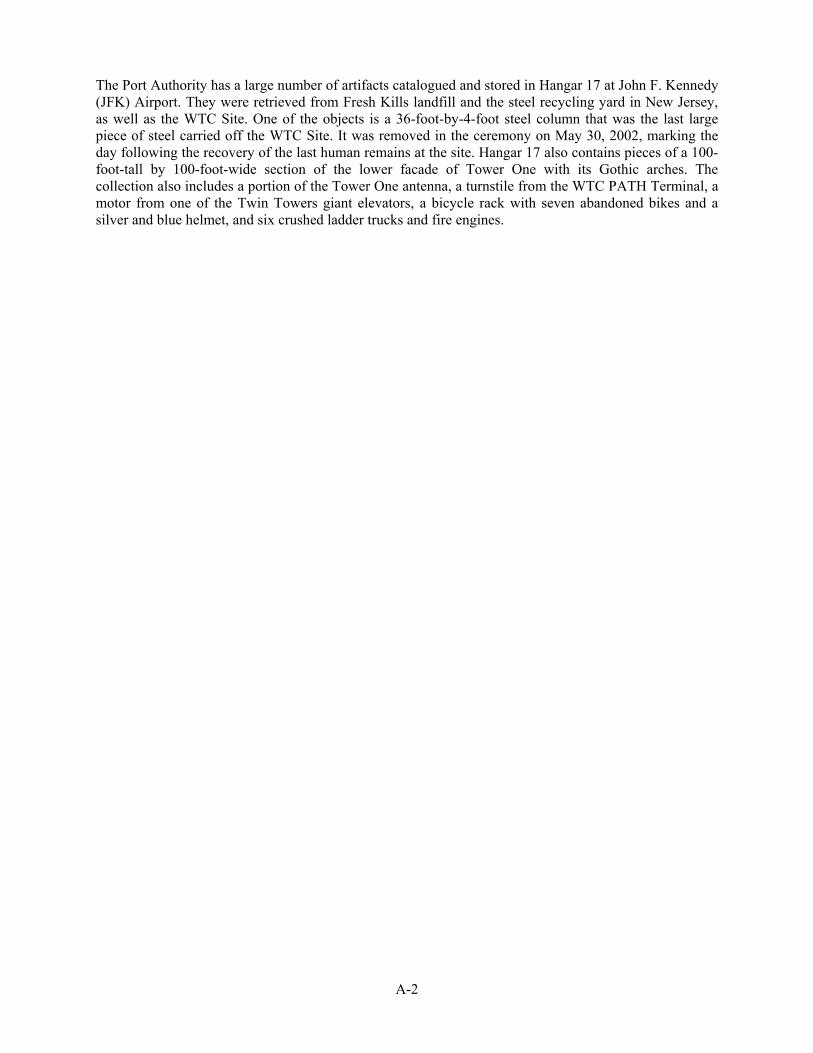
3. East wall (constructed pre-September 11): This wall is visible above the temporary PATH tracks and on either side of the portion of the temporary WTC PATH station in the bathtub (see Photos 9 and 10). September 11 damage as well as new concrete in repaired sections of the wall are distinguishable.
a. Hudson Tubes (constructed pre-September 11): Two cast-iron ring tubes are located in the east wall. Only the south tube is visible (see Photo 11).
b. Vehicular access ramp (constructed pre-September 11): A former vehicular ramp into the below-grade service areas on the WTC Site is just west of the east wall (see Photo 12). Inside the WTC Site (at approximately Fulton Street) the ramp connects to and runs through a portion of the one of the original Hudson Tubes. It connected to the outside world on Barclay Street under 7 WTC where trucks entered and exited the WTC.
c. Temporary WTC PATH station (constructed post-September 11/temporary): The new structure of the temporary WTC PATH station is visible, and is adjacent to the eastern wall of the bathtub (see Photos 13 and 14). The structures are at the same location and elevations as the pre-September 11 station facility. PATH trains enter and exit the station on the track/platform level. Above that is the mezzanine level (also within the bathtub) where the turnstiles are located. Along the west wall of the mezzanine and overlooking the bathtub, the open structure has screen panels that are translucent; they allow light into the mezzanine level but do not obscure most views out to the WTC Site. Printed panels are also located along the walls and have quotes of famous New Yorkers. Four temporary emergency exit staircases lead from the PATH mezzanine to the floor of the bathtub.
4. North wall (constructed pre-September 11): This wall is largely obscured by the remnants of the substructure of 6 WTC.
a. 6 WTC (constructed pre-September 11): Remnants of the grade level slab, an egress staircase, and six below-grade floors of 6 WTC (Levels B1-B6) are remaining at the north end of the bathtub (see Photo 15). Smoke scars from the September 11 terrorist attacks are visible at levels B1-B5 from the exterior. These areas were used as below-grade parking (see Photos 16 and 17) and have been temporarily stabilized and shored as part of the site recovery following September 11, 2001.
b. Tiebacks (constructed post-September 11/temporary): Some tiebacks have been installed where slabs have been demolished (see Photo 18). A few tiebacks near the truck access ramp have cables that have not been cut back and capped.
c. Vehicular access ramp (constructed pre-September 11): This heavily damaged ramp once connected the WTC Site to Barclay Street (under 7 WTC) and is visible in this area.
5. Area within Bathtub: This is the area that was generally excavated to the concrete floor of the bathtub. It is within the slurry walls (see Photos 2-4). Tower One, Tower Two, 3 WTC (the hotel) and 6 WTC all stood above the bathtub. The concrete floor of the bathtub lies over a layer of gravel which varies in thickness depending upon the geology of a particular location within the bathtub. In addition to the portions of 6 WTC and the temporary WTC PATH station, and

Coordinated Determination of National Register Eligibility—Revised March 31, 2004 13
operations and maintenance facilities and its elements identified above, other features or structures now present in the bathtub include:
a. Tower perimeter column bases (constructed pre-September 11): The original subgrade column grid for the Twin Towers was configured in the bathtub to span above the former H&M tunnels traversing the bathtub as well as the new PATH tracks. During the recovery and site clean-up, the perimeter column bases that outline the space where the Twin Towers stood (sometimes referred to as footprints) were cut off just at or above the concrete floor of the bathtub, but remnants remain (see Photos 19 and 20). The perimeter outlines of the north tower and south tower are delineated by column bases forming squares. Prior to September 11, 2001, the PATH facility occupied approximately the east half of the south tower’s footprint. There were 84 perimeter columns extending into the concrete floor of the bathtub that would outline the north tower and, due to the configuration and crossing of PATH tracks, 73 perimeter columns extending into the concrete floor of the bathtub that outline the south tower. Of the 73 perimeter columns outlining the south tower, 34 of them were in the PATH facility.
b. Other column bases (constructed pre-September 11): These column bases supported other structures or infrastructure that once existed in the bathtub. They include column bases inside the perimeter of the Twin Towers. Most of the columns were arranged in a 30-foot by 30-foot grid pattern, with notable exceptions and an irregular grid pattern occurring in the areas of the PATH tracks at the north and south ends of the WTC bathtub.
c. Other infrastructure (constructed pre-September 11): Other infrastructure including elevator pits, sump pumps, ejector pumps and drainage lines are located within the bathtub area.
East Portion of the WTC Site
This is the portion of the WTC Site outside of the bathtub area. This area is located east of the alignment of Greenwich Street and the restored No. 1/9 subway line which permits service to the Rector and South Ferry Stations. The new temporary WTC PATH station concourse level and street entrance is located in the north half of this area. There are no surviving remnants of buildings 4 WTC and 5 WTC in this area. Features identified in the eastern portion of the WTC Site include the following:
1. Temporary WTC PATH station main entrance (constructed post-September 11): This new structure is entered from Church Street at Fulton Street. The station has a sculptural form, with two wings rising from a central truss supported on two vertical trusses.
2. Temporary WTC PATH station concourse (constructed post-September 11): This is located one level below-grade (see Photo 21). It connects to the pre-existing downtown platform of the NYCT N/R/W line running under Church Street and at the northeast corner of the WTC Site to the NYCT E line.
3. WTC PATH Terminal underpass (constructed pre-September 11): This is a pedestrian underpass connecting the mezzanine level to the concourse level, located under the No. 1/9 subway line, just as it did in the former WTC. This underpass structure itself remained intact despite the destruction and damage of September 11. New escalators were installed post-September 11.
4. Restored NYCT No. 1/9 subway line (constructed post-September 11): A concrete box enclosing the subway tracks, as well as portions of the former Cortlandt Street station, runs north-south across the WTC Site, just east of the slurry wall. The tracks and enclosure were completely rebuilt after September 11.
5. Plaza and subway access from Vesey Street (constructed pre-September 11): The heavily damaged stair and escalator structure on Vesey Street lead up to the WTC plaza and the bridge to 7 WTC (see Photo 22). It also provided access to the No. 1/9 Cortlandt Street subway station which was under the WTC.

Coordinated Determination of National Register Eligibility—Revised March 31, 2004 14
6. Remnants of the Hudson Terminal and the H&M Railroad (constructed pre-September 11): These are found below grade in the middle of the WTC Site along Church Street between Fulton and Cortlandt Streets. When the new WTC PATH Terminal opened in 1971, unused portions of the Hudson Tubes were converted to truck ramps. Sections of these unused portions of the cast-iron tubes exist on site. Below-grade portions of the former terminal that were used for truck loading, parking, and commercial storage also exist on site. All components of the former H&M Terminal substation have been removed (during construction of the WTC), and only large openings in the ground where these features were located survive.
7. Sidewalks and fencing (constructed post-September 11): These sidewalks and fencing are located around the perimeter of the WTC Site.
8. Passageway to the NYCT WTC subway station (constructed pre-September 11): Remnants of the WTC passageway to the E subway line are located below-grade and include steps, a ramp, doors and flooring (see Photos 23 and 24). This passageway has been reopened and connects with the temporary WTC PATH station.
9. Steel cross (erected post-September 11): A section of two connected beams forming a steel cross was found near 6 WTC and erected by recovery workers on the WTC Site.
IV. NATIONAL REGISTER ELIGIBILITY EVALUATION The WTC Site meets National Register Criterion A for its association with the September 11, 2001 attacks on the two 110-story towers of the WTC which on local, state and national levels constitute “historic events that have made a significant contribution to the broad patterns of our history.” In connection with the events of September 11, the WTC Site is significant in the areas of political and government issues, social history and economic history. The WTC Site is exceptionally significant in the history of the United States as the location of events that immediately and profoundly influenced the lives of millions of American citizens and for its role in symbolizing and commemorating those events for survivors, families of victims, New Yorkers, Americans and visitors from all over the world. The WTC Site is defined as the approximately 16-acre property bounded by Route 9A (West Street), and Vesey, Liberty, and Church Streets.
Although the events of September 11 occurred just over two years ago, the WTC Site meets the requirement of National Register Criteria Consideration G that a property achieving significance within the last 50 years must be of exceptional importance. The flying of two large commercial jetliners into the WTC’s Twin Towers were the acts that precipitated numerous events of great magnitude, among them the deaths of an unprecedented number of individuals in a single location resulting from foreign attacks on American soil, and also actions, still unfolding, taken by the United States both at home and abroad in response to the attacks themselves and to the issues of global terrorism of which they were a part. The ultimate historical importance of the various events and actions resulting from the attacks has yet to be fully determined, since they are still underway and additional actions are likely to be initiated in the foreseeable future. However, there exists more than sufficient information at this time to document the exceptional importance of the attacks on the WTC to the history of the United States in the 21st century.
The attacks on the Twin Towers on September 11 caused the death of what is currently estimated to have been nearly 2,800 people and when taken together with the attack on the Pentagon and the crash of hijacked Flight 93 in Shanksville, PA, the total rises to more than 3,000. An immediate result of the attacks was a profound transformation in both local and national security. Shortly after the attacks, the FAA grounded all flights then within United States airspace and turned back all flights then coming into the country—something that it had never done before and that continued for several days after September 11. The United States Office of Homeland Security (which later became the Department of Homeland Security) was established on October 8, 2001. In early October 2001, the United States and other members of the international community attacked and then invaded Afghanistan, where the governing

Coordinated Determination of National Register Eligibility—Revised March 31, 2004 15
Taliban regime harbored terrorist leaders and training camps. The comprehensive federal response to the events of September 11 also included Congressional enactment of major legislation such as the Aviation and Transportation Security Act, National Construction Safety Team Act, Air Transportation Safety and System Stabilization Act, the United States Patriot Act, and the Terrorism Risk Insurance Act of 2002, as well as major changes in foreign policy.
The significance of the WTC Site is enhanced by the fact that the collapses of the Twin Towers was captured on film, witnessed on television by millions of people as it occurred, and has been replayed countless times all over the world. As such, the image has been indelibly burned into our collective memory, and the WTC Site is a compelling reminder of the tragic events of that terrible day.
In addition to its direct association with the events of September 11, the WTC Site has already acquired significance as the primary place for commemorating the events that transpired there. Almost from the day of the attacks, crowds of people from all over the world, representing diverse cultures, nationalities, and classes, have journeyed to the WTC Site to pay their respects to the victims and bear witness to the significance of the events. It has been the location of countless memorials, ceremonial events, and private pilgrimages by the families of the victims, survivors, rescue workers, government officials, world leaders, and citizens of New York, the nation, and the world. On each of the two subsequent anniversaries of the attacks, the name of each of the victims has been read aloud at the WTC Site, thus publicly proclaiming the collective grief of a nation.
The period of significance begins on September 11, 2001, the day on which the attacks occurred, and continues to June 30, 2002, the date on which DDC concluded the recovery efforts and returned the WTC Site to Port Authority control. Absent the events of September 11, the Twin Towers would not have collapsed, thousands of people would not have lost their lives, the WTC and several adjacent buildings would not have been destroyed or extensively damaged, the massive search, rescue and recovery efforts would not have taken place, the PATH system and the No. 1/9 subway line and station below the towers would have remained in operation, and the numerous actions taken by the United States at home and abroad in the name of national security and war on terrorism would not have taken place (or, with regard to the latter, not in the manner they have to date).
The WTC Site was the locus of the events of September 11 and the significance of those events and their aftermath to American history makes the WTC Site eligible for National Register listing, even at this early date. Although the existing elements on the site do not fully express the scale or catastrophic nature of the events of the day, various remnants of the WTC’s Twin Towers and other structures help convey in different ways the events of September 11 and their aftermath and, therefore contribute to the WTC Site’s historic significance.
Foremost among these items are the truncated box-beam column bases that help define the perimeter or “footprints” of the former Twin Towers and the slurry walls that form the sides of the underground bathtub for the Twin Towers. The truncated box-beam column bases serve to poignantly delineate the areas where so many lives were lost that day. As revealed by the recovery efforts, the west wall in particular helps to convey the scale of both the bathtub and the destruction wrought on September 11.
Other items also contribute to the understanding of the events in a different way. The remnants of the parking garage contain slabs and interior columns charred with smoke from the fires that burned for months. The beams forming a cross erected by recovery workers reflect the faith and dedication of thousands of rescue and recovery workers both on September 11 and in the months following.
Other remnants, such as the portion of the concrete steps and escalator ramp from Vesey Street to the subway and the remaining portion of the passageway to the E subway line, serve as reminders that the WTC Site was not limited to the Twin Towers and included both pedestrian and transit connections to the surrounding communities.
The significance of the WTC Site is reflected by its integrity of location, setting, feeling, association, and materials. Physical remnants on the WTC Site possess integrity of materials that convey the catastrophic

Coordinated Determination of National Register Eligibility—Revised March 31, 2004 16
events of September 11. The WTC Site retains integrity of location, as it is the location of the now-destroyed complex where the September 11 attacks occurred. It also retains integrity of setting. Although buildings and infrastructure within the WTC were destroyed and their ruins removed, the physical environment surrounding the WTC Site remains essentially as it was on September 11, for example its relationship to other buildings in the neighborhood and its location near the Hudson River in Lower Manhattan (a location that necessitated the construction of the slurry walls and bathtub visible today). The WTC Site retains integrity of feeling—the surviving physical features at the site, including the large bathtub, slurry walls, and the bases of steel columns, as they have been revealed by the rescue and recovery efforts, convey the destruction that took place on September 11. The WTC Site also retains integrity of association, which is the direct link between an important historic event and a historic property. The Twin Towers were the targets of these September 11 attacks, and physical features surviving on this site that have material integrity retain their quality of association with the profound events of that day, as well as the post September 11 recovery effort.
The WTC Site is significant due to the extraordinary and catastrophic events of September 11, 2001. These events are important at the local, state and national levels due to the people who died and who gave their lives trying to help others, the physical destruction of the WTC and the unprecedented recovery effort. During the recovery, surviving elements of the WTC were disassembled and removed as part of the search and rescue operations; these actions also contribute to the site’s significance. Some of these artifacts (as described in Appendix A) could also contribute to the site’s significance if returned to the WTC Site to convey aspects of the events that give rise to the site’s eligibility. The individual project sponsors will consider the reuse and interpretative value of artifacts as they further develop their undertakings.
BOUNDARY DESCRIPTION AND JUSTIFICATION FOR THE NATIONAL REGISTER-ELIGIBLE WTC SITE
The boundaries of the eligible property are contiguous with the boundaries of the WTC Site. The WTC Site was the immediate setting in terms of historical development, design and function for the 110-story Twin Towers, which were the specific objectives of the terrorist attacks, and is the primary area onto which they collapsed on September 11. The targets of the attacks, the area that suffered the most catastrophic loss of lives and buildings, and the location most widely recognized for its association with the attacks, is the 16 acres once occupied by the WTC. This area most directly and outstandingly represents the events of September 11. The WTC Site is also associated with the extensive recovery effort that continued on the WTC Site until June 30, 2002.

Coordinated Determination of National Register Eligibility—Revised March 31, 2004 17
V. BIBLIOGRAPHY Allen, Oliver E. Tales of Old Tribeca, an Illustrated History of New York's Triangle Below Canal. New
York: Tribeca Trib, Inc. 1999.
Anonymous. 9/11 Memorial to Store Unidentified Remains. Los Angeles Times. August 26, 2003.
Anonymous. Report: Final WTC Death Toll Drops by Three; Could Stand at 2,749. Posted 1/23/2004 2:38 PM, Updated 1/23/2004. 3:49 PM. USA Today. USA Today website as of February 4, 2004. http://www.usatoday.com/news/sept11/2004-01-23-wtc-toll_x.htm
Borakove, Ellen, Director of Public Affairs for New York City Medical Examiner's Office. Phone Interview February 4, 2004.
Darton, Eric. Divided We Stand: A Biography of New York's World Trade Center. New York: Basic Books. 1999.
Dewan, Sheila K. New York Times. Public Lives: An Interpreter of Messages Left by the Dead. June 6, 2003.
Federal Emergency Management Agency. World Trade Center Building Performance Study, FEMA 403, Appendix D: WTC Steel Data Collection. May 2002. FEMA website as of February 4, 2004. http://www.fema.gov/pdf/Library/Fema403_apd.pdf
Gillespie, Angus Kress. Twin Towers: The Life of New York City’s World Trade Center. New Brunswick, N.J.: Rutgers University Press. 1999.
Glanz, James and Eric Lipton. City in the Sky: The Rise and Fall of the World Trade Center. New York: Times Books, Henry Holt and Company. 2003.
Hartgen Archaeological Associates. Route 9A Reconstruction Project, Draft Archaeological Assessment Report, Battery Place to Harrison Street. March 1990.
Jackson, Kenneth T., ed. The Encyclopedia of New York City. New Haven, CT: Yale University Press. 1995.
Langewiesche, William. American Ground: Unbuilding the World Trade Center. New York: North Point Press. 2002.
Lipton, Eric. Left Mostly Out of Memorial Designs, Trade Center Steel Sits Rusting in a Hangar. New York Times. December 19, 2003.
National Institute of Standards and Technology. Documentary Information Received by NIST, August 2003. NIST website as of February 4, 2004. http://wtc.nist.gov/media/docs_info_received.html
National Institute of Standards and Technology. Federal Building and Fire Safety Investigation of the World Trade Center Disaster, Project #3: Analysis of Structural Steel, Update, December 2, 2003. NIST website as of February 4, 2004. http://wtc.nist.gov/media/Analysis of_Structural_Steel.pdf
National Park Service, National Register Bulletin 15: How to Apply the National Register Criteria for Evaluation.
National Park Service, National Register Bulletin 16A: How to Complete the National Register Registration Form.
New York State Museum. Press Release. August 2003. NYSM website as of February 4, 2004. http://www.nysm.nysed.gov/press/2003/wtcresponse.html
New York State Museum. The World Trade Center: Rescue Recovery Response. August 2003. NYSM website as of February 4, 2004. http://www.nysm.nysed.gov/wtc/

Coordinated Determination of National Register Eligibility—Revised March 31, 2004 18
Tyson, Peter. Towers of Innovation. Included in a companion web site to Public Broadcasting Service. Why the Towers Fell. Originally broadcast February 2, 2002. PBS website as of February 5, 2004. http://www.pbs.org/wgbh/nova/wtc/innovation.html
Voice of America News. Unidentified Remains of World Trade Center Victims to be Preserved in Permanent Memorial. Aug 25, 2003, 17:42 UTC. VOA website as of February 5, 2004. http://www.voanews.com.
VI. LIST OF PREPARERS AKRF, Inc.
• Anne M. Locke, Assoc. AIA Senior Vice President
• Andrea Burk, M.S. Architectural Historian
• Claudia Cooney, M.S. Technical Director
The Louis Berger Group, Inc.
• John A. Hotopp, Ph.D., RPA Senior Vice President
• Martha H. Bowers, M.A. Principal Architectural Historian
VII. COMMENTS Comments on the January 21, 2004 and February 6, 2004 drafts of this Coordinated Determination of National Register Eligibility were received from:
• Coalition of 9/11 Families, Anthony Gardner, Executive Board member
• Coalition to Save West Street, Marilyn Gaull Howard
• Families of September 11, Nikki Stern, Director
• Greek Orthodox Archdiocese and St. Nicholas Church, George Schira
• Historic Districts Council, Robert Kornfeld, Director
• Historic Districts Council, Robert Kornfeld, Director; Metro New York Chapter, American Planning Association, Ethel Sheffer, President; Coalition of 9/11 Families (Coalition), Anthony Gardner, Executive Board member; Voices of September 11th, Mary Fetchet, President
• Louise LoPresti
• Lower Manhattan Emergency Preservation Fund (composed of Municipal Art Society, Frank E. Sanchis, III, Executive Director; National Trust for Historic Preservation, Elizabeth S. Merritt, Deputy General Counsel, Marilyn Fenollosa, Senior Program Officer & Regional Attorney; New York Landmarks Conservancy, Peg Breen, President; Preservation League of New York State, Scott Heyl, President; World Monuments Fund, Bonnie Burnham, President; Ken Lustbader, Preservation Consultant)
• Municipal Art Society, Vicki Weiner, Director of Historic Preservation

Coordinated Determination of National Register Eligibility—Revised March 31, 2004 19
• National Trust for Historic Preservation, Elizabeth S. Merritt, Deputy General Counsel, Marilyn Fenollosa, Senior Program Officer & Regional Attorney
• New York City Landmarks Preservation Commission, Robert Tierney
• New York Landmarks Conservancy, Alex Herrera, Director of Preservation
• Preservation League of New York State, Ken Lustbader, Consultant
• Shinnecock Nation Cultural Center and Museum, Winonah Warren
• Voices of September 11th, Mary Fetchet, President

A-1
APPENDIX A—ARTIFACTS
During the rescue and recovery operations, a number of artifacts were removed from the WTC Site. Artifacts are the materials that were identified, secured, and preserved. This section deals with those artifacts that were taken from the WTC Site during the recovery efforts. A structure or pieces of a structure or a site removed from their historic location would not usually be considered for National Register eligibility because they have lost their integrity of location. However, based on consultation between the State Historic Preservation Office and the National Park Service, it has been determined that if artifacts are returned to the WTC Site, then they could be considered to contribute to the historic significance of the property.
Of the artifacts removed from the WTC Site one of the most famous is the Sphere, an artwork by Fritz Koenig originally located on the fountain at the center of the Tobin Plaza. The Sphere was damaged in the September 11 attacks and was donated by AXA Insurance Company to the Interim Memorial created on March 11, 2002, in Battery Park by LMDC, the Port Authority, and the City of New York. The Interim Memorial is dedicated “to all whose lives were taken, and the many who gave their lives trying to save them at the World Trade Center in the attacks of September 11, 2001.” On the first anniversary of the attacks, Mayor Michael Bloomberg dedicated an eternal flame at the Interim Memorial.
During the rescue and recovery period when New York City’s Department of Design and Construction controlled the WTC Site, the materials were taken to Fresh Kills landfill and steel was taken to a steel recycling plant in New Jersey. The National Institute of Standards and Technology selected certain pieces of steel for testing to study factors leading to the collapse of the Towers.
A note on the cover of the Steel Data Collection Spreadsheet attached to FEMA’s World Trade Center Building Performance Study indicates that: “As of May 2002, of the 156 steel pieces listed in the spread sheet, 41 are at the National Institute of Standards [and Technology], 19 were discarded after [samples] were taken, 45 are at the salvage yards, and the rest either were discarded after they were documented or were accidentally processed in the salvage operation before or after being documented.”
During the recovery efforts numerous requests were made by museums and other organizations for materials from the WTC Site. These requests were directed to the New York City Office of Emergency Management (OEM) and OEM allowed some organizations to take some materials. It has been reported that artifacts are in the possession of the Smithsonian Institution, the Federal Bureau of Investigation (FBI), the New York City Police Department (NYPD), the Fire Department of New York (FDNY), the Museum of the City of New York, the New York City Police Museum, the New York City Fire Museum, the Staten Island Historical Society, the New York Historical Society and the New Jersey Historical Society. One round planter containing a living yew tree was salvaged from the WTC Site and is now located at the Governor’s mansion in a nursery behind the house. A 60-ton piece of steel was given to the United States Navy and was melted down for the SS New York. At one point the Mayor’s office was giving away two-foot sections of steel and some of this steel is at Mt. Manresa—a retreat house in Staten Island that housed out-of-town workers involved in the recovery efforts at Fresh Kills. In addition, a traveling exhibition from the NYSM titled “Recovery: The World Trade Center Recovery Operation at Fresh Kills” has about 50 rare photographs and 40 objects and is touring the country.
The New York State Museum in Albany has a number of artifacts from the WTC Site including the heavily damaged Engine 6 pumper, recovered NYPD and FDNY objects, architectural remains, several battered flags, a large steel column from floors 7-9 of Tower Two, a damaged 20-foot high, 10-ton steel column from floors 71-73 of Tower One, the steering wheel from a car, observation deck souvenirs, melted floppy discs, keys, a crushed payphone, a large collection of firearms from the U.S. Customs House (Six World Trade Center), destroyed street lampposts, fire hydrants, a destroyed elevator door, pieces of the airplanes that crashed into the Twin Towers including a portion of the wheel assembly from one of the planes, a piece of fuselage, and a steel beam with an embedded airplane piece.
A-2
The Port Authority has a large number of artifacts catalogued and stored in Hangar 17 at John F. Kennedy (JFK) Airport. They were retrieved from Fresh Kills landfill and the steel recycling yard in New Jersey, as well as the WTC Site. One of the objects is a 36-foot-by-4-foot steel column that was the last large piece of steel carried off the WTC Site. It was removed in the ceremony on May 30, 2002, marking the day following the recovery of the last human remains at the site. Hangar 17 also contains pieces of a 100-foot-tall by 100-foot-wide section of the lower facade of Tower One with its Gothic arches. The collection also includes a portion of the Tower One antenna, a turnstile from the WTC PATH Terminal, a motor from one of the Twin Towers giant elevators, a bicycle rack with seven abandoned bikes and a silver and blue helmet, and six crushed ladder trucks and fire engines.

1
2
View of WTC Site as it appeared in December 2001 (Port Authority)
View of WTC Site as it appeared in June 2002 (Port Authority)
World Trade Center Site

3
4
Aerial view of WTC Site (Port Authority)
View of bathtub, looking south from northern edge of WTC Site
World Trade Center Site

5
6
West slurry wall, north end
West slurry wall, view of vehicular entrance ramps and southern projection
World Trade Center Site

7
8
West slurry wall, detail view of vehicular entrance ramps and cooling water pipes
West slurry wall, view of southern projection and PATH tunnel access
World Trade Center Site

9
10
South and east slurry walls, view of new PATH tracks
East slurry wall
World Trade Center Site
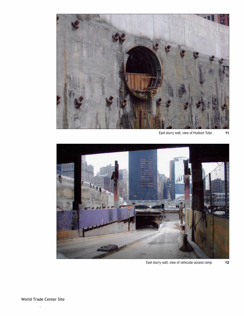
11
12
East slurry wall, view of Hudson Tube
East slurry wall, view of vehicular access ramp
World Trade Center Site

13
14
View of temporary WTC PATH station, adjacent to east slurry wall
View of temporary WTC PATH station
World Trade Center Site

15
16
North slurry wall, view of remnants of 6 WTC
View of 6 WTC remnants, former area of below-grade parking
World Trade Center Site

17
18
View of 6 WTC remnants, former area of below-grade parking
North slurry wall, view of temporary tieback caps
World Trade Center Site

19Bathtub area, truncated box beam column bases
World Trade Center Site
20Bathtub area, detail view of truncated box beam column base
21
22
View of new temporary WTC PATH station concourse
View of damaged stair and escalator structure on Vesey Street
World Trade Center Site

24Remnants of the WTC passageway to the E subway line
23Remnants of the WTC passageway to the E subway line
World Trade Center Site