Embed Size (px)
Citation preview
10 G Street, NEWashington, DC 20002, USA
wri.org
Lauretta Burke
kathLeen reytar
Mark SpaLding
aLLiSon perry
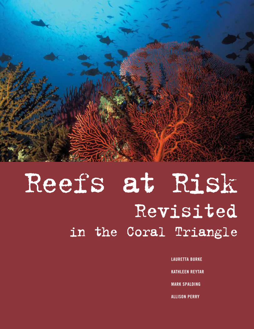
Reefs at RiskRevisited
in the Coral Triangle
ContriButing inStitutionS
Reefs at Risk Revisited in the Coral Triangle was developed by the World Resources Institute (WRI) in close collaboration with the USAID-funded Coral Triangle Support Partnership (CTSP). This report was adapted from WRI’s 2011 global analysis of threats to coral reefs, Reefs at Risk Revisited, produced in partnership with The Nature Conservancy (TNC), the WorldFish Center, the International Coral Reef Action Network (ICRAN), the United Nations Environment Programme-World Conservation Monitoring Centre (UNEP-WCMC), and the Global Coral Reef Monitoring Network (GCRMN). Many other government agencies, international organizations, research institutions, universities, non-governmental organizations and initiatives provided scientific guidance, contributed data, and reviewed results for these reports, including:
n Atlantic and Gulf Rapid Reef Assessment (AGRRA)
n Coastal Conservation and Education Foundation (CCEF)
n Coastal Oceans Research and Development in the Indian Ocean (CORDIO)
n Conservation International (CI)
n Coral Reef Alliance (CORAL)
n Coral Triangle Initiative on Coral Reefs, Fisheries, and Food Security (CTI-CFF)
n Healthy Reefs for Healthy People
n International Society for Reef Studies (ISRS)
n International Union for the Conservation of Nature (IUCN)
n L’Institut de Recherche pour le Développement (IRD)
n National Center for Ecological Analysis and Synthesis (NCEAS)
n Oceana
n Planetary Coral Reef Foundation
n Project AWARE Foundation
n Reef Check
n Reef Environmental Education Foundation (REEF)
n SeaWeb
n Secretariat of the Pacific Community (SPC)
n Secretariat of the Pacific Regional Environment Programme (SPREP)
n U.S. National Aeronautics and Space Administration (NASA)
n U.S. National Oceanic and Atmospheric Administration (NOAA)
n University of South Florida (USF)
n University of the South Pacific (USP)
n Wildlife Conservation Society (WCS)
n World Wildlife Fund (WWF)
FinanCiaL Support For Reefs at Risk Revisited in the CoRal tRiangle waS provided By:
n The Chino Cienega Foundation
n Roy Disney Family Foundation
n U.S. Agency for International Development
iSBn 978-1-56973-791-0

10 G Street, NEWashington, DC 20002, USA
wri.org
Lauretta Burke
kathLeen reytar
Mark SpaLding
aLLiSon perry
Reefs at RiskRevisited
in the Coral Triangle
ContriButing inStitutionS
Reefs at Risk Revisited in the Coral Triangle was developed by the World Resources Institute (WRI) in close collaboration with the USAID-funded Coral Triangle Support Partnership (CTSP). This report was adapted from WRI’s 2011 global analysis of threats to coral reefs, Reefs at Risk Revisited, produced in partnership with The Nature Conservancy (TNC), the WorldFish Center, the International Coral Reef Action Network (ICRAN), the United Nations Environment Programme-World Conservation Monitoring Centre (UNEP-WCMC), and the Global Coral Reef Monitoring Network (GCRMN). Many other government agencies, international organizations, research institutions, universities, non-governmental organizations and initiatives provided scientific guidance, contributed data, and reviewed results for these reports, including:
n Atlantic and Gulf Rapid Reef Assessment (AGRRA)
n Coastal Conservation and Education Foundation (CCEF)
n Coastal Oceans Research and Development in the Indian Ocean (CORDIO)
n Conservation International (CI)
n Coral Reef Alliance (CORAL)
n Coral Triangle Initiative on Coral Reefs, Fisheries, and Food Security (CTI-CFF)
n Healthy Reefs for Healthy People
n International Society for Reef Studies (ISRS)
n International Union for the Conservation of Nature (IUCN)
n L’Institut de Recherche pour le Développement (IRD)
n National Center for Ecological Analysis and Synthesis (NCEAS)
n Oceana
n Planetary Coral Reef Foundation
n Project AWARE Foundation
n Reef Check
n Reef Environmental Education Foundation (REEF)
n SeaWeb
n Secretariat of the Pacific Community (SPC)
n Secretariat of the Pacific Regional Environment Programme (SPREP)
n U.S. National Aeronautics and Space Administration (NASA)
n U.S. National Oceanic and Atmospheric Administration (NOAA)
n University of South Florida (USF)
n University of the South Pacific (USP)
n Wildlife Conservation Society (WCS)
n World Wildlife Fund (WWF)
FinanCiaL Support For Reefs at Risk Revisited in the CoRal tRiangle waS provided By:
n The Chino Cienega Foundation
n Roy Disney Family Foundation
n U.S. Agency for International Development
iSBn 978-1-56973-791-0
Phot
o: S
tacy
JuPi
ter
the Reefs at Risk SerieS
Reefs at Risk Revisited and Reefs at Risk Revisited in the Coral Triangle are part of a series that began in 1998 with the release of the first global analysis, Reefs at Risk: A Map-Based Indicator of Threats to the World’s Coral Reefs. Two region-specific publications followed with Reefs at Risk in Southeast Asia (2002) and Reefs at Risk in the Caribbean (2004). These regional studies incorporated more detailed data and refined the modeling approach for mapping the impact of human activities on reefs. Reefs at Risk Revisited — an updated global report — has drawn upon the enhanced meth-odology of the regional studies, improved global data sets, and new developments in mapping technology and coral reef science. Reefs at Risk Revisited in the Coral Triangle is based on the global report, supplemented with more recent and detailed data for the Coral Triangle Region. Both of these Reefs at Risk Revisited reports were collaborative efforts that involved more than 25 partner institutions (see inside front cover). The projects have compiled far more data, maps, and statistics than can be presented in the reports. Additional information and data are available at www.wri.org/reefs and on the accompanying data disk.
the world resources institute (wri) is a global environmental and development think tank that goes beyond research to create practical ways to protect
the earth and improve people’s lives. Wri’s work in coastal ecosystems includes the Reefs at Risk series, as well as the coastal capital project, which
supports sustainable management of coral reefs and mangroves by quantifying their economic value. (www.wri.org)
the Coral triangle Support partnership (CtSp) supports the governments of indonesia, Malaysia, Papua New Guinea, Philippines, Solomon islands, and
timor-Leste in their regional commitment to ensure that the world's most precious marine areas are sustained into the future. Made up of a consortium
of the world's leading conservation NGos — World Wildlife Fund (WWF), conservation international (ci) and the Nature conservancy (tNc) — ctSP is a
five-year, $32 million project supported by the united States agency for international Development (uSaiD). this partnership encourages the development
of transformational policies on natural resource management; strengthens the capacity of institutions and local communities; and builds decision support
capacity. (www.usctsp.org)
the nature Conservancy (tnC) is a leading conservation organization working around the world to protect ecologically important lands and waters for
nature and people. the conservancy and its more than one million members have protected more than 480,000 sq km of land and 8,000 km of rivers, and
engage in more than 100 marine conservation projects. the conservancy is actively working on coral reef conservation in 24 countries, including the
caribbean and the coral triangle regions. (www.nature.org)
worldFish Center is an international, nonprofit, nongovernmental organization dedicated to reducing poverty and hunger by improving fisheries and aqua-
culture. Working in partnership with a wide range of agencies and research institutions, WorldFish carries out research to improve small-scale fisheries
and aquaculture. its work on coral reefs includes reefBase, the global information system on coral reefs. (www.worldfishcenter.org)
united nations environment programme-world Conservation Monitoring Centre (unep-wCMC) is an internationally recognized center for the synthesis,
analysis, and dissemination of global biodiversity knowledge. uNeP-WcMc provides authoritative, strategic, and timely information on critical marine and
coastal habitats for conventions, countries, organizations, and companies to use in the development and implementation of their policies and decisions.
(www.unep-wcmc.org)
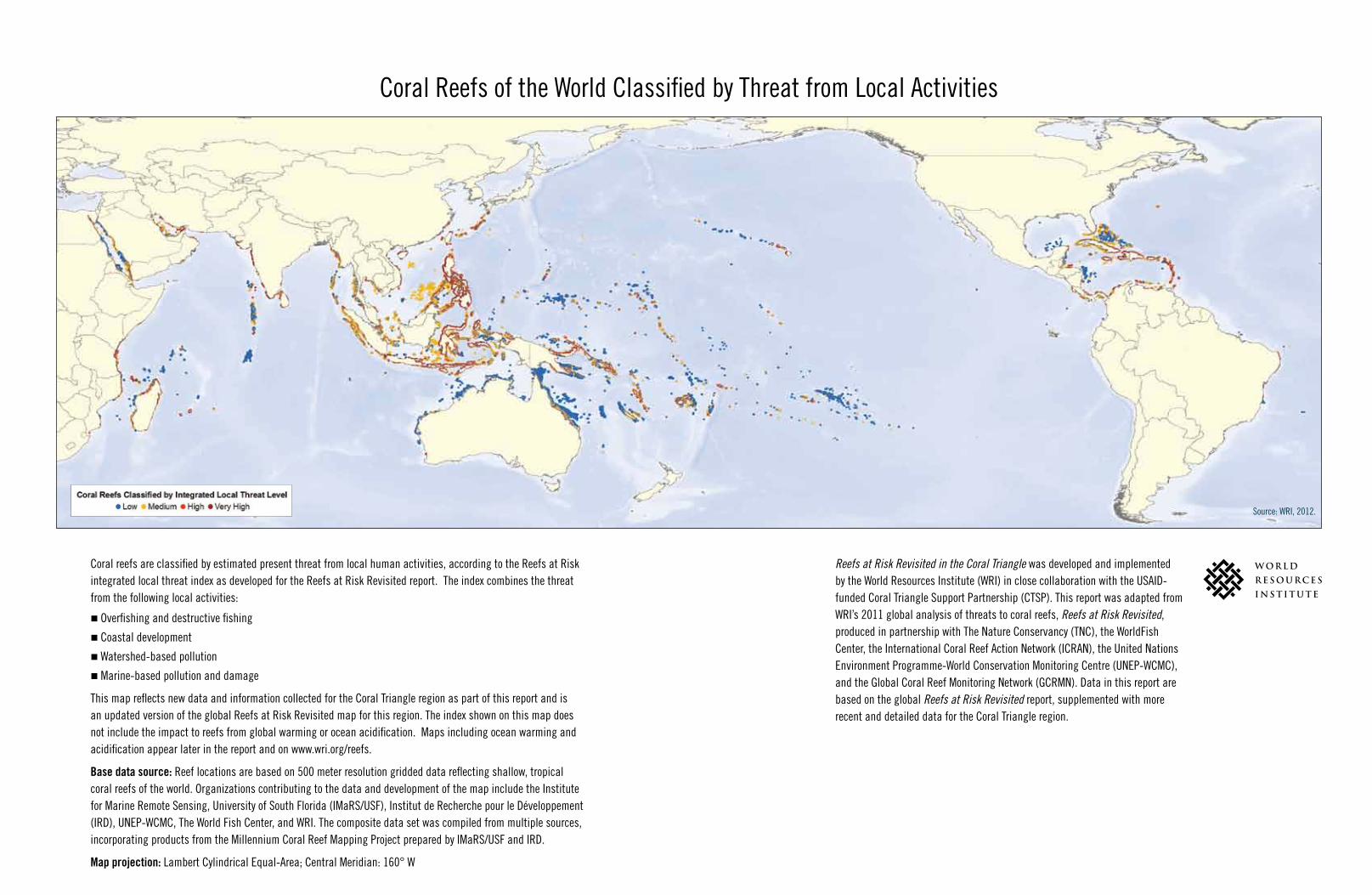
coral reefs of the World classified by threat from Local activities
coral reefs are classified by estimated present threat from local human activities, according to the reefs at risk integrated local threat index as developed for the reefs at risk revisited report. the index combines the threat from the following local activities:
n overfishing and destructive fishing
n coastal development
n Watershed-based pollution
n Marine-based pollution and damage
this map reflects new data and information collected for the coral triangle region as part of this report and is an updated version of the global reefs at risk revisited map for this region. the index shown on this map does not include the impact to reefs from global warming or ocean acidification. Maps including ocean warming and acidification appear later in the report and on www.wri.org/reefs.
Base data source: reef locations are based on 500 meter resolution gridded data reflecting shallow, tropical coral reefs of the world. organizations contributing to the data and development of the map include the institute for Marine remote Sensing, university of South Florida (iMarS/uSF), institut de recherche pour le Développement (irD), uNeP-WcMc, the World Fish center, and Wri. the composite data set was compiled from multiple sources, incorporating products from the Millennium coral reef Mapping Project prepared by iMarS/uSF and irD.
Map projection: Lambert cylindrical equal-area; central Meridian: 160° W
Reefs at Risk Revisited in the Coral Triangle was developed and implemented by the World resources institute (Wri) in close collaboration with the uSaiD-funded coral triangle Support Partnership (ctSP). this report was adapted from Wri’s 2011 global analysis of threats to coral reefs, Reefs at Risk Revisited, produced in partnership with the Nature conservancy (tNc), the WorldFish center, the international coral reef action Network (icraN), the united Nations environment Programme-World conservation Monitoring centre (uNeP-WcMc), and the Global coral reef Monitoring Network (GcrMN). Data in this report are based on the global Reefs at Risk Revisited report, supplemented with more recent and detailed data for the coral triangle region.
Source: Wri, 2012.

Reefs at Risk Revisited
in the Coral Triangle
Lauretta Burke | kathLeen reytar Mark SpaLding | aLLiSon perry
Contributing Authors
Maurice Knight
Benjamin Kushner
Benjamin Starkhouse
Richard Waite
Alan White
Hyacinth Billings
Publications Director
Cover Photo
David Wachenfeld
Inside Front Cover Photo
Suchana Chavanich/Marine Photobank
Layout of Reefs at Risk Revisited
Maggie Powell
No photograph in this report may be used in another work without written permission from the photographer.
Each World Resources Institute report represents a timely, scholarly treatment of a subject of public concern.
WRI takes responsibility for choosing the study topics and guaranteeing its authors and researchers freedom of inquiry.
It also solicits and responds to the guidance of advisory panels and expert reviewers. Unless otherwise stated,
however, all the interpretation and findings set forth in WRI publications are those of the authors.
Copyright 2012 World Resources Institute.
This work is licensed under the Creative Commons Attribution-NonCommercial-NoDerivative Works 3.0 License.
To view a copy of the license, visit http://creativecommons.org/licenses/by-nc-nd/3.0/
ISBN 978-1-56973-791-0
Library of Congress Control Number: 2012941340
REEFS AT R ISK REV IS ITED IN THE CORAL TR IANGLE iiiREEFS AT R ISK REV IS ITED IN THE CORAL TR IANGLE iii
Contents
Foreword. . . . . . . . . . . . . . . . . . . . . . . . . . . . . . . . . . . . . . . . . . . . . . . . . . . . . . . . . vi
aBBreviationS and aCronyMS . . . . . . . . . . . . . . . . . . . . . . . . . . . . . . . . . . . . . . . . . . . . . vii
aCknowLedgMentS . . . . . . . . . . . . . . . . . . . . . . . . . . . . . . . . . . . . . . . . . . . . . . . . . . . .viii
key FindingS 1Global Key Findings . . . . . . . . . . . . . . . . . . . . . . . . . . . . . . . . . . . . . . . . . . . . . 1Key Findings for the Coral Triangle Region . . . . . . . . . . . . . . . . . . . . . . . . . . . . . . . . . 2
SeCtion 1 introduCtion 5Purpose and Goal of Reefs at Risk Revisited . . . . . . . . . . . . . . . . . . . . . . . . . . . . . . . . . 6The Coral Triangle: The Center of Marine Biodiversity . . . . . . . . . . . . . . . . . . . . . . . . . . . 7Box 1.1 What is a Coral Reef? . . . . . . . . . . . . . . . . . . . . . . . . . . . . . . . . . . . . . . . . 7Why Reefs Matter . . . . . . . . . . . . . . . . . . . . . . . . . . . . . . . . . . . . . . . . . . . . . . 9Box 1.2 Method for Analyzing Threats to Reefs . . . . . . . . . . . . . . . . . . . . . . . . . . . . . . . 10
SeCtion 2 LoCaL and gLoBaL threatS to CoraL reeFS 11Present Threats to Coral Reefs—Global Summary . . . . . . . . . . . . . . . . . . . . . . . . . . . . . . 12Present Threats to Coral Reefs in the Coral Triangle Region . . . . . . . . . . . . . . . . . . . . . . . . . 13Local Threats to Coral Reefs in the Coral Triangle Region . . . . . . . . . . . . . . . . . . . . . . . . . . 16Box 2.1 Ten Years of Change in the Coral Triangle Region. . . . . . . . . . . . . . . . . . . . . . . . . . 19Future Threats to Coral Reefs . . . . . . . . . . . . . . . . . . . . . . . . . . . . . . . . . . . . . . . . 20
SeCtion 3 Country SuMMarieS 26Indonesia . . . . . . . . . . . . . . . . . . . . . . . . . . . . . . . . . . . . . . . . . . . . . . . . . . . 26Malaysia . . . . . . . . . . . . . . . . . . . . . . . . . . . . . . . . . . . . . . . . . . . . . . . . . . . 30Papua New Guinea . . . . . . . . . . . . . . . . . . . . . . . . . . . . . . . . . . . . . . . . . . . . . . 32Philippines . . . . . . . . . . . . . . . . . . . . . . . . . . . . . . . . . . . . . . . . . . . . . . . . . . 36Solomon Islands . . . . . . . . . . . . . . . . . . . . . . . . . . . . . . . . . . . . . . . . . . . . . . . 40Timor-Leste . . . . . . . . . . . . . . . . . . . . . . . . . . . . . . . . . . . . . . . . . . . . . . . . . 43Brunei Darussalam and Singapore . . . . . . . . . . . . . . . . . . . . . . . . . . . . . . . . . . . . . . 45
SeCtion 4 SoCiaL and eConoMiC iMpLiCationS oF reeF LoSS 46Reef Dependence. . . . . . . . . . . . . . . . . . . . . . . . . . . . . . . . . . . . . . . . . . . . . . . 46Box 4.1 Assessing Vulnerability: Analytical Approach . . . . . . . . . . . . . . . . . . . . . . . . . . . . 47Adaptive Capacity . . . . . . . . . . . . . . . . . . . . . . . . . . . . . . . . . . . . . . . . . . . . . . 48Social and Economic Vulnerability . . . . . . . . . . . . . . . . . . . . . . . . . . . . . . . . . . . . . . 50Box 4.3 Economic Value of Coral Reefs . . . . . . . . . . . . . . . . . . . . . . . . . . . . . . . . . . . 52
SeCtion 5 SuStaining and Managing CoraL reeFS For the Future 54Reef Protection Approaches . . . . . . . . . . . . . . . . . . . . . . . . . . . . . . . . . . . . . . . . . 54Box 5.1 Managing for Climate Change . . . . . . . . . . . . . . . . . . . . . . . . . . . . . . . . . . . 55Management Effectiveness and Coral Reefs . . . . . . . . . . . . . . . . . . . . . . . . . . . . . . . . . 57
SeCtion 6 ConCLuSionS and reCoMMendationS 60Box 6.1 The Coral Triangle Initiative. . . . . . . . . . . . . . . . . . . . . . . . . . . . . . . . . . . . . 61Box 6.2 Building Resilience in the Face of Climate Change in the Coral Triangle . . . . . . . . . . . . . . 64
reFerenCeS and teChniCaL noteS 65

iv REEFS AT R ISK REV IS ITED IN THE CORAL TR IANGLEiv REEFS AT R ISK REV IS ITED IN THE CORAL TR IANGLE
MapS1 Coral Reefs of the World Classified by Threat from Local Activities . . . . . . . . . . . . . . . . . . . . . . . . . . . . . . . . . . . . . . . . . . . . . .inside front coverES-1 The Coral Triangle Region . . . . . . . . . . . . . . . . . . . . . . . . . . . . . . . . . . . . . . . . . . . . . . . . . . . . . . . . . . . . . . . . . . . . . . . . . . . . . . . . . . . . . . . . . . . . . 31 .1 Major Coral Reef Regions of the World . . . . . . . . . . . . . . . . . . . . . . . . . . . . . . . . . . . . . . . . . . . . . . . . . . . . . . . . . . . . . . . . . . . . . . . . . . . . . . . . . . 71 .2 The Coral Triangle Region . . . . . . . . . . . . . . . . . . . . . . . . . . . . . . . . . . . . . . . . . . . . . . . . . . . . . . . . . . . . . . . . . . . . . . . . . . . . . . . . . . . . . . . . . . . . . 82 .1 Observations of Blast or Poison Fishing in the Coral Triangle Region . . . . . . . . . . . . . . . . . . . . . . . . . . . . . . . . . . . . . . . . . . . . . . . . . . . . . . . . . 132 .2 Reefs at Risk in the Coral Triangle Region . . . . . . . . . . . . . . . . . . . . . . . . . . . . . . . . . . . . . . . . . . . . . . . . . . . . . . . . . . . . . . . . . . . . . . . . . . . . . . . . 142 .3 Reefs Threatened by Coastal Development in the Coral Triangle Region . . . . . . . . . . . . . . . . . . . . . . . . . . . . . . . . . . . . . . . . . . . . . . . . . . . . . . . 162 .4 Reefs Threatened by Watershed-based Pollution in the Coral Triangle Region . . . . . . . . . . . . . . . . . . . . . . . . . . . . . . . . . . . . . . . . . . . . . . . . . . . 172 .5 Reefs Threatened by Marine-based Pollution and Damage in the Coral Triangle Region . . . . . . . . . . . . . . . . . . . . . . . . . . . . . . . . . . . . . . . . . . 172 .6 Reefs Threatened by Overfishing or Destructive Fishing in the Coral Triangle Region . . . . . . . . . . . . . . . . . . . . . . . . . . . . . . . . . . . . . . . . . . . 182 .7 Change in Local Threat between 1998 and 2007 in the Coral Triangle Region . . . . . . . . . . . . . . . . . . . . . . . . . . . . . . . . . . . . . . . . . . . . . . . . . . . 192 .8 Frequency of Future Coral Reef Bleaching Events in the 2030s and 2050s . . . . . . . . . . . . . . . . . . . . . . . . . . . . . . . . . . . . . . . . . . . . . . . . . . . . . 212 .9 Threat to Coral Reefs from Ocean Acidification in the Present, 2030, and 2050 . . . . . . . . . . . . . . . . . . . . . . . . . . . . . . . . . . . . . . . . . . . . . . . . . 222 .10 Reefs at Risk in the Present, 2030, and 2050 in the Coral Triangle Region . . . . . . . . . . . . . . . . . . . . . . . . . . . . . . . . . . . . . . . . . . . . . . . . . . . . . . 253 .1A Reefs at Risk in Western Indonesia . . . . . . . . . . . . . . . . . . . . . . . . . . . . . . . . . . . . . . . . . . . . . . . . . . . . . . . . . . . . . . . . . . . . . . . . . . . . . . . . . . . . . . 283 .1B Reefs at Risk in Eastern Indonesia . . . . . . . . . . . . . . . . . . . . . . . . . . . . . . . . . . . . . . . . . . . . . . . . . . . . . . . . . . . . . . . . . . . . . . . . . . . . . . . . . . . . . . 293 .2 Reefs at Risk in Malaysia . . . . . . . . . . . . . . . . . . . . . . . . . . . . . . . . . . . . . . . . . . . . . . . . . . . . . . . . . . . . . . . . . . . . . . . . . . . . . . . . . . . . . . . . . . . . . . 303 .3 Reefs at Risk in Papua New Guinea . . . . . . . . . . . . . . . . . . . . . . . . . . . . . . . . . . . . . . . . . . . . . . . . . . . . . . . . . . . . . . . . . . . . . . . . . . . . . . . . . . . . . 333 .4 Reefs at Risk in the Philippines . . . . . . . . . . . . . . . . . . . . . . . . . . . . . . . . . . . . . . . . . . . . . . . . . . . . . . . . . . . . . . . . . . . . . . . . . . . . . . . . . . . . . . . . . 373 .5 Reefs at Risk in Solomon Islands . . . . . . . . . . . . . . . . . . . . . . . . . . . . . . . . . . . . . . . . . . . . . . . . . . . . . . . . . . . . . . . . . . . . . . . . . . . . . . . . . . . . . . . 403 .6 Reefs at Risk in Timor-Leste . . . . . . . . . . . . . . . . . . . . . . . . . . . . . . . . . . . . . . . . . . . . . . . . . . . . . . . . . . . . . . . . . . . . . . . . . . . . . . . . . . . . . . . . . . . 434 .1 Social and Economic Dependence on Coral Reefs . . . . . . . . . . . . . . . . . . . . . . . . . . . . . . . . . . . . . . . . . . . . . . . . . . . . . . . . . . . . . . . . . . . . . . . . . 484 .2 Capacity of Reef Countries and Territories to Adapt to Reef Degradation and Loss . . . . . . . . . . . . . . . . . . . . . . . . . . . . . . . . . . . . . . . . . . . . . 494 .3 Social and Economic Vulnerability of Countries and Territories to Reef Loss . . . . . . . . . . . . . . . . . . . . . . . . . . . . . . . . . . . . . . . . . . . . . . . . . . 505 .1 Marine Protected Areas in the Coral Triangle Region Classified According to Management Effectiveness Rating . . . . . . . . . . . . . . . . . . . . . . 59
Contents
pHOT
O: W
OLCO
TT H
ENRy
REEFS AT R ISK REV IS ITED IN THE CORAL TR IANGLE vREEFS AT R ISK REV IS ITED IN THE CORAL TR IANGLE v
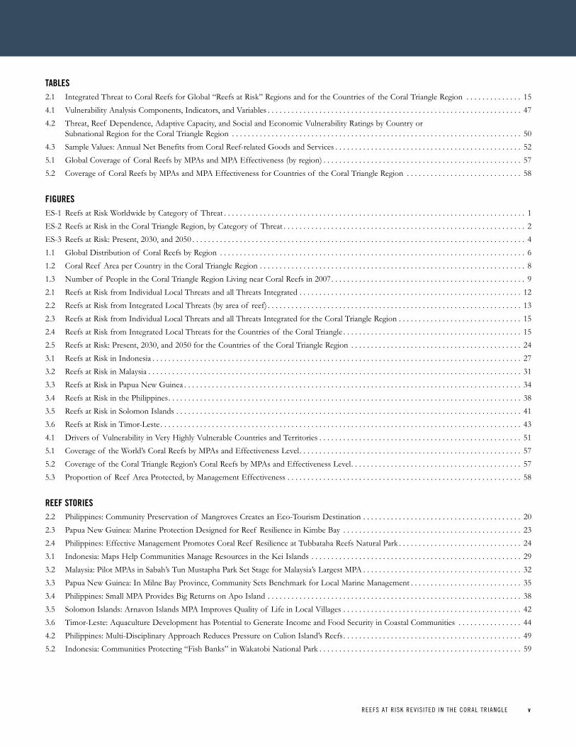
taBLeS2 .1 Integrated Threat to Coral Reefs for Global “Reefs at Risk” Regions and for the Countries of the Coral Triangle Region . . . . . . . . . . . . . . 154 .1 Vulnerability Analysis Components, Indicators, and Variables . . . . . . . . . . . . . . . . . . . . . . . . . . . . . . . . . . . . . . . . . . . . . . . . . . . . . . . . . . . . . . . . 474 .2 Threat, Reef Dependence, Adaptive Capacity, and Social and Economic Vulnerability Ratings by Country or
Subnational Region for the Coral Triangle Region . . . . . . . . . . . . . . . . . . . . . . . . . . . . . . . . . . . . . . . . . . . . . . . . . . . . . . . . . . . . . . . . . . . . . . . . . 504 .3 Sample Values: Annual Net Benefits from Coral Reef-related Goods and Services . . . . . . . . . . . . . . . . . . . . . . . . . . . . . . . . . . . . . . . . . . . . . . . 525 .1 Global Coverage of Coral Reefs by MPAs and MPA Effectiveness (by region) . . . . . . . . . . . . . . . . . . . . . . . . . . . . . . . . . . . . . . . . . . . . . . . . . . 575 .2 Coverage of Coral Reefs by MPAs and MPA Effectiveness for Countries of the Coral Triangle Region . . . . . . . . . . . . . . . . . . . . . . . . . . . . . 58
FigureSES-1 Reefs at Risk Worldwide by Category of Threat . . . . . . . . . . . . . . . . . . . . . . . . . . . . . . . . . . . . . . . . . . . . . . . . . . . . . . . . . . . . . . . . . . . . . . . . . . . . 1ES-2 Reefs at Risk in the Coral Triangle Region, by Category of Threat . . . . . . . . . . . . . . . . . . . . . . . . . . . . . . . . . . . . . . . . . . . . . . . . . . . . . . . . . . . . . 2ES-3 Reefs at Risk: Present, 2030, and 2050 . . . . . . . . . . . . . . . . . . . . . . . . . . . . . . . . . . . . . . . . . . . . . . . . . . . . . . . . . . . . . . . . . . . . . . . . . . . . . . . . . . . . 41 .1 Global Distribution of Coral Reefs by Region . . . . . . . . . . . . . . . . . . . . . . . . . . . . . . . . . . . . . . . . . . . . . . . . . . . . . . . . . . . . . . . . . . . . . . . . . . . . . 61 .2 Coral Reef Area per Country in the Coral Triangle Region . . . . . . . . . . . . . . . . . . . . . . . . . . . . . . . . . . . . . . . . . . . . . . . . . . . . . . . . . . . . . . . . . . . 81 .3 Number of People in the Coral Triangle Region Living near Coral Reefs in 2007 . . . . . . . . . . . . . . . . . . . . . . . . . . . . . . . . . . . . . . . . . . . . . . . . . 92 .1 Reefs at Risk from Individual Local Threats and all Threats Integrated . . . . . . . . . . . . . . . . . . . . . . . . . . . . . . . . . . . . . . . . . . . . . . . . . . . . . . . . 122 .2 Reefs at Risk from Integrated Local Threats (by area of reef) . . . . . . . . . . . . . . . . . . . . . . . . . . . . . . . . . . . . . . . . . . . . . . . . . . . . . . . . . . . . . . . . 132 .3 Reefs at Risk from Individual Local Threats and all Threats Integrated for the Coral Triangle Region . . . . . . . . . . . . . . . . . . . . . . . . . . . . . . . 152 .4 Reefs at Risk from Integrated Local Threats for the Countries of the Coral Triangle . . . . . . . . . . . . . . . . . . . . . . . . . . . . . . . . . . . . . . . . . . . . . 152 .5 Reefs at Risk: Present, 2030, and 2050 for the Countries of the Coral Triangle Region . . . . . . . . . . . . . . . . . . . . . . . . . . . . . . . . . . . . . . . . . . . 243 .1 Reefs at Risk in Indonesia . . . . . . . . . . . . . . . . . . . . . . . . . . . . . . . . . . . . . . . . . . . . . . . . . . . . . . . . . . . . . . . . . . . . . . . . . . . . . . . . . . . . . . . . . . . . . 273 .2 Reefs at Risk in Malaysia . . . . . . . . . . . . . . . . . . . . . . . . . . . . . . . . . . . . . . . . . . . . . . . . . . . . . . . . . . . . . . . . . . . . . . . . . . . . . . . . . . . . . . . . . . . . . . 313 .3 Reefs at Risk in Papua New Guinea . . . . . . . . . . . . . . . . . . . . . . . . . . . . . . . . . . . . . . . . . . . . . . . . . . . . . . . . . . . . . . . . . . . . . . . . . . . . . . . . . . . . . 343 .4 Reefs at Risk in the Philippines . . . . . . . . . . . . . . . . . . . . . . . . . . . . . . . . . . . . . . . . . . . . . . . . . . . . . . . . . . . . . . . . . . . . . . . . . . . . . . . . . . . . . . . . . 383 .5 Reefs at Risk in Solomon Islands . . . . . . . . . . . . . . . . . . . . . . . . . . . . . . . . . . . . . . . . . . . . . . . . . . . . . . . . . . . . . . . . . . . . . . . . . . . . . . . . . . . . . . . 413 .6 Reefs at Risk in Timor-Leste . . . . . . . . . . . . . . . . . . . . . . . . . . . . . . . . . . . . . . . . . . . . . . . . . . . . . . . . . . . . . . . . . . . . . . . . . . . . . . . . . . . . . . . . . . . 434 .1 Drivers of Vulnerability in Very Highly Vulnerable Countries and Territories . . . . . . . . . . . . . . . . . . . . . . . . . . . . . . . . . . . . . . . . . . . . . . . . . . . 515 .1 Coverage of the World’s Coral Reefs by MPAs and Effectiveness Level . . . . . . . . . . . . . . . . . . . . . . . . . . . . . . . . . . . . . . . . . . . . . . . . . . . . . . . . 575 .2 Coverage of the Coral Triangle Region’s Coral Reefs by MPAs and Effectiveness Level . . . . . . . . . . . . . . . . . . . . . . . . . . . . . . . . . . . . . . . . . . . 575 .3 Proportion of Reef Area Protected, by Management Effectiveness . . . . . . . . . . . . . . . . . . . . . . . . . . . . . . . . . . . . . . . . . . . . . . . . . . . . . . . . . . . 58
reeF StorieS 2 .2 Philippines: Community Preservation of Mangroves Creates an Eco-Tourism Destination . . . . . . . . . . . . . . . . . . . . . . . . . . . . . . . . . . . . . . . . 202 .3 Papua New Guinea: Marine Protection Designed for Reef Resilience in Kimbe Bay . . . . . . . . . . . . . . . . . . . . . . . . . . . . . . . . . . . . . . . . . . . . . 232 .4 Philippines: Effective Management Promotes Coral Reef Resilience at Tubbataha Reefs Natural Park . . . . . . . . . . . . . . . . . . . . . . . . . . . . . . . 243 .1 Indonesia: Maps Help Communities Manage Resources in the Kei Islands . . . . . . . . . . . . . . . . . . . . . . . . . . . . . . . . . . . . . . . . . . . . . . . . . . . . . 293 .2 Malaysia: Pilot MPAs in Sabah’s Tun Mustapha Park Set Stage for Malaysia’s Largest MPA . . . . . . . . . . . . . . . . . . . . . . . . . . . . . . . . . . . . . . . . 323 .3 Papua New Guinea: In Milne Bay Province, Community Sets Benchmark for Local Marine Management . . . . . . . . . . . . . . . . . . . . . . . . . . . . 353 .4 Philippines: Small MPA Provides Big Returns on Apo Island . . . . . . . . . . . . . . . . . . . . . . . . . . . . . . . . . . . . . . . . . . . . . . . . . . . . . . . . . . . . . . . . 383 .5 Solomon Islands: Arnavon Islands MPA Improves Quality of Life in Local Villages . . . . . . . . . . . . . . . . . . . . . . . . . . . . . . . . . . . . . . . . . . . . . 423 .6 Timor-Leste: Aquaculture Development has Potential to Generate Income and Food Security in Coastal Communities . . . . . . . . . . . . . . . . 444 .2 Philippines: Multi-Disciplinary Approach Reduces Pressure on Culion Island’s Reefs . . . . . . . . . . . . . . . . . . . . . . . . . . . . . . . . . . . . . . . . . . . . . 495 .2 Indonesia: Communities Protecting “Fish Banks” in Wakatobi National Park . . . . . . . . . . . . . . . . . . . . . . . . . . . . . . . . . . . . . . . . . . . . . . . . . . . 59
vi REEFS AT R ISK REV IS ITED IN THE CORAL TR IANGLEvi REEFS AT R ISK REV IS ITED IN THE CORAL TR IANGLE
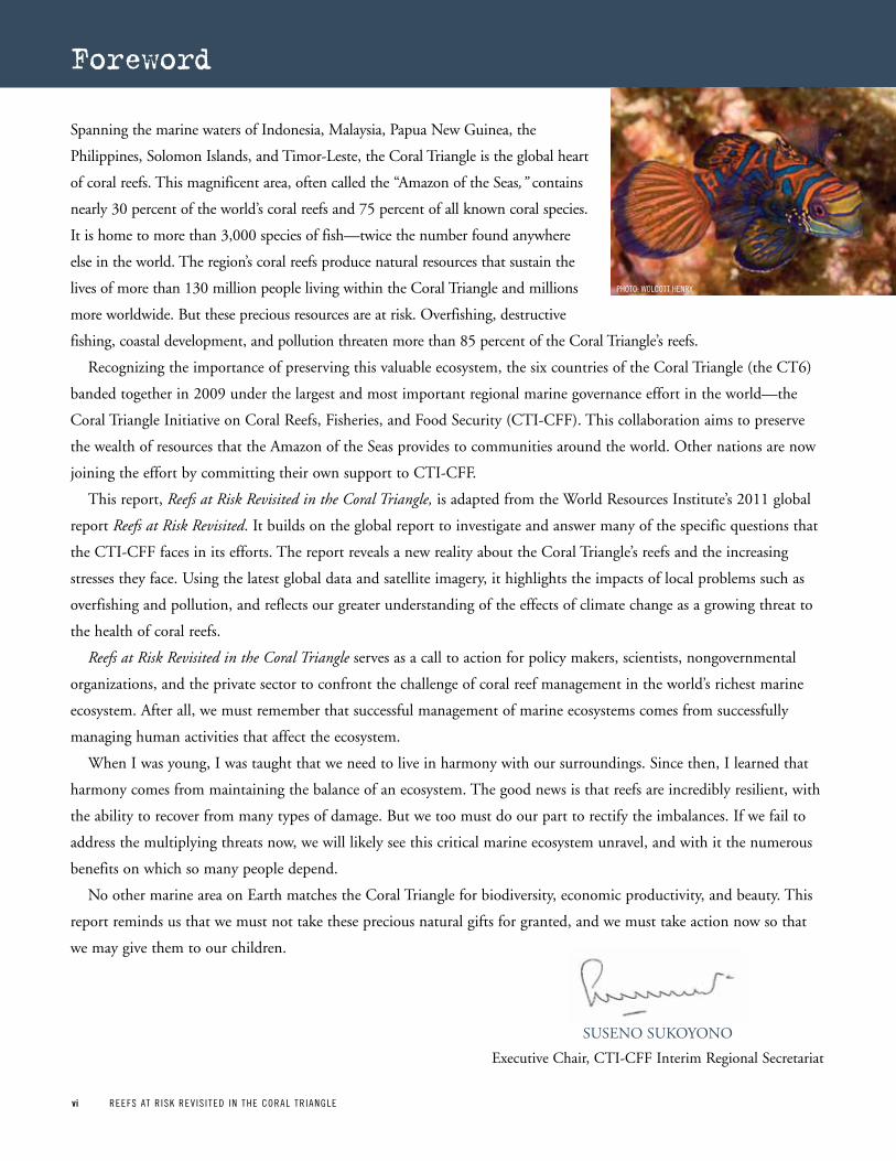
Spanning the marine waters of Indonesia, Malaysia, Papua New Guinea, the
Philippines, Solomon Islands, and Timor-Leste, the Coral Triangle is the global heart
of coral reefs. This magnificent area, often called the “Amazon of the Seas,” contains
nearly 30 percent of the world’s coral reefs and 75 percent of all known coral species.
It is home to more than 3,000 species of fish—twice the number found anywhere
else in the world. The region’s coral reefs produce natural resources that sustain the
lives of more than 130 million people living within the Coral Triangle and millions
more worldwide. But these precious resources are at risk. Overfishing, destructive
fishing, coastal development, and pollution threaten more than 85 percent of the Coral Triangle’s reefs.
Recognizing the importance of preserving this valuable ecosystem, the six countries of the Coral Triangle (the CT6)
banded together in 2009 under the largest and most important regional marine governance effort in the world—the
Coral Triangle Initiative on Coral Reefs, Fisheries, and Food Security (CTI-CFF). This collaboration aims to preserve
the wealth of resources that the Amazon of the Seas provides to communities around the world. Other nations are now
joining the effort by committing their own support to CTI-CFF.
This report, Reefs at Risk Revisited in the Coral Triangle, is adapted from the World Resources Institute’s 2011 global
report Reefs at Risk Revisited. It builds on the global report to investigate and answer many of the specific questions that
the CTI-CFF faces in its efforts. The report reveals a new reality about the Coral Triangle’s reefs and the increasing
stresses they face. Using the latest global data and satellite imagery, it highlights the impacts of local problems such as
overfishing and pollution, and reflects our greater understanding of the effects of climate change as a growing threat to
the health of coral reefs.
Reefs at Risk Revisited in the Coral Triangle serves as a call to action for policy makers, scientists, nongovernmental
organizations, and the private sector to confront the challenge of coral reef management in the world’s richest marine
ecosystem. After all, we must remember that successful management of marine ecosystems comes from successfully
managing human activities that affect the ecosystem.
When I was young, I was taught that we need to live in harmony with our surroundings. Since then, I learned that
harmony comes from maintaining the balance of an ecosystem. The good news is that reefs are incredibly resilient, with
the ability to recover from many types of damage. But we too must do our part to rectify the imbalances. If we fail to
address the multiplying threats now, we will likely see this critical marine ecosystem unravel, and with it the numerous
benefits on which so many people depend.
No other marine area on Earth matches the Coral Triangle for biodiversity, economic productivity, and beauty. This
report reminds us that we must not take these precious natural gifts for granted, and we must take action now so that
we may give them to our children.
Foreword
Executive Chair, CTI-CFF Interim Regional Secretariat
SUSENO SUkOyONO
pHOTO: WOLCOTT HENRy
REEFS AT R ISK REV IS ITED IN THE CORAL TR IANGLE viiREEFS AT R ISK REV IS ITED IN THE CORAL TR IANGLE vii
Abbreviations and Acronyms
CO2 Carbon dioxide
COREMAP Coral Reef Rehabilitation and Management program
COTS Crown-of-thorns starfish
CPUE Catch per unit effort
CTI Coral Triangle Initiative
CTI-CFF Coral Triangle Initiative on Coral Reefs, Fisheries, and Food Security
CTMPAS Coral Triangle Marine protected Area System
CTSP Coral Triangle Support partnership
DHW Degree heating week
EEZ Exclusive economic zone
FAO Food and Agriculture Organization of the United Nations
GCRMN The Global Coral Reef Monitoring Network
GDP Gross domestic product
GIS Geographic Information System
ICRI International Coral Reef Initiative
IMaRS/USF Institute for Marine Remote Sensing, University of South Florida
IPCC Intergovernmental panel on Climate Change
IRD Institut de Recherche pour le Développement
IUCN International Union for Conservation of Nature
LDC Least developed country
LEAP Local Early Action plans
LMMA Locally managed marine area
LRFFT Live reef food fish trade
MARPOL International Convention for the prevention of pollution from Ships
MMA Marine managed area
MMAF Ministry of Marine Affairs and Fisheries (Indonesia)
MPA Marine protected area
NASA U.S. National Aeronautics and Space Administration
NGO Nongovernmental organization
NIPC Nuakata Iabam pahalele Community
NOAA U.S. National Oceanic and Atmospheric Administration
PNG papua New Guinea
ppm parts per million
REAP-CCA Region-Wide Early Action plan for Climate Change Adaptation
sq km Square kilometers
SST Sea surface temperature
TMP Tun Mustapha park
TNC The Nature Conservancy
TRNP Tubbataha Reefs Natural park
UNEP-WCMC United Nations Environment programme- World Conservation Monitoring Centre
UNFCCC United Nations Framework Convention on Climate Change
USAID United States Agency for International Development
WCS Wildlife Conservation Society
WDPA World Database of protected Areas
WRI World Resources Institute
WWF World Wildlife Fund
viii REEFS AT R ISK REV IS ITED IN THE CORAL TR IANGLEviii REEFS AT R ISK REV IS ITED IN THE CORAL TR IANGLE
Acknowledgments
Reefs at Risk Revisited in the Coral Triangle was made possible
by the generous support of the American people through the
United States Agency for International Development
(USAID), as well as The Chino Cienega Foundation and The
Roy Disney Family Foundation. The contents are the responsi-
bility of WRI and the nongovernmental organizations of the
USAID-funded Coral Triangle Support Partnership (WWF,
CI, and TNC) and do not necessarily reflect the views of
USAID or the United States government.
Reefs at Risk Revisited in the Coral Triangle was adapted
from the global Reefs at Risk Revisited report, which was sup-
ported by The Roy Disney Family Foundation, The David
and Lucile Packard Foundation, Netherlands Ministry of
Foreign Affairs, The Chino Cienega Foundation, U.S.
Department of the Interior, U.S. Department of State, the
International Coral Reef Initiative, U.S. National Oceanic
and Atmospheric Administration, the National Fish and
Wildlife Foundation, The Tiffany & Co. Foundation, The
Henry Foundation, The Ocean Foundation, Project AWARE
Foundation, and The Nature Conservancy.
We gratefully acknowledge on this page the many partners
and colleagues who contributed to Reefs at Risk Revisited in
the Coral Triangle. For a full list of those who contributed to
the global Reefs at Risk Revisited analysis and report, please
visit www.wri.org/reefs/acknowledgments.
Contributing authors and regional experts Maurice Knight
(CTSP-WWF) and Alan White (CTSP-TNC) provided
invaluable guidance in planning and executing this report,
especially through their support in writing, reviewing, and
editing, as well as in coordinating the broad regional network
of data and information contributors. Benjamin Kushner and
Richard Waite (WRI) provided key support on research, edit-
ing, and communications, and Benjamin Starkhouse
(WorldFish) provided important research assistance for the
social vulnerability analysis.
Many colleagues contributed spatial data and regional
expertise to help us update and improve the maps and statis-
tics for marine protected areas (MPAs), MPA effectiveness
ratings, and destructive fishing (blast or poison fishing)
observations in the Coral Triangle Region. We would espe-
cially like to thank: Mark Erdmann (CI) for providing his
expert opinion on MPA effectiveness and destructive fishing
observations; Alan White and Wen Wen (TNC) for their
help in coordinating and contributing spatial data for MPAs
and destructive fishing; Handoko Adi Susanto (MMAF),
Stanley Tan (WorldFish), Arisetiarso Soemodinoto, and
Annick Cros (CTSP-TNC) for providing important informa-
tion and guidance on MPAs; and Lida Pet-Soede (WWF-
CTGI), Rizya Ardiwijaya, and Sangeeta Mangubhai (TNC)
for contributing destructive fishing information. Nate
Peterson (CTSP-TNC) provided spatial data and guidance in
formatting the regional maps. Andrew Harvey (CTSP-
WWF), Geoffrey Muldoon (WWF-CTGI), and Faedzul
Rahman Rosman (Malaysian Nature Society) also contrib-
uted valuable data, information, and literature.
We would like to thank the reviewers of this report, who
each provided important editorial, organizational, and infor-
mational input. Local and regional experts who reviewed the
country summaries included L.M. Chou (National University
of Singapore), Mark Erdmann, Lida Pet-Soede, Rui Pinto
(CTSP-CI), and Anne-Maree Schwarz (WorldFish).
Reviewers from WRI included Maggie Barron, Craig
Hanson, David Tomberlin, and Robert Winterbottom.
Several colleagues provided invaluable organizational support,
particularly Freya Paterson (CTSP-WWF), Darmawan (CTI
Secretariat), Erline Tasmania (CTSP-WWF), Cathy Plume
(WWF), Payton Deeks (CTSP-WWF), and Leilani Gallardo
(USCTI). We would especially like to thank Suseno Sukoyono
(Executive Chair, CTI-CFF Interim Regional Secretariat) for
generously providing the foreword for this report.
The report was edited by Maggie Barron and Bob
Livernash; Maggie Powell provided the layout and design of
the publication. Credit for the many striking photographs
throughout the report goes to: Mohd Yusuf Bin Bural, Bruce
Bowen, Ciemon Caballes, Suchana Chavanich/MPB,
Christopher J. Crowley, Robert Delfs, Mark Godfrey, Alison
Green, Wolcott Henry, Jun Lao, Angela Lim, James Morgan,
Freda Paiva, Peri Paleracio, Jharendu Pant, PATH
Foundation, Cheryl Ventura, David Wachenfeld, Rebecca
Weeks/MPB, Alan White, Daniel and Robbie Wisdom, and
Jeff Yonover. Photo credits with the label “MPB” were
acquired through Marine Photobank (marinephotobank.org).
REEFS AT R ISK REV IS ITED IN THE CORAL TR IANGLE 1REEFS AT R ISK REV IS ITED IN THE CORAL TR IANGLE 1
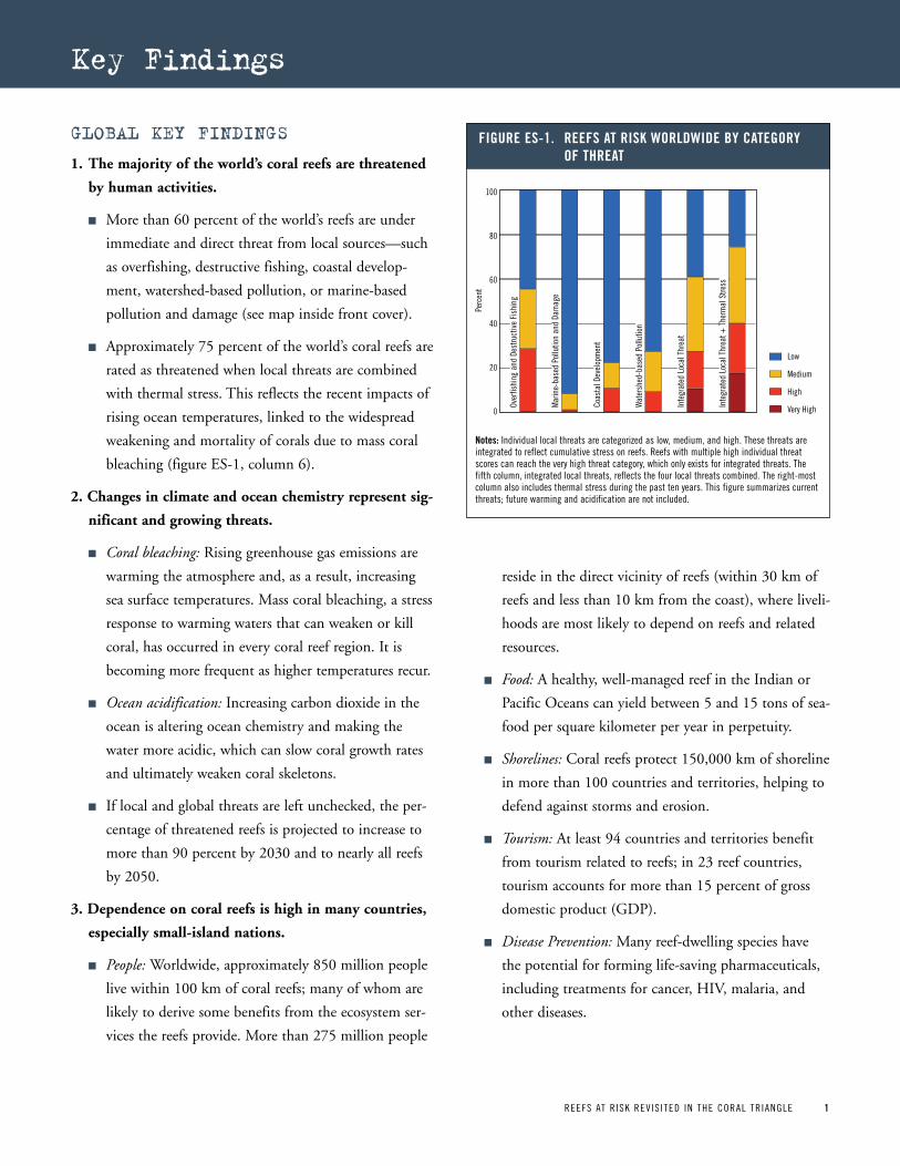
GlobAl Key FindinGs
1. The majority of the world’s coral reefs are threatened
by human activities.
n More than 60 percent of the world’s reefs are under
immediate and direct threat from local sources—such
as overfishing, destructive fishing, coastal develop-
ment, watershed-based pollution, or marine-based
pollution and damage (see map inside front cover).
n Approximately 75 percent of the world’s coral reefs are
rated as threatened when local threats are combined
with thermal stress. This reflects the recent impacts of
rising ocean temperatures, linked to the widespread
weakening and mortality of corals due to mass coral
bleaching (figure ES-1, column 6).
2. Changes in climate and ocean chemistry represent sig-
nificant and growing threats.
n Coral bleaching: Rising greenhouse gas emissions are
warming the atmosphere and, as a result, increasing
sea surface temperatures. Mass coral bleaching, a stress
response to warming waters that can weaken or kill
coral, has occurred in every coral reef region. It is
becoming more frequent as higher temperatures recur.
n Ocean acidification: Increasing carbon dioxide in the
ocean is altering ocean chemistry and making the
water more acidic, which can slow coral growth rates
and ultimately weaken coral skeletons.
n If local and global threats are left unchecked, the per-
centage of threatened reefs is projected to increase to
more than 90 percent by 2030 and to nearly all reefs
by 2050.
3. Dependence on coral reefs is high in many countries,
especially small-island nations.
n People: Worldwide, approximately 850 million people
live within 100 km of coral reefs; many of whom are
likely to derive some benefits from the ecosystem ser-
vices the reefs provide. More than 275 million people
reside in the direct vicinity of reefs (within 30 km of
reefs and less than 10 km from the coast), where liveli-
hoods are most likely to depend on reefs and related
resources.
n Food: A healthy, well-managed reef in the Indian or
Pacific Oceans can yield between 5 and 15 tons of sea-
food per square kilometer per year in perpetuity.
n Shorelines: Coral reefs protect 150,000 km of shoreline
in more than 100 countries and territories, helping to
defend against storms and erosion.
n Tourism: At least 94 countries and territories benefit
from tourism related to reefs; in 23 reef countries,
tourism accounts for more than 15 percent of gross
domestic product (GDP).
n Disease Prevention: Many reef-dwelling species have
the potential for forming life-saving pharmaceuticals,
including treatments for cancer, HIV, malaria, and
other diseases.
Over
fishi
ng a
nd D
estru
ctiv
e Fi
shin
g
Mar
ine-
base
d Po
llutio
n an
d Da
mag
e
Coas
tal D
evel
opm
ent
Wat
ersh
ed-b
ased
Pol
lutio
n
Inte
grat
ed L
ocal
Thr
eat
Inte
grat
ed L
ocal
Thr
eat +
The
rmal
Stre
ss
Figure eS-1 reeFS at riSk worLdwide By Category oF threat
Low
Medium
High
Very High
Perc
ent
100
80
60
40
20
0
notes: Individual local threats are categorized as low, medium, and high. These threats are integrated to reflect cumulative stress on reefs. Reefs with multiple high individual threat scores can reach the very high threat category, which only exists for integrated threats. The fifth column, integrated local threats, reflects the four local threats combined. The right-most column also includes thermal stress during the past ten years. This figure summarizes current threats; future warming and acidification are not included.
Key Findings

2 REEFS AT R ISK REV IS ITED IN THE CORAL TR IANGLE
4. Degradation and loss of reefs will result in significant
social and economic impacts.
n Of the 27 countries and territories most vulnerable to
coral reef degradation and loss, 19 (70 percent) are
small-island states, where people are more likely to
depend on reefs.
n Nine countries—Comoros, Fiji, Grenada, Haiti,
Indonesia, Kiribati, the Philippines, Tanzania, and
Vanuatu—are most vulnerable to the effects of coral
reef degradation. In these countries, reefs face high
threat levels, people are highly dependent on reefs,
and their capacity to adapt to reef loss is limited.
5. While more than one-quarter of the world’s coral reefs
are within protected areas, many of these are ineffec-
tive or only offer partial protection.
n Approximately 28 percent of the world’s coral reefs are
within marine protected areas (MPAs). Of the reef
area inside MPAs, more than half is in Australia.
n Based on our compilation of expert-based ratings of
the management effectiveness of these MPAs, we find
that only 6 percent of the world’s coral reefs are
located in MPAs that are effectively managed.
Fourteen percent are in MPAs rated as only partially
effective at achieving management goals.
6. Policy makers, government officials, resource manag-
ers, and others need to take action to protect reefs,
and to manage risks locally and globally.
n Reefs are resilient—they can recover from coral
bleaching and other impacts—particularly if other
threats are low.
n Reducing local pressures on reefs—overfishing, coastal
development, and pollution—offers the best way to
“buy time” for reefs. Doing so would help reefs sur-
vive warming seas and ocean acidification while the
global community works to reduce emissions of green-
house gases, particularly carbon dioxide.
Key FindinGs FoR The CoRAl TRiAnGle ReGion
1. Threats to coral reefs in the Coral Triangle Region are
much higher than the global average.
n More than 85 percent of reefs within the Coral
Triangle Region are currently threatened by local
stressors, which is substantially higher than the global
average of 60 percent. Nearly 45 percent are at high or
very high threat levels.
n The most widespread local threat to coral reefs in this
region is overfishing, including destructive fishing, which
threatens nearly 85 percent of reefs. Watershed-based pol-
lution is also pervasive, threatening 45 percent of reefs.
Impacts from coastal development threaten more than 30
percent of the region’s reefs (see figure ES-2).
n When the influence of recent thermal stress and coral
bleaching is combined with these local threats, the
percent of reefs rated as threatened increases to more
than 90 percent, which is substantially greater than the
global average of 75 percent (see figure ES-2, column 6.)
Over
fishi
ng a
nd D
estru
ctiv
e Fi
shin
g
Mar
ine-
base
d Po
llutio
n an
d Da
mag
e
Coas
tal D
evel
opm
ent
Wat
ersh
ed-b
ased
Pol
lutio
n
Inte
grat
ed L
ocal
Thr
eat
Inte
grat
ed L
ocal
Thr
eat +
The
rmal
Stre
ss
Figure eS-2 reeFS at riSk in the CoraL triangLe region By Category oF threat
Low
Medium
High
Very High
Perc
ent
100
80
60
40
20
0
note: Individual local threats are categorized as low, medium, and high. These threats are integrated to reflect cumulative stress on reefs. The fifth column, integrated local threats, reflects the four local threats combined. Reefs with multiple high individual local threat scores can reach the very high threat category, which only exists for integrated threats. The right-most column also includes thermal stress during the past ten years. This figure summarizes current threats; future warming and acidification are not included.
REEFS AT R ISK REV IS ITED IN THE CORAL TR IANGLE 3
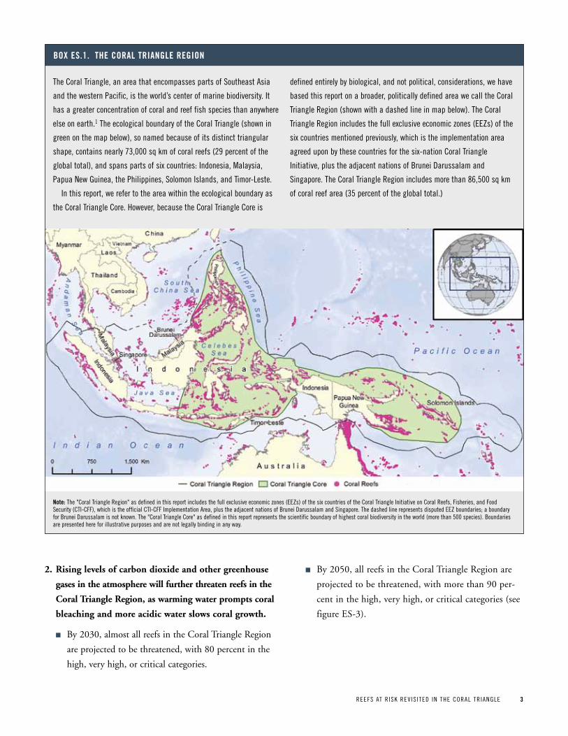
The Coral Triangle, an area that encompasses parts of Southeast Asia
and the western pacific, is the world’s center of marine biodiversity. It
has a greater concentration of coral and reef fish species than anywhere
else on earth.1 The ecological boundary of the Coral Triangle (shown in
green on the map below), so named because of its distinct triangular
shape, contains nearly 73,000 sq km of coral reefs (29 percent of the
global total), and spans parts of six countries: Indonesia, Malaysia,
papua New Guinea, the philippines, Solomon Islands, and Timor-Leste.
In this report, we refer to the area within the ecological boundary as
the Coral Triangle Core. However, because the Coral Triangle Core is
defined entirely by biological, and not political, considerations, we have
based this report on a broader, politically defined area we call the Coral
Triangle Region (shown with a dashed line in map below). The Coral
Triangle Region includes the full exclusive economic zones (EEZs) of the
six countries mentioned previously, which is the implementation area
agreed upon by these countries for the six-nation Coral Triangle
Initiative, plus the adjacent nations of Brunei Darussalam and
Singapore. The Coral Triangle Region includes more than 86,500 sq km
of coral reef area (35 percent of the global total.)
Box eS 1 the CoraL triangLe region
note: The "Coral Triangle Region" as defined in this report includes the full exclusive economic zones (EEZs) of the six countries of the Coral Triangle Initiative on Coral Reefs, Fisheries, and Food Security (CTI-CFF), which is the official CTI-CFF Implementation Area, plus the adjacent nations of Brunei Darussalam and Singapore. The dashed line represents disputed EEZ boundaries; a boundary for Brunei Darussalam is not known. The "Coral Triangle Core" as defined in this report represents the scientific boundary of highest coral biodiversity in the world (more than 500 species). Boundaries are presented here for illustrative purposes and are not legally binding in any way.
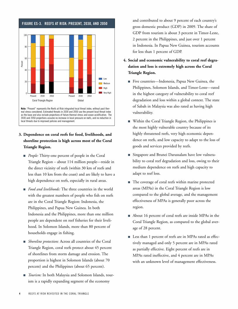
2. Rising levels of carbon dioxide and other greenhouse
gases in the atmosphere will further threaten reefs in the
Coral Triangle Region, as warming water prompts coral
bleaching and more acidic water slows coral growth.
n By 2030, almost all reefs in the Coral Triangle Region
are projected to be threatened, with 80 percent in the
high, very high, or critical categories.
n By 2050, all reefs in the Coral Triangle Region are
projected to be threatened, with more than 90 per-
cent in the high, very high, or critical categories (see
figure ES-3).
4 REEFS AT R ISK REV IS ITED IN THE CORAL TR IANGLE
3. Dependence on coral reefs for food, livelihoods, and
shoreline protection is high across most of the Coral
Triangle Region.
n People: Thirty-one percent of people in the Coral
Triangle Region – about 114 million people—reside in
the direct vicinity of reefs (within 30 km of reefs and
less than 10 km from the coast) and are likely to have a
high dependence on reefs, especially in rural areas.
n Food and livelihoods: The three countries in the world
with the greatest numbers of people who fish on reefs
are in the Coral Triangle Region: Indonesia, the
Philippines, and Papua New Guinea. In both
Indonesia and the Philippines, more than one million
people are dependent on reef fisheries for their liveli-
hood. In Solomon Islands, more than 80 percent of
households engage in fishing.
n Shoreline protection: Across all countries of the Coral
Triangle Region, coral reefs protect about 45 percent
of shorelines from storm damage and erosion. The
proportion is highest in Solomon Islands (about 70
percent) and the Philippines (about 65 percent).
n Tourism: In both Malaysia and Solomon Islands, tour-
ism is a rapidly expanding segment of the economy
and contributed to about 9 percent of each country’s
gross domestic product (GDP) in 2009. The share of
GDP from tourism is about 3 percent in Timor-Leste,
2 percent in the Philippines, and just over 1 percent
in Indonesia. In Papua New Guinea, tourism accounts
for less than 1 percent of GDP.
4. Social and economic vulnerability to coral reef degra-
dation and loss is extremely high across the Coral
Triangle Region.
n Five countries—Indonesia, Papua New Guinea, the
Philippines, Solomon Islands, and Timor-Leste—rated
in the highest category of vulnerability to coral reef
degradation and loss within a global context. The state
of Sabah in Malaysia was also rated as having high
vulnerability.
n Within the Coral Triangle Region, the Philippines is
the most highly vulnerable country because of its
highly threatened reefs, very high economic depen-
dence on reefs, and low capacity to adapt to the loss of
goods and services provided by reefs.
n Singapore and Brunei Darussalam have low vulnera-
bility to coral reef degradation and loss, owing to their
medium dependence on reefs and high capacity to
adapt to reef loss.
n The coverage of coral reefs within marine protected
areas (MPAs) in the Coral Triangle Region is low
compared to the global average, and the management
effectiveness of MPAs is generally poor across the
region.
n About 16 percent of coral reefs are inside MPAs in the
Coral Triangle Region, as compared to the global aver-
age of 28 percent.
n Less than 1 percent of reefs are in MPAs rated as effec-
tively managed and only 5 percent are in MPAs rated
as partially effective. Eight percent of reefs are in
MPAs rated ineffective, and 4 percent are in MPAs
with an unknown level of management effectiveness.
Figure eS-3 reeFS at riSk: preSent, 2030, and 2050
Low
Medium
High
Very High
Perc
ent
100
80
60
40
20
0Present 2030 2050
GlobalCoral Triangle Region
Present 2030 2050
note: “present” represents the Reefs at Risk integrated local threat index, without past ther-mal stress considered. Estimated threats in 2030 and 2050 use the present local threat index as the base and also include projections of future thermal stress and ocean acidification. The 2030 and 2050 projections assume no increase in local pressure on reefs, and no reduction in local threats due to improved policies and management.
REEFS AT R ISK REV IS ITED IN THE CORAL TR IANGLE 5REEFS AT R ISK REV IS ITED IN THE CORAL TR IANGLE 5
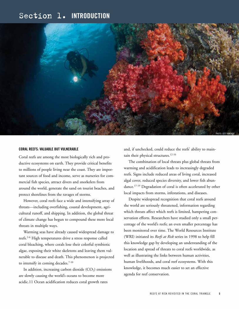
CoraL reeFS: vaLuaBLe But vuLneraBLe
Coral reefs are among the most biologically rich and pro-
ductive ecosystems on earth. They provide critical benefits
to millions of people living near the coast. They are impor-
tant sources of food and income, serve as nurseries for com-
mercial fish species, attract divers and snorkelers from
around the world, generate the sand on tourist beaches, and
protect shorelines from the ravages of storms.
However, coral reefs face a wide and intensifying array of
threats—including overfishing, coastal development, agri-
cultural runoff, and shipping. In addition, the global threat
of climate change has begun to compound these more local
threats in multiple ways.
Warming seas have already caused widespread damage to
reefs.2-6 High temperatures drive a stress response called
coral bleaching, where corals lose their colorful symbiotic
algae, exposing their white skeletons and leaving them vul-
nerable to disease and death. This phenomenon is projected
to intensify in coming decades.7-10
In addition, increasing carbon dioxide (CO2) emissions
are slowly causing the world’s oceans to become more
acidic.11 Ocean acidification reduces coral growth rates
and, if unchecked, could reduce the reefs’ ability to main-
tain their physical structures.12-16
The combination of local threats plus global threats from
warming and acidification leads to increasingly degraded
reefs. Signs include reduced areas of living coral, increased
algal cover, reduced species diversity, and lower fish abun-
dance.17-19 Degradation of coral is often accelerated by other
local impacts from storms, infestations, and diseases.
Despite widespread recognition that coral reefs around
the world are seriously threatened, information regarding
which threats affect which reefs is limited, hampering con-
servation efforts. Researchers have studied only a small per-
centage of the world’s reefs; an even smaller percentage has
been monitored over time. The World Resources Institute
(WRI) initiated its Reefs at Risk series in 1998 to help fill
this knowledge gap by developing an understanding of the
location and spread of threats to coral reefs worldwide, as
well as illustrating the links between human activities,
human livelihoods, and coral reef ecosystems. With this
knowledge, it becomes much easier to set an effective
agenda for reef conservation.
section 1. introduCtion
pHOTO: JEFF yONOVER
6 REEFS AT R ISK REV IS ITED IN THE CORAL TR IANGLE
purpoSe and goaL oF Reefs at Risk Revisited
Under the Reefs at Risk Revisited project, WRI and its part-
ners have developed a new, high-resolution assessment of
the status of and threats to the world’s coral reefs. This
information is intended to raise awareness about the loca-
tion and severity of threats to coral reefs and catalyze
changes in policy and practice that could safeguard coral
reefs and the benefits they provide to future generations.
Reefs at Risk Revisited is a high-resolution update of the
original global analysis, Reefs at Risk: A Map-Based Indicator of
Threats to the World’s Coral Reefs. Reefs at Risk Revisited uses a
global map of coral reefs at 500-m resolution, which is 64
times more detailed than the 4-km map used in the 1998
analysis. New data on threats are also much improved, with
many sources detailing information at 1-km resolution, which
is 16 times more detailed than that used in the 1998 analysis.
Like the original Reefs at Risk, the new study evaluates
threats to coral reefs from a wide range of human activities.
For the first time, it also includes an assessment of climate-
related threats to reefs. In addition, Reefs at Risk Revisited
includes a global assessment of the vulnerability of nations
and territories to coral reef degradation, based on their
dependence on coral reefs and their capacity to adapt to the
loss of reef ecosystem services.
WRI led the Reefs at Risk Revisited analysis in collabora-
tion with a broad partnership of more than 25 research,
conservation, and educational organizations. Partners have
provided data, offered guidance on the analytical approach,
contributed to the report, and served as critical reviewers of
the maps and findings (see the acknowledgments for a full
list of contributors).
This report provides a summary of Reefs at Risk Revisited
results for the world, but provides more detailed results for
the countries in the Coral Triangle Region, which is the
global center of coral diversity. It is intended to support the
six national governments of the Coral Triangle Initiative to
achieve their regional and national plans of action, which
include designating and effectively managing priority sea-
scapes; applying an ecosystem-based approach to manage-
ment of fisheries and other marine resources; establishing
marine protected areas (MPAs), including a region-wide
MPA system; achieving climate change adaptation measures;
and improving the status of threatened species. A complete
description of these goals and other aspects of the six-nation
Coral Triangle Initiative can be found at www.coraltrianglei-
nitiative.org.
The outputs of Reefs at Risk Revisited (report, maps, and
spatial data sets), will be valuable to many users, including
marine conservation practitioners, resource managers, policy
makers, educators, and students. These materials are available
on the Reefs at Risk Revisited website at www.wri.org/reefs, as
well as the Coral Triangle Atlas website ctatlas.reefbase.org.
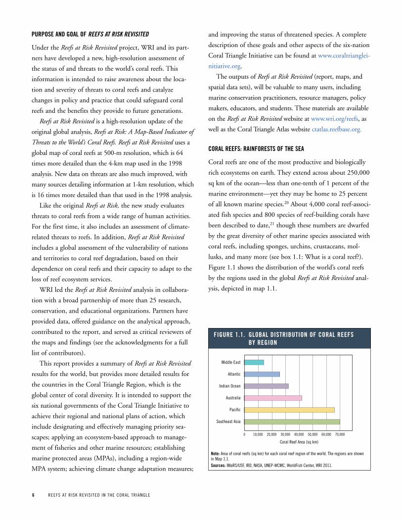
CoraL reeFS: rainForeStS oF the Sea
Coral reefs are one of the most productive and biologically
rich ecosystems on earth. They extend across about 250,000
sq km of the ocean—less than one-tenth of 1 percent of the
marine environment—yet they may be home to 25 percent
of all known marine species.20 About 4,000 coral reef-associ-
ated fish species and 800 species of reef-building corals have
been described to date,21 though these numbers are dwarfed
by the great diversity of other marine species associated with
coral reefs, including sponges, urchins, crustaceans, mol-
lusks, and many more (see box 1.1: What is a coral reef?).
Figure 1.1 shows the distribution of the world’s coral reefs
by the regions used in the global Reefs at Risk Revisited anal-
ysis, depicted in map 1.1.
Figure 1 1 gLoBaL diStriBution oF CoraL reeFS By region
Middle East
Atlantic
Indian Ocean
Australia
Pacific
Southeast Asia
20,000 30,000 40,000 50,000 60,000 70,000
Coral Reef Area (sq km)
0 10,000
note: Area of coral reefs (sq km) for each coral reef region of the world. The regions are shown in Map 1.1.Sources: IMaRS/USF, IRD, NASA, UNEp-WCMC, WorldFish Center, WRI 2011.

REEFS AT R ISK REV IS ITED IN THE CORAL TR IANGLE 7
the CoraL triangLe: the Center oF Marine BiodiverSity
Spanning parts of insular Southeast Asia and the western
Pacific, the Coral Triangle is recognized as the global center
of marine biological diversity, with the highest coral diver-
sity in the world—76 percent of all coral species—as well as
the highest diversity of coral reef fishes in the world—37
percent of all species.1 The area within the ecological
boundary of the Coral Triangle (shown in green in map 1.2)
contains nearly 73,000 sq km of coral reefs—29 percent of
the global total—and spans parts of six countries: Indonesia,
Malaysia, Papua New Guinea, the Philippines, Solomon
Islands, and Timor-Leste. These six countries have signed
and agreed to a regional plan of action called the Coral
Triangle Initiative, a collaboration that aims to protect this
important area, and each have developed national plans of
action that are aligned with the regional plan. Together, the
regional and national plans serve as the road map for joint
and cooperative action to achieve the goals of the Coral
Triangle Initiative, which focus on reducing threats in order
to preserve the marine, coastal, and small-island ecosystems
of this area (see section 6 for additional information about
the Coral Triangle Initiative).
In this report, we refer to the area within the ecological
boundary of the Coral Triangle, which designates the area
of the world’s highest marine biodiversity, as the Coral
Triangle Core. However, because the Coral Triangle Core
is defined entirely by biological and not political consider-
ations, we have based this report on a broader, politically
Map 1 1 Major CoraL reeF regionS oF the worLd aS deFined For the gLoBaL Reefs at Risk Revisited anaLySiS
Coral reefs are physical structures built by the actions of many tiny
coral animals that live in large colonies and lay down communal
limestone skeletons. Over millennia, the combined mass of skele-
tons build up into huge reefs, some of which are visible from space.
There are some 800 species of reef-building corals and they have
exacting requirements, needing bright, clear, and warm waters. The
individual coral animals, known as polyps, have a tubular body and
central mouth ringed by stinging tentacles, which can capture food.
Living within their body tissues are microscopic algae (zooxanthel-
lae) that need sunlight to survive. These algae convert sunlight into
sugars, which produces energy to help sustain their coral hosts.
These same algae also provide the corals with their vibrant colors.
The complex three-dimensional surface of the reef provides a
home to many other species. Some 4,000 species of fish are found
here (approximately one-quarter of all marine fish species), along
with a vast array of other life forms—mollusks, crustaceans, sea
urchins, starfish, sponges, tube-worms and many more. There are
perhaps 1 million species found in a habitat that covers a total of
about 250,000 sq km (roughly the area of the United Kingdom).22
Box 1 1 what iS a CoraL reeF?
pHOT
O: M
ARK
GODF
REy
8 REEFS AT R ISK REV IS ITED IN THE CORAL TR IANGLE
Figure 1 2 CoraL reeF area per Country in the CoraL triangLe region
Singapore
Brunei
Timor-Leste
Malaysia
Solomon Islands
Papua New Guinea
Philippines
Indonesia
10,000 15,000 20,000 25,000 30,000 35,000
Coral Reef Area (sq km)
0 5,000
Sources: IMaRS/USF, IRD, NASA, UNEp-WCMC, WorldFish Center, and WRI, 2011.
40,000
Map 1 2 the CoraL triangLe region
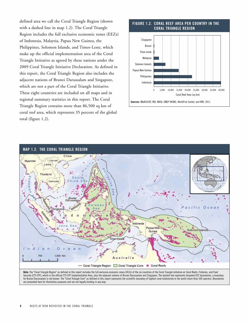
defined area we call the Coral Triangle Region (shown
with a dashed line in map 1.2). The Coral Triangle
Region includes the full exclusive economic zones (EEZs)
of Indonesia, Malaysia, Papua New Guinea, the
Philippines, Solomon Islands, and Timor-Leste, which
make up the official implementation area of the Coral
Triangle Initiative as agreed by these nations under the
2009 Coral Triangle Initiative Declaration. As defined in
this report, the Coral Triangle Region also includes the
adjacent nations of Brunei Darussalam and Singapore,
which are not a part of the Coral Triangle Initiative.
These eight countries are included on all maps and in
regional summary statistics in this report. The Coral
Triangle Region contains more than 86,500 sq km of
coral reef area, which represents 35 percent of the global
total (figure 1.2).
note: The "Coral Triangle Region" as defined in this report includes the full exclusive economic zones (EEZs) of the six countries of the Coral Triangle Initiative on Coral Reefs, Fisheries, and Food Security (CTI-CFF), which is the official CTI-CFF Implementation Area, plus the adjacent nations of Brunei Darussalam and Singapore. The dashed line represents disputed EEZ boundaries; a boundary for Brunei Darussalam is not known. The "Coral Triangle Core" as defined in this report represents the scientific boundary of highest coral biodiversity in the world (more than 500 species). Boundaries are presented here for illustrative purposes and are not legally binding in any way.
REEFS AT R ISK REV IS ITED IN THE CORAL TR IANGLE 9
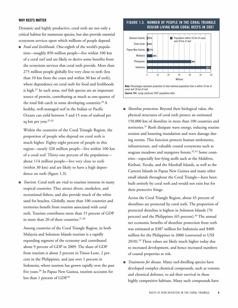
why reeFS Matter
Dynamic and highly productive, coral reefs are not only a
critical habitat for numerous species, but also provide essential
ecosystem services upon which millions of people depend.
n Food and livelihoods. One-eighth of the world’s popula-
tion—roughly 850 million people—live within 100 km
of a coral reef and are likely to derive some benefits from
the ecosystem services that coral reefs provide. More than
275 million people globally live very close to reefs (less
than 10 km from the coast and within 30 km of reefs),
where dependence on coral reefs for food and livelihoods
is high.23 In such areas, reef fish species are an important
source of protein, contributing as much as one-quarter of
the total fish catch in some developing countries.24 A
healthy, well-managed reef in the Indian or Pacific
Oceans can yield between 5 and 15 tons of seafood per
sq km per year.25,26
Within the countries of the Coral Triangle Region, the
proportion of people who depend on coral reefs is
much higher. Eighty-eight percent of people in this
region—nearly 320 million people—live within 100 km
of a coral reef. Thirty-one percent of the population—
about 114 million people—live very close to reefs
(within 30 km) and are likely to have a high depen-
dence on reefs (figure 1.3).
n Tourism. Coral reefs are vital to tourism interests in many
tropical countries. They attract divers, snorkelers, and
recreational fishers, and also provide much of the white
sand for beaches. Globally, more than 100 countries and
territories benefit from tourism associated with coral
reefs. Tourism contributes more than 15 percent of GDP
in more than 20 of these countries.27,28
Among countries of the Coral Triangle Region, in both
Malaysia and Solomon Islands tourism is a rapidly
expanding segment of the economy and contributed
about 9 percent of GDP in 2009. The share of GDP
from tourism is about 3 percent in Timor-Leste, 2 per-
cent in the Philippines, and just over 1 percent in
Indonesia, where tourism has grown rapidly over the past
five years.29 In Papua New Guinea, tourism accounts for
less than 1 percent of GDP.30
n Shoreline protection. Beyond their biological value, the
physical structures of coral reefs protect an estimated
150,000 km of shoreline in more than 100 countries and
territories.31 Reefs dissipate wave energy, reducing routine
erosion and lessening inundation and wave damage dur-
ing storms. This function protects human settlements,
infrastructure, and valuable coastal ecosystems such as
seagrass meadows and mangrove forests.32,33 Some coun-
tries—especially low-lying atolls such as the Maldives,
Kiribati, Tuvalu, and the Marshall Islands, as well as the
Carteret Islands in Papua New Guinea and many other
small islands throughout the Coral Triangle—have been
built entirely by coral reefs and would not exist but for
their protective fringe.
Across the Coral Triangle Region, about 45 percent of
shorelines are protected by coral reefs. The proportion of
protected shoreline is highest in Solomon Islands (70
percent) and the Philippines (65 percent).34 The annual
net economic benefits of shoreline protection from reefs
was estimated at $387 million for Indonesia and $400
million for the Philippines in 2000 (converted to US$
2010).35 These values are likely much higher today due
to increased development, and hence increased numbers
of coastal properties at risk.
n Treatments for disease. Many reef-dwelling species have
developed complex chemical compounds, such as venoms
and chemical defenses, to aid their survival in these
highly competitive habitats. Many such compounds have
Figure 1 3 nuMBer oF peopLe in the CoraL triangLe region Living near CoraL reeFS in 2007
Solomon Islands
Timor-Leste
Papua New Guinea
Malaysia
Philippines
Indonesia
20 30 40 50 60
Millions
0 10
note: percentages represent proportion of total national population that is within 10 km of coast and 30 km of reef.Source: WRI, using Landscan 2007 population data.
Population within 10 km of coast and 30 km of reef
97%
20%
26%
46%
27%
53%
10 REEFS AT R ISK REV IS ITED IN THE CORAL TR IANGLE
Human pressures on coral reefs are categorized throughout the report as
either “local” or “global” in origin. These categories are used to distin-
guish between threats from human activities near reefs, which have a
direct and relatively localized impact, versus threats that affect reefs indi-
rectly through human impacts on the global climate and ocean chemistry.
Local threats addressed in this analysis are:
• Coastal development, including coastal engineering, runoff from
coastal construction, sewage discharge, and impacts from unsus-
tainable tourism.
• Watershed-based pollution, focusing on erosion and nutrient fertilizer
runoff from agriculture delivered to coastal waters from rivers.
• Marine-based pollution and damage, including solid waste, nutrients,
toxins from oil and gas installations and shipping, and physical
damage from anchors and ship groundings.
• Overfishing and destructive fishing, including unsustainable har-
vesting of fish or invertebrates, and damaging fishing practices such
as the use of explosives or poisons.
Global threats addressed in this analysis:
• Thermal stress, including warming sea temperatures, which can
induce widespread or “mass” coral bleaching.
• Ocean acidification driven by increased CO2 concentrations, which
can reduce coral growth rates.
Each of the four local threats were modeled separately and subse-
quently combined in the Reefs at Risk integrated local threat index. For
each local threat, an indicator was developed using data reflecting vari-
ous “stressors,” such as human population density and infrastructure
features (including the location and size of cities, ports, and hotels), as
well as more complex modeled estimates such as sediment input from
rivers. Threat diminishes with distance from each stressor. Thresholds
for low, medium, and high threats were developed using available infor-
mation on observed impacts to coral reefs.
Local threats were modeled at WRI; data and models for global
threats were obtained from external climate experts. Climate-related
stressors are based on data from satellite observations of sea surface
temperature, coral bleaching observations, and modeled estimates of
future ocean warming and acidification. Input from coral reef scientists
and climate change experts contributed to the selection of thresholds
for the global threats.
Modeled outputs were further tested and calibrated against available
information on coral reef condition and observed impacts on coral reefs.
All threats were categorized as low, medium, or high, both to simplify
the findings and to enable comparison between findings for different
threats. In the presentation of findings, “threatened” refers to coral
reefs classified at medium or high threat.
The analysis method is of necessity a simplification of human activi-
ties and complex natural processes. The model relies on available data
and predicted relationships, but cannot capture all aspects of the
dynamic interactions between people, climate, and coral reefs. Climate
change science, in particular, is a relatively new field in which the com-
plex interactions between reefs and their changing environment are not
yet fully understood. The threat indicators gauge current and potential
risks associated with human activities, climate change, and ocean
acidification. A strength of the analysis lies in its use of globally consis-
tent data sets to develop global indicators of human pressure on coral
reefs. We purposefully use a conservative approach to the modeling, in
which thresholds for threat grades are set at reasonably high levels to
avoid exaggeration.
Full technical notes, including data sources and threat category
thresholds, and a list of data contributors are available online at
http://www.wri.org/reefs.
Box 1 2 Method For anaLyzing threatS to reeFS
the potential to form the basis of life-saving pharmaceuti-
cals. Explorations into the medical application of reef-
related compounds to date include treatments for cancer,
HIV, malaria, and other diseases.36 Since only a small
portion of reef life has been sampled, there is still vast
potential for new pharmaceutically valuable discoveries.36
REEFS AT R ISK REV IS ITED IN THE CORAL TR IANGLE 11REEFS AT R ISK REV IS ITED IN THE CORAL TR IANGLE 11
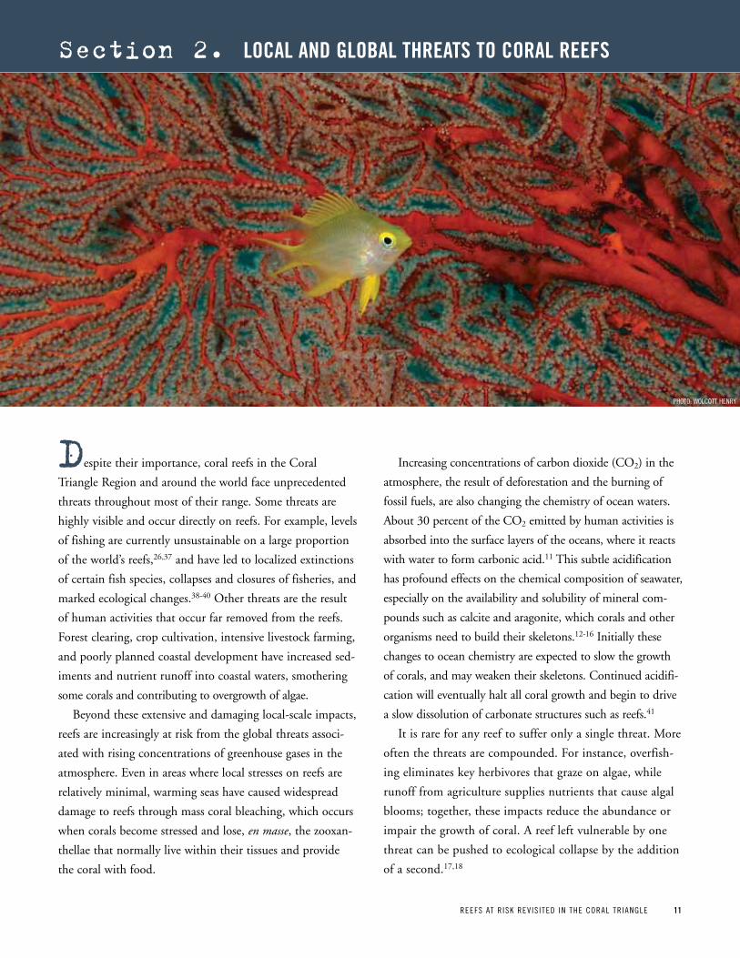
despite their importance, coral reefs in the Coral
Triangle Region and around the world face unprecedented
threats throughout most of their range. Some threats are
highly visible and occur directly on reefs. For example, levels
of fishing are currently unsustainable on a large proportion
of the world’s reefs,26,37 and have led to localized extinctions
of certain fish species, collapses and closures of fisheries, and
marked ecological changes.38-40 Other threats are the result
of human activities that occur far removed from the reefs.
Forest clearing, crop cultivation, intensive livestock farming,
and poorly planned coastal development have increased sed-
iments and nutrient runoff into coastal waters, smothering
some corals and contributing to overgrowth of algae.
Beyond these extensive and damaging local-scale impacts,
reefs are increasingly at risk from the global threats associ-
ated with rising concentrations of greenhouse gases in the
atmosphere. Even in areas where local stresses on reefs are
relatively minimal, warming seas have caused widespread
damage to reefs through mass coral bleaching, which occurs
when corals become stressed and lose, en masse, the zooxan-
thellae that normally live within their tissues and provide
the coral with food.
Increasing concentrations of carbon dioxide (CO2) in the
atmosphere, the result of deforestation and the burning of
fossil fuels, are also changing the chemistry of ocean waters.
About 30 percent of the CO2 emitted by human activities is
absorbed into the surface layers of the oceans, where it reacts
with water to form carbonic acid.11 This subtle acidification
has profound effects on the chemical composition of seawater,
especially on the availability and solubility of mineral com-
pounds such as calcite and aragonite, which corals and other
organisms need to build their skeletons.12-16 Initially these
changes to ocean chemistry are expected to slow the growth
of corals, and may weaken their skeletons. Continued acidifi-
cation will eventually halt all coral growth and begin to drive
a slow dissolution of carbonate structures such as reefs.41
It is rare for any reef to suffer only a single threat. More
often the threats are compounded. For instance, overfish-
ing eliminates key herbivores that graze on algae, while
runoff from agriculture supplies nutrients that cause algal
blooms; together, these impacts reduce the abundance or
impair the growth of coral. A reef left vulnerable by one
threat can be pushed to ecological collapse by the addition
of a second.17,18
section 2. LoCaL and gLoBaL threatS to CoraL reeFS
pHOTO: WOLCOTT HENRy
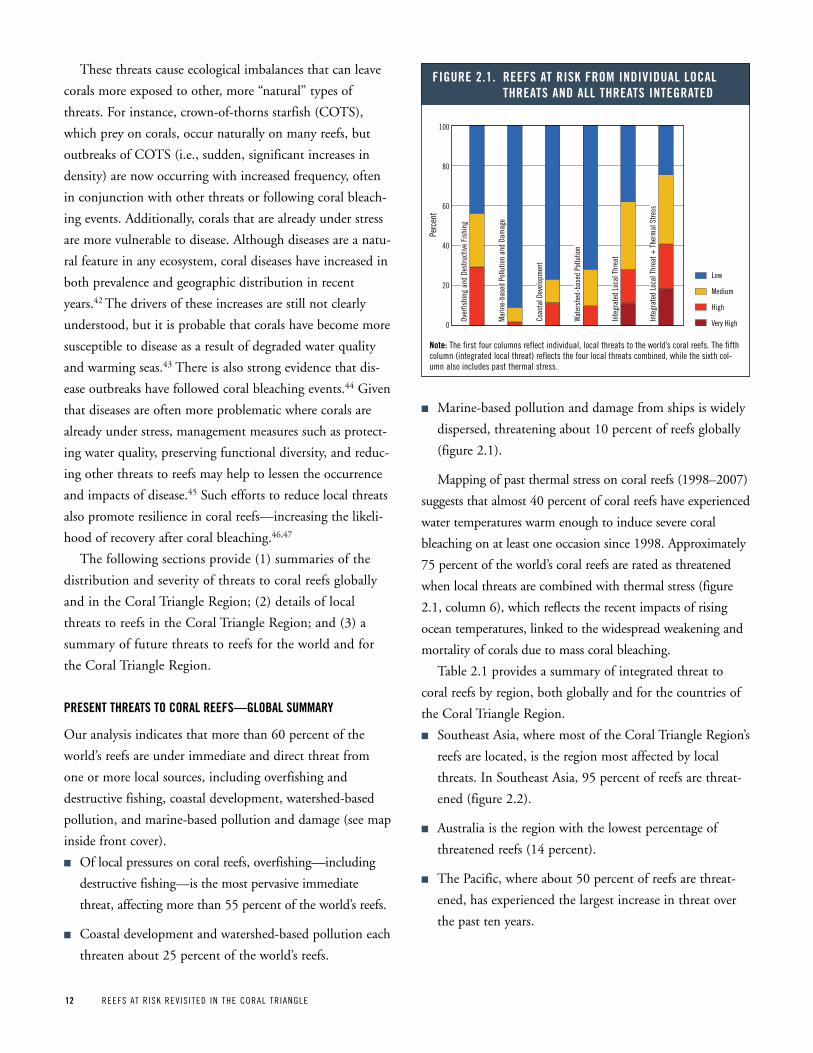
12 REEFS AT R ISK REV IS ITED IN THE CORAL TR IANGLE
These threats cause ecological imbalances that can leave
corals more exposed to other, more “natural” types of
threats. For instance, crown-of-thorns starfish (COTS),
which prey on corals, occur naturally on many reefs, but
outbreaks of COTS (i.e., sudden, significant increases in
density) are now occurring with increased frequency, often
in conjunction with other threats or following coral bleach-
ing events. Additionally, corals that are already under stress
are more vulnerable to disease. Although diseases are a natu-
ral feature in any ecosystem, coral diseases have increased in
both prevalence and geographic distribution in recent
years.42 The drivers of these increases are still not clearly
understood, but it is probable that corals have become more
susceptible to disease as a result of degraded water quality
and warming seas.43 There is also strong evidence that dis-
ease outbreaks have followed coral bleaching events.44 Given
that diseases are often more problematic where corals are
already under stress, management measures such as protect-
ing water quality, preserving functional diversity, and reduc-
ing other threats to reefs may help to lessen the occurrence
and impacts of disease.45 Such efforts to reduce local threats
also promote resilience in coral reefs—increasing the likeli-
hood of recovery after coral bleaching.46,47
The following sections provide (1) summaries of the
distribution and severity of threats to coral reefs globally
and in the Coral Triangle Region; (2) details of local
threats to reefs in the Coral Triangle Region; and (3) a
summary of future threats to reefs for the world and for
the Coral Triangle Region.
preSent threatS to CoraL reeFS—gLoBaL SuMMary
Our analysis indicates that more than 60 percent of the
world’s reefs are under immediate and direct threat from
one or more local sources, including overfishing and
destructive fishing, coastal development, watershed-based
pollution, and marine-based pollution and damage (see map
inside front cover).
n Of local pressures on coral reefs, overfishing—including
destructive fishing—is the most pervasive immediate
threat, affecting more than 55 percent of the world’s reefs.
n Coastal development and watershed-based pollution each
threaten about 25 percent of the world’s reefs.
n Marine-based pollution and damage from ships is widely
dispersed, threatening about 10 percent of reefs globally
(figure 2.1).
Mapping of past thermal stress on coral reefs (1998–2007)
suggests that almost 40 percent of coral reefs have experienced
water temperatures warm enough to induce severe coral
bleaching on at least one occasion since 1998. Approximately
75 percent of the world’s coral reefs are rated as threatened
when local threats are combined with thermal stress (figure
2.1, column 6), which reflects the recent impacts of rising
ocean temperatures, linked to the widespread weakening and
mortality of corals due to mass coral bleaching.
Table 2.1 provides a summary of integrated threat to
coral reefs by region, both globally and for the countries of
the Coral Triangle Region.
n Southeast Asia, where most of the Coral Triangle Region’s
reefs are located, is the region most affected by local
threats. In Southeast Asia, 95 percent of reefs are threat-
ened (figure 2.2).
n Australia is the region with the lowest percentage of
threatened reefs (14 percent).
n The Pacific, where about 50 percent of reefs are threat-
ened, has experienced the largest increase in threat over
the past ten years.
Over
fishi
ng a
nd D
estru
ctiv
e Fi
shin
g
Mar
ine-
base
d Po
llutio
n an
d Da
mag
e
Coas
tal D
evel
opm
ent
Wat
ersh
ed-b
ased
Pol
lutio
n
Inte
grat
ed L
ocal
Thr
eat
Inte
grat
ed L
ocal
Thr
eat +
The
rmal
Stre
ss
Figure 2 1 reeFS at riSk FroM individuaL LoCaL threatS and aLL threatS integrated
Low
Medium
High
Very High
Perc
ent
100
80
60
40
20
0
note: The first four columns reflect individual, local threats to the world’s coral reefs. The fifth column (integrated local threat) reflects the four local threats combined, while the sixth col-umn also includes past thermal stress.

REEFS AT R ISK REV IS ITED IN THE CORAL TR IANGLE 13
preSent threatS to CoraL reeFS in the CoraL triangLe region
Local pressure on coral reefs within the Coral Triangle
Region is high compared to the global average. Within the
countries of this region, more than 85 percent of reefs are
rated as threatened, with nearly 45 percent at high or very
high risk (map 2.2). Overfishing, including destructive fish-
ing, is the most pervasive and damaging threat, affecting
nearly 85 percent of reefs. Destructive fishing—the use of
explosives and poisons to kill or capture fish—is common
throughout much of the Coral Triangle Region, particularly
in East Malaysia, the Philippines, and Indonesia, threaten-
ing nearly 60 percent of the region’s reefs (map 2.1).
Threats emanating from land-based sources contribute
significantly to overall threat as well. Watershed-based pollu-
tion threatens 45 percent of the region’s reefs, while coastal
development threatens more than 30 percent. Marine-based
pollution and damage are the least pervasive threats across
the Coral Triangle Region, threatening fewer than 5 percent
of reefs (figure 2.3).
When the effects of recent thermal stress and coral
bleaching are combined with local threats, the estimate of
threat to reefs across the region increases to more than 90
percent, with the percent of reefs rated at high or very high
increasing to nearly 55 percent (column 6 of figure 2.3).
In the Philippines, Malaysia, and Timor-Leste, nearly all
reefs are rated as threatened by one or more local threats. In
Indonesia, this measure is only slightly lower, at about 93
percent. Solomon Islands and Papua New Guinea have lower
percentages of threatened reefs, at about 70 percent and 55
percent, respectively (figure 2.4). Table 2.1 provides a sum-
mary of threat for the eight countries in the Coral Triangle
Region. Map 2.2 reflects the distribution of present inte-
grated local threat to reefs. These threats have increased sig-
nificantly across the region over the past ten years (box 2.1).
Sout
heas
t Asi
a
Paci
fic
Aust
ralia
Atla
ntic
Indi
an O
cean
Mid
dle
East
Figure 2 2 reeFS at riSk FroM integrated LoCaL threatS (by area of reef)
Low
Medium
High
Very High
Reef
Are
a (s
q km
)
70,000
60,000
50,000
40,000
30,000
20,000
10,000
0
note: Amount of reef area (in sq km) in each region classified by integrated local threat.
Map 2 1 oBServationS oF BLaSt or poiSon FiShing in the CoraL triangLe region
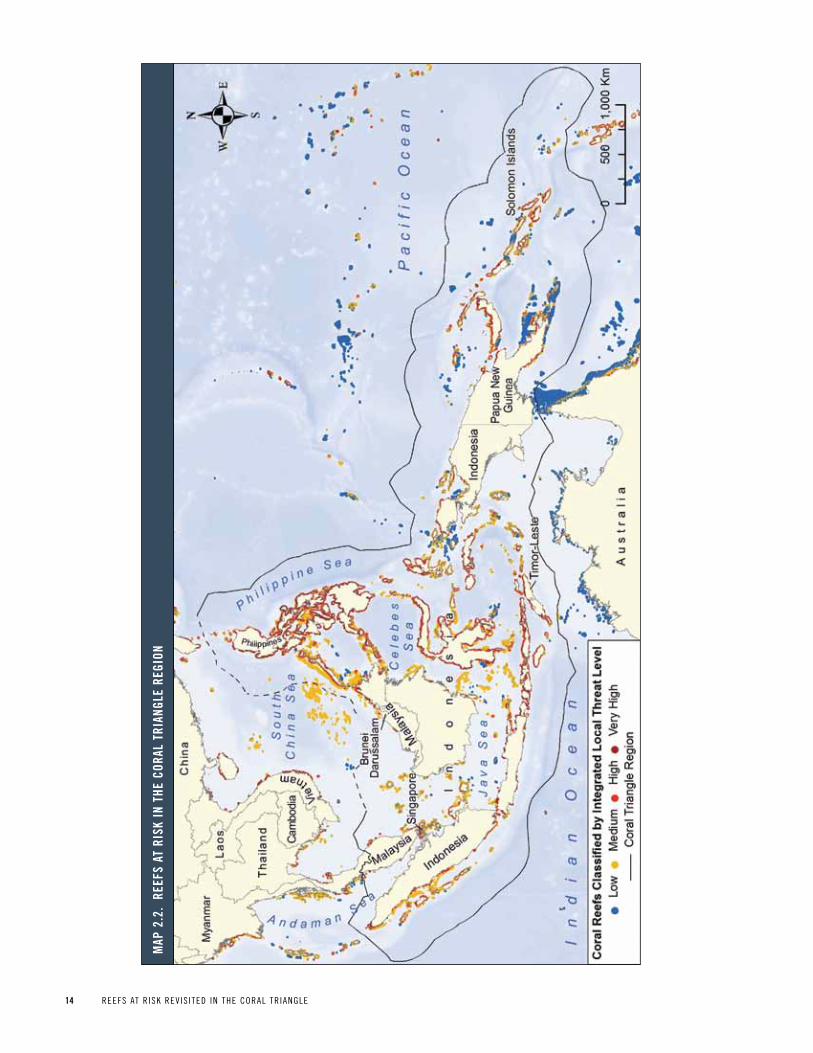
14 REEFS AT R ISK REV IS ITED IN THE CORAL TR IANGLE
Map
2 2
re
eFS
at r
iSk
in t
he C
oraL
tri
angL
e re
gion

REEFS AT R ISK REV IS ITED IN THE CORAL TR IANGLE 15
taBLe 2 1 integrated threat to CoraL reeFS For gLoBaL “reeFS at riSk” regionS and For the CountrieS oF the CoraL triangLe region
regionreef area (sq km)
reef area as percent of global
integrated Local threatSevere thermal stress
(1998 – 2007) (%)
integrated Local + thermal threat
(medium or higher) (%)
Coastal population (within 30
km of reef)a ‘000
reef area in
Mpas (%) Low (%)
Medium (%)
high (%)
very high (%)
threatened (medium or
higher) (%)
Atlantic 25,849 10 25 44 18 13 75 56 92 42,541 30
Australia 42,315 17 86 13 1 0 14 33 40 3,509 75
Indian Ocean 31,543 13 34 32 21 13 66 50 82 65,152 19
Middle East 14,399 6 35 44 13 8 65 36 76 19,041 12
pacific 65,972 26 52 28 15 5 48 41 65 7,487 13
Southeast Asia 69,637 28 6 47 28 20 94 27 95 138,156 19
global 249,713 100 39 34 17 10 61 38 75 275,886 28
Countries of the Coral triangle Region
Brunei Darussalam 109 <1 0 94 6 0 100 49 100 323 <1
Indonesia 39,538 16 7 55 26 12 93 16 93 59,784 29
Malaysiab 2,935 1 1 56 34 9 99 9 100 5,065 7
papua New Guinea 14,535 6 45 26 22 7 55 54 78 1,570 5
philippinesb 22,484 9 2 30 34 34 98 47 99 41,283 7
Singapore 13 <1 0 0 0 100 100 100 100 4,497 6
Solomon Islands 6,743 3 29 42 24 6 71 36 82 540 6
Timor-Leste 146 <1 0 8 48 43 100 0 100 564 0
Coral triangle region 86,503 35 14 43 27 16 86 32 92 113,626 16
notes:a. population statistics represent the human population living less than 10 km from the coast as well as within 30 km of a coral reef.b. Statistics for the philippines and Malaysia do not include disputed territory in the South China Sea.
Sources: 1 reef area estimates: Calculated at WRI based on 500-m resolution gridded data assembled under the Reefs at Risk Revisited project from Institute for Marine Remote Sensing, University of South
Florida (IMaRS/USF), Institut de Recherche pour le Développement (IRD/UR), UNEp-WCMC, The World Fish Center, and WRI (2011).2 Coastal population within 30 km of reef: Derived at WRI from LandScan population data (2007) and World Vector Shoreline (2004).3 number of Mpas: Compiled at WRI from the World Database of protected Areas (WDpA), ReefBase pacific, The Nature Conservancy, the Coral Triangle Atlas, the Indonesian Ministry of Marine Affairs and
Fisheries, and the Great Barrier Reef Marine park Authority.
Figure 2 3 reeFS at riSk FroM individuaL LoCaL threatS and aLL threatS integrated in the CoraL triangLe region
note: The first four columns reflect individual, local threats to the region’s coral reefs. The fifth column (integrated local threat) reflects the four local threats combined, while the sixth column also includes past thermal stress.
Over
fishi
ng a
nd D
estru
ctiv
e Fi
shin
g
Mar
ine-
base
d Po
llutio
n an
d Da
mag
e
Coas
tal D
evel
opm
ent
Wat
ersh
ed-b
ased
Pol
lutio
n
Inte
grat
ed L
ocal
Thr
eat
Inte
grat
ed L
ocal
Thr
eat +
The
rmal
Stre
ss
Low
Medium
High
Very High
Perc
ent
100
80
60
40
20
0
Figure 2 4 reeFS at riSk FroM integrated LoCaL threatS For the CountrieS oF the CoraL triangLe region
Low
Medium
High
Very High
note: Integrated local threats consist of the four local threats—overfishing and destructive fishing, marine pollution and damage, coastal development, and watershed-based pollution.
Perc
ent
100
80
60
40
20
0
Timor
-Les
te
Solo
mon
Isla
nds
Indo
nesi
a
Papu
a Ne
w Gu
inea
Phili
ppin
es
Glob
al
Mal
aysi
a
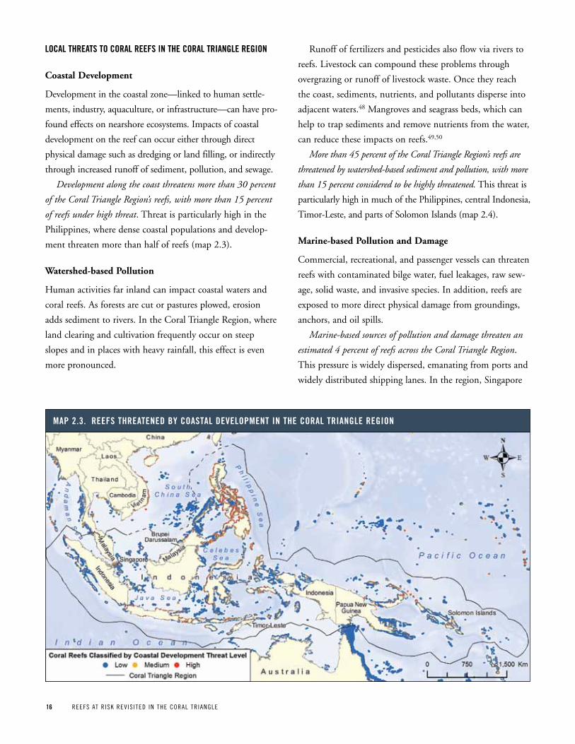
16 REEFS AT R ISK REV IS ITED IN THE CORAL TR IANGLE
LoCaL threatS to CoraL reeFS in the CoraL triangLe region
Coastal Development
Development in the coastal zone—linked to human settle-
ments, industry, aquaculture, or infrastructure—can have pro-
found effects on nearshore ecosystems. Impacts of coastal
development on the reef can occur either through direct
physical damage such as dredging or land filling, or indirectly
through increased runoff of sediment, pollution, and sewage.
Development along the coast threatens more than 30 percent
of the Coral Triangle Region’s reefs, with more than 15 percent
of reefs under high threat. Threat is particularly high in the
Philippines, where dense coastal populations and develop-
ment threaten more than half of reefs (map 2.3).
Watershed-based Pollution
Human activities far inland can impact coastal waters and
coral reefs. As forests are cut or pastures plowed, erosion
adds sediment to rivers. In the Coral Triangle Region, where
land clearing and cultivation frequently occur on steep
slopes and in places with heavy rainfall, this effect is even
more pronounced.
Runoff of fertilizers and pesticides also flow via rivers to
reefs. Livestock can compound these problems through
overgrazing or runoff of livestock waste. Once they reach
the coast, sediments, nutrients, and pollutants disperse into
adjacent waters.48 Mangroves and seagrass beds, which can
help to trap sediments and remove nutrients from the water,
can reduce these impacts on reefs.49,50
More than 45 percent of the Coral Triangle Region’s reefs are
threatened by watershed-based sediment and pollution, with more
than 15 percent considered to be highly threatened. This threat is
particularly high in much of the Philippines, central Indonesia,
Timor-Leste, and parts of Solomon Islands (map 2.4).
Marine-based Pollution and Damage
Commercial, recreational, and passenger vessels can threaten
reefs with contaminated bilge water, fuel leakages, raw sew-
age, solid waste, and invasive species. In addition, reefs are
exposed to more direct physical damage from groundings,
anchors, and oil spills.
Marine-based sources of pollution and damage threaten an
estimated 4 percent of reefs across the Coral Triangle Region.
This pressure is widely dispersed, emanating from ports and
widely distributed shipping lanes. In the region, Singapore
Map 2 3 reeFS threatened By CoaStaL deveLopMent in the CoraL triangLe region
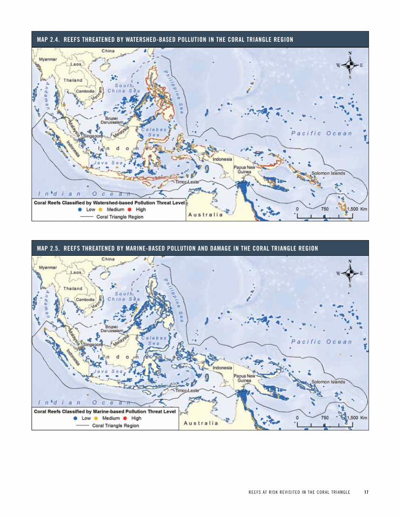
REEFS AT R ISK REV IS ITED IN THE CORAL TR IANGLE 17
Map 2 4 reeFS threatened By waterShed-BaSed poLLution in the CoraL triangLe region
Map 2 5 reeFS threatened By Marine-BaSed poLLution and daMage in the CoraL triangLe region
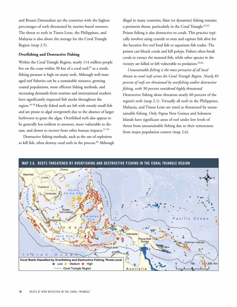
18 REEFS AT R ISK REV IS ITED IN THE CORAL TR IANGLE
and Brunei Darussalam are the countries with the highest
percentages of reefs threatened by marine-based stressors.
The threat to reefs in Timor-Leste, the Philippines, and
Malaysia is also above the average for the Coral Triangle
Region (map 2.5).
Overfishing and Destructive Fishing
Within the Coral Triangle Region, nearly 114 million people
live on the coast within 30 km of a coral reef;53 as a result,
fishing pressure is high on many reefs. Although well-man-
aged reef fisheries can be a sustainable resource, growing
coastal populations, more efficient fishing methods, and
increasing demands from tourism and international markets
have significantly impacted fish stocks throughout the
region.54-56 Heavily fished reefs are left with mostly small fish
and are prone to algal overgrowth due to the absence of larger
herbivores to graze the algae. Overfished reefs also appear to
be generally less resilient to stressors, more vulnerable to dis-
ease, and slower to recover from other human impacts.57-59
Destructive fishing methods, such as the use of explosives
to kill fish, often destroy coral reefs in the process.60 Although
illegal in many countries, blast (or dynamite) fishing remains
a persistent threat, particularly in the Coral Triangle.61,62
Poison fishing is also destructive to corals. This practice typi-
cally involves using cyanide to stun and capture fish alive for
the lucrative live reef food fish or aquarium fish trades. The
poison can bleach corals and kill polyps. Fishers often break
corals to extract the stunned fish, while other species in the
vicinity are killed or left vulnerable to predation.63,64
Unsustainable fishing is the most pervasive of all local
threats to coral reefs across the Coral Triangle Region. Nearly 85
percent of reefs are threatened by overfishing and/or destructive
fishing, with 50 percent considered highly threatened.
Destructive fishing alone threatens nearly 60 percent of the
region’s reefs (map 2.1). Virtually all reefs in the Philippines,
Malaysia, and Timor-Leste are rated as threatened by unsus-
tainable fishing. Only Papua New Guinea and Solomon
Islands have significant areas of reef under low levels of
threat from unsustainable fishing due to their remoteness
from major population centers (map 2.6).
Map 2 6 reeFS threatened By overFiShing and deStruCtive FiShing in the CoraL triangLe region
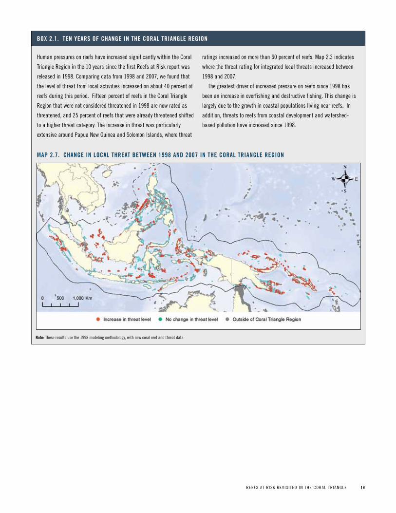
REEFS AT R ISK REV IS ITED IN THE CORAL TR IANGLE 19
Human pressures on reefs have increased significantly within the Coral
Triangle Region in the 10 years since the first Reefs at Risk report was
released in 1998. Comparing data from 1998 and 2007, we found that
the level of threat from local activities increased on about 40 percent of
reefs during this period. Fifteen percent of reefs in the Coral Triangle
Region that were not considered threatened in 1998 are now rated as
threatened, and 25 percent of reefs that were already threatened shifted
to a higher threat category. The increase in threat was particularly
extensive around papua New Guinea and Solomon Islands, where threat
ratings increased on more than 60 percent of reefs. Map 2.3 indicates
where the threat rating for integrated local threats increased between
1998 and 2007.
The greatest driver of increased pressure on reefs since 1998 has
been an increase in overfishing and destructive fishing. This change is
largely due to the growth in coastal populations living near reefs. In
addition, threats to reefs from coastal development and watershed-
based pollution have increased since 1998.
Box 2 1 ten yearS oF Change in the CoraL triangLe region
Map 2 7 Change in LoCaL threat Between 1998 and 2007 in the CoraL triangLe region
note: These results use the 1998 modeling methodology, with new coral reef and threat data.
20 REEFS AT R ISK REV IS ITED IN THE CORAL TR IANGLE
Future threatS to CoraL reeFS
Population growth, increased demand for fish and agricul-
tural products, and further development along coasts will
escalate pressures on coral reefs in the future. However, the
single greatest growing threat to coral reefs is the rapid
increase in greenhouse gases in the atmosphere, including
carbon dioxide (CO2), methane, nitrous oxide, and halocar-
bons, with CO2 contributing most to both warming and
acidification. Since preindustrial times, atmospheric concen-
trations of all of these greenhouse gases have increased signif-
icantly. In terms of CO2-equivalents, total greenhouse gas
emissions increased by 70 percent between 1970 and 2004.65
Mass coral bleaching, a stress response to abnormally warm
waters across wide expanses of coral reefs, is becoming more
frequent, more intense, and more widespread as higher tem-
peratures recur.8,66,67 Severe or prolonged bleaching events can
kill corals outright, while less extreme events can weaken cor-
als by reducing their growth rates and reproductive potential,
and leave them more vulnerable to disease. While corals can
recover from bleaching, studies have found that other local
stressors, such as pollution, diminish their resilience.68-71
Under a “business-as-usual” emissions scenario, our projec-
tions suggest that roughly 50 percent of the world’s reefs will
experience thermal stress sufficient to induce severe bleaching
in at least five out of ten years during the 2030s. In the Coral
Triangle Region, more than 80 percent of reefs are projected
to reach this level of thermal stress during the 2030s. During
the 2050s, this percentage is expected to grow to more than
95 percent for both the Coral Triangle Region and the world
(map 2.8). These projections assume that greenhouse gas
emissions continue on current trajectories and local threats
are not addressed. Although coral reefs can recover from infre-
quent and mild bleaching, this degree of high, regular stress
presents a significant risk of irreversible damage.
In addition, increasing CO2 emissions are dissolving into
the oceans and changing the chemical composition of sea-
water. Increased CO2 elevates the acidity of seawater and
reduces the saturation state of aragonite, the mineral that
corals use to build their skeletons. Increased acidity means a
reduction in the availability of aragonite, causing slower
coral growth. The best available data suggests that by 2030,
fewer than half of the world’s reefs will be in areas where
aragonite levels are adequate for coral growth; that is, where
Ang pulo is a small, uninhabited island located just off the coast of
Calatagan in the province of Batangas, philippines. Over several decades,
the island, which once supported a dense and thriving mangrove forest,
became more like a desert due to the continued removal of mangrove
trees for fuel and building materials. At the same time, local fishers
began reporting smaller catches around the degraded coastline. The local
community, led by youth leader Hannah Esguerra, initiated an effort to
reclaim the island’s former beauty and the services that mangroves pro-
vide, such as habitat for valuable fisheries species and coastal protection
from erosion and storm surges. They successfully lobbied the barangay
(local government unit) to declare the island a protected area, leading to
the establishment of the Ang pulo Mangrove Conservation park in 2009.
Since then, community-led replanting and conservation efforts have
transformed the barren island into a thriving mangrove forest once
again. Supported by the Coral Triangle Support partnership,
Conservation International is working with the municipal government to
rehabilitate the mangrove forest and construct a deck and walkway
around the island that allows tourists to explore the mangroves. The
park’s eco-tourism potential pro-
vides additional income opportuni-
ties for villagers in Calatagan who
have started new ventures, which
include ferrying and guiding visitors
to the island and selling souvenirs
and food to tourists. Since the man-
grove rehabilitation began, fishers
have also seen their catches
improve. Such benefits have made
community members highly protec-
tive of the park and active in its
operation. The park regularly hosts
local volunteers, students, and youth campers who visit the island to
learn about nature and participate in mangrove replanting activities.
The success at Ang pulo has already inspired the declaration of other
protected mangrove areas in the nearby towns of San Juan and Lobo in
Batangas, and Calapan City in Silangang Mindoro.51,52
pHOT
O: C
HERy
L VE
NTUR
A/CT
Sp-C
I
Box 2.2 Reef stoRyphilippines: Community preservation of Mangroves Creates an eco-tourism destination
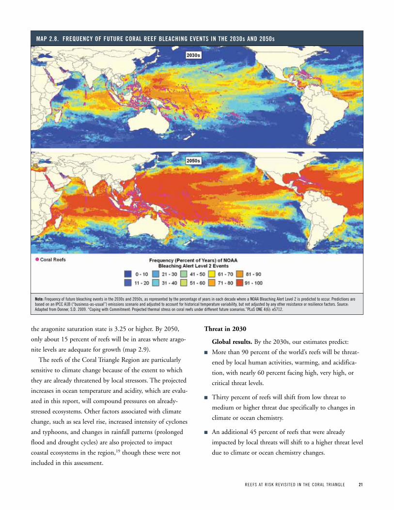
REEFS AT R ISK REV IS ITED IN THE CORAL TR IANGLE 21
the aragonite saturation state is 3.25 or higher. By 2050,
only about 15 percent of reefs will be in areas where arago-
nite levels are adequate for growth (map 2.9).
The reefs of the Coral Triangle Region are particularly
sensitive to climate change because of the extent to which
they are already threatened by local stressors. The projected
increases in ocean temperature and acidity, which are evalu-
ated in this report, will compound pressures on already-
stressed ecosystems. Other factors associated with climate
change, such as sea level rise, increased intensity of cyclones
and typhoons, and changes in rainfall patterns (prolonged
flood and drought cycles) are also projected to impact
coastal ecosystems in the region,19 though these were not
included in this assessment.
Threat in 2030
Global results. By the 2030s, our estimates predict:
n More than 90 percent of the world’s reefs will be threat-
ened by local human activities, warming, and acidifica-
tion, with nearly 60 percent facing high, very high, or
critical threat levels.
n Thirty percent of reefs will shift from low threat to
medium or higher threat due specifically to changes in
climate or ocean chemistry.
n An additional 45 percent of reefs that were already
impacted by local threats will shift to a higher threat level
due to climate or ocean chemistry changes.
Map 2 8 FrequenCy oF Future CoraL reeF BLeaChing eventS in the 2030s and 2050s
note: Frequency of future bleaching events in the 2030s and 2050s, as represented by the percentage of years in each decade where a NOAA Bleaching Alert Level 2 is predicted to occur. predictions are based on an IpCC A1B (“business-as-usual”) emissions scenario and adjusted to account for historical temperature variability, but not adjusted by any other resistance or resilience factors. Source: Adapted from Donner, S.D. 2009. “Coping with Commitment: projected thermal stress on coral reefs under different future scenarios.”pLoS ONE 4(6): e5712.
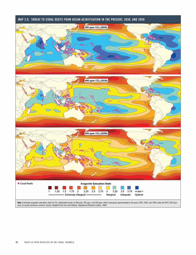
22 REEFS AT R ISK REV IS ITED IN THE CORAL TR IANGLE
Map 2 9 threat to CoraL reeFS FroM oCean aCidiFiCation in the preSent, 2030, and 2050
note: Estimated aragonite saturation state for CO2 stabilization levels of 380 ppm, 450 ppm, and 500 ppm, which correspond approximately to the years 2005, 2030, and 2050 under the IpCC A1B (busi-ness-as-usual) emissions scenario. Source: Adapted from Cao and Caldeira, Geophysical Research Letters, 2008.

REEFS AT R ISK REV IS ITED IN THE CORAL TR IANGLE 23
n Thermal stress is predicted to play a larger role in elevat-
ing threat levels than acidification by 2030, though about
half of all reefs will be threatened by both conditions.
Results for the Coral Triangle Region. By the 2030s
our estimates predict:
n Virtually all coral reefs in the Coral Triangle Region will
be threatened by a combination of local human activities,
ocean warming, and acidification, with more than 80
percent facing high, very high, or critical threat levels.
n More than 40 percent of reefs will be at very high or crit-
ical threat levels.
n The increased threat will be particularly significant in
Papua New Guinea, where the area of reef threatened will
rise from 55 percent today to 100 percent by 2030.
n In the Philippines and Timor-Leste, more than two-
thirds of reefs will shift to the high or critical categories
(map 2.10b and figure 2.5).
Threat in 2050
Global results. By the 2050s, our estimates predict that
almost no reefs will be under low threat and only about one-
quarter will be under medium threat, with the remaining 75
percent at high, very high, or critical threat levels (figure 2.5,
right-most column). A few small areas of reef are projected to
remain under low threat in Australia and the South Pacific.
Results for the Coral Triangle Region. By 2050, all
reefs in the Coral Triangle Region are projected to be threat-
ened, with more than 90 percent at high, very high, or criti-
cal levels. Roughly half of the reefs in the region will be in
the very high or critical categories. The increase in threat
ratings is estimated to be greatest in Papua New Guinea and
Solomon Islands (map 2.10c and figure 2.5).
These projections assume that current local threats
remain constant in the future, and do not account for
potential changes in human pressure, management, or pol-
icy, which could influence overall threat ratings. If future
population growth, coastal development, and agricultural
expansion were considered, the projections of the threat to
reefs would be even higher.
Moreover, the results presented here are projections and
not foregone conclusions. Coral reefs are resilient: they can
and do recover from coral bleaching and other impacts, par-
ticularly if other threats are low (boxes 2.3 and 2.4). This
analysis highlights the urgent need for global action to cur-
tail greenhouse gas emissions, in parallel with local actions
to lessen the immediate pressures on coral reefs. Controlling
local threats to coral reefs will be critical to ensuring their
resilience and survival in the face of heavy human pressure
in coastal regions, and growing threats from climate change
and ocean acidification.
Located off the island of New Britain in papua New Guinea, the rich
marine habitat of Kimbe Bay is a vital part of the local culture and
economy. However, Kimbe Bay’s coral reefs are particularly threatened by
land-based pollution, overfishing, and coral bleaching. In response,
local communities and government agencies are working together with
The Nature Conservancy to design and implement one of the first marine
protected area (MpA) networks that incorporates both socioeconomic
considerations and the principles of coral reef resilience to climate
change. These principles include: selecting sites that represent and rep-
licate major habitats; incorporating biological patterns of connectivity to
promote the exchange of larvae between reefs; and protecting unique
locations such as fish spawning sites. The lessons learned from this
pilot MpA network will help to give coral reefs around the world a better
chance to survive climate change. See full story online at
http://www.wri.org/reefs/stories.
Box 2.3 Reef stoRy
papua new guinea: Marine protection designed for reef resilience in kimbe Bay
pHOT
O: A
LISO
N GR
EEN

24 REEFS AT R ISK REV IS ITED IN THE CORAL TR IANGLE
Pres
ent
2030
2050
Pres
ent
2030
2050
Low
Medium
High
Very High
Critical
Figure 2 5 reeFS at riSk: preSent, 2030, and 2050 For the CountrieS oF the CoraL triangLe regionPe
rcen
t
100
80
60
40
20
0 Pres
ent
2030
2050
Pres
ent
2030
2050
Pres
ent
2030
2050
Pres
ent
2030
2050
Pres
ent
2030
2050
Indonesia GlobalTimor-LesteSolomon IslandsPhilippinesPapua New GuineaMalaysia
note: “present” represents the Reefs at Risk integrated local threat index, without past thermal stress considered. Estimated threats in 2030 and 2050 use the present local threat index as the base and also include projections of future thermal stress and ocean acidification. The 2030 and 2050 projections assume no increase in local pressure on reefs, and no reduction in local threats due to improved policies and management.
In the middle of the Sulu Sea, 150 kilometers off the coast of palawan in the
southwestern philippines, lie the Tubbataha reefs. The magnitude of marine
diversity at these reefs makes them both an important ecological asset and
a popular diving destination. The reefs support at least 360 species of cor-
als—representing more than 70 percent of all known coral genera in the
world—and 600 species of fish. Despite their remoteness, the reefs of
Tubbataha were badly damaged by the destructive fishing practices of local
and migrant fishers in the 1970s. In order to prevent further degradation of
the reefs, the philippine government declared Tubbataha a national marine
park in 1988; in 1993 the park became a UNESCO World Heritage Site. At
970 sq km, the Tubbataha Reefs Natural park (TRNp) is among the largest
effectively-enforced no-take marine reserves in Southeast Asia.
When the 1998 global mass coral bleaching event damaged reefs at
Tubbataha—causing live coral cover to decline by about 22 percent—the
reefs in the TRNp were better able to recover from the damage because of
their protection inside the reserve. By 2008, live coral cover on the reefs
had even exceeded that of pre-bleaching levels and fish density has grad-
ually increased since 2000. TRNp is a successful model of effective MpA
management largely because of its use of regular patrolling activities
combined with financial and governance incentives: dive tourism gener-
ates revenue for the park, which is shared with local municipalities in
exchange for not fishing in the area.72,73
pHOT
O: C
IEM
ON C
ABAL
LES
Box 2.4 Reef stoRyphilippines: effective Management promotes Coral reef resilience at tubbataha reefs natural park
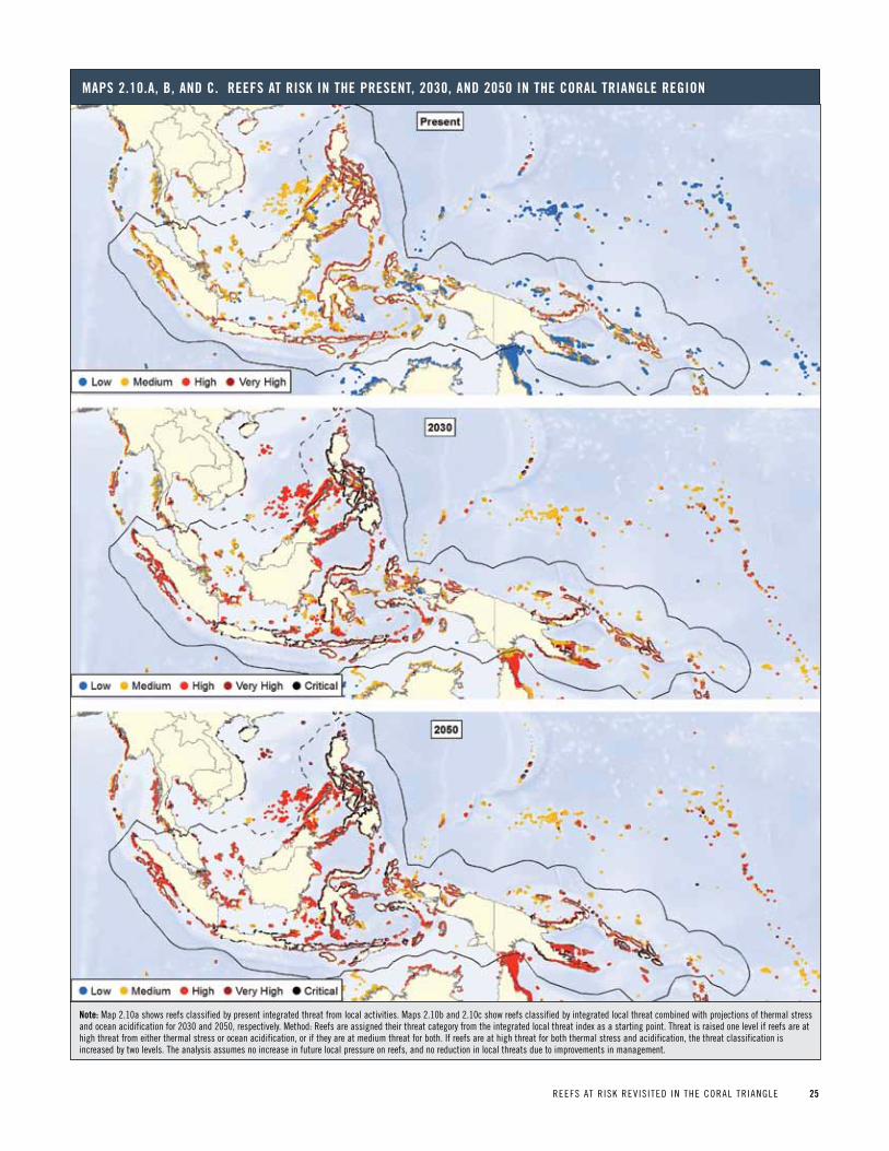
REEFS AT R ISK REV IS ITED IN THE CORAL TR IANGLE 25
MapS 2 10 a, B, and C reeFS at riSk in the preSent, 2030, and 2050 in the CoraL triangLe region
note: Map 2.10a shows reefs classified by present integrated threat from local activities. Maps 2.10b and 2.10c show reefs classified by integrated local threat combined with projections of thermal stress and ocean acidification for 2030 and 2050, respectively. Method: Reefs are assigned their threat category from the integrated local threat index as a starting point. Threat is raised one level if reefs are at high threat from either thermal stress or ocean acidification, or if they are at medium threat for both. If reefs are at high threat for both thermal stress and acidification, the threat classification is increased by two levels. The analysis assumes no increase in future local pressure on reefs, and no reduction in local threats due to improvements in management.
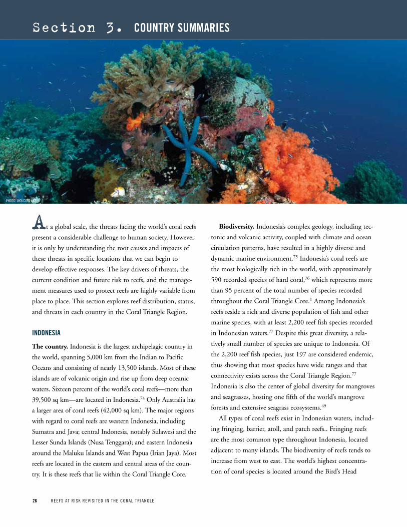
26 REEFS AT R ISK REV IS ITED IN THE CORAL TR IANGLE26 REEFS AT R ISK REV IS ITED IN THE CORAL TR IANGLE
At a global scale, the threats facing the world’s coral reefs
present a considerable challenge to human society. However,
it is only by understanding the root causes and impacts of
these threats in specific locations that we can begin to
develop effective responses. The key drivers of threats, the
current condition and future risk to reefs, and the manage-
ment measures used to protect reefs are highly variable from
place to place. This section explores reef distribution, status,
and threats in each country in the Coral Triangle Region.
indoneSia
The country. Indonesia is the largest archipelagic country in
the world, spanning 5,000 km from the Indian to Pacific
Oceans and consisting of nearly 13,500 islands. Most of these
islands are of volcanic origin and rise up from deep oceanic
waters. Sixteen percent of the world’s coral reefs—more than
39,500 sq km—are located in Indonesia.74 Only Australia has
a larger area of coral reefs (42,000 sq km). The major regions
with regard to coral reefs are western Indonesia, including
Sumatra and Java; central Indonesia, notably Sulawesi and the
Lesser Sunda Islands (Nusa Tenggara); and eastern Indonesia
around the Maluku Islands and West Papua (Irian Jaya). Most
reefs are located in the eastern and central areas of the coun-
try. It is these reefs that lie within the Coral Triangle Core.
Biodiversity. Indonesia’s complex geology, including tec-
tonic and volcanic activity, coupled with climate and ocean
circulation patterns, have resulted in a highly diverse and
dynamic marine environment.75 Indonesia’s coral reefs are
the most biologically rich in the world, with approximately
590 recorded species of hard coral,76 which represents more
than 95 percent of the total number of species recorded
throughout the Coral Triangle Core.1 Among Indonesia’s
reefs reside a rich and diverse population of fish and other
marine species, with at least 2,200 reef fish species recorded
in Indonesian waters.77 Despite this great diversity, a rela-
tively small number of species are unique to Indonesia. Of
the 2,200 reef fish species, just 197 are considered endemic,
thus showing that most species have wide ranges and that
connectivity exists across the Coral Triangle Region.77
Indonesia is also the center of global diversity for mangroves
and seagrasses, hosting one fifth of the world’s mangrove
forests and extensive seagrass ecosystems.49
All types of coral reefs exist in Indonesian waters, includ-
ing fringing, barrier, atoll, and patch reefs.. Fringing reefs
are the most common type throughout Indonesia, located
adjacent to many islands. The biodiversity of reefs tends to
increase from west to east. The world’s highest concentra-
tion of coral species is located around the Bird’s Head
section 3. Country SuMMarieS
pHOTO: WOLCOTT HENRy
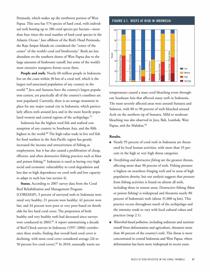
REEFS AT R ISK REV IS ITED IN THE CORAL TR IANGLE 27
Peninsula, which makes up the northwest portion of West
Papua. This area has 574 species of hard coral, with individ-
ual reefs hosting up to 280 coral species per hectare—more
than four times the total number of hard coral species in the
Atlantic Ocean.1 Just offshore of the Bird’s Head Peninsula,
the Raja Ampat Islands are considered the “center of the
center” of the world’s coral reef biodiversity.1 Reefs are less
abundant on the southern shores of West Papua due to the
large amounts of freshwater runoff, but some of the world’s
most extensive mangrove forests occur there.
People and reefs. Nearly 60 million people in Indonesia
live on the coast within 30 km of a coral reef, which is the
largest reef-associated population of any country in the
world.78 Java and Sumatra have the country’s largest popula-
tion centers, yet practically all of the country’s coastlines are
now populated. Currently, there is no sewage treatment in
place for any major coastal city in Indonesia, which particu-
larly affects reefs around Java and in the more heavily popu-
lated western and central regions of the archipelago.79
Indonesia has the highest total fish and seafood con-
sumption of any country in Southeast Asia, and the fifth
highest in the world.80 The high-value trade in live reef fish
for food markets in the Asia-Pacific region has greatly
increased the income and attractiveness of fishing as
employment, but it has also caused a proliferation of cheap,
efficient, and often destructive fishing practices such as blast
and poison fishing.81 Indonesia is rated as having very high
social and economic vulnerability to coral degradation and
loss due to high dependence on coral reefs and low capacity
to adapt to such loss (see section 4).
Status. According to 2007 survey data from the Coral
Reef Rehabilitation and Management Program
(COREMAP), 3 percent of surveyed reefs in Indonesia were
rated very healthy; 21 percent were healthy; 42 percent were
fair; and 34 percent were poor or very poor based on thresh-
olds for live hard coral cover. The proportion of both
healthy and very healthy reefs had decreased since surveys
were conducted in 2003.82 A report summarizing a decade
of Reef Check surveys in Indonesia (1997–2006) corrobo-
rates these results, finding that overall hard coral cover is
declining, with most coral cover considered average (26 to
50 percent live coral cover).83 In 2010, unusually warm sea
temperatures caused a mass coral bleaching event through-
out Southeast Asia that affected many reefs in Indonesia.
The most severely affected areas were around Sumatra and
Sulawesi, with 80 to 90 percent of reefs bleached around
Aceh on the northern tip of Sumatra. Mild to moderate
bleaching was also observed in Java, Bali, Lombok, West
Papua, and the Malukus.84
Results.
n Nearly 95 percent of coral reefs in Indonesia are threat-
ened by local human activities, with more than 35 per-
cent in the high or very high threat categories.
n Overfishing and destructive fishing are the greatest threats,
affecting more than 90 percent of reefs. Fishing pressure
is highest on nearshore fringing reefs and in areas of high
population density, but our analysis suggests that pressure
from fishing activities is found on almost all reefs,
including those in remote areas. Destructive fishing (blast
or poison fishing) is widespread and threatens nearly 80
percent of Indonesia’s reefs (about 31,000 sq km). This
practice occurs throughout much of the archipelago and
the intensity tends to vary with local cultural values and
practices (map 2.1).
n Watershed-based pollution, including sediment and nutrient
runoff from deforestation and agriculture, threatens more
than 40 percent of the country’s reefs. This threat is more
concentrated in central Indonesia and West Papua, where
deforestation has been more widespread in recent years.
Figure 3 1 reeFS at riSk in indoneSia
Over
fishi
ng a
nd D
estru
ctiv
e Fi
shin
g
Mar
ine-
base
d Po
llutio
n an
d Da
mag
e
Coas
tal D
evel
opm
ent
Wat
ersh
ed-b
ased
Pol
lutio
n
Inte
grat
ed L
ocal
Thr
eat
Inte
grat
ed L
ocal
Thr
eat +
The
rmal
Stre
ss
Low
Medium
High
Very High
Perc
ent
100
80
60
40
20
0
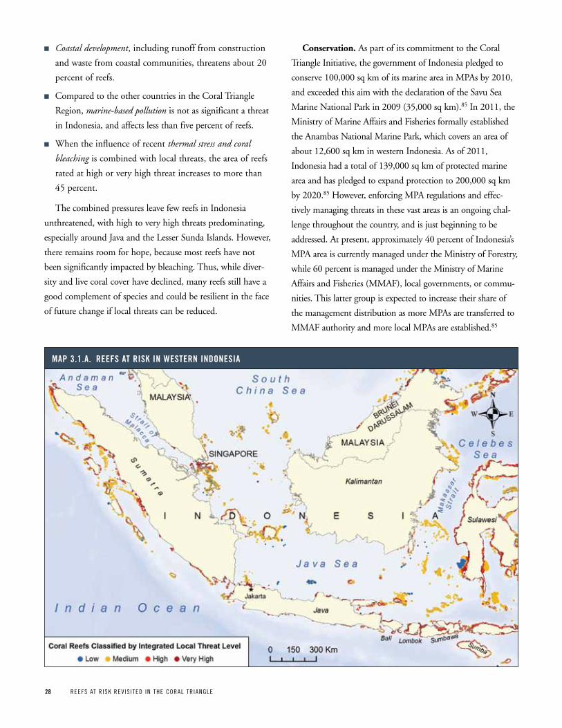
28 REEFS AT R ISK REV IS ITED IN THE CORAL TR IANGLE
n Coastal development, including runoff from construction
and waste from coastal communities, threatens about 20
percent of reefs.
n Compared to the other countries in the Coral Triangle
Region, marine-based pollution is not as significant a threat
in Indonesia, and affects less than five percent of reefs.
n When the influence of recent thermal stress and coral
bleaching is combined with local threats, the area of reefs
rated at high or very high threat increases to more than
45 percent.
The combined pressures leave few reefs in Indonesia
unthreatened, with high to very high threats predominating,
especially around Java and the Lesser Sunda Islands. However,
there remains room for hope, because most reefs have not
been significantly impacted by bleaching. Thus, while diver-
sity and live coral cover have declined, many reefs still have a
good complement of species and could be resilient in the face
of future change if local threats can be reduced.
Conservation. As part of its commitment to the Coral
Triangle Initiative, the government of Indonesia pledged to
conserve 100,000 sq km of its marine area in MPAs by 2010,
and exceeded this aim with the declaration of the Savu Sea
Marine National Park in 2009 (35,000 sq km).85 In 2011, the
Ministry of Marine Affairs and Fisheries formally established
the Anambas National Marine Park, which covers an area of
about 12,600 sq km in western Indonesia. As of 2011,
Indonesia had a total of 139,000 sq km of protected marine
area and has pledged to expand protection to 200,000 sq km
by 2020.85 However, enforcing MPA regulations and effec-
tively managing threats in these vast areas is an ongoing chal-
lenge throughout the country, and is just beginning to be
addressed. At present, approximately 40 percent of Indonesia’s
MPA area is currently managed under the Ministry of Forestry,
while 60 percent is managed under the Ministry of Marine
Affairs and Fisheries (MMAF), local governments, or commu-
nities. This latter group is expected to increase their share of
the management distribution as more MPAs are transferred to
MMAF authority and more local MPAs are established.85
Map 3 1 a reeFS at riSk in weStern indoneSia
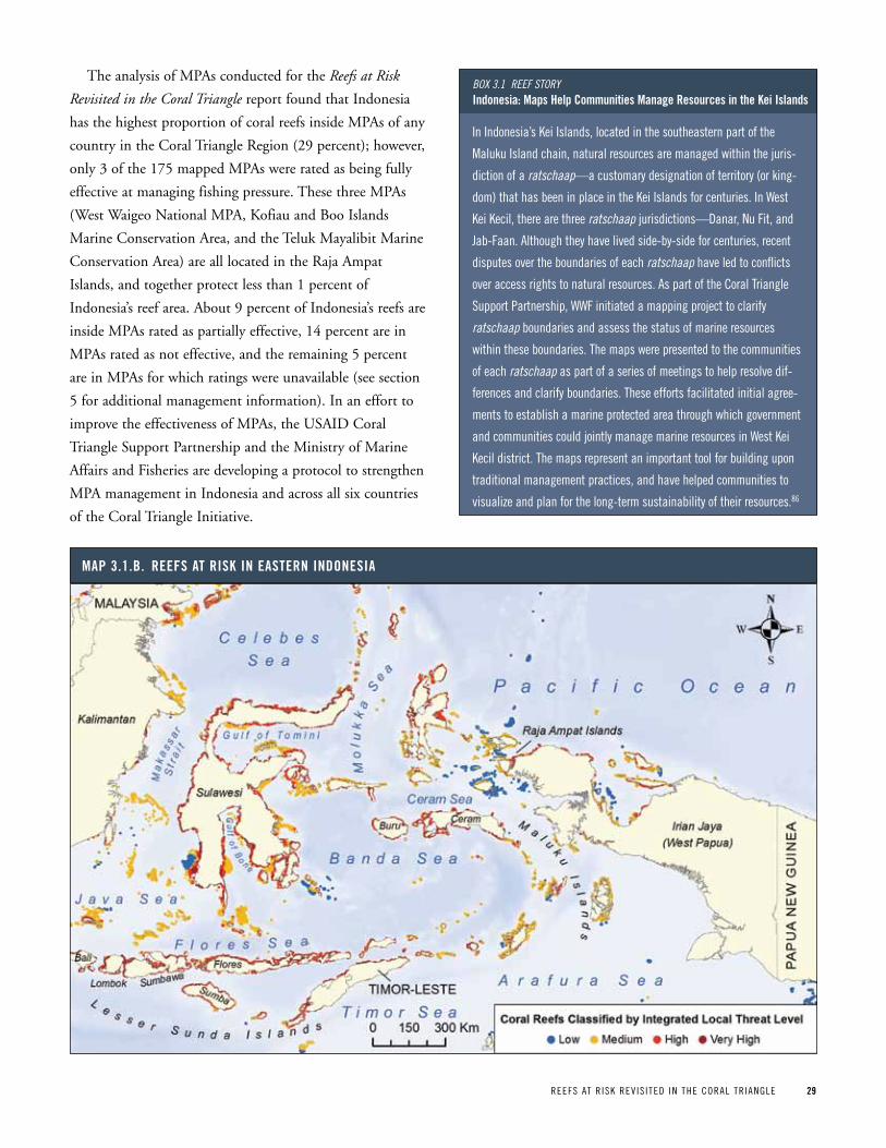
REEFS AT R ISK REV IS ITED IN THE CORAL TR IANGLE 29
The analysis of MPAs conducted for the Reefs at Risk
Revisited in the Coral Triangle report found that Indonesia
has the highest proportion of coral reefs inside MPAs of any
country in the Coral Triangle Region (29 percent); however,
only 3 of the 175 mapped MPAs were rated as being fully
effective at managing fishing pressure. These three MPAs
(West Waigeo National MPA, Kofiau and Boo Islands
Marine Conservation Area, and the Teluk Mayalibit Marine
Conservation Area) are all located in the Raja Ampat
Islands, and together protect less than 1 percent of
Indonesia’s reef area. About 9 percent of Indonesia’s reefs are
inside MPAs rated as partially effective, 14 percent are in
MPAs rated as not effective, and the remaining 5 percent
are in MPAs for which ratings were unavailable (see section
5 for additional management information). In an effort to
improve the effectiveness of MPAs, the USAID Coral
Triangle Support Partnership and the Ministry of Marine
Affairs and Fisheries are developing a protocol to strengthen
MPA management in Indonesia and across all six countries
of the Coral Triangle Initiative.
In Indonesia’s Kei Islands, located in the southeastern part of the
Maluku Island chain, natural resources are managed within the juris-
diction of a ratschaap—a customary designation of territory (or king-
dom) that has been in place in the Kei Islands for centuries. In West
Kei Kecil, there are three ratschaap jurisdictions—Danar, Nu Fit, and
Jab-Faan. Although they have lived side-by-side for centuries, recent
disputes over the boundaries of each ratschaap have led to conflicts
over access rights to natural resources. As part of the Coral Triangle
Support partnership, WWF initiated a mapping project to clarify
ratschaap boundaries and assess the status of marine resources
within these boundaries. The maps were presented to the communities
of each ratschaap as part of a series of meetings to help resolve dif-
ferences and clarify boundaries. These efforts facilitated initial agree-
ments to establish a marine protected area through which government
and communities could jointly manage marine resources in West Kei
Kecil district. The maps represent an important tool for building upon
traditional management practices, and have helped communities to
visualize and plan for the long-term sustainability of their resources.86
Box 3.1 Reef stoRyindonesia: Maps help Communities Manage resources in the kei islands
Map 3 1 B reeFS at riSk in eaStern indoneSia

30 REEFS AT R ISK REV IS ITED IN THE CORAL TR IANGLE
MaLaySia
The country. Malaysia is governed as a federation made up
of 13 states, 11 of which are located in Peninsular Malaysia.
The remaining two, Sabah and Sarawak, are on the island of
Borneo and are sometimes collectively referred to as East
Malaysia. Peninsular and East Malaysia are separated by the
South China Sea and the underlying Sunda Shelf. Malaysia’s
coral reefs cover nearly 3,000 sq km, with the majority
located around the northern and eastern coasts of Sabah on
the margins of the Sulu Sea.87
Biodiversity. In total, about 540 species of hard corals
have been identified in Malaysian waters to date.1 More
than 90 percent of the country’s reefs are located off the
coast of Sabah and consist mainly of fringing and barrier
reefs. These reefs are part of the biogeographic Coral
Triangle Core and support a far greater diversity of corals
and fish than elsewhere in the country. Reefs are sparse
along the mainland coasts of both Sarawak and Peninsular
Malaysia, although island groups further offshore support
many fringing reefs. Across Malaysia, at least 925 different
species of fish inhabit coral reefs.88 Many of these reef fish
benefit from close proximity to coastal mangroves, which
provide habitat and protection from predators, especially
during juvenile stages. Of the 73 known species of man-
groves in the world, 40 can be found in Malaysia.49
Mangrove forests cover more than 7,000 sq km across the
country, some of which are inside reserves and are success-
fully managed for sustainable timber harvest.49
People and reefs. Approximately five million people in
Malaysia live on the coast within 30 km of a coral reef. This
number includes 3.2 million people in Peninsular Malaysia
and 1.8 million in East Malaysia.89 While Malaysia as a
country continues to grow and develop its economy, rates of
development are not occurring uniformly in both regions.90
Since the mid-1990s, Peninsular Malaysia has become
increasingly industrialized, with an economy supported by
manufacturing, while the economy of East Malaysia has
remained largely agricultural and resource-based.91 Poverty
rates in rural areas have also diverged, with 23 percent of
the population living in poverty in East Malaysia compared
to 6 percent in Peninsular Malaysia.90
While fish is an important food staple throughout the
country, with an annual consumption rate of about 52 kg
per person,92 people in East Malaysia are more dependent
on fisheries for income and food security than those in
Peninsular Malaysia.
Tourism is one of the fastest growing sectors of the coun-
try’s economy; tourist arrivals grew fourfold between 1998
and 2009, from 5.5 million to 23.6 million.93 Tourism has
also been identified as an important sector for development
Map 3 2 reeFS at riSk in MaLaySia
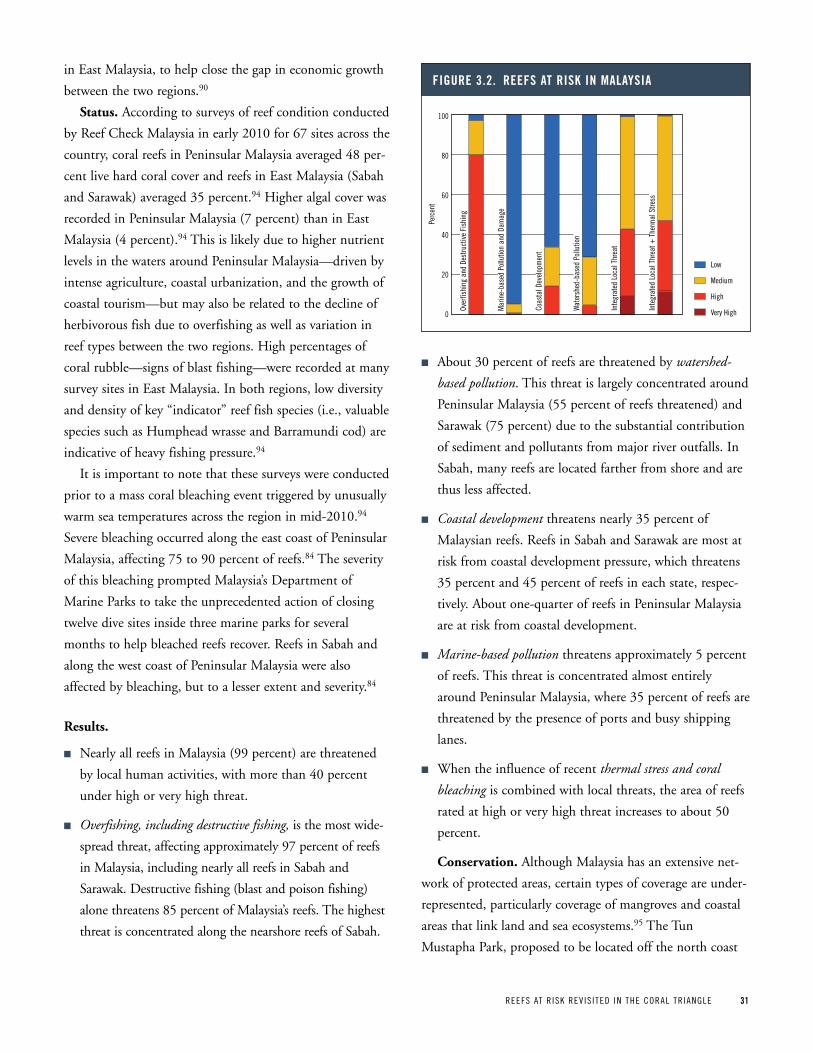
REEFS AT R ISK REV IS ITED IN THE CORAL TR IANGLE 31
in East Malaysia, to help close the gap in economic growth
between the two regions.90
Status. According to surveys of reef condition conducted
by Reef Check Malaysia in early 2010 for 67 sites across the
country, coral reefs in Peninsular Malaysia averaged 48 per-
cent live hard coral cover and reefs in East Malaysia (Sabah
and Sarawak) averaged 35 percent.94 Higher algal cover was
recorded in Peninsular Malaysia (7 percent) than in East
Malaysia (4 percent).94 This is likely due to higher nutrient
levels in the waters around Peninsular Malaysia—driven by
intense agriculture, coastal urbanization, and the growth of
coastal tourism—but may also be related to the decline of
herbivorous fish due to overfishing as well as variation in
reef types between the two regions. High percentages of
coral rubble—signs of blast fishing—were recorded at many
survey sites in East Malaysia. In both regions, low diversity
and density of key “indicator” reef fish species (i.e., valuable
species such as Humphead wrasse and Barramundi cod) are
indicative of heavy fishing pressure.94
It is important to note that these surveys were conducted
prior to a mass coral bleaching event triggered by unusually
warm sea temperatures across the region in mid-2010.94
Severe bleaching occurred along the east coast of Peninsular
Malaysia, affecting 75 to 90 percent of reefs.84 The severity
of this bleaching prompted Malaysia’s Department of
Marine Parks to take the unprecedented action of closing
twelve dive sites inside three marine parks for several
months to help bleached reefs recover. Reefs in Sabah and
along the west coast of Peninsular Malaysia were also
affected by bleaching, but to a lesser extent and severity.84
Results.
n Nearly all reefs in Malaysia (99 percent) are threatened
by local human activities, with more than 40 percent
under high or very high threat.
n Overfishing, including destructive fishing, is the most wide-
spread threat, affecting approximately 97 percent of reefs
in Malaysia, including nearly all reefs in Sabah and
Sarawak. Destructive fishing (blast and poison fishing)
alone threatens 85 percent of Malaysia’s reefs. The highest
threat is concentrated along the nearshore reefs of Sabah.
n About 30 percent of reefs are threatened by watershed-
based pollution. This threat is largely concentrated around
Peninsular Malaysia (55 percent of reefs threatened) and
Sarawak (75 percent) due to the substantial contribution
of sediment and pollutants from major river outfalls. In
Sabah, many reefs are located farther from shore and are
thus less affected.
n Coastal development threatens nearly 35 percent of
Malaysian reefs. Reefs in Sabah and Sarawak are most at
risk from coastal development pressure, which threatens
35 percent and 45 percent of reefs in each state, respec-
tively. About one-quarter of reefs in Peninsular Malaysia
are at risk from coastal development.
n Marine-based pollution threatens approximately 5 percent
of reefs. This threat is concentrated almost entirely
around Peninsular Malaysia, where 35 percent of reefs are
threatened by the presence of ports and busy shipping
lanes.
n When the influence of recent thermal stress and coral
bleaching is combined with local threats, the area of reefs
rated at high or very high threat increases to about 50
percent.
Conservation. Although Malaysia has an extensive net-
work of protected areas, certain types of coverage are under-
represented, particularly coverage of mangroves and coastal
areas that link land and sea ecosystems.95 The Tun
Mustapha Park, proposed to be located off the north coast
Figure 3 2 reeFS at riSk in MaLaySia
Over
fishi
ng a
nd D
estru
ctiv
e Fi
shin
g
Mar
ine-
base
d Po
llutio
n an
d Da
mag
e
Coas
tal D
evel
opm
ent
Wat
ersh
ed-b
ased
Pol
lutio
n
Inte
grat
ed L
ocal
Thr
eat
Inte
grat
ed L
ocal
Thr
eat +
The
rmal
Stre
ss
Low
Medium
High
Very High
Perc
ent
100
80
60
40
20
0
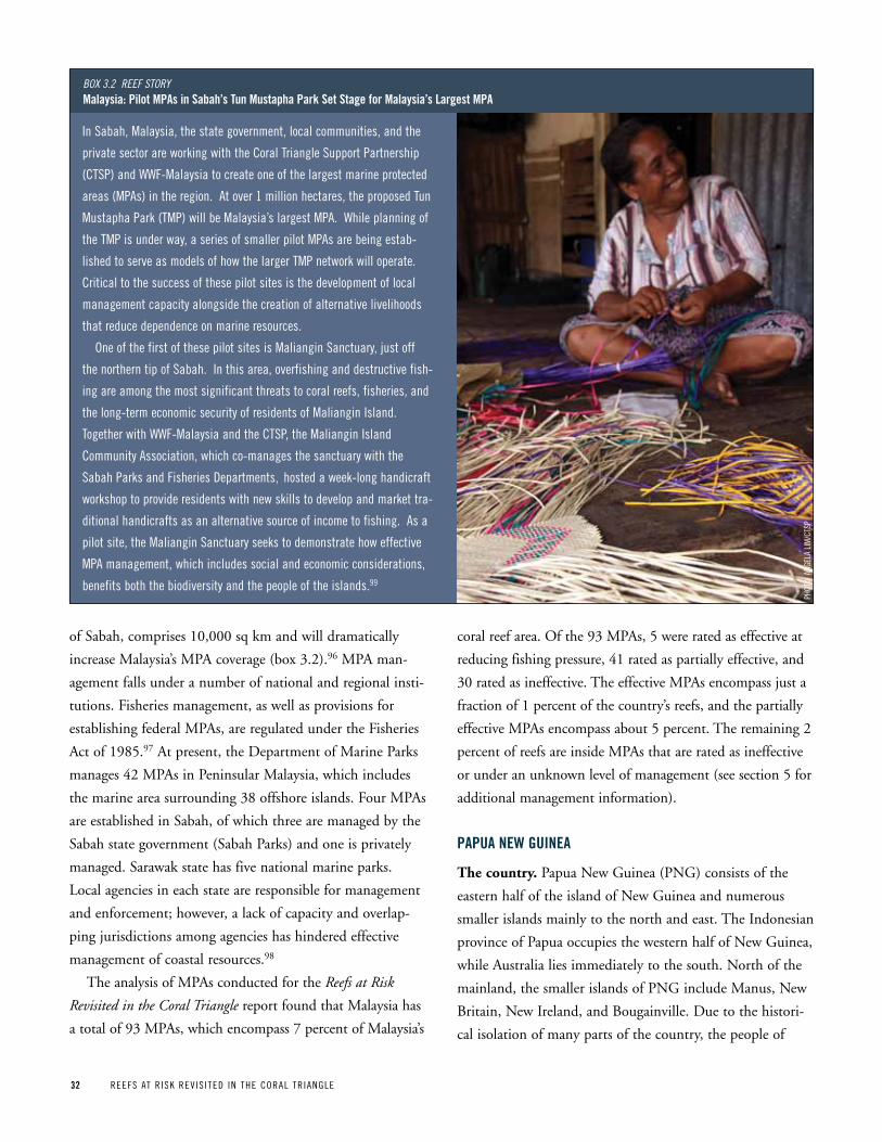
32 REEFS AT R ISK REV IS ITED IN THE CORAL TR IANGLE
of Sabah, comprises 10,000 sq km and will dramatically
increase Malaysia’s MPA coverage (box 3.2).96 MPA man-
agement falls under a number of national and regional insti-
tutions. Fisheries management, as well as provisions for
establishing federal MPAs, are regulated under the Fisheries
Act of 1985.97 At present, the Department of Marine Parks
manages 42 MPAs in Peninsular Malaysia, which includes
the marine area surrounding 38 offshore islands. Four MPAs
are established in Sabah, of which three are managed by the
Sabah state government (Sabah Parks) and one is privately
managed. Sarawak state has five national marine parks.
Local agencies in each state are responsible for management
and enforcement; however, a lack of capacity and overlap-
ping jurisdictions among agencies has hindered effective
management of coastal resources.98
The analysis of MPAs conducted for the Reefs at Risk
Revisited in the Coral Triangle report found that Malaysia has
a total of 93 MPAs, which encompass 7 percent of Malaysia’s
coral reef area. Of the 93 MPAs, 5 were rated as effective at
reducing fishing pressure, 41 rated as partially effective, and
30 rated as ineffective. The effective MPAs encompass just a
fraction of 1 percent of the country’s reefs, and the partially
effective MPAs encompass about 5 percent. The remaining 2
percent of reefs are inside MPAs that are rated as ineffective
or under an unknown level of management (see section 5 for
additional management information).
papua new guinea
The country. Papua New Guinea (PNG) consists of the
eastern half of the island of New Guinea and numerous
smaller islands mainly to the north and east. The Indonesian
province of Papua occupies the western half of New Guinea,
while Australia lies immediately to the south. North of the
mainland, the smaller islands of PNG include Manus, New
Britain, New Ireland, and Bougainville. Due to the histori-
cal isolation of many parts of the country, the people of
In Sabah, Malaysia, the state government, local communities, and the
private sector are working with the Coral Triangle Support partnership
(CTSp) and WWF-Malaysia to create one of the largest marine protected
areas (MpAs) in the region. At over 1 million hectares, the proposed Tun
Mustapha park (TMp) will be Malaysia’s largest MpA. While planning of
the TMp is under way, a series of smaller pilot MpAs are being estab-
lished to serve as models of how the larger TMp network will operate.
Critical to the success of these pilot sites is the development of local
management capacity alongside the creation of alternative livelihoods
that reduce dependence on marine resources.
One of the first of these pilot sites is Maliangin Sanctuary, just off
the northern tip of Sabah. In this area, overfishing and destructive fish-
ing are among the most significant threats to coral reefs, fisheries, and
the long-term economic security of residents of Maliangin Island.
Together with WWF-Malaysia and the CTSp, the Maliangin Island
Community Association, which co-manages the sanctuary with the
Sabah parks and Fisheries Departments, hosted a week-long handicraft
workshop to provide residents with new skills to develop and market tra-
ditional handicrafts as an alternative source of income to fishing. As a
pilot site, the Maliangin Sanctuary seeks to demonstrate how effective
MpA management, which includes social and economic considerations,
benefits both the biodiversity and the people of the islands.99
Box 3.2 Reef stoRyMalaysia: pilot Mpas in Sabah’s tun Mustapha park Set Stage for Malaysia’s Largest Mpa
pHOT
O: A
NGEL
A LI
M/C
TSp

REEFS AT R ISK REV IS ITED IN THE CORAL TR IANGLE 33
PNG speak more than 800 languages, illustrating the coun-
try’s considerable diversity of people and cultures.100
Biodiversity. PNG has a unique array of both terrestrial
and marine ecosystems. The mainland is exceptionally
diverse, with ecosystems that vary from high alpine ranges
and plateaus to rainforests and swamps. Approximately 78
percent of the mainland is covered in natural forest.101
Coastal and marine ecosystems include seagrass beds, man-
grove forests, and more than 14,500 sq km of coral reefs (6
percent of the world total).87 The coral reefs located south of
the mainland are largely an extension of the Great Barrier
Reef, while reefs along the northern coast of PNG and
around the northern islands are more similar to those found
throughout the Coral Triangle Region.102 Fringing and patch
reefs make up the majority of reef types in PNG, with barrier
reefs south and east of the mainland.101 At least 514 species of
hard corals have been recorded in northern Papua New
Guinea, including the offshore islands.1 In Kimbe Bay, on the
north coast of New Britain, more than 860 species of reef fish
have been recorded.6 Milne Bay, on the eastern tip of the
mainland, has similarly high biodiversity, with at least 511
species of hard corals1 and over 1,100 species of reef fish.103
People and reefs. Much of mainland PNG is made up
of rugged and largely inaccessible terrain, such that many
areas are sparsely populated and undeveloped.101 The total
population of PNG is about 5.7 million, and population
density averages 12 persons per sq km for the entire coun-
try.100 However, because of the rugged interior, much of the
population lives in the more accessible coastal areas. Some
coastal villages, such as those surrounding Kimbe Bay, have
population densities as high as 130 persons per sq km.104
Resources in these areas are under increasing pressure to
support a population that is growing at about 2.7 percent
per year.105
Eighty-five percent of Papua New Guineans live in rural
villages and support themselves with subsistence agriculture
Map 3 3 reeFS at riSk in papua new guinea
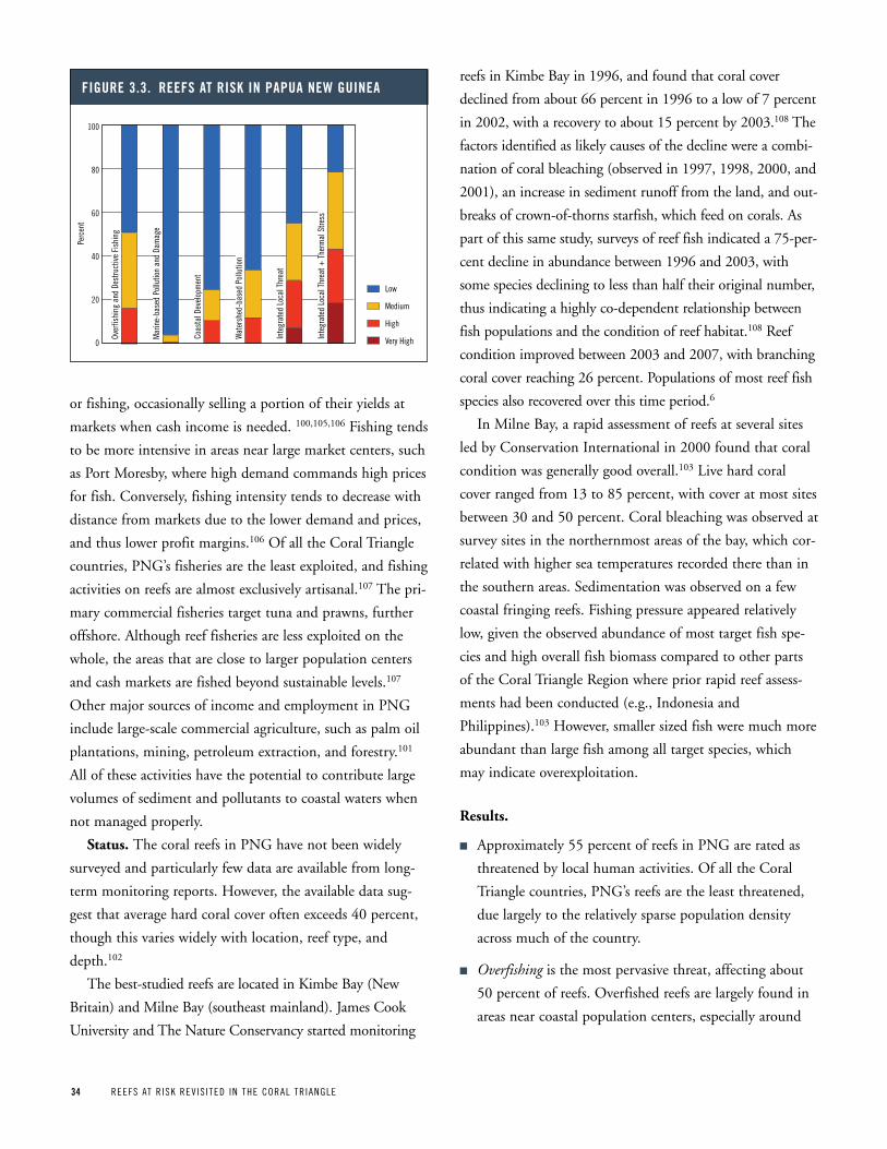
34 REEFS AT R ISK REV IS ITED IN THE CORAL TR IANGLE
or fishing, occasionally selling a portion of their yields at
markets when cash income is needed. 100,105,106 Fishing tends
to be more intensive in areas near large market centers, such
as Port Moresby, where high demand commands high prices
for fish. Conversely, fishing intensity tends to decrease with
distance from markets due to the lower demand and prices,
and thus lower profit margins.106 Of all the Coral Triangle
countries, PNG’s fisheries are the least exploited, and fishing
activities on reefs are almost exclusively artisanal.107 The pri-
mary commercial fisheries target tuna and prawns, further
offshore. Although reef fisheries are less exploited on the
whole, the areas that are close to larger population centers
and cash markets are fished beyond sustainable levels.107
Other major sources of income and employment in PNG
include large-scale commercial agriculture, such as palm oil
plantations, mining, petroleum extraction, and forestry.101
All of these activities have the potential to contribute large
volumes of sediment and pollutants to coastal waters when
not managed properly.
Status. The coral reefs in PNG have not been widely
surveyed and particularly few data are available from long-
term monitoring reports. However, the available data sug-
gest that average hard coral cover often exceeds 40 percent,
though this varies widely with location, reef type, and
depth.102
The best-studied reefs are located in Kimbe Bay (New
Britain) and Milne Bay (southeast mainland). James Cook
University and The Nature Conservancy started monitoring
reefs in Kimbe Bay in 1996, and found that coral cover
declined from about 66 percent in 1996 to a low of 7 percent
in 2002, with a recovery to about 15 percent by 2003.108 The
factors identified as likely causes of the decline were a combi-
nation of coral bleaching (observed in 1997, 1998, 2000, and
2001), an increase in sediment runoff from the land, and out-
breaks of crown-of-thorns starfish, which feed on corals. As
part of this same study, surveys of reef fish indicated a 75-per-
cent decline in abundance between 1996 and 2003, with
some species declining to less than half their original number,
thus indicating a highly co-dependent relationship between
fish populations and the condition of reef habitat.108 Reef
condition improved between 2003 and 2007, with branching
coral cover reaching 26 percent. Populations of most reef fish
species also recovered over this time period.6
In Milne Bay, a rapid assessment of reefs at several sites
led by Conservation International in 2000 found that coral
condition was generally good overall.103 Live hard coral
cover ranged from 13 to 85 percent, with cover at most sites
between 30 and 50 percent. Coral bleaching was observed at
survey sites in the northernmost areas of the bay, which cor-
related with higher sea temperatures recorded there than in
the southern areas. Sedimentation was observed on a few
coastal fringing reefs. Fishing pressure appeared relatively
low, given the observed abundance of most target fish spe-
cies and high overall fish biomass compared to other parts
of the Coral Triangle Region where prior rapid reef assess-
ments had been conducted (e.g., Indonesia and
Philippines).103 However, smaller sized fish were much more
abundant than large fish among all target species, which
may indicate overexploitation.
Results.
n Approximately 55 percent of reefs in PNG are rated as
threatened by local human activities. Of all the Coral
Triangle countries, PNG’s reefs are the least threatened,
due largely to the relatively sparse population density
across much of the country.
n Overfishing is the most pervasive threat, affecting about
50 percent of reefs. Overfished reefs are largely found in
areas near coastal population centers, especially around
Figure 3 3 reeFS at riSk in papua new guinea
Over
fishi
ng a
nd D
estru
ctiv
e Fi
shin
g
Mar
ine-
base
d Po
llutio
n an
d Da
mag
e
Coas
tal D
evel
opm
ent
Wat
ersh
ed-b
ased
Pol
lutio
n
Inte
grat
ed L
ocal
Thr
eat
Inte
grat
ed L
ocal
Thr
eat +
The
rmal
Stre
ss
Low
Medium
High
Very High
Perc
ent
100
80
60
40
20
0
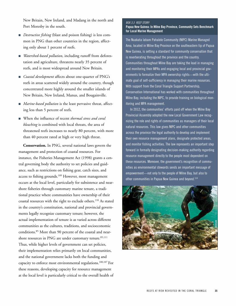
REEFS AT R ISK REV IS ITED IN THE CORAL TR IANGLE 35
New Britain, New Ireland, and Madang in the north and
Port Moresby in the south.
n Destructive fishing (blast and poison fishing) is less com-
mon in PNG than other countries in the region, affect-
ing only about 1 percent of reefs.
n Watershed-based pollution, including runoff from defores-
tation and agriculture, threatens nearly 35 percent of
reefs, and is most widespread around New Britain.
n Coastal development affects about one-quarter of PNG’s
reefs in areas scattered widely around the country, though
concentrated more highly around the smaller islands of
New Britain, New Ireland, Manus, and Bougainville.
n Marine-based pollution is the least pervasive threat, affect-
ing less than 5 percent of reefs.
n When the influence of recent thermal stress and coral
bleaching is combined with local threats, the area of
threatened reefs increases to nearly 80 percent, with more
than 40 percent rated at high or very high threat.
Conservation. In PNG, several national laws govern the
management and protection of coastal resources. For
instance, the Fisheries Management Act (1998) grants a cen-
tral governing body the authority to set policies and guid-
ance, such as restrictions on fishing gear, catch sizes, and
access to fishing grounds.109 However, most management
occurs at the local level, particularly for subsistence and near-
shore fisheries through customary marine tenure, a tradi-
tional practice where communities have ownership of their
coastal resources with the right to exclude others.110 As stated
in the country’s constitution, national and provincial govern-
ments legally recognize customary tenure; however, the
actual implementation of tenure is as varied across different
communities as the cultures, traditions, and socioeconomic
conditions.85 More than 90 percent of the coastal and near-
shore resources in PNG are under customary tenure.85,111
Thus, while higher levels of government can set policies,
their implementation relies primarily on local communities,
and the national government lacks both the funding and
capacity to enforce most environmental regulations.100,107 For
these reasons, developing capacity for resource management
at the local level is particularly critical to the overall health of
The Nuakata Iabam pahalele Community (NIpC) Marine Managed
Area, located in Milne Bay province on the southeastern tip of papua
New Guinea, is setting a standard for community conservation that
is reverberating throughout the province and the country.
Communities throughout Milne Bay are taking the lead in managing
and monitoring their MpAs and engaging local and provincial gov-
ernments to formalize their MpA ownership rights—with the ulti-
mate goal of self-sufficiency in managing their marine resources.
With support from the Coral Triangle Support partnership,
Conservation International has worked with communities throughout
Milne Bay, including the NIpC, to provide training on biological mon-
itoring and MpA management.
In 2012, the communities’ efforts paid off when the Milne Bay
provincial Assembly adopted the new Local Government Law recog-
nizing the role and rights of communities as managers of their local
natural resources. This law gives NIpC and other communities
across the province the legal authority to develop and implement
their own resource management plans, designate protected areas,
and monitor fishing activities. The law represents an important step
forward in formally designating decision-making authority regarding
resource management directly to the people most dependent on
these resources. Moreover, the government’s recognition of commu-
nities as environmental stewards sends an important message of
empowerment—not only to the people of Milne Bay, but also to
other communities in papua New Guinea and beyond.114
Box 3.3 Reef stoRypapua new guinea: in Milne Bay province, Community Sets Benchmark for Local Marine Management
pHOT
O: JA
MES
MOR
GAN
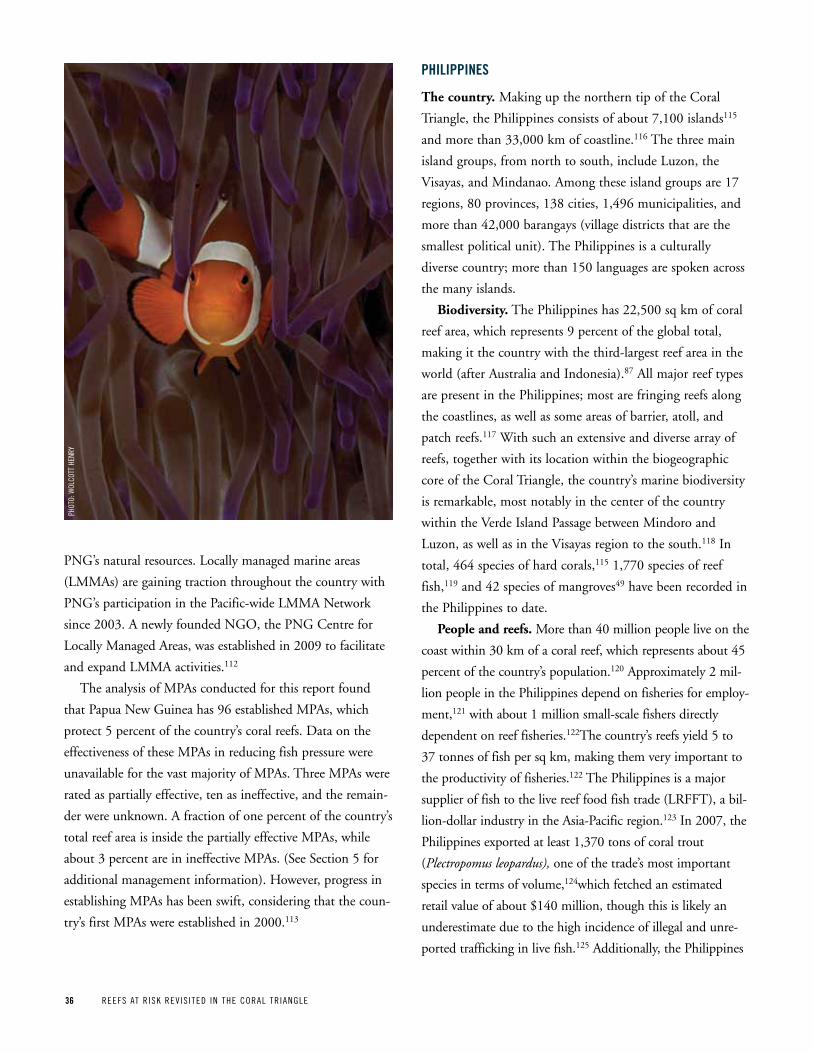
36 REEFS AT R ISK REV IS ITED IN THE CORAL TR IANGLE
PNG’s natural resources. Locally managed marine areas
(LMMAs) are gaining traction throughout the country with
PNG’s participation in the Pacific-wide LMMA Network
since 2003. A newly founded NGO, the PNG Centre for
Locally Managed Areas, was established in 2009 to facilitate
and expand LMMA activities.112
The analysis of MPAs conducted for this report found
that Papua New Guinea has 96 established MPAs, which
protect 5 percent of the country’s coral reefs. Data on the
effectiveness of these MPAs in reducing fish pressure were
unavailable for the vast majority of MPAs. Three MPAs were
rated as partially effective, ten as ineffective, and the remain-
der were unknown. A fraction of one percent of the country’s
total reef area is inside the partially effective MPAs, while
about 3 percent are in ineffective MPAs. (See Section 5 for
additional management information). However, progress in
establishing MPAs has been swift, considering that the coun-
try’s first MPAs were established in 2000.113
phiLippineS
The country. Making up the northern tip of the Coral
Triangle, the Philippines consists of about 7,100 islands115
and more than 33,000 km of coastline.116 The three main
island groups, from north to south, include Luzon, the
Visayas, and Mindanao. Among these island groups are 17
regions, 80 provinces, 138 cities, 1,496 municipalities, and
more than 42,000 barangays (village districts that are the
smallest political unit). The Philippines is a culturally
diverse country; more than 150 languages are spoken across
the many islands.
Biodiversity. The Philippines has 22,500 sq km of coral
reef area, which represents 9 percent of the global total,
making it the country with the third-largest reef area in the
world (after Australia and Indonesia).87 All major reef types
are present in the Philippines; most are fringing reefs along
the coastlines, as well as some areas of barrier, atoll, and
patch reefs.117 With such an extensive and diverse array of
reefs, together with its location within the biogeographic
core of the Coral Triangle, the country’s marine biodiversity
is remarkable, most notably in the center of the country
within the Verde Island Passage between Mindoro and
Luzon, as well as in the Visayas region to the south.118 In
total, 464 species of hard corals,115 1,770 species of reef
fish,119 and 42 species of mangroves49 have been recorded in
the Philippines to date.
People and reefs. More than 40 million people live on the
coast within 30 km of a coral reef, which represents about 45
percent of the country’s population.120 Approximately 2 mil-
lion people in the Philippines depend on fisheries for employ-
ment,121 with about 1 million small-scale fishers directly
dependent on reef fisheries.122The country’s reefs yield 5 to
37 tonnes of fish per sq km, making them very important to
the productivity of fisheries.122 The Philippines is a major
supplier of fish to the live reef food fish trade (LRFFT), a bil-
lion-dollar industry in the Asia-Pacific region.123 In 2007, the
Philippines exported at least 1,370 tons of coral trout
(Plectropomus leopardus), one of the trade’s most important
species in terms of volume,124which fetched an estimated
retail value of about $140 million, though this is likely an
underestimate due to the high incidence of illegal and unre-
ported trafficking in live fish.125 Additionally, the Philippines
pHOT
O: W
OLCO
TT H
ENRy
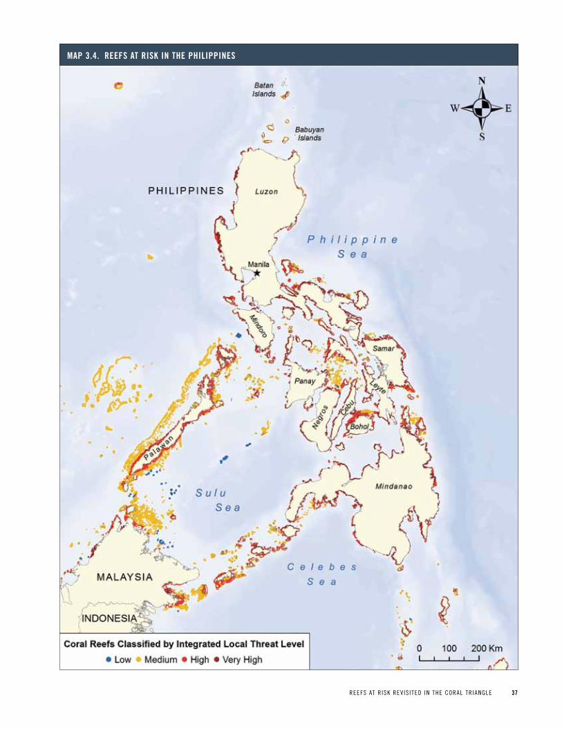
REEFS AT R ISK REV IS ITED IN THE CORAL TR IANGLE 37
Map 3 4 reeFS at riSk in the phiLippineS
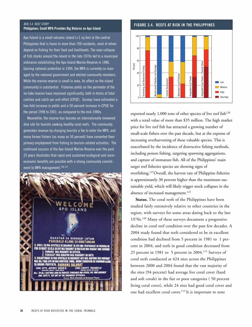
38 REEFS AT R ISK REV IS ITED IN THE CORAL TR IANGLE
exported nearly 1,000 tons of other species of live reef fish126
with a retail value of more than $35 million. The high market
price for live reef fish has attracted a growing number of
small-scale fishers over the past decade, but at the expense of
increasing overharvesting of these valuable species. This is
exacerbated by the incidence of destructive fishing methods,
including poison fishing, targeting spawning aggregations,
and capture of immature fish. All of the Philippines’ main
target reef fisheries species are showing signs of
overfishing.127Overall, the harvest rate of Philippine fisheries
is approximately 30 percent higher than the maximum sus-
tainable yield, which will likely trigger stock collapses in the
absence of increased management.121
Status. The coral reefs of the Philippines have been
studied fairly extensively relative to other countries in the
region, with surveys for some areas dating back to the late
1970s.128 Many of these surveys document a progressive
decline in coral reef condition over the past few decades. A
2004 study found that reefs considered to be in excellent
condition had declined from 5 percent in 1981 to 1 per-
cent in 2004, and reefs in good condition decreased from
25 percent in 1981 to 5 percent in 2004.115 Surveys of
coral reefs conducted at 424 sites across the Philippines
between 2000 and 2004 found that the vast majority of
the sites (94 percent) had average live coral cover (hard
and soft corals) in the fair or poor categories ( 50 percent
living coral cover), while 24 sites had good coral cover and
one had excellent coral cover.115 It is important to note
Apo Island is a small volcanic island (<1 sq km) in the central
philippines that is home to more than 700 residents, most of whom
depend on fishing for their food and livelihoods. The near-collapse
of fish stocks around the island in the late 1970s led to a municipal
ordinance establishing the Apo Island Marine Reserve in 1986.
Gaining national protection in 1994, the MpA is currently co-man-
aged by the national government and elected community members.
While the marine reserve is small in area, its effect on the island
community is substantial. Fisheries yields on the perimeter of the
no-take reserve have improved significantly, both in terms of total
catches and catch per unit effort (CpUE). Surveys have estimated a
two-fold increase in yields and a 50-percent increase in CpUE for
the period 1998 to 2001, as compared to the mid-1980s.
Meanwhile, the reserve has become an internationally renowned
dive site for tourists seeking healthy coral reefs. The community
generates revenue by charging tourists a fee to enter the MpA, and
many former fishers (as many as 50 percent) have converted their
primary employment from fishing to tourism-related activities. The
continued success of the Apo Island Marine Reserve over the past
25 years illustrates that rapid and sustained ecological and socio-
economic benefits are possible with a strong community commit-
ment to MpA management.136,137
Box 3.4 Reef stoRyphilippines: Small Mpa provides Big returns on apo island
pHOT
O: A
LAN
WHI
TE
Figure 3 4 reeFS at riSk in the phiLippineS
Over
fishi
ng a
nd D
estru
ctiv
e Fi
shin
g
Mar
ine-
base
d Po
llutio
n an
d Da
mag
e
Coas
tal D
evel
opm
ent
Wat
ersh
ed-b
ased
Pol
lutio
n
Inte
grat
ed L
ocal
Thr
eat
Inte
grat
ed L
ocal
Thr
eat +
The
rmal
Stre
ss
Low
Medium
High
Very High
Perc
ent
100
80
60
40
20
0
REEFS AT R ISK REV IS ITED IN THE CORAL TR IANGLE 39
that reefs with the highest and most stable levels of coral
cover are most often found in protected areas, as are higher
densities of fish and other reef species.129-132
Widespread development of the coastline has also led to
degradation of nearshore ecosystems such as mangroves and
seagrass beds. Mangrove cover across the Philippines has
declined by 75 percent since the early 1900s, largely to clear
areas for fishponds to support a growing aquaculture indus-
try, but also due to logging for construction materials and
fuelwood.133
Results.
n Almost all reefs in the Philippines are threatened by local
activities. Two-thirds are rated in the high or very high
threat categories.
n Overfishing and destructive fishing are the greatest threats,
affecting 98 percent of reefs, with the exception of those
within effectively managed MPAs. Destructive fishing
alone (i.e., blast or poison fishing) threatens nearly 70
percent of reefs.
n Coastal development along crowded shorelines threatens
nearly 60 percent of reefs.
n Watershed-based pollution, primarily from agricultural
runoff and erosion of deforested slopes, also threatens
nearly 60 percent of reefs.
n Marine-based pollution is a relatively minor threat, affect-
ing about six percent of reefs.
n When the influence of recent thermal stress and coral
bleaching is combined with local threats, nearly 80 per-
cent of reefs are rated at high or very high threat, with
over half in the very high threat category.
Conservation. Management of marine resources and
marine protected areas (MPAs) in the Philippines is largely
decentralized. Local government units manage the vast
majority of MPAs located in municipal waters (defined as
15 km from the shoreline). This delegation of authority to
the local level has contributed to an increase in the numbers
of municipal MPAs, which can be established entirely
through a municipal ordinance without national govern-
ment approval.132At the national level, the National
Integrated Protected Areas System Act grants authority to
the Department of Environment and Natural Resources to
establish and manage ecologically and nationally significant
MPAs in partnership with local government through a
Protected Area Management Board composed of national
and local agencies and stakeholders.
National targets for MPA coverage were declared in the
1998 Fisheries Code, which calls for protection of 15 per-
cent of municipal waters within no-take MPAs, and the
Philippine Marine Sanctuary Strategy of 2004, which calls
for 10 percent of coral reefs within no-take MPAs by
2020.85,134 A 2010 evaluation of progress toward these goals
found that about 5 percent of municipal waters were within
MPAs, of which 0.5 percent was no-take area. 134
As of 2011, the Philippines had 28 MPAs supported at the
national level and more than 1,000 small MPAs supported by
local governments.85 Many of these local MPAs are still
unmapped. The MPA analysis conducted for this report was
able to include 232 mapped MPAs, which comprises all 28
national MPAs and about 200 local MPAs. Surveys on the
effectiveness of these MPAs rated 25 MPAs as fully effective
at reducing fishing pressure, 112 as partially effective, and 61
as ineffective. Of the fully effective MPAs, two are national
MPAs—Tubbataha Reefs and Apo Island—and 23 are local.
In total, 7 percent of Philippine reefs are inside MPAs, with
less than 1 percent in effectively managed MPAs, 2 percent in
partially effective MPAs, 2 percent in ineffective MPAs, and
the remaining 3 percent in unrated MPAs.
The benefits of MPAs to fisheries are largely dependent
on effective enforcement and compliance, which remains a
challenge in the Philippines but is showing encouraging
signs of improvement. The MPA Support Network, a local
collaboration of government and nongovernmental organi-
zations formed to build capacity for MPA management,
performed a survey of MPAs in 2007 and found that the
enforcement of fishing regulations at MPAs had improved
since a previous survey was conducted in 2000.113,135
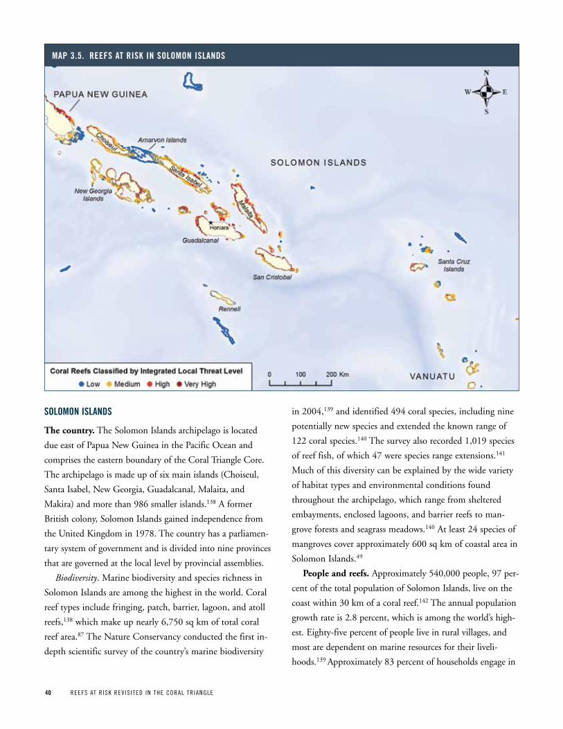
40 REEFS AT R ISK REV IS ITED IN THE CORAL TR IANGLE
SoLoMon iSLandS
The country. The Solomon Islands archipelago is located
due east of Papua New Guinea in the Pacific Ocean and
comprises the eastern boundary of the Coral Triangle Core.
The archipelago is made up of six main islands (Choiseul,
Santa Isabel, New Georgia, Guadalcanal, Malaita, and
Makira) and more than 986 smaller islands.138 A former
British colony, Solomon Islands gained independence from
the United Kingdom in 1978. The country has a parliamen-
tary system of government and is divided into nine provinces
that are governed at the local level by provincial assemblies.
Biodiversity. Marine biodiversity and species richness in
Solomon Islands are among the highest in the world. Coral
reef types include fringing, patch, barrier, lagoon, and atoll
reefs,138 which make up nearly 6,750 sq km of total coral
reef area.87 The Nature Conservancy conducted the first in-
depth scientific survey of the country’s marine biodiversity
in 2004,139 and identified 494 coral species, including nine
potentially new species and extended the known range of
122 coral species.140 The survey also recorded 1,019 species
of reef fish, of which 47 were species range extensions.141
Much of this diversity can be explained by the wide variety
of habitat types and environmental conditions found
throughout the archipelago, which range from sheltered
embayments, enclosed lagoons, and barrier reefs to man-
grove forests and seagrass meadows.140 At least 24 species of
mangroves cover approximately 600 sq km of coastal area in
Solomon Islands.49
People and reefs. Approximately 540,000 people, 97 per-
cent of the total population of Solomon Islands, live on the
coast within 30 km of a coral reef.142 The annual population
growth rate is 2.8 percent, which is among the world’s high-
est. Eighty-five percent of people live in rural villages, and
most are dependent on marine resources for their liveli-
hoods.139 Approximately 83 percent of households engage in
Map 3 5 reeFS at riSk in SoLoMon iSLandS
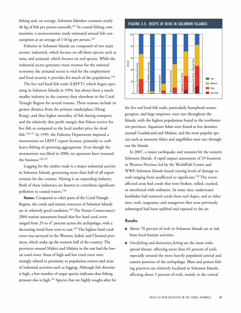
REEFS AT R ISK REV IS ITED IN THE CORAL TR IANGLE 41
fishing and, on average, Solomon Islanders consume nearly
46 kg of fish per person annually.143 In coastal fishing com-
munities, a socioeconomic study estimated annual fish con-
sumption at an average of 118 kg per person.144
Fisheries in Solomon Islands are composed of two main
sectors: industrial, which focuses on off-shore species such as
tuna, and artisanal, which focuses on reef species. While the
industrial sector generates more revenue for the national
economy, the artisanal sector is vital for the employment
and food security it provides for much of the population.145
The live reef food fish trade (LRFFT), which began oper-
ating in Solomon Islands in 1994, has always been a much
smaller industry in the country than elsewhere in the Coral
Triangle Region for several reasons. These reasons include its
greater distance from the primary marketplace (Hong
Kong), and thus higher mortality of fish during transport;
and the relatively slim profit margin that fishers receive for
live fish as compared to the local market price for dead
fish.146,147 In 1999, the Fisheries Department imposed a
moratorium on LRFFT export licenses, primarily to curb
heavy fishing of spawning aggregations. Even though the
moratorium was lifted in 2000, no operators have resumed
the business.146,147
Logging for the timber trade is a major industrial activity
in Solomon Islands, generating more than half of all export
revenue for the country. Mining is an expanding industry.
Both of these industries are known to contribute significant
pollution to coastal waters.138
Status. Compared to other parts of the Coral Triangle
Region, the corals and marine resources of Solomon Islands
are in relatively good condition.148 The Nature Conservancy’s
2004 marine assessment found that live hard coral cover
ranged from 29 to 47 percent across the archipelago, with a
decreasing trend from west to east.149 The highest hard coral
cover was surveyed in the Western, Isabel, and Choiseul prov-
inces, which make up the western half of the country. The
provinces around Makira and Malaita in the east had the low-
est coral cover. Areas of high and low coral cover were
strongly related to proximity to population centers and areas
of industrial activities such as logging. Although fish diversity
is high, a low number of target species indicates that fishing
pressure also is high.141 Species that are highly sought-after for
the live reef food fish trade, particularly humphead wrasse,
groupers, and large emperors, were rare throughout the
Islands, with the highest populations found in the northwest-
ern provinces. Aquarium fishes were found at low densities
around Guadalcanal and Malaita, and the most popular spe-
cies such as anemone fishes and angelfishes were rare through-
out the Islands.
In 2007, a major earthquake and tsunami hit the western
Solomon Islands. A rapid impact assessment of 29 locations
in Western Province led by the WorldFish Center and
WWF-Solomon Islands found varying levels of damage to
reefs ranging from unaffected to significant.150 The worst-
affected areas had corals that were broken, rolled, cracked,
or smothered with sediment. At some sites, underwater
landslides had removed corals from reef slopes, and at other
sites, reefs, seagrasses, and mangroves that were previously
submerged had been uplifted and exposed to the air.
Results.
n About 70 percent of reefs in Solomon Islands are at risk
from local human activities.
n Overfishing and destructive fishing are the most wide-
spread threats, affecting more than 65 percent of reefs,
especially around the more heavily populated central and
eastern portions of the archipelago. Blast and poison fish-
ing practices are relatively localized in Solomon Islands,
affecting about 5 percent of reefs, mainly in the central
Figure 3 5 reeFS at riSk in SoLoMon iSLandS
Over
fishi
ng a
nd D
estru
ctiv
e Fi
shin
g
Mar
ine-
base
d Po
llutio
n an
d Da
mag
e
Coas
tal D
evel
opm
ent
Wat
ersh
ed-b
ased
Pol
lutio
n
Inte
grat
ed L
ocal
Thr
eat
Inte
grat
ed L
ocal
Thr
eat +
The
rmal
Stre
ss
Low
Medium
High
Very High
Perc
ent
100
80
60
40
20
0

42 REEFS AT R ISK REV IS ITED IN THE CORAL TR IANGLE
archipelago around Malaita and the Russell and Florida
Islands near Guadalcanal.
n Watershed-based pollution is also a significant threat,
affecting about 50 percent of reefs, especially due to run-
off of sediment and nutrients from large-scale agriculture,
logging, and mining.
n Population growth and urbanization are contributing to
coastal development pressure, which threatens more than
15 percent of reefs, especially around Guadalcanal.
n The threat from marine-based pollution is relatively
minor, affecting about 4 percent of reefs.
n When the influence of recent thermal stress and coral
bleaching is combined with local threats, the area of
threatened reefs increases beyond 80 percent, with about
45 percent rated at high or very high threat.
Conservation. The management of coastal resources in
Solomon Islands is largely decentralized; several national
laws assign responsibility to the provincial and local lev-
els.151,152 In particular, the country’s constitution recognizes
customary laws and the traditional rights of landowners to
exercise control over their land and resources. This is signifi-
cant for conservation strategies, given that Solomon
Islanders have customary tenure rights to 87 percent of the
country’s land and adjacent marine resources. 152 The
Fisheries Act (1998) recognizes customary fishing rights and
also grants overall management responsibility for coastal and
inshore fisheries to the nine provincial governments.
However, the provincial governments have largely not
exercised this power and thus management of fisheries and
other resources is mainly organized at the community
level.152 The Solomon Islands Locally Managed Marine Area
(SILMMA) Network, a national branch of the region-wide
grass-roots LMMA Network, has played a large role in pro-
liferating the establishment of community-based MPAs and
building capacity for resource management in Solomon
Islands since 2003.151,152 Most recently, the Protected Areas
Act (2010) makes provisions for communities to acquire
legal recognition for local management plans.138,153 This leg-
islation illustrates progress toward an integrated manage-
ment approach that includes more coordination among the
national, provincial, and local levels, which has been identi-
The Arnavon Community Marine Conservation Area, located between
the main islands of Choiseul and Santa Isabel in the western
Solomon Islands, is a 158-sq-km MpA that includes the three small
Arnavon Islands and more than 18 sq km of coral reefs. It is co-
managed by three local communities—Kia, Wagina, and
Katupika—and the provincial government, with support from The
Nature Conservancy. Approximately 2,200 people live within the
three communities that manage the MpA.
In the nearly 15 years since its establishment, the MpA has dra-
matically improved the lives of residents of the three managing com-
munities compared to communities elsewhere in Solomon Islands. A
recent survey of community members found that household incomes
are more than double that of other communities, due largely to the
diversification of employment opportunities beyond fishing, which
include MpA patrols, vegetable farming, and custom handcrafts.
Trade and communication between the three culturally diverse com-
munities have increased as village leaders work together on the MpA
management committee. Moreover, the committee framework has
empowered more villagers, especially women, to have an active role
in community meetings and a more direct dialogue with the provin-
cial government, which has strengthened government support for
fisheries and local health care. While the MpA has not completely
eliminated poverty among these communities and there have been
challenges in sustaining consistent incomes from alternative liveli-
hoods, villagers have noticed a clear improvement in their quality of
life over the past 15 years because of the MpA.137,154
Box 3.5 Reef stoRySolomon islands: arnavon islands Mpa improves quality of Life in Local villages
pHOT
O: JA
MES
MOR
GAN
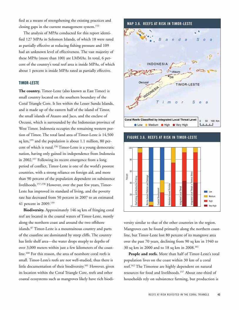
REEFS AT R ISK REV IS ITED IN THE CORAL TR IANGLE 43
fied as a means of strengthening the existing practices and
closing gaps in the current management system.153
The analysis of MPAs conducted for this report identi-
fied 127 MPAs in Solomon Islands, of which 18 were rated
as partially effective at reducing fishing pressure and 109
had an unknown level of effectiveness. The vast majority of
these MPAs (more than 100) are LMMAs. In total, 6 per-
cent of the country’s total reef area is inside MPAs, of which
about 1 percent is inside MPAs rated as partially effective.
tiMor-LeSte
The country. Timor-Leste (also known as East Timor) is
small country located on the southern boundary of the
Coral Triangle Core. It lies within the Lesser Sunda Islands,
and is made up of the eastern half of the island of Timor,
the small islands of Atauro and Jaco, and the enclave of
Oecussi, which is surrounded by the Indonesian province of
West Timor. Indonesia occupies the remaining western por-
tion of Timor. The total land area of Timor-Leste is 14,500
sq km,155 and the population is about 1.1 million, 80 per-
cent of which is rural.156 Timor-Leste is a young democratic
nation, having only gained its independence from Indonesia
in 2002.157 Following its recent emergence from a long
period of conflict, Timor-Leste is one of the world’s poorest
countries, with a strong reliance on foreign aid, and more
than 90 percent of the population dependent on subsistence
livelihoods.157,158 However, over the past few years, Timor-
Leste has improved its standard of living, and the poverty
rate has decreased from 50 percent in 2007 to an estimated
41 percent in 2009.159
Biodiversity. Approximately 146 sq km of fringing coral
reef are located in the coastal waters of Timor-Leste, mostly
along the northern coast and around the two offshore
islands.87 Timor-Leste is a mountainous country and parts
of the coastline are dominated by steep cliffs. The country
has little shelf area—the water drops steeply to depths of
over 3,000 meters within just a few kilometers of the coast-
line.160 For this reason, the area of nearshore coral reefs is
small. Timor-Leste’s reefs are not well-studied, thus there is
little documentation of their biodiversity.161 However, given
its location within the Coral Triangle Core, reefs and other
coastal ecosystems such as mangroves likely have rich biodi-
versity similar to that of the other countries in the region.
Mangroves can be found primarily along the northern coast-
line, but Timor-Leste lost 80 percent of its mangrove area
over the past 70 years, declining from 90 sq km in 1940 to
30 sq km in 2000 and to 18 sq km in 2008.161
People and reefs. More than half of Timor-Leste’s total
population lives on the coast within 30 km of a coral
reef.162 The Timorese are highly dependent on natural
resources for food and livelihoods.157 About one-third of
households rely on subsistence farming, but production is
Map 3 6 reeFS at riSk in tiMor-LeSte
Figure 3 6 reeFS at riSk in tiMor-LeSteOv
erfis
hing
and
Des
truct
ive
Fish
ing
Mar
ine-
base
d Po
llutio
n an
d Da
mag
e
Coas
tal D
evel
opm
ent
Wat
ersh
ed-b
ased
Pol
lutio
n
Inte
grat
ed L
ocal
Thr
eat
Inte
grat
ed L
ocal
Thr
eat +
The
rmal
Stre
ssLow
Medium
High
Very High
Perc
ent
100
80
60
40
20
0
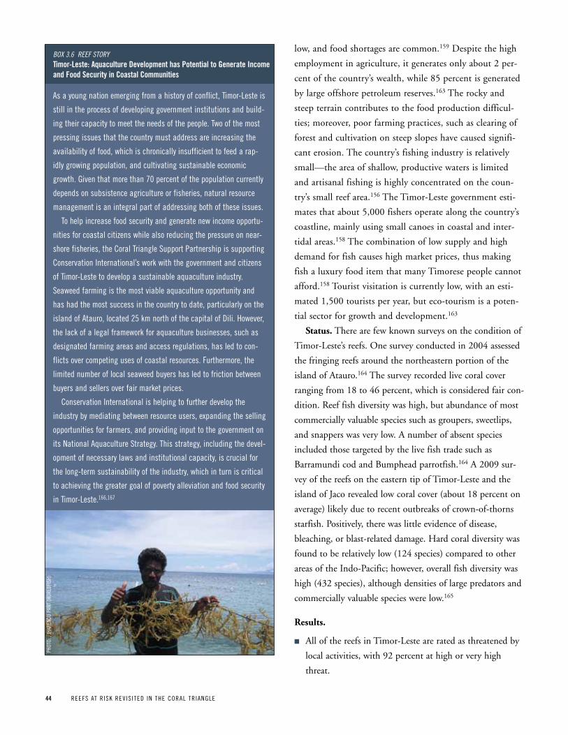
44 REEFS AT R ISK REV IS ITED IN THE CORAL TR IANGLE
low, and food shortages are common.159 Despite the high
employment in agriculture, it generates only about 2 per-
cent of the country’s wealth, while 85 percent is generated
by large offshore petroleum reserves.163 The rocky and
steep terrain contributes to the food production difficul-
ties; moreover, poor farming practices, such as clearing of
forest and cultivation on steep slopes have caused signifi-
cant erosion. The country’s fishing industry is relatively
small—the area of shallow, productive waters is limited
and artisanal fishing is highly concentrated on the coun-
try’s small reef area.156 The Timor-Leste government esti-
mates that about 5,000 fishers operate along the country’s
coastline, mainly using small canoes in coastal and inter-
tidal areas.158 The combination of low supply and high
demand for fish causes high market prices, thus making
fish a luxury food item that many Timorese people cannot
afford.158 Tourist visitation is currently low, with an esti-
mated 1,500 tourists per year, but eco-tourism is a poten-
tial sector for growth and development.163
Status. There are few known surveys on the condition of
Timor-Leste’s reefs. One survey conducted in 2004 assessed
the fringing reefs around the northeastern portion of the
island of Atauro.164 The survey recorded live coral cover
ranging from 18 to 46 percent, which is considered fair con-
dition. Reef fish diversity was high, but abundance of most
commercially valuable species such as groupers, sweetlips,
and snappers was very low. A number of absent species
included those targeted by the live fish trade such as
Barramundi cod and Bumphead parrotfish.164 A 2009 sur-
vey of the reefs on the eastern tip of Timor-Leste and the
island of Jaco revealed low coral cover (about 18 percent on
average) likely due to recent outbreaks of crown-of-thorns
starfish. Positively, there was little evidence of disease,
bleaching, or blast-related damage. Hard coral diversity was
found to be relatively low (124 species) compared to other
areas of the Indo-Pacific; however, overall fish diversity was
high (432 species), although densities of large predators and
commercially valuable species were low.165
Results.
n All of the reefs in Timor-Leste are rated as threatened by
local activities, with 92 percent at high or very high
threat.
As a young nation emerging from a history of conflict, Timor-Leste is
still in the process of developing government institutions and build-
ing their capacity to meet the needs of the people. Two of the most
pressing issues that the country must address are increasing the
availability of food, which is chronically insufficient to feed a rap-
idly growing population, and cultivating sustainable economic
growth. Given that more than 70 percent of the population currently
depends on subsistence agriculture or fisheries, natural resource
management is an integral part of addressing both of these issues.
To help increase food security and generate new income opportu-
nities for coastal citizens while also reducing the pressure on near-
shore fisheries, the Coral Triangle Support partnership is supporting
Conservation International’s work with the government and citizens
of Timor-Leste to develop a sustainable aquaculture industry.
Seaweed farming is the most viable aquaculture opportunity and
has had the most success in the country to date, particularly on the
island of Atauro, located 25 km north of the capital of Dili. However,
the lack of a legal framework for aquaculture businesses, such as
designated farming areas and access regulations, has led to con-
flicts over competing uses of coastal resources. Furthermore, the
limited number of local seaweed buyers has led to friction between
buyers and sellers over fair market prices.
Conservation International is helping to further develop the
industry by mediating between resource users, expanding the selling
opportunities for farmers, and providing input to the government on
its National Aquaculture Strategy. This strategy, including the devel-
opment of necessary laws and institutional capacity, is crucial for
the long-term sustainability of the industry, which in turn is critical
to achieving the greater goal of poverty alleviation and food security
in Timor-Leste.166,167
Box 3.6 Reef stoRytimor-Leste: aquaculture development has potential to generate income and Food Security in Coastal Communities
pHOT
O: :
JHAR
ENDU
pAN
T (W
ORLD
FISH
)
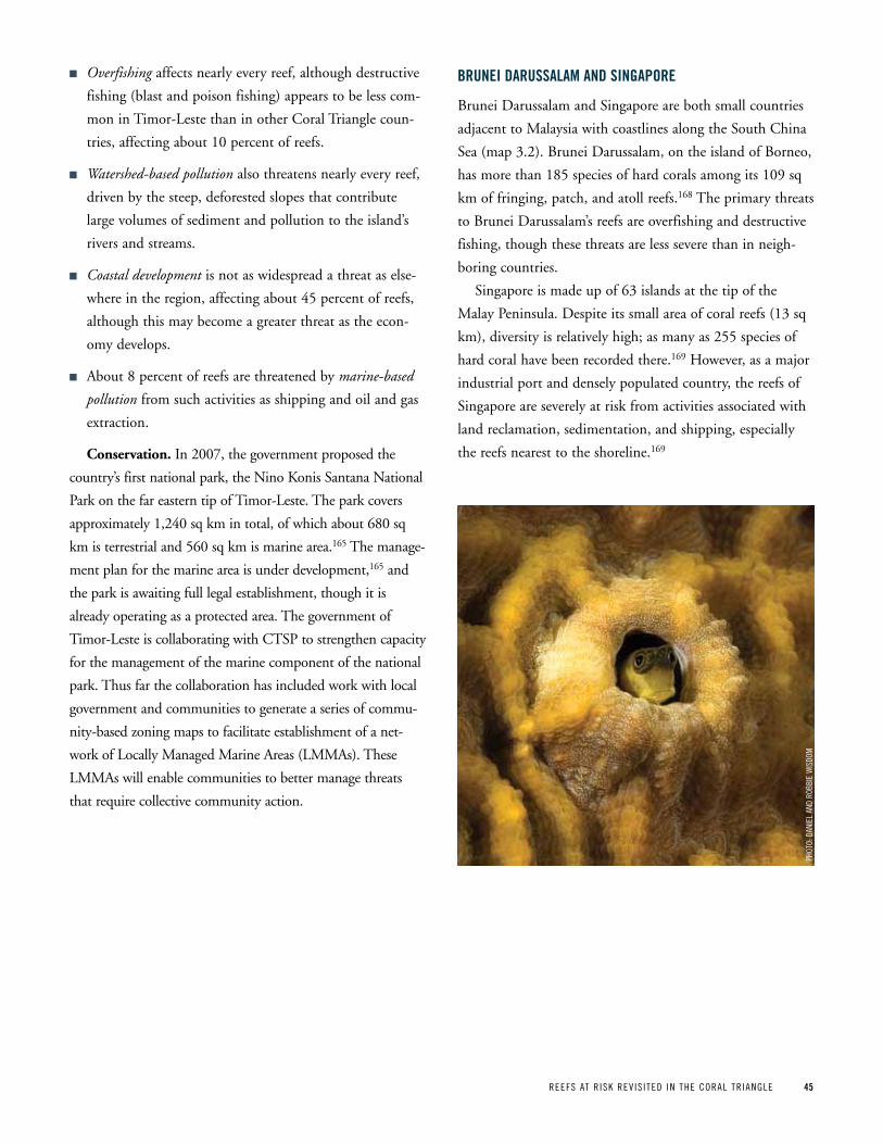
REEFS AT R ISK REV IS ITED IN THE CORAL TR IANGLE 45
n Overfishing affects nearly every reef, although destructive
fishing (blast and poison fishing) appears to be less com-
mon in Timor-Leste than in other Coral Triangle coun-
tries, affecting about 10 percent of reefs.
n Watershed-based pollution also threatens nearly every reef,
driven by the steep, deforested slopes that contribute
large volumes of sediment and pollution to the island’s
rivers and streams.
n Coastal development is not as widespread a threat as else-
where in the region, affecting about 45 percent of reefs,
although this may become a greater threat as the econ-
omy develops.
n About 8 percent of reefs are threatened by marine-based
pollution from such activities as shipping and oil and gas
extraction.
Conservation. In 2007, the government proposed the
country’s first national park, the Nino Konis Santana National
Park on the far eastern tip of Timor-Leste. The park covers
approximately 1,240 sq km in total, of which about 680 sq
km is terrestrial and 560 sq km is marine area.165 The manage-
ment plan for the marine area is under development,165 and
the park is awaiting full legal establishment, though it is
already operating as a protected area. The government of
Timor-Leste is collaborating with CTSP to strengthen capacity
for the management of the marine component of the national
park. Thus far the collaboration has included work with local
government and communities to generate a series of commu-
nity-based zoning maps to facilitate establishment of a net-
work of Locally Managed Marine Areas (LMMAs). These
LMMAs will enable communities to better manage threats
that require collective community action.
Brunei daruSSaLaM and Singapore
Brunei Darussalam and Singapore are both small countries
adjacent to Malaysia with coastlines along the South China
Sea (map 3.2). Brunei Darussalam, on the island of Borneo,
has more than 185 species of hard corals among its 109 sq
km of fringing, patch, and atoll reefs.168 The primary threats
to Brunei Darussalam’s reefs are overfishing and destructive
fishing, though these threats are less severe than in neigh-
boring countries.
Singapore is made up of 63 islands at the tip of the
Malay Peninsula. Despite its small area of coral reefs (13 sq
km), diversity is relatively high; as many as 255 species of
hard coral have been recorded there.169 However, as a major
industrial port and densely populated country, the reefs of
Singapore are severely at risk from activities associated with
land reclamation, sedimentation, and shipping, especially
the reefs nearest to the shoreline.169
pHOT
O: D
ANIE
L AN
D RO
BBIE
WIS
DOM
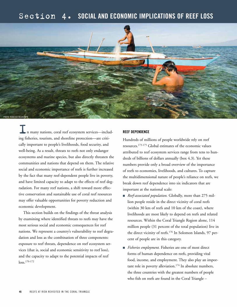
46 REEFS AT R ISK REV IS ITED IN THE CORAL TR IANGLE46 REEFS AT R ISK REV IS ITED IN THE CORAL TR IANGLE
section 4. SoCiaL and eConoMiC iMpLiCationS oF reeF LoSS
in many nations, coral reef ecosystem services—includ-
ing fisheries, tourism, and shoreline protection—are criti-
cally important to people’s livelihoods, food security, and
well-being. As a result, threats to reefs not only endanger
ecosystems and marine species, but also directly threaten the
communities and nations that depend on them. The relative
social and economic importance of reefs is further increased
by the fact that many reef-dependent people live in poverty,
and have limited capacity to adapt to the effects of reef deg-
radation. For many reef nations, a shift toward more effec-
tive conservation and sustainable use of coral reef resources
may offer valuable opportunities for poverty reduction and
economic development.
This section builds on the findings of the threat analysis
by examining where identified threats to reefs may have the
most serious social and economic consequences for reef
nations. We represent a country’s vulnerability to reef degra-
dation and loss as the combination of three components:
exposure to reef threats, dependence on reef ecosystem ser-
vices (that is, social and economic sensitivity to reef loss),
and the capacity to adapt to the potential impacts of reef
loss.170-172
reeF dependenCe
Hundreds of millions of people worldwide rely on reef
resources.173-175 Global estimates of the economic values
attributed to reef ecosystem services range from tens to hun-
dreds of billions of dollars annually (box 4.3). Yet these
numbers provide only a broad overview of the importance
of reefs to economies, livelihoods, and cultures. To capture
the multidimensional nature of people’s reliance on reefs, we
break down reef dependence into six indicators that are
important at the national scale:
n Reef-associated population. Globally, more than 275 mil-
lion people reside in the direct vicinity of coral reefs
(within 30 km of reefs and 10 km of the coast), where
livelihoods are most likely to depend on reefs and related
resources. Within the Coral Triangle Region alone, 114
million people (31 percent of the total population) live in
the direct vicinity of reefs.176 In Solomon Islands, 97 per-
cent of people are in this category.
n Fisheries employment. Fisheries are one of most direct
forms of human dependence on reefs, providing vital
food, income, and employment. They also play an impor-
tant role in poverty alleviation.174 In absolute numbers,
the three countries with the greatest numbers of people
who fish on reefs are found in the Coral Triangle –
pHOTO: REBECCA WEEKS/MpB
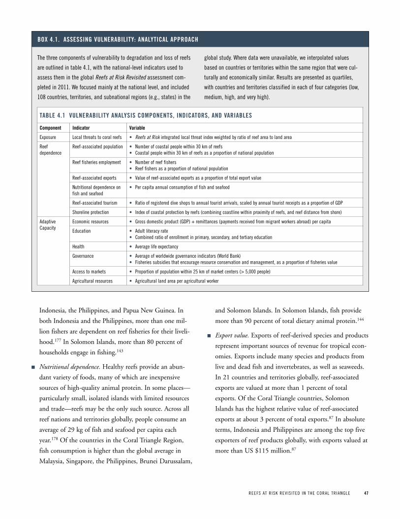
REEFS AT R ISK REV IS ITED IN THE CORAL TR IANGLE 47
Indonesia, the Philippines, and Papua New Guinea. In
both Indonesia and the Philippines, more than one mil-
lion fishers are dependent on reef fisheries for their liveli-
hood.177 In Solomon Islands, more than 80 percent of
households engage in fishing.143
n Nutritional dependence. Healthy reefs provide an abun-
dant variety of foods, many of which are inexpensive
sources of high-quality animal protein. In some places—
particularly small, isolated islands with limited resources
and trade—reefs may be the only such source. Across all
reef nations and territories globally, people consume an
average of 29 kg of fish and seafood per capita each
year.178 Of the countries in the Coral Triangle Region,
fish consumption is higher than the global average in
Malaysia, Singapore, the Philippines, Brunei Darussalam,
and Solomon Islands. In Solomon Islands, fish provide
more than 90 percent of total dietary animal protein.144
n Export value. Exports of reef-derived species and products
represent important sources of revenue for tropical econ-
omies. Exports include many species and products from
live and dead fish and invertebrates, as well as seaweeds.
In 21 countries and territories globally, reef-associated
exports are valued at more than 1 percent of total
exports. Of the Coral Triangle countries, Solomon
Islands has the highest relative value of reef-associated
exports at about 3 percent of total exports.87 In absolute
terms, Indonesia and Philippines are among the top five
exporters of reef products globally, with exports valued at
more than US $115 million.87
The three components of vulnerability to degradation and loss of reefs
are outlined in table 4.1, with the national-level indicators used to
assess them in the global Reefs at Risk Revisited assessment com-
pleted in 2011. We focused mainly at the national level, and included
108 countries, territories, and subnational regions (e.g., states) in the
global study. Where data were unavailable, we interpolated values
based on countries or territories within the same region that were cul-
turally and economically similar. Results are presented as quartiles,
with countries and territories classified in each of four categories (low,
medium, high, and very high).
Box 4 1 aSSeSSing vuLneraBiLity: anaLytiCaL approaCh
taBLe 4 1 vuLneraBiLity anaLySiS CoMponentS, indiCatorS, and variaBLeS
Component indicator variable
Exposure Local threats to coral reefs • Reefs at Risk integrated local threat index weighted by ratio of reef area to land area
Reef dependence
Reef-associated population • Number of coastal people within 30 km of reefs• Coastal people within 30 km of reefs as a proportion of national population
Reef fisheries employment • Number of reef fishers• Reef fishers as a proportion of national population
Reef-associated exports • Value of reef-associated exports as a proportion of total export value
Nutritional dependence on fish and seafood
• per capita annual consumption of fish and seafood
Reef-associated tourism • Ratio of registered dive shops to annual tourist arrivals, scaled by annual tourist receipts as a proportion of GDp
Shoreline protection • Index of coastal protection by reefs (combining coastline within proximity of reefs, and reef distance from shore)
Adaptive Capacity
Economic resources • Gross domestic product (GDp) + remittances (payments received from migrant workers abroad) per capita
Education • Adult literacy rate• Combined ratio of enrollment in primary, secondary, and tertiary education
Health • Average life expectancy
Governance • Average of worldwide governance indicators (World Bank)• Fisheries subsidies that encourage resource conservation and management, as a proportion of fisheries value
Access to markets • proportion of population within 25 km of market centers (> 5,000 people)
Agricultural resources • Agricultural land area per agricultural worker
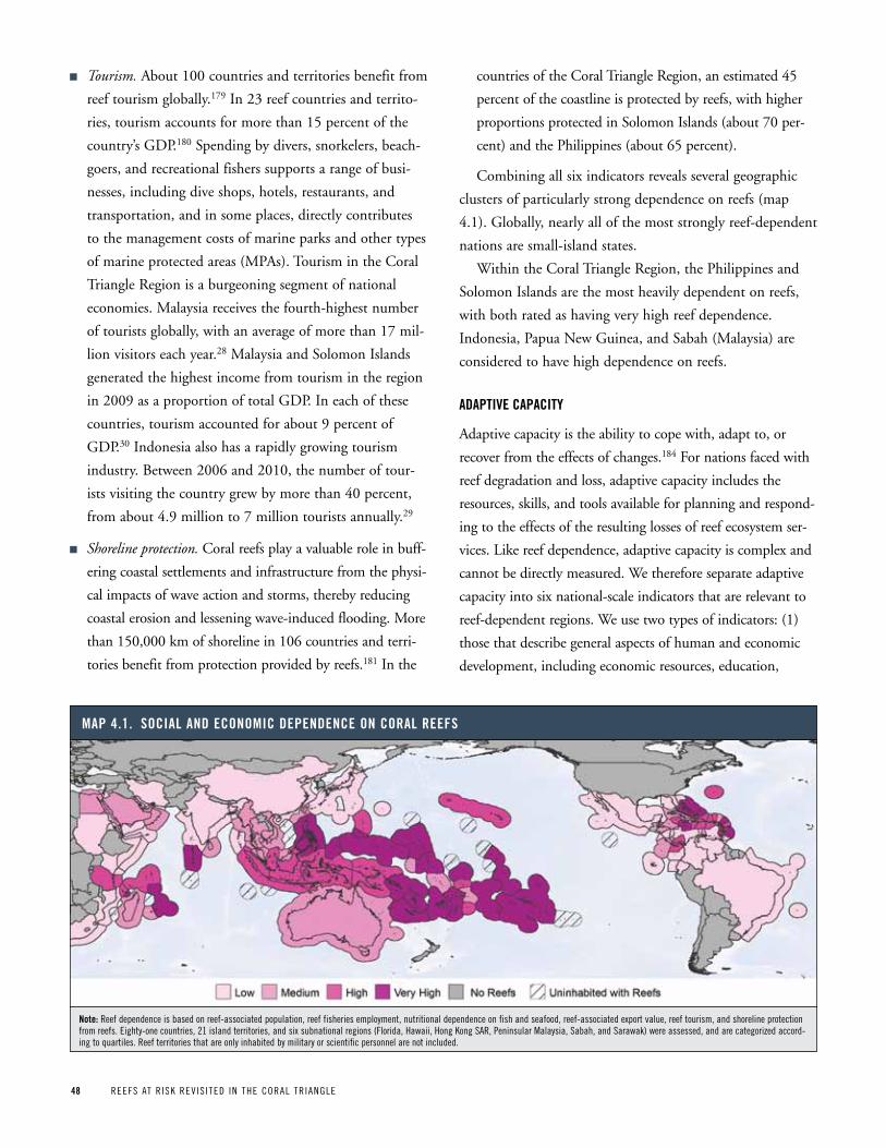
48 REEFS AT R ISK REV IS ITED IN THE CORAL TR IANGLE
n Tourism. About 100 countries and territories benefit from
reef tourism globally.179 In 23 reef countries and territo-
ries, tourism accounts for more than 15 percent of the
country’s GDP.180 Spending by divers, snorkelers, beach-
goers, and recreational fishers supports a range of busi-
nesses, including dive shops, hotels, restaurants, and
transportation, and in some places, directly contributes
to the management costs of marine parks and other types
of marine protected areas (MPAs). Tourism in the Coral
Triangle Region is a burgeoning segment of national
economies. Malaysia receives the fourth-highest number
of tourists globally, with an average of more than 17 mil-
lion visitors each year.28 Malaysia and Solomon Islands
generated the highest income from tourism in the region
in 2009 as a proportion of total GDP. In each of these
countries, tourism accounted for about 9 percent of
GDP.30 Indonesia also has a rapidly growing tourism
industry. Between 2006 and 2010, the number of tour-
ists visiting the country grew by more than 40 percent,
from about 4.9 million to 7 million tourists annually.29
n Shoreline protection. Coral reefs play a valuable role in buff-
ering coastal settlements and infrastructure from the physi-
cal impacts of wave action and storms, thereby reducing
coastal erosion and lessening wave-induced flooding. More
than 150,000 km of shoreline in 106 countries and terri-
tories benefit from protection provided by reefs.181 In the
countries of the Coral Triangle Region, an estimated 45
percent of the coastline is protected by reefs, with higher
proportions protected in Solomon Islands (about 70 per-
cent) and the Philippines (about 65 percent).
Combining all six indicators reveals several geographic
clusters of particularly strong dependence on reefs (map
4.1). Globally, nearly all of the most strongly reef-dependent
nations are small-island states.
Within the Coral Triangle Region, the Philippines and
Solomon Islands are the most heavily dependent on reefs,
with both rated as having very high reef dependence.
Indonesia, Papua New Guinea, and Sabah (Malaysia) are
considered to have high dependence on reefs.
adaptive CapaCity
Adaptive capacity is the ability to cope with, adapt to, or
recover from the effects of changes.184 For nations faced with
reef degradation and loss, adaptive capacity includes the
resources, skills, and tools available for planning and respond-
ing to the effects of the resulting losses of reef ecosystem ser-
vices. Like reef dependence, adaptive capacity is complex and
cannot be directly measured. We therefore separate adaptive
capacity into six national-scale indicators that are relevant to
reef-dependent regions. We use two types of indicators: (1)
those that describe general aspects of human and economic
development, including economic resources, education,
Map 4 1 SoCiaL and eConoMiC dependenCe on CoraL reeFS
note: Reef dependence is based on reef-associated population, reef fisheries employment, nutritional dependence on fish and seafood, reef-associated export value, reef tourism, and shoreline protection from reefs. Eighty-one countries, 21 island territories, and six subnational regions (Florida, Hawaii, Hong Kong SAR, peninsular Malaysia, Sabah, and Sarawak) were assessed, and are categorized accord-ing to quartiles. Reef territories that are only inhabited by military or scientific personnel are not included.
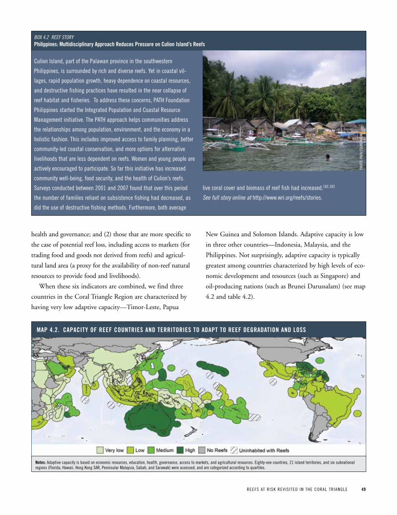
REEFS AT R ISK REV IS ITED IN THE CORAL TR IANGLE 49
health and governance; and (2) those that are more specific to
the case of potential reef loss, including access to markets (for
trading food and goods not derived from reefs) and agricul-
tural land area (a proxy for the availability of non-reef natural
resources to provide food and livelihoods).
When these six indicators are combined, we find three
countries in the Coral Triangle Region are characterized by
having very low adaptive capacity—Timor-Leste, Papua
New Guinea and Solomon Islands. Adaptive capacity is low
in three other countries—Indonesia, Malaysia, and the
Philippines. Not surprisingly, adaptive capacity is typically
greatest among countries characterized by high levels of eco-
nomic development and resources (such as Singapore) and
oil-producing nations (such as Brunei Darussalam) (see map
4.2 and table 4.2).
Map 4 2 CapaCity oF reeF CountrieS and territorieS to adapt to reeF degradation and LoSS
notes: Adaptive capacity is based on economic resources, education, health, governance, access to markets, and agricultural resources. Eighty-one countries, 21 island territories, and six subnational regions (Florida, Hawaii, Hong Kong SAR, peninsular Malaysia, Sabah, and Sarawak) were assessed, and are categorized according to quartiles.
Culion Island, part of the palawan province in the southwestern
philippines, is surrounded by rich and diverse reefs. yet in coastal vil-
lages, rapid population growth, heavy dependence on coastal resources,
and destructive fishing practices have resulted in the near collapse of
reef habitat and fisheries. To address these concerns, pATH Foundation
philippines started the Integrated population and Coastal Resource
Management initiative. The pATH approach helps communities address
the relationships among population, environment, and the economy in a
holistic fashion. This includes improved access to family planning, better
community-led coastal conservation, and more options for alternative
livelihoods that are less dependent on reefs. Women and young people are
actively encouraged to participate. So far this initiative has increased
community well-being, food security, and the health of Culion’s reefs.
Surveys conducted between 2001 and 2007 found that over this period
the number of families reliant on subsistence fishing had decreased, as
did the use of destructive fishing methods. Furthermore, both average
live coral cover and biomass of reef fish had increased.182,183
see full story online at http://www.wri.org/reefs/stories.
Box 4.2 Reef stoRyphilippines: Multidisciplinary approach reduces pressure on Culion island’s reefs
pHOT
O: p
ATH
FOUN
DATI
ON
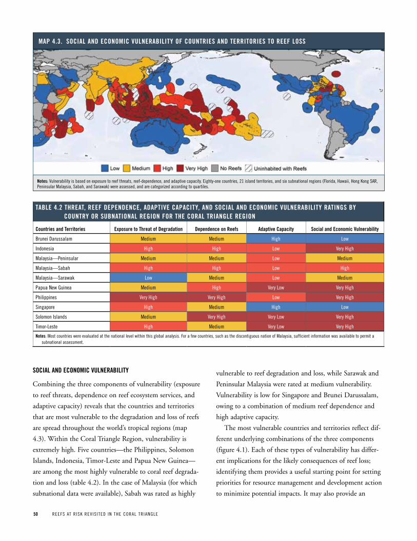
50 REEFS AT R ISK REV IS ITED IN THE CORAL TR IANGLE
SoCiaL and eConoMiC vuLneraBiLity
Combining the three components of vulnerability (exposure
to reef threats, dependence on reef ecosystem services, and
adaptive capacity) reveals that the countries and territories
that are most vulnerable to the degradation and loss of reefs
are spread throughout the world’s tropical regions (map
4.3). Within the Coral Triangle Region, vulnerability is
extremely high. Five countries—the Philippines, Solomon
Islands, Indonesia, Timor-Leste and Papua New Guinea—
are among the most highly vulnerable to coral reef degrada-
tion and loss (table 4.2). In the case of Malaysia (for which
subnational data were available), Sabah was rated as highly
vulnerable to reef degradation and loss, while Sarawak and
Peninsular Malaysia were rated at medium vulnerability.
Vulnerability is low for Singapore and Brunei Darussalam,
owing to a combination of medium reef dependence and
high adaptive capacity.
The most vulnerable countries and territories reflect dif-
ferent underlying combinations of the three components
(figure 4.1). Each of these types of vulnerability has differ-
ent implications for the likely consequences of reef loss;
identifying them provides a useful starting point for setting
priorities for resource management and development action
to minimize potential impacts. It may also provide an
Map 4 3 SoCiaL and eConoMiC vuLneraBiLity oF CountrieS and territorieS to reeF LoSS
notes: Vulnerability is based on exposure to reef threats, reef-dependence, and adaptive capacity. Eighty-one countries, 21 island territories, and six subnational regions (Florida, Hawaii, Hong Kong SAR, peninsular Malaysia, Sabah, and Sarawak) were assessed, and are categorized according to quartiles.
taBLe 4 2 threat, reeF dependenCe, adaptive CapaCity, and SoCiaL and eConoMiC vuLneraBiLity ratingS By Country or SuBnationaL region For the CoraL triangLe region
Countries and territories exposure to threat of degradation dependence on reefs adaptive Capacity Social and economic vulnerability
Brunei Darussalam Medium Medium High Low
Indonesia High High Low Very High
Malaysia—peninsular Medium Medium Low Medium
Malaysia—Sabah High High Low High
Malaysia—Sarawak Low Medium Low Medium
papua New Guinea Medium High Very Low Very High
philippines Very High Very High Low Very High
Singapore High Medium High Low
Solomon Islands Medium Very High Very Low Very High
Timor-Leste High Medium Very Low Very High
notes: Most countries were evaluated at the national level within this global analysis. For a few countries, such as the discontiguous nation of Malaysia, sufficient information was available to permit a subnational assessment.
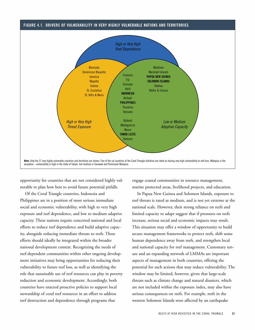
REEFS AT R ISK REV IS ITED IN THE CORAL TR IANGLE 51
opportunity for countries that are not considered highly vul-
nerable to plan how best to avoid future potential pitfalls.
Of the Coral Triangle countries, Indonesia and
Philippines are in a position of most serious immediate
social and economic vulnerability, with high to very high
exposure and reef dependence, and low to medium adaptive
capacity. These nations require concerted national and local
efforts to reduce reef dependence and build adaptive capac-
ity, alongside reducing immediate threats to reefs. These
efforts should ideally be integrated within the broader
national development context. Recognizing the needs of
reef-dependent communities within other ongoing develop-
ment initiatives may bring opportunities for reducing their
vulnerability to future reef loss, as well as identifying the
role that sustainable use of reef resources can play in poverty
reduction and economic development. Accordingly, both
countries have enacted proactive policies to support local
stewardship of coral reef resources in an effort to address
reef destruction and dependence through programs that
engage coastal communities in resource management,
marine protected areas, livelihood projects, and education.
In Papua New Guinea and Solomon Islands, exposure to
reef threats is rated as medium, and is not yet extreme at the
national scale. However, their strong reliance on reefs and
limited capacity to adapt suggest that if pressures on reefs
increase, serious social and economic impacts may result.
This situation may offer a window of opportunity to build
secure management frameworks to protect reefs, shift some
human dependence away from reefs, and strengthen local
and national capacity for reef management. Customary ten-
ure and an expanding network of LMMAs are important
aspects of management in both countries, offering the
potential for such actions that may reduce vulnerability. The
window may be limited, however, given that large-scale
threats such as climate change and natural disasters, which
are not included within the exposure index, may also have
serious consequences on reefs. For example, reefs in the
western Solomon Islands were affected by an earthquake
Figure 4 1 driverS oF vuLneraBiLity in very highLy vuLneraBLe nationS and territorieS
note: Only the 27 very highly vulnerable countries and territories are shown. Five of the six countries of the Coral Triangle Initiative are rated as having very high vulnerability to reef loss. Malaysia is the exception—vulnerability is high in the state of Sabah, but medium in Sarawak and peninsular Malaysia.
High or Very High Reef Dependence
Low or Medium Adaptive Capacity
High or Very High Threat Exposure
BermudaDominican Republic
JamaicaMayotteSamoa
St. EustatiusSt. Kitts & Nevis
ComorosFiji
GrenadaHaiti
INDONESIAKiribati
PHILIPPINESTanzaniaVanuatu
DjiboutiMadagascar
NauruTIMOR-LESTE
Vietnam
MaldivesMarshall Islands
PAPUA NEW GUINEASOLOMON ISLANDS
TokelauWallis & Futuna
52 REEFS AT R ISK REV IS ITED IN THE CORAL TR IANGLE
and tsunami in 2007, with resulting impacts on coastal
communities and fisheries.150
In Timor-Leste, very high vulnerability stems from high
threats to reefs and limited adaptive capacity, despite only
moderate national-scale dependence on reefs. This combina-
tion of drivers suggests that while social and economic
impacts of reef loss may be serious for some local areas,
these effects are likely to be less significant on a national
scale. Vulnerability may be reduced most effectively by tar-
geting efforts to reduce threats to reefs and build capacity at
local scales, raising government awareness about locations
where reef dependence is particularly high, and paying
attention to others where this dependence may increase. A
primary objective within the government of Timor-Leste is
to identify and encourage economic development opportu-
nities that both employ people and lessen dependence on
natural resources, including coral reefs.
Valuation
Economic valuation is a tool that can aid decision making by quanti-
fying ecosystem services, such as those provided by coral reefs, in
monetary terms. In traditional markets, ecosystem services are often
overlooked or unaccounted for, an omission that regularly leads to
decisions favoring short-term economic gains at the expense of lon-
ger-term benefits; for example, clearing mangroves to make room for
aquaculture versus the longer-term benefits of leaving mangroves in
place, which include nutrient filtering, shoreline protection, and habi-
tat for fisheries species. Economic valuation provides more complete
information on the economic consequences of decisions that lead to
degradation and loss of natural resources, as well as the short- and
long-term costs and benefits of environmental protection.
Coral reef values
Many studies have quantified the value of one or more ecosystem ser-
vices provided by coral reefs. These studies vary widely in terms of spa-
tial scale (from global to local), method used, and type of value esti-
mated. Some assessments focus on the annual benefits coming from
reefs, and some estimate total value over a number of years. Still others
focus on the change in value as an ecosystem is altered.
Of the many ecosystem services provided by coral reefs, reef-related fish-
eries, tourism, and shoreline protection are among the most widely studied
because their prices are traceable in markets and are thus relatively easy to
calculate. We provide examples of values in table 4.3. The economic bene-
fits derived from coral reefs vary considerably by site, depending on the size
of tourism markets, the importance and productivity of fisheries, level of
coastal development, and the distance to major population centers.
Box 4 3 eConoMiC vaLue oF CoraL reeFS
taBLe 4 3 SaMpLe vaLueS: annuaL net BeneFitS FroM CoraL reeF-reLated goodS and ServiCeS* (uS$, 2010)
extent of Study tourism Coral-reef Fisheries Shoreline protection
Globala $11.5 billion $6.8 billion $10.7 billion
Indonesia (National)b $127 million $1.5 billion $387 million
philippines (National)c $133 million $750 million $400 million
Raja Ampat, Indonesia (local)d $1.7 million $7.7 million $62 thousand
Tubbataha, philippines (local)e $3.7 million $1.5 million Not evaluated
* All estimates are net benefits (which take costs into account) and have been converted to US$ 2010.Sources: a. Cesar, H., L. Burke, and L. pet-Soede. 2003. The Economics of Worldwide Coral Reef Degradation. Zeist, Netherlands: Cesar Environmental Economics Consulting (CEEC). b. Burke, L., E. Selig, and M. Spalding. 2002. Reefs at Risk in Southeast Asia. Washington, DC: World Resources Institute. Adapted from H.S.J. Cesar. 1996. “Economic Analysis of Indonesian Coral
Reefs.” Working paper Series ‘Work in progress.’ Washington, DC: World Bank.c. Burke, L., E. Selig, and M. Spalding. 2002. Reefs at Risk in Southeast Asia. Washington, DC: World Resources Institute. Adapted from A.T. White, H.p. Vogt, and T. Arin. 2000. “philippine Coral
Reefs under Threat: The Economic Losses Caused by Reef Destruction.” Marine Pollution Bulletin 40, 7 (2000): 598-605; and A.T. White and A. Cruz-Trinidad. 1998. The Values of Philippine Coastal Resources: Why Protection and Management are Critical. Cebu City: Coastal Resource Management project.
d. Emerton, L. 2009. “Investing in Natural Infrastructure: The Economic Value of Indonesia’s Marine & Coastal Ecosystems.” Denpasar, Indonesia: Indonesian Marine program, The Nature Conservancy. Based on work presented in Dohar, A. and D. Anggraeni. 2006. Economic Valuation of Natural Resources and Ecosystem Services, Raja Ampat. Jakarta: Universitas Negeri papua (UNIpA) and Conservation International Indonesia; and Sumaila, U.R. and M. Bailey. 2007. Towards Ecosystem-Based Management in the Birds Head Functional Seascape of Papua, Indonesia: The Economic Sub-Project. Jakarta: The Nature Conservancy, Conservation International, and WorldWide Fund for Nature Indonesia.
e. Subade, R.F. 2006. “Mechanisms to Capture Economic Values of Marine Biodiversity: The Case of Tubbataha Reefs UNESCO World Heritage Site, philippines.” Marine Policy 31, 2 (2006): 135-142. Adapted from Arquiza, y., and A. White. 1994. “Tales from Tubbataha: Natural History, Resource Use, and Conservation of the Tubbataha Reefs, palawan, philippines.” Mandaluyong City, philippines: Rainee Trading and publishing, Inc.
REEFS AT R ISK REV IS ITED IN THE CORAL TR IANGLE 53
Reducing reef dependence is extremely challenging. In
many areas, a lack of information about dependence on spe-
cific reef ecosystem services—for example, dietary consump-
tion, or numbers of subsistence fishers—has hindered plan-
ning and prioritization at local scales. Even where reef
dependence is well-understood, past efforts to develop alter-
native livelihoods in coastal areas have frequently proven
unsuccessful.185 Such initiatives have typically been carried
out on a very limited scale and as stand-alone efforts, rather
than within the framework of broader development pro-
grams. Furthermore, many such initiatives have failed to
identify or adequately consider the reasons why individuals
choose to engage in reef-dependent livelihood activities. In
some cases, activities such as agriculture, aquaculture, tour-
ism, or trade may represent viable alternatives, but these will
only be sustainable where their development takes into
account local aspirations, needs, perceptions, and cultural
ties to coral reefs.186 For millions of reef-dependent people
in the Coral Triangle and around the world, it is critical that
such efforts succeed.
Valuation of losses due to degradation
Although many economic valuation studies have focused on estimating
the benefits of coral reef ecosystem services, some studies have also
focused on changes in value—that is, what an economy stands to lose
if a reef is degraded. Examples include:
• The2004Reefs at Risk in the Caribbean study estimated that, by
2015, the projected degradation of Caribbean reefs from human
activities such as overfishing and pollution could result in annual
losses of US$95 million to US$140 million in net revenues from coral
reef-associated fisheries, and US$100 million to US$300 million in
reduced tourism revenue. In addition, degradation of reefs could lead
to annual losses of US$140 million to US$420 million from reduced
coastal protection within the next 50 years.187
• PervasiveoverfishinginIndonesiaandthePhilippinescouldresultin
massive societal losses, estimated at US$1.9 billion over 20 years in
Indonesia and $1.2 billion over 20 years in the philippines.35
• AnotherstudyestimatedthatAustralia’seconomycouldloseUS$2.2
billion to US$5.3 billion over the next 19 years due to global climate
change degrading the Great Barrier Reef.188
Moving in the other direction, improved management can increase the
sustainable benefits provided by coral reefs. A valuation of coral reefs
surrounding Olango Island in the philippines compared current economic
benefits (net revenues) with those that would be possible under improved
coastal and fisheries management within an MpA, and projected a 55 to
60 percent increase in benefits, which vastly exceeds management costs.
For the Giluntungan Marine Reserve at Olango, estimates of incremental
annual revenues from tourism and fisheries under improved manage-
ment were estimated at US$176,000 and $24,000, respectively, while
estimated management costs were only US$21,000.189
Policy and Management Applications
The goal of economic valuation is to influence decisions that will pro-
mote the conservation and sustainable management of reefs. By quanti-
fying the economic benefits or losses likely to occur due to degradation
of reefs, it is possible to tap public and private funding for coastal
management, gain access to new markets, initiate payments for ecosys-
tem services, and charge polluters for damages. The results of coral reef
valuation studies have helped to establish user fees at MpAs, improve
fisheries management regulations, and inform damage claims assess-
ments. Despite the usefulness of economic valuation, there are still
many challenges to its practical application. In particular, although
global-scale valuation studies are frequently cited, they are often mis-
leading due to the difficulty of aggregating values and constraints on
data at the global level. Furthermore, economic valuation can produce
only a partial estimate of total ecosystem value, as humankind’s limited
technical, economic, and ecological knowledge prevents us from ever
truly identifying, calculating, and ranking all of an ecosystem’s services,
benefits, and values. Valuation studies also contain a range of assump-
tions and limitations, which must be taken into account during the
decision-making process. Economic valuation can inform policy deci-
sions, but valuations tend to be most useful when developed with a par-
ticular policy application in mind, such as evaluating the benefits of a
no-take reserve, and at a scale that national or local policy makers can
relate to from their own experience.
Box 4 3 continued
pHOT
O: B
RUCE
BOW
EN
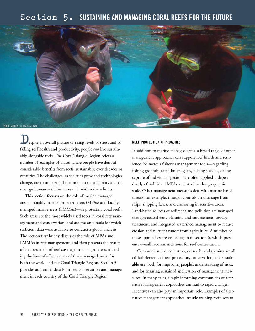
54 REEFS AT R ISK REV IS ITED IN THE CORAL TR IANGLE54 REEFS AT R ISK REV IS ITED IN THE CORAL TR IANGLE
despite an overall picture of rising levels of stress and of
failing reef health and productivity, people can live sustain-
ably alongside reefs. The Coral Triangle Region offers a
number of examples of places where people have derived
considerable benefits from reefs, sustainably, over decades or
centuries. The challenges, as societies grow and technologies
change, are to understand the limits to sustainability and to
manage human activities to remain within these limits.
This section focuses on the role of marine managed
areas—notably marine protected areas (MPAs) and locally
managed marine areas (LMMAs)—in protecting coral reefs.
Such areas are the most widely used tools in coral reef man-
agement and conservation, and are the only tools for which
sufficient data were available to conduct a global analysis.
The section first briefly discusses the role of MPAs and
LMMAs in reef management, and then presents the results
of an assessment of reef coverage in managed areas, includ-
ing the level of effectiveness of these managed areas, for
both the world and the Coral Triangle Region. Section 3
provides additional details on reef conservation and manage-
ment in each country of the Coral Triangle Region.
reeF proteCtion approaCheS
In addition to marine managed areas, a broad range of other
management approaches can support reef health and resil-
ience. Numerous fisheries management tools—regarding
fishing grounds, catch limits, gears, fishing seasons, or the
capture of individual species—are often applied indepen-
dently of individual MPAs and at a broader geographic
scale. Other management measures deal with marine-based
threats; for example, through controls on discharge from
ships, shipping lanes, and anchoring in sensitive areas.
Land-based sources of sediment and pollution are managed
through coastal zone planning and enforcement, sewage
treatment, and integrated watershed management to reduce
erosion and nutrient runoff from agriculture. A number of
these approaches are visited again in section 6, which pres-
ents overall recommendations for reef conservation.
Communications, education, outreach, and training are all
critical elements of reef protection, conservation, and sustain-
able use, both for improving people’s understanding of risks,
and for ensuring sustained application of management mea-
sures. In many cases, simply informing communities of alter-
native management approaches can lead to rapid changes.
Incentives can also play an important role. Examples of alter-
native management approaches include training reef users to
section 5. SuStaining and Managing CoraL reeFS For the Future
pHOTO: MOHD yUSUF BIN BURAL/WWF
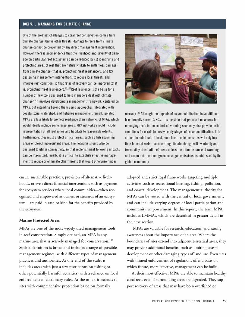
REEFS AT R ISK REV IS ITED IN THE CORAL TR IANGLE 55
ensure sustainable practices, provision of alternative liveli-
hoods, or even direct financial interventions such as payment
for ecosystem services where local communities—when rec-
ognized and empowered as owners or stewards of an ecosys-
tem—are paid in cash or kind for the benefits provided by
the ecosystem.
Marine Protected Areas
MPAs are one of the most widely used management tools
in reef conservation. Simply defined, an MPA is any
marine area that is actively managed for conservation.190
Such a definition is broad and includes a range of possible
management regimes, with different types of management
practices and authorities. At one end of the scale, it
includes areas with just a few restrictions on fishing or
other potentially harmful activities, with a reliance on local
enforcement of customary rules. At the other, it extends to
sites with comprehensive protection based on formally
adopted and strict legal frameworks targeting multiple
activities such as recreational boating, fishing, pollution,
and coastal development. The management authority for
MPAs can be vested with the central or local government,
and can include varying degrees of local participation and
community empowerment. In this report, the term MPA
includes LMMAs, which are described in greater detail in
the next section.
MPAs are valuable for research, education, and raising
awareness about the importance of an area. Where the
boundaries of sites extend into adjacent terrestrial areas, they
may provide additional benefits, such as limiting coastal
development or other damaging types of land use. Even sites
with limited enforcement of regulations offer a basis on
which future, more effective, management can be built.
At their most effective, MPAs are able to maintain healthy
coral reefs even if surrounding areas are degraded. They sup-
port recovery of areas that may have been overfished or
One of the greatest challenges to coral reef conservation comes from
climate change. Unlike other threats, damage to reefs from climate
change cannot be prevented by any direct management intervention.
However, there is good evidence that the likelihood and severity of dam-
age on particular reef ecosystems can be reduced by (1) identifying and
protecting areas of reef that are naturally likely to suffer less damage
from climate change (that is, promoting “reef resistance”), and (2)
designing management interventions to reduce local threats and
improve reef condition, so that rates of recovery can be improved (that
is, promoting “reef resilience”).47,197Reef resilience is the basis for a
number of new tools designed to help managers deal with climate
change.46 It involves developing a management framework, centered on
MpAs, but extending beyond them using approaches integrated with
coastal zone, watershed, and fisheries management. Small, isolated
MpAs are less likely to promote resilience than networks of MpAs, which
would ideally include some large areas. MpA networks should include
representation of all reef zones and habitats to reasonable extents.
Furthermore, they must protect critical areas, such as fish spawning
areas or bleaching-resistant areas. The networks should also be
designed to utilize connectivity, so that replenishment following impacts
can be maximized. Finally, it is critical to establish effective manage-
ment to reduce or eliminate other threats that would otherwise hinder
recovery.198 Although the impacts of ocean acidification have still not
been broadly shown in situ, it is possible that proposed measures for
managing reefs in the context of warming seas may also provide better
conditions for corals to survive early stages of ocean acidification. It is
critical to note that, at best, such local-scale measures will only buy
time for coral reefs—accelerating climate change will eventually and
irreversibly affect all reef areas unless the ultimate cause of warming
and ocean acidification, greenhouse gas emissions, is addressed by the
global community.
Box 5 1 Managing For CLiMate Change
pHOT
O: F
REDA
pAI
VA, T
NC
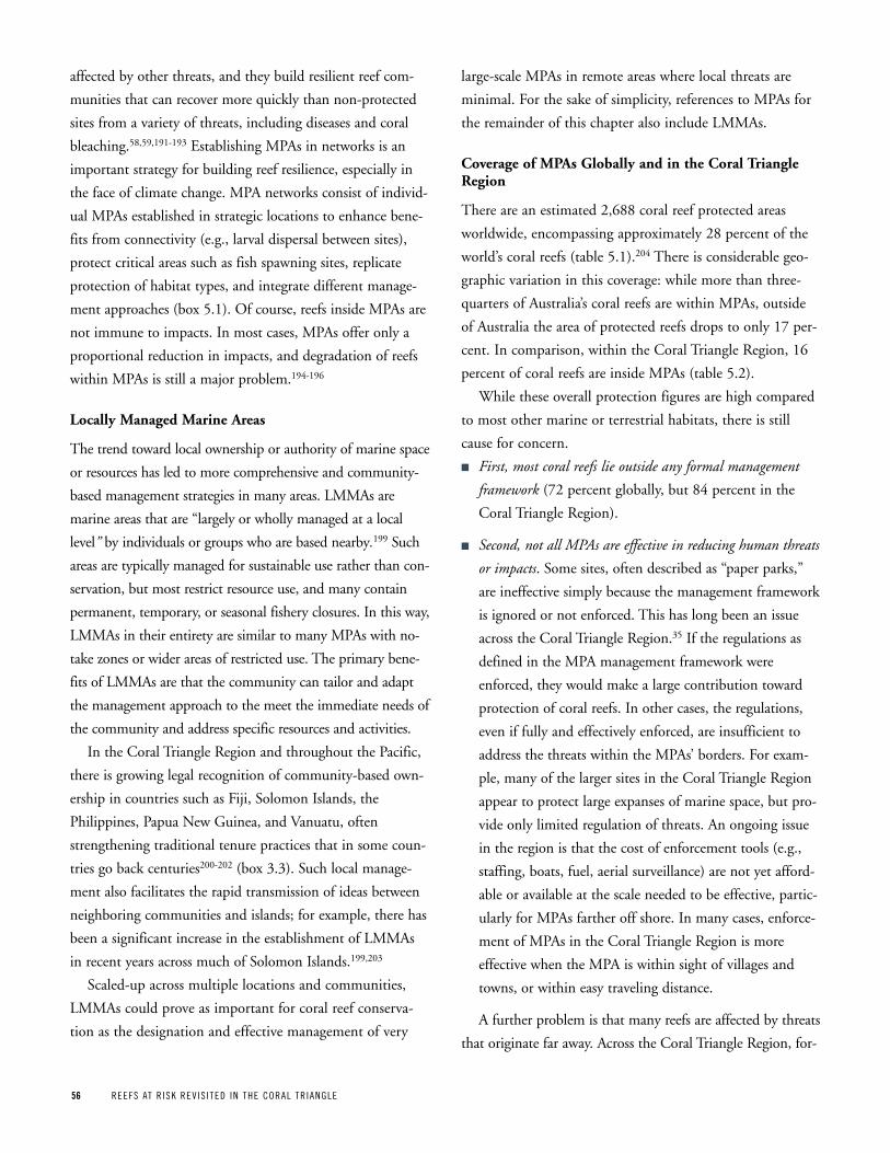
56 REEFS AT R ISK REV IS ITED IN THE CORAL TR IANGLE
affected by other threats, and they build resilient reef com-
munities that can recover more quickly than non-protected
sites from a variety of threats, including diseases and coral
bleaching.58,59,191-193 Establishing MPAs in networks is an
important strategy for building reef resilience, especially in
the face of climate change. MPA networks consist of individ-
ual MPAs established in strategic locations to enhance bene-
fits from connectivity (e.g., larval dispersal between sites),
protect critical areas such as fish spawning sites, replicate
protection of habitat types, and integrate different manage-
ment approaches (box 5.1). Of course, reefs inside MPAs are
not immune to impacts. In most cases, MPAs offer only a
proportional reduction in impacts, and degradation of reefs
within MPAs is still a major problem.194-196
Locally Managed Marine Areas
The trend toward local ownership or authority of marine space
or resources has led to more comprehensive and community-
based management strategies in many areas. LMMAs are
marine areas that are “largely or wholly managed at a local
level” by individuals or groups who are based nearby.199 Such
areas are typically managed for sustainable use rather than con-
servation, but most restrict resource use, and many contain
permanent, temporary, or seasonal fishery closures. In this way,
LMMAs in their entirety are similar to many MPAs with no-
take zones or wider areas of restricted use. The primary bene-
fits of LMMAs are that the community can tailor and adapt
the management approach to the meet the immediate needs of
the community and address specific resources and activities.
In the Coral Triangle Region and throughout the Pacific,
there is growing legal recognition of community-based own-
ership in countries such as Fiji, Solomon Islands, the
Philippines, Papua New Guinea, and Vanuatu, often
strengthening traditional tenure practices that in some coun-
tries go back centuries200-202 (box 3.3). Such local manage-
ment also facilitates the rapid transmission of ideas between
neighboring communities and islands; for example, there has
been a significant increase in the establishment of LMMAs
in recent years across much of Solomon Islands.199,203
Scaled-up across multiple locations and communities,
LMMAs could prove as important for coral reef conserva-
tion as the designation and effective management of very
large-scale MPAs in remote areas where local threats are
minimal. For the sake of simplicity, references to MPAs for
the remainder of this chapter also include LMMAs.
Coverage of MPAs Globally and in the Coral Triangle Region
There are an estimated 2,688 coral reef protected areas
worldwide, encompassing approximately 28 percent of the
world’s coral reefs (table 5.1).204 There is considerable geo-
graphic variation in this coverage: while more than three-
quarters of Australia’s coral reefs are within MPAs, outside
of Australia the area of protected reefs drops to only 17 per-
cent. In comparison, within the Coral Triangle Region, 16
percent of coral reefs are inside MPAs (table 5.2).
While these overall protection figures are high compared
to most other marine or terrestrial habitats, there is still
cause for concern.
n First, most coral reefs lie outside any formal management
framework (72 percent globally, but 84 percent in the
Coral Triangle Region).
n Second, not all MPAs are effective in reducing human threats
or impacts. Some sites, often described as “paper parks,”
are ineffective simply because the management framework
is ignored or not enforced. This has long been an issue
across the Coral Triangle Region.35 If the regulations as
defined in the MPA management framework were
enforced, they would make a large contribution toward
protection of coral reefs. In other cases, the regulations,
even if fully and effectively enforced, are insufficient to
address the threats within the MPAs’ borders. For exam-
ple, many of the larger sites in the Coral Triangle Region
appear to protect large expanses of marine space, but pro-
vide only limited regulation of threats. An ongoing issue
in the region is that the cost of enforcement tools (e.g.,
staffing, boats, fuel, aerial surveillance) are not yet afford-
able or available at the scale needed to be effective, partic-
ularly for MPAs farther off shore. In many cases, enforce-
ment of MPAs in the Coral Triangle Region is more
effective when the MPA is within sight of villages and
towns, or within easy traveling distance.
A further problem is that many reefs are affected by threats
that originate far away. Across the Coral Triangle Region, for-
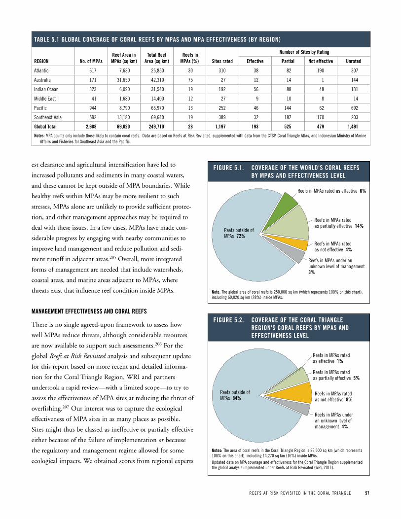
REEFS AT R ISK REV IS ITED IN THE CORAL TR IANGLE 57
est clearance and agricultural intensification have led to
increased pollutants and sediments in many coastal waters,
and these cannot be kept outside of MPA boundaries. While
healthy reefs within MPAs may be more resilient to such
stresses, MPAs alone are unlikely to provide sufficient protec-
tion, and other management approaches may be required to
deal with these issues. In a few cases, MPAs have made con-
siderable progress by engaging with nearby communities to
improve land management and reduce pollution and sedi-
ment runoff in adjacent areas.205 Overall, more integrated
forms of management are needed that include watersheds,
coastal areas, and marine areas adjacent to MPAs, where
threats exist that influence reef condition inside MPAs.
ManageMent eFFeCtiveneSS and CoraL reeFS
There is no single agreed-upon framework to assess how
well MPAs reduce threats, although considerable resources
are now available to support such assessments.206 For the
global Reefs at Risk Revisited analysis and subsequent update
for this report based on more recent and detailed informa-
tion for the Coral Triangle Region, WRI and partners
undertook a rapid review—with a limited scope—to try to
assess the effectiveness of MPA sites at reducing the threat of
overfishing.207 Our interest was to capture the ecological
effectiveness of MPA sites in as many places as possible.
Sites might thus be classed as ineffective or partially effective
either because of the failure of implementation or because
the regulatory and management regime allowed for some
ecological impacts. We obtained scores from regional experts
taBLe 5 1 gLoBaL Coverage oF CoraL reeFS By MpaS and Mpa eFFeCtiveneSS (By region)
region no of Mpasreef area in
Mpas (sq km)total reef
area (sq km) reefs in Mpas (%) Sites rated
number of Sites by rating
effective partial not effective unrated
Atlantic 617 7,630 25,850 30 310 38 82 190 307
Australia 171 31,650 42,310 75 27 12 14 1 144
Indian Ocean 323 6,090 31,540 19 192 56 88 48 131
Middle East 41 1,680 14,400 12 27 9 10 8 14
pacific 944 8,790 65,970 13 252 46 144 62 692
Southeast Asia 592 13,180 69,640 19 389 32 187 170 203
global total 2,688 69,020 249,710 28 1,197 193 525 479 1,491
notes: MpA counts only include those likely to contain coral reefs. Data are based on Reefs at Risk Revisited, supplemented with data from the CTSp, Coral Triangle Atlas, and Indonesian Ministry of Marine Affairs and Fisheries for Southeast Asia and the pacific.
Figure 5 1 Coverage oF the worLd'S CoraL reeFS By MpaS and eFFeCtiveneSS LeveL
Reefs in MPAs rated as effective 6%
Reefs in MPAs rated as partially effective 14%
Reefs in MPAs rated as not effective 4%
Reefs in MPAs under an unknown level of management 3%
Reefs outside of MPAs 72%
note: The global area of coral reefs is 250,000 sq km (which represents 100% on this chart), including 69,020 sq km (28%) inside MpAs.
Figure 5 2 Coverage oF the CoraL triangLe region'S CoraL reeFS By MpaS and eFFeCtiveneSS LeveL
Reefs in MPAs rated as effective 1%
Reefs in MPAs rated as partially effective 5%
Reefs in MPAs rated as not effective 8%
Reefs in MPAs under an unknown level of management 4%
Reefs outside of MPAs 84%
notes: The area of coral reefs in the Coral Triangle Region is 86,500 sq km (which represents 100% on this chart), including 14,270 sq km (16%) inside MpAs.Updated data on MpA coverage and effectiveness for the Coral Triangle Region supplemented the global analysis implemented under Reefs at Risk Revisited (WRI, 2011).
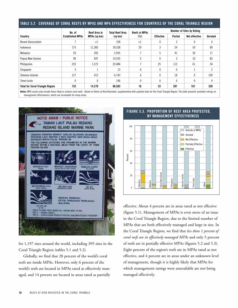
58 REEFS AT R ISK REV IS ITED IN THE CORAL TR IANGLE
effective. About 4 percent are in areas rated as not effective
(figure 5.1). Management of MPAs is even more of an issue
in the Coral Triangle Region, due to the limited number of
MPAs that are both effectively managed and large in size. In
the Coral Triangle Region, we find that less than 1 percent of
coral reefs are in effectively managed MPAs and only 5 percent
of reefs are in partially effective MPAs (figures 5.2 and 5.3).
Eight percent of the region’s reefs are in MPAs rated as not
effective, and 4 percent are in areas under an unknown level
of management, though it is highly likely that MPAs for
which management ratings were unavailable are not being
managed effectively.
taBLe 5 2 Coverage oF CoraL reeFS By MpaS and Mpa eFFeCtiveneSS For CountrieS oF the CoraL triangLe region
Countryno of
established Mpasreef area in
Mpas (sq km)total reef area
(sq km)reefs in Mpas
(%)
number of Sites by rating
effective partial not effective unrated
Brunei Darussalam 7 <1 109 <1 0 3 0 4
Indonesia 175 11,383 39,538 29 3 24 59 89
Malaysia 93 205 2,935 7 5 41 30 17
papua New Guinea 96 697 14,535 5 0 3 10 83
philippines 232 1,572 22,484 7 25 112 61 34
Singapore 3 1 13 6 0 0 1 2
Solomon Islands 127 412 6,743 6 0 18 0 109
Timor-Leste 0 0 146 0 0 0 0 0
total for Coral triangle region 733 14,270 86,503 16 33 201 161 338
notes: MpA counts only include those likely to contain coral reefs. Based on Reefs at Risk Revisited, supplemented with updated data for the Coral Triangle Region. The table presents available ratings on management effectiveness, which are incomplete for many areas.
Figure 5 3 proportion oF reeF area proteCted, By ManageMent eFFeCtiveneSS
Timor
-Les
te
Solo
mon
Isla
nds
Indo
nesi
a
Papu
a Ne
w Gu
inea
Phili
ppin
es
Glob
al
Mal
aysi
a
Perc
ent
100
80
60
40
20
0
Outside of MPAs
Unrated
Not Effective
Partially Effective
Effective
for 1,197 sites around the world, including 395 sites in the
Coral Triangle Region (tables 5.1 and 5.2).
Globally, we find that 28 percent of the world’s coral
reefs are inside MPAs. However, only 6 percent of the
world’s reefs are located in MPAs rated as effectively man-
aged, and 14 percent are located in areas rated as partially
pHOT
O: L
AURE
TTA
BURK
E
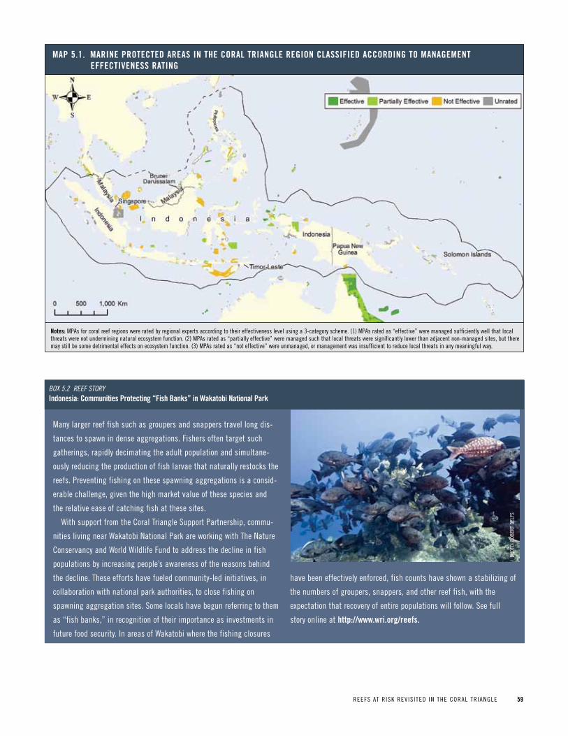
REEFS AT R ISK REV IS ITED IN THE CORAL TR IANGLE 59
Many larger reef fish such as groupers and snappers travel long dis-
tances to spawn in dense aggregations. Fishers often target such
gatherings, rapidly decimating the adult population and simultane-
ously reducing the production of fish larvae that naturally restocks the
reefs. preventing fishing on these spawning aggregations is a consid-
erable challenge, given the high market value of these species and
the relative ease of catching fish at these sites.
With support from the Coral Triangle Support partnership, commu-
nities living near Wakatobi National park are working with The Nature
Conservancy and World Wildlife Fund to address the decline in fish
populations by increasing people’s awareness of the reasons behind
the decline. These efforts have fueled community-led initiatives, in
collaboration with national park authorities, to close fishing on
spawning aggregation sites. Some locals have begun referring to them
as “fish banks,” in recognition of their importance as investments in
future food security. In areas of Wakatobi where the fishing closures
have been effectively enforced, fish counts have shown a stabilizing of
the numbers of groupers, snappers, and other reef fish, with the
expectation that recovery of entire populations will follow. See full
story online at http://www wri org/reefs
Box 5.2 Reef stoRyindonesia: Communities protecting “Fish Banks” in wakatobi national park
pHOT
O: R
OBER
T DE
LFS
Map 5 1 Marine proteCted areaS in the CoraL triangLe region CLaSSiFied aCCording to ManageMent eFFeCtiveneSS rating
notes: MpAs for coral reef regions were rated by regional experts according to their effectiveness level using a 3-category scheme. (1) MpAs rated as “effective” were managed sufficiently well that local threats were not undermining natural ecosystem function. (2) MpAs rated as “partially effective” were managed such that local threats were significantly lower than adjacent non-managed sites, but there may still be some detrimental effects on ecosystem function. (3) MpAs rated as “not effective” were unmanaged, or management was insufficient to reduce local threats in any meaningful way.
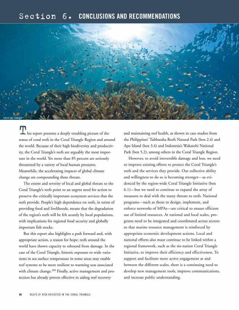
60 REEFS AT R ISK REV IS ITED IN THE CORAL TR IANGLE60 REEFS AT R ISK REV IS ITED IN THE CORAL TR IANGLE
section 6. ConCLuSionS and reCoMMendationS
and maintaining reef health, as shown in case studies from
the Philippines’ Tubbataha Reefs Natural Park (box 2.4) and
Apo Island (box 3.4) and Indonesia’s Wakatobi National
Park (box 5.2), among others in the Coral Triangle Region.
However, to avoid irreversible damage and loss, we need
to improve existing efforts to protect the Coral Triangle’s
reefs and the services they provide. Our collective ability
and willingness to do so is becoming stronger—as evi-
denced by the region-wide Coral Triangle Initiative (box
6.1)—but we need to continue to expand the array of
measures to deal with the many threats to reefs. National
programs—such as those to design, implement, and
enforce networks of MPAs—are critical to ensure efficient
use of limited resources. At national and local scales, pro-
grams need to be integrated and coordinated across sectors
so that marine resource management is reinforced by
appropriate economic development actions. Local and
national efforts also must continue to be linked within a
regional framework, such as the six-nation Coral Triangle
Initiative, to improve their efficiency and effectiveness. To
support and facilitate more active engagement at and
between the different scales, there is a continuing need to
develop new management tools, improve communications,
and increase public understanding.
This report presents a deeply troubling picture of the
status of coral reefs in the Coral Triangle Region and around
the world. Because of their high biodiversity and productiv-
ity, the Coral Triangle’s reefs are arguably the most impor-
tant in the world. Yet more than 85 percent are seriously
threatened by a variety of local human pressures.
Meanwhile, the accelerating impacts of global climate
change are compounding these threats.
The extent and severity of local and global threats to the
Coral Triangle’s reefs point to an urgent need for action to
preserve the critically important ecosystem services that the
reefs provide. People’s high dependence on reefs, in terms of
providing food and livelihoods, means that the degradation
of the region’s reefs will be felt acutely by local populations,
with implications for regional food security and globally
important fish stocks.
But this report also highlights a path forward and, with
appropriate action, a reason for hope: reefs around the
world have shown capacity to rebound from damage. In the
case of the Coral Triangle, historic exposure to wide varia-
tions in sea surface temperature in some areas may enable
reef systems to be more resilient to warming seas associated
with climate change.208 Finally, active management and pro-
tection has already proven effective in aiding reef recovery
pHOTO: JEFF yONOVER
REEFS AT R ISK REV IS ITED IN THE CORAL TR IANGLE 61
Regional and global efforts to quickly and significantly
reduce greenhouse gas emissions are of paramount concern
not only for reefs, but for nature and humanity as a whole.
Current international efforts, even if wholly successful, are
not likely to curb increases in atmospheric warming, sea sur-
face temperatures, and ocean acidification, all of which will
have dramatic impacts on reef systems around the world,
including those in the Coral Triangle. However, by taking
the appropriate actions now to protect reefs from local pres-
sures, we may be able to “buy time” in the face of climate
change through local-scale measures to increase reef health
and resilience.
reCoMMendationS
We hope this report will spur further action to save the
globally important reef ecosystems of the Coral Triangle
Region. Toward this aim, we recommend the following spe-
cific actions involving a broad range of people at the local,
national, regional, and international scales. Most of these
actions are addressed under the Coral Triangle Initiative
(CTI) Regional and National Plans of Action, and can be
implemented with combined national and international
support.
n Mitigate threats from local human activities.
• Reduce unsustainable fishing by addressing the underly-
ing social and economic drivers of overfishing; estab-
lishing sustainable fisheries management policies and
practices; reducing excess fishing capacity and remov-
ing inefficient subsidies that encourage overfishing;
enforcing fishing regulations; halting destructive fish-
ing; improving and expanding MPAs to maximize
benefits; and involving stakeholders in resource man-
agement.
• Manage coastal development by implementing coastal
zone planning and enforcement to encourage sound
land development; protecting coastal vegetation;
In May 2009, the governments of Indonesia, Malaysia, papua New
Guinea, the philippines, Solomon Islands, and Timor-Leste signed the
Coral Triangle Initiative Declaration on Coral Reefs, Fisheries, and Food
Security (CTI-CFF). CTI-CFF is a multilateral partnership that aims to
safeguard the marine and coastal resources of the Coral Triangle.
Under the CTI-CFF, the six Coral Triangle countries collectively adopted a
Regional plan of Action, which was soon followed by each country’s
adoption of a CTI-CFF National plan of Action that aligns with the goals
of the regional plan. The Regional plan of Action is organized around
five goals, each supported by a technical working group chaired by one
of the six countries:
1. priority seascapes designated and effectively managed
(chair: Indonesia)
2. Ecosystem approach to management of fisheries and other marine
resources fully applied (chair: Malaysia)
3. Marine protected areas established and effectively managed
(chair: philippines)
4. Climate change adaptation measures achieved
(chairs: Indonesia and Solomon Islands)
5. Threatened species status improving (chair: philippines).
The technical working groups include national representatives from
each country and various partners that provide technical and financial
assistance, including the United States Agency for International
Development (USAID), the government of Australia, the Global
Environment Facility, and the Asian Development Bank.
The Regional and National plans of Action contain indicators and tar-
gets for each of the five goals at both the regional and national scales
that are to be accomplished by 2020. For example, one strategy for pro-
tecting and enhancing the condition of the Coral Triangle’s reefs—as
part of achieving Goal 3 for MpAs—is to “establish and make fully
functional by 2020 a Coral Triangle Marine protected Area System
(CTMpAS).” The MpA Technical Working Group is designing the CTMpAS
framework, where each country will contribute qualified MpAs to a
region-wide system of MpAs. Criteria under consideration for determin-
ing qualified MpAs include meeting minimum standards for effective
management, addressing core biodiversity issues, fulfilling fisheries
and climate adaptation needs, and, where appropriate, providing key
connectivity linkages within the larger MpA system. A projected benefit
of the CTMpAS is that it provides an incentive for each country to ele-
vate its standards for MpA design and management so that its MpAs
will qualify for inclusion in the system.
Box 6 1 the CoraL triangLe initiative
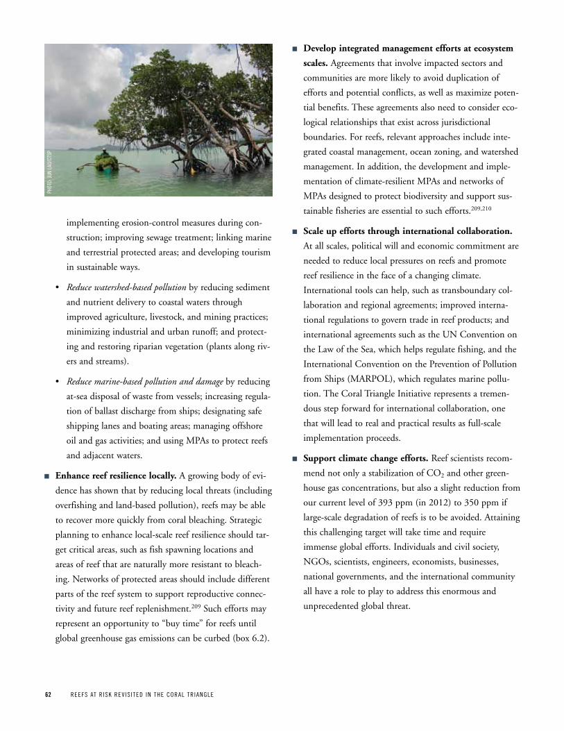
62 REEFS AT R ISK REV IS ITED IN THE CORAL TR IANGLE
implementing erosion-control measures during con-
struction; improving sewage treatment; linking marine
and terrestrial protected areas; and developing tourism
in sustainable ways.
• Reduce watershed-based pollution by reducing sediment
and nutrient delivery to coastal waters through
improved agriculture, livestock, and mining practices;
minimizing industrial and urban runoff; and protect-
ing and restoring riparian vegetation (plants along riv-
ers and streams).
• Reduce marine-based pollution and damage by reducing
at-sea disposal of waste from vessels; increasing regula-
tion of ballast discharge from ships; designating safe
shipping lanes and boating areas; managing offshore
oil and gas activities; and using MPAs to protect reefs
and adjacent waters.
n Enhance reef resilience locally. A growing body of evi-
dence has shown that by reducing local threats (including
overfishing and land-based pollution), reefs may be able
to recover more quickly from coral bleaching. Strategic
planning to enhance local-scale reef resilience should tar-
get critical areas, such as fish spawning locations and
areas of reef that are naturally more resistant to bleach-
ing. Networks of protected areas should include different
parts of the reef system to support reproductive connec-
tivity and future reef replenishment.209 Such efforts may
represent an opportunity to “buy time” for reefs until
global greenhouse gas emissions can be curbed (box 6.2).
n Develop integrated management efforts at ecosystem
scales. Agreements that involve impacted sectors and
communities are more likely to avoid duplication of
efforts and potential conflicts, as well as maximize poten-
tial benefits. These agreements also need to consider eco-
logical relationships that exist across jurisdictional
boundaries. For reefs, relevant approaches include inte-
grated coastal management, ocean zoning, and watershed
management. In addition, the development and imple-
mentation of climate-resilient MPAs and networks of
MPAs designed to protect biodiversity and support sus-
tainable fisheries are essential to such efforts.209,210
n Scale up efforts through international collaboration.
At all scales, political will and economic commitment are
needed to reduce local pressures on reefs and promote
reef resilience in the face of a changing climate.
International tools can help, such as transboundary col-
laboration and regional agreements; improved interna-
tional regulations to govern trade in reef products; and
international agreements such as the UN Convention on
the Law of the Sea, which helps regulate fishing, and the
International Convention on the Prevention of Pollution
from Ships (MARPOL), which regulates marine pollu-
tion. The Coral Triangle Initiative represents a tremen-
dous step forward for international collaboration, one
that will lead to real and practical results as full-scale
implementation proceeds.
n Support climate change efforts. Reef scientists recom-
mend not only a stabilization of CO2 and other green-
house gas concentrations, but also a slight reduction from
our current level of 393 ppm (in 2012) to 350 ppm if
large-scale degradation of reefs is to be avoided. Attaining
this challenging target will take time and require
immense global efforts. Individuals and civil society,
NGOs, scientists, engineers, economists, businesses,
national governments, and the international community
all have a role to play to address this enormous and
unprecedented global threat.
pHOT
O: JU
N LA
O/CT
Sp
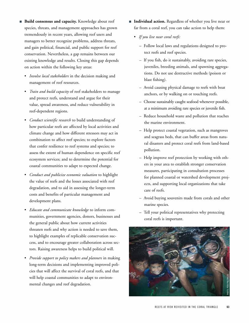
REEFS AT R ISK REV IS ITED IN THE CORAL TR IANGLE 63
n Build consensus and capacity. Knowledge about reef
species, threats, and management approaches has grown
tremendously in recent years, allowing reef users and
managers to better recognize problems, address threats,
and gain political, financial, and public support for reef
conservation. Nevertheless, a gap remains between our
existing knowledge and results. Closing this gap depends
on action within the following key areas:
• Involve local stakeholders in the decision making and
management of reef resources.
• Train and build capacity of reef stakeholders to manage
and protect reefs, understand and argue for their
value, spread awareness, and reduce vulnerability in
reef-dependent regions.
• Conduct scientific research to build understanding of
how particular reefs are affected by local activities and
climate change and how different stressors may act in
combination to affect reef species; to explore factors
that confer resilience to reef systems and species; to
assess the extent of human dependence on specific reef
ecosystem services; and to determine the potential for
coastal communities to adapt to expected change.
• Conduct and publicize economic valuation to highlight
the value of reefs and the losses associated with reef
degradation, and to aid in assessing the longer-term
costs and benefits of particular management and
development plans.
• Educate and communicate knowledge to inform com-
munities, government agencies, donors, businesses and
the general public about how current activities
threaten reefs and why action is needed to save them,
to highlight examples of replicable conservation suc-
cess, and to encourage greater collaboration across sec-
tors. Raising awareness helps to build political will.
• Provide support to policy makers and planners in making
long-term decisions and implementing improved poli-
cies that will affect the survival of coral reefs, and that
will help coastal communities to adapt to environ-
mental changes and reef degradation.
n Individual action. Regardless of whether you live near or
far from a coral reef, you can take action to help them:
• If you live near coral reefs:
– Follow local laws and regulations designed to pro-
tect reefs and reef species.
– If you fish, do it sustainably, avoiding rare species,
juveniles, breeding animals, and spawning aggrega-
tions. Do not use destructive methods (poison or
blast fishing).
– Avoid causing physical damage to reefs with boat
anchors, or by walking on or touching reefs.
– Choose sustainably caught seafood whenever possible,
at a minimum avoiding rare species or juvenile fish.
– Reduce household waste and pollution that reaches
the marine environment.
– Help protect coastal vegetation, such as mangroves
and seagrass beds, that can buffer areas from natu-
ral disasters and protect coral reefs from land-based
pollution.
– Help improve reef protection by working with oth-
ers in your area to establish stronger conservation
measures, participating in consultation processes
for planned coastal or watershed development proj-
ects, and supporting local organizations that take
care of reefs.
– Avoid buying souvenirs made from corals and other
marine species.
– Tell your political representatives why protecting
coral reefs is important.
pHOT
O: p
ERI p
ALER
ACIO
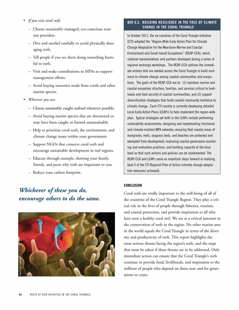
64 REEFS AT R ISK REV IS ITED IN THE CORAL TR IANGLE
• If you visit coral reefs:
– Choose sustainably managed, eco-conscious tour-
ism providers.
– Dive and snorkel carefully to avoid physically dam-
aging reefs.
– Tell people if you see them doing something harm-
ful to reefs.
– Visit and make contributions to MPAs to support
management efforts.
– Avoid buying souvenirs made from corals and other
marine species.
• Wherever you are:
– Choose sustainably caught seafood whenever possible.
– Avoid buying marine species that are threatened or
may have been caught or farmed unsustainably.
– Help to prioritize coral reefs, the environment, and
climate change issues within your government
– Support NGOs that conserve coral reefs and
encourage sustainable development in reef regions.
– Educate through example, showing your family,
friends, and peers why reefs are important to you.
– Reduce your carbon footprint.
ConCLuSion
Coral reefs are vitally important to the well-being of all of
the countries of the Coral Triangle Region. They play a crit-
ical role in the lives of people through fisheries, tourism,
and coastal protection, and provide inspiration to all who
have seen a healthy coral reef. We are at a critical juncture in
the conservation of reefs in the region. No other marine area
in the world equals the Coral Triangle in terms of the diver-
sity and productivity of reefs. This report highlights the
most serious threats facing the region’s reefs, and the steps
that must be taken if these threats are to be addressed. Only
immediate action can ensure that the Coral Triangle’s reefs
continue to provide food, livelihoods, and inspiration to the
millions of people who depend on them now and for gener-
ations to come.
In October 2011, the six countries of the Coral Triangle Initiative
(CTI) adopted the “Region-Wide Early Action plan for Climate
Change Adaptation for the Nearshore Marine and Coastal
Environment and Small Island Ecosystems” (REAp-CCA), which
national representatives and partners developed during a series of
regional exchange workshops. The REAp-CCA outlines the immedi-
ate actions that are needed across the Coral Triangle to build resil-
ience to climate change among coastal communities and ecosys-
tems. The goals of the REAp-CCA are to: (1) maintain marine and
coastal ecosystem structure, function, and services critical to liveli-
hoods and food security of coastal communities; and (2) support
diversification strategies that build coastal community resilience to
climate change. Each CTI country is currently developing detailed
Local Early Action plans (LEAps) to help implement the region-wide
plan. Typical strategies set forth in the LEAps include performing
vulnerability assessments; designing and implementing functional
and climate-resilient MpA networks; ensuring that coastal areas of
mangroves, reefs, seagrass beds, and beaches are protected and
exempted from development; improving coastal governance monitor-
ing and evaluation practices; and building capacity at the local
level so that such actions and policies can be implemented. The
REAp-CCA and LEAps serve as important steps forward in realizing
Goal 4 of the CTI Regional plan of Action (climate change adapta-
tion measures achieved).
Box 6 2 BuiLding reSiLienCe in the FaCe oF CLiMate Change in the CoraL triangLe
Whichever of these you do, encourage others to do the same.
pHOT
O: JE
FF y
ONOV
ER
REEFS AT R ISK REV IS ITED IN THE CORAL TR IANGLE 65REEFS AT R ISK REV IS ITED IN THE CORAL TR IANGLE 65
References and Technical notes
17. Hughes, T. P., M. J. Rodrigues, D. R. Bellwood, et al. 2007. “Phase Shifts, Herbivory, and the Resilience of Coral Reefs to Climate Change.” Current Biology 17 (4):360–365.
18. Riegl, B., A. Bruckner, S. L. Coles, P. Renaud, and R. E. Dodge. 2009. “Coral Reefs: Threats and Conservation in an Era of Global Change.” Annals of the New York Academy of Sciences 1162 (The Year in Ecology and Conservation Biology 2009):136–186.
19. Hoegh-Guldberg, O., H. Hoegh-Guldberg, J. E. N. Veron, et al. 2009. The Coral Triangle and Climate Change: Ecosystems, People and Societies at Risk. Brisbane, Australia: WWF Australia.
20. McAllister, D. 1995. “Status of the World Ocean and Its Biodiversity.” Sea Wind 9 (4):1-72.
21. Paulay, G. 1997. “Diversity and Distribution of Reef Organisms.” In Life and Death of Coral Reefs, edited by C. Birkeland. New York: Chapman & Hall.
22. The coral reef data used in the Reefs at Risk Revisited analysis were compiled specifically for this project from multiple sources by UNEP-WCMC, the World Fish Center, and WRI, incorpo-rating products from the Millennium Coral Reef Mapping Project prepared by the Institute for Marine Remote Sensing, University of South Florida (IMaRS/USF), Institut de Recherche pour le Développement (IRD/UR), 2011. To standardize these data for the purposes of the Reefs at Risk Revisited project, data were converted to raster format (ESRI grid) at 500-m resolution.
23. Calculated at WRI based on data from LandScan High Resolution Global Population Data Set, Oak Ridge National Laboratory, 2007.
24. Jameson, S. C., J. W. McManus, and M. D. Spalding. 1995. State of the Reefs: Regional and Global Perspectives. Vol. 26. Washington, DC: U.S. Department of State.
25. Jennings, S., and N. V. C. Polunin. 1995. “Comparative Size and Composition of Yield from Six Fijian Reef Fisheries.” Journal of Fish Biology 46 (1):28–46.
26. Newton, K., I. M. Côté, G. M. Pilling, S. Jennings, and N. K. Dulvy. 2007. “Current and Future Sustainability of Island Coral Reef Fisheries.” Current Biology 17 (7):655–658.
27. The World Bank. 2010. World Development Indicators 2010 [accessed July 2010]. Available from http://data.worldbank.org.
28. United Nations World Tourism Organization. 2010. Compendium of Tourism Statistics, Data 2004–2008. 2010 ed. Madrid, Spain: World Tourism Organization.
29. Statistics Indonesia. 2012. Number of Foreign Visitor Arrivals to Indonesia by Country of Residence, 2002-2010. [accessed April 18, 2012] Available from http://dds.bps.go.id/eng.
30. World Bank. World Databank: World Development Indicators & Global Development Indicators 2009 [accessed February 22, 2012] Available from http://databank.worldbank.org.
31. Coastline protected by reefs was calculated at WRI from coast-line data from the National Geospatial Intelligence Agency, World Vector Shoreline, 2004; and coral reef data from the Institute for Marine Remote Sensing, University of South Florida (IMaRS/USF), Institut de Recherche pour le Développement (IRD/UR), UNEP-WCMC, The World Fish Center, and WRI, 2011.
1. Veron, J. E. N., L. M. Devantier, E. Turak, A. L. Green, S. Kininmonth, M. Stafford-Smith, and N. Peterson. 2009. “Delineating the Coral Triangle.” Galaxea, Journal of Coral Reef Studies 11:91–100.
2. Berkelmans, R., G. De’ath, S. Kininmonth, and W. J. Skirving. 2004. “A Comparison of the 1998 and 2002 Coral Bleaching Events on the Great Barrier Reef: Spatial Correlation, Patterns, and Predictions.” Coral Reefs 23 (1):74–83.
3. Eakin, C. M., J. A. Morgan, S. F. Heron, et al. 2010. “Caribbean Corals in Crisis: Record Thermal Stress, Bleaching, and Mortality in 2005.” PLoS ONE 5 (11):e13969.
4. Sheppard, C. R. C., M. Spalding, C. Bradshaw, and S. Wilson. 2002. “Erosion vs. Recovery of Coral Reefs after 1998 El Niño: Chagos Reefs, Indian Ocean.” AMBIO 31:40–48.
5. Wildlife Conservation Society. 2010. Troubled Waters: Massive Coral Bleaching in Indonesia. Wildlife Conservation Society, August 17, 2010. Available from www.wcs.org/new-and-note-worthy/aceh-coral-bleaching.aspx.
6. Wilkinson, C. 2008. Status of Coral Reefs of the World: 2008. Townsville, Australia: Global Coral Reef Monitoring Network and Reef and Rainforest Research Centre.
7. Donner, S. D., W. J. Skirving, C. M. Little, M. Oppenheimer, and O. Hoegh-Guldberg. 2005. “Global Assessment of Coral Bleaching and Required Rates of Adaptation under Climate Change.” Global Change Biology 11 (225):2251–2265.
8. Hoegh-Guldberg, O. 1999. “Climate Change, Coral Bleaching and the Future of the World’s Coral Reefs.” Marine and Freshwater Research 50:839–66.
9. Sheppard, C. R. C. 2003. “Predicted Recurrences of Mass Coral Mortality in the Indian Ocean.” Nature 425:294–297.
10. Hoegh-Guldberg, O., P. J. Mumby, A. J. Hooten, et al. 2007. “Coral Reefs under Rapid Climate Change and Ocean Acidification.” Science 318 (5857):1737–1742.
11. Sabine, C. L. 2004. “The Oceanic Sink for Anthropogenic CO2.” Science 305 (5682):367–371.
12. Cao, L., K. Caldeira, and A. K. Jain. 2007. “Effects of Carbon Dioxide and Climate Change on Ocean Acidification and Carbonate Mineral Saturation.” Geophysical Research Letters 34 (5):5607.
13. Fabricius, K. E., C. Langdon, S. Uthicke, et al. 2011. “Losers and Winners in Coral Reefs Acclimatized to Elevated Carbon Dioxide Concentrations.” Nature Climate Change 1 (3):165–169.
14. Guinotte, J. M., and V. J. Fabry. 2008. “Ocean Acidification and Its Potential Effects on Marine Ecosystems.” Annals of the New York Academy of Sciences 1134 (1):320–342.
15. Kuffner, I. B., A. J. Andersson, P. L. Jokiel, K. S. Rodgers, and F. T. Mackenzie. 2008. “Decreased Abundance of Crustose Coralline Algae Due to Ocean Acidification.” Nature Geoscience 1 (2):114–117.
16. Silverman, J., B. Lazar, L. Cao, K. Caldeira, and J. Erez. 2009. “Coral Reefs May Start Dissolving When Atmospheric CO2 Doubles.” Geophysical Research Letters 36 (5):L05606.
66 REEFS AT R ISK REV IS ITED IN THE CORAL TR IANGLE
32. Fernando, H. J. S., S. P. Samarawickrama, S. Balasubramanian, S. S. L. Hettiarachchi, and S. Voropayev. 2008. “Effects of Porous Barriers Such as Coral Reefs on Coastal Wave Propagation.” Journal of Hydro-environment Research 1 (3-4):187–194.
33. Sheppard, C., D. J. Dixon, M. Gourlay, A. Sheppard, and R. Payet. 2005. “Coral Mortality Increases Wave Energy Reaching Shores Protected by Reef Flats: Examples from the Seychelles.” Estuarine, Coastal and Shelf Science 64 (2-3):223–234.
34. Coastline protected by reefs was calculated at WRI from coast-line data from the National Geospatial Intelligence Agency, World Vector Shoreline, 2004; and coral reef data from the Institute for Marine Remote Sensing, University of South Florida (IMaRS/USF), Institut de Recherche pour le Développement (IRD/UR), UNEP-WCMC, The World Fish Center, and WRI, 2011.
35. Burke, L., E. Selig, and M. Spalding. 2002. Reefs at Risk in Southeast Asia. Washington, DC: World Resources Institute.
36. U.S. Commission on Ocean Policy. 2004. An Ocean Blueprint for the 21st Century Final Report. Washington, DC: U.S. Commission on Ocean Policy.
37. Sadovy, Y. 2005. “Trouble on the Reef: The Imperative for Managing Valuable and Vulnerable Fisheries.” Fish and Fisheries 6:167–185.
38. Jackson, J. B. C. 2008. “Ecological Extinction and Evolution in the Brave New Ocean.” Proceedings of the National Academy of Sciences 105:11458–11465.
39. Mumby, P. J., C. P. Dahlgren, A. R. Harborne, et al. 2006. “Fishing, Trophic Cascades, and the Process of Grazing on Coral Reefs.” Science 311 (5757):98–101.
40. Roberts, C. M. 1995. “Effects of Fishing on the Ecosystem Structure of Coral Reefs.” Conservation Biology 9 (5):988–995.
41. Guinotte, J. M., R. W. Buddemeier, and J. A. Kleypas. 2003. “Future Coral Reef Habitat Marginality: Temporal and Spatial Effects of Climate Change in the Pacific Basin.” Coral Reefs 22 (4):551–558.
42. Sutherland, K. P., J. W. Porter, and C. Torres. 2004. “Disease and Immunity in Caribbean and Indo-Pacific Zooxanthellate Corals.” In Marine Ecology Progress Series 266:273–302.
43. Harvell, C. D., and E. Jordán-Dahlgren. 2007. “Coral Disease, Environmental Drivers, and the Balance between Coral and Microbial Associates.” Oceanography and Marine Biology: an Annual Review 20:58–81.
44. Bruno, J. F., E. R. Selig, K. S. Casey, C. A. Page, B. L. Willis, C. D. Harvell, H. Sweatman, and A. M. Melendy. 2007. “Thermal Stress and Coral Cover as Drivers of Coral Disease Outbreaks.” PLoS Biol 5 (6):1220–1227.
45. Lesser, M. P., J. C. Bythell, R. D. Gates, R. W. Johnstone, and O. Hoegh-Guldberg. 2007. “Are Infectious Diseases Really Killing Corals? Alternative Interpretations of the Experimental and Ecological Data.” Journal of Experimental Marine Biology and Ecology 346:36–44.
46. Marshall, P., and H. Schuttenberg. 2006. A Reef Manager’s Guide to Coral Bleaching. Townsville, Australia: Great Barrier Reef Marine Park Authority.
47. West, J. M., and R. V. Salm. 2003. “Resistance and Resilience to Coral Bleaching: Implications for Coral Reef Conservation and Management.” Conservation Biology 17 (4):956–967.
48. Wright, L. D., and C. A. Nittrouer. 1995. “Dispersal of River Sediments in Coastal Seas: Six Contrasting Cases.” Estuaries and Coasts 18 (3):494–508.
49. Spalding, M. D., M. Kainuma, and L. Collins. 2010. World Atlas of Mangroves. London: Earthscan, with International Society for Mangrove Ecosystems, Food and Agriculture Organization of the United Nations, UNEP World Conservation Monitoring Centre, United Nations Scientific and Cultural Organisation, United Nations University.
50. Waycott, M., C. M. Duarte, T. J. B. Carruthers, et al. 2009. “Accelerating Loss of Seagrasses across the Globe Threatens Coastal Ecosystems.” Proceedings of the National Academy of Sciences 106 (30):12377–12381.
51. Balinton, J. 2011. “Maiden’s Dream Turns Islet into Mangrove Park.” Philippine Daily Inquirer, November 13, 2011.
52. Lesaba, M. E. 2011. “Youths Help Develop Islet into ‘Eco-Park’.” Philippine Daily Inquirer, May 25, 2011.
53. Calculated at WRI based on data from LandScan High Resolution Global Population Data Set, Oak Ridge National Laboratory, 2007
54. Graham, N. A. J., M. Spalding, and C. Sheppard. 2010. “Reef Shark Declines in Remote Atolls Highlight the Need for Multi-Faceted Conservation Action.” Aquatic Conservation: Marine and Freshwater Ecosystems 20 (5):543–548.
55. Berkes, F., T. P. Hughes, R. S. Steneck, et al. 2006. “Globalization, Roving Bandits, and Marine Resources.” Science 311 (5767):1557–1558.
56. Sadovy, Y. J., T. J. Donaldson, T. R. Graham, F. McGilvray, G. J. Muldoon, M. J. Phillips, M. A. Rimmer, A. Smith, and B. Yeeting. 2003. While Stocks Last: The Live Reef Food Fish Trade. Manila: Asian Development Bank.
57. Hughes, T. P., D. R. Bellwood, C. S. Folke, L. J. McCook, and J. M. Pandolfi. 2007. “No-Take Areas, Herbivory and Coral Reef Resilience.” Trends in Ecology & Evolution 22 (1):1–3.
58. Mumby, P. J., and A. R. Harborne. 2010. “Marine Reserves Enhance the Recovery of Corals on Caribbean Reefs.” PLoS ONE 5 (1):e8657.
59. Raymundo, L. J., A. R. Halford, A. P. Maypa, and A. M. Kerr. 2009. “Functionally Diverse Reef-Fish Communities Ameliorate Coral Disease.” Proceedings of the National Academy of Sciences 106 (40):17067–17070.
60. Fox, H. E., and R. L. Caldwell. 2006. “Recovery from Blast Fishing on Coral Reefs: A Tale of Two Scales.” Ecological Applications 16 (5):1631–1635.
61. Fox, H. E., J. S. Pet, R. Dahuri, et al. 2002. “Coral Reef Restoration after Blast Fishing in Indonesia.” In Proceedings of the Ninth International Coral Reef Symposium, Bali, October 23–27, 2000.
62. Wells, S. 2009. “Dynamite Fishing in Northern Tanzania–Pervasive, Problematic and yet Preventable.” Marine Pollution Bulletin 58 (1): 20–23.
REEFS AT R ISK REV IS ITED IN THE CORAL TR IANGLE 67
63. Mous, P. J., L. Pet-Soede, M. Erdmann, H. S. J. Cesar, Y. Sadovy, and J. Pet. 2000. “Cyanide Fishing on Indonesian Coral Reefs for the Live Food Fish Market—What Is the Problem?” SPC Live Reef Fish Information Bulletin 7:20–27.
64. Barber, C. V., and V. R. Pratt. 1997. Sullied Seas: Strategies for Combating Cyanide Fishing in Southeast Asia. Washington, DC: World Resources Institute.
65. IPCC. 2007. Synthesis Report. Contribution of Working Groups I, II and III to the Fourth Assessment Report of the Intergovernmental Panel on Climate Change. Geneva: Intergovernmental Panel on Climate Change.
66. Eakin, C. M., J. M. Lough, and S. F. Heron. 2009. “Climate Variability and Change: Monitoring Data and Evidence for Increased Coral Bleaching Stress.” In Coral Bleaching, edited by M. J. H. Oppen and J. M. Lough. Heidelberg, Germany: Springer.
67. Glynn, P. W. 1993. “Coral Reef Bleaching: Ecological Perspectives. Coral Reefs 12 (1):1–17.
68. Lasagna, R., G. Albertelli, P. Colantoni, C. Morri, and C. Bianchi. 2009. “Ecological Stages of Maldivian Reefs after the Coral Mass Mortality of 1998.” Facies 56 (1):1–11.
69. Obura, D., and G. Grimsditch. 2009. Resilience Assessment of Coral Reefs: Rapid Assessment Protocol for Coral Reefs, Focusing on Coral Bleaching and Thermal Stress. Gland, Switzerland: IUCN.
70. Sheppard, C. R. C., A. Harris, and A. L. S. Sheppard. 2008. “Archipelago-Wide Coral Recovery Patterns since 1998 in the Chagos Archipelago, Central Indian Ocean.” Marine Ecology Progress Series 362: 109–117.
71. Obura, D. 2005. “Resilience and Climate Change: Lessons from Coral Reefs and Bleaching in the Western Indian Ocean.” Estuarine, Coastal and Shelf Science 63:353–372.
72. White, A. T., A. Maypa, S. Tesch, R. Diaz, R. Martinez, and E. White. 2008. “Summary Field Report: Coral Reef Monitoring Expedition to Tubbataha Reefs Natural Park, Sulu Sea, Philippines, March 26–April 1, 2008.” Cebu City, Philippines: The Coastal Conservation and Education Foundation, Inc.
73. Dygico, M., A. Songco, A. T. White, and S. J. Green. 2012 (in press). “Achieving MPA Effectiveness through Application of Responsive Governance Incentives in the Tubbataha Reefs.” Ocean & Coastal Management.
74. The coral reef data used in the Reefs at Risk Revisited analysis were compiled specifically for this project from multiple sources by UNEP-WCMC, the World Fish Center, and WRI, incorpo-rating products from the Millennium Coral Reef Mapping Project prepared by the Institute for Marine Remote Sensing, University of South Florida (IMaRS/USF), Institut de Recherche pour le Développement (IRD), 2011. To standardize these data for the purposes of the Reefs at Risk Revisited project, data were converted to raster format (ESRI grid) at 500-m resolution.
75. Tomascik, T., A. J. Mah, A. Nontji, and M. K. Moosa. 1997. The Ecology of the Indonesian Seas, Part 1. Vol. VII, The Ecology of Indonesia Series. Singapore: Periplus Editions (HK) Ltd.
76. Veron, J. E. N. 2002. “Reef Corals of the Raja Ampat Islands, Papua Province, Indonesia, Part I: Overview of Scleractinia.” In A Marine Rapid Assessment of the Raja Ampat Islands, Papua Province, Indonesia, edited by S. A. McKenna, G. R. Allen and S. Suryadi. Washington, DC: Conservation International.
77. Allen, G. R., and M. V. Erdmann. 2012. Reef Fishes of the East Indies. Volumes I-III. Perth, Australia: Tropical Reef Research.
78. Calculated at WRI based on data from LandScan High Resolution Global Population Data Set, Oak Ridge National Laboratory, 2007 and coral reef data from the Institute for Marine Remote Sensing, University of South Florida (IMaRS/USF), Institut de Recherche pour le Développement (IRD), UNEP-WCMC, The World Fish Center, and WRI, 2011.
79. Edinger, E. N., J. Jompa, G. V. Limmon, W. Widjatmoko, and M. J. Risk. 1998. “Reef Degradation and Coral Biodiversity in Indonesia: Effects of Land-Based Pollution, Destructive Fishing Practices and Changes over Time.” Marine Pollution Bulletin 36 (8): 617–630.
80. FAO. 2010. “1961–2007 Fish and Fishery Products: World Apparent Consumption Statistics Based on Food Balance Sheets.” In FAO Yearbook. Fishery and Aquaculture Statistics 2008, edited by G. Laurenti. Rome: FAO.
81. Koeshendrajana, S., and T. T. Hartono. 2006. “Indonesian Live Reef Fish Industry: Status, Problems and Possible Future Direction.” In Economics and Marketing of the Live Reef Fish Trade in Asia-Pacific, edited by B. Johnston and B. Yeeting. Canberra: Australian Centre for International Agricultural Research.
82. Wilkinson, C. 2008. Status of Coral Reefs of the World: 2008. Townsville, Australia: Global Coral Reef Monitoring Network and Reef and Rainforest Research Centre.
83. Habibi, A., N. Setiasih, and J. Sartin, eds. 2007. A Decade of Reef Check Monitoring: Indonesian Coral Reefs, Condition and Trends. Bali: The Indonesian Reef Check Network.
84. Tun, K., L. M. Chou, J. Low, et al. 2010. “A Regional Overview on the 2010 Coral Bleaching Event in Southeast Asia.” In Status of Coral Reefs in East Asian Seas Region: 2010, edited by Global Coral Reef Monitoring Network. Tokyo: Ministry of the Environment, Japan.
85. Green, A., A. White, and J. Tanzer. 2011. Technical Assistance Required to Integrate Fisheries, Biodiversity and Climate Change Objectives into Resilient Marine Protected Area Design in the Coral Triangle. Prepared by The Nature Conservancy for the Coral Triangle Support Partnership.
86. USAID Coral Triangle Support Partnership. Ecosystem Status and Boundaries Map Helps Communities Manage Resources 2010. Available from http://www.uscti.org/uscti/pages/NewsEvents_ProgramUpdates_SuccessStories.html.
87. Burke, L., K. Reytar, M. Spalding, and A. Perry. 2011. Reefs at Risk Revisited. Washington, DC: World Resources Institute. http://www.wri.org/reefs.
88. Chong, V. C., P. K. Y. Lee, and C. M. Lau. 2010. “Diversity, Extinction Risk and Conservation of Malaysian Fishes.” Journal of Fish Biology 76 (9):2009–2066.
89. Calculated at WRI based on data from LandScan High Resolution Global Population Data Set, Oak Ridge National Laboratory, 2007 and coral reef data from the Institute for Marine Remote Sensing, University of South Florida (IMaRS/USF), Institut de Recherche pour le Développement (IRD), UNEP-WCMC, The World Fish Center, and WRI, 2011.
90. Lee, O. A. 2010. “Coastal Resort Development in Malaysia: A Review of Policy Use in the Pre-Construction and Post-Construction Phase.” Ocean & Coastal Management 53: 439–446.
68 REEFS AT R ISK REV IS ITED IN THE CORAL TR IANGLE
91. Hezri, A. A., and M. N. Hasan. 2006. “Towards Sustainable Development? The Evolution of Environmental Policy in Malaysia.” Natural Resources Forum 30:37–50.
92. FAO. 2009. Malaysia. In Fishery and Aquaculture Country Profiles. Rome: FAO Fisheries and Aquaculture Department.
93. Tourism Malaysia. 2009. Annual Report 2009. Kuala Lumpur, Malaysia.
94. Reef Check Malaysia. 2010. Reef Check Malaysia Annual Survey Report 2010. Kuala Lumpur, Malaysia.
95. Ministry of Science, Environment and Technology. 1998. Malaysia’s National Biodiversity Policy. Kuala Lumpur, Malaysia.
96. World Wildlife Fund. 2011. Tun Mustapha Marine Park, Malaysia. [accessed December 14, 2011. Available from http://wwf.panda.org/who_we_are/wwf_offices/malaysia/index.cfm?uProjectID=MY0219.
97. Daw, T. 2004. “Reef Fish Aggregations in Sabah, East Malaysia: A Report on Stakeholder Interviews Conducted for the Society for the Conservation of Reef Fish Spawning Aggregations.” In Western Pacific Fisher Survey Series: Society for the Conservation of Reef Fish Aggregations.
98. Pilcher, N., and A. Cabanban. 2000. The Status of Coral Reefs in Sabah, Labuan and Sarawak, East Malaysia. Edited by GCRMN. Townsville: Australia Institute of Marine Science.
99. USAID Coral Triangle Support Partnership. 2011. Handicraft Workshop for Maliangin Residents. Available from http://www.uscti.org/uscti/pages/NewsEvents_ProgramUpdates_SuccessStories.html.
100. Montgomery Watson Harza (MWH). 2006. “Country Environmental Profile Papua New Guinea: Final Report for the Government of Papua New Guinea and the European Commission.”
101. Nicholls, S. 2004. “The Priority Environmental Concerns of Papua New Guinea.” Apia, Samoa: South Pacific Regional Environment Programme.
102. Madl, P., and M. Yip. 2000. “Field Excursion to Milne Bay Province - Papua New Guinea.” In BUFUS Newsletter: University of Salzburg.
103. Allen, G. R., J. P. Kinch, S. A. McKenna, and P. Seeto, eds. 2003. A Rapid Marine Biodiversity Assessment of Milne Bay Province, Papua New Guinea—Survey II (2000), RAP Bulletin of Biological Assessment 29. Washington, DC: Conservation International.
104. Koczberski, G., G. N. Curry, J. Warku, and C. Kwam. 2006. “Village-Based Marine Resource Use and Rural Livelihoods: Kimbe Bay, West New Britain, Papua New Guinea.” TNC Pacific Island Countries Report No. 5/06.
105. Secretariat of the Pacific Community. 2008. “Papua New Guinea Country Profile.”
106. Kailola, P. J. 1995. “Fisheries Resources Profiles: Papua New Guinea.” Honiara, Solomon Islands: Forum Fisheries Agency.
107. Cinner, J. E., and T. R. McClanahan. 2006. “Socioeconomic Factors That Lead to Overfishing in Small-Scale Coral Reef Fisheries of Papua New Guinea.” Environmental Conservation 33 (01): 73–80.
108. Jones, G. P., M. I. McCormick, M. Srinivasan, and J. V. Eagle. 2004. “Coral Decline Threatens Fish Biodiversity in Marine Reserves.” Proceedings of the National Academy of Sciences 101 (21):8251–8253.
109. Independent State of Papua New Guinea. 1998. Fisheries Management Act 1998. In No. 48 of 1998.
110. Cinner, J. 2007. “Designing Marine Reserves to Reflect Local Socioeconomic Conditions: Lessons from Long-Enduring Customary Management Systems.” Coral Reefs 26 (4): 1035–1045.
111. Department of Environment and Conservation (DEC), and National Fisheries Authority (NFA). Papua New Guinea Marine Program on Coral Reefs, Fisheries and Food Security: National Plan of Action 2010-2013. Coral Triangle Initiative, December 14, 2011. Available from http://www.uscti.org/uscti/Resources/PNG%20MARINE%20NATIONAL%20PLAN%20OF%20ACTION%202010-2013.pdf.
112. The Locally-Managed Marine Area (LMMA) Network. Papua New Guinea. LMMA Network 2011 [accessed November 14, 2011]. Available from http://lmmanetwork.dreamhosters.com/papuanewguinea.
113. The Nature Conservancy, World Wildlife Fund, Conservation International, and Wildlife Conservation Society. 2008. Marine Protected Area Networks in the Coral Triangle: Development and Lessons. Cebu City, Philippines: TNC, WWF, CI, WCS and USAID.
114. USAID Coral Triangle Support Partnership. 2011. Community Conservation Takes Root. Available from http://www.uscti.org/uscti/pages/NewsEvents_ProgramUpdates_SuccessStories.html.
115. Nañola, C. L., A. C. Alcala, P. M. Aliño, et al. 2005. “Philippines.” In Status of Coral Reefs in East Asian Seas Region: 2004, edited by Japan Wildlife Research Center. Tokyo: Ministry of Environment.
116. Calculated at WRI based on data from the National Geospatial Intelligence Agency, World Vector Shoreline, 2004.
117. Spalding, M., C. Ravilious, and E. P. Green. 2001. World Atlas of Coral Reefs. Berkeley: University of California Press.
118. Carpenter, K. E., and V. G. Springer. 2005. “The Center of the Center of Marine Shore Fish Biodiversity: The Philippine Islands.” Environmental Biology of Fishes 72:467–480.
119. Froese, R., and D. Pauly. 2011. Fishbase. [accessed December 2011] Available from http://www.fishbase.org.
120. Calculated at WRI based on data from LandScan High Resolution Global Population Data Set, Oak Ridge National Laboratory, 2007 and coral reef data from the Institute for Marine Remote Sensing, University of South Florida (IMaRS/USF), Institut de Recherche pour le Développement (IRD), UNEP-WCMC, The World Fish Center, and WRI, 2011.
121. Green, S. J., A. T. White, J. O. Flores, M. F. C. III, and A. E. Sia. 2003. Philippine Fisheries in Crisis: A Framework for Management. Cebu City, Philippines: Coastal Resource Management Project of the Department of Environment and Natural Resources.
122. Barut, N. C., M. D. Santos, and L. R. Garces. 2003. “Overview of Philippine Marine Fisheries.” In In Turbulent Seas: The Status of Philippine Marine Fisheries, edited by DA-BFAR (Department of Agriculture-Bureau of Fisheries and Aquatic Resources). Cebu City, Philippines: Coastal Resource Management Project of the Department of Environment and Natural Resources,.

REEFS AT R ISK REV IS ITED IN THE CORAL TR IANGLE 69
123. Pomeroy, R. S., M. D. Pido, J. F. A. Pontillas, B. S. Francisco, A. T. White, and G. T. Silvestre. 2005. Evaluation of Policy Options for the Live Reef Food Fish Trade: Focus on Calamianes Islands and Palawan Province, Philippines, with Implications for National Policy: Palawan Council for Sustainable Development, Fisheries Improved for Sustainable Harvest Project, Provincial Government of Palawan.
124. Hong Kong Agriculture, Forestry and Conservation Department (AFCD) official imports records, 2007.
125. Geoffrey Muldoon, WWF, personal communication, March 2012.
126. Hong Kong Agriculture, Forestry and Conservation Department (AFCD) official imports records, 2007.
127. Aliño, P. M., C. Nañola, W. Campos, V. Hilomen, A. Uychiaoco, and S. Mamauag. 2004. “Philippine Coral Reef Fisheries: Diversity in Adversity.” In In Turbulent Seas: The Status of Philippine Marine Fisheries, edited by DA-BFAR (Department of Agriculture-Bureau of Fisheries and Aquatic Resources). Cebu City, Philippines: Coastal Resource Management Project.
128. Tun, K., L. M. Chou, T. Yeemin, et al. 2008. “Status of the Coral Reefs in Southeast Asia.” In Status of Coral Reefs of the World: 2008, edited by C. Wilkinson. Townsville, Australia: Global Coral Reef Monitoring Network and Reef and Rainforest Research Center.
129. White, A. T., P. M. Aliño, and A. T. Meneses. 2006. “Creating and Managing Marine Protected Areas in the Philippines.” Cebu City, Philippines: Fisheries Improved for Sustainable Harvest Project, Coastal Conservation and Education Foundation, Inc. and University of the Philippines Marine Science Institute.
130. Maliao, R., A. White, A. Maypa, and R. Turingan. 2009. “Trajectories and Magnitude of Change in Coral Reef Fish Populations in Philippine Marine Reserves: A Meta-Analysis.” Coral Reefs 28 (4):809–822.
131. Alcala, A. C., G. R. Russ, A. P. Maypa, and H. P. Calumpong. 2005. “A Long-Term, Spatially Replicated Experimental Test of the Effect of Marine Reserves on Local Fish Yields.” Canadian Journal of Fisheries and Aquatic Sciences 62 (1):98–108.
132. White, A. T., C. A. Courtney, and A. Salamanca. 2002. “Experience with Marine Protected Area Planning and Management in the Philippines.” Coastal Management 30 (1): 1–26.
133. White, A. T., and R. O. D. D. Leon. 2004. “Mangrove Resource Decline in the Philippines: Government and Community Look for New Solutions.” In In Turbulent Seas: The Status of Philippine Marine Fisheries, edited by DA-BFAR (Department of Agriculture-Bureau of Fisheries and Aquatic Resources). Cebu City, Philippines: Coastal Resource Management Project of the Department of Environment and Natural Resources.
134. Weeks, R., G. R. Russ, A. C. Alcala, and A. T. White. 2010. “Effectiveness of Marine Protected Areas in the Philippines for Biodiversity Conservation.” Conservation Biology 24 (2): 531–540.
135. Maypa, A. P., A.T. White, E. Canares, R. Martinez, P. Alino, D. Apistar, and R. L. Eisma-Osorio. 2012 (in press). “Marine Protected Area Management Effectiveness in the Philippines: Progress and Gaps.” Coastal Management.
136. Russ, G. R., A. C. Alcala, A. P. Maypa, H. P. Calumpong, and A. T. White. 2004. “Marine Reserve Benefits Local Fisheries.” Ecological Applications 14 (2): 597–606.
137. Leisher, C., P. Van Beukering, and L. M. Scherl. 2007. “Nature’s Investment Bank: How Marine Protected Areas Contribute to Poverty Reduction.” Arlington, VA: The Nature Conservancy.
138. Kool, J., T. Brewer, M. Mills, and R. Pressey. 2010. “Ridges to Reefs Conservation Plan for Solomon Islands.” Townsville: ARC Centre of Excellence for Coral Reef Studies.
139. Green, A., P. Lokani, W. Atu, P. Ramohia, P. Thomas, and J. Almany, eds. 2006. Solomon Islands Marine Assessment: Technical Report of Survey Conducted May 13-June 17, 2004, edited by A. Green, P. Lokani, W. Atu, P. Ramohia, P. Thomas and J. Almany. TNC Pacific Island Countries Report No. 1/06.
140. Veron, J. E. N., and E. Turak. 2006. “Coral Diversity.” In Solomon Islands Marine Assessment: Technical Report of Survey Conducted May 13-June 17, 2004, edited by A. Green, P. Lokani, W. Atu, P. Ramohia, P. Thomas and J. Almany: TNC Pacific Island Countries Report No. 1/06.
141. Allen, G. R. 2006. “Coral Reef Fish Diversity.” In Solomon Islands Marine Assessment: Technical Report of Survey Conducted May 13-June 17, 2004, edited by A. Green, P. Lokani, W. Atu, P. Ramohia, P. Thomas and J. Almany: TNC Pacific Island Countries Report No. 1/06.
142. Calculated at WRI based on data from LandScan High Resolution Global Population Data Set, Oak Ridge National Laboratory, 2007 and coral reef data from the Institute for Marine Remote Sensing, University of South Florida (IMaRS/USF), Institut de Recherche pour le Développement (IRD), UNEP-WCMC, The World Fish Center, and WRI, 2011.
143. Brewer, T. D., J. E. Cinner, A. Green, and J. M. Pandolfi. 2009. “Thresholds and Multiple Scale Interaction of Environment, Resource Use, and Market Proximity on Reef Fishery Resources in the Solomon Islands.” Biological Conservation 142: 1797–1807.
144. Bell, J. D., M. Kronen, A. Vunisea, W. J. Nash, G. Keeble, A. Demmke, S. Pontifex, and S. Andréfouët. 2008. “Planning the Use of Fish for Food Security in the Pacific.” Marine Policy 33:64–76.
145. Green, A., P. Ramohia, M. Ginigele, and T. Leve. 2006. “Fisheries Resources: Coral Reef Fishes.” In Solomon Islands Marine Assessment: Technical Report of Survey Conducted May 13-June 17, 2004, edited by A. Green, P. Lokani, W. Atu, P. Ramohia, P. Thomas and J. Almany: TNC Pacific Island Countries Report No. 1/06.
146. Sadovy, Y. J., T. J. Donaldson, T. R. Graham, F. McGilvray, G. J. Muldoon, M. J. Phillips, M. A. Rimmer, A. Smith, and B. Yeeting. 2003. While Stocks Last: The Live Reef Food Fish Trade. Manila: Asian Development Bank.
147. Lausu’u, P. R. 2006. “Summary of Important Events in the Development of the Live Reef Food Fish Trade in the Solomon Islands.” In Economics and Marketing of the Live Reef Fish Trade in Asia–Pacific, edited by B. Johnston and B. Yeeting. Canberra, Australia: Australian Centre for International Agricultural Research.
70 REEFS AT R ISK REV IS ITED IN THE CORAL TR IANGLE
148. Turak, E. 2006. “Coral Communities and Reef Health.” In Solomon Islands Marine Assessment: Technical Report of Survey Conducted May 13-June 17, 2004, edited by A. Green, P. Lokani, W. Atu, P. Ramohia, P. Thomas and J. Almany: TNC Pacific Island Countries Report No. 1/06.
149. Hughes, A. 2006. “Benthic Communities.” In Solomon Islands Marine Assessment: Technical Report of Survey Conducted May 13-June 17, 2004, edited by A. Green, P. Lokani, W. Atu, P. Ramohia, P. Thomas and J. Almany: TNC Pacific Island Countries Report No. 1/06.
150. Schwarz, A., C. Ramofafia, G. Bennett, D. Notere, A. Tewfik, C. Oengpepa, B. Manele, and N. Kere. 2007. “After the Earthquake: An Assessment of the Impact of the Earthquake and Tsunami on Fisheries-Related Livelihoods in Coastal Communities of Western Province, Solomon Islands.” WorldFish Center and WWF-Solomon Islands Programme.
151. Cohen, P. 2011. “Social Networks to Support Learning for Improved Governance of Coastal Ecosystems in Solomon Islands.” Townsville: ARC Centre of Excellence for Coral Reef Studies.
152. Govan, H. 2009. “Status and Potential of Locally-Managed Marine Areas in the South Pacific: Meeting Nature Conservation and Sustainable Livelihood Targets through Widespread Implementation of LMMAs.” Suva, Fiji: SPREP, WWF, WorldFish/ReefBase, CRISP.
153. Govan, H., A. M. Schwarz, and D. Boso. 2011. “Towards Integrated Island Management: Lessons from Lau, Malaita, for the Implementation of a National Approach to Resource Management in Solomon Islands.” WorldFish Center Report to SPREP.
154. Equator Initiative. 2008. Arnavon Community Marine Conservation Area Committee: 2008 Equator Initiative Prize Winners. [accessed December 6, 2011] Available from http://www.equatorinitiative.org/images/stories/nominations/Nom2008/solomonislands-arnavoncommunitymarineconserva-tionareamanagementcommittee.pdf.
155. Calculated at WRI based on data from the National Geospatial Intelligence Agency, World Vector Shoreline, 2004.
156. Barbosa, M., and S. Booth. 2009. “Timor-Leste’s Fisheries Catches (1950-2009): Fisheries under Different Regimes.” In Fisheries Catch Reconstructions: Islands, Part I, edited by D. Zeller and S. Harper. Vancouver, Canada: Fisheries Centre, University of British Columbia.
157. Wever, L. 2008. “Assessing Management Challenges and Options in the Coastal Zone of Timor-Leste.” In Griffith Centre for Coastal Management Research Report No. 86. Southport, Queensland, Australia: Griffith Centre for Coastal Management.
158. FAO. 2011. “Timor-Leste and FAO Achievements and Success Stories.” FAO Emergency Office in Timor-Leste.
159. UNDP. 2011. “Managing Natural Resources for Human Development: Developing the Non-Oil Economy to Achieve the MDGs.” In Timor-Leste National Human Development Report 2011. UNDP.
160. Sandlund, O. T., I. Bryceson, D. de Carvalho, N. Rio, J. da Silva, and M. I. Silva. 2001. “Assessing Environmental Needs and Priorities in East Timor: Issues and Priorities.” Trondheim: Report submitted to UNOPS and NINA-NIKU.
161. Boggs, G., K. Edyvane, N. de Carvalho, et al. 2009. “Marine & Coastal Habitat Mapping in Timor-Leste (North Coast) - Final Report.” In The Timor-Leste Coastal/Marine Habitat Mapping for Tourism and Fisheries Development Project. Ministry of Agriculture & Fisheries, Government of Timor-Leste.
162. Calculated at WRI based on data from LandScan High Resolution Global Population Data Set, Oak Ridge National Laboratory, 2007 and coral reef data from the Institute for Marine Remote Sensing, University of South Florida (IMaRS/USF), Institut de Recherche pour le Développement (IRD), UNEP-WCMC, The World Fish Center, and WRI, 2011.
163. World Bank. 2009. Timor-Leste: Country Environmental Analysis. Washington, DC: World Bank.
164. Wong, L. S., and L. M. Chou. 2005. “Status of Coral Reefs on Northeast Atauro Island, Timor-Leste, Based on Surveys Conducted in November 2004.” In REST Technical Report No. 7. Singapore: National University of Singapore.
165. Edyvane, K., N. de Carvalho, S. Penny, A. Fernandes, C.B. de Cunha, A. L. Amaral, M. Mendes, and P. Pinto. 2009. “Conservation Values, Issues, and Planning in Konis Santana Marine Park, Timor-Leste - Final Report.” In The Timor-Leste Coastal/Marine Habitat Mapping for Tourism and Fisheries Development Project. Ministry of Agriculture & Fisheries, Government of Timor-Leste.
166. USAID Coral Triangle Support Partnership. 2011. Seaweed Farming Diversifies Coastal Livelihoods. Available from http://www.uscti.org/uscti/pages/NewsEvents_ProgramUpdates_SuccessStories.html.
167. Andrew, N., K. S. Pheng, and M. Philips. 2011. “Mapping Fisheries Dependence and Aquaculture Development in Timor-Leste: A Scoping Study.” Edited by M. Knight and A. Harvey. Jakarta, Indonesia: Coral Triangle Support Partnership.
168. Government of Brunei Darussalam. 2010. 4th National Report, Convention on Biological Diversity. Forestry Department, Ministry of Industry & Primary Resources, Brunei Darussalam.
169. Huang, D., K. P. P. Tun, L. M. Chou, and P. A. Todd. 2009. “An Inventory of Zooxanthellate Scleractinian Corals in Singapore, Including 33 New Records.” The Raffles Bulletin of Zoology 22:69–80.
170. Allison, E. H., A. L. Perry, M.-C. Badjeck, et al. 2008. “Vulnerability of National Economy to the Impacts of Climate Change on Fisheries.” Fish and Fisheries 10: 173–196.
171. IPCC. 2001. Climate Change 2001: Impacts, Adaptation, and Vulnerability. Contribution of Working Group Ii to the Third Assessment Report of the Intergovernmental Panel on Climate Change. Cambridge: Cambridge University Press.
172. Turner, B. L., R. E. Kasperson, P. A. Matson, et al. 2003. “A Framework for Vulnerability Analysis in Sustainability Science.” Proceedings of the National Academy of Sciences 100: 8074–8079.
173. Salvat, B. 1992. “Coral Reefs - A Challenging Ecosystem for Human Societies.” Global Environmental Change 2: 12–18.
174. Whittingham, E., J. Campbell, and P. Townsley. 2003. Poverty and Reefs. Volume 1: A Global Overview. Paris, France: DFID–IMM–IOC/UNESCO.
175. Wilkinson, C. R. 1996. Global Change and Coral Reefs: Impacts on Reefs, Economies and Human Cultures. Global Change Biology 2:547-558.

REEFS AT R ISK REV IS ITED IN THE CORAL TR IANGLE 71
176. Calculated at WRI based on data from LandScan High Resolution Global Population Data Set, Oak Ridge National Laboratory, 2007.
177. Estimates include full-time, part-time, commercial, and subsis-tence fishers. Source: Burke, L., K. Reytar, M. Spalding, and A. Perry. (2011). Reefs at Risk Revisited. Washington, DC: World Resources Institute.
178. Data are from FAO food balance sheets, national Household Income and Expenditure Surveys, and other studies. Consumption includes marine and freshwater fish and inverte-brates.
179. Based on countries with registered dive centers.
180. Based on tourism receipts and current GDP.
181. Calculated at WRI based on population data from LandScan High Resolution Global Population Data Set, Oak Ridge National Laboratory, 2007; coastline data from the National Geospatial Intelligence Agency, World Vector Shoreline, 2004; and coral reef data from the Institute for Marine Remote Sensing, University of South Florida (IMaRS/USF), Institut de Recherche pour le Développement (IRD/UR), UNEP-WCMC, The World Fish Center, and WRI, 2011.
182. Castro, J., and L. D’Agnes. 2008. “Fishing for Families: Reproductive Health and Integrated Coastal Management in the Philippines.” FOCUS on Population, Environment and Security http://www.wilsoncenter.org/topics/pubs/ECSP_Focus_Apr08Castro.pdf.
183. Marine Environment and Research Foundation (MERF). 2007. Resource and Ecological Habitat Assessment of Island-Ecosystems in Northern Palawan: Final Report (Unpublished). Makati City, Philippines: PATH Foundation Philippines.
184. Smit, B., and J. Wandel. 2006. “Adaptation, Adaptive Capacity and Vulnerability.” Global Environmental Change 16: 282–292.
185. Ireland, C., D. Malleret, and L. Baker. 2004. Alternative Sustainable Livelihoods for Coastal Communities: A Review of Experience and Guide to Best Practice. Edited by IUCN. Nairobi: IUCN.
186. IMM. 2008. Sustainable Livelihoods Enhancement and Diversification (SLED): A Manual for Practitioners. Sri Lanka: IUCN.
187. Burke, L., and J. Maidens. 2004. Reefs at Risk in the Caribbean. Washington, D.C.: World Resource Institute.
188. Hoegh-Guldberg, O., and H. Hoegh-Guldberg. 2004. Implications of Climate Change for Australia’s Great Barrier Reef. Sydney: World Wildlife Fund.
189. White, A. T., M. Ross, and M. Flores. 2000. “Benefits and Costs of Coral Reef and Wetland Management, Olango Island, Philippines.” In Collected Essays on the Economics of Coral Reefs, edited by H. Cesar. Kalmar, Sweden: CORDIO, Department for Biology and Environmental Sciences, Kalmar University.
190. IUCN defines a protected area as “a clearly defined geographical space, recognized, dedicated and managed through legal or effec-tive means, to achieve the long-term conservation of nature with associated ecosystem services and cultural values.” “Marine” pro-tected areas include any site with subtidal or intertidal waters.
191. Selig, E. R., and J. F. Bruno. 2010. “A Global Analysis of the Effectiveness of Marine Protected Areas in Preventing Coral Loss.” PLoS ONE 5 (2):7.
192. McClanahan, T. R., N. A. J. Graham, J. M. Calnan, and M. A. MacNeil. 2007. “Toward Pristine Biomass: Reef Fish Recovery in Coral Reef Marine Protected Areas in Kenya.” Ecological Applications 17 (4): 1055–1067.
193. Grimsditch, G. D., and R. V. Salm. 2006. Coral Reef Resilience and Resistance to Bleaching. IUCN Resilience Science Group Working Paper Series No. 1. Gland, Switzerland: IUCN.
194. Graham, N. A. J., T. R. McClanahan, M. A. MacNeil, et al. 2008. “Climate Warming, Marine Protected Areas and the Ocean-Scale Integrity of Coral Reef Ecosystems.” PLoS ONE 3 (8):e3039.
195. Jones, P. 2007. “Point-of-View: Arguments for Conventional Fisheries Management and Against No-Take Marine Protected Areas: Only Half of the Story?” Reviews in Fish Biology and Fisheries 17 (1): 31–43.
196. Lester, S., and B. Halpern. 2008. “Biological Responses in Marine No-Take Reserves Versus Partially Protected Areas.” Marine Ecology Progress Series 367:49–56.
197. Obura, D. 2005. “Resilience and Climate Change: Lessons from Coral Reefs and Bleaching in the Western Indian Ocean.” Estuarine, Coastal and Shelf Science 63: 353–372.
198. Partnership for Interdisciplinary Studies of Coastal Oceans (PISCO). 2008. “The Science of Marine Reserves.” Second Edition, Latin America and the Caribbean.
199. Govan, H. 2009. “Status and Potential of Locally-Managed Marine Areas in the South Pacific: Meeting Nature Conservation and Sustainable Livelihood Targets through Wide-Spread Implementation of LMMAs.” Coral Reef Initiatives for the Pacific (CRISP), with SPREP, WWF,WorldFish/ReefBase.
200. Alcala, A. C., and G. R. Russ. 2006. “No-Take Marine Reserves and Reef Fisheries Management in the Philippines: A New People Power Revolution.” Ambio 35:245–254.
201. Bartlett, C. Y., K. Pakoa, and C. Manua. 2009. “Marine Reserve Phenomenon in the Pacific Islands.” Marine Policy 33 (4):99–104.
202. McClanahan, T. R., M. J. Marnane, J. E. Cinner, and W. E. Kiene. 2006. “A Comparison of Marine Protected Areas and Alternative Approaches to Coral-Reef Management.” Current Biology 16 (14):1408–1413.
203. Govan, H. 2009. “Achieving the Potential of Locally Managed Marine Areas in the South Pacific.” SPC Traditional Marine Resource Management and Knowledge Information Bulletin 25:16–25.
204. For Reefs at Risk Revisited, we compiled a new global dataset of MPAs near coral reefs, which was updated for the Reefs at Risk Revisited in the Coral Triangle report based on more recent and detailed data for the region. Our definition of a coral reef MPA includes all sites that overlap with coral reefs on the maps, but also those that are known (from a variety of sources) to contain reefs. The primary source for this information is the World Database of Protected Areas (WDPA), which provided the majority of sites. In addition, ReefBase provided information on over 600 LMMAs for Pacific Islands and in the Phillipines. The Nature Conservancy, the Coral Triangle Atlas, and the Indonesian Ministry of Marine Affairs and Fisheries provided data for additional sites in the Coral Triangle, while reviewers provided about 50 additional sites globally.
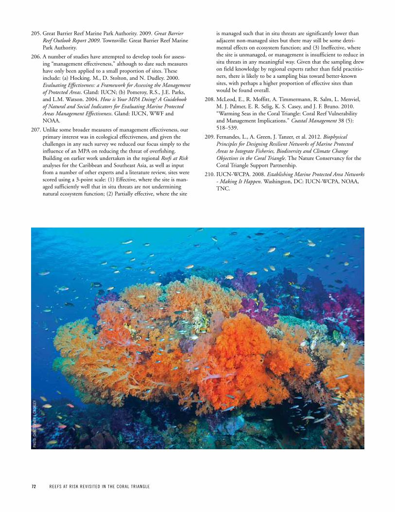
72 REEFS AT R ISK REV IS ITED IN THE CORAL TR IANGLE
205. Great Barrier Reef Marine Park Authority. 2009. Great Barrier Reef Outlook Report 2009. Townsville: Great Barrier Reef Marine Park Authority.
206. A number of studies have attempted to develop tools for assess-ing “management effectiveness,” although to date such measures have only been applied to a small proportion of sites. These include: (a) Hocking. M., D. Stolton, and N. Dudley. 2000. Evaluating Effectiveness: a Framework for Assessing the Management of Protected Areas. Gland: IUCN; (b) Pomeroy, R.S., J.E. Parks, and L.M. Watson. 2004. How is Your MPA Doing? A Guidebook of Natural and Social Indicators for Evaluating Marine Protected Areas Management Effectiveness. Gland: IUCN, WWF and NOAA.
207. Unlike some broader measures of management effectiveness, our primary interest was in ecological effectiveness, and given the challenges in any such survey we reduced our focus simply to the influence of an MPA on reducing the threat of overfishing. Building on earlier work undertaken in the regional Reefs at Risk analyses for the Caribbean and Southeast Asia, as well as input from a number of other experts and a literature review, sites were scored using a 3-point scale: (1) Effective, where the site is man-aged sufficiently well that in situ threats are not undermining natural ecosystem function; (2) Partially effective, where the site
is managed such that in situ threats are significantly lower than adjacent non-managed sites but there may still be some detri-mental effects on ecosystem function; and (3) Ineffective, where the site is unmanaged, or management is insufficient to reduce in situ threats in any meaningful way. Given that the sampling drew on field knowledge by regional experts rather than field practitio-ners, there is likely to be a sampling bias toward better-known sites, with perhaps a higher proportion of effective sites than would be found overall.
208. McLeod, E., R. Moffitt, A. Timmermann, R. Salm, L. Menviel, M. J. Palmer, E. R. Selig, K. S. Casey, and J. F. Bruno. 2010. “Warming Seas in the Coral Triangle: Coral Reef Vulnerability and Management Implications.” Coastal Management 38 (5): 518–539.
209. Fernandes, L., A. Green, J. Tanzer, et al. 2012. Biophysical Principles for Designing Resilient Networks of Marine Protected Areas to Integrate Fisheries, Biodiversity and Climate Change Objectives in the Coral Triangle. The Nature Conservancy for the Coral Triangle Support Partnership.
210. IUCN-WCPA. 2008. Establishing Marine Protected Area Networks - Making It Happen. Washington, DC: IUCN-WCPA, NOAA, TNC.
pHOT
O: C
HRIS
TOpH
ER J.
CRO
WLE
y
Phot
o: S
tacy
JuPi
ter
the Reefs at Risk SerieS
Reefs at Risk Revisited and Reefs at Risk Revisited in the Coral Triangle are part of a series that began in 1998 with the release of the first global analysis, Reefs at Risk: A Map-Based Indicator of Threats to the World’s Coral Reefs. Two region-specific publications followed with Reefs at Risk in Southeast Asia (2002) and Reefs at Risk in the Caribbean (2004). These regional studies incorporated more detailed data and refined the modeling approach for mapping the impact of human activities on reefs. Reefs at Risk Revisited — an updated global report — has drawn upon the enhanced meth-odology of the regional studies, improved global data sets, and new developments in mapping technology and coral reef science. Reefs at Risk Revisited in the Coral Triangle is based on the global report, supplemented with more recent and detailed data for the Coral Triangle Region. Both of these Reefs at Risk Revisited reports were collaborative efforts that involved more than 25 partner institutions (see inside front cover). The projects have compiled far more data, maps, and statistics than can be presented in the reports. Additional information and data are available at www.wri.org/reefs and on the accompanying data disk.
the world resources institute (wri) is a global environmental and development think tank that goes beyond research to create practical ways to protect
the earth and improve people’s lives. Wri’s work in coastal ecosystems includes the Reefs at Risk series, as well as the coastal capital project, which
supports sustainable management of coral reefs and mangroves by quantifying their economic value. (www.wri.org)
the Coral triangle Support partnership (CtSp) supports the governments of indonesia, Malaysia, Papua New Guinea, Philippines, Solomon islands, and
timor-Leste in their regional commitment to ensure that the world's most precious marine areas are sustained into the future. Made up of a consortium
of the world's leading conservation NGos — World Wildlife Fund (WWF), conservation international (ci) and the Nature conservancy (tNc) — ctSP is a
five-year, $32 million project supported by the united States agency for international Development (uSaiD). this partnership encourages the development
of transformational policies on natural resource management; strengthens the capacity of institutions and local communities; and builds decision support
capacity. (www.usctsp.org)
the nature Conservancy (tnC) is a leading conservation organization working around the world to protect ecologically important lands and waters for
nature and people. the conservancy and its more than one million members have protected more than 480,000 sq km of land and 8,000 km of rivers, and
engage in more than 100 marine conservation projects. the conservancy is actively working on coral reef conservation in 24 countries, including the
caribbean and the coral triangle regions. (www.nature.org)
worldFish Center is an international, nonprofit, nongovernmental organization dedicated to reducing poverty and hunger by improving fisheries and aqua-
culture. Working in partnership with a wide range of agencies and research institutions, WorldFish carries out research to improve small-scale fisheries
and aquaculture. its work on coral reefs includes reefBase, the global information system on coral reefs. (www.worldfishcenter.org)
united nations environment programme-world Conservation Monitoring Centre (unep-wCMC) is an internationally recognized center for the synthesis,
analysis, and dissemination of global biodiversity knowledge. uNeP-WcMc provides authoritative, strategic, and timely information on critical marine and
coastal habitats for conventions, countries, organizations, and companies to use in the development and implementation of their policies and decisions.
(www.unep-wcmc.org)
coral reefs of the World classified by threat from Local activities
coral reefs are classified by estimated present threat from local human activities, according to the reefs at risk integrated local threat index as developed for the reefs at risk revisited report. the index combines the threat from the following local activities:
n overfishing and destructive fishing
n coastal development
n Watershed-based pollution
n Marine-based pollution and damage
this map reflects new data and information collected for the coral triangle region as part of this report and is an updated version of the global reefs at risk revisited map for this region. the index shown on this map does not include the impact to reefs from global warming or ocean acidification. Maps including ocean warming and acidification appear later in the report and on www.wri.org/reefs.
Base data source: reef locations are based on 500 meter resolution gridded data reflecting shallow, tropical coral reefs of the world. organizations contributing to the data and development of the map include the institute for Marine remote Sensing, university of South Florida (iMarS/uSF), institut de recherche pour le Développement (irD), uNeP-WcMc, the World Fish center, and Wri. the composite data set was compiled from multiple sources, incorporating products from the Millennium coral reef Mapping Project prepared by iMarS/uSF and irD.
Map projection: Lambert cylindrical equal-area; central Meridian: 160° W
Reefs at Risk Revisited in the Coral Triangle was developed and implemented by the World resources institute (Wri) in close collaboration with the uSaiD-funded coral triangle Support Partnership (ctSP). this report was adapted from Wri’s 2011 global analysis of threats to coral reefs, Reefs at Risk Revisited, produced in partnership with the Nature conservancy (tNc), the WorldFish center, the international coral reef action Network (icraN), the united Nations environment Programme-World conservation Monitoring centre (uNeP-WcMc), and the Global coral reef Monitoring Network (GcrMN). Data in this report are based on the global Reefs at Risk Revisited report, supplemented with more recent and detailed data for the coral triangle region.
Source: Wri, 2012.
10 G Street, NEWashington, DC 20002, USA
wri.org
Lauretta Burke
kathLeen reytar
Mark SpaLding
aLLiSon perry
Reefs at RiskRevisited
in the Coral Triangle
ContriButing inStitutionS
Reefs at Risk Revisited in the Coral Triangle was developed by the World Resources Institute (WRI) in close collaboration with the USAID-funded Coral Triangle Support Partnership (CTSP). This report was adapted from WRI’s 2011 global analysis of threats to coral reefs, Reefs at Risk Revisited, produced in partnership with The Nature Conservancy (TNC), the WorldFish Center, the International Coral Reef Action Network (ICRAN), the United Nations Environment Programme-World Conservation Monitoring Centre (UNEP-WCMC), and the Global Coral Reef Monitoring Network (GCRMN). Many other government agencies, international organizations, research institutions, universities, non-governmental organizations and initiatives provided scientific guidance, contributed data, and reviewed results for these reports, including:
n Atlantic and Gulf Rapid Reef Assessment (AGRRA)
n Coastal Conservation and Education Foundation (CCEF)
n Coastal Oceans Research and Development in the Indian Ocean (CORDIO)
n Conservation International (CI)
n Coral Reef Alliance (CORAL)
n Coral Triangle Initiative on Coral Reefs, Fisheries, and Food Security (CTI-CFF)
n Healthy Reefs for Healthy People
n International Society for Reef Studies (ISRS)
n International Union for the Conservation of Nature (IUCN)
n L’Institut de Recherche pour le Développement (IRD)
n National Center for Ecological Analysis and Synthesis (NCEAS)
n Oceana
n Planetary Coral Reef Foundation
n Project AWARE Foundation
n Reef Check
n Reef Environmental Education Foundation (REEF)
n SeaWeb
n Secretariat of the Pacific Community (SPC)
n Secretariat of the Pacific Regional Environment Programme (SPREP)
n U.S. National Aeronautics and Space Administration (NASA)
n U.S. National Oceanic and Atmospheric Administration (NOAA)
n University of South Florida (USF)
n University of the South Pacific (USP)
n Wildlife Conservation Society (WCS)
n World Wildlife Fund (WWF)
FinanCiaL Support For Reefs at Risk Revisited in the CoRal tRiangle waS provided By:
n The Chino Cienega Foundation
n Roy Disney Family Foundation
n U.S. Agency for International Development
iSBn 978-1-56973-791-0