Embed Size (px)
Citation preview
Contourite origin for shelf and upper slope sand sheet, offshoreAntarctica
ANTONIO B. RODRIGUEZ* and JOHN B. ANDERSON�*University of Alabama, Department of Geological Sciences, Box 870338, Tuscaloosa, AL 35487-0338,USA (E-mail: [email protected])�Rice University, Department of Earth Science, Box 1892, Houston, TX 77251-1892, USA
ABSTRACT
A widespread (3200 km2), thick (10 cm to > 100 cm) sand deposit exists on the
continental shelf and upper slope offshore of the Pennell Coast, Antarctica.
The sand body occurs at water depths between 200 and 1200 m. The mean
grain size of the sand varies from 3Æ3 phi to 1Æ2 phi, and the composition is
dominantly volcanic. The only source for this volcanic material is Cape Adare,
a volcanic headland. Sands are transported up to 70 km from Cape Adare by a
westward-flowing circumpolar boundary current that impinges on the upper
slope and shelf. Radiocarbon dates from the sand and from the glacial unit
beneath it indicate that the deposit formed within the past 9000 years. The
occurrence of this sand sheet demonstrates the ability of contour currents to
assemble extensive sand bodies on the shelf and upper slope and the relatively
rapid rate at which these deposits may form.
Keywords Contourite, impinging current, Pennell Coast, sheet sand, traction-current deposit.
INTRODUCTION
Siliciclastic sand deposits located on the outerportions of modern continental shelves and oncontinental slopes include submerged relict low-stand shoreline/shoreface and early transgressivedeposits, sediment gravity-flow deposits and bot-tom-current deposits (contourites). Deposition ofouter shelf and upper slope sheet sands bygeostrophic currents and thermohaline-drivencurrents is favoured during sea-level highstands;however, sequence-stratigraphic models do nottake into account these types of deposits. In fact,Viana & Faugeres (1998) called for an integrationof palaeocirculation studies with sequence-strati-graphic interpretations to help better to predictthese potentially thick sandy deposits.
Many modern continental margins are influ-enced by strong boundary currents that arecapable of transporting sand-sized material, butare starved of sand. Thus, modern contourites arecomposed of terrigenous fine-grained mud andsilt or biogenic-rich marl and ooze; sandy conto-urites are relatively rare in the modern ocean(Faugeres & Stow, 1993; Viana et al., 1998). For
example, Antarctic contourites sampled aroundthe Weddell Sea (Camerlenghi et al., 2001; Mich-els et al., 2001) and the Pacific margin of theAntarctic Peninsula (Rebesco et al., 1996; Harriset al., 1999; Lucchi et al., 2002) are composed ofhemipelagic muddy sediment. Some ancient andmodern contourite deposits, however, have beendescribed as being sandy (Carminatti & Scarton,1991; Shanmugam et al., 1993a,b; Viana, 2001)and, in some cases, are composed of thick mas-sive sand (Enjorlas et al., 1986). In the absence ofgravity flows, the formation of deep- to mid-water(300–> 2000 m) sand sheets depends on theability of marine currents to transport and depositsand as well as having a source for the sand. Evenwhere sand is delivered to the outer shelf andupper slope during lowstands, the short durationof the recent glacial-eustatic lowstands has pro-vided little time for marine currents to remobilizethe sand and transport it along the margin.Lowstand sand bodies are quickly buried intransgressive and highstand mud.
Identifying the origin of an outer shelfsand deposit is not always straightforward. Forexample, an outer shelf relict coastal lithosome
Sedimentology (2004) 51, 699–711 doi: 10.1111/j.1365-3091.2004.00645.x
� 2004 International Association of Sedimentologists 699
originally deposited during a sea-level lowstandmay become completely or partially reworkedduring marine transgression, and furtherreworked by marine currents once submergedbelow fairweather wave base (Emery, 1968; Swiftet al., 1971; 1984; Stubblefield et al., 1984). Ant-arctica is an ideal natural laboratory for assessingthe ability of geostrophic and thermohaline-driven currents and sediment gravity-flow pro-cesses in transporting and sorting sediments indeep-marine settings. There is no fluvial input tothe continental shelf or a coastal zone fringing thecontinent; glaciers deliver sediment directly tothe deep continental shelf. Outer shelf depthsaverage 200–500 m, and inner shelf depths may beover 1000 m (e.g. Dennistoun Trough; Anderson,1999). Wind-driven currents generally influencethe sea floor at water depths above 300 m(Anderson et al., 1983, 1984). Tidal currentsaround Antarctica are relatively weak because ofthe microtidal range (< 2 m). In the absence ofthese sedimentary agents, mechanisms for thegeneration of shelf/slope sand bodies are limitedto geostrophic and thermohaline-driven currentsand sediment gravity-flow processes.
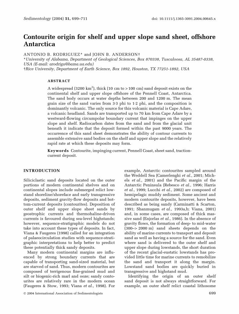
This paper discusses the character and origin ofa large 3200 km2, 10 cm to > 100 cm thick fine- tomedium-grained massive sand sheet. The sandbody is located in 200–> 1300 m of water on theNorth Victoria Land continental shelf, Antarctica(Fig. 1). A robust radiocarbon data set shows thatthis sand sheet formed during the last 9000 years.
STUDY AREA
Regional geology of the Pennell Coast
The Pennell coast, located in North Victoria Land(Fig. 1), is divided into two broad geologicalprovinces comprising the extensive and uniformRobertson Bay Group and the McMurdo VolcanicGroup (Fig. 1). Within the study area, about 80%of the coastline is composed of the Robertson BayGroup (Fig. 1), which consists of a very uniformsuccession of Early Cambrian grey to greenquartzose meta-graywacke and slate (Crowder,1968; Wright, 1981; Wright et al., 1984). Thissuccession represents a low-grade metamor-phosed flysch sequence that was originallydeposited in a deep-sea fan to abyssal plainenvironment (Wright, 1981; Field & Findlay,1983). Two phases of Robertson Bay Groupdeformation occurred during the Ordovician(Findlay, 1986), and granite and granodiorite of
the Carboniferous Admiralty Group wereintruded into these tightly folded rocks. Alongthe eastern edge of the study area lies a linear beltof Miocene to Recent extrusives known as theMcMurdo Volcanic Group (Fig. 1). This is com-posed of sand- and granule-sized fragments ofglassy basalt and palagonite in a soft, porous,earthy palagonite matrix (Hamilton, 1972).
Oceanography
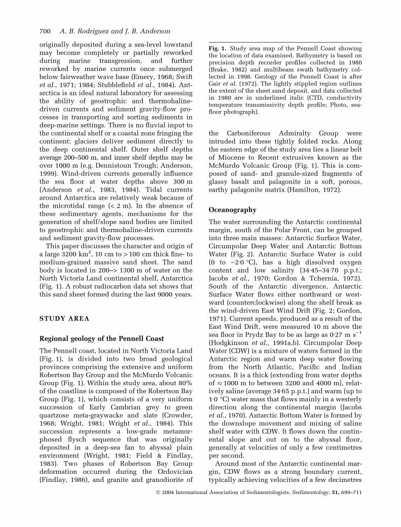
The water surrounding the Antarctic continentalmargin, south of the Polar Front, can be groupedinto three main masses: Antarctic Surface Water,Circumpolar Deep Water and Antarctic BottomWater (Fig. 2). Antarctic Surface Water is cold(0 to )2Æ0 �C), has a high dissolved oxygencontent and low salinity (34Æ45–34Æ70 p.p.t.;Jacobs et al., 1970; Gordon & Tchernia, 1972).South of the Antarctic divergence, AntarcticSurface Water flows either northward or west-ward (counterclockwise) along the shelf break asthe wind-driven East Wind Drift (Fig. 2; Gordon,1971). Current speeds, produced as a result of theEast Wind Drift, were measured 10 m above thesea floor in Prydz Bay to be as large as 0Æ27 m s)1
(Hodgkinson et al., 1991a,b). Circumpolar DeepWater (CDW) is a mixture of waters formed in theAntarctic region and warm deep water flowingfrom the North Atlantic, Pacific and Indianoceans. It is a thick (extending from water depthsof � 1000 m to between 3200 and 4000 m), relat-ively saline (average 34Æ65 p.p.t.) and warm (up to1Æ0 �C) water mass that flows mainly in a westerlydirection along the continental margin (Jacobset al., 1970). Antarctic Bottom Water is formed bythe downslope movement and mixing of salineshelf water with CDW. It flows down the contin-ental slope and out on to the abyssal floor,generally at velocities of only a few centimetresper second.
Around most of the Antarctic continental mar-gin, CDW flows as a strong boundary current,typically achieving velocities of a few decimetres
Fig. 1. Study area map of the Pennell Coast showingthe location of data examined. Bathymetry is based onprecision depth recorder profiles collected in 1980(Brake, 1982) and multibeam swath bathymetry col-lected in 1998. Geology of the Pennell Coast is afterGair et al. (1972). The lightly stippled region outlinesthe extent of the sheet sand deposit, and data collectedin 1980 are in underlined italic (CTD, conductivitytemperature transmissivity depth profile; Photo, sea-floor photograph).
700 A. B. Rodriguez and J. B. Anderson
� 2004 International Association of Sedimentologists, Sedimentology, 51, 699–711

Contourite sand sheet, Antarctica 701
� 2004 International Association of Sedimentologists, Sedimentology, 51, 699–711
per second (Pillsbury & Jacobs, 1985). The uppersurface of CDW is often at or above the depth ofthe continental shelf and impinges on to the shelf.The salinity of the waters occupying theshelf determines whether CDW flows on to theshelf. Where CDW encounters denser watersflowing off the continental shelf, it upwells and,where the shelf is bathed in relatively low-densitywaters, CDW flows on to the shelf as either abottom current or an intermediate tongue. Thisgeneral circulation regime results in a situationwhereby the outer shelf and upper slope sea floorare locally influenced by much stronger currentsthan those on the inner shelf or lower slope. Forexample, on the upper slope of the MacRobertsonshelf, located west of Prydz Bay, Hodgkinsonet al. (1988) measured hourly averaged currentvelocities 10 m above the bed to be 0Æ49 m s)1,
and the current reached a maximum of 1Æ96 m s)1
over a 10-month period of data collection. Thestrongest currents occur in regions where theCDW impinges on to the margin (Jacobs et al.,1970; Anderson, 1999).
METHODS
During the 1998 RV/IB Nathaniel B. Palmerresearch cruise (NBP9801), eight Smith-McIntyregrab samples, one piston core, three sea-floorphotos, four conductivity temperature depthtransmissivity (CTD) profiles and 50 km of seis-mic and side-scan sonar data were collected from
the Pennell Coast (Fig. 1). These data comple-ment a previous data set, collected from thePennell Coast during the Deep Freeze 1980expedition (Brake & Anderson, 1983), whichincludes 16 piston cores and 17 Dietz-LaFondgrab samples (Fig. 1). Piston cores range from38 cm to 281 cm in length. A SeaBird 11 instru-ment was used to collect CTD data. A DatasonicsSIS 1000 deep-tow CHIRP sonar system was usedto collect the seismic and side-scan sonar data.The CHIRP synchronously transmits a 2–7 kHzswept FM (4 kW output) sub-bottom pulseand a 100 kHz side-scan pulse. The CHIRP wasunable to image the internal stratification or thebase of the sheet sand deposit because of pulseattenuation at the sea floor.
Analysis of the sediment cores recovered inclu-ded descriptions of colour, texture and structure,grain-size measurements, determination of grossmineralogy and qualitative palaeontologicalexamination. Mineralogy was determined bycounting individual grains using a binocularmicroscope and smear slide analysis using atransmitted light microscope. Sample weight percent of silt and clay was calculated by measuringweight lost after washing through a 63-micronsieve. An automated settling tube was used forgrain-size analysis of the sand fraction. The grainsize of each sample was analysed three times toensure accuracy; the analyses of each sample didnot vary by more than 0Æ1 phi. Piston cores andgrab samples from both expeditions werearchived at the Florida State University AntarcticResearch Facility (http://www.arf.fsu.edu).
Radiocarbon ages were derived from foramini-fera and other carbonate material by acceleratormass spectrometry (AMS) at the University ofArizona NSF facility. Reported ages were correc-ted by 1300 years for the carbon reservoir effect,as suggested by Berkman & Forman (1996).
RESULTS
The grab samples and sediment cores obtainedfrom the study area sampled five distinct litho-facies: diamicton, diatom-rich mud/ooze, muddysand, sand and sandy gravel. Brake (1982) ini-tially described the sedimentary units in thestudy area from the examination of 41 pistoncores and 69 bottom grab samples. The descrip-tions below are in part a result of this earlierwork.
Diamicton typically consists of 0–50% gravel,10–70% sand, 10–60% silt, 5–50% clay and
Fig. 2. Schematic representation of water massesaround Antarctica (modified after Sugden, 1982).
702 A. B. Rodriguez and J. B. Anderson
� 2004 International Association of Sedimentologists, Sedimentology, 51, 699–711
variable concentrations of biogenic material. Gra-vel and sand grains are commonly striated andfaceted and are dominantly composed of quartz(40–60%), basalt (15–30%), rock fragments(5–15%) and heavy minerals (2–7%). Diamictonis exposed at the sea floor adjacent to the coast(Fig. 1) and was sampled below the sand faciesalong Rice Plateau (Fig. 3). The diatom mud/oozelithofacies contains 50–90% diatom frustules,50–90% muddy matrix and 0–10% sand and islaminated. The sand fraction is very fine grained(4Æ0 phi) and dominantly composed of quartz(25–70%) and basalt lithic grains (30–75%). Thislithofacies was only sampled at the sea floor inDennistoun Trough (Fig. 1). The muddy sandlithofacies contains 20–40% diatom frustules andsponge spicules, 15–40% muddy matrix, 50–70%sand and 0–10% gravel and is bioturbated. Thesand fraction is fine to very fine grained (3Æ0–4Æ0phi) and dominantly composed of quartz(30–50%) and basalt lithic grains (50–70%). Thislithofacies was sampled at the sea floor inRobertson Bay, along the eastern flank of Den-nistoun Trough and on the landward side of RicePlateau (Figs 1 and 3). The sand lithofaciescontains no clay- or silt-sized material and rep-resents the best sorted sediment in the study area.The lithofacies is well sorted, structureless, fineto coarse grained (mean grain size 1–3Æ3 phi) andis composed largely of basalt grains (63–95%).The lithofacies forms an extensive sheet sandbody along the outer shelf and upper slope westof Cape Adare (Figs 1 and 3). It is situated inwater depths between 200 and 1200 m. Mostcores did not penetrate through the thickestportion of the sand deposit, but those that didshow the lower contact to be sharp (Fig. 3, coreDF-80-153). The sandy gravel lithofacies is poorlysorted and contains no clay- or silt-sized material.The lithofacies is dominantly composed of basaltgrains and clasts (90%) with moderate amounts offossils including bryozoan fragments, ostracods,foraminifera, echinoderm spines and sponge spi-cules. Sandy gravel was sampled adjacent to CapeAdare (DF-80-171; Figs 1 and 3).
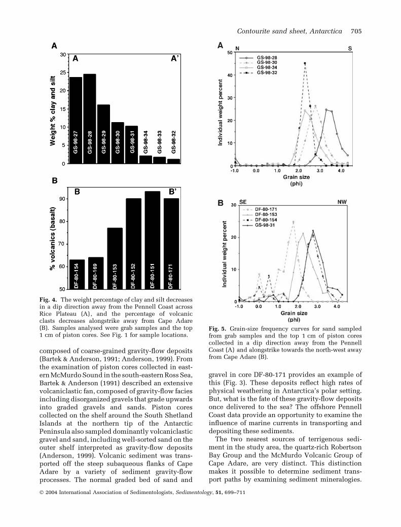
The percentage of clay and silt contained in thesea-floor sediment decreases in an offshore direc-tion across Rice Plateau from about 25% clay andsilt at the landward sample locations to < 2% in theseaward sample locations (Figs 1 and 4A). Themean grain size of surface sediment increases in aseaward direction across Rice Plateau from 3Æ3 phiin sample GS-98-28 to 2Æ1 phi in sample GS-98-32(Fig. 5A). The surface sediment also becomesbetter sorted across Rice Plateau in a seaward
direction (Fig. 5A). The mean grain size of sandalso decreases towards the north-west from 1Æ2 phinear Cape Adare (sample DF-80–171) to 2Æ7 phi atthe north-west edge of Rice Plateau (sample GS-98-31; Fig. 5B). Mineralogical examination of surfacesediment indicates a decrease in the percentage ofbasaltic grains away from Cape Adare towards thenorth-west (Fig. 4B). In general, the mean grainsize and percentage of sand increases towards CapeAdare (south-eastward) and away from the PennellCoast across Rice Plateau.
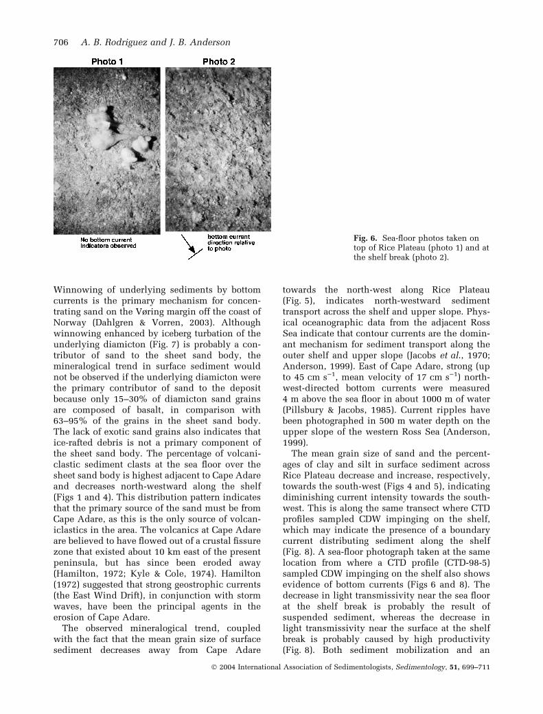
No current-meter data exist in the study area;however, evidence for the presence of bottomcurrents and estimates of flow direction wereobtained by examining sea-floor features. Twosea-floor photos were taken from the Rice Plateauarea (Figs 1 and 6). The first was taken on top ofRice Plateau in 200 m of water and does not showany indicators of current flow (Fig. 6, photo 1).The second was taken at the shelf break, seawardof Rice Plateau in 470 m of water, and reveals thepresence of a current flowing towards the bottomright of the photo, as indicated by the inclinationof fenestrate bryozoans (Fig. 6, photo 2). Unfor-tunately, the compass was not in the camera’sfield of view, so no definite current flow directioncan be deduced from the photos.
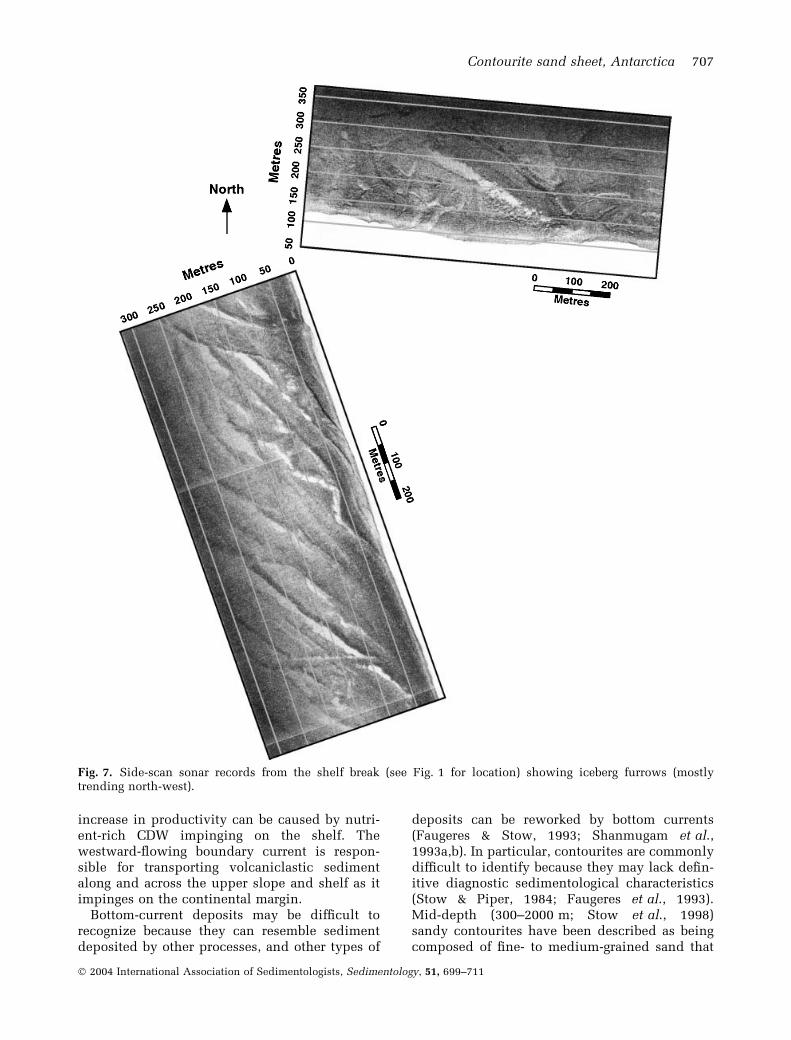
The side-scan sonar data shown in Fig. 7 werecollected from the north-east edge of Rice Plateau(Fig. 1). These data show numerous iceberg fur-rows that formed as icebergs ran aground at theedge of the plateau. The width of the furrowsranges from 40 to 100 m, and they trend predom-inantly towards the north-west (Fig. 7). In general,this orientation reflects offshore drift under theinfluence of surface currents (East Wind Drift).
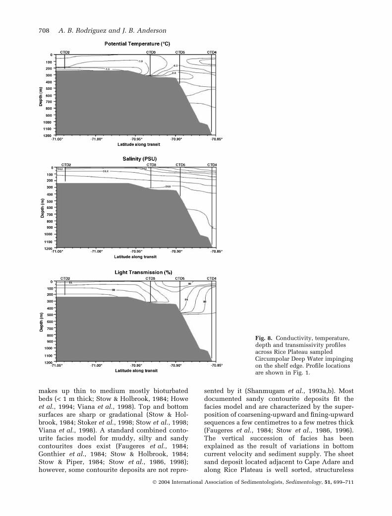
CTD profiles show that a warm and saline watermass is impinging on the continental shelf in thearea of Rice Plateau (Fig. 8). Stations CTD3 andCTD5 show that this water mass has a tempera-ture of 0Æ0 �C and salinity of 34Æ6 p.p.t. (Fig. 8).Based on these characteristics, the water mass isinterpreted to be CDW (Jacobs et al., 1970).Stations CTD3 and CTD5 show a decrease inlight transmission from the surface water down tothe sea floor (Fig. 8). This decrease in lighttransmission occurs just seaward of Rice Plateauat the shelf break, coinciding with the area whereCDW is impinging on the shelf (Fig. 8).
INTERPRETATION AND DISCUSSION
Volcanic islands and headlands of Antarctica arecharacterized by steep slopes and debris aprons
Contourite sand sheet, Antarctica 703
� 2004 International Association of Sedimentologists, Sedimentology, 51, 699–711
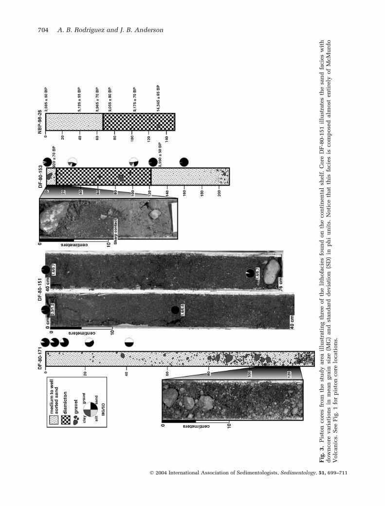
Fig
.3.
Pis
ton
core
sfr
om
the
stu
dy
are
ail
lust
rati
ng
thre
eof
the
lith
ofa
cie
sfo
un
don
the
con
tin
en
tal
shelf
.C
ore
DF
-80-1
51
illu
stra
tes
the
san
dfa
cie
sw
ith
dow
ncore
vari
ati
on
sin
mean
gra
insi
ze
(MG
)an
dst
an
dard
devia
tion
(SD
)in
ph
iu
nit
s.N
oti
ce
that
this
facie
sis
com
pose
dalm
ost
en
tire
lyof
McM
urd
oV
olc
an
ics.
See
Fig
.1
for
pis
ton
core
locati
on
s.
704 A. B. Rodriguez and J. B. Anderson
� 2004 International Association of Sedimentologists, Sedimentology, 51, 699–711
composed of coarse-grained gravity-flow deposits(Bartek & Anderson, 1991; Anderson, 1999). Fromthe examination of piston cores collected in east-ern McMurdo Sound in the south-eastern Ross Sea,Bartek & Anderson (1991) described an extensivevolcaniclastic fan, composed of gravity-flow faciesincluding disorganized gravels that grade upwardsinto graded gravels and sands. Piston corescollected on the shelf around the South ShetlandIslands at the northern tip of the AntarcticPeninsula also sampled dominantly volcaniclasticgravel and sand, including well-sorted sand on theouter shelf interpreted as gravity-flow deposits(Anderson, 1999). Volcanic sediment was trans-ported off the steep subaqueous flanks of CapeAdare by a variety of sediment gravity-flowprocesses. The normal graded bed of sand and
gravel in core DF-80-171 provides an example ofthis (Fig. 3). These deposits reflect high rates ofphysical weathering in Antarctica’s polar setting.But, what is the fate of these gravity-flow depositsonce delivered to the sea? The offshore PennellCoast data provide an opportunity to examine theinfluence of marine currents in transporting anddepositing these sediments.
The two nearest sources of terrigenous sedi-ment in the study area, the quartz-rich RobertsonBay Group and the McMurdo Volcanic Group ofCape Adare, are very distinct. This distinctionmakes it possible to determine sediment trans-port paths by examining sediment mineralogies.
Fig. 5. Grain-size frequency curves for sand sampledfrom grab samples and the top 1 cm of piston corescollected in a dip direction away from the PennellCoast (A) and alongstrike towards the north-west awayfrom Cape Adare (B).
Fig. 4. The weight percentage of clay and silt decreasesin a dip direction away from the Pennell Coast acrossRice Plateau (A), and the percentage of volcanicclasts decreases alongstrike away from Cape Adare(B). Samples analysed were grab samples and the top1 cm of piston cores. See Fig. 1 for sample locations.
Contourite sand sheet, Antarctica 705
� 2004 International Association of Sedimentologists, Sedimentology, 51, 699–711
Winnowing of underlying sediments by bottomcurrents is the primary mechanism for concen-trating sand on the Vøring margin off the coast ofNorway (Dahlgren & Vorren, 2003). Althoughwinnowing enhanced by iceberg turbation of theunderlying diamicton (Fig. 7) is probably a con-tributor of sand to the sheet sand body, themineralogical trend in surface sediment wouldnot be observed if the underlying diamicton werethe primary contributor of sand to the depositbecause only 15–30% of diamicton sand grainsare composed of basalt, in comparison with63–95% of the grains in the sheet sand body.The lack of exotic sand grains also indicates thatice-rafted debris is not a primary component ofthe sheet sand body. The percentage of volcani-clastic sediment clasts at the sea floor over thesheet sand body is highest adjacent to Cape Adareand decreases north-westward along the shelf(Figs 1 and 4). This distribution pattern indicatesthat the primary source of the sand must be fromCape Adare, as this is the only source of volcan-iclastics in the area. The volcanics at Cape Adareare believed to have flowed out of a crustal fissurezone that existed about 10 km east of the presentpeninsula, but has since been eroded away(Hamilton, 1972; Kyle & Cole, 1974). Hamilton(1972) suggested that strong geostrophic currents(the East Wind Drift), in conjunction with stormwaves, have been the principal agents in theerosion of Cape Adare.
The observed mineralogical trend, coupledwith the fact that the mean grain size of surfacesediment decreases away from Cape Adare
towards the north-west along Rice Plateau(Fig. 5), indicates north-westward sedimenttransport across the shelf and upper slope. Phys-ical oceanographic data from the adjacent RossSea indicate that contour currents are the domin-ant mechanism for sediment transport along theouter shelf and upper slope (Jacobs et al., 1970;Anderson, 1999). East of Cape Adare, strong (upto 45 cm s)1, mean velocity of 17 cm s)1) north-west-directed bottom currents were measured4 m above the sea floor in about 1000 m of water(Pillsbury & Jacobs, 1985). Current ripples havebeen photographed in 500 m water depth on theupper slope of the western Ross Sea (Anderson,1999).
The mean grain size of sand and the percent-ages of clay and silt in surface sediment acrossRice Plateau decrease and increase, respectively,towards the south-west (Figs 4 and 5), indicatingdiminishing current intensity towards the south-west. This is along the same transect where CTDprofiles sampled CDW impinging on the shelf,which may indicate the presence of a boundarycurrent distributing sediment along the shelf(Fig. 8). A sea-floor photograph taken at the samelocation from where a CTD profile (CTD-98-5)sampled CDW impinging on the shelf also showsevidence of bottom currents (Figs 6 and 8). Thedecrease in light transmissivity near the sea floorat the shelf break is probably the result ofsuspended sediment, whereas the decrease inlight transmissivity near the surface at the shelfbreak is probably caused by high productivity(Fig. 8). Both sediment mobilization and an
Fig. 6. Sea-floor photos taken ontop of Rice Plateau (photo 1) and atthe shelf break (photo 2).
706 A. B. Rodriguez and J. B. Anderson
� 2004 International Association of Sedimentologists, Sedimentology, 51, 699–711
increase in productivity can be caused by nutri-ent-rich CDW impinging on the shelf. Thewestward-flowing boundary current is respon-sible for transporting volcaniclastic sedimentalong and across the upper slope and shelf as itimpinges on the continental margin.
Bottom-current deposits may be difficult torecognize because they can resemble sedimentdeposited by other processes, and other types of
deposits can be reworked by bottom currents(Faugeres & Stow, 1993; Shanmugam et al.,1993a,b). In particular, contourites are commonlydifficult to identify because they may lack defin-itive diagnostic sedimentological characteristics(Stow & Piper, 1984; Faugeres et al., 1993).Mid-depth (300–2000 m; Stow et al., 1998)sandy contourites have been described as beingcomposed of fine- to medium-grained sand that
Fig. 7. Side-scan sonar records from the shelf break (see Fig. 1 for location) showing iceberg furrows (mostlytrending north-west).
Contourite sand sheet, Antarctica 707
� 2004 International Association of Sedimentologists, Sedimentology, 51, 699–711
makes up thin to medium mostly bioturbatedbeds (< 1 m thick; Stow & Holbrook, 1984; Howeet al., 1994; Viana et al., 1998). Top and bottomsurfaces are sharp or gradational (Stow & Hol-brook, 1984; Stoker et al., 1998; Stow et al., 1998;Viana et al., 1998). A standard combined conto-urite facies model for muddy, silty and sandycontourites does exist (Faugeres et al., 1984;Gonthier et al., 1984; Stow & Holbrook, 1984;Stow & Piper, 1984; Stow et al., 1986, 1998);however, some contourite deposits are not repre-
sented by it (Shanmugam et al., 1993a,b). Mostdocumented sandy contourite deposits fit thefacies model and are characterized by the super-position of coarsening-upward and fining-upwardsequences a few centimetres to a few metres thick(Faugeres et al., 1984; Stow et al., 1986, 1996).The vertical succession of facies has beenexplained as the result of variations in bottomcurrent velocity and sediment supply. The sheetsand deposit located adjacent to Cape Adare andalong Rice Plateau is well sorted, structureless
Fig. 8. Conductivity, temperature,depth and transmissivity profilesacross Rice Plateau sampledCircumpolar Deep Water impingingon the shelf edge. Profile locationsare shown in Fig. 1.
708 A. B. Rodriguez and J. B. Anderson
� 2004 International Association of Sedimentologists, Sedimentology, 51, 699–711
and fine to coarse grained and generally adheresto the facies model proposed by Stoker et al.(1998) for a mid-only contourite with a sharpbase. Mid-only contourite deposits are missingthe fining-upward portion of the contouritesequence, implying that currents switch offabruptly or are persistently strong in the area(Stoker et al., 1998).
The age of the sheet sand is constrained usingradiocarbon dates from two cores, one collectednear the centre of the sheet sand on the outer shelf(core DF-80-153) and the other taken at thewestern edge of the sand sheet (core NBP-98-26;Fig. 1). Core DF-80-153 sampled two sand unitsseparated by a diamicton unit (Fig. 3). An age of920 ± 70 years BP was acquired from the upperunit and a date of 3550 ± 50 years BP from the topof the lower unit. Radiocarbon dates from thesand unit in core NBP-98-26 range from8965 ± 70 years BP at the base to 2595 ± 50 yearsBP near the top of the unit and are all instratigraphic succession. This sand unit rests ona diamicton that yielded radiocarbon ages of9175 ± 70–14 345 ± 95 years BP (Fig. 3). Thesedata indicate that the sheet sand formed withinthe past 9000 years. The average accumulationrate is 8 cm/1000 years.
CONCLUSIONS
A widespread (3200 km2) sheet sand depositexists on the continental shelf and slope offshoreof the Pennell Coast, Antarctica, in water depthsbetween 200 and 1200 m. This deposit has beeninterpreted as a contourite. The sand that makesup the contourite is mostly derived from Ceno-zoic volcanic rocks exposed at Cape Adare. Initialproduction of sand and gravel results from rapidweathering of the volcanic headland in the polarAntarctic setting. Debris is shed from theseheadlands by sediment gravity-flow processes.Sediment grain sizes < medium sand are, in turn,transported across the shelf and upper slope by astrong boundary current (Circumpolar DeepWater) that flows towards the west and impingeson to the shelf. Sand is transported up to 70 kmfrom its source in a period of 9000 years. Grainsize decreases towards the west. The contouritedeposit has a sharp base and displays nosignificant vertical grain-size trends. This impliesfairly constant current velocities over the timeinterval of sand body deposition.
The Antarctic contourite deposit is evidencethat bottom currents can form longitudinal,
massive, thick (possibly > 1 m), sharp-based sandbodies on the outer shelf and upper slope atremarkably rapid rates.
ACKNOWLEDGEMENTS
This work was funded by NSF-OPP grantnumber 9527876 awarded to John Anderson.The authors would like to thank the crew of theRV/IB Nathaniel B. Palmer and the AntarcticSupport Associates personnel for help in col-lecting these data and for a productive cruise.Suzanne O’Hara of Lamont-Doherty GeologicalObservatory, Columbia University, helped im-mensely in collecting the CTD profiles. Criticalreviews by Peter Haughton, Jan Sverre Labergand Michele Rebesco greatly improved themanuscript.
REFERENCES
Anderson, J.B. (1999) Antarctic Marine Geology. Cambridge
University Press, New York, 289 pp.
Anderson, J.B., Brake, C.F., Myers, N.C. and Singer, J. (1983)
Sedimentary dynamics on the Antarctic Continental Shelf.
In: Antarctic Earth Science (Eds R.L. Oliver, P.R. James and
J.B. Jago), pp. 387–389. Cambridge University Press, New
York.
Anderson, J.B., Brake, C.F. and Myers, N.C. (1984) Sedimen-
tation on the Ross Sea continental shelf: Antarctica. Mar.
Geol., 57, 295–333.
Bartek, L.R. and Anderson, J.B. (1991) Facies distribution
resulting from sedimentation under polar interglacial cli-
matic conditions within a high-latitude marginal basin,
McMurdo Sound, Antarctica. In: Paleoclimatic Interpre-tation of Glacial Marine Deposits (Eds J.B. Anderson and
G.M. Ashley), Geol. Soc. Am. Spec. Publ., 261, 27–49.
Berkman, P.A. and Forman, S.L. (1996) Pre-bomb radiocarbon
and the reservoir correction for calcareous marine species in
the Southern Ocean. Geophys. Res. Lett., 23, 363–366.
Brake, C.F. (1982) Sedimentology of North Victoria Land
Continental Margin, Antarctica. MA Thesis, Rice Univer-
sity, Houston, TX.
Brake, C.F. and Anderson, J.B. (1983) The bathymetry of
North Victoria Land continental margin. Mar. Geodesy, 6,139–147.
Camerlenghi, A., Domack, E., Rebesco, M., Gilbert, R.,Ishman, S., Leventer, A., Brachfeld, S. and Drake, A. (2001)
Glacial morphology and post-glacial contourites in northern
Prince Gustav Channel (NW Weddell Sea, Antarctica. Mar.Geophys. Res., 22, 417–443.
Carminatti, M. and Scarton, J.C. (1991) Sequence stratigraphy
of the Oligocene turbidite complex of Campos Basin, off-
shore Brazil. In: Seismic Facies and Sedimentary Processes
of Submarine Fans and Turbidite Systems: Frontiers in
Sedimentary Geology (Eds P. Weimer and M.H. Link), 18,
pp. 241–246. Springer, New York.
Crowder, D.F. (1968) Geology of a part of north Victoria Land,
Antarctica. US Geol. Surv. Prof. Paper, 600-D, 95–107.
Contourite sand sheet, Antarctica 709
� 2004 International Association of Sedimentologists, Sedimentology, 51, 699–711
Dahlgren, K.I.T. and Vorren, T.O. (2003) Sedimentary envi-
ronment and glacial history during the last 40 ka of the Vøring
Continental margin, mid-Norway. Mar. Geol., 193, 93–127.
Emery, K.O. (1968) Relict sediments on continental shelves of
the world. AAPG Bull., 52, 445–464.
Enjorlas, J.M., Gouadain, J., Mutti, E. and Pizon, J. (1986) New
Turbiditic model for the lower Tertiary sands in the South
Viking Graben. In: Habitat of Hydrocarbons on theNorwegian Continental Shelf (Eds A.M. Spencer, E. Holter,
C.J. Campbell, S.H. Hanslein, E. Nysther and E.G. Ormaa-
sen), pp. 171–178. Graham and Trotman, London.
Faugeres, J.C. and Stow, D.A.V. (1993) Bottom-current-con-
trolled sedimentation: a synthesis of the contourite prob-
lem. Sed. Geol., 82, 287–297.
Faugeres, J.C., Stow, D.A.V. and Gonthier, E. (1984) Conto-
urite drift molded by deep Mediterranean outflow. Geology,
12, 296–300.
Faugeres, J.C., Mezerais, M.L. and Stow, D.A.V. (1993)
Contourite drift types and their distribution in the North
and South Atlantic Ocean Basins. In: Contourites and Bot-
tom Currents (Eds D.A.V. Stow and J.C. Faugeres), Sed.
Geol., 82, 189–203.
Field, B.D. and Findlay, R.H. (1983) The sedimentology of the
Robertson Bay Group, Northern Victoria Land. In: Antarctic
Earth Science (Eds R.L. Oliver, P.R. Jones and J.B. Jago), pp.
102–106. Australian Academy of Science, Canberra.
Findlay, R.H. (1986) Structural Geology of the Robertson Bay
and Millen Terranes, Northern Victoria Land, Antarctica.
In: Geological Investigations in Northern Victoria Land (Ed.
E. Stump), Antarctic Res. Series, 46, 91–114.
Gair, H.S., Sturm, A., Carryer, J.J. and Grindley, G.W. (1972)
The Geology of Northern Victoria Land. Antarctic Map
Folio Series, Folio 12. American Geographical Society,
New York.
Gonthier, E., Faugeres, J.C. and Stow, D.A.V. (1984) Conto-
urite facies of the Faro Drift, Gulf of Cadiz. In: Fine-Grained
Sediments: Deep-Water Processes and Facies (Eds D.A.V.
Stow and D.J.W. Piper), Geol. Soc. Spec. Publ., 15, 275–292.
Gordon, A.L. (1971) Oceanography of Antarctic waters.
In: Antarctic Oceanology I: Antarctic Research Series (Ed.
J.L. Reid), Am. Geophys. Union Publ., 15, 169–203.
Gordon, A.L. and Tchernia, P. (1972) Waters of the contin-
ental margin off Adelie Coast, Antarctica. In: Antarctic
Oceanology II: Antarctic Research Series (Ed. D.E. Hayes),
Am. Geophys. Union Publ., 19, 59–69.
Hamilton, W. (1972) The Hallett Volcanic Providence,
Antarctica. US Geol. Surv. Prof. Paper, 456-C, 56.
Harris, P.T., Domack, E., Manley, P., Gilbert, R. and Leventer,A. (1999) Andvord drift: a new type of inner shelf, glacial
marine deposystem from the Antarctic Peninsula. Geology,
27, 683–686.
Hodgkinson, R.P., Colman, R.S., Kerry, K.R. and Robb, M.(1988) Water currents in Prydz Bay, Antarctica, during 1985.
Research Notes no. 59. Australian Antarctic Division, 127 pp.
Hodgkinson, R.P., Colman, R.S., Robb, M. and Williams, R.(1991a) Current meter moorings in the region of Prydz Bay,
Antarctica, 1986. ANARE Research Notes no. 81. Australian
Antarctic Division, 130 pp.
Hodgkinson, R.P., Colman, R.S., Robb, M. and Williams, R.(1991b) Current meter moorings in the region of Prydz Bay,
Antarctica, 1987. ANARE Research Notes no. 82. Australian
Antarctic Division, 68 pp.
Howe, J.A., Stoker, M.S. and Stow, D.A.V. (1994) Late Ceno-
zoic sediment drift complex, northeast Rockall Trough,
North Atlantic. Paleoceanography, 9, 989–999.
Jacobs, S.S., Amos, A.F. and Bruchhausen, P.M. (1970) Ross
Sea oceanography and Antarctic Bottom Water formation.
Deep-Sea Res., 17, 935–962.
Kyle, P.R. and Cole, J.W. (1974) Structural control of volcan-
ism in the McMurdo Volcanic Group, Antarctica. Bull.
Volcanol., 38, 16–25.
Lucchi, R.G., Rebesco, M., Camerlenghi, A., Busetti, M.,Tomadin, L., Villa, G., Persico, D., Morigi, C., Bonci, M.C.and Giorgetti, G. (2002) Mid-late Pleistocene glacimarine
sedimentary processes of a high-latitude, deep-sea sediment
drift (Antarctic Peninsula Pacific margin). Mar. Geol., 189,343–370.
Michels, K.H., Rogenhagen, J. and Kuhn, G. (2001) Recogni-
tion of contour-current influence in mixed contourite-
turbidite sequences of the western Weddell Sea, Antarctica.
Mar. Geophys. Res., 22, 465–485.
Pillsbury, R.D. and Jacobs, S.S. (1985) Preliminary observa-
tions from long-term current meter moorings near the Ross
Ice Shelf. In: Oceanology of the Antarctic Continental Shelf(Ed. S.S. Jacobs). Antarctic Research Series. Am. Geophys.
Union Publ., 43, 87–107.
Rebesco, M., Larter, L.D., Camerlenghi, A. and Barker, P.F.(1996) Giant sediment drift on the continental rise west of
the Antarctic Peninsula. Geo-Mar. Lett., 16, 65–75.
Shanmugam, G., Spalding, T.D. and Rofheart, D.H. (1993a)
Process sedimentology and reservoir quality of deep-marine
bottom current reworked sands (sandy contourites): an
example from the Gulf of Mexico. AAPG Bull., 77, 1241–
1259.
Shanmugam, G., Spalding, T.D. and Rofheart, D.H. (1993b)
Traction structures in deep-marine, bottom-current-
reworked sands in the Pliocene and Pleistocene, Gulf of
Mexico. Geology, 21, 929–932.
Stoker, M.S., Akhurst, M.C., Howe, J.A. and Stow, D.A.V.(1998) Sediment drifts and contourites on the continental
margin off Northwest Britain. Sed. Geol., 115, 33–51.
Stow, D.A.V. and Holbrook, J.A. (1984) North Atlantic
contourites: an overview. In: Fine-Grained Sediments:
Deep-Water Processes and Facies (Eds D.A.V. Stow and
D.J.W. Piper), Geol. Soc. London Spec. Publ., 15, 245–256.
Stow, D.A.V. and Piper, D.J.W. (1984) Deep-water fine-grained
sediments: facies models. In: Fine-Grained Sediments:
Deep-Water Processes and Facies (Eds D.A.V. Stow and
D.J.W. Piper), Geol. Soc. London Spec. Publ., 15, 611–646.
Stow, D.A.V., Faugeres, J.C., Viana, A. and Gonthier, E. (1986)
Facies distribution and textural variation in faro drift
contourites: velocity fluctuation and drift growth. Mar.
Geol., 72, 71–100.
Stow, D.A.V., Reading, H.G. and Collinson, J.D. (1996) Deep
seas. In: Sedimentary Environments: Processes Facies and
Stratigraphy (Ed. H.G. Reading), 3rd edn, pp. 395–453.
Blackwell Science, Oxford.
Stow, D.A.V., Faugeres, J.C., Viana, A. and Gonthier, E.(1998) Fossil contourites: a critical review. Sed. Geol., 115,3–31.
Stubblefield, W.L., McGrail, D.W. and McKinney, T.F. (1984)
Recognition of transgressive and post-transgressive sand
ridges on the New Jersey continental shelf-a reply. In:
Siliciclastic Shelf Sediments (Eds R.W. Tillman and C.T.
Siemens), SEPM Spec. Publ., 34, 37–41.
Sugden, D. (1982) Arctic and Antarctic, a Modern Geograph-
ical Synthesis. Barnes and Noble Books, New Jersey, 472 pp.
Swift, D.J.P., Stanley, D.J. and Curray, J. (1971) Relict sedi-
ments on continental shelves: a reconsideration. J. Geol., 79,322–346.
710 A. B. Rodriguez and J. B. Anderson
� 2004 International Association of Sedimentologists, Sedimentology, 51, 699–711
Swift, D.J.P., McKinney, T.F. and Stahl, L. (1984) Recognition
of transgressive and post-transgressive sand ridges on the
New Jersey continental shelf – discussion. In: Siliciclastic
Shelf Sediments (Eds R.W. Tillman and C.T. Siemens),
SEPM Spec. Publ., 34, 25–36.
Viana, A.R. (2001) Seismic expression of shallow- to deep-
water contourites along the south-eastern Brazilian margin.
Mar. Geophys. Res., 22, 509–521.
Viana, A.R. and Faugeres, J.C. (1998) Upper slope sand
deposits: the example of Campos Basin, a latest Pleistocene-
Holocene record of the interaction between alongslope and
downslope currents. In: Geological Processes on Continen-
tal Margins: Sedimentation, Mass-Wasting and Stability
(Eds M.S. Stoker, D. Evans and A. Cramp), Geol. Soc. Lon-
don Spec. Publ., 129, 287–316.
Viana, A.R., Faugeres, J.C. and Stow, D.A.V. (1998) Bottom-
current-controlled sand deposits – a review of modern
shallow – to deep-water environments. Sed. Geol., 115, 53–
80.
Wright, T.O. (1981) Sedimentology of the Robertson Bay Group,
North Victoria Land, Antarctica. Geol. Jb., 41, 127–138.
Wright, T.O., Ross, R.J., Jr and Repetski, J.E. (1984) Newly
discovered youngest Cambrian or oldest Ordovician fossils
from the Robertson Bay Terrane (formerly Precambrian),
northern Victoria Land, Antarctica. Geology, 12, 301–305.
Manuscript received 10 February 2003;revision accepted 17 October 2003.
Contourite sand sheet, Antarctica 711
� 2004 International Association of Sedimentologists, Sedimentology, 51, 699–711