Embed Size (px)
Citation preview

Oregon Department of Environmental Quality
Construction Stormwater Erosion and Sediment Control Manual 1200-C NPDES General Permit January 2013
Last Updated: 1/4/2013 By Erich Brandstetter
Water Quality Division
Water Quality Division Surface Water Management 811 SW 6th Avenue Portland, OR 97204 Phone: (503) 229-5696 (800) 452-4011 Fax: (503) 229-6762 Contact: Erich R. Brandstettter www.oregon.gov/DEQ DEQ is a leader in restoring, maintaining and enhancing the quality of Oregon’s air, land and water.

Oregon Department of Environmental Quality ii
This report prepared by:
Oregon Department of Environmental Quality
811 SW 6th Avenue Portland, OR 97204
1-800-452-4011 www.oregon.gov/deq
Contact:
Erich R. Brandstetter (503) 229-5047
Alternative formats (Braille, large type) of this document can be made available. Contact DEQ’s Office of Communications & Outreach, Portland, at (503) 229-5696, or toll-free in Oregon at 1-800-452-4011, ext. 5696.

Oregon Department of Environmental Quality iii
1200-C Construction Erosion and Sediment Control
Table of Contents
Chapter 1: Introduction ................................................................................................................................1
1.1 Regulatory Overview ........................................................................................................................................ 1
1.2 What is an Erosion and Sediment Control Plan (ESCP)? ................................................................................. 2
1.3 Responsible Party .............................................................................................................................................. 2
1.4 Submitting the ESCP ........................................................................................................................................ 3
Chapter 2: Concepts of Erosion and Sedimentation ....................................................................................4
2.1 Types of Erosion ............................................................................................................................................... 4
2.2 Erosion Factors ................................................................................................................................................. 5 2.2.1 Climate .......................................................................................................................................5
2.2.2 Soil .............................................................................................................................................7
2.2.3 Topography ..............................................................................................................................10
2.2.4 Ground Cover ...........................................................................................................................10
Chapter 3: ESCP Development ..................................................................................................................11
3.1 Prevention vs. Control ..................................................................................................................................... 11
3.2 Guiding Principles ........................................................................................................................................... 12 3.3 Common Practices .......................................................................................................................................... 12
3.4 Wet Weather Principles................................................................................................................................... 13
3.4 ESCP Development Steps ............................................................................................................................... 14 3.4.1 Identify potential issues and concerns ......................................................................................14
3.4.2 Develop goals and objectives ...................................................................................................15
3.4.3 Collect and evaluate data ..........................................................................................................15
3.4.4 Select BMPs .............................................................................................................................17
3.4.5 Establish BMP Schedule ..........................................................................................................20
3.5 Writing the ESCP ............................................................................................................................................ 21 3.5.1 Part I: ESCP Narrative Form ....................................................................................................22
3.5.2 Part II: BMPs and ESCP Implementation Schedule Form .......................................................22
Oregon Department of Environmental Quality 1
1200-C Construction Erosion and Sediment Control
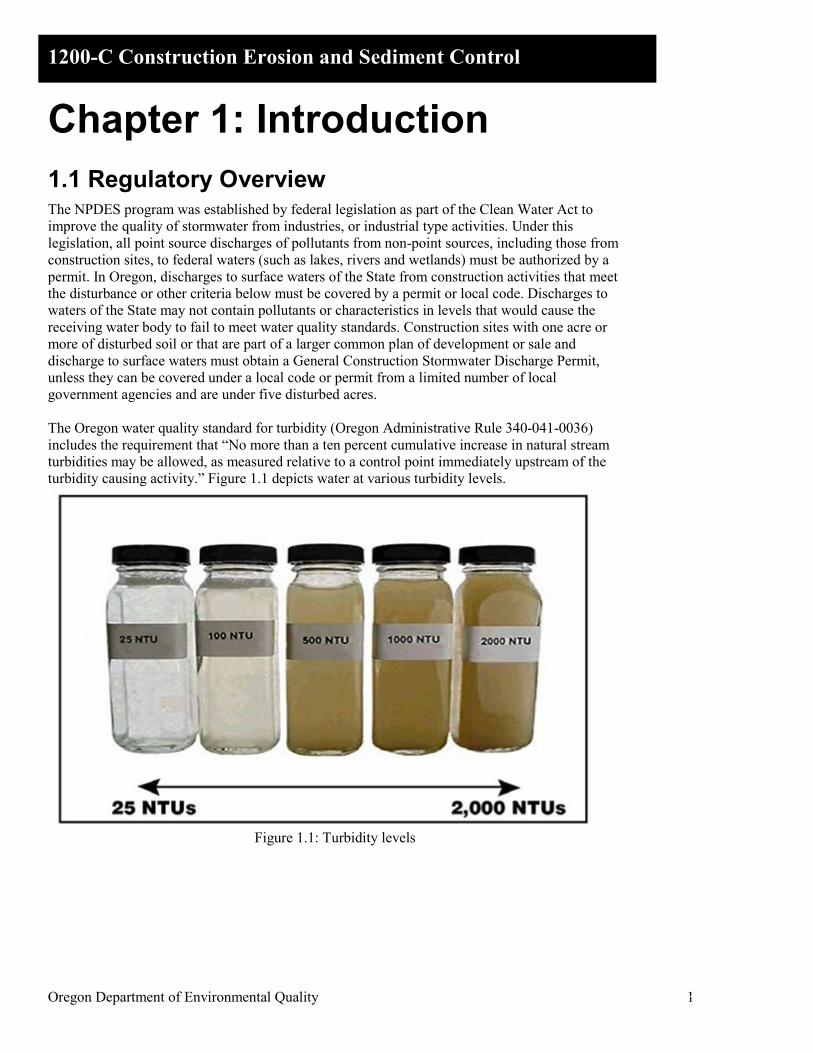
Chapter 1: Introduction 1.1 Regulatory Overview The NPDES program was established by federal legislation as part of the Clean Water Act to improve the quality of stormwater from industries, or industrial type activities. Under this legislation, all point source discharges of pollutants from non-point sources, including those from construction sites, to federal waters (such as lakes, rivers and wetlands) must be authorized by a permit. In Oregon, discharges to surface waters of the State from construction activities that meet the disturbance or other criteria below must be covered by a permit or local code. Discharges to waters of the State may not contain pollutants or characteristics in levels that would cause the receiving water body to fail to meet water quality standards. Construction sites with one acre or more of disturbed soil or that are part of a larger common plan of development or sale and discharge to surface waters must obtain a General Construction Stormwater Discharge Permit, unless they can be covered under a local code or permit from a limited number of local government agencies and are under five disturbed acres. The Oregon water quality standard for turbidity (Oregon Administrative Rule 340-041-0036) includes the requirement that “No more than a ten percent cumulative increase in natural stream turbidities may be allowed, as measured relative to a control point immediately upstream of the turbidity causing activity.” Figure 1.1 depicts water at various turbidity levels.
Figure 1.1: Turbidity levels
Oregon Department of Environmental Quality 2
1200-C Construction Erosion and Sediment Control
1.2 What is an Erosion and Sediment Control Plan (ESCP)?
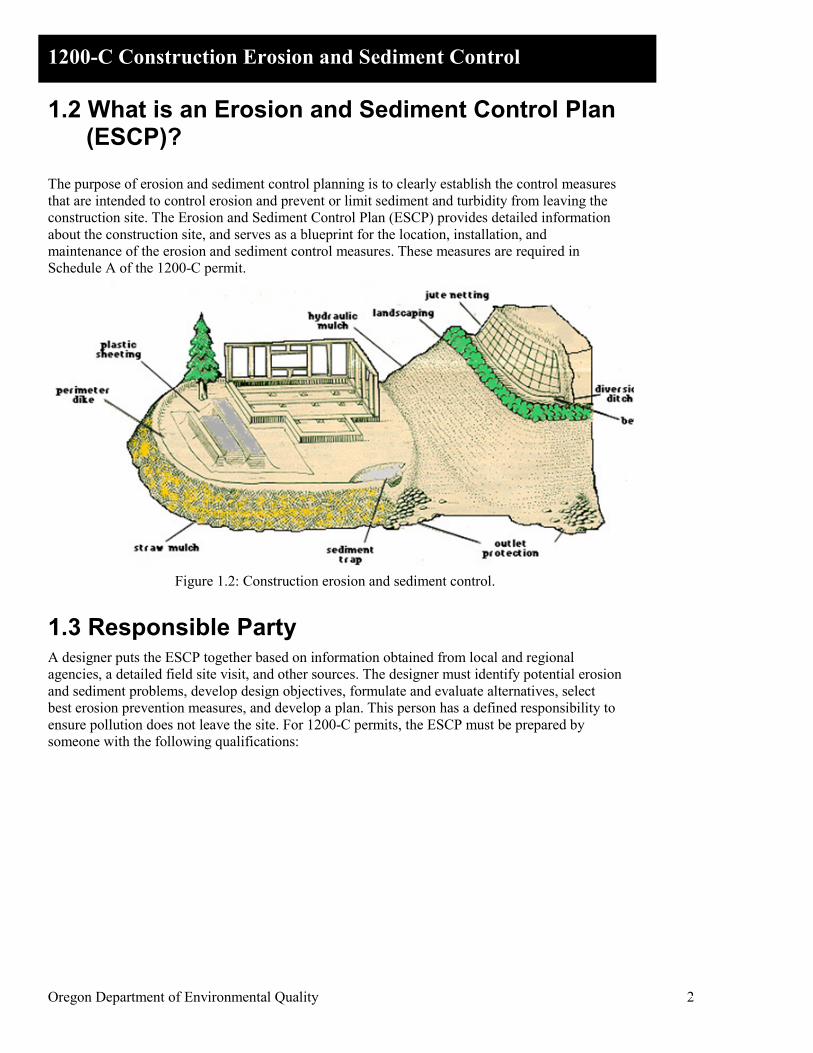
The purpose of erosion and sediment control planning is to clearly establish the control measures that are intended to control erosion and prevent or limit sediment and turbidity from leaving the construction site. The Erosion and Sediment Control Plan (ESCP) provides detailed information about the construction site, and serves as a blueprint for the location, installation, and maintenance of the erosion and sediment control measures. These measures are required in Schedule A of the 1200-C permit.
Figure 1.2: Construction erosion and sediment control.
1.3 Responsible Party A designer puts the ESCP together based on information obtained from local and regional agencies, a detailed field site visit, and other sources. The designer must identify potential erosion and sediment problems, develop design objectives, formulate and evaluate alternatives, select best erosion prevention measures, and develop a plan. This person has a defined responsibility to ensure pollution does not leave the site. For 1200-C permits, the ESCP must be prepared by someone with the following qualifications:

Oregon Department of Environmental Quality 3
1200-C Construction Erosion and Sediment Control
Table 3.1: ESCP preparation requirements (Schedule A.4.b.i) Site Description Preparation Requirement
Construction sites disturbing 20 or more acres
Prepared and stamped by one of the following: • Oregon Registered Professional Engineer • Oregon Registered Landscape Architect • Oregon Certified Engineering Geologist • Certified Professional in Erosion and Sediment
Control (Soil and Water Conservation Society) Any size site with engineered facilities for erosion or sediment controls (such as settling ponds or diversion structures)
Oregon Registered Professional Engineer
All other sites Person with knowledge of the site and training or experience in the design, installation, maintenance and/or inspection of erosion and sediment controls.
1.4 Submitting the ESCP Include two full sized hard copies and one electronic (PDF) copy of the ESCP with your permit application. If the ESCP is incomplete, DEQ or its Agent will notify you and you will be required to submit the missing information. DEQ or the Agent will not grant you coverage under the permit if the ESCP is incomplete. Please note that ESCP for projects 5 acres or larger may require changes after a public comment period. Issuance of the 1200-C Permit coverage by DEQ or its Agent will signify acceptance of the ESCP. If an Agent is assigning the 1200-C permit coverage for DEQ, check with that office to determine if additional information is required to meet local government requirements and the submittal schedule. If you have any questions, please call the DEQ office in your region or DEQ’s Agent and ask to speak to available stormwater staff. Submit a complete Agent ESCP to DEQ or its Agent at least 30 days before starting the construction project. There is no guarantee that the project will be approved within 30 days. Because revisions may be required by DEQ or after the public comment period, early submission (more than 30 days before starting construction) is recommended. Complete details on when, where and how to submit the ESCP are contained in DEQ’s Construction Stormwater Application and Forms Manual.
Oregon Department of Environmental Quality 4
1200-C Construction Erosion and Sediment Control
Chapter 2: Concepts of Erosion and Sedimentation
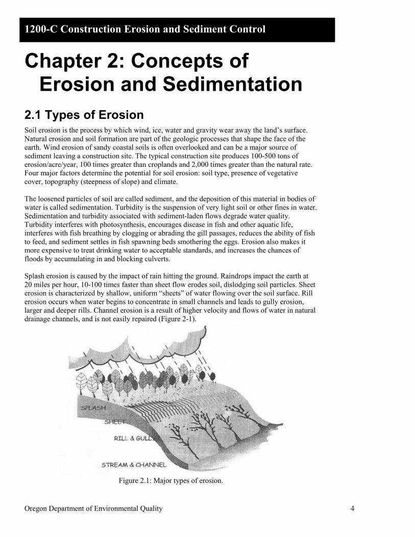
2.1 Types of Erosion Soil erosion is the process by which wind, ice, water and gravity wear away the land’s surface. Natural erosion and soil formation are part of the geologic processes that shape the face of the earth. Wind erosion of sandy coastal soils is often overlooked and can be a major source of sediment leaving a construction site. The typical construction site produces 100-500 tons of erosion/acre/year, 100 times greater than croplands and 2,000 times greater than the natural rate. Four major factors determine the potential for soil erosion: soil type, presence of vegetative cover, topography (steepness of slope) and climate. The loosened particles of soil are called sediment, and the deposition of this material in bodies of water is called sedimentation. Turbidity is the suspension of very light soil or other fines in water. Sedimentation and turbidity associated with sediment-laden flows degrade water quality. Turbidity interferes with photosynthesis, encourages disease in fish and other aquatic life, interferes with fish breathing by clogging or abrading the gill passages, reduces the ability of fish to feed, and sediment settles in fish spawning beds smothering the eggs. Erosion also makes it more expensive to treat drinking water to acceptable standards, and increases the chances of floods by accumulating in and blocking culverts. Splash erosion is caused by the impact of rain hitting the ground. Raindrops impact the earth at 20 miles per hour, 10-100 times faster than sheet flow erodes soil, dislodging soil particles. Sheet erosion is characterized by shallow, uniform “sheets” of water flowing over the soil surface. Rill erosion occurs when water begins to concentrate in small channels and leads to gully erosion, larger and deeper rills. Channel erosion is a result of higher velocity and flows of water in natural drainage channels, and is not easily repaired (Figure 2-1).
Figure 2.1: Major types of erosion.

Oregon Department of Environmental Quality 5
1200-C Construction Erosion and Sediment Control
2.2 Erosion Factors Erosion rates are determined primarily by climate, soil characteristics, topography and ground cover. Understanding the factors that affect the erosion process enables us to make useful predictions about the extent and consequences of on-site erosion.
2.2.1 Climate Rain is generally the driving force of erosion. In areas with low precipitation, there is little water to move sediment; where precipitation is consistently high, vegetation holds sediment in place. The highest naturally occurring erosion tends to be in semi-arid basins (Figure 2-2). Raindrops dislodge soil particles, and runoff carries the particles away. The erosive power of rain is determined by rainfall intensity (millimeters of rain per hour) and droplet size. A highly intense rainfall of relatively short duration can produce far more erosion than a long duration storm of low intensity. In addition, storms with large raindrops are much more erosive than misty rain events with small droplets.
Figure 2-2: Precipitation rate impacts natural erosion.
Oregon Department of Environmental Quality 6
1200-C Construction Erosion and Sediment Control
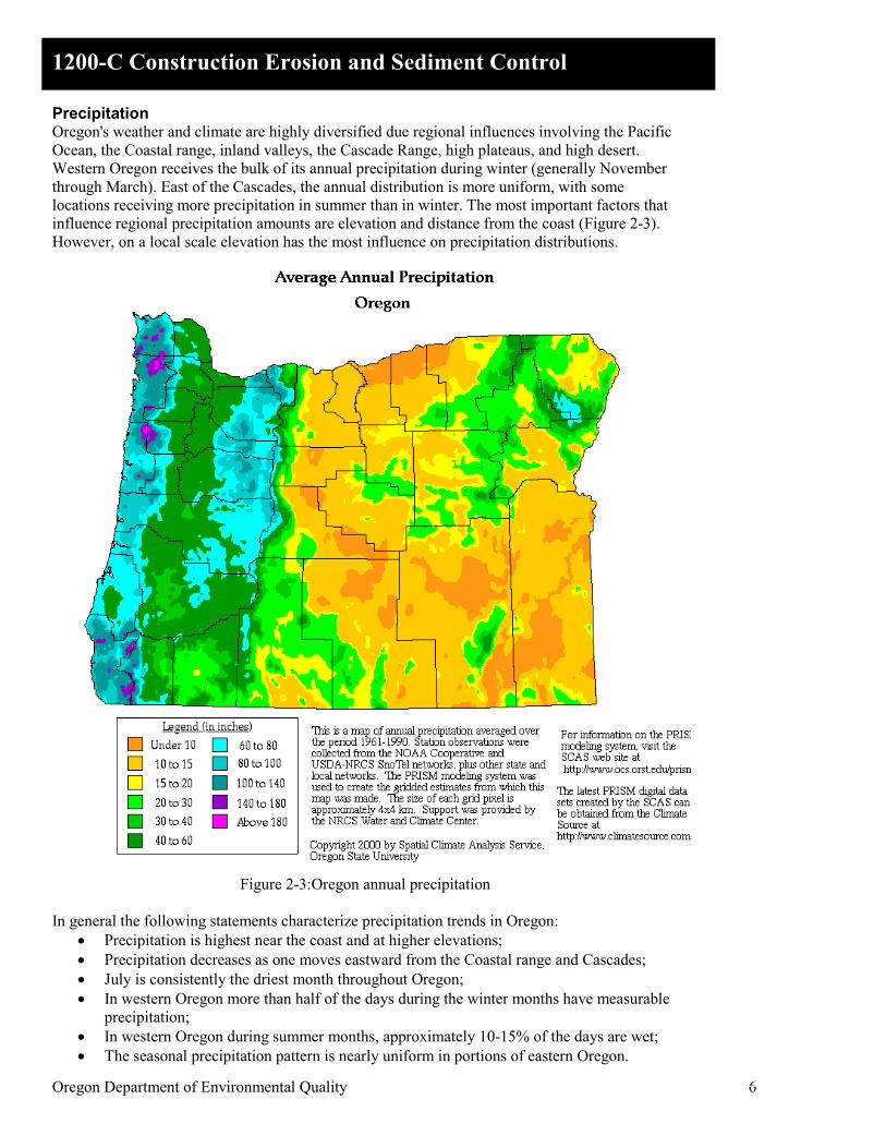
Precipitation Oregon's weather and climate are highly diversified due regional influences involving the Pacific Ocean, the Coastal range, inland valleys, the Cascade Range, high plateaus, and high desert. Western Oregon receives the bulk of its annual precipitation during winter (generally November through March). East of the Cascades, the annual distribution is more uniform, with some locations receiving more precipitation in summer than in winter. The most important factors that influence regional precipitation amounts are elevation and distance from the coast (Figure 2-3). However, on a local scale elevation has the most influence on precipitation distributions.
Figure 2-3:Oregon annual precipitation
In general the following statements characterize precipitation trends in Oregon:
• Precipitation is highest near the coast and at higher elevations; • Precipitation decreases as one moves eastward from the Coastal range and Cascades; • July is consistently the driest month throughout Oregon; • In western Oregon more than half of the days during the winter months have measurable
precipitation; • In western Oregon during summer months, approximately 10-15% of the days are wet; • The seasonal precipitation pattern is nearly uniform in portions of eastern Oregon.

Oregon Department of Environmental Quality 7
1200-C Construction Erosion and Sediment Control
Thunderstorms In western Oregon, thunderstorms occur only four to five times per year, mostly in the inland valleys and near the Cascades. Generally, they are not severe and produce little damage. Eastern Oregon receives many more thunderstorms (typically 12-18 per year), and they tend to be much more severe. Thunderstorms are also frequent in mountainous areas. Wind During winter (and, to a lesser extent, autumn and spring), frequent cyclonic storms reach the area from the west, greatly influencing winds and other weather elements. Summer months see fewer strong storms, and are more typically characterized by sea-land breeze regimes. Several times each year winds exceeding hurricane strength (74 mph; 119 kmph) strike Oregon, especially along the coast. These high wind events are usually associated with intense storm events and may cause damage to vegetation and structures. However, throughout Oregon, occasional high intensity windstorms are evident.
2.2.2 Soil Key factors that affect erodibility are texture, structure, amount of organic matter, and permeability.
• Soil texture refers to the sizes and proportions of the particles making up a particular soil. Sand, silt, and clay are the three major classes of soil particles. Soils high in sand content are said to be coarse-textured. Because water readily infiltrates sandy soils, the runoff, and consequently the erosion potential, is relatively low. Soils high in content of silts and clays are said to be fine-textured or heavy. Clay, because of its stickiness, binds soil particles together and makes a soil resistant to erosion. However, once heavy rain or fast flowing water erodes the fine particles, they will travel great distances before settling. Because particle size is an important factor in BMP selection, Figure 2-4 and Tables 2-1 and 2-2 provide details on particle size, filtration and settling rates.
• Soil structure is the arrangement of soil particles into larger aggregates (a soil aggregate is a clustered mass of individual soil particles varied in shape, ranging in size from a microscopic granule to a small crumb). Soil structure affects the soil’s ability to absorb water. Compaction damages the soil structure, causing water to run off rather than infiltrate. Erosion hazard increases with increased runoff. Loose, granular soils reduce runoff by absorbing water and by providing a favorable environment for plant growth.
• Organic matter consists of plant and animal litter in various stages of decomposition. Organic matter improves soil structure and increases permeability, water holding capacity, and soil fertility. Organic matter in an undisturbed soil or in mulch covering a disturbed soil reduces runoff and erosion potential. Mulch on the surface also cushions the soil from erosive impact of raindrops.
• Soil permeability refers to the ability of the soil to allow air and water movement through the soil. Soil texture, structure, and organic matter all contribute to permeability. Soils that are least subject to erosion from rainfall and shallow surface runoff are those with high permeability rates, such as well-graded gravels and gravel-sand mixtures.

Oregon Department of Environmental Quality 8
1200-C Construction Erosion and Sediment Control
Figure 2-4: Clay and silt particle size compared to other substances.
Table 2-1: Settling Velocities of Sediment Particles in Water
Diameter of Particle (mm)
Order of Size Settling Velocity m/sec
Time Required to Settle 1 meter (3.28 ft)
10 Gravel 60.0 0.016 Seconds 2
Coarse Sand
2.4 0.4 Seconds 1 0.60 1.7 Seconds
0.6 0.21 4.6 Seconds 0.3 * 0.054 19.0 Seconds 0.2 * 0.024 42.0 Seconds
0.15 * Fine Sand
0.013 75.0 Seconds 0.1 0.0060 168.0 Seconds 0.06 0.0021 7.8 Minutes
0.025
Silt
0.00012 2.2 Hours 0.015 4.5E-05 6.2 Hours 0.01 2.0E-05 14.0 Hours
0.005 5.0E-06 56.0 Hours 0.003 1.8E-06 155.3 Hours
0.0015 Clay
4.5E-07 26.0 Days 0.001 2.0E-07 58.0 Days
0.0001 2.0E-09 16.0 Years
0.00001 Colloidal Particles 2.0E-11 1600.0 Years
*Range of acceptable pore size (apparent opening size) for silt fence geotextiles. (Courtesy of HaloSource)

Oregon Department of Environmental Quality 9
1200-C Construction Erosion and Sediment Control
Table 2-2: Filter sieve sizes Sieve Designation Nominal Sieve Opening Comments
Standard Mesh inches mm Microns 25.4 mm 1in. 1.00 25.4 25400 22.6 mm 7/8 in. 0.875 22.6 22600 19.0 mm 3/4 in. 0.750 19.0 19000 16.0 mm 5/8 in. 0.625 16.0 16000 13.5 mm 0.530 in. 0.530 13.5 13500 12.7 mm 1/2 in. 0.500 12.7 12700 11.2 mm 7/16 in. 0.438 11.2 11200 9.51 mm 3/8 in. 0.375 9.51 9510 8.00 mm 5/16 in. 0.312 8.00 8000 6.73 mm 0.265 in. 0.265 6.73 6730 6.35 mm 1/4 in. 0.250 6.35 6350 5.66mm No. 3 1/2 0.223 5.66 5660
4.76 mm No. 4 0.187 4.76 4760 4.00 mm No. 5 0.157 4.00 4000 3.36 mm No. 6 0.132 3.36 3360 2.83 mm No. 7 0.111 2.83 2830 2.38 mm No. 8 0.0937 2.38 2380 2.00 mm No. 10 0.0787 2.00 2000 Sand 1.68 mm No. 12 0.0661 1.68 1680 1.41 mm No. 14 0.0555 1.41 1410 1.19mm No. 16 0.0469 1.19 1190
1.00 mm No. 18 0.0394 1.00 1000 841 µ No. 20 0.0331 0.841 841 SiltSack High Flow 707 µ No. 25 0.0278 0.707 707 Sediment Fence 595 µ No. 30 0.0234 0.595 595 Sediment Fence 500 µ No. 35 0.01 97 0.500 500 Sediment Fence 420 µ No. 40 0.0165 0.420 420 SiltSack Regular Flow 354 µ No. 45 0.0139 0.354 354 Sediment Fence 297 µ No. 50 0.0117 0.297 297 Sediment Fence 250 µ No. 60 0.0098 0.250 250 210 µ No. 70 0.0083 0.210 210 177 µ No. 80 0.0070 0.177 177 DirtBag Style 53 149 µ No. 100 0.0059 0.149 149 DirtBag Style 55 125 µ No. 120 0.0049 0.125 125 105 µ No. 140 0.0041 0.105 105 88 µ No. 170 0.0035 0.088 88 74 µ No. 200 0.0029 0.074 74 63 µ No. 230 0.0025 0.063 63 53 µ No. 270 0.0021 0.053 53 Silt 44 µ No. 325 0.0017 0.044 44
Larger sieve openings (1 in. to 1/4 in.) have been designated by a sieve "mesh" size that corresponds to the size of the opening in inches. Smaller sieve "mesh" sizes of 3 1/2 to 400 are designated by the number of openings per linear inch in the sieve. The following convention is used to characterize particle size by mesh designation:
• a "+" before the sieve mesh indicates the particles are retained by the sieve; • a "-" before the sieve mesh indicates the particles pass through the sieve; • typically 90% or more of the particles will lie within the indicated range.
For example, if the particle size of a material is described as -4 +40 mesh, then 90% or more of the material will pass through a 4-mesh sieve (particles smaller than 4.76 mm) and be retained by a 40-mesh sieve (particles larger than 0.420 mm). If a material is described as - 40 mesh, then 90% or more of the material will pass through a 40-mesh sieve (particles smaller than 0.420 mm).

Oregon Department of Environmental Quality 10
1200-C Construction Erosion and Sediment Control
2.2.3 Topography Slope length and slope steepness are critical factors in erosion potential, since they determine in large part the velocity of runoff. Swales and channels concentrate surface flow, which results in higher velocities. Long, continuous slopes allow runoff to build up momentum. The high velocity runoff tends to concentrate in narrow channels and produce rills and gullies. The shape of a slope also has a major bearing on erosion potential: A convex slope shape (“valley”) increases runoff and magnifies slope erosion, while a concave slope shape (“ridge”) enhances infiltration and reduces erosion. In addition, the base of a slope is more susceptible to erosion than the top, because runoff has more momentum and is more concentrated as it approaches the base. Slope orientation can also be a factor in determining erosion potential. In northern latitudes, exposed south-facing soils are hotter and drier, which makes vegetation difficult to establish. Northern exposures tend to be cooler and moister, receiving less sunlight, which results in slow plant growth.
2.2.4 Ground Cover Ground cover refers principally to vegetation, but also includes surface treatments such as mulches, matting, wood chips, and crushed rock. Vegetation is the most effective means of stabilizing soils and controlling erosion. It shields the surface from the impact of falling rain, reduces flow velocity, and disperses flow. Vegetation provides a rough surface that slows the runoff velocity and promotes infiltration and deposition of sediment. Plants remove water from the soil and thus increase the soil’s capacity to absorb water, and help maintain the soil structure while holding the soil in place.
Oregon Department of Environmental Quality 11
1200-C Construction Erosion and Sediment Control
Chapter 3: ESCP Development
Best Management Practices (BMPs) are a key component of the Erosion Sediment Control Plans (ESCPs) required by the National Pollutant Discharge Elimination System (NPDES) General Stormwater Discharge Permit 1200-C for construction. BMPs are measures or controls that reduce pollutants at the source to prevent the pollution of stormwater runoff discharged from the site. These practices can also be used to divert runoff away from areas of exposure to pollutants, or to treat stormwater runoff before discharge to receiving waters. BMPs are designed to address the quality of a site’s practices with respect to stormwater leaving the site, and to meet environmental water quality standards or benchmarks. BMPs are most effective when organized into a comprehensive Erosion and Sediment Control Plan. Rather than delineate particular practices that all sites should adhere to, the NPDES sets standards for minimum allowed pollution benchmarks, and allows the permittee to select technologies to meet those standards. The stormwater discharge permit does not generally require specific BMPs because the practices should be selected on a case-by-case basis depending on the particular conditions at the site, such as the quantity of rainfall reaching the site, the area of land available for constructing management practices, costs in implementing the practices, slope, and soil type.
3.1 Prevention vs. Control In planning, implementing, and maintaining an erosion and sediment control system, it is important to understand the difference between erosion prevention and sediment control.
• Erosion prevention is any practice that protects the soil surface and prevents the soil particles from being detached by rainfall or wind. Erosion prevention, therefore, is a source control (prevention technique) that treats the soil as a resource that has value and should be kept in place. Such measures include temporary ground covers (such as mulch, temporary grasses, or straw mulch and tackifier), matting, plastic sheeting, and numerous other products designed to provide mechanical or physical protection to exposed soil,
• Sediment Control is any practice that traps the soil particles after they have been detached and moved by wind or water. Sediment control measures are usually passive systems that rely on filtering or settling the particles out of the water or wind that is transporting them. Sediment control treats the soil as a waste product that must be removed and disposed of. Sediment control measures include sediment traps and basins, sediment fences, check dams, sediment barriers, and catch basin filters.
Generally speaking, erosion prevention controls are more effective, cost efficient and practical than sediment controls, because they keep the soil in place and enhance the protection of the site resources – they prevent the problem before it starts. Erosion prevention measures are less subject to failure from high flows, and are more reliable than sediment control. On the other hand, sediment control measures require continual and costly maintenance. It is also often impractical to recover large amounts of sediment after it becomes dislodged and suspended in runoff. Thus, use erosion prevention as the primary protection at the site, with sediment controls used as a secondary system.

Oregon Department of Environmental Quality 12
1200-C Construction Erosion and Sediment Control
3.2 Guiding Principles To develop an effective ESCP, keep the following broad principles in mind: As stated above, use erosion prevention as the primary protection at the site, with sediment controls used as a secondary system. Preserve the existing vegetation. This is frequently the best preventative measure for erosion - and the least expensive. Very little erosion occurs on a soil covered with undisturbed natural vegetation, and reestablishing vegetation can be a difficult and costly process. Try to integrate existing trees and other vegetation into the project. If possible, strip only the area where construction will actually occur. Design the project to be compatible with the existing topography, soils, and vegetation. When construction is tailored to existing contours and vegetation, little grading is necessary, and erosion potential is reduced. Similarly, to the extent possible, fit BMPs to the existing terrain. Schedule grading and construction to minimize soil exposure, especially during the rainy season. The most effective BMP for preventing erosion is to not expose soil to stormwater. Exposure can be minimized by not removing existing vegetation any sooner than is absolutely necessary. Grading the entire site at the beginning of the project is often viewed as cost effective, due to the cost of bringing construction equipment to a site more than once. This is usually a false cost savings. The additional costs in erosion controls, sediment controls, and treatment facilities may be far more costly than phased grading. Minimizing soil exposure also reduces the risk of potential fines for polluting and possible negative publicity. Therefore, stage construction activities to minimize the exposed area and duration of exposure. Balance efficiency with flow volume. Typically, one is sacrificed for the other. The higher the flow volume, the less sediment and turbidity will be reduced. Time is needed to allow sediments to settle out of water. Finer filters trap more sediment, but water also takes longer to pass through, or more filtration surface area is needed to meet the increased need for flow volume. Make sure controls will be able to handle expected flow rates. Plan for maintenance. Inspection and maintenance of control measures are vital to the success of an erosion and sediment control program. Problems often develop during a single storm. Some BMPs are expensive to install, but are low maintenance and long lasting. Conversely, other BMPs are inexpensive to install but require frequent sediment removal or frequent replacement. When selecting BMPs, consider both initial and life cycle costs, including installation, maintenance, removal, and disposal.
3.3 Common Practices The following practices are commonly used to prevent erosion and control sediment: Minimize concentrated flows and divert runoff away from exposed or critical areas. Don’t allow runoff to cross exposed soils, particularly on slopes. Use diversion dikes or swales to divert upland runoff away from a disturbed area to a stable outlet. Minimize slope steepness and slope length. To prevent erosive velocities from occurring on long, steep slopes, create energy dissipaters at regular intervals by using barrier or trap techniques such as benches, terraces, contour furrows, or diversion ditches.

Oregon Department of Environmental Quality 13
1200-C Construction Erosion and Sediment Control
Keep runoff velocities low by using channel linings or temporary structures in drainage channels. Concrete channels, although efficient and easy to maintain, transport runoff quickly, often resulting in downstream channel erosion and flooding. Instead, keep channel velocities low by lining drainage ways with rough surfaces such as vegetation and riprap; by designing broad, shallow flow areas; and by constructing check dams at appropriate intervals. Prepare drainage ways and outlets to handle concentrated or increased runoff. Construction typically increases the volume of runoff. However, designing a project so that runoff from development areas infiltrates into the soil on-site reduces the need for off-site channel enlargement or protection. When flow is expected to increase, line drainage ways with materials appropriate for peak flows, and de-energize concentrated flows at outlets using energy dissipaters. If development substantially changes the natural drainage conditions in a watershed, merely protecting the drainage channels on a project site may not be sufficient to prevent erosion, and additional measures farther downstream may be needed. Use flagged poles or stakes to mark storm drains, catch basins, curb inlets, and other BMPs (Figure 3.1). This helps protect sediment controls from being hit by cars and street cleaners, buried under mounds of soil, or lost in fields of high grasses.
Figure 3.1: Flagging BMPs Vegetate and mulch disturbed areas. Seed and mulch exposed soil as soon as possible after grading is completed. Mulch helps seedlings become established and protects the soil from raindrop splash until vegetation takes over. Soils may be planted with temporary or permanent vegetation. If the soil will be exposed during the winter months, use protective measures other than vegetation. Keep sediment on site by using sediment basins, traps or sediment barriers. Sediment control is necessary, because there is almost always some risk of erosion. Locate sediment basins and traps at low points below disturbed areas. Use earth dikes or swales to route drainage from disturbed areas into the basins. Sediment barriers and sediment fences can be placed below small disturbed areas on gentle to moderate slopes. Stormwater temporarily ponds up behind these barriers, allowing sediment to settle out.
3.4 Wet Weather Principles In western Oregon (that is, in areas with high precipitation), or if construction may occur during wet weather, use the following principles to guide BMP selection:
Oregon Department of Environmental Quality 14
1200-C Construction Erosion and Sediment Control
• Place a greater emphasis on scheduling and timing of construction. Where possible, schedule earthwork (particularly significant grading operations or grading of critical areas) for the dry season or during periods of low forecasted rainfall. Reduce total exposed soil areas and duration of exposure.
• Use a tire wash facility in addition to a stabilized entrance to reduce tracking. • Do not rely solely on sediment control measures and perimeter controls (such as sediment
fences, gravel bag berms, temporary sediment basins, and inlet protection. These measures alone will not adequately reduce discharges, particularly in areas of high rainfall.
• Place a greater emphasis on diverting run-on around exposed soil areas. Design conveyances to carry larger design storm events.
• Install runoff control measures before the rainy season to reduce the potential for scour from concentrated flows.
• In areas of clayey soils, do not rely on sediment basins. Use source controls (erosion prevention controls) to keep the soils in place.
• Increase the use of and reduce spacing of benches, terraces and other methods to reduce flow velocity on slopes.
• Use robust slope stabilization methods such as bonded fiber matrix, rolled erosion control products, or hydraulic mulch rather than soil stabilizers/tackifiers alone, particularly in areas with steeper slopes and more erodible soils. Consider use of erosion control blankets for steep areas and areas of high rainfall.
• Consider biotechnical soil stabilization measures to obtain more rapid erosion control effectiveness during the rainy season. Emphasize the use of on-site native vegetation.
• Evaluate the fertility of finish grade soils, particularly on slopes, and use compost or other approved soil amendments to promote rapid plant establishment.
• Increase BMP inspection and maintenance frequency. Inspect BMPs early and often to assess BMP performance to get a handle on the effectiveness of the BMP design given site conditions. Adjust and increase BMPs accordingly.
3.4 ESCP Development Steps Start developing the ESCP early in the project design process. The essential steps in developing an ESCP are:
1. Identify potential issues and concerns 2. Develop goals and objectives 3. Collect and evaluate data 4. Select BMPs 5. Establish BMP schedule 6. Write the ESCP
3.4.1 Identify potential issues and concerns The first step in erosion and sediment control planning is to evaluate the local, regional, and statewide issues, concerns and requirements. This evaluation will influence all other aspects of planning, including the selection of the BMPs, the time frame for implementation, and the establishment of responsibilities for various aspects of the plan. The identified issues and concerns may include the following:
• The nature of the project • Public opinion, environmental interest groups • Contact with public agencies • Proximity of sensitive receiving waters • Regulatory environment

Oregon Department of Environmental Quality 15
1200-C Construction Erosion and Sediment Control
3.4.2 Develop goals and objectives Once the issues and concerns are established, identify the goals and objectives for the ESCP. These may include:
• Meet stormwater discharge and other regulations (Federal, State, and local) • Address public concerns • Use cost-effective solutions • Maintain or improve aesthetics • Enhance the environment • Decrease liability exposure • Reduce overall maintenance • Maximize use of on-site materials and features • Minimize disturbed soil area • Stabilize slopes, with emphasis on steep slopes (2:1 or greater) • Reduce short- and long-term erosion (including both construction erosion and final grade
erosion) • Prevent sediment leaving the site • Reduce or eliminate irrigation costs • Establish permanent vegetation
With these goals in mind, the designer can move forward with development of the plan. When possible, the designer is encouraged to coordinate with the contractor when designing the ESCP to promote development of a plan that is consistent with the contractor’s construction approach.
3.4.3 Collect and evaluate data After the issues, concerns, goals and objectives for the project have been established, the next step is to collect and analyze data to perform the erosion and sedimentation evaluation. This generally involves the following steps:
1. Collect data 2. Identification of critical habitat and sensitive areas 3. Identification of timing of soil-disturbing activities 4. Evaluation of erosion potential
3.4.3.1 Collect Data The potential for erosion at a site may be evaluated using a wide range of published resource material in combination with data collected by field investigation. Data typically includes:
• Federal, State and local regulations and ordinances • Climate and rainfall • Soils information • Topography • Photo documentation • Field surveys • Drainage areas and receiving waters
Information sources are discussed below and summarized in Table 3-1. Climate and rainfall Precipitation data may be found by contacting the National Weather Service. Northwest Weather Forecasts (http://IWIN.nws.noaa.gov/iwin/or/or.html) provides weather predictions as well as current weather data. In addition, areas with similar precipitation and temperature characteristics have been classified into “Climate Zones” by the National Climatic Data Center (NCDC). The

Oregon Department of Environmental Quality 16
1200-C Construction Erosion and Sediment Control
Western Regional Climate Center (http://www.wrcc.dri.edu) and Oregon Climate Service (http://www.ocs.orst.edu) also have weather information for Oregon. Soils The Natural Resource Conservation Service (NRCS) Soil Survey is a mapped soil inventory by county with physical properties and characteristics described for each soil type. Of prime importance are the predictions of soil behavior for selected land uses. Great differences in soil properties can occur even within short distances. A directory of NRCS county offices can be found at http://www.or.nrcs.usda.gov/contact/countydir.html Topography A site visit is essential to determine the drainage patterns from the topography. If runoff may flow from offsite through the construction site, use BMPs to re-route this water around areas that will have ground disturbance. Avoid construction on very long slopes and especially on long, steep slopes. If soil disturbance will occur on long or steep slopes, use BMPs to break up the lengths of the uninterrupted flows so that the rainfall runoff will only flow short distances, thereby decreasing flow velocity and the erosive force. If the slopes are steep and short, surface cover may be needed to decrease runoff and promote rainfall infiltration into the soil. DEQ’s “location tool” (http://deqgisweb.deq.state.or.us/llid/llid.html) is a good source of topographic mapping. Table 3-1: Information Sources Source Web Site City and County - regulations and ordinances, prior land uses, adjacent and downstream uses, storm drain system information, rainfall data
Oregon Department of Environmental Quality, Construction Stormwater
www.deq.state.or.us/wq/stormwater
DEQ location tool -topography deqgisweb.deq.state.or.us/llid/llid.html Washington Stormwater Center – a variety of stormwater-related information
www.wastormwatercenter.org
National Climatic Data Center (NOAA) www.ncdc.noaa.gov Western Regional Climate Center www.wrcc.dri.edu Oregon Coast and Pacific NW Weather IWIN.nws.noaa.gov/iwin/or/or.html National Weather Service www.dfw.state.or.us Oregon Climate Service www.ocs.orst.edu NRCS/District Conservationist - soil survey, climatological information, vegetation/habitat, water management, recreation potential, aerial surveys
www.ocs.orst.edu
Department of State Lands www.oregon.gov/DSL US Army Corps of Engineers www.usace.army.mil USGS - topographic maps, major waterways, rainfall and stream gauge data
Oregon Seed Certification Service www.oscs.orst.edu Oregon Department of Fish and Wildlife www.dfw.state.or.us Oregon Department of Agriculture www.oregon.gov/ODA International Erosion Control Association www.ieca.org Pacific Northwest Chapter IECA www.pnwieca.org Natural Resource Conservation Service www.or.nrcs.usda.gov

Oregon Department of Environmental Quality 17
1200-C Construction Erosion and Sediment Control
3.4.3.2 Identify Critical Areas Critical areas include points of ingress/egress, graded slopes, areas where vegetation is to be removed, wetlands, wildlife habitat, other receiving water bodies, and other sensitive habitat areas. These must all be explicitly addressed in the plan. 3.4.3.3 Evaluate Erosion Potential Evaluate local and regional factors that may affect erosion, including weather patterns, soil, watershed factors, and other site factors
• Weather patterns o Rainfall intensity, duration, and seasonal patterns o Wind o Freeze/thaw o Snowmelt
• Soil types o Soil erodibility is estimated by the “K factor,” available through NRCS (see data
sources section) • Watershed factors
o Watershed size o Topography o Location of waterbodies o Land use
• Site factors o Length and steepness of slopes o Convex slopes (“valley” shape) concentrate runoff, whereas concave slopes
(“ridge” shape) disperse runoff o Ground cover o Run-on
3.4.4 Select BMPs Effective ESCPs include BMPs that provide layers of protection against erosion. Therefore, it is important to include BMPs from the following categories:
• Run-on control (if applicable) • Erosion prevention • Sediment control • Runoff control • Non-stormwater pollution control
Important considerations in selecting BMPs include:
• Effectiveness • Costs
o Implementation cost (materials and installation) o Long-term cost (maintenance) <Operation> o Cost of temporary BMP removal
• Availability • Feasibility • Durability • Compatibility
o Suitability for the site o Environmental impacts o Regulatory acceptability (state and local)

Oregon Department of Environmental Quality 18
1200-C Construction Erosion and Sediment Control
o Aesthetics o Public acceptability
These issues are discussed further below. Effectiveness Factors to consider relative to BMP effectiveness include:
• Areal density (the amount of cover on the soil surface) • Balance between runoff and infiltration • Sediment reduction capabilities (ability to trap and retain sediment and prevent
mobilization of soil particles) • Reduction in water velocity (lower water velocity means less erosion potential) • Soil texture sensitivity (some practices work better on different types of soils; other
practices are unaffected by soil texture) Costs Evaluate costs and performance histories, both field and laboratory, for a number of materials and techniques. Factors to be considered relative to costs include:
• Material costs • Preparation costs • Installation costs • Maintenance costs • Temporary BMP removal costs • Local government requirements
All erosion and sediment control BMPs need maintenance (particularly those used for sediment control). While the cost of operation is seldom considered in erosion control planning, lack of maintenance is usually the primary cause of failure of an erosion and sediment control system and adds cost to the overall project. Cost factors relative to operation of installed measures include:
• Inspection, maintenance, repair and sediment removal, particularly after storm events • Additional fertility requirements to maintain quality of vegetation • Irrigation requirements, if needed, to establish and maintain effective cover
Availability Choose BMP materials that are readily available from a local supplier, or are capable of shipment to the area within the timeframe designated by the plans. Feasibility It is generally preferred to use BMP materials capable of relatively quick and easy application with minimal training required to orient crews or contractors to proper application procedures. However, there are times when specialized equipment or crews may be preferred (for example, hydroseeding). Consider each BMP for its:
• Flexibility, or applicability to a variety of field conditions • Complexity, number of steps needed to apply the BMP, and so on • Whether or not hand labor or machinery is required • Whether locally available materials can be utilized • The time required for the BMP to dry, cure, or otherwise be unaffected by rainfall

Oregon Department of Environmental Quality 19
1200-C Construction Erosion and Sediment Control
Table 3-2: Installed costs and effectiveness of BMPs
BMP Unit Cost Installed Estimated Relative Erosion/ Sediment Control Effectiveness1
Sediment Control Sediment Fence $1.50 – 2.00 per lineal foot 95% Compost Berm (12-16 inch height) $1.75 - 2.00 per lineal foot 95 - 99% Fiber Rolls (9 inch) (12 inch) (9 inch with trackwalking)
$1.50 – 2.00 per lineal foot $2.00 - 2.50 per lineal foot $3.00 - 4.00 per lineal foot
58% 95 - 99%
84 % Erosion Prevention Controls Fertilizer $450 – 550 per acre N/A Seeding $870 – 2,170 per acre 50% Stolonizing $2,200 per acre + cost of stolons 90% Hydraulic Mulching $900 – 1,200 per acre 50 – 60% Compost Application (2,000 lbs/acre) (2 inch blanket application) (3-4 inch blanket application)
$900 – 1,200 per acre $7,000 - 10,000 per acre $10,000 - 15,000 per acre
40 – 50% 95 - 99% 95 - 99%
Straw Mulching $1,800 – 2,100 per acre 90 – 95% Soil Binders
Plant Material-Based (Short-Term) $700 – 900 per acre 85 - 99% Plant Material-Based (Long-Term) $1,200 – 1,500 per acre 60 – 65% Polymeric Emulsion Blends (Including PAM) $700 – 1,500 per acre 30 – 95% Petroleum Resin-Based $1,200 – 1,500 per acre 25 – 40% Cementitious Binder-Based $800 – 1,200 per acre 80 – 85%
Hydraulic Matrices (Wood mulch + Soil binder) $1,000 - 2,000 per acre 65 - 99% Bonded Fiber Matrices $5,000 – 6,500 per acre 90 – 99% Rolled Erosion Control Products
Biodegradable Jute $6,000 – 7,000 per acre 65 – 70% Curled Wood Fiber $8,000 – 10,500 per acre 90 – 99% Straw $8,000 – 10,500 per acre 90 – 99% Wood Fiber $8,000 – 10,500 per acre 90 – 99% Coconut Fiber $13,000 – 14,000 per acre 90 – 99% Coconut Fiber Net $30,000 – 33,000 per acre 90 – 99% Straw Coconut $10,000 – 12,000 per acre 90 – 99%
Non-Biodegradable Plastic Netting $2,000 – 2,200 per acre < 50% Plastic Mesh $3,000 – 3,500 per acre 75 – 80% Synthetic Fiber w/Netting $34,000 – 40,000 per acre 90 – 99% Bonded Synthetic Fibers $45,000 – 55,000 per acre 90 – 99% Combination Synthetic and Biodegradable Fibers
$30,000 – 36,000 per acre 85 – 99%
Source: Erosion Control Pilot Study Report, Caltrans, June 2000, Table 4-1; Updated May 2004 1. Effectiveness is based on the percentage of sediment retained by weight in laboratory tests. A high effectiveness rating may not equate to meeting water quality standards because some controls such as sediment fence retain larger particles and allow fines to pass which remain in suspension. Durability Given the nature of the site conditions, evaluate whether or not the BMP materials will maintain their structural integrity during installation and persist until vegetation has established effective cover. If BMPs are not durable enough, include maintenance or replacement issues in the ESCP, or else select other BMPs.
Oregon Department of Environmental Quality 20
1200-C Construction Erosion and Sediment Control
Compatibility Select BMP materials with regard to public acceptability and environmental sensitivity. In this regard, primarily organic/biodegradable, recycled and/or photodegradable products are often preferable. Other factors include:
• Does the BMP fit the site? • Environmental compatibility, including water quality impact • Regulatory acceptability (state and local) • Institutional acceptance • Risk/liability • Visual or aesthetic impact • Effect on vegetation
o Whether the BMP is compatible with native plants, either introduced by seeding operations or plant material remaining on site after grading
o Effect on germination and growth of plants o Whether or not the practice requires additional fertilization or soil amendments to
work o Effects on soil moisture and temperature o Any potential adverse effects (for example, use weed-free straw)
3.4.5 Establish BMP Schedule The timing of soil-disturbing activities and the timing of implementation of BMPs are both critical to the prevention of accelerated erosion and transport of sediment off-site. Schedule grading to take into account the rainy season and minimize the length of the time that soils are left exposed, and reduce the total area of exposed soil during the rainy season. Consider phasing the grading and construction so that critical areas (such as highly erodible soils or areas adjacent to receiving waters) are not disturbed until the non-rainy season, and so the entire area that is disturbed at any one time is kept to a size that can be controlled effectively. The construction schedule is an orderly listing of all major land disturbing activities together with the necessary erosion and sedimentation control measures planned for a project. The schedule guides the contractor on work sequencing so that serious erosion and sedimentation problems can be avoided. Following a specified work schedule that coordinates the timing of land disturbing activities and the installation of control measures is perhaps the most cost-effective way of controlling erosion during construction. Specify in the ESCP how the proposed erosion/sediment control measures will divert flows, limit runoff from exposed areas, stabilize exposed soil and filter sediment. The following controls and practices (BMPs), if appropriate for the site, are required in the ESCP and on the Part III ESCP Drawings, and must be implemented according to the following schedule: Before Construction:
(1) Identify, mark, and protect (with construction fencing or other means) critical riparian areas and vegetation including important trees and associated rooting zones and vegetation areas to be preserved.
(2) Identify vegetative buffer zones between the site and sensitive areas (for example, wetlands), and other areas to be preserved, especially in perimeter areas.
(3) Hold a pre-construction meeting of project construction personnel that includes the inspector required by permit condition A.12.b.iii to discuss erosion and sediment control measures and construction limits.

Oregon Department of Environmental Quality 21
1200-C Construction Erosion and Sediment Control
(4) Stabilize site entrances and access roads including, but not limited to construction entrances, roadways and equipment parking areas (for example, using geotextile fabric underlay).
(5) Install perimeter sediment control, including storm drain inlet protection as well as all sediment basins, traps, and barriers.
(6) Establish concrete truck and other concrete equipment washout areas before beginning concrete work.
(7) Establish material and waste storage areas, and other non-stormwater controls. (8) Stabilize stream banks and construct the primary runoff control measures to protect
areas from concentrated flows. During Construction:
(1) Land Clearing, Grading and Roadways. (a) Begin land clearing, excavation, trenching, cutting or grading only after installing
applicable sediment and runoff control measures. (b) Provide appropriate erosion and sediment control BMPs for all roadways
including gravel roadways. (c) Install additional control measures as work progresses as needed. (d) Phase clearing and grading to the maximum extent practical to prevent exposed
inactive areas from becoming a source of erosion. (2) Surface Stabilization.
Apply temporary or permanent soil stabilization measures (for example, temporary and permanent seeding, or mulching) immediately on all disturbed areas as work is completed. Stabilization of disturbed areas must be initiated immediately whenever any earth disturbing activities have permanently ceased on any portion of the site.
(3) Construction and Paving. Keep erosion and sediment control measures in place for the duration of construction, including protection for active storm drain inlets and appropriate non-stormwater pollution controls.
Final Stabilization and Landscaping: (1) Provide permanent erosion prevention measures on all exposed areas. (2) Remove and properly dispose of construction materials and waste, including sediment
retained by temporary BMPs. (3) Remove all temporary control measures as areas are stabilized, unless doing so
conflicts with local requirements. Failure to implement the BMPs according to this schedule is a violation of the permit.
3.5 Writing the ESCP The ESCP must contain the following elements: (NPDES 1200-C Permit Schedule A.12.b)
• Local government requirements. • Inspection information including inspector(s) and qualification(s), if known. If not
known, contact DEQ regional staff or local jurisdiction for assistance. • Narrative site description. • Implementation schedule and description of BMPs. • Site map and drawings (see ESCP Part III form for complete list of items to include).
Oregon Department of Environmental Quality 22
1200-C Construction Erosion and Sediment Control
There are two options for submitting a complete ESCP: Option 1: Fill out DEQ ESCP forms (Parts I-III) and provide ESCP Drawings
• Complete ESCP Part I: Narrative description of the site and soils present, inspector qualifications, etc.
• Complete ESCP Part II: Best Management Practices (BMPs) Implementation Schedule. • Complete ESCP Part III and ESCP Drawings: Prepare drawings that include a site
(project location) map and site drawing(s) showing location and details of the BMPs to be used. Use ESCP form Part III to verify that you placed the required information on the drawings.
• Include the Standard Notes on the drawings (as listed in ESCP form part III). Option 2: Consolidating all of the required information (Parts I-III) into the ESCP Drawings
• Complete the ESCP Drawings and include the following information on the drawings: o Site location map. o Site description and soils present, inspector qualifications. o BMP implementation schedule initialed by the engineer of architect. o The Standard Notes (as listed in ESCP form part III), plus construction notes on
the drawings which show pre-construction and post-construction contours or surface flow directions.
o BMP locations and installation and/or construction details. An example set of drawings that meet these requirements is located on DEQ’s website at: http://www.deq.state.or.us/wq/stormwater/constappl.htm. In addition, ESCP form Part III may be used as a tool to verify that you placed the required information on the drawings.
3.5.1 Part I: ESCP Narrative Form There is information about your project that may be best provided in a text form rather than on the ESCP Drawings. If you submit the information on the Narrative Form (Option 1), do not also include this information on the drawings (Option 2) per the Example Drawings. Please fill out the ESCP form Part I.
3.5.2 Part II: BMPs and ESCP Implementation Schedule Form The ESCP form Part II includes an extensive table of BMPs. Your project may only require some of these BMPs to effectively manage erosion and sediment control. DEQ expects each project to use BMPs that are appropriate for specific conditions, such as project type (residential, commercial or industrial), local site conditions (rainfall, soils types, slopes, presence of streams, wetlands, ditches and other waters of the state, drinking water wells, UICs, and so on) or surrounding properties. Some of BMPs, such as sediment fences, will require construction; some require maintenance or site inspections and reporting. List BMPs that require construction in the drawings, and include installation details or drawing notes as appropriate. Use the ESCP form Part II “BMPs and ESCP Implementation Schedule” to identify your selected BMPs for the project and a schedule for implementing these BMPs.