Embed Size (px)
Citation preview

Note
Comparison of minimum safe and more complex displays on an electronic chart
ROY K A U F M A N N
The Electronic Chart Display and Information System allows the mariner to navigate and track the course of his ship using information from an electronic chart. The effects of information quantity on user performance was investigated by asking nine users navigation questions on a simple and complex electronic chart and a paper chart. Results show that users responded more quickly using the simple electronic chart compared to the paper chart when exhaustive search was required, and that performance depended on the type of question. Comments from participants indicated that the simple display was easier to use because of less clutter than the more complex electronic chart and paper chart, but electronic charts were more difficult to read than the paper chart.
Keywords: display system, Electronic Chart and Informa~on Syster& nav~ga~or~ paper chart
The aim of Electronic Chart Display and Information Systems (ECDIS) is to provide a computer display system that displays information to the mariner. ECDIS integrates, manages and presents hydrographic chart data, radar, and operational information to the navigator, conning officer and captain/master of a vessel. The mariner uses this information to navigate and make decisions during ship operation. ECDIS allows the mariner to track the course of his ship on an electronic chart, providing an overhead view of the ship and surrounding water, land, objects and overlaid radar. An Electronic Chart Testbed (ECTB) was developed by the Canadian Hydrographic Service to evaluate various features of ECDIS with the aim of providing a clear, realistic, quick and error free way of presenting information essential for navigation. The International Hydrographic Organization has recom- mended specifications for ECDIS to standardize the databases, display formats, and equipment 1 . Numerous human factors issues impact on effective map design s . One issue concerns the consequences of transferring all the information presently displayed on paper charts to electronic charts.
Defence and Civil Institute of Environmental Medicine, 1133 Sheppard Avenue West, PO Box 2000, North York, Ontario, Canada M3M 3B9
One possible consequence is that the electronic chart (EC) would appear more cluttered than the paper chart because of display differences in size, resolution and luminance between paper and electronic charts. If the large amount of information currently available on paper charts appears cluttered on electronic charts, there is the potential that user performance will deteriorate.
In a review of display design guidelines, TuUis 3 states that only relevant information should be displayed, or that the display should not be cluttered. A common theme in these guidelines is that the total amount of information should be kept to a minimum. High information content can cause human perceptual channels to become overloaded, leading to confusion and increased error rates. These guidelines are supported by empirical studies that have repeatedly shown that performance deteriorates as display density increases. The most common finding using a variety of tasks and display types is that increasing the number of displayed items increases time and errors in the target location 3.
The principle of reducing the complexity of informa- tion can be applied to the design of electronic charts 2. The problem of information complexity on a chart involves the figure/ground relationship between classes of information. Items or classes of information that are attended to appear as foreground, whereas information
DISPLAYS, APRIL 1 9 9 0 0141-9382/90/020087-06 (~) 1990 Butterworth & Co (Publishers) Ltd 87
Note
that is not at tended to, appears as background. This figure/ground relationships is strongly influenced by the amount of background information. The more informa- tion on a map, the more difficult it is to separate the foreground from the background, and subsequently, the greater the load on processing of that information 4. There is a limit to the amount of information that can be at tended to, recognized and retained in memory at one particular time.
One advantage of ECDIS is the flexibility to display different sets of information selected from the data- base. Despite the potential to display different types of information and large amounts of data, it is essential that a minimum amount of information, vital for safe navigation, be on the screen at all times. Initial considerations for the minimum information display have been outlined in Reference 1. Information can be added to the minimum set to provide more specific details about surroundings or various objects. As more information is added to the display, there is an increased potential for the resulting clutter to overload the user and possibly cause decrements in performance. There is a t radeoff between reducing the amount of information on the display to reduce clutter and ensuring that there is enough information on the display for the mariner to complete all of his tasks. Both too much information and too little information can cause losses in performance. An important factor in the design of ECDIS is to determine the optimal level of displayed information so that the mariner can complete his tasks without a loss of performance caused by too much clutter.
A field study was carried out on board the FCG SMITH to investigate the effects of information content on ECDIS by comparing operater performance on three types of displays. The displays consisted of a standard paper chart (paper display), an electronic chart with the same information as the paper chart (complex display), and another EC with the minimum set of information required for safe navigation (simple display). Participants were asked navigation questions while viewing each of the displays and their responses were recorded as a performance measure.
METHOD P a r t i c i p a n t s
Nine cartographers, designers, and navigators partici- pated in the test. Two did not have navigational or map design experience, four had map design experience and three had navigational experience. All participants reported normal colour vision and had normal or corrected-to-normal vision.
Equipment An ECDIS demonstration was set up and used for testing onboard the FCG SMITH at the Bedford
Institute of Oceanography in Dartmouth, NS. The EC was displayed on a 1024 × 1 024 pixel, 19 inch Tektronics 4125 monitor under normal daylight condi- tions. The database consisted of an area covering part of the Elbe River entering Hamburg. This same area was shown on three different types of displays. The simple EC displayed the chart area with only vital information required for navigation as outlined in the IHO Draft Specifications ~. The complex EC displayed the region with all the information normally available on the German hydrographic paper chart. The third display was a conventional German hydrographic chart folded to expose the same area shown on the EC. Thus, all displays showed the same area. They differed only in the amount of information available and the type of display. The simple display did not include depth markings, land mass and water region names, land contours and structures, channel boundary markings, and light sector boundaries. The complex and paper displays included all this information, as well as four shades of blue as opposed to two on the simple display to indicate water depth. The paper display differed slightly from the complex display in that it contained more depth markings.
Procedure
Each participant was tested using each type of display. Testing consisted of verbally asking prepared questions that relate to navigational tasks. Questions were chosen following discussion with experienced navigators. The questions were designed to be one of three types. Questions that asked for information relative to the ship's position or track were called position questions. These questions focused attention on a relatively small area of the display. Buoy-type questions asked specific information about various buoys. These questions required relatively restricted search as well as identifi- cation, since information had to be read from the display. The search was restricted because the buoys were located in an expected pattern along the channel. Search type questions were more general, and included questions that required a search through the whole display, or interpretation of information. This set included queries concerning water depth and other hazards such as wrecks. It usually takes longer to respond to questions that require exhaustive search, i.e., when answers to questions are false rather than true s . Therefore, questions were evenly divided be- tween ones that required yes and no answers.
Appendix A shows the set of questions used for the simple display. Ship tracks were positioned in different areas along the harbour for each display; however, questions were matched for all displays. There was an equal number of questions that required positive and negative answers for each display. Question order was randomized to minimize practice effects. Each partici- pant answered thirty questions for each display with equal numbers for each type (position, buoy, search
88 DISPLAYS, APRIL 199(}

Note
and yes, no). The three display conditions were counterbalanced to control for learning effects. Partici- pants were asked to respond as quickly as possible without committing errors.
Performance m e a s u r e s
Questions were read by the experimenter while the participant viewed the display. The experimenter started a stopwatch as soon as the question had been read, and stopped it as soon as the participant responded by saying yes or no. Response time and answers were recorded before continuing to the next question. Error rates were calculated by averaging the number of errors made per display. Upon completion of all conditions, users were asked to complete a questionnaire to provide a subjective evaluation of the three displays. Participants were asked to rate each display on how easy or difficult it was to use, spot specific information, and read text. They were also asked to rate their satisfaction with the amount of information available and their overall satisfaction on each display.
RESULTS
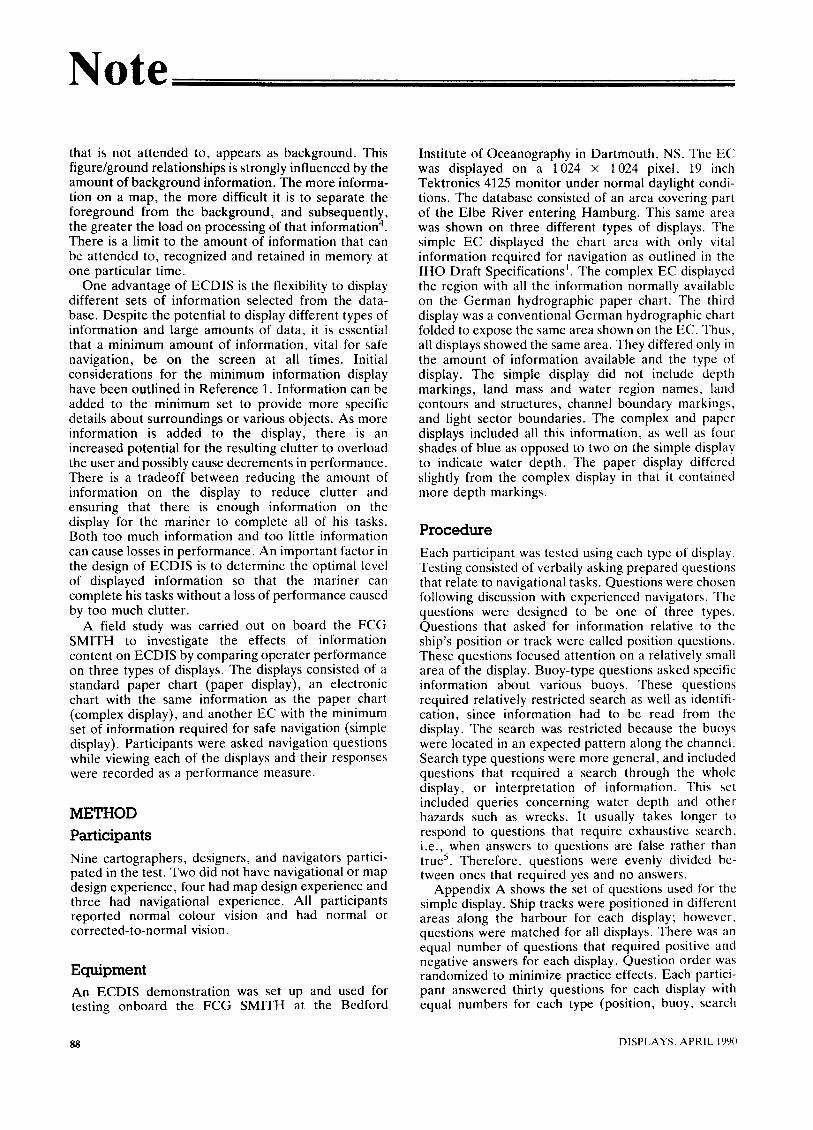
The main purpose of this evaluation was to investigate whether the amount of information on the display affected the ability to recognize, read and interpret information. Performance was measured in terms of response time and errors. The response time data were logarithmically (natural) corrected to normalize the distribution. Trials on which errors occurred were not included in the analyses of response time.
Figure 1 shows the mean response time in seconds for participants to answer correctly on questions about
12
10
8
E 6
e -
0 ,.~ 4
2
o simple complex paper
Display Condition
Figure 1. Mean response times for each display type (error bars show standard deviation)
4
"6 3 $
E ~" 2 ¢-
1
0
simple complex paper
Display condition
Figure 2. Mean number of errors per display (error bars show standard deviation)
14
"6"
0 E
0
0 rr
12
10
8
6
4
2
0 simple complex
Display condition
paper
Figure 3. Mean response times for yes~no questions on each display type (error bars show standard deviation)
information on the three displays. Response times for both the simple (mean = 7.6 s) and complex (mean = 8.3 s) EC were slightly shorter than for the paper chart (mean = 9.2s). The average number of errors per display is shown in Figure 2. The simple display resulted in the lowest average error rate (mean -- 2.67) as compared to the complex display (mean = 4.00) and the paper chart (mean --- 3.44). Although these effects
DISPLAYS, APRIL 1990 119

Note
were in the expected direction for both errors and response times, they were not statistically significant using one factor ANOVA (probability levels for significance on all ANOVAs were set at 0.05).
The data were separated into response type (yes/no) as well as display type (simple/complex/paper). Figure 3 shows the mean response time for simple, complex and paper displays categorized into questions that were true or false. Two factor ANOVA showed an interaction between yes/no type questions and display type, F[2,16] = 4.99, p < 0.05. It took longer to respond to questions that required a negative response on a paper chart (mean = 10.67) than on a simple chart (mean = 7.3), Tukey HSD = 4.89, p < 0.05.
The data were also analysed by grouping the questions according to the type of information asked. One type of question referred to information relative to the ship's position along the ship's track (position). The second type of question queried information specific to buoys (buoy). The third type of question required a general search for items throughout the display (search). For the mean response times for the three types of questions on each of the displays, two factor ANOVA showed a main effect of question type, F[2,16] = 33.09, p < 0.01. Buoy questions (mean = 6.53s) were answered more quickly than position questions (mean = 8.28 s), and position questions were answered more quickly than search questions (mean = 10.98s), Tukey HSD --- 1.39, p < 0.05. When analysis was done on data including incorrectly answered questions, there was an interaction between display type and question type, F[2,16] = 2.76, p < 0.05. Comparison of means showed that the simple display (mean = 8.35 s) produced quicker response times than the paper display (mean = 10.01s) for position questions, Tukey HSD = 1.75, p < 0.05. Error data was not analysed for question type because of the few number of errors committed.
The purpose of the questionnaire was to obtain subjective evaluations on each type of display from participants. When asked to rate the displays in terms of legibility, users found it more difficult to read information from the simple display (Wilcoxon T = 8, p < 0.05) and the complex display (Wilcoxon T = 9, p < 0.05) than from the paper chart. Users thought that the complex display was more difficult to use than the paper chart (Wilcoxon T = 7, p < 0.05), yet they rated the complex display better in terms of overall satisfaction (Wilcoxon T = 9, p < 0.05). There was also a trend that showed users reported more difficulty in spotting objects on paper displays compared to the simple display; however, this effect was not statistically significant (Wilcoxon T = 6, p < 0.0506).
DISCUSSION There was no simple relationship between display type and performance, since no main effect of display type on either response times or error rate was found.
Despite no main effect of display type, results show a trend for faster response times when less background information is present on the simple EC compared to complex EC and paper display.
Response time performance was affected by the nature of the question. Users answered questions more quickly when a negative answer was required rather than a positive answer on the simple display compared to the paper chart. These results support the assump- tion that it takes less time to realize that information is not on a display as information density decreases. This is not surprising, since it takes longer to search through more information on the paper chart before realizing information is not present compared to the simple display.
The increased time required to search for informa- tion on a cluttered display may be detrimental to performance in real navigational tasks when time is critical for decisions. It is also likely that more mistakes would be made under stressful situations, and more time would be needed to spot important information on a complex display compared to a simple display when observers are not anticipating this information. Thus, in a real task, the effects of information density on a map may be critical. Taylor cites numerous studies on information density and map clutter that suggest performance declines with increased information density 2.
Questions were classified according to the type of information queried. Response times were shortest for buoy questions, intermediate for position questions, and longest for search questions independent of display type. When the data were analysed to include incorrect responses, there was a significant effect of position questions on response time for the three displays. It took longer for users to respond to position questions on the paper chart then it did on the simple display. Therefore, there is some evidence that a simple display will result in shorter response times compared to more complex paper displays depending on the type of question.
There seems to be no effect of either buoy type or search type questions on response times for each of the displays. One reason for the lack of effect on these types of questions may be the difficulty in reading text from the screen, especially for buoy-type questions, where text had to be read to answer questions. Another confounding variable that may have obscured the effect of clutter was the experience of the participants. Although most questions were designed to minimize the effectof experience, some search questions required interpretation and assessment of surrounding informa- tion in order that the experimental task reflect real navigational tasks. Differences in maritime experience between participants may have influenced results.
Results from the questionnaire showed that users found it difficult to read text on the simple display, that they would have liked more information on the display, and that they were not completely satisfied with the simple display. It became apparent from comments that
90 DISPLAYS, APRIL 1990
Note
lower scores for both the simple and complex displays was a result of the small size of text on the screen. Six of the nine respondents directly commented on the difficulty to read text from the screen. Because the same chart area was shown on the EC as on the paper chart, text size on the screen was approximately the same size as on the paper chart. The lower resolution of the EC compared to the paper chart resulted in more difficulty in reading text from the EC. This difficulty resulted in the slightly lower satisfaction ratings for the simple and complex displays as indicated by the comments made by participants. The difficulty in reading text from the EC may have also offset any effect of less clutter on the simple display when reading information for buoy and search type questions. To ensure maximum efficiency of ECs, the size of text must be larger than text on paper charts.
Six respondents also made specific comments about the simple display being easier to use and the complex or paper chart being too cluttered. Despite the difficulty of reading text from the screen, users thought that the simple display was easier to use because of less clutter. However, the two mariners with extensive navigational experience preferred the paper chart over the ECs. They stated that the simple chart should have had more information, whereas others were more satisfied with the amount of information on the simple display. An important consideration in the design of any new system is user acceptance, and it appears that there might be some reluctance in accepting the simple EC despite potential advantages in performance.
A potential feature that was not tested during this trial is the ability to select items on the display with the cursor to access more detailed information. One obvious way to overcome clutter on displays is to display a minimum set of vital information similar to the simple display, and have cursor controlled pop-up windows that temporarily display detail on selected items. All the information available on paper charts could be easily accessible using windows without the potential hazards caused by clutter.
CONCLUSIONS The trial carried out onboard the FCG SMITH provided some evidence that an EC with a minimum set of information may offer performance advantages over electronic or paper charts that include all the informa- tion currently available on conventional nautical charts. Despite the reported problem of reading small text on the displays, the EC was at least as effective as the paper chart in terms of response times. The simple EC showed an advantage over the paper chart in response times to position type questions, in questions that required a negative response, as well as in comments on ease of use. Participants felt that the simpler display was easier to use because of less clutter. The use of windows to access detailed information offers a
potentially effective way of presenting an uncluttered display without sacrificing information.
ACKNOWLEDGEMENTS The author would like to thank Steve Giavin (Universal Systems, Ltd., Fredricton) for his exceptional work and effort throughout the project. Appreciation is also extended to Mike Eaton (Canadian Hydrographic Service, Dartmouth) and all the participants for their cooperation.
REFERENCES 1 Draft Specifications for Electronic Chart Display
and Information Systems (ECDIS) International Hydrographic Organisation, The Hague (1987)
2 Hopkin, D V and Taylor, R M 'Human factors in the design and evaluation of aviation maps' AGARD- AG-225 Harford House, London (1979)
3 Tuilis, T S 'The formatting of alphanumeric displays: a review and analysis' Human Factors Vol 25 No 6 (1987) pp 657-682
4 Taylor, R M 'Colour design in aviation cartogra- phy' Displays Vol 6 No 4 (1985) pp 187-201
5 Boff, K R, Kaufman, L and Thomas, J P (Eds) Handbook of Perception Vol 2 J. Wiley & Sons, New York (1986) pp 24-28
APPENDIX A: QUESTIONS CHART DISPLAY
1. 2. 3.
FOR PAPER
Is the water south of buoy #12 safe? Along track A to B, do you pass a RWR tower? Is there a danger in the line between #20 and NL8 buoys?
4. Along track C to D, do you pass any hazardous wrecks?
5. Along track B to C, do you pass NL2 buoy? 6. At ship's position B, is there an island on the Stbd
side? 7. Is there a lit buoy labelled NE18? 8. Does Nl12 buoy have a green light? 9. Along ship's track A to B, will you pass #20 and
#22 buoys? 10. At ship's position B, are you in safe waters? 11. Is there a danger on a line between #11 and #14
buoys? 12. From ship's position D, is there tower Y ahead? 13. At ship's position A, is it safe close ahead? 14. Are there more than 3 EN type buoys on the chart? 15. Along B to C, do you cross a ribbon of blue? 16. From ship's position C, is there a BYB buoy to
Stbd? 17. Is #9 buoy an occulting green light? 18. Is the colour red used at all on the chart?
DISPLAYS, APRIL 1990 91

Note i i . . . .
19. Between ship's position B and C, is 13.6m the deepest water charted?
20. Is #21 a flashing green lit buoy? 21. From ship's position A, is there a tower to Stbd? 22. Along track C to D, do you cross a danger line? 23. Is there a tower close to #25 buoy? 24. Along track A to B, do you cross unsafe waters? 25. Along track A to D, are there any shallow waters
on the port side?
26. Is there any danger on a line between NL2 and #14 buoys?
27. Is NWreede 9 a flashing lit buoy? 28. Is NL6 a flashing buoy? 29. From ship's position C, is there a BYB buoy to
port? 30. Along C to D, do you pass between NL2 and #16
buoys?
9 2 DISPLAYS, APRIL 1990