Embed Size (px)
Citation preview
BioOne sees sustainable scholarly publishing as an inherently collaborative enterprise connecting authors, nonprofit publishers, academic institutions,research libraries, and research funders in the common goal of maximizing access to critical research.
Community and Society: The Thing at the Edge of EuropeAuthor(s): Frode IversenSource: Journal of the North Atlantic, 8():1-17.Published By: Eagle Hill InstituteDOI: http://dx.doi.org/10.3721/037.002.sp802URL: http://www.bioone.org/doi/full/10.3721/037.002.sp802
BioOne (www.bioone.org) is a nonprofit, online aggregation of core research in the biological, ecological,and environmental sciences. BioOne provides a sustainable online platform for over 170 journals and bookspublished by nonprofit societies, associations, museums, institutions, and presses.
Your use of this PDF, the BioOne Web site, and all posted and associated content indicates your acceptanceof BioOne’s Terms of Use, available at www.bioone.org/page/terms_of_use.
Usage of BioOne content is strictly limited to personal, educational, and non-commercial use. Commercialinquiries or rights and permissions requests should be directed to the individual publisher as copyrightholder.
Journal of the North AtlanticF. Iversen
2015 Special Volume 8
1
Introduction
Key questions: From local communities to larger societies—the development of law regions during the Middle Ages The thing is the oldest known collective institu-tion in Europe. In pre-urban Scandinavia, the thing was the most important place for social interaction and negotiation. The concept of place has been a central topic in research since 1970. By using terms such as “sense of place”, “placelessness”, and “topo-philia”, geographers and others have described posi-tive reflections between people and places (Easthope 2004, Patterson and Williams 2005, Relph 1976, Tuan 1974). Categories such as “insideness” and “outsideness” have been used to describe the notions of familiarity with or estrangement from a place. In 1980, the Norwegian architect Christian Norberg-Schulz published a study of the Roman religious concept of genius loci, the spirit of the place, which inspired a more phenomenological approach (Nor-berg-Schulz 1980). In this concept, the focus was particularly centered on the subjective experience of place. This was the prevailing theoretical perspective during the 1990s and 2000s in studies of place and home (Iversen 2014, Lappegard Hauge 2007). The first key question of this study is therefore whether the thing was planned with inter-subjective communication in mind. Was their primary purpose to create grounds for the exchange of equality of rights and identity as well as a shared neutral space for negotiation? To explore this question, an ex-amination of the architecture of the assembly sites is essential and demands closer attention, not only to shed light on the interaction between people and places but also to understand the principles behind the layout of such meeting-places. The thing did not exist in a void. Things were so-cially, morally, and potentially religiously attached to
both communities and larger societies. A geographic context is essential to the understanding of the earli-est known thing sites in northern Europe—namely the courtyard sites of Norway, dating from the 2nd to the 11th century. A courtyard site is essentially a collec-tion of houses or booths situated around an oval semi-circular open space (yard) (Johansen and Søbstad 1978:55). These have recently been re-interpreted as thing sites (A.B. Olsen 2005; M. Olsen 2003; Storli 2006, 2010). A second key question is to what degree these sites both archaeologically and architecturally reflect the communities, societies, and landscapes within which they functioned. Several unresolved questions about courtyard sites remain, such as in what way and on which geo-graphical level did they function as assembly sites? Were they the gathering sites for local communities or were they representational things for vast societ-ies? If these sites truly were thing-sites, why and when did they cease to function as such? Could their disuse or abandonment be linked to political changes and the emergence of minor kingships, as Inger Storli (2006, 2010) has claimed, or was it caused by the development of an extensive judicial authority encompassing vast societies? The third and perhaps the most essential question concerns the origin and development of law provinces, which is fundamental for understanding the past and the processes where-by small communities transformed and merged into larger societies. These are a few of the aspects that I examine in this analysis.
Counting communities? The arithmetic of land-scapes: A hypothesis Cultures are shaped on a micro-level, when people meet and interact and when relationships and various behaviors occur. Culture is communication. Individuals are the “atoms” of culture. Through
Community and Society: The Thing at the Edge of Europe
Frode Iversen*
Abstract - This article addresses the question of how vast societies were created by increased interaction among smaller communities through judicial cooperation. This process is explored through two case studies of the law provinces of (1) Gulathing and (2) Hålogaland, Norway, covering a time span of nearly a millennium, from the 3rd to 13th century. Central to the discussion of the early phase, during the 3rd–10th centuries, are the courtyard sites of Åse and Bjarkøy, Hålogaland, providing key materials to these developments in a northern European context. This material is supplemented by a case study of the Gulathing law area, which is one of only a few Scandinavian cases where the development can be more securely traced from the 11th to the 13th centuries. In addition, population size and the number of delegates present at the representa-tive thing are considered.
Debating the Thing in the North: The Assembly Project IIJournal of the North Atlantic
*Department of Archaeology, Museum of Cultural History, University of Oslo, Oslo, Norway; [email protected].
Special Volume 8:1–172015
Journal of the North AtlanticF. Iversen
2015 Special Volume 8
2
interaction, individuals become confined and re-stricted in opposition to others. However, culture is more than a bland compromise. Community cre-ates a division of labor and specialization, where individuals can realize their potential and become included in larger networks. Complementary actors form communities. In larger collectives, security and tradition, when combined with avant-garde methods and innovation, can become mutually beneficial to one another. However, social conflict can occur when interests are in opposition and when certain attributes are assigned values and become ranked above others—where mine or ours becomes more important than yours. This situation prompts social negotiation to occur. What strategies did communities adopt to ac-commodate such needs? I investigate this question in terms of the role of the thing during the Middle Ages. My hypothesis is that quantification—the counting alike—has been and remains a necessary prerequisite for creating a sense of justice, both in-dividually and collectively. Evidence of this can be demonstrated by the oc-currence of numerical naming of various landscapes in Europe. A few examples are Tiundaland, Attunda-land, and Fjärdrundland in Uppland, Sweden. The meaning of these place-names is “ten-hundred-land”, “eight-hundred-land”, and “four-hundred-land”. The word hundred (hundari), as in the numer-al 100, was not only an administrative base unit in parts of Sweden but is known from similar examples from Germany, Friesland, and Switzerland as early as A.D. 776 (Andersson 2000, Iversen 2013:13). The Domesday Book tells us that much of England was subdivided into hundreds in A.D. 1086 (Baker and Brookes 2013) and remained so until A.D. 1894. The earliest record of hundreds in a northern European context is two Frankish decrees from the 6th century, where Centena, the Latin term for Hundreds, is re-ferred to as an administrative unit (Iversen 2013:13). Numerical division of the landscape is an old tradition. The meaning of the Frisian names Tventhe (recorded in the 2nd and 3rd centuries) and Drenthe (recorded in the 9th century) are likely to be “the second land” and “the third land” and account for two of the three historic parts of the landscape of Oversjissel—the landscape beyond the river Issel.1 In Scandinavia and Iceland, landscapes were also divided into arithmetic units. This practice was not necessarily embraced in the naming of landscapes. However, medieval laws and other written sources demonstrate the existence of subdivisions. A few examples are sixths and thirds in Gotland, Swe-den, thirds in the inlands of eastern Norway and in the Danelaw of England, quarters in Jämtland, modern Sweden, and Iceland, and finally quarters
and eights in western Norway (Baker and Brookes 2013, Hobæk 2013, Holmbäck and Wessén 1943:92, Indrebø 1935). In parts of northern and eastern Nor-way (Hålogaland and Borgathing law province), the quarter represented the smallest thing district during the Middle Age (Indrebø 1935, Ødegaard 2013). There were four quarters in each “ship-district”. Ad-ditionally, the so-called wapentakes in the Danelaw of England were divided into smaller quarters (Bak-er and Brookes 2013:80). Such numerical divisions were closely connected to the thing system. Thus, it appears that there was a widespread cultural need for classifying and counting communities according to equal units. Ultimately, it was a way to assess population size—whether for military, legal, or tax purposes—and is related to the transition from com-munity to society.
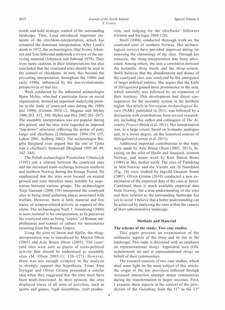
Past perspectives: Reinterpreting the courtyard sites as thing sites In Europe, the Norwegian courtyard sites are key material for understanding the thing system. Ap-proximately 30 courtyard sites have been identified and are located on the west coast of Norway, stretch-ing from Lista in the south to Bjarkøy in the north (Fig. 1a). The use of and activity at these sites can be traced as far back as the 2nd and 3rd centuries. Many were still in use during the 9th and 10th centuries, and a few as late as the early 11th century. These sites were especially suitable for longer stays, providing lodging and feasting. However, it is surprising that there are no known parallels elsewhere in Scandina-via or northern Europe, with the exception of later versions in Iceland (Vésteinsson 2013). Extensive or long commutes, sparse population, and rare occur-rences of thing meetings could be possible explana-tions as to why there are many courtyard sites here. The courtyard sites have been much discussed since their initial discovery by Nicolay Nicolaysen in the 1860s of Dysjane by Tinghaug at Hauge in Jæren (Fig. 1d). Nicolaysen (1866:301) described Dysjane as a thing site containing remnants of houses. Since then, there have been almost as many interpretations as there have been sites discovered. Previously, these sites were regarded as related to royal power and minor chiefdoms (Grimm 2010). In recent years, however, they have been reinterpreted as assembly sites (Storli 2006, 2010). In the 1930s, the archaeologist Jan Petersen interpreted the sites at Jæren, southwest Norway, as villages (Fig. 1c; Petersen 1938:156). Unlike the more densely populated areas of Europe, Iron Age villages had yet to be discovered in Norway. Hence, Petersen attempted to place the settlement history of Norway into a known European pattern. However, the archaeological material discovered

Journal of the North AtlanticF. Iversen
2015 Special Volume 8
3
during Petersen’s excavation did not reflect the type of material one might expect to find at more permanent settlements. Essentially, only fragments of simple cooking vessels, hearths, and cooking pits were found. The individual house-plots contained a build-up of thick cultural layers, consisting of waste material from food preparation and consumption. Later research has shown that the sites are located some distance away from arable land (Berglund 1994, Grimm 2010, Storli 2006).
The Norwegian archaeologist Harald Egenæs Lund (1955, 1959, 1965) had a particular focus on the northernmost courtyard sites. He saw a connec-tion between richly furnished burials and the rem-nants of boathouses in the vicinity of the courtyard sites. He believed that the material remains reflected legal, militant, and cultic gathering places, not vil-lages or farmstead settlements. Instead, he under-stood the sites as a tactical focal point in the land-scape, where the chieftain and his followers could
Figure 1. (A) Map of the courtyard sites in Norway. Image © Frode Iversen. (B) Top right: LiDAR-scan of the courtyard site at Værem. This site was still in use in the early 11th century. Image © Lars Forseth, Nord-Trøndelag Fylkeskommune. (C) Middle right: The courtyard site of Øygarden, close to Stavanger, during the excavation of Jan Petersen, 1939–1940. The site was still in use in the early 8th century. Photograph © Arkeologisk Museum, Universitetet i Stavanger. (D) Lower right: The courtyard site at Dysjane at Tinghaug, Jæren, A.D. 200–600. Photograph © Ragne Jonsrud, Arkeologisk Museum, Universitetet i Stavanger.
Journal of the North AtlanticF. Iversen
2015 Special Volume 8
4
reside and hold strategic control of the surrounding landscape. Thus, Lund introduced important ele-ments of the chiefdom-interpretation, which has remained the dominant interpretation. After Lund’s death in 1972, the archaeologists Olaf Sverre Johan-sen and Tom Søbestad undertook a review of the sur-viving material (Johansen and Søbstad 1978). They were more cautious in their interpretations but also concluded that the courtyard sites should be seen in the context of chiefdoms. In turn, this became the prevailing interpretation throughout the 1980s and early 1990s, influenced by the neo-evolutionistic perspectives of that era. Work conducted by the influential archaeologist Bjørn Myhre, who had a particular focus on social organization, formed an important underlying prem-ise in the study of courtyard sites during the 1980s and 1990s (Grimm 2010:12; Magnus and Myhre 1986:265, 315, 380; Myhre and Øye 2002:201–207). The assembly interpretation was not popular during this period, and the sites were regarded as imposed “top-down” structures reflecting the power of petty kings and chieftains (Lillehammer 1994:154–155, Løken 2001, Solberg 2002). The archaeologist Bir-gitta Berglund even argued that the site of Tjøtta was a chieftain's farmstead (Berglund 1995:48–49, 342–344). The Polish archaeologist Przemisław Urbańczyk (1992) saw a relation between the courtyard sites and the increased trade-exchange between southern and northern Norway during the Roman Period. He emphasized that the sites were located on neutral ground and were therefore more suitable for nego-tiation between various groups. The archaeologist Terje Gansum (2000:159) interpreted the courtyard sites as being ritual gathering places associated with warfare. However, there is little material and few traces of weapon-related activity in support of this claim. The archaeologist Niall J. Armstrong (2000) is more isolated in his interpretation, as he perceives the courtyard sites as being “copies” of Roman am-phitheatres and centers of culture for mercenaries returning from the Roman Empire. Using the sites of Jæren and Hjelle, the thing-interpretation was re-introduced by Morten Olsen (2003) and Asle Bruen Olsen (2005). The court-yard sites were seen as places of socio-political activity that should be understood as assembly sites (M. Olsen 2003:11, 126–127). However, there was not enough evidence in the analysis to strongly support this hypothesis. Frans Arne Stylegar and Oliver Grimm presented a similar idea when they suggested that the sites must have been multi-functional. In their opinion, the sites displayed traces of all sorts of activities, such as sports and games, legal assemblies, craft produc-
tion, and lodging for the chieftains’ followers (Grimm and Stylegar 2004:128). Storli (2006) conducted thorough work on the courtyard sites of northern Norway. Her archaeo-logical surveys have provided improved dating for assessing the chronology of the sites. Through her research, the thing-interpretation has been advo-cated. Among others, she sees a correlation between the Icelandic thing booth and the thing-system. Storli believes that the abandonment and disuse of the courtyard sites was catalyzed by the emergence of larger political entities. She argues that the Earls of Hålogaland gained more prominence in the area, which naturally was followed by an expansion of their territory. This development had direct con-sequences for the assembly system in the northern region. Her article in Norwegian Archaeological Re-view (NAR), published in 2011, was followed by a discussion with contributions from several research-ers, including this author and colleagues of The As-sembly Project (Brink et al. 2011). Her interpretation was, to a large extent, based on Icelandic analogies and, to a lesser degree, on the historical sources of Hålogaland (Iversen et al. 2011). Additional important contributions to this topic were made by Asle Bruen Olsen (2005, 2013), fo-cusing on the sites of Hjelle and Sausjord, western Norway, and minor work by Kari Støren Binns (1988) at Mo, farther north. The sites of Trøndelag in Mid-Norway and the Værem site in Namdalen (Fig. 1b) were studied by Ingvild Onsøien Strøm (2007). Oliver Grimm (2010) conducted a new ex-amination of the empirical data of the sites at Jæren. Combined, there is much available empirical data from Norway, but a true understanding of the sites and their relation to the surrounding landscape has yet to occur. I believe that a better understanding can be achieved by analyzing the sites within the context of their administrative landscape.
Methods and Material
The scheme of the study: Two case studies This paper presents an examination of the arithmetic aspects of the thing and its ties to the landscape. This topic is discussed with an emphasis on representational things. Appointed men (ON, nefndarmaðr m) met at representational things on behalf of their communities. The research consists of two case studies, which shed some light on the main subject of this article: the origin of the law provinces reflected through increased interaction amongst minor communities during the transformation to larger societies. First, I examine these aspects in the context of the juris-diction of the Gulathing from the 11th to the 13th
Journal of the North AtlanticF. Iversen
2015 Special Volume 8
5
century. Then I conducted an in-depth discussion of the thing-system during the 3rd to the 10th century, using examples from Hålogaland.
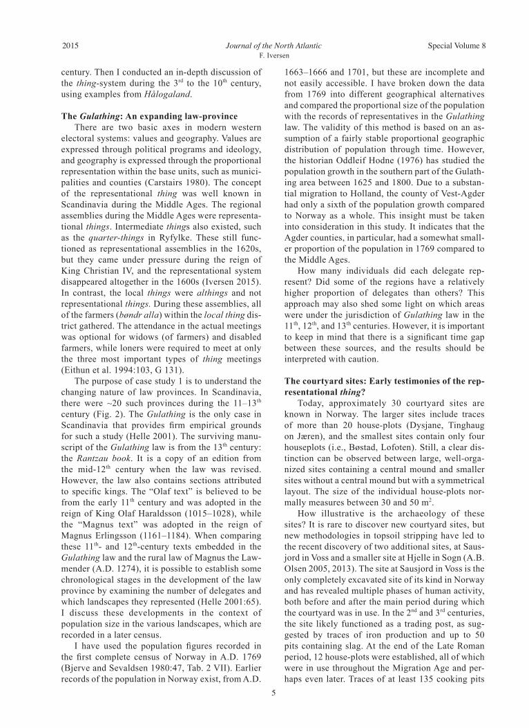
The Gulathing: An expanding law-province There are two basic axes in modern western electoral systems: values and geography. Values are expressed through political programs and ideology, and geography is expressed through the proportional representation within the base units, such as munici-palities and counties (Carstairs 1980). The concept of the representational thing was well known in Scandinavia during the Middle Ages. The regional assemblies during the Middle Ages were representa-tional things. Intermediate things also existed, such as the quarter-things in Ryfylke. These still func-tioned as representational assemblies in the 1620s, but they came under pressure during the reign of King Christian IV, and the representational system disappeared altogether in the 1600s (Iversen 2015). In contrast, the local things were althings and not representational things. During these assemblies, all of the farmers (bøndr alla) within the local thing dis-trict gathered. The attendance in the actual meetings was optional for widows (of farmers) and disabled farmers, while loners were required to meet at only the three most important types of thing meetings (Eithun et al. 1994:103, G 131). The purpose of case study 1 is to understand the changing nature of law provinces. In Scandinavia, there were ~20 such provinces during the 11–13th century (Fig. 2). The Gulathing is the only case in Scandinavia that provides firm empirical grounds for such a study (Helle 2001). The surviving manu-script of the Gulathing law is from the 13th century: the Rantzau book. It is a copy of an edition from the mid-12th century when the law was revised. However, the law also contains sections attributed to specific kings. The “Olaf text” is believed to be from the early 11th century and was adopted in the reign of King Olaf Haraldsson (1015–1028), while the “Magnus text” was adopted in the reign of Magnus Erlingsson (1161–1184). When comparing these 11th- and 12th-century texts embedded in the Gulathing law and the rural law of Magnus the Law-mender (A.D. 1274), it is possible to establish some chronological stages in the development of the law province by examining the number of delegates and which landscapes they represented (Helle 2001:65). I discuss these developments in the context of population size in the various landscapes, which are recorded in a later census. I have used the population figures recorded in the first complete census of Norway in A.D. 1769 (Bjerve and Sevaldsen 1980:47, Tab. 2 VII). Earlier records of the population in Norway exist, from A.D.
1663–1666 and 1701, but these are incomplete and not easily accessible. I have broken down the data from 1769 into different geographical alternatives and compared the proportional size of the population with the records of representatives in the Gulathing law. The validity of this method is based on an as-sumption of a fairly stable proportional geographic distribution of population through time. However, the historian Oddleif Hodne (1976) has studied the population growth in the southern part of the Gulath-ing area between 1625 and 1800. Due to a substan-tial migration to Holland, the county of Vest-Agder had only a sixth of the population growth compared to Norway as a whole. This insight must be taken into consideration in this study. It indicates that the Agder counties, in particular, had a somewhat small-er proportion of the population in 1769 compared to the Middle Ages. How many individuals did each delegate rep-resent? Did some of the regions have a relatively higher proportion of delegates than others? This approach may also shed some light on which areas were under the jurisdiction of Gulathing law in the 11th, 12th, and 13th centuries. However, it is important to keep in mind that there is a significant time gap between these sources, and the results should be interpreted with caution.
The courtyard sites: Early testimonies of the rep-resentational thing? Today, approximately 30 courtyard sites are known in Norway. The larger sites include traces of more than 20 house-plots (Dysjane, Tinghaug on Jæren), and the smallest sites contain only four houseplots (i.e., Bøstad, Lofoten). Still, a clear dis-tinction can be observed between large, well-orga-nized sites containing a central mound and smaller sites without a central mound but with a symmetrical layout. The size of the individual house-plots nor-mally measures between 30 and 50 m2. How illustrative is the archaeology of these sites? It is rare to discover new courtyard sites, but new methodologies in topsoil stripping have led to the recent discovery of two additional sites, at Saus-jord in Voss and a smaller site at Hjelle in Sogn (A.B. Olsen 2005, 2013). The site at Sausjord in Voss is the only completely excavated site of its kind in Norway and has revealed multiple phases of human activity, both before and after the main period during which the courtyard was in use. In the 2nd and 3rd centuries, the site likely functioned as a trading post, as sug-gested by traces of iron production and up to 50 pits containing slag. At the end of the Late Roman period, 12 house-plots were established, all of which were in use throughout the Migration Age and per-haps even later. Traces of at least 135 cooking pits
Journal of the North AtlanticF. Iversen
2015 Special Volume 8
6Figure 2. The law provinces in Scandinavia in the 11–14th to the centuries. Image © Frode Iversen.
Journal of the North AtlanticF. Iversen
2015 Special Volume 8
7
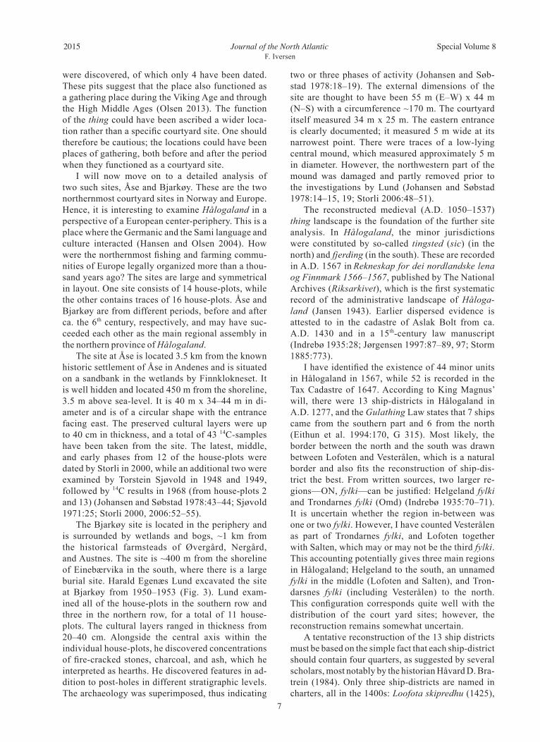
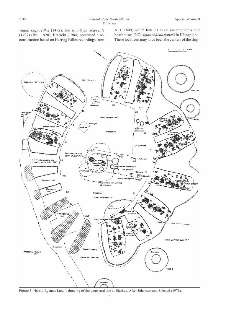
two or three phases of activity (Johansen and Søb-stad 1978:18–19). The external dimensions of the site are thought to have been 55 m (E–W) x 44 m (N–S) with a circumference ~170 m. The courtyard itself measured 34 m x 25 m. The eastern entrance is clearly documented; it measured 5 m wide at its narrowest point. There were traces of a low-lying central mound, which measured approximately 5 m in diameter. However, the northwestern part of the mound was damaged and partly removed prior to the investigations by Lund (Johansen and Søbstad 1978:14–15, 19; Storli 2006:48–51). The reconstructed medieval (A.D. 1050–1537) thing landscape is the foundation of the further site analysis. In Hålogaland, the minor jurisdictions were constituted by so-called tingsted (sic) (in the north) and fjerding (in the south). These are recorded in A.D. 1567 in Rekneskap for dei nordlandske lena og Finnmark 1566–1567, published by The National Archives (Riksarkivet), which is the first systematic record of the administrative landscape of Håloga-land (Jansen 1943). Earlier dispersed evidence is attested to in the cadastre of Aslak Bolt from ca. A.D. 1430 and in a 15th-century law manuscript (Indrebø 1935:28; Jørgensen 1997:87–89, 97; Storm 1885:773). I have identified the existence of 44 minor units in Hålogaland in 1567, while 52 is recorded in the Tax Cadastre of 1647. According to King Magnus’ will, there were 13 ship-districts in Hålogaland in A.D. 1277, and the Gulathing Law states that 7 ships came from the southern part and 6 from the north (Eithun et al. 1994:170, G 315). Most likely, the border between the north and the south was drawn between Lofoten and Vesterålen, which is a natural border and also fits the reconstruction of ship-dis-trict the best. From written sources, two larger re-gions—ON, fylki—can be justified: Helgeland fylki and Trondarnes fylki (Omd) (Indrebø 1935:70–71). It is uncertain whether the region in-between was one or two fylki. However, I have counted Vesterålen as part of Trondarnes fylki, and Lofoten together with Salten, which may or may not be the third fylki. This accounting potentially gives three main regions in Hålogaland; Helgeland to the south, an unnamed fylki in the middle (Lofoten and Salten), and Tron-darsnes fylki (including Vesterålen) to the north. This configuration corresponds quite well with the distribution of the court yard sites; however, the reconstruction remains somewhat uncertain. A tentative reconstruction of the 13 ship districts must be based on the simple fact that each ship-district should contain four quarters, as suggested by several scholars, most notably by the historian Håvard D. Bra-trein (1984). Only three ship-districts are named in charters, all in the 1400s: Loofota skipredhu (1425),
were discovered, of which only 4 have been dated. These pits suggest that the place also functioned as a gathering place during the Viking Age and through the High Middle Ages (Olsen 2013). The function of the thing could have been ascribed a wider loca-tion rather than a specific courtyard site. One should therefore be cautious; the locations could have been places of gathering, both before and after the period when they functioned as a courtyard site. I will now move on to a detailed analysis of two such sites, Åse and Bjarkøy. These are the two northernmost courtyard sites in Norway and Europe. Hence, it is interesting to examine Hålogaland in a perspective of a European center-periphery. This is a place where the Germanic and the Sami language and culture interacted (Hansen and Olsen 2004). How were the northernmost fishing and farming commu-nities of Europe legally organized more than a thou-sand years ago? The sites are large and symmetrical in layout. One site consists of 14 house-plots, while the other contains traces of 16 house-plots. Åse and Bjarkøy are from different periods, before and after ca. the 6th century, respectively, and may have suc-ceeded each other as the main regional assembly in the northern province of Hålogaland. The site at Åse is located 3.5 km from the known historic settlement of Åse in Andenes and is situated on a sandbank in the wetlands by Finnklokneset. It is well hidden and located 450 m from the shoreline, 3.5 m above sea-level. It is 40 m x 34–44 m in di-ameter and is of a circular shape with the entrance facing east. The preserved cultural layers were up to 40 cm in thickness, and a total of 43 14C-samples have been taken from the site. The latest, middle, and early phases from 12 of the house-plots were dated by Storli in 2000, while an additional two were examined by Torstein Sjøvold in 1948 and 1949, followed by 14C results in 1968 (from house-plots 2 and 13) (Johansen and Søbstad 1978:43–44; Sjøvold 1971:25; Storli 2000, 2006:52–55). The Bjarkøy site is located in the periphery and is surrounded by wetlands and bogs, ~1 km from the historical farmsteads of Øvergård, Nergård, and Austnes. The site is ~400 m from the shoreline of Einebærvika in the south, where there is a large burial site. Harald Egenæs Lund excavated the site at Bjarkøy from 1950–1953 (Fig. 3). Lund exam-ined all of the house-plots in the southern row and three in the northern row, for a total of 11 house-plots. The cultural layers ranged in thickness from 20–40 cm. Alongside the central axis within the individual house-plots, he discovered concentrations of fire-cracked stones, charcoal, and ash, which he interpreted as hearths. He discovered features in ad-dition to post-holes in different stratigraphic levels. The archaeology was superimposed, thus indicating
Journal of the North AtlanticF. Iversen
2015 Special Volume 8
8Figure 3. Harald Egenæs Lund´s drawing of the courtyard site at Bjarkøy. After Johansen and Søbstad (1978).
Vagha skiparedhæ (1472), and Raudøyar skipreide (1497) (Bull 1920). Bratrein (1984) presented a re-construction based on Hartvig Billes recordings from
A.D. 1609, which lists 13 naval encampments and boathouses (NO, skjøttebåtstasjoner) in Hålogaland. These locations may have been the centers of the ship-
Journal of the North AtlanticF. Iversen
2015 Special Volume 8
9
the meetings, 16 of whom arrived from Sunnmøre (Eithun et al. 1994:33–35;G 3). Thus there appears to have been a reduction of 150 representatives over ~150 years. Seven barons from the coastal provinces, except from Nordhordland, which was close to the thing site, had to stay at home during the assemblies to guard the region, as there was fear of possible conflict. The bishop appointed two parish priests from each county. During the 13th century, the number of delegates decreased. According to the rural law of Magnus the Lawmender (Munch 1848:L I 2), only 148 representatives should attend the as-sembly after A.D. 1274, which is approximately 40% of the attendees of the 11th century. In addition to the barons and the bailiffs, the king himself and the bishops’ stewards (NO, årmenn) were obligated to attend the assembly. The figures display the following: Firda com-prised 19.2% of the population in 1769 and held 21.3% of the delegates in 11th century. The area of Sogn had 14.9% of the population and held 17.1% of the delegates. Under the assumption of stable ratios, these counties were somewhat overrepresented at the assembly in relation to the overall ratio of the population (2.1 and 2.2%, respectively). Hordaland (Sunnhordland and Nordhordland) was in a slight minority (-1.7%), encompassing 28.9% of the popu-lation in A.D. 1769, and held 27.2% of the delegates. The region of Rogaland had a slightly better ratio, with 25.6% of the population and 27.2% of the del-egates (+1.6%). However, Lista in Agder contained 11.5% of the population but held only 7.2% of the representatives (-4.3%). Apparently, these data could indicate that Agder, which was located farther from the assembly site, was in a minority and that Sogn and Firda—areas closer to the assembly site—were overrepresented. Still, these differences are not more significant than could be explained by small changes in the relative population ratio between A.D. 1000 and A.D. 1769. However, if we include Hardanger and Voss (13,500) within Hordaland, and Nedenes (20,018), Mandal (10,688), and Setesdal (6206) within Agder, there are significant discrepancies, and the numbers
districts in the Middle Ages. My method for reconstructing the ship-districts is slightly different. I have taken Bratrein’s naval centers into consideration. However, unlike both him and the historian Edvard Bull (1920), I perceive Våge and Lofoten as two separate ship districts and not as a single unit. The Þingasaga informs us that the baron Sigurd Ranesson (ca. 1070–1130) was taken to court ca. 1114 by King Sigurd Magnusson (the Crusader) at Kepsiey (Kjefsøy) (Storm 1877:8, 49). Sigurd Ranesson came from Steigen in Engeløy quarter, while Kepsiey is identified to the bordering Våge quarter. In my view, this could indicate that the quarters of Engeløy and Våge, one on each side of the fjord, had a common assembly, and most likely was part of the same ship-district (Våge).
Results
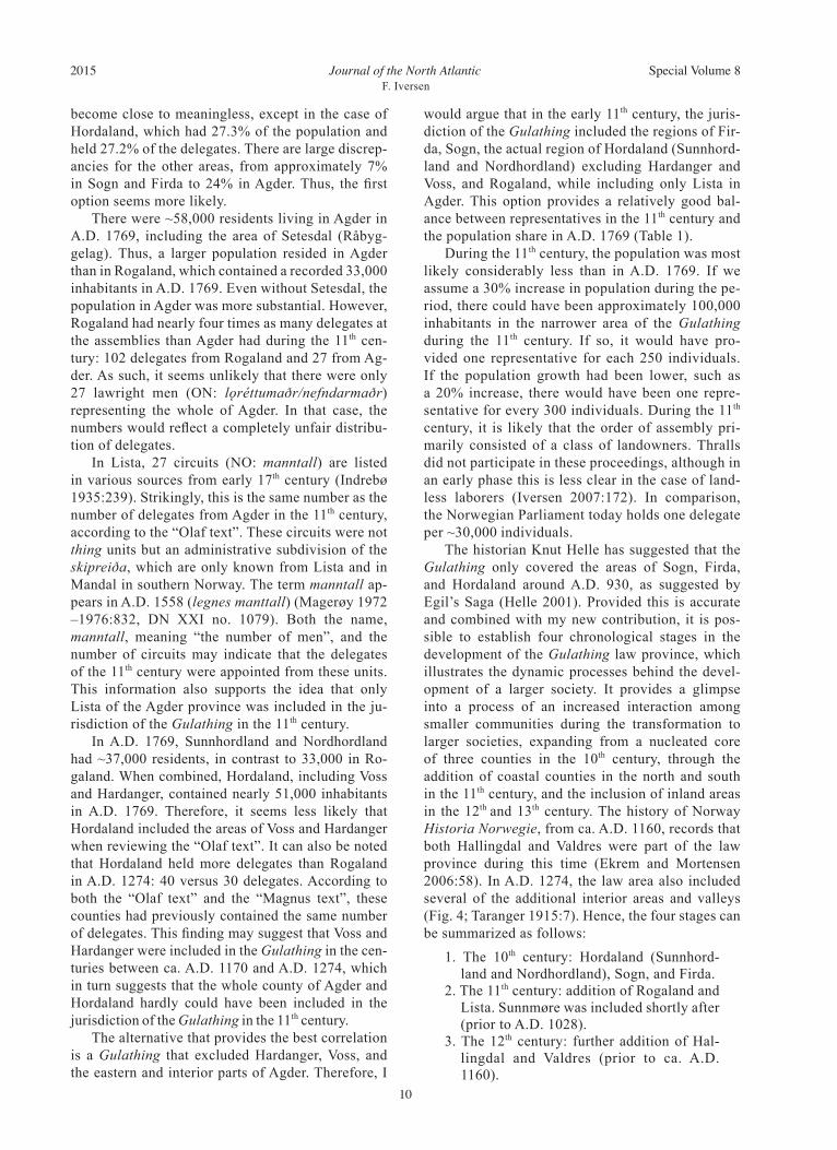
Case study 1: Development of the Gulathing law province during the 10th–13th centuries It is not clear which geographical areas were un-der the jurisdiction of the Gulathing Law during the 11th century. Partly, it is a matter of whether Horda-land encompassed Sunnhordland and Nordhordland and excluded Voss and Hardanger, as it did later. It is also uncertain whether the entire county of Agder was part of the law province during the 11th century or whether only a smaller part of it was included. I would like to explore two possible alternatives by comparing the population size and the number of rep-resentatives of Hordaland with and without Voss and Hardanger and of Agder with and without Nedenes, Mandal, and Setesdal. In the 11th century, 375 representatives met at the Gulathing (Table 1; Helle 2001:65). They came from the areas of Agder (27), Rogaland (102), Hordaland (102), Sogn (64), and Firda (80), in addition to an undetermined number from Sunnmøre, which I have excluded from this discussion. The king’s barons and bailiffs, in addition to the priests of the par-ishes, were obliged to attend. According to the later “Magnus text”, from the reign of Magnus Erlings-son (1161–1184), only 248 representatives attended
Table 1. Distribution in percentage of the number of delegates attending the Gulathing in the 11th century and the population ratio in A.D. 1769. # = number of delegates. % = percent of delegates. Count = population count in A.D. 1769. % ratio = percent of population in A.D. 1769.
Distribution of delegates Alternative 1: The Gulathing excluding Alternative 2: The Gulathing including mentioned in the ”Olaf text” Hardanger, Voss, Mandal, Nedenes and Setesdal all of Hordaland and Agder
Region # % Regions in A.D. 1769 Count % ratio Regions in A.D. 1769 Count % ratio
Rogaland 102 27.2 Rogaland 33,116 25.6 Rogaland 33,116 17.8Hordaland 102 27.2 Sunn- and Nordhordland 37,347 28.9 All of Hordaland 50,847 27.3Firda 80 21.3 Sunnfjord and Nordfjord 24,799 19.2 Sunnfjord and Nordfjord 24,799 13.3Sogn 64 17.1 Sogn 19,283 14.9 Sogn 19,283 10.4Agder 27 7.2 Lista 14,862 11.5 All of Agder and Setesdal 58,007 31.2
Sum 375 100.0 129,407 100.0 186,052 100.0
Journal of the North AtlanticF. Iversen
2015 Special Volume 8
10
become close to meaningless, except in the case of Hordaland, which had 27.3% of the population and held 27.2% of the delegates. There are large discrep-ancies for the other areas, from approximately 7% in Sogn and Firda to 24% in Agder. Thus, the first option seems more likely. There were ~58,000 residents living in Agder in A.D. 1769, including the area of Setesdal (Råbyg-gelag). Thus, a larger population resided in Agder than in Rogaland, which contained a recorded 33,000 inhabitants in A.D. 1769. Even without Setesdal, the population in Agder was more substantial. However, Rogaland had nearly four times as many delegates at the assemblies than Agder had during the 11th cen-tury: 102 delegates from Rogaland and 27 from Ag-der. As such, it seems unlikely that there were only 27 lawright men (ON: lǫréttumaðr/nefndarmaðr) representing the whole of Agder. In that case, the numbers would reflect a completely unfair distribu-tion of delegates. In Lista, 27 circuits (NO: manntall) are listed in various sources from early 17th century (Indrebø 1935:239). Strikingly, this is the same number as the number of delegates from Agder in the 11th century, according to the “Olaf text”. These circuits were not thing units but an administrative subdivision of the skipreiða, which are only known from Lista and in Mandal in southern Norway. The term manntall ap-pears in A.D. 1558 (legnes manttall) (Magerøy 1972 –1976:832, DN XXI no. 1079). Both the name, manntall, meaning “the number of men”, and the number of circuits may indicate that the delegates of the 11th century were appointed from these units. This information also supports the idea that only Lista of the Agder province was included in the ju-risdiction of the Gulathing in the 11th century. In A.D. 1769, Sunnhordland and Nordhordland had ~37,000 residents, in contrast to 33,000 in Ro-galand. When combined, Hordaland, including Voss and Hardanger, contained nearly 51,000 inhabitants in A.D. 1769. Therefore, it seems less likely that Hordaland included the areas of Voss and Hardanger when reviewing the “Olaf text”. It can also be noted that Hordaland held more delegates than Rogaland in A.D. 1274: 40 versus 30 delegates. According to both the “Olaf text” and the “Magnus text”, these counties had previously contained the same number of delegates. This finding may suggest that Voss and Hardanger were included in the Gulathing in the cen-turies between ca. A.D. 1170 and A.D. 1274, which in turn suggests that the whole county of Agder and Hordaland hardly could have been included in the jurisdiction of the Gulathing in the 11th century. The alternative that provides the best correlation is a Gulathing that excluded Hardanger, Voss, and the eastern and interior parts of Agder. Therefore, I
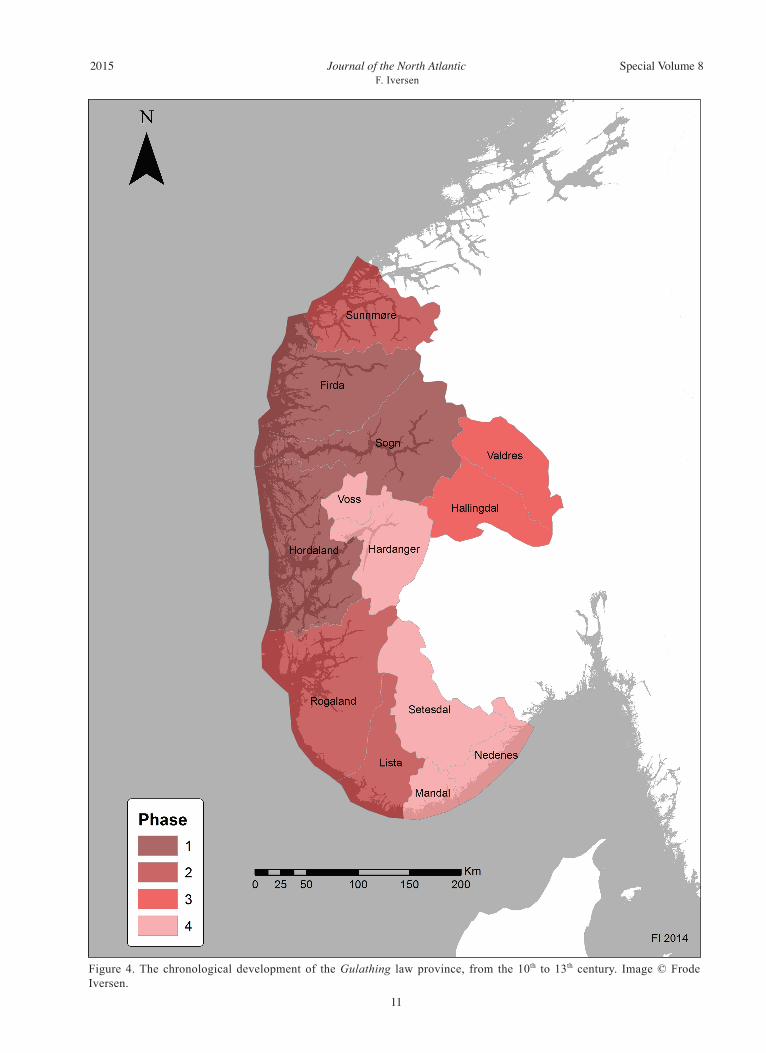
would argue that in the early 11th century, the juris-diction of the Gulathing included the regions of Fir-da, Sogn, the actual region of Hordaland (Sunnhord-land and Nordhordland) excluding Hardanger and Voss, and Rogaland, while including only Lista in Agder. This option provides a relatively good bal-ance between representatives in the 11th century and the population share in A.D. 1769 (Table 1). During the 11th century, the population was most likely considerably less than in A.D. 1769. If we assume a 30% increase in population during the pe-riod, there could have been approximately 100,000 inhabitants in the narrower area of the Gulathing during the 11th century. If so, it would have pro-vided one representative for each 250 individuals. If the population growth had been lower, such as a 20% increase, there would have been one repre-sentative for every 300 individuals. During the 11th century, it is likely that the order of assembly pri-marily consisted of a class of landowners. Thralls did not participate in these proceedings, although in an early phase this is less clear in the case of land-less laborers (Iversen 2007:172). In comparison, the Norwegian Parliament today holds one delegate per ~30,000 individuals. The historian Knut Helle has suggested that the Gulathing only covered the areas of Sogn, Firda, and Hordaland around A.D. 930, as suggested by Egil’s Saga (Helle 2001). Provided this is accurate and combined with my new contribution, it is pos-sible to establish four chronological stages in the development of the Gulathing law province, which illustrates the dynamic processes behind the devel-opment of a larger society. It provides a glimpse into a process of an increased interaction among smaller communities during the transformation to larger societies, expanding from a nucleated core of three counties in the 10th century, through the addition of coastal counties in the north and south in the 11th century, and the inclusion of inland areas in the 12th and 13th century. The history of Norway Historia Norwegie, from ca. A.D. 1160, records that both Hallingdal and Valdres were part of the law province during this time (Ekrem and Mortensen 2006:58). In A.D. 1274, the law area also included several of the additional interior areas and valleys (Fig. 4; Taranger 1915:7). Hence, the four stages can be summarized as follows:
1. The 10th century: Hordaland (Sunnhord-land and Nordhordland), Sogn, and Firda.
2. The 11th century: addition of Rogaland and Lista. Sunnmøre was included shortly after (prior to A.D. 1028).
3. The 12th century: further addition of Hal-lingdal and Valdres (prior to ca. A.D. 1160).
Journal of the North AtlanticF. Iversen
2015 Special Volume 8
11
Figure 4. The chronological development of the Gulathing law province, from the 10th to 13th century. Image © Frode Iversen.
Journal of the North AtlanticF. Iversen
2015 Special Volume 8
12
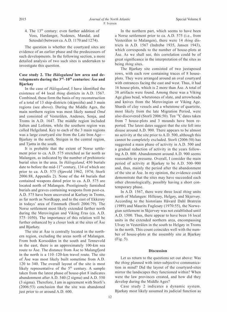
In the northern part, which seems to have been a Norse settlement prior to ca. A.D. 575 (i.e., from Vesterålen to Malangen), there were 14 thing dis-tricts in A.D. 1567 (Indrebø 1935, Jansen 1943), which corresponds to the number of house-plots at Åse. As we shall see, this correlation could be of great significance in the interpretation of the sites as being thing sites. The Bjarkøy site consisted of two juxtaposed rows, with each row containing traces of 8 house-plots. They were arranged around an oval courtyard with entrances facing the east and west. Thus, it had 16 house-plots, which is 2 more than Åse. A total of 38 artifacts were found. Among these was a Viking Age glass bead, whetstones of slate, and arrowheads and knives from the Merovingian or Viking Age. Shards of clay vessels and a whetstone of quartzite, most likely from the late Migration Period, were also discovered (Storli 2006:50). Ten 14C dates taken from 7 house-plots and 3 mounds have been re-ported. The latest dates suggest that the site fell into disuse around A.D. 900. There appears to be almost no activity at the site prior to A.D. 500, although this cannot be completely excluded. Storli (2006:50) has suggested a main phase of activity in A.D. 500 and a gradual reduction of activity in the years follow-ing A.D. 800. Abandonment around A.D. 900 seems reasonable to presume. Overall, I consider the main period of activity at Bjarkøy to be A.D. 500–900 and, thus, mainly the period after the abandonment of the site at Åse. In my opinion, the evidence could demonstrate that the sites may have succeeded each other chronologically, possibly having a short con-temporary phase. In A.D. 1567, there were three local thing units north of Malangen: Hillesøy, Helgøy, and Skjervøy. According to the historians Håvard Dahl Bratrein (1989) and Maurits Fuglesøy (1970:55), the Norwe-gian settlement in Skjervøy was not established until A.D. 1500. Thus, there appear to have been 16 local units in the extended northern area, encompassing Ulvøy in Vesterålen in the south to Helgøy in Troms in the north. This count coincides well with the num-ber of house-plots at the assembly site at Bjarkøy (Fig. 5).
Discussion
Let us return to the questions set out above: Was the thing planned with inter-subjective communica-tion in mind? Did the layout of the courtyard-sites mirror the landscapes they functioned within? When were the law provinces created, and how did they develop during the Middle Ages? Case study 2 indicates a dynamic system. Bjarkøy most likely assumed its judicial function as
4. The 13th century: even further addition of Voss, Hardanger, Nedenes, Mandal, and Setesdal (between ca. A.D. 1170 and 1274).
The question is whether the courtyard sites are evidence of an earlier phase and the predecessors of such developments. In the following section, a more detailed analysis of two such sites is undertaken to investigate this question.
Case study 2. The Hålogaland law area and de-velopments during the 3rd–10th centuries: Åse and Bjarkøy In the case of Hålogaland, I have identified the existence of 44 local thing districts in A.D. 1567. Combined, these form the basis of my reconstruction of a total of 13 ship-districts (skipreiða) and 3 main regions (see above). During the Middle Ages, the main northern region was most likely named Omd and consisted of Vesterålen, Andenes, Senja, and Troms in A.D. 1647. The middle region included Salten and Lofoten, while the southern region was called Helgeland. Key to each of the 3 main regions was a large courtyard site from the Late Iron Age—Bjarkøy in the north, Steigen in the central region, and Tjøtta in the south. It is probable that the extent of Norse settle-ment prior to ca. A.D. 575 stretched as far north as Malangen, as indicated by the number of prehistoric burial sites in the area. In Hålogaland, 450 burials date to before the mid-11th century, 134 of which are prior to ca. A.D. 575 (Sjøvold 1962, 1974; Storli 2006:88, Appendix 2). None of the 44 burials that contained weapons dated prior to ca. A.D. 575 are located north of Malangen. Prestigiously furnished burials and graves containing weapons from post-ca. A.D. 575 have been uncovered at Karlsøy in Troms, as far north as Nordkapp, and to the east of Ekkerøy in todays’ area of Finnmark (Storli 2006:79). The Norse settlement most likely extended farther north during the Merovingian and Viking Eras (ca. A.D. 575–1050). The importance of this relation will be further enhanced by a closer look at the sites of Åse and Bjarkøy. The site at Åse is centrally located in the north-ern region, excluding the areas north of Malangen. From both Korsodden in the south and Tennevold in the east, there is an approximately 100-km sea route to Åse. The distance from Åse to Malangfjord in the north is a 110–120-km travel route. The site of Åse was most likely built sometime from A.D. 120 to 340. The overall layout of the site is most likely representative of the 5th century. A sample taken from the latest phase of house-plot 8 indicates abandonment after A.D. 540 (2 sigma) and A.D. 550 (3 sigma). Therefore, I am in agreement with Storli’s (2006:53) conclusion that the site was abandoned just prior to or around A.D. 600.
Journal of the North AtlanticF. Iversen
2015 Special Volume 8
13
from the cooperating communities gathered at the courtyard sites. Each community had their separate house-plots. In the case of Bjarkøy, 13 individuals from each of the 16 communities would have made a total of 208 representatives, in addition to the in-volved parties of the cases tried at these meetings. The historically known lawthing of Hålogaland was located at Steigen in the mid-region until A.D. 1797 (Falkanger 2007:20). The first written record of the Steigen lawthing is from the 23rd of June A.D. 1404 (Lange and Unger 1852:440; DN 2, no. 580). The relationship between the lawthing at Steigen and the thing held in the town and marketplace of Vågan has been discussed. The historian Narve Bjørgo (1982:50) concluded that the Brudeberg-thing at Vågan was an urban lawthing and did not perceive the lawthing at Steigen as a later successor, as suggested by the historian Jens Arup Seip (1934). I agree with Bjørgo. It is symptomatic that the medieval lawthing of Hålogaland was established in the precise location, on the same island, where the central site of the three major courtyard sites in Hålogaland was located during the Viking Age. In my view, this chronology strongly suggests a type of centralization process, in which the geographically most central site took on the function of the main lawthing of the entire province. This scenario im-plies that the functions of minor lawthings became centralized and that a new authority of the 3 main
a regional thing site after the discontinuity of Åse and the expansion of the northern territory. It is my opinion that the local thing units recorded in A.D. 1567 are in fact far earlier and could well be simul-taneous with the courtyard sites. More specifically, I surmise that the communities of Ulvøy, Barkestad and Kalsnes, Langenes, Malnes, Vinje, Andenes, Gryllefjord, Kvæfjord, Fauskevåg, Sand, Astafjord, Gisund, and Gibostad all had a separate house-plot at the site at Åse. When the jurisdiction was extend-ed further north, the assembly site was relocated to Bjarkøy, thus including the new thing districts and the communities of Hillesøy and Helgeøy, which received their own house-plots. The site at Bjarkøy was located approximately 30 km farther east and was thus more centrally situated in the expanded area. The distance between Karlsøy in the north and Bjarkøy was 200 km, and from the southern areas the journey to Bjarkøy was 30 km longer than to Åse. The thing was relocated from Åse to Bjarkøy, which was larger and included the additional house-plots needed for the extended judi-cial region. The Thing books of the early 17th century contain clear evidence that the delegations of representa-tional quarter things in Ryfylke, in southern Norway, consisted of 4, 6, or 12 men from each community, in addition to local sheriffs (NO, lensmenn) (Iversen 2015). I suggest that similarly sized delegations
Figure 5. Left: Local thing districts in northern Hålogaland A.D. 1567. Image © Frode Iversen. Right: Simplified plan of the house plots at Bjarkøy. Drawing © Inger Storli.
Journal of the North AtlanticF. Iversen
2015 Special Volume 8
14
provinces in Hålogaland was established. In my opinion, the disuse of the 3 major assembly sites was connected with the establishment of a new lawthing at Steigen at Engeløya. The courtyard sites of Norway present a unique testimony of judicial processes in the landscape. It is fascinating that we are able to follow the evolution of the thing and its development in Hålogaland—the northern agrarian outpost of Europe—over 2000 years, from the establishment of the earliest sites in the Late Roman Period to the disuse of Steigen in 1779. What can be observed is a process of central-ization during the first millennium. Prior to the 7th century, many small courtyard sites existed, which gradually became obsolete, until only 3 large sites were left, each of them located in their own region, as highlighted by Inger Storli (2006, 2010). During the 9th or 10th century, the 3 regions merged and a new singular lawthing was established at Engeløya in the mid-region. It is probable that this chronology reflects an extensive development in the process of establishing a superior jurisdiction, where an increasing number of communities were merged in order to establish larger societies. As such, the development is similar to that of the Gulathing, the origins of which could be far earlier and as such display the dynamics of judicial development. The jurisdictions were gradually expanded, as demon-strated by the analysis of both Hålogaland and the Gulathing. The Gulathing law province was expanded from a minor nucleation of 3 counties in the 10th century to include the northern and southern coastal areas in the 11th century, as I have demonstrated by com-paring the population ratio with the percentage of representatives. During the 12th and 13th centuries, the inland regions became part of the larger society. This analysis presents new results to the study of the origin of the thing in a Norwegian context. The locations of the assembly sites during the Iron Age were most likely chosen for their neutral-ity and centrality in the landscape. This neutrality could have induced a positive sense of place by the gathered individuals. It signalled the absence of sovereignty. Still, this could have been decep-tive because many of the courtyard sites are located close to known important centers of power, as Storli (2006) has demonstrated. However, these sites were located in neutral zones in the periphery, some dis-tance away from the main farmstead. The spirit of the place, the genius loci, was supposed to evoke a sense of neutrality, even if it was a misleading no-tion. There could have been a division of insideness and outsideness—both among the delegates in the various thing booths and among those who attended
the assembly and those who did not (A. Sanmark, University of the Highlands and Islands, Kirkwall, Orkney, unpubl. data). Being chosen or elected to be a delegate and thus represent the local community at the gatherings was most likely recognized as a great honor. As such, only the best of men (góðir men, meliores) received this recognition in their local communities. We are not sure whether the house-plots were arranged according to the delegates’ geographical region. For example, it is possible that the delega-tions from the northernmost areas took up residence in the northernmost house-plots and the delegation from the south in the southern house-plots of the site. If each of the local delegations had their own house-plot, structured by their geographic location, it would have been a way for the participants to gain knowledge of their geography and regional land-scape. The courtyard sites were designed in such a way that the façade and the width of the house-plots were relatively alike when viewed from the open courtyard. This positioning could express the ideo-logical conditions and the historical mentality—the idea of shared values and equality. The individual house-plots varied in length, but this would not have been noticed from the angle of the central courtyard. Thus, it would not have affected the visual impres-sion of equality. I believe that quantification—the counting alike—was a fundamental prerequisite in the establishment of the collective judicial body and is something that is observable in the spatial and ideological organization of the courtyard sites.
Acknowledgments
My sincere thanks go to Dr. Alexandra Sanmark (Uni-versity of the Highlands and Islands), Dr. Sarah Semple (Durham University), and Dr. Natascha Mehler (Vienna University) for discussions, critical reading, and com-ments with regards to this manuscript. Thanks to Profes-sor Orri Vésteinsson (University of Iceland) who acted as JONAs guest editor, and the two anonymous reviewers for their valuable input. Thank you to Jessica McGraw for translation and proofreading.
Literature Cited
Andersson, T. 2000. Hundare. Pp. 233–238, In R. Müller (Ed.). Reallexikon der Germanischen Altertumskunde 15. Walter de Gruyter, Berlin, Germany.
Armstrong, N. 2000. Tunanlegg og amfiteatre. En hypo-tese om tunanleggenes opprinnelse. Primitive tider—arkeologisk tidsskrift:102–118.
Baker, J., and Brookes, S. 2013. Governance at the Anglo-Scandinavian interface: Hundredal organization in the southern Danelaw. Journal of the North Atlantic Special Volume 5:76–95.
Berglund, B. 1994. Samfunnsorganisasjon på Helgeland. Spor 1 17:22–26.
Journal of the North AtlanticF. Iversen
2015 Special Volume 8
15
Berglund, B. 1995. Tjøtta-riket—en arkeologisk under-søkelse av maktforhold og sentrumsdannelser på Hel-gelandskysten fra Kr. f. til 1700 e. Kr. UNIT, Viten-skapsmuseet, Fakultet for arkeologi og kulturhistorie, Arkeologisk avdeling. Trondheim, Norway. 619 pp.
Binns, K.S. 1988. Ringformet tunanlegg - også oppdaget på Mo i Brønnøy. Spor 2:50.
Bjerve P.J., and P. Sevaldsen (Eds.). 1980. Norges første folketelling 1769. The first population census in Nor-way 1769. Statistisk sentralbyrå. Central Bureau of Statistics of Norway, Oslo, Norway. 368 pp.
Bjørgo N. 1982. Vågastemna i mellomalderen. Pp. 4–60, In S. Imsen and G. Sandvik (Eds.). Hamarspor. Eit festskrift til Lars Hamre 1912 – 23. Januar – 1982. Universitetsforlaget. Oslo – Bergen –Tromsø, Norway.
Bratrein, H.D. 1984. Skjøttebåter og leidangsskip i Nord-Norge. Acta Borelia. A Norwegian journal of circumpolar societies 1:27–37.
Bratrein, H.D. 1989. Fra steinalder til år 1700. Karlsøy og Helgøy bygdebok: Folkeliv, næringsliv, samfunnsliv 1. Hansnes, Karlsøy kommune, Norway. 562 pp.
Brink. S., et al. 2011. Comments on Inger Storli: “Court Sites of Arctic Norway: Remains of Thing Sites and Representations of Political Consolidation Processes in the Northern Germanic World during the First Mil-lennium AD?” Norwegian Archaeological Review 44(1):89–117.
Bull, E. 1920. Leding. Militær- og finansforfatning I Norge i ældre tid. Steenske forlag, Kristiania og København. 175 pp.
Carstairs, A.M. 1980. A Short History of Electoral Sys-tems in Western Europe. Allen & Unwin, London, UK. 236 pp.
Easthope, H. 2004. A place called home. Housing, Theory, and Society 21:128–138.
Eithun, B., M. Rindal, and T. Ulset. 1994. Den eldre Gu-latingsloven. Riksarkivet, Oslo, Norway. 208 pp.
Ekrem I., and L.B. Mortensen (Eds). 2006. Historia Norwegie. Museum Tusculanum Press, University of Copenhagen, Denmark. 245 pp.
Falkanger, T.A. 2007. Lagmann og lagting i Hålogaland gjennom 1000 år. Universitetsforlaget, Oslo, Norway. 237 pp.
Fugelsøy, M. 1970. Skjervøy. Et prestegjeld og et herred i Nord-Troms 1. Skjervøy kommune, Norway. 420 pp.
Gansum, T. 2000. Etterord. Pp. 148–169, In J. Illkjær (Ed.). Den første Norgeshistorien—Illerupfunnet: Ny innsikt i skandinavisk romertid. Kulturhistorisk for-lag, Tønsberg, Norway.
Grimm, O. 2010. Roman period court sites in South-Wes-tern Norway: a social organisation in an international perspective. AmS-skrifter 22. Arkeologisk Museum, Universitetet i Stavanger, Norway. 192 pp.
Grimm, O., and F.A. Stylegar. 2004. Court sites in south-west Norway. Reflection of a Roman Period political organisation? Norwegian Archaeological Review 37(2):111–133.
Hansen, L.I., and B. Olsen. 2004. Samenes historie fram til 1750. Cappelen akademisk forlag, Oslo, Norway. 427 pp.
Helle, K. 2001. Gulatinget og Gulatingslova. Skald, Lei-kanger, Norway. 240 pp.
Hobæk, H. 2013. Tracing medieval administrative sys-tems: Hardanger, Western Norway. Journal of the North Atlantic Special Volume 5:64–75.
Hodne O. 1976. Fra Agder til Amsterdam: en studie av norsk emigrasjon til Nederland i tiden ca. 1625–1800. Unpublished thesis in History, University of Oslo. 127 pp.
Holmbäck, Å., and Wessén, E. 1943. Svenska Landskaps-lager Tolkade och Förklarade för Nutidens Svenskar 4. Skånelagen och Gutalagen. Hugo Gebers Förlag, Stockholm, Sweden. 421 pp.
Indrebø, G. 1935. Fjordung: granskingar i eldre norsk organisasjons-soge. Bergens museums aarbok 1935:1, Bergen, Norway. 287 pp.
Iversen, F. 2013. Concilium and pagus—Revisiting the Early Germanic thing system of northern Europe. Journal of the North Atlantic, Special Volume 5:5–17.
Iversen, F. 2014. Tinget. Om aritmetikk og rettferdighet. Tinget i randen av Europa i jernalderen. Pp. 246–256, In S.H. Gullbekk (Ed.). Ja, vi elsker frihet: en antologi. Dreyer. Oslo, Norway.
Iversen, F. 2015. Tinglag og tunanlegg. Øygarden i Ro-galand. In S. Sindbæk and A. Pedersen (Eds.). Nord-lige Verdener. Nationalmuseet, København, Denmark.
Iversen, F., Hobæk H., and Ødegaard M., 2011. The historic and sociogeographical context of thing sites. Comments on Inger Storli: “Court Sites of Arctic Norway: Remains of Thing Sites and Representations of Political Consolidation Processes in the Northern Germanic World during the First Millennium AD?” (Norwegian Archaeological Review 43[2]). Norwe-gian Archaeological Review 44(1):94–97.
Iversen, T. 2007. Die frühe norwegische Dingordnung zwischen Herrschaft und Genossenschaft. Pp. 167–186, In T. Iversen, J.R. Myking, and G. Thoma (Eds.). Bauern zwischen Herrschaft und Genossenschaft. Tapir Academic Press, Trondheim, Norway. 289 pp.
Jansen, J. (Ed.). 1943. Rekneskap for dei nordlandske lena og Finnmark 1566–1567. Pp. 137–266. In Nor-ske Lensrekneskapsbøker 1548–1567, 5. Riksarkivet, Oslo, Norway.
Johansen, O.S. and Søbstad, T. 1978. De nordnorske tun-anleggene fra jernalderen. Viking 1977 41:9–56.
Jørgensen, J.G. (Ed.). 1997. Aslak Bolts jordebok. Riksar-kivet, Oslo, Norway. 522 pp.
Lange, C.C.A., and C.R. Unger (Eds.). 1852. Diplo-matarium Norvegicum. Oldbreve til Kundskab om Norges indre og ydre Forhold, Sprog, Slægter, Sæder, Lovgivning og Rettergang i Middelalderen, vol. 2:2, Christiania, Norway. 948 pp.
Lappegard Hauge, Å. 2007. Identitet og sted: En sammen-ligning av tre identitetsteorier. Tidsskrift for Norsk Psykologforening 44 8:980–987.
Lillehammer. A. 1994. Fra jeger til bonde: inntil 800 e.Kr. Aschehougs norgeshistorie 1. Aschehoug, Oslo, Nor-way. 233 pp.
Lund, H.E. 1955. Håløygske høvdingeseter fra jernalde-ren. Stavanger Museums Årbok:101–107.
Lund, H.E. 1959. Håløygske høvdingeseter og tunanlegg fra eldre og yngre jernalder. Håløygminne 10:244–249.
Journal of the North AtlanticF. Iversen
2015 Special Volume 8
16
Lund, H.E. 1965. Håløygske høvdingegårder og tunanlegg av Steigen-typen fra eldre og yngre jernalder. “Valhall med de mange dører.” Norsk Tidsskrift for sprogviten-skap 20:287–325.
Løken, T. 2001. Jæren eller Karmøy—hvor var makta i Rogaland i eldre jernalder? Var Avaldsnes et maktsen-ter omkring 200 e. Kr.? Frá Haug ok heiðni 2:13–14.
Magerøy, H. (Ed.). 1972–1976. Diplomatarium Norvegi-cum 21 1–3. Oslo, Norway. 1025 pp.
Magnus, B., and B. Myhre. 1986. Forhistorien: Fra jeger-gruper til høvdingsamfunn. Norges historie 1. Bok-klubben nye bøker, Stabekk, Norway. 451 pp.
Munch, P.A. 1848 (Ed.). Den nyere Lands-Lov, utgiven av Kong Magnus Haakonsson. Pp. 1–178, In R. Keyser and P.A. Munch (Eds). Norges gamle Love indtil 1387 2. Lovgivningen under Kong Magnus Haakonssøns Regjeringstid fra 1263 til 1280, tilligemed et Supple-ment til første Bind. Christiania, Norway.
Myhre, B., and I. Øye. 2002. Jorda blir levevei: 4000 f.Kr.-1350 e.Kr. Norges landbrukshistorie 1. Samla-get, Oslo, Norway. 495 pp.
Nicolaysen, N. 1866. Norske fornlevninger. En oplysende fortegnelse over Norges fortidslevninger ældre end reformationen og henførte til hver sit sted. Foreningen til Norske fortidsminnesmerkes bevaring, Kristiania, Norway. 859 pp.
Norberg-Schulz, C. 1980. Genius Loci: Toward a Phe-nomenology of Architecture. Rizzoli International Publications, New York, USA. 216 pp.
Olsen, A.B. 2005. Et vikingtids tunanlegg på Hjelle i Stryn. En konservativ institusjon i et konservativt samfunn. Pp. 319–354, In K.A. Bergsvik and A. En-gevik (Eds). Fra funn til samfunn. Jernaldersstudier tilegnet Bergljot Solberg på 70-årsdagen. Arkeologisk institutt, University of Bergen, Norway.
Olsen, A.B. 2013. Undersøkelse av et eldre jernalders tun-anlegg på Sausjord, Voss, Hordaland – et nytt bidrag til kunnskapen om jernaldersamfunnets sosiale og politiske organisasjon. Viking 2013 76:87–112.
Olsen, M. 2003. Den sosio-politiske organiseringen av Jæren i eldre jernalder. Et tolkningsforsøk med utgangspunkt i skriftlige kilder og tunanleggene. Unpublished Master’s Thesis. University of Tromsø. 148 pp.
Patterson, M.E., and D.R. Williams. 2005. Maintaining research on place: Diversity of thought and scien-tific progress. Journal of environmental Psychology 25:361–380.
Petersen, J. 1938. Leksaren. Viking 1937 2:151–158.Relph, E. 1976. Place and placelessness: Research in
Planning and Design 1. Pion Limited, London, UK. 156 pp.
Room, A. 2005. Placenames Of The World: Origins and Meanings of the Names for 6600 Countries, Cities, Territories, Natural Features, and Historic Sites, 2nd Edition. McFarland & Company, London, UK. 439 pp.
Schütte, G. 1933. Our Forefathers, the Gothonic Nations: A Manual of the Ethnography of the Gothic, Ger-man, Dutch, Anglo-Saxon, Frisian, and Scandinavian Peoples 2. Cambridge University Press, Cambridge, UK. 482 pp.
Seip, J.A. 1934. Lagmann og lagting i senmiddelalderen og det 16de århundre. Det Norske Videnskaps-Akade-mi, Oslo, Norway. 131 pp.
Sjøvold, T. 1962. Early Iron Age: (Roman and Migration periods).The Iron Age Settlement of Artic Norway I. Tromsø Museums Skrifter, 10, 1.Tromsø, Norway. 253 pp.
Sjøvold, T. 1971. Åse-anlegget på Andøya. Et Nord-Norsk tunanlegg fra jernalderen. Acta Borealia, B. Humanio-ra no. 12:5–34.
Sjøvold, T. 1974. Late Iron Age: (Merovingian and Viking periods). The Iron Age Settlement of Artic Norway II. Tromsø Museums Skrifter, 10, 2. Tromsø, Norway. 392 pp.
Solberg, B. 2002. Courtyard sites north of the polar circle. Reflections of power in the Late Roman and Migration Period. Pp. 219–229. In B. Hårdh, B. and L. Larsson (Eds). Central Places in the Migration and Merovin-gian Periods. Papers from the 52nd Sachsensympo-sium. Almquist and Wiksell, Stockholm, Sweden.
Storli, I. 2000. Barbarians’ of the north. Reflections on the establishment of courtyard sites in North Norway. Norwegian Archaeological Review 33(2):81–103.
Storli, I. 2006. Hålogaland før rikssamlingen. Politiske prosesser i perioden 200–900 e. Kr. Instituttet for sammenlignende kulturforskning. Novus forlag, Oslo, Norway. 224 pp.
Storli, I. 2010. Court sites of arctic Norway: Remains of thing sites and representations of political consolida-tion processes in the northern Germanic world during the First Millennium AD? Norwegian Archaeological Review 43(2):128–44.
Storm, G. 1877. Sigurd Ranessøns process. Þingasaga milli Sigurðar konungs ok Eysteins konungs. Kristia-naia. 68 pp.
Storm, G. 1885. (Ed.). Norges gamle Love indtil 1387 4. Indeholdende Supplementer til de tre foregaaende Bind samt Haandskriftbeskrivelse med Facsimiler. Christiania, Norway. 797 pp.
Strøm, I.O. 2007. Tunanlegg i Midt-Norge. Med særlig vekt på Væremsanlegget i Namdalen. Unpublished Master’s Thesis. NTNU, Trondheim, Norway. 107 pp.
Taranger, Absalon (Ed.) 1915. Magnus Lagabøtes Land-slov. Cammermeyers boghandel, Kristiania, Norway. 206 pp.
Tuan, Y-F. 1974. Topophilia: A Study of Environmental Perception, Attitudes, and Values. Columbia Univer-sity Press, New York, NY, USA. 260 pp.
Urbańczyk, P. 1992. Medieval Arctic Norway. Institute of the History of Material Culture, Polish Academy of Sciences. Semper, Warszawa, Poland. 287 pp.
Vésteinsson, O. 2013. What is in a Booth? Material Sym-bolism at Icelandic Assembly Sites. Journal of the North Atlantic Special Volume 5:111–124.
Ødegaard, M. 2013. State formation, administrative ar-eas, and thing sites in the Borgarthing Law Province, Southeast Norway. Journal of the North Atlantic Spe-cial Volume 5:42–63.
Journal of the North AtlanticF. Iversen
2015 Special Volume 8
17
Endnotes1Pago Drenthe, ca. 820, Thrija-hantja, three land, derives from thrija (three) and hantja (land). Accordingly, Tvi derives from two (Room 2005:114, Schütte 1933:162). Cives Tuihanti is mentioned in a Latin Inscription of the 3rd century, and the name is recorded by C. Tacitus (A.D. 98; Iversen 2013:10).