Embed Size (px)
Citation preview
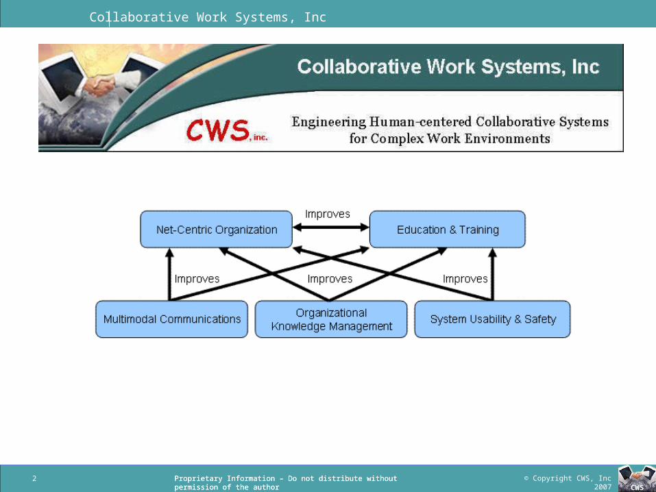
Collaborative Work Systems, Inc
CWS
Collaborative Work Systems, Inc
Geo-Docent: Improving Human, Team, and Organizational Performance with Geographically
Triggered Multimodal Information
Roger J. Chapman, PhD
President
Collaborative Work Systems (CWS), Inc
LTC James Merlo, PhD
Academy Professor
US Military Academy
Collaborative Work Systems, Inc
© Copyright CWS, Inc 2007CWS
Proprietary Information – Do not distribute without permission of the authorProprietary Information – Do not distribute without permission of the author2
Collaborative Work Systems, Inc
© Copyright CWS, Inc 2007CWS
Proprietary Information – Do not distribute without permission of the authorProprietary Information – Do not distribute without permission of the author
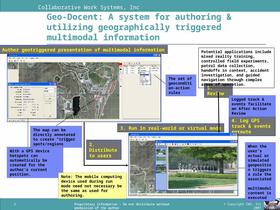
Geo-Docent: A system for authoring & utilizing geographically triggered multimodal information
1. Author geotriggered presentation of multimodal information
2. Distribute to users
3. Run in real-world or virtual mode
4. Log GPS track & events enroute
5. Review
The map can be directly annotated to create “trigger spots/regions”
With a GPS device hotspots can automatically be created for the author’s current position.
The set of geocondition-action rules
Note: The mobile computing device used during run mode need not necessary be the same as used for authoring.
When the user’s actual or simulated geoposition triggers a rule the associated multimodal content is executed
Logged track & events facilitate an After Action Review
3
Potential applications include mixed reality training, controlled field experiments, patrol data collection, handoffs in context, accident investigation, and guided navigation through complex areas of operation.
Collaborative Work Systems, Inc
© Copyright CWS, Inc 2007CWS
Proprietary Information – Do not distribute without permission of the authorProprietary Information – Do not distribute without permission of the author4
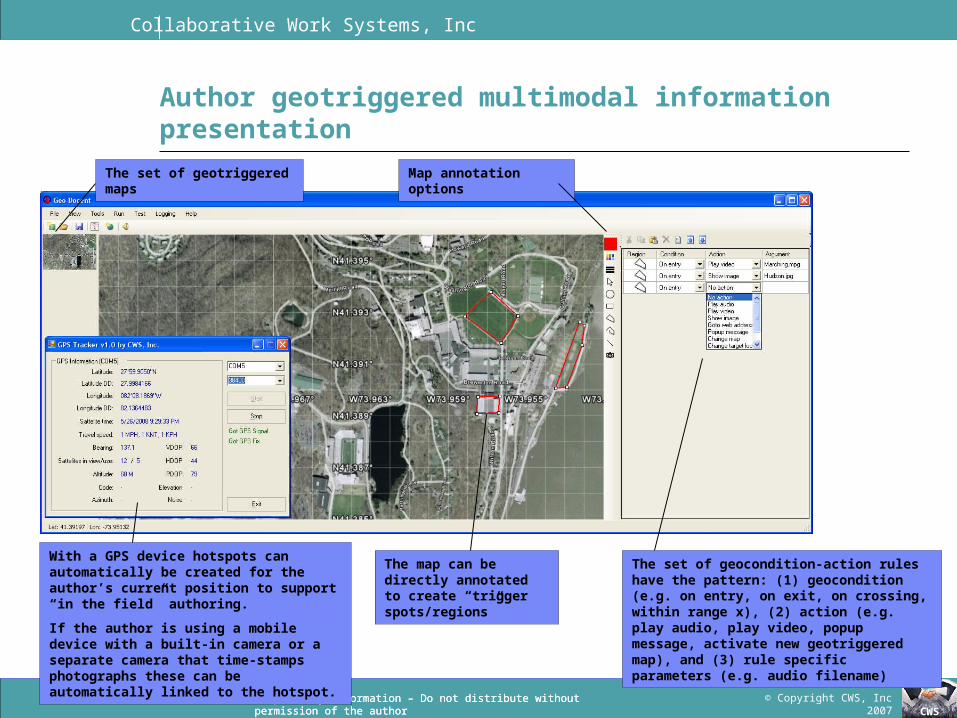
Author geotriggered multimodal information presentation
The map can be directly annotated to create “trigger spots/regions”
With a GPS device hotspots can automatically be created for the author’s current position to support “in the field” authoring.
If the author is using a mobile device with a built-in camera or a separate camera that time-stamps photographs these can be automatically linked to the hotspot.
The set of geocondition-action rules have the pattern: (1) geocondition (e.g. on entry, on exit, on crossing, within range x), (2) action (e.g. play audio, play video, popup message, activate new geotriggered map), and (3) rule specific parameters (e.g. audio filename)
The set of geotriggered maps Map annotation options
Collaborative Work Systems, Inc
© Copyright CWS, Inc 2007CWS
Proprietary Information – Do not distribute without permission of the author5
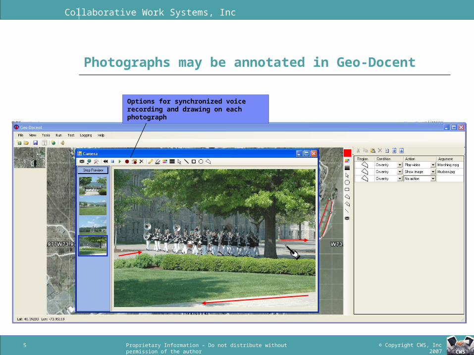
Photographs may be annotated in Geo-Docent
Options for synchronized voice recording and drawing on each photograph
Collaborative Work Systems, Inc
© Copyright CWS, Inc 2007CWS
Proprietary Information – Do not distribute without permission of the author6
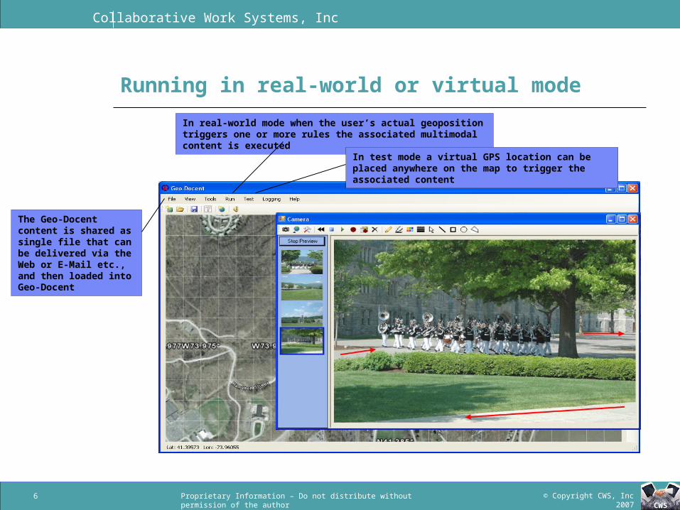
Running in real-world or virtual mode
In real-world mode when the user’s actual geoposition triggers one or more rules the associated multimodal content is executed
In test mode a virtual GPS location can be placed anywhere on the map to trigger the associated content
The Geo-Docent content is shared as single file that can be delivered via the Web or E-Mail etc., and then loaded into Geo-Docent

Collaborative Work Systems, Inc
© Copyright CWS, Inc 2007CWS
Proprietary Information – Do not distribute without permission of the author7
Logging GPS tracks & events to support AAR
The built-in GPS Tracker module supports logging the users current location over time to help facilitate an AAR.
Note: Geo-Docent data can be exported to Google Earth to provide a context-rich environment for this AAR and for sharing the results with non-Geo-Docent users.
Collaborative Work Systems, Inc
© Copyright CWS, Inc 2007CWS
Proprietary Information – Do not distribute without permission of the author8
Quick Demo

Collaborative Work Systems, Inc
© Copyright CWS, Inc 2007CWS
Proprietary Information – Do not distribute without permission of the author
Wearing communications technology output displays can improve user efficiency
Collaborative Work Systems, Inc
© Copyright CWS, Inc 2007CWS
Proprietary Information – Do not distribute without permission of the authorProprietary Information – Do not distribute without permission of the author
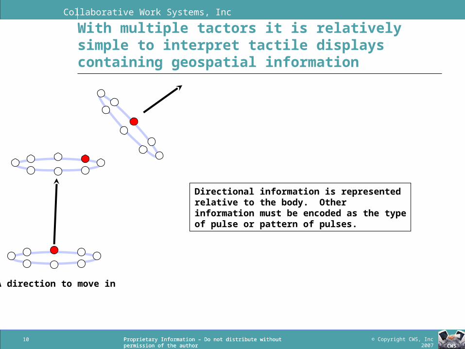
With multiple tactors it is relatively simple to interpret tactile displays containing geospatial information
10
A direction to move in
Directional information is represented relative to the body. Other information must be encoded as the type of pulse or pattern of pulses.
Collaborative Work Systems, Inc
© Copyright CWS, Inc 2007CWS
Proprietary Information – Do not distribute without permission of the authorProprietary Information – Do not distribute without permission of the author
Databases with geotagged information can be utilized in the field with GPS enabled location “triggers”
DARPA’s TiGR system has geotagged patrol collected data that could be used to create dynamic walkthroughs or spontaneous feedback as the Geo-Docent user explores areas of operation in simulation or real “in the field” mode- Raw data (could be presented by text-to-speech and/or multimedia)
Geotagged event summaries, often support by photos Patrol routes
- Aggregated data Warning of entry to categorized regions
11
Collaborative Work Systems, Inc
© Copyright CWS, Inc 2007CWS
Proprietary Information – Do not distribute without permission of the authorProprietary Information – Do not distribute without permission of the author
Conclusions
The Geo-Docent prototype demonstrates the basic feasibility of integrating GPS and Tactile technologies to support the creation and execution of geotriggered Tactile messages
Further development is needed to create a robust, complete, and field testable system- Cadets at USMA conducting human factors systems analysis
Participants authoring geotriggered content for USMA Participants using geotriggered content to receive a tour of USMA
- Can use cases be developed that suggest it would support any of the following applications: mixed reality training, controlled field experiments, patrol preparation, patrol data collection, handoffs in
context, accident investigation
12


