Embed Size (px)
Citation preview
Geoforum 43 (2012) 305–314
Contents lists available at SciVerse ScienceDirect
Geoforum
journal homepage: www.elsevier .com/locate /geoforum
Collaborative geomatics and the Mushkegowuk Cree First Nations: Fosteringadaptive capacity for community-based sub-arctic natural resource management
Daniel D.P. McCarthy a,⇑, Graham S. Whitelaw b,c, Scott Anderson d, Donald Cowan e, Fred McGarry f,Anthony Robins e, Holly L. Gardner g, Christine D. Barbeau g, Nadia A. Charania g,Zachariah General g, Jeff Liedtke h, Celine Sutherland i, Paulo Alencar j, Leonard J.S. Tsuji g
a Social Innovation Generation, Department of Environment and Resources Studies, University of Waterloo, 200 University Avenue West, Waterloo, Ontario, Canada N2L 3G1b School of Environmental Studies, Queen’s University, Kingston, Ontario, Canada K7L 3N6c School of Urban and Regional Studies, Queen’s University, Kingston, Ontario, Canada K7L 3N6d CTE: Centre for Teaching Excellence, MAD: Mapping, Analysis and Design, University of Waterloo, 200 University Avenue West, Waterloo, Ontario, Canada N2L 3G1e Computer Science Department, University of Waterloo, 200 University Avenue West, Waterloo, Ontario, Canada N2L 3G1f Centre for Community Mapping (COMAP), 160 Columbia Street West, Unit 3, Waterloo, Ontario, Canada N2L 3L3g Department of Environment and Resources Studies, University of Waterloo, 200 University Avenue West, Waterloo, Ontario, Canada N2L 3G1h Real World Globes, Redlands, California 92373, United Statesi Attawapiskat Health Services, Attawapiskat, Ontario, Canada P0L 1A0j Computer Systems Group, University of Waterloo, 200 University Avenue West, Waterloo, Ontario, Canada N2L 3G1
a r t i c l e i n f o
Article history:Received 6 May 2010Received in revised form 14 July 2011Available online 23 September 2011
Keywords:Collaborative geomaticsAdaptive capacityCree communitiesCommunity developmentLand use plans
0016-7185/$ - see front matter � 2011 Elsevier Ltd. Adoi:10.1016/j.geoforum.2011.07.015
⇑ Corresponding author. Tel.: +1 519 888 4567x330E-mail address: [email protected] (D.D.P. M
a b s t r a c t
The remote First Nation (FN) communities of the Mushkegowuk Territory on the west coast of James Bay,Ontario, Canada are currently facing increased development pressures and the imposition of a govern-ment land use planning process. The land use planning process is mandated in the Far North Act (receivedRoyal Assent on September 23, 2010). There is a need for capacity enhancement for community-basednatural resource planning and management in the Territory. A number of frameworks are emergingfor addressing change brought on by resource development and building resilience to such change atthe community level. Among these include the concept of adaptive capacity. In collaboration with FNcommunity leaders, we explored the use of ‘‘collaborative geomatics’’ tools to foster adaptive capacity.Our action research suggests that collaborative geomatics technologies should enhance the Mush-kegowuk First Nations’ adaptive capacity to address environmental and policy change by allowing themto collect and manage data collaboratively (e.g., traditional environmental knowledge, western science)to create opportunities for innovative community development, including natural resource developmentand management.
� 2011 Elsevier Ltd. All rights reserved.
1. Introduction
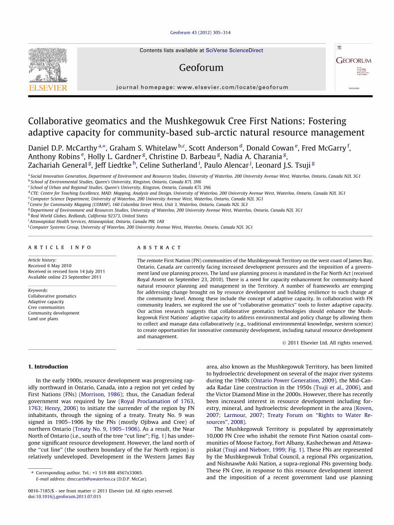
In the early 1900s, resource development was progressing rap-idly northward in Ontario, Canada, into a region not yet ceded byFirst Nations (FNs) (Morrison, 1986); thus, the Canadian federalgovernment was required by law (Royal Proclamation of 1763,1763; Henry, 2006) to initiate the surrender of the region by FNinhabitants, through the signing of a treaty. Treaty No. 9 wassigned in 1905–1906 by the FNs (mostly Ojibwa and Cree) ofnorthern Ontario (Treaty No. 9, 1905–1906). As a result, the NearNorth of Ontario (i.e., south of the tree ‘‘cut line’’; Fig. 1) has under-gone significant resource development. However, the land north ofthe ‘‘cut line’’ (the southern boundary of the Far North region) isrelatively undeveloped. Development in the Western James Bay
ll rights reserved.
65.cCar).
area, also known as the Mushkegowuk Territory, has been limitedto hydroelectric development on several of the major river systemsduring the 1940s (Ontario Power Generation, 2009), the Mid-Can-ada Radar Line construction in the 1950s (Tsuji et al., 2006), andthe Victor Diamond Mine in the 2000s. However, there has recentlybeen increased interest in resource development including for-estry, mineral, and hydroelectric development in the area (Koven,2007; Larmour, 2007; Treaty Forum on ‘‘Rights to Water Re-sources’’, 2008).
The Mushkegowuk Territory is populated by approximately10,000 FN Cree who inhabit the remote First Nation coastal com-munities of Moose Factory, Fort Albany, Kashechewan and Attawa-piskat (Tsuji and Nieboer, 1999; Fig. 1). These FNs are representedby the Mushkegowuk Tribal Council, a regional FNs organization,and Nishnawbe Aski Nation, a supra-regional FNs governing body.These FN Cree, in response to this resource development interestand the imposition of a recent government land use planning
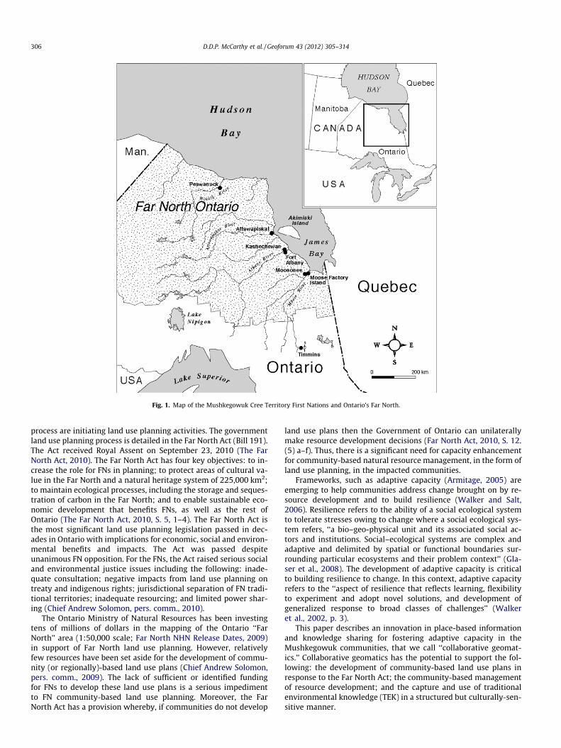
Fig. 1. Map of the Mushkegowuk Cree Territory First Nations and Ontario’s Far North.
306 D.D.P. McCarthy et al. / Geoforum 43 (2012) 305–314
process are initiating land use planning activities. The governmentland use planning process is detailed in the Far North Act (Bill 191).The Act received Royal Assent on September 23, 2010 (The FarNorth Act, 2010). The Far North Act has four key objectives: to in-crease the role for FNs in planning; to protect areas of cultural va-lue in the Far North and a natural heritage system of 225,000 km2;to maintain ecological processes, including the storage and seques-tration of carbon in the Far North; and to enable sustainable eco-nomic development that benefits FNs, as well as the rest ofOntario (The Far North Act, 2010, S. 5, 1–4). The Far North Act isthe most significant land use planning legislation passed in dec-ades in Ontario with implications for economic, social and environ-mental benefits and impacts. The Act was passed despiteunanimous FN opposition. For the FNs, the Act raised serious socialand environmental justice issues including the following: inade-quate consultation; negative impacts from land use planning ontreaty and indigenous rights; jurisdictional separation of FN tradi-tional territories; inadequate resourcing; and limited power shar-ing (Chief Andrew Solomon, pers. comm., 2010).
The Ontario Ministry of Natural Resources has been investingtens of millions of dollars in the mapping of the Ontario ‘‘FarNorth’’ area (1:50,000 scale; Far North NHN Release Dates, 2009)in support of Far North land use planning. However, relativelyfew resources have been set aside for the development of commu-nity (or regionally)-based land use plans (Chief Andrew Solomon,pers. comm., 2009). The lack of sufficient or identified fundingfor FNs to develop these land use plans is a serious impedimentto FN community-based land use planning. Moreover, the FarNorth Act has a provision whereby, if communities do not develop
land use plans then the Government of Ontario can unilaterallymake resource development decisions (Far North Act, 2010, S. 12.(5) a–f). Thus, there is a significant need for capacity enhancementfor community-based natural resource management, in the form ofland use planning, in the impacted communities.
Frameworks, such as adaptive capacity (Armitage, 2005) areemerging to help communities address change brought on by re-source development and to build resilience (Walker and Salt,2006). Resilience refers to the ability of a social ecological systemto tolerate stresses owing to change where a social ecological sys-tem refers, ‘‘a bio–geo-physical unit and its associated social ac-tors and institutions. Social–ecological systems are complex andadaptive and delimited by spatial or functional boundaries sur-rounding particular ecosystems and their problem context’’ (Gla-ser et al., 2008). The development of adaptive capacity is criticalto building resilience to change. In this context, adaptive capacityrefers to the ‘‘aspect of resilience that reflects learning, flexibilityto experiment and adopt novel solutions, and development ofgeneralized response to broad classes of challenges’’ (Walkeret al., 2002, p. 3).
This paper describes an innovation in place-based informationand knowledge sharing for fostering adaptive capacity in theMushkegowuk communities, that we call ‘‘collaborative geomat-ics.’’ Collaborative geomatics has the potential to support the fol-lowing: the development of community-based land use plans inresponse to the Far North Act; the community-based managementof resource development; and the capture and use of traditionalenvironmental knowledge (TEK) in a structured but culturally-sen-sitive manner.
D.D.P. McCarthy et al. / Geoforum 43 (2012) 305–314 307
The Dene Cultural Institute has defined TEK as a body of knowl-edge and beliefs transmitted orally, being both cumulative and dy-namic, building upon the experience of earlier generations whileadapting to the present (Stevenson, 1996). Collaborative geomaticsenables communities, in this case remote FN communities, to col-lect, display, share and analyze information, as well as collaboratewith other communities, relevant agencies and private corpora-tions. This represents a substantial advance in current practices,as the collaborative geomatics system under development for thisregion is relatively inexpensive to apply and deploy, and userfriendly thus minimizing the need for technical expertise and pro-gramming (once the system is in place). In this paper, we describethe potential of collaborative geomatics to be employed to fosteradaptive capacity with respect to community-based natural re-source management.
The paper starts with background information on our researchdesign and methods. This is followed by background informationon the Mushkegowuk Territory case and concept of adaptivecapacity for community-based, natural resource management. Adescription of the concept, and tools of, collaborative geomaticsfollows. The core of the paper focuses on an assessment and dis-cussion of the potential of collaborative geomatics to foster adap-tive capacity in the Mushkegowuk Territory communities basedon our research findings. Conclusions and recommendations forfurther research are provided based on other key aspects of adap-tive capacity not explicitly addressed in this exploratory work.
2. Collaborative research design and methods
Our research has emerged based on more than 20 years of col-laborative research with Fort Albany First Nation and other Mush-kegowuk Cree communities. We have addressed issues such as,contamination from abandoned Mid-Canada Radar Line sites(e.g., Tsuji et al., 2006), environmental health (e.g., Tsuji et al.,2009a,b), nutrition (Lougheed, 2010), environmental assessment(Whitelaw et al., 2009; Tsuji et al., 2011), social justice (McCarthyet al., 2010), and land use planning (Youden, 2010). Through thistime, our research team has forged a strong, collaborative relation-ship with the formal leadership (Chiefs and Councils), health ser-vices units, education authorities and communities. Ourcollaborative research approach or elements of partnership are de-scribed in detail in Sistili et al. (2006).
Our research approach involved numerous consultations withcommunity leaders and capacity enhancement sessions withChiefs and Councils, health services personnel, education authoritypersonnel and community members. Research methods selectedfor this work included semi-structured interviews to get feedbackon the needs of the community for a mapping and data manage-ment system for community-based, land use management plan,and workshops to introduce and pilot-test the collaborative geo-matics system.
The semi-structured interviews were undertaken in a culturallyappropriate manner following Tsuji et al. (2007) and Huntington(1998). Interviews were conducted in person from May 2009 toOctober 2010. Thirty-one respondents, 18 years of age or older,were interviewed representing members of Band (FN) Councils,land use planning staff, health services personnel, educationauthority personnel, identified community members (e.g., Elders)and staff from Mushkegowuk Council’s Department of Lands andForests. Oral consent was given by all participants after being in-formed of the purpose of the study. A themed analysis of the inter-views was carried out by hand.
Workshops were also used to complement the individual inter-views to introduce and test the collaborative geomatics system in agroup setting. The workshop format incorporated culturally-
appropriate engagement techniques: the use of informal educa-tional settings; the use of resources that rely on spatial–visualcues; the research team acting as facilitators; the use of groupactivities; collaborative learning; peer teaching and learning; andthe use of hands-on teaching (Moore, 1987; Rhodes, 1988; Fore-man, 1991).
In examining the potential use of collaborative geomatics in theMushkegwouk Territory FNs for community-based natural re-source management, information for this paper was gatheredthrough four formal workshops (and several informal meetings)in August of 2009. Two workshops were held in Fort Albany FirstNation and two were held in Timmins, Ontario. Community partic-ipants in the workshops included Chiefs and Councils (Attawapi-skat First Nation, Kashechewan First Nation, Fort Albany FirstNation), other stakeholders (e.g., health-care professionals, Mush-kegowuk Council Lands and Resources personnel) and interestedcommunity members (former members of Chiefs and Councils).
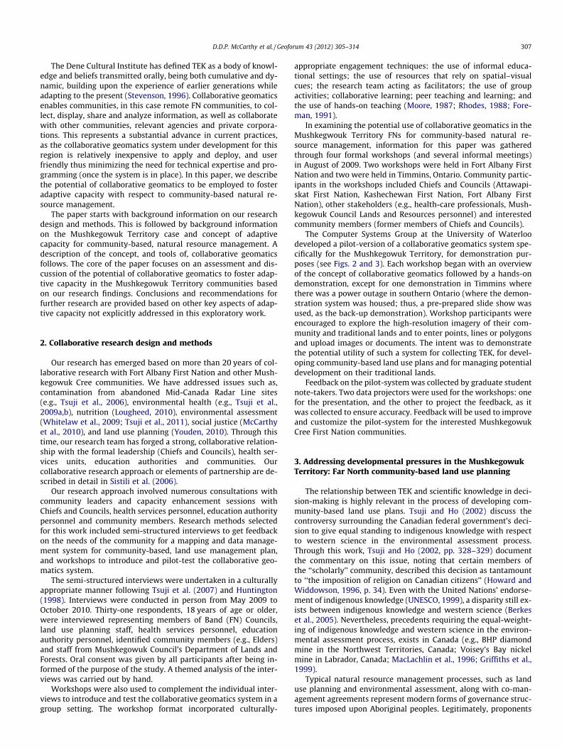
The Computer Systems Group at the University of Waterloodeveloped a pilot-version of a collaborative geomatics system spe-cifically for the Mushkegowuk Territory, for demonstration pur-poses (see Figs. 2 and 3). Each workshop began with an overviewof the concept of collaborative geomatics followed by a hands-ondemonstration, except for one demonstration in Timmins wherethere was a power outage in southern Ontario (where the demon-stration system was housed; thus, a pre-prepared slide show wasused, as the back-up demonstration). Workshop participants wereencouraged to explore the high-resolution imagery of their com-munity and traditional lands and to enter points, lines or polygonsand upload images or documents. The intent was to demonstratethe potential utility of such a system for collecting TEK, for devel-oping community-based land use plans and for managing potentialdevelopment on their traditional lands.
Feedback on the pilot-system was collected by graduate studentnote-takers. Two data projectors were used for the workshops: onefor the presentation, and the other to project the feedback, as itwas collected to ensure accuracy. Feedback will be used to improveand customize the pilot-system for the interested MushkegowukCree First Nation communities.
3. Addressing developmental pressures in the MushkegowukTerritory: Far North community-based land use planning
The relationship between TEK and scientific knowledge in deci-sion-making is highly relevant in the process of developing com-munity-based land use plans. Tsuji and Ho (2002) discuss thecontroversy surrounding the Canadian federal government’s deci-sion to give equal standing to indigenous knowledge with respectto western science in the environmental assessment process.Through this work, Tsuji and Ho (2002, pp. 328–329) documentthe commentary on this issue, noting that certain members ofthe ‘‘scholarly’’ community, described this decision as tantamountto ‘‘the imposition of religion on Canadian citizens’’ (Howard andWiddowson, 1996, p. 34). Even with the United Nations’ endorse-ment of indigenous knowledge (UNESCO, 1999), a disparity still ex-ists between indigenous knowledge and western science (Berkeset al., 2005). Nevertheless, precedents requiring the equal-weight-ing of indigenous knowledge and western science in the environ-mental assessment process, exists in Canada (e.g., BHP diamondmine in the Northwest Territories, Canada; Voisey’s Bay nickelmine in Labrador, Canada; MacLachlin et al., 1996; Griffiths et al.,1999).
Typical natural resource management processes, such as landuse planning and environmental assessment, along with co-man-agement agreements represent modern forms of governance struc-tures imposed upon Aboriginal peoples. Legitimately, proponents
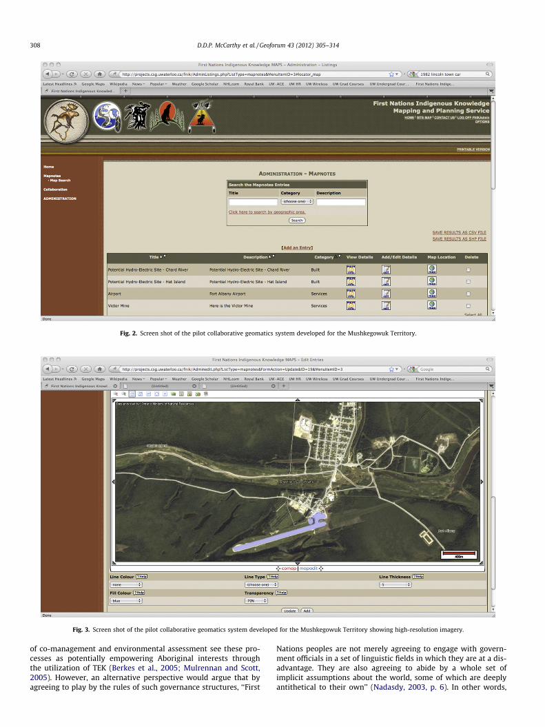
Fig. 2. Screen shot of the pilot collaborative geomatics system developed for the Mushkegowuk Territory.
Fig. 3. Screen shot of the pilot collaborative geomatics system developed for the Mushkegowuk Territory showing high-resolution imagery.
308 D.D.P. McCarthy et al. / Geoforum 43 (2012) 305–314
of co-management and environmental assessment see these pro-cesses as potentially empowering Aboriginal interests throughthe utilization of TEK (Berkes et al., 2005; Mulrennan and Scott,2005). However, an alternative perspective would argue that byagreeing to play by the rules of such governance structures, ‘‘First
Nations peoples are not merely agreeing to engage with govern-ment officials in a set of linguistic fields in which they are at a dis-advantage. They are also agreeing to abide by a whole set ofimplicit assumptions about the world, some of which are deeplyantithetical to their own’’ (Nadasdy, 2003, p. 6). In other words,
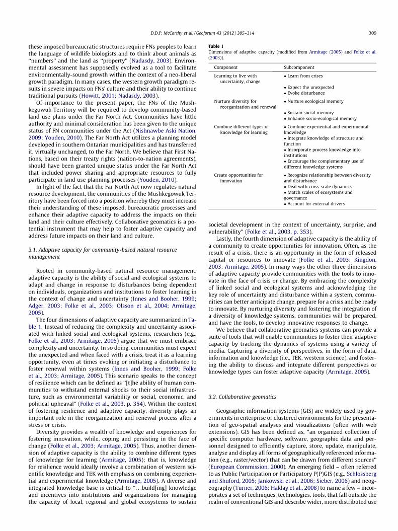
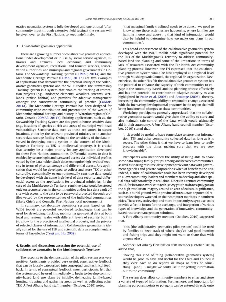
Table 1Dimensions of adaptive capacity (modified from Armitage (2005) and Folke et al.(2003)).
Component Subcomponent
Learning to live withuncertainty, change
� Learn from crises
� Expect the unexpected� Evoke disturbance
Nurture diversity forreorganization and renewal
� Nurture ecological memory
� Sustain social memory� Enhance socio-ecological memory
Combine different types ofknowledge for learning
� Combine experiential and experimentalknowledge� Integrate knowledge of structure andfunction� Incorporate process knowledge intoinstitutions� Encourage the complementary use ofdifferent knowledge systems
Create opportunities forinnovation
� Recognize relationship between diversityand disturbance� Deal with cross-scale dynamics� Match scales of ecosystems andgovernance� Account for external drivers
D.D.P. McCarthy et al. / Geoforum 43 (2012) 305–314 309
these imposed bureaucratic structures require FNs peoples to learnthe language of wildlife biologists and to think about animals as‘‘numbers’’ and the land as ‘‘property’’ (Nadasdy, 2003). Environ-mental assessment has supposedly evolved as a tool to facilitateenvironmentally-sound growth within the context of a neo-liberalgrowth paradigm. In many cases, the western growth paradigm re-sults in severe impacts on FNs’ culture and their ability to continuetraditional pursuits (Howitt, 2001; Nadasdy, 2003).
Of importance to the present paper, the FNs of the Mush-kegowuk Territory will be required to develop community-basedland use plans under the Far North Act. Communities have littleauthority and minimal consideration has been given to the uniquestatus of FN communities under the Act (Nishnawbe Aski Nation,2009; Youden, 2010). The Far North Act utilizes a planning modeldeveloped in southern Ontarian municipalities and has transferredit, virtually unchanged, to the Far North. We believe that First Na-tions, based on their treaty rights (nation-to-nation agreements),should have been granted unique status under the Far North Actthat included power sharing and appropriate resources to fullyparticipate in land use planning processes (Youden, 2010).
In light of the fact that the Far North Act now regulates naturalresource development, the communities of the Mushkegowuk Ter-ritory have been forced into a position whereby they must increasetheir understanding of these imposed, bureaucratic processes andenhance their adaptive capacity to address the impacts on theirland and their culture effectively. Collaborative geomatics is a po-tential instrument that may help to foster adaptive capacity andaddress future impacts on their land and culture.
3.1. Adaptive capacity for community-based natural resourcemanagement
Rooted in community-based natural resource management,adaptive capacity is the ability of social and ecological systems toadapt and change in response to disturbances being dependenton individuals, organizations and institutions to foster learning inthe context of change and uncertainty (Innes and Booher, 1999;Adger, 2003; Folke et al., 2003; Olsson et al., 2004; Armitage,2005).
The four dimensions of adaptive capacity are summarized in Ta-ble 1. Instead of reducing the complexity and uncertainty associ-ated with linked social and ecological systems, researchers (e.g.,Folke et al., 2003; Armitage, 2005) argue that we must embracecomplexity and uncertainty. In so doing, communities must expectthe unexpected and when faced with a crisis, treat it as a learningopportunity, even at times evoking or initiating a disturbance tofoster renewal within systems (Innes and Booher, 1999; Folkeet al., 2003; Armitage, 2005). This scenario speaks to the conceptof resilience which can be defined as ‘‘[t]he ability of human com-munities to withstand external shocks to their social infrastruc-ture, such as environmental variability or social, economic, andpolitical upheaval’’ (Folke et al., 2003, p. 354). Within the contextof fostering resilience and adaptive capacity, diversity plays animportant role in the reorganization and renewal process after astress or crisis.
Diversity provides a wealth of knowledge and experiences forfostering innovation, while, coping and persisting in the face ofchange (Folke et al., 2003; Armitage, 2005). Thus, another dimen-sion of adaptive capacity is the ability to combine different typesof knowledge for learning (Armitage, 2005); that is, knowledgefor resilience would ideally involve a combination of western sci-entific knowledge and TEK with emphasis on combining experien-tial and experimental knowledge (Armitage, 2005). A diverse andintegrated knowledge base is critical to ‘‘. . .build[ing] knowledgeand incentives into institutions and organizations for managingthe capacity of local, regional and global ecosystems to sustain
societal development in the context of uncertainty, surprise, andvulnerability’’ (Folke et al., 2003, p. 353).
Lastly, the fourth dimension of adaptive capacity is the ability ofa community to create opportunities for innovation. Often, as theresult of a crisis, there is an opportunity in the form of releasedcapital or resources to innovate (Folke et al., 2003; Kingdon,2003; Armitage, 2005). In many ways the other three dimensionsof adaptive capacity provide communities with the tools to inno-vate in the face of crisis or change. By embracing the complexityof linked social and ecological systems and acknowledging thekey role of uncertainty and disturbance within a system, commu-nities can better anticipate change, prepare for a crisis and be readyto innovate. By nurturing diversity and fostering the integration ofa diversity of knowledge systems, communities will be prepared,and have the tools, to develop innovative responses to change.
We believe that collaborative geomatics systems can provide asuite of tools that will enable communities to foster their adaptivecapacity by tracking the dynamics of systems using a variety ofmedia. Capturing a diversity of perspectives, in the form of data,information and knowledge (i.e., TEK, western science), and foster-ing the ability to discuss and integrate different perspectives orknowledge types can foster adaptive capacity (Armitage, 2005).
3.2. Collaborative geomatics
Geographic information systems (GIS) are widely used by gov-ernments in enterprise or clustered environments for the presenta-tion of geo-spatial analyses and visualizations (often with webextensions). GIS has been defined as, ‘‘an organized collection ofspecific computer hardware, software, geographic data and per-sonnel designed to efficiently capture, store, update, manipulate,analyse and display all forms of geographically referenced informa-tion (e.g., raster/vector) that can be drawn from different sources’’(European Commission, 2000). An emerging field – often referredto as Public Participation or Participatory P(P)GIS (e.g., Schlossbergand Shuford, 2005; Jankowski et al., 2006; Sieber, 2006) and neog-eography (Turner, 2006; Haklay et al., 2008) to name a few – incor-porates a set of techniques, technologies, tools, that fall outside therealm of conventional GIS and describe wider, more distributed use

310 D.D.P. McCarthy et al. / Geoforum 43 (2012) 305–314
and development of geographic data, information and knowledge(Haklay et al., 2008; Taylor, 2003; Sieber, 2006).
There is no commonly used definition of PPGIS and use of theterm is inconsistent (Schlossberg and Shuford, 2005). PPGIS wasoriginally defined as ‘‘a variety of approaches to make GIS andother spatial decision-making tools available and accessible to allthose with a stake in official decisions’’ (Schroeder (1996) quotedin Sieber (2006, p. 492)). Generally PPGIS, ‘‘pertains to the use ofgeographic information systems (GIS) to broaden public involve-ment in policymaking as well as to the value of GIS to promotethe goals of nongovernmental organizations, grassroots groups,and community-based organizations’’ (Sieber, 2006, p. 491). Onecan identify multiple ‘‘publics’’ (geographic, economic, profes-sional, social and political) and that these publics can change overtime (Schlossberg and Shuford, 2005). In addition, there are differ-ent reasons why these groups participate (Schlossberg and Shu-ford, 2005). For instance, the concept of ‘‘empowerment’’ isassociated with PPGIS (Sieber, 2006). In the context of commu-nity-based planning, Friedmann (1992, p. vii) describes theempowerment approach to planning as placing the emphasis ‘‘onautonomy in the decision-making of territorially organized com-munities, local self-reliance (but not autarchy), direct (participa-tory) democracy, and experiential social learning.’’ Indeed, PPGISis meant to enhance the autonomy and self-reliance in spatial datamanagement of a community and promote participatory democ-racy. This relates to the concept of ‘‘neogeography’’ which refersto non-experts creating and publishing custom maps (Haklayet al., 2008). However, many PPGIS systems only allow users to dis-play content rather than being truly interactive, allowing for vol-unteered geographic information (VGI) (Haklay et al., 2008).There are other similar terms used to convey concepts comparableto PPGIS including participatory GIS (PGIS), public participatoryGIS, critical GIS, or collaborative GIS (Elwood, 2006; Sieber, 2006;Dunn, 2007). Collaborative GIS has been define by Balram and Dra-gicevic (2006, p. 3) ‘‘as an eclectic integration of theories, tools, andtechnologies focusing on, but not limited to structuring humanparticipation in group spatial decision processes’’.
There are numerous terms associated with the various tech-niques tools and approaches that fall within the realm of neogeog-raphy or PPGIS, examples include:
� Geoweb – Elwood (2010);� Neogeography – Turner (2006);� Cybercartography – Taylor (2003) and Taylor and Pyne
(2009);� VGI – volunteered geographic information – Goodchild
(2007);� GIS 2.0 – McHaffie (2008);� ‘wikification’ of GIS – Sui (2008);� Web Mapping 2.0; and,� Web Mapping – Haklay et al. (2008).
Our purpose is not to provide a comprehensive or exhaustivelist or categorization for such terms (for such a review please seeHaklay et al., 2008; Sieber, 2006), but to acknowledge that differentapproaches to geomatics that are collaborative exist.
While it is not our intent to further clutter the landscape ofterms and concepts relating to the collaborative use of GIS technol-ogies, we have adopted the term ‘‘collaborative geomatics’’ as itreflects a version of neogeography (Turner, 2006) or cybercartogra-phy (Taylor, 1997, 2003) and builds on the concepts of PPGIS andCGIS. The term ‘‘collaborative geomatics’’ was originally used inColeman and Li (1999) where they refer to an unpublished reportby Finley (1997) where it is defined by seven key requirements: filemanagement, communications, group discussion, calendering andscheduling, viewing, administration and security issues. We define
collaborative geomatics as a participatory approach to both thedevelopment and use of online, distributed-authority, geomaticsapplications. What makes our collaborative geomatics system trulyunique is the declarative application engine upon which it is based,referred to as the Web Informatics Development Environment(WIDE).
The Computer Systems Group of the University of Waterloodeveloped the WIDE toolkit to begin to remove ‘‘gate keepers’’,such as, programmers and GIS technicians, allowing citizens totake control of some of their own data, information and knowl-edge, collection, processing and management. In the WIDE context,‘‘programming’’ has effectively been replaced with a declarativemethodology; thus, making it possible to provide a wizard orforms-based approach to building web-based systems. This ap-proach allows the technical team to develop web-based informa-tion systems faster than more traditional methods. The WIDEapplication engine provides the opportunity to use an iterativeand collaborative approach to create complex web-based systemswhere the users are engaged during the entire specification, designand implementation cycle. Once users operate a version of the sys-tem, they may quickly refine the specification and the correspond-ing design and implementation. This method contrasts with theconventional waterfall model of software design where specifica-tions are gathered and then realized without much subsequent in-put from the user or client. The WIDE, iterative approach tosoftware development allows the technical team to create systemsabout 10 times faster than more traditional methods. Current re-search at the Computer Systems Group, is intended to create astand-alone WIDE toolkit to allow communities of practice to cre-ate their own applications.
The current WIDE toolkit allows for the following: supports thecapture, manipulation and presentation of geo-spatial data; allowsinterconnection with existing geo-spatial repositories includingGIS; supports secure collaboration within social networks andcommunities; allows applications to be constructed quickly andmaintained with minimal expertise; works with standard webbrowsers, requires no installation as it is provided as a softwareservice over the Internet and is relatively inexpensive; and sup-ports existing and evolving geomatics standards. The WIDE toolkitsupports a common reference map base (typically, high-resolutionsatellite imagery, similar to how Google Earth presents data) builtupon existing geo-spatial information; while, allowing the entry(real-time) of new geospatial information (either oral, written orphotographic, similar to how Wikipedia presents information,but more advanced with safeguards concerning identity andauthority), and the analysis and presentation of the results. TheWIDE toolkit and collaborative geomatics system is a proven tech-nology having been used in governmental, environmental non-government and cultural heritage applications.
In terms of the long-term sustainability of the collaborativegeomatics system, applications and data must be continuouslyaccessible by the relevant communities in perpetuity. With datahoused within the communities (and/or secured data vault) andwith the applications accessible through any internet connection,the short-term accessibility is not in question. Over the medium-to-long term, there are concerns around the sustainability of a sys-tem that requires upgrades and development from a third-partyorganization, such as the University of Waterloo’s Computer Sys-tems Group. Given this issue, the Computer Systems Group asmentioned previously are creating a stand-alone version of WIDEso that clients can continue to create their own new applicationsfor their collaborative geomatics system. With some basic training,Mushkegowuk Territory community members could develop theirown applications and evolve their system to meet the future geo-spatial information and knowledge needs of the communities. Itshould also be emphasized that once the FN version of the collab-
D.D.P. McCarthy et al. / Geoforum 43 (2012) 305–314 311
orative geomatics system is fully developed and operational (aftercommunity input through extensive field testing), the system willbe given over to the First Nations to keep indefinitely.
3.3. Collaborative geomatics applications
There are a growing number of collaborative geomatics applica-tions under development or in use by social service agencies, li-braries and archives, local economic and communitydevelopment agencies, recreational and tourism services, conser-vation authorities, and municipal and regional governments in On-tario. The Stewardship Tracking System (COMAP, 2011a) and theMennonite Heritage Portrait (COMAP, 2011b) are two examplesof applications that demonstrate the practical utility of the collab-orative geomatics systems and the WIDE toolkit. The StewardshipTracking System is a system that enables the tracking of restora-tion projects (e.g., landscape elements, woodlots, streams, wet-lands, prairie habitat) and provides for adaptive managementamongst the conservation community of practice (COMAP,2011a). The Mennonite Heritage Portrait has been designed forcommunity-wide contribution and presentation of the wealth ofMennonite cultural heritage and history in Waterloo region of On-tario, Canada (COMAP, 2011b). Existing applications, such as, theStewardship Tracking System are designed to house sensitive data(e.g., locations of species at risk and areas of municipal well-headvulnerability). Sensitive data such as these are stored in securelocations, either by the relevant provincial ministry or in anothersecure data storage facility. Owing to the sensitivity of the data in-volved in deploying such a system in the context of the Mush-kegowuk Territory, as TEK is intellectual property, it is crucialthat security be a major priority for any application developedfor these First Nations communities. Differential access to data isenabled by secure login and password access via individual profilesvetted by the data holder. Such datasets require high levels of secu-rity in terms of physical storage and differential access. Any appli-cation that would be developed to collect and store TEK or otherculturally, economically or environmentally sensitive data wouldbe developed with the same high-level of data security and differ-ential access as the applications for provincial ministries. In thecase of the Mushkegowuk Territory, sensitive data would be storedonly on secure servers in the communities and/or in a data vault offsite with access to the data to be password protected through pro-files vetted by the representatives of the individual communities(likely Chiefs and Councils, First Nations local government).
In summary, collaborative geomatics systems based on theWIDE toolkit are powerful web-based technologies that can beused for developing, tracking, monitoring geo-spatial data at bothlocal and regional scales with different levels of security built in(to allow for the protection of intellectual property, and the privacyof selected classes of information). Collaborative geomatics is ide-ally suited for the use of TEK and scientific data as complementaryforms of knowledge (Tsuji and Ho, 2002).
4. Results and discussion: assessing the potential use ofcollaborative geomatics in the Mushkegowuk Territory
The response to the demonstration of the pilot-system was verypositive. Participants provided very useful, constructive feedbackthat can be loosely categorized into conceptual and technical feed-back. In terms of conceptual feedback, most participants felt thatthe system could be used immediately to begin to develop commu-nity-based land use plans by initially, delineating family-basedhunting, trapping and gathering areas as well as collecting otherTEK. A Fort Albany band staff member (October, 2010) noted,
‘‘that mapping [family traplines] needs to be done. . . we need toknow where those activities are happening, where families arehunting moose and goose . . . that kind of information wouldalso be helpful to determine how we make our plans in ourcommunities’’.
This broad endorsement of the collaborative geomatics systemdeveloped with the WIDE toolkit holds significant potential forthe FNs of the Mushkegowuk Territory to address community-based land-use planning and some of the limitations in terms oflack of resources associated with the Far North Act communityplanning process. However, one FN expressed that the collabora-tive geomatics system would be best employed at a regional levelthrough Mushkegowuk Council, the regional FN organization. Nev-ertheless, the other FNs felt the collaborative geomatics system hasthe potential to enhance the capacity of their communities to en-gage in the community-based land use planning process effectivelyand has the potential to contribute to adaptive capacity as alsohighlighted in Folke et al. (2003) and Armitage (2005); thereby,increasing the community’s ability to respond to change associatedwith the increasing developmental pressures in the region that willbring fundamental changes to these communities.
Workshop participants generally appreciated that the collabo-rative geomatics system would give them the ability to store andalso maintain safe control of the data, which would ultimatelyaid in their autonomy. A Fort Albany band council member (Octo-ber, 2010) stated that,
‘‘. . .it would be useful to have some place to store that informa-tion [TEK and other community collected data] as long as it issecure. The other thing is that we have to learn how to reallyprogress with the times making sure that we are veryknowledgeable’’.
Participants also mentioned the utility of being able to sharesome data among family groups, among and between communities,as well as sharing resource-development relevant data with govern-ment agencies and private corporations when of benefit to the FNs.Indeed, a suite of collaborative tools has been recently developedto allow community leaders and members to develop and alter spa-tial data collaboratively in real-time. Elders in a remote communitycould, for instance, work with tech-savvy youth to draw a polygon onthe high-resolution imagery around an area of cultural significance,such as, a burial ground, while provincial bureaucrats or potential re-source developers watched on their computer monitors in southerncities. These easy to develop, and more importantly easy to use, toolsprovide a fertile forum for the exchange, and integration of varioustypes of knowledge and the generation of innovative, community-based resource management solutions.
A Fort Albany community member (October, 2010) suggestedthat,
‘‘this [the collaborative geomatics pilot system] could be usedby families to keep track of where they’ve had good huntingand fishing trips and they might not want to share that withanyone else’’.
Another Fort Albany First Nation staff member (October, 2010)added that,
‘‘having this kind of thing [collaborative geomatics system]would be good to have and useful for the Chief and Council ifthey ever have to do reports or maps or stats or some-thing. . .[and] . . . maybe we could use it for getting informationout to the community’’.
The system does allow community members to enter and storea variety of types of information. Furthermore, and important forplanning purposes, points or polygons can be entered directly onto
312 D.D.P. McCarthy et al. / Geoforum 43 (2012) 305–314
high-resolution imagery of potential development areas along withtabular data (e.g., water quality data or flood data) or even picturesof emerging development or mineral prospecting. The systemcould also be used to collect TEK from elders allowing for the accu-rate citing of historic sites, cemeteries or other important FN cul-tural sites. Further, the collaborative geomatics system can allowfor the capture and storage of oral narratives by uploading digitalaudio files of Elders telling site-specific stories. Together, thesetypes of data and knowledge could be used alone and/or in con-junction with standard, proprietary GIS systems to track the cumu-lative effects of existing and proposed development. One of the keybenefits to a collaborative geomatics system is the ability of anycommunity member (depending on permissions set by communityleaders) to enter data, information or knowledge regarding envi-ronmental change including resource development. This volun-teered geographic information (VGI) (Goodchild, 2007) effectivelyincreases the number of ‘‘monitors’’ or perspectives on an issue,on a given landscape. Armitage (2005) describes the need to nur-ture diversity as an important dimension of adaptive capacity. Incomparison to the use of traditional GIS systems where one ortwo users enter and maintain data, VGI and collaborative geomat-ics systems allow for a much broader community of practice to en-ter and maintain data, effectively, in real time. Different levels ofaccess can easily be established by community leaders to allowfor quality assurance when entering data on some databases. Fur-thermore, the concern raised by one of the community membersthat some contributors to the system may not want certain indi-viduals or parties to have access to certain data (e.g., specific hunt-ing areas), can also be addressed through differential access to thesystem through user names and passwords.
In addition, workshop participants also provided useful techni-cal feedback. Community leaders asked if this type of system couldbe used instead of traditional GIS software. Our team made it clearthat the collaborative geomatics system has some of the function-ality of a GIS system (map making, displaying different layers ofdata) that the community leaders were interested in, but lackedthe tools for spatial statistics and other more complex analyticalfunctions, at this time. It should be emphasized that the collabora-tive geomatics system was specifically designed for communityuse, not necessarily for professional use; thus, the collaborativegeomatics system is a good fit for community-based initiatives,but not purely professional or research uses requiring advancedspatial statistics. However, GIS data can be imported or exportedfrom the collaborative geomatics system if complex data analysesare required.
In addition, workshop attendees indicated that they liked theability to upload data, documents, pictures and even audio clipsassociated with spatial data. Participants also indicated that theywould like to see the map navigation tools and map-making toolssimplified with the option of allowing for some users to choosemore advanced options. A suggestion was made that the windowthat popped-up when you mouse-over a point, line or polygonwas more annoying than helpful. Also, several workshop partici-pants suggested that there should be a ‘‘context window’’ thatwould allow them to see where, in the broader context, they werenavigating on the map. A Fort Albany band staff member (October,2010) noted that,
‘‘many important, historic sites and cemeteries are on highground so it would be good to have those lines that show higherareas [contour lines]’’.
The same staff member also asked if there could be a ‘‘measur-ing tool’’ developed so that distances could be easily and quicklycalculated. Within weeks of these requests, contour data were pro-vided as part of the base map and a beta measuring tool was devel-
oped and deployed for testing. In addition, data entered into thecollaborative geomatics system also undergoes constant peer re-view – as comments can be added each time the data areviewed/reviewed – community members can act as citizen scien-tists. Community members can also monitor potential develop-ments, for instance using narrative descriptions and photographs.The capture and storage of place-based TEK is allowed in variousformats (English text, Cree syllabics or oral narratives capturedon digital audio) in the collaborative geomatics system, and canbe viewed side-by-side with western-science databases. This al-lows for a diversity of perspectives to be represented on one sys-tem and contributes to the use of differing knowledge systems.
Armitage (2005) also notes the importance of using differenttypes of knowledge for learning, including western scientificknowledge and/or TEK across multiple scales. As the collaborativegeomatics systems have been specifically designed to capture,store and display a wide variety of data, information and knowl-edge including western science and TEK, such systems can encour-age the development of social networks that can be based onfamily-ties, community interests and communities of practice re-lated to planning, resource management and land use. In general,community leaders, residents and staff voiced the potential bene-fits of such a system not only in the development of community-based land use plans but also in building community capacityand autonomy.
5. Fostering future adaptive capacity through collaborativegeomatics
Our initial research and testing of the collaborative geomaticssystem with the FNs of the Mushkegowuk Territory subsequentlyled our team to identify three potential future areas to explore inrelation to adaptive capacity and the use of collaborative geomat-ics: tracking cumulative effects, tracking the influence of slow vari-ables, and facilitating opportunities for innovation. These arebriefly discussed below.
Folke et al. (2003) and Armitage (2005, p. 706) note that one ofthe key aspects of adaptive capacity is ‘‘learning to live with uncer-tainty and change by allowing and/or encouraging small-scale dis-turbance events before there is a buildup of pressures leading,inevitably, to some sort of collapse.’’ Aside from acknowledgingthat there is inherent uncertainty associated with any change inthe environment, an insight already reflected in Cree TEK (see fore.g., McDonald et al., 1997), this dimension of adaptive capacityspeaks to the importance of tracking cumulative effects of develop-ment (CEAA, 1999; Gibson et al., 2005; Noble, 2005) as well as theinfluence of ‘‘slow variables’’ (Gunderson and Holling, 2002).Cumulative effects are assessed to ensure that the incremental ef-fects resulting from the combined influences of several undertak-ings are considered as the resulting impacts may be significantdespite the fact that each individual action, when independentlyassessed, are considered insignificant (CEAA, 1999). The pilot col-laborative geomatics system developed for the Mushkegowuk Ter-ritory has the potential to facilitate First Nations-based monitoringthat may help in tracking cumulative effects.
Another key element of learning to live with uncertainty andchange is the ability to track the influence of ‘‘slow variables,’’ orthose large-scale and slow moving variables, such as climatechange, that control or constrain ecological resilience (Abel et al.,2006; Walker and Salt, 2006). The pilot collaborative geomaticssystem may allow Mushkegowuk Cree communities to track slowchanges to their landscape including the impacts of isostatic re-bound and global warming leading to sea-level change (Tsujiet al., 2009a,b). State-of-the art computer modeling has been usedto predict changes in shoreline geometry associated with sea-level
D.D.P. McCarthy et al. / Geoforum 43 (2012) 305–314 313
change in the Mushkegowuk Territory owing to glacial isostaticadjustment and (several plausible) global warming scenarios;these predictions will be used for First Nations land claims with re-spect to the islands of the western James Bay region (Tsuji et al.,2009a,b). Future work with the FNs might explore the possibilityof examining change in sea-level using TEK and a collaborativegeomatics system and the value to the community of tracking thisslow variable for application to long-range planning. In addition,the collaborative geomatics approach will empower the communi-ties through social learning so that future activities will be dealtwith based not only on previous traditional knowledge capturedin the system, but also real-time data, as well as predictive sea-le-vel change models, all of which, can be stored and displayed in acollaborative geomatics system.
The last dimension of adaptive capacity is the ability of a com-munity to create opportunities for innovation. Innovation in socialsystems can be defined as an initiative, product, process or pro-gram that profoundly changes the basic routines, resource andauthority flows or beliefs of any social system (Westley, 2009).By acknowledging the role of uncertainty and change in systems,communities can be better prepared for crises and possibly be ina position to reshape the system as it reorganizes. A collaborativegeomatics system would allow communities to track cumulativeeffects of developments and monitor the influence of slow vari-ables, such as, climate change. A diversity of perspectives and theintegration of a variety of data, information and knowledge are re-quired to engage in community-based land use planning and re-source management effectively. The collaborative geomaticssystem can allow for the development of a spatial database ofthe TEK of the Mushkegowuk Cree as well as provide a secure, on-line warehouse of relevant scientific data. Communities would notonly be better prepared to address the associated impacts of re-source development, but be in a better position to influence policydecisions and take more of a leadership role in the planning anddevelopment of their traditional lands.
6. Conclusion
The FNs of the Far North have made it clear that they oppose theFar North Act. Chief Stan Beardy, the Grand Chief of the NishnawbeAski Nation (representing 49 First Nation communities within theTerritory of James Bay Treaty No. 9 and the Ontario portions ofTreaty No. 5) clearly indicated the position of his people on thethen proposed ‘‘Far North’’ legislation during the Province of Ontar-io’s Standing Committee on Bill 191 Far North Act.
As it is with this committee’s process, so it is with these pieces oflegislation-a fiasco, an utter failure, an opportunity lost, a promisebroken. The plan from the start, as directed by the Premier [leaderof the Government of Ontario], was that this would be a true part-nership, a new relationship, creating a land-use planning law thatwould put First Nations in the driver’s seat on a government-to-government basis. We keep repeating this context to you becauseit is fundamentally important. It is the key to everything that hasgone wrong. . .what did we get instead? The same old thing, theold relationship; not a partnership but a wardship.
The future of land use planning in the Far North under the FarNorth Act will be difficult and strained due to concerns alreadyidentified in the paper. Regardless, tools, such as collaborative geo-matics system using the WIDE toolkit can enhance the adaptivecapacity of the FNs. Our hope is that such a system may allowthe Mushkegowuk Cree FNs to not only effectively participate in,but to lead, the planning and development of their traditional landsand to continue to enhance Mushkegowuk Cree capacity for auton-omy and self-governance.
Acknowledgements
We would like to thank all the people who participated, andfunding provided by Natural Sciences and Engineering ResearchCouncil of Canada, the Social Sciences and Humanities ResearchCouncil of Canada and the Government of Ontario.
References
Abel, N., Cumming, D.H.M., Anderies, J.M., 2006. Collapse and reorganization insocial–ecological systems: questions, some ideas, and policy implications.Ecology and Society 11 (1), 17.
Adger, N., 2003. Social aspects of adaptive capacity. In: Smith, J., Klein, J., Huq, S.(Eds.), Climate Change, Adaptive Capacity and Development. Imperial CollegePress, London, pp. 29–49.
Armitage, Derek, 2005. Adaptive capacity and community-based natural resourcemanagement. Environmental Management 35 (6), 703–715.
Balram, S., Dragicevic, S., 2006. Collaborative geographic information systems:origins, boundaries, and structures. In: Balram, S., Dragicevic, S. (Eds.), Collabo-rative Geographic Information Systems. Idea Group, Hershey, PA, pp. 1–22.
Berkes, F., Huebert, R., Fast, H., Manseau, M., Diduck, A., 2005. Breaking Ice:Renewable Resource and Ocean Management in the Canadian North. Universityof Calgary Press, Calgary, Alberta (Bishr and Montelas (2008) see p. 16).
CEAA, 1999. <http://www.ceaa.gc.ca/default.asp?lang=En&n=43952694-1> (acces-sed September 2011).
Coleman, D., Li, S., 1999. Developing a groupware-based prototype to supportgeomatics production management. Computers, Environment and UrbanSystems 23, 1–17.
COMAP, 2011a. Stewardship Tracking System. <http://www.comap.ca/sts/>(retrieved June 2011, WWW document).
COMAP, 2011b. Mennonite Heritage Portrait. <http://www.comap.ca/index.php?MenuItemID=23> (retrieved June 2011, WWW document).
Dunn, C.E., 2007. Participatory GIS – a people’s GIS? Progress in Human Geography31 (5), 616–637.
Elwood, S., 2006. Critical issues in participatory GIS: deconstructions,reconstructions, and new research directions. Transactions in GIS 10 (5), 693–708.
Elwood, S., 2010. Geographic information science: emerging research on thesocietal implications of the geospatial web. Progress in Human Geography 34(3), 349–357.
European Commission, 2000. Glossary. <http://ec.europa.eu/agriculture/publi/landscape/gloss.htm> (retrieved March 2010, WWW document).
Far North NHN Release Dates, 2009. Ontario Ministry of Natural Resources, BaseData Infrastructure Section.
Far North Act, 2010. Bill 191. An Act with Respect to Land Use Planning andProtection in the Far North. Legislative Assembly of Ontario, 39th Legislature,2nd session.
Finley, D., 1997. Collaborative GIS in a Distributed Work Environment. UnpublishedM.Eng Report, Department of Geodesy and Geomatics Engineering University ofNew Brunswick, Fredericton, N. B., Canada.
Folke, C., Colding, J., Berkes, F., 2003. Synthesis: building resilience and adaptivecapacity in socio-ecological systems. In: Berkes, F., Folke, C., Colding, J. (Eds.),Navigating Social–Ecological Systems: Building Resilience for Complexity andChange. Cambridge University Press, Cambridge, pp. 352–387.
Foreman, K., 1991. A dramatic approach to native teacher education. CanadianJournal of Native Education 18, 73–80.
Friedmann, J., 1992. Empowerment: The Politics of Alternative Development.Blackwell, Malden, Massachusetts.
Gibson, R.B., Hassan, S., Holtz, S., Tansey, J., Whitelaw, G., 2005. SustainabilityAssessment: Criteria and Processes. Earthscan, London, UK.
Glaser, M., Krause, G., Ratter, B., Welp, M., 2008. Human–nature-interaction in theanthropocene. Potential of social–ecological systems analysis. In: PreparationPaper for the DGH-Symposium, Human–Nature-Interactions in theAnthropocene: Potentials of Social–Ecological Systems Analysis,Sommerhausen, 29th–31st May, 2008.
Goodchild, M.F., 2007. Citizens as sensors: the world of volunteered geography.GeoJournal 69 (4), 211–221.
Griffiths, L., Metcalfe, S., Michael, L., Pelley, C., Usher, P., 1999. EnvironmentalAssessment Panel – Report on the Proposed Voisey’s Bay Mine and Mill Project.Minister of Public Works and Government Services, Ottawa, ON.
Gunderson, L.H., Holling, C.S., 2002. Panarchy: Understanding Transformations inHuman and Natural Systems. Island Press, Washington.
Haklay, M., Singleton, A., Parker, C., 2008. Web mapping 2.0: the neogeography ofthe GeoWeb. Geography Compass 2 (6), 2011–2039.
Henry, J., 2006. The Proclamation of 1763. A Model for the Establishment ofTreaties. <http://www.lac-bac.gc.ca/publications/002/015002-2010-e.html>(retrieved April 2007, WWW document).
Howard, A., Widdowson, F., 1996. Traditional knowledge threatens environmentalassessment. Policy Options 17, 34–36.
Howitt, R., 2001. Rethinking Resource Management: Justice, Sustainability andIndigenous Peoples. Routledge, New York.
Huntington, H.P., 1998. Observations on the utility of the semi-directive interviewfor documenting traditional ecological knowledge. Arctic 51, 237–242.
314 D.D.P. McCarthy et al. / Geoforum 43 (2012) 305–314
Innes, Judith E., Booher, D.E., 1999. Consensus building and complex adaptivesystems: a framework for evaluating collaborative planning. American PlanningAssociation Journal 65 (4), 412–423.
Jankowski, P., Nyerges, T., Robischon, S., Ramsey, K., Tuthill, D., 2006. Designconsiderations and evaluation of a collaborative, spatio-temporal decisionsupport system. Transactions in GIS 10 (3), 335–354.
Kingdon, J.W., 2003. Agendas, Alternatives, and Public Policies. Longman, New York.Koven, P., 2007. Is this Voisey’s Bay II? Financial Post Saturday, October 13, 2007.
<http://www.financialpost.com/story.html?id=84a8d38f-5a09-450c-81ee-185441db3305&p=1> (retrieved April 2008, WWW document).
Larmour, A., 2007. Shooting for double eagle. Northern Ontario Business 27, 40.Lougheed, T., 2010. The changing landscape of arctic traditional food.
Environmental Health Perspectives 118 (9), A386–A393.MacLachlin, L., Kenny-Gilday, C., Kupsch, W., Sloan, J., 1996. NWT Diamonds Project.
Report of the Environmental Assessment Panel. Minister of Supply and Services,Ottawa, ON.
McHaffie, M., 2008. GIS 2.0? <http://www.nsgic.org/blog/2008/01/gis-20.html>(retrieved 16.06.09).
McCarthy, D.D.P., Whitelaw, G., Tsuji, L., 2010. The Victor Diamond Mineenvironmental assessment and the Mushkegowuk Territory First Nations:critical systems thinking and social justice. Canadian Journal of Native Studies30 (1).
McDonald, M.L., Arragutainaq, L., Novalinga, Z., 1997. Voices from the Bay:Traditional Ecological Knowledge of Inuit and Cree in the Hudson BayBioregion. Canadian Arctic Resources Committee and the EnvironmentalCommittee of Municipality of Sanikiluaq, Ottawa, Ontario.
Moore, A.J., 1987. Native Indian students and their learning styles: research resultsand classroom applications. British Columbia Journal of Special Education 11,23–37.
Morrison, J., 1986. Treaty Research Report Treaty No. 9 (1905–1906). Indian andNorthern Affairs Canada, Treaties and Historical Research Centre, Ottawa,Canada.
Mulrennan, M., Scott, C., 2005. Co-management – an attainable partnership? Twocases from James Bay, Quebec and Torres Strait, Queensland. Anthropologica 47,197–213.
Nadasdy, Paul, 2003. Hunters and Bureaucrats: Power, Knowledge and Aboriginal-State Relations in the Southwest Yukon. University of British Columbia Press,Toronto, Ontario.
Nishnawbe Aski Nation, 2009. Our Homelands. Ontario Introduces the Far NorthAct, Bill 191 and An Act to Ammend [sic] the Mining Act, Bill 173.
Noble, B.F., 2005. Strategic Environmental Assessment. Oxford University Press,Toronto.
Olsson, P., Folke, C., Hahn, T., 2004. Socio-ecological transformation for ecosystemmanagement: the development of adaptive co-management of a wetlandlandscape in southern Sweden. Ecology and Society 9 (4), 2.
Ontario Power Generation, 2009. Northwest Plant Group. <http://www.opg.com/power/hydro/northwest_plant_group/> (retrieved June 2009, WWWdocument).
Rhodes, R.W., 1988. Holistic teaching/learning for Native American students.Journal of American Indian Education 27, 21–29.
Royal Proclamation of 1763, 1763. <http://www.ainc-inac.gc.ca/ch/rcap/sg/sga4_e.html> (retrieved April 2007, WWW document).
Schlossberg, M., Shuford, E., 2005. Delineating ‘public’ and ‘participation’ in PPGIS.URISA Journal 16 (2), 15–26.
Schroeder, P., 1996. Criteria for the design of a GIS/2. Specialists’ meeting for NCGIAInitiative 19: GIS and society, Summer 1996. <http://www.spatial.maine.edu/>.
Sieber, R., 2006. Public participation geographic information systems: a literaturereview and framework. Annals of the Association of American Geographers 96(3), 491–507.
Sistili, B., Metatawabin, M., Iannucci, G., Tsuji, L.J.S., 2006. An Aboriginal perspectiveof the remediation of Mid-Canada Radar Line sites in the sub-arctic: apartnership evaluation. Arctic 59, 142–154.
Solomon, A. (Chief, Fort Albany First Nation), 2009. Personal Communication. FortAlbany First Nation, Ontario.
Solomon, A. (Chief, Fort Albany First Nation) 2010. Personal Communication. FortAlbany First Nation, Ontario.
Stevenson, M.G., 1996. Indigenous knowledge in environmental assessment. Arctic49 (3), 278–291.
Sui, D., 2008. The wikification of GIS and its consequences: or Angelina Jolie’s newtattoo and the future of GIS. Computers, Environment and Urban Systems 32, 1–5.
Taylor, D.R.F., 1997. Maps and Mapping in the Information Era. In: Ottoson, L. (Ed.),ICC Proceedings, vol. 1. Swedish Cartographic Society, Stockholm, Sweden, pp.1–10.
Taylor, D.R.F., 2003. The concept of cybercartography. In: Peterson, M.P. (Ed.), Mapsand the Internet. Elsevier, Amsterdam, pp. 405–420.
Taylor, D.R.F., Pyne, S., 2009. The history and development of the theory andpractice of cybercartography. International Journal of Digital Earth.
The Far North Act, 2010. Bill 191: An Act With Respect to Land Use Planning inOntario’s Far North. Legislative Assembly of Ontario, 39 Seating, 2nd Session,Toronto, Ontario.
Treaty No. 9. 1905–1906. The James Bay Treaty. Treaty No. 9 (Made in 1905 and1906) and Adhesions Made in 1929 and 1930. <http://www.ainc-inac.gc.ca/pr/trts/trty9_e.html> (retrieved April 2007, WWW document).
Treaty Forum on ‘‘Rights to Water Resources’’, 2008. December 17–18, 2008,Timmins, Ontario.
Tsuji, L.J.S., Ho, E., 2002. Traditional environmental knowledge and western science:in search of common ground. Canadian Journal of Native Studies 22, 327–360.
Tsuji, L.J.S., Nieboer, E., 1999. A question of sustainability in cree harvestingpractices: the seasons, technological and cultural changes in the Western JamesBay Region of Northern Ontario, Canada. Canadian Journal of Native Studies 19,169–192.
Tsuji, L.J.S., Gomez, N., Mitrovica, J.X., Kendall, R., 2009. Post-glacial isostaticadjustment and global warming in sub-arctic Canada: implications for islandsof the James Bay region. Arctic.
Tsuji, L.J.S., Wainman, B.C., Jayasinghe, R.K., VanSpronsen, E.P., Liberda, E.N., 2009b.Determining tissue-lead levels in large game mammals harvested with leadbullets: human health concerns. Bulletin of Environmental Contamination andToxicology 82, 435–439.
Tsuji, L.J.S., Wainman, B.C., Martin, I.D., Weber, J.-P., Sutherland, C., Nieboer, E., 2006.Abandoned Mid-Canada Radar Line sites in the Western James region ofNorthern Ontario, Canada: a source of organochlorines for First Nations people?Science of the Total Environment 370, 452–466.
Tsuji, L.J.S., Manson, H., Vanspronsen, E.P., Wainman, B.C., Shecapio-Blacksmith, J.,Rabbitskin, T., 2007. Identifying potential receptors and routes of contaminantexposure in the traditional territory of the Ouje-Bougoumou Cree: land use anda geographical information system. Environmental Monitoring and Assessment127 (1–3), 293–306.
Tsuji, L.J.S., McCarthy, D.D.P., Whitelaw, G.S., McEachren, J., 2011. Getting back tobasics: the victor diamond mine environmental assessment scoping processand the issue of family-based traditional lands versus registered traplines.Impact Assessment Project Appraisal 29, 1.
Turner, A.J., 2006. Introduction to Neogeography. O’Reilly Media Inc., Sebastopol,CA.
UNESCO, 1999. Modern Science and Other Systems of Knowledge. <http://www.unesco.org/science/wcs/eng/#3> (accessed September 2008).
Walker, B., Carpenter, S., Anderies, J., Abel, N., Cumming, G.S., Janssen, M., Lebel, L.,Norberg, J., Peterson, G.D., Pritchard, R., 2002. Resilience management in social–ecological systems: a working hypothesis for a participatory approach.Conservation Ecology 6 (1), 14, <http://www.consecol.org/vol6/iss1/art14>.
Walker, B., Salt, D., 2006. Resilience Thinking: Sustaining Ecosystems and People ina Changing World. Island Press, Washington, DC.
Westley, F., 2009. Social Innovation. <http://www.sig.uwaterloo.ca/social_innovation.html> (retrieved July 2009, WWW document).
Whitelaw, G.S., McCarthy, D., Tsuji, L., 2009. The Victor Diamond MineEnvironmental Assessment Process: A Critical First Nations Perspective,Impact Assessment and Project Appraisal.
Youden, H., 2010. Planning in Ontario’s Far North: Preservation, development andculture in policy, Thesis submitted in partial fulfillment of the MES Program,School of Environmental Studies, Queen’s University, Kingston, Ontario, 125pp.<http://qspace.library.queensu.ca/handle/1974/61>.