Embed Size (px)
Citation preview
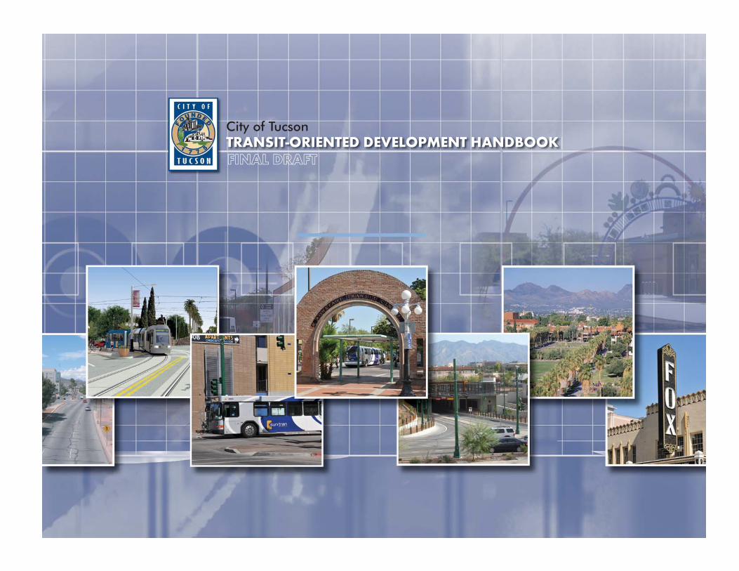
City of TucsonTRANSIT-ORIENTED DEVELOPMENT HANDBOOKFINAL DRAFT

THIS PAGE LEFT INTENTIONALLY BLANK
City of Tucson
TRANSIT-ORIENTED DEVELOPMENT HANDBOOKFINAL DRAFT
Prepared by
HDR | SR Beard & Associates
101 N. 1st Avenue
Suite 1950
Phoenix, AZ 85003
602.792.8800 Phone
602.385.1620 Fax
This document is a policy document intended for review and approval by the City of Tucson Mayor and Council. Portions of the document will be implemented through zoning associated with the Downtown Links project, which has a coterminous area. For areas in which Transit-Oriented Development zoning has not been implemented, this document should be used by project proponents seeking plan amendments through the Planning Commission or rezonings through the Zoning Examiner.
City of Tucson TRANSIT-ORIENTED DEVELOPMENT HANDBOOK
TABLE OF CONTENTS Introduction .................................................................................................................. 1The Tucson Streetcar Corridor .................................................................................................1
What is Transit-Oriented Development? ......................................................................... 4
Creating TOD................................................................................................................ 7
Mix of Uses in the Streetcar Corridor ............................................................................. 7
Compact Development in the Streetcar Corridor .......................................................... 10
Pedestrian Amenities in the Streetcar Corridor ............................................................ 12
Parking in the Streetcar Corridor .................................................................................. 15
Context Sensitive Design in the Streetcar Corridor ........................................................ 17
Streetcar and TOD ...................................................................................................... 18
Designing TOD in the Tucson Streetcar Corridor:
Conceptual Sketches and Renderings . ......................................................... 27
Peer Cities: Austin, TX, Tempe, AZ and Boulder, CO .......................................................... 31
Moving Forward – Development Approval in the Streetcar Corridor ............................. 34
Conclusion .................................................................................................................. 43
Acknowledgments ....................................................................................................... 44

THIS PAGE LEFT INTENTIONALLY BLANK
1
City of Tucson TRANSIT-ORIENTED DEVELOPMENT HANDBOOK
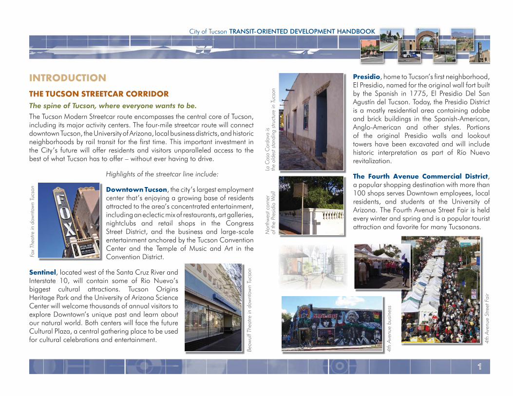
Presidio, home to Tucson’s first neighborhood, El Presidio, named for the original wall fort built by the Spanish in 1775, El Presidio Del San Agustín del Tucson. Today, the Presidio District is a mostly residential area containing adobe and brick buildings in the Spanish-American, Anglo-American and other styles. Portions of the original Presidio walls and lookout towers have been excavated and will include historic interpretation as part of Río Nuevo revitalization.
The Fourth Avenue Commercial District, a popular shopping destination with more than 100 shops serves Downtown employees, local residents, and students at the University of Arizona. The Fourth Avenue Street Fair is held every winter and spring and is a popular tourist attraction and favorite for many Tucsonans.
INTRODUCTIONTHE TUCSON STREETCAR CORRIDORThe spine of Tucson, where everyone wants to be.The Tucson Modern Streetcar route encompasses the central core of Tucson, including its major activity centers. The four-mile streetcar route will connect downtown Tucson, the University of Arizona, local business districts, and historic neighborhoods by rail transit for the first time. This important investment in the City’s future will offer residents and visitors unparalleled access to the best of what Tucson has to offer – without ever having to drive.
Highlights of the streetcar line include:
Downtown Tucson, the city’s largest employment center that’s enjoying a growing base of residents attracted to the area’s concentrated entertainment, including an eclectic mix of restaurants, art galleries, nightclubs and retail shops in the Congress Street District, and the business and large-scale entertainment anchored by the Tucson Convention Center and the Temple of Music and Art in the Convention District.
Sentinel, located west of the Santa Cruz River and Interstate 10, will contain some of Rio Nuevo’s biggest cultural attractions. Tucson Origins Heritage Park and the University of Arizona Science Center will welcome thousands of annual visitors to explore Downtown’s unique past and learn about our natural world. Both centers will face the future Cultural Plaza, a central gathering place to be used for cultural celebrations and entertainment.
Fox
Thea
tre in
dow
ntow
n Tu
cson
Beow
ulf T
heat
re in
dow
ntow
n Tu
cson
La C
asa
Cor
dova
isth
e ol
dest
sta
ndin
g st
ruct
ure
in T
ucso
n N
orth
wes
t cor
ner
of th
e Pr
esid
io W
all
4th
Aven
ue b
usin
ess
4th
Aven
ue S
treet
Fai
r
2
design, pedestrian amenities, parking, and stop circulation and access as they relate to transit-oriented development along the streetcar corridor. This handbook also considers the transportation network and varied community priorities of the Tucson area. The examples of Transit-Oriented Development in this Handbook are meant to illustrate policies and principles, not to suggest duplication of any particular design solution. Individual observation shall be made to determine the appropriateness of these examples in applying the concepts within this handbook.
In 2007, a market study was commissioned that examined the City’s Transit-Oriented Development potential. These findings are an important piece of the vision for Tucson’s streetcar corridor, as they provide a framework for development that the Tucson market can realistically support in each of its stops.
Several planning workshops were held with residents, neighborhood groups, advocacy organizations and other members of the Tucson community over the last year. The purpose of the workshops was to come up with a framework for future stop area redevelopment that will help establish a walkable, vibrant sense of place along the streetcar corridor.
A review of similar communities and the tools and strategies that they developed to capitalize on their rail and streetcar lines in generating walkable, Transit-Oriented Development that benefits existing residents, new residents, local employees, and visitors alike is important for providing a framework for future Transit-Oriented Development in Tucson. These were identified in the market study and are useful in highlighting the ways other cities have shifted their development paradigm to reflect their rail lines and how their development community and residents have benefited as a result.
Main Gate Business District, a bustling commercial center featuring restaurants, specialty shops selling the latest in fashion, gifts and sports apparel. Live music and a monthly farmers market can also be found here.
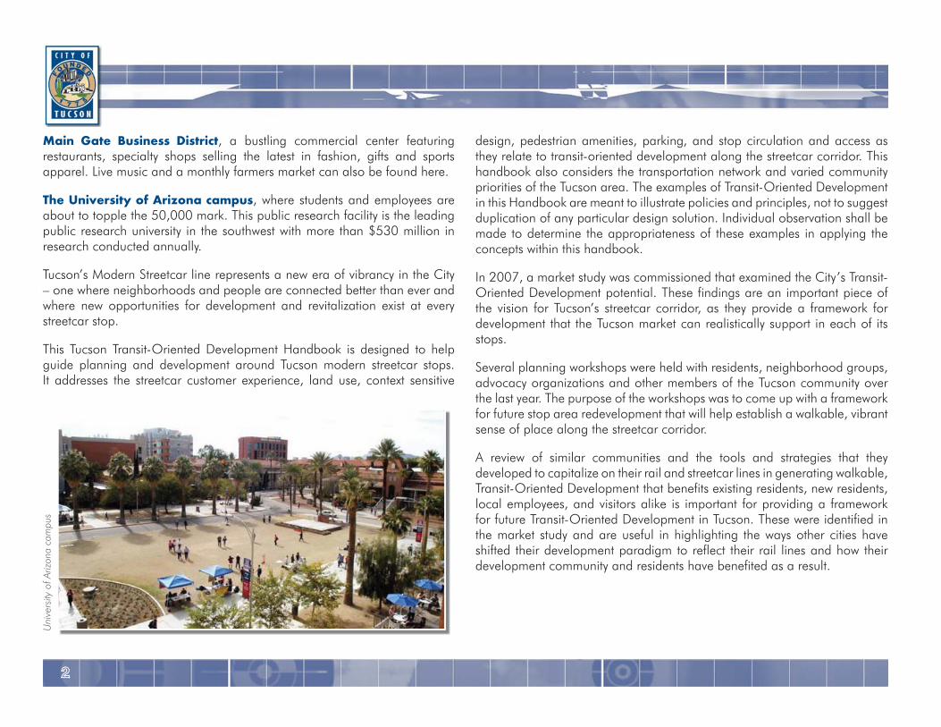
The University of Arizona campus, where students and employees are about to topple the 50,000 mark. This public research facility is the leading public research university in the southwest with more than $530 million in research conducted annually.
Tucson’s Modern Streetcar line represents a new era of vibrancy in the City – one where neighborhoods and people are connected better than ever and where new opportunities for development and revitalization exist at every streetcar stop.
This Tucson Transit-Oriented Development Handbook is designed to help guide planning and development around Tucson modern streetcar stops. It addresses the streetcar customer experience, land use, context sensitive
Uni
vers
ity o
f Ariz
ona
cam
pus
3
City of Tucson TRANSIT-ORIENTED DEVELOPMENT HANDBOOK
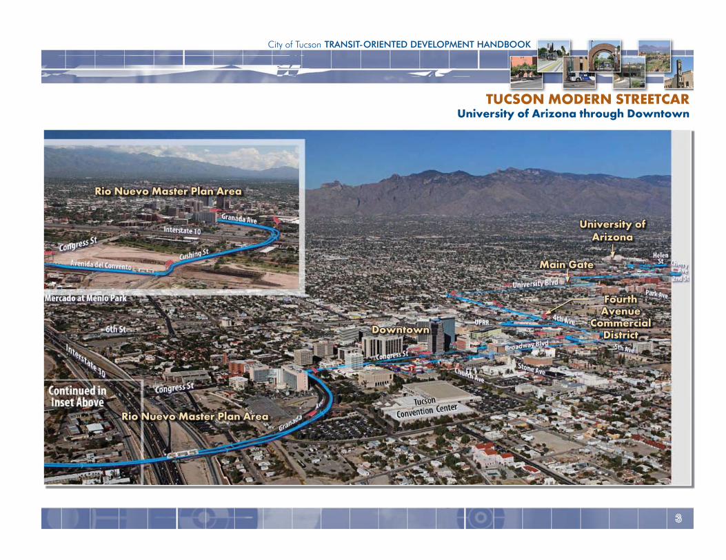
TUCSON MODERN STREETCARUniversity of Arizona through Downtown
Main Gate
University ofUniversity ofArizonaArizona
Fourth Fourth AvenueAvenue
CommercialDistrictDistrictDowntownDowntown
Rio Nuevo Master Plan AreaRio Nuevo Master Plan Area
Rio Nuevo Master Plan AreaRio Nuevo Master Plan Area
4
Benefits of Transit-Oriented Development include: Revitalization of declining areas
Improved accessibility to jobs
Generation of sales tax revenues
Affordable housing, creating a high-level of mobility for households on limited incomes
Opportunities for public/private partnerships
Increased property values
Improved foot traffic for retailers
Decrease in transportation costs for residents and workers
Access to a more diverse workforce
Reduction in automobile trips
Improved accessibility for cyclists
Providing a multi-modal environment
Characteristics of Transit-Oriented Development: Walkable, tree-lined streets that provide shade for pedestrians.
Buildings that front and are built to the street
Buildings with frequent windows and doors
Diverse, complimentary uses that encourage people to stroll, shop, meet, greet, and eat
A variety of compact housing in an assortment of styles
Consolidated parking structures providing more land for development
Reduced parking standards
Linkages to supporting land use and community amenities such as residential areas and parks
WHAT IS TRANSIT-ORIENTED DEVELOPMENT?Transit-Oriented Development (TOD) is a development pattern that is characterized by a mix of uses where buildings and uses cater to the pedestrian accessing the area via alternate modes of transportation. It typically incorporates compact development and dense activity centers within easy walking distance of transit stops (typically a half mile). It generally includes a mix of residential, employment and shopping opportunities designed for transit riders, cyclists, and pedestrians.
TOD includes new development or reconstruction whose design and orientation facilitate transit use. It tailors new development in the context of existing residential and business districts and emphasizes neighborhood, business, and historic preservation. Automobile use is still accommodated in a TOD, but is not treated as the sole or predominant mode of transportation.
A successful TOD should strive to accomplish the following goals: Enhance transit customer safety and convenience
Improve access to transit and pedestrian amenities
Create an attractive, dynamic stop area
Increase ridership and revenues for the Tucson streetcar
Improve system and stop operation efficiency
Take advantage of development opportunities and revenue generation for the City of Tucson
Increase sustainable development
Become major activity centers
Become an identifiable destination through unified streetscapes
5
City of Tucson TRANSIT-ORIENTED DEVELOPMENT HANDBOOK
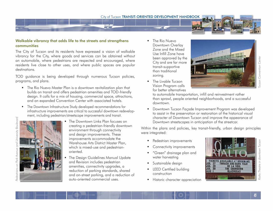
The Rio Nuevo Downtown Overlay Zone and the Mixed Use Infill Zone have been approved by the City and are far more transit-supportive than traditional zoning.
The Livable Tucson Vision Program calls for better alternatives to automobile transportation, infill and reinvestment rather than sprawl, people oriented neighborhoods, and a successful downtown.
Downtown Tucson Façade Improvement Program was developed to assist in the preservation or restoration of the historical visual character of Downtown Tucson and improve the appearance of Downtown streetscapes in anticipation of the streetcar.
Within the plans and policies, key transit-friendly, urban design principles were integrated:
Pedestrian improvements
Connectivity improvements
“Green” drainage plan and water harvesting
Sustainable design
LEED Certified building construction
Historic character appreciation
Walkable vibrancy that adds life to the streets and strengthens communities
The City of Tucson and its residents have expressed a vision of walkable vibrancy for the City, where goods and services can be obtained without an automobile, where pedestrians are respected and encouraged, where residents live close to other uses, and where public spaces are popular destinations.
TOD guidance is being developed through numerous Tucson policies, programs, and plans.
The Rio Nuevo Master Plan is a downtown revitalization plan that builds on transit and offers pedestrian amenities and TOD-friendly design. It calls for a mix of housing, commercial space, attractions, and an expanded Convention Center with associated hotels.
The Downtown Infrastructure Study developed recommendations for infrastructure improvements are critical to successful downtown redevelop-ment, including pedestrian/streetscape improvements and transit.
The Downtown Links Plan focuses on creating a pedestrian-friendly downtown environment through connectivity and design improvements. These improvements accommodate the Warehouse Arts District Master Plan, which is mixed-use and pedestrian-oriented.
The Design Guidelines Manual Update and Revision includes pedestrian amenities, connectivity upgrades, a reduction of parking standards, shared and on-street parking, and a reduction of auto-oriented commercial uses. Pe
dest
rians
on
Park
Ave
nue
and
Uni
vers
ity B
oule
vard
Tucs
on C
onve
ntio
n C
ente
rRi
alto
The
atre
in d
ownt
own
Tucs
on
6
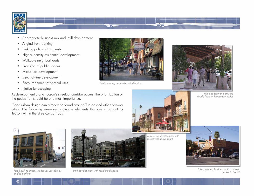
Appropriate business mix and infill development
Angled front parking
Parking policy adjustments
Higher-density residential development
Walkable neighborhoods
Provision of public spaces
Mixed-use development
Zero-lot-line development
Encouragement of vertical uses
Native landscaping
As development along Tucson’s streetcar corridor occurs, the prioritization of the pedestrian should be of utmost importance.
Good urban design can already be found around Tucson and other Arizona cities. The following examples showcase elements that are important to Tucson within the streetcar corridor.
Mixed-use development with residential above retail
Wide pedestrian pathway, shade feature, landscape buffer
Retail built to street, residential use above, angled parking
Public spaces, pedestrian prioritization
Infill development with residential space Public spaces, business built to street, access to transit
7
City of Tucson TRANSIT-ORIENTED DEVELOPMENT HANDBOOK
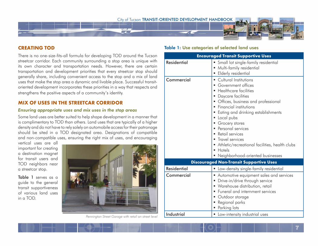
Table 1: Use categories of selected land uses
Encouraged Transit Supportive UsesResidential Small lot single-family residential
Multi-family residential Elderly residential
Commercial Cultural Institutions Government offices Healthcare facilities Daycare facilities Offices, business and professional Financial institutions Eating and drinking establishments Local pubs Grocery stores Personal services Retail services Travel services Athletic/recreational facilities, health clubs Hotels Neighborhood-oriented businesses
Discouraged Non-Transit Supportive UsesResidential Low-density single-family residentialCommercial Automotive equipment sales and services
Drive-in/drive through service Warehouse distribution, retail Funeral and internment services Outdoor storage Regional parks Parking lots
Industrial Low-intensity industrial uses
CREATING TODThere is no one-size-fits-all formula for developing TOD around the Tucson streetcar corridor. Each community surrounding a stop area is unique with its own character and transportation needs. However, there are certain transportation and development priorities that every streetcar stop should generally share, including convenient access to the stop and a mix of land uses that make the stop area a dynamic and livable place. Successful transit-oriented development incorporates these priorities in a way that respects and strengthens the positive aspects of a community’s identity.
MIX OF USES IN THE STREETCAR CORRIDOREnsuring appropriate uses and mix uses in the stop areas Some land uses are better suited to help shape development in a manner that is complimentary to TOD than others. Land uses that are typically of a higher density and do not have to rely solely on automobile access for their patronage should be sited in a TOD designated area. Designations of compatible and non-compatible uses, ensuring the right mix of uses, and encouraging vertical uses are all important for creating a destination magnet for transit users and TOD neighbors near a streetcar stop.
Table 1 serves as a guide to the general transit supportiveness of various land uses in a TOD.
Pennington Street Garage with retail on street level
8
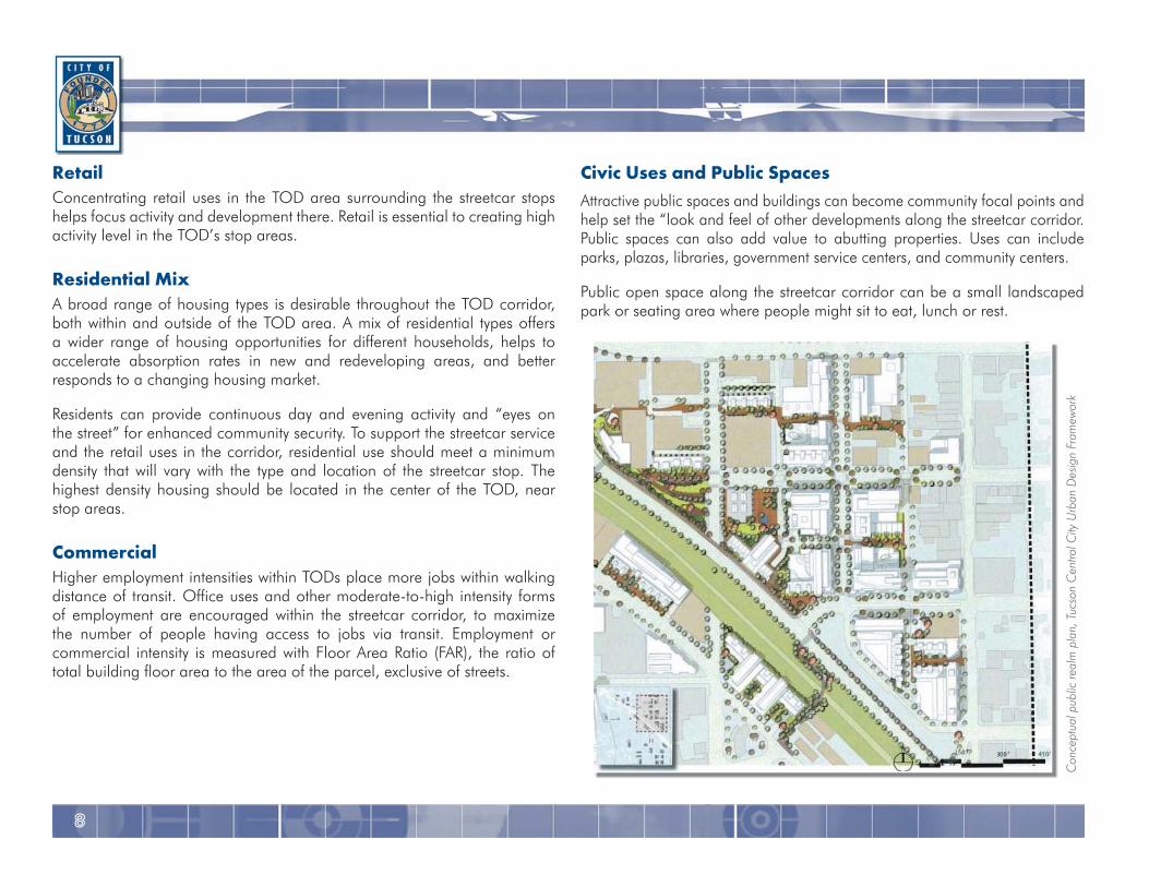
Civic Uses and Public SpacesAttractive public spaces and buildings can become community focal points and help set the “look and feel of other developments along the streetcar corridor. Public spaces can also add value to abutting properties. Uses can include parks, plazas, libraries, government service centers, and community centers.
Public open space along the streetcar corridor can be a small landscaped park or seating area where people might sit to eat, lunch or rest.
RetailConcentrating retail uses in the TOD area surrounding the streetcar stops helps focus activity and development there. Retail is essential to creating high activity level in the TOD’s stop areas.
Residential MixA broad range of housing types is desirable throughout the TOD corridor, both within and outside of the TOD area. A mix of residential types offers a wider range of housing opportunities for different households, helps to accelerate absorption rates in new and redeveloping areas, and better responds to a changing housing market.
Residents can provide continuous day and evening activity and “eyes on the street” for enhanced community security. To support the streetcar service and the retail uses in the corridor, residential use should meet a minimum density that will vary with the type and location of the streetcar stop. The highest density housing should be located in the center of the TOD, near stop areas.
CommercialHigher employment intensities within TODs place more jobs within walking distance of transit. Office uses and other moderate-to-high intensity forms of employment are encouraged within the streetcar corridor, to maximize the number of people having access to jobs via transit. Employment or commercial intensity is measured with Floor Area Ratio (FAR), the ratio of total building floor area to the area of the parcel, exclusive of streets.
Con
cept
ual p
ublic
real
m p
lan,
Tuc
son
Cen
tral C
ity U
rban
Des
ign
Fram
ewor
k

9
City of Tucson TRANSIT-ORIENTED DEVELOPMENT HANDBOOK
In Tempe, AZ, guidelines are given for street frontage in relation to horizontal and vertical mixed uses.
Color images above from Community Design Principles, Tempe AZ
1010
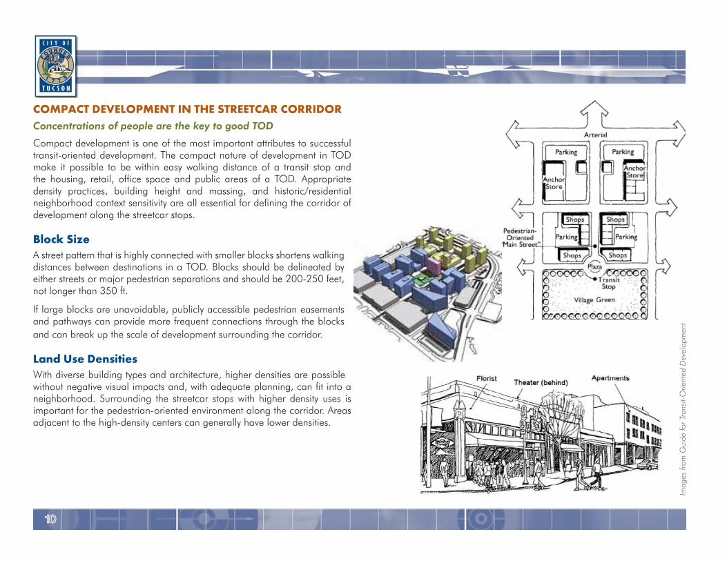
COMPACT DEVELOPMENT IN THE STREETCAR CORRIDORConcentrations of people are the key to good TOD
Compact development is one of the most important attributes to successful transit-oriented development. The compact nature of development in TOD make it possible to be within easy walking distance of a transit stop and the housing, retail, office space and public areas of a TOD. Appropriate density practices, building height and massing, and historic/residential neighborhood context sensitivity are all essential for defining the corridor of development along the streetcar stops.
Block SizeA street pattern that is highly connected with smaller blocks shortens walking distances between destinations in a TOD. Blocks should be delineated by either streets or major pedestrian separations and should be 200-250 feet, not longer than 350 ft.
If large blocks are unavoidable, publicly accessible pedestrian easements and pathways can provide more frequent connections through the blocks and can break up the scale of development surrounding the corridor.
Land Use DensitiesWith diverse building types and architecture, higher densities are possible without negative visual impacts and, with adequate planning, can fit into a neighborhood. Surrounding the streetcar stops with higher density uses is important for the pedestrian-oriented environment along the corridor. Areas adjacent to the high-density centers can generally have lower densities.
Imag
es fr
om G
uide
for T
rans
it-O
rient
ed D
evel
opm
ent
1111
City of Tucson TRANSIT-ORIENTED DEVELOPMENT HANDBOOK
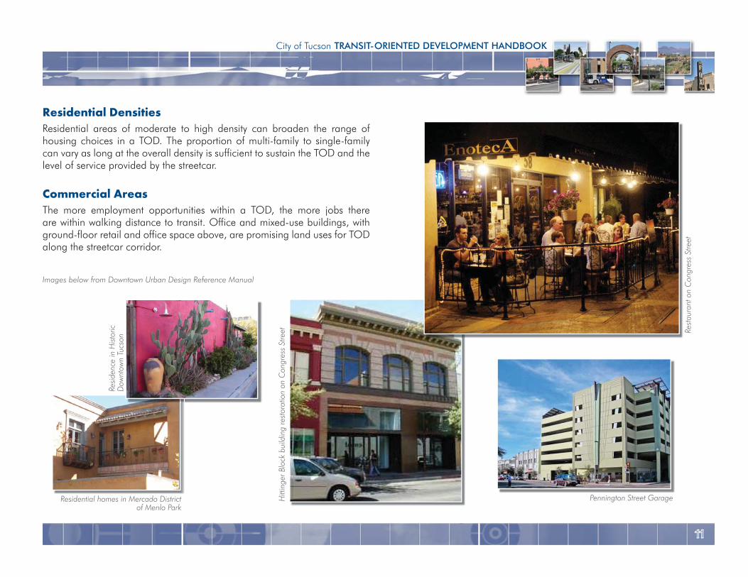
Residential Densities Residential areas of moderate to high density can broaden the range of housing choices in a TOD. The proportion of multi-family to single-family can vary as long at the overall density is sufficient to sustain the TOD and the level of service provided by the streetcar.
Commercial AreasThe more employment opportunities within a TOD, the more jobs there are within walking distance to transit. Office and mixed-use buildings, with ground-floor retail and office space above, are promising land uses for TOD along the streetcar corridor.
Rest
aura
nt o
n C
ongr
ess
Stre
et
Pennington Street GarageHitt
inge
r Blo
ck b
uild
ing
rest
orat
ion
on C
ongr
ess
Stre
etImages below from Downtown Urban Design Reference Manual
Residential homes in Mercado Districtof Menlo Park
Resi
denc
e in
His
toric
Dow
ntow
n Tu
cson
1212
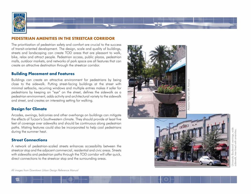
PEDESTRIAN AMENITIES IN THE STREETCAR CORRIDORThe prioritization of pedestrian safety and comfort are crucial to the success of transit-oriented development. The design, scale and quality of buildings, streets and landscaping can create TOD areas that are pleasant to walk, bike, relax and attract people. Pedestrian access, public plazas, pedestrian malls, outdoor markets, and networks of park space are all features that can create an attractive destination through the streetcar corridor.
Building Placement and FeaturesBuildings can create an attractive environment for pedestrians by being close to the sidewalk. Putting street-facing buildings at the street with minimal setbacks, recurring windows and multiple entries makes it safer for pedestrians by keeping an “eye” on the street, defines the sidewalk as a pedestrian environment, adds activity and architectural variety to the sidewalk and street, and creates an interesting setting for walking.
Design for ClimateArcades, awnings, balconies and other overhangs on buildings can mitigate the effects of Tucson’s Southwestern climate. They should provide at least five feet of coverage over sidewalks and should be continuous along pedestrian paths. Misting features could also be incorporated to help cool pedestrians during the summer heat.
Street ConnectionsA network of pedestrian-scaled streets enhances accessibility between the streetcar stop and the adjacent commercial, residential and civic areas. Streets with sidewalks and pedestrian paths through the TOD corridor will offer quick, direct connections to the streetcar stop and the surrounding areas.
Uni
vers
ity B
oule
vard
: aw
ning
s, w
ide
side
wal
k, tr
ee-li
ned
with
am
eniti
es.
Ariz
ona
Hot
el o
n 6t
h Av
enue
All images from Downtown Urban Design Reference Manual
1313
City of Tucson TRANSIT-ORIENTED DEVELOPMENT HANDBOOK
SidewalksThe design of sidewalks is crucial for transit-oriented development. A planting strip with street trees is one way to separate sidewalks from roadways. Street trees and planting strips enhance neighborhoods, separate pedestrians from cars, and shelter pedestrians from the hot summer sun.
Connections to Surrounding AreasStreet and rail connections should extend into adjacent areas to encourage walking and bicycling to the streetcar corridor surrounding services. Frequent street and rail connections in the surrounding area will encourage pedestrian and bicycle trips to the core and facilitate the use of the streetcar, retail, and public facilities by the surrounding area residents and employees.
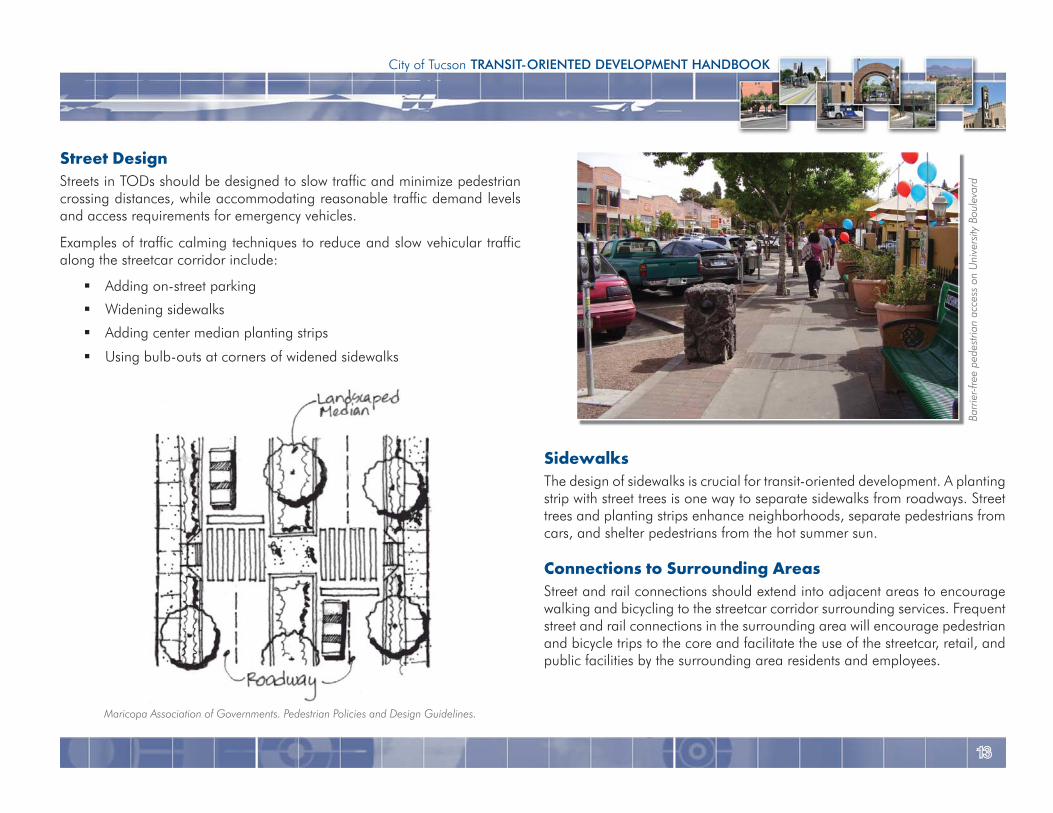
Street DesignStreets in TODs should be designed to slow traffic and minimize pedestrian crossing distances, while accommodating reasonable traffic demand levels and access requirements for emergency vehicles.
Examples of traffic calming techniques to reduce and slow vehicular traffic along the streetcar corridor include:
Adding on-street parking
Widening sidewalks
Adding center median planting strips
Using bulb-outs at corners of widened sidewalks
Barri
er-fr
ee p
edes
trian
acc
ess
on U
nive
rsity
Bou
leva
rd
Maricopa Association of Governments. Pedestrian Policies and Design Guidelines.
1414
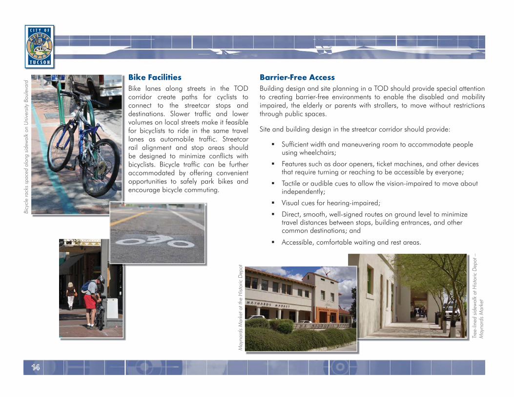
Barrier-Free AccessBuilding design and site planning in a TOD should provide special attention to creating barrier-free environments to enable the disabled and mobility impaired, the elderly or parents with strollers, to move without restrictions through public spaces.
Site and building design in the streetcar corridor should provide:
Sufficient width and maneuvering room to accommodate people using wheelchairs;
Features such as door openers, ticket machines, and other devices that require turning or reaching to be accessible by everyone;
Tactile or audible cues to allow the vision-impaired to move about independently;
Visual cues for hearing-impaired;
Direct, smooth, well-signed routes on ground level to minimize travel distances between stops, building entrances, and other common destinations; and
Accessible, comfortable waiting and rest areas.
Bike FacilitiesBike lanes along streets in the TOD corridor create paths for cyclists to connect to the streetcar stops and destinations. Slower traffic and lower volumes on local streets make it feasible for bicyclists to ride in the same travel lanes as automobile traffic. Streetcar rail alignment and stop areas should be designed to minimize conflicts with bicyclists. Bicycle traffic can be further accommodated by offering convenient opportunities to safely park bikes and encourage bicycle commuting.
Bicy
cle
rack
s sp
aced
alo
ng s
idew
alk
on U
nive
rsity
Bou
leva
rd
Tree
-line
d si
dew
alk
at H
isto
ric D
epot
–
May
nard
s M
arke
t
May
nard
s M
arke
t at t
he H
isto
ric D
epot
1515
City of Tucson TRANSIT-ORIENTED DEVELOPMENT HANDBOOK
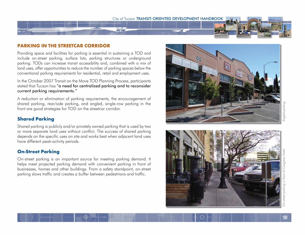
PARKING IN THE STREETCAR CORRIDORProviding space and facilities for parking is essential in sustaining a TOD and include on-street parking, surface lots, parking structures or underground parking. TODs can increase transit accessibility and, combined with a mix of land uses, offer opportunities to reduce the number of parking spaces below the conventional parking requirements for residential, retail and employment uses.
In the October 2007 Transit on the Move TOD Planning Process, participants stated that Tucson has “a need for centralized parking and to reconsider current parking requirements.”
A reduction or elimination of parking requirements, the encouragement of shared parking, rear/side parking, and angled, single-row parking in the front are good strategies for TOD on the streetcar corridor.
Shared ParkingShared parking is publicly and/or privately owned parking that is used by two or more separate land uses without conflict. The success of shared parking depends on the specific uses on site and works best when adjacent land uses have different peak-activity periods.
On-Street ParkingOn-street parking is an important source for meeting parking demand. It helps meet projected parking demand with convenient parking in front of businesses, homes and other buildings. From a safety standpoint, on-street parking slows traffic and creates a buffer between pedestrians and traffic.
Angl
ed p
arki
ng
On-
stre
et p
arki
ng in
fron
t of C
ongr
ess
Hot
el
1616
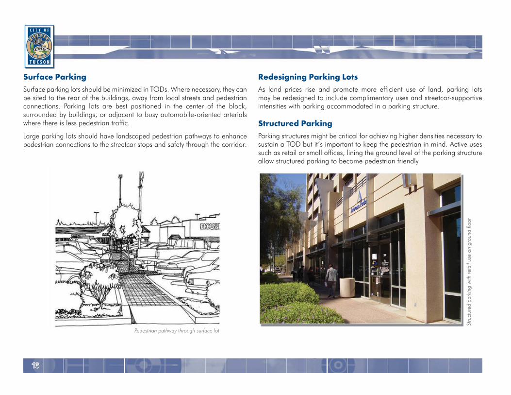
Redesigning Parking LotsAs land prices rise and promote more efficient use of land, parking lots may be redesigned to include complimentary uses and streetcar-supportive intensities with parking accommodated in a parking structure.
Structured ParkingParking structures might be critical for achieving higher densities necessary to sustain a TOD but it’s important to keep the pedestrian in mind. Active uses such as retail or small offices, lining the ground level of the parking structure allow structured parking to become pedestrian friendly.
Surface ParkingSurface parking lots should be minimized in TODs. Where necessary, they can be sited to the rear of the buildings, away from local streets and pedestrian connections. Parking lots are best positioned in the center of the block, surrounded by buildings, or adjacent to busy automobile-oriented arterials where there is less pedestrian traffic.
Large parking lots should have landscaped pedestrian pathways to enhance pedestrian connections to the streetcar stops and safety through the corridor.
Stru
ctur
ed p
arki
ng w
ith re
tail
use
on g
roun
d flo
or
Pedestrian pathway through surface lot
1717
City of Tucson TRANSIT-ORIENTED DEVELOPMENT HANDBOOK
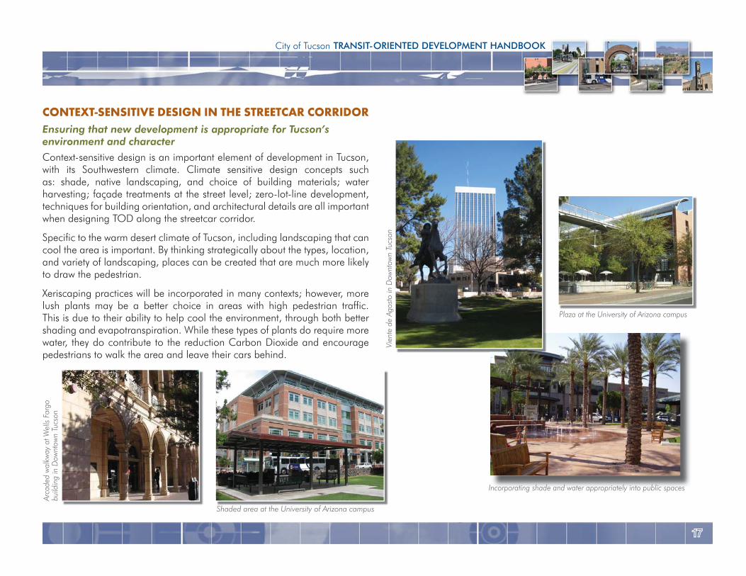
CONTEXT-SENSITIVE DESIGN IN THE STREETCAR CORRIDOREnsuring that new development is appropriate for Tucson’senvironment and characterContext-sensitive design is an important element of development in Tucson, with its Southwestern climate. Climate sensitive design concepts such as: shade, native landscaping, and choice of building materials; water harvesting; façade treatments at the street level; zero-lot-line development, techniques for building orientation, and architectural details are all important when designing TOD along the streetcar corridor.
Specific to the warm desert climate of Tucson, including landscaping that can cool the area is important. By thinking strategically about the types, location, and variety of landscaping, places can be created that are much more likely to draw the pedestrian.
Xeriscaping practices will be incorporated in many contexts; however, more lush plants may be a better choice in areas with high pedestrian traffic. This is due to their ability to help cool the environment, through both better shading and evapotranspiration. While these types of plants do require more water, they do contribute to the reduction Carbon Dioxide and encourage pedestrians to walk the area and leave their cars behind.
Incorporating shade and water appropriately into public spaces
Vien
te d
e Ag
osto
in D
ownt
own
Tucs
on
Shaded area at the University of Arizona campus
Arca
ded
wal
kway
at W
ells
Farg
obu
ildin
g in
Dow
ntow
n Tu
cson
Plaza at the University of Arizona campus
1818
Process The WorkshopsTwo rounds of workshops were conducted in order to share information with the community and provide a forum for their questions and concerns. The intent of the first workshop was to:
Educate the public about TOD and what makes it successful
Educate landowners about investment in transit and the types of development that can be successful within TOD
Introduce the process, the draft TOD boundaries and general goals of the work program
Provide citizens the opportunity to offer input regarding the stops
Discuss the strengths and challenges within the stop areas
Discuss new opportunities related to area revitalization and implementation of the modern streetcar
After presentations were given about TOD and the process developed for Tucson, the attendees broke into discussion groups. They were encouraged to share information about their property and the type of infill that they envisioned for the area. The following is what was expressed:
Need for more pedestrians, less cars
Need for a common vision
Parking is problematic; need centralized parking
The group expressed support for:
Mixed-use development
Additional residential development
Increased density
STREETCAR AND TODApproachThe purpose of the TOD study was to explore the opportunities that exist for development and preservation around the streetcar stops. The areas impacted by the addition of transit are defined by a ¼-mile radius around each stop. The stops on the east end of the transit corridor were chosen as the subject of further planning designed to provide a blue print for future development, revitalization, and rezoning. With evaluation through both a market study and series of public workshops, a set of design guidelines that addresses use and function of the area, scale, height, massing and other urban design characteristics will be created to accompany final stop designs.
The stop areas for consideration:
4th Avenue/8th Street
4th Avenue/mid-block between 7th and 6th streets
University Boulevard/Tyndall Avenue (Main Gate)
Helen Street/Campbell Avenue (end-of-the-line stop)
The areas around these stops are described below:
The Fourth Avenue commercial district is a popular shopping destination serving Downtown employees and local residents, as well as being oriented toward the students at the University of Arizona.
The University and Tyndall stop area is located at the western edge of the University of Arizona making it home to an increasingly vibrant and high-performing area for retail and restaurants at Main Gate Square.
The Helen and Campbell stop area is located at the northeast corner of the University of Arizona campus, adjacent to both the campus (including the Arizona Health Sciences Center and University Medical Center) and upscale residential neighborhoods.
1919
City of Tucson TRANSIT-ORIENTED DEVELOPMENT HANDBOOK
“New residential opportunities; an exciting mix of cultural attractions; arts, entertainment, restaurants, and retail; a pedestrian-friendly environment;
and abundant natural landscaping.” (Rio Nuevo Master Plan, 2001)
“Create a pedestrian-friendly downtown environment through connectivity and design improvements”
(Downtown Links, 2007)
“Ensure that the necessary infrastructure is in place to support downtown development as it occurs and to meet the public’s goals of a thriving and
vital downtown district.”(Downtown Infrastructure Study, May 2007)
Tucson Modern Streetcar Station Area Market AnalysisAs part of the process, a market study examined the City’s Transit-Oriented Development potential. The analysis provided information with relation to the specific stop areas, as well as, a regional overview. The purpose was to identify the types and amount of development best-suited for the specific stop areas and to consider the current and future market and economic conditions for the area. The market study findings provided a framework for realistic development types that the Tucson market can support in its stop areas. The study also identified future TOD trends that may have yet to emerge in the local market. With these different factors assessed, the study was able to evaluate opportunities for redevelopment or preservation of sites and districts. These opportunity sites are detailed further in the following section.
Multi-story buildings/gradual increases in height
Creating a regional destination and attracting a broader range of clientele
Creating public gathering spaces along the street front and mid-block
They also stated some development challenges that they had experienced. These included:
Parking requirements
Redevelopment process
Need for development standards to support urban infill
The second series of workshops included two meetings. With the intent of this workshop to be more stop specific, one meeting was held pertaining to the two 4th Avenue stops and a second meeting focused on the University Boulevard/Tyndall Avenue (Main Gate) stop and the Helen Street/Campbell Avenue end of the line stop. With the public having participated throughout the workshops, their visions and goals were developed. Some of these were captured in the following quotes.
“The Modern Streetcar will be a defining element, focusing development pressures. The streetcar will create/enhance a pedestrian-friendly corridor
with increased densities and more mixed-use, transit-oriented development.” (Transit on the Move Citizens Liasion Group, June 2007)
“Mixed-use development, more residential development, increased density, multi-story buildings with a gradual increase in height”
(Transit on the Move TOD Planning Process, October 2007)
2020
Some of the findings include:
The Tucson region is one of the fastest-growing areas in the country, suggesting future demand for all types of housing. With Young Professionals and Empty Nesters accounting for more than half of expected growth, smaller housing product types, such as condominiums and lofts, will likely become more prevalent in the market.
Through 2020, 1.1 million square feet of office space is expected to develop. This high number is due to a lack of supply, a new courthouse complex under development, and university-related expansion.
Tucson’s job base is expected to grow, generating additional demand for office development, as well as retail space.
Tucson’s year round tourism market continues to make the central downtown and University of Arizona area prime hotel location with continued demand.
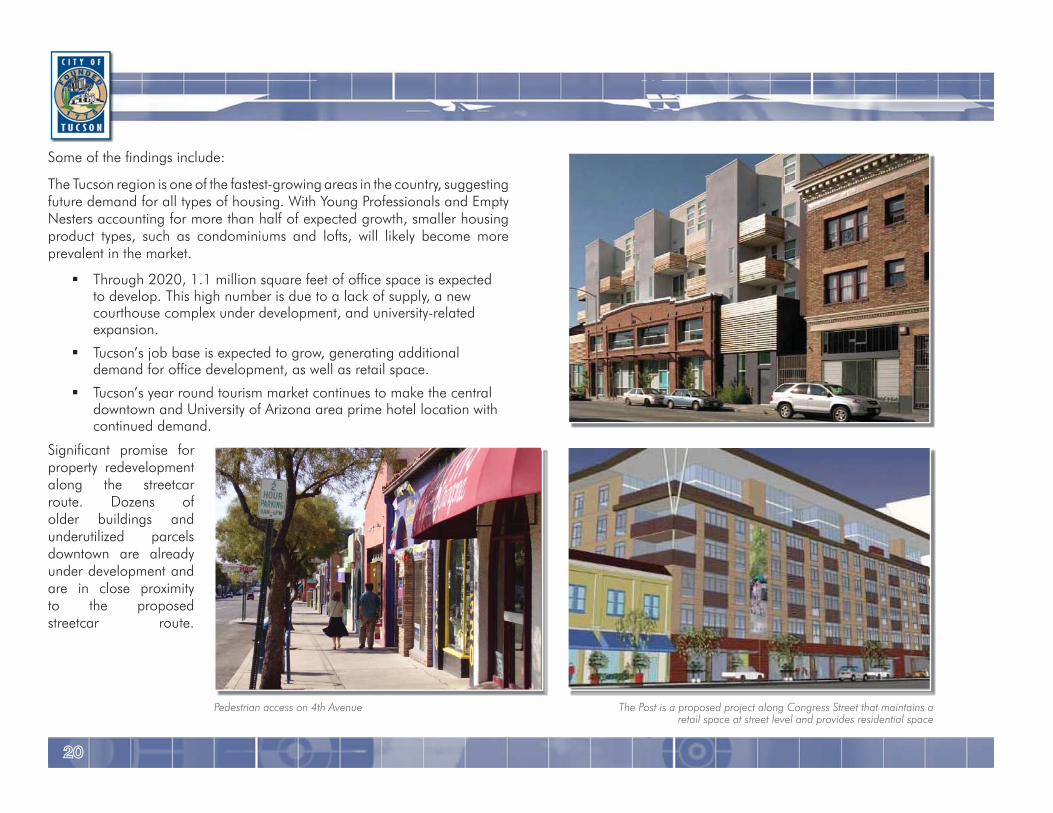
Significant promise for property redevelopment along the streetcar route. Dozens of older buildings and underutilized parcels downtown are already under development and are in close proximity to the proposed streetcar route.
The Post is a proposed project along Congress Street that maintains a retail space at street level and provides residential space
Pedestrian access on 4th Avenue
2121
City of Tucson TRANSIT-ORIENTED DEVELOPMENT HANDBOOK
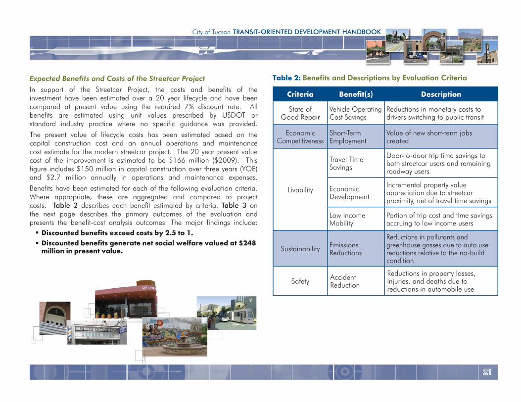
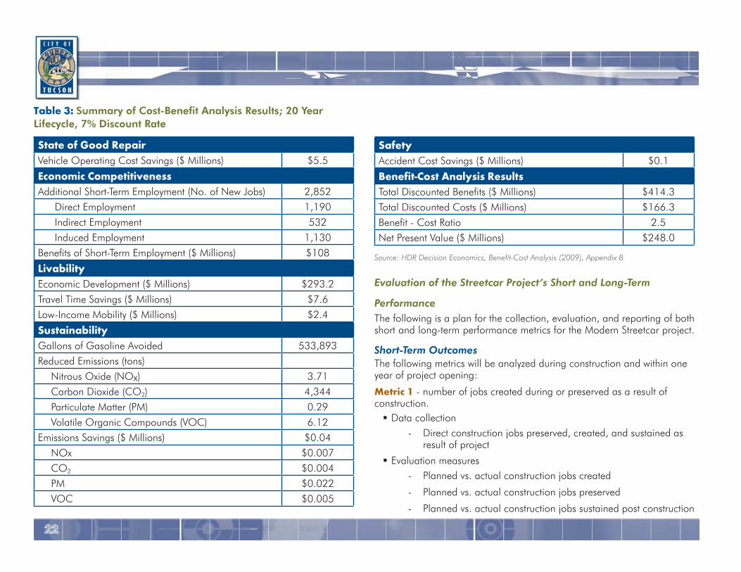
Expected Benefits and Costs of the Streetcar ProjectIn support of the Streetcar Project, the costs and benefits of the investment have been estimated over a 20 year lifecycle and have been compared at present value using the required 7% discount rate. All benefits are estimated using unit values prescribed by USDOT or standard industry practice where no specific guidance was provided.
The present value of lifecycle costs has been estimated based on the capital construction cost and an annual operations and maintenance cost estimate for the modern streetcar project. The 20 year present value cost of the improvement is estimated to be $166 million ($2009). This figure includes $150 million in capital construction over three years (YOE) and $2.7 million annually in operations and maintenance expenses.
Benefits have been estimated for each of the following evaluation criteria. Where appropriate, these are aggregated and compared to project costs. Table 2 describes each benefit estimated by criteria. Table 3 on the next page describes the primary outcomes of the evaluation and presents the benefit-cost analysis outcomes. The major findings include:
Discounted benefits exceed costs by 2.5 to 1. Discounted benefits generate net social welfare valued at $248 million in present value.
Table 2: Benefits and Descriptions by Evaluation Criteria
Criteria Benefit(s) Description
State ofGood Repair
Vehicle Operating Cost Savings
Reductions in monetary costs to drivers switching to public transit
Economic Competitiveness
Short-Term Employment
Value of new short-term jobs created
Livability
Travel Time Savings
Door-to-door trip time savings to both streetcar users and remaining roadway users
Economic Development
Incremental property value appreciation due to streetcar proximity, net of travel time savings
Low Income Mobility
Portion of trip cost and time savings accruing to low income users
Sustainability Emissions Reductions
Reductions in pollutants and greenhouse gasses due to auto use reductions relative to the no-build condition
Safety Accident Reduction
Reductions in property losses, injuries, and deaths due to reductions in automobile use
2222
Table 3: Summary of Cost-Benefit Analysis Results; 20 Year Lifecycle, 7% Discount Rate
State of Good RepairVehicle Operating Cost Savings ($ Millions) $5.5
Economic CompetitivenessAdditional Short-Term Employment (No. of New Jobs) 2,852
Direct Employment 1,190Indirect Employment 532Induced Employment 1,130
Benefits of Short-Term Employment ($ Millions) $108
LivabilityEconomic Development ($ Millions) $293.2Travel Time Savings ($ Millions) $7.6Low-Income Mobility ($ Millions) $2.4
SustainabilityGallons of Gasoline Avoided 533,893Reduced Emissions (tons)
Nitrous Oxide (NOx) 3.71Carbon Dioxide (CO2) 4,344Particulate Matter (PM) 0.29Volatile Organic Compounds (VOC) 6.12
Emissions Savings ($ Millions) $0.04NOx $0.007CO2 $0.004PM $0.022VOC $0.005
SafetyAccident Cost Savings ($ Millions) $0.1
Benefit-Cost Analysis ResultsTotal Discounted Benefits ($ Millions) $414.3Total Discounted Costs ($ Millions) $166.3Benefit - Cost Ratio 2.5Net Present Value ($ Millions) $248.0
Source: HDR Decision Economics, Benefit-Cost Analysis (2009), Appendix B
Evaluation of the Streetcar Project’s Short and Long-Term
Performance The following is a plan for the collection, evaluation, and reporting of both short and long-term performance metrics for the Modern Streetcar project.
Short-Term OutcomesThe following metrics will be analyzed during construction and within one year of project opening:
Metric 1 - number of jobs created during or preserved as a result of construction.
Data collection - Direct construction jobs preserved, created, and sustained as
result of project
Evaluation measures - Planned vs. actual construction jobs created
- Planned vs. actual construction jobs preserved
- Planned vs. actual construction jobs sustained post construction
2323
City of Tucson TRANSIT-ORIENTED DEVELOPMENT HANDBOOK
Metric 2 - Evaluate number and types of businesses created as a result of or that will directly benefit from construction and operation of Modern Streetcar.
Data collection - Business permits issued 6-months prior or less and within
½-mile radius of project.
Evaluation measures - Forecasted number of employees vs. actual
- Type of industry
Long-Term OutcomesThe following metrics will be analyzed after project has been open for one year or more:
Metric 1 - Quantify how project will improve existing transit system by providing better accessibility to a range of jobs in corridor
Data collection - Current employment by industry in corridor
- List of major employers, number of employees, distance from project
- Proposed employment by industry
Evaluation measures - Evaluate how existing employment changed; number and types
of employers in the corridor after the project opens vs. what was planned
Metric 2 - Measure improvement in accessibility for special populations in the proposed corridor.
Data collection - Corridor population figures on following groups before and
one year after project opening:
∙ Minority population ∙ Population whose income is below poverty level ∙ Number of zero-car households ∙ Persons with disabilities
- Statistics on use of major medical or social service facilities in corridor before and one year after project opening
∙ El Rio Community Health Center – currently serves 280,000 patients a year; many low income
Evaluation measures - Calculate changes to above populations between existing year
and one year after project opening
- Measure increase in patients accessing El Rio Community Health Center; controlling for increase in services, staff, etc.
Metric 3 - Capture improvements in energy efficiency and level of dependence on foreign oil between existing transit system and system with project operating.
Data collection - Inventory of current bus fleet by fuel type before project
opening
- Fuel costs by type and revenue mile before project opening
- Inventory of current bus fleet by fuel type after project opening
- Fuel costs by type and revenue mile after project opening
Evaluation measures - Calculate bus fuel costs by vehicle type both before and after
project opening
- Calculate rail fuel costs
- Calculate total system wide fuel costs for bus and rail; compare costs before and after project opening
2424
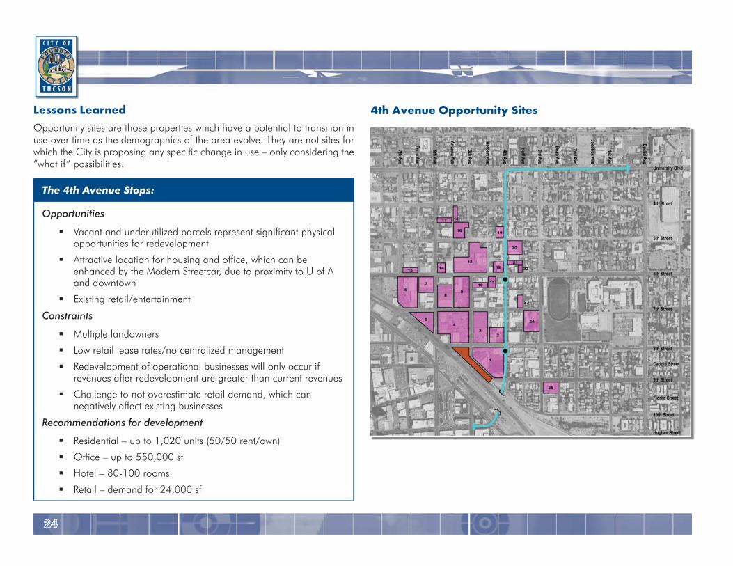
4th Avenue Opportunity SitesLessons Learned Opportunity sites are those properties which have a potential to transition in use over time as the demographics of the area evolve. They are not sites for which the City is proposing any specific change in use – only considering the “what if” possibilities.
The 4th Avenue Stops:
Opportunities
Vacant and underutilized parcels represent significant physical opportunities for redevelopment
Attractive location for housing and office, which can be enhanced by the Modern Streetcar, due to proximity to U of A and downtown
Existing retail/entertainment
Constraints
Multiple landowners
Low retail lease rates/no centralized management
Redevelopment of operational businesses will only occur if revenues after redevelopment are greater than current revenues
Challenge to not overestimate retail demand, which can negatively affect existing businesses
Recommendations for development
Residential – up to 1,020 units (50/50 rent/own)
Office – up to 550,000 sf
Hotel – 80-100 rooms
Retail – demand for 24,000 sf
2525
City of Tucson TRANSIT-ORIENTED DEVELOPMENT HANDBOOK
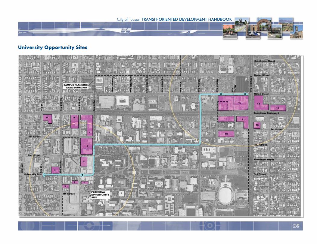
University Opportunity Sites
2626
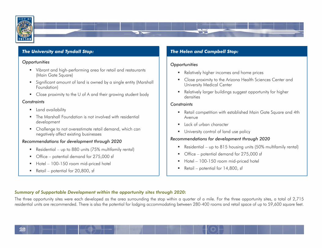
The University and Tyndall Stop:
Opportunities
Vibrant and high-performing area for retail and restaurants (Main Gate Square)
Significant amount of land is owned by a single entity (Marshall Foundation)
Close proximity to the U of A and their growing student body
Constraints
Land availability
The Marshall Foundation is not involved with residential development
Challenge to not overestimate retail demand, which can negatively affect existing businesses
Recommendations for development through 2020
Residential – up to 880 units (75% multifamily rental)
Office – potential demand for 275,000 sf
Hotel – 100-150 room mid-priced hotel
Retail – potential for 20,800, sf
Summary of Supportable Development within the opportunity sites through 2020:The three opportunity sites were each developed as the area surrounding the stop within a quarter of a mile. For the three opportunity sites, a total of 2,715 residential units are recommended. There is also the potential for lodging accommodating between 280-400 rooms and retail space of up to 59,600 square feet.
The Helen and Campbell Stop:
Opportunities
Relatively higher incomes and home prices
Close proximity to the Arizona Health Sciences Center and University Medical Center
Relatively larger buildings suggest opportunity for higher densities
Constraints
Retail competition with established Main Gate Square and 4th Avenue
Lack of urban character
University control of land use policy
Recommendations for development through 2020
Residential – up to 815 housing units (50% multifamily rental)
Office – potential demand for 275,000 sf
Hotel – 100-150 room mid-priced hotel
Retail – potential for 14,800, sf
2727
City of Tucson TRANSIT-ORIENTED DEVELOPMENT HANDBOOK
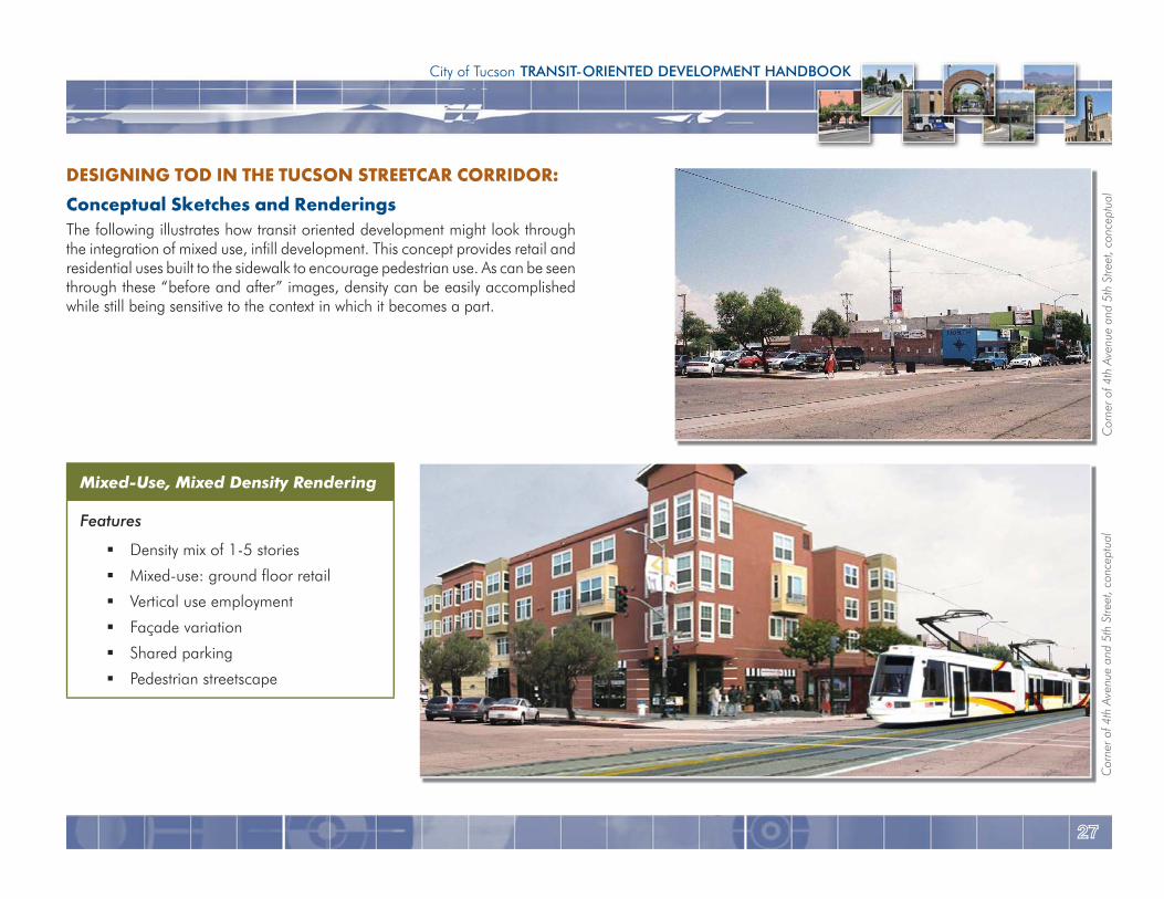
DESIGNING TOD IN THE TUCSON STREETCAR CORRIDOR:Conceptual Sketches and RenderingsThe following illustrates how transit oriented development might look through the integration of mixed use, infill development. This concept provides retail and residential uses built to the sidewalk to encourage pedestrian use. As can be seen through these “before and after” images, density can be easily accomplished while still being sensitive to the context in which it becomes a part.
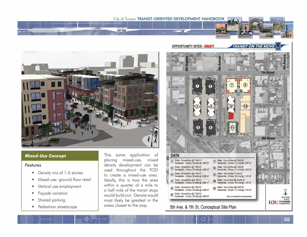
Mixed-Use, Mixed Density Rendering
Features
Density mix of 1-5 stories
Mixed-use: ground floor retail
Vertical use employment
Façade variation
Shared parking
Pedestrian streetscape
Cor
ner o
f 4th
Ave
nue
and
5th
Stre
et, c
once
ptua
lC
orne
r of 4
th A
venu
e an
d 5t
h St
reet
, con
cept
ual
2828
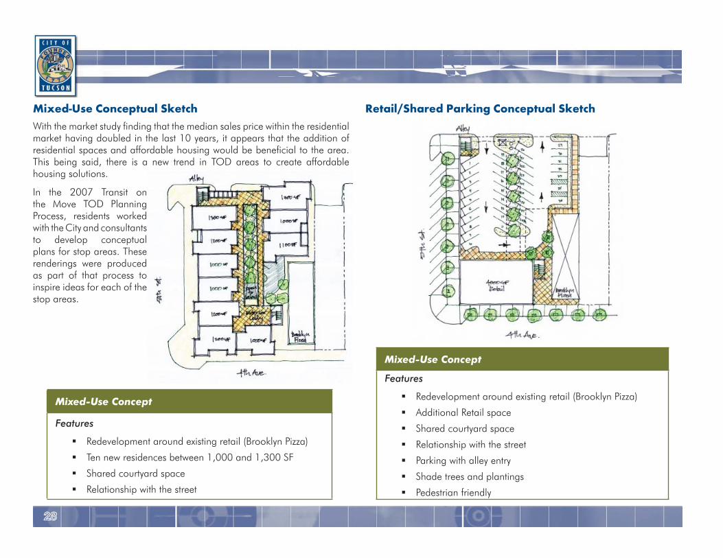
Retail/Shared Parking Conceptual SketchMixed-Use Conceptual SketchWith the market study finding that the median sales price within the residential market having doubled in the last 10 years, it appears that the addition of residential spaces and affordable housing would be beneficial to the area. This being said, there is a new trend in TOD areas to create affordable housing solutions.
In the 2007 Transit on the Move TOD Planning Process, residents worked with the City and consultants to develop conceptual plans for stop areas. These renderings were produced as part of that process to inspire ideas for each of the stop areas.
Mixed-Use Concept
Features
Redevelopment around existing retail (Brooklyn Pizza)
Ten new residences between 1,000 and 1,300 SF
Shared courtyard space
Relationship with the street
Mixed-Use Concept
Features
Redevelopment around existing retail (Brooklyn Pizza)
Additional Retail space
Shared courtyard space
Relationship with the street
Parking with alley entry
Shade trees and plantings
Pedestrian friendly
2929
City of Tucson TRANSIT-ORIENTED DEVELOPMENT HANDBOOK
This same application of placing mixed-use, mixed density development can be used throughout the TOD to create a mixed-use area. Ideally, this is how the area within a quarter of a mile to a half mile of the transit stops would build out. Density would most likely be greatest in the areas closest to the stop.
Mixed-Use Concept
Features
Density mix of 1-5 stories
Mixed-use: ground floor retail
Vertical use employment
Façade variation
Shared parking
Pedestrian streetscape
3030
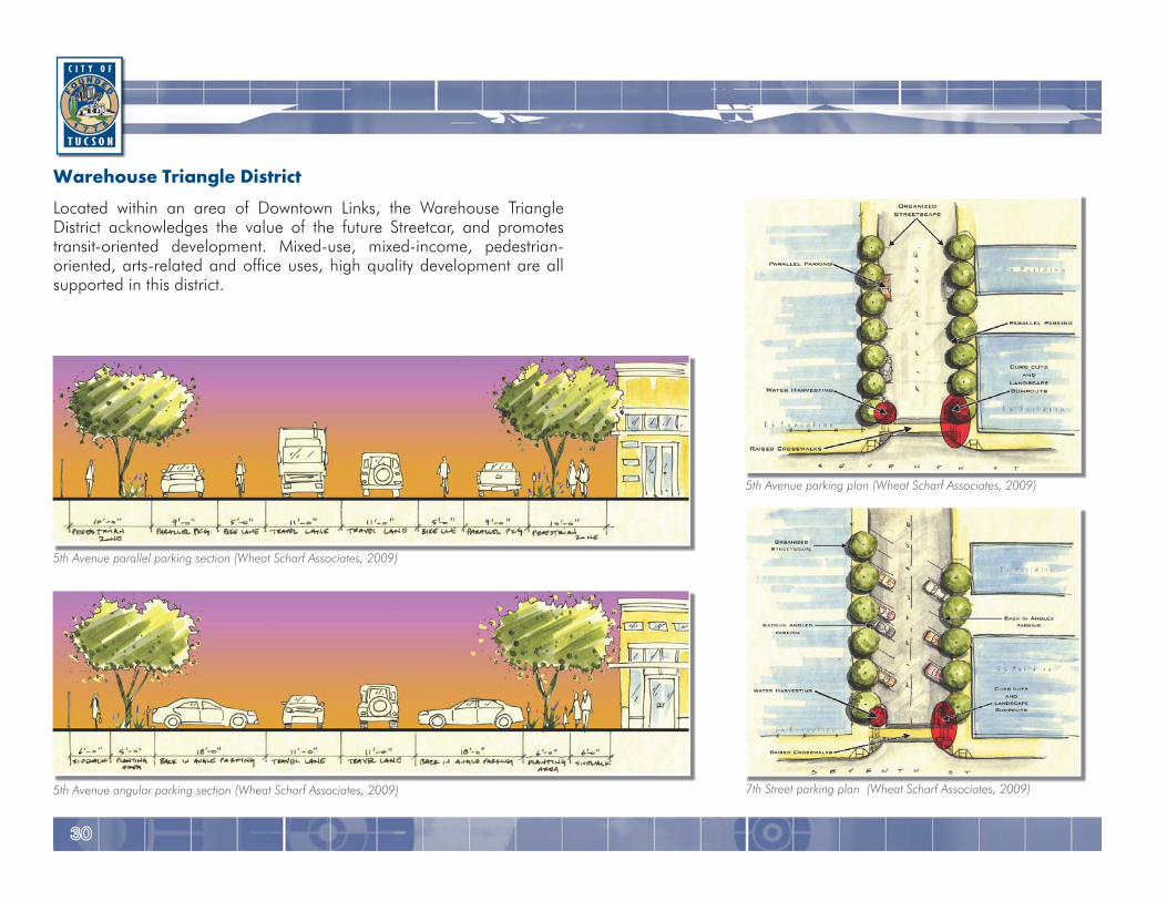
Warehouse Triangle DistrictLocated within an area of Downtown Links, the Warehouse Triangle District acknowledges the value of the future Streetcar, and promotes transit-oriented development. Mixed-use, mixed-income, pedestrian-oriented, arts-related and office uses, high quality development are all supported in this district.
5th Avenue parallel parking section (Wheat Scharf Associates, 2009)
5th Avenue angular parking section (Wheat Scharf Associates, 2009)
5th Avenue parking plan (Wheat Scharf Associates, 2009)
7th Street parking plan (Wheat Scharf Associates, 2009)
3131
City of Tucson TRANSIT-ORIENTED DEVELOPMENT HANDBOOK
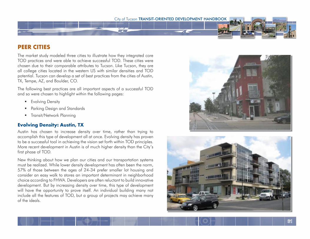
PEER CITIESThe market study modeled three cities to illustrate how they integrated core TOD practices and were able to achieve successful TOD. These cities were chosen due to their comparable attributes to Tucson. Like Tucson, they are all college cities located in the western US with similar densities and TOD potential. Tucson can develop a set of best practices from the cities of Austin, TX, Tempe, AZ, and Boulder, CO.
The following best practices are all important aspects of a successful TOD and so were chosen to highlight within the following pages:
Evolving Density
Parking Design and Standards
Transit/Network Planning
Evolving Density: Austin, TXAustin has chosen to increase density over time, rather than trying to accomplish this type of development all at once. Evolving density has proven to be a successful tool in achieving the vision set forth within TOD principles. More recent development in Austin is of much higher density than the City’s first phase of TOD.
New thinking about how we plan our cities and our transportation systems must be realized. While lower density development has often been the norm, 57% of those between the ages of 24-34 prefer smaller lot housing and consider an easy walk to stores an important determinant in neighborhood choice according to FHWA. Developers are often reluctant to build innovative development. But by increasing density over time, this type of development will have the opportunity to prove itself. An individual building many not include all the features of TOD, but a group of projects may achieve many of the ideals.
3232
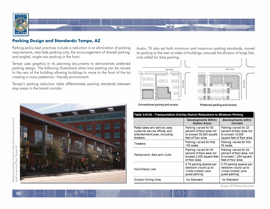
Parking Design and Standards: Tempe, AZParking policy best practices include a reduction in or elimination of parking requirements, rear/side parking only, the encouragement of shared parking, and angled, single-row parking in the front.
Tempe uses graphics in its planning documents to demonstrate preferred parking design. The following illustrations show how parking can be moved to the rear of the building allowing buildings to move to the front of the lot creating a more pedestrian- friendly environment.
Tempe’s parking reduction table differentiates parking standards between stop areas in the transit corridor.
Tempe, AZ Parking Standards
Rece
ssed
par
king
stru
ctur
e w
ith re
tail
at re
stau
rant
s an
dre
tail
at g
roun
d flo
or, T
empe
AZ
Austin, TX also set forth minimum and maximum parking standards, moved its parking to the rear or sides of buildings, ensured the division of large lots, and called for bike parking.
3333
City of Tucson TRANSIT-ORIENTED DEVELOPMENT HANDBOOK
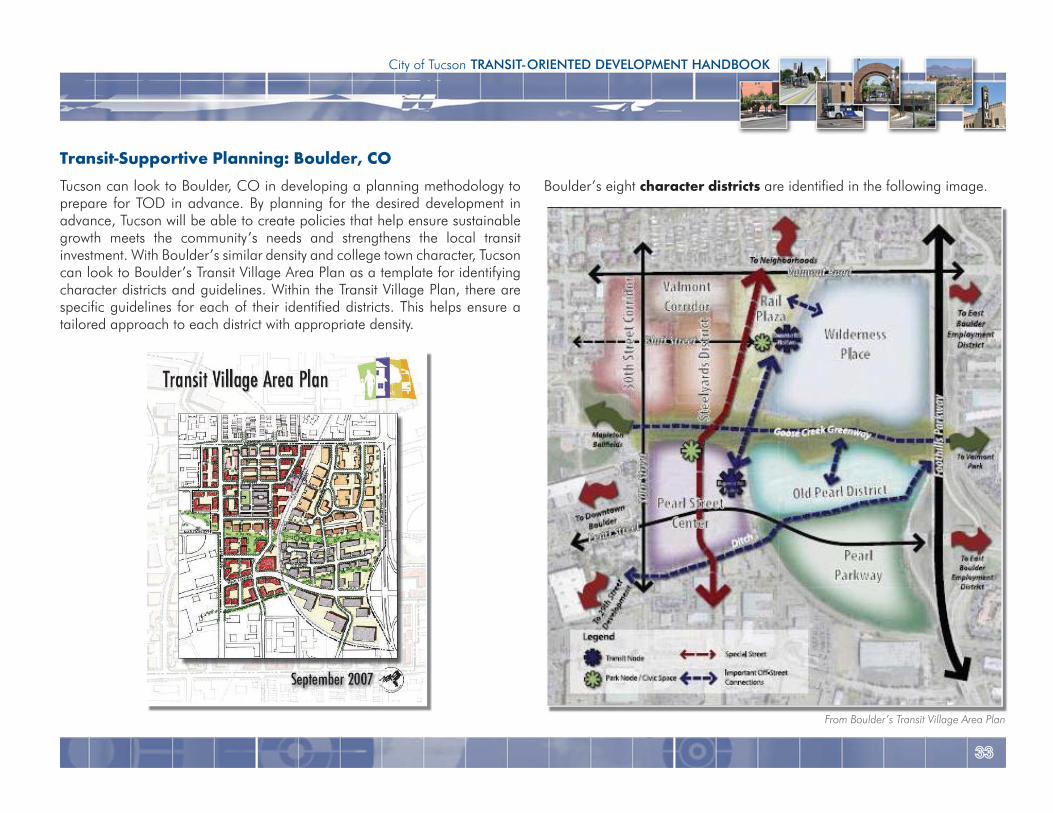
Boulder’s eight character districts are identified in the following image.
Transit-Supportive Planning: Boulder, COTucson can look to Boulder, CO in developing a planning methodology to prepare for TOD in advance. By planning for the desired development in advance, Tucson will be able to create policies that help ensure sustainable growth meets the community’s needs and strengthens the local transit investment. With Boulder’s similar density and college town character, Tucson can look to Boulder’s Transit Village Area Plan as a template for identifying character districts and guidelines. Within the Transit Village Plan, there are specific guidelines for each of their identified districts. This helps ensure a tailored approach to each district with appropriate density.
From Boulder’s Transit Village Area Plan
3434
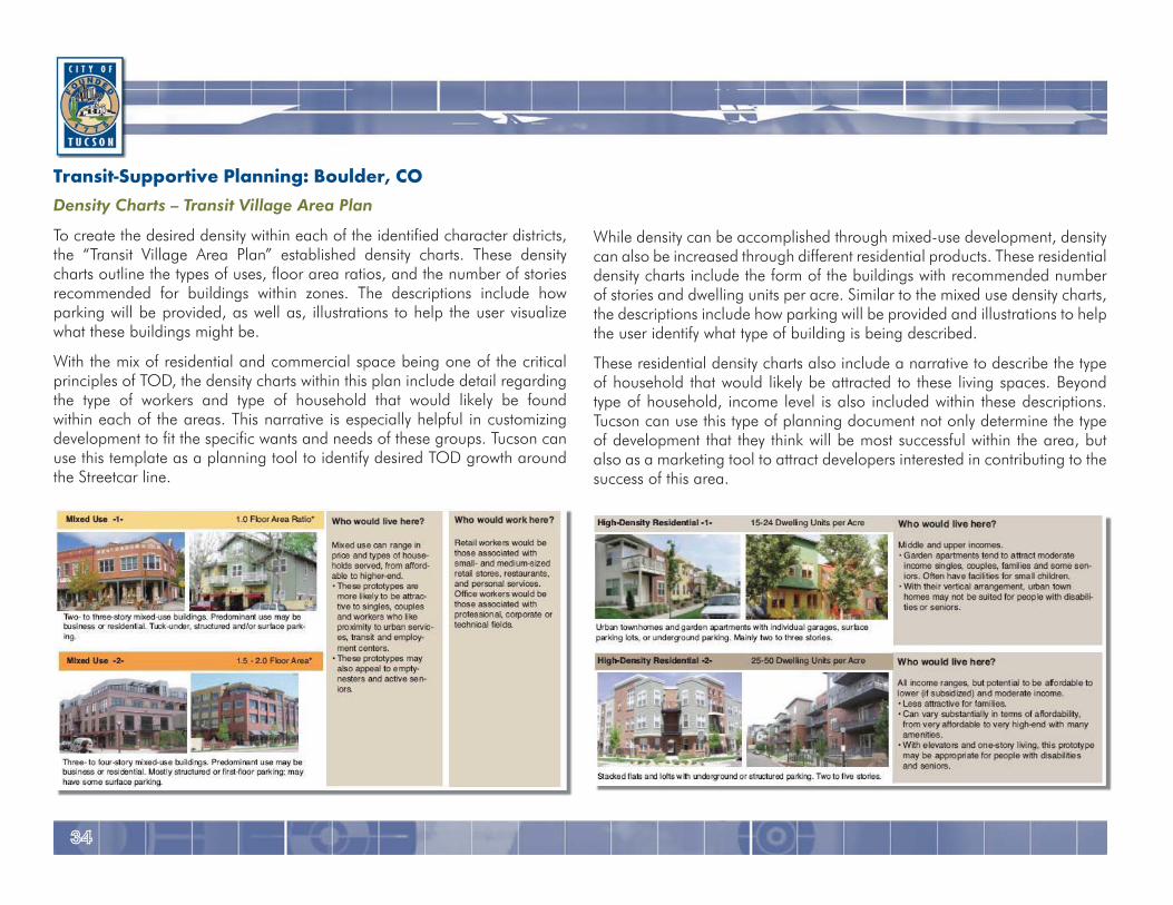
Transit-Supportive Planning: Boulder, CODensity Charts – Transit Village Area Plan
To create the desired density within each of the identified character districts, the “Transit Village Area Plan” established density charts. These density charts outline the types of uses, floor area ratios, and the number of stories recommended for buildings within zones. The descriptions include how parking will be provided, as well as, illustrations to help the user visualize what these buildings might be.
With the mix of residential and commercial space being one of the critical principles of TOD, the density charts within this plan include detail regarding the type of workers and type of household that would likely be found within each of the areas. This narrative is especially helpful in customizing development to fit the specific wants and needs of these groups. Tucson can use this template as a planning tool to identify desired TOD growth around the Streetcar line.
While density can be accomplished through mixed-use development, density can also be increased through different residential products. These residential density charts include the form of the buildings with recommended number of stories and dwelling units per acre. Similar to the mixed use density charts, the descriptions include how parking will be provided and illustrations to help the user identify what type of building is being described.
These residential density charts also include a narrative to describe the type of household that would likely be attracted to these living spaces. Beyond type of household, income level is also included within these descriptions. Tucson can use this type of planning document not only determine the type of development that they think will be most successful within the area, but also as a marketing tool to attract developers interested in contributing to the success of this area.
3535
City of Tucson TRANSIT-ORIENTED DEVELOPMENT HANDBOOK
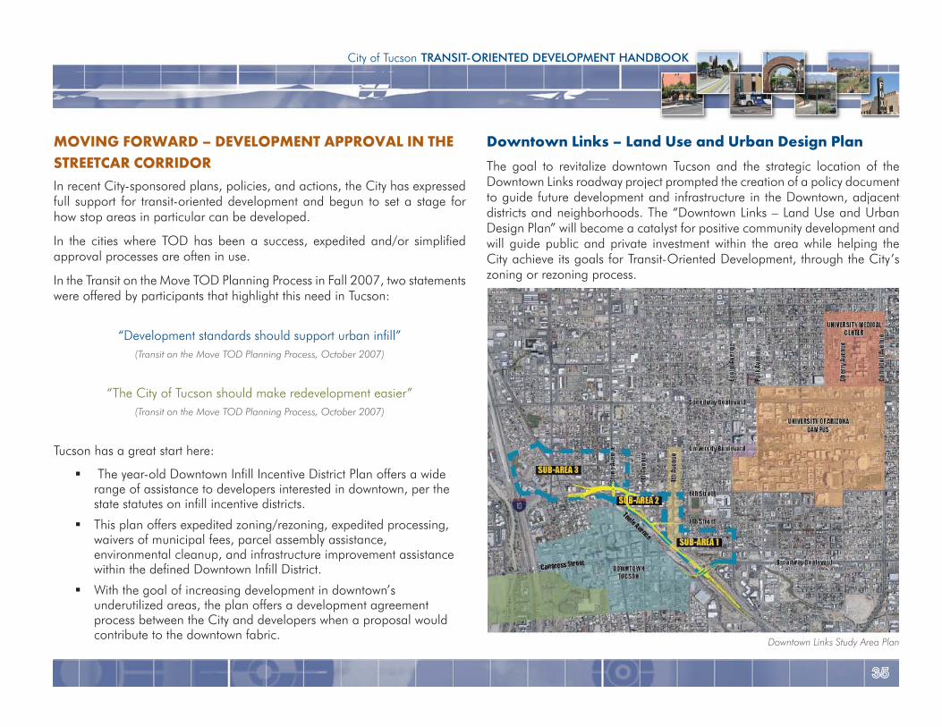
Downtown Links – Land Use and Urban Design PlanThe goal to revitalize downtown Tucson and the strategic location of the Downtown Links roadway project prompted the creation of a policy document to guide future development and infrastructure in the Downtown, adjacent districts and neighborhoods. The “Downtown Links – Land Use and Urban Design Plan” will become a catalyst for positive community development and will guide public and private investment within the area while helping the City achieve its goals for Transit-Oriented Development, through the City’s zoning or rezoning process.
MOVING FORWARD – DEVELOPMENT APPROVAL IN THE STREETCAR CORRIDORIn recent City-sponsored plans, policies, and actions, the City has expressed full support for transit-oriented development and begun to set a stage for how stop areas in particular can be developed.
In the cities where TOD has been a success, expedited and/or simplified approval processes are often in use.
In the Transit on the Move TOD Planning Process in Fall 2007, two statements were offered by participants that highlight this need in Tucson:
“Development standards should support urban infill” (Transit on the Move TOD Planning Process, October 2007)
“The City of Tucson should make redevelopment easier”(Transit on the Move TOD Planning Process, October 2007)
Tucson has a great start here:
The year-old Downtown Infill Incentive District Plan offers a wide range of assistance to developers interested in downtown, per the state statutes on infill incentive districts.
This plan offers expedited zoning/rezoning, expedited processing, waivers of municipal fees, parcel assembly assistance, environmental cleanup, and infrastructure improvement assistance within the defined Downtown Infill District.
With the goal of increasing development in downtown’s underutilized areas, the plan offers a development agreement process between the City and developers when a proposal would contribute to the downtown fabric.
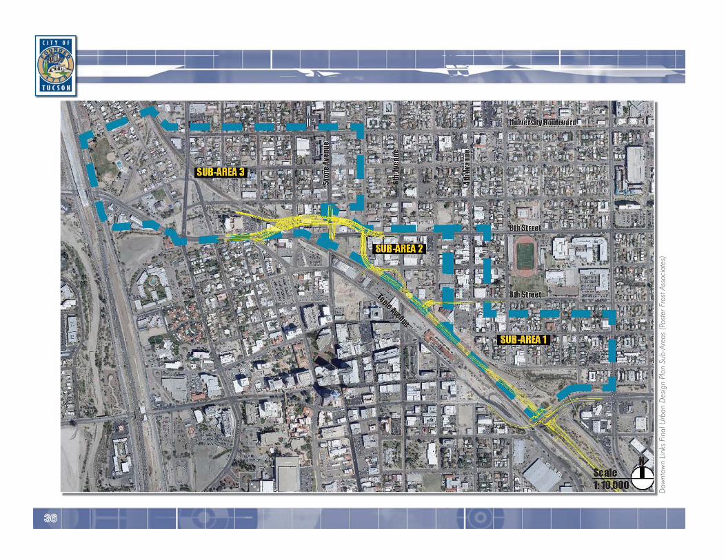
Downtown Links Study Area Plan
3636
Dow
ntow
n Li
nks
Fina
l Urb
an D
esig
n Pl
an S
ub-A
reas
(Pos
ter F
rost
Ass
ocia
tes)
3737
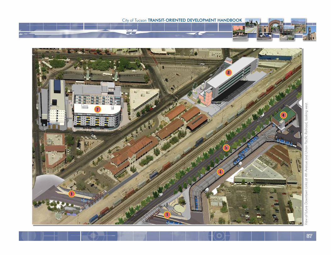
City of Tucson TRANSIT-ORIENTED DEVELOPMENT HANDBOOK
View
of f
utur
e D
ownt
own
Link
s at
4th
Ave
nue
and
Uni
on P
acifi
c Ra
ilroa
d, lo
okin
g w
est.
3838
Plan Opportunities
The intersection of Downtown Links and the planned Streetcar project will present a unique opportunity to incorporate and encourage new/infill development and support transit-oriented uses, while reinforcing the unique character and strengths of each adjoining neighborhood.
The goal of Downtown Links is to develop an implementable plan that carries forward the revitalization goals and objectives of Downtown, the adjacent neighborhoods, the adjacent districts, and the various property owners and stakeholders. The Downtown Links Urban Design Plan will be used to guide public and private investments within the study area. In addition, the Downtown Links project can provide some protection for critical and vulnerable historic resources.
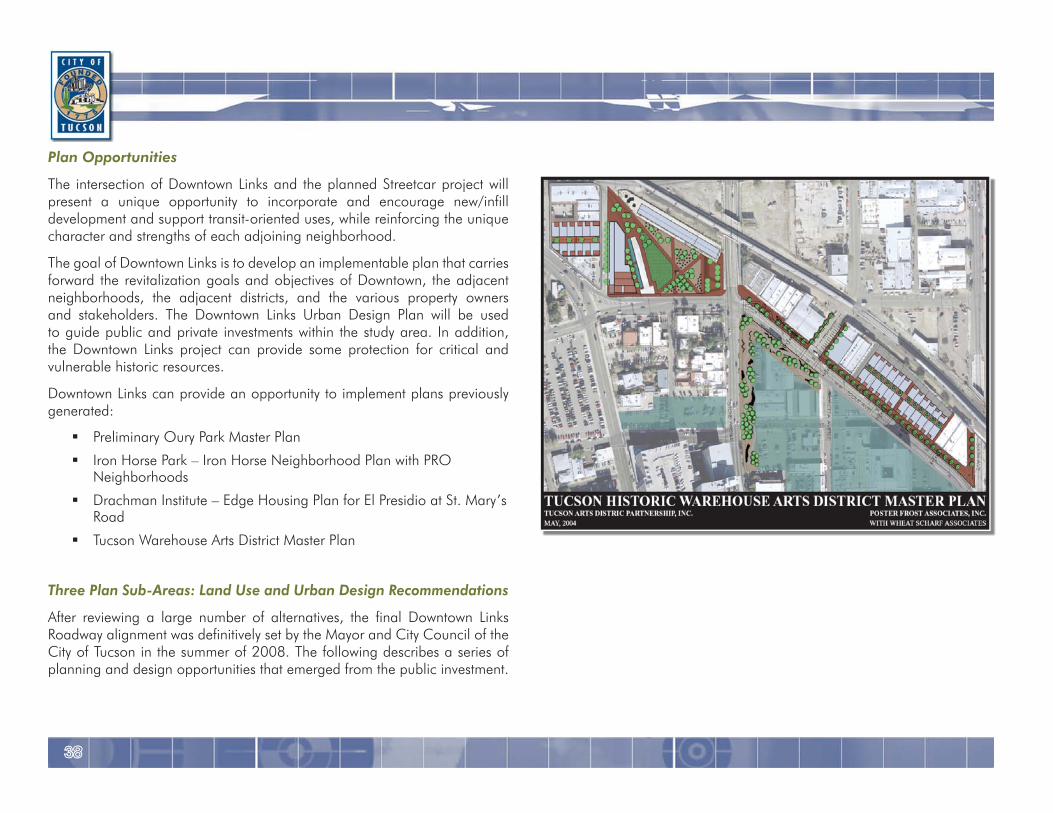
Downtown Links can provide an opportunity to implement plans previously generated:
Preliminary Oury Park Master Plan
Iron Horse Park – Iron Horse Neighborhood Plan with PRO Neighborhoods
Drachman Institute – Edge Housing Plan for El Presidio at St. Mary’s Road
Tucson Warehouse Arts District Master Plan
Three Plan Sub-Areas: Land Use and Urban Design Recommendations
After reviewing a large number of alternatives, the final Downtown Links Roadway alignment was definitively set by the Mayor and City Council of the City of Tucson in the summer of 2008. The following describes a series of planning and design opportunities that emerged from the public investment.
3939
City of Tucson TRANSIT-ORIENTED DEVELOPMENT HANDBOOK
- If owner chooses Overlay, the on-site parking requirement is waived entirely, unless the owner chooses to park on-site, which must then be in structure.
The guidelines within this TOD document, along with additional City supported plans, policies and actions further strengthen the opportunities for transit-oriented development outlined in the three Downtown Links Plan Sub-Areas below.
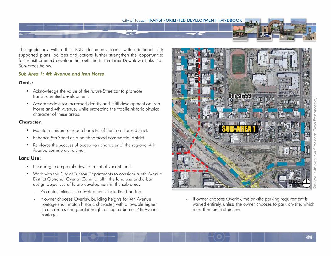
Sub Area 1: 4th Avenue and Iron Horse
Goals:
Acknowledge the value of the future Streetcar to promote transit-oriented development.
Accommodate for increased density and infill development on Iron Horse and 4th Avenue, while protecting the fragile historic physical character of these areas.
Character:
Maintain unique railroad character of the Iron Horse district.
Enhance 9th Street as a neighborhood commercial district.
Reinforce the successful pedestrian character of the regional 4th Avenue commercial district.
Land Use:
Encourage compatible development of vacant land.
Work with the City of Tucson Departments to consider a 4th Avenue District Optional Overlay Zone to fulfill the land use and urban design objectives of future development in the sub area.
- Promotes mixed-use development, including housing.
- If owner chooses Overlay, building heights for 4th Avenue frontage shall match historic character, with allowable higher street corners and greater height accepted behind 4th Avenue frontage.
Sub
Area
1: 4
th A
venu
e an
d Iro
n H
orse
(Pos
ter F
rost
Ass
ocia
tes)
4040
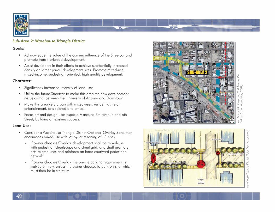
Sub-Area 2: Warehouse Triangle District
Goals:
Acknowledge the value of the coming influence of the Streetcar and promote transit-oriented development.
Assist developers in their efforts to achieve substantially increased density on larger parcel development sites. Promote mixed-use, mixed-income, pedestrian-oriented, high quality development.
Character:
Significantly increased intensity of land uses.
Utilize the future Streetcar to make this area the new development nexus district between the University of Arizona and Downtown
Make this area very urban with mixed-uses: residential, retail, entertainment, arts-related and office.
Focus art and design uses especially around 6th Avenue and 6th Street, building on existing success.
Land Use:
Consider a Warehouse Triangle District Optional Overlay Zone that encourages mixed-use with lot-by-lot rezoning of I-1 sites.
- If owner chooses Overlay, development shall be mixed-use with pedestrian streetscape and street grid, and shall promote arts-related uses and reinforce an inner courtyard pedestrian network.
- If owner chooses Overlay, the on-site parking requirement is waived entirely, unless the owner chooses to park on-site, which must then be in structure.
Iron
Hor
se 9
th S
treet
and
2nd
Ave
nue
Plan
(Whe
at S
char
f Ass
ocia
tes,
200
9)
War
ehou
se T
riang
le D
istric
t (Pe
ter F
rost
Asso
ciat
es)
4141
City of Tucson TRANSIT-ORIENTED DEVELOPMENT HANDBOOK
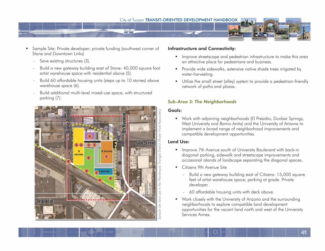
Infrastructure and Connectivity:
Improve streetscape and pedestrian infrastructure to make this area an attractive place for pedestrians and business.
Provide wide sidewalks, extensive native shade trees irrigated by water-harvesting.
Utilize the small street (alley) system to provide a pedestrian-friendly network of paths and plazas.
Sub-Area 3: The Neighborhoods
Goals:
Work with adjoining neighborhoods (El Presidio, Dunbar Springs, West University and Barrio Anita) and the University of Arizona to implement a broad range of neighborhood improvements and compatible development opportunities.
Land Use:
Improve 7th Avenue south of University Boulevard with back-in diagonal parking, sidewalk and streetscape improvements and occasional islands of landscape separating the diagonal spaces.
Citizens 9th Avenue Site
- Build a new gateway building east of Citizens: 15,000 square feet of artist warehouse space; parking at grade. Private developer.
- 60 affordable housing units with deck above.
Work closely with the University of Arizona and the surrounding neighborhoods to explore compatible land development opportunities for the vacant land north and west of the University Services Annex.
Sample Site: Private developer; private funding (southwest corner of Stone and Downtown Links)
- Save existing structures (3).
- Build a new gateway building east of Stone: 40,000 square foot artist warehouse space with residential above (5).
- Build 60 affordable housing units (steps up to 10 stories) above warehouse space (6).
- Build additional multi-level mixed-use space, with structured parking (7).
Sam
ple
site
land
use
in th
e W
areh
ouse
Tria
ngle
Dis
trict
(Pos
ter F
rost
Ass
ocia
tes)
4242
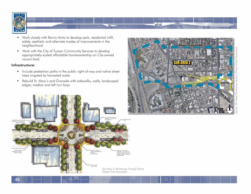
Work closely with Barrio Anita to develop park, residential infill, safety, aesthetic and alternate modes of improvements in the neighborhood.
Work with the City of Tucson Community Services to develop appropriately-scaled affordable homeownership on City-owned vacant land.
Infrastructure:
Include pedestrian paths in the public right-of-way and native street trees irrigated by harvested water
Rebuild St. Mary’s and Granada with sidewalks, walls, landscaped edges, median and left turn bays
Abov
e: 5
th S
treet
9th
Ave
nue
Sect
ion
(Whe
at S
char
f Ass
ocia
tes)
Sub Area 3: Warehouse Triangle District(Poster Frost Associates)
4343
City of Tucson TRANSIT-ORIENTED DEVELOPMENT HANDBOOK
Specific to the Tucson Modern Streetcar project, areas for further TOD study include the 4th Avenue commercial district, Main Gate business district, and the Arizona Health Sciences Center. The area impacted around each streetcar stop extends in a ¼-mile radius. At the conclusion of public workshops and presentations held during the station area market analysis, TOD was understood as being essential in solving many of the identified issues. The Tucson area anticipates fast growth and provides excellent market potential for Transit-Oriented Development.
Streetcar-related TOD is supplemented by several established and ongoing plans and projects in Tucson, including the Downtown Links Land Use and Urban Design Plan, Livable Tucson Vision Program, Design Guidelines Manual Update and Revision, Downtown Tucson Façade Improvement Program, and the Urban Design Reference Manual Draft. These plans and projects provide the opportunity to diversify land uses along the corridor, respect historic buildings, promote pedestrian-oriented streetscapes, adhere to design code and improve connectivity.
Pedestrians who will ride the streetcar will boost investment possibilities and generate revenue in the corridor. The guidelines in this handbook ensure that planning and development in the corridor create a positive customer experience, a mix of uses, compact development, pedestrian amenities, parking and stop circulation and access, and context sensitive design to provide Transit-Oriented Development for the central core of Tucson.
CONCLUSIONEncouraging transit-oriented development in Tucson
The four-mile Tucson Modern Streetcar route will connect major activity centers in Tucson: the Downtown corridor, 4th Avenue commercial district, Main Gate business district, University of Arizona campus, Arizona Health Sciences Center and historic neighborhoods along the route. Corresponding to the connection, this integral investment in the city will spur transit-oriented development, through infill and redevelopment opportunities in Tucson, while linking it collectively.
By catering to the pedestrian, transit-oriented development creates a livable and vibrant community fabric. Mixed-use development provides variety and accessibility, eliminating the need for personal vehicle use. Transit-Oriented Development also provides an economic boost, as the redevelopment increases property values and draws jobs and retail investments to the corridor. Compact development and a pedestrian friendly environment are the source for the success of any TOD plan.
Pedestrian amenities in the streetcar corridor are encouraged to provide minimal setbacks of buildings, shade, street connections, and wide sidewalks. Bicycle supportive services, such as dedicated lanes and convenient bike parking, are also important. Barrier-free environments are promoted to ensure accessibility along the corridor. Both on-street and structured parking will remain in the streetcar corridor, but the emphasis on the pedestrian will present features such as pathways that are safe for movement and linkages.
Climate sensitive design, especially in the Southwestern desert climate, plays an important role in redevelopment. Particular emphasis should be placed on appropriate landscaping, shading, water features, and building design.
4444
Resources
Reconnecting America. 2007. Why Transit-Oriented Development and Why Now? Prepared by Reconnecting America and the Center for Transit-Oriented Development.
San Francisco Bay Area Rapid Transit District. 2003.BART Transit-Oriented Development Guidelines.
Urban Land Institute. 2003. Ten Principles for Successful Development Around Transit. Prepared by Robert Dunphy, et al.
Consultant
HDR, Inc.
City of Tucson: Department of Transportation Planning Division
Jim Glock, Director
Andrew Singelakis, Deputy Director
Shellie Ginn, Project Manager
Melissa Antol, Project Manager
ACKNOWLEDGEMENTS
References
City of Tucson. 2007. Downtown Urban Design Reference Manual Draft. Prepared by Swaback Partners. Scottsdale, AZ.
City of Tucson. Tucson Downtown Strategy Plan.City of Tucson Web site.
Downtown Links, 2009. Final Land Use and Urban Design Plan.Prepared by Poster Frost Associates. Tucson, AZ.
March Joint Powers Authority. 2008. March Lifecare Campus Specific Plan Draft. Prepared by HDR, Inc. San Diego, CA.
Maricopa Association of Governments. 2005. Pedestrian Policies and Design Guidelines. Prepared by HDR, Inc. Phoenix, AZ.
Metropolitan Council. 2006. Guide for Transit-Oriented Development. Prepared by and for Metropolitan Council. St. Paul, MN.
Valley Metro Regional Public Transportation Authority. 2001.Pedestrian-oriented Design (PeD) Standards and Design Guidelines.Prepared by Community Design and Architecture, Inc. Oakland, CA.
City of Tucson: Department of Transportation Planning Division201 North Stone Avenue - 6th Floor
Tucson, AZ 85726-7210