Embed Size (px)
Citation preview
1
CITY OF HOUGHTON
NON-MOTORIZED TRANSPORTATION PLAN
2013
Contents Introduction......................................................................................................... 2
Vision Statement............................................................................................ 4 The Planning Process...................................................................................... 4
Existing Non-motorized Use & Facilities................................................................ 6 Non-motorized Goals & Strategies........................................................................ 9 Project Plan by Location........................................................................................ 11 Implementation Strategy...................................................................................... 14 Appendices......................................................................................................... 15
A) Houghton Complete Streets Ordinance........................................... 16 B) 2012 Bike & Pedestrian Survey Report............................................ 19 C) Houghton Bicycle & Pedestrian Crash Map...................................... 55 D) Houghton Safe Routes to School Plan............................................. 56 E) Bike-Friendly Community Rubric..................................................... 57 F) 2012 Michigan Tech Bike Boulevard Study....................................... 58 G) Michigan Tech Signage Plan............................................................ 66 H) Houghton Bicycle Parking Ordinance.............................................. 67
2
CITY OF HOUGHTON
NON-MOTORIZED TRANSPORTATION PLAN
2013
Introduction The City [hereafter, the City] offers many opportunities for non-motorized transportation, with more miles of trails than city streets. In accordance with the City’s Complete Streets ordinance (2010) (Appendix A), this Non-Motorized Transportation Plan documents current conditions, facilities and programs, and sets forth a vision, goals, and objectives to make Houghton more bike- and pedestrian-friendly for users of all ages and abilities. The Houghton Bike and Pedestrian Committee will conduct ongoing assessment, planning and evaluation, and make periodic reports to the Houghton City Council and its Planning Commission regarding implementation of Non-Motorized Transportation Plan elements, with emphasis on Complete Streets guidelines, Safe Routes to School plans, and maintenance of Bike-Friendly City status. Through long-term involvement and commitment by city officials and an informed citizenry, Houghton will strive to make walking and biking safe, convenient, and healthy transportation options. Community Overview Houghton is a vibrant community that is home to an active population and generous outdoor recreation opportunities. Community features include a revitalized downtown business zone and a developed waterfront path system featuring parks and water access as well as the campus of Michigan Technological University (MTU). Residents use non-motorized modes of travel to connect these key destinations within the City. Additionally, the area’s extensive off-road trail systems attract tourists interested in silent sports such as cross country skiing, hiking, and all forms of cycling. Due to community and visitor interest in recreation and healthy living, non-motorized travel has become an increasingly common form of transportation within the City. Cyclists and pedestrians require safe, convenient access between residential neighborhoods, schools, commercial zones and recreational destinations. Improvement of the City’s existing non-motorized network will allow users to easily navigate streets and paths using easy, clean, healthy, and energy-efficient modes of travel. The City supports the community’s commitment to healthy living and is dedicated to improving residents’ and visitors’ quality of life through the promotion of non-motorized travel.

3
Non-motorized user characteristics Non-motorized users in the City are a mix of commuters and those that travel for recreation or health. Out of the 695 respondents to the 2012 Houghton Bicycle & Pedestrian Survey (Appendix B), 526 were cyclists with 426 identifying themselves as bike commuters and 470 reporting that they rode for recreation. Similarly, 301 pedestrians completed the survey with 230 identifying themselves as commuters and 241 reporting that they walk for recreation. Given this broad range of users, it is important to consider bikers and pedestrians of all abilities and ages throughout the planning process. Both cyclists and pedestrians will vary in speed, skill, and knowledge of safe travel techniques. For example, there are three types of bicycle riders to address when considering facility needs. Although a typical rider needs only 40 inches width of operating space, a bicyclist’s skills, confidence and preferences will dictate where they choose to ride. The most advanced or experienced riders will travel in traffic lanes as an on-road vehicle. Basic or less confident adult riders prefer to avoid traffic and use shared-use paths, designated bike lanes or wide shoulders. Children want to ride to key destinations such as schools or parks with and without parents, but are best served by low-traffic residential streets and off-road paths. As per the 2012 Bicycle and Pedestrian Survey, bikers and walkers tend to travel to a few specific locations and use the same routes in both directions. The Michigan Tech campus was the top destination for bicycle traffic with 518 trips per week. Downtown Houghton was the second most popular destination, with 138 bicycle trips per week. Other common biking and walking destinations include businesses near the M26/Sharon Ave intersection and off-road trails such as the MTU and Nara systems. Biking in high-traffic areas that do not have a dedicated bike lane may cause cyclists to gravitate to sidewalks where they feel safer than in the traffic lane. This is common along College Avenue because of the high population of students and traffic volume. Riding through downtown along Montezuma and Shelden Avenues also pose a challenge for cyclists, who cite the speed of traffic, number of intersections to negotiate, and on-street parking as deterrents. Additionally, the use of the waterfront path along this stretch is avoided by some users because of the steep climb up to Cliff Drive/MTU Campus. Although bicycle use during winter months is more limited and commuting habits change due to the large amount of snowfall and cold weather, many users still reported biking in all 4 seasons. 83 survey respondents (out of 323) listed at least one winter bicycling route that they used one or more times per week. Similarly, the number of pedestrians who continue to walk in winter falls only slightly, from 250 to 280 walkers in spring/summer/fall to 200 walkers in winter. These numbers indicate that it is important to consider winter use when planning for clearing snow and bicycle parking. The overall recommendation of this plan is to consider bicycling and walking, per the City Complete Streets ordinance, when planning any and all future improvements in the City , including new construction and street renovations. During the planning of streets and
4
sidewalks, pathways, downtown improvements, business development, new residential areas and parks, bicycle facilities and connections to facilities should be considered. Vision Statement The vision of the City of Houghton is to create a pedestrian- and bicycle-friendly city where non-motorized travel is an easy, safe and convenient form of transportation and recreation for people of all ages and abilities in all seasons. In order to achieve this vision, recommendations of this plan will include:
● Development and implementation of a uniform signage plan. ● Physical improvements to existing transportation facilities. ● Development of new bicycle/pedestrian facilities. ● Promotional and educational efforts to encourage safe non-motorized use and improve
awareness of bicycles and pedestrians within the city. ● Implement Complete Streets Ordinance when constructing new and repairing existing
streets. ● Implement Safe Routes to School plan recommendations. ● Promote non-motorized travel for transportation and recreation
The Planning Process The Planning Process requires gathering data on traffic counts, natural cycling and pedestrian routes and preferences, inventorying current facilities and condition, applying standard design guidelines to develop plan, providing time for open comment period, and implementing the plan. A critical piece is working with key stakeholders to raise awareness of opportunities for connections and partnerships. Data Collection and Analysis Crash Data On average, 5.5 crashes between bicycles or pedestrians and vehicles occur each year in Houghton, with the majority of these incidents occurring near or along US 41. (Appendix C) Traffic Counts In the fall of 2011, the City conducted traffic counts at intersections throughout the city. The findings will be used to determine where the high-priority areas are to construct sidewalks and bike lanes when implementing the complete streets ordinance as part of the 2012 Water/Sewer project and also implementing the Safe Routes to School Plan (Appendix D). Safe Routes to Schools From fall 2010 to spring 2012, Houghton-Portage Township Schools participated in Safe Routes to school planning through its Coordinated School Health and
5
Wellness Team, with participation by students, parents, staff, school board, public health officials, and City officials. Through student and parent surveys and walkability/bikeability audits, recommendations were made to City officials and a Safe Routes plan developed with proposals to improve pedestrian safety through facilities at key intersections on Sharon Avenue and Bridge Street and along certain north-south roadways. Bicycle & Pedestrian Surveys The Houghton Bike & Pedestrian committee conducted an initial survey of bike commuters in 2007 to gather information about cyclist demographics, common bike commuter routes and the current bike commuting environment. The City used these data to guide infrastructure planning and design while making the City more friendly towards both bikers and walkers. A second survey was conducted Fall 2012 in partnership with the City of Hancock and MTU. This survey expanded the 2007 questionnaire by including questions for both bikers and walkers. It also collected detailed seasonal information about routes traveled. This online survey was accessible through the City of Hancock and the City of Houghton websites from October 18 to November 21, 2012. It can be viewed in its entirety in Appendix B. Bike 2 Work Day Beginning in 2009, Houghton has participated in the national Bike 2 Work Day every year by encouraging non-motorized commuting on the third week of May. Data are gathered from cyclists through pre-registration online and surveys at Bike 2 Work rest stops. Information gathered includes: distance of commute, destinations, and frequency of annual non-motorized trips. Plan Development Once the data are collected, the Houghton Bike & Pedestrian Committee works to apply standard design guidelines to develop an action plan. These include industry standards like the American Association of State Highway and Transportation Officials (AASHTO) and the requirements of Bike Friendly Communities developed but the League of American Cyclists. Moreover, the committee collaborates with Michigan Tech faculty and students from the department of Civil and Environmental Engineering. Students research design standards and develop plans for routes, signage and other non-motorized infrastructure. Students present these plans to the Bicycle & Pedestrian Committee and City officials for consideration. Review and Implementation
Once a draft plan has been developed, the Committee reviews it with the public and the Houghton Planning Commission before taking it to the City Council to be approved. The Non-Motorized plan is updated at least every 5 years and attached to the City Master Plan, with annual task lists available for review by contacting the Houghton City Manager.
6
Existing Non-Motorized Use and Facilities
Bicycling and walking are healthy and low-impact methods of accessing parks, businesses, and other destinations. However Houghton’s hilly topography (including slopes in excess of 18%) and winter conditions pose many challenges for the non-motorized user. Drastic elevation changes on many north-south routes discourage use of non-motorized modes of travel, and many sidewalks and off-road routes are snow-covered or used for snowmobiles in winter months (mid-November through March.) In order to address these impediments to non-motorized travel and create a comprehensive and well-connected network, existing facilities and programs contributing to the non-motorized environment must be reviewed. In general, opportunities for non-motorized travel within the City rely on a disconnected system, including a main non-motorized path, some wide shoulders and sidewalks joined by haphazard use of miscellaneous streets. The current system is not entirely bicycle or walking friendly and can be difficult to navigate for both residents and visitors. Bicycle use along the sidewalks in the downtown area is prohibited. When determining how to best accommodate pedestrians/bicyclists traffic within the City, factors to consider first are the types of users that are expected to use the facility and how to accommodate users based on conditions and costs. Additional issues during facility selection include continuity, parking, barriers, directness, accessibility, aesthetics, personal safety, limited stops, conflicts, maintenance, surface, traffic conditions and surface quality. Inventory of Existing Non-motorized Facilities The City started providing non-motorized recreational facilities along the waterfront in the 1980’s following completion of the Waterfront Plan which recommended the construction of a waterfront trail. Non-motorized facilities were increased throughout the city following the 2002 Walkability Plan and the 2007 Bike Plan. The key improvements from those plans are the M-26 tunnel, Sharon Avenue bike lane, and connection between the Waterfront Trail and Houghton Canal Road. The following facilities exist at this time. Waterfront Trail – Paved trail stretching from Kestner Waterfront Park on the west side of the City and following the waterfront to the Nara Park on the east, where it connects to the Houghton-Chassell DNR-owned rail trail. The trail was started in the mid-1980s along an abandoned railroad grade, is 8 feet wide and approximately 4 miles long. The surface condition varies. There are three sections of the trail that are poorly designated and confusing to navigate: the portion between the Public Library and MTU Lakeshore Center office building; around the Super 8 Motel, and through the MTU campus where the route crosses roadways and a large parking lot. On the western end of the trail there is a connection to the Houghton Canal Road. There are barriers in place preventing motorized vehicles from entering the trail.
7
Sharon Avenue Non-motorized Shoulder – A 6 foot wide shoulder is provided along the north side of Sharon Avenue from M-26 to the Michigan Tech campus. On the south side of Sharon Avenue the shoulder runs from M-26 to Garnet Street. A white stripe separates the shoulder from the traffic lane along Sharon Avenue. The shoulder is stenciled to indicate that it is a bike lane. Gaps currently exist on the north side of Sharon from Evergreen Street to Enterprise Drive. Parking is allowed along the shoulder of Sharon Avenue and cars occasionally impede non-motorized traffic in the area near Agate Street. Overall, the condition of shoulder is fair, but there are scattered sections with edge deterioration. Debris also builds up in the lower sections along the route. West Sharon Avenue Non-Motorized Path – A paved pathway is installed along the north edge of W. Sharon to the M-26/Festival Foods intersection. The pathway is either elevated next to the road or separated from the roadway with a grass buffer. The pathway provides good access to the neighborhoods adjacent to W. Sharon Avenue. US 41 Bike Shoulder – A non-motorized shoulder is provided along US41 heading east from town beginning at the west end of MTU’s campus. Bridge St. Bike Lane – A stenciled bicycle lane is painted on both sides of Bridge St. Off-road Trail Systems in adjacent Portage Township include the Nara/MTU trails. This easily accessible network provides ample recreation opportunities and an alternative route between the east end of the City and Houghton High School on Gundlach Rd. Van Orden’s Hill links the neighborhoods west of M-26 with the Houghton Canal and City Waterfront Trail. This 8 foot wide, 675 foot long, paved trail runs from Park Avenue in Portage Township to the Houghton Canal Road. M-26 Commercial Strip – A concrete sidewalk with curb cuts follows the east side of M-26 from the Lift Bridge to Sharon Ave. This transitions to an asphalt sidewalk with no curb cuts on both the east and west sides from Sharon Ave to Green Acres Rd. M-26 Tunnel – A tunnel constructed in 2005 under M-26 provides safe crossing for bicyclists and pedestrians. This tunnel connects the West Houghton neighborhoods with the Waterfront Trail. Montezuma Avenue – A number of traffic calming bump-outs with cross walks have been installed assisting bicyclists and pedestrians while crossing this highway to access downtown. Townsend Drive Islands – Cross-walks and islands were installed on U.S. 41 in the middle of the MTU campus, providing students with a safe haven in the middle of the highway when traveling between their dorms and campus. These features serve to slow vehicle speeds as motorists enter the City from the south on U.S. 41.
8
Bicycle Parking – Bicycle racks are currently available throughout the MTU campus, local K-12 schools, downtown along Shelden Avenue, and a few miscellaneous businesses and public locations. The City parking requirements include a provision for off street bicycle parking in new developments. There are very few bike racks available along the waterfront where bicyclists use signposts and other vertical objects to secure their bikes. Lighting - The City has made a number of lighting improvements to increase safety. All of the street lights on College Avenue as well as all of the lights on the downtown parking decks were replaced with LED lights that save energy while supplying a brighter, clearer light creating a safer environment for pedestrians, bicyclists and motorists. Signage – Limited signage and directional signage for bicycles are currently installed in the City. “Walk your bike” signs in downtown Houghton do not convey a bicycle-friendly community. The Portage Lift Bridge allows bicyclists on the sidewalks but users are required to walk their bicycles. Sidewalks – In the older areas of the city, sidewalks were typically constructed as part of the traditional neighborhood design of high density residential in a grid-type lot and block platting pattern. Many of these original walkways still exist. Over the years, and probably after automobiles became common, some walkways were abandoned, and in some areas, never constructed. Topographic constraints also limited walkway construction in some areas of the City. Following the Walkability and Bike Plans of 2007, the City realized the importance of sidewalks. A complete streets ordinance was passed in 2010 and requires the City to look at the necessity of constructing sidewalks when any existing street is reconstructed or a new subdivision is platted. The Safe Routes to School Plan includes the construction of sidewalks on key streets that school children use. The City has also been plowing well-traveled sidewalks (downtown and College Avenue) more frequently.
9
Non-Motorized Goals and Strategies
In order to determine what facilities are needed in the City, broad goals have been developed to provide long-term direction for this plan. Each of the goals lists detailed strategies that bridge the gap between an overarching vision and specific outcomes. The goals and their related strategies will serve to guide non-motorized improvements in the City. Goal 1: Design, construct and maintain a system of non-motorized facilities that provide safe and convenient opportunities for walking and bicycling within the City.
Strategy – Consider the needs of users of all ages and abilities during planning for any new road construction or renovation, using a Context Sensitive Design process and Complete Streets facilities such as bike lanes, sidewalks and shared lanes, as well as curb bump-outs and medians to enhance safety at intersections and mid-block crossings, and other design elements as appropriate based on number and type of users, safety, cost and benefit. Strategy – Establish a comprehensive and coordinated system with both north-south and east-west connections serving a wide range of walking and bicycling abilities. Strategy – Increase the amount of bicycle parking on public properties and continue encouraging private businesses to provide bicycle parking. Strategy – Provide bicycle access to the downtown and waterfront through improved linkages and convenient bicycle parking. Strategy – Inspect, review and evaluate routes during all seasons to provide adequate maintenance of surface markings and facilities; identify improvements as needed. Strategy – Have appropriate lighting on designated routes. Strategy – Clear roadways and walkways of gravel, ice and snow as quickly as possible.
Goal 2: Improve the safety of bicyclists and pedestrians through education, promotional and law enforcement efforts
Strategy – Install additional signage in the form of “Share the Road,” “Bike Route,” etc. creating awareness of bicycles and pedestrians. Strategy – Educate cyclists and drivers on bicycle traffic laws through enforcement, information packets and awareness activities. Strategy – Coordinate bicycle maps on best routes with City route signage.
10
Strategy – Encourage helmet use and safe bicycle use through rewards and education programs. Strategy – Pay special attention to enforcement of speed limits and other traffic laws along designated non-motorized routes.
Goal 3: Encourage non-motorized travel as an alternative form of transportation to promote community health and lifestyle, and help reduce automobile traffic and related parking needs Strategy – Increase awareness for cycling through events such as Bike to Work Day and
Safe Routes to School.
Strategy – Provide online resources & reference materials for new cyclists and visitors to determine where bike routes are and how to get to primary destinations around the City.
Strategy – Work with downtown employers and Michigan Tech to encourage employees to walk or ride their bicycles to work.
Goal 4: Connect Houghton with neighboring cities for regional assessment, planning, coordination, promotion, and evaluation.
Strategy – Work with surrounding communities, trail groups and MDOT and MDNR to improve non-motorized access to-and-from the City, such as at the Portage Lake Lift Bridge and points north toward Lake Linden and Calumet, and on routes to Chassell, Portage Township, Stanton Township, Adams Township and other destinations south of the bridge. Strategy – Support efforts by neighboring communities to become more bike-friendly by sharing expertise and lessons learned. Strategy – Participate in a regional bike advocacy group to plan regional education and promotion events and campaigns, promote awareness of cycling, build support for cycling among the public, policymakers and funders, and liaison to state and national advocacy organizations and networks.
Goal 5: Elevate Houghton’s Bike-Friendly Community status by using the assessment rubric (Appendix E) as a framework for facility improvements, increased community outreach, with reapplications every three years.
11
PROJECT PLAN BY LOCATION
The goals and strategies identified for the City Non-Motorized Plan provide specific direction for improving conditions for cyclists and pedestrians. The next step is identifying actions to carry out the goals and strategies. The following projects and programs have been identified to improve non-motorized conditions in the City. Recommendations have been grouped by type/area of improvement and include both short- and long-term projects. East – West Routes Waterfront Path
● Direct bicycle traffic to waterfront as feasible. Provide signage linking waterfront with key attractions (i.e. MTU, downtown, Etc.)
● Explore bench cut trail beginning at Super 8 Motel and other alternatives to ease transition to Michigan Tech campus from Houghton waterfront path.
● Clearly mark pathway through shared-use areas near the Portage Lake District Library and Super 8 Motel.
● Construct a safe trail from the Great Lakes Research Center to the east end of the parking lot on the MTU campus.
● Repave surface in areas where condition is poor. Consider widening path to 10’ as funding is available.
● Add signage to point visitors to downtown business and other primary destinations accessible from the Waterfront Path.
● Add lighting to the area next to the National Park Service and the area east of MTU to the Pilgrim River where lacking.
College Ave/Shelden Ave
● Work with MDOT planners to identify best solution incorporating bicycle traffic along College Avenue to reduce conflict with pedestrians. Bicycle lanes are the preferred solution in order to safely accommodate commuting cyclists and eliminate sidewalk conflicts.
● Provide signage directing people to designate alternative East-West routes (i.e. Waterfront Path and Houghton Ave).
Houghton Ave
● Evaluate and remove unnecessary stop signs, replace with yield as necessary to allow free movement.
● Install bicycle route signage along entire length and provide directional signs to downtown Houghton.
12
● Provide clear, paved connection from M26 tunnel to Houghton Avenue designated non-motorized route.
● Incorporate recommendations from the 2012 MTU Bike Boulevard Study (Appendix F).
Seventh and Edwards Ave
● Install bicycle route signage along entire length of routes. ● Evaluate roadway and resurface as needed. ● Consider recommendations in the 2012 MTU Bike Boulevard Study.
Sharon Ave
● Paint the bike symbol in the bike lane on the south side of Sharon Avenue. ● Create a new side path on the south side of Sharon Avenue from Michigan Tech’s ball
fields east. ● Fill in bicycle lane gap near Madeleine Drive on south side of Sharon Avenue. ● Repair areas of broken pavement. ● Relocate the lane lines to accommodate existing parking plus a bike lane. ● Install consistent signage on both sides of road. ● Install street lights where lacking.
North – South Routes
● Install bicycle route signage along identified north-south routes including Bridge/Military Road, Portage Street, Agate Street, Garnet Street and MacInnes Drive.
● Complete gap in sidewalk on Bridge Street/Military Road. ● Cut sidewalk curbs along Memorial Drive/M26, allowing for better sidewalk bike route. ● Increase public awareness of the bike racks on city buses providing easier north-south
access to less skilled riders. ● Install handrails and textured pavement surfaces where appropriate, aiding winter
walking. Downtown Improvements
● Install a walkway on the north side of Montezuma Avenue from Isle Royale Street to Franklin Square.
● Replace existing signage with bicycle friendly signage: “Walk Bike” instead of “No Bicycles on Sidewalk” and “No Bicycles”.
● Inquire to MDOT about removal of “Walk Your Bicycle” signs on Portage Lake Lift Bridge. Consider change to “Bikes Yield to Pedestrians.”
● At south end of bridge, improve access from waterfront for northbound cyclists (walkway adjacent to Downtowner lot) and encourage bicycles to drop down to waterfront path when traveling south.
13
Razorback Drive Business Area
● Fill in gaps to provide continuous bike/pedestrian sidewalk along Ridge Road and Razorback Drive connecting to M26/Memorial Drive sidewalks.
Safe Routes to School
● Install a sidewalk on Second Street to the Elementary School, which will be maintained in the winter months.
● Install traffic calming and pedestrian safety islands at the intersection of Sharon Avenue and Gundlach Road, the intersection of Sharon Avenue and Dodge Street, and the intersection of Bridge and Jacker Streets.
● Install sidewalks on Agate Street, Portage Street, Dodge Street, Bridge Street, Second Street, Fourth Street and Jacker Avenue.
● Educate school children and their families about safety when using non-motorized travel to and from school. Also, educate drivers through signage in the areas where school children will walk and/or bike.
● Provide lighting along designated routes and at bus stops. Signage
● Create a signage plan. (Appendix G) ● Sign all routes and include directional signage to destination areas. ● Use bicycle-friendly signage instead of “No Bicycle” signage use “Walk Your Bicycle”
signage at parks, business areas, etc. where riding is not allowed. Bicycle Parking
● Increase bicycle parking at city facilities that are key cyclist destinations. ● Ordinance 2010-217 requires that bicycle off-street parking be provided in all districts
except for R-1 and the downtown for all new construction. (Appendix H) Education
● Participate in an area-wide education partnership ● Produce maps for city residents, visitors and Michigan Tech students with route
information. Include bicycle laws as well as riding tips. Map should be available both printed and in digital format on the City website.
● Seek opportunities to promote and reward safe cycling in the city. Programs may include: incentive coupons distributed by the police department; annual bicycle rodeo for kids and families teaching safe riding and providing tips for navigating the City; incorporation of bike and pedestrian safety into school curriculum and events.
● Work with other groups and agencies promoting special events such as the Ride of Silence to bring awareness to public.
● Participate in annual Bike to Work Day & Bike to School events.
14
IMPLEMENTATION STRATEGY
1. Adoption of the Plan by the Houghton City Council after being reviewed by the City’s
Planning Commission and public input. An adopted plan provides credibility and establishes support for the proposed improvements. Timeline: Spring 2013
2. Establish priority list of projects with costs and timeline for consideration by City Council. City Manager will work with the Houghton Bike and Pedestrian Committee to identify priorities. Timeline: Summer 2013
3. Allocate funding in The City’s annual budget. Specific project costs should be
determined during the preparation of the annual capital improvement program on a project by project basis. Larger projects may be completed in conjunction with street improvement projects and based on funding availability. Timeline: Annual
4. Seek grant funds for improvements and education/safety. Timeline: Ongoing
5. Continue Houghton Bike and Pedestrian Committee to work with user groups and make
annual recommendations to the City Council, move projects forward, reapply for Bike Friendly Community designation, and ensure ongoing maintenance/sustainability of the system.
15
Appendices
A) Houghton Complete Streets Ordinance........................................... 16 B) 2012 Bike & Pedestrian Survey Report............................................ 19 C) Houghton Bicycle & Pedestrian Crash Map...................................... 55 D) Houghton Safe Routes to School Plan............................................. 56 E) Bike-Friendly Community Rubric..................................................... 57 F) 2012 Michigan Tech Bike Boulevard Study....................................... 58 G) Michigan Tech Signage Plan............................................................ 66 H) Houghton Bicycle Parking Ordinance.............................................. 67
16
Appendix A - City of Houghton 2010 Complete Streets Ordinance
CITY OF HOUGHTON
ORDINANCE NO. 2010-226
AN ORDINANCE TO AMEND SECTION 74, ARTICLE III OF THE CODE OF ORDINANCES, CITY OF HOUGHTON, MICHIGAN
THE CITY OF HOUGHTON ORDAINS:
ARTICLE III. DESIGN STANDARDS
Sec 74-71. General Requirements.
(a) Complete Streets. The City of Houghton will plan for, design, and construct all transportation improvement projects, both new and retrofit activities, to provide appropriate accommodation for bicyclists, pedestrian, transit users, and motorists of all ages and abilities in accordance with City of Houghton pedestrian and bike plans.
In furtherance of that policy:
(1) The City of Houghton pedestrian and bike plans shall be referenced and their implementation considered prior to construction or re-construction within city rights-of-way.
(2) All street plans will include, at a minimum, accommodations for accessibility, sidewalks, curb ramps and cuts, trails and pathways, signage, bike lanes, and shall incorporate principles of complete streets and maximize walkable and bikeable streets wherever feasible within the City of Houghton.
(3) The accommodations shall also be designed and built using guidance from the most recent editions of the American Association of State Highway Transportation officials (AASHTO) Guide for Development of Bicycle Facilities, the Michigan Manual on Uniform Traffic Control Device (MMUTCD) (MDOT, and the Americans with Disabilities Act Accessibility Guidelines (ADAAG). Methods for providing flexibility within safe design parameters, such as context sensitive solutions and design, will be considered.
(4) It will be the goal of the City to fund the implementation of Complete Street Projects which shall include expending State Act 51 funds received by the City annually in accordance with Public Act 135 of 2010, as amended.
(b) Exceptions.
Facilities for bicyclists, pedestrians, transit users, and motorists of all ages and abilities are not required to be provided in instances where a documented exception is recommended by the City Manager and granted by the City Council based on findings of one or more of the following conditions:
17
(1) Where their establishment would be contrary to public health and safety,
(2) When the cost would be excessively disproportionate to the need for probable use,
(3) When the cost would result in an unacceptable diminishing of other city services,
(4) Where there is no identified long-term need,
(5) Where the length of the project does not permit a meaningful addition to the non-motorized network, or
(6) Where reconstruction of the right-of-way is due to an emergency.
(c) The arrangement, character, extent, width, grade and location of all streets shall conform to the master plan and shall be considered in their relation to existing and planned streets, to topographical conditions, to public convenience and safety, and in their appropriate relation to the proposed uses of the land to be served by such streets.
(d) Where such is not shown in the master plan, the arrangement of streets in a subdivision shall either:
(1) Provide for the continuation or appropriate projection of existing principal streets in surrounding areas; or
(2) Conform to a plan for the neighborhood approved by the commission to meet a particular situation where topographical or other conditions make conformation to existing streets impracticable.
(e) Minor streets shall be laid out that their use by through traffic will be discouraged.
(f) Where a subdivision abuts or contains an existing or proposed arterial street, the commission may require marginal-access streets, reverse-frontage with screen planting contained in a nonaccess reservation along the rear property line, deep lots with near service alleys, or such other treatment as may be necessary for adequate protection of residential properties and to afford separation of through and local traffic.
(g) Where a subdivision borders on or contains a railroad right-of-way or limited-access highway right-of-way, the commission may require a street approximately parallel to and on each side of such right-of-way, at a distance suitable for the appropriate use of the intervening land, as for park purposes in residential districts, or for commercial or industrial purposes in appropriate districts. Such distances shall also be determined with due regard for the requirements of approach grades and future grade separations.
(h) Half-streets shall be prohibited, except where essential to the reasonable development of the subdivision in conformity with the other requirements of this chapter and where the commission finds it will be practicable to require the dedication of the other half when the adjoining property is subdivided. Wherever a half-street is adjacent to a tract to be subdivided, the other half of the street shall be platted within such tract.
18
(i) Where the plat submitted covers only a part of the subdivider’s plat, a sketch of the prospective future system of the unsubmitted part shall be furnished; and the street system of the part submitted shall be considered in the light of adjustments in connection with the street system of the part not submitted.
(j) the parcel is subdivided into larger tracts than for building lots, such parcels shall be divided so as to allow for the opening of major streets and the ultimate extension of adjacent minor streets.
This Ordinance was enacted by the City Council of the City of Houghton, Houghton County, Michigan on the 22nd day of December, 2010. This Ordinance shall take effect 10 days after enactment:
_______________________ ___________________________
Robert Backon, Mayor Kurt Kuure, Clerk

19
Appendix B - 2012 Bike & Pedestrian Survey Report
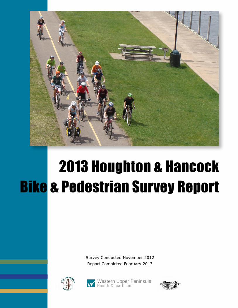
2013 Houghton & Hancock Bike & Pedestrian Survey Report
Survey Conducted November 2012Report Completed February 2013
1 The Cities of Houghton and Hancock | Bike & Pedestrian Survey Report February 2013
The Houghton & Hancock Bicycle & Pedestrian Survey was developed by the Houghton & Hancock Bicycle & Pedestrian Committees. The following organizations and individuals made special contributions to this project.
City of Houghton Bicycle & Pedestrian Committee
City of Hancock Bicycle & Pedestrian Committee
Michigan Technological University Student Transportation Enterprise
Western Upper Peninsula Health Department
Data EntryKris BunkerSara SaloKristen SchmittDanielle ShannonJoe ShannonDanielle TerryAnn West
MappingDanielle Shannon
Data Analysis & ReportSara Salo
Acknowledgements
2 The Cities of Houghton and Hancock | Bike & Pedestrian Survey Report February 2013
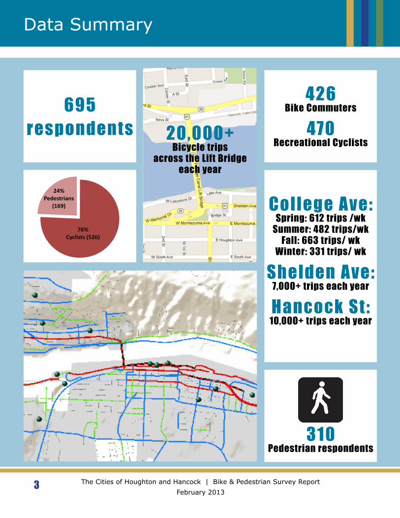
The Houghton Bicycle and Pedestrian Committee was formed in 2006 to improve biking and walking conditions in the City of Houghton, Michigan. This committee conducted an initial survey of bike commuters in 2007 to gather information about cyclist demographics, common bike commuter routes and the bike commuting environment. Since 2007 the City of Houghton has used the survey data to guide infrastructure planning and design while making the city more friendly towards both bikers and walkers. Houghton earned a Bicycle-Friendly City designation in September 2010 and passed a Complete Streets ordinance in December of that year. Along with Houghton’s emphasis on bicycling and walking, the area has also seen a regional trend towards supporting active transportation. Houghton’s neighboring city, Hancock, reconvened its Bicycle and Pedestrian Committee in 2012 and works with the City Council and MDOT on infrastructure improvement projects.
Bikers and walkers in Houghton and Hancock travel often between the two adjacent cities via a the Portage Lake Lift Bridge. The proximity of Houghton and Hancock has resulted in a long history of partnership between the two cities. When Houghton began to update its Master and Non-motorized plans, the Houghton and Hancock Bicycle and Pedestrian Committees determined that a survey encompassing both communities would provide a more comprehensive view of bikers’ and walkers’ routes, preferences and destinations.
Michigan Technological University (MTU) is a central feature of the Houghton/Hancock area and is a common destination for students, staff and community members, many of whom bike or walk. The Michigan Tech Student Transportation Enterprise contributed questions to a special MTU section of the survey that focused on bike commuters. This information will allow the City and MTU to coordinate non-motorized transportation facilities and services.
The 2012 Houghton and Hancock Bicycle & Pedestrian Survey was conducted in November 2012 with the intent to record non-motorized users’ routes, common destinations and feedback on bicycle and pedestrian infrastructure. This online survey was accessible through the City of Hancock and the City of Houghton websites from October 18 to November 21, 2012.
Project Summary
3 The Cities of Houghton and Hancock | Bike & Pedestrian Survey Report February 2013
Data Summary
695 respondents
426 Bike Commuters
470 Recreational Cyclists
College Ave:Spring: 612 trips /wk
Summer: 482 trips/wkFall: 663 trips/ wk
Winter: 331 trips/ wk
Shelden Ave:7,000+ trips each year
Hancock St:10,000+ trips each year
310Pedestrian respondents
76%Cyclists (526)
24%Pedestrians
(169)
Bicycle & Pedestrian Survey Respondents: Percentage of Cyclists and Pedestrians
Cyclist only or Cyclist & Pedestrian Pedestrian only
20,000+Bicycle trips
across the Lift Bridgeeach year
4 The Cities of Houghton and Hancock | Bike & Pedestrian Survey Report February 2013
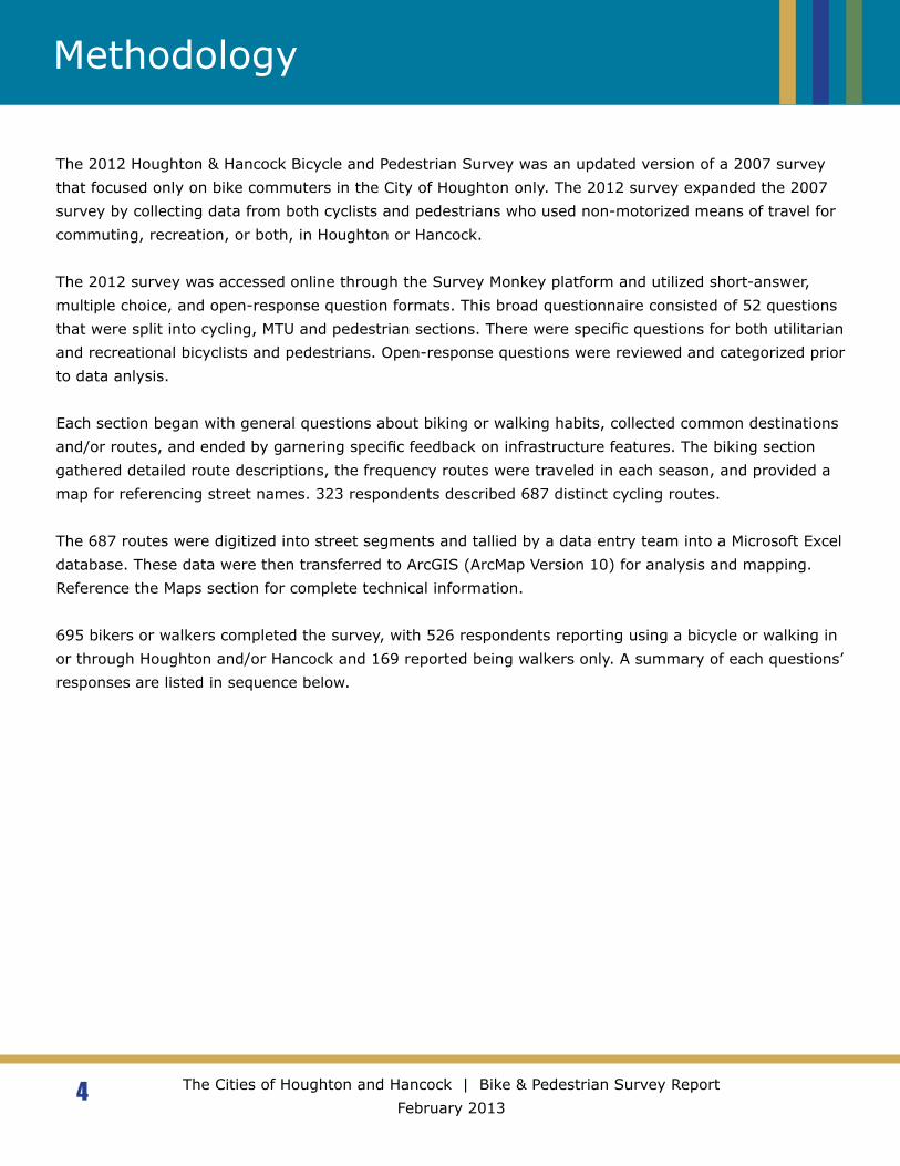
Methodology
The 2012 Houghton & Hancock Bicycle and Pedestrian Survey was an updated version of a 2007 survey that focused only on bike commuters in the City of Houghton only. The 2012 survey expanded the 2007 survey by collecting data from both cyclists and pedestrians who used non-motorized means of travel for commuting, recreation, or both, in Houghton or Hancock.
The 2012 survey was accessed online through the Survey Monkey platform and utilized short-answer, multiple choice, and open-response question formats. This broad questionnaire consisted of 52 questions that were split into cycling, MTU and pedestrian sections. There were specific questions for both utilitarian and recreational bicyclists and pedestrians. Open-response questions were reviewed and categorized prior to data anlysis.
Each section began with general questions about biking or walking habits, collected common destinations and/or routes, and ended by garnering specific feedback on infrastructure features. The biking section gathered detailed route descriptions, the frequency routes were traveled in each season, and provided a map for referencing street names. 323 respondents described 687 distinct cycling routes.
The 687 routes were digitized into street segments and tallied by a data entry team into a Microsoft Excel database. These data were then transferred to ArcGIS (ArcMap Version 10) for analysis and mapping. Reference the Maps section for complete technical information.
695 bikers or walkers completed the survey, with 526 respondents reporting using a bicycle or walking in or through Houghton and/or Hancock and 169 reported being walkers only. A summary of each questions’ responses are listed in sequence below.
426 (85%) “Yes”
81 (16%) “No”
76%Cyclists (526)
24%Pedestrians
(169)
Cyclist only or Cyclist & Pedestrian Pedestrian only
0%0-17
47%18-29
27%30-49
22%50-64
4%65+
0-17
18-29
30-49
50-64
65+
5 The Cities of Houghton and Hancock | Bike & Pedestrian Survey Report February 2013
Survey Responses
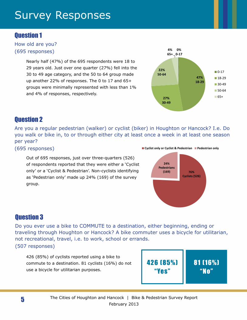
Question 1How old are you?(695 responses)
Question 2Are you a regular pedestrian (walker) or cyclist (biker) in Houghton or Hancock? I.e. Do you walk or bike in, to or through either city at least once a week in at least one season per year?(695 responses)
Question 3Do you ever use a bike to COMMUTE to a destination, either beginning, ending or traveling through Houghton or Hancock? A bike commuter uses a bicycle for utilitarian, not recreational, travel, i.e. to work, school or errands.(507 responses)
Nearly half (47%) of the 695 respondents were 18 to 29 years old. Just over one quarter (27%) fell into the 30 to 49 age category, and the 50 to 64 group made up another 22% of responses. The 0 to 17 and 65+ groups were minimally represented with less than 1% and 4% of responses, respectively.
Out of 695 responses, just over three-quarters (526) of respondents reported that they were either a ‘Cyclist only’ or a ‘Cyclist & Pedestrian’. Non-cyclists identifying as ‘Pedestrian only’ made up 24% (169) of the survey group.
426 (85%) of cyclists reported using a bike to commute to a destination. 81 cyclists (16%) do not use a bicycle for utilitarian purposes.
470 (93%) “Yes”
37 (7%) “No”
13 12 12
8 7 7 6
3 31 1 1 1
Reasons for not commuting by bicycle
6 The Cities of Houghton and Hancock | Bike & Pedestrian Survey Report February 2013
Survey Responses
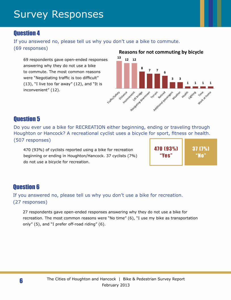
Question 4If you answered no, please tell us why you don’t use a bike to commute.(69 responses)
Question 5Do you ever use a bike for RECREATION either beginning, ending or traveling through Houghton or Hancock? A recreational cyclist uses a bicycle for sport, fitness or health.(507 responses)
Question 6If you answered no, please tell us why you don’t use a bike for recreation.(27 responses)
69 respondents gave open-ended responses answering why they do not use a bike to commute. The most common reasons were “Negotiating traffic is too difficult” (13), “I live too far away” (12), and “It is inconvenient” (12).
470 (93%) of cyclists reported using a bike for recreation beginning or ending in Houghton/Hancock. 37 cyclists (7%) do not use a bicycle for recreation.
27 respondents gave open-ended responses answering why they do not use a bike for recreation. The most common reasons were “No time” (6), “I use my bike as transportation only” (5), and “I prefer off-road riding” (6).
7 The Cities of Houghton and Hancock | Bike & Pedestrian Survey Report February 2013
Bike Trip Frequency
Questions 7-19: Route DescriptionsRespondents were provided with a map and directed to describe their 6 most commonly traveled routes following the protocol below.
(A) Route 1: Please fill in details about your most commonly used commuting and/or recreational bicycling routes. Include your starting point, ending destination and the number of trips per week that you use this route during each season listed. Consider one round trip, such as from home to work and back, as two trips.
Seasons are defined as:
• Spring - After roads are clear of snow until May 31
• Summer - June through August
• Fall - September until ice or snow is present on roadway
• Winter - Any time ice or snow is present on roadway
(B) Route 1 Details:
• Starting point (e.g. home, SDC, etc.)
• Ending destination (e.g. Finlandia, Jutila Center)
• Trips per week spring
• Trips per week summer
• Trips per week fall
• Trips per week winter
22981
Rider Origins
Using the Maps
*All maps completed by: 2013, P. Danielle Shannon using ArcGIS - ArcMap version 10
Road lines, Zip code, City boundaries: obtained from MI Geographic Data Library, http://www.mcgi.state.mi.us. Roads specifically were updated as of - May 25, 2012: http://www.mcgi.state.mi.us/mgdl/?rel=thext&action=thmname&cid=14&cat=MI+Geographic+Framework+All+Roads+%28v12b%29Aerial photography: Bing Maps Aerial (2010) Terrain: Sources: USGS, ESRI, TANA, AND, “The map was compiled from a variety of sources from several data providers, including the U.S. Geological Survey, Tele Atlas, AND, and ESRI. The base map currently provides coverage for the world down to a scale of ~1:1m and coverage for the continental United States and Hawaii to a scale of ~1:70k.”Survey data: Collected through the community using Survey Monkey, complied by volunteers in Microsoft Excel
8 The Cities of Houghton and Hancock | Bike & Pedestrian Survey Report February 2013
Bike Trip Frequency
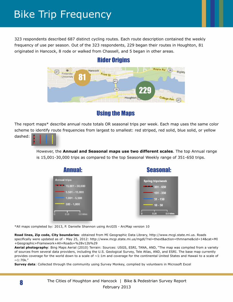
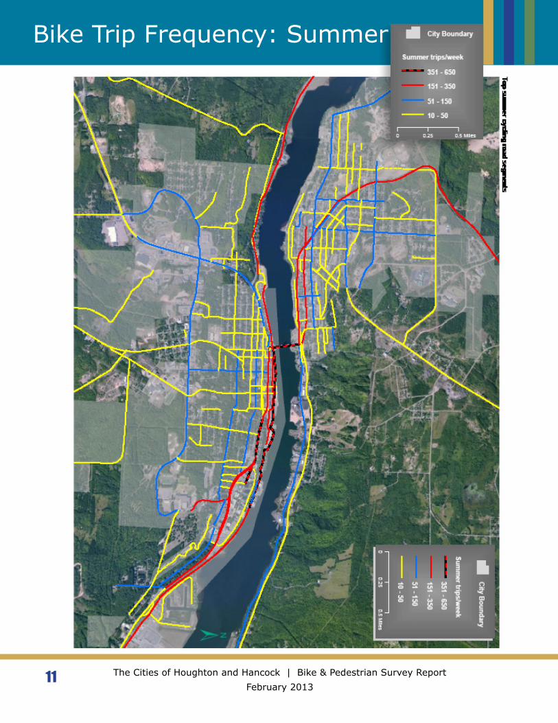
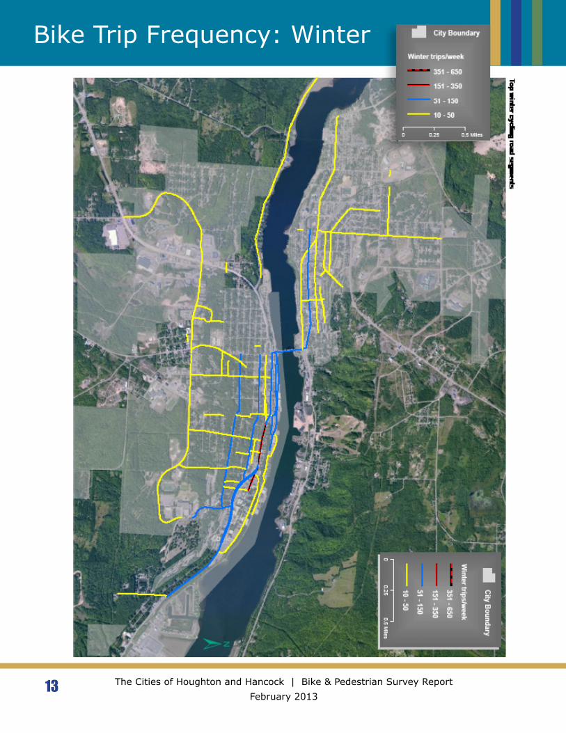
323 respondents described 687 distinct cycling routes. Each route description contained the weekly frequency of use per season. Out of the 323 respondents, 229 began their routes in Houghton, 81 originated in Hancock, 8 rode or walked from Chassell, and 5 began in other areas.
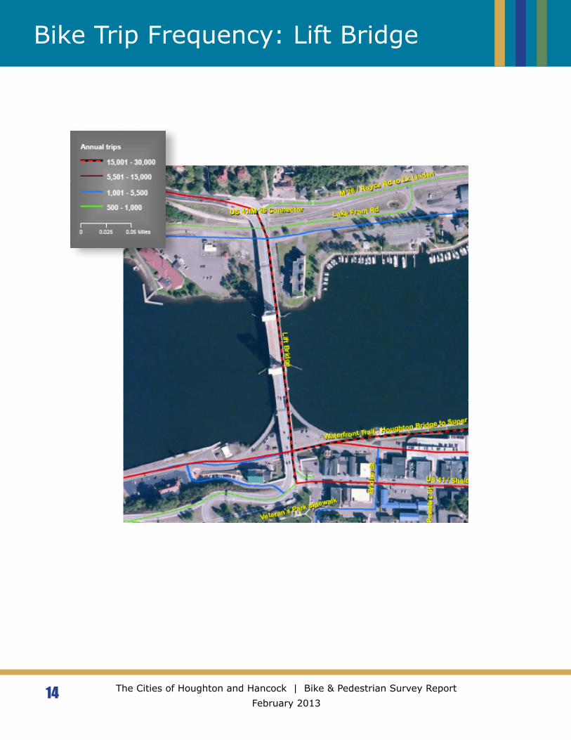
The report maps* describe annual route totals OR seasonal trips per week. Each map uses the same color scheme to identify route frequencies from largest to smallest: red striped, red solid, blue solid, or yellow dashed:
However, the Annual and Seasonal maps use two different scales. The top Annual range is 15,001-30,000 trips as compared to the top Seasonal Weekly range of 351-650 trips.
Annual: Seasonal:
9 The Cities of Houghton and Hancock | Bike & Pedestrian Survey Report February 2013
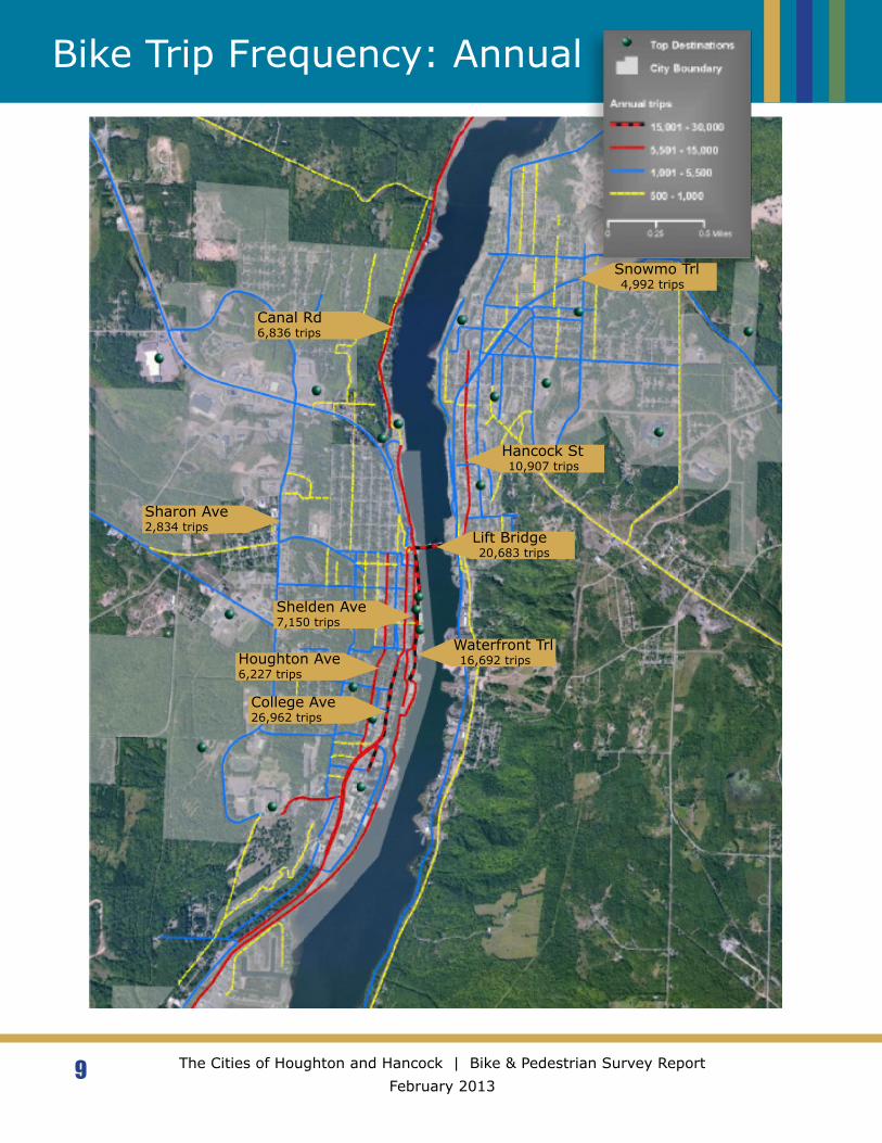
Bike Trip Frequency: Annual
College Ave26,962 trips
Shelden Ave7,150 trips
Hancock St 10,907 trips
Snowmo Trl 4,992 trips
Lift Bridge 20,683 trips
Canal Rd6,836 trips
Sharon Ave2,834 trips
Houghton Ave6,227 trips
Waterfront Trl 16,692 trips

10 The Cities of Houghton and Hancock | Bike & Pedestrian Survey Report February 2013
Bike Trip Frequency: Spring
11 The Cities of Houghton and Hancock | Bike & Pedestrian Survey Report February 2013
Bike Trip Frequency: Summer

12 The Cities of Houghton and Hancock | Bike & Pedestrian Survey Report February 2013
Bike Trip Frequency: Fall
13 The Cities of Houghton and Hancock | Bike & Pedestrian Survey Report February 2013
Bike Trip Frequency: Winter
14 The Cities of Houghton and Hancock | Bike & Pedestrian Survey Report February 2013
Bike Trip Frequency: Lift Bridge
15 The Cities of Houghton and Hancock | Bike & Pedestrian Survey Report February 2013
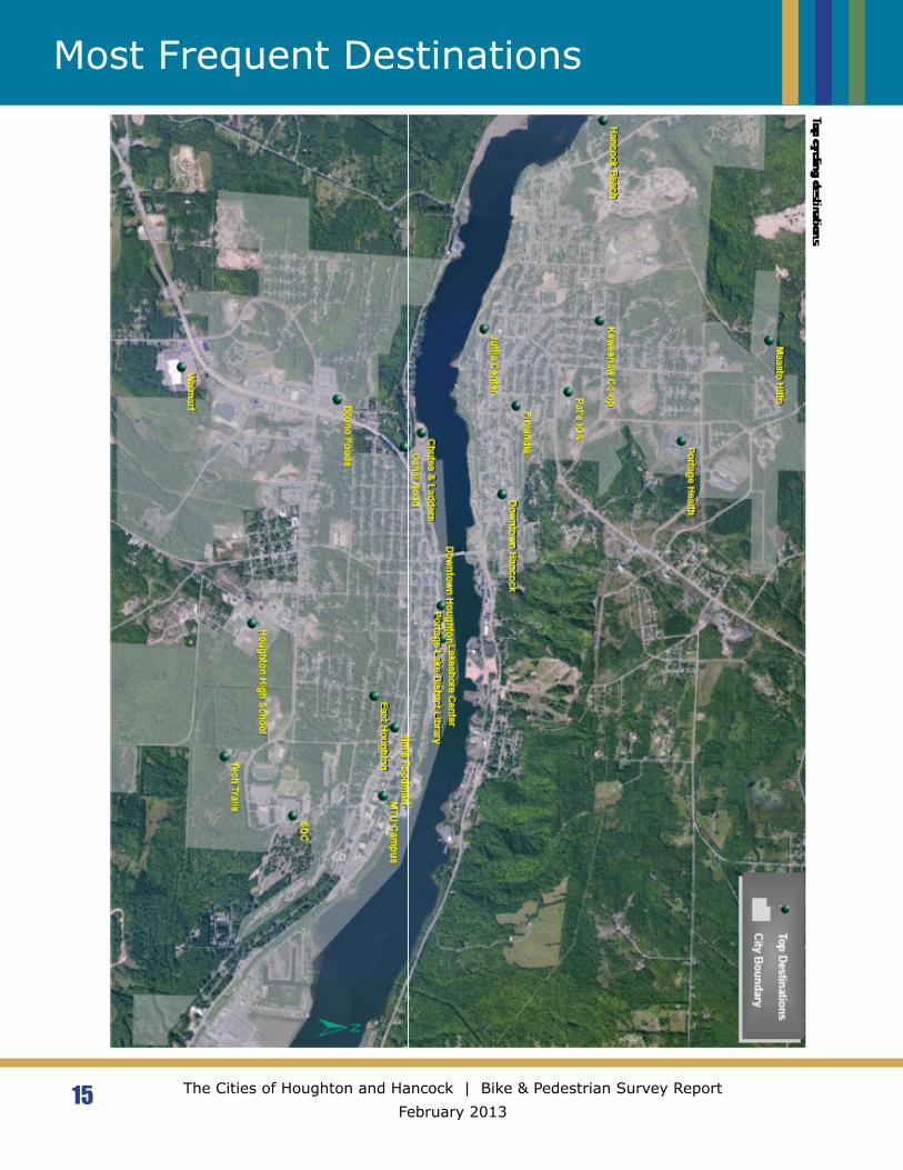
Most Frequent Destinations
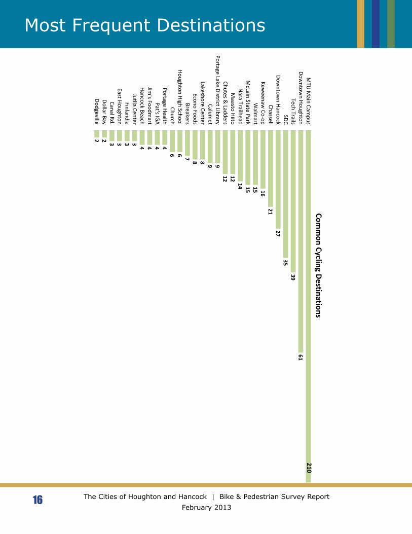
16 The Cities of Houghton and Hancock | Bike & Pedestrian Survey Report February 2013
Most Frequent Destinations
2 2 3 3 3 3 4 4 4 46 6 7 8 8 9 9
12 1214 15 15 16
2127
3539
61
DodgevilleDollar BayCanal Rd.
East HoughtonFinlandia
Jutila CenterHancock BeachJim
's Foodmart
Pat's IGA
Portage HealthChurch
Houghton High SchoolBreakers
Econo FoodsLakeshore Center
Calumet
Portage Lake District LibraryChutes &
LaddersM
aasto HiitoN
ara TrailheadM
cLain State ParkW
almart
Keweenaw
Co-opChassell
Downtow
n HancockSDC
Tech TrailsDow
ntown Houghton
MTU
Main Cam
pusCom
mon Cycling Destinations
210
Yes73%
(233 Riders)
No27%
(85 Riders)
69
49
39
20 19 19 16 13 11 117
3 3 1 1
Challenges to Using the Portage Lake Lift Bridge
17 The Cities of Houghton and Hancock | Bike & Pedestrian Survey Report February 2013
Survey Responses
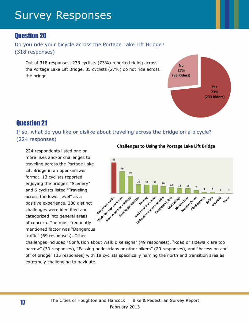
Question 20Do you ride your bicycle across the Portage Lake Lift Bridge?(318 responses)
Question 21If so, what do you like or dislike about traveling across the bridge on a bicycle?(224 responses)
Out of 318 responses, 233 cyclists (73%) reported riding across the Portage Lake Lift Bridge. 85 cyclists (27%) do not ride across the bridge.
224 respondents listed one or more likes and/or challenges to traveling across the Portage Lake Lift Bridge in an open-answer format. 13 cyclists reported enjoying the bridge’s “Scenery” and 6 cyclists listed “Traveling across the lower level” as a positive experience. 280 distinct challenges were identified and categorized into general areas of concern. The most frequently mentioned factor was “Dangerous traffic” (69 responses). Other challenges included “Confusion about Walk Bike signs” (49 responses), “Road or sidewalk are too narrow” (39 responses), “Passing pedestrians or other bikers” (20 responses), and “Access on and off of bridge” (35 responses) with 19 cyclists specifically naming the north end transition area as extremely challenging to navigate.
24%
29%
4%
43%
Improved Stayed the same
Gotten worse Did not live here in 2007
18 The Cities of Houghton and Hancock | Bike & Pedestrian Survey Report February 2013
Survey Responses
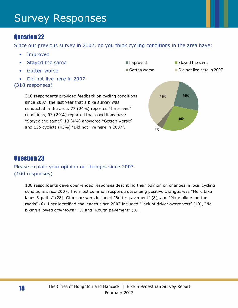
Question 22Since our previous survey in 2007, do you think cycling conditions in the area have:
• Improved
• Stayed the same
• Gotten worse
• Did not live here in 2007(318 responses)
Question 23Please explain your opinion on changes since 2007. (100 responses)
318 respondents provided feedback on cycling conditions since 2007, the last year that a bike survey was conducted in the area. 77 (24%) reported “Improved” conditions, 93 (29%) reported that conditions have “Stayed the same”, 13 (4%) answered “Gotten worse” and 135 cyclists (43%) “Did not live here in 2007”.
100 respondents gave open-ended responses describing their opinion on changes in local cycling conditions since 2007. The most common response describing positive changes was “More bike lanes & paths” (28). Other answers included “Better pavement” (8), and “More bikers on the roads” (6). User identified challenges since 2007 included “Lack of driver awareness” (10), “No biking allowed downtown” (5) and “Rough pavement” (3).

77
26 25 2115 11 10 9 9 6 5 5 4 4 3 3 2 1 1
What do you like about your bike commute, route and/or facilities?
19 The Cities of Houghton and Hancock | Bike & Pedestrian Survey Report February 2013
Survey Responses
Question 24What do you like about your bike commute and/or bike routes or facilities in the Houghton/Hancock area?(257 responses)
257 respondents listed one or more positive aspects of their bike commute and/or bike routes or facilities in the Houghton/Hancock area. The most common response was “Paved bike paths” (77). Other common responses were “Low traffic volume along my route” (26), “Scenery” (25), Easy access to facilities (21), and “Wide shoulders and/or designated bike lanes (15).
111111122223333345567
914141516
2324
3841
5064
Access to Econo areaBike racks on public transport
Connect Van Ordens to LakeshoreCrossing College Ave
Crossing Hancock St. & Quincy St.More sidewalks - Houghton Ave
No on-site shower or changing areaBike paths to local schools
Crossing M26Safer routes to MTU
Vehicles on bike pathConnected cross-town route
Crossing MontezumaHigh traffic volume
Poor lightingSeparate bike & car lanesImproved snow removal
Debris on bike pathMore bike racks at MTUMore sidewalk curb cuts
Signed bike routesCrossing US 41 - Campus & Downtown
More bike parkingMore bike paths
Access on/off the Portage Lake Lift BridgeImproved pavement maintenance
More bike lanes - Specific locationsLift Bridge - General
Improved driver awarenessMore bike lanes - general
Navigating through downtownMore bike lanes/wider shoulders
Dislikes and Suggested Improvements
20 The Cities of Houghton and Hancock | Bike & Pedestrian Survey Report February 2013
Survey Responses
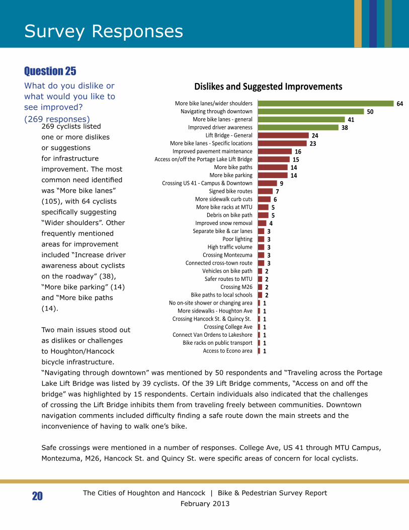
Question 25What do you dislike or what would you like to see improved?(269 responses)
269 cyclists listed one or more dislikes or suggestions for infrastructure improvement. The most common need identified was “More bike lanes” (105), with 64 cyclists specifically suggesting “Wider shoulders”. Other frequently mentioned areas for improvement included “Increase driver awareness about cyclists on the roadway” (38), “More bike parking” (14) and “More bike paths (14). Two main issues stood out as dislikes or challenges to Houghton/Hancock bicycle infrastructure. “Navigating through downtown” was mentioned by 50 respondents and “Traveling across the Portage Lake Lift Bridge was listed by 39 cyclists. Of the 39 Lift Bridge comments, “Access on and off the bridge” was highlighted by 15 respondents. Certain individuals also indicated that the challenges of crossing the Lift Bridge inhibits them from traveling freely between communities. Downtown navigation comments included difficulty finding a safe route down the main streets and the inconvenience of having to walk one’s bike.
Safe crossings were mentioned in a number of responses. College Ave, US 41 through MTU Campus, Montezuma, M26, Hancock St. and Quincy St. were specific areas of concern for local cyclists.
21 The Cities of Houghton and Hancock | Bike & Pedestrian Survey Report February 2013
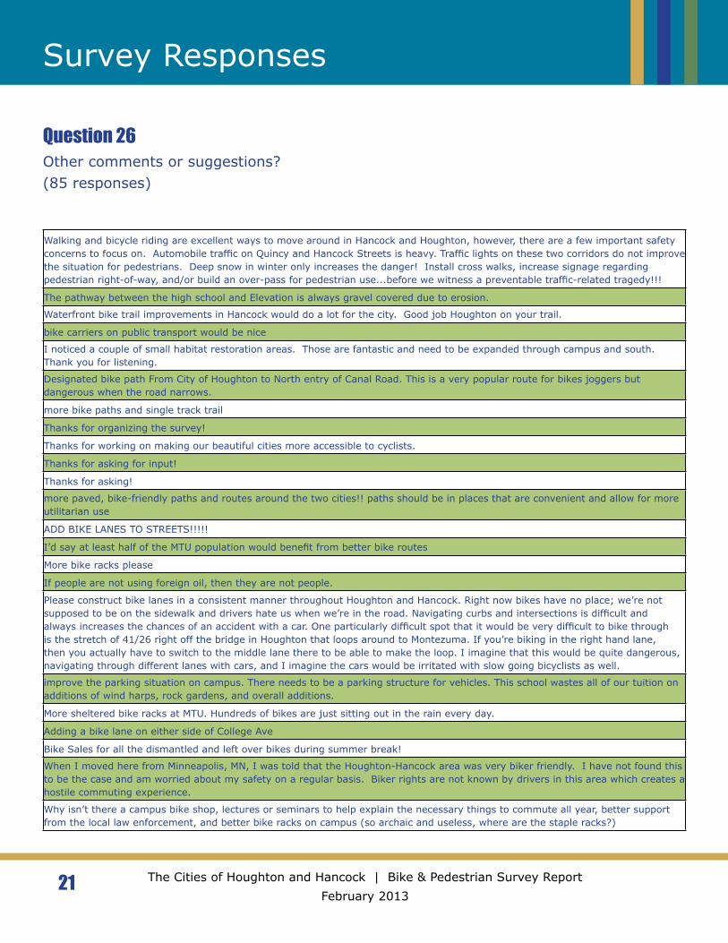
Survey Responses
Question 26Other comments or suggestions?(85 responses)
Walking and bicycle riding are excellent ways to move around in Hancock and Houghton, however, there are a few important safety concerns to focus on. Automobile traffic on Quincy and Hancock Streets is heavy. Traffic lights on these two corridors do not improve the situation for pedestrians. Deep snow in winter only increases the danger! Install cross walks, increase signage regarding pedestrian right-of-way, and/or build an over-pass for pedestrian use...before we witness a preventable traffic-related tragedy!!!
The pathway between the high school and Elevation is always gravel covered due to erosion.
Waterfront bike trail improvements in Hancock would do a lot for the city. Good job Houghton on your trail.
bike carriers on public transport would be nice
I noticed a couple of small habitat restoration areas. Those are fantastic and need to be expanded through campus and south. Thank you for listening.
Designated bike path From City of Houghton to North entry of Canal Road. This is a very popular route for bikes joggers but dangerous when the road narrows.
more bike paths and single track trail
Thanks for organizing the survey!
Thanks for working on making our beautiful cities more accessible to cyclists.
Thanks for asking for input!
Thanks for asking!
more paved, bike-friendly paths and routes around the two cities!! paths should be in places that are convenient and allow for more utilitarian use
ADD BIKE LANES TO STREETS!!!!!
I’d say at least half of the MTU population would benefit from better bike routes
More bike racks please
If people are not using foreign oil, then they are not people.
Please construct bike lanes in a consistent manner throughout Houghton and Hancock. Right now bikes have no place; we’re not supposed to be on the sidewalk and drivers hate us when we’re in the road. Navigating curbs and intersections is difficult and always increases the chances of an accident with a car. One particularly difficult spot that it would be very difficult to bike through is the stretch of 41/26 right off the bridge in Houghton that loops around to Montezuma. If you’re biking in the right hand lane, then you actually have to switch to the middle lane there to be able to make the loop. I imagine that this would be quite dangerous, navigating through different lanes with cars, and I imagine the cars would be irritated with slow going bicyclists as well.
improve the parking situation on campus. There needs to be a parking structure for vehicles. This school wastes all of our tuition on additions of wind harps, rock gardens, and overall additions.
More sheltered bike racks at MTU. Hundreds of bikes are just sitting out in the rain every day.
Adding a bike lane on either side of College Ave
Bike Sales for all the dismantled and left over bikes during summer break!
When I moved here from Minneapolis, MN, I was told that the Houghton-Hancock area was very biker friendly. I have not found this to be the case and am worried about my safety on a regular basis. Biker rights are not known by drivers in this area which creates a hostile commuting experience.
Why isn’t there a campus bike shop, lectures or seminars to help explain the necessary things to commute all year, better support from the local law enforcement, and better bike racks on campus (so archaic and useless, where are the staple racks?)
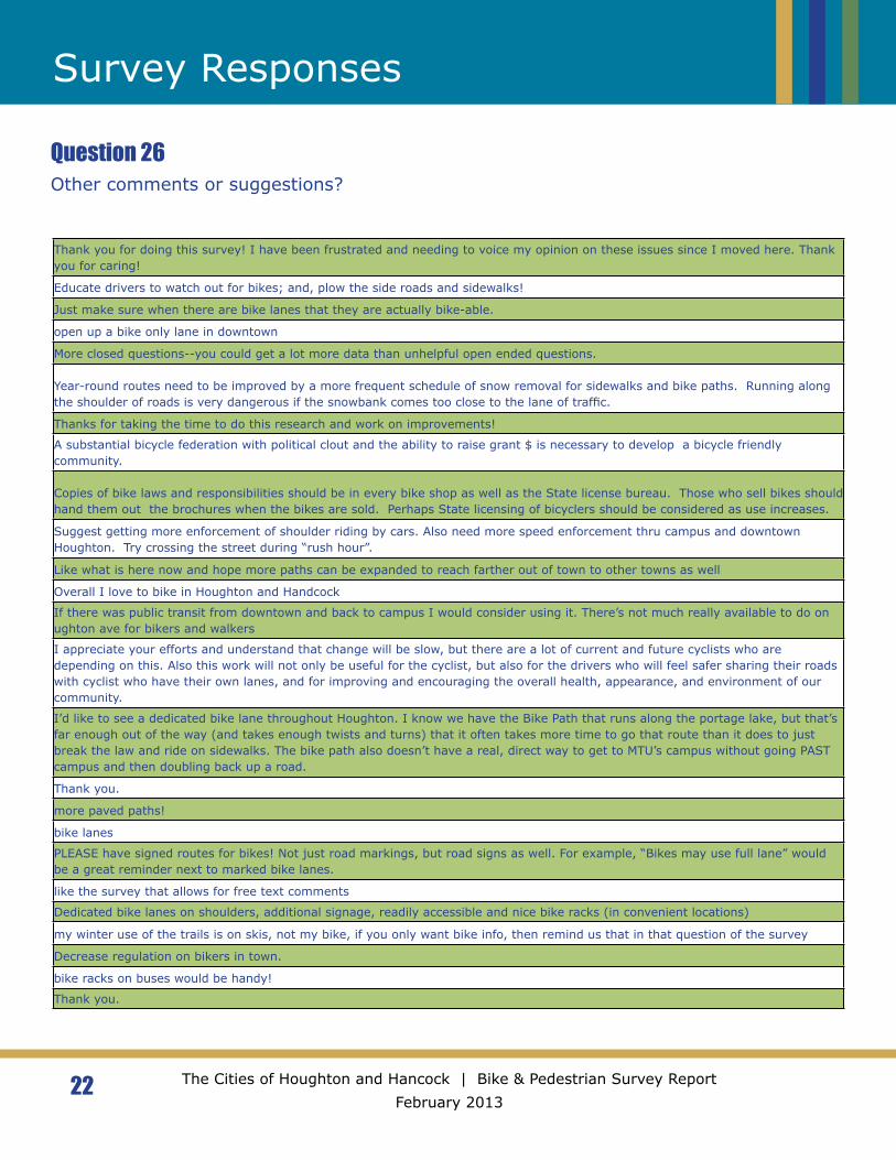
22 The Cities of Houghton and Hancock | Bike & Pedestrian Survey Report February 2013
Survey Responses
Question 26Other comments or suggestions?
Thank you for doing this survey! I have been frustrated and needing to voice my opinion on these issues since I moved here. Thank you for caring!
Educate drivers to watch out for bikes; and, plow the side roads and sidewalks!
Just make sure when there are bike lanes that they are actually bike-able.
open up a bike only lane in downtown
More closed questions--you could get a lot more data than unhelpful open ended questions.
Year-round routes need to be improved by a more frequent schedule of snow removal for sidewalks and bike paths. Running along the shoulder of roads is very dangerous if the snowbank comes too close to the lane of traffic.
Thanks for taking the time to do this research and work on improvements!
A substantial bicycle federation with political clout and the ability to raise grant $ is necessary to develop a bicycle friendly community.
Copies of bike laws and responsibilities should be in every bike shop as well as the State license bureau. Those who sell bikes should hand them out the brochures when the bikes are sold. Perhaps State licensing of bicyclers should be considered as use increases.
Suggest getting more enforcement of shoulder riding by cars. Also need more speed enforcement thru campus and downtown Houghton. Try crossing the street during “rush hour”.
Like what is here now and hope more paths can be expanded to reach farther out of town to other towns as well
Overall I love to bike in Houghton and Handcock
If there was public transit from downtown and back to campus I would consider using it. There’s not much really available to do on ughton ave for bikers and walkers
I appreciate your efforts and understand that change will be slow, but there are a lot of current and future cyclists who are depending on this. Also this work will not only be useful for the cyclist, but also for the drivers who will feel safer sharing their roads with cyclist who have their own lanes, and for improving and encouraging the overall health, appearance, and environment of our community.
I’d like to see a dedicated bike lane throughout Houghton. I know we have the Bike Path that runs along the portage lake, but that’s far enough out of the way (and takes enough twists and turns) that it often takes more time to go that route than it does to just break the law and ride on sidewalks. The bike path also doesn’t have a real, direct way to get to MTU’s campus without going PAST campus and then doubling back up a road.
Thank you.
more paved paths!
bike lanes
PLEASE have signed routes for bikes! Not just road markings, but road signs as well. For example, “Bikes may use full lane” would be a great reminder next to marked bike lanes.
like the survey that allows for free text comments
Dedicated bike lanes on shoulders, additional signage, readily accessible and nice bike racks (in convenient locations)
my winter use of the trails is on skis, not my bike, if you only want bike info, then remind us that in that question of the survey
Decrease regulation on bikers in town.
bike racks on buses would be handy!
Thank you.
23 The Cities of Houghton and Hancock | Bike & Pedestrian Survey Report February 2013
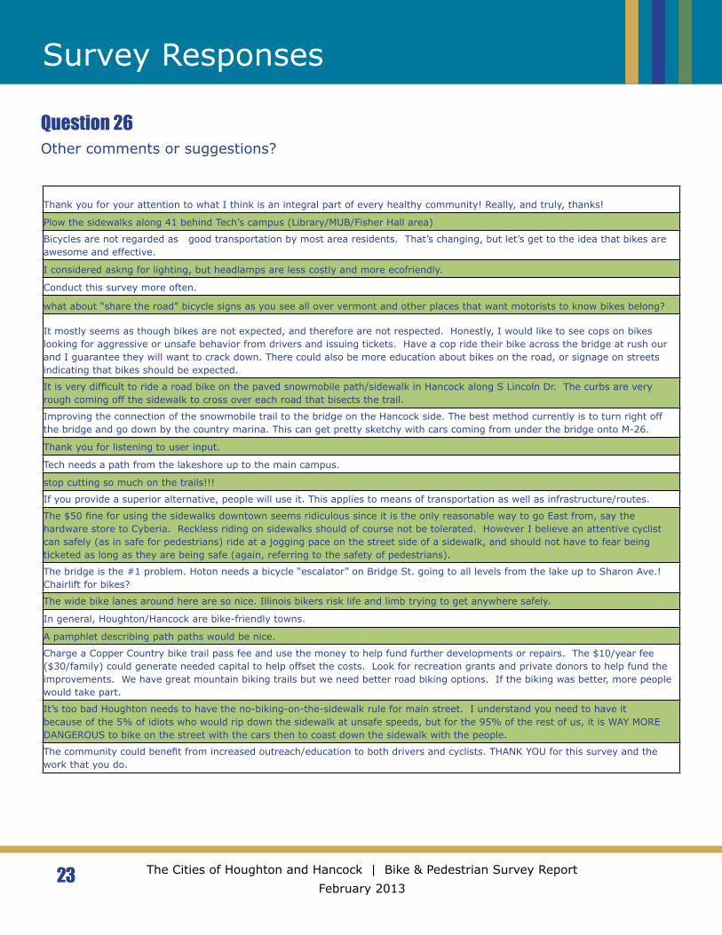
Survey Responses
Question 26Other comments or suggestions?
Thank you for your attention to what I think is an integral part of every healthy community! Really, and truly, thanks!
Plow the sidewalks along 41 behind Tech’s campus (Library/MUB/Fisher Hall area)
Bicycles are not regarded as good transportation by most area residents. That’s changing, but let’s get to the idea that bikes are awesome and effective.
I considered askng for lighting, but headlamps are less costly and more ecofriendly.
Conduct this survey more often.
what about “share the road” bicycle signs as you see all over vermont and other places that want motorists to know bikes belong?
It mostly seems as though bikes are not expected, and therefore are not respected. Honestly, I would like to see cops on bikes looking for aggressive or unsafe behavior from drivers and issuing tickets. Have a cop ride their bike across the bridge at rush our and I guarantee they will want to crack down. There could also be more education about bikes on the road, or signage on streets indicating that bikes should be expected.
It is very difficult to ride a road bike on the paved snowmobile path/sidewalk in Hancock along S Lincoln Dr. The curbs are very rough coming off the sidewalk to cross over each road that bisects the trail.
Improving the connection of the snowmobile trail to the bridge on the Hancock side. The best method currently is to turn right off the bridge and go down by the country marina. This can get pretty sketchy with cars coming from under the bridge onto M-26.
Thank you for listening to user input.
Tech needs a path from the lakeshore up to the main campus.
stop cutting so much on the trails!!!
If you provide a superior alternative, people will use it. This applies to means of transportation as well as infrastructure/routes.
The $50 fine for using the sidewalks downtown seems ridiculous since it is the only reasonable way to go East from, say the hardware store to Cyberia. Reckless riding on sidewalks should of course not be tolerated. However I believe an attentive cyclist can safely (as in safe for pedestrians) ride at a jogging pace on the street side of a sidewalk, and should not have to fear being ticketed as long as they are being safe (again, referring to the safety of pedestrians).
The bridge is the #1 problem. Hoton needs a bicycle “escalator” on Bridge St. going to all levels from the lake up to Sharon Ave.! Chairlift for bikes?
The wide bike lanes around here are so nice. Illinois bikers risk life and limb trying to get anywhere safely.
In general, Houghton/Hancock are bike-friendly towns.
A pamphlet describing path paths would be nice.
Charge a Copper Country bike trail pass fee and use the money to help fund further developments or repairs. The $10/year fee ($30/family) could generate needed capital to help offset the costs. Look for recreation grants and private donors to help fund the improvements. We have great mountain biking trails but we need better road biking options. If the biking was better, more people would take part.
It’s too bad Houghton needs to have the no-biking-on-the-sidewalk rule for main street. I understand you need to have it because of the 5% of idiots who would rip down the sidewalk at unsafe speeds, but for the 95% of the rest of us, it is WAY MORE DANGEROUS to bike on the street with the cars then to coast down the sidewalk with the people.
The community could benefit from increased outreach/education to both drivers and cyclists. THANK YOU for this survey and the work that you do.
24 The Cities of Houghton and Hancock | Bike & Pedestrian Survey Report February 2013
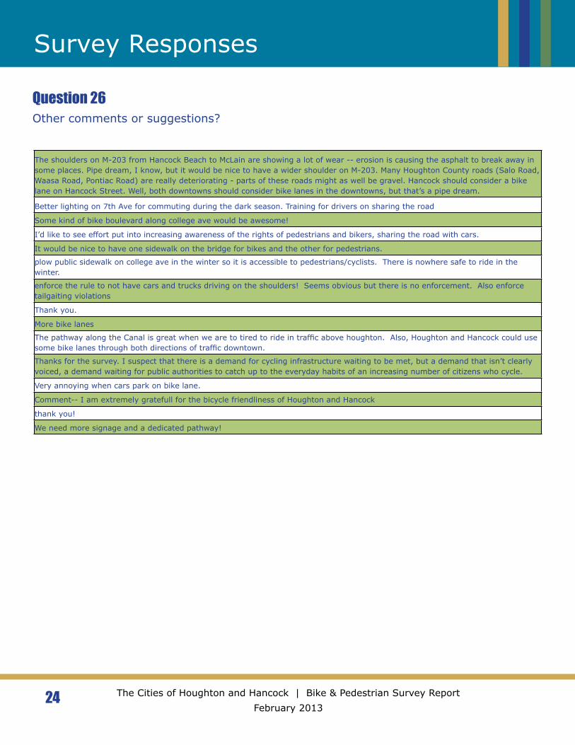
Survey Responses
Question 26Other comments or suggestions?
The shoulders on M-203 from Hancock Beach to McLain are showing a lot of wear -- erosion is causing the asphalt to break away in some places. Pipe dream, I know, but it would be nice to have a wider shoulder on M-203. Many Houghton County roads (Salo Road, Waasa Road, Pontiac Road) are really deteriorating - parts of these roads might as well be gravel. Hancock should consider a bike lane on Hancock Street. Well, both downtowns should consider bike lanes in the downtowns, but that’s a pipe dream.
Better lighting on 7th Ave for commuting during the dark season. Training for drivers on sharing the road
Some kind of bike boulevard along college ave would be awesome!
I’d like to see effort put into increasing awareness of the rights of pedestrians and bikers, sharing the road with cars.
It would be nice to have one sidewalk on the bridge for bikes and the other for pedestrians.
plow public sidewalk on college ave in the winter so it is accessible to pedestrians/cyclists. There is nowhere safe to ride in the winter.
enforce the rule to not have cars and trucks driving on the shoulders! Seems obvious but there is no enforcement. Also enforce tailgaiting violations
Thank you.
More bike lanes
The pathway along the Canal is great when we are to tired to ride in traffic above houghton. Also, Houghton and Hancock could use some bike lanes through both directions of traffic downtown.
Thanks for the survey. I suspect that there is a demand for cycling infrastructure waiting to be met, but a demand that isn’t clearly voiced, a demand waiting for public authorities to catch up to the everyday habits of an increasing number of citizens who cycle.
Very annoying when cars park on bike lane.
Comment-- I am extremely gratefull for the bicycle friendliness of Houghton and Hancock
thank you!
We need more signage and a dedicated pathway!
25 The Cities of Houghton and Hancock | Bike & Pedestrian Survey Report February 2013
Survey Responses
Question 28-41: Michigan Tech Commuter QuestionsThe Michigan Tech section of the survey was comprised of 13 questions for students, faculty, staff, and community members who ride their bicycles to campus. Members of the Student Transportation Enterprise wrote and analyzed these data. The questions are listed below.
28. Do you ride a bicycle to the MTU campus as a student, faculty, staff or
community member?
29. Which category most applies to you?Community MemberStudentFaculty/Staff
30. Please list the locations on campus that you bike to most frequently.
31. What is the typical availability of bike racks near your most frequently used
destination on campus?Mostly OpenHalf FullMostly FullCrowdedNo bike racks available
32. If covered bike racks were located farther away from your destination than
regular bike racks, would you choose to use the covered parking in the rain or
snow?
33. Would having covered bike parking make you more willing to bike to Michigan
Tech in adverse weather conditions?
34. Do you feel that Michigan Tech’s campus is easy to bike through (from class to
class, from dorms to class, etc.)?
35. If no, what obstacles do you face?
36. Do you commute by bike from off-campus to Michigan Tech?
37. If yes, do you feel that campus is easily accessible by bike? Please explain why
or why not.
26 The Cities of Houghton and Hancock | Bike & Pedestrian Survey Report February 2013
Survey Responses
38. If offered, would you attend any of the following bike-related one-time classes?
(Select all that apply)Bike Safety – as a motorist, cyclist, and pedestrianBike Repair ClassesLocal Trails and Biking Events
39. Where do you store your bike in the winter?
40. Do you have any additional comments about cycling on or to the Michigan Tech
campus?
230 (76%) “Yes”
7 1 (24%) “No”
147
39
35
5
20
20
147
38
16
3
5
5
6
Downtown Houghton
Portage Lake District Library
Downtown Hancock
Finlandia
Pat's IGA
Keweenaw Co-op
Michigan Tech Main Campus
Jim's Foodmart area
SDC
Houghton High School
Lakeshore Drive area
Econo Foods
Walmart
Pedestrian Commuting Destinations
27 The Cities of Houghton and Hancock | Bike & Pedestrian Survey Report February 2013
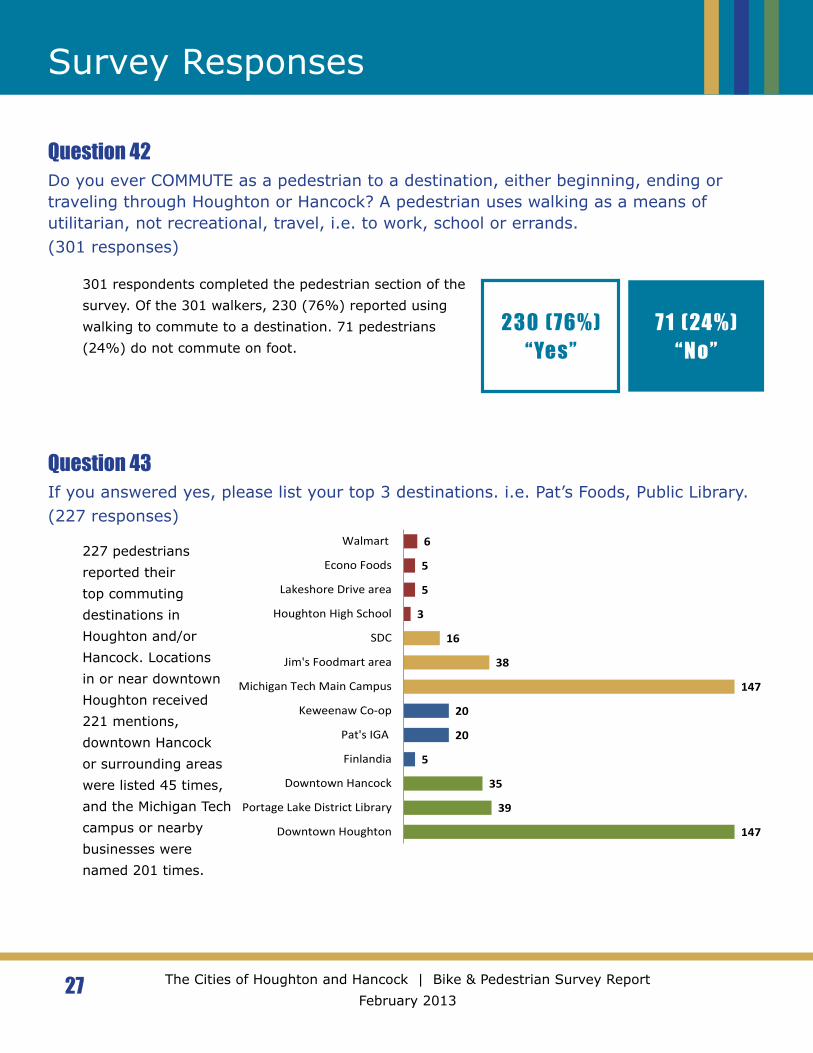
Survey Responses
Question 42Do you ever COMMUTE as a pedestrian to a destination, either beginning, ending or traveling through Houghton or Hancock? A pedestrian uses walking as a means of utilitarian, not recreational, travel, i.e. to work, school or errands.(301 responses)
Question 43If you answered yes, please list your top 3 destinations. i.e. Pat’s Foods, Public Library.(227 responses)
301 respondents completed the pedestrian section of the survey. Of the 301 walkers, 230 (76%) reported using walking to commute to a destination. 71 pedestrians (24%) do not commute on foot.
227 pedestrians reported their top commuting destinations in Houghton and/or Hancock. Locations in or near downtown Houghton received 221 mentions, downtown Hancock or surrounding areas were listed 45 times, and the Michigan Tech campus or nearby businesses were named 201 times.
241 (80%) “Yes”
60 (20%) “No”
46
13
4
19
10
11
3
10
45
3
3
Downtown Houghton or Hancock
7th Street Houghton
Houghton Avenue
Sharon Avenue
MTU campus or trails
Nara Trails
SDC
College Avenue
Massto Hiito Trails
Hancock Beach and Campground
Quincy Hill
28 The Cities of Houghton and Hancock | Bike & Pedestrian Survey Report February 2013
Survey Responses
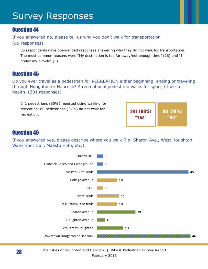
Question 45Do you ever travel as a pedestrian for RECREATION either beginning, ending or traveling through Houghton or Hancock? A recreational pedestrian walks for sport, fitness or health. (301 responses)
Question 44If you answered no, please tell us why you don’t walk for transportation.(65 responses)
65 respondents gave open-ended responses answering why they do not walk for transportation. The most common reasons were “My destination is too far away/not enough time” (26) and “I prefer my bicycle” (5).
241 pedestrians (80%) reported using walking for recreation. 60 pedestrians (24%) do not walk for recreation.
Question 46If you answered yes, please describe where you walk (i.e. Sharon Ave., West Houghton, Waterfront trail, Maasto Hiito, etc.)
201
284
257
271
Winter
Fall
Summer
Spring
Improved13% (40)
Stayed the same
45% (133)
Gotten worse3% (9)
Did not live here
39% (116)
29 The Cities of Houghton and Hancock | Bike & Pedestrian Survey Report February 2013
Survey Responses
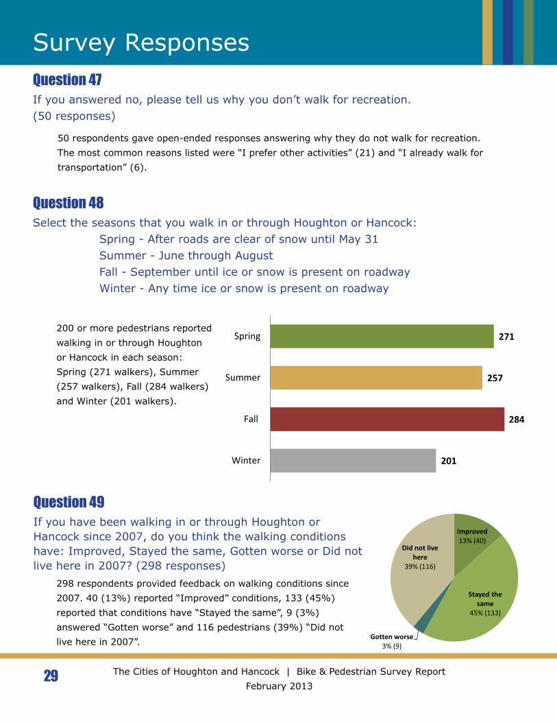
Question 48Select the seasons that you walk in or through Houghton or Hancock:
Spring - After roads are clear of snow until May 31Summer - June through AugustFall - September until ice or snow is present on roadwayWinter - Any time ice or snow is present on roadway
Question 49If you have been walking in or through Houghton or Hancock since 2007, do you think the walking conditions have: Improved, Stayed the same, Gotten worse or Did not live here in 2007? (298 responses)
Question 47If you answered no, please tell us why you don’t walk for recreation.(50 responses)
50 respondents gave open-ended responses answering why they do not walk for recreation. The most common reasons listed were “I prefer other activities” (21) and “I already walk for transportation” (6).
200 or more pedestrians reported walking in or through Houghton or Hancock in each season: Spring (271 walkers), Summer (257 walkers), Fall (284 walkers) and Winter (201 walkers).
298 respondents provided feedback on walking conditions since 2007. 40 (13%) reported “Improved” conditions, 133 (45%) reported that conditions have “Stayed the same”, 9 (3%) answered “Gotten worse” and 116 pedestrians (39%) “Did not live here in 2007”.
30 The Cities of Houghton and Hancock | Bike & Pedestrian Survey Report February 2013
Survey Responses
Question 50What do you like about your walking commute and/or walking routes and facilities in the Houghton/Hancock area?(214 responses)
Question 51What do you dislike or what would you like to see improved?(212 responses)
214 respondents gave open-ended responses describing what they like about their walking commute and/or walking routes and facilities in the Houghton/Hancock area. The most common response was “Scenery” (38). Other answers included “Access to trails” (34), “Plentiful sidewalks” (31), and “Convenience” (28). User identified challenges since 2007 included “Lack of driver awareness” (10), “No biking allowed downtown” (5) and “Rough pavement” (3).
212 pedestrians listed one or more dislikes or suggestions for infrastructure improvement. The most commonly listed dislike to walking in Houghton and Hancock was “No place to safely cross street” (40), with 19 pedestrians specifically naming “Main Street” in Houghton or Hancock as an area of concern. Other frequently mentioned unsafe crossings included “US 41 through the Michigan Tech Campus or College Ave” (9).
38 respondents would like to see “More sidewalks”, with some naming specific locations, while “More snow removal” was mentioned in 36 comments. “Difficulty accessing the lift bridge” was named by 18 walkers as an additional area of concern. Reference the graph on PAGE for additional details.

1 1 1 1 1 1 12 2 2 2 2
3 3 3 34
56 6
8 89 9
10 1012 13
1826
35 36
Add multiuse path on Cem
etary RdBetter street drainage
Create pedestrian malls on dow
ntown streets
Crossing M26
Extend Waterfront east
Indoor walking option
More trails
Connect Downtow
n to M26 shopping
Crossing Hancock StM
ore lighting - specificPath m
aintenanceTraffic, specific locations
Improve netw
ork connectionsCrossing College Ave
Crossing US41 in Hancock
Improve Hancock w
aterfront pathCars parked in w
alking pathSafer crossw
alksCrossing U
S41 on Campus
More dedicated w
alking pathsM
ore lighting - generalTerrain
Crossing Montezum
a, Shelden, Quincy, Hancock St
Improved pavem
ent maintenance
Crossing main streets
Dangerous trafficM
ore sidewalks - specific
Better walker/biker etiquette
Access to bridgeM
ore sidewalks
Crossing challenges - allM
ore snow rem
oval/winter routes
Pedestrian Challenges and Suggestions for Improvem
ent
31 The Cities of Houghton and Hancock | Bike & Pedestrian Survey Report February 2013
Survey Responses
32 The Cities of Houghton and Hancock | Bike & Pedestrian Survey Report February 2013
Survey ResponsesQuestion 52Other comments or suggestions?(56 responses)
If installing additional lights on major traffic arteries is not a realistic option, could signs reminding drivers to slow for pedestrians be placed along Quincy and Hancock Streets in Hancock?
It would be nice to have some kind of trail from ‘ShopKo Heights’ down to the snowmobile trail by the canal. I would most likely ride my bike and/or walk to campus more frequently.
I wish there were pedestrian crossings where pedestrians always have priority.
An alternate path to Sharon Ave. Would be nice. One that walkers and bicyclers could use to access the businesses at the end of Sharon Ave. More patrolling of traffic violators. Inour town there is really no need for excessive speed when we can get from one side of Houghton to the othrt in ten minutes.
I live in Hancock, so please complete the waterfront walk and get us to the bridge without dodging traffic over here!
spruce up hancock, separate bikes and pedestrains
Again thanks for trying to make pedestrian and cycling access in Houghton and Hancock safer and easier.
I don’t walk as often in the winter; fear of falling. I started walking to work when downtown Houghton was torn up in the summer of 2009. It was much easier than driving to Tech.
Better publicity locally.
One word: Zip-lines Baby!
keep up on the roads and keep the walkers and bikers safer. I have almost been hit numerous times by people driving and I have many friends who have been hit by careless drivers
The sidewalks work perfectly well for both bikers and pedestrians at the same time.
Wider shoulders on highways. More bike racks.
I would live more of a waterfront route in Hancock or down the canal to McLains. I feel if there was a wide shoulder on the road or near more people would use this route for activities. It would aid in the canal run as well as it does get congested since traffic isn’t blocked.
Houghton ave gets narrow for one block west of bridge. Makes ride/walk cramped.
Recommend reduced speed limit to the edge of the City of Hancock limit just past the cemetery. Recommend no passing on uphill approach to the park. Recommend a flashing light to draw attention to pedestrians at the entrance to Hancock Beach.
I WOULD bike if the trail near the county fairgrounds wasn’t so sandy that I can’t use it. I don’t like to bike on the streets. Cars scare me. If we had special bike lanes I would like it better.
Thanks for having the survey!
Put in a stoplight on Montezuma!
Both waterfronts could use much more accessibility and beautification. They are wonderful natural features of both towns and are quite ugly.
More signage on how to use the trail -- see previous question
Sure would like a better way (steps?) from under the Bridge to the Synagogue steps. Would like traffic to stop for ped traffic on marked Quincy/Hancock St crosswalks (this should be an enforced law - like Rhinelander/Eagle River, WI). Slower traffic also (crossing Quincy, Hancock, Lincoln is a crapshoot-very risky). Better street lighting for night walking in winter (need to see ice!!).
more police enforcement of no riding the shoulder, more speed enforcement
signage for path
It is very difficult to walk in Hancock in winter especially when snowmobiles are around. Especially around waterfront near ramada area
The sidewalk ends at the bottom of White street where it meets with Franklin and Reservation Streets in Hancock. Also, lack of north sidewalk from the park & ride across from Hardee’s to the bridge in Houghton. I often see people walking there because I assume they don’t want to cross traffic to the south sidewalk or backtrack to the W. Memorial Dr. underpass from Lakeshore Dr.
put in more sidewalks - move cars to the outside
posting speed limits and signs on shared use trails warning atv/snowmobiles of foot/bike traffic.
extend paved non-motorized trails in all directions!
33 The Cities of Houghton and Hancock | Bike & Pedestrian Survey Report February 2013
Survey ResponsesQuestion 52Other comments or suggestions?(56 responses)
There should be more walking paths in the city! The field next to the community garden should be turned into a park!
We could use a nice stairway from the Waterfront trail up to campus level at Michigan Tech. The only ways to get up now are a couple steep trails, the creepy M & M bldg. elevator, or the crowded Dow bldg. elevator.
Thank you!
could we check into some more stop lights along these highways?
find a way to slow down the “leadfoot drivers” going from us-41 up white st. at the scott building in hancock to give pedestrian a chance.
Expanding the area used for sidewalks would be undoubtedly very expensive, a cheaper option might be to have an awareness campaign for drivers to look out for pedestrians or promote reflective clothing or wearable flashers for pedestrians.
More sidewalks, please.
Better lighting
Plans cater to cyclists and have been helpful. Perhaps it is time to develop plans that are friendly to walkers including more sidewalks and snow management for sidewalks during winter months (especially on the MTU Campus)
I like the sidewalks added to Bridge Street. Makes it much nicer. I’d like to see them continued up to elementary school for children’s safety.
- Please make sure pedestrian crossings are taken seriously (might need some serious effort by the law enforcement officers. Please, pay as much attention to snow and ice removal for pedestrian (e.g.; promptly and neatly clearing sidewalks) as for road and parking-lots
Wish Hancock expanded/improved the trail behind Fine Line Tire. Please fix the Ethyl Ave. (Hancock) sidewalk.
I know sidewalks are expensive, but is there a cheaper alternative to concrete or asphalt? More sidewalks are needed if Houghton is truly going to be a “walkable community”.
People need to be educated as to maintaining their alleys and street right-of-ways. The city shouldn’t have to deal with this! I’m bummed when I see weeds growing between the sidewalks and curbs.
Snowplows should slow down so that the snow on the road is not piled on the sidewalks, or......the city should plow the sidewalks each time they plow the street.
Hancock needs a waterfront trail
It is too bad Hancock didn’t extend the Campus Drive sidewalk when they extended Campus Drive between Elevation and Poplar.
Police need to practice and enforce the law by turning into the proper lane. Especially turning from White St west onto Quincy. Everyone switches lanes during the turn, cops too. Impossible to cross there safely and without getting honked, swore and yelled at.
stop sprawl
Because of snow clearing pedestrians must walk in the street in the winter and many motorists are not willing to share the space.
Clear sidewalks soon after snowfall.
enforce pedestrian respect and signage
More trails
Safer Crossings
34 The Cities of Houghton and Hancock | Bike & Pedestrian Survey Report February 2013
Houghton and Hancock2012 Bicycle & Pedestrian Survey Report
Compiled by Sara Salo of the Western Upper Peninsula Health Department
540 Depot St. Hancock, MI 49931906.482.7382
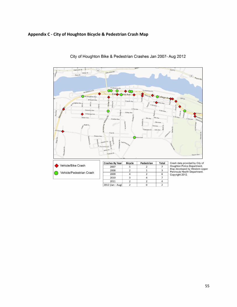
55
Appendix C - City of Houghton Bicycle & Pedestrian Crash Map
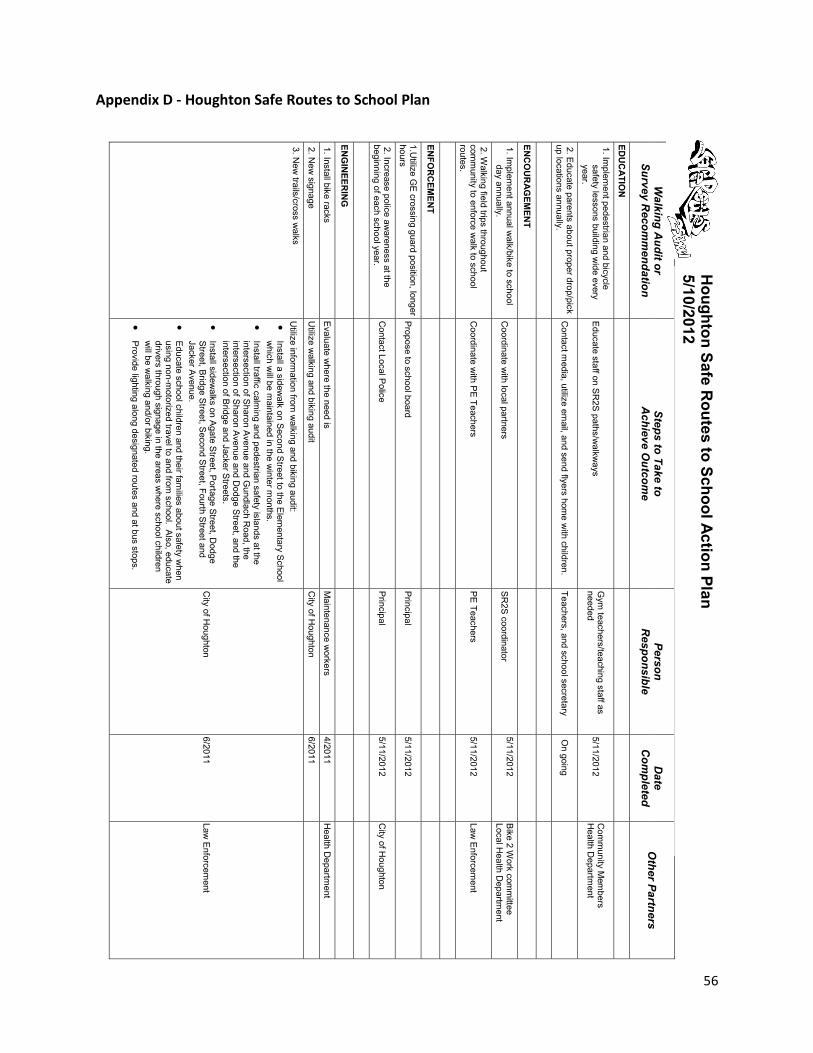
56
Appendix D - Houghton Safe Routes to School Plan
Walking A
udit or Survey R
ecomm
endation
Steps to Take to A
chieve Outcom
e Person
Responsible
D
ate C
ompleted
O
ther Partners
EDU
CATIO
N
1. Implem
ent pedestrian and bicycle safety lessons building w
ide every year.
Educate staff on S
R2S paths/w
alkways
Gym
teachers/teaching staff as needed
5/11/2012 C
omm
unity Mem
bers H
ealth Departm
ent
2. Educate parents about proper drop/pick
up locations annually. C
ontact media, utilize em
ail, and send flyers home w
ith children. Teachers, and school secretary
On going
ENC
OU
RAG
EMEN
T
1. Implem
ent annual walk/bike to school
day annually. C
oordinate with local partners
SR
2S coordinator
5/11/2012
Bike 2 W
ork comm
ittee Local H
ealth Departm
ent
2. Walking field trips throughout
comm
unity to enforce walk to school
routes. C
oordinate with P
E Teachers P
E Teachers 5/11/2012
Law E
nforcement
ENFO
RC
EMEN
T
1.Utilize G
E crossing guard position, longer
hours P
ropose to school board P
rincipal 5/11/2012
2. Increase police awareness at the
beginning of each school year. C
ontact Local Police
Principal
5/11/2012 C
ity of Houghton
ENG
INEER
ING
1. Install bike racks E
valuate where the need is
Maintenance w
orkers 4/2011
Health D
epartment
2. New
signage U
tilize walking and biking audit
City of H
oughton 6/2011
3. New
trails/cross walks
Utilize inform
ation from w
alking and biking audit:
Install a sidewalk on S
econd Street to the E
lementary School
which w
ill be maintained in the w
inter months.
Install traffic calm
ing and pedestrian safety islands at the intersection of S
haron Avenue and G
undlach Road, the
intersection of Sharon A
venue and Dodge S
treet, and the intersection of B
ridge and Jacker Streets.
Install sidew
alks on Agate S
treet, Portage Street, D
odge S
treet, Bridge Street, S
econd Street, Fourth S
treet and Jacker A
venue.
Educate school children and their fam
ilies about safety when
using non-motorized travel to and from
school. Also, educate drivers through signage in the areas w
here school children w
ill be walking and/or biking.
P
rovide lighting along designated routes and at bus stops.
City of H
oughton 6/2011
Law E
nforcement
Houghton Safe R
outes to School Action Plan 5/10/2012
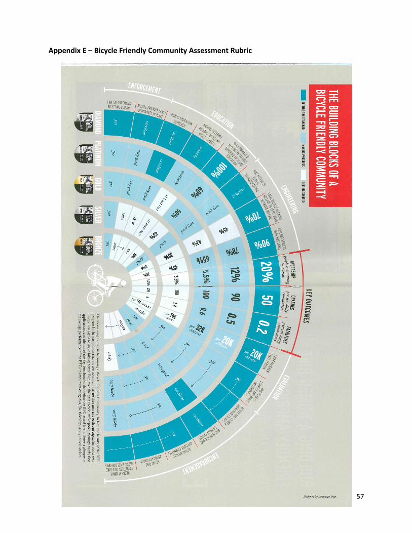
57
Appendix E – Bicycle Friendly Community Assessment Rubric
58
Appendix F - 2012 MTU Bike Boulevard Study MEMORANDUM To: Scott MacInnes, Houghton City Manager From: Bill Sproule Date: August 6, 2012 Subject: A Bicycle Boulevard for Houghton Avenue The concept of a bicycle boulevard has been discussed by students in several Independent Study courses on Bicycle Transportation that I have offered over the years. Bicycle Boulevards are streets that put an emphasis on travel by bicycle in which bicyclists typically share the roadway with other traffic. Some characteristics of bicycle boulevards are as follows:
· Signs denoting the route as a Bicycle Boulevard · Large pavement markings regarding boulevard · Shared road usage of motor vehicles and bicycles · Low speeds for motor vehicle traffic · Traffic Calming Characteristics
· Traffic circles · Bump outs · Access diverters · Lane narrowing
· Limited stop signs along route (Attempts are made to put stop signs on cross roads)
Bicycle boulevards are popular in several cities although the students did not find any examples in Michigan yet. The concept is discussed in the new AASHTO “Guide for the Development of Bicycle Facilities” and there are several presentations on YouTube that illustrate bicycle boulevards.
http://www.youtube.com/watch?v=JcJaZ8Zc0J8 http://www.youtube.com/watch?v=vX8wkI7CwpU
http://www.youtube.com/watch?v=NM60DqAM6bQ Three students (Adam Brokaw, Adam Newton, and Jesse Smith) enrolled in an Independent Study course on Bicycle Transportation in the spring semester 2012 and one of their assignments was to explore Houghton Avenue as a potential location for a bicycle boulevard. The students also documented case study examples in Madison, Minneapolis, and Berkeley, California, and these are included in an Appendix to this memorandum.

59
Background Houghton Avenue is parallel to main east-west streets and it provides a direct route that connects downtown Houghton, West Houghton, and student housing south of downtown, with Michigan Tech. The bicycle boulevard could also be extended to connect with the pedestrian tunnel under M26 and provide access to the waterfront bicycle trail. It is envisioned that a bicycle boulevard on Houghton Avenue would be a popular route and important part of the city’s bicycle plan. A few modifications will be necessary to implement the proposal and these include changing stop control at a several intersections on Houghton Avenue, installing route guide signing, and painting pavement markings on the street. In some cities where bicycle boulevards have been developed a variety of traffic calming measures have also been installing but the team felt that these measures would not be necessary for Houghton Avenue at this time.
Suitability One of the initial steps of the team was to examine Houghton Avenue, between Fifth Street and Townsend Drive (US 41), and see if it is well suited to bicyclists and identify improvements to make it safer and more bicycle friendly. Through much of its length, Houghton Avenue runs through residential neighborhoods with narrow unmarked lanes and on-street parking. There are several stop controlled intersections and limited sight distance. As a result Houghton Avenue is not a through route and traffic volumes are relatively low and vehicle traffic operates at lower speeds. On a daily basis, traffic volumes range from 300 to 600 vehicles per day along Houghton Avenue with higher daily volumes (approaching 1500 vehicles per day) closer to the university near Vivian Street. The hills along Houghton Ave may seem daunting to amateur bicyclists, but the grades along the street meet AASHTO guidelines for bike paths. One exception is the hill between Franklin and Prospect where eastbound traffic needs to climb a fairly long and steep hill through a large rock outcropping. While the grades may be much worse than any other grade along Houghton Ave, they are similar to many other streets in the area, so local riders would be used to such terrain. The team felt that Houghton Avenue would be an excellent candidate for a bicycle boulevard.
The Plan
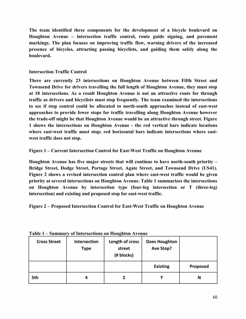
60
The team identified three components for the development of a bicycle boulevard on Houghton Avenue – intersection traffic control, route guide signing, and pavement markings. The plan focuses on improving traffic flow, warning drivers of the increased presence of bicycles, attracting passing bicyclists, and guiding them safely along the boulevard.
Intersection Traffic Control There are currently 23 intersections on Houghton Avenue between Fifth Street and Townsend Drive for drivers travelling the full length of Houghton Avenue, they must stop at 18 intersections. As a result Houghton Avenue is not an attractive route for through traffic as drivers and bicyclists must stop frequently. The team examined the intersections to see if stop control could be allocated to north-south approaches instead of east-west approaches to provide fewer stops for traffic travelling along Houghton Avenue however the trade-off might be that Houghton Avenue would be an attractive through street. Figure 1 shows the intersections on Houghton Avenue - the red vertical bars indicate locations where east-west traffic must stop; red horizontal bars indicate intersections where east-west traffic does not stop. Figure 1 – Current Intersection Control for East-West Traffic on Houghton Avenue Houghton Avenue has five major streets that will continue to have north-south priority – Bridge Street, Dodge Street, Portage Street, Agate Street, and Townsend Drive (US41). Figure 2 shows a revised intersection control plan where east-west traffic would be given priority at several intersections on Houghton Avenue. Table 1 summarizes the intersections on Houghton Avenue by intersection type (four-leg intersection or T (three-leg) intersection) and existing and proposed stop for east-west traffic. Figure 2 – Proposed Intersection Control for East-West Traffic on Houghton Avenue Table 1 – Summary of Intersections on Houghton Avenue
Cross Street Intersection Type
Length of cross street
(# blocks)
Does Houghton Ave Stop?
Existing Proposed
5th 4 2 Y N
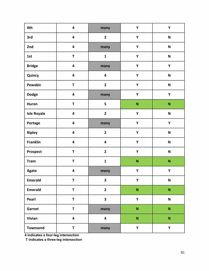
61
4th 4 many Y Y
3rd 4 2 Y N
2nd 4 many Y N
1st T 1 Y N
Bridge 4 many Y Y
Quincy 4 4 Y N
Pewabic T 2 Y N
Dodge 4 many Y Y
Huron T 5 N N
Isle Royale 4 2 Y N
Portage 4 many Y Y
Ripley 4 2 Y N
Franklin 4 4 Y N
Prospect T 2 Y N
Tram T 1 N N
Agate 4 many Y Y
Emerald T 3 Y N
Emerald T 2 N N
Pearl T 3 Y N
Garnet T many N N
Vivian 4 4 N N
Townsend T many Y Y
4 indicates a four-leg intersection T indicates a three-leg intersection
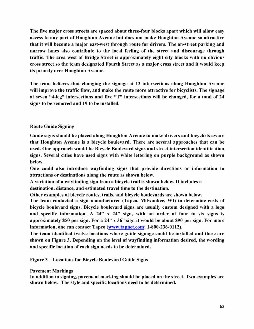
62
The five major cross streets are spaced about three-four blocks apart which will allow easy access to any part of Houghton Avenue but does not make Houghton Avenue so attractive that it will become a major east-west through route for drivers. The on-street parking and narrow lanes also contribute to the local feeling of the street and discourage through traffic. The area west of Bridge Street is approximately eight city blocks with no obvious cross street so the team designated Fourth Street as a major cross street and it would keep its priority over Houghton Avenue. The team believes that changing the signage at 12 intersections along Houghton Avenue will improve the traffic flow, and make the route more attractive for bicyclists. The signage at seven “4-leg” intersections and five “T” intersections will be changed, for a total of 24 signs to be removed and 19 to be installed.
Route Guide Signing Guide signs should be placed along Houghton Avenue to make drivers and bicyclists aware that Houghton Avenue is a bicycle boulevard. There are several approaches that can be used. One approach would be Bicycle Boulevard signs and street intersection identification signs. Several cities have used signs with white lettering on purple background as shown below. One could also introduce wayfinding signs that provide directions or information to attractions or destinations along the route as shown below. A variation of a wayfinding sign from a bicycle trail is shown below. It includes a destination, distance, and estimated travel time to the destination. Other examples of bicycle routes, trails, and bicycle boulevards are shown below. The team contacted a sign manufacturer (Tapco, Milwaukee, WI) to determine costs of bicycle boulevard signs. Bicycle boulevard signs are usually custom designed with a logo and specific information. A 24” x 24” sign, with an order of four to six signs is approximately $50 per sign. For a 24” x 36” sign it would be about $90 per sign. For more information, one can contact Tapco (www.tapnet.com; 1-800-236-0112). The team identified twelve locations where guide signage could be installed and these are shown on Figure 3. Depending on the level of wayfinding information desired, the wording and specific location of each sign needs to be determined. Figure 3 – Locations for Bicycle Boulevard Guide Signs Pavement Markings In addition to signing, pavement marking should be placed on the street. Two examples are shown below. The style and specific locations need to be determined.
63
Recommendations A bicycle boulevard would be an exciting addition to the Houghton Bike Plan and enhance bicycling opportunities in the city. The team recommends that a bicycle boulevard be developed on Houghton Avenue, between Michigan Tech (Townsend Drive) and Fifth Street. To implement a bicycle boulevard the following steps should be taken:
1 Review all intersections to determine implications of changing the traffic control to provide a priority for east-west traffic on Houghton Avenue. Identify all signs that can be removed, added, and/or relocated.
2 Determine the level of wayfinding that is desired on guide signs and then identify specific wording and locations for all signs.
3 Determine the desired bicycle boulevard pavement marking symbol and identify specific locations for application.
4 Identify work to be completed to connect the Houghton Avenue bicycle boulevard with the pedestrian tunnel under M26. The location is shown in the photograph below.
1 Examine the Houghton Avenue/Townsend intersection and develop a plan for the safe crossing of Townsend Drive (US41) and provide a safe connection to the Michigan Tech campus.
References Guide for the Development of Bicycle Facilities, Fourth Edition, AASHTO, Washington, DC, 2012. Manual on Uniform Traffic Control Devices for Streets and Highway, 2009 edition, FHWA and others, Washington, DC – http://mutcd.fhwa.dot.gov Federal Highway Administration University Course on Bicycle and Pedestrian Transportation, USDOT/FHWA, Washington, DC, 2006 – http://www.fhwa.dot.gov/publications/research/safety/pedbike/05085 Bicycle Boulevard Planning and Design Guidebook, Portland State University, Portland, OR, 2009 - http://www.ibpi.usp.pdx.edu/guidebook.php APPENDIX - CASE STUDIES Madison, WI Objective: To move from gold level to platinum level of bicycle friendly community from League of American Bicyclists – three projects Kendall Ave. (N Franklin Ave to N Breese Terrace) · Cost estimated at $15,000 · Used pilot program of restricting access with construction barrels prior to making permanent commitment with concrete curb · Neighboring streets appear to be getting hit hard with extra traffic · Completed in 2010 · Similar to what we may be looking for in Houghton as it runs parallel approximately two blocks from a main road.
64
· Madison approach is to utilize bicycle boulevards on areas with a grid system where there is a parallel road to accommodate decreased traffic. · Compared to bike lanes where a city can just stripe a bike lane and call it good without discussing it with the community it takes a larger effort to make changes with stop signs at intersections and traffic calming techniques which would divert traffic to other areas due to the need and expense of community meetings. Mifflin Street. (Blair St to about Baldwin St)
· Completed in 2010 · Uses Signage and minimal infrastructure modifications
Wilson Street · Wisconsin’s first Bicycle Blvd. · Criticism – Just through up some signs and pavement markings
http://madisonneareast.channel3000.com/content/bike-boulevard-pilot-program-underway-madison http://www.cityofmadison.com/bikeMadison/planning/completed/ http://bfw.org/2011/12/20/bicycle-boulevards-evolve-into-greenways/ Minneapolis, MN River-lake Greenway Bicycle Boulevard (40th Street between I-35W and Nokomis Avenue)
· Minneapolis first Bicycle Blvd. · Uses signage · Many stop signs switched, but could use more according to some user criticisms · Curb extensions / Bump outs utilized · Diverter Utilized
http://velotraffic.com/2010/11/riverlake-greenway-bicycle-boulevard/
Berkeley, CA Bicycle Blvd. Network of seven boulevards
· Ninth Street – California/King – Milvia Street - Hillegass/Bowditch - Virginia Street - Channing Way - Russell Street · Connections
· BART · Downtown · Elementary Schools
65
· University of California Berkeley · Signage Utilization
· Color purple to distinguish individuality opposed to other street signs · Identification sign – Name of boulevard · Destination & Distance – Provides information in regards to route · Route Guidance – Signs direct users in regards to turns along route and destinations · Off Route Signage – Directs bicyclists not on boulevard in direction of boulevard · Night-Time Signage – Highly reflective signs · Utilization of large visible pavement markings
· Funding Sources · Transportation Fund for Clean Air (TFCA) · Transportation Development Act, Article 3 (TDA, Article 3) · Transportation Development Act, Article 3 (TDA, Article 3)
http://www.ci.berkeley.ca.us/ContentDisplay.aspx?id=6748 Link to web site that includes the City of Berkeley “Bike Plan” and “Bicycle Boulevard Design Tools and Guidelines”
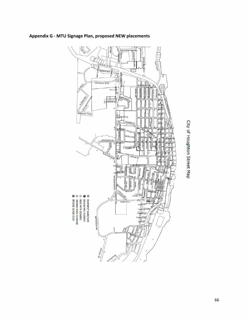
66
Appendix G - MTU Signage Plan, proposed NEW placements
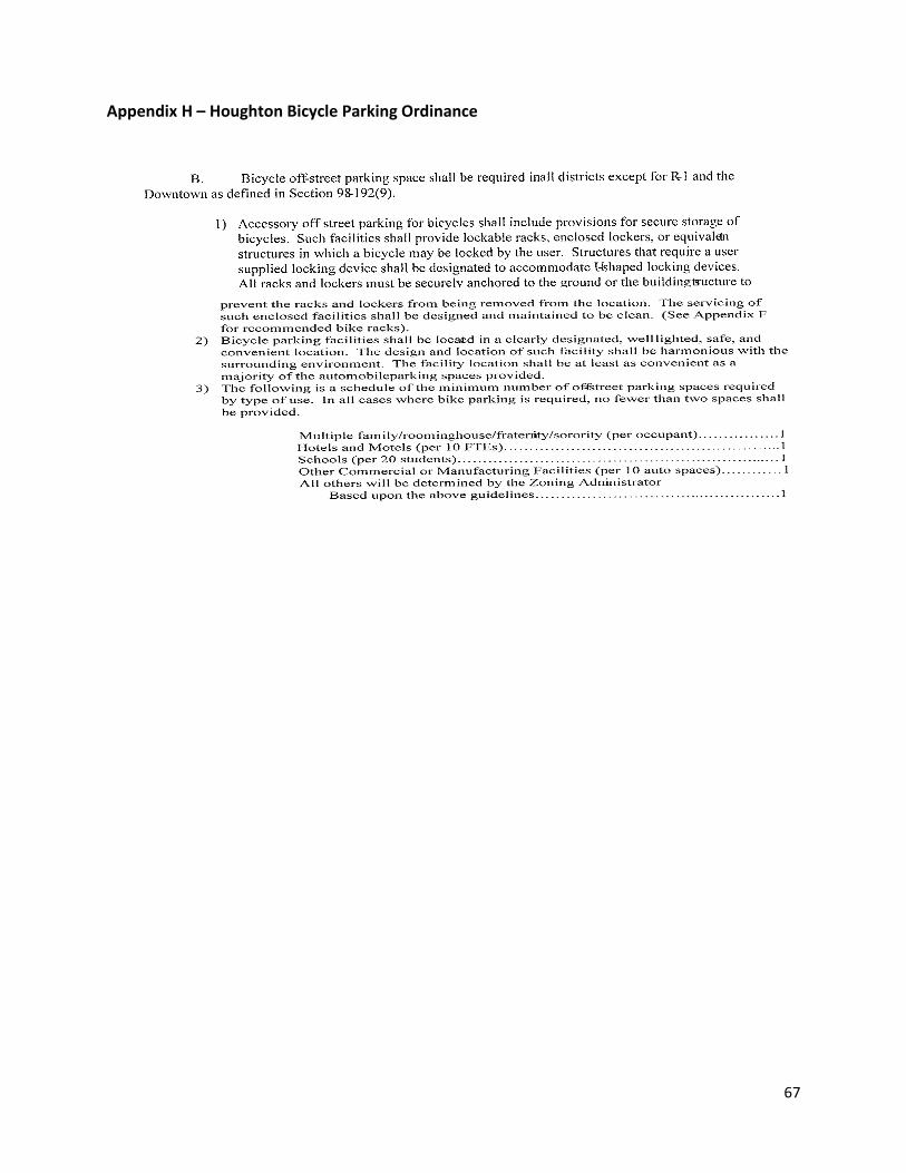
67
Appendix H – Houghton Bicycle Parking Ordinance