Embed Size (px)
Citation preview

Chesapeake Bay Seminar SeriesCoping with sea level rise in Chesapeake Bay
and around the worldWas the storm surge from Hurricane Isabel
a taste of Chesapeake Bay’s future?
J. Court StevensonHorn Point Laboratory, University of Maryland Center for Environmental Science
Online broadcast athttp://ian.umces.edu/seminarbroadcast.htm
Hosted by the Integration & Application Network at the University of Maryland Center for Environmental Science
http://ian.umces.edu
integration application network

Coping with sea level rise in Coping with sea level rise in Chesapeake Bay andChesapeake Bay and
around the worldaround the worldWas the storm surge from Hurricane IsabelWas the storm surge from Hurricane Isabel
a taste of Chesapeake Bay’s future?a taste of Chesapeake Bay’s future?The last house on Holland IslandThe last house on Holland Island Image: J.C. StevensonImage: J.C. Stevenson
Prof. J. Court StevensonProf. J. Court Stevenson

OutlineOutline•• Relative sea level is rising inRelative sea level is rising in
Chesapeake BayChesapeake Bay
•• Sea level rise can be balanced by Sea level rise can be balanced by sediment/organic accretionsediment/organic accretion
•• Dams can reduce sediment supplyDams can reduce sediment supply(Three Gorges Dam, China)(Three Gorges Dam, China)
•• Storm surges threaten many regions Storm surges threaten many regions (London, Holland, Venice)(London, Holland, Venice)
•• Management responses in Chesapeake Management responses in Chesapeake to sea level rise and storm surges include to sea level rise and storm surges include using dredged sediments & living using dredged sediments & living shorelinesshorelines

Isabel storm surge provides impetus to Isabel storm surge provides impetus to understand underlying processesunderstand underlying processes
•• Isabel demonstrated how a minor hurricane can Isabel demonstrated how a minor hurricane can pose a threat to manpose a threat to man--made structures along the made structures along the Atlantic shoreline. Atlantic shoreline.
•• In view of global warming and sea level rise, Isabel In view of global warming and sea level rise, Isabel should be a wakeshould be a wake--up call to the public that better up call to the public that better strategies are needed to cope in the future.strategies are needed to cope in the future.
Raleigh News and Observer, Sept 2003Raleigh News and Observer, Sept 2003Photo: Don Photo: Don MerritMerrit, UMCES, UMCES

Relative sea level rise =Relative sea level rise =

Sea level is rising in Sea level is rising in Chesapeake BayChesapeake Bay
Source: Permanent Servicefor Mean Sea LevelBaltimore sea level

Sea level rise can be balanced Sea level rise can be balanced by sediment/organic accretionby sediment/organic accretion
Marsh expansionMarsh expansionand peat formationand peat formation
Marsh lossMarsh loss(drowning)(drowning)
Photo: E.W. Koch, UMCESPhoto: E.W. Koch, UMCES

IntertidalIntertidal vegetation is extremely vegetation is extremely sensitive to sea level fluctuationssensitive to sea level fluctuations
Salt marshes inSalt marshes intemperate regions
Mangroves inMangroves intropical regionstemperate regions tropical regions
Redfield’s model for saltRedfield’s model for salt--marsh development over accumulating sediment on a marsh development over accumulating sediment on a sand flat & over the upland under the influence of rising sea lesand flat & over the upland under the influence of rising sea level (Redfield, vel (Redfield, 1972). HW refers to mean high water at various times during deve1972). HW refers to mean high water at various times during developmentlopment

Regions where sea level rise exceeds Regions where sea level rise exceeds accretion will 'drown' marshesaccretion will 'drown' marshes
Sediment budget (MT yrSediment budget (MT yr--11) for ) for BlackwaterBlackwater RiverRiverInputs Outputs
Blackwater River Lower Blackwater at Shorter's WharfEbb tides 1,070 Ebb tides 766,000-Flood tides 500 - Flood tides 41,400Net input 570
Little Blackwater RiverEbb tides 6,580-Flood tides 1,880Net input 4,700
Total riverine input 5270 Total tidal output 724,600
Net system export -719,330
From: Stevenson et al. 1985. Mar. Geol. 67: 213From: Stevenson et al. 1985. Mar. Geol. 67: 213--235235

SaltmarshSaltmarsh management implications:management implications:Biotic grazing removes biomassBiotic grazing removes biomass
Photo: Chesapeake Bay ProgramPhoto: Chesapeake Bay Program Photo: G. C. KelleyPhoto: G. C. Kelley
NutriaNutria Snow gooseSnow goose
Photo: J.C. StevensonPhoto: J.C. Stevenson

SaltmarshSaltmarsh management implications:management implications:Harvesting removes biomassHarvesting removes biomass
Gathering Hay Before a StormGathering Hay Before a Storm, 1862 Oil Painting by Martin Johnson , 1862 Oil Painting by Martin Johnson HeadeHeade –– Antiques MagazineAntiques Magazine, May 2001. , May 2001.
Salt haying was common along the coast in the 1800s. However, sSalt haying was common along the coast in the 1800s. However, sea level began to ea level began to take its toll in the 20take its toll in the 20thth century and eventually dikes were put up on the seaward sides century and eventually dikes were put up on the seaward sides in NJ to reduce tidal action. This promoted peat subsidencein NJ to reduce tidal action. This promoted peat subsidence

SaltmarshSaltmarsh management implications:management implications:Sediment accretion can be enhancedSediment accretion can be enhanced
Dredge material can be applied to eroding marshes (Louisiana)Dredge material can be applied to eroding marshes (Louisiana)
CahounCahoun and Cowan, 1988and Cowan, 1988CahounCahoun and Cowan, 1988and Cowan, 1988
Salt marsh (Sept Salt marsh (Sept 2003) on 2003) on BlackwaterBlackwaterRiver one year after River one year after thinthin--layer application layer application of dredged material. of dredged material. Photo: J.C. StevensonPhoto: J.C. Stevenson

SaltmarshSaltmarsh management implications:management implications:PhragmitesPhragmites control removes biomasscontrol removes biomass
Photo: J.C. StevensonPhoto: J.C. Stevenson
•• PhragmitesPhragmites australisaustralis is a Cis a C--3 plant and as 3 plant and as such grows more vigorously under such grows more vigorously under enhanced COenhanced CO22 environmentsenvironments
•• Introduced variety encroaching on Introduced variety encroaching on marshlands of the Chesapeake overmarshlands of the Chesapeake overthe last several decadesthe last several decades
•• Appears to promotes sediment accretionAppears to promotes sediment accretion
Diagram: K. Diagram: K. SaltonstallSaltonstall
Salt marsh (Sept Salt marsh (Sept 2003) on 2003) on BlackwaterBlackwaterRiver one year after River one year after thinthin--layer application layer application of dredged material. of dredged material.
Stevenson et al. (2001)Stevenson et al. (2001)

Dams can remove sediment supplyDams can remove sediment supplywww.chinahighlights.com Photo: J.C. StevensonPhoto: J.C. Stevenson
Photo: J.C. StevensonPhoto: J.C. Stevenson Photo: J.C. StevensonPhoto: J.C. Stevenson

Impact of large dam on coastal Impact of large dam on coastal features may be profoundfeatures may be profound
IimageIimage: NASA/MODIS: NASA/MODIS Photo: J.C. StevensonPhoto: J.C. Stevenson
ShanghaiShanghai
Yangtze River floodingYangtze River floodingin Hunan Province
Former school flooded Former school flooded for Three Gorges Damin Hunan Province for Three Gorges Dam

Storm surges threaten many coastal regions:Storm surges threaten many coastal regions:European examplesEuropean examples
LondonLondonRotterdamRotterdam
VeniceVenice
Images courtesy NASA Visible EarthImages courtesy NASA Visible Earth

Historical storm surges noted inHistorical storm surges noted inLondon by Samuel London by Samuel PepysPepys
"There was last night the greatest tide that was ever was rememb"There was last night the greatest tide that was ever was remembered ered in England to have been in this River all Whitehall having been in England to have been in this River all Whitehall having been drowned" drowned" Samuel Samuel PepysPepys in his diary 7 December 1663in his diary 7 December 1663
Whitehall from St James's ParkWhitehall from St James's Park by Peter by Peter TillemansTillemansOriginal owned by His Grace the Duke of Original owned by His Grace the Duke of RoxburgheRoxburghe, UK, UK

'Little Ice Age' of medieval Europe 'Little Ice Age' of medieval Europe was cooler with lower sea levelwas cooler with lower sea level
There were generally cooling There were generally cooling temperatures from 1,000 AD to temperatures from 1,000 AD to 1600s. The curve suggests an 1600s. The curve suggests an upward trend in the 1700s and then upward trend in the 1700s and then cooling again about 1815 and then a cooling again about 1815 and then a steady increase as fossil fuels steady increase as fossil fuels became more available and land became more available and land clearance was widespread. clearance was widespread.
Thousand year air temperature trends Thousand year air temperature trends suggest about ½ degree change over suggest about ½ degree change over last century and a half last century and a half –– but why wasn’t but why wasn’t this more? this more?
'Little Ice Age''Little Ice Age'
The Frozen ThamesThe Frozen Thames by A. by A. HondiusHondius
Data: Climate Research Unit, University of East Anglia, UK Data: Climate Research Unit, University of East Anglia, UK

Tide gates on Thames River used to Tide gates on Thames River used to protect London from storm surgeprotect London from storm surge
•• North Sea Flood of 1953 drowned 160,000 a. & killed 300 peopleNorth Sea Flood of 1953 drowned 160,000 a. & killed 300 people
•• Following 1966 report by Sir Herman Following 1966 report by Sir Herman BondiBondi, decision was that best solution was bank , decision was that best solution was bank raising in conjunction with a flood barrier with movable gates braising in conjunction with a flood barrier with movable gates built across the riveruilt across the river
•• Thames Barrier and Flood Protection Act 1972 to give powers to cThames Barrier and Flood Protection Act 1972 to give powers to carry it out arry it out
•• Interim bank raising actually begun in April 1971 and completed Interim bank raising actually begun in April 1971 and completed in December 1972 in December 1972
•• Construction of the Barrier started in late 1974 & operational iConstruction of the Barrier started in late 1974 & operational in Oct 1982. It was first n Oct 1982. It was first used in Feb 1983 & officially opened by Her Majesty The Queen onused in Feb 1983 & officially opened by Her Majesty The Queen on 8th May 19848th May 1984
ThamesThamesbarrierbarrier
Image: University of Nottingham, UKImage: University of Nottingham, UKInstitute of EngineeringInstitute of EngineeringSurveying & GeodesySurveying & Geodesy
Image: Thames Barrier ParkImage: Thames Barrier Park

The Dutch have had extensive The Dutch have had extensive experience in storm surge protection experience in storm surge protection
and coastal developmentand coastal developmentOriginal landOriginal landReclaimed landReclaimed land
Source: World Source: World FactbookFactbook Netherlands GovernmentNetherlands Government

Reclaimed lands in Holland are Reclaimed lands in Holland are used for agricultureused for agriculture
BeforeBefore AfterAfter
Images: Images: CruquiusCruquius Museum, NetherlandsMuseum, Netherlands

Extensive dikes are being raised to Extensive dikes are being raised to account for sea level riseaccount for sea level rise
Source: Netherlands GovernmentSource: Netherlands Government Source: Netherlands GovernmentSource: Netherlands Government

Port of Rotterdam uses largest Port of Rotterdam uses largest storm surge gates in the worldstorm surge gates in the world
Source: Port of RotterdamSource: Port of Rotterdam
Source: Source: ConsorzioConsorzio VeneziaVenezia NuovaNuova

Venice is the best known case study of sea Venice is the best known case study of sea level riselevel rise
Source: Source: ChiozzottoChiozzotto and and DrusianiDrusiani, IWA Conference 2002, IWA Conference 2002

Rising sea level has led to Rising sea level has led to increased flooding of Veniceincreased flooding of Venice
Annual distribution of Annual distribution of exceptional high water exceptional high water events in the periodevents in the period19231923--19961996Source: Centre for tidal Source: Centre for tidal forecasting of the Venice forecasting of the Venice Municipality and Rafael Municipality and Rafael Bras, MITBras, MIT
Sea level trend at Venice Sea level trend at Venice and Trieste in the period and Trieste in the period 18961896--1996.1996.Source: Source: CarbogninCarbognin L, CNR, L, CNR, Venice, Italy, and Rafael Venice, Italy, and Rafael Bras, MITBras, MIT
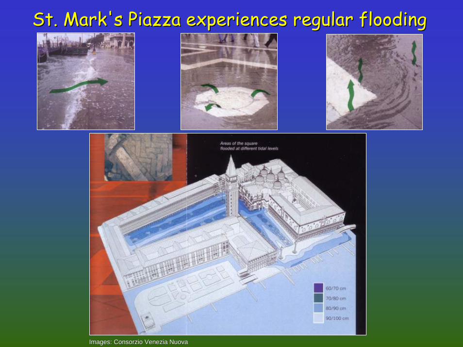
St. Mark's Piazza experiences regular flooding St. Mark's Piazza experiences regular flooding
Images: Images: ConsorzioConsorzio VeneziaVenezia NuovaNuova

Water diversion reduced sediment Water diversion reduced sediment delivery to Venice Lagoondelivery to Venice Lagoon
Venice circa 1500Venice circa 1500Source: Source: ConsorzioConsorzio VeneziaVenezia NuovaNuova
BrentaBrenta CanalCanal
BrentaBrenta RiverRiver
VeniceVenice

Net sediment transportNet sediment transportout of Venice Lagoonout of Venice Lagoon
Source: Source: ConsorzioConsorzio VeneziaVenezia NuovaNuova

BondesanBondesan et al. 1995et al. 1995J. Coastal Research Vol. 11J. Coastal Research Vol. 11
< 2 m below sea level< 2 m below sea level
0 to 2 m below sea level0 to 2 m below sea level
0 to 2 m above sea level0 to 2 m above sea level
>2 m above sea level>2 m above sea level
Sea level problems are notSea level problems are notrestricted to Venice Lagoonrestricted to Venice Lagoon

Management responses to the Management responses to the Venice situation varyVenice situation vary
Source: Source: ChiozzottoChiozzotto and and DrusianiDrusiani, IWA Conference 2002, IWA Conference 2002

A massive engineering project has beenA massive engineering project has beeninitiated for storm surge protectioninitiated for storm surge protection
Source: Source: ChiozzottoChiozzotto and and DrusianiDrusiani, IWA Conference 2002, IWA Conference 2002

Floating gates being Floating gates being constructed for Venice Lagoonconstructed for Venice Lagoon
Source: Source: ConsorzioConsorzio VeneziaVenezia NuovaNuova

Artist: Ken BrownArtist: Ken Brown
The future fate of St Mark's The future fate of St Mark's Piazza, Venice? Piazza, Venice?

A book comparing northern Adriatic and A book comparing northern Adriatic and Chesapeake Bay has been publishedChesapeake Bay has been published
Available from American Available from American Geophysical UnionGeophysical Unionhttp://http://www.agu.orgwww.agu.org

In Chesapeake Bay, shoreline erosion In Chesapeake Bay, shoreline erosion is accelerated with sea level riseis accelerated with sea level rise
Image: J.C. StevensonImage: J.C. Stevenson
Photo: David HarpPhoto: David Harp Photo: J.C. StevensonPhoto: J.C. Stevenson

As marshes erode, buffering As marshes erode, buffering capacity is lostcapacity is lost
Photo: J.C. StevensonPhoto: J.C. Stevenson
Armoring shorelines at Cooks Pt Armoring shorelines at Cooks Pt ––18 Apr 200118 Apr 2001

Poplar Island is being restored using Poplar Island is being restored using dredge materialdredge material
Image: USGSImage: USGS

Dredge material for Poplar Dredge material for Poplar Island comes from Baltimore Island comes from Baltimore
Harbor approachesHarbor approachesThe Poplar Island The Poplar Island project will project will reconstruct the island reconstruct the island to its approximate to its approximate size in 1847 using 29 size in 1847 using 29 million cubic meters million cubic meters of clean dredged of clean dredged material from the material from the Baltimore Channels Baltimore Channels Federal Navigation Federal Navigation project. project.
Image: US Army Corps of EngineersImage: US Army Corps of Engineers

Dikes created initially, followed by Dikes created initially, followed by inin--filling with dredge materialfilling with dredge material
Images: US Army Corps of EngineersImages: US Army Corps of Engineers
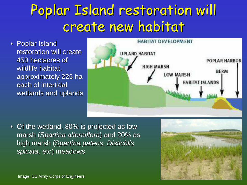
Poplar Island restoration will Poplar Island restoration will create new habitatcreate new habitat
•• Poplar IslandPoplar Islandrestoration will createrestoration will create450 450 hectacreshectacres ofofwildlife habitat,wildlife habitat,approximately 225 haapproximately 225 haeach of each of intertidalintertidalwetlands and uplandswetlands and uplands
•• Of the wetland, 80% is projected as low Of the wetland, 80% is projected as low marsh (marsh (SpartinaSpartina alternifloraalterniflora) and 20% as ) and 20% as high marsh (high marsh (SSpartinapartina patens, patens, DistichlisDistichlisspicataspicata,, etc) meadowsetc) meadows
Image: US Army Corps of EngineersImage: US Army Corps of Engineers

0
10
20
30
40
50
0.000 2.000 4.000 6.000 8.000 10.000
[H2S] mmol L-1
Dep
th (c
m)
3H 3L
Tilled dredge
0
10
20
30
40
50
0.000 2.000 4.000 6.000 8.000 10.000
[H2S] mmol L-1
Dep
th (c
m)
4H 4L
Un-tilled dredge
0
5
10
15
20
25
0.000 2.000 4.000 6.000 8.000 10.000
[H2S] mmol L-1
Dep
th (c
m)
5H 5L
No treatment
0
10
20
30
40
50
0.000 200.000 400.000 600.000 800.000 1000.000
[H2S] mmol L-1
Dep
th (c
m)
6H 6L
Reference marsh
Sulfides much lower in dredge materialSulfides much lower in dredge material
Photo:Photo:J.C. StevensonJ.C. Stevenson
Data: Quarterly Progress Report to Port of Baltimore and MD EnviData: Quarterly Progress Report to Port of Baltimore and MD Environmental Services, Sept 2003ronmental Services, Sept 2003

Restored marsh does not have anoxia Restored marsh does not have anoxia problems like reference marshesproblems like reference marshes
0
5
10
15
20
25
30
35
6/26 6/27 6/28 6/29 6/30 7/1 7/2
Temp CDO mg/L
•• Dissolved oxygen maintained above 5 mg/LDissolved oxygen maintained above 5 mg/L
Data: Quarterly Progress Report to Port of Baltimore and MD EnviData: Quarterly Progress Report to Port of Baltimore and MD Environmental Services, Sept 2003ronmental Services, Sept 2003

John Flood’s Living Shoreline on South RiverJohn Flood’s Living Shoreline on South River
Lateral marsh Lateral marsh accretion along accretion along shoreline of shoreline of south river farm, south river farm, six years after six years after installation of installation of offshore 'sill' to offshore 'sill' to reduce wave reduce wave action at ‘toe’ of action at ‘toe’ of eroding bluff
ErodedErodedbluffbluff
Offshore 'sill' toOffshore 'sill' toreduce wave actionreduce wave action
SAV bedsSAV beds
OffshoreOffshoresandbarsandbar
AccretingAccretingmarshmarsh
Photo: J.C. StevensonPhoto: J.C. Stevenson
eroding bluff

'Bio logs' can be used to reduce 'Bio logs' can be used to reduce erosion in low wave activity areaserosion in low wave activity areas
Photo: J.C. StevensonPhoto: J.C. Stevenson

Do we need storm surge Do we need storm surge barriers in Chesapeake Bay?barriers in Chesapeake Bay?
Washington DCWashington DC
AnnapolisAnnapolis
BaltimoreBaltimore
Image: USGSImage: USGS

Management responses to sea level rise Management responses to sea level rise need to include greenhouse gas strategyneed to include greenhouse gas strategy
Source: IPCCSource: IPCC

ConclusionsConclusions•• Relative sea level is rising inRelative sea level is rising in
Chesapeake BayChesapeake Bay
•• Sea level rise can be balanced by Sea level rise can be balanced by sediment/organic accretionsediment/organic accretion
•• Dams can reduce sediment supplyDams can reduce sediment supply(Three Gorges Dam, China)(Three Gorges Dam, China)
•• Storm surges threaten many regions Storm surges threaten many regions (London, Holland, Venice, Chesapeake)(London, Holland, Venice, Chesapeake)
•• Management responses to storm surges Management responses to storm surges include reduced groundwater extraction include reduced groundwater extraction and surge barriers; need to include and surge barriers; need to include greenhouse gas strategygreenhouse gas strategy

AcknowledgementsAcknowledgements•• MD Dept of Natural ResourcesMD Dept of Natural Resources•• US Environmental Protection AgencyUS Environmental Protection Agency•• US Fish & Wildlife ServiceUS Fish & Wildlife Service•• US Army Corps of EngineersUS Army Corps of Engineers•• MD Environmental ServiceMD Environmental Service•• Port of BaltimorePort of Baltimore•• NOAA Coastal Zone ProgramNOAA Coastal Zone Program
•• My publication list is on our website My publication list is on our website hpl.umces.eduhpl.umces.eduFor copies email me For copies email me [email protected]@hpl.umces.eduOr phone 410 221 8442, fax 410 221 8490Or phone 410 221 8442, fax 410 221 8490

Chesapeake Bay Seminar SeriesChesapeake Bay Seminar Series
QUESTION TIME
Coping with sea level rise in Chesapeake Bay and around the world
Was the storm surge from Hurricane Isabela taste of Chesapeake Bay’s future?
J. Court Stevenson(Horn Point Laboratory, University of Maryland Center for Environmental Science)
Hosted by the Integration & Application Network at the University of Maryland Center for Environmental Science
http://ian.umces.edu
integration application network