Embed Size (px)
Citation preview
571A.J. Heppenstall et al. (eds.), Agent-Based Models of Geographical Systems, DOI 10.1007/978-90-481-8927-4_28, © Springer Science+Business Media B.V. 2012
Abstract The high rates of urban growth in Latin America during the 1960s and 1970s produced rapid urbanization and housing problems. In developing countries, planning policies as well as the research community have approached urban growth as a static problem rather than as a spatial form that emerges from the urban devel-opment process and that is part of a constant dynamic process. This paper focuses on a specifi c kind of urban growth that happens in Latin American cities, called ‘peripherisation’. This is characterized by the formation of low-income residential areas in the peripheral ring of the city and a perpetuation of a dynamic core-periphery spatial pattern. The dynamics of growth and change in Latin American cities are explored using agent-based simulation. The objective is to increase the understanding of urban spatial phenomena in Latin American cities, which is essential to providing a basis for future planning actions and policies. The fi rst part of the chapter presents a brief overview of urban growth and dynamics in Latin American cities. The Peripherisation Model is introduced, and its implementation and evaluation described. Simulation exercises were used to revisit assumptions about urbanization issues in Latin American cities and investigate important aspects of growth and change in these cities. These exercises allowed the problem of urban growth in Latin American cities to be unfolded through their dynamics, relating these dynamics to urban morphology, and thus presenting a new and important perspective on the phenomenon.
J. Barros (*) Department of Geography, Environment and Development Studies , Birkbeck, University of London , London , UK e-mail: [email protected]
Chapter 28 Exploring Urban Dynamics in Latin American Cities Using an Agent-Based Simulation Approach
Joana Barros
572 J. Barros
28.1 Introduction
Rapid urbanization has been the main theme of urban studies in Latin America since the explosion of rates of growth in the 1960s and 1970s. While studies predicted an unprecedented rate of growth in these cities by the year 2000, the speed of develop-ment has been blamed as the cause of spatial inequalities and problems in these cities. Yet, the actual rates of growth have slowed since the 1980s and studies sug-gest that the tendency is that the rates will remain as they are. The urban problems, however, have not disappeared in the last two decades, and, despite lower rates of population growth, cities keep growing and developing in the very same way. Hence, the principal problem of urban growth in Latin American cities is no longer the high rates of population growth and rural-urban migration. Rather, it is the spatial pattern of growth and its underlying dynamics of change, the peripherisation process, which enlarges the peripheral rings of cities and metropolises despite the reduction in overall urban growth rates.
There have been a large number of studies of urbanization issues in these coun-tries, mainly focusing on the rapidity of growth of cities and the social inequalities in urban space produced by this process. Most of these studies have taken a socio-logical and political approach, often discussing either the role of the poor and spon-taneous settlements, or the State in the context of economic and urban development. Hence, while studies of demographic trends, housing, urban poor and urbanization proliferated during the 1970s and 1980s, very few studies have been devoted to the morphology and dynamics of Latin American cities to date. Planning policies as well as the research community have approached urban growth as a static problem rather than as a spatial form that emerges from the urban development process and that is part of a constant dynamic process.
The present study looks at issues related to the growth of Latin American cities by investigating the dynamics of this mode of urban growth and change. The objective is to increase the understanding of urban spatial phenomena in Latin American cities, which is essential to providing a basis for future planning actions and policies.
The study of urban dynamics requires tools that allow for the exploration of change phenomena in time and space. Urban modeling techniques have been traditionally used to explore issues in urban dynamics, and automata models like cellular automata (CA) and agent-based models (ABMs) seem to be a particu-larly suitable approach for this kind of study. Therefore, an ABM was used in order to unfold the problem of urban growth of Latin American cities through their dynamics. ABMs are based on the understanding that human decision-making plays a major role in urban processes and urban change. Their framework allows interactions between agents and their landscape to be explicitly represented. Hence, this kind of model permits the analysis of dynamic processes that link spatial development with social issues, which is of fundamental importance when dealing with cases of strong social differentiation, as is the case of urban dynamics in Latin American cities.

57328 Exploring Urban Dynamics in Latin American Cities…
The present chapter describes an exploratory use of ABMs, which conceives the ABM simulation as a laboratory where existing theories of urban phenomena can be explored and further developed. The simulation model is, thus, seen as part of a theory-building process. Simulation exercises were used to revisit assumptions on urbanization issues in Latin American cities and investigate important aspects regarding growth and change in them. These exercises allowed the problem of urban growth in Latin American cities to be revealed through their dynamics, relating these dynamics to urban morphology, and thus presenting a new and important per-spective on the phenomenon.
28.2 Urban Dynamics in Latin American Cities
While the problem of urban growth in Europe and North America has been formu-lated in terms of sprawl in the Third World and, more specifi cally, in Latin America the main focus has been the rapidity of the growth of cities. Indeed, it has been the fastest urban growth in history. During the period between 1950 and 1980 growth rates were very high (Hall 1983 ; Valladares and Coelho 1995 ) and, based on these data, studies anticipated continuing high rates of growth. It was believed that many areas would double in population and a few would triple, creating urban areas that by the year 2000 would be without parallel in history (Hall 1983 ) . Latin American countries went from being predominantly rural to predominantly urban in a few decades, with high concentrations of urban population in cities with more than one million inhabitants (UNCHS 1996 ) . This rapid urbanization produced various kinds of social problems, especially in terms of housing since the governments of such countries did not manage to provide enough housing and urban infrastructure to house the infl ux of migrants to the cities.
However, this population change has shown marked signs of change since 1980. After decades of explosive urbanization, urban growth rates have slowed, the rate of metropolitan growth has fallen and fertility rates have declined (Valladares and Coelho 1995 ) . Moreover, rural to urban migration has come to have a much smaller role in urban population growth and, most recently, the pace of urban expansion has been maintained by births in the cities. These new trends have been detected in the period between 1980 and 1990, and have been confi rmed by recent censuses.
Thus, the principal problem of urban growth in Latin American cities is no lon-ger the high rates of population growth and rural-urban migration. Rather, it is the spatial pattern of growth, the peripherisation process, which enlarges the periph-eral rings of cities and metropolis despite the reduction in the overall urban growth rates. The peripherisation phenomenon is becoming an increasingly signifi cant issue, particularly in the larger cities of Latin America. In those cities, the demo-graphic growth rate has slowed right down, migration has taken second place to natural increase, and the bulk of the housing stock now consists of upgraded (or in the process of upgrading) low-income residential areas, with a large number of spontaneous settlements.
574 J. Barros
The phenomenon of peripheral growth, which has been recognized by Latin American researchers and planners and termed ‘peripherisation’, can now be con-sidered as an established process of growth of most Latin American cities. Peripherisation can be defi ned as a kind of growth process characterized by the expansion of the borders of the city through the massive formation of peripheral settlements, which are, in most cases, low-income residential areas. These areas are incorporated to the city by a long-term process of expansion in which some of the low-income areas are recontextualised within the urban system and occupied by a higher economic group while new low-income settlements continue to emerge on the periphery.
Peripherisation is an urban spatial problem which has strong effects in social and economic terms, a problem that is unlikely to fade away without strong planning action. The peripheral ring of Latin American cities consists mostly of low-income housing including large spontaneous settlements, which usually lack urban services of any kind. As such, peripherisation clearly constitutes a social problem. However, it is not only a problem in the sense of the extreme social inequalities that appear in the city in a very concrete spatial form. Rather, the problem is the perpetuation of such a form in space and time and, in this sense, peripherisation is a social problem of spatial order.
In terms of urban planning policies, the peripherisation phenomenon is seen from a static point of view. The focus of the governments’ interventions is still on the local/housing scale, upgrading settlements and providing housing tracks for the low-income groups. There has been no focus either on the dynamics of the process or on the linkage between local and global scales. The overall growth of the cities has so far been seen as a mere result of a demographic phenomenon.
Peripherisation, like urban sprawl, is a suburbanization phenomenon. Whilst urban sprawl has been studied in detail and its main features seem to be broadly understood, in Latin America’s case the understanding of the peripherisation pro-cess remains a central issue. Contrary to sprawl, an inherently spatial problem, urban peripherisation is essentially a social problem with spatial characteristics. From a social point of view, peripherisation is not a simple problem to solve. As a spatial problem, and more specifi cally as an urban development problem, the phenomenon still needs to be further investigated.
Like urban sprawl, peripherisation is fragmented and discontinuous develop-ment. It also presents problems related to urban sustainability, transportation and the cost of infrastructure and urban services. Studies from the 1970s suggest that the lowest densities in Latin American cities are found in high-income residential areas, with the highest densities in middle-class areas and the densities of spontaneous settlements are somewhere between these two (Amato 1970a ) . Finally, an interest-ing difference between urban sprawl and peripherisation is related to the fact that, while urban sprawl is directly related to the preference of people for suburban set-tings, peripherisation is not a direct consequence of locational preference. On the contrary, people who move to the city’s border do not wish to live there but are compelled to.
57528 Exploring Urban Dynamics in Latin American Cities…
28.3 The Peripherisation Model
The Peripherisation Model is an exploratory ABM for urban growth in Latin American cities that explores agent-landscape relationships only, and was elabo-rated in such a way that the behavioural rules are as simple as possible.
The simulation model was developed by adding features to a simple logic, or in other words, increasing the model’s complexity step-by-step so that the understanding of its behaviour was not lost during the development process. Each of these four suc-cessive modules adds up to a model that simulates different aspects of urban growth and change in Latin American cities. Thus, module one focuses on the peripherisation phenomenon. Module two consists of the peripherisation module supplemented by a consolidation rule, and focuses on the formation of spontaneous settlements. Module three examines inner city processes, which are also added to the peripherisation logic. Finally, module four introduces spatial constraints on the simulation.
The Peripherisation Model was written in the JAVA Programming Language, using RePast (REcursive Porous Agent Simulation Toolkit). This is a software framework for creating agent-based simulations using the JAVA language devel-oped at the University of Chicago ( 2003 ) .
The model’s logic and implementation will be detailed below using ODD Protocol (Grimm et al. 2006 ; Polhill et al. 2008 ; Grimm and Railsback 2012 ) , i.e. purpose, entities and behaviour, and variables will be explained where appropriate for each module.
28.3.1 Module One: The Peripherisation Module
The main process behind the peripherisation phenomenon has similar dynamics to those proposed in the succession and expansion model of Burgess ( 1925 ) . In Latin American cities, as the growth of the city passes over low-income areas, many of their original inhabitants move further out, while new peripheral rings are created on the border of the city. The process of peripherisation consists of the expansion of the city borders through the formation of peripheral low-income settlements that are then incor-porated into the city by a long-term process of expansion in which some of the low-income areas are recontextualised within the urban system and occupied by higher economic groups while new low-income settlements keep emerging on the periphery.
28.3.1.1 Purpose
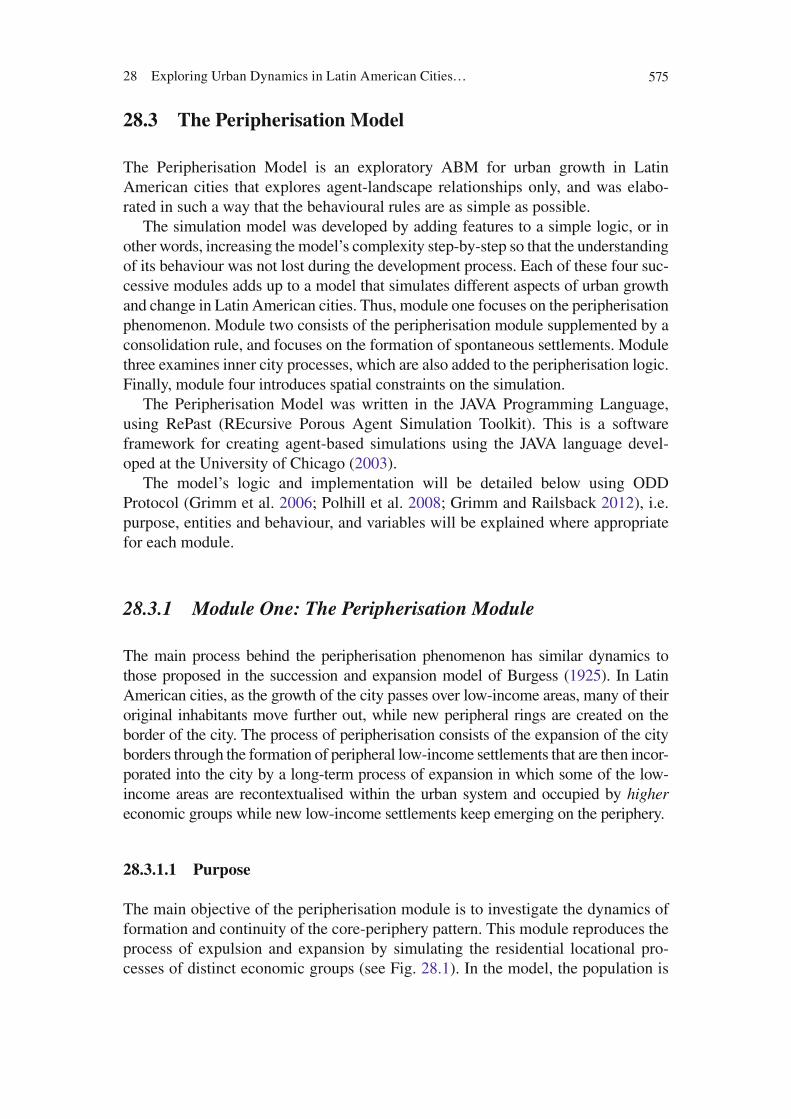
The main objective of the peripherisation module is to investigate the dynamics of formation and continuity of the core-periphery pattern. This module reproduces the process of expulsion and expansion by simulating the residential locational pro-cesses of distinct economic groups (see Fig. 28.1 ). In the model, the population is
576 J. Barros
divided into three economic groups according to the pyramidal model of distribu-tion of income in Latin American countries. This model suggests that the society is divided into three economic groups (high, medium and low income) that can be represented by a pyramid where the high-income group is the minority at the top, the middle-income group is the middle part of the triangle and the low-income group is the majority, at the bottom of the triangle.
28.3.1.2 Entities and Behaviour
The model has mobile agents which walk randomly over a grid space. The entities (agents) in the model are proxies to individual households. However, the peripheri-sation phenomenon is studied independently of the spatial scale, and therefore the size of the cell might not correspond to the scale of a single plot.
Agents are divided into three economic groups (breeds) in a proportion based on the division of Latin American society by income. The main difference between agents lies in their economic group.
The simulation model is underlain by an economic logic, although it is not an economic model. It assumes that, despite the economic differences, all agents have the same locational preferences, which means that they all want to locate close to the areas served by infrastructure, with nearby commerce, job opportuni-ties and so on. Since in Third World cities these facilities are found mostly close to the high-income residential areas, agents look for a place close to a high-income group residential area. The behaviours of the three income groups are differentiated by the restrictions imposed on their economic power. Thus, the high-income group (represented in the model in medium-grey) is able to locate in any place of its preference. The medium-income group (in light-grey) can
Fig. 28.1 Flowchart of agent’s rules for the peripherisation module
57728 Exploring Urban Dynamics in Latin American Cities…
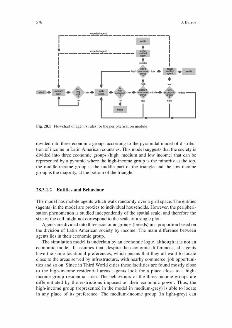
locate everywhere except where the high-income group is already located; and, in turn the low-income group (in dark-grey) can locate only in otherwise vacant space. Since some agents can occupy other agents’ cells, this means that the latter are ‘evicted’ and must fi nd other places to settle. A detailed diagram of agents’ rules of behaviour can be found in Fig. 28.2 .
28.3.1.3 State Variables
Two main parameters defi ne the behaviour of the Peripherisation Module: steps and proportion of agents per income group. ‘ Steps’ is the number of cells that the agent walks before trying to settle in a place (cell). This parameter represents how far people are willing to settle from their ideal location. The proportion of agents per income group is a percentage of the total number of agents belonging to each eco-nomic group. It is important to note that in reality, the proportion of agents per economic group differs from country to country and even from city to city, and that the proportion in the model represents a relative proportion only, as there is no defi -nition of ‘economic group’ implied in the model.
28.3.2 Module Two: Spontaneous Settlements
28.3.2.1 Purpose
This module is intended to simulate the process of formation and consolidation of spontaneous settlements as part of the urban growth dynamics of the Latin American city. The module combines the original peripherisation logic with a consolidation rule. This rule refers to a process in which spontaneous settlements are gradually upgraded, and, as time passes, turn into consolidated favelas or, in other words, spontaneous settlements that are immune from eviction, as detailed in Fig. 28.2 . As a result of the introduction of the consolidation logic, the spontaneous settlements module generates a more fragmented landscape than the homogeneous concentric-like spatial distribution of classes in which consolidated spontaneous settlements are spread all over the city.
28.3.2.2 State Variables
The consolidation process is built into the model through a ‘ cons ’ variable. This cons variable has its value increased at each iteration of the model and, at a certain threshold (‘ consLimit’ ), the low-income cell turns into the consolidation state. If a high-income or medium-income agent tries to settle on the low-income cell in a stage previous to the consolidation threshold, the low-income cell is replaced by the respective new occupant’s economic group. Otherwise, consolidated cells are ‘immune’ from eviction.
578 J. Barros
28.3.3 Module Three: Inner City Processes
28.3.3.1 Purpose
In this module, features were added to the model in order to simulate these other aspects of Latin American urban development, such as re-occupation and regenera-tion of older housing in attractive inner city districts. These features attempt to repro-duce some of the main dynamic processes in cities: inner city decay, movement of elites towards the city edge and gentrifi cation by the process of location and reloca-tion of individual agents from different income groups.
The model simplifi es these dynamic processes using a set of very simple spatial interaction rules and allows the modeller to examine how these rules produce con-trasting and complex spatial patterns in different kinds of cities. The aim of this module is to study the nature of inner city dynamic processes, and examine how these dynamics produce global spatial residential patterns.
28.3.3.2 Entities and Behaviour
Three sets of rules compose the inner city processes module: transition from a higher to lower-income group; transition from a lower to higher-income group, and movement of higher-income groups towards the suburbs.
Hence, the processes of fi ltering and gentrifi cation are translated in the model into the change from one economic group to another. Simplifying the inner city change processes in this form, fi ltering is translated into the model as the occupation of housing stock by a lower income group than that which previously occupied it (moving down the social scale) while gentrifi cation is the opposite, an occupation of a housing stock by a higher economic group. The detailed schema of the agent behavioural rules in these terms is illustrated in Fig. 28.2 , below.
In short, agents walk randomly through the grid in search of a place to settle. As in the peripherisation module, all agents have the same spatial preferences but react according to different restrictions. Each agent settles on a place based on local knowledge only, such as neighborhood density, their own income-group, and the income-group occupying their desired location.
28.3.3.3 State Variables
The housing transition from higher to lower income groups is introduced in the model by adding two variables: ‘ age’ which refers to occupied cells, and ‘ density’ which is the neighborhood density. Two thresholds for these variables were also added: a parameter ‘ decayStartPoint’ which is the threshold value for ‘ age’ in which the decay is activated, and a parameter d which corresponds to the maximum neigh-borhood density value.

57928 Exploring Urban Dynamics in Latin American Cities…
Fig
. 28.
2 Fl
owch
art o
f the
age
nt’s
rule
s (m
odul
es o
ne, t
wo
and
thre
e)

580 J. Barros
At every iteration, age value is increased in the simulation for all cells occupied by high-income agents. When age gets to a certain limit (parameter ‘ decayStart-Point ’), a percentage of cells occupied by high-income agents may start to decrease through ‘inoccupation’ as these places become available to lower-income groups (their color turns green, which corresponds to empty cells that can only be occupied by low-income groups). Also, if the ‘ age’ value of a high-income cell is higher than the parameter ‘ decayStartPoint ’, and density is higher than ‘ d’ , the cell becomes available to the lower-income agents who wish to settle there, and the high-income agent must look for a place further out. A second part of the rule determines that low-income cells with an age value higher than the parameter ‘ consolidationLimit’ will consolidate, i.e. they will no longer be subject to eviction.
28.3.4 Module Four: Spatial Constraints
28.3.4.1 Purpose
The objective of module four is to introduce spatial constraints to the simulation model. These spatial constraints represent bodies of water, steep slopes, or any other area where urbanisation is not possible.
Spatial constraints are implemented by the introduction of areas where agents are not allowed to settle or even walk as initial conditions. In the code, for every movement that agents make towards new cells, it checks if the new position belongs to a spatial constraint area or not and, if it does, the agent returns to their previous position and changes direction in order to avoid returning to the same cell.
28.4 Model Verifi cation and Validation
As part of the model’s development process, an evaluation of the model was per-formed. This included both comparisons of the model outputs with the modeled real-world system and understanding the sensitivity of the model to its internal parameters (Turner et al. 2001 ) .
These two evaluation steps, more commonly referred to as verifi cation and vali-dation, concern, respectively, the correctness of model construction and truthful-ness of a model with respect to its problem domain. To perform verifi cation, a sensitivity analysis of relationships between a model’s parameters and its outputs was performed.
Validation concerns how well the model outcomes represent the real system behavior and its methodology depends on the objectives of the model. Where accu-rate predictions are the main goal, measuring the accuracy of spatial outcomes is necessary. However, where the goal is to represent a process and explain general patterns observed across a variety of situations, as is the case with the present model, validation requires evaluating how well a model reproduces critical system properties
58128 Exploring Urban Dynamics in Latin American Cities…
in terms of spatial and temporal dynamics (Brown et al. 2004b ; Rand et al. 2003 ) . It is important to stress that this process “involves judgments about how well a par-ticular model meets the modeler’s goals, which in turn depends on choices about what aspects of the real system to model and what aspects to ignore” (Brown et al. 2004a , p. 2). Ngo and See ( 2012 ) provide an overview of calibration and validation of models in relation to land cover change.
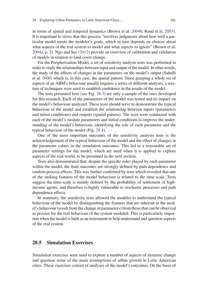
For the Peripherisation Model, a set of sensitivity analysis tests was performed in order to study the relationships between input and output of the model. In other words, the study of the effects of changes in the parameters on the model’s output (Saltelli et al. 2000 ) which is, in this case, the spatial pattern. Since grasping a whole set of aspects of an ABM’s behaviour usually requires a series of different analyses, a mix-ture of techniques were used to establish confi dence in the results of the model.
The tests presented here (see Fig. 28.3 ) are only a sample of the ones developed for this research. Each of the parameters of the model was tested and its impact on the model’s behaviour analyzed. These tests should serve to demonstrate the typical behaviour of the model and establish the relationship between inputs (parameters and initial conditions) and outputs (spatial pattern). The tests were conducted with each of the model’s module parameters and initial conditions to improve the under-standing of the model’s behaviour, identifying the role of each parameter and the typical behaviour of the model (Fig. 28.4 ).
One of the most important outcomes of the sensitivity analysis tests is the acknowledgement of the typical behaviour of the model and the effect of changes in the parameter values in the simulation outcomes. This led to a reasonable set of parameter settings for the model, which are used when it is applied to explore aspects of the real world, to be presented in the next section.
Tests also demonstrated that, despite the specifi c roles played by each parameter within the model, the fi nal outcomes are strongly defi ned by path dependence and random process effects. This was further confi rmed by tests which revealed that one of the striking features of the model behaviour is related to the time-scale. Tests suggest the time-scale is mainly defi ned by the probability of settlement of high-income agents, and therefore is highly vulnerable to stochastic processes and path dependence effects.
In summary, the sensitivity tests allowed the modeler to understand the typical behaviour of the model by distinguishing the features that are inherent in the mod-el’s behaviour (result from the change in parameters) from those that can be observed as proxies for the real behaviour of the system modeled. This is particularly impor-tant when the model is built as an instrument to help understand and question aspects of the real system.
28.5 Simulation Exercises
Simulation exercises were used to explore a number of aspects of dynamic change and question some of the main assumptions of urban growth in Latin American cities. These exercises consist of analyses of the model’s outcomes. On the basis of
582 J. Barros
Fig
. 28.
3 E
xam
ple
of s
ensi
tivity
test
: seq
uenc
es o
f sna
psho
ts te
stin
g th
e pa
ram
eter
ste
p , w
here
seq
uenc
e A
use
s st
eps =
2 , s
eque
nce
B s
teps
= 4
, and
seq
uenc
e C
ste
ps =
8

58328 Exploring Urban Dynamics in Latin American Cities…
these results, we attempt to provoke discussions and draw conclusions about some aspects of the reality of Latin American cities.
Four sets of simulation exercises were performed, each exploring one of the Peripherisation Model simulation modules. For the purposes of the present chapter, only the fi rst exercise is presented. This exercise is based on the peripherisation module and discusses general issues of urban growth in Latin American cities.
The peripherisation module’s agents rule base is a very simplistic one and pro-duces the spatial patterns presented in Fig. 28.5 , which shows the spatial develop-ment of the simulation run through a sequence of snapshots. The parameters used for this simulation run were steps equal to 2 and proportion of agents per economic group 10% high-income, 40% middle-income, and 50% low-income.
The fi nal spatial pattern shown in the sequence of snapshots in Fig. 28.5 consists of three concentric rings where medium-grey represents high-income settled agents, light-grey represents middle-income agents, and dark-grey represents low-income agents. Although the simulation starts with a mixed set of patches, the fi nal outcome is a clearly segregated pattern where each of the three economic groups congre-gates, forming a single large patch completely separate from one another.
This outcome is not ‘unpredictable’ and makes sense within the rules of the model. However, there is nothing in the rule base to suggest that the spatial outcome of the model would be a segregated pattern, and nothing suggesting high-income groups should be located in the centre surround by buffering rings of middle and
Number of occupied cells versus time
0
2000
4000
6000
8000
10000
0 1000 2000 3000 4000 5000 6000 7000 8000time
nu
mb
er o
f occ
upi
ed c
ells
steps = 2 steps = 4 steps = 8
Double logarithmNumber of occupied cells versus time
0
2
4
6
8
10
0 2 4 6 8 10
log time
log
nu
mb
er o
f o
ccu
pie
d
cells
steps = 2 steps = 4 steps= 8
Fig. 28.4 Example of sensitivity test: charts testing the steps parameter, where sequence A uses steps = 2, sequence B steps = 4, and sequence C steps = 8
Fig. 28.5 Spatial pattern produced with the peripherisation module
584 J. Barros
low-income cells. Therefore, it is possible to conclude that the pattern is emergent, since it is the product of the local interactions of agents only.
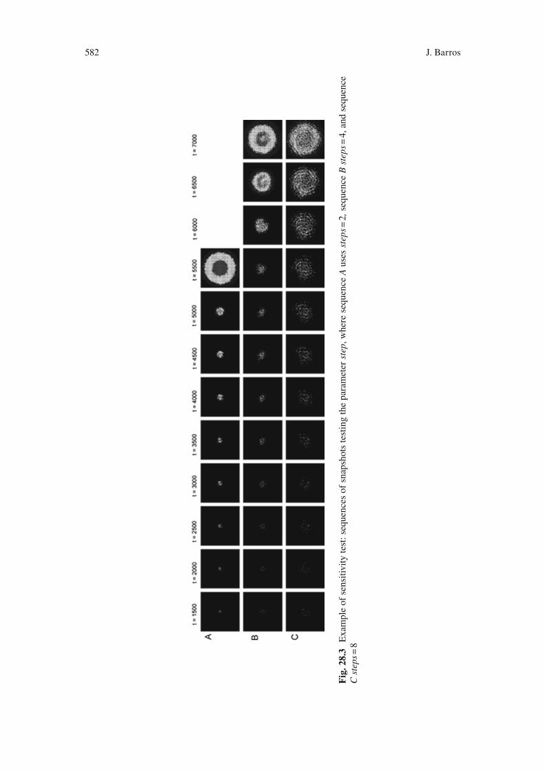
Although very simplistic, the pattern produced by the model appears to approxi-mate the spatial structure found in the residential locational pattern of Latin American cities. Similarly, the pattern produced by the model when using multiple initial seeds, resembles certain characteristics of metropolitan areas.
Figure 28.6 presents a sequence of snapshots using four seeds, all equidistant from the centre of the grid. The simulation was conducted using the same set of parameter values used for the previous experiment. This sequence approximates to the development of metropolitan areas, which are the result of the combination of several cities or villages that end up as a single spatial area because of their proximity. It is interesting to note how the spatial development starts with a very mixed structure, and as time passes, the core-periphery structure emerges. As in reality, this spatially segregated pattern is consolidated in the model, and as the simulation progresses, the spatial development expands, maintaining the core-periphery structure.
It is particularly striking to see how the high-income areas of the spatial patterns become slowly linked to each other, and the light-grey and dark-grey rings simply follow the shape imposed by high-income areas, acting as buffering zones for high-income areas, following the pattern described by Amato ( 1970b ) for Bogotá, Colombia. This suggests that the model reproduces not only a fi nal spatial pattern that is consistent with reality, but also that the evolutionary process shaping this pattern is relevant too.
The simple spatial pattern produced by the Peripherisation Model resembles in essence the spatial pattern and dynamics of urban growth in Latin American cities. As discussed previously, Latin American cities are characterized by their high rates of growth, and their spatial patterns are the result of this fast process of urban development. It is understood that high rates of urban growth have overwhelmed the capacity of urban governments to provide either adequate services or infra-structure and, therefore, are the main cause of the urban inequalities found in Latin American cities.
The simulation experiments provide material with which to discuss this assump-tion using the model as a tool to think with, and to examine the context of the rate of
Fig. 28.6 Spatial pattern produced with the peripherisation module using multiple seeds as initial condition
58528 Exploring Urban Dynamics in Latin American Cities…
development within the simulation. In the Peripherisation Model, the presence of a great percentage of high-income agents, for instance, results in larger and faster development. This is implicit in the model’s rules since high-income cells act as a catalyst for urban development. In reality it seems that the presence of high-income groups has a similar effect. The richer a city is, the more attractive it is and, there-fore, more people migrate to it causing a higher rate of growth.
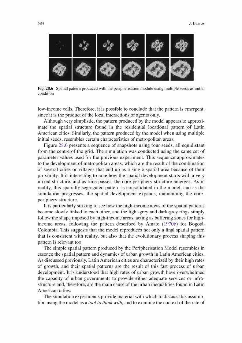
Whenever urban growth in Latin American cities is encountered, the fi rst factor to be mentioned is the high rate of growth. In the literature, this rate is seen as an essential cause of the resulting spatial patterns. The present simulation exercises make clear that if the rules of the model are related in any sense to the way loca-tional decision takes place in reality, then speed has little, if any, infl uence on the generation of the core-periphery spatial pattern. In the model, speed can be manipu-lated by, for example, increasing the number of agents within the simulation. This does not affect the spatial pattern at all, as can be observed in Fig. 28.7 , which shows snapshots of simulation using different numbers of agents.
These exercises showed how some assumptions about urban growth in Latin American cities should be questioned and further investigated. The simulation exer-cises made it evident that the research community must review the causes driving the spatial patterns of those cities, and this knowledge must be fed back to urban planning practice.
28.6 Comparison with Reality
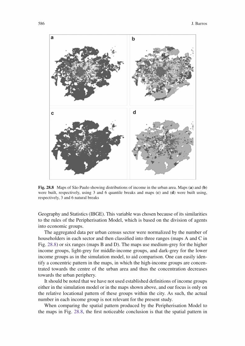
This section presents simple maps built from the Census 2000 dataset for São Paulo. Although these maps are static representations, the patterns of income concentra-tion combine with the simulation model to help demonstrate the locational pattern generated by peripherisation in Latin American cities.
Figure 28.8 shows maps of income distribution per census sector in the metro-politan area of São Paulo, Brazil. The data used here are the average of the head of household monthly income per census sector (enumeration district/census block), which are part of the Census 2000 dataset provided by the Brazilian Institute of
Fig. 28.7 Sequences of snapshots testing different numbers of agents
586 J. Barros
Geography and Statistics (IBGE). This variable was chosen because of its similarities to the rules of the Peripherisation Model, which is based on the division of agents into economic groups.
The aggregated data per urban census sector were normalized by the number of householders in each sector and then classifi ed into three ranges (maps A and C in Fig. 28.8 ) or six ranges (maps B and D). The maps use medium-grey for the higher income groups, light-grey for middle-income groups, and dark-grey for the lower income groups as in the simulation model, to aid comparison. One can easily iden-tify a concentric pattern in the maps, in which the high-income groups are concen-trated towards the centre of the urban area and thus the concentration decreases towards the urban periphery.
It should be noted that we have not used established defi nitions of income groups either in the simulation model or in the maps shown above, and our focus is only on the relative locational pattern of these groups within the city. As such, the actual number in each income group is not relevant for the present study.
When comparing the spatial pattern produced by the Peripherisation Model to the maps in Fig. 28.8 , the fi rst noticeable conclusion is that the spatial pattern in
Fig. 28.8 Maps of São Paulo showing distributions of income in the urban area. Maps ( a ) and ( b ) were built, respectively, using 3 and 6 quantile breaks and maps ( c ) and ( d ) were built using, respectively, 3 and 6 natural breaks
58728 Exploring Urban Dynamics in Latin American Cities…
reality is not as concentric as the patterns produced by the simulation model. This is due to various factors such as initial conditions, topography, the presence of bodies of water, etc. In particular, the topography of these areas has strong infl uences on the spatial development of these cities.
A second very clear difference is that high-income groups are not all concen-trated in the (historical) centre of the city, but may reach towards the city’s outskirts. Similarly, middle-income groups are at times located on the city edge and in more central areas surrounded by low-income areas. These suggest that there are more dynamic processes in action than those simulated in module one of the model. Some of the shortcomings highlighted by these exercises have led towards the next stages in the development of the model, which were added to the model through the mod-ules presented previously.
28.7 Conclusions
The main idea of the Peripherisation Model is concentrated in module one, which, therefore, forms the main stream of this research. This is because the module is based on the rather simple assumption that residential locational patterns in Latin American cities can be explained by essentially two concepts. The fi rst is the idea that the composition of society, or how society is divided in groups, has a great impact on spatial development. The second is that restrictions rather than prefer-ences generate the spatial pattern. Once these two factors are established, urban development appears to become locked in a vicious circle with high-income groups located in the best locations, while low-income groups are pushed away from all urban facilities.
The kind of government housing typically provided in Latin American cities consists mainly of housing tracts for low-income groups located in the vast majority of cases on the urban fringe. It is evident that governments have acted without knowledge of the global dynamics of the urban system and, reinforcing the current dynamics, have attracted more low-income groups to the outskirts of the city. As such, the need for centrally located housing for low-income groups was not understood. Similarly, government policies for spontaneous settlements have disregarded the dynamics of the global process of which their location and evolution is part. Because of the absence of available housing in the central area combined with the lack of good transport systems, spontaneous settlements con-tinue to be a reasonably good alternative for low-income citizens. Yet urban interventions continue to approach the problem from a static and local point of view, and although upgrading interventions by urban governance have supported the natural upgrading process, those intervention programs have not dealt with the problem as a whole, and new spontaneous settlements continue to proliferate on the urban fringes and in other unoccupied areas within the city. From this point of view, it seems that rather than not being able to cope with the housing demand, urban governments do not have the appropriate knowledge to deal with this situation.
588 J. Barros
It seems the major planning problem in Latin American cities is how to stop such a process once it has been initiated. The role of the present investigation is not to answer this question, but to attempt to raise alternative points of view and speculate about urban development in those cities on the basis of the simulation experiments. It is important to note that the simulation exercises provide insights provoking debate, not only when the simulation results accord with reality, but also when they do not. In this case, the modeller is obliged to look for further explanations. Hence, the fi ndings from this chapter are neither conclusive nor proven. Rather, they draw attention to gaps in our knowledge in the urban development of Latin American cit-ies that deserves further investigation
The dynamic modeling exercises presented in this chapter have helped to further develop an understanding of the rapid urbanization process and its dynamics. They have changed the perspective on the problem from a demographic and static view-point to a dynamic and morphological one. The fi ndings of this chapter have thus taken a step in the direction of bringing a new perspective to an old problem.
In this light, a question arises as to what in fact generates the segregated spatial pattern found in most Latin American cities; is it the rate of growth that was so uncontrollable that planners could not contain or control it, or is it perhaps a simple product of the inequalities of a segregated urban society? If it is assumed that the roots of a segregated spatial pattern can be largely explained by the unequal division of urban society and its economic power, then the role played by speed in the forma-tion of the spatial pattern must be questioned.
The Peripherisation Model seems to be a good example of an exploratory simu-lation model, and the simulation exercises seem to be an effective way to explore aspects of reality. In addition, agent-based simulation proved to be a suitable tech-nique to explore urbanization issues at the conceptual level, and allowed spatial patterns, dynamics and social issues to be handled within the same conceptual and modeling framework.
The need for an increased understanding of urban spatial phenomena in cities of the Third World is essential in order to provide a basis for future planning actions and policies. The approach outlined in this study has taken a step in this direction. This study provides evidence that urban modeling tools can provide an appropriate basis for research on Latin American urban processes, and makes clear the need to approach the problem by relating morphology and dynamics, for which dynamic modeling provides the appropriate means.
References
Amato, P. (1970a). A comparison: Population densities, land values and socioeconomic class in four Latin American cities. Land Economics, 46 , 447–455.
Amato, P. (1970b). Elitism and settlement patterns in the Latin American city. Journal of the American Institute of Planners, 36 , 96–105.
Brown, D. G., Page, S. E., Riolo, R., & Rand, W. (2004a). Agent based and analytical modeling to evaluate the effectiveness of greenbelts. Environmental Modelling and Software, 19 (12), 1097–1109.
58928 Exploring Urban Dynamics in Latin American Cities…
Brown, D. G., Walker, R., Manson, S. M., & Seto, K. (2004b). Modeling land-use and land-cover change. In B. L. Turner & G. Gutmann (Eds.), Land change science: Observing, monitoring, and understanding trajectories of change on the land surface . Dordrecht: Kluwer.
Burgess, E. W. (1925). The growth of the city: An introduction to a research project. In R. Park, E. W. Burgess, & R. D. McKenzie (Eds.), The city (pp. 47–62). Chicago: University of Chicago Press.
Grimm, V., & Railsback, S. F. (2012). Designing, formulating and communicating agent-based models. In A. J. Heppenstall, A. T. Crooks, L. M. See, & M. Batty (Eds.), Agent-based models of geographical systems (pp. 361–377). Dordrecht: Springer.
Grimm, V., Berger, U., Bastiansen, F., Eliassen, S., Ginot, V., Giske, J., et al. (2006). A standard protocol for describing individual-based and agent-based models. Ecological Modelling, 198 (1–2), 115–126.
Hall, P. (1983). Decentralization without end? A re-evaluation. In J. Patten (Ed.), The expanding city: Essays in honour of professor Jean Gottmann (pp. 125–155). London: Academic.
Ngo, T. A., & See, L. M. (2012). Calibration and validation of agent-based models of land cover change. In A. J. Heppenstall, A. T. Crooks, L. M. See, & M. Batty (Eds.), Agent-based models of geographical systems (pp. 181–196). Dordrecht: Springer.
Polhill, J. G., Parker, D., Brown, D. G., & Grimm, V. (2008). Using the ODD protocol for describing three agent-based social simulation models of land-use change. Journal of Artifi cial Societies and Social Simulation, 11 (23).
Rand, W., Brown, D. G., Page, S. E., Riolo, R., Fernandez, L. E., & Zellner, M. (2003). Statistical validation of spatial patterns in agent-based models. Paper presented at the proceedings of agent based simulation 2003, Montpellier.
Saltelli, A., Chan, K., & Scott, E. M. (2000). Sensitivity analysis . New York: Wiley. Turner, M. G., Gardner, R. H., & O’Neill, R. V. (2001). Landscape ecology in theory and practice:
Pattern and process . New York: Springer. UNCHS. (1996). An urbanizing world: Global report on human settlements . Oxford: Oxford
University Press for the United Nations Centre for Human Settlements (Habitat). University of Chicago. (2003). RePast 2.0 (Software) from http://repast.sourceforge.net/ Valladares, L., & Coelho, M. P. (1995). Urban research in Brazil and Venezuela: Towards an
agenda for the 1990s. In R. Stren (Ed.), Urban research in the developing world . Toronto: University of Toronto.