Embed Size (px)
Citation preview

BioOne sees sustainable scholarly publishing as an inherently collaborative enterprise connecting authors, nonprofit publishers,academic institutions, research libraries, and research funders in the common goal of maximizing access to critical research.
Challenge of Infrared Kite Aerial Photography: A Digital UpdateAuthor(s): James S. Aber, Susan W. Aber, Lida Buster, William E. Jensen, andRichard L. SleezerSource: Transactions of the Kansas Academy of Science, 112(1/2):31-39. 2009.Published By: Kansas Academy of ScienceDOI: http://dx.doi.org/10.1660/062.112.0205URL: http://www.bioone.org/doi/full/10.1660/062.112.0205
BioOne (www.bioone.org) is a nonprofit, online aggregation of core research in the biological,ecological, and environmental sciences. BioOne provides a sustainable online platform for over170 journals and books published by nonprofit societies, associations, museums, institutions,and presses.
Your use of this PDF, the BioOne Web site, and all posted and associated content indicatesyour acceptance of BioOne’s Terms of Use, available at www.bioone.org/page/terms_of_use.
Usage of BioOne content is strictly limited to personal, educational, and non-commercial use.Commercial inquiries or rights and permissions requests should be directed to the individualpublisher as copyright holder.
Challenge of infrared kite aerial photography: A digital update
JAMES S. ABER1,3, SUSAN W. ABER1, LIDA BUSTER1, WILLIAM E. JENSEN2, AND
RICHARD L. SLEEZER1
1. Earth Science Department, Emporia State University, Emporia, Kansas 668012. Department of Biological Sciences, Emporia State University, Emporia, Kansas 668013. Corresponding author: [email protected]
Kite aerial photography (KAP) is a means to acquire large-scale, highly detailed imageryfor various environmental applications. Previous color-infrared KAP was developed forfilm-based cameras, but is now effectively obsolete. The authors have built a KAP rigand field tested a digital color-infrared camera, the Tetracam ADC, which producesresults that are generally comparable with color-infrared film photography. Field testingwas conducted at the Cheyenne Bottoms Preserve of The Nature Conservancy in centralKansas. The resulting images are high-contrast photographs that depict emergentvegetation in bright red-pink colors and show water bodies nearly black, as would beexpected in color-infrared imagery. Color-visible digital cameras produce better apparentspatial resolution, whereas the Tetracam ADC camera provides an extended spectralrange into the near-infrared. For detailed environmental field investigations involvingkite aerial photography, a combination of color-visible and color-infrared cameras isrecommended for improved results overall.
Keywords: infrared, digital, kite, aerial photography, wetlands, Cheyenne Bottoms,Kansas.
TRANSACTIONS OF THE KANSAS
ACADEMY OF SCIENCE
Vol. 112, no. 1/2p. 31-39 (2009)
INTRODUCTION
Kite aerial photography (KAP) is a type ofsmall-format aerial photography, which isbased on compact film or digital camerasflown on various manned or unmannedplatforms (Warner, Graham and Read 1996;Bauer et al. 1997). KAP typically operates lessthan 150 m above the ground, and pictures canbe taken in vertical or oblique vantages in anydirection relative to the ground target and sunposition (Fig. 1). Resulting images have largescale and high spatial resolution (2-5 cm) thatdepict ground objects in surprising clarity.The method is especially well suited fordetailed investigations of small study sitescomprising a few hectares for diverse types ofnatural or cultural features.
Two of us (JSA and SWA) have elaboratedkite aerial photography for variousenvironmental applications (e.g. Aber et al.
1999; Aber and Aber 2001; Aber et al. 2002;Aber, Eberts and Aber 2005). These studiestypically involve vegetation, soils, and waterbodies, for which color-infrared aerialphotography is particularly valuable as asurvey, mapping, and monitoring tool (Maceet al. 1997; Murtha et al. 1997). The near-infrared portion of the spectrum highlightsactive vegetation and water bodies quitedistinctly (Jensen 2007).
We earlier developed film-based color-infraredkite aerial photography to exploit this potentialfor environmental investigations (Aber, Aberand Leffler 2001). This technique was basedon color-infrared, 35-mm, slide film and aconventional SLR camera with a yellow filter.However, this method has become effectivelyobsolete for two reasons. First, KodakEktachrome EIR was the only color-infraredfilm available in the United States, but it isnow quite expensive and difficult to obtain.

32 Aber, Aber, Buster, Jensen, and Sleezer
Figure 1. Cartoon showing setup for kite aerial photography (KAP). A radio transmitter on theground controls operation of the camera rig. Illustration not to scale. Adapted from Aber, Zupancicand Aber (2003, fig. 1).
Second, developing this film requires specialdarkroom techniques, and nearly all commerciallaboratories have ceased to process this film.
Here we report development of digital color-infrared kite aerial photography and presentresults of field testing from The NatureConservancy (TNC) marshes at CheyenneBottoms in central Kansas. Color-infraredaerial photography is considered best foridentification of vegetated wetlands in manysituations, including marshes, swamps andbogs (Tiner 1997).
TETRACAM ADC CAMERA AND RIG
Camera — The primary challenge was toidentify a suitable color-infrared digital cameraof relatively small size and weight at a cost thatcould be justified for kite aerial photography.Only one commercial camera is known to theauthors to meet these requirements, theAgricultural Digital Camera (ADC) byTetracam. The camera has the followinggeneral characteristics (Tetracam 2008):
CMOS sensor: 2048 x 1536 pixels (3 MBor 3.2 megapixels).
Spectral range: 0.52 to 0.92 μmwavelength (green, red and near-infrared).
Image storage format: proprietary DCMlossless format.
Memory: removable Compact Flash card.Lens: 4.5- to 12-mm CS-mount zoom lens
with manual focus and apertureadjustment.
Filter: permanently mounted long-passfilter behind lens.
Body: machined aluminum.Dimensions: length - 4.8 in (122 mm),
height - 3.05 in (77.5 mm), depthincluding lens - 3.5 in (89 mm).
Weight without batteries, 12 oz (460 g).Power: 8 AA batteries, internal.
The primary applications for this camera are,as the name suggests, agriculture as well asforestry and other studies involving vegetation,soil and water. The camera is designed to beoperated on the ground or from manned or

Transactions of the Kansas Academy of Science 112(1/2), 2009 33
unmanned aircraft either by hand or remotecontrol. Its size, shape, weight, and operatingcharacteristics place this camera within thenormal range for digital SLR-type cameras.Cost of the camera and lens with educationaldiscount was about $4500.
The first phase of camera operation began onthe ground with the camera either hand heldor mounted on a tripod for stability. Thebiggest problem for using this camera routinelyproved to be adjusting the lens focus and zoomproperly. Considerable trial-and-error testingwas necessary to achieve a suitable field ofview and focus, which are fixed with lockingthumb screws on the lens. The field of viewwas set to approximate a 40-mm focal lengthfor a standard 35-mm film camera, whichproduces a slight wide-angle effect. Lensaperture (f-stop) is likewise adjusted manuallybased on lighting conditions. The image fileformat is proprietary, and special Tetracamsoftware is necessary to process and displaythe false-color images (Fig. 2).
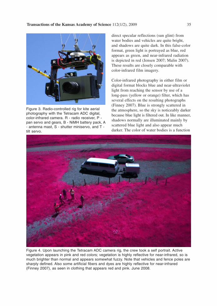
KAP rig — We built a radio-controlled KAPrig based on a kit and accessories from Leffler(2008). The basic kit had to be modified toaccommodate the Tetracam ADC camera; therig features full control of camera tilt, pan,and shutter button (Fig. 3). The radio receiverand servos are powered by rechargeablenickel-metal-hydrite (NiMH) batteries.
Aside from reliable camera operation, themost important design criterion for buildingthe KAP rig was to minimize weight. In thisregard, the greatest single factor is 8 AAbatteries in the camera itself. Eightconventional alkaline AA batteries weigh~185 g, whereas 8 AA lithium batteries areonly ~110 g. Thus, replacing alkaline withlithium batteries reduces weight substantiallyand provides longer-lasting camera power. Werejected rechargeable AA lithium batteries,though, because of lower output (1.2 v)compared with standard batteries (1.5 v).Total weight of the camera, rig, and batteries
is just over 1 kg, which is well within the rangeof other camera rigs we utilize for kite aerialphotography. Cost of the rig kit, accessories,batteries, and spare parts was less than $500.
FIELD TESTING AT CHEYENNE BOTTOMS
We field tested the Tetracam ADC camera atthe Cheyenne Bottoms Preserve of The NatureConservancy (TNC) in central Kansas, wherewe have employed small-format aerialphotography to monitor marshes for the pastseveral years (Aber et al. 2006). Our long-term goal is to document environmentalconditions as consequences of natural climaticevents and TNC management practices. Ourinvestigations have focused in particular onfrequent changes in water bodies andemergent wetland vegetation.
Kite aerial photography was conducted in theearly afternoon on 6 June 2008 under anexceptionally blue, cloudless sky. The marsheswere full of water, following heavy May rainand runoff, and emergent wetland vegetationwas well developed within and around thestudy site. A large delta kite (8.2 m²) lifted thecamera rig easily on a consistent southerlybreeze. Field testing began with close-up shotsof the ground crew and launch site (Fig. 4).Oblique pictures were taken in all compassdirections from multiple heights. The kite andcamera rig flew over open water, so no verticalpictures were attempted. We conducted KAP asecond time at the same site on 19 September2008 using a large Rokkaku kite (3.3 m²), againunder nearly ideal weather conditions with highwater in the marshes (Fig. 5).
COLOR-INFRARED IMAGERY
General characteristics — The TetracamADC color-infrared photographs obtained atCheyenne Bottoms are high-contrast imagesconsisting of bright pink-red-magentavegetation and dark, almost black water bodies.Other objects, such as the gravel road, aregenerally intermediate in brightness, although

34 Aber, Aber, Buster, Jensen, and Sleezer
Figure 2. Ground-based photographs of a sub-alpine forest scene at Cuchara, Colorado.A - color-visible photograph taken in late May with active grass and conifer shrubs andtrees (pine and spruce); aspen trees have not leafed out yet. B - Tetracam ADC color-infrared photograph of approximately same scene. Active vegetation appears in pink,red, and magenta colors in this standard false-color format.
Transactions of the Kansas Academy of Science 112(1/2), 2009 35
direct specular reflections (sun glint) fromwater bodies and vehicles are quite bright,and shadows are quite dark. In this false-colorformat, green light is portrayed as blue, redappears as green, and near-infrared radiationis depicted in red (Jensen 2007; Malin 2007).These results are closely comparable withcolor-infrared film imagery.
Color-infrared photography in either film ordigital format blocks blue and near-ultravioletlight from reaching the sensor by use of along-pass (yellow or orange) filter, which hasseveral effects on the resulting photographs(Finney 2007). Blue is strongly scattered inthe atmosphere, so the sky is noticeably darkerbecause blue light is filtered out. In like manner,shadows normally are illuminated mainly byscattered blue light and also appear muchdarker. The color of water bodies is a function
Figure 3. Radio-controlled rig for kite aerialphotography with the Tetracam ADC digital,color-infrared camera. R - radio receiver, P -pan servo and gears, B - NiMH battery pack, A- antenna mast, S - shutter miniservo, and T -tilt servo.
Figure 4. Upon launching the Tetracam ADC camera rig, the crew took a self portrait. Activevegetation appears in pink and red colors; vegetation is highly reflective for near-infrared, so ismuch brighter than normal and appears somewhat fuzzy. Note that vehicles and fence poles aresharply defined. Also some artificial fibers and dyes are highly reflective for near-infrared(Finney 2007), as seen in clothing that appears red and pink. June 2008.

36 Aber, Aber, Buster, Jensen, and Sleezer
Figure 5. High-oblique late summer views over TNC marsh looking toward the northeast. Thedelta of Deception Creek appears in the left background. A - color-visible image. B - color-infrared image of approximately the same scene. Water strongly absorbs near-infrared energyand so appears quite dark. September 2008.

Transactions of the Kansas Academy of Science 112(1/2), 2009 37
of scattering of blue and, to a lesser extent,green light and absorption of red and near-infrared; thus, in color-infrared imagery waterusually appears dark. However, the watersurface may act as a specular mirror in near-infrared as well as visible light; thus, sun glintappears especially strong. All these phenomenaare displayed in the Tetracam ADC images.
A potential issue of image sharpness involvesfocusing the lens. The longer wavelength ofnear-infrared is refracted slightly differentlythrough the lens compared with visible light(Finney 2007). Thus objects that appear to bein focus in the visible spectrum may not be insharp focus in near-infrared, even for infinitefocal distances. We believe extensive pre-flight,ground testing and lens adjustment minimizedthis problem. Also an intermediate aperture(f-stop) is utilized to force faster shutter speedas another means to minimize image blurring.
In general, visual details appear less sharplydefined in the Tetracam ADC images comparedwith color-visible digital images (see Fig. 5).This may be explained, in part, by the 3.2megapixel CMOS sensor in the Tetracam ADCcamera compared with 6 to 7 megapixel CCDsensors in the color-visible cameras. Anotherless obvious factor has to do with how near-infrared radiation interacts with green leavesin the canopy of emergent vegetation, aselaborated below.
Vegetation — The strong near-infraredreflectivity of active “green” leaves wasdiscovered nearly a century ago, and is knownas the Wood Effect after Prof. R.W. Wood whofirst photographed this phenomenon in 1910(Finney 2007). Near-infrared radiation (~0.7to 1.3 μm wavelength) is strongly scattered byleaf cell walls, but some near-infrared energypasses through an individual leaf and mayinteract with adjacent leaves or soil. Note thatchlorophyll is not the source of strong near-infrared reflectivity for green leaves (Finney2007). The result is multiple scattering ofnear-infrared radiation from overlapping leaves
in the canopy, creating strong return signals;whereas, red and blue wavelengths are stronglyabsorbed and green light is only weaklyreflected by the canopy (Murtha et al. 1997).
At the times of our field tests, the primaryemergent marsh plants were great bulrush(Scirpus validus), blunt spike rush (Eleocharisobtusa), and small stands of cattail (Typhasp.), all of which grow in carpets or patches ofclosely spaced, upright leaves and stalks. Thisstructure appears to enhance multiple strongscattering of the near-infrared, which infillsand reduces shadows within the vegetationcanopy, so that fine spatial details are obscured.
On the basis of these spatial and spectralissues, color-visible kite aerial photographsreveal different types of emergent wetlandvegetation more effectively than do the color-infrared images. Nonetheless, the near-infrared-to-red ratio of color-infrared imagesmay be utilized to determine variousvegetation indices, such as the normalizeddifference vegetation index (NDVI), whichare important for ecological studies of biomass,leaf area index, and photosynthetic activity(Tucker 1979; Murtha et al. 1997).
Water bodies — Water reflects blue light, butreflectance drops off sharply for green and redlight and is essentially zero for near-infraredradiation (Wiesnet, Wagner and Philpot 1997).The result in color-infrared imagery is thatwater bodies appear dark blue to black,regardless of water depth or turbidity, exceptfor sun glint noted above. At the times of ourfield tests, some portions of TNC marshes werefilled with muddy water from recent runoff,and other portions contained water with littlesuspended sediment. This is clearly portrayedin color-visible photographs, but all waterbodies are dark blue to nearly black in color-infrared images.
One problem for wetland image interpretationis to separate sediment-rich water bodies frombare wet soil with similar appearance. Shallow

38 Aber, Aber, Buster, Jensen, and Sleezer
muddy pools and moist mudflats may be nearlyidentical in the visible portion of the spectrum.Color-infrared photographs depict a sharpcontrast between water bodies, regardless oftheir depth or suspended sediment, and exposedsoil or emergent vegetation. However,submerged aquatic vegetation is seen better incolor-visible imagery (Tiner 1997).
CONCLUSIONS
• The digital Tetracam ADC camera issuitable for kite aerial photography, and itsimages are generally comparable to film-based color-infrared photographs.
• Tetracam ADC images from CheyenneBottoms are high-contrast pictures withemergent vegetation depicted in bright red,magenta, and pink colors, whereas waterbodies are dark blue to black.
• Because blue light is excluded, the sky,shadows, and water bodies are relatively darkcompared with color-visible photographs.However, sun glint may be quite strong incolor-infrared images.
• Tetracam ADC photographs are less sharpthan color-visible images, because the CMOSsensor has lower spatial resolution comparedwith color-visible digital cameras used by theauthors. Furthermore, multiple scattering ofthe near-infrared tends to reduce shadowswithin the vegetation canopy, so that finespatial details are blurred.
• Color-visible digital photographs aresuperior for identification of emergentvegetation zones, because of sharper spatialdetail, and color-infrared imagery is valuablefor deriving vegetation indices.
• Digital color-infrared KAP effectivelyseparates water bodies of all types fromemergent vegetation, bare soil, and otherfeatures. However, color-visible images aremore effective for displaying differences in
water turbidity and revealing submergedaquatic vegetation.
• For improved results overall, a combinationof color-visible and color-infrared digitalcameras is recommended for environmentalfield studies employing kite aerial photography.
ACKNOWLEDGEMENTS
Funding to purchase the Tetracam ADC camerawas provided by a grant from the EmporiaState University Foundation. Additional financialsupport came from KansasView and the KansasSpace Grant Consortium. The following ESUstudents assisted with kite aerial photography atCheyenne Bottoms in June 2008: P. Johnson, J.Matthews and M. Unruh. The authors thank S.Egbert for reviewing the manuscript andsuggesting several improvements. Specialthanks to R. Penner of the Kansas NatureConservancy at Cheyenne Bottoms.
LITERATURE CITED
Aber, J.S., Aaviksoo, K., Karofeld, E. andAber, S.W. 2002. Patterns in Estonianbogs as depicted in color kite aerialphotographs. Suo 53(1):1-15.
Aber, J.S. and Aber, S.W. 2001. Potential ofkite aerial photography for peatlandinvestigations with examples fromEstonia. Suo 52(2):45-56.
Aber, J.S., Aber, S.W. and Leffler, B. 2001.Challenge of infrared kite aerialphotography. Kansas Academy of Science,Transactions 104:18-27.
Aber, J.S., Aber, S.W., Pavri, F., Volkova, E.and Penner, R.L. 2006. Small-formataerial photography for assessing change inwetland vegetation, Cheyenne Bottoms,Kansas. Kansas Academy of Science,Transactions 109:47-57.
Aber, J.S., Eberts, D. and Aber, S.W. 2005Applications of kite aerial photography:Biocontrol of salt cedar (Tamarix) in thewestern United States. Kansas Academy ofScience, Transactions 108:63-66.

Transactions of the Kansas Academy of Science 112(1/2), 2009 39
Aber, J.S., Sobieski, R., Distler, D.A. andNowak, M.C. 1999. Kite aerialphotography for environmental siteinvestigations in Kansas. Kansas Academyof Science, Transactions 102:57-67.
Aber, J.S., Zupancic, J. and Aber, S.W. 2003.Applications of kite aerial photography:Golf course management. Kansas Academyof Science, Transactions 106:211-214.
Bauer, M., Befort, W., Coppin, Ir. Pol R. andHuberty, B. 1997. Proceedings of the firstNorth American symposium on smallformat aerial photography. AmericanSociety of Photogrammetry and RemoteSensing, 218 pp.
Finney, A. 2007. Infrared photography. pp.556-562 in Peres, M.R. (ed.), Focalencyclopedia of photography, 4th edition,Elsevier, Amsterdam.
Jensen, J.R. 2007. Remote sensing of theenvironment: An Earth resourceperspective. Pearson Prentice Hall, UpperSaddle River, New Jersey, 592 pp.
Leffler, B. 2008. Kite aerial photography onbrooxes.com, http://www.brooxes.com/
Mace, T. H., Williams, D.R., Duggan, J.R.,Norton, D.J. and Muchoney, D.M. 1997.Environmental monitoring. pp. 591-612 inPhilipson, W.R. (ed.), Manual ofphotographic interpretation, 2nd edition,American Society for Photogrammetry andRemote Sensing, Bethesda, Maryland.
Malin, D. 2007. False-color photography. p.533 in Peres, M.R. (ed.), Focalencyclopedia of photography, 4th edition,Elsevier, Amsterdam.
Murtha, P.A., Deering, D.W., Olson, C.E. Jr.and Bracher, G.A. 1997. Vegetation. pp.225-255 in Philipson, W.R. (ed.), Manualof photographic interpretation, 2ndedition, American Society forPhotogrammetry and Remote Sensing,Bethesda, Maryland.
Tetracam 2008. Tetracam ADC installationand operation (rev. 1.5). http://www.tetracam.com/DC%20User%20Manual.pdf
Tiner, R.W. 1997. Wetlands. pp. 475-494 inPhilipson, W.R. (ed.), Manual ofphotographic interpretation, 2nd edition,American Society for Photogrammetry andRemote Sensing, Bethesda, Maryland.
Tucker, C.J. 1979. Red and photographicinfrared linear combinations formonitoring vegetation. Remote Sensing ofthe Environment 8:127-150.
Warner, W.S., Graham, R.W. and Read, R.E.1996. Small format aerial photography.American Society for Photogrammetry andRemote Sensing, Bethesda, Maryland, 348pp.
Wiesnet, D.R., Wagner, C.R. and Philpot,W.D. 1997. Water, snow, and ice. pp. 257-267 in Philipson, W.R. (ed.), Manual ofphotographic interpretation, 2nd edition,American Society for Photogrammetry andRemote Sensing, Bethesda, Maryland.