Embed Size (px)
Citation preview
Centre for Archaeological Fieldwork
School of Geography, Archaeology and Palaeoecology
Queen’s University Belfast
CAF Data Structure Report No. 076
Investigations at
Dartanree Road
Tynan
Co. Armagh
AE/11/89E
On behalf of
NI Water Ltd.

Investigations at Dartanree Road
Tynan
Co. Armagh
Naomi Carver
CAF DSR 076
Licence Number: AE/11/89E
Grid Ref: H 76504 42808
3rd
October 2011
Contents
List of Figures I
List of Plates II
1. Summary 3
1.1 Background 3
1.2 Objectives 3
1.3 Excavation 3
1.4 Discussion 3
1.5 Recommendations 4
2. Introduction 7
2.1 General 7
2.2 Background 7
2.3 Site description 7
2.4 Historical background 9
2.5 Sites of archaeological interest 9
2.6 Cartographic evidence 11
2.7 Previous excavations 14
2.8 Geological background 14
2.9 Reason for excavation and research objectives 14
2.10 Archiving 14
2.11 Credits and acknowledgements 15
3. Excavation 17
3.1 Methodology 17
3.2 Account of the excavations 17
3.3 North-western side of the trench 17
3.4 South-eastern side of the trench 20
3.5 The pipe trench 23
4. Discussion 24
4.5 Conclusions 25
5. Recommendations 26
5.1 Introduction 26
5.2 Osteo-archaeological analysis 26
5.3 Radiocarbon dating 26
Bibliography 27

Appendix One: Context Register 28
Appendix Two: Harris Matrix 30
Appendix Three: Digital Photograph Register 31
Appendix Four: Field Drawing Register 33
Appendix Five: Finds Register 34
Plates 35

I
List of Figures
Figure One: Map of Northern Ireland 5
Figure Two: General location map 6
Figure Three: Detailed location map 8
Figure Four: Detail of 1834 Ordnance Survey map 11
Figure Five: Detail of 1862 Ordnance Survey map revision 12
Figure Six: Detail of 1906 Ordnance Survey map revision 13
Figure Seven: Detail of 1952 Ordnance Survey map revision 13
Figure Eight: Plan of site 16
Figure Nine: South-east facing section of trench 19
Figure Ten: North-west facing section of trench 21

II
List of Plates
Plate One: General view of site showing pipe trench and excavation trench, looking north-east
Plate Two: General view of site, looking south-west
Plate Three: General view of fields around site, looking south-east
Plate Four: General view of fields around site, looking north-west
Plate Five: View of site showing difference in levels between road and field, looking south-east
Plate Six: Human bone in south-east facing section, looking north-west
Plate Seven: Disarticulated bone on north-western side of trench, looking north-west
Plate Eight: Close-up of human bone, looking north-west
Plate Nine: South-east facing section, looking north-west
Plate Ten: North-west facing section, looking south-east
Dartanree Road, Tynan, Co. Armagh (Licence No. AE/11/89E) CAF DSR 076
______________________________________________________________________________
3
1 Summary 1.1 Background 1.1.1 The discovery of skeletal human remains by contractors laying pipes on behalf of Northern
Ireland Water Ltd. in July 2011 necessitated an archaeological excavation in order to
recover all remains and assess their depositional context.
1.1.2 A small-scale excavation was undertaken by a team from the Centre for Archaeological
Fieldwork (CAF) in August 2011. All of the archaeological work on the site was conducted
under licence from the Northern Ireland Environment Agency (NIEA) [licence number
AE/11/89E] and was funded by Northern Ireland Water Ltd.
1.2 Objectives
1.2.1 The principal objective of the excavation was to excavate the skeletal remains and record
any deposits stratigraphically related to them. A further objective was to excavate and
record- if present- any other in-situ remains including articulated burials.
1.3 Excavation
1.3.1 The excavation comprised a single trench opened across the drainage pipe trench and
measuring 2.0m by 2.5m (north-east/south-west by north-west/south-east). The excavation
trench was sub-divided into north-west (NW) and south-east (SE) sides where it straddled
the pipe trench. Excavation was carried out partly by hand and partly using a mechanical
excavator under archaeological supervision, where appropriate, to remove the overburden.
1.3.2 The majority of the human bones were confined to the north-western side of the trench and
were found at varying depths. Skeletal remains were also recovered from the south-
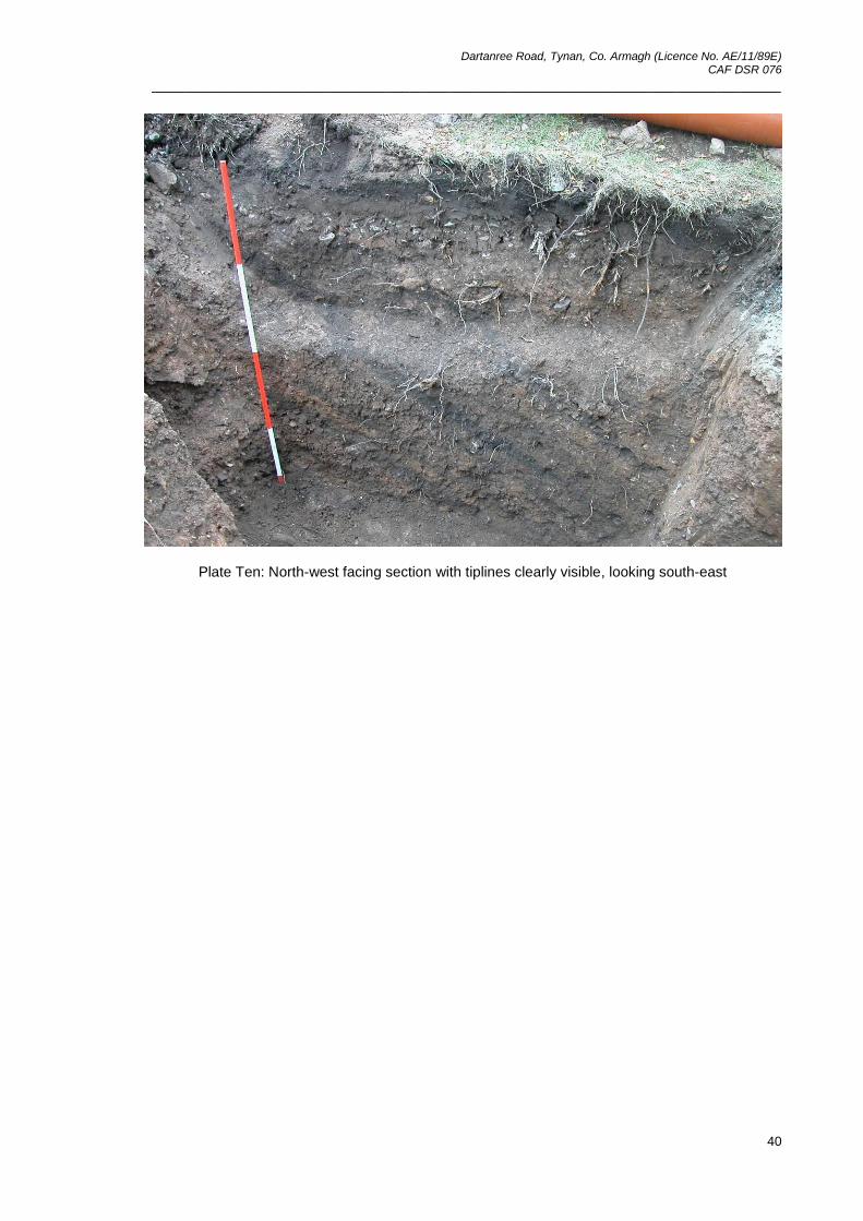
eastern side. On completion of the excavation a number of tip lines were visible in the
north-west and south-east facing sections. The human bone was mixed through these
layers and did not appear to be confined to any one layer in particular, although larger
quantities of bone were recovered from higher up in the sequence.
1.4 Discussion
1.4.1 The results of the investigations at Tynan revealed a series of tipline deposits, some of
which contained human bone. The deposits predate the construction of the Dartanree
Road and have been tentatively dated, by association, to the eighteenth or nineteenth
century due to the discovery of a copper alloy mount, possibly part of a coffin mount, found
in the south-east facing section of the pipe trench. Cartographic evidence supports this as
the Dartanree Road is shown on the earliest Ordnance Survey six inch map of the area

Dartanree Road, Tynan, Co. Armagh (Licence No. AE/11/89E) CAF DSR 076
______________________________________________________________________________
4
dating to 1834. The road is also shown on the 1860 revision having been lengthened and
improved. It can therefore been inferred that the human remains were buried prior to 1860,
and possibly, prior to 1834. A plausible explanation for the presence of the human remains
is that they are the result of clearance from a nearby graveyard, such as the one adjoining
the Church of Ireland to the north-east. It is possible that the bone was removed from
graves and re-buried in an unmarked part of the graveyard before the soil they were
contained in was used to create a raised platform with a level surface for the construction
of the road.
1.5 Recommendations
1.5.1 It is recommended that the skeletal remains are examined by an osteo-archaeologist and
that a full report produced, along with their recommendations for one sample to be sent for
radiocarbon dating. If the bones exhibit any interesting pathologies such as signs of
disease or trauma, where appropriate, the final report will then be published in a relevant
journal.

Dartanree Road, Tynan, Co. Armagh (Licence No. AE/11/89E) CAF DSR 076
______________________________________________________________________________
5
Dartanree Road, Tynan, Co. Armagh (Licence No. AE/11/89E) CAF DSR 076
______________________________________________________________________________
6
Dartanree Road, Tynan, Co. Armagh (Licence No. AE/11/89E) CAF DSR 076
______________________________________________________________________________
7
2 Introduction
2.1 General
2.1.1 The following report details the preliminary results of the archaeological excavation at
Dartanree Road, Tynan, Co. Armagh. The excavation was directed by Naomi Carver of the
Centre for Archaeological Fieldwork (CAF), School of Geography, Archaeology and
Palaeoecology at Queen’s University Belfast (QUB), under licence from the Northern
Ireland Environment Agency (NIEA) [AE/11/89E] from the 2nd
August 2011 to the 8th
August 2011. The excavation and subsequent post-excavation work were funded by
Northern Ireland Water Ltd. The report also offers recommendations for post-excavation
work and further analysis.
2.2 Background
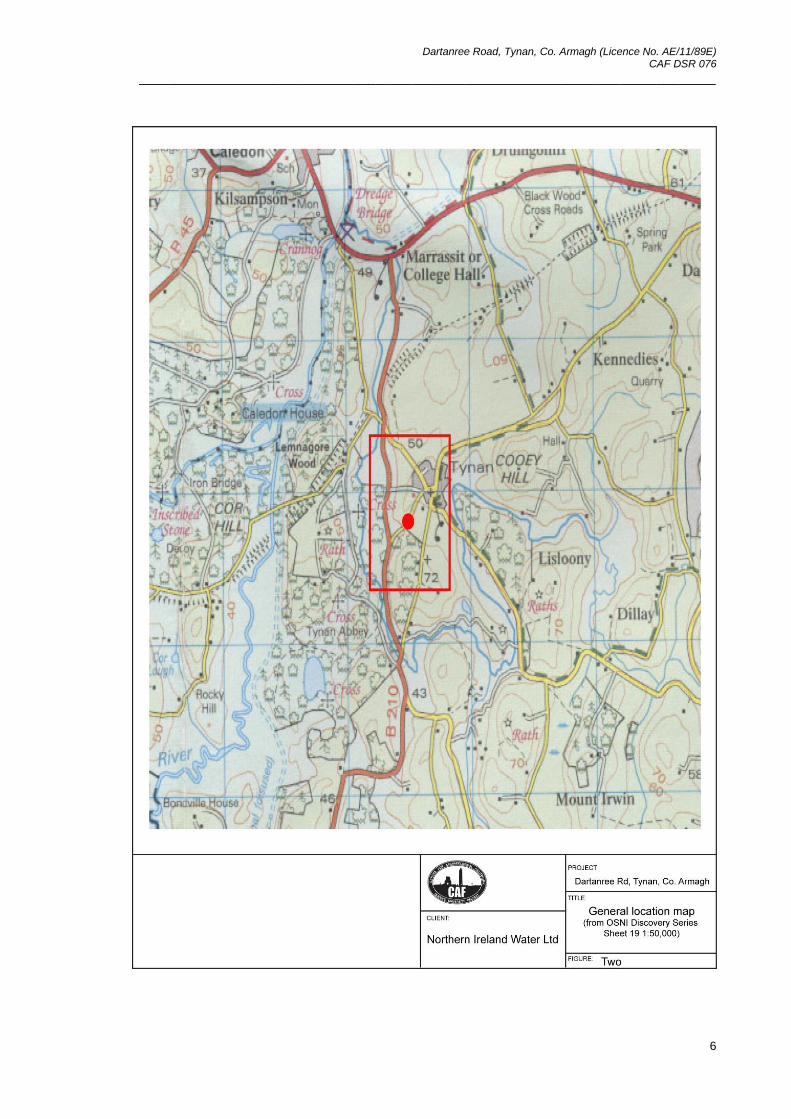
2.2.1 On 22
nd July 2011 contractors working on behalf of Northern Ireland Water Ltd, who were
co-ordinating the laying of storm drains for a new development on the outskirts of the
village of Tynan in Co. Armagh (Figures One and Two), came across human remains. The
discovery was reported to Dr John O’Keeffe, Assistant Director within the NIEA who
identified that the bones were of archaeological interest and arranged for it to be examined
by Dr Eileen Murphy of QUB. An initial examination by Dr Murphy revealed that the
collection of bones comprised largely of long bones such as femurs. None of the bones
exhibited evidence of trauma and were probably from both males and females. There was
also no evidence that the skeletal remains were articulated suggesting that they may have
represented a charnel deposit. A copper artefact found associated with the bones was
assessed by Dr Philip Macdonald of the CAF who provisionally identified it as a copper
alloy mount, probably part of a coffin mount, of eighteenth- or nineteenth-century date.
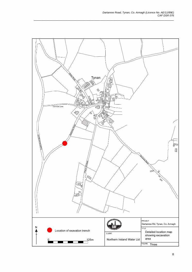
2.3 Site description
2.3.1 The site is located on the Dartanree Road, around 130m to the south-west of the village of
Tynan in Co. Armagh (Figure Three). The Dartanree Road originates in Tynan village and
runs south-west for approximately 0.5km where it joins the Coolkill Road (B210) that runs
between Caledon and Middletown. The Dartanree road follows the natural topography,
which consists mostly of rolling drumlins, sloping down from north-east to south-west. The
site lies at a height of around 50m above sea level, while the village of Tynan is at a height
of around 200m. To the north of the site are fields currently used for pasture, while to the
west is the Coolkill Road beyond which is a mill race and also the Tynan River. The Coolkill
Road crosses the estate land of Tynan Abbey which also lies to the south and south-east
of the excavation area. This land, which rises up to the south-east to a height of around
200m above sea level, is currently used for the grazing of cattle.
Dartanree Road, Tynan, Co. Armagh (Licence No. AE/11/89E) CAF DSR 076
______________________________________________________________________________
8
Dartanree Road, Tynan, Co. Armagh (Licence No. AE/11/89E) CAF DSR 076
______________________________________________________________________________
9
2.4 Historical background
2.4.1 The village of Tynan lies within the parish of the same name which was referred to as
Tungenethe in the early 14th century Papal Taxation (Hamlin 2008, 251). At this time it was
listed as belonging to the Culdees of Armagh (Reeves 1864, 13 & 102). The present
church, St Vindic’s Church of Ireland, is thought to be on or near the site of an Early
Christian foundation dating back to the first millennium AD, of which the patron saint may
have been St Vindic, although there is some confusion relating to saints and places with
similar names (Hamlin 1976, 536). That it was mentioned in the Annals of Ulster in 1072
supports the theory of an early settlement at Tynan (Reeves 1884, 413). The village has a
High Cross (Northern Ireland Sites and Monuments Record ARM 011:014) and there are
also other elements of early ecclesiastical architecture, including carved cross fragments,
in the graveyard of the present Church of Ireland. To the south-west of the village, in the
grounds of Tynan Abbey, an eighteenth-century stately home, there are three more
crosses (NISMR ARM 0015:001, 002 and 011:013). These were probably once associated
with the early church site. They have been extensively described by Reeves (1884), Roe
(1955) and Hamlin (1976).
2.4.1 The present day church of St Vindic’s was probably built in the early seventeenth century.
Leslie notes that in 1622 the ‘Rector [was] resident, church now built’ (Leslie 1911, 435).
Leslie goes on to say that the church was rebuilt in 1784 and that it was then modified in
1822 with the addition of two transepts and a chancel (ibid. 1911, 435). Lewis also
mentions these modifications (1837, 664).
2.5 Sites of archaeological interest
2.5.1 There are a number of archaeological sites in the surrounding area dating from pre-history
to more recent times and also including the ecclesiastical sites mentioned above (2.4.1).
Table One, below, lists some of the sites.

Dartanree Road, Tynan, Co. Armagh (Licence No. AE/11/89E) CAF DSR 076
______________________________________________________________________________
10
Description SMR No. Townland Grid Ref.
Well cross ARM
011:013
Fairview/
Mucklagh
H 7602 4288
Tynan High Cross ARM
011:014
Tynan H 7662 4300
Rath ARM
011:015
Fairview/
Mucklagh
H 7582 4277
Underground
observation post
ARM
011:027
Cooey H 7735 4314
Cross ARM
015:001
Fairview/
Mucklagh
H 7592 2322
High cross ARM
015:002
Corfehan H 7576 4165
Bi-vallate rath ARM
015:003
Lisloony H 7762 4231
Cairn or barrow ARM
015:004
Tynan H 7717 4207
Possible crannog ARM
015:033
Corfehan H 7581 4183
Bullaun ARM
015:045
Corfehan H 7596 4240
Table One: Sites of archaeological interest in the surrounding area
Dartanree Road, Tynan, Co. Armagh (Licence No. AE/11/89E) CAF DSR 076
______________________________________________________________________________
11
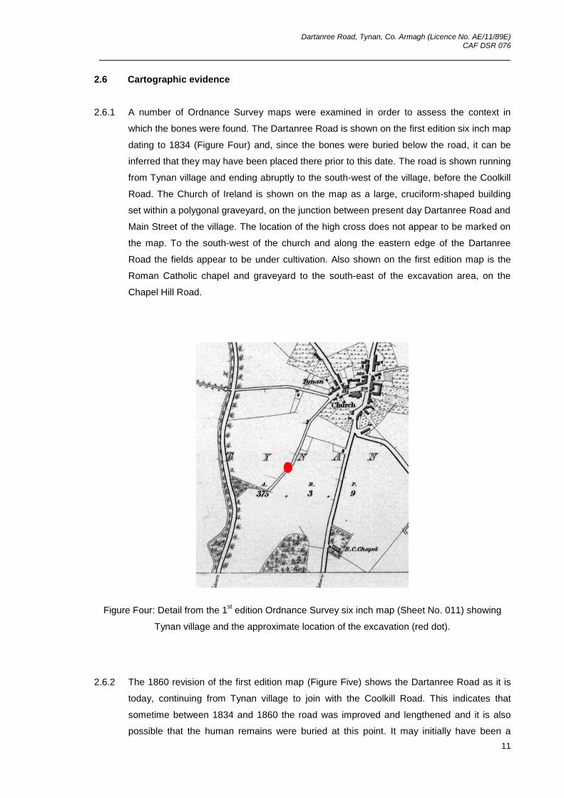
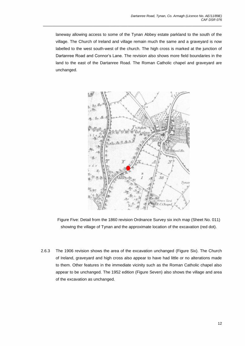
2.6 Cartographic evidence
2.6.1 A number of Ordnance Survey maps were examined in order to assess the context in
which the bones were found. The Dartanree Road is shown on the first edition six inch map
dating to 1834 (Figure Four) and, since the bones were buried below the road, it can be
inferred that they may have been placed there prior to this date. The road is shown running
from Tynan village and ending abruptly to the south-west of the village, before the Coolkill
Road. The Church of Ireland is shown on the map as a large, cruciform-shaped building
set within a polygonal graveyard, on the junction between present day Dartanree Road and
Main Street of the village. The location of the high cross does not appear to be marked on
the map. To the south-west of the church and along the eastern edge of the Dartanree
Road the fields appear to be under cultivation. Also shown on the first edition map is the
Roman Catholic chapel and graveyard to the south-east of the excavation area, on the
Chapel Hill Road.
Figure Four: Detail from the 1st edition Ordnance Survey six inch map (Sheet No. 011) showing
Tynan village and the approximate location of the excavation (red dot).
2.6.2 The 1860 revision of the first edition map (Figure Five) shows the Dartanree Road as it is
today, continuing from Tynan village to join with the Coolkill Road. This indicates that
sometime between 1834 and 1860 the road was improved and lengthened and it is also
possible that the human remains were buried at this point. It may initially have been a
Dartanree Road, Tynan, Co. Armagh (Licence No. AE/11/89E) CAF DSR 076
______________________________________________________________________________
12
laneway allowing access to some of the Tynan Abbey estate parkland to the south of the
village. The Church of Ireland and village remain much the same and a graveyard is now
labelled to the west south-west of the church. The high cross is marked at the junction of
Dartanree Road and Connor’s Lane. The revision also shows more field boundaries in the
land to the east of the Dartanree Road. The Roman Catholic chapel and graveyard are
unchanged.
Figure Five: Detail from the 1860 revision Ordnance Survey six inch map (Sheet No. 011)
showing the village of Tynan and the approximate location of the excavation (red dot).
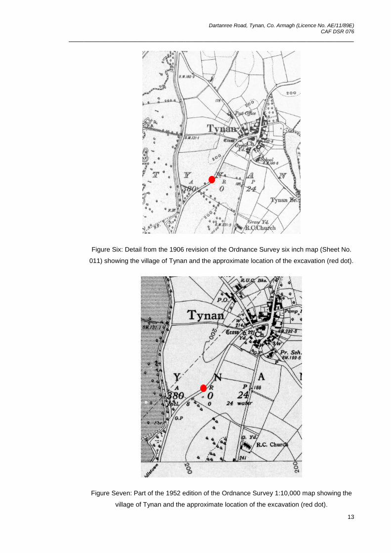
2.6.3 The 1906 revision shows the area of the excavation unchanged (Figure Six). The Church
of Ireland, graveyard and high cross also appear to have had little or no alterations made
to them. Other features in the immediate vicinity such as the Roman Catholic chapel also
appear to be unchanged. The 1952 edition (Figure Seven) also shows the village and area
of the excavation as unchanged.
Dartanree Road, Tynan, Co. Armagh (Licence No. AE/11/89E) CAF DSR 076
______________________________________________________________________________
13
Figure Six: Detail from the 1906 revision of the Ordnance Survey six inch map (Sheet No.
011) showing the village of Tynan and the approximate location of the excavation (red dot).
Figure Seven: Part of the 1952 edition of the Ordnance Survey 1:10,000 map showing the
village of Tynan and the approximate location of the excavation (red dot).
Dartanree Road, Tynan, Co. Armagh (Licence No. AE/11/89E) CAF DSR 076
______________________________________________________________________________
14
2.7 Previous excavations
2.7.1 A small number of archaeological investigations have been carried out in and around the
village of Tynan. An evaluation in advance of a housing development on land adjacent to
Chapel Hill Road, to the east of the site, which consisted of ten trenches found no remains
of archaeological significance (Long 2007:089) while another evaluation close to a possible
barrow (NISMR No. ARM 015:004) also uncovered no archaeological features (Sloan
2007). A third investigation off Abbey Road to the north of the site found evidence of
occupation (MacManus 2008:070). The remains have been interpreted as part of a small
rural dwelling of unknown date; and are to be dated using radiocarbon samples.
2.8 Geological background
2.8.1 Tynan is located on Carboniferous sedimentary rocks of the Maydown Limestone
Formation. This limestone, which contains macrofossils such as Asbian corals and
brachiopods, is exposed in Plaister Quarry near Aughnacloy, Co. Tyrone and also in
Maydown Quarry on the outskirts of Benburb (Mitchell 2004).
2.8.2 Overlying the natural bedrock the superficial or drift geology consists mainly of
Carboniferous limestone till with some alluvial deposits of sand and silt. The main soil
types in the area are gleys with good to impeded drainage (Cruickshank 1997).
2.9 Reason for the excavation and research objectives
2.9.1 The main objectives of the investigation were:
to retrieve human remains from the area of the pipe trench
to identify and record any deposits stratigraphically related to the human remains
to excavate and record any further in-situ remains including possible articulated
skeletal remains
to set such deposits within the wider archaeological and historical background of
the area, if possible
2.10 Archiving
2.10.1 Copies of this report will be deposited with the NIEA. All site records and finds are
temporarily archived within the Centre for Archaeological Fieldwork, School of Geography,
Archaeology and Palaeoecology, Queen’s University Belfast.

Dartanree Road, Tynan, Co. Armagh (Licence No. AE/11/89E) CAF DSR 076
______________________________________________________________________________
15
2.11 Credits and Acknowledgements
2.11.1 The excavation was directed by Naomi Carver and the crew consisted of Ruth Logue and
Sapphire Mussen (CAF).
2.11.2 Assistance during the course of the excavation and the preparation of this report was
kindly provided by: Dr Philip Macdonald (CAF); Richard Manson (AECOM); Sam McManus
(AECOM); Cormac McSparron (CAF); Dr Eileen Murphy (QUB); Ruairí Ó Baoill (CAF),
Maura Pringle (QUB) and Brian Sloan (CAF). The human remains were washed and
catalogued by Grace McAlister (CAF) and Sapphire Mussen (CAF). Sapphire Mussen
(CAF) also compiled some of the appendices.
Dartanree Road, Tynan, Co. Armagh (Licence No. AE/11/89E) CAF DSR 076
______________________________________________________________________________
16
Dartanree Road, Tynan, Co. Armagh (Licence No. AE/11/89E) CAF DSR 076
______________________________________________________________________________
17
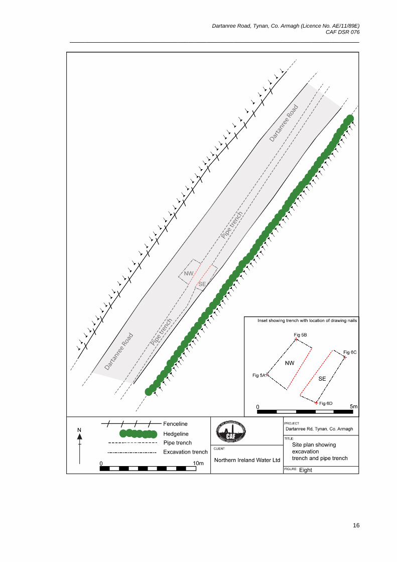
3 Excavation
3.1 Methodology 3.1.1 The excavation trench was rectangular in shape and measured approximately 2.0m (north-
east/south-west) by 2.5m (north-west/south-east). It was positioned over the pipe trench,
centred on the concentration of human bone which was uncovered during the initial pipe
laying. The trench was excavated in two parts, referred to here as north-west (NW) and
south-east (SE). The stratigraphy in each trench was treated separately due to the pipe
trench having severed the stratigraphic relationships between the two sets of deposits.
During the course of the excavation it was difficult to discern subtle changes in context and
therefore much of the trench was treated as a single stratigraphic unit and all finds
recorded from the same context (no. 106) which was suffixed by NW and SE to represent
the two sides of the trench. When both sides of the trench had been excavated down to the
level of the base of the pipe trench, a number of layers were visible in the section. These
were retrospectively assigned context numbers for the purpose of description and
interpretation and will be described at greater length below.
3.1.2 The excavation was carried out both by hand and with the aid of a mechanical excavator,
under archaeological supervision, to remove layers of overburden. The context record for
the site was created using the standard context recording method. The list of contexts
forms Appendix One, the photographic record is reproduced as Appendix Three and the
field drawing register forms Appendix Four. The finds register is Appendix Five. No
samples were taken during the course of the excavation. The unique site code used to
identify the site records during both the evaluation and the excavation was TYN’11.
3.2 Account of the excavation
3.2.1 The Harris Matrix for the site is provided in Appendix Two. It is intended that this is referred
to whilst reading the following account of the stratigraphic sequence present on the site.
3.3 North-western side of the trench
3.3.1 The north-western side of the trench measured approximately 1.0m (north-west/south-east
by 2.0m (north-east/south-west). It was excavated to the base of the pipe trench, an overall
depth of 1.8-2.0m. The stratigraphically latest deposit in this part of the trench was the
bitumen road surface (context no. 101). This was cut and subsequently removed by
mechanical excavator. The road surface was between 0.06 and 0.12m thick. It extended
over much of the trench although was encroached by grass on the south-eastern side.
Below the road surface was a layer of hardcore (context no. 102) consisting of angular and
sub-angular stones ranging in size from 15x15x7mm to 50x40x30mm. This layer was also
removed using a mechanical excavator. It was around 0.18m thick.
Dartanree Road, Tynan, Co. Armagh (Licence No. AE/11/89E) CAF DSR 076
______________________________________________________________________________
18
3.3.2 Below the hardcore (context no. 102) was a deposit of highly compact orange clay (context
no. 107) up to 0.3m in thickness. The clay contained small angular stones around
3x3x1mm along with occasional flecks of charcoal. It also contained some bone as high up
as 0.25m below the surface of the road. It is probable that the clay was brought in as a
levelling deposit upon which to construct the road.
3.3.3 Below the clay levelling deposit (context no. 107) was a layer of dark brown, smooth,
friable clay loam (context no. 108) containing occasional small stones around 3x3x1mm in
size and also some flecks of charcoal. The clay loam sloped relatively steeply from north-
east to south-west. The layer was between 0.08m and 0.14m thick and was not
represented in the south-east facing section. Below the clay loam was a layer of greyish
brown and orange mottled compact loamy clay with a slightly gritty texture. It contained
sub-rounded stones around 10x5x2mm in size along with occasional charcoal flecks and
some concentrations of charcoal. The layer extended over the whole trench and was
recorded as context nos. 106NW and 106SE (see paragraph 3.1.1 above). In the north-
western side of the trench it was 0.50m thick. The mottled clay contained dense
concentrations of human bone, particularly in the north-western part of the trench. The
most significant find from this part of the trench were fragments of copper alloy which are
thought to have been part of a coffin mount of eighteenth or nineteenth century date (Philip
Macdonald pers. comm.). The layer also contained a small sherd of brown-glazed
earthenware which may also date to the eighteenth or nineteenth century and a piece of
flint. The flint was examined by Brian Sloan (CAF) who identified it as a proximal fragment
of a flake or blade with semi-invasive pressure flaking on lower left dorsal lateral. It was
prehistoric in date and therefore residual.
3.3.4 Below the mottled clay (context no. 106NW), and visible in the south-east facing section
was a layer of dark clay loam (context no. 117) containing large concentrations of bone.
The layer sloped steeply from north-east to south-west. It was slightly gritty in texture,
friable and contained moderately frequent angular stones around 3x3x2mm along with
occasional flecks of charcoal. It was 0.20m thick and at least 0.80m long. Below the dark
layer was more of the mottled clay layer (context no. 106NW); in parts these two layers
were indistinguishable from one another. Below the mottled clay was another layer of clay
(context no. 118) which was brownish orange in colour, slightly gritty and compact. It
contained moderately frequent angular stones around 3x3x2mm as well as occasional
charcoal flecks. The layer was around 0.10m thick and may have been deliberately laid
down as a consolidator between the looser, loamier layers. Below the clay (context no.
118) was another layer of clay (context no. 121) which also sloped down from north-east to
south-west. The clay was compact, with a smooth texture, and mottled orangeish brown in
colour. It was between 0.05 and 0.30m thick and contained a few sub-angular stones

Dartanree Road, Tynan, Co. Armagh (Licence No. AE/11/89E) CAF DSR 076
______________________________________________________________________________
19
around 3x3x2mm as well as a few flecks of charcoal. Fragments of bone were visible in
this layer in the south-east facing section.
Dartanree Road, Tynan, Co. Armagh (Licence No. AE/11/89E) CAF DSR 076
______________________________________________________________________________
20
3.3.5 Below the clay (context no. 121) was another layer of dumped soil (context no. 119) which
was also only identifiable in the south-east facing section. The layer consisted of brownish
orange compact clay which was slightly gritty in texture. It contained moderately frequent
angular stones around 3x3x2mm in size. The layer sloped relatively steeply from north-east
to south-west and was between 0.04m to 0.18m thick. Below the compact clay layer
(context no. 119) was another layer of clay (context no. 122) which was mottled orangeish
brown in colour and quite compact. It had a slightly gritty texture and contained moderately
frequent sub-angular stones around 3x3x2mm in size as well as occasional flecks of
charcoal. It was an average of 0.60m thick. The layer contained some bone which was
visible in the south-east facing section. Two sherds of glass from a bottle were also
recovered from this layer and have been dated to the eighteenth or possibly nineteenth
century (Ruairí Ó Baoill pers. comm.). The layer was probably intended to consolidate the
looser, loamier layers within the dump.
3.3.6 Below the clay (context no. 122) was a dark brown loamy clay (context no. 120) which was
friable with a smooth texture and up to 0.20m thick. The loamy clay contained a few sub-
angular stones around 3x3x2mm in size as well as occasional flecks of charcoal. The
lowest exposed layer in the sequence was a clay layer (context no. 123). This layer was
mottled orangeish grey in colour and quite compact with a slightly gritty texture. It
contained moderately frequent angular stones around 3x3x2mm in size along with some
occasional charcoal flecks. It was at least 0.35m thick and at the base of the sequence of
layers visible in the south-east facing section. It may be the equivalent of the clay layer
(context no. 116) exposed in the north-west facing section and probably overlies the
natural, but as the excavation ceased at this layer when it reached the level of the base of
the pipe trench, this was impossible to prove.
3.4 South-eastern side of the trench
3.4.1 The south-eastern side of the trench measured 1.0m (north-west/south-east) by 2.0m
(north-east/south-west). It was later extended by approximately 1.0m to the north-east for
health and safety reasons. The trench was excavated to the level of the base of the pipe
trench, a depth of 1.9m. The stratigraphically latest deposit on this side of the trench was
the sod layer (context no. 103). This layer consisted of dark brown, gritty, loose sandy loam
containing small rounded stones around 2x3x5mm in size. It was 0.15m thick and overlay
the road surface along its south-eastern edge. The sod layer (context no. 103) also overlay
a layer of topsoil (context no. 104) which consisted of blackish brown relatively compact
clay loam with a gritty texture. It contained angular stone approximately 25x15x5mm in size
along with occasional charcoal flecks and was 0.12m thick.

Dartanree Road, Tynan, Co. Armagh (Licence No. AE/11/89E) CAF DSR 076
______________________________________________________________________________
21
Dartanree Road, Tynan, Co. Armagh (Licence No. AE/11/89E) CAF DSR 076
______________________________________________________________________________
22
3.4.2 Below the topsoil (context no. 104) was a layer of light greyish brown clay loam (context
no. 105) which had a spongy texture and was quite compact. The layer contained
infrequent angular stones around 5x5x2mm along with more frequent larger stones at the
base of the layer which were around 35x40x20mm in size. The clay loam also contained
occasional flecks of charcoal along with tree roots. The layer was 0.10-0.20m thick.
3.4.3 Below the clay loam (context no. 105), at the south-eastern side of the trench, was a layer
of clay (context no. 107) equivalent to that excavated at the north-western side of the
trench (also context no. 107). As previously described, this layer was orange in colour and
highly compact with a smooth texture. It contained occasional small angular stones around
3x3x1mm in size as well as occasional charcoal flecks. At this side of the trench the layer
was up to 0.50m thick. As suggested previously, it was probably intended as a levelling
deposit to provide a base for the construction of the road.
3.4.4 Below the levelling deposit (context no. 107) was a sequence of deposits visible in the
north-west facing section but not clearly identifiable during excavation. The first layer in this
sequence consisted of a dark brown, smooth, friable clay loam (context no. 108) containing
occasional small stones around 3x3x1mm in size and also some flecks of charcoal. The
clay loam sloped relatively steeply from north-east to south-west and contained bone,
visible in the section. It was between 0.08m and 0.14m thick. Below the clay loam (context
no. 108) was a layer of greyish brown and orange mottled clay (context no. 106SE) which
again was the equivalent to a deposit excavated on the north-western side of the trench
(context no. 106NW). As previously described, the compact loamy clay had a slightly gritty
texture and contained sub-rounded stones approximately 10x5x2mm in size. It contained a
large quantity of bone as well as fragments of copper alloy and a small sherd of eighteenth
century pottery.
3.4.5 Below the mottled clay (context no. 106SE) was a layer of greyish brown sandy loamy clay
(context no. 109) which also sloped down steeply from north-east to south-west. The loamy
clay was friable with a slightly gritty texture and contained frequent sub-angular stones
around 10x5x2mm in size. The layer contained bone although not in as large quantities as
the layers above (contexts no. 106SE and 108). It was around 0.16m thick.
3.4.6 Below the sandy loamy clay (context no. 109) was a compact clay (context no. 110). The
clay was mottled greyish brown and orange in colour and contained frequent sub-rounded
stones with an average size of 10x5x2mm and also some flecks of charcoal. It was up to
0.34m thick and sloped from north-east to south-west. The layer was probably intended to
consolidate the loamier dumps on either side. Below the clay (context no. 110) was a layer
of loamy clay (context no. 111) which was greyish brown in colour and relatively compact
with a slightly gritty texture. The loamy clay contained some small sub-angular stones with
Dartanree Road, Tynan, Co. Armagh (Licence No. AE/11/89E) CAF DSR 076
______________________________________________________________________________
23
an average size of 3x3x1mm and also occasional flecks of charcoal. The layer was shallow
at its north-eastern side (around 0.02m) but became thicker towards the south-western
side (around 0.14m). It did not contain any visible bone.
3.4.7 Below the loamy clay (context no. 111) was a compact orange clay (context no. 112) which
had a gritty texture and contained a moderate amount of sub-angular stones with an
average size of 3x3x2mm. It also contained occasional flecks of charcoal. The layer was
between 0.08m to 0.16m thick. It overlay another layer of loamy clay (context no. 113)
which was greyish brown in colour and compact with a smooth texture. The loamy clay
contained occasional small stones around 3x3x2mm in size. It did not contain any visible
bone or artefacts. The loamy clay sloped down from north-east to south-west and was
visible in the north-west facing section. It was up to 0.14m thick.
3.4.8 Below the loamy clay (context no. 113) was a compact orange clay (context no. 114). The
clay was at least 0.20m thick and contained moderately frequent angular to sub-angular
stones around 3x3x1mm. It was visible in the north-west facing section of the trench and
may have been intended to consolidate the looser, loamier layers. Below the compact
orange clay (context no. 114) was a layer of mottled orangeish grey clay loam (context
no.115) which was around 0.10m thick. The mottled clay loam had a smooth to slightly
gritty texture and was friable. It contained small angular stones with an average size of
3x3x2mm. As with the overlying layers, the mottled clay loam probably represented the
remains of dumped, looser soil in between consolidatory layers of clay. It contained no
visible bone. Below the mottled clay loam (context no. 115) was a compact orange clay
(context no. 116) which contained some small stones around 3x3x2mm and occasional
flecks of charcoal. This was the lowest layer exposed by excavation and probably overlay
the boulder clay subsoil (which was exposed in the pipe trench to the north-east). The
surface of the layer was encountered at a depth of 1.76m and excavation continued to a
level of 1.96m. The layer may have been the equivalent of the clay layer in the north-
western side of the trench (context no. 123).
3.5 The pipe trench
3.5.1 The excavation of the pipe trench by mechanical excavator was monitored for a distance of
around 20m to the north-east of the excavation trench. Although a section drawing was
completed of this trench, the layers were not recorded by context. The bone retrieved from
this section was recorded as coming from the ‘fill of the pipe trench’. It was found that the
banded layers containing bone continued for a distance of around 14.0m to the north-east
of the trench.
Dartanree Road, Tynan, Co. Armagh (Licence No. AE/11/89E) CAF DSR 076
______________________________________________________________________________
24
4 Discussion
4.1 The excavation at Dartanree Road, Tynan revealed that there was a substantial quantity of
human bone buried below the surface of the road. The bone was not contained within a cut
feature but rather within a series of tipline deposits which, during excavation were virtually
indistinguishable from one another. There was bone present within most of the tip lines
from as close to the surface as 0.25m down to around 1.2m below the surface of the road.
The bone was, however, concentrated within a layer of mottled clay loam (context no. 106)
and there was also more bone found in the north-western side of the trench than the south-
eastern side. The layers containing the bone extended beyond the limit of excavation to the
north-west. Monitoring of the pipe trench under archaeological supervision also revealed
that the layers containing the bone extended for a distance of around 14.0m to the north-
east of the excavation trench. Some fragments of bone were visible in the section of the
pipe trench which had previously been excavated to the south-west of the excavation
trench.
4.2 The area of the site was raised up from the surrounding landscape, probably to provide a
level surface for the construction of the road. Perhaps the nearby fields were boggy or
prone to becoming waterlogged. The layers observed within the excavation trench revealed
the nature of the deposit used to build up the land. It comprised alternating layers of loam
and clay or clay loam which had been dumped or tipped from the north-east. It is probable
that the clay-rich layers were intended to consolidate the looser, loamier soil. The bone
was not confined to any single layer.
4.3 The bone was in a secondary or tertiary context of deposition. The excavation did not
reveal any evidence of articulated burials or burials within formal grave cuts. All the
excavated bone was disarticulated and consisted mainly of long bones and cranial
fragments. This indicates that it had been moved from elsewhere and in the process the
smaller, more fragile bones, such as ribs and phalanges for example, were lost. The
association of the bone with a possible coffin mount suggests that the original context of
deposition was within a formalised burial ground. There are two graveyards nearby- that
associated with the Roman Catholic chapel to the south-east and that adjoining the Church
of Ireland to the north-east. Documentary evidence records that the Church of Ireland was
substantially renovated in 1822 with the addition of two transepts and a chancel (Lewis
1837, 664 and Leslie 1911, 435). It is plausible that during these renovations some of the
existing burials within the graveyard were disturbed and re-buried elsewhere, perhaps
straight into area of excavation, but more likely reburied in an unmarked area of the
graveyard. The remains must then have been dug up again within the deposits used to
build up the level of the land surface below the road. If the bones were within their third
context of deposition this would account for the missing smaller bones plus the fragmentary
nature of some of the remains.
Dartanree Road, Tynan, Co. Armagh (Licence No. AE/11/89E) CAF DSR 076
______________________________________________________________________________
25
4.4 The human bone was buried prior to, or during the construction of, the Dartanree Road.
Cartographic evidence indicates that the road was finished by 1860 and that although it
was extant in 1834 it was not at its full length and as such was probably a lane or trackway.
The excavation revealed a series of tipline deposits capped with a thick deposit of clay that
was probably intended as a levelling deposit. It was not possible to determine if the clay
was related to the initial construction of the lane prior to 1834 or to the improvement of the
road prior to 1860. It is possible that there was a horizontal discontinuity between the tipline
deposits and the levelling clay or between the levelling clay and the modern day road
which represents the removal of the original lane.
4.5 It is probable that the bones were buried after 1822, when the Church of Ireland was
renovated, and prior to 1860 when the completed road is shown on the Ordnance Survey
map revision. It is possible that the road was constructed at around the same time as the
church improvements and finished by 1860. The artefactual evidence also supports an
early nineteenth century date for the deposition of the bone. As well as the possible coffin
mount which was tentatively dated to the eighteenth or nineteenth century (Philip
Macdonald pers. comm.), a small sherd of glazed earthenware along with a piece of glass
also indicates an eighteenth or nineteenth century date (Ruairí Ó Baoill pers. comm.).
Unfortunately, the artefactual evidence only serves to provide a terminus post quem for the
deposition of the bone. However, the depiction of the finished road on the 1860 Ordnance
Survey map provides an approximate terminus ante quem for the burial. Obtaining a
radiocarbon date from a bone sample as recommended by the osteo-archaeologist will
hopefully provide an idea of the original burial date.
4.5 Conclusions
4.5.1 The excavation uncovered a series of tipline deposits containing skeletal human remains.
The bone was buried prior to 1860 and, possibly prior to 1834, and was probably removed
from a nearby graveyard during an episode of graveyard clearance. It may relate to the
remodelling of St Vindic’s Church of Ireland in 1822. The bone was contained within a
series of tip line deposits which formed a ‘made-up’ platform upon which the Dartanree
road was constructed.
Dartanree Road, Tynan, Co. Armagh (Licence No. AE/11/89E) CAF DSR 076
______________________________________________________________________________
26
5 Recommendations.
5.1 Introduction
5.1.1 There are several areas of further work required to bring the Tynan excavation to final
report stage. These are detailed below in Sections 5.2-5.3. Depending on the results of the
osteo-archaeological analysis, the final report may take the form of a short article or note
intended for submission to the Ulster Journal of Archaeology. A short summary will also be
published in the Excavations 2011 bulletin. A Costed Assessment (CAF CA 076)
accompanies this report.
5.2 Osteo-archaeological analysis
5.2.1 Several hundred individual human bones, from perhaps 30 individuals, were recovered
from the site. Most of these were long bones such as femurs and skull fragments. It is
proposed that the assemblage is analysed by an osteo-archaeologist in order to discover if
the bone exhibits interesting pathologies, as well as finding out details on the minimum
number of individuals present and retrieving data on age and sex.
5.3 Programme of radiocarbon dating
5.3.1 It is proposed that one radiocarbon date is obtained from the human bone recovered during
the course of the excavation. The sample for submission will be chosen following the
completion of the osteo-archaeological analysis. Although the bone is in a secondary
context and the excavated sequence of deposits were thought to have been dumped within
a relatively short space of time, a radiocarbon date may help to refine the timescale of the
site.

Dartanree Road, Tynan, Co. Armagh (Licence No. AE/11/89E) CAF DSR 076
______________________________________________________________________________
27
Bibliography
Cruickshank, J.G. (ed.), 1997. Soil and Environment: Northern Ireland. Agricultural and
Environmental Science Division, DANI and the Agricultural and Environmental Science
Department, Queen’s University, Belfast.
Hamlin, A., 2008. The Archaeology of Early Christianity in the North of Ireland. T. Kerr, (ed.), with
contributions from Bell, J., Kyle, A., Meek, M. and Sloan, B. BAR British Series, 460, Oxford.
Leslie, J.B., 1911. Armagh Clergy and Parishes. Dundalk.
Lewis, S., 1837. A Topographical Dictionary of Ireland. London.
Long, C., 2007. Armagh 2007: 089: Chapel Hill, Tynan. Excavations Bulletin 2007 [online] Available
at: <http://www.excavations.ie> [Accessed 8th September 2011]
MacManus, C., 2008. Armagh 2008: 070: Abbey Road, Tynan. Excavations Bulletin 2008 [online]
Available at: <http://www.excavations.ie> [Accessed 8th September 2011]
Mitchell, W.I. (ed.), 2004. The Geology of Northern Ireland: Our Natural Foundation. Geological
Survey of Northern Ireland, Belfast.
Reeves, D. 1884. Tynan and its Crosses. The Journal of the Royal Historical and Archaeological
Association of Ireland, Fourth Series, Vol 6, No. 59, 412-428.
Reeves, W., 1864. The Culdees of the British Isles, as they appear in history. Dublin.
Roe, H., 1955. The High Crosses of Armagh. Seanchas Ardmhacha I No. 2, 111-114.
Sloan, B., 2007. 14 Derryhaw Road, Tynan, Co. Armagh, CAF Monitoring Report No. 098, Centre
for Archaeological Fieldwork, Queen’s University Belfast, Belfast. Unpublished Report.

Dartanree Road, Tynan, Co. Armagh (Licence No. AE/11/89E) CAF DSR 076
______________________________________________________________________________
28
Appendix One: Context Register
Context Number
Context Type
Description
101 Layer Tarmac road surface over most of trench
102 Layer Hardcore for road surface over most of trench
103 Layer Grass/sod layer at edge of road on south-eastern side of trench
104 N/a Topsoil on south-eastern side of trench
105 Layer Sandy clay below topsoil on south-eastern side of trench
106 Layer Heterogeneous deposit of mottled clay loam
107 Layer Compact orange clay levelling deposit
108 Layer Dark loam layer on south-eastern side of trench
109 Layer Dark loam layer on south-eastern side of trench
110 Layer Mottled clay between loam layers on south-eastern side of trench
111 Layer Dark loam layer on south-eastern side of trench
112 Layer Orange clay between loam layers on south-eastern side of trench
113 Layer Dark loam layer on south-eastern side of trench
114 Layer Orange-mottled clay between layers in south-eastern side of trench
115 Layer Dark loam layer on south-eastern side of trench
116 Layer Mottled clay below layers in south-eastern side of trench

Dartanree Road, Tynan, Co. Armagh (Licence No. AE/11/89E) CAF DSR 076
______________________________________________________________________________
29
Context Number
Context Type
Description
117 Layer Dark loam layer in north-western side of trench
118 Layer Dark loam layer in north-western side of trench
119 Layer Dark loam layer in north-western side of trench
120 Layer Dark loam layer in north-western side of trench
121 Layer Clay between layers in north-western side of trench
122 Layer Clay between layers in north-western side of trench
123 Layer Clay between layers in north-western side of trench
124 Cut Cut of pipe trench
Dartanree Road, Tynan, Co. Armagh (Licence No. AE/11/89E) CAF DSR 076
______________________________________________________________________________
30
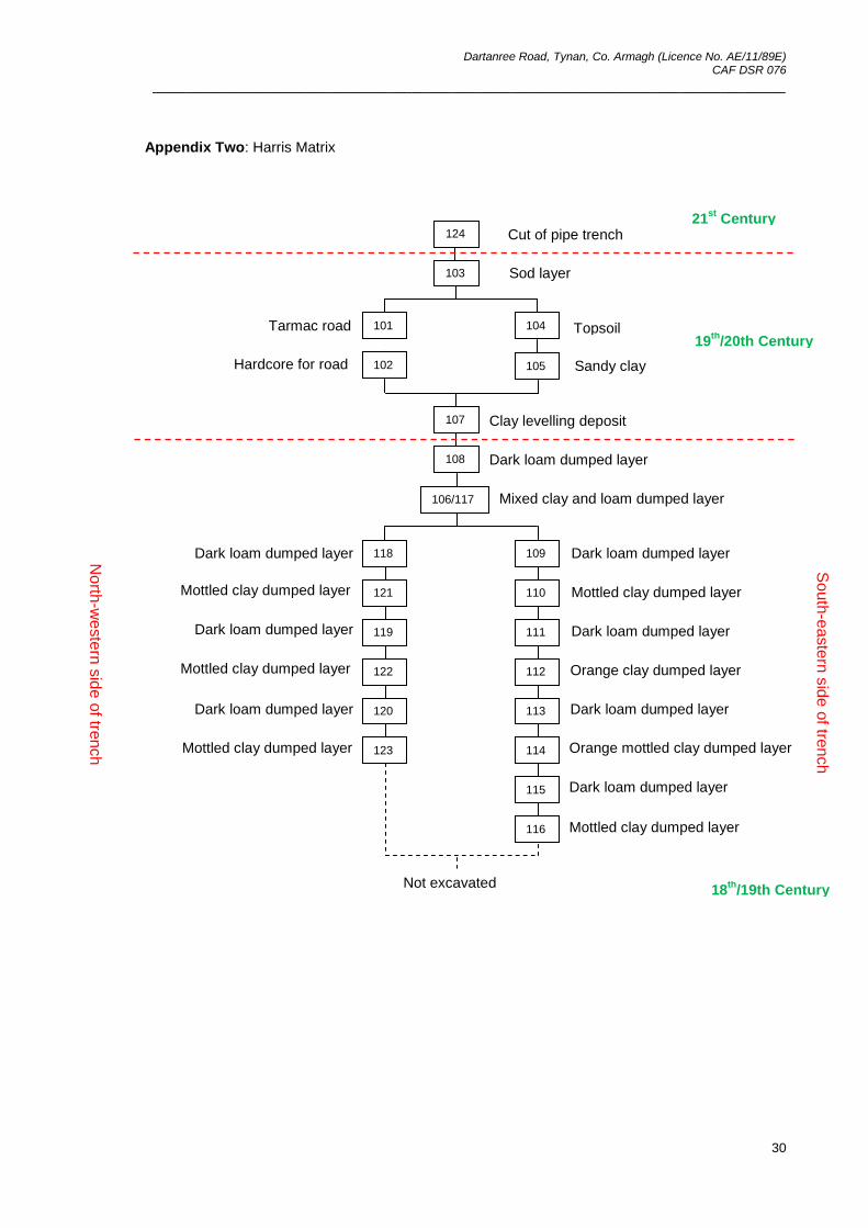
Appendix Two: Harris Matrix
103 Sod layer
Cut of pipe trench
Topsoil
Sandy clay
Tarmac road
Hardcore for road
124
101
102
104
105
107
108
106/117
118 109
121 110
119
122
120
123
111
112
113
114
115
116
Clay levelling deposit
Dark loam dumped layer
Mixed clay and loam dumped layer
Dark loam dumped layer
Mottled clay dumped layer
Dark loam dumped layer
Orange clay dumped layer
Dark loam dumped layer
Orange mottled clay dumped layer
Dark loam dumped layer
Mottled clay dumped layer
Dark loam dumped layer
Dark loam dumped layer
Dark loam dumped layer
Mottled clay dumped layer
Mottled clay dumped layer
Mottled clay dumped layer
So
uth
-easte
rn s
ide o
f tren
ch
No
rth-w
este
rn s
ide o
f tren
ch
21st
Century
19th
/20th Century
18th
/19th Century Not excavated
Dartanree Road, Tynan, Co. Armagh (Licence No. AE/11/89E) CAF DSR 076
______________________________________________________________________________
31
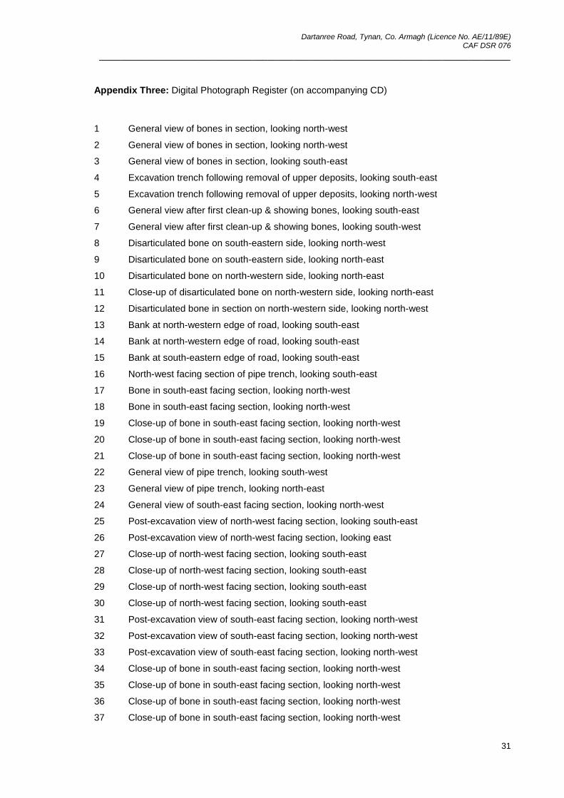
Appendix Three: Digital Photograph Register (on accompanying CD)
1 General view of bones in section, looking north-west
2 General view of bones in section, looking north-west
3 General view of bones in section, looking south-east
4 Excavation trench following removal of upper deposits, looking south-east
5 Excavation trench following removal of upper deposits, looking north-west
6 General view after first clean-up & showing bones, looking south-east
7 General view after first clean-up & showing bones, looking south-west
8 Disarticulated bone on south-eastern side, looking north-west
9 Disarticulated bone on south-eastern side, looking north-east
10 Disarticulated bone on north-western side, looking north-east
11 Close-up of disarticulated bone on north-western side, looking north-east
12 Disarticulated bone in section on north-western side, looking north-west
13 Bank at north-western edge of road, looking south-east
14 Bank at north-western edge of road, looking south-east
15 Bank at south-eastern edge of road, looking south-east
16 North-west facing section of pipe trench, looking south-east
17 Bone in south-east facing section, looking north-west
18 Bone in south-east facing section, looking north-west
19 Close-up of bone in south-east facing section, looking north-west
20 Close-up of bone in south-east facing section, looking north-west
21 Close-up of bone in south-east facing section, looking north-west
22 General view of pipe trench, looking south-west
23 General view of pipe trench, looking north-east
24 General view of south-east facing section, looking north-west
25 Post-excavation view of north-west facing section, looking south-east
26 Post-excavation view of north-west facing section, looking east
27 Close-up of north-west facing section, looking south-east
28 Close-up of north-west facing section, looking south-east
29 Close-up of north-west facing section, looking south-east
30 Close-up of north-west facing section, looking south-east
31 Post-excavation view of south-east facing section, looking north-west
32 Post-excavation view of south-east facing section, looking north-west
33 Post-excavation view of south-east facing section, looking north-west
34 Close-up of bone in south-east facing section, looking north-west
35 Close-up of bone in south-east facing section, looking north-west
36 Close-up of bone in south-east facing section, looking north-west
37 Close-up of bone in south-east facing section, looking north-west
Dartanree Road, Tynan, Co. Armagh (Licence No. AE/11/89E) CAF DSR 076
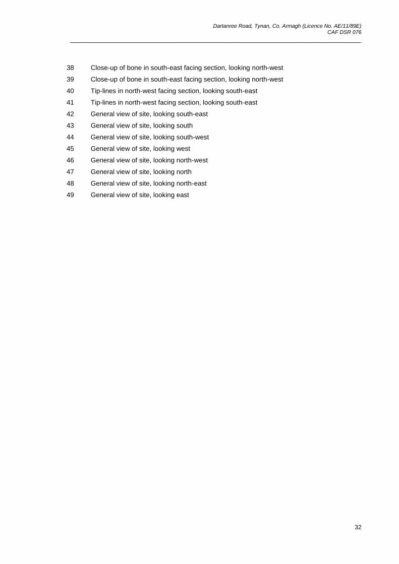
______________________________________________________________________________
32
38 Close-up of bone in south-east facing section, looking north-west
39 Close-up of bone in south-east facing section, looking north-west
40 Tip-lines in north-west facing section, looking south-east
41 Tip-lines in north-west facing section, looking south-east
42 General view of site, looking south-east
43 General view of site, looking south
44 General view of site, looking south-west
45 General view of site, looking west
46 General view of site, looking north-west
47 General view of site, looking north
48 General view of site, looking north-east
49 General view of site, looking east
Dartanree Road, Tynan, Co. Armagh (Licence No. AE/11/89E) CAF DSR 076
______________________________________________________________________________
33
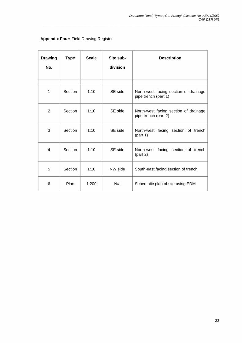
Appendix Four: Field Drawing Register
Drawing
No.
Type Scale Site sub-
division
Description
1 Section 1:10 SE side North-west facing section of drainage pipe trench (part 1)
2 Section 1:10 SE side North-west facing section of drainage pipe trench (part 2)
3 Section 1:10 SE side North-west facing section of trench (part 1)
4 Section 1:10 SE side North-west facing section of trench (part 2)
5 Section 1:10 NW side South-east facing section of trench
6 Plan 1:200 N/a Schematic plan of site using EDM

Dartanree Road, Tynan, Co. Armagh (Licence No. AE/11/89E) CAF DSR 076
______________________________________________________________________________
34
Appendix Five: Finds Register
Context No. Type Quantity Comment/description
106 Slate 542.9g Fragments
106 Brick 76.3g 1 fragment
106 Flint 2.8g Flake or blade fragment
106 Pottery 1.3g 1 small sherd of post-medieval pottery – 18
th century
106 Copper 5 fragments
Copper alloy mount, probably from a coffin mount – 18
th/19
th
century
122 Glass 29.3g Fragments – 18th century
Dartanree Road, Tynan, Co. Armagh (Licence No. AE/11/89E) CAF DSR 076
______________________________________________________________________________
35
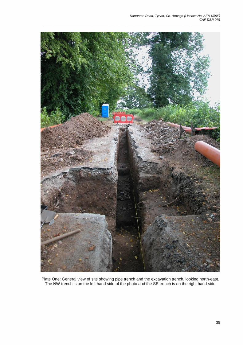
Plate One: General view of site showing pipe trench and the excavation trench, looking north-east.
The NW trench is on the left hand side of the photo and the SE trench is on the right hand side
Dartanree Road, Tynan, Co. Armagh (Licence No. AE/11/89E) CAF DSR 076
______________________________________________________________________________
36
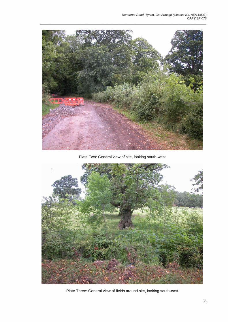
Plate Two: General view of site, looking south-west
Plate Three: General view of fields around site, looking south-east
Dartanree Road, Tynan, Co. Armagh (Licence No. AE/11/89E) CAF DSR 076
______________________________________________________________________________
37
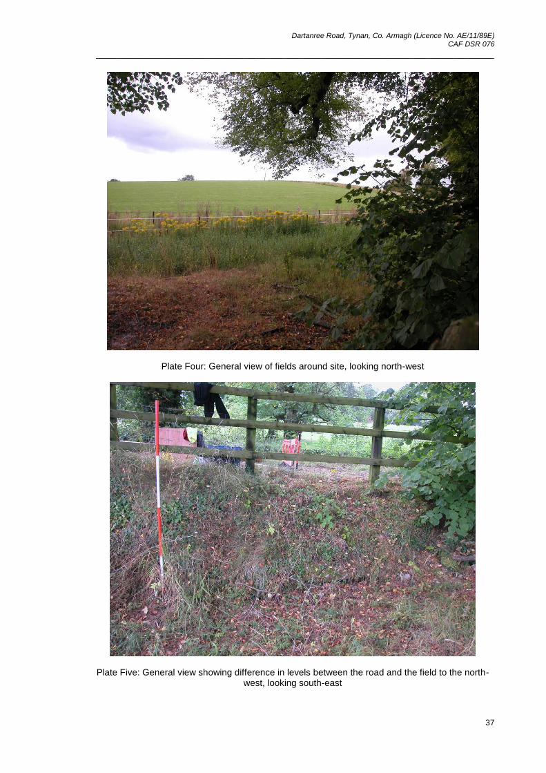
Plate Four: General view of fields around site, looking north-west
Plate Five: General view showing difference in levels between the road and the field to the north-west, looking south-east
Dartanree Road, Tynan, Co. Armagh (Licence No. AE/11/89E) CAF DSR 076
______________________________________________________________________________
38
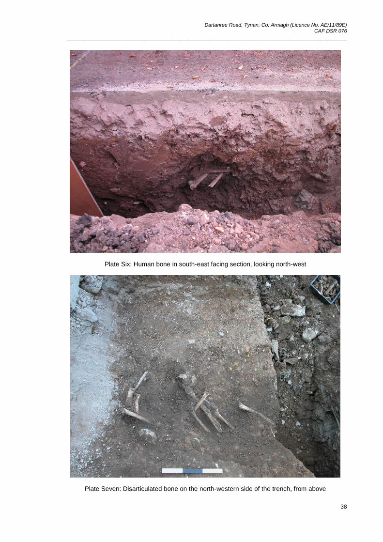
Plate Six: Human bone in south-east facing section, looking north-west
Plate Seven: Disarticulated bone on the north-western side of the trench, from above
Dartanree Road, Tynan, Co. Armagh (Licence No. AE/11/89E) CAF DSR 076
______________________________________________________________________________
39
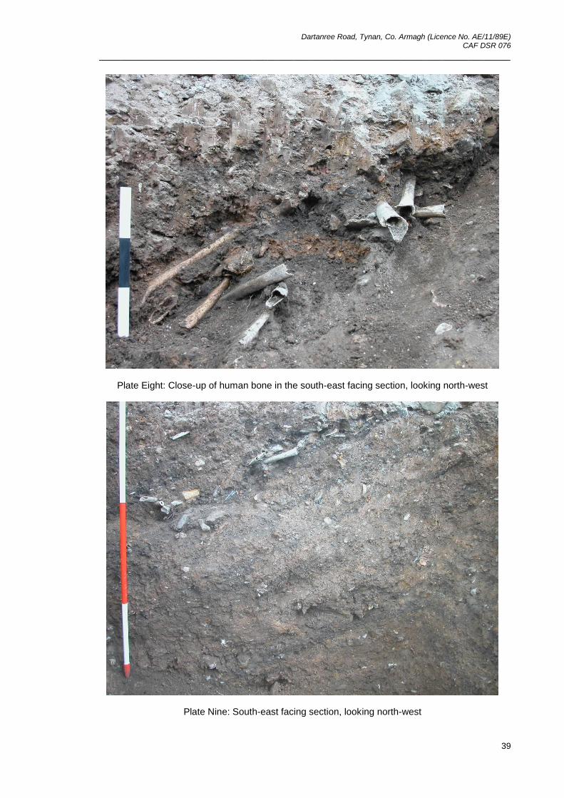
Plate Eight: Close-up of human bone in the south-east facing section, looking north-west
Plate Nine: South-east facing section, looking north-west
Dartanree Road, Tynan, Co. Armagh (Licence No. AE/11/89E) CAF DSR 076
______________________________________________________________________________
40
Plate Ten: North-west facing section with tiplines clearly visible, looking south-east