Embed Size (px)
Citation preview
1
CENTRE FOR ARCHAEOLOGICAL FIELDWORK
SCHOOL OF NATURAL AND BUILT ENVIRONMENT
QUEEN’S UNIVERSITY BELFAST
DATA STRUCTURE REPORT: No. 123
AE/17/84
EXCAVATIONS AT STONE CIRCULAR COMPLEX AND BURIAL CAIRN, DIVIS, COUNTY ANTRIM
Henry Welsh, Ruairí Ó Baoill and Ruth Logue

Centre for Archaeological Fieldwork, QUB Data Structure Report 123: AE/17/84
Stone Circular Complex and Burial Cairn, Divis, County Antrim
2
© 2019 Centre for Archaeological Fieldwork, School of Natural and Built Environment, Queen’s
University Belfast BT7 1NN
Data Structure Report: Divis Stone Circular Complex and Burial Cairn, Divis, County Antrim
Henry Welsh, Ruairí Ó Baoill and Ruth Logue
Grid References: Stone Circular Complex: J 2700 1050; Burial Cairn: J 2747 7456
CAF DSR 123
Licence No. AE/17/84
SMR References: Stone Circular Complex: ANT 060:083; Burial Cairn: not in SMR

Centre for Archaeological Fieldwork, QUB Data Structure Report 123: AE/17/84
Stone Circular Complex and Burial Cairn, Divis, County Antrim
3
Background
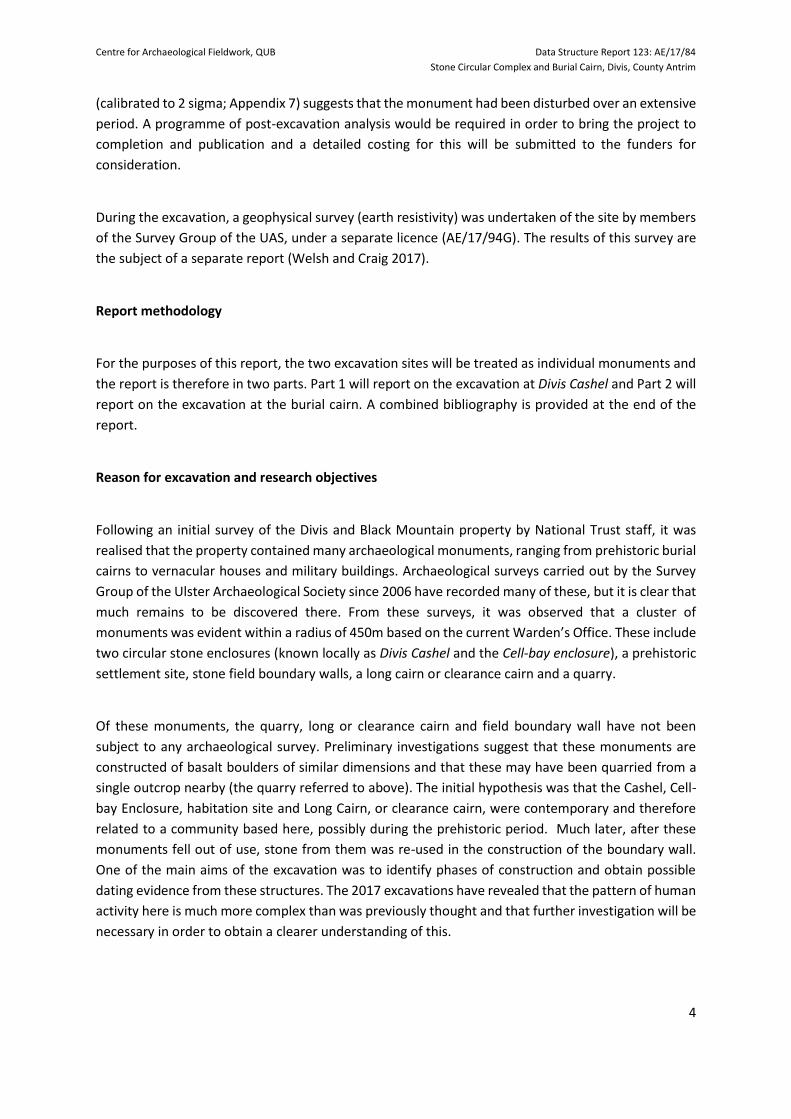
Between 12 and 23 June 2017, small-scale excavations took place at two sites in Divis townland, in the
parish of Shankill and within the National Trust Divis and Black Mountain property. These were at a
stone circular complex and a burial cairn. Both sites were in unimproved grassland. The stone circular
complex, known locally as Divis Cashel, was located 167m to the north-north-west of the present
Warden’s Base and Visitor Centre, also known as the Long Barn. The stone circular complex was
recorded in the Northern Ireland Sites and Monuments Record (SMR) as ANT 060:083 and was located
at National Grid Reference J 2700 1050. The burial cairn, originally thought to be part of a settlement
cluster, was located 280m to the east-north-east of the Warden’s base. It was not recorded in the
SMR, but was located at National Grid Reference J 2747 7456.
The excavations were part of a wider project undertaken by the Belfast Hills Partnership, in association
with the National Trust, the Department for Communities: Historic Environment Division (HED) and
the Centre for Archaeological Fieldwork, School of Natural and Built Environment at the Queen’s
University of Belfast (CAF). The project was funded by the Big Lottery Fund. The aim of the project was
to provide local people with an opportunity to participate in an archaeological excavation and in doing
so, encourage greater awareness of the archaeological resource in the Belfast Hills area, while
investigating two of the most enigmatic sites in the Belfast Hills. A total of 593 people participated in
the excavation, including 16 schools, community groups and members of the general public. While
the excavation was on-going, an archaeological survey training course was held and 18 members of
the public attended. Three evening field trips were carried out, attended by 69 people and it is
estimated that approximately 250 members of the public visited the site. The dig attracted widespread
media attention, including BBC radio and local newspapers. The principal excavation crew was
composed of members of the Ulster Archaeological Society (UAS) and post-graduate archaeology
students from Queen’s University, Belfast.
Summary
At the stone circular enclosure, the excavation revealed the presence of a previously unknown
vernacular building at the south-east of the enclosure and a substantial amount of prehistoric flints
and pottery. No evidence of occupation during the medieval period was recovered, but an initial
inspection of artefacts recovered from sub-surface contexts and a subsequent radiocarbon date of
701-397 BC (calibrated to 2 sigma; Appendix G) was obtained, suggesting that there was significant
prehistoric activity in the area.
At the site previously thought to be a hut site and part of a settlement cluster, it quickly became
apparent that it was instead the remains of a burial cairn, of probable late Bronze Age date. However,
while an initial study of recovered flint artefacts and coarse pottery sherds seemed to confirm this,
the recovery of modern several bullet cases and a subsequent radiocarbon date of AD 772-967
Centre for Archaeological Fieldwork, QUB Data Structure Report 123: AE/17/84
Stone Circular Complex and Burial Cairn, Divis, County Antrim
4
(calibrated to 2 sigma; Appendix 7) suggests that the monument had been disturbed over an extensive
period. A programme of post-excavation analysis would be required in order to bring the project to
completion and publication and a detailed costing for this will be submitted to the funders for
consideration.
During the excavation, a geophysical survey (earth resistivity) was undertaken of the site by members
of the Survey Group of the UAS, under a separate licence (AE/17/94G). The results of this survey are
the subject of a separate report (Welsh and Craig 2017).
Report methodology
For the purposes of this report, the two excavation sites will be treated as individual monuments and
the report is therefore in two parts. Part 1 will report on the excavation at Divis Cashel and Part 2 will
report on the excavation at the burial cairn. A combined bibliography is provided at the end of the
report.
Reason for excavation and research objectives
Following an initial survey of the Divis and Black Mountain property by National Trust staff, it was
realised that the property contained many archaeological monuments, ranging from prehistoric burial
cairns to vernacular houses and military buildings. Archaeological surveys carried out by the Survey
Group of the Ulster Archaeological Society since 2006 have recorded many of these, but it is clear that
much remains to be discovered there. From these surveys, it was observed that a cluster of
monuments was evident within a radius of 450m based on the current Warden’s Office. These include
two circular stone enclosures (known locally as Divis Cashel and the Cell-bay enclosure), a prehistoric
settlement site, stone field boundary walls, a long cairn or clearance cairn and a quarry.
Of these monuments, the quarry, long or clearance cairn and field boundary wall have not been
subject to any archaeological survey. Preliminary investigations suggest that these monuments are
constructed of basalt boulders of similar dimensions and that these may have been quarried from a
single outcrop nearby (the quarry referred to above). The initial hypothesis was that the Cashel, Cell-
bay Enclosure, habitation site and Long Cairn, or clearance cairn, were contemporary and therefore
related to a community based here, possibly during the prehistoric period. Much later, after these
monuments fell out of use, stone from them was re-used in the construction of the boundary wall.
One of the main aims of the excavation was to identify phases of construction and obtain possible
dating evidence from these structures. The 2017 excavations have revealed that the pattern of human
activity here is much more complex than was previously thought and that further investigation will be
necessary in order to obtain a clearer understanding of this.

Centre for Archaeological Fieldwork, QUB Data Structure Report 123: AE/17/84
Stone Circular Complex and Burial Cairn, Divis, County Antrim
5
Credits and acknowledgements
We would like to record our appreciation for the help given by the Ulster Archaeological Society for
the duration of the excavations. We would also like to thank the staff of the National Trust, particularly
Malachy Conway and Dermot McCann, for facilitating the excavations and the welfare of the
excavation crew. We would also like to thank Dr Lizzy Pinkerton and Jo Boylan of the Belfast Hills
Partnership for all their efforts to ensure the smooth working of the excavations and the many
hundreds of visitors and volunteers who took part. Thanks also to Ken Neill of HED for his help and
understanding with regard to the requirements of the excavation licence.

Centre for Archaeological Fieldwork, QUB Data Structure Report 123: AE/17/84
Stone Circular Complex and Burial Cairn, Divis, County Antrim
6
PART 1: STONE CIRCULAR COMPLEX (DIVIS CASHEL)
Contents Page
Introduction to Trench 1 7
Summary Recording methodology Archiving
Excavation 8
Background
Account of the excavation
Phasing of the stratigraphic sequences
Discussion 12
Recommendations for further work 15
Programme of post-excavation analysis of the materials recovered Further investigation at the site Publication
Appendix A: Harris Matrix 16 Appendix B: Context Register 17 Appendix C: Field Drawing Register 21 Appendix D: Small Finds Register 22 Appendix E: Samples Register 24 Appendix F: Photographic Register 25 Appendix G: Radiocarbon date certificate 32 Figures 34 Plates 36
Centre for Archaeological Fieldwork, QUB Data Structure Report 123: AE/17/84
Stone Circular Complex and Burial Cairn, Divis, County Antrim
7
Introduction to Trench 1
Summary
The excavation at Divis Cashel consisted of one trench, initially proposed to be 3m in width and 12m
in length, with the long axis of the trench aligned north/south over the visible footprint of the
monument, at the south of the enclosure. It was decided to initially open two parts of this trench, as
the number of volunteer excavators throughout the duration of the excavation could not be
confirmed. The larger part of the trench (Trench 1 North) was 10.5m in length by 1.5m in width and
aligned north/south, with an extension 1.5m in length, by 0.50m in width, at the southern end.
Another part of the trench (Trench 1 South) was opened at the southern end and used by school
groups and members of the public who participated in the excavation. It measured 3m in length by
3m in width. Trenches 1 North and South were excavated manually. Two broad sequences of human
activity, prehistoric and 19th century, were identified across the site (see Appendix A: The Harris
Matrix). A subsequent radiocarbon sample from the excavation returned a date of 701-397 cal. BC
[UBA-36431; Appendix G], confirming that some human activity was taking place at or near the
monument during the late Bronze Age, but without leaving any structural or artefactual evidence
within the excavated area.
Recording Methodology
The context records for the excavation were created using the standard context recording method: all
built features and deposits were assigned a unique context number and pro-forma (Context sheet)
was completed for each. All features were photographed prior to and following excavation and a
series of plans and sections were completed throughout the excavation at scales of 1:10 or 1:20, as
appropriate. A field notebook was also maintained. The Harris Matrix is presented in Appendix A and
the Context Register is detailed in Appendix B. The Field Drawing Register is presented in Appendix C
and the Small Finds Register in Appendix D. The Samples Register is contained in Appendix E. The
Photographic Register is catalogued in Appendix F. The Radiocarbon Date Certificate is presented in
Appendix G.
Archiving
Copies of this report have been deposited with the HED, National Trust and Belfast Hills Partnership.
All site records and finds are temporarily archived with the School of Natural and Built Environment,
Queen’s University Belfast.

Centre for Archaeological Fieldwork, QUB Data Structure Report 123: AE/17/84
Stone Circular Complex and Burial Cairn, Divis, County Antrim
8
Excavation
Underlying geology
The underlying geology of the site is predominantly clay and volcanic bedrock, mainly basalt. Subsoil
was not conclusively reached in any area of Trench 1 North as many of the later, nineteenth century,
substantial features were left in situ after they were uncovered and this meant that only small areas
of strata were available for further investigation.
Possible prehistoric strata
Evidence of possible prehistoric activity at the site was uncovered in Trench 1 North, between the
sections of various nineteenth century masonry remains and their associated features such as flagged
and metalled surfaces and drains which occupied much of the area within the trench (see below). It
is possible that some of the prehistoric horizons were contemporary and although given different
numbers in the various parts of the trench where they were separated from each other by the in situ
Victorian features it is possible that these were, in fact, the same horizons. None of the layers
underneath the horizon of nineteenth century masonry and associated features yielded any artefacts
other than prehistoric flint or pottery.
The strata to the north of Trench 1 North
The earliest strata in the northern end of Trench 1, beyond wall and drain C.102 and drain C.111, was
mottled dark and bright orangey-brown compact clay that contained many small stones. No artefacts
were uncovered from the small area archaeologically investigated. Because of the sterile appearance
of the horizon it was initially interpreted as subsoil and no further excavation of the deposit took. But
the discovery of deeper prehistoric horizons elsewhere within the trench suggests that the layer may,
in fact, be also a prehistoric horizon and future, larger scale, investigation may yet yield datable finds.
Directly above this horizon in the north of the trench was moderately compact, red-brown and orange
clay containing roots and small-medium-sized stones (C.117). Small fragments of flint were recovered
from it. It was later used as the bedding layer for a metalled surface (C.104), probably in the Victorian
period when there was substantial re-use of the monument.
The strata to the east of Trench 1 North
In the triangular area between the junction of walls C.106 and C.102 and the eastern edge of the
trench, further prehistoric strata were uncovered below nineteenth century levels. Subsoil was not
reached in the small area available for investigation. The earliest of these strata was a layer of
moderately friable and compact red-orange clay which contained occasional charcoal fragments, roots

Centre for Archaeological Fieldwork, QUB Data Structure Report 123: AE/17/84
Stone Circular Complex and Burial Cairn, Divis, County Antrim
9
and small stones (C.119). Flint and pottery were recovered from this horizon. Directly above this was
a layer of moderately loose red-brown clay containing some mostly small but also some medium-sized
stones, occasional roots and charcoal flecks (C.114). There was much flint found in this layer. Above
this was a layer of moderately compact orange-brown clay that contained roots and small stones
(C.113). It was directly below a layer associated with masonry construction that took place in the
Victorian period (C.112) and may have been the same prehistoric horizon as C.120 on the other side
of wall C.106.
Strata to the south of Trench 1 North
At the southern end of the trench several strata were encountered. The earliest of these was a friable
and soft dark- brown mix of clay and soil with occasional small stones (C. 130). Only a small area was
investigated, due to time constraints. Some of the area investigated had been disturbed by a modern
animal burrow (C.124) had caused disturbance close to the inside face of the enclosure wall of the
monument (C.107). Above C.130 was a mottled brown (with occasional lenses of red clay) mixture of
clay and soil (C.123), containing large lumps of charcoal and occasional small stones. Struck flint
recovered from this horizon. Above this, and representing the latest of the possible prehistoric strata,
was a layer of crumbly, almost sandy, mottled orange clay (C.120). It contained little flecks of charcoal
and lots of small and occasional medium-sized stones that were less angular that in other layers in the
trench little flecks of charcoal. Much struck flint and some sherds of Neolithic pottery recovered from
this horizon. It was immediately below the Victorian stone surface or platform (C.116). Several
thousand years appears to have elapsed from the period of prehistoric occupation at the site until its
re-use in the Victorian period. The stone-built monument known as Divis Cashel may well be an Early
Medieval structure, constructed on ground that had been settled in the prehistoric period, but no
archaeological evidence in terms of strata, features or artefacts were uncovered during the 2017
excavation to show that the monument dates to the Early Medieval period. A number of Victorian
features appear to have been cut through the latest prehistoric horizon C. 120 in the south of Trench
1 North. A foundation/ bench cut (C.125) for the inner face of the enclosure wall that was only 0.02-
0.03m wide ran parallel to the face of the wall. In the south-west corner of the trench it had been
removed by the later animal burrow (C.124) but was visible in the centre of the trench and in the west-
facing section face.
A distance of 1.5m north of the inner face of the cashel a linear cut (C.121) was revealed. This was
aligned roughly north-west/south-east and it ran parallel, but immediately south of, dry stone wall
C.108. The cut was filled with a dark brown soil (C.122) which produced a number of flints. The feature
may have been a drainage gully for both wall C.108 and also for the 19th century stone platform/
surface C.116, that later occupied the area between wall C.108 and the enclosing wall of the cashel
C.107 in the south of Trench 1 North. It also ran east under wall C.106 into the area between walls
C.102 and C.106 where it was cut through the prehistoric layer C.113 on the other side of wall C.106.
[Note: a possible posthole, given the context number cut C.126, was initially identified within cut C.121
but was not clearly defined. The fill of this possible feature, C.127, was also identical to fill C.122 and
Centre for Archaeological Fieldwork, QUB Data Structure Report 123: AE/17/84
Stone Circular Complex and Burial Cairn, Divis, County Antrim
10
so these context numbers have been voided]. Within Trench 1 North, there was no other evidence of
human activity at the monument until it was re-used in the Victorian period.
Nineteenth century activity at the monument
During the excavation, a series of walls, surfaces and other features were uncovered that occupied
most of the area within Trench 1 North. Some of these were undoubtedly constructed in the
nineteenth century when activity took place at the monument and some of these were earlier
structures re-used, repaired and added to at this time. In the middle of the trench were the remains
of two walls that clearly made the corner of a stone structure (or part of a larger stone structure). The
most substantial of these (C.106) was aligned north-west/south-east. Within the trench it was a
recorded maximum length of 2.23m by 0.37m wide and 0.32m high. The wall was constructed of two
courses of medium and large stones and was heavily mortared than the second wall (wall C.102). It
was founded on possible prehistoric surface C.113. The last 0.50m of masonry between its south-
eastern end and the eastern edge of the trench showed evidence being a deliberate block up with
medium-sized stone. This may suggest that an entrance way in the wall was later blocked up. The
fact that this section was founded on brown soil and not C.113 suggests the blocking up was a later
phase of activity. More substantial and mortared section of wall C.106 was butted by wall C.102 to
the north-east, by a dry stone wall C.108 to the south-west and by a flagged stone surface C.109 to
the west. The second, and wider, wall (C.102) that made up the other side of the structure within the
trench was constructed of medium and large stones. Within the trench, it was a recorded maximum
length of 1.53m by 0.47m wide and 0.47m high. The wall was a maximum of three courses high and
was two courses wide. It was heavily mortared on both external and internal faces and on its surviving
top course. The course of the wall curved north-east/south-west.
Immediately adjacent to the northern/ outside face of wall C.102 was a stone drain (C.111) set in a
clay matrix. The drain was aligned north-east/ south-west and was a maximum length of 2.13m by
0.41m wide. It was composed of mostly rounded pebbles (c.0.08m by 0.06m) but its two long edges
were made up of a single line of slightly raised more angular stones set on their long sides. The base
of the drain was 3-4 pebbles wide. The drain was also contemporary with a metalled surface (C.104)
that filled up the northern third of Trench 1 North and which ran from the northern edge of the drain
to beyond the limits of the trench. Amongst the stones of the drain were found fragments of slate,
mould-blown bottle glass, red brick, iron nails, slag/clinker and burnt chalk. All of these presumably
date to the period of Victorian activity on site. The metalled surface (C.104=C.105) was very
compacted and relatively uneven. It was constructed of small and medium-sized, irregular-shaped,
stones and brown soil. A third, rougher, wall (C.108) was located immediately west of wall C.106 and
it butted this wall mid-way along its western face. Of dry stone construction, within the trench it was
a recorded maximum length of 0.90m by 0.42m wide and 0.20m high. The wall consisted of a line of
three large un-mortared stones aligned south-west/north-east. It butted wall C.106 to the east and
together they contained a flagged stone surface (C.109). Running off from the junction of walls C.102
and C.106 was a dry stone wall (C.128). This was visible only in the west-facing section face in the
middle of Trench 1 North, where it was recorded as being 0.45m wide and 0.25m high. The wall
Centre for Archaeological Fieldwork, QUB Data Structure Report 123: AE/17/84
Stone Circular Complex and Burial Cairn, Divis, County Antrim
11
abutted the western end of C 106 and ran in an arc beyond the trench to form an inner enclosure wall
within the monument. Aerial photographs taken during the 2017 excavation clearly indicate that
walls C.102/C.128, C.106 and C.108, uncovered in Trench 1 North, are part of a complex of curving
internal walls that sit within the limits of the circular stone enclosure (as defined by outer wall C.107).
A flagged stone surface (C.109), contained by walls C.106, C.108 was revealed in the western half of
the middle of Trench 1 North. This surface was a maximum recorded length of 1m, north-south and
was 0.65m wide. It consisted of mostly flat, irregularly-shaped, large stones with some medium-sized
stones filling the gaps between the larger stones. There was mortar in the soil between the stones
and also evidence of tar on the stones, perhaps reflective of the light industrial activity taking place
on site in the nineteenth century. In the south of the trench, between the southern face of wall C.108
and the internal face of enclosure wall C.107 there was a rough surface (C.116) composed of medium
sized and large stones to create a platform. The last stratum associated with all of this Victorian
activity at the monument was a horizon (C.112), located below abandonment-phase rubble (C.103).
It consisted of compact brown clay-soil with high mortar content that also contained roots and small
stones and was located in the middle/east of the trench. The mortar content would suggest that this
would appear to be the original surface connected with the construction of the Victorian building
investigated within the trench (walls C.102 and C.106, etc). From this horizon were also recovered
fragments of red brick, slate, burnt clay, slag/clinker, mortar and pieces if iron including the fragment
of the hinge of a gate.
Later horizons
At some point, the building constructed in the nineteenth century collapsed or was deliberately
slighted and the site was abandoned. This was reflected by a layer of loose rubble (C.103) consisting
of a mixture of dark brown soil, medium-sized stones, mortared slate, red brick and roots which was
found over and around walls C.102 and C.106. Finds from the rubble included bottle glass, fragments
of mortar, burnt stone, slag/ clinker, quartz, (?) lignite and a fragment of glazed black earthenware
ceramic from a large crock. Iron finds included nails and as fragment of a possible horse shoe. The fact
that the rubble was observed to be mounded around and between the walls in the centre of the trench
could also reflect a conscious effort to level up the area within the monument once activity there had
ceased, perhaps to prevent livestock from being injured. Modern topsoil on site (C.101) was a light
brown compact soil containing small stones, roots, occasional charcoal flecking. Finds included
prehistoric flint, Post-Medieval bottle glass, glazed ceramic pipe, red brick, mortar, burnt limestone,
slag/clinker, shell, coal and iron nails and wire. A fragment of a .22 shell casing was also found,
evidence of the intense military activity that took place on Divis during World War Two and between
1953 and 2004 when the Ministry of Defence leased Black Mountain and Divis for use as a training
area, with a small arms range. Fragments of shotgun cartridges were also uncovered in the topsoil and
probably reflect sporting (or poaching) activity taking place on the mountain.

Centre for Archaeological Fieldwork, QUB Data Structure Report 123: AE/17/84
Stone Circular Complex and Burial Cairn, Divis, County Antrim
12
The wall enclosing the monument
The wall (C.107) enclosing Divis Cashel is of dry stone construction and roughly circular. The portion
excavated at the south of Trench 1 North was approximately 0.80m wide and is composed of two
parallel courses of stones, each roughly 0.35m wide. The face of the inner course is heavily rendered
with white mortar (C.115). The space between the two courses of the enclosure wall is filled with
small and medium-sized stones and soil. It is possible that the outer face represents the earliest phase
of construction and that the inner face was added in the 19th century which would also explain the
mortar render. A narrow foundation or bench cut (C.125) for the inner course of the enclosure wall
was observed during excavation. This cut was very narrow, only 2-3 centimetres wide and was filled
with brown soil (C.129). The cut for the inner course of the enclosure wall was made from the level
of layer C.120, the same level as the gully or drain (C.121) that was associated with wall C.108. This
suggests that the foundation cut probably also dates to the nineteenth century and adds more
evidence that the inner course of the enclosure wall may be a much later addition, perhaps to give
stability to the platform within which activities were taking place.
The external path
A path, comprising of a metalled surface, which may run around the outside of the monument, was
located in the very south of Trench 1. It extended south from the outer face of the enclosing wall
(C.107) for a distance of 1.90m and was uncovered directly below topsoil (C.101). The surface was
composed of mostly medium-sized and some larger sized stones. The surface lay immediately below
topsoil (C.101). The stones of the path were noticeably bigger than those used to construct the
metalled surface (C.104) in the north of the trench. A similar feature was observed during the
excavation of Ballyaghagan Cashel (ANT 056:019), on nearby Cave Hill in 2011 (Welsh 2011(a) and (b)).
Trench 1 South.
Trench 1 South was located immediately 2.5m south of the main Trench 1 North and it measured 3m
by 3m. This trench was used as the public outreach excavation trench, where children from various
schools and members of the public who had volunteered gained experience of excavating on an
archaeological site, under instruction from the professionals. Excavation within Trench 1 South did
not get below the surface of topsoil (C.301), a brown soil containing small stones and roots. Finds
recovered from this topsoil included flint, slate, iron nails, strips and wire and other miscellaneous
metal artefacts as well as a fragment of a glazed ceramic pipe that was virtually identical to the
fragments found in topsoil (C.101) in Trench 1 North.

Centre for Archaeological Fieldwork, QUB Data Structure Report 123: AE/17/84
Stone Circular Complex and Burial Cairn, Divis, County Antrim
13
Discussion
The short excavation at Divis Cashel revealed that there were significant in situ archaeological features
and strata extant across all the area of the monument and probably also beyond it (based on the
number of artefacts recovered from the topsoil of Trench 1 South). The evidence recovered within
Trench 1 North would appear to date from two widely separated periods of human activity on Divis
Mountain; the prehistoric period, more specifically the Bronze Age and Neolithic, and the nineteenth
century. Only a very small area of the monument was archaeologically investigated in 2017 and the
decision to preserve in situ most of the nineteenth century features, or features re-used in the
nineteenth century, meant that only small areas under this horizon was available for deeper
archaeological examination. Despite this, the 2017 excavation was a major success. Aerial
photographs and visible above-ground remains also suggest that the monument substantially remains
intact and that the internal walls uncovered within the area of the Trench 1 North excavation were
part of this structure that the Victorians re-used or adapted for their activities on site in the 19th
century. The nature and date of the enclosure wall of the monument and the external path around
it, uncovered during the 2017 excavation, as well as the walls exposed in the middle of the trench, still
remain to be resolved. As it stands, there is no structural evidence to prove that the stone monument
known as Divis Cashel actually dates to the Early Medieval period.
Prehistoric settlement at the site
Evidence of substantial prehistoric activity at the site was uncovered in Trench 1 North, between the
sections of the various later walls and their associated features such as flagged and metalled surfaces
and drains which occupied much of the area within the trench. It is possible that some of the
prehistoric strata were the same and although given different numbers in the various parts of the
trench where they were separated from each other by the in situ Victorian features it is possible that
these were, in fact, the same horizons (C.120=C.113=C.117?; C.123=C.114=C.117?). None of the strata
underneath the horizons of later masonry and associated features yielded any artefacts other than
prehistoric flint or pottery, so it is very possible that these were in situ prehistoric strata rather than
material brought in from around the site to level up the interior of the ‘cashel’ prior to the 19th century
activity taking place. No evidence of prehistoric structures or other features were uncovered during
the 2017 excavation but their lack of discovery probably only reflects the small areas available for
investigation within the trench.
The enclosure wall of the monument
The enclosure wall (C.107) currently consists of two parallel courses of dry stone construction with the
space between these two courses filled by small and medium-sized stones and soil. The fact that a
deep foundation cut was discovered close to the inside face of the wall and that mortar render had
been applied roughly to this face raises the question of whether or not the inner course is a later
addition, perhaps to stabilise the activities that were taking place inside the monument in the

Centre for Archaeological Fieldwork, QUB Data Structure Report 123: AE/17/84
Stone Circular Complex and Burial Cairn, Divis, County Antrim
14
nineteenth century or whether it is part of the original wall that has been repaired and rendered
during the nineteenth century. The dates of the outer face of the wall and the external metalled path
(C.110) immediately adjacent are also still uncertain. The surface of the path was uncovered but not
further investigated so that the date of its construction is unknown.
Nineteenth century activity at the site
The fact that mortar was uncovered on top of internal curving wall C.128 within the monument also
calls into question the date of this part of the monument. It also lines up with wall C.102 within the
excavated trench and aerial photographs show them both to be part of a circular inner enclosure wall
in the monument. The same can be said for dry stone wall C.108 that curves off to the west roughly
parallel but in between the lines of walls C. 128/ C.102) and enclosure wall C.107. Given the poor
quality of the walls uncovered within the trench, the strong suspicion has to be that in the nineteenth
century there was re-use and rendering of walls from an earlier monument. It is hard to believe that
if the whole monument had been erected in the Victorian period that the masonry would not have
been of better construction. The picture was muddied for the archaeological investigation in that if
the earlier walls were re-used and re-rendered and some genuine nineteenth century features were
constructed, such as drain C.111, determining the exact sequence within the trench was always going
to be difficult without a larger section of the monument, especially the masonry remains, being
completely excavated to subsoil. The small area available for excavation in 2017 means that exact
sequence of the 19th century activity uncovered during the investigation is also unclear. The narrow
distances between the walls and the rudimentary surfaces uncovered might suggest parts of the
monument were being used as animal pens. The fact that it nestled into the slope of Divis Mountain
would have given these animals a certain amount of protection from the elements. The discovery of
slag and other by-products of metalworking in virtually all of the Victorian strata (C.101, C.103, C.104
and C.112) suggested that a blacksmith was at work here, or that some other type of light industry
was taking place at the site, perhaps associated with the nearby quarry. Due to the lack of surviving
courses of masonry the original height of the buildings when they were being used in the nineteenth
century is unknown. That they were originally roofed when the site was being occupied is heavily
suggested by the discovery during the excavation of nails, roof slates and red brick. It is distinctly
possible that when the site was being abandoned, or at some later period, that the upper courses
were demolished and the material taken away for use elsewhere on the estate. The monument is
located very close less than 100m south of a now disused stone quarry, of uncertain date, cut into the
side of Divis Mountain. A relationship between the quarry and Divis Cashel has not been established,
or if the stones used to construct the monument were actually hewn from there. But the close
proximity of both is very suspicious and the quarry also requires further investigation. Although the
monument within which the 2017 excavation took place is known as Divis Cashel, no structural
evidence was uncovered during the archaeological investigation to show that the monument actually
is a cashel or dates to the Early Medieval period. Only prehistoric and Victorian-period artefacts were
recovered within the excavated trench. It could be that the very small area targeted for excavation in
2017, along with the substantial nature of the 19th century remains on site, are factors in this
ambiguity. It is, therefore, possible that we might be dealing with a prehistoric structure that was
substantially re-used in the 19th century. Or perhaps the re-use of an Early Medieval period stone

Centre for Archaeological Fieldwork, QUB Data Structure Report 123: AE/17/84
Stone Circular Complex and Burial Cairn, Divis, County Antrim
15
monument built over land that which has seen extensively settlement in the prehistoric period.
Further excavation of a larger area of this enigmatic monument will be necessary to find definitive
evidence of when it was constructed.
Recommendations for further work
Programme of post-excavation analysis of the materials recovered
If funding can be obtained, a programme of post-excavation analysis will be carried out in order to obtain the maximum amount of information from the excavation. A costing for this work will be presented to the owners of the monument, the National Trust, for consideration. Subsequent to the excavation, a radiocarbon date was obtained from the monument, which returned a date 701-397 BC (calibrated to 2 sigma. See Appendix G).
Further investigation at the site
The 2017 excavation revealed much information about this enigmatic monument, but time
constraints, combined with the requirement not to remove any in-situ archaeological features,
prevented a full excavation of the small area involved. It is considered that a larger-scale investigation,
involving excavation and geophysical survey, be carried out at this monument, along with the field
walls associated with it and the quarry nearby, in order to obtain a fuller picture of the date and use
of the different phases of activity here.
Publication
It is hoped that the results of the excavation, along with information obtained from any post-
excavation analysis, can be published in an academic journal, such as the Ulster Journal of Archaeology
in due course. A brief summary of results has been published in Archaeology Ireland (Welsh et al.,
2017).

16
Appendix A: Trench 1 - Harris matrix
101
111 104 102 128
103
106 116 115 108
121
113
126
112
122 124 107
117
118
SOUTH OF TRENCH
123
110
119
125
114
120
109
NORTH OF TRENCH
130
MODERN
19th CENTURY
PREHISTORIC?
UNEXCAVATED
17
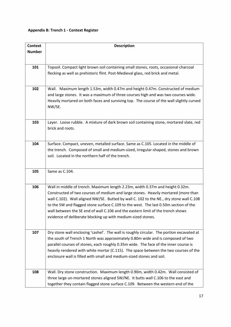
Appendix B: Trench 1 - Context Register
Context
Number
Description
101 Topsoil. Compact light brown soil containing small stones, roots, occasional charcoal
flecking as well as prehistoric flint. Post-Medieval glass, red brick and metal.
102 Wall. Maximum length 1.53m, width 0.47m and height 0.47m. Constructed of medium
and large stones. It was a maximum of three courses high and was two courses wide.
Heavily mortared on both faces and surviving top. The course of the wall slightly curved
NW/SE.
103 Layer. Loose rubble. A mixture of dark brown soil containing stone, mortared slate, red
brick and roots.
104 Surface. Compact, uneven, metalled surface. Same as C.105. Located in the middle of
the trench. Composed of small and medium-sized, irregular-shaped, stones and brown
soil. Located in the northern half of the trench.
105 Same as C.104.
106 Wall in middle of trench. Maximum length 2.23m, width 0.37m and height 0.32m.
Constructed of two courses of medium and large stones. Heavily mortared (more than
wall C.102). Wall aligned NW/SE. Butted by wall C. 102 to the NE., dry stone wall C.108
to the SW and flagged stone surface C.109 to the west. The last 0.50m section of the
wall between the SE end of wall C.106 and the eastern limit of the trench shows
evidence of deliberate blocking up with medium-sized stones.
107 Dry stone wall enclosing ‘cashel’. The wall is roughly circular. The portion excavated at
the south of Trench 1 North was approximately 0.80m wide and is composed of two
parallel courses of stones, each roughly 0.35m wide. The face of the inner course is
heavily rendered with white mortar (C.115). The space between the two courses of the
enclosure wall is filled with small and medium-sized stones and soil.
108 Wall. Dry stone construction. Maximum length 0.90m, width 0.42m. Wall consisted of
three large un-mortared stones aligned SW/NE. It butts wall C.106 to the east and
together they contain flagged stone surface C.109. Between the western end of the

Centre for Archaeological Fieldwork, QUB Data Structure Report 123: AE/17/84
Stone Circular Complex and Burial Cairn, Divis, County Antrim
18
wall and the western limits of the trench, either the wall has been added to or rebuilt
with medium-sized stones.
109 Surface. Flagged stone surface. Maximum length 1m, N-S and width, 0.65m. The
surface consisted of mostly flat, irregularly-shaped, large stones with some medium-
sized stones filling the gaps between the larger stones. There was mortar in the soil
between the stones and also evidence of tar on the stones.
110 Surface. Metalled surface. Path or berm around the outside of the ‘cashel’, located in
the very south of Trench 1. Extended south from the outer face of ‘cashel’ wall C.107
for a distance of 1.90m. Surface composed of small and medium-sized irregularly
shaped stones. Immediately below topsoil C.101.
111 Drain/gully set in a clay matrix. Maximum length 2.13m, NE/SW and width 0.41m.
Composed of mostly rounded pebbles (c.0.08m by 0.06m). Either edge has a single line
of slightly raised more angular stones. Base of feature is 3-4 pebbles wide. Drain
aligned NE/SW and is associated with adjacent wall C.102 and contemporary with
metalled surface C.104 north of it.
112 Surface. Compact brown clay-soil with high mortar content. Also contained roots and
small stones. Latest or original surface connected with the walls of the Victorian
building (C.102 and C.106) in the east of Trench 1. At the base of the layer much
metalwork was discovered. Below rubble layer C.103. Above C.113.
113 Layer/ surface. Moderately compact orange-brown clay. Also contained roots and small
stones. Same as C.120 on the other side of wall C.106 and C.117?
114 Layer. Moderately loose red-brown clay. Contained some mostly small but also some
medium-sized stones, occasional roots and charcoal flecks. Lots of flint in this horizon.
115 Render. White mortar applied to the inner face of the enclosure wall of the ‘cashel’,
C.107.
116 Surface. Composed of medium sized and large stones to create a platform between
wall C.108 and the enclosure wall C.107 in the south of the trench.

Centre for Archaeological Fieldwork, QUB Data Structure Report 123: AE/17/84
Stone Circular Complex and Burial Cairn, Divis, County Antrim
19
117 Layer. Moderately compact mottled (red-brown-orange) clay. Contained some mostly
small to medium-sized stones and fine roots. Some small pieces of flint recovered from
this horizon. Bedding for surface C.104? Same horizon as C.113 and C.120?
118 Very compact mottled (dark and bright orange) clay containing very many small stones.
No finds in the small area where it was uncovered. Initially interpreted as subsoil but
now thought to be the one of the prehistoric horizons encountered in the areas of
Trench 1 where strata could be investigated.
119 Layer. Moderately friable and compact red-orange clay. Contained occasional charcoal
fragments, roots and small stones. Flint and pottery from this horizon.
120 Layer. Crumbly, almost sandy, mottle orange clay. Contained lots of small and
occasional medium-sized stones that were less angular that in other layers in the trench
and little flecks of charcoal. Much struck flint and some sherds of Neolithic pottery
recovered from this horizon. Located in the south of the trench between walls C.106,
C.108 and the inside face of wall C.107. Same as C.113 on the other side of wall C.106
and also C.117 in north of trench?
121 Cut. Cut running parallel but south of wall C.108 in the south of the trench. May have
been a gully and not a foundation trench for wall C. 108 as it ran east under wall C.106
into the area between walls C.102 and C.106. Seems to have been cut from the level of
C.120 (C.113 on the other side of wall C.106). Filled by C.122.
122 Fill. Fill of cut C.121. Soft and very friable dark brown soil. Some flint recovered from
this. Fill identical to the fill of possible posthole, C.126.
123 Mottled brown (with occasional lenses of red clay) mixture of clay and soil. Contained
large lumps of charcoal and occasional small stones. Struck flint recovered from this
horizon.
124 Modern animal burrow in south-west corner of trench, adjacent to the inner face of
enclosure wall C.107. Cuts layers C.120 and C.123.
125 Cut. Cut for inner face of enclosure wall C.107. Very narrow, 2-3 centimetres wide.
Cut from the level of C.120. Filled by C.129. Victorian?

Centre for Archaeological Fieldwork, QUB Data Structure Report 123: AE/17/84
Stone Circular Complex and Burial Cairn, Divis, County Antrim
20
126 Possible posthole within cut C.121. Not totally convincing as feature and its fill,
C.127, was identical to C.122, the fill of C.121. Not recorded.
127 Fill of possible posthole. Same as C.122.
128 Wall. Stone wall butting wall C.106 in the middle of Trench 1 North at its western limit.
Not excavated. This wall runs west of the trench to form an inner enclosure wall.
Several small cuttings were excavated across the line of this wall within the interior of
the enclosure west of Trench 1 down to the top of the structure (see sketch on page 13
of the site diary). Mortar was found on some of the exposed sections of the wall. Does
this mean that the inner enclosure wall is Victorian?
129 Fill of bench/ foundation cut C.125 for inner course of enclosure wall of “cashel”, C.107.
Moderately compact brown soil with occasional small stones and fragments of mortar.
Victorian?
130 Layer. Friable and soft dark brown mix of clay and soil. Occasional small stones. Below
C.123.

Centre for Archaeological Fieldwork, QUB Data Structure Report 123: AE/17/84
Stone Circular Complex and Burial Cairn, Divis, County Antrim
21
Appendix C: Trench 1 - Field Drawing Register
Drawing
No.
Trench
No.
Type Scale Description
1 Duplicate number allocated. Unused and Voided.
2 1 North Plan 1:20 Northern section of Trench 1. Links to Drawing 3.
Preliminary plan of trench after de-sodding.
Shows surface C.104, rubble C.103, wall C.102,
stone platform C.116 and enclosing wall of
‘cashel ‘ C.107.
3 1 North
and 1
South
Plan 1:20 Southern section of Trench 1. Links to Drawing 2.
Preliminary plan of trench after de-sodding.
Shows stone platform C.116, enclosing wall of
‘cashel ‘C.107 and path/berm C.110. Also shows
location and outline of Trench 1 South.
4 1 North Section 1:10 Links to Drawing 5. East-facing section of trench,
post-excavation.
5 1 North Section 1:10 Links to Drawing 4. East-facing section of trench,
post-excavation.
6 1 North Section 1:10 Links to Drawing 7. West-facing section of
trench, post-excavation.
7 1 North Section 1:10 Links to Drawing 6. West-facing section of
trench, post-excavation.

Centre for Archaeological Fieldwork, QUB Data Structure Report 123: AE/17/84
Stone Circular Complex and Burial Cairn, Divis, County Antrim
22
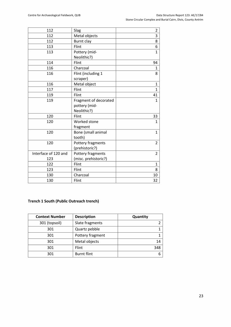
Appendix D: Trench 1 - Small Finds Register
Trench 1 North
Context Number Description Quantity
101(topsoil) Pottery fragments 2
101 Burnt bone fragments 3
101 Coal/lignite 9
101 Glass fragments 2
101 Bone/shell (small mollusc)
1
101 Burnt flint fragments 19
101 Brick fragments 3
101 Flint 86
101 Metal objects 96
103 Pottery fragment 1
103 Glass fragments 5
103 Quartz pebble 1
103 Timber fragments 1 small bag
103 Coal/lignite 9
103 Metal objects 17
103 Burnt flint 32
103 Brick fragments 14
103 Burnt stone (miscellaneous)
17
103 Flint 44
104 Clay tobacco pipe stem (two pieces now con-joined)
1
104 Glass fragments (two pieces now con-joined)
1
104 Slate fragments 2
104 Stone pebbles (1 worked)
2
104 Burnt flint 12
104 Lignite/coal 3
104 Flint 57
104 Metal objects 11
111 Glass fragments 5
111 Flint 6
111 Burnt flint 8
111 Slate fragment 1
111 Metal objects 5
112 Slate fragments 2
112 Flint 2
112 Brick fragments 6
Centre for Archaeological Fieldwork, QUB Data Structure Report 123: AE/17/84
Stone Circular Complex and Burial Cairn, Divis, County Antrim
23
112 Slag 2
112 Metal objects 3
112 Burnt clay 8
113 Flint 6
113 Pottery (mid-Neolithic?)
1
114 Flint 94
116 Charcoal 1
116 Flint (including 1 scraper)
8
116 Metal object 1
117 Flint 1
119 Flint 41
119 Fragment of decorated pottery (mid-Neolithic?)
1
120 Flint 33
120 Worked stone fragment
1
120 Bone (small animal tooth)
1
120 Pottery fragments (prehistoric?)
2
Interface of 120 and 123
Pottery fragments (misc. prehistoric?)
2
122 Flint 1
123 Flint 8
130 Charcoal 10
130 Flint 32
Trench 1 South (Public Outreach trench)
Context Number Description Quantity
301 (topsoil) Slate fragments 2
301 Quartz pebble 1
301 Pottery fragment 1
301 Metal objects 14
301 Flint 348
301 Burnt flint 6

Centre for Archaeological Fieldwork, QUB Data Structure Report 123: AE/17/84
Stone Circular Complex and Burial Cairn, Divis, County Antrim
24
Appendix E: Trench 1 North - Samples Register
Context Number Description Number of bags
116 Charcoal: Stone platform in
south of trench. Victorian.
130 Charcoal: Earliest of the
prehistoric strata in the south
of the trench.
101 Mortar: Topsoil. Sample
presumably from Victorian
deposits directly below.
103 Mortar: Rubble over walls in
middle of site. Directly below
topsoil. Relates to the
abandonment of the site in the
19th century.
112 Mortar: Layer associated with
Victorian activity and
construction/ re-use of the
walls in the middle of the
trench.
115 Mortar: Samples taken from
the mortar adhering to the
inner face of the inner course of
the ‘cashel’ enclosure wall
(C.107).

Centre for Archaeological Fieldwork, QUB Data Structure Report 123: AE/17/84
Stone Circular Complex and Burial Cairn, Divis, County Antrim
25
Appendix F: Trench 1 - Photographic Register
Photo
No.
Trench Description Date Taken From
050-063 Tr1 N General shots of Trench 1 North after trench
was de-sodded.
12/6/17 N: 51-52.
E: 52-53, 56-
59.
S: 54-55.
W:60-61.
NW: 62-63.
064-067 “ Metalwork in the topsoil in the NW of trench. “ S: 64, 66-67.
W: 65.
68-84 Tr1 N
Tr 1 N
and S.
People shots, showing phots of preliminary
clean-up.
Shots 79-80 also shot Trench 1 South
(“children’s trench”).
13/06/17 N: 60-70.
NE: 71-77.
SE: 78.
S: 79-90.
W: 81-83.
85-90 Tr1 N Detail of the preliminary cleaning up of wall
C.102 and rubble layer C.103
“ SW: 85-86.
NW: 87.
NE: 88-89.
SE: 90.
91-110 “ Wall C.102, metalled surface C.104 and rubble
layer C.103 after preliminary clean up.
Shots C.101-110 also show stone surface C.116
in south of trench.
“ N: 91-96, 98.
NE: 97, 108-
110.
NW: 99.
W: 100.
SW: 101-103.
S: 104-105.
SE: 106-107.
111-123 “ Enclosure wall of “cashel” C.107 and stone
surface/ platform C.116.
“ NE: 112.
E: 111, 113-
116.
S: 118-120,
122, 123.
SW: 121.
SE: 117.
124-129 “ Southern half of the trench with ranging rods,
showing enclosure wall of “cashel” C.107 and
stone surface/ platform C.116.
14/06/17 S:124, 127.
SE:125, 126,
128.
SW:129.
130-136 “ Southern half of the trench with ranging rods,
showing metalled surface C.104 during
excavation, wall C.102 and rubble layer C.103.
“ N
Centre for Archaeological Fieldwork, QUB Data Structure Report 123: AE/17/84
Stone Circular Complex and Burial Cairn, Divis, County Antrim
26
137-146 Middle and southern half of the trench, with
ranging rods, showing metalled surface C.104
during excavation, wall C.102 and rubble layer
C.103, stone surface C.116 and enclosure wall
C.107.
“ NE: 136, 137.
SE: 138-140,
146.
S: 143, 144.
E: 145.
147-150 “ Southern end of Trench 1 with ranging rods,
showing rubble layer C.103, stone surface C.116
and enclosure wall C.107.
“ N
151,
153
“ Northern half of the trench, with ranging rods,
showing metalled surface C.104 during
excavation, wall C.102 and drain/gully C.111
adjacent to wall C.102 starting to be uncovered.
“ S
152,
154,
156
“ Detail of metalled surface C.104 during
excavation.
S, E, N and W
157-159 Tr 1 S Trench 1 South with children from Oakgrove
Integrated School getting experience of
archaeological excavation.
“ N, W and
NW.
160-167 Tr 1 N Wild horses that arrived at the trench
unexpectedly.
“
168-187 Tr1 N David Craig taking aerial images of the
excavation using a drone.
SW: 168-171.
W: 172-177.
NW: 180-184.
N: 185-186.
NE: 187.
188-193 Tr1 N
and S
Shots of the protective fencing put by CAF
around Trenches 1 N and S nightly, on
completion of excavation.
S: 188, 189.
N: 190-191.
SW: 192-193.
194-204 Tr1 N “The Big Dig” at Divis. Lovely weather and lots
of people shots. Northern half of Trench 1 N
showing metalled surface C.104 nearly fully
exposed, wall C.102 and drain/gully C.111
adjacent to wall C.102 under excavation, and
walls C.106 and C.108.
Saturday
17/06/17
N:194-195,
197-199, 202
NE: 196, 200,
201.
SW: 203.
W: 204.
205-
206,
214-217
Tr 1 S “The Big Dig” at Divis. Trench 1 S with
volunteers, school children and Lizzy and Jo.
“ NW: 205-206.
SW: 214.
S: 215-216.
SE: 217.
207-
209,
Tr 1 N “The Big Dig” at Divis. Southern end of Trench 1
N showing enclosure wall of “cashel” C.107,
external berm C.110 and stone surface/
platform C.116.
“ SW
Centre for Archaeological Fieldwork, QUB Data Structure Report 123: AE/17/84
Stone Circular Complex and Burial Cairn, Divis, County Antrim
27
210-212 “ “The Big Dig” at Divis. Middle and northern half
of Trench 1 N showing metalled surface C.104
nearly fully-exposed, walls C.102, C.106 and
C.108, flagged stone surface C.109 and stone
platform C.116.
“ SW: 210.
NE: 211-212.
213 “ “The Big Dig” at Divis. Southern end of Trench 1
N showing enclosure wall of “cashel” C.107,
external berm C.110 and stone surface/
platform C.116.
“ S
218-220 “ Walls C.102, C.106, C.108, flagged stone surface
C.109 and surfaces C.112 and C.113.
19/06/17 E, NE and SE
221-222 Tr 1 N
and S“
Southern end of Tr 1 N showing enclosure wall
C.107 and berm C.110 and beyond it in Tr 1 S
Lagan College school kids getting excavation
experience with Lizzy.
20/06/17 N
225-226 Tr 1 S Lagan College school kids getting excavation
experience with Lizzy.
“ NW
227-228 Tr 1 N Walls C.108, C.106 and C.102 and flagged stone
surface C.109.
“ SW
229 “ Wall C.102, drain/gully C.111 and metalled
surface C.104.
“ SW
230-232 “ Metalled surface C.104, drain/gully C.111 and
wall C.102.
“ N
233 “ Metalled surface C.104, drain/gully C.111, walls
C.102, C.106, C.108 and surface C.114.
“ NE
234 “ Walls C.102, C.106, C.108, flagged stone surface
C.109 and surface C.114.
“ NE
235-239 “ Walls C.102, C.106, C. 108, flagged stone surface
C.109 and surface C.114.
“ E:235, 237
NE:236,238
SE:239
240-245 Tr 1 N General shots of people excavating in Trench 1
N.
20/06/17 NW
248 “ Site in its setting. Shot of the site from the
carpark of Divis Barn coffee shop.
“ SE
250-254 “ Southern end of trench. Cut C.121, fill C.122,
wall C.108, wall C.106 and layer/ surface C.120
(=C.113?)
“ S: 250, 253,
254
E: 251-252
255-266 “ Southern end of trench. Inner face of enclosure
wall of “cashel” C.107, cut C.125, fill C.129 and
mortar render C.115.
“ N: 255, 256,
262-266
NW:257
W: 258
E: 259-261

Centre for Archaeological Fieldwork, QUB Data Structure Report 123: AE/17/84
Stone Circular Complex and Burial Cairn, Divis, County Antrim
28
267-268 “ Working shots with people in it. Also shows
walls C.102, C.106, C.108, flagged stone surface
C.109, mortar render C.115, bench cut C.125/ fill
C.129 and surface C.120.
“ SW
269-272 “ Middle/ east of trench, between walls C.102 and
C.106, showing west-facing section, baulk left at
level of C.113 and C.114 pre-excavation.
“ W and SW
273 “ General site shot. Shows metalled surface
C.104, walls C.102, C.106, C.108 and C.107.
“ SW
274 “ As 273, but more of southern end of trench
shown.
“ SW
275-278 “ Enclosure wall of “cashel” C.107 and external
path/berm C.110.
“ SW: 275-276
NE: 277-278
279-281 “ Walls C.102, C.106, C 108 and flagged stone
surface C.109.
“ SE
282 “ Flagged stone surface C.109. “ E
283 “ Wall C.108. “ E
284-287 “ Walls C.102, C.106, C.108, drain/gully C.111 and
baulk left at level of C.113 and C.114, pre-
excavation.
“ E: 284-285
NE: 286
SE: 287
288-292 “ Wall C.102 and drain/gully C.111. “ NE
293-295 “ Wall C.102 and drain/gully C.111. “ NW: 293-295
SW: 295
296-297 “ Walls C.102, C.108 and flagged stone surface
C.109.
“ W
298-299 “ Walls C.102, C.108, C.107, flagged stone surface
C.109 and surface C.120.
“ NW and W
300,
303-305
“ Metalled surface C.104 and subsoil C.118 below
it after a section of the surface was removed.
“ SW: 300
N: 303-305
301 “ Metalled surface C.104 and layer C.118 below it
after a section of the surface was removed. Also
shows drain/ gully C.111, walls C.102 and C.106.
“ NE
302 “ Drain/ gully C.111, walls C.102, C.106, C.108 and
C.107.
“ NW
306-313 “ Sondage through metalled surface C.104
showing (bedding) layers C.117 and C.118.
21/06/17 W: 306-308
N: 309
E: 310-312
NE: 313
314-
330,
339-
352,
Tr 1 N Southern end of trench. Enclosure wall of
“cashel” C.107 and external berm C.110.
Shots 326-330, 351-352 and 361-362 also show
layers C.120 and C.123 and animal burrow C.124
in SW corner of trench. Mortar on internal face
“ SE: 314, 317-
319, 341-344
S: 315, 320,
321, 339, 340,
366, 367
Centre for Archaeological Fieldwork, QUB Data Structure Report 123: AE/17/84
Stone Circular Complex and Burial Cairn, Divis, County Antrim
29
366,
367
of enclosure wall running below layers C.120
and C.123 which have been deposited against it,
so these appear to have been later re-
depositions.
SW: 316, 326,
327
W: 322,323,
346, 347
NW: 324, 325
NE: 328-330,
348-350
E: 345
333 “ UAS Survey Group surveying around the
“cashel”
“ SE
334 “ General shot of the trench while waiting for
John Meneely, QUB, to start his laser scan of the
trench.
“ N
335,
337,
338
“ Shots of John Meneely, QUB, during his laser
scanning of the trench.
“
353-360 “ SE corner of the trench showing west-facing
section adjacent to inner face of wall C.107,
surface C.120 and gully C.121/ fill C.122, during
excavation, under wall C.106 which appears to
stop close to the section face.
W: 353-355,
358, 364, 365
S: 356, 357,
371
E:359-360
363 “ Enclosure wall of “cashel” C.107 and mortar
render on the inside face C.115.
“ E
368-370 “ SW corner of the trench showing east-facing
section adjacent to inner face of wall C.107,
animal burrow C.124 and surfaces C.120 and
C.123.
“ E
372-374 “ Shot of trench showing surfaces C.120 and
C.123, gully C.121/ fill C.122, walls C.108, C.106,
C.102, flagged stone surface C.109 and metalled
surface C.104.
“ SE
375 “ Walls C.106 and C.106 and surface C.119. “ SE
376-
381,
389
“ Walls C.108, C.106, C.102, flagged stone surface
C.109, gully, C.121 fill C.122, surfaces C.119 and
C.120.
“ SE: 376-378,
381
NW: 379, 380
382-
385,
388-395
“ Flagged stone surface C.109, walls C.108 and
C.106.
“ W: 382, 383
S: 384
SE: 392-393
NE: 385
NW: 388, 390,
391,394, 395
386,
387
“ Wall C.108, flagged stone surface C.109, wall
C.106, gully, C.121/ fill C.122 and surface C.120.
“ SW

Centre for Archaeological Fieldwork, QUB Data Structure Report 123: AE/17/84
Stone Circular Complex and Burial Cairn, Divis, County Antrim
30
396-398 “ Detail of eastern face of wall C.106 and surface
C.119.
“ NE
399-400 “ Detail of eastern/ southern faces of walls C.106,
C.102 and surface C.119.
“ E
401-
403,
407,
408
Tr 1 N Detail of southern face of wall C.102 and surface
C.119.
22/06/17 SE
404-
405,
409,
410-
412,
452-458
“ Detail of wall C.102 and drain gully C.111. Also
shows junction of walls C.102 and C.106.
“ NE: 404, 405,
409, 410, 452,
453, 455-458
SW: 411-412,
418, 419, 455
NW: 454
406 “ As 404-405, but also showing walls C.108 and
C.107.
“ NE
413-415 Middle of trench. Detail of west-facing section
between walls C.102 and C.106. Shows C.101,
C.103, C.112-C.114 and C.119.
“ W
416-417 “ Middle of trench. Detail of east-facing section
between walls C.106, flagged stone surface
C.109, and walls C.108 and C.128. Shows C.101
and C.103.
“ E
420-421 “ Shots of cuttings excavated down onto the
surface of wall C.128, running south-west of
Trench 1 North.
“ SW
422-426 “ Detail of the northern face of wall C.102 and its
junction with wall C.106 and drain/ gully C.111.
“ NW
427-430 “ As 422-426, but also showing walls C.108 and
C.107.
“ NW
431 “ Junction of walls C.102 and C.106 and flagged
stone surface C.109. Also shows walls C.108 and
C.107.
“ NW
432-432 “ Drain/ gully C.111, walls C.102. C.106, C.108 and
C.107.
“ NW:432, 441-
443
N:433-435,
440
NE:436-439
444,
448-451
“ Walls C.108, C.106, C.102, flagged stone surface
C.109, metalled surface C.104 and surfaces
C.119 and C.120.
“ SE

Centre for Archaeological Fieldwork, QUB Data Structure Report 123: AE/17/84
Stone Circular Complex and Burial Cairn, Divis, County Antrim
31
445-447 “ Walls C.107, C.108, C.106, C. 102, flagged stone
surface C.109, gully C.121/fill C.122 and surfaces
C.119 and C.120.
“ SE

Centre for Archaeological Fieldwork, QUB Data Structure Report 123: AE/17/84
Stone Circular Complex and Burial Cairn, Divis, County Antrim
32
Appendix G: Radiocarbon date certificate

Centre for Archaeological Fieldwork, QUB Data Structure Report 123: AE/17/84
Stone Circular Complex and Burial Cairn, Divis, County Antrim
33

34
Trench 1: Figures
Figure 1. Divis Cashel 2017. Trench 1 North. West-facing section of trench.

Centre for Archaeological Fieldwork, QUB Data Structure Report 123: AE/17/84
Stone Circular Complex and Burial Cairn, Divis, County Antrim
35
Figure 2. Divis Cashel 2017. Trench 1 North. East-facing section of trench.
36
Trench 1: Plates
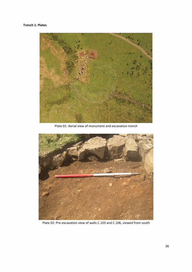
Plate 01: Aerial view of monument and excavation trench
Plate 02: Pre-excavation view of walls C.103 and C.106, viewed from south

Centre for Archaeological Fieldwork, QUB Data Structure Report 123: AE/17/84
Stone Circular Complex and Burial Cairn, Divis, County Antrim
37
Plate 03: Detail of metalled surface C.104 at the extreme north of trench, viewed from east
Plate 04: Excavation of wall C.102 and rubble C.103, viewed from north-east
Centre for Archaeological Fieldwork, QUB Data Structure Report 123: AE/17/84
Stone Circular Complex and Burial Cairn, Divis, County Antrim
38
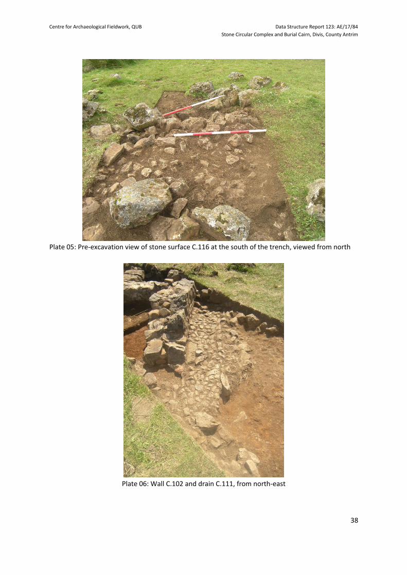
Plate 05: Pre-excavation view of stone surface C.116 at the south of the trench, viewed from north
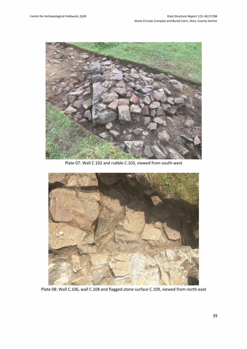
Plate 06: Wall C.102 and drain C.111, from north-east
Centre for Archaeological Fieldwork, QUB Data Structure Report 123: AE/17/84
Stone Circular Complex and Burial Cairn, Divis, County Antrim
39
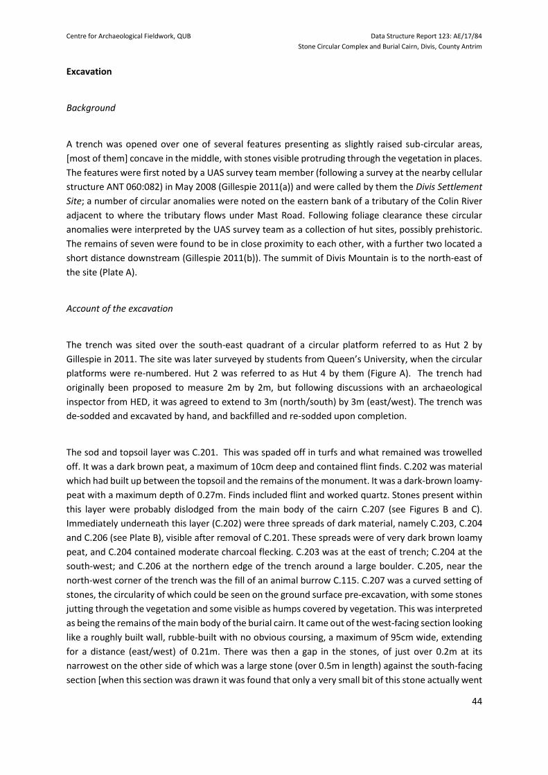
Plate 07: Wall C.102 and rubble C.103, viewed from south-west
Plate 08: Wall C.106, wall C.108 and flagged stone surface C.109, viewed from north-east

Centre for Archaeological Fieldwork, QUB Data Structure Report 123: AE/17/84
Stone Circular Complex and Burial Cairn, Divis, County Antrim
40
Plate 09: Wall C.107 and external path, viewed from south
Plate 10: Wall C.107, with mortar C.115 and external path C.110, viewed from north-west

Centre for Archaeological Fieldwork, QUB Data Structure Report 123: AE/17/84
Stone Circular Complex and Burial Cairn, Divis, County Antrim
41
Plate 11: Walls C.102, C.106 and C.108, flagged surface C.109 and drain C.111, viewed from east
Plate 12: Walls C.102, C.106, C.107, C.108 and drain C.111, viewed from north-east

Centre for Archaeological Fieldwork, QUB Data Structure Report 123: AE/17/84
Stone Circular Complex and Burial Cairn, Divis, County Antrim
42
PART 2: BURIAL CAIRN Contents Page Introduction to Trench 2 43
Summary Recording methodology Archiving
Excavation 44
Background
Account of the excavation
Discussion 46
Recommendations for further work 48
Programme of post-excavation analysis of the materials recovered Further investigation at the site Publication
Appendix 1: Harris Matrix 49 Appendix 2: Context Register 50 Appendix 3: Field Drawing Register 51 Appendix 4: Small Finds Register 52 Appendix 5: Samples Register 53 Appendix 6: Photographic Register 54 Appendix 7: Radiocarbon date certificate 56 Figures 58 Plates 60 References 65

Centre for Archaeological Fieldwork, QUB Data Structure Report 123: AE/17/84
Stone Circular Complex and Burial Cairn, Divis, County Antrim
43
Introduction to Trench 2
Summary
The excavation at the burial cairn consisted of one trench, initially proposed to be 2m in width and 2m
in length, but following consultation with an inspector from HED, this was later extended to 3m in
width and 3m in length. It was centred on what was initially thought to be the south-eastern quadrant
of a prehistoric hut platform. As the excavation progressed, it soon became apparent that this was not
a hut site, but the remains of a prehistoric burial cairn. Two sequences of human activity were
represented, prehistoric (pottery and flint) and twentieth century (rifle bullet cases). (See Appendix 1:
The Harris Matrix). The trench was given the title Trench 2, in order to minimise confusion with Trench
1, described above. Only one trench was excavated here. Following the excavation, a radiocarbon date
of AD 772-967 (calibrated to 2 sigma) was obtained [UBA-36431; Appendix 7], suggesting some activity
in the area during the medieval period.
Recording Methodology
The context records for the excavation were created using the standard context recording method: all
built features and deposits were assigned a unique context number and pro-forma (Context sheet)
was completed for each. All features were photographed prior to and following excavation and a
series of plans and sections were completed throughout the excavation at scales of 1:10 or 1:20, as
appropriate. A field notebook was also maintained. The Harris Matrix is presented in Appendix 1 and
the Context Register is detailed in Appendix 2. The Field Drawing Register is presented in Appendix 3
and the Small Finds Register in Appendix 4. The Samples Register is contained in Appendix 5. The
Photographic Register is catalogued in Appendix 6. The Radiocarbon Date Certificate is presented in
Appendix 7.
Archiving
Copies of this report have been deposited with the HED. All site records and finds are temporarily
archived with the School of Natural and Built Environment, Queen’s University Belfast.
Centre for Archaeological Fieldwork, QUB Data Structure Report 123: AE/17/84
Stone Circular Complex and Burial Cairn, Divis, County Antrim
44
Excavation
Background
A trench was opened over one of several features presenting as slightly raised sub-circular areas,
[most of them] concave in the middle, with stones visible protruding through the vegetation in places.
The features were first noted by a UAS survey team member (following a survey at the nearby cellular
structure ANT 060:082) in May 2008 (Gillespie 2011(a)) and were called by them the Divis Settlement
Site; a number of circular anomalies were noted on the eastern bank of a tributary of the Colin River
adjacent to where the tributary flows under Mast Road. Following foliage clearance these circular
anomalies were interpreted by the UAS survey team as a collection of hut sites, possibly prehistoric.
The remains of seven were found to be in close proximity to each other, with a further two located a
short distance downstream (Gillespie 2011(b)). The summit of Divis Mountain is to the north-east of
the site (Plate A).
Account of the excavation
The trench was sited over the south-east quadrant of a circular platform referred to as Hut 2 by
Gillespie in 2011. The site was later surveyed by students from Queen’s University, when the circular
platforms were re-numbered. Hut 2 was referred to as Hut 4 by them (Figure A). The trench had
originally been proposed to measure 2m by 2m, but following discussions with an archaeological
inspector from HED, it was agreed to extend to 3m (north/south) by 3m (east/west). The trench was
de-sodded and excavated by hand, and backfilled and re-sodded upon completion.
The sod and topsoil layer was C.201. This was spaded off in turfs and what remained was trowelled
off. It was a dark brown peat, a maximum of 10cm deep and contained flint finds. C.202 was material
which had built up between the topsoil and the remains of the monument. It was a dark-brown loamy-
peat with a maximum depth of 0.27m. Finds included flint and worked quartz. Stones present within
this layer were probably dislodged from the main body of the cairn C.207 (see Figures B and C).
Immediately underneath this layer (C.202) were three spreads of dark material, namely C.203, C.204
and C.206 (see Plate B), visible after removal of C.201. These spreads were of very dark brown loamy
peat, and C.204 contained moderate charcoal flecking. C.203 was at the east of trench; C.204 at the
south-west; and C.206 at the northern edge of the trench around a large boulder. C.205, near the
north-west corner of the trench was the fill of an animal burrow C.115. C.207 was a curved setting of
stones, the circularity of which could be seen on the ground surface pre-excavation, with some stones
jutting through the vegetation and some visible as humps covered by vegetation. This was interpreted
as being the remains of the main body of the burial cairn. It came out of the west-facing section looking
like a roughly built wall, rubble-built with no obvious coursing, a maximum of 95cm wide, extending
for a distance (east/west) of 0.21m. There was then a gap in the stones, of just over 0.2m at its
narrowest on the other side of which was a large stone (over 0.5m in length) against the south-facing
section [when this section was drawn it was found that only a very small bit of this stone actually went

Centre for Archaeological Fieldwork, QUB Data Structure Report 123: AE/17/84
Stone Circular Complex and Burial Cairn, Divis, County Antrim
45
into the section]. This gap may have been created by the monument builders, or could be where
stones from the structure have dislodged and fallen away. C.207 rested on C.213, the surface on which
the monument was constructed (see Plates E, F, G, H and I).
Cut C.208 was linear feature along southern edge of the trench. It was filled by C.209, a dark brown
silty loam, but also contained a large percentage (c.65%) of stone, and had uneven angular stony
edges; the fill also contained flint. It appeared to be cut through C.213, though some of the stones of
its fill were at a physically higher level than C.213 and were actually in C.202; the fill also sat below
some of the stones of the arc C.214. Although it ran the whole length (i.e. 3m) of the trench, we do
not know its actual length or width. This may be a drainage feature associated with the monument,
or an accumulation of material into a natural linear depression in the adjacent bedrock (see Plates C,
D and E). Cut C.210 was initially thought to be a possible post-hole, but on excavation was found to be
an animal burrow, it was filled by C.211.
C.212 was clay material which was present inside the monument, i.e. within C.207, and therefore in
the north-west quarter of the trench. It was a mid to dark brown clayey loam, a maximum of 0.35m
deep and was interpreted as a clay bonding matrix used to consolidate the stone cairn. C.212 had
evidence of burning that presented as patches of orange burnt earth, areas of concentrated charcoal
(some associated with the orange burnt areas, some not), and charcoal flecking (Plate F). Presumably
these deposits accumulated during the use of the monument, perhaps representing several
occurrences. Stones present within this layer had been dislodged from C.207. Found in this layer were
prehistoric pottery sherds (possibly Neolithic in date) and flint including blades, a scraper and flakes.
Also found were parts of two bullet cases near the inside face of one of the stones of C.207, possibly
due to the action of burrowing animals.
C.213 was the surface on which the stones of the monument, C.207, and the outer arc of stones, C.214,
had been set. It was a mid-grey-orange silty loam, containing small gritty stones and with light charcoal
flecking; in the north-west area, within C.207, it had medium charcoal flecking. The context sloped
slightly upwards in a northerly direction, following the incline of the surrounding landscape. Due to
time constraints C.213 was not excavated, apart from a very small test-hole in the north-west corner
of the trench where a soil sample was taken. The surface was present over most of the trench running
below C.207 and C.214. It was not present along the southern edge of the trench, where it appeared
that C.208 was cut through C.213. It is not known how far C.213 extended, if at all, to the eastern side
of the trench as excavation only went as far as C.202 and stone here. C.214 (Plates G, H and I) appeared
to be an arcing setting of stones, which curved concentrically with C.207; it therefore rested on C.213
and consisted of one layer of flattish stones. it is also possible that this feature is coincidental.
A sample of charcoal was recovered from C.212 which returned a date of AD 772-967 [calibrated to 2
sigma; UBA-36424. See Appendix 7]. This early Medieval date suggests the presence of burning in the
area of the cairn during the early Medieval period and is inconsistent with the interpretation of the
monument as a prehistoric burial cairn. However, this result also suggests that the upper layers of
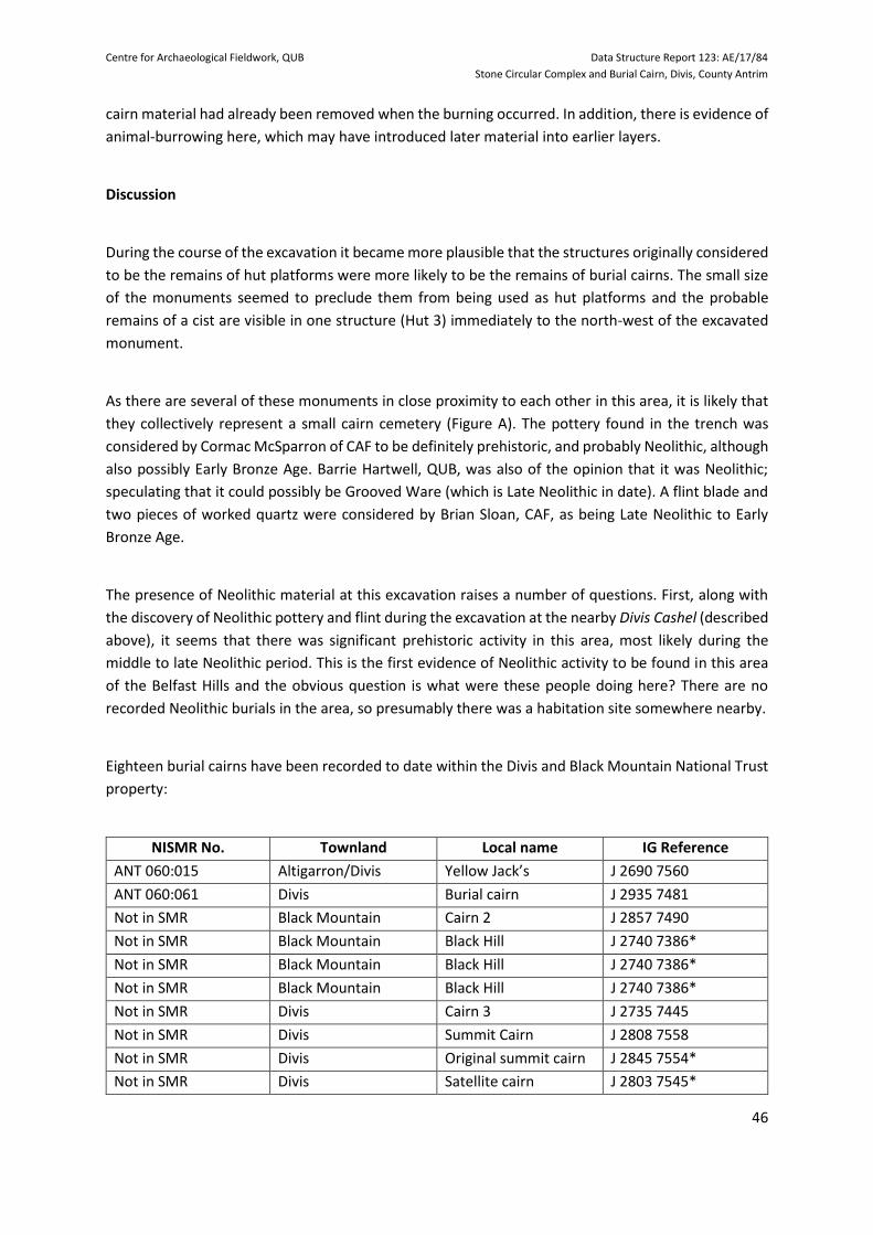
Centre for Archaeological Fieldwork, QUB Data Structure Report 123: AE/17/84
Stone Circular Complex and Burial Cairn, Divis, County Antrim
46
cairn material had already been removed when the burning occurred. In addition, there is evidence of
animal-burrowing here, which may have introduced later material into earlier layers.
Discussion
During the course of the excavation it became more plausible that the structures originally considered
to be the remains of hut platforms were more likely to be the remains of burial cairns. The small size
of the monuments seemed to preclude them from being used as hut platforms and the probable
remains of a cist are visible in one structure (Hut 3) immediately to the north-west of the excavated
monument.
As there are several of these monuments in close proximity to each other in this area, it is likely that
they collectively represent a small cairn cemetery (Figure A). The pottery found in the trench was
considered by Cormac McSparron of CAF to be definitely prehistoric, and probably Neolithic, although
also possibly Early Bronze Age. Barrie Hartwell, QUB, was also of the opinion that it was Neolithic;
speculating that it could possibly be Grooved Ware (which is Late Neolithic in date). A flint blade and
two pieces of worked quartz were considered by Brian Sloan, CAF, as being Late Neolithic to Early
Bronze Age.
The presence of Neolithic material at this excavation raises a number of questions. First, along with
the discovery of Neolithic pottery and flint during the excavation at the nearby Divis Cashel (described
above), it seems that there was significant prehistoric activity in this area, most likely during the
middle to late Neolithic period. This is the first evidence of Neolithic activity to be found in this area
of the Belfast Hills and the obvious question is what were these people doing here? There are no
recorded Neolithic burials in the area, so presumably there was a habitation site somewhere nearby.
Eighteen burial cairns have been recorded to date within the Divis and Black Mountain National Trust
property:
NISMR No. Townland Local name IG Reference
ANT 060:015 Altigarron/Divis Yellow Jack’s J 2690 7560
ANT 060:061 Divis Burial cairn J 2935 7481
Not in SMR Black Mountain Cairn 2 J 2857 7490
Not in SMR Black Mountain Black Hill J 2740 7386*
Not in SMR Black Mountain Black Hill J 2740 7386*
Not in SMR Black Mountain Black Hill J 2740 7386*
Not in SMR Divis Cairn 3 J 2735 7445
Not in SMR Divis Summit Cairn J 2808 7558
Not in SMR Divis Original summit cairn J 2845 7554*
Not in SMR Divis Satellite cairn J 2803 7545*

Centre for Archaeological Fieldwork, QUB Data Structure Report 123: AE/17/84
Stone Circular Complex and Burial Cairn, Divis, County Antrim
47
Not in SMR Divis Johnstons Green J 2813 7462*
Not in SMR Divis Ballygillespie J 2747 7456
Not in SMR Divis Ballygillespie J 2747 7456*
Not in SMR Divis Ballygillespie J 2747 7456*
Not in SMR Divis Ballygillespie J 2747 7456*
Not in SMR Divis Ballygillespie J 2747 7456*
Not in SMR Divis Ballygillespie J 2747 7456*
Not in SMR Divis Ballygillespie J 2747 7456*
* = not precisely located
Table of burial cairns in National Trust Divis and Black Mountain property
Of these eighteen burial cairns, three are clustered together at the summit of Divis Mountain, three
are clustered together at the summit of Black Hill and seven are clustered together at the 2017
excavation site. The remainder are located in isolation. Those that are clustered together may be
considered as small cairn cemeteries, similar to those found at Broughderg (Welsh and Craig 2017),
but it is as yet unclear why the others were situated in isolation. It is presumed that these are not
contemporary, representing changes in funerary practices over time. Only further investigation will
resolve this.
When the monuments stopped being maintained by the builders and their descendants, the cairn
material would have been subject to degradation. Stones would have been dislocated by weathering,
by vegetation growth, by animals and by humans, therefore the upper cairn material (including
possibly small stones) would have been removed down to the height that the monument stands at
now. What remains, up to the present time, are the stones forming the base or kerb of the cairn. The
surface of C.202 may also have been disturbed if it was exposed to the elements, leaving what remains
today and then topsoil accumulated on top. Depressions at the centre of this monument, the adjacent
monuments and others in the Divis and Black Mountain property (see Rutherford 2009 and McShane
and Cooper 2012), may represent robbing by treasure hunters, possibly shortly after they were
abandoned.
Parts of two bullet cases were found in the top level of C.212, against the side of one of the stones of
C.207. One was identified as a military type .303 calibre, in use from 1941, but the other could not be
identified during the excavation. As the Ministry of Defence had control of the Divis area for a number
of years (1953 until 2004) and were using it for training, it is to be presumed that the cases were
dropped there when soldiers were using the depression in the middle of the monument as cover when
doing fire-arms training. This demonstrates the re-use of the monument in the twentieth century.

Centre for Archaeological Fieldwork, QUB Data Structure Report 123: AE/17/84
Stone Circular Complex and Burial Cairn, Divis, County Antrim
48
Recommendations for further work Programme of post-excavation analysis of the materials recovered
If funding can be obtained, a programme of post-excavation analysis will be carried out in order to
obtain the maximum amount of information from the excavation. A costing for this work will be
presented to the owners of the monument, the National Trust, for consideration.
Further investigation at the site
The 2017 excavation revealed the interesting prospect that this site is not, as previously thought, the
remains of a prehistoric settlement site, but rather the remains of a small cairn cemetery, usually
dating to the Bronze Age. The discovery of what appears to be a Neolithic presence here is unusual
and is worthy of further investigation. It is recommended that a larger-scale investigation, involving
further excavation and geophysical survey, be carried out at this, or adjacent monuments, in order to
obtain a fuller picture of the date and use of the different phases of activity here.
Publication
It is hoped that the results of the excavation, along with information obtained from any post-
excavation analysis, can be published in an academic journal, such as the Ulster Journal of Archaeology
in due course. A brief summary of results has been published in Archaeology Ireland (Welsh et al.,
2017).
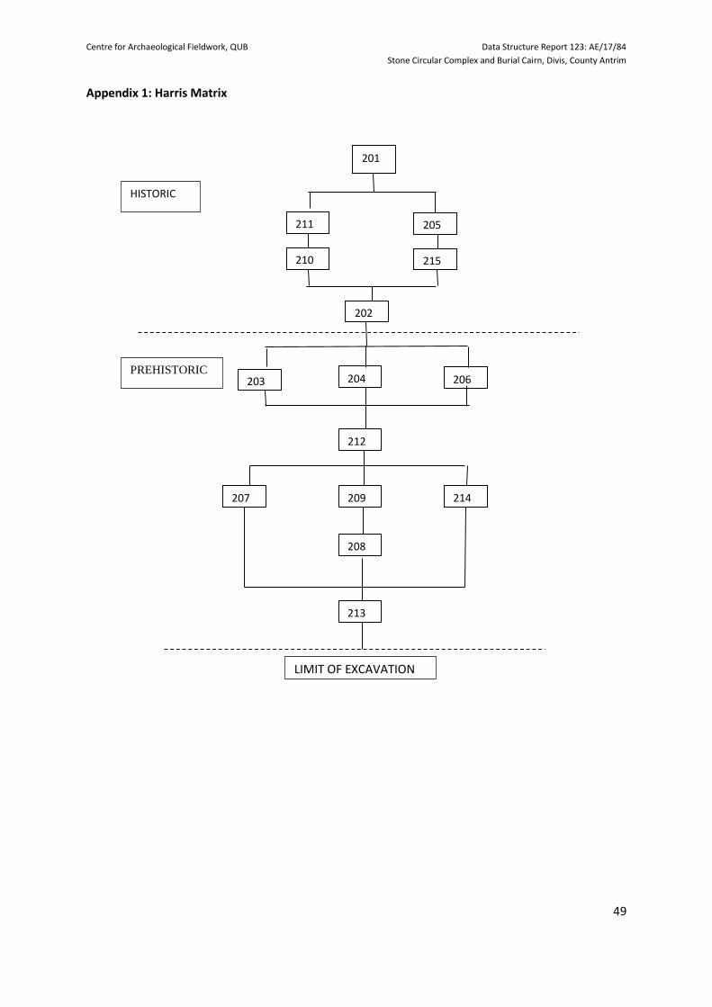
Centre for Archaeological Fieldwork, QUB Data Structure Report 123: AE/17/84
Stone Circular Complex and Burial Cairn, Divis, County Antrim
49
Appendix 1: Harris Matrix
206 204
207
202
210
214
212
201
203
211
208
209
213
LIMIT OF EXCAVATION
HISTORIC
PREHISTORIC
205
215

Centre for Archaeological Fieldwork, QUB Data Structure Report 123: AE/17/84
Stone Circular Complex and Burial Cairn, Divis, County Antrim
50
Appendix 2: Trench 2 - Context Register
Context
Number
Description
201 Layer. Sod and topsoil layer
202 Layer. Material which built up outside monument
203 Spread. Very dark brown material, within topsoil
204 Spread. Very dark brown material, within topsoil
205 Fill. Fill of animal burrow C.215
206 Spread. Very dark brown material, within topsoil
207 Stone feature. Setting of stones constituting monument
208 Cut. Linear feature
209 Fill. Fill of C.208
210 Cut. Animal burrow
211 Fill. Fill of C.210
212 Layer. Material which built up in interior of monument
213 Layer. Surface on which monument was built
214 Stone feature? Possible arc of stones [around outside of monument]
215 Animal burrow into C.202
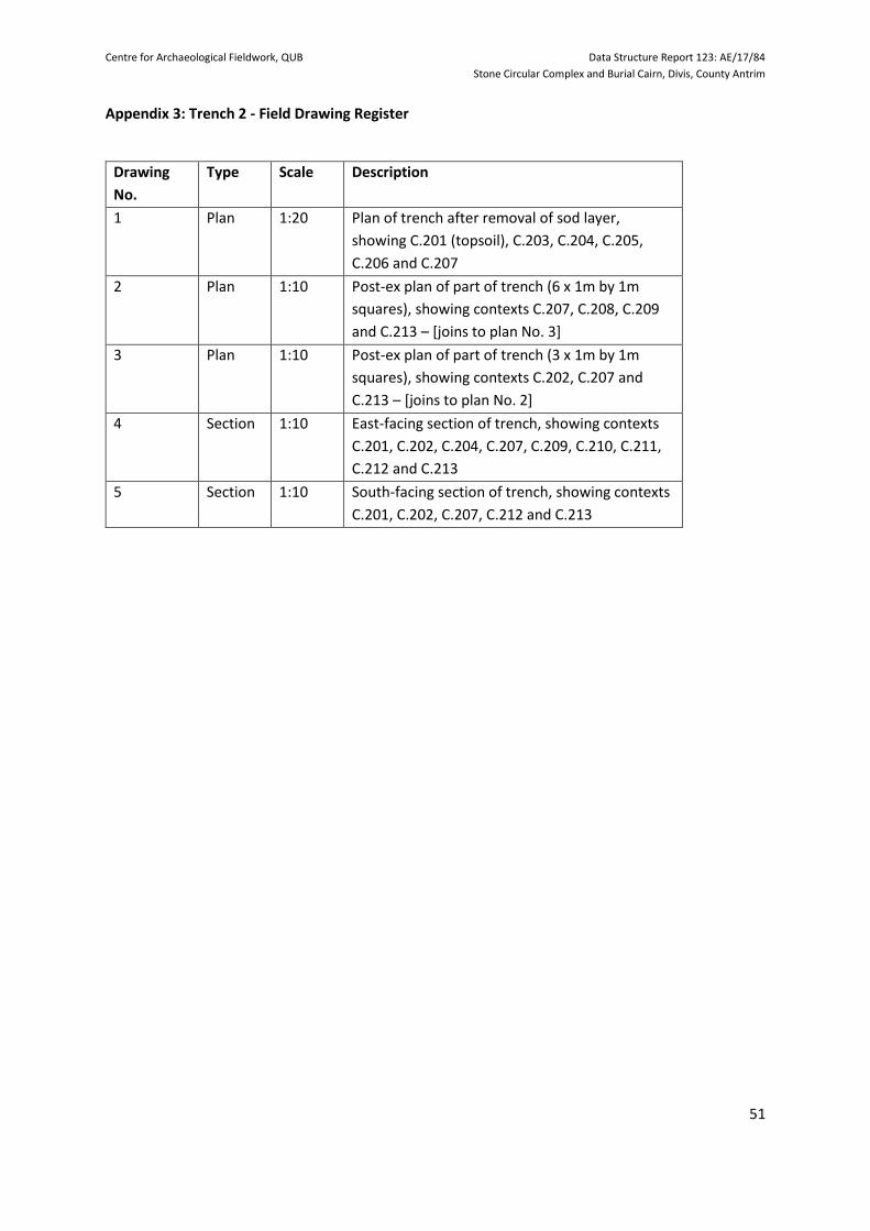
Centre for Archaeological Fieldwork, QUB Data Structure Report 123: AE/17/84
Stone Circular Complex and Burial Cairn, Divis, County Antrim
51
Appendix 3: Trench 2 - Field Drawing Register
Drawing
No.
Type Scale Description
1 Plan 1:20 Plan of trench after removal of sod layer,
showing C.201 (topsoil), C.203, C.204, C.205,
C.206 and C.207
2 Plan 1:10 Post-ex plan of part of trench (6 x 1m by 1m
squares), showing contexts C.207, C.208, C.209
and C.213 – [joins to plan No. 3]
3 Plan 1:10 Post-ex plan of part of trench (3 x 1m by 1m
squares), showing contexts C.202, C.207 and
C.213 – [joins to plan No. 2]
4 Section 1:10 East-facing section of trench, showing contexts
C.201, C.202, C.204, C.207, C.209, C.210, C.211,
C.212 and C.213
5 Section 1:10 South-facing section of trench, showing contexts
C.201, C.202, C.207, C.212 and C.213

Centre for Archaeological Fieldwork, QUB Data Structure Report 123: AE/17/84
Stone Circular Complex and Burial Cairn, Divis, County Antrim
52
Appendix 4: Trench 2 - Small Finds Register
Context Number Description Quantity
201 Flint 5
202 Quartz (worked) 2
202 Flint (struck pieces
including blade)
295
204 Flint (including struck
pieces)
12
207 Flint 5
209 Flint (including struck
pieces)
62
211 Flint 3
212 Flint (some struck
pieces including
scraper and 2 blades)
159
212 Pottery (prehistoric,
undiagnostic body
sherds)
5
212 Metal (parts of 2 bullet
cases)
2
213 Flint 21

Centre for Archaeological Fieldwork, QUB Data Structure Report 123: AE/17/84
Stone Circular Complex and Burial Cairn, Divis, County Antrim
53
Appendix 5: Trench 2 - Samples Register
Sample No. Context Details Quantity
1 C.204 Charcoal 1 small bag
2 C.206 1 bag
3 C.212 Charcoal 2 bags
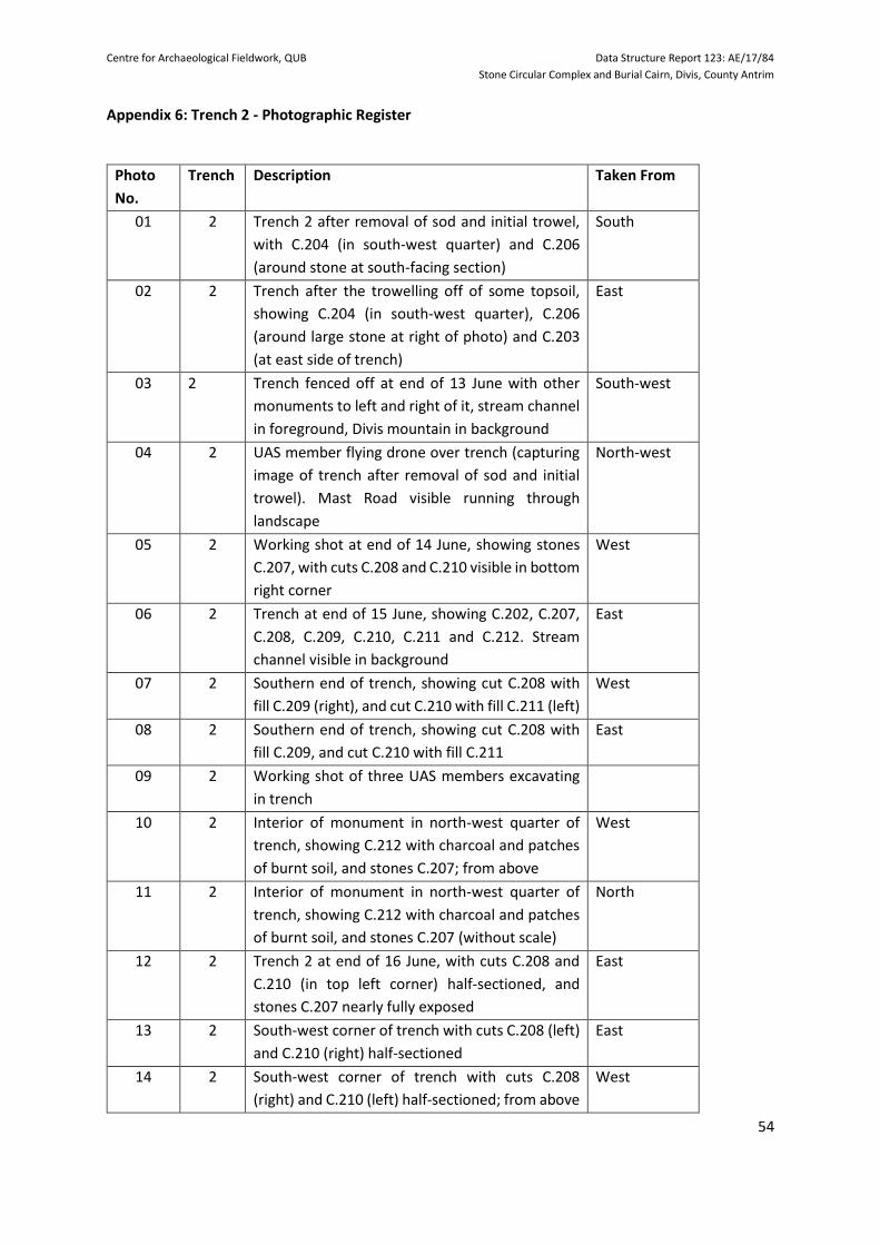
Centre for Archaeological Fieldwork, QUB Data Structure Report 123: AE/17/84
Stone Circular Complex and Burial Cairn, Divis, County Antrim
54
Appendix 6: Trench 2 - Photographic Register
Photo
No.
Trench Description Taken From
01 2 Trench 2 after removal of sod and initial trowel,
with C.204 (in south-west quarter) and C.206
(around stone at south-facing section)
South
02 2 Trench after the trowelling off of some topsoil,
showing C.204 (in south-west quarter), C.206
(around large stone at right of photo) and C.203
(at east side of trench)
East
03 2 Trench fenced off at end of 13 June with other
monuments to left and right of it, stream channel
in foreground, Divis mountain in background
South-west
04 2 UAS member flying drone over trench (capturing
image of trench after removal of sod and initial
trowel). Mast Road visible running through
landscape
North-west
05 2 Working shot at end of 14 June, showing stones
C.207, with cuts C.208 and C.210 visible in bottom
right corner
West
06 2 Trench at end of 15 June, showing C.202, C.207,
C.208, C.209, C.210, C.211 and C.212. Stream
channel visible in background
East
07 2 Southern end of trench, showing cut C.208 with
fill C.209 (right), and cut C.210 with fill C.211 (left)
West
08 2 Southern end of trench, showing cut C.208 with
fill C.209, and cut C.210 with fill C.211
East
09 2 Working shot of three UAS members excavating
in trench
10 2 Interior of monument in north-west quarter of
trench, showing C.212 with charcoal and patches
of burnt soil, and stones C.207; from above
West
11 2 Interior of monument in north-west quarter of
trench, showing C.212 with charcoal and patches
of burnt soil, and stones C.207 (without scale)
North
12 2 Trench 2 at end of 16 June, with cuts C.208 and
C.210 (in top left corner) half-sectioned, and
stones C.207 nearly fully exposed
East
13 2 South-west corner of trench with cuts C.208 (left)
and C.210 (right) half-sectioned
East
14 2 South-west corner of trench with cuts C.208
(right) and C.210 (left) half-sectioned; from above
West

Centre for Archaeological Fieldwork, QUB Data Structure Report 123: AE/17/84
Stone Circular Complex and Burial Cairn, Divis, County Antrim
55
15 2 Cut C.210 excavated, between cut C.209 and
stones C.207; from above
West
16 2 Charcoal-rich area within C.212 (without scale),
north-west corner of trench; from above
South
17 2 Whole trench, with stones C.207 and C.214; the
circular impression of the monument can be seen
in the grass curving around the top left corner of
the trench, with another monument visible to the
north
South
18 2 Whole trench, with stones C.207 and C.214; the
circular impression of the monument can be
seen in the grass curving around the top right
corner of the trench, beyond the trench can be
seen the channel of a stream which flows to the
west of the site
East
19 2 Outer face of stones C.207, and some of stones
C.214
South
20 2 South-facing section of trench, with unexcavated
part of monument visible beyond the section, and
another monument visible to the north
South
21 2 West-facing section of trench West
22 2 North-facing section of trench North
23 2 East-facing section of trench, with stream channel
in background
East
24 2 Working shot of UAS members section drawing.
25 2 UAS members after back-filling.
26 2 UAS members and member of CAF staff after
back-filling.

Centre for Archaeological Fieldwork, QUB Data Structure Report 123: AE/17/84
Stone Circular Complex and Burial Cairn, Divis, County Antrim
56
Appendix 7: Radiocarbon date certificate

Centre for Archaeological Fieldwork, QUB Data Structure Report 123: AE/17/84
Stone Circular Complex and Burial Cairn, Divis, County Antrim
57

Centre for Archaeological Fieldwork, QUB Data Structure Report 123: AE/17/84
Stone Circular Complex and Burial Cairn, Divis, County Antrim
58
Trench 2: Figures
Figure A: Plan of Divis Settlement Site

Centre for Archaeological Fieldwork, QUB Data Structure Report 123: AE/17/84
Stone Circular Complex and Burial Cairn, Divis, County Antrim
59
Figure B: Plan of Trench 2 showing contexts C.202, C.207, C.208, C.209 and C.213
Figure C: South-facing section of trench

Centre for Archaeological Fieldwork, QUB Data Structure Report 123: AE/17/84
Stone Circular Complex and Burial Cairn, Divis, County Antrim
60
Trench 2: Plates
Plate A: Post-excavation view of site, with Divis Mountain in background, viewed from south-west
Plate B: Mid-excavation view, with stones C.204, C.206 and C.203, looking east

Centre for Archaeological Fieldwork, QUB Data Structure Report 123: AE/17/84
Stone Circular Complex and Burial Cairn, Divis, County Antrim
61
Plate C: Southern end of trench, showing cut C.208, looking west
Plate D: South-west corner of trench, with stones C.207 and C.214, looking west

Centre for Archaeological Fieldwork, QUB Data Structure Report 123: AE/17/84
Stone Circular Complex and Burial Cairn, Divis, County Antrim
62
Plate E: Mid-excavation view of trench, looking east
Plate F: North-west part of trench, showing patches of burnt material C.212, looking north

Centre for Archaeological Fieldwork, QUB Data Structure Report 123: AE/17/84
Stone Circular Complex and Burial Cairn, Divis, County Antrim
63
Plate G: View of trench, showing C.207 and C.214, looking south
Plate H: View of trench, showing C.207 and C.214, looking east

Centre for Archaeological Fieldwork, QUB Data Structure Report 123: AE/17/84
Stone Circular Complex and Burial Cairn, Divis, County Antrim
64
Plate I: Outer face of stones C.207 and C.214, looking south
Plate J: UAS members after back-filling

Centre for Archaeological Fieldwork, QUB Data Structure Report 123: AE/17/84
Stone Circular Complex and Burial Cairn, Divis, County Antrim
65
References
Brannon, N.F. 1984. ‘A small excavation in Tildarg Townland, near Ballyclare, County Antrim’, Ulster
Journal of Archaeology 3: Vol. 47, 163-170.
Catney, M. 2016. Game Keeper’s Cottage, Black Mountain Td, Co. Antrim, Survey Report No. 54,
Belfast: Ulster Archaeological Society.
Edwards, N. 1990. The Archaeology of Early Medieval Ireland, London: Batsford.
Ó Baoill, R. 2011. Hidden History Below Our Feet, the Archaeological Story of Belfast, Belfast: Tandem.
Dunlop, W. and Catney, M. 2009. House Site 1, Black Mountain, Belfast, Survey Report No. 11, Ulster
Archaeological Society.
Gillespie, I. 2011(a). Survey of Divis Cell Bay Enclosure, Survey Report No. 12, Belfast: Ulster
Archaeological Society.
Gillespie, I. 2011(b). Survey of Divis Settlement Site, Survey Report No. 16, Belfast: Ulster
Archaeological Society.
McAlister, G. 2012. Survey of Divis Cashel, County Antrim, Survey Report No. 36, Belfast: Ulster
Archaeological Society.
McDonald, J. and Catney, M. 2013. Divis Farm, Belfast, Survey Report No. 25, Belfast: Ulster
Archaeological Society.
McShane, L. 2014. Survey of Johnston’s Green at Divis, County Antrim, Survey Report No. 39, Belfast:
Ulster Archaeological Society.
McShane, L. and Cooper, C. 2012. Survey of Burial Cairn 3 at Divis, County Antrim, Survey Report No.
31, Belfast: Ulster Archaeological Society.
McShane, L. and Catney, M. 2015. Divis Lodge, Divis Townland, Co. Antrim, Survey Report No. 49,
Belfast: Ulster Archaeological Society.
Rutherford, G. 2009. Survey of Yellow Jack’s Cairn, Divis, County Antrim, Survey Report No. 9, Ulster
Archaeological Society.
Scott, R. 2013. Survey of Reavy House Site at Divis, County Antrim, Survey Report No. 40, Belfast: Ulster
Archaeological Society.
Welsh 2011(a), Survey of Ballyaghagan Cashel, County Antrim, Survey Report No. 35, Belfast: Ulster
Archaeological Society.
Welsh, H. 2011(b) Excavation at Ballyaghagan Cashel, County Antrim. Data Structure Report No. 78,
Belfast: Centre for Archaeological Fieldwork.
Welsh, H. 2013. Survey of Vernacular House at Divis Barn, Divis, County Antrim, Survey Report No. 41,
Belfast: Ulster Archaeological Society.
Welsh, H. and Pinkerton, L. 2011. ‘The Hills are Alive – with the Sound of Digging’, Archaeology Ireland,
Vol. 25, No. 4, Winter 2011, 33-35.
Welsh, J. and Welsh, H. 2007. Survey of Cairn 2, Black Mountain, County Antrim, Survey Report No. 2,
Ulster Archaeological Society.
Welsh, J. and Welsh, H. 2007. Survey of Summit Cairn, Divis Mountain, County Antrim, Survey Report
No. 3, Ulster Archaeological Society.
Welsh, H. and Welsh, J. 2014. The Prehistoric Burial Sites of Northern Ireland, British Archaeological
Reports British Series 106, Oxford: Archaeopress.
Welsh, H., Ó Baoill, R., Logue, R., Conway, M. and Pinkerton, L. 2017. ‘Big Questions at the Big Dig’,
Archaeology Ireland, Vol. 31, No. 4, 44-47.

Centre for Archaeological Fieldwork, QUB Data Structure Report 123: AE/17/84
Stone Circular Complex and Burial Cairn, Divis, County Antrim
66
Welsh, H. and Craig, D. 2017. Geophysical Survey, Divis Cashel, County Antrim, Excavation Licence
AE/17/94G, Geophysical Survey Report No. 2, Belfast: Ulster Archaeological Society.
Welsh, H. and Welsh, J. 2018. Sites of Prehistoric Life in Northern Ireland, Oxford: Archaeopress
Archaeology.
Websites
HED Sites and Monuments Record.


![Flexural Behaviour of Basalt Fiber Reinforced Concrete ... · Basalt rock can also make basalt rock, chopped basalt fiber, basalt fabrics and continuous filament wire [9]. Basalt](https://img.dokumen.tips/doc/110x75/5e8d373fa059ea2b69053027/flexural-behaviour-of-basalt-fiber-reinforced-concrete-basalt-rock-can-also.jpg)