Embed Size (px)
Citation preview

### ### ####### ### ###### ### ## ### ## ### # ### ### ## ## ## ### ## # #### ### # # ## ## ## ## # ## ## # ### # # ## # # ## # ## ## ## ### ### ## # #### ## # ### ###### ### ### ### ##### ### ### # ###### # ## ## ## # ## #####
# # ## # #### ##### ##### #### # #####
# ####### ## ##
ÊÚ
ÊÚÊÚ
ÊÚ
0 5
60
NorthSea
Norway
UnitedKingdom
Bergen
Edinburgh
Glasgow
0 100 200 300 KILOMETERS
Central GrabenAssessment Unit 40250103
North Sea Graben Geologic Province 4025
Central Graben Assessment Unit 40250103

Page 1
USGS PROVINCE: North Sea Graben (4025) GEOLOGIST: D.L. Gautier TOTAL PETROLEUM SYSTEM: Kimmeridgian Shales (402501) ASSESSMENT UNIT: Central Graben (40250103) DESCRIPTION: The total petroleum system and corresponding assessment unit coincide with the extent of oil and gas accumulations and thermally mature, organic matter-rich marine shales of late Jurassic and earliest Cretaceous age in and adjacent to the Central Graben of the northern North Sea. SOURCE ROCKS: Virtually all significant oil and gas accumulations in the northern North Sea are believed to have been generated within certain fine-grained, organic-carbon-rich marine strata of late Jurassic and earliest Cretaceous age. These Kimmeridgian shales accumulated in oxygen-starved rift basins and may locally thicken to 3000 m. The actual source rocks are black shales that display high radioactivity and have total organic carbon (TOC) contents of 2 percent to 15 percent or more and average about 5 percent TOC. The typical kerogen types within the hot shales are mixtures of organic matter commonly described as Type II kerogen, reflecting a mixture of planktonic marine algae and degraded terrigenous humic organic matter. MATURATION: Burial of Central Graben source rocks has been more or less continuous from the time of deposition until the present day. Some source rocks achieved thermal maturity with respect to oil and gas generation as early as Late Cretaceous time and continuing to the present day in some areas. Thus newly generated oil and gas has been available to traps almost continuously during post-early Cretaceous Central Graben history. Locally, the continuous time-temperature process was interrupted by structural inversion, also in Late Cretaceous time. MIGRATION: The near-universal predominance of upper Jurassic marine shales as source rocks in the Central Graben has resulted in a wide variety of migration styles and pathways, including stratigraphically downward migration into pre-Jurassic reservoirs rocks in fault blocks. RESERVOIR ROCKS: Pre-rift rocks as old as Devonian, and including nonmarine Carboniferous fluvial sequences associated with the Coal Measures, Permian Rotliegendes sandstones, Zechstein carbonates, and Triassic and lower Jurassic sandstones in fault blocks have been variously charged with hydrocarbons. Middle and Upper Jurassic sandstones, deposited simultaneously with rifting in the Central Graben, form significant reservoirs for fields such as Fulmar and Ula. These syn-rift reservoirs include both shallow water and deep-water marine facies, evidently reflecting topography present during the formation of the Central Graben rifts. Lower Cretaceous reservoir sandstones are also present, having formed within the framework of the post-rift topography of the Central Graben. Chalk reservoirs dominate the Upper Cretaceous to lowermost Danian strata of the Central Graben. The most productive chalk reservoirs of the Central Graben occur in slump blocks and other structures associated with salt tectonics. Paleogene submarine fan complexes provide reservoirs for some of the most outstanding fields of the North Sea, including Forties.
Page 2
TRAPS AND SEALS: Central Graben traps include fault blocks draped with Jurassic mudstones, Cretaceous chalk, or shale of Tertiary age. In contrast to the Viking Graben and Moray Firth, salt tectonics is responsible for much of the structural complexity that provides opportunities for hydrocarbon entrapment. Stratigraphic traps are dominant in the upper Jurassic and younger sandstones. Seals are Jurassic shale, Cretaceous chalk, or Tertiary shale. REFERENCES: Pegrum, R.M. and Spencer, A.M., 1990, Hydrocarbon plays in the northern North Sea, in
Brooks, Jim, ed., Classic petroleum provinces: London, The Geological Society Special Publication 50, p. 441-470.
Abbotts, I.L., ed., 1991, United Kingdom Oil and Gas Fields 25 Years Commemorative Volume: London, The Geological Society Memoir 14, p. 211-386.
Cornford, Chris, 1994, Mandal-Ekofisk(!) Petroleum System in the Central Graben of the North Sea, in Magoon, L.B. and Dow, W.G., eds., The Petroleum System–from source to trap: American Association of Petroleum Geologists Memoir 60, p. 537-571.
Ziegler, P.A., 1990, Geological atlas of western and central Europe: Shell Internationale Petroleum Maatschappij B.V., 239 p.

40250103
40250103Assessment unitcode and boundary
4025
4023
4027
4028
4036
4025
Assessment Unit - 40250103Central Graben
EXPLANATION
HydrographyShorelineGeologic province code and boundaryCountry boundaryGas field centerpointOil field centerpoint
Projection: Robinson. Central meridian: 0
75 KILOMETERS
0 2 4
54
56
58
North Sea
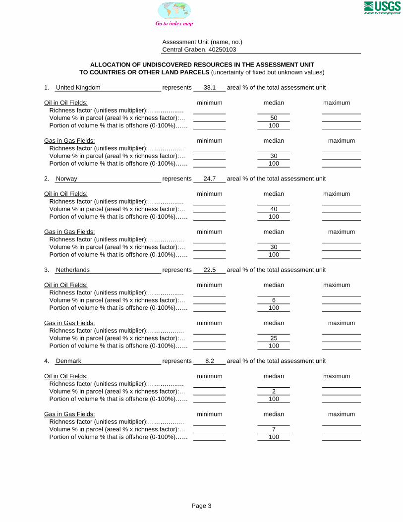
SEVENTH APPROXIMATIONNEW MILLENNIUM WORLD PETROLEUM ASSESSMENTDATA FORM FOR CONVENTIONAL ASSESSMENT UNITS
Date:………………………….. 8/3/99Assessment Geologist:…….. D.L. GautierRegion:……………………….. Europe Number: 4Province:……………………… North Sea Graben Number: 4025Priority or Boutique.………… PriorityTotal Petroleum System:…… Kimmeridgian Shales Number: 402501Assessment Unit:…………… Central Graben Number: 40250103* Notes from Assessor MMS growth function.
CHARACTERISTICS OF ASSESSMENT UNIT
Oil (<20,000 cfg/bo overall) or Gas (>20,000 cfg/bo overall):… Oil
What is the minimum field size?………. 2 mmboe grown (>1mmboe)(the smallest field that has potential to be added to reserves in the next 30 years)
Number of discovered fields exceeding minimum size:………… Oil: 128 Gas: 61 Established (>13 fields) X Frontier (1-13 fields) Hypothetical (no fields)
Median size (grown) of discovered oil fields (mmboe):1st 3rd 76.5 2nd 3rd 15.9 3rd 3rd 59.7
Median size (grown) of discovered gas fields (bcfg):1st 3rd 290 2nd 3rd 498 3rd 3rd 224
Assessment-Unit Probabilities: Attribute Probability of occurrence (0-1.0)1. CHARGE: Adequate petroleum charge for an undiscovered field > minimum size……………… 1.02. ROCKS: Adequate reservoirs, traps, and seals for an undiscovered field > minimum size…… 1.03. TIMING OF GEOLOGIC EVENTS: Favorable timing for an undiscovered field > minimum size 1.0
Assessment-Unit GEOLOGIC Probability (Product of 1, 2, and 3):……...…….....…. 1.0
4. ACCESSIBILITY: Adequate location to allow exploration for an undiscovered field > minimum size……………………………………………………..………………..……..………… 1.0
UNDISCOVERED FIELDS
Oil fields:…………………………………min. no. (>0) 30 median no. 125 max no. 300Gas fields:……………………………….min. no. (>0) 15 median no. 60 max no. 150
Size of Undiscovered Fields: What are the anticipated sizes (grown) of the above fields?:
Oil in oil fields (mmbo)………………..……min. size 2 median size 15 max. size 1000Gas in gas fields (bcfg):……………………min. size 12 median size 70 max. size 4000
(variations in the sizes of undiscovered fields)
(uncertainty of fixed but unknown values)Number of Undiscovered Fields: How many undiscovered fields exist that are > minimum size?:
Page 1

Assessment Unit (name, no.)Central Graben, 40250103
AVERAGE RATIOS FOR UNDISCOVERED FIELDS, TO ASSESS COPRODUCTS
Oil Fields: minimum median maximum Gas/oil ratio (cfg/bo)………………………...……… 400 800 1200 NGL/gas ratio (bngl/mmcfg)…………………....…. 30 60 90
Gas fields: minimum median maximum Liquids/gas ratio (bngl/mmcfg)….…………..…….. 25 50 75 Oil/gas ratio (bo/mmcfg)………………………….…
SELECTED ANCILLARY DATA FOR UNDISCOVERED FIELDS(variations in the properties of undiscovered fields)
Oil Fields: minimum median maximum API gravity (degrees)…………………….…………. 20 38 50 Sulfur content of oil (%)………………………...….. Drilling Depth (m) ……………...…………….…….. 250 3200 5000 Depth (m) of water (if applicable)……………...….. 10 75 150
Gas Fields: minimum median maximum Inert gas content (%)……………………….....…… CO2 content (%)……………………………….....… Hydrogen-sulfide content (%)………………...……. Drilling Depth (m)…………………………………… 800 3200 6000 Depth (m) of water (if applicable)…………………. 10 75 150
(uncertainty of fixed but unknown values)
Page 2
Assessment Unit (name, no.)Central Graben, 40250103
ALLOCATION OF UNDISCOVERED RESOURCES IN THE ASSESSMENT UNITTO COUNTRIES OR OTHER LAND PARCELS (uncertainty of fixed but unknown values)
1. United Kingdom represents 38.1 areal % of the total assessment unit
Oil in Oil Fields: minimum median maximum Richness factor (unitless multiplier):……….…..… Volume % in parcel (areal % x richness factor):… 50 Portion of volume % that is offshore (0-100%)…… 100
Gas in Gas Fields: minimum median maximum Richness factor (unitless multiplier):…………..…. Volume % in parcel (areal % x richness factor):… 30 Portion of volume % that is offshore (0-100%)…… 100
2. Norway represents 24.7 areal % of the total assessment unit
Oil in Oil Fields: minimum median maximum Richness factor (unitless multiplier):……….…..… Volume % in parcel (areal % x richness factor):… 40 Portion of volume % that is offshore (0-100%)…… 100
Gas in Gas Fields: minimum median maximum Richness factor (unitless multiplier):…………..…. Volume % in parcel (areal % x richness factor):… 30 Portion of volume % that is offshore (0-100%)…… 100
3. Netherlands represents 22.5 areal % of the total assessment unit
Oil in Oil Fields: minimum median maximum Richness factor (unitless multiplier):……….…..… Volume % in parcel (areal % x richness factor):… 6 Portion of volume % that is offshore (0-100%)…… 100
Gas in Gas Fields: minimum median maximum Richness factor (unitless multiplier):…………..…. Volume % in parcel (areal % x richness factor):… 25 Portion of volume % that is offshore (0-100%)…… 100
4. Denmark represents 8.2 areal % of the total assessment unit
Oil in Oil Fields: minimum median maximum Richness factor (unitless multiplier):……….…..… Volume % in parcel (areal % x richness factor):… 2 Portion of volume % that is offshore (0-100%)…… 100
Gas in Gas Fields: minimum median maximum Richness factor (unitless multiplier):…………..…. Volume % in parcel (areal % x richness factor):… 7 Portion of volume % that is offshore (0-100%)…… 100
Page 3
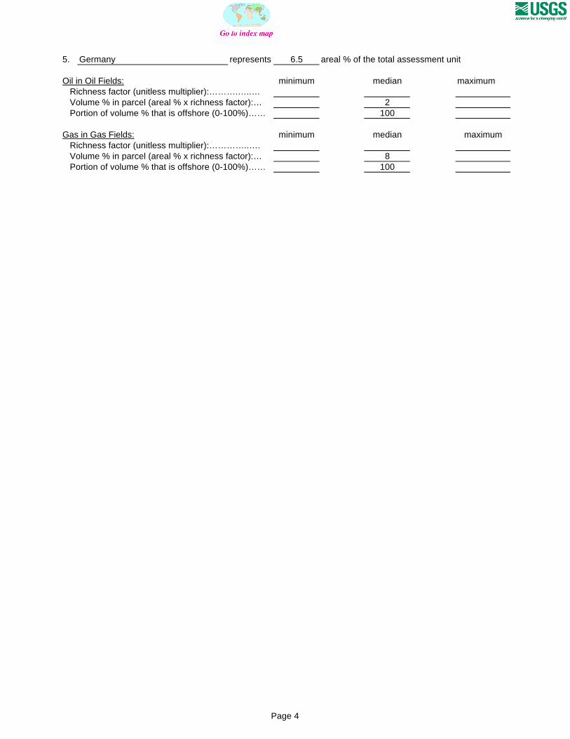
5. Germany represents 6.5 areal % of the total assessment unit
Oil in Oil Fields: minimum median maximum Richness factor (unitless multiplier):……….…..… Volume % in parcel (areal % x richness factor):… 2 Portion of volume % that is offshore (0-100%)…… 100
Gas in Gas Fields: minimum median maximum Richness factor (unitless multiplier):…………..…. Volume % in parcel (areal % x richness factor):… 8 Portion of volume % that is offshore (0-100%)…… 100
Page 4

0
5
10
15
20
25
30
35
2-<4 4-<8 8-<16 16-<32 32-<64 64-<128 128-<256 256-<512 512-<1024
1024-<2048
OIL-FIELD SIZE (MMBO)
UN
DIS
CO
VE
RE
D O
IL F
IEL
DS
(N
o.)
Minimum field size: 2 MMBO
Mean number ofundiscovered fields: 134.3
Central Graben, AU 40250103 Undiscovered Field-Size Distribution

0
2
4
6
8
10
12
14
16
18
12-<24 24-<48 48-<96 96-<192 192-<384 384-<768 768-<1536
1536-<3072
3072-<6144
6144-<12288
GAS-FIELD SIZE (BCFG)
UN
DIS
CO
VE
RE
D G
AS
FIE
LD
S (
No
.)
Minimum field size: 12 BCFG
Mean number ofundiscovered fields: 65
Central Graben, AU 40250103 Undiscovered Field-Size Distribution