Embed Size (px)
Citation preview
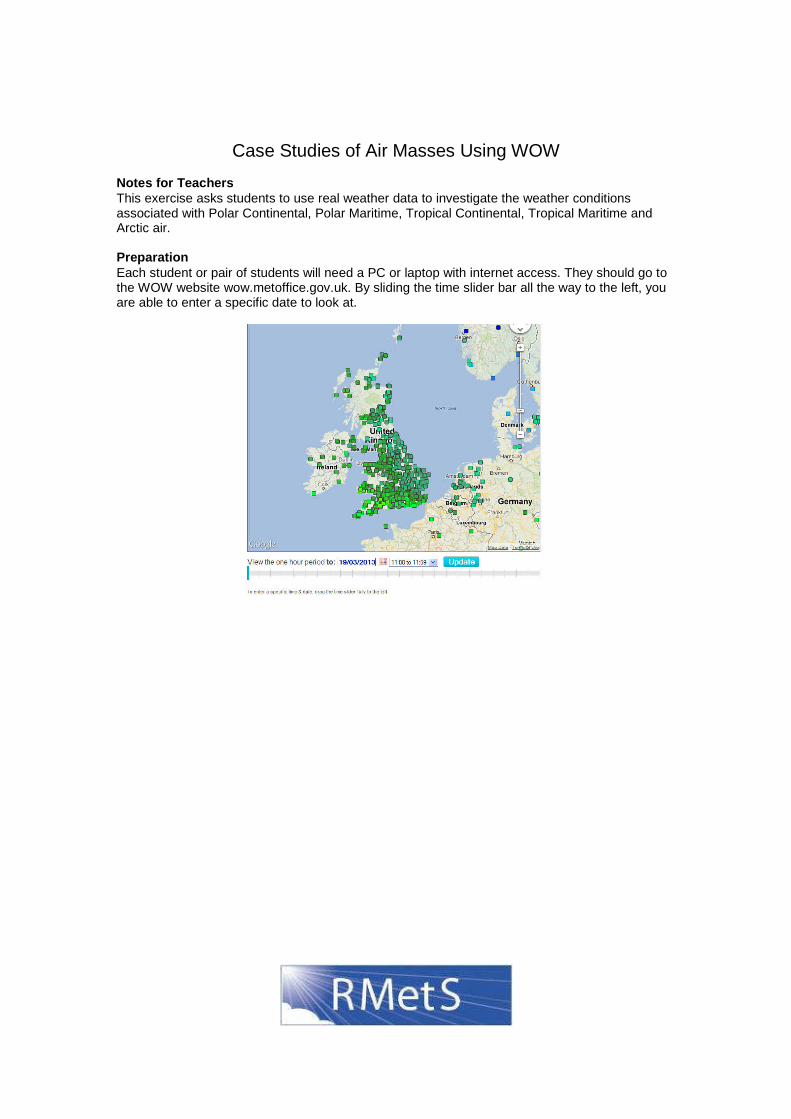
Case Studies of Air Masses Using WOW Notes for Teachers This exercise asks students to use real weather data to investigate the weather conditions associated with Polar Continental, Polar Maritime, Tropical Continental, Tropical Maritime and Arctic air. Preparation Each student or pair of students will need a PC or laptop with internet access. They should go to the WOW website wow.metoffice.gov.uk. By sliding the time slider bar all the way to the left, you are able to enter a specific date to look at.
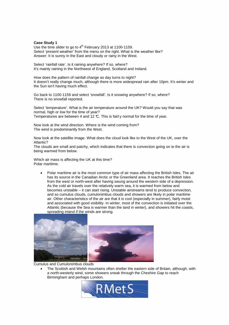
Case Study 1 Use the time slider to go to 4th February 2013 at 1100-1159. Select ‘present weather’ from the menu on the right. What is the weather like? Answer: It is sunny in the East and cloudy or rainy in the West. Select ‘rainfall rate’. Is it raining anywhere? If so, where? It’s mainly raining in the Northwest of England, Scotland and Ireland. How does the pattern of rainfall change as day turns to night? It doesn’t really change much, although there is more widespread rain after 10pm. It’s winter and the Sun isn’t having much effect. Go back to 1100-1159 and select ‘snowfall’. Is it snowing anywhere? If so, where? There is no snowfall reported. Select ‘temperature’. What is the air temperature around the UK? Would you say that was normal, high or low for the time of year? Temperatures are between 4 and 12 °C. This is fairl y normal for the time of year. Now look at the wind direction. Where is the wind coming from? The wind is predominantly from the West. Now look at the satellite image. What does the cloud look like to the West of the UK, over the Atlantic? The clouds are small and patchy, which indicates that there is convection going on ie the air is being warmed from below. Which air mass is affecting the UK at this time? Polar maritime. • Polar maritime air is the most common type of air mass affecting the British Isles. The air
has its source in the Canadian Arctic or the Greenland area. It reaches the British Isles from the west or north-west after having swung around the western side of a depression. As the cold air travels over the relatively warm sea, it is warmed from below and becomes unstable – it can start rising. Unstable airstreams tend to produce convection, and so cumulus clouds, cumulonimbus clouds and showers are likely in polar maritime air. Other characteristics of the air are that it is cool (especially in summer), fairly moist and associated with good visibility. In winter, most of the convection is initiated over the Atlantic (because the Sea is warmer than the land in winter), and showers hit the coasts, spreading inland if the winds are strong.
Cumulus and Cumulonimbus clouds • The Scottish and Welsh mountains often shelter the eastern side of Britain, although, with
a north-westerly wind, some showers sneak through the Cheshire Gap to reach Birmingham and perhaps London.
• With a westerly wind, the winter showers can cross Glasgow and central Scotland to reach Edinburgh and Fife; others travel up the Bristol Channel to affect Cardiff and Bristol.
• In spring and summer, convection clouds tend to be set off inland by daytime heating. Now, the shelter of the western mountains is less important, and showers or short-lived thunderstorms can occur almost anywhere. At night the clouds disperse.
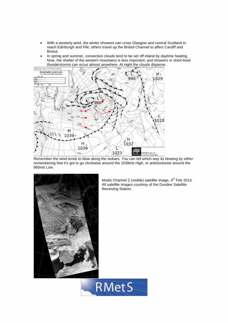
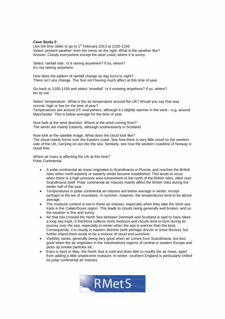
Remember the wind tends to blow along the isobars. You can tell which way its blowing by either remembering that it’s got to go clockwise around the 1039mb High, or anticlockwise around the 960mb Low.
Modis Channel 2 (visible) satellite image, 4th Feb 2013. All satellite images courtesy of the Dundee Satellite Receiving Station.
Case Study 2: Use the time slider to go to 1st February 2013 at 1100-1159. Select ‘present weather’ from the menu on the right. What is the weather like? Answer: Cloudy everywhere except the west coast, where it is sunny. Select ‘rainfall rate’. Is it raining anywhere? If so, where? It’s not raining anywhere. How does the pattern of rainfall change as day turns to night? There isn’t any change. The Sun isn’t having much affect at this time of year. Go back to 1100-1159 and select ‘snowfall’. Is it snowing anywhere? If so, where? No its not. Select ‘temperature’. What is the air temperature around the UK? Would you say that was normal, high or low for the time of year? Temperatures are around 2°C everywhere, although it s slightly warmer in the west – e.g. around Manchester. This is below average for the time of year. Now look at the wind direction. Where is the wind coming from? The winds are mainly Easterly, although southeasterly in Scotland. Now look at the satellite image. What does the cloud look like? The cloud mainly forms over the Eastern coast. See how there is very little cloud on the western side of the UK, carrying on out into the sea. Similarly, see how the western coastline of Norway is cloud free. Which air mass is affecting the UK at this time? Polar Continental. • A polar continental air mass originates in Scandinavia or Russia, and reaches the British
Isles when north-easterly or easterly winds become established. This tends to occur when there is a high pressure area somewhere to the north of the British Isles, often over Scandinavia itself. Polar continental air masses mainly affect the British Isles during the winter half of the year.
• Temperatures in polar continental air masses are below average in winter, except perhaps to the lee of mountains. In summer, however, the temperatures tend to be above average.
• The moisture content is low in these air masses, especially when they take the short sea track in the Calais/Dover region. This leads to clouds being generally well broken, and so the weather is fine and sunny.
• Air that has crossed the North Sea between Denmark and Scotland is said to have taken a long sea track. It therefore collects more moisture and clouds tend to form during its journey over the sea, especially in winter when the sea is warmer than the land. Consequently, it is cloudy in eastern districts (with perhaps drizzle or snow flurries), but further inland there tends to be a mixture of cloud and sunshine.
• Visibility varies, generally being very good when air comes from Scandinavia, but less good when the air originates in the industrialised regions of central or eastern Europe and picks up smoke particles etc.
• Even in April or May, the North Sea is cold and does little to modify the air mass, apart from adding a little unwelcome moisture. In winter, southern England is particularly chilled by polar continental air masses.
Remember the wind tends to blow along the isobars. The air affecting the UK has taken a fairly short track across the North Sea/ English Channel. The polar front is actually to the North of the UK, so the air reaching the UK hasn’t come from very far North.
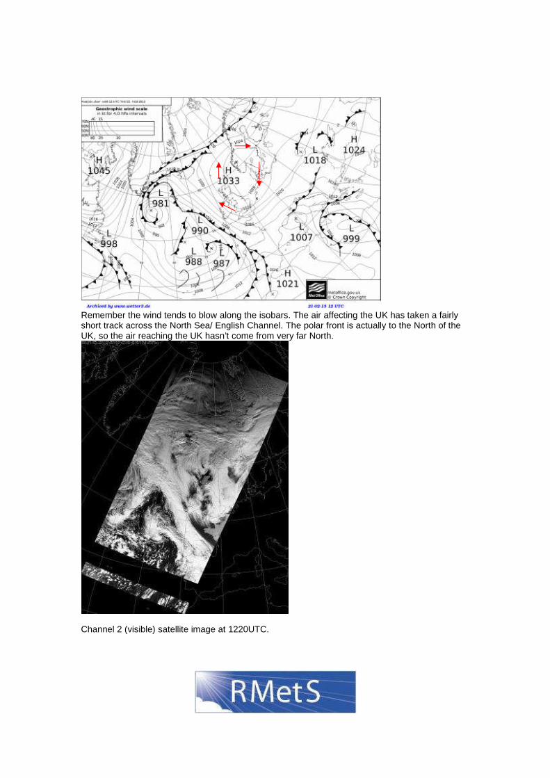
Channel 2 (visible) satellite image at 1220UTC.
Case Study 3: Use the time slider to go to 4th January 2013 at 1100-1159. Select ‘present weather’ from the menu on the right. What is the weather like? Answer: Mostly cloudy with a few patches of sun. Select ‘rainfall rate’. Is it raining anywhere? If so, where? There is no rainfall. How does the pattern of rainfall change as day turns to night? There is no change. It’s winter and the Sun isn’t having much effect. Go back to 1100-1159 and select ‘snowfall’. Is it snowing anywhere? If so, where? There is no snowfall. Select ‘temperature’. What is the air temperature around the UK? Would you say that was normal, high or low for the time of year? The temperature is 10-12°C. That is fairly warm for the time of year. Now look at the wind direction. Where is the wind coming from? South and East. Now look at the satellite image. What does the cloud look like? There is a sheet of cloud over France, the English Channel and the South and East of the UK. Which air mass is affecting the UK at this time? Tropical Maritime. • Tropical maritime air usually approaches the British Isles from the south-west. Its source
region is the subtropical Atlantic Ocean, typically the Azores area, although occasionally it may come almost directly from the Tropics. During its passage across the Atlantic, the air is cooled from below as it passes over a progressively cooler ocean, and so it becomes more stable (not inclined to rise). While it cools down, little of its moisture is lost. It therefore reaches south-west England or western Ireland almost saturated (there is as much condensation going on as evaporation), giving dull, warm, overcast weather. On the coasts, sea fog is common in these tropical maritime south-westerlies. However, if the cloud base of the stratus or stratocumulus is several hundred feet, sea-level sites may be saved from the fog, but on rising ground and hills there may be fog and drizzle. Bodmin Moor, Dartmoor, south-west Wales, western Ireland and western Scotland can be shrouded in mild, damp conditions whether it be winter or summer. The cloud is not convective cloud, caused by the air being warmed from below, rising and cooling, so it is not puffy cumulus clouds. Instead, sheets of layer cloud are generated as the air is cooled from below.
• Further inland, in the summer half of the year at least, the low stratus may be burnt off by the sun and it could turn out to be quite warm, though still humid. In the lee of hills or mountain ranges, the clouds sometimes break up and there is a lot of sunshine. Favoured locations like north Somerset, North Wales, Northumberland and the Moray Firth can become very warm during summer and bask in spring-like weather on a January day. In a tropical maritime air mass, the nights are mild and damp, especially in mid-winter. In December and January, the overcast skies result in little variation in temperature between day and night. However, if there are light winds and clear skies, fog may form inland overnight.
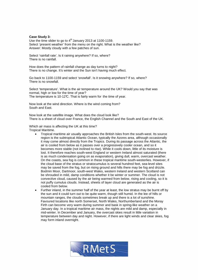
Remember that the wind tends to follow the isobars and will go in a clockwise direction around the 1041mb Highs.
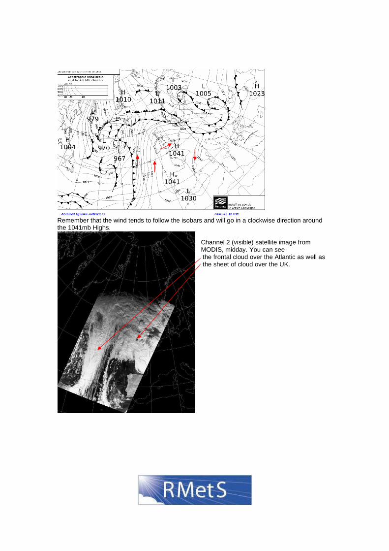
Channel 2 (visible) satellite image from MODIS, midday. You can see the frontal cloud over the Atlantic as well as the sheet of cloud over the UK.
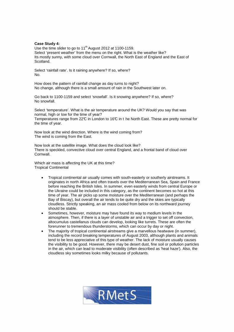
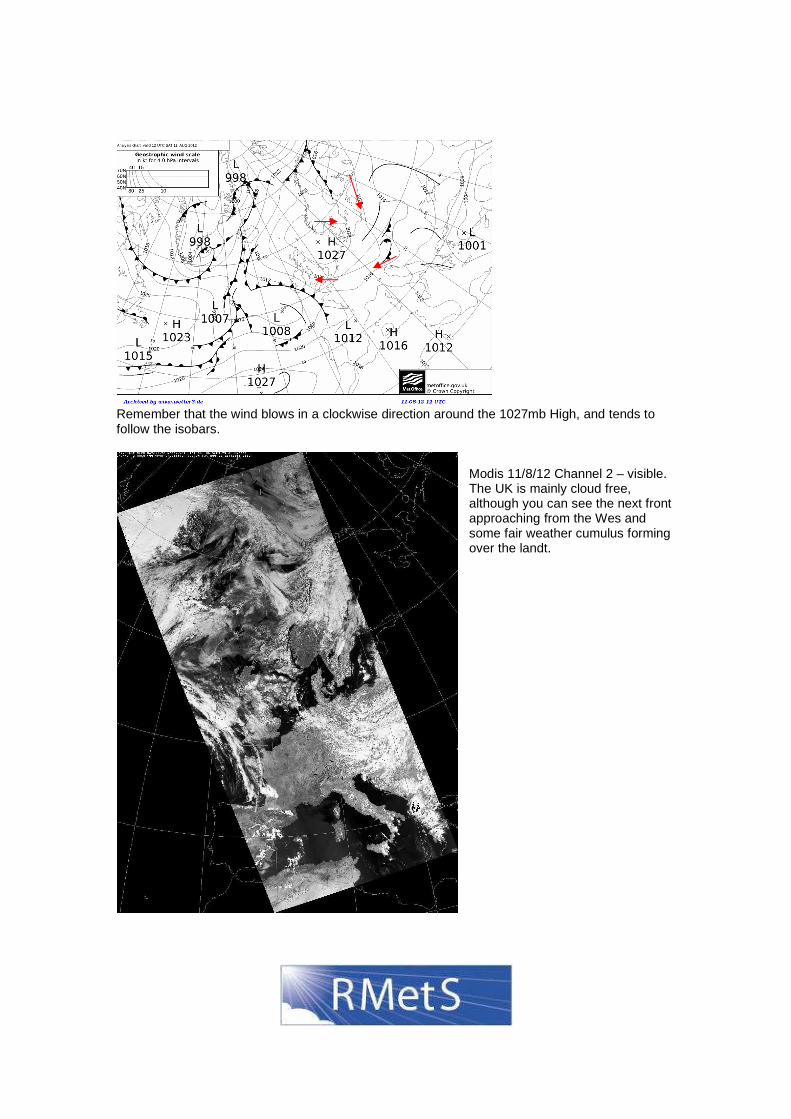
Case Study 4: Use the time slider to go to 11th August 2012 at 1100-1159. Select ‘present weather’ from the menu on the right. What is the weather like? Its mostly sunny, with some cloud over Cornwall, the North East of England and the East of Scotland. Select ‘rainfall rate’. Is it raining anywhere? If so, where? No. How does the pattern of rainfall change as day turns to night? No change, although there is a small amount of rain in the Southwest later on. Go back to 1100-1159 and select ‘snowfall’. Is it snowing anywhere? If so, where? No snowfall. Select ‘temperature’. What is the air temperature around the UK? Would you say that was normal, high or low for the time of year? Temperatures range from 22°C in London to 16°C in t he North East. These are pretty normal for the time of year. Now look at the wind direction. Where is the wind coming from? The wind is coming from the East. Now look at the satellite image. What does the cloud look like? There is speckled, convective cloud over central England, and a frontal band of cloud over Cornwall. Which air mass is affecting the UK at this time? Tropical Continental
• Tropical continental air usually comes with south-easterly or southerly airstreams. It originates in north Africa and often travels over the Mediterranean Sea, Spain and France before reaching the British Isles. In summer, even easterly winds from central Europe or the Ukraine could be included in this category, as the continent becomes so hot at this time of year. The air picks up some moisture over the Mediterranean (and perhaps the Bay of Biscay), but overall the air tends to be quite dry and the skies are typically cloudless. Strictly speaking, an air mass cooled from below on its northward journey should be stable.
• Sometimes, however, moisture may have found its way to medium levels in the atmosphere. Then, if there is a layer of unstable air and a trigger to set off convection, altocumulus castellanus clouds can develop, looking like turrets. These are often the forerunner to tremendous thunderstorms, which can occur by day or night.
• The majority of tropical continental airstreams give a marvellous heatwave (in summer), including the record breaking temperatures of August 2003, although plants and animals tend to be less appreciative of this type of weather. The lack of moisture usually causes the visibility to be good. However, there may be desert dust, fine soil or pollution particles in the air, which can lead to moderate visibility (often described as 'heat haze'). Also, the cloudless sky sometimes looks milky because of pollutants.
Remember that the wind blows in a clockwise direction around the 1027mb High, and tends to follow the isobars.
Modis 11/8/12 Channel 2 – visible. The UK is mainly cloud free, although you can see the next front approaching from the Wes and some fair weather cumulus forming over the landt.
Case Study 5: Use the time slider to go to 6th February 2013 at 1100-1159. Select ‘present weather’ from the menu on the right. What is the weather like? Answer: It is cloudy in the South East, sunny elsewhere. Select ‘rainfall rate’. Is it raining anywhere? If so, where? There is some rain on the East coast. How does the pattern of rainfall change as day turns to night? Rainfall continues to affect the East coast. It’s winter and the Sun isn’t having much effect, so there isn’t much difference between day and night. Go back to 1100-1159 and select ‘snowfall’. Is it snowing anywhere? If so, where? There is no snowfall shown. Select ‘temperature’. What is the air temperature around the UK? Would you say that was normal, high or low for the time of year? The temperature varies from -1.5C in Scotland to 5C. This is about normal for the time of year. Now look at the wind direction. Where is the wind coming from? From the North. Now look at the satellite image. What does the cloud look like? There are small clouds over the North Sea – these are probably cumulus clouds indicating localised convection. There is also a band of cloud over the South East of England. Which air mass is affecting the UK at this time? Arctic Maritime • Arctic air rarely occurs outside winter and is colder and drier than Polar Maritime,
although it picks up sufficient moisture to produce showers, usually of sleet or snow, on north-facing coasts and hills. As a rule, these showers don't travel far inland and many places will be fine and sunny, if rather cold. Occasionally, they may become organised into lines of heavy showers and, rarely, into small depressions known as Polar Lows, which can produce quite heavy falls of snow. If accompanied by strong winds, blizzard conditions may develop, usually over the Scottish Highlands and other areas of high ground..
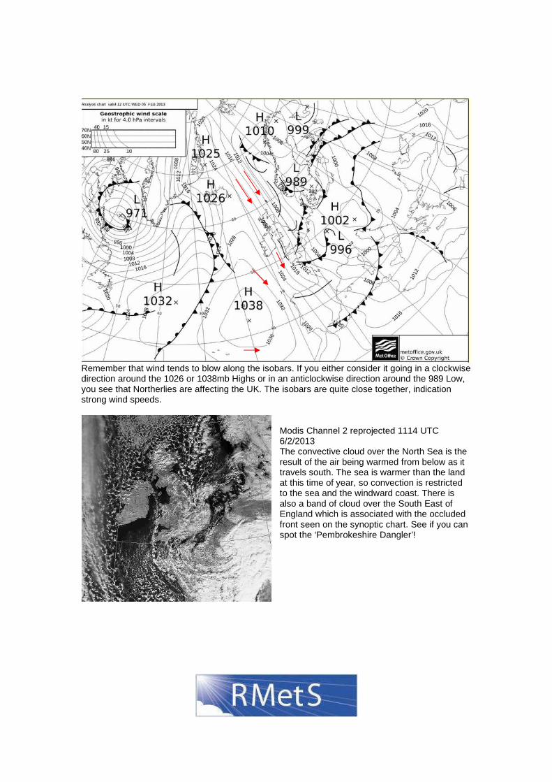
Remember that wind tends to blow along the isobars. If you either consider it going in a clockwise direction around the 1026 or 1038mb Highs or in an anticlockwise direction around the 989 Low, you see that Northerlies are affecting the UK. The isobars are quite close together, indication strong wind speeds.
Modis Channel 2 reprojected 1114 UTC 6/2/2013 The convective cloud over the North Sea is the result of the air being warmed from below as it travels south. The sea is warmer than the land at this time of year, so convection is restricted to the sea and the windward coast. There is also a band of cloud over the South East of England which is associated with the occluded front seen on the synoptic chart. See if you can spot the ‘Pembrokeshire Dangler’!
Possible Extension Activities:
- Draw station plots for the weather charts showing pressure, temperature, weather etc. - The WOW website has 3 types of data – Met Office, WOW sites and quick observations.
Each observation is given a star quality rating. Do you need to take the quality of the data into account? Does the quantity of data on the map matter?
- Is the concept of air masses useful in working out the weather? Look at a weather chart for today when considering your answer.