Embed Size (px)
Citation preview

PLAN OF MANAGEMENT
CAPE BYRON TRUST
CAPE BYRONHEADLAND RESERVE
CAPE BYRONSTATE CONSERVATION AREA


i
Cape ByronHeadlandReserve
Plan of Management
A report prepared for the
Cape Byron Trust by:
Wildsite Ecological ServicesPO Box 1622BYRON BAY NSW 2481E-mail: [email protected]

FOREWORD
Cape Byron Headland Reserve is a State Conservation Area and covers an area of 98.5 hectares,including the most easterly point of the Australian mainland, rugged headlands and shelteredrainforest gullies. It is situated only 2 kilometres from Byron Bay on the far north coast.
The Reserve is of importance to the Arakwal Aboriginal People of Byron Bay. The Reserve maintainsspiritual, cultural and historical significance for the Arakwal People and contains many sites, artefactsand landscapes which are significant in maintaining ties with the past and facilitating the continuationof Aboriginal culture. This plan of management intends to continue the process of reconciliationthrough the further recognition of the Aboriginal cultural values of the Reserve and the support of theArakwal People’s involvement in the planning, management and interpretation of the Reserve.
Cape Byron Headland Reserve is of particular importance because of its spectacular scenery, thediversity of natural features and environments and the cultural historical heritage importance of theCape Byron Lighthouse and associated buildings.
The Reserve is a major focus for local, regional, national and international tourism, as well as formany types of recreation in a natural coastal environment. These range from passive enjoyment ofthe Reserve’s scenery to activities such as lighthouse tours, education programs and whale watching.
The care, control and management of the Reserve rests with the Cape Byron Trust in accordancewith the National Parks and Wildlife Act 1974. The Cape Byron Trust has a membership consisting ofrepresentatives of the community, local and state government and the Arakwal AboriginalCorporation.
This plan of management establishes the scheme of operations for the Cape Byron State RecreationArea. In accordance with section 75 of the National Parks and Wildlife Act 1974, this plan ofmanagement is hereby adopted.
BOB DEBUS
Minister for the Environment

Acknowledgments
The principal author of this plan of management is Andy Baker, Principal Consultant, Wildsite EcologicalServices. The plan has been developed from a detailed discussion of issues prepared by Peter Helman aprevious Trust Board Member. the plan. Nick Rigby, former Reserve Manager, conducted extensive communityissues workshops. Bob Speirs, Director, Commercial and Community Services, Queensland Parks and WildlifeService, provided invaluable guidance in the development of the planning framework adopted by
Peter Parker, author of the 1989 plan of management, Graeme McGregor, Planning Officer, Northern RiversRegion, and a peer review panel, which included Lorraine Cairnes, Adrian Davey and Jim Starling reviewed apreliminary draft.. Vanessa Coverdale provided assistance with plan structure and layout.
Peter Parker, on appointment to the Trust, reviewed the final draft together with Sue Walker, Sean Court andAndy Baker. This review brought the draft plan up to date and included the latest resolutions, actions andaspirations of new Trust members.
The assistance of the Trustees and Reserve staff in the preparation of the plan is also acknowledged.
Cape Byron Headland Reserve Plan of Management
October 2002
ISBN 0-646-39877-6
© 2002 Cape Byron TrustPO Box 127 BYRON BAY NSW Australia 2481
Use permitted with appropriate acknowledgment.
Cover photography:Cape Byron by John D’erry, Byron Bay.
Additional Images by the Silent Picture Show, Mullumbimby.
Printed by the NSW National Parks and Wildlife Service.
Copies of this document may be purchased from the Cape Byron Trust at the above address.
Disclaimer
Any representation, statement, opinion or advice expressed or implied in this document/publication is made ingood faith but on the basis that the Cape Byron Trust, its agents, consultants and employees are not liable(whether by reason of negligence, lack of care or otherwise) to any person for damage or loss whatsoever,which has occurred or may occur in relation to that person taking or not taking (as the case may be) action inrespect of any representation, statement or advice referred to above.

Table of ContentsACKNOWLEDGMENTSTABLE OF CONTENTSLISTS OF ILLUSTRATIONS
List of TablesList of Maps
Part A Basis for ManagementINTRODUCTION 1THE MANAGEMENT PLAN 2
Plan preparation 2Plan review 2Understanding and implementing this Plan of Management 3
LOCAL AND REGIONAL SETTING 4Location and boundary 4Regional context 4Surrounding land uses 4
MANAGEMENT AND ADMINISTRATION 6Cape Byron Headland Reserve 6Cape Byron Trust 6Community involvement 6Financial independence 6Memorandum of Understanding 6Planning context 7
VALUES OF CAPE BYRON HEADLAND RESERVE 13Natural values 13Cultural heritage values 13Recreation and tourism values 13Economic values 14Research and education values 14Scenic and aesthetic values 14Existence, bequest and inspiration values 14
STATEMENT OF S IGNIFICANCE 19PURPOSES OF MANAGEMENT 19
Part B Management Strategies 21
Strategy 1 Natural resource management 231.01 VEGETATION MANAGEMENT 241.02 FAUNA MANAGEMENT 281.03 FIRE MANAGEMENT 311.04 GEOLOGY AND LANDFORM EVOLUTION 341.05 LAND REHABILITATION 361.06 COASTAL LANDSCAPE 381.07 CATCHMENT MANAGEMENT AND WATER QUALITY 401.08 NOISE POLLUTION 42
Strategy 2 Cultural resource management 432.01 ABORIGINAL CULTURAL HERITAGE 442.02 HISTORIC CULTURAL HERITAGE 47
Strategy 3 Recreation, tourism and visitor use 513.01 GENERAL RECREATION MANAGEMENT 523.02 PUBLIC CONTACT, VISITOR EDUCATION AND INTERPRETATION 543.03 SENSE OF PLACE 573.04 COMMUNITY PARTICIPATION 583.05 VISITOR ACCESS 603.06 VISITOR FACILITIES 63

Contents
3.07 VISITOR RISK AND SAFETY 653.08 PARKING CHARGES 673.09 LIGHTHOUSE TOURS 693.10 COMMERCIAL RECREATION MANAGEMENT 713.11 WHALE WATCHING 743.12 VESSEL -BASED ACTIVITIES 763.13 BEACH AND ROCK FISHING 793.14 SURFING 813.15 HANG-GLIDING 833.16 VISITOR ACCOMMODATION 853.17 EDUCATION AND RESEARCH 873.18 CONCESSIONS, LEASING AND LICENSING 88
Strategy 4 Complementary management of adjacent areas 914.01 RESERVE NEIGHBOURS 924.02 CONSERVATION OF ADJACENT AREAS 944.03 PARTICIPATION IN THE LOCAL COMMUNITY 96PLAN IMPLEMENTATION 98REFERENCES 109
Lists of Illustrations
List of TablesTable 1. Flora of conservation significance recorded on the Reserve. 25Table 2. Fauna of conservation significance recorded on and adjacent to the Reserve. 29Table 3. Fire regime thresholds for vegetation communities in the Reserve. 32Table 4. Plan Implementation 96
List of MapsMap 1. Regional ContextMap 2. Administrative ContextMap 3. Physical EnvironmentMap 4. Vegetation CommunitiesMap 5. Access and FeaturesMap 6. Recreational values

Part A
Basis forManagement

Introduction 1
IntroductionCape Byron Headland Reserve is a special andunique part of Australia, which contains a rich floraand fauna, Aboriginal heritage and Europeanhistory.
Situated on the most easterly point of the Australianmainland, the rugged headlands and shelteredrainforest gullies are surrounded by subtropicalcoastal waters that support an abundance ofmarine life.
The Reserve, on the far north coast of New SouthWales, covers 98.5 hectares of the Cape Byronheadland and is a natural, cultural and recreationalresource of outstanding significance.
The diversity of plant communities on the Reserveis dominated by coastal rainforest, and providesessential refuge for many important plants andanimals.
The Reserve has been a significant place forAboriginal people for many thousands of years,being both a provider of daily resources and afocus for ceremony. The Reserve continues to besignificant for Aboriginal people. The ArakwalAboriginal people are actively involved in Reserveplanning issues.
The rich historic heritage of the Reserve issymbolised by the Cape Byron Lighthouse, whichhighlights the role of the Cape in the developmentof Byron Bay. The Cape and the Lighthousecontinue to be reference points for the Byron Baytownship and tourism.
Cape Byron has 360o views of the ocean, ByronBay township and the Mount Warning caldera. Itprovides a unique setting for a range of recreationalactivities, ranging from walks through the rainforestto hang-glider flights over the Cape and the best ofAustralia’s land-based whale watching.
For those who live in or visit Byron Bay, the Cape isa special place able to provide inspiration, respiteand re-connection. It has a powerful sense of placeand its grandeur captivates the mind.
Cape Byron is an integral part of Byron Bay, apopular tourist destination, with a significantreputation for its natural beauty, cultural diversityand a relaxed and rejuvenating atmosphere.
Cape Byron Headland Reserve is part of the NewSouth Wales National Parks and Wildlife Service(NPWS) estate. The Reserve’s management isdistinctive among National Park and WildlifeService areas, being managed by a community-based Trust. The Cape Byron Trust (the “Trust”)has a membership of community and governmentrepresentatives who have a broad range ofopinions, skills and experience.
The Trust has achieved remarkable success in itsfirst decade of management from the restorationand promotion of the Reserve’s cultural heritage,and the sensitive development of diverse recreationopportunities, through to the preservation andregeneration of the Reserve’s unique plant andanimal communities. It has established essentialinfrastructure, an effective management framework,and an experienced and skilled staff. Thisfoundation has been achieved through thedevelopment and implementation of creative self-funding opportunities.
This Plan provides the framework within which theTrust will manage the Reserve for the next tenyears. Working in partnership with the community,the Trust will build on this solid foundation toprotect and promote the outstanding values of theReserve.

The Plan2
The Management Plan
Plan preparationThe National Parks and Wildlife Act 1974 (NSW)requires that a plan of management be prepared foreach National Park and Wildlife Service area. Aplan of management is a legal document thatoutlines how an area will be managed in the yearsahead. The Cape Byron Headland Reserve waspreviously subject to a plan of managementadopted in 1992 by the Minister for Lands .
The planning framework established in this Planhas been derived from the Great Sandy RegionManagement Plan (Queensland NPWS 1994).
A peer review panel was established by the CapeByron Trust to review the Draft Plan prior to publicexhibition. The role of the panel was to advise theTrust on how well the Draft Plan meets the goals ofbest practice for natural and heritage conservationplanning and management.
Plan reviewThis Plan provides the framework within which theCape Byron Headland Reserve will be managed.The year 2011 is the planning horizon which willallow sufficient time to enact the major actionsidentified in this Plan and to evaluate outcomes.
The guidelines, policies and actions in this Plan willcommence from the date of approval and continueuntil the Plan is amended by the Minister.Amendments may be made as a result of changingcircumstances or better information resulting fromresearch and monitoring activities.
The policies and actions established in this Planprovide the framework for management of theReserve and are consistent with the significance ofthe Reserve and the anticipated resourcesavailable to the Trust. Other management actionsmay be developed over the life of this Planconsistent with the policies set out in the Plan.
Where not specifically provided for in this Plan,management of the Cape Byron Headland Reservewill be in accordance with the National Parks andWildlife Act and with Trust and National Parks andWildlife Service policies.
The planning process leading to the developmentof this Plan has involved the collection and use of alarge amount of information which, for reasons ofdocument size, has not been included in the Plan.
Management principlesThis plan was prepared in accordance with theNational Parks and Wildlife Act 1974.
The purpose of reserving land as a stateconservation area is to identify, protect andconserve areas that:
(a) contain significant or representativeecosystems, landforms or natural phenomena orplaces of cultural significance, and
(b) are capable of providing opportunities forsustainable visitor use and enjoyment, thesustainable use of buildings and structures orresearch, and
(c) are capable of providing opportunities for usespermitted under other provisions of the Act.
A state conservation area is to be managed inaccordance with the following principles:
(a) the conservation of biodiversity, themaintenance of ecosystem function, the protectionof natural phenomena and the maintenance ofnatural landscapes,
(b) the conservation of places, objects and featuresof cultural value,
(c) provision for the undertaking of uses permittedunder other provisions of the Act having regard tothe conservation of the natural and cultural valuesof the state conservation area,
(d) provision for sustainable visitor use andenjoyment that is compatible with the conservationof the state conservation area's natural and culturalvalues and with uses permitted under otherprovisions of the Act in such areas,
(e) provision for the sustainable use (includingadaptive reuse) of any buildings or structures ormodified natural areas having regard to theconservation of the state conservation area'snatural and cultural values and with uses permittedunder other provisions of the Act in such areas,
(f) provision for appropriate research andmonitoring.

The Plan 3
Understanding and implementing thisPlan of ManagementThis Plan constitutes the planning framework withinwhich the Cape Byron Headland Reserve will bemanaged to the year 2011. This Plan sets out theprocess that identifies what outcomes are desiredand what actions will be undertaken to achievethem. However, it is also the responsibility ofmanagement to monitor and report whether andhow cost effectively the outcomes are actuallybeing achieved.
Information in this document is presented in twoparts: Part A provides the basis for managementand Part B provides strategies which include thefollowing:
• natural resource management;
• cultural resource management;
• recreation, tourism and visitor management;and
• complementary management of adjacentareas.
Each subject is dealt with in the following format:
Cape ByronHeadlandReserve
Plan of Management
Subject headingSubject name and number for reference purposesSee also: Specifies other subjects within the plan that
address similar or related matters.
Background Information
Information which needs to be known in order tocomprehend this subject and which provides acontext for the outcomes, guidelines and actions.
DESIREDOUTCOMES
The desired condition of one or more specificattributes of the subject to be achieved by orbefore 2011.
EXISTINGSITUATION
The current condition of the attributes referred toin ‘Desired outcomes’.
GUIDELINESAND POLICIES
Guidelines and policies to guide the change fromthe existing situation to the desired outcome.
ACTIONS Actions needed to bring about the proposedchange from the existing situation to the desiredoutcome.
The actions are not in order of priority and includeitems of required information, positions onrelevant issues, and the implementation of actionsranging from on ground works to those thatencourage attitudinal and behavioural change.
See Table 4 for action priorities.
The Planning Process4
Local and Regional Setting
Location and boundaryCape Byron Headland Reserve, on the easternmost point of the Australian mainland, is situated onthe far-north coast of NSW, approximately 2kilometres east of the town of Byron Bay.
The Reserve covers 98.5 hectares and adjoinsfreehold land and Crown reserves. The internalboundary of the Reserve is complex and adjoinsresidential areas, public roads and serviceeasements.
Regional contextThe Reserve is an integral component of a regionalsystem of national parks and nature reserves lyingalong the northern NSW coastline (Map 1). Itsupports littoral rainforest, a vegetation communitywhich once occurred extensively along the northernNSW coastline. The largest remaining remnant oflittoral rainforest is located within the Iluka NatureReserve, approximately 80 km south of CapeByron.
The coastal landscape when viewed from theReserve includes the following:
• to the south, along Tallow Beach is the ArakwalNational Park and existing Broken Head NatureReserve;
• to the south-west on the escarpment is theHayters Hill Nature Reserve;
• to the west and north-west on the coastal plainare the Cumbebbin, Tyagarah, MarshallsCreek, Brunswick Heads, Wooyung andBillinudgel Nature Reserves;
• to the far west the Mt Warning, Nightcap, MtJerusalem and the Border Ranges NationalParks form an significant landscape element;and
• offshore to the north in Byron Bay embaymentare the Julian Rocks Aquatic Reserve andJulian Rocks Nature Reserve.
These reserved areas and other unreservedvegetation remnants combine with Crown andfreehold land to form a network of conservationassets which contribute to the region’s biodiversity.The retention and enhancement of natural areasand their connecting corridors is important for theecological sustainability of the Reserve.
The Reserve is close to the large regional centresof northern NSW and the major population centresof southeast Queensland with approximately twomillion people residing within less than three hourstravelling time of the Reserve. This population isexpected to increase substantially over the next 20years.
The Reserve is a significant tourist attraction, withover 600,000 persons visiting the LighthousePrecinct each year and it is estimated that theentire Reserve receives in excess of one millionregional, interstate and international visitorsentering the Reserve each year. The Reserve is asignificant regional employment provider throughdirect employment, contracted services and byproviding opportunities for commercial interests.
The Reserve is a significant recreational resource,providing access to a diversity of opportunities.The range and quality of recreational opportunitiesoffered is unmatched in the region.
Surrounding land usesThe Reserve lies within the local government areaof Byron Shire. Land tenures adjacent to theReserve include Crown and Council ManagedReserves, freehold land within the Wategos andLighthouse Road residential area and roadnetworks.
The variety of land uses adjacent to the Reserve isan important consideration of management as theyhave the potential to impact on the natural, culturaland recreational values of the Reserve.
The seaward boundaries of the Reserve extend tothe mean low water mark and adjoin marine areasthat provide for commercial and recreational wateractivities. The Arakwal National Park comprisesthe coastal lands to the south of the Reserve,adjoining the southern boundary. Themanagement of these lands by the National Parksand Wildlife Service will complement theconservation of the Reserve’s natural, cultural andrecreational values.
Land uses adjoining the complex internalboundaries of the Reserve include residentialareas, service easement corridors and a publicroad network. The extended and irregular shape ofthe Reserve’s internal boundary exposes theReserve to impacts from weeds, domestic animals,stormwater and pedestrian access.
There is a permissive occupancy within theReserve at Clarkes Beach.
Two encroachments on the Reserve are occupiedunder licence and/or lease agreements.

Basis for Management 5

Basis for Management6
Management andAdministration
Cape Byron Headland ReserveThe Cape Byron Headland Reserve wasestablished in 1903 for ‘public recreation and thepreservation of native flora’.
In 1933, three Special Leases were granted, forgardens, orchards and grazing within the Reserveat Wategos Beach. In the 1960s, these lands wereexcised from the Reserve for urban subdivision.Residential subdivisions along Lighthouse Roadwere excised from the Reserve in the 1940s.
In 1989 the Cape Byron Trust was established, andthe Reserve was managed as a Crown Reserveunder the NSW Crown Lands Consolidated Act1913.
In 1997, the Cape Byron Headland Reserve wasgazetted as a State Recreation Area and part of theNSW National Parks and Wildlife Service estate.Under the National Parks and Wildlife AmendmentAct 2001 the reserve became a State ConservationArea on 4 October, 2002 . The Cape Byron StateConservation Area is known publicly as the CapeByron Headland Reserve.
Cape Byron TrustThe management of the Cape Byron HeadlandReserve differs from most other National Parks andWildlife Service areas as it is managed by a localcommunity trust, an incorporated, non-profit body.
The Cape Byron State Conservation Area Trust,known as the Cape Byron Trust is empowered bySection 47GA of the National Parks and WildlifeAct, 1974. Under the Act, the Trust is consolidatedas a corporation and ‘has the care, control andmanagement of the Cape Byron HeadlandReserve’. The Trust Board is appointed by theNSW Minister for the Environment and is subject tothe control and direction of the Director-General ofNational Parks and Wildlife. Re-appointment of theTrust is due on 30 June, 2003.
Since its establishment, the Trust has beensuccessful in the management of the Reserve. Themix of community and government representationon the Trust enables the effective integration of awide range of aspirations and results in an informedand careful approach to management.
Community involvementStrong and meaningful community involvement isthe cornerstone of the Trust’s management of theReserve. There is strong support for continuedcommunity involvement in the care, control andmanagement of the Reserve by an independentand autonomous Trust.
Due to the diversity of Board members, the Trusthas been effective in integrating the views of bothspecial interest groups and the wider community inthe consideration of management issues.
The Trust maintains community ownership andstewardship of the Reserve through the provision ofopportunities for the community to be involved inplanning and management .
Financial independenceThe Trust provides an outstanding model forprotected area management. successfullygenerating the majority of income required tomanage the Reserve.
In 2000-01, the Trust covered approximately 90%of its recurrent costs, only relying on public fundingfor special projects and capital improvements.
All income generated by the Trust is returneddirectly to fund Reserve management.
The Trust's philosophy is that income-generatingactivities should be appropriate and sustainablewith charges and licence fees reflecting the cost ofmanagement and the benefits gained from the useof the Reserve.
Memorandum of UnderstandingThe Trust has powers and functions conferred uponit by the National Parks and Wildlife Act, 1974 andby a Memorandum of Understanding between theTrust and the Director-General of National Parksand Wildlife.
The Memorandum of Understanding establishesthe framework for the operational relationshipbetween the Trust and the NPWS and the role ofthe Trust in relation to the care, control andmanagement of the Reserve.
Through the Memorandum of Understanding, theTrust is guaranteed ‘the highest level’ ofmanagement autonomy whilst meeting anystatutory requirements resulting from its operationunder the National Parks and Wildlife Act, 1974.The Memorandum of Understanding seeks toensure a harmonious, beneficial and effectiveworking relationship between the Trust and theNPWS.
The Trust can establish policies and procedures toimplement planning and management strategieshowever these should be guided by National Parksand Wildlife Service policy.

Basis for Management 7
Planning contextNSW Environmental Planning andAssessment Act, 1979
Part 5 of the NSW Environmental Planning andAssessment Act, 1979 (EPA Act) places a duty onall public authorities to fully assess theenvironmental impact of their activities beforemaking a determination. When considering thelikely impact of a proposal certain matters(specified under sections 111 and 112 of the EPAAct and clause 82 of the EPA Regulation) must betaken into account.
NSW Coastal Policy
The New South Wales Coastal Policy (1997)provides a framework for the coordinatedmanagement of the coastal zone. The Policyapplies to inshore areas, coastal water bodies andland of coastal features such as lakes, bays andtidal rivers. Thus, lands within the Reserve arecovered by this Policy.
Cultural heritage
The Charter for the Conservation of Places ofCultural Significance (the ‘Burra Charter’) wasprepared by the International Council onMonuments and Sites (Australia ICOMOS) toprovide a consistent framework for the recognitionand protection of cultural places in Australia. TheCharter seeks to care for culturally significantplaces by understanding the cultural values of theplace and its setting and providing appropriatepolicies regarding its management, use andinterpretation. The Charter provides the basis forthe Trust’s heritage assessments, conservationplans and overall management of the Europeanand Aboriginal cultural heritage values of theReserve. The National Parks and Wildlife ServiceLighthouses: Draft Conservation Management andCultural Tourism Plan (1999) is consistent with theCharter and guides the practical management ofthe historical resources on the Reserve.
Arakwal Aboriginal Corporation
On 22 December 1994, the Arakwal AboriginalCorporation lodged a Native Title DeterminationApplication (NC95/01), which covers the land andsea between Byron Bay and Broken Head includingthe Reserve.
The Arakwal Aboriginal Corporation, establishedunder the Aboriginal Councils and Association Act1976, is a prescribed body to represent the nativetitleholders and their rights, interests and benefits intrust.
In April 1997, the NSW Ministers for theEnvironment and for Land and Water Conservationsigned an agreement with the Arakwal AboriginalCorporation and the Arakwal claimants. Theagreement allowed for the transfer of Reservelands from the Department of Land and WaterConservation to the National Parks and WildlifeService, while maintaining the Native Titleapplication. The agreement also provided for theappointment of an Arakwal Aboriginal Corporationrepresentative to the Cape Byron Trust by theMinister for the Environment.
The Trust has established a cooperativepartnership with the Arakwal Aboriginal Corporationthrough continued representation on the Trust. TheTrust intends to continue the process ofreconciliation through the further recognition of theAboriginal cultural values of the Reserve andsupport of the Corporation’s involvement in theplanning, management and interpretation of theReserve.
Regional Environment Plan
The North Coast Regional Environmental Plan(REP) provides guidelines for planning, thepreparation of Local Environmental Plans andrecognition of government policy such as theCoastal Policy.
Under Schedule 2 of the REP, the Cape ByronLighthouse and lighthouse buildings are classifiedas ‘Heritage Items of State and RegionalImportance’. The Plan places strict controls on thealteration of buildings or the setting of heritageitems.
The objectives of the REP with respect to the landssurrounding the Reserve are to:
• provide corridors between significant areas ofnatural vegetation and wildlife habitat; and
• enhance and protect the visual quality of thecoastal environment, including areas adjacentto headlands, skylines and escarpments.
The Department of Urban Affairs and Planning(DUAP) has commenced the Northern RiversRegional Strategy to review the regional plan andincorporate sustainable development principles.
The initial report of this strategy, Guiding Principlesfor a Sustainable Future, recognises and adaptsthe definition of sustainability principlesincorporated into NSW legislation, for example, theLocal Government Amendment (EcologicallySustainable Development) Act 1997 (NSW).
Ecologically Sustainable Development Principleshave been adopted by the Trust and are outlinedbelow.
• Precautionary principle: Public and privatedecisions should assess the risk of options andbe guided by consideration of the need to avoid

Basis for Management8
serious or irreversible damage to theenvironment.
• Inter-generational equity: The need for thepresent generation to ensure that the diversityand productivity of the environment ismaintained for future generations.
• Conservation of biodiversity and ecologicalintegrity: A fundamental consideration of alldecision making should be the conservation ofbiodiversity and the protection of ecologicalprocesses.
• Improved valuation, pricing and incentives:Environmental factors should be included in thevaluation of assets and services throughpayment for pollution, users contributing to thefull cost of environmental management andproviding incentives to improve environmentalmanagement.
In addition, the Northern Rivers Regional Strategyendorsed the following:
• a global perspective and the region’srelationship with other areas;
• the quality of human welfare andcommunity participation;
• the value of the region’s natural capital andthe limits on natural resource use; and
• efficient of use of resources.
Byron Shire Local Environment Plan
The proposed new Byron Shire Local EnvironmentPlan will see the Reserve identified as a place witha specific character statement. Any developmentwithin the Reserve will be in accordance with anyManagement Plan that may apply to the land at thetime or with the National Parks and Wildlife Act1974. Byron Local Environment Plan (1988)(BLEP) recognises the Lighthouse Complex as anitem of environmental heritage (Schedule 2) towhich special considerations apply to any proposedworks or alterations. The zoning of the Reserveand adjacent areas includes the following (Map 2):
• 1(d) (Investigation Zone) – Lands underinvestigation.
• 2(a) (Residential Zone) – Land zoned forhousing and associated neighbourhoodfacilities with controls for the location, form,character and density of development.
• 6(a) (Open Space Zone) – Land zoned forrecreational use.
• 7(b) (Coastal Habitat Zone) – Land zoned forcoastal habitat protection and prohibits mostdevelopments.
• 7(d) (Scenic/Escarpment Zone) – Land zonedfor its scenic quality and prohibits mostdevelopment.
• 7(f1) (Coastal Land Zone) – Coastal land zonedfor its environmental sensitivity and prohibitsdevelopment which would adversely affect, orbe adversely affected by coastal processes.
The National Parks and Wildlife Service estate isexempt from Council approval processes.
Amendments to the BLEP should see the Reserverezoned to 8(a) ‘National Parks and NatureReserve Zone’.

Basis for Management 9
The Planning Process10
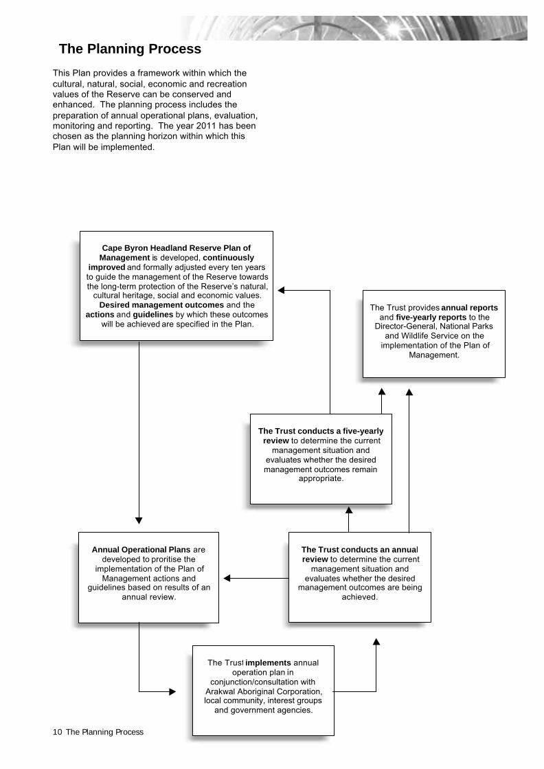
This Plan provides a framework within which thecultural, natural, social, economic and recreationvalues of the Reserve can be conserved andenhanced. The planning process includes thepreparation of annual operational plans, evaluation,monitoring and reporting. The year 2011 has beenchosen as the planning horizon within which thisPlan will be implemented.
Cape Byron Headland Reserve Plan ofManagement is developed, continuously
improved and formally adjusted every ten yearsto guide the management of the Reserve towardsthe long-term protection of the Reserve’s natural,
cultural heritage, social and economic values.Desired management outcomes and the
actions and guidelines by which these outcomeswill be achieved are specified in the Plan.
Annual Operational Plans aredeveloped to proritise the
implementation of the Plan ofManagement actions and
guidelines based on results of anannual review.
The Trust conducts an annualreview to determine the current
management situation andevaluates whether the desired
management outcomes are beingachieved.
The Trust provides annual reportsand five-yearly reports to the
Director-General, National Parksand Wildlife Service on the
implementation of the Plan ofManagement.
The Trust implements annualoperation plan in
conjunction/consultation withArakwal Aboriginal Corporation,local community, interest groups
and government agencies.
The Planning Process
The Trust conducts a five-yearlyreview to determine the current
management situation andevaluates whether the desiredmanagement outcomes remain
appropriate.

Basis for Management 11
Evaluation of management effectiveness(achievement of outcomes)
An evaluation of management will be based on amonitoring program which will identify the extent towhich outcomes have been achieved.
Cape ByronHeadlandReserve
Plan of Management
Subject heading
DESIREDOUTCOMES
As specified in the Plan of Management.
PERFORMANCEINDICATORSAND MEASURES
1. Identification of parameters that indicate thecondition of the attribute(s) of the subject.
2. Specification of means by which to measurechange in the indicators.
PERFORMANCEASSESSMENT
Assessment of the extent to which the condition ofthe attribute(s) of this subject have changed fromthe condition existing in 2001 toward the conditionsought by or before 2011.
MANAGEMENTRESPONSE
Proposed amendments to the guidelines, policiesand actions for this subject.

Basis for Management12
Monitoring the implementation
A management information system will beestablished which will track the process ofimplementing the specified strategies and actions.
Cape ByronHeadlandReserve
Plan of Management
Subject heading
DESIREDOUTCOMES
As specified in the Plan of Management.
GUIDELINE/POLICY/ACTION
Individual guideline, policy or action as specifiedin the Plan of Management.
STATUS Statement of progress made (e.g. completed,extent to which completed, not yet commenced).
RESOURCECOST
Direct cost (and indirect cost where appropriate)of implementation of this guideline, policy oraction – expended or committed.
CONTRIBUTION TOOUTCOME
Assessment by manager of the extent to whichcomplete or partial implementation of thisguideline, policy or action has contributed toachievement of the outcome specified above.
MANAGEMENTRESPONSE
Proposed amendments to the guidelines, policiesand actions for this subject.

Basis for Management 13
Values of Cape Byron HeadlandReserve
Natural valuesVegetation
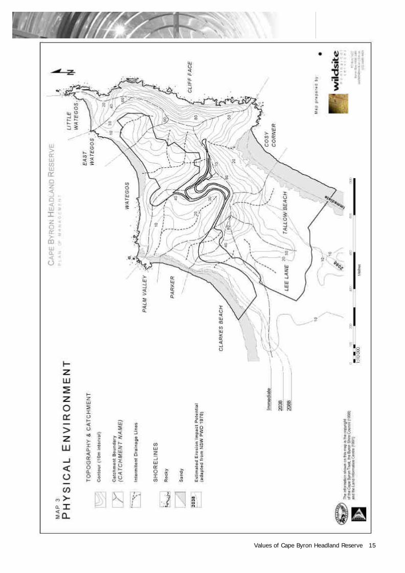
A variety of vegetation communities are foundwithin the Reserve. These range from wetsclerophyll forests dominated by brushbox(Lophostemon confertus) and cabbage palm(Livistona australis) along sheltered creeklinesdraining to The Pass and to Clarkes Beach,through to low, wind-swept grasslands dominatedby kangaroo grass (Themeda australis) on theexposed headlands (Map 4).
Several of the plant communities in the Reserveare remnants of formerly widespread vegetationtypes which are of local, regional or statesignificance. In particular, littoral rainforest has arestricted distribution along the NSW coast todaydue to extensive past land clearing.
Three plant species found on the Reserve are listedunder the Threatened Species Conservation Act1995: scented acronchia (Acronychia littoralis), afern, (Drynaria rigidula) (both Schedule 1,Endangered), and stinking cryptocarya(Cryptocarya foetida) (Schedule 2, Vulnerable).
More than 10% of the plant species found on theReserve are of regional, state or nationalconservation significance.
Native Animals
The Reserve provides a diversity of fauna habitatsincluding those of threatened frog, bird and batgroups.
Over 100 species of birds, including both local andmigratory species, have been recorded within theReserve.
The marine environment adjacent to the Reservesupports several threatened fauna species,including the humpback whale (Megapteranovaeangliae), the southern right whale (Eubalaenaaustralis), the leathery turtle (Dermochelyscoriacea), the green turtle (Chelonia mydas) and theloggerhead turtle (Caretta caretta).
Threatened fish recorded within marine watersadjacent to the reserve include the grey nurse shark(Carcharias taurus).
The remains of many terrestrial vertebrate species,including the greater glider and the eastern greykangaroo, have been found within midden depositson the Reserve, however these species have notbeen recorded within coastal Byron Shire for someyears.
Cultural heritage values The Aboriginal and cultural significance of theReserve is outstanding. The cultural heritagevalues of the Reserve provide a unique insight intothe long history of human occupation of the regionand the importance of Cape Byron in the region’sdevelopment.
Aboriginal
Cape Byron has been a place of great significancefor Aboriginal people for many thousands of years.The Aboriginal values of the Reserve remainsignificant for both indigenous and non-Aboriginalcommunities, despite changes to the landscapebrought about by European settlement.
Aboriginal cultural values range from significantsites and artefacts to the natural landscapeelements that reflect the pre-Europeanenvironment.
Three open camp/midden sites have been recordedon the Reserve. The Pass midden is the oldest(circa 1,440) and only large and substantiallyundisturbed foredune pipi midden between Ballinaand the Queensland Border.
Scattered stone artefacts and an Aboriginal BoraRing have also been reported above LighthouseRoad. The Reserve is also believed to be asignificant location of tribal fights.
Historic cultural heritage
The heritage values of the Reserve are closelyassociated with the historical development of theByron Bay region; through exploration, settlement,trade, commerce and land use.
The most significant heritage element is the CapeByron Lighthouse and the associated buildings.The Lighthouse is of national significance for itsassociation with navigation safety, its method andthe technology used during construction and itsstate of conservation.
The first permanent non-Aboriginal structure inByron Bay was Jarman’s Hotel. This was locatedwithin Palm Valley and contained a hotel, store,bakery and butchery.
The Reserve contains evidence of shifts in regionalland-use and industry, such as timber getting,grazing, agricultural plantations, sand mining, andmore recently, tourism.
Recreation and tourism valuesThe Reserve supports a high level of communityownership and is a major recreational resource forByron Bay and the north-coast region. It provideseasily accessible recreation opportunities of adiversity and quality unique to the north-coast (Map6).

Values of Cape Byron Headland Reserve14
The Reserve’s natural and cultural setting allows asense of escape from the Byron Bay township andcomplements recreational opportunities provided bythe nearby Broken Head and Tyagarah NatureReserves.
Recreational opportunities include picnics,barbecues, walking, jogging, cycling, surfing,fishing, snorkelling, hang-gliding and lighthousetours. The Reserve is recognised as one of thebest land-based whale watching sites in the world.Holiday rental accommodation is available incottages managed by the Trust within the Reserve.
The Reserve is easily accessible from the populartourist destination of Byron Bay and contains manysites of interest. These include the Lighthouse andits historic precinct and cottages, the eastern mostpoint on the Australian mainland, spectacularscenic walks, rocky headlands and cliffs,unprecedented views, protected beaches, shelteredrainforest gullies and abundant marine life.
Economic valuesThe Reserve has significant economic value for theregion by providing direct and indirect employmentand enhancing the scope and attractiveness oflocal tourist assets.
Many of the businesses in Byron Bay utilise theLighthouse and the coastal landscape of theReserve to promote their identities.
Of the nine lighthouses located in NPWS estate,Cape Byron Lighthouse is recognised as the mostsophisticated in terms of tourist development andmanagement.
Research and education valuesThe Reserve provides an ideal natural and culturalresource for research and education by tertiaryinstitutions, school groups, tour operators andspecial interest groups.
Many aspects of the Reserve, including biological,geological, cultural, social, tourism and recreationalcomponents, present opportunities for education,interpretation and research. Education andinterpretation provides opportunities to generateawareness of, and support for, the Trust’smanagement of the Reserve.
The Trust has provided significant resources foreducation and interpretation and has developed asophisticated volunteer program whereby membersof the local community are trained in interpretiveactivities.
Scenic and aesthetic valuesThe Cape Byron headland and Lighthouse are aprominent visual element within the Byron Bayarea. The Cape is a significant component of thecoastal landscape and provides unrivalled views ofthe Tweed to Ballina coastline, the hinterland andthe ranges. Viewing platforms located at prominentpositions and walking trails enhance thepresentation of the Reserve’s scenic and aestheticvalues (Map 5).
Existence, bequest and inspiration valuesPeople derive pleasure from knowing that theReserve is protected, even though they may nevervisit it. The Reserve supports a high level of publicownership and the Trust’s role in preservationallows the community to experience the areasnatural and cultural values.
Values of Cape Byron Headland Reserve 15

Values of Cape Byron Headland Reserve16

Basis for Management 17

Basis for Management18
Basis for Management 19
Statement of SignificanceThe Reserve is one of a number of reserves on thefar north-coast of NSW which protects significantfeatures of the natural and cultural environment,and provides a diversity of recreation opportunities.
The Reserve:
• protects important communities of vegetationon the far north-coast of NSW and contributesto a larger system of vegetation communitiesand corridors;
• protects threatened native plants and animals,and provides numerous habitats for a variety ofmore common native animals;
• is a significant area to the Arakwal Aboriginalpeople;
• contains and protects and conserves one of thelargest and oldest Aboriginal middens in theregion;
• contains and protects and conserves the CapeByron Lighthouse and associated buildingswhich are of national historic significance;
• provides opportunities for a variety ofrecreational activities in a natural landscapesetting adjacent to Byron Bay township;
• is an important tourist resource which attractsaround one million visits a year;
• is the most easterly point of the Australianmainland;
• offers spectacular panoramic views of theocean, stretching coastline and the Australianmainland, and is itself a significant landscapefeature of coastal Byron Shire;
• is a focus of community involvement in natureconservation and education activities;
• provides a valuable environmental educationalresource; and
• is a nationally significant land-based whalewatching site from which to observe the annualmigrations of the humpback whale.
Purposes of ManagementThis Plan of Management has been prepared toassist the Trust in managing:
• the natural resources and cultural values of theReserve;
• the diversity of recreational and educationalopportunities available;
• how the community will participate in Reserveplanning; and
• the business opportunities available.
The Reserve will be managed for the followingpurposes:
• to protect, conserve, present, rehabilitate andtransmit to future generations the physicallandscape, biological, cultural heritage andother significant values of the entire CapeByron Headland Reserve, together with thecomponents and processes required for theircontinuance;
• to provide a diversity of high-quality recreationand educational opportunities to ensure thewidest possible cross-section of the communityis able to experience and appreciate the CapeByron Headland Reserve commensurate withtheir needs, interests, capabilities andexpectations;
• to maintain community ownership andstewardship of the Cape Byron HeadlandReserve, through the provision of meaningfulopportunities for the community to participate inand be consulted about the planning andmanagement of the Reserve; and
• to maintain a high degree of financial autonomyin the management of the Reserve, through theimplementation of ecologically sustainableincome-generation opportunities.


Part B
ManagementStrategies


23
Strategy 1Natural resourcemanagement
Natural resource management relates to the management andunderstanding of the interaction between physical features such asgeology, soils, water, air, plants and animals.
The definition of conservation adopted in the IUCN Nature ConservationStrategy (IUCN 1980) is:
'The management of human use of the biosphere so that it may yield thegreatest sustainable benefit to present generations whilst maintaining itspotential to meet the needs and aspirations of future generations.'
This definition, which has been adopted by the Trust, recognises theinterdependence of humans on the biosphere and its natural resources andthat all elements of biosphere have intrinsic value and rights of existence.
The protection of biodiversity will ensure conservation at its three levels ofdiversity; genetic, species and ecological.
The Trust has established a management regime to ensure the adequatemaintenance of biological and geological diversity. This regime willcontinue under the actions described in this Plan.
Natural Resource Management24
1.01 Vegetation managementCape ByronHeadlandReserve
Plan of Management
See also: 1.02 Fauna management p.281.03 Fire management p.311.05 Land rehabilitation p.361.06 Coastal landscape p.383.04 Community participation p.583.05 Visitor access p.60
3.10 Commercial recreation management p.713.18 Concessions, leasing and licensing p.884.01 Reserve neighbours p.924.02 Conservation of adjacent areas p.94
Background Information
The outstanding values of Cape Byron was confirmed by the dedication of the CapeByron Headland Reserve for ‘recreation and the preservation of native flora’ in1903. The Reserve supports a mosaic of vegetation communities which includeslittoral rainforest, sclerophyll forest, heathland and grassland. The Reserveprovides refugia for native plants and animals, many of which are listed asthreatened species in NSW. It also provides for aesthetic, spiritual, scientific andeducational experiences and opportunities.
A total of 25 vegetation communities has been recognised in the Reserve. Thesecommunities support over 270 species of flowering plants and ferns,of which morethan 10% are of regional, state or national significance ( Table 1). Species ofconservation significance include: the scented acronychia (Acronychia littoralis), ofwhich only 100 specimens are known to occur in the wild, and only several maturespecimen on the Reserve and the stinking cryptocarya ( Cryptocarya foetida), whoserestricted population has its stronghold around the Cape and adjacent littoralrainforest remnants.
The Reserve’s vegetation is undergoing a complex phase of recovery and re-colonisation resulting from past clearing, fire, dieback, tree fall and land slippage.Timber cutting, grazing, plantations, beach sand mining and urban and recreationaldevelopment have all played a role in shaping the vegetation communities we seetoday.
The most significant vegetation type recognised on the Reserve is littoral rainforest,which covers almost 50% of the land area and supports most of the knownthreatened species. This littoral rainforest is included under the State EnvironmentPlanning Policy (SEPP) 26 – Littoral Rainforests. NPWS areas are exempt from theprovisions of SEPP 26, although the Trust will adhere to the most rigorousenvironmental impact assessment procedures, if and when assessing developmentproposals within this area.
Some of the plant communities found in the Reserve are of high conservationsignificance due to factors such as reduced distribution through clearing andinadequate representation in conservation reserves. Other communities are wellconserved elsewhere, but are at risk from habitat modification such as weedinvasion.
Over 60 species of plants in the Reserve are exotics. Several of theseenvironmental weed species pose a significant threat to the natural values of theReserve by the displacement of native species. Weeds also threaten the aestheticand recreational values of the Reserve.
Major weed species include madeira vine (Anredera cordifolia), bitou bush(Chrysanthemoides monilifera) and winter senna (Senna pendula var. glabrata).Several introduced species, including broad-leaved pepper tree (Schinusterebrinthifolia), umbrella tree (Schefflera actinophylla) and Indian coral tree(Erythrina x sykseii) are rapidly increasing in numbers. Many of these weeds foundon the Reserve are dispersed from lands adjacent to the Reserve.
In addition to environmental weeds there are numerous noxious species in theReserve which are listed under the Noxious Weeds Act 1993. The Noxious WeedsAct places an obligation upon public authorities to manage noxious weeds on landthey occupy to the extent necessary to prevent such weeds spreading to adjoininglands.
Natural Resource Management 25
A habitat restoration program, which involves the application of bush regenerationand revegetation techniques to restore the degraded ecosystems of the Reservecommenced in 1994. This program is coordinated by bush regenerators with theassistance of volunteers of the Cape Byron Friends, school groups and governmentemployment program participants. There are currently around ten volunteersinvolved in bush regeneration. Volunteers have spent several thousand hours todate assisting with weed management and bush regeneration.
Current weed management programs have targeted mixed species infestations inareas of high ecological or recreational significance and the management of highlyinvasive and destructive species such as madeira vine.
Infestations of bitou bush have increased over the last few years and now formextensive stands on the steep slopes to the east and south of the LighthousePrecinct. Other conspicuous weed species include bat’s wing coral tree alongClarkes Beach. Works within this Plan will target these species.
Visitor impacts on vegetation are not insignificant. Impacts include the creation ofinformal tracks and damage resulting from unauthorised car parking and camping.
Vegetation management both within and adjacent to the Reserve is undertaken byagencies who may have varying objectives. The Trust will need to provide planninginput into powerline and utility maintenance by Northpower, road reserve slashingby Council and garden maintenance by neighbouring residents in order to maintainand enhance the vegetation values within the Reserve.
Table 1. Flora of conservation significance recorded on the Reserve.
Conservation Significance Number of Plant Species
Threatened Species Conservation Act 1995Endangered (Schedule 1)
Vulnerable (Schedule 2)
Acronychia littoralisDrynaria rigidulaXylosma terra-reginae
Cryptocarya foetidaMacadamia tetrapyhlla
Nationally Rare or Threatened (ROTAP)EndangeredVulnerable
Rare
Poorly known
Acronychia littoralisCryptocarya foetidaCordyline conjestaXylosma terra-reginae
Plectranthus cremnus
Rare in NSW Drynaria rigidulaMelicope vitifloraXylosma terra reginae
Regionally uncommon in north-eastern NSW Aotus lanigera
Depleted habitat/sparse Crinum pedunculatumMucuna gigantea
Disjunct populations Cordyline congestaOchrosperma citriodorum
Limit of distribution within regionNorthern LimitSouthern Limit
Ochrosperma citriodorum22 species

Natural Resource Management26
DESIREDOUTCOMES
To have:
• the biological diversity of native vegetation conserved and the populations offlora of conservation significance secured and increased where appropriate.
• the conservation values of the Reserve largely free from the effects ofintroduced flora.
EXISTINGSITUATION
The existing Priority Weed Plan (1991) does not reflect the current distribution andstatus of weed infestations or the extent of lands now managed by the Trust andrequires revision.
Volunteer assistance through the Cape Byron Friends currently contributes asignificant proportion of the weed management effort on the Reserve through theimplementation of the annual Habitat Restoration Program.
No vegetation assessments have been undertaken for the Reserve additions.
The current state of knowledge does not allow a realistic assessment to be madeof the long-term viability of all plant species and communities within the Reserve.
While current management practice is based on present understanding of speciesand community requirements, long-term and regular monitoring is necessary toensure that desired outcomes are being achieved.
Conflicting vegetation management practices within and adjacent to the Reservesuch as powerline and road reserve maintenance are currently uncoordinated withthe Habitat Restoration Program and threaten the natural values of the Reserve.
GUIDELINES ANDPOLICIES
All activities undertaken in the Reserve will be required to minimise disturbance tonative vegetation and rehabilitate any damage resulting from the activity, and wherenecessary, include bush regeneration strategies to ameliorate the spread of weedspecies from or onto the activity site.
Priority will be given to the removal of introduced species which are known to beincreasing in abundance, extending their range, highly invasive of undisturbednative plant communities or threatening the survival or integrity of threatened orlocally uncommon plant or animal species or communities.
Preference in exotic plant management will be given to those programs that utilisemanagement measures that have least harmful or residual environmental impact.
When replanting is necessary, in situ propagules should be derived fromimmediately local in situ or ex situ populations of native species, and issues ofgenetic purity and pollution duly considered.
Nursery propagated material of uncertain origin will not be used.
Weed management programs will take into consideration retention of native animalhabitat and erosion management strategies.
Manipulation of native plant communities will be considered where it can bedemonstrated that natural processes responsible for the continued survival of aspecies or community are subject to human interference.
The continued and increased use of volunteers in rehabilitation activities will beencouraged.
Habitat restoration planning and activities will be integrated with landscape andcoastal planning, fire management and the neighbours program.

Natural Resource Management 27
ACTIONS The Vegetation Management Strategy will be finalised. The strategy will:
• update the 1991 Priority Weed Plan, identify environmental and noxious weeds,prioritise target weed species and mixed species infestations on their potentialfor ecological impacts and prioritise activities for regeneration programs;
• address visitor impacts, fire ecology and neighbour activities in relation to themanagement of vegetation on the Reserve;
• map significant vegetation values to guide Reserve planning;
• revise and update vegetation assessment and mapping of the recent Reserveadditions; and
• undertake surveys of species of conservation significance to determinedistribution and ecological requirements and prioritise communities that arevulnerable to impacts of fire, weeds and human visitation.
Regeneration and weed management programs will be undertaken forenvironmental and noxious weeds which have a high potential for ecological impactor are in visually prominent areas.
Measures used to manage exotic plant species will be periodically reviewed todetermine their effectiveness and environmental impact.
Bush regeneration activities will be entered into a geographic information system.
The condition of vegetation communities will be periodically evaluated andmonitored.
The cause and methods of treatment of fungal associated dieback will continue tobe investigated.
Pandanus will be inspected for dieback and a pest control plan developed.
Locations of threatened plant species will be added to the NSW Wildlife Atlas.
Maintenance agreements outlining vegetation management procedures will bedeveloped in conjunction with utility suppliers with interests within or adjacent to theReserve.
The relocation of utility easements outside significant vegetation communities willbe investigated and implemented where appropriate.
Dunal vegetation threatened by recreation activity, such as at Clarkes Beach, will beprotected by way of fencing or similar means as appropriate.
Interpretative signage will be provided to restrict access and inform visitors ofsignificant vegetation and restoration programs on the Reserve.
Community education material will be developed to provide information relating toweed management on the Reserve and on neighbouring properties.
The Trust will seek the co-operation of Byron Shire Council, land managementauthorities and neighbours to retain native vegetation and to implementcomplementary weed management programs in adjacent bushland or in areascontributing to the spread of weed species into the Reserve.

Natural Resource Management28
1.02 Fauna managementCape ByronHeadlandReserve
Plan of Management
See also: 1.01 Vegetation management p.243.13 Beach and rock fishing p.793.17 Education and research p.874.01 Reserve neighbours p.924.02 Conservation of adjacent areas p.94
Background Information
The Reserve lies within a region which supports a rich diversity of terrestrialvertebrates which is among the highest in Australia. The region also provides thenorthern or southern distributional extreme of many species.
Intertidal areas and nearby marine habitats support a diversity of lifeforms includinghumpback whales, dolphins, turtles and transequatorial migratory birds.
A total of 40 fauna species of State or regional significance has been recorded onthe Reserve or within the adjoining marine environment ( Table 2).
Birds are the best represented vertebrate group with over 100 species beingrecorded. Furthermore, the Reserve provides important habitat for migratory birdand bat species.
With the exception of the adjoining Arakwal National Park there is poor connectivitybetween the Reserve and nearby vegetation remnants reduces recolonisationopportunities of terrestrial species from adjacent areas.
Archaeological investigations of The Pass midden site indicate that severalsignificant fauna species including the greater glider and grey kangaroo havebecome locally extinct, possibly since European settlement. Alternatively, theswamp wallaby population appears to be recovering on the Reserve as thevegetation communities regenerate.
Several introduced species including goats, rats, mice, cane toads and birds occurwithin the Reserve. Some of these species, such as the goat have significantecological impacts including vegetation modification and erosion. Most carnivorousintroduced fauna (e.g., dogs and cats) may decrease the populations of nativewildlife through competition and predation.

Natural Resource Management 29
Table 2. Fauna of conservation significance recorded on and adjacent to the Reserve.
Conservation Significance Animal Species
Threatened SpeciesConservation Act 1995 (NSW)
Endangered (Schedule 1)
Vulnerable (Schedule 2)
Caretta caretta loggerhead turtleSterna albifrons little tern
Crinia tinnula wallum frogletGygis alba white ternHaematopus fuliginosus sooty oystercatcherLitoria olongburensis olongburra frogMiniopterus australis little bent-wing batMiniopterus schreibersii common bent-wing batNyctophilus bifax eastern long-eared batPandion haliatetus ospreyPhaethon rubricauda red-tailed tropicbirdPtilinopus magnificus wompoo fruit-dovePtilinopus regina rose-crowned fruit-doveSterna fuscata sooty ternSyconycteris australis queensland blossom-bat
Population strongholds in theregion
Ailuroedus crassirostros green catbirdEgernia major land mulletLitoria dentata bleating tree frogPseudophryne coriacea red-backed toadletPtilinopus magnificus wompoo fruit-doveSaiphos equalis three-toed skinkTropidechis carinatus rough-scaled snakeVespadelus pumilus little cave eptesicus
Endemic to region Crinia tinnula wallum frogletLitoria olongburensis olungburra frogSericulus chrysocephalus regent bowerbird
DESIREDOUTCOMES
To have:
• the biological diversity and genetic integrity of native animals and their habitatsconserved and the populations of fauna of conservation significance securedand increased where appropriate.
• the conservation values of the Reserve free from the effects of introducedfauna.
EXISTINGSITUATION
Records of most groups of terrestrial vertebrate fauna are comprehensive.
Knowledge of some fauna communities is limited, particularly the terrestrial andintertidal invertebrates, terrestrial reptiles and amphibians and cliff facecommunities.
The goat herd has been regularly maintained at a minimum size. However, even atlow numbers goats impact on the values of the Reserve through the spread ofweeds, erosion and the degradation of cliff face habitats.
GUIDELINES ANDPOLICIES
Dogs and other domestic animals are not be permitted in the Reserve, with theexception of registered assistance animals.
Disturbance of wildlife populations or communities by future development will beminimised.

Natural Resource Management30
Fauna habitat will be maintained through the management of introduced species offauna and flora, appropriate fire management and the management of recreationrelated impacts.
ACTIONS Research will be encouraged into the habitat requirements, status and distributionof significant fauna species within the Reserve and threatening processes.
Further research into poorly understood species and communities will beencouraged including intertidal and cliff face communities.
The management and protection of wildlife corridors will be encouraged.
Research will be encouraged into the habitat requirements, status and distributionof introduced fauna in the Reserve. Methods to manage these species will beinvestigated and implemented where appropriate.
Goats will be removed from the Reserve by relocation.
Surveys will be undertaken targeting threatened fauna and the locations ofthreatened fauna species will be added to the NSW Wildlife Atlas.
Interpretative material will be produced to foster an appreciation and understandingof the conservation, cultural importance and management of wildlife.
Material to educate the community on the impact of domestic animals on wildlife willbe developed.

Natural Resource Management 31
1.03 Fire managementCape ByronHeadlandReserve
Plan of Management
See also: 1.01 Vegetation management p.243.07 Visitor risk and safety p.654.01 Reserve neighbours p.92
Background Information
Fire is a natural part of the Cape Byron Headland Reserve environment and isessential to the survival of some plant and animal communities. However, proactivefire management is necessary to conserve the conservation values of the Reserveand to protect life and property. Inappropriate fire frequency and intensity cancause the loss of particular plant and animal species or community. Fire can alsodamage Aboriginal sites, heritage values and recreation facilities and can threatenvisitors and neighbouring lands.
The relative abundance of rainforest and the humid microclimate found within theserainforests which makes them comparatively resistant to burning greatly reducesthe likelihood of intense, uncontrollable wildfires in the Reserve.
A large percentage of the Reserve boundary adjoins a residential area which placesan onus on management to reduce the risk of fire spreading from the Reserve toadjoining areas. Fortunately, fire resistant rainforest communities fringe a majorityof the Reserve’s boundaries in the residential area of Wategos Beach.
The Trust has the following goals for fire management:
• to reduce the risk of fire damage to life and property both within andimmediately adjacent to the Reserve;
• to effectively manage fires to avoid the localised extinction of species andvegetation communities which are known within the Reserve;
• to manage fires for the protection and conservation of the natural, cultural,scenic and recreational features of the Reserve;
• to prevent human-caused unplanned fires within the Reserve; and
• to co-operate and work with other organisations in fire management planning.
The Reserve contains a network of management tracks and public access roadsproviding good access for fire management. These access points provide firefighters with strategic cut off points to manage wildfires (Map 5).
Ecological research in fire-prone ecosystems, similar to the eucalypt forests on thewestern slopes of Tallow Ridge, has established broad principles about the fireregimes needed to avoid the extinction of species and thus conserve biodiversity.
A diversity of fire regimes is needed to maintain natural diversity. Accordingly, themanagement of fire should aim to provide a pattern of fires of varied intensity,frequency and extent.
The following fire regimes (Table 3) have been identified for the management of firewithin the Reserve. These are based on the similarity of the vegetationcommunities found in the Reserve with those of other coastal and sub-coastal areason the far North Coast.

Natural Resource Management32
Table 3. Fire regime thresholds for vegetation communities in the Reserve.
Vegetation Community Fire Threshold
Littoral Rainforest No fire acceptable.
Closed Forest No fire acceptable.
Wet Sclerophyll Forest Decline expected if successive fires, of anyintensity, occur less than 50 years apart. Declinepredicted if no fire for more than 200 years.
Dry Forest Complex Decline expected if more than two successive firesoccur at intervals of less than 5 years. Declineexpected if there are no fires for more than 30years. Decline expected if successive fires occurwhich totally scorch or consume the tree canopy.
Shrubland/heath Complex Decline expected if more than two successive firesoccur at intervals of less than 8 years. Declineexpected if more than two successive fires occur atintervals of more than 15 years. Decline expected ifthere are no fires for more than 30 years.
Grassland Complex Decline expected if more than two successive firesoccur at intervals of less than 5 years. Declineexpected if more than two successive fires occur atintervals of more than 15 years.
DESIREDOUTCOMES
To have fire managed for the protection of life and property, and to ensure themaintenance of biodiversity through the continuation of natural processes.
EXISTINGSITUATION
Fire management on the Reserve focuses on the protection of life and property.
The 1994 Fire Management Plan is in need of revision due to additions to theReserve and the proposed Arakwal National Park.
A Preliminary Draft Fire Management Plan (1999) has been developed inaccordance with the objectives outlined in this Plan of Management.
No neighbour orientated fire management program has been developed.
The optimal fire regimes for animal and plant species and plant communities withinthe Reserve are not fully understood.
The extended absence of fire in the heath and dry sclerophyll forest communitieswithin the Reserve is not within recognised fire frequency thresholds for thesecommunities.
A disused vehicle access between Tallow Beach Road and Lee Lane currentlyprovides only limited access for fire management.
GUIDELINES ANDPOLICIES
Fire management will aim to exclude fire from closed forest communities and tomaintain an appropriate diversity of age classes in open forest, woodland,heathland and grassland communities within the Reserve
Fire management will seek to maintain the full range of biodiversity rather thanmaintain species-specific habitat conditions.

Natural Resource Management 33
Natural fire advantages and existing strategic management lines will be used tomanage fires where possible.
Consistent with the provisions of the Fire Management Plan, neighbours, culturalsites and facility areas will be protected by fire management trails, fire radiationzones and areas of hazard reduction where appropriate. The size of fuel reductionzones will be dependent on whether natural features (e.g. topography aspect, lowrisk vegetation types, etc.) provide some existing protection.
The impacts of any fire management activities on the values of the Reserve will beminimised as far as possible.
All fire management activities will be subject to a review of environmental factors,except for emergency fire suppression activities.
The use of heavy machinery, especially tracked machinery, for fire suppressionactivities will be avoided as far as possible.
Prescribed burns, if undertaken, will incorporate both pre-fire and post-fire weedingwhere necessary.
The use of wetting agents and fire retardant for fire suppression within the Reservewill be avoided as far as possible.
A co-operative management approach currently undertaken with fire managementauthorities and neighbours will be maintained and enhanced.
Close contact will be maintained with the Byron Shire Bush Fire ManagementCommittee through the NPWS Regional Fire Management Officer to facilitate acoordinated approach to fire fighting.
ACTIONS A Fire Management Plan will be prepared for the Reserve.
A fire management track will be established along the currently disused vehicleaccess between Tallow Beach Road and Lee Lane, in accordance with theproposed Fire Management Plan.
Manual fuel reduction may be undertaken in high-risk areas in accordance with theproposed Fire Management Plan, to reduce the risk of high intensity fires andimprove the capacity of firefighters to safely manage wildfires.
Records of fire occurrences will be entered into a geographical information system,with particular emphasis on mapping and recording the extent, frequency,seasonality and intensity of fire.
Research into appropriate fire regimes and practices for management of nativespecies will be encouraged, including ecological prescription burns and alternativesto burning, such as litter reduction, and simulated disturbance.
Information will be provided to neighbours about fire management and protectionmeasures and neighbours will be encouraged to become involved in co-operativefuel management works where appropriate.

Natural Resource Management34
1.04 Geology and landform evolutionCape ByronHeadlandReserve
Plan of Management
See also: 1.05 Land rehabilitation p.361.06 Coastal landscape p.38
Background Information
Shifts in the Reserve’s beaches and dunes and the changing profile of the cliffs andslopes are part of the character of the area. Cape Byron and Byron Bay form anoutstanding example of a zeta-form bay. This feature results from the differentialerosion of sand on beaches to the north and south of the Cape, associated with thenorthward migration of sand along the NSW coastline.
The Reserve contains outstanding examples of past and present geomorphological(evolution of the landform) processes. There are two major landform elements ofdistinctly different geology - the Carboniferous/ Devonian metamorphosedsediments (metasediments) of the Brisbane Metamorphics (the headland) and theQuaternary coastal dune systems (Cosy Corner and Clarkes Beach).
The metasediments that comprise the bulk of the headland are part of the oldestrock formations in the region (345 - 405 million years). The greywacke, slate,phyllite and quartzite metasediments have been extensively folded to form theprominent features of Cape Byron, Julian Rocks and Broken Head.
Quaternary sands in low areas adjacent to the present shoreline have subsequentlyburied this bedrock geology. These sediments of alluvial, marine and aeolian (windblown) origin are up to 130 000 years old and were formed during Quaternary sealevel fluctuations. Around 130 000 years ago, the sea level was several metresabove the present level and sand dunes were deposited in ridges behind TallowBeach. Wind blown sand from this period occurs up to 60 m above sea level on theslopes above Cosy Corner. These old sand dunes extend to the present-daycoastline where they are covered by the more recent sands of the foredunes andbeach. Cape Byron has existed in its present form for approximately 6000 yearsfollowing establishment of the present-day sea level.
The dune-swale system behind Tallow Beach has been extensively modified bysand mining operations, including gold extraction in the 1880s, mineral sandextraction in the 1930s and extensive dredging for mineral sands during the 1960s,resulting in the simplification of the previously complex mosaic of dunes andwetlands.
DESIREDOUTCOMES
To have all landforms and the processes by which they are formed free of human-induced disturbance.
EXISTINGSITUATION
The diversity and accessibility of significant geomorphological sites on the Reserveprovide opportunities for interpretation and education. There is currently littleinterpretation of the geomorphological processes associated with the Reserve.
Areas within the Reserve which are potentially threatened in the short term include,the midden at The Pass, The Pass boat launching ramp and Marine Parade atWategos Beach.
Natural Resource Management 35
GUIDELINESAND POLICIES
No permanent structures will be provided on or near features likely to be affected bysignificant natural erosion.
The Trust will only consider management intervention after extensive assessment ofthe relative value of the threatened feature, the plausibility of effectively mitigating theerosion and the impact of proposed management activities.
Removal or relocation of facilities threatened by natural erosion will be investigatedand implemented where appropriate.
ACTIONS Interpretive material will be produced to foster an appreciation of geomorphologicalprocesses.
A monitoring system for tracking shoreline fluctuations and trends within the Reservewill be established.

Natural Resource Management36
1.05 Land rehabilitationCape ByronHeadlandReserve
Plan of Management
See also: 1.01 Vegetation management p.241.02 Fauna management p.281.04 Geology and landform p.341.06 Coastal landscape p.382.01 Aboriginal cultural heritage p.44
3.01 General recreation management p.523.05 Visitor access p.60
Background Information
The Brisbane Metamorphics weather to form thin soils which are highly erodableand hence are extremely susceptible to disturbance. This soil type is commonthroughout the ridgelines and midslopes of the Reserve. Sheet erosion increasessubstantially wherever the vegetation is disturbed. Minor to severe gullyingfrequently occurs on unpaved roads and tracks. Additionally, the unconsolidatedsand masses of the shoreline and coastal plain are vulnerable to wind erosionfollowing disturbance of the vegetation cover.
Human and introduced animal activities can lead to accelerated rates of erosion.Examples of such activities include pedestrian induced erosion on Fisherman’sLookout, clearing of vegetation, major earthworks and the activities of feral goats.Many areas on the Reserve are subject to human induced erosion which hasresulted in a loss of vegetation cover and subsequent exposure to wind and watererosion.
The aim of rehabilitation is to stabilise the land and to recover the condition whichwould have existed had erosion not occurred. This may involve reshaping the landand making drains or diversion banks, regulating visitor access and establishing apermanent cover of vegetation.
DESIREDOUTCOMES
To rehabilitate land and sites of significant or representative ecological, cultural orarchaeological value eroded by non-natural activities.
EXISTINGSITUATION
The introduced goats have accelerated the process of erosion, particularly aroundthe edge of cliff tops.
Recent rehabilitation has reduced the rate of erosion on Fisherman’s Lookout.
The midden at The Pass is subject to coastal erosion. The site has beenrevegetated and pedestrian access excluded, however, the site is still beingdegraded by natural erosion.
A dune-blow at Lovers Cove threatens the integrity of the forested remnantcontaining scented acronychia. This site has been revegetated and pedestrianaccess reduced, however, unregulated access still threatens the integrity of thedune.
Natural Resource Management 37
GUIDELINES ANDPOLICIES
The design and construction of permanent structures will be undertaken to minimiseerosion.
To the greatest extent possible, all earthworks undertaken on the Reserve willutilise local, lithologically similar materials and will be designed and undertaken in amanner which minimises soil erosion and incorporates soil conservation principles.
Rehabilitation work will be in a manner which when carried out will not threatensignificant or representative natural or cultural features.
Rehabilitation works on beaches and dunes throughout the Reserve will only becarried out if there is certainty that the works will not affect other areas within thisfragile zone.
The assistance of recreation user groups and special interest groups may beenlisted to help revegetate degraded sites.
Where a natural feature or cultural site is subject to erosion, the conservationimportance of the area will be determined. The Trust will only take measures tomanage natural erosion, where it is determined that the importance of the resourceoverrides the importance of maintaining the natural processes.
Plans for development sites will be prepared to ensure areas of disturbance areminimised and rehabilitation work is conducted in the most efficient and effectivemanner.
ACTIONS Erosion management and stabilisation work will be undertaken along the Reservewalking track and road system.
The stabilisation of the Lovers Cove dune-blowout and The Pass Middenrevegetation works will continue.

Natural Resource Management38
1.06 Coastal landscapeCape ByronHeadlandReserve
Plan of Management
See also: 1.01 Vegetation management p.241.04 Geology and landform p.341.05 Land rehabilitation p.363.03 Sense of place p.574.01 Reserve neighbours p.924.02 Conservation of adjacent areas p.94
Background Information
Cape Byron and the Lighthouse are recognised symbols of the eastern-most pointon the Australian mainland.
The Cape and the Lighthouse provide a visual pinnacle and dramatic backdrop tothe township of Byron Bay and much of Byron Shire and is one of the mostsignificant landscape elements along the NSW coastline.
Cape Byron rises 100 m above sea level, providing an elevated vantage point with360o views of the ocean, the waters of Byron Bay and the hinterland. The coastlineis visible from Ballina to the Queensland border. The volcanic plateau of the MountWarning caldera and the Border Ranges form a dramatic inland background.
Management of landscape and scenic values are essentially concerned withviewfield protection. The form and contrast of any disturbance or development, itsdistance from the observer and the location of the observer are all factors thatinfluence its impact on the landscape.
The range of viewfields from distant vistas to foregrounds must be managedcarefully. Views from the Reserve as well as from within it need to be consideredand require co-operative management with neighbours. The visual impact fromdevelopment including signs, walking tracks, shelters, toilets, roads, car parks andbuildings needs to be assessed.
This assessment will need to consider the maintenance of the natural and culturalheritage character of the site in when determining siting, design, scale andconstruction materials.
DESIREDOUTCOMES
To have the visual and physical integrity of the coastal landscape elements on theReserve and adjacent areas maintained and enhanced where possible. All areasof human disturbance will be visually integrated with the surrounding naturallandscape where appropriate.
EXISTINGSITUATION
The NPWS has guidelines relating to the siting, design and materials used inconstruction to minimise visual impacts of Reserve signage and facilities. TheTrust has adopted these guidelines.
The Trust is represented on the Byron Shire Coastline Management Committee.This committee is advising Byron Shire Council on the preparation of a CoastlineManagement Study and Coastline Management Plan.
The regenerating vegetation on the Reserve is progressively obscuring bothpositive and negative visual elements within the Reserve.
The Trust has adopted the principle of sustainable integrated coastal planning forthe Reserve in line with the NSW Government Coastal Policy.
Aerial power lines in the residential area of Wategos Beach significantlycompromise the landscape values of this sector of the viewfield.
The Trust is not formally notified by Council of developments which may impact onthe visual quality of the Reserve.

Natural Resource Management 39
GUIDELINES ANDPOLICIES
The Trust will not support developments within the viewfield of the Reserve that willhave adverse visual or other impacts on the Reserve and will encourage ByronShire Council to put in place planning controls to protect the visual amenity of thesurrounding coastal area.
The Trust will consult with other government agencies, local authorities and privateorganisations regarding future developments outside the Reserve which are likelyto impact upon landscape viewfields in the Reserve.
ACTIONS A landscape assessment of areas on and adjacent to the Reserve will beencouraged to identify significant or representative elements.
Byron Shire Council will be requested to formally notify the Trust of advertisedDevelopment Applications that may affect lands visible form the Reserve.
Byron Shire Council will be requested to reduce the visual impact of the Wategoswater supply reservoir.
Authorities will be encouraged to reduce the visual impact of highly visible impactswithin and outside the Reserve if they detract from the view from high-use vantagepoints.
The replacement of overhead powerlines adjacent to and within the Reserve, withunderground services, will be implemented where appropriate.
Interpretative material will be developed to foster an appreciation andunderstanding of the conservation, cultural importance and management of thelandscapes of the Reserve and surrounding lands.

Natural Resource Management40
1.07 Catchment management and water qualityCape ByronHeadlandReserve
Plan of Management
See also: 1.01 Vegetation management p.241.05 Land rehabilitation p.364.01 Reserve neighbours p.92
Background Information
The Reserve has a number of small short catchments that drain directly to theocean and are not part of the major coastal catchments of the Brunswick orRichmond Rivers.
The Palm Valley creek, draining to The Pass, is the only semi-permanentwatercourse on the Reserve. Other small catchments are intermittent and displaysurface flow only during, or temporarily after, periods of rainfall.
The Reserve contains small wetland areas which are periodically inundated andprovide important habitat for fauna, including the threatened Wallum froglet andolongburra frog. Although these dunal wetland systems are common within theregion, their occurrence is extremely limited on the Reserve, being restricted to thesandplain behind Tallow Beach and a small swale behind Clarkes Beach.
Runoff entering the Reserve from adjoining residential areas can result in a rangeof issues including increased weed invasion, soil erosion, siltation of creeks andwetlands, flooding, water logging, damage to terrestrial and aquatic ecosystemsand offensive odours.
Improvements to wastewater management on the Reserve include the recentlyconstructed amenities building in the Lighthouse Precinct and the composting toiletand artificial wetland greywater system at the Clarkes Beach Cottage.
DESIREDOUTCOMES
To have the water quality of all waterbodies within the Cape Byron HeadlandReserve within limits necessary for maintenance of natural processes, biodiversity,and ecological integrity.
EXISTINGSITUATION
There has been no assessment of the water quality of the catchments associatedwith the Reserve.
Large volumes of stormwater runoff are generated from the impermeable surfacesof the Lighthouse Precinct, roads and the adjacent urban areas and createsignificant erosion and sedimentation problems.
The two catchments draining to Wategos Beach have a high potential for urbanstormwater pollution. The eastern sub-catchment receives drainage from theLighthouse Car park and blackwater from the Lighthouse septic trenches.
The Wategos Beach residential area is serviced by a sewage pumping station(SPS) that pumps via a rising main to gravity sewer in Lighthouse Road. The PalmValley area is serviced by a SPS located in The Pass carpark which also pumps viaa separate rising main to gravity sewer in Lighthouse Road. The two systems areindependent. The Palm Valley catchment is dominated by natural vegetation,although some pollutants may be concentrated in the car park after dry periods.
Small catchments associated with Clarkes Beach contain a significant amount ofresidential development. Runoff from these areas is likely to impact on the waterquality within the intermittent streams, the dunal wetland behind the beach and thelagoons that periodically develop on the beach in periods of sand accretion.

Natural Resource Management 41
GUIDELINES ANDPOLICIES
The preparation of soil and water management plans will be required whenconsidering development proposals which are likely to affect water quality on theReserve. These plans will detail means for minimisation of soil erosion and waterquality impacts .
Nutrient inputs to streams and wetlands will be minimised.
ACTIONS Septic systems will be maintained for optimum performance and where feasible willbe connected to Byron Shire Council’s sewage system.
Stormwater management measures will be implemented on the Reserve,particularly at the Lighthouse Precinct and the Reserve roads and carparks.
The Precinct toilet facilities will be connected to Council’s sewage system.
A program for the inspection and maintenance of the Reserve’s wastewater(including stormwater) facilities will be developed to minimise risks to environmentalquality and visitor safety.
Liaison with Council will be undertaken to ensure that the operation andmaintenance of sewer rising mains and pumps in the Reserve does not result inenvironmental or health impacts.
Encourage Byron Shire Council to address stormwater management throughStormwater Management Plans for the adjoining residential areas.

Natural Resource Management42
1.08 Noise pollutionCape ByronHeadlandReserve
Plan of Management
See also: 3.01 General recreation p.523.03 Sense of place p.573.10 Commercial recreation management p.714.01 Reserve neighbours p. 92
Background Information
The Reserve is a popular feature for scenic joy flights and ultra-lite aircraft whichcan be chartered from the Tyagarah Airport.
The use of powered aircraft over the Reserve commonly impacts on the sense oftranquillity offered by the natural bushland setting of the Reserve and consequentlyon visitor’s enjoyment of the sights and sounds of nature.
Several food vending vehicles operate on the Reserve and public access areasadjacent to the Reserve. These vehicles usually operate on the beaches oradjacent to picnic areas and may conflict with the natural ambience of the Reserve.
Noise is also generated by vessels launching from The Pass.
Jet skis are not permitted on Byron Shire beaches or from launching at The Pass,thus their impact is minimal.
DESIREDOUTCOMES
To have noise emissions that adversely affect the Reserve managed withinacceptable environmental and social standards.
EXISTINGSITUATION
The noise generated by recreational and chartered aircraft, food vending vehicles,and vessels launching out of The Pass, reduces the enjoyment of some visitors.
Food vendors and vessel operators use the Reserve under licence.
GUIDELINES ANDPOLICIES
The Trust will not permit any new activities that generate excessive noise to theextent that it diminishes visitor enjoyment of the Reserve.
The Trust discourages the use of jet skis in proximity to the Reserve.
Vendor licences will require operating conditions to minimise noise generation towithin acceptable levels where appropriate.
Commercial vessel operators will be required to use practices to minimise noise.
ACTIONS Investigations will be undertaken to assess the noise emitted by various activities todetermine whether further action to manage noise emissions is required.
Liaison will occur with vessel operators to determine potential methods for reducingnoise generation at The Pass.
Liaison will occur with the Civil Aviation Authority and local flight operators toinvestigate the designation of appropriate areas within the airspace above theReserve as 'sensitive areas' and associated overflight restrictions will beimplemented where appropriate.

43
Strategy 2Cultural resourcemanagement
Places and items of cultural significance provide insights into the past andcontribute to ones experience and appreciation of the present social andnatural environment.
The cultural significance of a place is embodied in a broad range ofelements including its fabric, setting, contents, and use as well as inpeople’s memories and associations with the place. These elementscombine to tell a unique story of the place. The aim of heritageconservation is to retain the cultural significance of a place which includesprovision for its security, its maintenance and its future. Each heritageplace or area has specific significance or value and special requirementsfor conservation.
Heritage management at the Reserve needs to respect and involvedifferent cultures and aspirations, particularly indigenous groups.
An important concept in the conservation, maintenance and presentation ofthe cultural heritage values of the Reserve is the adaptive reuse of places.However, the adaptive reuse of items of cultural heritage needs to beconsistent and sensitive to the conservation and appreciation of the item.

Management Strategies44
2.01 Aboriginal cultural heritageCape ByronHeadlandReserve
Plan of Management
See also: 1.05 Land rehabilitation p.363.02 Public contact, visitor education and interpretation p.543.17 Education and research p.874.02 Conservation of adjacent areas p.94
Background Information
Historically, Aboriginal people have been displaced from traditional lands, thelearning of culture through ceremony has been disrupted and the use of traditionallanguage discouraged. This process has lead to a loss of cultural informationalthough Aboriginal people continue to maintain strong cultural traditions.
Today, Cape Byron - or Walgun, as it is known by the Aboriginal custodians –maintains spiritual, cultural and historical significance for the Arakwal people. TheReserve contains many sites, artefacts and landscapes which are significant inmaintaining ties with the past and facilitating the continuation of Aboriginal culture.
The Aboriginal heritage values of the Reserve enrich the cultural, scientific andeducational experience of visitors and are all a special part of the regions culturalheritage.
Palm Valley represents the most culturally significant indigenous area of the Reserve.The Pass midden (Site 4-5-61) is a significant Aboriginal site and is the single oldest(approximately 1440 years) large and substantially undisturbed foredune pipi middenbetween Ballina and the Queensland Border. The site is an important remnant of aseries of discontinuous middens that once stretched from The Pass to Tyagarahbefore disturbance by sand mining. The midden was a fishing camp comprising offish (e.g., bream and shellfish). Animals and plants from nearby bushland were alsoprepared here. The midden is an important site to the Aboriginal custodians andprovides opportunities to foster increased community awareness and appreciation ofAboriginal culture.
Other significant elements include scattered stone artefacts of regional significanceand the relatively intact natural landscape of the Reserve. It is likely that otherimportant sites exist around the shorelines especially near freshwater springs at CosyCorner, Tallow beach and Clarkes Beach.
Aboriginal sites are protected under the National Parks and Wildlife Act. Activitieswhich encroach on, or interfere with any Aboriginal site or area must have LocalAboriginal Land Council approval.
Aboriginal sites may be threatened by natural processes and visitor impacts. ThePass midden has been significantly disturbed by inappropriate developments in thepast, by natural erosion and visitor impacts. Recent restoration works haverestricted pedestrian access to the site, although natural erosion of the dune by waveaction and freshwater flows still threaten the midden.
The Aboriginal community have active and meaningful involvement in all aspects ofReserve management, through the representation of the Arakwal AboriginalCorporation on the Trust Board.
Recent agreements between the Arakwal Aboriginal Corporation, the Trust and theNPWS, have provided new avenues for the involvement of Aboriginal people in themanagement of natural and cultural resources on the Byron Shire coast.
The Trust has created a position for an Aboriginal Field Officer and recently providedan interpretive space, the Arakwal Room, in the Head Lighthouse Keeper’s Cottageto assist in the provision of meaningful participation of the Aboriginal people inReserve management and interpretation.
The Trust will seek to continue the process of reconciliation through the furtherrecognition of the Aboriginal cultural values of the Reserve and co-operation and

Cultural Resource Management 45
involvement with Aboriginal people in on-going management.
DESIREDOUTCOMES
To have:
• the Aboriginal cultural heritage values of the Reserve protected, maintained andappropriately presented.
• the history, culture and aspirations of Aboriginal people recognised, respectedand documented.
• opportunities for active and meaningful involvement by Aboriginal people in themanagement of the Reserve, maintained and developed.
EXISTINGSITUATION
The Trust acknowledges the cultural importance of all sites, objects and places to thecontemporary Aboriginal community, and also the scientific, educational andaesthetic significance of sites to society as a whole.
A Deed of Agreement between the Minister for the Environment, Minister for Landand Water Conservation, the Arakwal People, Arakwal Aboriginal Corporation andthe Tweed Byron Local Aboriginal Land Council was endorsed on 3 April 1997. ThisDeed of Agreement recognises that the traditional owners shall have access to theReserve for traditional purposes, and that the preparation of the Reserve’s Plan ofManagement requires their consent.
Interpretation of the Aboriginal cultural heritage values of the Reserve is inadequate.
The Arakwal Aboriginal Corporation have lodged a Native Title DeterminationApplication (NC95/1) with the Native Title Tribunal (22 December, 1994) over landand sea between Byron Bay, Julian Rocks and Broken Head, including the Reserve.
An additional Native Title Determination Application (NC 97/36) has been lodged withthe Native Title Tribunal over land adjacent to the Reserve on the corner ofLighthouse and Tallow Beach Roads. The Corporation intends to develop aninterpretive centre on the site, in partnership with other government landmanagement agencies.
All Aboriginal objects, sites and places are protected under the National Parks andWildlife Act.
The location and extent of identified sites of Aboriginal cultural significance has beenresearched in detail and is well documented and understood.
Other sites and artefacts of Aboriginal cultural significance are likely to exist on theReserve, particularly within the recent Reserve additions.
The Trust is currently undertaking restoration and protection works on The PassMidden to minimise impacts associated with visitors and natural processes.
The Special Places Education Kit was launched and the Arakwal Room was openedby Sean Kay, Chairperson of the Arakwal Corporation on 18 May 2001.
GUIDELINES ANDPOLICIES
Opportunities for resourcing the protection and enhancement of Aboriginal culturalvalues will be investigated.
The Arakwal Aboriginal Corporation shall be consulted on all developments thatimpact on the Aboriginal cultural values of the Reserve and be provided with theopportunity to determine the future of sites, objects and Aboriginal places, and theirinterpretation.
In consulting with Aboriginal communities it is recognised that organisations includedbut not limited to the Native Title Claimants, and Holders, Elder Corporations andAboriginal Land Councils may have members who have information concerning theissue/item of consultation.

Cultural Resource Management46
Site and artefact locations will not generally be publicised without the consent of theArakwal Aboriginal Corporation. Decisions on the desirability of interpretingAboriginal sites within the Reserve will be made in consultation with the ArakwalAboriginal Corporation.
All Aboriginal sites will continue to be protected from disturbance or damage byhuman activities.
The Arakwal Aboriginal Corporation is granted access to the Reserve for traditionalpurposes, including:
§ protection and conservation of cultural heritage;
§ access to sites of significance;
§ access for ceremonies under traditional law;
§ gathering material for traditional medicines and ceremonies; and
§ access for fishing purposes.
At all times, two members of the Trust shall be a nominee of the Arakwal AboriginalCorporation as ex-officio members of the Trust.
ACTIONS Significant Aboriginal cultural resources will be mapped to guide Reserve planning.
A conservation and management strategy will be developed in consultation withArakwal Aboriginal Corporation, for the continuing management of Aboriginal culturalheritage.
A Memorandum of Understanding between the Trust and the Arakwal AboriginalCorporation will be developed to facilitate opportunities for employment, training andparticipation in the administration and affairs of the Reserve.
An assessment of the Aboriginal cultural heritage significance of the recent additionsto the Reserve will be undertaken and encouraged.
Further research into the pre-European environments, Aboriginal resource uses, andspiritual and cultural associations of the Reserve and the adjacent coastal areas willbe encouraged.
Sites of Aboriginal significance will be regularly inspected and restoration worksconsistent with the conservation and management strategy will be undertaken whererequired. The Arakwal Aboriginal Corporation will be encouraged to participate inthese inspections.
Names and locations which have an Arakwal name will be investigated and used withthe agreement of the Arakwal Aboriginal Corporation.
The mitigation of coastal processes acting on the midden will be investigated andimplemented where appropriate in consultation with the Arakwal AboriginalCorporation.
Pedestrian access will continue to be regulated and vegetation cover maintained atThe Pass midden.
In consultation with the Arakwal Aboriginal Corporation interpretive material on theAboriginal resource use and the mythological, ceremonial and cultural significance ofthe Reserve will be developed, including the development of the Arakwal InterpretiveRoom in the Lighthouse Visitor Information Centre.
The development and implementation of education and information programs willcontinue to be resourced by the Trust with ongoing participation of the ArakwalAboriginal Corporation in recognition of the Arakwal People as traditional owners ofthe Reserve.

Cultural Resource Management 47
2.02 Historic cultural heritageCape ByronHeadlandReserve
Plan of Management
See also: 1.05 Land rehabilitation p.363.02 Public contact, visitor education
and interpretation p.543.03 Sense of place p.573.05 Visitor access p.603.06 Visitor facilities p.633.07 Visitor risk and safety p.65
3.09 Lighthouse tours p.693.16 Visitor accommodation p.853.17 Education and research p.87
Background Information
The Reserve has a rich and diverse historic heritage. Within this Plan ofManagement, ‘historic’ refers to places, events and items associated with peoplesince European settlement. Historic values include the Cape Byron Lighthouse, littleknown sites associated with early agriculture and industry and less tangible featuressuch as photographs and stories. Historic features all embody particular storiesabout people and the region.
The Cape Byron Headland has played a significant role in the historical developmentof Byron Bay for more than 150 years.
The Lighthouse, which was constructed in 1901, is an outstanding example of periodconstruction and engineering and is an important symbol of historical methods ofcommunication and transport although it no longer has an essential role innavigation. The Precinct buildings, lighthouse equipment, documentary andartefactual evidence of use all make the Cape Byron Lighthouse a rare and intactexample of a significant period in Australian history.
The Trust has undertaken considerable restoration works to maintain and protect thehistorical values of the Lighthouse Precinct, including the reinstatement of theterracotta roof tiles and repainting of the Lightkeeper's Quarters and generalmaintenance works on buildings and fencing. The buildings of the LighthousePrecinct are currently used for a range of purposes including the Trust office andadministrative spaces, the Visitor Information Centre, interpretive space andaccommodation. Palm Valley was the location of Jarman’s Hotel, the first Europeansettlement in Byron Bay (c. 1883). This was destroyed by fire and little evidenceremains today.
The beaches of the Reserve were once used to access the region and are thereforehistorically significant in terms of European exploration, commercial use andsettlement. Timber from the Reserve, particularly brush box, was harvested duringthe cedar-felling era, from around 1840 to 1870. The main bullock track used forhauling cedar from the escarpment to ships awaiting in Byron Bay passes to thesouth of the Reserve. Other historical uses of the Reserve include sand mining andactivities which continue today, such as boat launching and beach hauling.
Cape Byron also played a significant part in the commercial whaling industry whichoperated from Byron Bay between 1954 and 1962. Where the cape is now used as asite for observing whales for pleasure and research, between 1954 and 1962 it was astrategic site for locating passing whales for the patrolling whaling vessels.
DESIREDOUTCOMES
To have the historic cultural heritage values of the Reserve, including the fabric, form,scale, context and setting, protected, maintained and appropriately presented.
EXISTINGSITUATION
The Trust is guided by the Australia ICOMOS Charter for the conservation of Placesof Cultural Significance (The Burra Charter) and supports the use of these guidelinesin all cultural conservation projects. The conservation, management andpresentation of the Lighthouse Precinct is currently guided by the Heritage Act 1977(NSW) and the NPWS Lighthouses: Conservation Management and Cultural TourismPlan 1999.

Cultural Resource Management48
The cultural heritage values of the Lighthouse Precinct have been researched indetail and are well documented and understood.
The location, extent and significance of historic heritage values of the recentadditions to the Reserve are poorly understood.
A review of all lighthouses within National Parks and Wildlife Service areas,concluded that Cape Byron Lighthouse was subject to the most advancedmanagement.
The documentation of the cultural heritage values of the Reserve (both Aboriginaland historical) is widely scattered among several disparate documents. Importantly,there is no comprehensive documentation of the history of the Reserve.
The Australian Maritime Safety Authority maintains and operates the Lighthouse formarine navigation under a lease from the National Parks and Wildlife Service.
The historic heritage of the Reserve is inadequately interpreted.
GUIDELINES ANDPOLICIES
Systematic photographic surveys will be carried out, catalogued and archived before,during and after any works implemented within the Lighthouse Precinct.
Where information is considered to be inadequate, further documentary and physicalresearch of the historical heritage items and places will be undertaken andencouraged prior to carrying out works or removal.
Where necessary, conservation assessments and the preparation of conservationplans will precede any works on a historic structure other than routine maintenanceor urgent stabilisation work.
The use of historical buildings will only be permitted if it is consistent with theconservation of building fabric, the appreciation and enjoyment of cultural featuresand the quality of experience of other Reserve users.
The Trust shall conserve and manage the Cape Byron Lighthouse in full recognitionof the heritage and environmental management provisions of the NPWS LighthousesConservation Management and Cultural Tourism Plan, relevant aims, objectives,standards and procedures of the Australian Heritage Commission, NSW HeritageCouncil, Environmental Planning and Assessment Act 1979 (NSW), Regional andLocal Environmental Plans, the National Trust of Australia (NSW), National Parksand Wildlife Service and good conservation practice as promoted by AustraliaICOMOS.
Uses and activities within the Lighthouse Precinct that lessen, obscure or confuse thehistorical associations of the place will be discouraged and prohibited whereappropriate.
The conservation and tourism management of the Lighthouse will be consistent withthe maritime safety objectives of the Lighthouse operation.
The historical cultural heritage of the Reserve will be incorporated into the Trust’sinterpretation program and will also include more contemporary cultural values (e.g.surfing and modern artefacts).

Cultural Resource Management 49
ACTIONS Significant historic cultural resources will be entered into a geographic informationsystem to guide Reserve planning.
An assessment of the historical cultural heritage significance of the recent additionsto the Reserve will be encouraged.
Site management guidelines and a works schedule for the maintenance of all historicheritage features will be developed and implemented.
A system will be developed to catalogue and conserve all artefacts found on theReserve.
The Lightkeeper’s Quarters and associated buildings in the Lighthouse Precinct willbe used as interpretive space and for appropriate commercial activities.
Documentation on the cultural heritage of the Reserve will be consolidated.


51
Strategy 3Recreation, tourismand visitor use
The Cape Byron Headland Reserve offers a diversity of recreationopportunities — from the natural experiences of the rainforests andbeaches, to the adventurous recreation activities of hang gliding andsurfing.
The Reserve is a significant provider of recreation within the region. It isan important recreational resource for many local residents, and a majorattraction to international visitors, who comprise one third of visits to theLighthouse Precinct.
The Cape maintains a high level of public identity, support and community“ownership” with the community recognising the diversity of recreationopportunities available.
The Reserve is a major tourist destination, having a significant role in theNSW tourism industry. In terms of economic development, tourism israpidly becoming the most significant industry in the region. The Reservereceives approximately one million visits each year and is situated withinthe fastest growing region of NSW and adjacent to the fastest growingregion in Australia – South East Queensland. Approximately half a millionpeople live within one hours travel time of the Reserve, and around twomillion people within four hours.
Visitor surveys indicate that of the seven most important attractions tovisitors to the Byron Bay area, four are located within the Reserve,including the Cape Byron Lighthouse, Wategos Beach, Cape ByronWalking Track and Clarkes Beach.
The effective management of recreation on the Reserve requires the use ofspecific plans or policies.

Management Strategies52
3.01 General recreation managementCape ByronHeadlandReserve
Plan of Management
See also: 1.01 Vegetation management p.241.06 Coastal landscape p.383.02 Public contact, visitor education
and interpretation p.543.03 Sense of place p.573.05 Visitor access p.603.06 Visitor facilities p.63
3.10 Commercial recreation management p.713.11 Whale watching p.743.13 Beach and rock fishing p.793.14 Surfing p.81
Background Information
The Reserve offers a diversity of recreational opportunities and is a significantprovider of recreation within the region. Its location adjacent to Byron Bay makes itan important recreational resource for many local residents, interstate andinternational visitors. Focus areas within the Reserve include the LighthousePrecinct, the Cape Byron Walking Track, Palm Valley and the beaches. Walking,jogging and cycling are particularly popular activities among local residents.
These activities are all associated with particular settings– from seeing a swampwallaby on a morning walk through Palm Valley; to sighting of a whale ‘breaching’in the Bay – the recreational experiences of the Reserve are firmly linked to theirunique settings. The effective management of the Reserve’s recreational valuesmust aim to preserve these unique settings and avoid conflict between the variouspursuits.
The recreational opportunities within the Reserve are under increasing pressuresand demands. Careful planning and management is essential to protect Reservevalues without destroying the very qualities that attract visitors in the first place.
DESIREDOUTCOMES
To have:
• a diversity of high-quality, sustainable recreation opportunities that areconsistent with the protection of the natural and cultural values of the Reserve, andwhich complement other local and regional recreation opportunities.
• visitors behaving responsibly towards the Reserve’s natural and culturalfeatures and ensuring their own and other visitors’ safety.
EXISTINGSITUATION
A diversity of recreational opportunities is available within the Reserve.
There is a high level of visitor satisfaction with the level of recreation opportunitiesavailable on the Reserve.
Although visitor use of the Lighthouse Precinct is well understood, the recreationsettings elsewhere on the Reserve require further assessment.
Impacts associated with recreational activities collectively present the mostsignificant threat to the natural values of the Reserve.
Not all recreational activities are being managed without conflict between users andwithout threat to the environment and the integrity of the recreational settings.
No significant attempt has been made to assess the social, physical andmanagerial attributes of the recreation sites in the Reserve. The attributes that areimportant to user satisfaction and enjoyment are not well understood. Evidencesuggests that these conditions are being compromised at most sites at certaintimes.
Visitor use of the Reserve continues to increase rapidly, with high levels of visitationon weekends (particularly Sundays), school holidays, and public holidays.

Recreation, tourism and visitor use 53
GUIDELINES ANDPOLICIES
Recreation opportunities available within the Reserve will be based on the specialfeatures of the Reserve, and will aim to complement rather than duplicateopportunities offered elsewhere in the region.
Visitor numbers and behaviour will be managed where natural, social or culturalvalues of the area are threatened or in order to retain a predetermined range andquality of recreation opportunities.
Activities that are determined to have an unacceptable impact on the natural,cultural heritage or recreation values of the Reserve will not be permitted.
Recreation management policies will be modified as necessary, as demands forparticular recreation activities change, or as additional information is obtained.
All non-commercial activities with the potential to cause disturbance to other visitorsor the Reserve will require a licence or consent agreement.
The natural recreation setting at Cosy Corner will be maintained.
ACTIONS A Recreation Management Strategy will be developed and implemented.
Indicators by which changes in recreation settings can be measured over time willbe identified and standards to be maintained will be established.
A regular program to monitor recreation setting conditions and adjust managementto maintain the desired standards will be developed and implemented.
Pre-visit information will be made available regarding the recreation opportunitiesand experiences available in the Reserve.
Liaison with State and local government agencies and private enterprise will occurto coordinate recreation management within Byron Shire and the region.

Recreation, tourism and visitor use54
3.02 Public contact, visitor education andinterpretation
Cape ByronHeadlandReserve
Plan of Management
See also: 1.01 Vegetation management p.241.03 Fire management p.312.01 Aboriginal cultural heritage p.442.02 Historic cultural heritage p.47
3.04 Community participation p.583.09 Lighthouse tours p.693.11 Whale watching p.743.17 Education and research p.87
Background Information
Public contact is about providing information, education, interpretation, promotionand publicity with the aim of increasing awareness, encouraging appropriatebehaviour and enhancing the quality of visitor experiences. The Trust providesinformation through a variety of means including guided tours, signage, interpretivedisplays, education programs and the publication of information sheets andbrochures. These services shape the public image of the area and support itsprotection and conservation.
The Reserve is an ideal location to interpret the natural heritage, cultural heritageand human use of the region and to promote important conservation messages.
The aims of the Trust’s public contact activities are:
• to enrich experiences for visitors by providing information and educationservices and facilities;
• to enhance public understanding and interest in the physical, biological,historical and cultural processes which have shaped the environment of CapeByron;
• to promote a conservation ethic in the local community, which will be reflectedin community support and commitment to management of the Reserve’snatural and cultural heritage values through planned education and informationservices and programs; and
• to promote public awareness, understanding and confidence in Reservemanagement and interpretive programs.
The Trust employs staff to develop and implement educational, interpretative andcommunity programs and has produced a range of pre-visit information materialincluding booklets, brochures, videos and tourism industry kits. Information ismade available through the Byron Bay Tourism Information Centre and the Trust’sVisitor Information Centre and Trust Office.
Welcome In and the Arakwal Room are interpretive spaces situated in the HeadLightkeeper’s Quarters. Welcome In presents information about the values of theReserve and encourages visitor reflection and communication of their experiences.
A display sponsored by Southern Cross University, promoting the natural, cultural,recreation and tourism values of the region and the Reserve is currently located inthe Head Lighthouse Keeper’s Quarters.
An interpretive display is planned for the Lighthouse tower, with a focus on maritimehistory.
The Trust provides a range of education and interpretation opportunities throughpersonal contact. Roving Ranger provides a welcoming service to visitors andinformal site interpretation around the Lighthouse Precinct. Trust staff give regulartalks to schools, technical colleges, and university student groups. Environmentaleducation programs conducted by the Trust provide activities that include night-time story telling and the award winning Kids on the Coast program. Additionalactivities include the hosting of occasional seminars.
The Trust uses the local media for the promotion of its activities.

Recreation, tourism and visitor use 55
DESIREDOUTCOMES
To have:
• an appreciation within the wider community of the natural, recreational, cultural,educational, scientific and economic values of the Reserve, and an understandingand appreciation of the physical, biological, historical and cultural processes whichhave shaped and continue to shape Cape Byron.
• community awareness, understanding, confidence and support for the actionsof the Trust and the benefits of conservation in general, reflected in behaviour thatis environmentally responsible, and ensures their own and other visitors’ safety.
• assistance provided to visitors to obtain the greatest possible benefit,satisfaction and enjoyment from their visit while gaining an understanding andappreciation of the Reserve’s values.
• to foster among people an awareness of economic, social, political andecological interdependence and provide visitors with a range of opportunities toacquire knowledge, skills, attitudes, values, and the commitment needed to protectand improve the natural and cultural environment.
EXISTINGSITUATION
Interpretation of values and processes associated with the Reserve is extremelylimited.
Interpretative space/material is provided within the Head Lightkeeper’s Quartersand the Lighthouse.
Interpretive signs have been provided at various locations along the walking track,including a self-guided walk within Palm Valley. However, the age anddiscontinuous nature of the signage system requires a major upgrade to provide anoverall communication system.
No public contact or interpretation plans have been developed for the Reserve.
Minutes and reports of Trust meetings are available to the public.
Directional signs on the Reserve have been upgraded in accordance with thestandards of the National Parks and Wildlife Service Signage Manual.
Information relating to the Reserve’s values and their management is currentlyspread across a large range of disparate documents, in a variety of formats, andrequires collation to provide a base of information for developing public contactmaterials.
Education programs undertaken by the Trust have been very successful to date.
GUIDELINES ANDPOLICIES
All public contact material associated with Aboriginal cultural values will bedeveloped in consultation with the Arakwal Aboriginal Corporation.
All information, on which interpretive programs are based, will be thoroughlyresearched to present the most up to date and accurate knowledge available.Interpretation programs developed by the Trust will be imaginative and effective.
The community will be kept informed of Trust management activities, includingplans, new initiatives and management decisions.
Signs within the Reserve will be designed, constructed, sited and maintained withthe guidance of the National Parks and Wildlife Service Signage Manual.
Facilities within the Lighthouse precinct will be used for providing interpretiveactivities and information.
ACTIONS A website will be developed and maintained.
Information panels will be provided at the Lighthouse Precinct, Captain Cook
Recreation, tourism and visitor use56
Carpark, The Pass, Wategos and Cosy Corner.
A self-guided interpretive sign system for the Reserve walking tracks will bedeveloped.
Guidelines will be developed to ensure merchandise provided in the VisitorInformation Centre is consistent with, and promotes the conservation of natural andcultural heritage values of the Reserve.
A formal public report register will be developed and the comments received will bereviewed and appropriate management responses taken.
The Trust will seek to be involved in providing an interpretive component in theproposed Arakwal Cultural Centre.
An Interpretative Plan will be developed and implemented.
The use of multilingual signs will be investigated and implemented wherenecessary.
The production of a saleable brochure for the Reserve will be investigated andimplemented if feasible.
The Trust will participate where appropriate in local Tourism Boards and Forums.
The maritime history of Cape Byron including information on the shipwrecks off theByron Shire coastline will be interpreted.

Recreation, tourism and visitor use 57
3.03 Sense of placeCape ByronHeadlandReserve
Plan of Management
See also: 1.06 Coastal landscape p.381.08 Noise pollution p.422.02 Historic cultural heritage p.473.01 General recreation management p.523.05 Visitor access p.603.10 Commercial recreation management
p.71
4.01 Reserve neighbours p.924.02 Conservation of adjacent areas
p.94
Background Information
The Reserve has a powerful sense of place providing inspiration, respite and re-connection. While the individual values of the Reserve are significant in isolation,the combination of these values create an overall sense of place and uniquecharacter.
The Reserve offers unique opportunities to experience and connect with theelements, the ocean and the landscape. Open, exposed and expansive, thesettings of Cape Byron capture the imagination – its wild, rugged and imposinglandscapes; its panoramic view over the mainland, ocean and stretching coastline;and its ever changing moods linked to the wind, storms, and the rise and fall of thesun and moon. From the sense of remoteness and vulnerability of the LighthousePrecinct, to the awe and beauty of whales breaching off the coast, Cape Byron isable to inspire.
An important component of the Reserve’s sense of place is its contrast to the paceof life within the Byron Bay township. The Reserve provides separation and respitefrom daily routine and provides a setting, which is both alternative andcomplementary to that of Byron Bay. Many of the components of the Reserve’sunique sense of place are beyond the influence of management, (e.g., CapeByron’s rugged topography). However, it is the maintenance of settings withinwhich visitors appreciate and connect with these components which is important topreserve.
DESIREDOUTCOMES
To have the Reserve’s unique sense of place, and the visitors’ ability and means ofexperiencing this, maintained and where appropriate, enhanced.
EXISTINGSITUATION
The contribution of the Lighthouse Precinct to the Reserve’s sense of place is wellunderstood. Other aspects (not including the Precinct) that contribute to theReserve’s sense of place, and the ability and means by which visitors experiencethis, are poorly understood.
The maintenance of settings within which visitors experience the Reserve’s senseof place is currently not a compulsory consideration in assessing new developmentsassociated with the Reserve.
GUIDELINES ANDPOLICIES
The Trust recognises that the Reserve is a unique and special place and iscommitted to maintaining the Reserve’s unique character and visitors’ experience ofthis.
All planning and development assessments will have a component that assesses anactivities’ impact on the Reserve’s sense of place, and the visitors’ experiences ofthis.
ACTIONS The Trust will promote the Reserve’s unique sense of place and character.

Recreation, tourism and visitor use58
3.04 Community participationCape ByronHeadlandReserve
Plan of Management
See also: 1.01 Vegetation management p.243.02 Public contact, visitor education and interpretation p.543.11 Whale watching p.744.01 Reserve neighbours p.92
Background Information
Community participation includes the active and meaningful involvement of thecommunity in the activities and planning decisions relating to the management ofthe Reserve. The Trust Board includes members of the local community which areuniquely placed to channel community concerns into management actions.
Community involvement through volunteers is an integral part of the Trust’sactivities. Volunteers provide the opportunity to strengthen communication linksand understanding between the Trust and the community, as well as expanding theTrust’s work capabilities by making a significant and practical contribution tomanagement.
The Reserve has a long history of community involvement. The Cape ByronFriends is comprised of volunteers from the community who are dedicated to theconservation and promotion of the Reserve. In 1998, the success of the CapeByron Friends program was recognised through receipt of the NSW CommunityLink Award for Volunteers in Conservation of the Environment and Heritage. TheCape Byron Friends now has a pool of over 30 trained workers available toparticipate in various bush regeneration activities and to provide education andinterpretation services, including the staffing of the Roving Ranger, Welcome in andassistance in various education programs such as Kids on the Coast.
Community consultation is a dynamic two-way flow of information between theTrust and specific interest groups in the community who may be affected by theTrust’s activities or who have a close and ongoing interest in the management ofnatural and cultural heritage. Avenues of participation include, attending Trustmeetings, attending special access sessions, public meetings, visitor surveys, theexhibition of draft policies or management plans and responding to press releases.
DESIREDOUTCOMES
To have a range of meaningful avenues of community participation in thedevelopment and implementation of Reserve management objectives.
To keep the community informed on Reserve issues.
EXISTINGSITUATION
There are high levels of community participation in the habitat restoration andeducation programs of the Reserve, through the Cape Byron Friends.
There is currently no program specifically aimed at providing Reserve neighbourswith information about Reserve management issues and encouraging theparticipation of neighbours in the activities and planning processes of the Reserve.
The Trust has developed extensive experience in facilitating communityconsultation, and has developed strong and cooperative working relationships withall identified specific interest groups associated with the Reserve.

Recreation, tourism and visitor use 59
GUIDELINES ANDPOLICIES
Continued community involvement in the Reserve will be encouraged, particularlyinvolvement in bush regeneration programs and educational activities.
ACTIONS Additional opportunities for volunteer participation in Reserve managementactivities will be investigated and implemented.
Community consultation will continue to be undertaken to allow all stakeholders toparticipate in the development and review of policy and management decisions.
Local community days will be held to encourage community involvement andprovide information to neighbours and the surrounding community on specificReserve management issues.

Recreation, tourism and visitor use60
3.05 Visitor accessCape ByronHeadlandReserve
Plan of Management
See also: 1.01 Vegetation management p.241.05 Land rehabilitation p.361.07 Catchment management and water
quality p.403.03 Sense of place p.573.06 Visitor facilities p.633.07 Visitor risk and safety p.65
3.15 Hang-gliding p.834.01 Reserve neighbours p.92
Background Information
Extremely high visitation rates make access a particularly significant issue,requiring careful and flexible management. Carefully planned access is required toallow reasonable entry into the Reserve whilst maintaining the values which visitorsexpect.
Access to the Reserve is possible through various entrance points by vehicles (i.e.private vehicles and chartered coaches), walking, cycling and by boat or by water.
Vehicle access to the Reserve is available via Lighthouse Road. It provides directaccess to the main entrance below the Lighthouse Precinct and is maintained byCouncil. Vehicle access is also available at the Reserve entrances located onBrooke Drive and Tallow Beach Road.
The Reserve has three classes of roads. Public vehicle access is permitted on allpublic and Reserve roads . Reserve roads are managed by the Trust and publicroads are managed by Council. The Reserve also contains a number ofmanagement tracks that primarily serve as fire breaks and provide access formanagement.
The different management responsibilities for public and Reserve roads results ininconsistencies in traffic and parking enforcement and in road maintenanceactivities. Council has the responsibility to maintain Council roads and car parksadjacent to the Reserve.
The Cape Byron Walking Track provides access of varying grades. Entrancepoints at Lee Lane, Palm Valley, the Lighthouse Precinct and the eastern andwestern ends of Wategos Beach provide access to the track system. Beachesalso provide access into and within the Reserve.
Car parking is available at the end of all access roads and limited coach parkingexists in the Lighthouse Precinct car park. There is no provision for trailer orcaravan parking on the Reserve, with the exception of boat trailers at The Pass.
Carparks are frequently pushed beyond capacity during holiday periods,particularly in the Lighthouse Precinct. Congestion during these periods is inconflict with the cultural and natural settings of the Reserve and significantlycompromises visitor enjoyment. There is no opportunity to increase car parkingspace within the Reserve without compromising other values. Parking spacecannot be increased in any of the Reserve’s car parks due to physical limitationsand strict management requirements to maintain historic and natural settings.While the Trust is committed to providing a diversity of access, the Trust will seekto encourage alternative means of access such as bus shuttle services andimproved walking tracks.
The Trust has regulated traffic to the Lighthouse Precinct by introducing parkingfees, providing parking officers and limiting activities which would attract additionalvehicles.
Scenic drives, walking, jogging and cycling are popular activities along Reserveroads. Conflicts between road users frequently occur, particularly on LighthouseRoad and may compromise visitor safety. The roads are narrow and the steepslopes of the Reserve make widening of the roads impractical. However, it hasbeen proposed to develop an elevated walkway between Captain Cook car parkand The Pass. The proposed walkway would complement the existing Cape ByronWalking Track, forming a continuous circuit around the Reserve.
The road and track network throughout the Reserve require high levels of
Recreation, tourism and visitor use 61
maintenance to ensure serviceability, visitor safety and to minimise environmentalimpacts associated with runoff, including erosion, sedimentation and waterpollution. Improvements of the access infrastructure in some areas are required toaddress these issues.
Disabled access is provided to some facilities at major locations. The NPWSdesign standards for recreational facilities cater for disabled access and are usedby the Trust in the development of these facilities. Although the Trust will seek toprovide access for disabled visitors at important locations, the provision of disabledaccess to all sites in the Reserve may not be possible or appropriate.
DESIREDOUTCOMES
To have a diversity of access provided within the Reserve that is consistent withthe natural, cultural and recreational values of the Reserve.
To reduce the number of private vehicles within the Lighthouse precinct withaccess predominately by walking, cycling or by public transport.
EXISTINGSITUATION
Increasingly, the unique recreation settings of the Reserve are overcome by trafficand parking congestion. Vehicle access to all areas of the Reserve, particularlythe Lighthouse Precinct, has reached capacity during holiday periods and issteadily increasing between holiday periods.
Access and parking restrictions only apply within the Lighthouse Precinct.
No public transport system is provided to the Reserve from the township of ByronBay. Although preliminary trials of a bus service have been undertaken.
The lack of formalised parking spaces at Cosy Corner results in significantvegetation damage associated with vehicle encroachment into natural areas.
Informal walking tracks on the Reserve cause damage to vegetation, increaseweed invasion and erosion.
The level of public access to beaches and shorelines is currently satisfactory,however informal tracks are greatly accelerating erosion in these foreshore areas.
Disabled access is provided to public toilet facilities at the Lighthouse Precinct andThe Pass. Disabled access is not provided within the Lighthouse or the associatedbuildings.
Pedestrians, cyclists and motorists share the roads within the Reserve at a numberof sites, presenting considerable visitor safety risks.
The responsibility for maintenance of the road network associated with theReserve is shared by both Council and the Cape Byron Trust. The sharedmanagement results in inconsistent law enforcement and road maintenance.
GUIDELINES ANDPOLICIES
The public access system will be regulated based on the need to limitenvironmental damage, reduce conflict between users, or for reasons of publicsafety. Regulation may include permanent or seasonal closures to privatevehicles. Prior consultation will take place with the community whenever possible.
Horseriding is prohibited in the Reserve.
Cycling is not permitted on walking tracks in order to prevent damage to the tracksand minimise conflicts with walkers.
The towing of trailers and caravans to the Lighthouse Precinct is discouraged dueto space limitations and public safety.
Private vehicle use will be managed through fees for management and protectionof Reserve values.
Access for disabled vehicles will not be restricted.
Off road recreational vehicles are not permitted off roads or on managementtracks.
No special provisions for trail bike or four-wheel drive vehicles will be made.

Recreation, tourism and visitor use62
Where possible and appropriate, access for disabled visitors to new developmentswill be provided.
Methods for improving public safety on roads within the Reserve will beimplemented, and may include the construction of walking track links whereappropriate.
ACTIONS Cosy Corner Carpark will be improved for drainage, traffic flow, visual amenity andenvironmental protection, while maintaining current capacity.
A walking track to Cosy Corner Carpark from Lighthouse Road will be providedwith a link to the Tallow Ridge Track at Lee Lane to be investigated andimplemented if appropriate.
A walking track/boardwalk and cycleway to connect Captain Cook Carpark to ThePass will be constructed.
The walking track surface between Tallow Ridge to Lee Lane will be upgraded.
The redesign of Captain Cook Carpark will be investigated and implemented iffeasible.
The walking track from Captain Cook Carpark to the beach will be redesigned andconstructed.
The installation of traffic calming devices along Lighthouse and Tallow BeachRoads, such as flat-topped speed humps, speed limit signs and signs warning ofother road users will be investigated and implemented where appropriate.
Appropriate traffic control techniques will be applied to address informal Carparking issues along Tallow Beach and Lighthouse Roads and their associatedCarparks .
A walking track will be provided adjacent to the road at Wategos Beach, subject tothe approval of Byron Shire Council.
Access onto Wategos Beach will be improved.
Methods to discourage private vehicle access to the reserve, such as parking feesand fee incentives to use public transport, especially during peak holiday periodswill be implemented.
Fee incentives will be implemented to encourage use of smaller coaches to theLighthouse Precinct.
Alternative transport options to the Lighthouse and other locations on the Reservewill be investigated and trailed and, if successful implemented. Transport optionswill consider disabled access and look at facilities for carrying surfboards andbicycles.
The informal walking track between Palm Valley Drive and the Cape ByronWalking Track will be formalised to control erosion. All other informal walking trackswill closed and revegetated.
The condition of Reserve roads and walking tracks, and their impact on adjacentvalues and will be regularly assessed and maintenance implemented as required.
Disabled access will be provided to a representative range of the opportunitieswithin the Reserve.
Byron Shire Council rangers will be provided with the authority to issueinfringement notices on the Reserve, in accordance with National Parks andWildlife (Land Management) Regulation 1995.
Management tracks will be maintained and gated to prevent illegal access.
The Reserve brochure will be upgraded to provide information including Reservelocation, accessibility and facilities, and maps showing access roads and walkingtracks.
The potential for the ownership or care, control and maintenance of the CouncilRoad to the Lighthouse from Lighthouse Road will be investigated.

Recreation, tourism and visitor use 63
3.06 Visitor facilitiesCape ByronHeadlandReserve
Plan of Management
See also: 1.01 Vegetation management p.241.04 Geology and landform evolution p.341.06 Coastal landscape p.381.07 Catchment management and water quality p.402.02 Historic cultural heritage p.473.02 Public contact, visitor education and interpretation p.54
Background Information
Beaches, picnic areas and walking tracks invite visitors to spend extended periodsof time on the Reserve. Picnic areas and associated facilities are providedadjacent to the beaches. These facilities are relatively discrete and generally inkeeping with the natural setting. Picnic furniture, barbecues, amenities buildings,outdoor showers, drinking fountains and bins are provided at these locations. Nobarbecues are provided at Cosy Corner.
The provision of facilities must be carefully balanced with the maintenance of thenatural and cultural heritage qualities of the site and the Reserve as a whole.Facilities should not be permitted to adversely impact on the environmental andcultural values of the Reserve or diminish the quality of experiences offered.
Facilities provided along the walking track include seating, rest spots and lookouts.The maintenance of views at lookouts is sometimes in conflict with the ecologicalvalues of the site as vegetation cover increases. These lookouts may bemaintained as shady rest areas or where the view is to be maintained, they will becarefully managed to avoid impacting on the natural landscape.
The Visitor Information Centre, situated in the Head Lightkeeper's Quarters,provides visitors with refreshments, information and souvenirs. Other facilitiesoffered within the Precinct include seating, telescopes, garbage bins and atelephone.
The type of facilities provided are important in determining which visitors will beattracted to a site. The unlimited incremental development of visitor facilities, whichinappropriately shift settings towards the more developed end of the recreationopportunity spectrum, should be avoided. Consequently visitor facilities should notbe provided where: there is no demonstrated demand or need for them; they areadequately provided for elsewhere; they are in conflict with the natural or culturalvalues, or they could result in an undesirable shift in recreation setting.
The Trust will maintain a flexible approach to the siting of facilities. Existing visitorfacilities which may be inappropriately located and be in conflict with the desiredrecreational setting may be removed to obtain a setting for a recreationalopportunity and a new or additional visitor facilities provided elsewhere.
DESIREDOUTCOMES
To have a diversity of facilities provided within the Reserve that are consistent withthe natural, cultural and recreational values of the Reserve, and that do not detractfrom the enjoyment of other visitors.
EXISTINGSITUATION
Levels of visitor use and satisfaction associated with facilities in the LighthousePrecinct is well understood.
The number of picnic areas within the Reserve is considered adequate.
There is currently no recycling of visitor waste generated on the Reserve.
GUIDELINES ANDPOLICIES
The Trust will provide facilities, services and amenities where they meet normalvisitor requirements, and are directed to improving protection or management of thearea, and are consistent with the Trust’s goals of nature conservation, cultural

Recreation, tourism and visitor use64
resource conservation and the provision of recreational opportunities.
The level and type of facilities provided should not be permitted to adversely impacton the environmental and cultural values of the Reserve or diminish the quality ofthe experience offered.
Visitors will be encouraged to remove their own rubbish and no fires will bepermitted.
Private gas or similar portable stoves will be permitted in the Reserve but charcoalor heat bead stoves will not be permitted due to the fire risks associated withdisposal of hot coals.
No new picnic areas will be constructed within the Reserve.
Mobile food vendors will be allowed on the Reserve to provide additional servicesto park visitors. The operation of mobile kiosks will be established under licenceagreements where such services are compatible with the areas concerned.
ACTIONS The future use of the existing café building at The Pass for office accommodation,visitor information and shop will be investigated and implemented if feasible.
The provision of a café in the Lighthouse Precinct will be investigated andimplemented if appropriate.
The redesign of the facility layout at The Pass and Captain Cook Carpark will beinvestigated and implemented if appropriate.
A rubbish recycling system throughout the Reserve will be implemented wherefeasible.
An additional barbecue and picnic tables will be provided at Wategos Beach picnicarea.
Water saving devices will be installed on all Reserve facilities. Thesupplementation of water supplies with on site collection and storage will beinvestigated and implemented if feasible.
A study to determine visitor use, satisfaction and expectations in relation to therange, quantity and quality of facilities provided on the Reserve will be undertaken.This study will also include an assessment of the existing facilities to determinetheir consistency with the natural, cultural and recreational values of the Reserve.
Vegetation may be managed in order to maintain views from viewing platformsindicated on Map 5.
Site plans will be prepared and implemented for each visitor area.
Energy saving and recycled materials will be used where feasible in theconstruction of facilities.
A design theme manual will be prepared to guide development of visitor facilities.

Recreation, tourism and visitor use 65
3.07 Visitor risk and safetyCape ByronHeadlandReserve
Plan of Management
See also: 1.03 Fire management p.312.02 Historic cultural heritage p.473.05 Visitor access p.603.06 Visitor facilities p.633.10 Commercial recreation management
p.71
3.12 Vessel-based activities p.763.13 Beach and rock fishing p.79
Background Information
The diverse range of recreational opportunities, combined with high visitation rates,rugged topography and the surrounding marine environment result in numerousvisitor safety issues on the Reserve.
The Trust has an obligation and duty of care to minimise risks of injury and illnessto the public within its boundaries. Risk and challenge, however, are an integralcomponent of some activities such as hang-gliding and surfing and the risk ofcalculated danger is not accepted as a reason for management intervention insome circumstances. The Trust has kept itself well informed as to its duty of careand regularly reviews its activities (e.g., boat launching) with respect to relevantissues.
The pursuit of a variety of recreation activities within an area often requiresmanagement intervention. Considerable visitor safety issues have arisen from theconcentration of competing uses including boat launching, surfing, and swimmingat The Pass. In 1995, the Trust employed staff to co-ordinate boat launching andenforce its Code of Conduct.
Vehicle access to the Lighthouse Precinct permits visitors of varying abilities,including children and the elderly, to an area of high use and potential hazardsincluding sheer cliffs, strong winds, sun exposure, steep inclines and significanttraffic movements. The heritage values of the Precinct, however, require that therisk management measures are consistent with maintaining the historical setting ofthe site. Similarly, risk management measures must avoid compromising thenatural character of a site.
DESIREDOUTCOMES
To have minimised risk to visitors and public liability. As far as practicabledamage, deaths or injuries associated with recreation activities will be limited tothose caused by wilful misbehaviour or unforeseeable accidents.
EXISTINGSITUATION
There is presently no comprehensive visitor safety and risk management plan forthe Reserve.
Visitor safety associated with vessel launching at The Pass is actively managed toa high standard.
Risk management and safety inspections of the Reserve were made in 1992 and1999. Both reports note the problems of balancing safety standards withaesthetics and heritage values in relation to fencing along the cliff tops. Several‘trip hazards’ were noted in the Lighthouse Precinct and on walking track surfaces.
The Trust has a system for recording accidents. However, there is no system inplace to regularly review and evaluate accident patterns, frequency ormanagement responses.
Lifeguards are employed during summer holidays to patrol the Trust managedbeaches at The Pass, Wategos Beach and Tallow Beach.

Recreation, tourism and visitor use66
GUIDELINES ANDPOLICIES
In relation to natural features, unusual features that call for the warning orprotection of visitors will be identified and appropriate responses initiated. Theseinclude signposting, barriers, location and relocation of facilities such as tracks andlookouts, information related to visitor safety, and prohibition of some activities.
Where measures suggested to rectify safety problems cannot be carried outbecause of lack of immediate resources, consideration will be given to closure ofthe area or facility until remedial action can be taken.
Facilities provided for visitors will be designed in accordance with relevant safetystandards.
ACTIONS A Risk Management Strategic Plan will be prepared and implemented.
To discourage people climbing fences, the regeneration of the grassed areabeyond cliff fences, with indigenous low-growing headland species, will beimplemented where appropriate.
Walking track surfaces will be regularly inspected and maintained to a safestandard.
Fencing of public access areas adjacent to the cliff faces will be regularly inspectedto ensure compliance with the required safety standards and heritage guidelines.
All accidents that occur on the Reserve will be recorded in a register and reportedto Trust meetings.

Recreation, tourism and visitor use 67
3.08 Parking chargesCape ByronHeadlandReserve
Plan of Management
See also: 3.05 Visitor access p.603.06 Visitor facilities p.633.09 Lighthouse tours p.693.10 Commercial recreation management p.71
Background Information
There is currently no charge for public access to the Cape Byron HeadlandReserve. However, facility provision and the management of impacts associatedwith approximately one million visits a year is becoming increasingly expensive.
A vast majority of the management issues on the Reserve are associated withvisitor impacts and a significant proportion of expenditure is associated withprovision and maintenance of visitor facilities. For example, the provision andmaintenance of toilet facilities on the Reserve (not including construction) iscurrently about $50 000 a year. Currently these services are provided free ofcharge to the public.
Currently visitors are required to pay a parking fee for vehicles within theLighthouse Precinct. The parking controls, including the fees and employment ofparking officers, assist in the management of vehicle numbers to limit the impactof vehicles in the historic setting of the Precinct, to enhance visitor experience andensure equity in the provision of vehicular access. Parking fees provide a methodof collecting important data on visitor use and facilitate the collection of funds forthe management of the Reserve. The revenue collected contributes to fundingconservation and recreational management of the Reserve.
Car parks at The Pass, Cosy Corner, and Wategos Beach operate beyondcapacity in busy periods and require vehicle management measures to maintaintheir recreational setting and ensure quality visitor experiences. The introductionof measures to regulate vehicle traffic and to provide equity in access within theseareas, including parking fees, will be investigated.
DESIREDOUTCOMES
To have:
• parking fees that reflect the cost of providing recreation opportunities,including the management of recreational impacts on the natural, cultural andrecreational values throughout the Reserve, and which do not discourage accessby any particular social group.
EXISTINGSITUATION
Parking fees apply at the Lighthouse Precinct and honesty box system whenparking officers not employed.
An honesty box system for parking fees is in place at The Pass.
Annual parking permits are available.
NSW NPWS entry permits apply to vehicle parking in the Precinct.
Car parking at The Pass and Cosy Corner is currently unmanaged. These areasare beyond capacity in peak periods, and are reaching capacity more frequently inless busy times. The traffic congestion in busy times compromises visitorexperience.
The recent addition of 33.4 hectares to the Reserve has increased the area ofland managed by the Trust by about 50%, and has substantially increased thecost of management. However, parking fees in these additional areas are notbeing utilised to cover the costs of associated recreational impacts, themanagement of natural and cultural heritage, or the provision of facilities.

Recreation, tourism and visitor use68
GUIDELINES ANDPOLICIES
Parking fees will be collected to assist with the management of the sites and toprovide income for the management of the Reserve.
Annual parking permits will be available for use throughout the Reserve.
ACTIONS Alternative public transport to the Reserve, such as a bus shuttle service will beinvestigated and implemented.
Parking management measures, including parking officers and fees will continueat the Lighthouse Precinct.
Parking management measures, including the use of fees, will be implemented asappropriate within the Reserve carparks.

Recreation, tourism and visitor use 69
3.09 Lighthouse toursCape ByronHeadlandReserve
Plan of Management
See also: 2.02 Historic cultural heritage p.473.02 Public contact, visitor education and interpretation p.543.05 Visitor access p.603.07 Visitor risk and safety p.653.08 Parking charges p.67
Background Information
The Cape Byron Lighthouse is the single most significant attraction for visitors tothe Reserve.
The Lighthouse was officially opened on 1 December 1901 amid enthusiasticcelebrations by the people of the region. Among Australian Lighthouses the CapeByron Lighthouse is notable for the power of its light which has a range of over 27nautical miles, its construction using precast concrete blocks, and its position onthe eastern most edge of the continent.
The Lighthouse is a significant and representative example of the so called“coastal highway lighthouses” that were erected along the NSW coastlinebetween 1858 and 1903, providing an important navigational aid for theincreasing number of ships travelling along Australia’s east coast at the turn of thecentury.
The Lighthouse and associated buildings were designed by Charles Harding, thethen architect of the Harbour and River Navigation Board. In 1977 the NationalTrust of Australia classified the entire lightstation in recognition of the“architectectural monumentality” of the group of buildings as well as their historicbackground, and the construction innovations of the concrete block technique,which “made significant first steps towards the introduction of standardised on-siteand off site building elements to Australian architecture”.
The last lighthouse keeper left Cape Byron in 1989 at which time themanagement of the Lighthouse precinct became the responsibility of the Trust.The Lighthouse itself remained the property and under the control of theAustralian Maritime Safety Authority (AMSA).
In June 1997 AMSA and the State of New South Wales signed the Heads ofAgreement document which facilitated the transfer of the Cape Byron Lighthousefrom the Commonwealth to the State of New South Wales. The Lighthouse wasinitially transferred to the Department of Land & Water Conservation and later inOctober 1998 to the National Park and Wildlife Service.
A condition of the Heads of Agreement was a requirement of the State to leaseback to AMSA the Lighthouse for its continued operation as an aid to marinenavigation. The Heads of Agreement also provided that the NPWS would begranted a licence agreement by AMSA to conduct public tours in the Lighthouse.
The lease and licence agreements have a term of 25 years plus a further 25 yearoption. The first lease and licence period terminates on 30 June 2022.
The Cape Byron Trust has been appointed by the Minister for the Environment asthe Minister’s agent for the purpose of administering the tourist licence.
From July 2001 the Lighthouse has been opened to the public for organisedguided tours.
The Lighthouse provides extraordinary opportunities for an interpretive facility in aunique setting. Although the operation of the Lighthouse is now automated, thebuilding is generally in its original condition and various artefacts associated withearlier modes of operation are available and in good condition. An interpretivespace will be developed in the southern room of the Lighthouse Tower with afocus on maritime heritage issues.
The Lighthouse precinct is extensively described in the NPWS Lighthouses:Conservation Management and Cultural Tourism Plan 1999.
Recreation, tourism and visitor use70
DESIREDOUTCOMES
To have:
• guided tours and an interpretive display operating in the Lighthouse thatexpand upon the cultural and recreational opportunities for the public in theReserve without impacting on the visitor experience and heritage values of theLighthouse Precinct.
• visitor appreciation and enjoyment of the cultural heritage values of theLighthouse enhanced.
EXISTINGSITUATION
The Lighthouse is open to the public for guided tours.
The tours are operated in accordance with the Licence between the AustralianMaritime Safety Authority and the Minister for the Environment for the State ofNew South Wales for Tourist Access at Cape Byron Lighthouse.
Operational guidelines for public use of the Lighthouse have been developed bythe Australian Maritime Safety Authority.
GUIDELINES ANDPOLICIES
Interpretation of the Lighthouse will be consistent with the NPWS Lighthouses:Draft Conservation and Cultural Tourism Plan.
The operation of the Lighthouse tours will be consistent with the Trust’s goal ofminimising traffic within the precinct.
ACTIONS Lighthouse tours will be conducted in accordance with AMSA guidelines and feeswill apply.
An interpretive facility will be established within the Lighthouse, which focuses onmaritime heritage.
Recreation, tourism and visitor use 71
3.10 Commercial recreation managementCape ByronHeadlandReserve
Plan of Management
See also: 1.01 Vegetation management p.243.01 General recreation management p.523.02 Public contact, visitor education and
interpretation p.543.03 Sense of place p.573.07 Visitor risk and safety p.653.12 Vessel-based activities p.76
3.14 Surfing p.813.15 Hang-gliding p.833.18 Concessions, leasing and
licensing p.88
Background Information
Commercial recreation includes recreation activities which are organised orconducted by a company, organisation, group or individual for which a payment isreceived.
The Reserve is a popular destination for those involved in a range of commercialrecreation activities. The Trust has numerous licensed commercial operatorsproviding activities on or from the Reserve, including hang-gliding, surfing lessons,sea kayaking and scuba diving.
The style of tourism represented by commercial recreation on natural lands isrecognised as a major segment within a growth industry.
Commercial recreation activities help to achieve a number of objectives, includingthe following:
• contributing to the range of recreational opportunities available to Reservevisitors;
• increasing interpretive and educational opportunities for Reserve visitors;
• providing avenues for the encouragement of appropriate visitor behaviour;
• provide opportunities for the recovery of some costs associated withcommercial use of the Reserve; and
• provide ecologically sustainable opportunities for the economic use ofreserved lands, and thus contribute to the local and regional economy andemployment.
The demand for nature and outdoor recreation based tourism has increasedsignificantly in the past few years. Commercial recreation conducted within theReserve currently provides economic benefits to the Byron Bay area by providingdirect and indirect employment and enhancing the scope and attractiveness of thetourism assets.
Commercial recreation is managed in the context of the overall availability ofrecreational opportunities within the region and the ability of the site to sustainsuch a use. The extent of commercial recreation must be managed in relation tothe total use of the Reserve to prevent the exclusion of other Reserve users froma setting, site, or activity. Limits to the number of commercial operators, groupsizes and approved locations and the development of minimal impact and safetycodes are used as a means to manage environmental and social impacts.
The Trust views that it is the responsibility of all commercial operators to take allprecautionary measures necessary to ensure the safety of clients fromunreasonable danger. However, the Trust has a duty of care to ensure thatoperators are adequately addressing the safety needs of their clients and areadequately insured.
The Trust has adopted a Commercial Recreation Policy to provide guidance forthe management of commercial recreational activities on the Reserve. The policywas adopted following consultation with licence holders, industry representatives,special interest groups and the community. The policy provides:
• objectives for the management of commercial recreation in the Reserve;
• guidance on the type and style of commercial recreation activities which areconsidered appropriate;
Recreation, tourism and visitor use72
• standards for operators;
• a fee structure;
• a basis for the assessment of proposals for commercial recreation; and
• guidance on the assessment of commercial recreation licences.
Following the extension of the Reserve boundaries to mean low water mark inDecember 1998, commercial beach activities previously managed by Council arenow managed by the Trust .
DESIREDOUTCOMES
To have a range of commercial recreation opportunities available on the Reserve,consistent with the maintenance and enhancement of the Reserve’s natural andcultural values and the safety and enjoyment of other visitors.
EXISTINGSITUATION
The demand from the public and from industry to conduct outdoor recreationactivities on the reserve has grown dramatically in the past few years, and thistrend is likely to continue.
Commercial operators are becoming a major means by which people areintroduced to outdoor activities.
Commercial recreation is primarily focused on water activities, hang-gliding andvisits to the Lighthouse Precinct.
Not all commercial recreational activities are being managed without conflictbetween users and without threat to the environment and the integrity of therecreational settings.
Commercial recreational activities currently do not include interpretation of theReserve’s values as a significant theme.
The Trust currently has a moratorium on any further licences for commercial useon the Reserve until a Commercial Use Plan is prepared and finalised.
GUIDELINES ANDPOLICIES
Commercial recreation will be managed in accordance with the Trust’sCommercial Recreation Policy
The Trust will provide appropriate opportunities for commercial recreation,consistent with the protection of natural and cultural resources and the overallmanagement of recreational opportunities.
Commercial activities will not be permitted to dominate a particular setting orunreasonably restrict or exclude the recreational opportunity of other users.
All commercial operators will require a licence and will be required to haveappropriate Public Liability Cover. The licence will specify appropriate conditions.
Limits will be placed on the number of commercial operators and group sizes onthe Reserve as a means of managing impacts and to ensure ecologicalsustainable use.
All commercial operators will be required to pay a fee for conducting their activitieson public lands. The fee will reflect the number of clients and the associated costof maintenance, facility provision and administration.
Provision of activities by commercial operators will be conditional on safe andeffective operation and evidence of their ability to avoid conflict with other users.
Commercial activities will be subject to the normal provisions relating to publicaccess and use of the Reserve.
All commercial operators will be required by their licence to comply withenvironmental safeguards such as containment of waste and the rehabilitation ofany vegetation disturbed by their operations or by their visitors.
Commercial operators will be required to apply high standards of instruction and

Recreation, tourism and visitor use 73
leadership and where appropriate, be required to possess formal qualifications.
All commercial recreation promotional material relating to operators activities onthe Reserve will be assessed as a condition of the licence to ensure that they arenot misleading and consistent with the Trust policies, licence conditions or desiredoutcomes for Reserve management.
The training of operators and their instructors in issues relating to the localenvironment, Reserve management and Trust policies will be required.
All commercial recreational activities will be encouraged to have a significanteducational and interpretative component, including instruction on the natural andcultural values of the Reserve and appropriate conduct in the Reserve.
Where appropriate the management of commercial recreation activities will beconsistent with other land and water management agencies.
Commercial recreational operators will be required to instruct their clients onappropriate conduct in the Reserve.
All operators will be required to provide a Risk Management Plan as a condition ofthe licence.
ACTIONS The compatibility of commercial recreation activities with the desired outcomes ofconservation and recreation management will be regularly monitored andassessed.
A formal communication mechanism will be established between the industry,Reserve management and other stakeholders.
The number of commercial recreation licences/operators and their use of theReserve will be monitored and reviewed to ensure that commercial operationsform a minor component of total use and not dominate a particular setting, site,route or activity, or unreasonably restrict or exclude the recreational opportunity ofother users. Where appropriate the Trust will vary, reduce or close locations andalso limit use to manage issues of impact, conflict or safety.
The Trust will undertake annually an induction/information day for all licensedoperators.

Recreation, tourism and visitor use74
3.11 Whale watchingCape ByronHeadlandReserve
Plan of Management
See also: 1.06 Coastal landscape p.383.02 Public contact, visitor education and interpretation p.543.07 Visitor risk and safety p.65
Background Information
The eastern humpback whale population is estimated to have been 10,000 beforethe commencement of commercial whaling. By the 1960’s due to the significantdecrease in the number of humpback whales, the whaling industry was no longerfinancially viable and the east coast whaling stations at Byron Bay, Eden andTangalooma were closed in 1962. In response to protection, the humpbackpopulation is increasing gradually (approximately 10% per year), and the currentpopulation is estimated to be around 4000.
During the whaling era the Cape was a popular destination to watch whaling shipstow whale carcasses around the headland to the processing factory in Byron Bay.Today, however the Reserve attracts thousands of visitors to celebrate the annualmigration of the humpbacks to breed in the tropical waters of Harvey Bay and theGreat Barrier Reef.
Cape Byron is among the best vantage points in the world for land-basedobservations of humpback whales. This is due to a number of factors including theCape’s proximity to a relatively narrow continental shelf which results in whalespassing close by, the sheer cliffs and elevation of the Cape, its position as theeastern-most point on the coast and its proximity to the south flowing East AustraliaCurrent – humpback whales on the northward leg of their migration travel close tothe Cape through the narrow gap between the coast and the current.
The Australian and New Zealand Environment and Conservation CouncilGuidelines for Whale Watching (2000) identify Cape Byron as an area of nationalspecial interest for cetacean based tourism, specifically as an area that provideshigh quality land based whale and dolphin watching. Importantly Cape Byron is thelocation of one of the longest running whale research programs in the southernhemisphere with annual surveys having commenced at the Cape in 1984.
The Trust has been active in promoting land-based whale watching from CapeByron. This activity has no impact on whales and supports a profitable andsustainable local eco-tourism industry. The significance of the site for whalewatching is recognised and acknowledged in the NSW Far North Coast NatureBased and Eco-tourism Plan, which states that whale watching has become part ofByron Bay’s tourism image. This popular image is directly related to the successfulCape Byron Whale Watch Program.
The Trust has established the whale watch program to:
• recognise the annual migration of the humpback whales past northern NSW;
• highlight Cape Byron’s value as a world class land-based whale watching site;and
• encourage appropriate and sustainable tourism in the region based on land-based whale watching and marine conservation.
The Trust has used the Whale Watch Program to promote its broader activities, toattract financial support and increase community and corporate involvement inmanagement.
Other whale species also pass the Cape. These include orca, southern right,Bryde’s and minke whales. Dolphins which live in the waters around the Cape arealso a significant attraction of the Reserve.

Recreation, tourism and visitor use 75
DESIREDOUTCOMES
To have:
• opportunities for public enjoyment of whale watching from the Reserve that areconsistent with the protection of the natural, cultural and recreational values of theReserve.
• visitors and the wider community aware of the importance of the annualmigration of humpback whales and support their conservation.
EXISTINGSITUATION
The popularity of whale watching is increasing rapidly and requires strategies to bedeveloped to prevent further over crowding and impacts on other Reserve values.
The volunteers of the Cape Byron Friends are an essential component of the CapeByron Whale Watch Program, providing visitor contact and interpretive services.
During busy whale watching periods, the Trust has trialed the use of shuttle busesto reduce vehicle congestion and may establish their regular use in busy periods.
In order to gain a clearer view of the whales, visitors regularly climb safety barriersand sit on steep cliff edges, presenting a significant visitor safety issue.
The National Parks and Wildlife Service, Australian Whale Conservation Societyand the Southern Cross University conduct whale research annually from theReserve.
GUIDELINES ANDPOLICIES
Well-developed interpretive programs will be a key tool for enhancing visitorenjoyment and understanding of the annual whale migration.
The Trust does not support the establishment of vessel-based whale watchingactivities, and will adopt, where possible, management strategies to limit vessel-based whale watching activities around the Cape.
The Trust will encourage participation in, and provide opportunities for, research ofwhales and dolphins.
Continued involvement of volunteers in visitor contact and interpretation activitiesassociated with whale watching will be encouraged.
The Trust will work with other management agencies to maintain the integrity ofland based whale watching from the Cape.
ACTIONS Education interpretive material relating to whales will be provided.
The Trust will continue to facilitate and encourage whale research activities.Results of the research will be compiled and made available to visitors.
Information on Whale Watching guidelines will be provided to all vessel operatorslicensed by the Trust.

Recreation, tourism and visitor use76
3.12 Vessel-based activitiesCape ByronHeadlandReserve
Plan of Management
See also: 3.05 Visitor access p.603.07 Visitor risk and safety p.653.10 Commercial recreation management p.713.11 Whale watching p.743.14 Surfing p.81
Background Information
Located on the Reserve at The Pass is a boat-launching ramp which provides themain access to the waters of Byron Bay for both commercial and recreationalvessel-based activities and represents the only viable boat launching site suitablefor commercial vessels between Brunswick Heads and Ballina.
The ramp provides access to Julian Rocks Aquatic Reserve, which is the focus ofthe regional scuba-diving industry. More than 20 000 divers a year gain access toJulian Rocks through the Cape Byron Headland Reserve, with dive boats formingthe majority of vessel movements through The Pass. Additionally, commercial andrecreational fishing vessels use the ramp to access the reefs of Byron Bay and thefishing grounds of the continental shelf.
The Pass is also a world-class surfing break, and is the most protected stretch ofbeach in Byron Bay due to its unique westerly aspect. The intensity of use at ThePass presents significant opportunity for conflict between the different user groups.The potential for conflict between the various user groups, particularly betweenboats and swimmers/surfers, has been recognised for some time. Communityconcerns have focussed on the public safety, nuisance and parking congestionrelating to boat operations. The periods of greatest congestion for beach use arethe summer and Easter holiday periods.
In response to conflict between user groups and threats to visitor safety, the Trustinitiated an extensive consultation and mediation process and has implementedsuccessful strategies for the management of vessel operations at The Pass.
In 1995, the Trust introduced a licensing scheme under the Crown Lands Act 1989(NSW), for all parties with existing commercial interests in the use of the boatrampat The Pass. The licensing of operators was introduced to manage use, reduceuser conflicts, increase public safety and respond to community concerns over thelaunching of vessels. In addition, the Trust has employed staff to assist in themanagement of recreational and commercial boating activities, capped the numberof vessel licences, placed limits on the number of launches that can be made bycommercial operators, introduced safety standards and developed a Code ofConduct in consultation with NSW Waterways and the community.
All users of the launch facility are required to be licensed by the Trust. User groupsinclude professional fishers, charter and dive vessel operators and amateur vesseloperators.
In 1995 the six commercial operators launching from The Pass were licensed bythe Trust. The historical level of use (number of launches per year) was consideredin determining annual launch quotas. Three commercial operators were issued with5+5 year licences in 1997 expiring on the 30 June 2007. Total annual launchallocation for the three operators is 4700.
The number of amateur vessel activity licences issued by the Trust is capped at100. Of this number the Byron Bay Deep Sea Fishing Club is allocated 50 licencesfor issue to Club members. Amateur licences are renewed annually uponapplication with licences becoming available to new applicants when an existingoperator does not renew.
There are currently nine commercial fishers who operate from The Pass all of whoare licensed by the Trust.
The Trust has a Commercial Recreation Policy within which are specific provisionsfor commercial vessel operations . This policy is consistent with relevant legislation
Recreation, tourism and visitor use 77
and NPWS policies and has been prepared in consultation with user groups andNSW Waterways. The policy is based on limits to access, environmentalprotection, public safety, recreation management and operator standards.
The Trust, NPWS and NSW Waterways recognise the operational needs of localcommercial and non-commercial boat operators as well as the social and economicaspects of tourism and recreational activities. It is also recognised that theconstruction of an alternative boat launch site in Byron Bay is not feasible in theshort term and that effective management of the existing boat launch area at ThePass is the only practicable solution.
The management of vessel operations at The Pass is a complex issue with anumber of dimensions. These include:
• location and capacity of existing vehicle/trailer parking;
• public safety aspects of vessel operations both on the water and on the beach;
• time of vessel movement (by annual/weekly/daily variables); and
• compatibility of such operations with the conservation and recreation objectivesof the Reserve.
The effective management of vessel movements at The Pass requires acollaborative effort from a number of organisations. The Trust, the NPWS, NSWWaterways, NSW Fisheries and Byron Shire Council, as well as local recreation,tourism and industry groups, all share an interest in and responsibility for themanagement of this issue.
DESIREDOUTCOMES
To have:
• boat launching and operation at The Pass conducted without any detrimentalimpact on the Reserve’s natural, cultural or recreational values or the safety orenjoyment of other Reserve users.
• boat launching movements across the beach maintained at or below currentlevels.
EXISTINGSITUATION
The jurisdiction of the Trust extends down to the mean low water mark, withsuccessful management of vessel-based activities requiring the participation ofNSW Waterways and NSW Fisheries and the cooperation of all user groups.
The management arrangements currently in place at The Pass are successful inmeeting management objectives. This success is indicated by: extremely highlevels of compliance; extremely low incidence of user conflicts, or disapproval andpositive feedback from interest groups and operators.
The Trust encourages and facilitates extensive consultation with all interest groupsthat use The Pass.
Dedicated parking space for boat trailers is provided adjacent to the ramp. Abollard system has been installed to adjust available parking allocation dependingthe relative parking requirements of different Reserve users.
All operators are licensed and required to pay licence fees to assist inmanagement.
Commercial Vessel Activity Licences expire on 30 June 2007.
Commercial fishers and amateur operators are licensed annually.
GUIDELINES ANDPOLICIES
All operators launching from The Pass are required to be licensed.
No additional commercial licences will be issued by the Trust.
The Trust will continue to provide access for commercial and recreational vesselbased activities subject to a review prior to 2007.

Recreation, tourism and visitor use78
Continued boat launching at The Pass will be conditional upon the managed riskbeing deemed acceptable.
Maintaining the historic pattern and level of use provides an appropriate means ofbalancing the competing demands in relation to existing uses, access, safety,parking, business planning for operators and the management of the Reserve’snatural and cultural values.
The Trust will limit the number of daily commercial vessel movements and inconsultation with licensed operators seek to reduce the current launching quota.
Consistent with the Australian and New Zealand Environment and ConservationCouncil guidelines for Whale Watching 2000, the Trust will not approve access tocommercial vessel-based whale watching activities that may compromise land-based whale watching from the Cape. These guidelines identify Cape Byron as anarea of national special interest for cetacean-based tourism and state that as thearea provides such high quality land based whale watching, boat based cetaceanwatching in the area could be discouraged especially given the increasing levels ofwhale watching activities out of numerous ports the length of the NSW coast.
There will be no increase in the number of licensed amateur vessel operators.
The Trust will continue to provide access for commercial fishers.
Temporary short term licences may be issued by the Trust where access to theboat launch is required by operators for occasional special events.
Conditions of use will be placed on operators to:
- ensure sustainability of recreational and environmental resource,
- limit risk and improve visitor safety; and
- ensure the Trust receives an equitable financial return consistent with therights and opportunities awarded, and the cost of providing these.
All vessel operators will be required to have public risk liability cover appropriatelyindemnifying the Trust.
The Trust in consultation with other authorities will implement managementstrategies that assist in the management of adjacent lands and waters.
There will be no increase in the size/area of the vessel and trailer parking area.
ACTIONS The Commercial Boat Policy will be reviewed in consultation with users and thecommunity to determine the continued use of The Pass boat launching bycommercial operators beyond 30 June 2007.
Recreation, tourism and visitor use 79
3.13 Beach and rock fishingCape ByronHeadlandReserve
Plan of Management
See also: 1.02 Fauna management p.283.05 Visitor access p.603.07 Visitor risk and safety p.65
Background Information
The Reserve provides access to several popular beach and rock fishing locations.
Professional fishers utilise:
• an ocean beach haul fishery for sea mullet and bait fish such as pilchards; and
• a small bait fishery for beach worms.
Access to the beach haul fishery on Tallow Beach is by way of a management trackat Cosy Corner. Clarkes Beach is accessed at The Pass boat ramp. Impactsassociated with vehicle access to beach fisheries are minimal.
Recreational fishers access various areas within the Reserve and target a numberof species. Popular areas include:
• ocean beaches and rock platforms targeting species which include tailor, dart,whiting, bream and jew;
• sandy beaches to collect beach worms and pippies;
• offshore areas to fish for bottom and pelagic species; and
• offshore areas for spear fishing mainly pelagic species, although bottom androcky platform species are targeted in shallow water.
Fishing from rocky platforms is inherently dangerous. An unpredictable oceancombined with steep cliffs used to access many of the preferred fishing locationswithin the Reserve makes this sport particularly hazardous. Fences discouragevisitors from steep cliffs faces. Rock fishing ‘below the Cape’ has been practisedfor generations and is a popular activity.
The addition of the intertidal zone to the Reserve brings new management issuesand responsibilities for the Trust. Responsibility for this zone is shared with NewSouth Wales Fisheries who manage intertidal fisheries to the high water markunder the Fisheries Management Act 1997.
EXISTINGSITUATION
NSW Fisheries is responsible for research, management and enforcement of allfisheries in NSW. A range of statewide management regulations apply to fisherswithin the Reserve. These include restrictions on fishing gear, the specification ofminimum sizes, bag limits, closures and the protection of some species.
Intertidal invertebrates that are collected subject for bait are not protected under theNational Parks and Wildlife Act.
Professional fishers, bait collectors and beach haulers are provided with vehicleaccess to the Reserve’s beaches.
Rock fishers currently gain access down the Reserve’s cliffs.
The carrying of spears through the Reserve is prohibited under the National Parksand Wildlife Act.
DESIREDOUTCOMES
To have:
• access to professional fishers which is consistent with the natural andrecreational values of the Reserve.

Recreation, tourism and visitor use80
• a diverse range of recreational fishing opportunities which are ecologically andsocially sustainable.
• fishing activities undertaken on the Reserve should be consistent with visitorsafety.
GUIDELINES ANDPOLICIES
Fishing is acceptable within the Reserve.
A permit system allowing vehicular access on beaches and tracks for professionalfishers will be investigated and implemented, where appropriate.
Visitors will be notified of the safety issues associated with rock fishing.
All professional fishers accessing the Reserve will be required to have publicliability cover.
ACTIONS Vehicular access to beaches will be available only to commercial fishers licensedby NSW Fisheries and those holding a licence from the Trust to launch at ThePass.

Recreation, tourism and visitor use 81
3.14 SurfingCape ByronHeadlandReserve
Plan of Management
See also: 1.01 Vegetation management p.243.07 Visitor risk and safety p.653.10 Commercial recreation management p.713.12 Vessel-based activities p.76
Background Information
The Reserve has a historic association with Australian surfing. The long northerlysurf break at The Pass is one of Australia’s best-known and popular surfing breaksalong the eastern seaboard. Wategos Beach provides surfing opportunities forlongboarders, beginners and families while Tallow Beach caters for all levels andtypes of surfing.
Surfing is an extremely popular pursuit for both locals and visitors to the Reserve.It popularity has led to the establishment of a number of local surf schools.Following the extension of the Reserve boundaries to mean low water mark inDecember 1998, the management and licensing of commercial surfing activitieswas transferred from Council to the Trust. In 2001, the Trust licensed fivecommercial surf schools.
In 1995, the Trust established the Trust Surfing Committee. The Committeeprovides a forum to discuss issues relating to the use of Reserve beaches, andrepresentatives include the Trust, Byron Bay Malibu Club, Byron Bay Boardriders,Surfing Far North Coast and the Surfrider Foundation.
Community-based and professional surfing competitions are occasionally held onReserve beaches. These events are generally supported by the Trust and they areconsistent with the community access objectives of the Trust. Surfing competitionsmay result in concentrations of spectators and surfers on the beach which maycompromise the recreational setting of the beach for other users.
Byron Bay Malibu Club, Byron Bay Boardriders Club and Surfing Far North Coastare all licensed by the Trust to conduct surfing contests on the Reserve. Thelicences list the responsibilities of the club and the conditions which apply to theuse of the Reserve’s beaches.
DESIREDOUTCOMES
To support surfing in waters adjacent to the Reserve while maintaining natural,cultural and aesthetic values.
EXISTINGSITUATION
Surfing on the Reserve’s beaches at The Pass, Wategos and Tallows is one of themost popular recreational pursuits undertaken by visitors to the Reserve.
Surf schools constitute one of the largest commercial recreation activities on theReserve.
Commercial surf schools and surfing competitions impact to some degree on therecreational values of the Reserve.
Surf schools operate under the Commercial Recreation Policy of the Trust, whichincludes specific provisions for the management of surf school operations includingthe issuing of licences and the development of environmental, visitor safety andoperational standards.
The high concentrations of people associated with surfing competitions may resultin considerable damage to dunal vegetation.
Amateur boardriding clubs including the Byron Bay Malibu Club and Byron BayBoardriders are licensed to conduct club contests on the Reserve.
Some conflict still occurs between surfers and boats launching through The Pass.

Recreation, tourism and visitor use82
GUIDELINES ANDPOLICIES
The Trust will limit the number of surf school licences and the number ofparticipants in a class on the Reserve at any one time.
All surfing clubs are required to be licensed for undertaking club activities.
The Trust will limit the number of professional and amateur contests held on theReserve. These activities will be required to be licensed. Licence fees will becharged for professional surfing contests.
The activities of surf school operators and contest organisers, including training andequipment storage will not be allowed to be conducted on sensitive dunal areas.
The Trust will encourage the continuation of the Trust Surfing Committee as aforum.
Commercial surf schools will not be permitted to dominate a particular beach orunreasonably restrict or exclude the recreational opportunity of other users.
The importance of the Reserve’s beaches for surfing is recognised and appropriateuse encouraged.
ACTIONS Guidelines will be established for surf contests.
The commercial surf school activities policy will be reviewed, in consultation withlicensed surfing industry representatives and the community.
Boardrider Club activities will be encouraged to promote the values of the Reserveand their management.
Boardrider Club members will be encouraged to participate in communitymanagement programs on the Reserve.

Recreation, tourism and visitor use 83
3.15 Hang-glidingCape ByronHeadlandReserve
Plan of Management
See also: 1.01 Vegetation management p.241.06 Coastal landscape p.383.05 Visitor access p.603.07 Visitor risk and safety p.653.10 Commercial recreation management p.71
Background Information
The Reserve provides several hang-gliding opportunities due to the prevailingwinds and tall and extensive cliff faces. It has been a popular launch site since themid 1970’s.
A hang-gliding launching platform is located on Tallow Ridge and an unmodifiedlaunch site is on the eastern cliff face, adjacent to the Assistant Lightkeeper’sQuarters. These sites are operated and supervised by the Byron Bay Hang-GlidingClub (Club). The Club has a licence agreement with the Trust which lists theresponsibilities of the Club and the conditions which apply to the use of launchfacilities and the Reserve.
Commercial hang-gliding schools are operated by instructors endorsed by the Club.The Trust has established individual licensing arrangements for commercial hang-gliding schools which operate under the Trust’s Commercial Recreation Policy.
Hang-gliding is administered by the Hang-Gliding Federation of Australia throughstate associations. The association’s safety procedures have been developed to ahigh standard, resulting in a greatly improved safety record.
Impacts associated with hang-gliding include erosion and trampling aroundlaunching and landing sites, visual impact for some visitors, although this can beboth positive and negative, conflict with other users (especially during landings),and parking.
The pursuit of hang-gliding within the Reserve presents several managementissues. These include: damage to vegetation associated with take off, landing andpack-up sites, and the retrieval of wayward gliders from the forested canopy. Anissue which the Trust may need to address in the future is the continued utility ofthe Tallow Ridge launching site as the littoral rainforest regenerates above theexisting level of the launching platform.
DESIREDOUTCOMES
To have hang-gliding conducted on the Reserve without impacting on theReserve’s natural or cultural values or affecting the safety and enjoyment ofvisitors.
EXISTINGSITUATION
Limited area is available for carparking and unloading of hanggliders.
Littoral rainforest surrounding the platform is encroaching on the hangglider ramp.
There are currently no guidelines in place to minimise vegetation damageassociated with hang-glider retrieval.
Use of the east face launch site results in management issues relating to visitorsafety and access.
The licence agreement between the Byron Bay Hang-Gliding Club and the Trustlimits the number of commercial operators to four.
Recreation, tourism and visitor use84
GUIDELINES ANDPOLICIES
The Trust will provide opportunity for hang-gliding on the Reserve.
No expansion or significant upgrade of the hang-glider launching platform will bepermitted.
The Byron Bay Hang-gliding Club is responsible for monitoring amateur andcommercial hangglider activities.
Commercial operations will be managed through the Trust’s CommercialRecreation Policy.
ACTIONS Options for the continued use and maintenance of the launching platform whileminimising damage to the adjacent littoral rainforest will be investigated andimplemented.
Guidelines for the minimisation of vegetation disturbance during hang-gliderretrieval operations will be developed.
The use of the east face for hang-glider launching will be reviewed in consultationwith the Club.
Hang-gliding club members will be encouraged to participate in communitymanagement programs on the Reserve.
Interpretive information will be provided on hang-gliding on the Reserve.

Recreation, tourism and visitor use 85
3.16 Visitor accommodationCape ByronHeadlandReserve
Plan of Management
See also: 2.02 Historic cultural heritage p.473.01 General recreation p.523.02 Public contact, visitor education and interpretation p54.
Background Information
The accommodation offered on the Reserve provides the Trust with revenue and aunique opportunity for visitors to enjoy the natural and cultural heritage values ofthe Reserve in a way that is not possible during a day visit.
Accommodation within the Reserve includes the two cottages of the AssistantLightkeeper’s Quarters in the Lighthouse Precinct and the Clarkes Beach cottage.
The Assistant Lightkeeper’s Quarters have been used for accommodation since1989. Strict heritage requirements ensure that the management of the cottages isconsistent with the maintenance of the cultural heritage values of the building.
Clarkes Beach Cottage was recently renovated by the Trust and included theinstallation of a composting toilet and an artificial wetland for the treatment ofwastewater.
Two other residential buildings are located on the Reserve. These buildings, andClarkes Beach Cottage, are former permissive occupancies granted by the LandsDepartment. The permissive occupancies ceased upon the death of the registeredholder or on the prior vacation of the premises. The dwellings reverted to theownership of the Crown upon the termination of the permissive occupancies.
The cottages are referred to by the name of the former permissive occupancyholders. A lease on one of these buildings, Parkers Cottage has been granted tothe Arakwal Aboriginal Corporation. The Trust is currently reviewing its optionswith respect to the building on the beachside of Lighthouse Road (MildenhallCottage), and has had the site appraised by an architect and engineer for thepurpose of providing low key visitor accommodation.
One other residential building is located within the boundaries of the Reserve and issubject to a current permissive occupancy.
The Trust currently leases the cafe at The Pass and it is not envisaged that thisbuilding could provide any future accommodation opportunities.
The Trust does not provide camping facilities on the Reserve due to limitations ofspace and associated management issues. Fully serviced camping and caravanareas are provided adjacent to the Reserve at Clarkes Beach Caravan Park.
DESIREDOUTCOMES
To provide a range of accommodation opportunities that are consistent with thenatural, cultural and recreational values of the Reserve.
EXISTINGSITUATION
The building located on Lighthouse Road above Clarkes Beach on the Reserveprovides an ideal site for low key visitor accommodation. The existing building isstructurally unsound and requires redevelopment.
The provision of holiday accommodation at the Lighthouse Keeper’s Quarters andClarkes Beach Cottage is very popular with visitors resulting in over 85%occupancy throughout the year.
Parker’s Cottage has been leased to the Arakwal Aboriginal Corporation for aperiod of three year wih the option for a further two three year terms. Thisarrangement is an outcome of the Indigenous Land Use Agreement between theState of NSW and the Arakwal People of Byron Bay.

Recreation, tourism and visitor use86
GUIDELINES ANDPOLICIES
No provisions for camping in the Reserve will be made.
Buildings used for accommodation purposes that are identified as having specialhistoric value will also be managed as historic places.
Cottages on the Reserve will be used for low key tourist accommodation.
The Trust will investigate the redevelopment of the building on the beachside ofLighthouse Road for the purpose of low key visitor accommodation. Any proposalwill be consistent with the traditional scale and character of the area and will bepaced on public exhibit for comment.
ACTIONS Holiday tourist accommodation in the Assistant Lighthouse Keeper’s Cottages andat Clarkes Beach Cottage will be promoted.
The Trust will investigate and implement the redevelopment of the building on thebeachside of Lighthouse Road for the purpose of low key visitor accommodation.
Holiday tourist accommodation will be provided within Parkers Cottage whenavailable and the permissive occupancy when it is transferred to the Reserve.

Recreation, tourism and visitor use 87
3.17 Education and researchCape ByronHeadlandReserve
Plan of Management
See also: 3.02 Public contact, visitor education and interpretation p. 54
Background Information
The Reserve is an important educational resource for schools, universities andcolleges. Research within the Reserve will provide data which is of value in refiningthe effectiveness of the Trust’s management.
Research activities may include: surveys of the distribution of plants and animals;the development of methods for weed management; collection of data on publicvisitation; and assessment of the impact of such visitation on natural and culturalresources.
Research activities on the Reserve will meet the following objectives:
• to provide information on specific management issues;
• to extend the existing knowledge of the natural and cultural features of theReserve; and
• to provide data on user needs, to monitor the impact of these needs and topredict circumstances where impacts may exceed acceptable limits.
Studies which have previously been undertaken within the Reserve include floraand fauna surveys, cultural heritage assessments, visitor use surveys and weedmanagement trials.
DESIREDOUTCOMES
To encourage research to provide meaningful data on which to base managementdecisions.
EXISTINGSITUATION
Information on the nature, extent and location of research conducted within theReserve is limited. The development of an inventory of existing sites will helpprioritise and locate future research efforts.
GUIDELINES ANDPOLICIES
Research proposals will be assessed according to the extent of the activities, thetime involved, the amount of disruption or damage caused to the natural, culturaland recreational resources of the area and the likely impact on visitors.
The use of areas during research activities will be monitored to ensure minimalimpact practices are being observed.
Research structures and long term markers must be placed in locations that willminimise their visual impact and be removed upon completion of the research.
ACTIONS An inventory of existing research projects and the nature and date of researchpreviously conducted on the Reserve will be prepared.
A comprehensive assessment of research opportunities and needs associated withthe Reserve will be undertaken.
Identified research opportunities will be compiled into a prospectus detailing thenature and scope of priority research areas and distributed to appropriate researchbodies.

Recreation, tourism and visitor use88
3.18 Concessions, leasing and licensingCape ByronHeadlandReserve
Plan of Management
See also: 1.01 Vegetation management p.243.08 Parking charges p.673.10 Commercial recreation management p.714.01 Reserve neighbours p.92
Background Information
The Reserve is used for a diversity of special purposes and interests by communitygroups, commercial operators, government agencies and individuals. Specialpurpose activities and interests may be commercial, non-commercial, non-profit orcharity and are considered to require a concession, leasing or licensing agreement.Any person, company, contractor, business, charity, group, school, training body,government agency or club conducting retail, informative, sightseeing, adventure,educative or personal development activities, courses, tours, transport or eventswithin the Reserve or based on a resource managed by the Trust, needs to belicensed by the Trust.
Additional licence agreements are required for any permanent physical occupationon the Reserve such as utility easements and property boundary encroachments.
Licences vary in term from one day (e.g. commercial photography), to five years(e.g. dive boat operators). Activities and interests currently authorised by the Trustinclude:
• Lease of buildings for commercial premises (e.g. The Pass Cafe)
• Coach parking
• Commercial filming and photography
• Mobile traders (e.g. ice cream vendors)
• Commercial recreation (See 3.10 Commercial recreation management )
• Special events (e.g. Winter Whales Swim)
• Alien Tenure (e.g. utility easements and residential/commercialencroachments)
• Functions (e.g. wedding ceremonies)
• Amateur club activities (e.g. Boardrider, Hang-gliding and Deep Sea FishingClubs)
Licence agreements are an important tool in the management of the Reserve asthey:
• allow for regulation of activity types and numbers;
• provide guidance to operators for minimising impact(s) on the Reserve;
• ensure that there is a financial return to the community from the special-purpose use of a public asset;
• provide a mechanism for monitoring activities undertaken on the Reserve; and
• ensure the conservation values of the Reserve are maintained.
DESIREDOUTCOMES
To have all special purpose use of the Reserve managed under an appropriatelicence agreement.
EXISTINGSITUATION
Special purpose activities or interests undertaken on the Reserve are covered bylicence agreements.
Recreation, tourism and visitor use 89
Fees for licensing of special purpose activities and interests on the Reserve havebeen reviewed and records are well maintained. The Trust has adopted a policy towithdraw an operator’s licence when fees remain unpaid.
Arrangements for easements and utilities within and adjacent to the Reserve do notadequately protect the Reserve.
The Pass Cafe is under a 10 year lease that expires in 2004
The encroachment of Rae's at Wategos is under a 10 year lease that expires in2005.
A residential encroachment at Wategos is under an occupation licence that can bereviewed at any time.
GUIDELINES ANDPOLICIES
All special purpose activities and interests on the Reserve require formalagreements.
The granting of licence and lease agreements will be consistent with themanagement objectives outlined in this Plan and in accordance with relevant policy.
All commercial concessions, licences and leases will be granted in accordance withpublic sector/NPWS policy.
Appropriate fees will be charged for non-commercial activities to contribute toadministrative and management costs. The Trust may waive fees for non-profitactivities and charities, where activities are of significant benefit to the localcommunity.
All lessees, licensees and commercial operators will be required by their lease orlicence to comply with environmental safeguards.
The granting of licence and lease agreements may be granted via tendering,expression of interest or upon direct application.
All vegetation management activities undertaken by supply authorities will besubject to an environmental impact assessment, except for emergencymaintenance activities.
New works, facilities or operations proposed by any organisation or individual willnot be permitted unless they are consistent with the purposes of the Reserve or thisPlan.
The encroachment of Rae’s at Wategos will not be expanded.
ACTIONS A commercial use strategy will be prepared to identify and implement appropriatecommercial opportunities.
A business plan will be prepared for the Trust’s commercial activities.
A policy on encroachments will be developed and adopted by the Trust.
The fee structure for all special purpose activities and interests will be reviewed.Fees will where appropriate provide for commercial return and reflect ecological,cultural, social and administrative costs.
All arrangements for existing easements and utilities will be reviewed.Prescriptions for the operation and maintenance of utilities and easements will beformulated in consultation with relevant authorities to ensure the protection andmaintenance of the Reserve’s values. These arrangements may include specificmaintenance procedures, security bonds and relocation/realignment of easementsaway from sensitive values.
A maintenance agreement will be developed between the Trust and all utilitysuppliers (eg. power/water), which ensures the protection of the Reserve’svegetation and other values.


91
Strategy 4Complementary managementof adjacent areas
The Trust recognises that the maintenance of the Reserve requires theinvolvement of the whole community.
Management issues affecting the Reserve extend well beyond itsboundaries. For example, the Reserve shares a long and intricateboundary with adjoining neighbours, most of whom have very differentobjectives for the management of their land.
On an even broader scale, the Reserve is simply one element within amosaic of land uses within the region’s coastal zone. The coastal zone issubject to management by a range of organisations, both government andnon-government, who manage their lands in a diversity of ways to suit avariety of purposes.
The activities of land managers should be coordinated through anintegrated approach to planning. This approach requires the developmentof partnership arrangements between the community, landowners,government agencies and specific interest groups.
The Trust has developed a strong relationship with the community andother land management agencies and regards this partnership as asignificant factor in achieving results.
This Trust proposes to increase its involvement in integrated coastalplanning, management and the conservation of adjacent areas and willseek to build and extend its partnerships with the community and otheragencies.

Management Strategies92
4.01 Reserve neighboursCape ByronHeadlandReserve
Plan of Management
See also: 1.01 Vegetation management p. 241.03 Fire management p.311.06 Coastal landscape p.381.07 Catchment management and water quality p.403.04 Community participation p.583.05 Visitor access p.604.02 Conservation of adjacent areas p.94
Background Information
Neighbours are a special group of stakeholders whose activities may impact in botha positive and negative way on the Reserve. The Trust manages the Reserve forthe conservation of natural, cultural and recreational values. Neighbours maymanage their land with a range of objectives in mind, such as creating an urbangarden landscape or providing restaurant facilities.
Some neighbours have a common boundary with the Reserve. These includeprivate landholders and leaseholders, government agencies with land managementresponsibilities and utility authorities. Dealing effectively with local issues mayneed the support and involvement of neighbours, some of whom may not share acommon boundary with the Reserve.
The building, maintaining and enhancing of constructive relationships withneighbours is critical if the Trust is to achieve its conservation objectives detailed inthis Plan.
Problems posed by activities on adjacent lands include introduced plant and animalencroachments onto the Reserve, clearing of Reserve vegetation due to unclearboundary definition, informal access and developmental pressures affecting views,water quality and reduction of habitat.
DESIREDOUTCOMES
To have the management of all neighbouring lands consistent with the conservationobjectives of the Reserve.
EXISTINGSITUATION
The Reserve boundary around the residential area of Wategos Beach and alongpublic roads is poorly defined.
Neighbouring lands contribute weeds into the Reserve through direct dumping ofgarden litter or seed dispersal from mature parent plants occurring adjacent to theReserve.
The Trust has ongoing consultation with the Wategos Progress Association.
Two urban areas, Wategos Beach and Lighthouse Road, share boundaries with theReserve. There is also one permissive occupancy at Clarkes Beach and twoencroachments on the Reserve which are under licence agreements.
Public roads share an extensive boundary with the Reserve and presentsnumerous management challenges for the Trust, including the disturbance ofvegetation by road maintenance activities, erosion caused by concentrated runoffand some visitor access and safety issues.
Several easements for utility services cross the Reserve, including electricitysupply, sewer mains and pumping stations, telephone lines, water mains and areservoir.
The Arakwal National Park occupies the coastal lands to the south of the Reserve,adjoining the southern boundary. The management of these lands by the NPWSwill complement the conservation of the Reserve’s natural, cultural and recreationalvalues.

Complimentary management of adjacent areas 93
GUIDELINES ANDPOLICIES
The Trust will consult with neighbours and local groups who share commonboundaries to ensure that they are advised of proposed management initiatives oractivities which may affect them.
The Trust will participate in joint management programs and initiatives withneighbours.
ACTIONS Encroachments on the Reserve may be required to be removed. Anyencroachments that are permitted to remain must be licensed.
The scope, nature and extent of all issues associated with adjoining land uses willbe assessed.
A Neighbours Program will be developed to address identified issues. As part ofthe Neighbours Program, a consultation process will be developed to improve theresolution of management issues.
An assessment of access roads to the Reserve through the public road system willbe undertaken with Byron Shire Council to determine joint management issues andresponses associated with the maintenance of vegetation integrity, water quality,visitor safety, and general provision of access.

Complimentary management of adjacent areas94
4.02 Conservation of adjacent areasCape ByronHeadlandReserve
Plan of Management
See also: 1.01 Vegetation management p.241.02 Fauna management p.281.06 Coastal landscape p.383.02 Public contact, visitor education and interpretation p.544.01 Reserve neighbours p.92
Background Information
The Reserve is an integral component of a larger system of land uses and the long-term viability of many of the Reserve’s values is dependent on the conservation ofland outside of the Reserve. A holistic approach to resource management isrequired which recognises the importance of conserving areas beyond the Reserveboundary.
Cape Byron is a component of a once continuous mosaic of coastal vegetationcommunities. Rapid land use changes over the past 150 years have resulted in thefragmentation of this coastal vegetation complex into a series of isolated remnants.However, varying degrees of connectivity still occur between these remnants, and itis this connectivity that is essential in maintaining individual species, theirpopulations and larger ecological units.
Input by the Trust into the strategic management of biodiversity, landscape andrecreation values has significant and complementary benefit for the conservation ofthe Reserve.
The management of adjacent areas for the benefit of the Reserve requires theactive participation of the Trust in the development of integrated strategies.
Council, the Department of Land and Water Conservation and the NPWS arecurrently developing the Byron Shire Coastline Management Plan for public landsalong the Shire’s coastline. The Trust has participated in preparation this Planthrough representation on the Coastline Management Committee.
DESIREDOUTCOMES
To have established an integrated and coordinated approach to natural andrecreational resource management within the immediate environment of CapeByron.
EXISTINGSITUATION
The representation of the NPWS and the Department of Land and WaterConservation on the Trust provides an opportunity for developing coordinatedmanagement approaches between the Trust and these agencies.
The Trust currently has representation on the:
• Cape Byron Consultative Committee
• Coastline Management Committee
• New Years Eve Safety Committee
• Activities on Crown Reserves Committee
• Byron Bushfire Management Committee
The Trust is recognised as a leading natural resource management agency in ByronBay.
The Trust has extensive experience in coordinating management activities onadjacent lands in conjunction with resource management agencies and specificinterest groups.
The Trust has extensive experience in facilitating and coordinating communityconsultation and community involvement in resource management activities.

Complimentary management of adjacent areas 95
GUIDELINES ANDPOLICIES
The Trust has adopted the principle of sustainable integrated coastal planning forthe Reserve in line with the NSW Government Coastal Policy and seeks to havethis principle adopted for the surrounding coastal zone.
The Trust will seek to influence land use decisions in areas near the Reserve whereexisting or proposed land uses are likely to compromise Trust objectives.
The Trust will encourage and assist neighbours to obtain information that will assistin property planning and ecologically sustainable land management, includingopportunities to learn about bush regeneration and wastewater management.
ACTIONS The assessment of the conservation values of privately owned land adjacent to theReserve will be undertaken with prior consent. Where lands are found to be ofsignificant conservation value, supplementary methods of land conservation will beinvestigated and encouraged where appropriate.
The Trust and the Arakwal National Park Committee of Management will liaise andwork together to ensure that conservation management is consistent across the twoparks.
Neighbours will be encouraged and assisted to obtain information that will assist inproperty planning and ecologically sustainable land management, includingopportunities to learn about bush regeneration and wastewater management.
Relevant management agencies will be requested to formally notify the Trust of alldevelopments and planning activities associated with adjacent areas.
The proposed additions of lands with significant vegetation or recreationopportunities at Wategos and Clarkes Beach area will be pursued.
The Trust will seek to participate in and provide input into local and regionalplanning exercises, and seek to gain representation on relevant coastal planningand management committees, including the management committee for theArakwal National Park.

Complimentary management of adjacent areas96
4.03 Participation in the local communityCape ByronHeadlandReserve
Plan of Management
See also: 3.04 Community participation p.583.17 Education and research p.87
Background Information
The Trust is an integral part of the Shire’s community. The Trust is a significantlocal employer which generates revenue for the local economy and is a major hostand supporter of community events and programs.
The Trust is dedicated to supporting programs which will benefit and enhance thevitality of the community.
The Trust has initiated an extensive community-link program which includes specialevents, fundraisers, charitable activities and education awareness programs.
The involvement of the Trust in the local community includes:
• encouraging the use of the Reserve as a venue for community events – e.g.Winter Whales swim, community surfing competitions and club activities;
• hosting special events e.g. whale watch weekend, New Years breakfast, musicconcerts and film festivals;
• hosting community events and community education programs – e.g. ‘SpecialPlaces’ Aboriginal cultural heritage seminars and ‘Kids on the Coast’.
• support of community events e.g. Byron ‘New Year’s Eve 2000 ’ and the NorthCoast Women’s Festival;
• donation of raffle prizes to local community groups;
• annual donations to the Westpac Rescue Helicopter and Seabird Rescue unit;
• commitment of staff to assist in regional fire fighting campaigns, whalestrandings and other local incident management activities;
• active partnerships with organisations e.g. Southern Cross University; and
• provision of special visitor services to community groups e.g. ranger talks toschool and senior citizen groups.
An important aspect of the Trust’s involvement in the community, is its relationshipwith the Arakwal Aboriginal Corporation. The Trust provides assistance andsupport for the Corporation for cultural and natural resource management on bothReserve and adjacent areas. Activities include assistance and encouragement fortraining and the employment of Arakwal people in the management of public lands.
Further support of the local community is given by a preference for local suppliers ofgoods and services, although the Trust has no official policy in this regard.
DESIREDOUTCOMES
To have a diverse range of community-link activities, events and programs whichbenefit the local community.
EXISTINGSITUATION
The Trust currently undertakes a diversity of community-link programs.
The Trust has no policy on preferred suppliers of products and services.
The Trust actively assists and supports the development and implementation ofopportunities for the involvement of the Arakwal Aboriginal Corporation.

Complimentary management of adjacent areas 97
GUIDELINES ANDPOLICIES
The Trust will continue to support community activities, events and programs, andwhere appropriate broaden the range of this support.
The Trust will encourage the use of the Reserve as a venue for community eventsand activities.
Where appropriate, the Trust will seek to use suppliers of goods and services thatare locally based, environmentally and socially responsible, and are committed tocommunity support and development.
The Trust will avoid supporting businesses engaged in poor social andenvironmental practices.
The Trust will continue to support the Arakwal Aboriginal Corporation in itsendeavours to develop and implement meaningful participation in the cultural andnatural resource management.
ACTIONS Further opportunities for community links and support will be investigated andpromoted.
Local community activities, events and programs will be promoted.

Plan Implementation98
Plan ImplementationThe actions in this plan provide the framework for management consistent with anticipated availability ofresources and anticipated community trends.
The priority ratings outlined in the plan implementation table on the following pages ( Table 4) are subject to theavailability of necessary staff and funds, and may require modification if special circumstances arise.
Codes used to define priorities in the following implementation table:
H (High) Action completed within 2 years.
M (Medium) Action completed within 5 years.
L (Low) Action commenced within 4 ye ars and completed within life of plan.
O (Ongoing) Action undertaken every 2 years, with the first undertaking within 3 years.
C (Commenced) Action has commenced.
Table 4. Plan Implementation
REF. PROPOSED ACTION PRIORITY
1.01 Vegetation management
1.01.01 The Vegetation Management Strategy will be finalised. The strategy will:
• update the 1991 Priority Weed Plan, identify environmental and noxious weeds,prioritise target weed species and mixed species infestations on their potential forecological impacts and prioritise activities for regeneration programs;
• address visitor impacts, fire ecology and neighbour activities in relation to themanagement of vegetation on the Reserve;
• map significant vegetation values to guide Reserve planning;• revise and update vegetation assessment and mapping of the recent Reserve
additions; and• undertake surveys of species of conservation to determine distribution and
ecological requirements and prioritise communities that are vulnerable to impactsof fire, weeds and human visitation.
H
1.01.02 Regeneration and weed management programs will be undertaken for environmental and noxiousweeds which have a high potential for ecological impact or are in visually prominent areas.
O
1.01.03 Measures used to manage exotic plant species will be periodically reviewed to determine theireffectiveness and environmental impact.
M
1.01.04 Bush regeneration activities will be entered into a geographic information system. O
1.01.05 The condition of vegetation communities will be periodically evaluated and monitored. C/H
1.01.06 The cause and methods of treatment of fungal associated dieback will continue to be investigated. O
1.01.07 Pandanus will be inspected for dieback and a pest control plan developed. O
1.01.08 Locations of threatened plant species will be added to the NSW Wildlife Atlas. O
1.01.09 Maintenance agreements outlining vegetation management procedures will be developed inconjunction with utility suppliers with interests within or adjacent to the Reserve.
L
1.01.10 The relocation of utility easements outside significant vegetation communities will be investigatedand implemented where appropriate.
H
1.01.11 Dunal vegetation threatened by recreation activity, such as at Clarkes Beach, will be protected byway of fencing or similar means as appropriate.
H
1.01.12 Interpretative signage will be provided to restrict access and inform visitors of significant vegetationand restoration programs on the Reserve.
C/M

Plan Implementation 99
REF. PROPOSED ACTION PRIORITY
1.01.13 Community education material will be developed to provide information relating to weedmanagement on the Reserve and on neighbouring properties.
H
1.01.14 The Trust will seek the co-operation of Byron Shire Council, land management authorities andneighbours to retain native vegetation and to implement complementary weed managementprograms in adjacent bushland or in areas contributing to the spread of weed species into theReserve.
O
1.02 Fauna management
1.02.01 Research will be encouraged into the habitat requirements, status and distribution of significantfauna species within the Reserve and threatening processes.
C/H
1.02.02 Further research into poorly understood species and communities will be encouraged includingintertidal and cliff face communities.
M
1.02.03 The management and protection of wildlife corridors will be encouraged. O
1.02.04 Research will be encouraged into the habitat requirements, status and distribution of introducedfauna in the Reserve. Methods to manage these species will be investigated and implementedwhere appropriate.
M
1.02.05 The goat herd will be removed from the Reserve by relocation. C/H
1.02.06 Surveys will be undertaken targeting threatened fauna and the locations of threatened faunaspecies will be added to the NSW Wildlife Atlas.
O
1.02.07 Interpretative material will be produced to foster an appreciation and understanding of theconservation, cultural importance and management of wildlife.
M
1.02.08 Material to educate the community on the impact of domestic animals on wildlife will be developed. H
1.03 Fire management
1.03.01 A Fire Management Plan will be prepared for the Reserve. H
1.03.02 A fire management track will be established along the currently disused vehicle access betweenTallow Beach Road and Lee Lane, in accordance with the proposed Fire Management Plan.
M
1.03.03 Manual fuel reduction may be undertaken in high-risk areas in accordance with the proposed FireManagement Plan, to reduce the risk of high intensity fires and improve the capacity of firefighters tosafely manage wildfires.
O
1.03.04 Records of fire occurrences will be entered into a geographical information system, with particularemphasis on mapping and recording the extent, frequency, seasonality and intensity of fire.
O
1.03.05 Research into appropriate fire regimes and practices for management of native species will beencouraged, including ecological prescription burns and alternatives to burning, such as litterreduction, and simulated disturbance.
M
1.03.06 Information will be provided to neighbours about fire management and protection measures andneighbours will be encouraged to become involved in co-operative fuel management works whereappropriate.
H
1.04 Geology and landform evolution
1.04.01 Interpretive material will be produced to foster an appreciation of geomorphological processes. M
1.04.02 A monitoring system for tracking shoreline fluctuations and trends within the Reserve will beestablished.
M
Plan Implementation100
REF. PROPOSED ACTION PRIORITY
1.05 Land rehabilitation
1.05.01 Erosion management and stabilisation work will be undertaken along the Reserve walking track androad system.
C/O
1.05.02 The stabilisation of the Lover’s Cove dune-blowout and The Pass Midden revegetation works willcontinue.
C/O
1.06 Coastal landscape
1.06.01 A landscape assessment of areas on and adjacent to the Reserve will be encouraged to identifysignificant or representative elements of the landscape.
H
1.06.02 Byron Shire Council will be requested to formally notify the Trust of advertised DevelopmentApplications that may affect lands visible form the Reserve.
H
1.06.03 Byron Shire Council will be requested to reduce the visual impact of the Wategos water supplyreservoir.
L
1.06.04 Authorities will be encouraged to reduce the visual impact of highly visible impacts within andoutside the Reserve if they detract from the view from high-use vantage points.
O
1.06.05 The replacement of overhead powerlines adjacent to and within the Reserve, with undergroundservices, will be implemented where appropriate.
M
1.06.06 Interpretative material will be developed to foster an appreciation and understanding of theconservation, cultural importance and management of the landscapes of the Reserve andsurrounding lands.
M
1.07 Catchment management and water quality
1.07.01 Septic systems will be maintained for optimum performance and where feasible will be connected toByron Shire Council’s sewage system.
H
1.07.02 Stormwater management measures will be implemented on the Reserve, particularly at theLighthouse Precinct and the Reserve roads and Carparks.
H
1.07.03 The Precinct toilet facilities will be connected to Byron Shire Council’s sewage system. H
1.07.04 A program for the inspection and maintenance of the Reserve’s wastewater (including stormwater)facilities will be developed to minimise risks to environmental quality and visitor safety.
M
1.07.05 Liaison with Byron Shire Council will be undertaken to ensure that the operation and maintenance ofsewer rising mains and pumps in the Reserve does not result in environmental or health impacts.
H
1.07.06 Encourage Byron Shire Council to address stormwater management through stormwaterManagement Plans for the adjoining residential areas.
M
1.08 Noise pollution
1.08.01 Investigations will be undertaken to assess the noise emitted by various activities to determinewhether further action to manage noise emissions is required.
M
1.08.02 Liaison will occur with vessel operators to determine potential methods for reducing noisegeneration at The Pass.
L
1.08.03 Liaison will occur with the Civil Aviation Authority and local flight operators to investigate thedesignation of appropriate areas within the airspace above the Reserve as 'sensitive areas' andassociated overflight restrictions will be implemented where appropriate.
L
Plan Implementation 101
REF. PROPOSED ACTION PRIORITY
2.01 Aboriginal cultural heritage
2.01.01 Significant Aboriginal cultural heritage will be mapped to guide Reserve planning. H
2.01.02 A conservation and management strategy will be developed in consultation with Arakwal AboriginalCorporation, for the continuing management of Aboriginal cultural heritage resources.
M
2.01.03 A Memorandum of Understanding between the Trust and the Arakwal Aboriginal Corporation will bedeveloped to facilitate opportunities for employment, training and participation in the administrationand affairs of the Reserve.
H
2.01.04 An assessment of the Aboriginal cultural heritage significance of the recent additions to the Reservewill be undertaken and encouraged.
M
2.01.05 Further research into the pre-European environments, Aboriginal resource uses, and spiritual andcultural associations of the Reserve and the adjacent coastal areas will be encouraged.
M
2.01.06 Sites of Aboriginal significance will be regularly inspected and restoration works consistent with theconservation and management strategy will be undertaken where required. The Arakwal AboriginalCorporation will be encouraged to participate in these inspections.
O
2.01.07 The mitigation of coastal processes acting on the midden will be investigated and implementedwhere appropriate in consultation with the Arakwal Aboriginal Corporation.
C/H
2.01.08 Pedestrian access will continue to be regulated and vegetation cover maintained at The Passmidden.
C/O
2.01.09 Names and locations which have an Arakwal name will be investigated and used with theagreement of the Arakwal Aboriginal Corporation.
H
2.01.10 In consultation with the Arakwal Aboriginal Corporation interpretive material on the Aboriginalresource use and the mythological, ceremonial and cultural significance of the Reserve will bedeveloped, including the development of the Arakwal Interpretive Room in the Lighthouse VisitorInformation Centre.
H
2.01.11 The development and implementation of education and information programs will continue to beresourced by the Trust with ongoing participation of the Arakwal Aboriginal Corporation inrecognition of the Arakwal People as traditional owners of the Reserve.
C/O
2.02 Historic cultural heritage
2.02.01 Significant historic cultural resources will be entered into a geographic information system to guidereserve planning.
H
2.02.02 An assessment of the historical cultural heritage significance of the recent additions to the Reservewill be encouraged.
H
2.02.03 Site management guidelines and a works schedule for the maintenance of all historic heritagefeatures will be developed and implemented.
M
2.02.04 A system will be developed to catalogue and conserve all artefacts found on the Reserve. H
2.02.05 The Lightkeeper’s Quarters and associated buildings in the Lighthouse Precinct will be used asinterpretive space and for appropriate commercial activities.
H
2.02.06 Documentation on the cultural heritage of the Reserve will be consolidated. O

Plan Implementation102
REF. PROPOSED ACTION PRIORITY
3.01 General recreation management
3.01.01A Recreation Management Strategy will be developed and implemented.
H
3.01.02 Indicators by which changes in recreation settings can be measured over time will be identified andstandards to be maintained will be established.
M
3.01.03 A regular program to monitor recreation setting conditions and adjust management to maintain thedesired standards will be developed and implemented.
M
3.01.04 Pre-visit information will be made available regarding the recreation opportunities and experiencesavailable in the Reserve.
H
3.01.05 Liaison with State and local government agencies and private enterprise will occur to coordinaterecreation management within Byron Shire and the region.
M
3.02 Public contact, visitor education and interpretation
3.02.01 A website will be developed and maintained. H
3.02.02 Information panels will be provided at the Lighthouse Precinct, Captain Cook Carpark, The Pass,Wategos and Cosy Corner.
H
3.02.03 A self-guided interpretive sign system for the Reserve walking tracks will be developed. M
3.02.04 A Public Contact and Interpretive Strategy will be developed that provides a framework forcoordinating the messages to be communicated and strategies and actions to be undertaken acrossthe Reserve. The plan will also provide for the ongoing maintenance and review of service,program and facility provision to ensure consistency with objectives.
H
3.02.05 Guidelines will be developed to ensure merchandise provided in the Visitor Information Centre isconsistent with, and promotes the conservation of natural and cultural heritage values of theReserve.
H
3.02.06 A formal public report register will be developed and the comments received will be reviewed andappropriate management responses taken.
O
3.02.07 The Trust will seek to be involved in providing an interpretive component in the proposed ArakwalCultural Centre.
O
3.02.08 An Interpretive Plan will be developed and implemented. H
3.02.09 The use of multilingual signs will be investigated and implemented where necessary. M
3.02.10 The production of a saleable brochure for the Reserve will be investigated and implemented iffeasible.
M
3.02.11 The Trust will participate where appropriate in local Tourism Boards and Forums. O
3.02.12 The maritime history of Cape Byron including information on the shipwrecks off the Byron Shirecoastline will be interpreted.
L
3.03 Sense of place
3.03.01 The Trust will promote the Reserve’s unique sense of place and character. O
3.04 Community participation
3.04.01 Additional opportunities for volunteer participation in Reserve management activities will be H

Plan Implementation 103
REF. PROPOSED ACTION PRIORITY
investigated and implemented.
3.04.02 Extensive and meaningful community consultation will continue to be undertaken to allow allstakeholders to participate in the development and review of policy and management decisions.
C/O
3.04.03 Local community days will be held to encourage community involvement and provide information toneighbours and the surrounding community on specific Reserve management issues.
M
3.05 Visitor access
3.05.01 Cosy Corner Car park will be improved for drainage, traffic flow, visual amenity and environmentalprotection, while maintaining current capacity.
C/H
3.05.02 A walking track to Cosy Corner Carpark from Lighthouse Road will be provided with a linkto the Tallow Ridge Track at Lee Lane to be investigated and implemented if appropriate.
H
3.05.03 A walking track/boardwalk and cycleway to connect Captain Cook Carpark to The Pass will beconstructed.
H
3.05.04 The walking track surface between Tallow Ridge to Lee Lane will be upgraded. M
3.05.05 The redesign of Captain Cook Carpark will be investigated and implemented if feasible. M
3.05.06 The walking track from Captain Cook Carpark to the beach will be redesigned and constructed. L
3.05.07 The installation of traffic calming devices along Lighthouse and Tallow Beach Roads, such as flat-topped speed humps, speed limit signs and signs warning of other road users will be investigatedand implemented where appropriate.
M
3.05.08 Appropriate traffic control techniques will be applied to address informal Car parking issues alongTallow Beach and Lighthouse Roads and their associated Carparks .
H
3.05.09 A walking track will be provided adjacent to the road at Wategos Beach, subject to the approval ofByron Shire Council.
M
3.05.10 Access to Wategos Beach will be improved. M
3.05.11 Methods to discourage private vehicle access to the Reserve, such as parking fees and feeincentives to use public transport, especially during peak holiday periods will be implemented.
H
3.05.12 Fee incentives will be implemented to encourage use of smaller coaches to the Lighthouse Precinct. H
3.05.13 Alternative transport options to the Lighthouse and other locations on the Reserve will beinvestigated and trailed and, if successful, implemented. Transport options will consider disabledaccess and look at facilities for carrying surfboards and bicycles.
H
3.05.14 The informal walking track between Palm Valley Drive and the Cape Byron Walking Track will beformalised to control erosion. All other informal walking tracks will closed and revegetated.
H
3.05.15 The condition of Reserve roads and walking tracks, and their impact on adjacent values and will beregularly assessed and maintenance implemented as required.
O
3.05.16 Disabled access will be provided to a representative range of the opportunities within the Reserve. H
3.05.17 Byron Shire Council rangers will be provided with the authority to issue infringement notices on theReserve in accordance with National Parks and Wildlife (Land Management) Regulation 1995.
H
3.05.18 Management tracks will be maintained and gated to prevent illegal access. H
3.05.19 The Reserve brochure will be upgraded to provide information including Reserve location,accessibility and facilities, and maps showing access roads and walking tracks.
M

Plan Implementation104
REF. PROPOSED ACTION PRIORITY
3.05.20 The potential for the ownership or care, control and maintenance of the Council Road to theLighthouse from Lighthouse Road will be investigated.
M
3.06 Visitor facilities
3.06.01 The future use of the existing café building at The Pass for office accommodation, visitor informationand shop will be investigated and implemented if feasible.
M
3.06.02 The provision of a café in the Lighthouse Precinct will be investigated and implemented ifappropriate.
M
3.06.03 The redesign of the facility layout at The Pass and Captain Cook Carpark will be investigated andimplemented if appropriate.
M
3.06.04 A rubbish recycling system throughout the Reserve will be implemented where feasible. H
3.06.05 An additional barbecue and picnic table will be provided at Wategos Beach picnic area. H
3.06.06 Water saving devices will be installed on all Reserve facilities. The supplementation of watersupplies with on site collection and storage will be investigated and implemented if feasible.
M
3.06.07 A study to determine visitor use, satisfaction and expectations in relation to the range, quantity andquality of facilities provided on the Reserve will be undertaken. This study will also include anassessment of the existing facilities to determine their consistency with the natural, cultural andrecreational values of the Reserve.
M
3.06.08 Vegetation may be managed in order to maintain views from viewing platforms indicated on Map 5. M
3.06.09 Site plans will be prepared and implemented for each visitor area. M
3.06.10 Energy saving and recycled materials will be used where feasible in the construction of facilities. O
3.06.11 A design theme manual will be prepared to guide development of visitor facilities. M
3.07 Visitor risk and safety
3.07.01 A Risk Management Strategic Plan will be prepared and implemented. H
3.07.02 To discourage people climbing fences, the regeneration of the grassed area beyond cliff fences,with indigenous low-growing headland species, will be investigated and implemented whereappropriate.
O
3.07.03 Walking track surfaces will be regularly inspected and maintained to a safe standard. O
3.07.04 Fencing of public access areas adjacent to the cliff faces will be regularly inspected to ensurecompliance with the required safety standards and heritage guidelines.
O
3.07.05 All accidents that occur on the Reserve will be recorded in a register and reported to Trust meetings C/O
3.08 Parking charges
3.08.01 Alternative public transport to the Reserve, such as a bus shuttle service will be investigated andimplemented.
H
3.08.02 Park management measures, including parking officers and fees will continue at the LighthousePrecinct.
C/O
3.08.03 Parking management measures, including the use of fees, will be implemented as appropriatewithin the Reserve carparks.
H

Plan Implementation 105
REF. PROPOSED ACTION PRIORITY
3.09 Lighthouse tours
3.09.01 Lighthouse tours will be conducted in accordance with AMSA guidelines and fees will apply. H
3.09.02 An interpretive facility will be established within the Lighthouse, which focuses on the historicheritage of the Reserve.
H
3.10 Commercial recreation management
3.10.01 The compatibility of commercial recreation activities with the desired outcomes of conservation andrecreation management will be regularly monitored and assessed.
O
3.10.02 A formal communication mechanism will be established between the industry, Reservemanagement and other stakeholders.
H
3.10.03 The number of commercial recreation licences/operators and their use of the Reserve will bemonitored and reviewed to ensure that commercial operations form a minor component of total useand not dominate a particular setting, site, route or activity, or unreasonably restrict or exclude therecreational opportunity of other users. Where appropriate the Trust will vary, reduce or closelocations and also limit use to manage issues of impact, conflict or safety.
O
3.10.04 The Trust will undertake annually an induction/information day for all licensed operators. O
3.11 Whale watching
3.11.01 Education interpretive material relating to whales will be provided. H
3.11.02 The Trust will continue to facilitate and encourage whale research activities. Results of the researchwill be compiled and made available to visitors.
C/O
3.11.03 Information on Whale Watching Guidelines will be provided to all vessel operators licensed by theTrust.
H
3.12 Vessel-based activities
3.12.01 The Commercial Boat Policy will be reviewed in consultation with users and the community todetermine the continued use of The Pass boat launching by commercial operators beyond 30 June2007.
L
3.13 Beach and rock fishing
3.13.01 Vehicular access to beaches will be available only to commercial fishers licensed by NSW Fisheriesand those holding a licence from the Trust to launch at The Pass.
H
3.14 Surfing
3.14.01 Guidelines will be established for surf contests. M
3.14.02 The commercial surf school activities policy will be reviewed annually, in consultation with licensedsurfing industry representatives and the community.
O
3.14.03 Boardrider Club activities will be encouraged to promote the values of the Reserve and theirmanagement.
L
3.14.04 Boardrider Club members will be encouraged to participate in community management programs onthe Reserve.
M
3.15 Hang-gliding
3.15.01 Options for the continued use and maintenance of the launching platform while minimising damageto the adjacent littoral rainforest will be investigated and implemented.
H
Plan Implementation106
REF. PROPOSED ACTION PRIORITY
3.15.02 Guidelines for the minimisation of vegetation disturbance during hang-glider retrieval operations willbe developed.
M
3.15.03 The use of the east face for hang-glider launching will be reviewed in consultation with the Club. M
3.15.04 Hang-gliding Club members will be encouraged to participate in community management programson the Reserve.
M
3.15.05 Interpretive information will be provided on hang-gliding on the Reserve. M
3.16 Visitor accommodation
3.16.01 Holiday tourist accommodation in the Assistant Lighthouse Keeper’s cottages and at Clarkes BeachCottage will be promoted.
H
3.16.02 The Trust will investigate the redevelopment of the building on the beachside of Lighthouse Roadfor the purpose of low key visitor accommodation.
H
3.16.03 Holiday tourist accommodation will be provided within Parkers’ Cottage when available and thepermissive occupancy when it is transferred to the Reserve.
M
3.16.04 Camping accommodation on appropriate sites outside the Reserve will be encouraged. L
3.17 Education and research
3.17.01 An inventory of existing research sites and the nature and date of research previously conducted onthe Reserve will be prepared.
H
3.17.02 A comprehensive assessment of research opportunities and needs associated with the Reserve willbe undertaken.
M
3.17.03 Identified research opportunities will be compiled into a prospectus detailing the nature and scope ofpriority research areas and distributed to appropriate research bodies.
L
3.18 Concessions, leasing and licensing
3.18.01 A commercial use strategy will be prepared to identify and implement appropriate commercialopportunities.
H
3.18.02 A business plan will be prepared for the Trust’s commercial activities. H
3.18.03 A policy on encroachments will be developed and adopted by the Trust. H
3.18.04 The fee structure for all special purpose activities and interests will be reviewed. Fees will whereappropriate provide for a commercial return and reflect ecological, cultural, social and administrativecosts.
M
3.18.05 All arrangements for existing easements and utilities will be reviewed. Prescriptions for theoperation and maintenance of utilities and easements will be formulated in consultation with relevantauthorities to ensure the protection and maintenance of the Reserve’s values. These arrangementsmay include specific maintenance procedures, security bonds and relocation/realignment ofeasements away from sensitive values.
M
3.18.06 A maintenance agreement will be developed between the Trust and all utility suppliers (egpower/water), which ensures the protection of the Reserve’s vegetation and other values.
H
4.01 Reserve neighbours
4.01.01 Where required, the precise location of the Reserve boundary will be surveyed and mapped and itsposition indicated on the ground with appropriate markers. Encroachments may be required to beremoved. Any encroachments that are permitted to remain must be licensed.
H
Plan Implementation 107
REF. PROPOSED ACTION PRIORITY
4.01.02 The scope, nature and extent of all issues associated with adjoining land uses will be assessed. M
4.01.03 A Neighbours Program will be developed to address identified issues. As part of the NeighboursProgram, a consultation process will be developed to improve the resolution of management issues.
M
4.01.04 An assessment of access roads to the Reserve through the public road system will be undertakenwith Byron Shire Council to determine joint management issues and responses associated with themaintenance of vegetation integrity, water quality, visitor safety, and general provision of access.
M
4.02 Conservation of adjacent areas
4.02.01 The assessment of the conservation values of privately owned land adjacent to the Reserve will beundertaken with prior consent. Where lands are found to be of significant conservation value,supplementary methods of land conservation will be investigated and encouraged whereappropriate.
M
4.02.02 The Trust and the Arakwal National Park Committee of Management will liaise and work together toensure that conservation management is consistent across the two parks.
M
4.02.03 Neighbours will be encouraged and assisted to obtain information that will assist in propertyplanning and ecologically sustainable land management, including opportunities to learn about bushregeneration and wastewater management.
H
4.02.04 Relevant management agencies will be requested to formally notify the Trust of all developmentsand planning activities associated with adjacent areas.
H
4.02.05 The proposed addition of lands with significant vegetation or recreation opportunities at Wategosand Clarkes Beach area will be pursued.
H
4.02.06 The Trust will seek to participate in and provide input into local and regional planning exercises, andseek to gain representation on relevant coastal planning and management committees, includingthe management committee for the Arakwal National Park.
H
4.03 Participation in the local community
4.03.01 Further opportunities for community links and support will be investigated and promoted. H
4.03.02 Local community activities, events and programs will be promoted. C/O


References 109
ReferencesAustralian Committee for IUCN, 1996, Australian Natural Heritage Charter for the conservation of places of
natural heritage significance: standards and principles, Australian Heritage Commission, Sydney.
Baker, A. 1998, Nomination for listing the Byron Bay Dwarf Graminoid Clay Heath as an Endangered EcologicalCommunity, report to the New South Wales Scientific Committee.
DUAP 1988, State Environmental Planning Policy No. 26: Littoral Rainforests, Sheet 5, Byron Bay - areas 27,27A and 27B, Department of Urban Affairs and Planning, Sydney.
IUCN 1980, IUCN World Conservation Strategy, Publ. World Conservation Union 1980
Murray, A. 1991, Cape Byron Headland Reserve rare and endangered plants - preliminary survey. A report tothe Cape Byron Trust.
NSW PWD 1978, Byron Bay – Hastings Point Erosion Study. Report No. PWD78026, Department of PublicWorks, Sydney.
Parker, P. and Plan Team Pty. Ltd. 1989, Cape Byron Headland Reserve Plan of Management, (Vols. 1 & 2),A report to the Cape Byron Trust.