Embed Size (px)
DESCRIPTION
The National Graduate School of Quality Management (NGS/U), a distance-learning institution based in Falmouth, Massachusetts, purchased a property that they plan to redevelop as a new Center and Institute for Sustainability. The school will hold events and host visitors in the lower part of the campus; the upper campus will be the residence of the school’s president, Dr. Bob Gee, and his wife, Aileen Waters Gee. The school hopes to communicate lessons learned in displays of sustainable demonstration at the visitor center, signs throughout the campus, and other graphic and written materials.
Citation preview

LILY JACOBSON TOM JANDERNOA
Spring 2010 Conway School of Landscape Design
332 S. Deerfield Rd. Conway, MA 01341Printed on 50% recycled paper
N AT I O N A L G R A D U AT E S C H O O L O F Q U A L I T Y M A N A G E M E N T C E N T E R A N D I N S T I T U T E F O R S U S TA I N A B I L I T Y Landscape Master Plan12 Onawa Lane, Falmouth, MA 02541

CONTEnTs
1. Project summary and goals 2. Context 3. Existing conditions 4. Analysis: Slope and soils 5. Drainage, flooding, and impervious surfaces 6. Access and circulation 7. Microclimate: wind, sun, heat island 8. Views 9. Summary 10. Preferred design: Site experience 11. Access and circulation 12. Water 13. Biodiversity and habitat 14. Construction and site management 15. Measures of success 16. Measures of success, continued 17. Cost estimate 18. Plant palette19. Plant palette, continued 20. Plant palette, continued 21. Plant palette, continued22. Plant palette, continued 23. Alternative designs: 1: Keep It Local24. 2: Reverse the Impact 25. 3. Green and Simple

PROJECT SUMMARY The National Graduate School of Quality Management (NGS/U), a distance-learning institution based in Falmouth, Massachusetts, has purchased a property that they plan to redevelop as a new Center and Institute for Sustainability. The school will hold events and host visitors in the lower part of the campus; the upper campus will be the residence of the school’s president, Dr. Bob Gee, and his wife, Aileen Waters Gee. NGS/U teaches systems and quality management to professionals in a range of different disciplines. Over the past several years, more and more NGS/U students have requested to do environmental quality-related projects, and the school’s curriculum is expanding to encompass this area of study with a new master’s degree program in Environmental Quality Management. NGS/U wants to document changes on the site and use the site as an evolving case study. The school hopes to communicate lessons learned in displays at the visitor center, signs throughout the campus, and other graphic and written materials. Some visitors to the site will come for a single event or site tour. Other visitors will stay overnight or for more extended periods of time. NGS/U would like the campus of the Center and Institute for Sustainability to teach about sustainability, whether those learning live there, stay for a few days, or are there for only an hour.
LAndSCAPE dESign gOALS• Employsustainablelandusepractices
• Usethedesignofthelandscapetooffereducationaboutsustainabilityto:
- Visitorstothesite
- Studentsoff-site
- Residents
> Makethesiteamodelforteachingandlearningaboutsustainability
> Illustrate“beforeandafter”
> Addresslocalenvironmentalconcernsthroughthelandscapedesignand
educationalmaterials
• Demonstrateenvironmentalstewardship
• Housedemonstrationsofenvironmentaltechnologies
• Enhanceresidents’andvisitors’sensoryexperienceonthesiteandsenseof
connectionwiththelandscape
• Maintaintheresidentialcharacterofthesite
• Addressfloodinginthedriveway
• Providetentofifteenparkingspaces
• AchieverecognitionofsustainabilitythroughLEEDcertification,andby
FalmouthConservationCommission,andOysterPondEnvironmentalTrust
WhAT iS SUSTAinAbiLiTY? Fundamentally, “sustainable” means that a process can continue. In contemporary common usage, the word means that a process can ethically continue indefinitely without ecological harm and without dependence on finite resources. A process or, in the case of this project, a landscape design can be judged to be sustainable if it is based on an accurate understanding of site conditions and responds to those conditions effectively and appropriately over the long term. Understanding and responding to site conditions is also essential to design that works—design that meets needs and solves problems without creating new problems. In the following pages, analysis is presented to develop an understanding of significant site conditions and issues.
PROJECT SUMMARY AND GOALS
Photos of the site of the future NGS/U Center and Institute for Sustainability
NATIONAL GRADUATE SCHOOL OF QUALITY MANAGEMENT CENTER AND INSTITUTE FOR SUSTAINABILITY Landscape Master Plan 1/25L I LY JACO B SO N • TO M JA N D E R N OA
Conway Schoo l o f Landscape Des ign , Spr ing 2010

CONTEXT The Onawa Lane property is located about two miles from downtown Falmouth and from the NGS/U administrative campus. The Shining Sea Bikeway, which traverses about ten miles of the southwestern Cape from Woods Hole to North Falmouth and connects with other bike routes, such as through downtown Falmouth, passes within hundreds of feet of the property. The easy bicycle connection between the Center and Institute for Sustainability and the other places its guests are likely to need to go—downtown for its amenities, and the school’s administrative campus for any other functions—puts NGS/U in a good position to promote transportation by bicycle as an element of the Center’s sustainability. Vineyard Sound and Martha’s Vineyard are visible from a number of places on the property; the site is a third of a mile from the ocean and is part of the Cape Cod coastal ecosystem. The coastal climate makes for relatively mild temperatures all year and strong winds that plants in exposed spots must be able to tolerate in order to survive. The property sits on Oyster Pond, a brackish coastal pond. According to the Oyster Pond Environmental Trust website, like other Cape Cod ponds, Oyster Pond is known to be polluted from stormwater runoff and septic groundwater contamination. The nitrogen level of the pond is very high, with nitrogen entering the pond from septic systems, lawn and garden fertilizers, and stormwater runoff. The pond is also contaminated with hormones and other pharmaceuticals and toxic chemicals entering from septic systems. Stormwater runoff brings salt, automotive chemicals, metals, grease, garden chemicals, animal waste, dust, and dirt into the pond. All of these pollutants are also issues in Vineyard Sound and the ocean in general. Such pollution is a major concern of groups like the Falmouth Conservation Commission and the Oyster Pond Environmental Trust. Waterfront properties and properties directly adjacent to ponds have especially direct impact on water bodies, and shoreline properties on Cape Cod ponds and coast are highly developed. The National Graduate School will demonstrate ecologically responsible shoreline living on two levels: by filtering water before it enters the ground and the pond, and by not polluting.
NATIONAL GRADUATE SCHOOL OF QUALITY MANAGEMENT CENTER AND INSTITUTE FOR SUSTAINABILITY Landscape Master Plan 2/25L I LY JACO B SO N • TO M JA N D E R N OA
Conway Schoo l o f Landscape Des ign , Spr ing 2010
Shin
ing
Sea
Bike
way
NGS/UCenterandinstitute
forSustainability
Photo courtesy of bing.com
CONTEXT
OysterPond
VineyardSound
Massachusetts

EXISTING CONDITIONS
3/25NATIONAL GRADUATE SCHOOL OF QUALITY MANAGEMENT CENTER AND INSTITUTE FOR SUSTAINABILITY Landscape Master Plan
Not for construction. This drawing is part of a student project and is not based on a legal survey
L I LY JACO B SO N • TO M JA N D E R N OA
Conway Schoo l o f Landscape Des ign , Spr ing 2010
The eastern side of the 2.75-acre property forms a low-lying bowl, with the driveway’s center island at the lowest point, just above the water table at an elevation of about two feet above sea level. Steep slopes in the northeast rise up to the road and the adjacent properties. The higher western side of the property forms a mound, with the highest part at an elevation of about twenty-four feet. The land forms a peninsula in the northwest of the property, known as “the Point.” The property was developed over the first half of the twentieth century as a summer estate. The property’s original house (the “White House”), the Gees’ intended residence, sits on the property’s highest ground. The eastern bowl holds the property’s other four buildings. The “Long House,” the cottage, and the four-stall garage with a second-story apartment will be remodeled to provide guest rooms, kitchens, and meeting space. Half of the two-stall garage will hold a visitor center, and the other half will be used as storage space. Other built structures include the property’s two driveways (the northern one asphalt, the southern one gravel), a network of mostly stone and brick footpaths, retaining and decorative stone walls, fenced enclosures, two patios on the pond and several other patios near the houses, a swimming pool to the southwest of the White House, a greenhouse attached to the small garage, and a dock in disrepair northwest of the Long House. Many ornamental plants throughout the property, some exotic and unusual, reflect care and thought over time, perhaps by longtime resident Marjorie Whittemore, who may at one time have been the president of the Garden Club of America. An espaliered apple tree northeast of the White House,
a few Japanese maples, an exotic flowering dogwood, unusually large cedars, and showy rhododendrons, azaleas, and lilacs make a striking impression. Several established garden areas also reflect an interest in plants, including a currently unused terraced former herb garden adjacent to the southern brick patio on the pond, a currently unused former rose garden east of the large garage, and a few areas near buildings. The property also has remarkable natural features: large glacial erratic boulders in the northeast corner of the property and elsewhere, two large beeches that may be up to two hundred years old, and a few especially striking oaks.
These trees and many others of varying sizes and stages of maturity form patches and swaths of canopy throughout the property. Most of the canopy is deciduous, primarily beech, oak, and maple; evergreens include a few cedars, cypresses, and pines. The steep slopes around the pond are thickly vegetated with brushy shrubs, some native like highbush blueberry and coastal sweet pepperbush, and many invasive like honeysuckle, bittersweet, winged euonymus, and porcelainberry. Ornamental shrubs including yew, boxwood, and the showy specimens mentioned above are distributed throughout the site. Remaining vegetation includes a few areas with flowers like tulips and daffodils, and over an acre of lawn. There are four existing septic leach fields on the property, which do not yet meet Title V requirements. With the property’s high water table and very permeable soils, the septic systems are likely contributing to the nitrogen-loading of Oyster Pond.
White House
Long House
Cottage
Two-stall garage
Four-stallgarage
Pool
20’ 0’ 20’ 40’10’
Patio
Patio
Patio
Patio
Patio Terracedgarden beds
Deck
Green- house
Onawa Lane
Patio
Lilac
Beech
Beech
Americanbeech
Eastern red cedar
Eastern red cedar
Japanese maple
Oak
Oak
Oak
Oak
Pitch pine
White pine
Maple
Cherry
Maple
Maple
Americanholly
42
2
68
1012
1416
1816
1412
108
6
20
24
2220
181614
12108
Septic
Septic
Section not to scale.
Section 1
A
A'
A A'
Garden beds
Septic
SepticThe Point
Dock
Espaliered apple tree
Quo
nset
Roa
d
Oyster Pond

Analysis: SLOPE AND SOILS
4/25NATIONAL GRADUATE SCHOOL OF QUALITY MANAGEMENT CENTER AND INSTITUTE FOR SUSTAINABILITY Landscape Master Plan
Not for construction. This drawing is part of a student project and is not based on a legal survey
L I LY JACO B SO N • TO M JA N D E R N OA
Conway Schoo l o f Landscape Des ign , Spr ing 2010
The soils on most of the site are permeable, erodible, fertile sandy loam and loamy sand. The property has many rocks and boulders. The soil on most of the property is suited to plants that need fertile, well-drained soil. The fine soil’s permeability means that stormwater runoff and wastewater are likely to need additional filtration before they become clean enough to enter the water table. Plants that effectively filter chemicals from water could help significantly on this site. Slopes on the property vary widely. In most of the bowl in the east, grades are shallow, making it easy to provide good access for pedestrians, cars, and people in wheelchairs. A band of steep slopes of over fifteen percent almost completely encircles the White House, except for a narrow flatter passage to the south, where a large beech grows. The perimeter of the property is also steeply sloped. Access is more difficult in these areas; the maximum recommended grade for driveways is ten percent, the maximum grade for ADA-compliant wheelchair access is five percent, and stairs are recommended for footpaths at ten percent. In slippery winter conditions, the steepness of the northern entrance to the property could be hazardous. Erodible soils on such steep slopes require slope stabilization in some places, for example vegetating the patches of hillsides with bare soil throughout the property. An effective vegetated pond buffer is especially important on such steep, erodible slopes.
White House
Long House
Cottage House
Pool
20’ 0’ 20’ 40’10’
Patio
Patio
Patio
Patio
Patio TerracedGarden Beds
Garden Beds
Deck
Green- house
Onawa Lane
Patio
AmericanBeech
Eastern Red Cedar
Eastern Red Cedar
Oak
Oak
Oak
Oak
Pitch Pine
White Pine
Maple
Cherry
Maple
Maple
AmericanHolly
Steep Northern Entrances
42
2
68
1012
1416
1816
1412
108
6
20
24
2220
181614
12108
Two-stall Garage
Four-stallGarage
Septic
Septic
Septic
Septic
Beech
Beech
Quo
nset
Roa
d
Oyster Pond

Analysis: DRAINAGE, FLOODING, AND IMPERVIOUS SURFACES
5/25NATIONAL GRADUATE SCHOOL OF QUALITY MANAGEMENT CENTER AND INSTITUTE FOR SUSTAINABILITY Landscape Master Plan
Not for construction. This drawing is part of a student project and is not based on a legal survey
L I LY JACO B SO N • TO M JA N D E R N OA
Conway Schoo l o f Landscape Des ign , Spr ing 2010
The mound shape of the western side of the property means that water flows from the top of the mound in all directions—into the pond and down into the eastern side of the property. The bowl of the eastern side of the property receives water from all directions. Any water that does not infiltrate on the way downhill collects in the lowest area—the driveway’s center island. The driveway’s center island sits just above the water table. Flooding takes place there due to both the fluctuation of the water table and stormwater runoff. As the level of the water table fluctuates with wet and dry weather, sometimes the water level is above ground and sometimes it is below ground in the center island, causing flooding up to eight inches above ground level, onto the driveway. Flooding occurs especially after heavy rains, when the water table is high and stormwater runoff has nowhere in the ground to infiltrate. Currently, water that would sit above ground level is pumped into Oyster Pond. The current system carries runoff pollutants straight into the pond; runoff should be filtered before entering the ground or the pond. The roofs of the five buildings and the asphalt driveway (the northern driveway) add up to about 23,500 square feet—about half an acre—of impervious surfaces on the property.
This means that on about one-sixth of the property, water cannot enter the ground. To reduce flooding, pervious parts of the property must be designed to accommodate the water. Reducing impervious surfaces reduces runoff and flooding. Flooding is conventionally averted by draining stormwater off-site as quickly as possible, into storm sewers that drain into streams and rivers and ultimately the ocean. This approach is problematic in many ways. When most water leaves an area rather than infiltrating, the water table below is depleted. Rivers and streams are overwhelmed by the extra stormwater; they flood and erode their banks. Stormwater runoff also tends to carry many pollutants. Without filtration, streams, rivers, and ultimately the ocean become polluted. Because of the shape of the land on the property, all stormwater will flow to Oyster Pond or percolate into the water table. The water that is currently pumped from the center island goes straight into the pond without being filtered. Some of this water is coming from Quonset Road by way of the driveways and a culvert through the retaining wall on the northeast slope. Water could percolate into the ground and flow into the pond cleaner if it were filtered better on the property.
White House
Long House
Cottage House
Pool
20’ 0’ 20’ 40’10’
Patio
Patio
Patio
Patio
Patio TerracedGarden Beds
Deck
Green- house
Onawa Lane
Patio
AmericanBeech
Eastern Red Cedar
Oak
Oak
Oak
Oak
Pitch Pine
White Pine
Maple
Cherry
Maple
Maple
AmericanHolly
2
1416
Impervious Surfaces
Driveway’s Center Island
Culverts
42
2
68
1012
1416
1816
1412
108
6
20
24
2220
181614
12108
Two-stall Garage
Four-stallGarage
Espaliered Apple Tree
Eastern Red Cedar
Septic
Garden Beds
Septic
Septic
Beech
Beech
Quo
nset
Roa
d
Oyster Pond

White House
Long House
Cottage House
Pool
20’ 0’ 20’ 40’10’
Patio
Patio
Patio
Patio
Patio TerracedGarden Beds
Deck
Green- house
Onawa Lane
Patio
Beech
Eastern Red Cedar
Oak
Oak
Oak
Oak
Pitch Pine
White Pine
Maple
Cherry
Maple
Maple
AmericanHolly
42
2
68
1012
1416
1816
1412
108
6
20
24
2220
181614
12108
Two-stall Garage
Four-stallGarage
Espaliered Apple Tree
Eastern Red Cedar
Septic
Garden Beds
Septic
Septic
Beech
Beech
Quo
nset
Roa
d
Oyster Pond
Analysis: ACCESS AND CIRCULATION
6/25NATIONAL GRADUATE SCHOOL OF QUALITY MANAGEMENT CENTER AND INSTITUTE FOR SUSTAINABILITY Landscape Master Plan
Not for construction. This drawing is part of a student project and is not based on a legal survey
L I LY JACO B SO N • TO M JA N D E R N OA
Conway Schoo l o f Landscape Des ign , Spr ing 2010
A network of footpaths around the site connect the buildings and allow access around buildings and through other key areas. Other likely pedestrian routes cross lawn. Most slopes on the property, even in the flatter eastern part of the property, are currently too steep for ADA accessibility; meeting LEED accessibility requirements will require some changes to grading. Vehicles can access the site through the two connected driveways. At approximately fifteen feet wide, the southern driveway is sized appropriately for one-way travel. The northern driveway is also sized for one-way travel at the entrance, at about thirteen feet wide. Toward the center of the bowl in the east of the property, the pavement widens to about forty feet by the two garages, to twenty-five feet between those buildings, and to varying widths around sixteen feet in the northern
part of the circle. While there is more pavement than necessary for vehicular travel, if the driveway were to accommodate one-way travel plus parking, it should be eighteen feet wide. Other than the garages, there are currently seven parking spaces available, three shy of the clients’ requested ten spaces; the garages currently add six more spaces, but after renovation the buildings will be used as guest housing and meeting space, not garages. While the pavement could simply be widened to accommodate parking plus travel, the driveways already make up about 14 percent of the property’s total area, contributing to drainage problems (sheet 5). Reconfiguring existing pavement can provide the requested number of parking spaces, making more space available for vegetation, which is more ecologically and aesthetically valuable than pavement.
Parking

Analysis: MICROCLIMATE— WIND, SUN, HEAT ISLAND
7/25NATIONAL GRADUATE SCHOOL OF QUALITY MANAGEMENT CENTER AND INSTITUTE FOR SUSTAINABILITY Landscape Master Plan
Not for construction. This drawing is part of a student project and is not based on a legal survey
L I LY JACO B SO N • TO M JA N D E R N OA
Conway Schoo l o f Landscape Des ign , Spr ing 2010
Wind is a major factor in the site’s microclimates—cold winter winds from the north and cool summer breezes from the south. Vegetation may partially block some of the wind, but the exposure of the White House and the Long House to cold winter winds is probably reflected in high heating costs. The vegetation on the northern edge of the property around the pond must be able to withstand harsh wind. The tree canopy and buildings cast partial shade over most of the property, but on the eastern side of the property there are several spots with full sunlight throughout the growing season, suitable places for plants that need full sunlight, like vegetable gardens to produce some of the food to be consumed on the property. The northern driveway, asphalt mostly unshaded by canopy, may create a heat island effect in the bowl of the eastern side of the property. The eastern side of the property may not directly receive cooling summer breezes, and in the summer that part of the property
may be especially hot. In cooler seasons, the eastern part of the property may be more comfortable than the wind-exposed western part. NGS/U plans to replace the black asphalt with lighter-colored pervious material, which would vastly reduce or eliminate the heat island effect. The wind and sunlight on the property create potential opportunities for capturing renewable energy. According to the UMass Renewable Energy Resource Laboratory, the ideal mean wind speed for wind power is at least 15.8 miles per hour over the long term. With mean wind speeds of 15.7 to 16.8 miles per hour throughout the year, the site has strong enough wind to pursue wind energy. A residential-scale wind turbine could potentially be sited on the wind-exposed western hilltop; a wind energy professional would need to choose the exact location. It may be possible to place photovoltaic or solar hot water panels in the parts of the property with full sunlight, including some rooftops; a solar energy professional would need to determine whether sunlight is sufficient for solar power.
White House
Long House
Cottage House
Pool
20’ 0’ 20’ 40’10’
Patio
Patio
Patio
Patio
Patio TerracedGarden Beds
Deck
Green- house
Onawa Lane
Patio
AmericanBeech
Eastern Red Cedar
Oak
Oak
Oak
Oak
Pitch Pine
White Pine
Maple
Cherry
Maple
Maple
AmericanHolly
46
8
Full Sunlight During Growing Season
Winter Winds
Summer Breezes
42
2
68
1012
1416
1816
1412
108
6
20
24
2220
181614
12108
Two-stall Garage
Four-stallGarage
Espaliered Apple Tree
Eastern Red Cedar
Septic
Garden Beds
Septic
Septic
Beech
Beech
Quo
nset
Roa
d
Oyster Pond

Analysis: VIEWS
8/25NATIONAL GRADUATE SCHOOL OF QUALITY MANAGEMENT CENTER AND INSTITUTE FOR SUSTAINABILITY Landscape Master Plan
Not for construction. This drawing is part of a student project and is not based on a legal survey
L I LY JACO B SO N • TO M JA N D E R N OA
Conway Schoo l o f Landscape Des ign , Spr ing 2010
The best views on the Onawa Lane property are of Oyster Pond. Some of the pond views are from buildings; the most open views of the pond are from outdoor spots—the rocky hill at the very north of the property, the waterfront patios, and various other places. Vegetation partially blocks views of Oyster Pond from many parts of buildings. The brushy invasive plants on the slopes by the pond may obstruct views more than the trees. Replacing honeysuckle, bittersweet, and the other invasive plants on those slopes with lower-growing native plants could potentially open up some Oyster Pond views from the buildings. However, even shrubs can grow tall, and in order both to provide full habitat value and to comply with the Falmouth Conservation Commission, whatever shrubs replace the invasive ones must be allowed to grow to full size. Completely open views of Oyster Pond from the buildings may not be realistic; it may be more effective and ecologically beneficial to emphasize the incredible views of the pond from outdoor parts of the property by directing people to lookout spots. Selected pruning could also create open view corridors from buildings. All of the buildings on the property have some views outward. Pond views from the White House and the Long House are attractive. While the sides of the bowl visible from the cottage and the two garages offer near views of vegetation, some parts of the slopes are unvegetated, appear to be eroding, and could be more appealing.
All of the buildings on the property also have some views inward, toward the middle of the driveway. The inward-facing views of the property are currently dominated by asphalt and the center island of the driveway, which also means that flooding is visible when it occurs. Views into the property from outside are also significant, as neighbors’ impressions and visitors’ first impressions may have impact on the site’s power to teach and its relationship with the community. Due to the shape of the land, the eastern side is highly visible from the road. The property’s entrances hold similar significance, so they should be attractive and reflect values expressed within the property.
White House
Long House
Cottage House
Pool
20’ 0’ 20’ 40’10’
Patio
Patio
Patio
Patio
Patio TerracedGarden Beds
Deck
Green- house
Onawa Lane
Patio
Beech
Eastern Red Cedar
Oak
Oak
Oak
Oak
Pitch Pine
White Pine
Maple
Cherry
Maple
Maple
AmericanHolly
42
2
68
1012
1416
1816
1412
108
6
20
24
2220
181614
12108
Views
Beech
Beech
Two-stall Garage
Four-stallGarage
Espaliered Apple Tree
Eastern Red Cedar
Septic
Garden Beds
Septic
A2
A1
A3
A1
A2
A3
A4
A5
A4
A5 D1
D1
D2
B1 B2
B1
B2
C1 C2
C1
C2
D2
} A
B
C
D
}}}
Quo
nset
Roa
d
Oyster Pond

Two-stall Garage
Four-stallGarage
42
2
68
1012
1416
1816
1412
108
6
20
24
2220
181614
12108
Analysis: SUMMARY
9/25NATIONAL GRADUATE SCHOOL OF QUALITY MANAGEMENT CENTER AND INSTITUTE FOR SUSTAINABILITY Landscape Master Plan
Not for construction. This drawing is part of a student project and is not based on a legal survey
L I LY JACO B SO N • TO M JA N D E R N OA
Conway Schoo l o f Landscape Des ign , Spr ing 2010
White House
Long House
Cottage House
Pool
Patio
Patio
Patio
Patio
Patio TerracedGarden Beds
Garden Beds
Deck
Green- house
Onawa Lane
Patio
The steep slopes of over fifteen percent on about a quarter of the property, combined with impervious surfaces on about one-sixth of the property, present challenges and opportunities for slowing down, filtering, and infiltrating stormwater runoff before it reaches Oyster Pond, and dealing with the flooding that takes place in the low area of the property. The property’s old septic systems in very permeable soils within a high water table are likely to be contributing to nitrogen-loading in Oyster Pond. The large amount of tree canopy distributed throughout the property means that the site already has valuable wildlife habitat. There are also opportunities to dramatically improve habitat on the site by replacing the thick, brushy invasive vegetation on the steep slopes around the pond, and much of the acre of lawn, with native vegetation. Plant choices will be guided by sunlight and shade, exposure to wind and to salt from the road and Oyster Pond, and goals of NGS/U and the Gees. While there are footpaths between the buildings and a few other spots on the property, there is little access to the pond or the perimeter of the property. Steep slopes make such access challenging. The steep slopes also limit ADA accessibility on the property, especially between the upper and lower campuses. The site’s position on Oyster Pond and the openness of the eastern side of the landscape make views important on the property. Education about local ecology could be enhanced by better views of the pond. Making ecologically beneficial changes like addressing flooding, stabilizing slopes, and reducing impervious surfaces could make views within the property more attractive and more educationally useful. Full Sunlight in
Growing Season
Winter Winds
Summer Breezes Parking
Beech
Beech
SepticSeptic
Septic
20’ 0’ 20’ 40’10’
Quo
nset
Roa
d
Oyster Pond

PREFERRED DESIGN—site experience
10/25NATIONAL GRADUATE SCHOOL OF QUALITY MANAGEMENT CENTER AND INSTITUTE FOR SUSTAINABILITY Landscape Master Plan
Not for construction. This drawing is part of a student project and is not based on a legal survey
L I LY JACO B SO N • TO M JA N D E R N OA
Conway Schoo l o f Landscape Des ign , Spr ing 2010
The new Center and Institute for Sustainability at the redeveloped Onawa Lane property is an informative, inspiring, effective living classroom. The property’s infrastructure serves people’s needs in harmony with the natural processes and cycles of the land. The beautiful woodland A , meadow B , and gardens C create inviting spaces and food for people while also providing food and shelter for wildlife. The site is managed to use resources efficiently and minimize waste and pollution. A clear, comfortable network of paths D and observation places E are punctuated by informational signs that facilitate easy movement through the site. Furthermore, they provide education about the site’s environment, history, and infrastructure.
Time spent on the site leaves visitors and residents with new knowledge of sustainability and ecology, and with a sense of connection with the land. The Center holds a meaningful place in the community.
The visitor center F introduces guests to the site. Informational signs and places to observe throughout the property facilitate visitors’ continued learning. The Center’s power to teach comes from telling the story of how and why the site has changed over time. The landscape design itself helps to tell that story. For instance, the native rose garden G refers to the ornamental rose garden that was once in the same spot, and with its native rather than exotic plants, it offers the opportunity to explain the
ecological importance and beauty of native vegetation.
Visitors and residents are inspired by direct experience with the land—the pond H , the woodland A , the meadow B , and the
various gardens C . Lessons from the visitor center and the informational signs enable visitors to see more complexity and detail in the landscape. The well-functioning habitat for humans and other organisms promotes a sense of comfort in the environment and genuine connection with it. Native plants flourish in their natural environment, encouraging the presence of wildlife; hardscape is constructed from local natural materials and looks like it belongs in the landscape; glacial erratic boulders evoke the region’s geological history. No sense of alienation from the landscape stems from poorly functioning infrastructure, like flooding.
The Center occupies a positive, meaningful place in the neighborhood and community. The Center’s promotion of sustainability and attention to relevant local ecological issues have helped NGS/U to develop mutually beneficial alliances with interested local organizations. Neighbors appreciate the property’s beauty, as well as the ways that the Center has reached out to them. They are inspired and educated by the common-sense, attractive demonstrations of how to reconfigure infrastructure and land use to meet people’s needs while cooperating better with the land’s natural processes.
A
A
A
B C
C
C
C
C
C
C
C
E
D
D
D
D
D
DE
E
E
E
E
E
D
E
F
G
H
20’ 0’ 20’ 40’10’
E
White House
Guest House
Guest House
Pool
Onawa Lane
Visitor Center
Guest House and
Meeting Center
A
Quo
nset
Roa
d
Oyster Pond

Access and Circulation
11/25NATIONAL GRADUATE SCHOOL OF QUALITY MANAGEMENT CENTER AND INSTITUTE FOR SUSTAINABILITY Landscape Master Plan
Not for construction. This drawing is part of a student project and is not based on a legal survey
L I LY JACO B SO N • TO M JA N D E R N OA
Conway Schoo l o f Landscape Des ign , Spr ing 2010
Residents and visitors arrive easily at the site, forming a good first impression of the Center, and find their way through the site with ease and comfort.
Lush native gardens A with year-round interest welcome visitors to the site, helping them to form positive first impressions of the Center’s values, ecology, and aesthetics. The centrally located parking lot B and bike shelter C inside the visitor center make arriving convenient. Visitors can easily choose alternative transportation during their stay at the Center, with bicycles available to guests and the NGS/U hybrid vehicle available for carpooling to and from the NGS/U administrative campus. The Gees have convenient access to the White House along Onawa Lane with a re-graded driveway up into a basement-level green-roofed carport D adjacent to the house.
ADA-accessible paths E facilitate circulation through the lower campus, and pedestrians can move throughout the property on the expansive network of footpaths F . The form of the paths and some gates guide visitors to explore the lower campus, maintaining the Gees’ privacy in the upper campus. Visitors are encouraged to stop and observe at lookout spots G , and they can get a different perspective on the landscape by paddling around Oyster Pond in boats launched from the dock H .
C
E
E
E
E
E
E
E
E
20’ 0’ 20’ 40’10’
F
F
F
F
G
G
G
G
G
G
G
G
H
White House
Guest House
Guest House
PoolOnawa Lane
Visitor Center
Guest House and
Meeting Center
A
A
B
B
Quo
nset
Roa
d
Oyster Pond
White House
PoolGreen-roofed
Carport
water
12/25NATIONAL GRADUATE SCHOOL OF QUALITY MANAGEMENT CENTER AND INSTITUTE FOR SUSTAINABILITY Landscape Master Plan
Not for construction. This drawing is part of a student project and is not based on a legal survey
L I LY JACO B SO N • TO M JA N D E R N OA
Conway Schoo l o f Landscape Des ign , Spr ing 2010
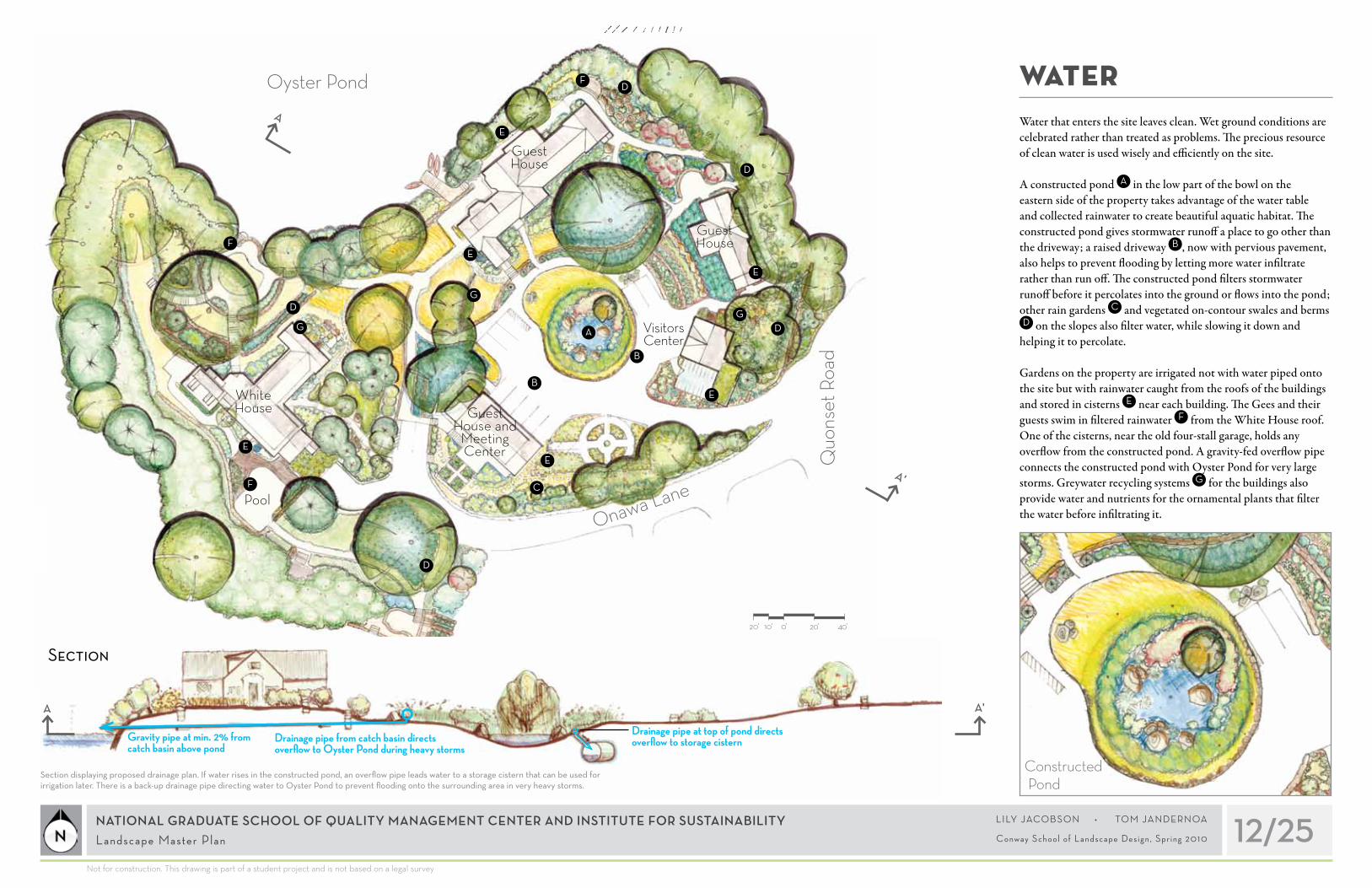
Water that enters the site leaves clean. Wet ground conditions are celebrated rather than treated as problems. The precious resource of clean water is used wisely and efficiently on the site.
A constructed pond A in the low part of the bowl on the eastern side of the property takes advantage of the water table and collected rainwater to create beautiful aquatic habitat. The constructed pond gives stormwater runoff a place to go other than the driveway; a raised driveway B , now with pervious pavement, also helps to prevent flooding by letting more water infiltrate rather than run off. The constructed pond filters stormwater runoff before it percolates into the ground or flows into the pond; other rain gardens C and vegetated on-contour swales and berms D on the slopes also filter water, while slowing it down and
helping it to percolate.
Gardens on the property are irrigated not with water piped onto the site but with rainwater caught from the roofs of the buildings and stored in cisterns E near each building. The Gees and their guests swim in filtered rainwater F from the White House roof. One of the cisterns, near the old four-stall garage, holds any overflow from the constructed pond. A gravity-fed overflow pipe connects the constructed pond with Oyster Pond for very large storms. Greywater recycling systems G for the buildings also provide water and nutrients for the ornamental plants that filter the water before infiltrating it.
White House
Guest House
Guest House
Pool
Visitors Center
Guest House and
Meeting Center
D
D
D
D
D
20’ 0’ 20’ 40’10’
E
E
E
E
E
E
F
F
G
GG
B
B
A
CF
Section
A
A'
A A'
Section displaying proposed drainage plan. If water rises in the constructed pond, an overflow pipe leads water to a storage cistern that can be used for irrigation later. There is a back-up drainage pipe directing water to Oyster Pond to prevent flooding onto the surrounding area in very heavy storms.
Drainage pipe from catch basin directs overflow to Oyster Pond during heavy storms
Drainage pipe at top of pond directs overflow to storage cisternGravity pipe at min. 2% from
catch basin above pond
Onawa Lane
Quo
nset
Roa
d
Oyster Pond
Constructed Pond

BIODIVERSITY AND HABITAT
13/25NATIONAL GRADUATE SCHOOL OF QUALITY MANAGEMENT CENTER AND INSTITUTE FOR SUSTAINABILITY Landscape Master Plan
Not for construction. This drawing is part of a student project and is not based on a legal survey
L I LY JACO B SO N • TO M JA N D E R N OA
Conway Schoo l o f Landscape Des ign , Spr ing 2010
White House
Guest House
Guest House
Pool
Visitors Center
Guest House and
Meeting Center
The property offers diverse habitat for wildlife and humans. There are many spaces for people to learn, socialize, relax, observe the landscape, and cultivate gardens. Lush native plants throughout the site feed wildlife and provide shelter for nesting and escape cover. The invasive, brushy shrubs and vines that once dominated the edge of the pond A have been replaced with native shrubs and controlled over time, vastly enhancing the available wildlife habitat. New fruit and nut trees B in the forest garden on the northeast slope of the property offer birds and bats more canopy for nesting and food. Fruiting shrubs C , ground cover D , and vines E also offer food and habitat. A native meadow F provides habitat for meadow-nesting bird species—species that are declining as global ecology changes—like bobwhites, meadowlarks, and grasshopper sparrows. Owls and bats keep homes in boxes in trees constructed for them. The native rose garden G and flowering plants throughout the property attract pollinators. Shade gardens H and native ground cover offer additional habitat for ground-living creatures. The Gees and visitors to the site enjoy the edible landscape—fruits, nuts, and other perennial foods, as well as vegetables and herbs from terraced gardens and other culinary gardens I . Meals on the site also include fish and aquatic plants raised in the aquaponics demonstration tanks in the greenhouse J . Decks and patios K offer sunny places to relax, while people can also cool down on benches in the shade of trees.
A
A
A
A
B B
B
C
C
D
D
E
E
F
G
H
H
H
I
I
P
I
J
K
K
K
K
K
K
R
K
K
A
I
Long House with native wildflower meadow replacing lawn
Onawa Lane
Quo
nset
Roa
d
Oyster Pond
20’ 0’ 20’ 40’10’ H
CB
KB
D
EB
F

CONSTRUCTION AND SITE MANAGEMENT
14/25NATIONAL GRADUATE SCHOOL OF QUALITY MANAGEMENT CENTER AND INSTITUTE FOR SUSTAINABILITY Landscape Master Plan
Not for construction. This drawing is part of a student project and is not based on a legal survey
L I LY JACO B SO N • TO M JA N D E R N OA
Conway Schoo l o f Landscape Des ign , Spr ing 2010
The Center’s commitment to ecological practice is demonstrated in the implementation of the design and maintenance on the site.
Soil throughout the site is fertilized with compost from material shed by plants on the site and from waste from the food consumed on the property.
Management of the property contributes little to the landfill waste stream, as materials for construction and maintenance are chosen for durability and the ability to be reused or recycled. They are also chosen for recyclable packaging. Some materials used on the site are salvaged and therefore diverted from the landfill waste stream.
The practices used to implement the landscape design have polluted as little as possible, using solar electric or hand tools rather than gas-powered machinery when possible. Site maintenance is also carried out with solar electric tools or by hand. All materials used in installation and maintenance are non-toxic, non-leaching, or organic. Potential pond and groundwater contamination from septic leach fields is reduced through the use of some composting toilets A .
Fuel use and the emissions that accompany it are reduced by receiving large deliveries of materials rather than many smaller deliveries. The food produced in the perennial edible landscape B and culinary annual gardens C also reduces fuel used for
transportation, plus the fuel and fertilizers used to produce the same amount of food industrially.
A
B
B
B
BC
C
C
C
C
White House
Guest House
Guest House
Pool
Visitors Center
Guest House and
Meeting Center
A
A
Onawa Lane
Quo
nset
Roa
d
Oyster Pond
20’ 0’ 20’ 40’10’ C B A
Guest House

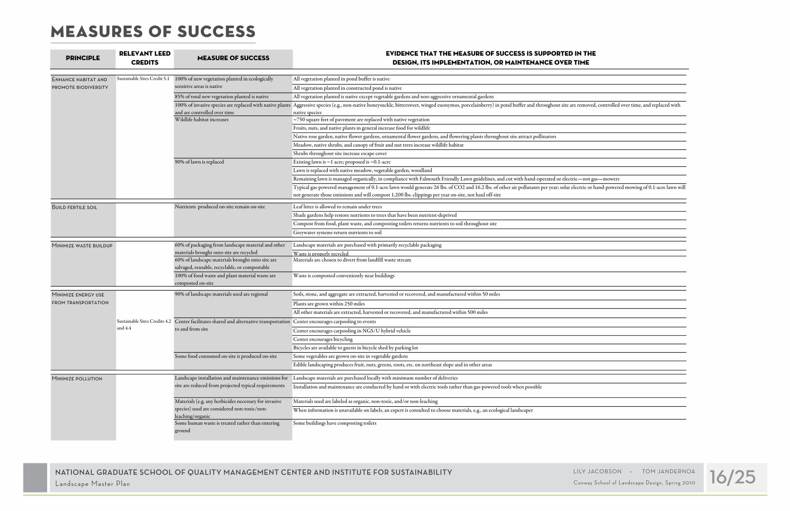
MEASURES OF SUCCESSThe National Graduate School for Quality Management teaches quantitative assessment of the change in systems. An important aspect of the NGS/U approach is developing “measures of success”— standards that can be used while a project is in progress and after it is completed to assess whether it is meeting its goals. Since NGS/U aims to practice sustainable land use at the Center
and Institute for Sustainability, and to educate about sustainability primarily through the landscape itself, most of the project’s measures of success address how the landscape design responds to those ecological and social issues that the Center has the ability to address and educate about.
Leadership in Energy and Environmental Design (LEED) and related standards are used to help measure success. NGS/U is redeveloping the buildings at the property to meet LEED standards for “Silver” certification. NGS/U also supports other ecologically oriented measures of success. Laid out in the following pages are the measures of success for this project as they have been
developed so far, relevant LEED measures, and how the landscape design helps the site to fulfill those standards. These standards are quantitative where that is possible; in some cases there is not enough information available for specific numbers. As the project continues, NGS/U should assess and further develop the measures of success.
Principlerelevant leed
creditsMeasure of success
Evidence that the measure of success is supported in the design, its implementation, or maintenance over time
Signs throughout site facilitate sustainability education
Site demonstrates sustainable technology
Visitor center introduces concepts explored and techniques used on property Informational materials explain site history and current processes: e.g., explanations of stormwater infiltration; compost area is accessible as a demonstration site
Views throughout site show more vegetation, less pavement; vegetation composition is more like complete ecosystems; handiwork of both humans and nature is visible
Lookout spots encourage landscape observation Information presented throughout site helps visitors see more detail and complexity of landscape processes
Ecology of site is described on interpretive signs
Connect the site with the larger community
Neighbors and local organizations feel positively about Center
Neighbors, local commissions, and visitors give positive feedback on landscape design when solicited
Path network winds through property, except ecologically sensitive pond buffer
Separate paths exist for lower and upper campusesLower campus path system is ADA-accessible: 5 feet wide, 5% grade or flatter Boat access is available from property to Oyster Pond
Path system is clear with cues for appropriate movement throughout site
Visitors give positive feedback on legibility of path system when solicited
There are twelve outdoor parking spaces, plus garage space Center facilitates carpooling in NGS/U hybrid vehicle
Sheltered bicycle racks are available
Signs make property entrances clear Attractive native plants at entrances reflect Center's values and aesthetics and retain interest through three or four seasons
Pervious driveway allows most water to infiltrate, preventing floodingRunoff from culvert on northeast slope is filtered and infiltrated by on-contour swales and rain gardens downslope
Green roof on generator room and carport catch rainwater and reduce runoff Remaining runoff from driveway is filtered and infiltrated by constructed pondPond overflow feeds into a cisternPlants in constructed pond filter waterGravity drainage system allows for overflow to pond only in extreme storm conditions
Landscape is irrigated with captured rainwater
Swimming pool and appliances are supplied first by filtered rainwaterPotable water used on property is recycled on site Greywater systems clean used water by irrigating wetland gardens and ornamental plants
Asphalt is replaced with pervious pavement, reducing impervious surfaces by about 43% (from about 23,550 square feet to about 13,440 square feet) Green roof on generator room reduces impervious surfaces by about 1%
Sustainable Sites Credits 6.1 and 6.2
Sustainable Sites Credits 4.2 and 4.4
Help people to connect with the land
Residents and visitors experience greater sense of connection with land after spending time at site
Teach about sustainability through the landscape
Visitors and residents learn about sustainability on site and take action elsewhere
Make it easy to get to and around the site
Access is available to all parts of site except ecologically sensitive pond buffer
Entry experience is clear and pleasant
Catch rainwater and recycle water
Minimize heat island effect
100% of asphalt is replaced
Water used in landscape is caught on siteWater Efficiency Credits 1 and 2
Sustainable Sites Credit 7.1
Site is close to regional bicycle trail
Arriving at site is convenient
Stormwater runoff is filtered before going into Oyster Pond
Stormwater runoff from impervious surfaces is caught, stored, and used, or filtered and infiltrated, on-site
Filter and infiltrate stormwater on-site
NATIONAL GRADUATE SCHOOL OF QUALITY MANAGEMENT CENTER AND INSTITUTE FOR SUSTAINABILITY Landscape Master Plan 15/25L I LY JACO B SO N • TO M JA N D E R N OA
Conway Schoo l o f Landscape Des ign , Spr ing 2010
MEASURES OF SUCCESSPrinciple
relevant leed credits
Measure of successEvidence that the measure of success is met in the design, its
implementation, or maintenance over time
All vegetation planted in pond buffer is native
All vegetation planted in constructed pond is native85% of total new vegetation planted is native All vegetation planted is native except vegetable gardens and non-aggressive ornamental gardens100% of invasive species are replaced with native plants and are controlled over time
Aggressive species (e.g., non-native honeysuckle, bittersweet, winged euonymus, porcelainberry) in pond buffer and throughout site are removed, controlled over time, and replaced with native species
Wildlife habitat increases ~750 square feet of pavement are replaced with native vegetationFruits, nuts, and native plants in general increase food for wildlifeNative rose garden, native flower gardens, ornamental flower gardens, and flowering plants throughout site attract pollinators Meadow, native shrubs, and canopy of fruit and nut trees increase wildlife habitatShrubs throughout site increase escape coverExisting lawn is ~1 acre; proposed is ~0.1-acreLawn is replaced with native meadow, vegetable garden, woodlandRemaining lawn is managed organically, in compliance with Falmouth Friendly Lawn guidelines, and cut with hand-operated or electric—not gas—mowersTypical gas-powered management of 0.1-acre lawn would generate 26 lbs. of CO2 and 16.2 lbs. of other air pollutants per year; solar electric or hand-powered mowing of 0.1-acre lawn will not generate those emissions and will compost 1,200 lbs. clippings per year on-site, not haul off-site
Leaf litter is allowed to remain under trees Shade gardens help restore nutrients to trees that have been nutrient-deprivedCompost from food, plant waste, and composting toilets returns nutrients to soil throughout site
Greywater systems return nutrients to soil
Landscape materials are purchased with primarily recyclable packaging
Waste is properly recycled60% of landscape materials brought onto site are salvaged, reusable, recyclable, or compostable
Materials are chosen to divert from landfill waste stream
100% of food waste and plant material waste are composted on-site
Waste is composted conveniently near buildings
Soils, stone, and aggregate are extracted, harvested or recovered, and manufactured within 50 miles
Plants are grown within 250 milesAll other materials are extracted, harvested or recovered, and manufactured within 500 miles
Center encourages carpooling to events
Center encourages carpooling in NGS/U hybrid vehicleCenter encourages bicycling Bicycles are available to guests in bicycle shed by parking lotSome vegetables are grown on-site in vegetable gardensEdible landscaping produces fruit, nuts, greens, roots, etc. on northeast slope and in other areas
Landscape materials are purchased locally with minimum number of deliveries
Installation and maintenance are conducted by hand or with electric tools rather than gas-powered tools when possible
Materials used are labeled as organic, non-toxic, and/or non-leaching
When information is unavailable on labels, an expert is consulted to choose materials, e.g., an ecological landscaper
Some human waste is treated rather than entering ground
Some buildings have composting toilets
Some food consumed on-site is produced on-site
Center facilitates shared and alternative transportation to and from site
90% of landscape materials used are regional
Nutrients produced on-site remain on-site
Materials (e.g. any herbicides necessary for invasive species) used are considered non-toxic/non-leaching/organic
Landscape installation and maintenance emissions for site are reduced from projected typical requirements
100% of new vegetation planted in ecologically sensitive areas is native
Enhance habitat and promote biodiversity
60% of packaging from landscape material and other materials brought onto site are recycled
Minimize waste buildup
90% of lawn is replaced
Minimize energy use from transportation
Minimize pollution
Build fertile soil
Sustainable Sites Credits 4.2 and 4.4
Sustainable Sites Credit 5.1
Principlerelevant leed
creditsMeasure of success
Evidence that the measure of success is supported in the design, its implementation, or maintenance over time
Signs throughout site facilitate sustainability education
Site demonstrates sustainable technology
Visitor center introduces concepts explored and techniques used on property Informational materials explain site history and current processes: e.g., explanations of stormwater infiltration; compost area is accessible as a demonstration site
Views throughout site show more vegetation, less pavement; vegetation composition is more like complete ecosystems; handiwork of both humans and nature is visible
Lookout spots encourage landscape observation Information presented throughout site helps visitors see more detail and complexity of landscape processes
Ecology of site is described on interpretive signs
Connect the site with the larger community
Neighbors and local organizations feel positively about Center
Neighbors, local commissions, and visitors give positive feedback on landscape design when solicited
Path network winds through property, except ecologically sensitive pond buffer
Separate paths exist for lower and upper campusesLower campus path system is ADA-accessible: 5 feet wide, 5% grade or flatter Boat access is available from property to Oyster Pond
Path system is clear with cues for appropriate movement throughout site
Visitors give positive feedback on legibility of path system when solicited
There are twelve outdoor parking spaces, plus garage space Center facilitates carpooling in NGS/U hybrid vehicle
SS Credits 4.2 and 4.4 Sheltered bicycle racks are available
Signs make property entrances clear Attractive native plants at entrances reflect Center's values and aesthetics and retain interest through three or four seasons
SS Credits 6.1 and 6.2 Pervious driveway allows most water to infiltrate, preventing floodingRunoff from culvert on northeast slope is filtered and infiltrated by on-contour swales and rain gardens downslope
Green roof on generator room and carport catch rainwater and reduce runoff Remaining runoff from driveway is filtered and infiltrated by constructed pondPond overflow feeds into a cisternPlants in constructed pond filter waterGravity drainage system allows for overflow to pond in extreme storm conditions
WE Credits 1 and 2 Landscape is irrigated with captured rainwater
Swimming pool and appliances are supplied first by filtered rainwaterPotable water used on property is recycled on site Greywater systems clean used water by irrigating wetland gardens and ornamental plants
SS Credit 7.1 Asphalt is replaced with pervious pavement, reducing impervious surfaces by about 43% (from about 23,550 square feet to about 13,440 square feet) Green roof on generator room reduces impervious surfaces by about 1%
Help people to connect with the land and landscape ecology
Residents and visitors experience greater sense of connection with land after spending time at site
Teach about sustainability through the landscape
Visitors and residents learn about sustainability on site and take action elsewhere
Make it easy to get to and around the site
Access is available to all parts of site except ecologically sensitive pond buffer
Entry experience is clear and pleasant
Stormwater runoff from impervious surfaces is caught, stored, and used, or filtered and infiltrated, on-site
Filter and infiltrate stormwater on-site
Catch rainwater and recycle water
Minimize heat island effect
100% of asphalt is replaced
Water used in landscape is caught on site
Stormwater runoff is filtered before going into Oyster Pond
Site is close to regional bicycle trail
Arriving at site is convenient
NATIONAL GRADUATE SCHOOL OF QUALITY MANAGEMENT CENTER AND INSTITUTE FOR SUSTAINABILITY Landscape Master Plan 16/25L I LY JACO B SO N • TO M JA N D E R N OA
Conway Schoo l o f Landscape Des ign , Spr ing 2010

Item installed price Unit Quantity Cost
Asphalt demolition 10.00$ square foot 10,110 101,100$
Driveway excavation 12.00$ cubic yard 187.2 2,246$
Grading 0.30$ square foot 20,000 6,000$
Pervious pavement 8.00$ square foot 10,110 80,880$
New paths 5.00$ square foot 2,600 13,000$
Pond excavation 12.00$ cubic yard 367 4,404$
10,000-gallon cistern 15,000.00$ each 1 15,000$
Six-inch pond overflow pipe 5,580.00$ each 1 5,580$
Glacial erratic boulders 2,000.00$ each 10 20,000$
Green roof over generator room 45.00$ square foot 250 11,250$
Trees--container plants 75.00$ each 15 1,125$
Shrubs--container plants 37.00$ each 25 plants/100 ft2 on 26,000 ft2: 6,500 240,500$
Shade garden small plants 2.00$ each 100 plants/100 ft2 on 7,500 ft2: 7,500 15,000$
Meadow--wildflower seeds 0.08$ square foot 5,350 428$
Bicycles 300.00$ each 4 1,200$
total 517,713$
Prices for landscaping materials and labor vary. This cost estimate is based on rough estimates of areas and quantities. Significant design elements it does not include are the expanded greenhouse, the repaired dock, the new carport, interpretive signs, landscape furniture, and composting toilets.
CONTEXTcost estimate
NATIONAL GRADUATE SCHOOL OF QUALITY MANAGEMENT CENTER AND INSTITUTE FOR SUSTAINABILITY Landscape Master Plan 17/25L I LY JACO B SO N • TO M JA N D E R N OA
Conway Schoo l o f Landscape Des ign , Spr ing 2010

Plants native to Massachusetts, many to Barnstable County and to Falmouth specifically, have been chosen to fit the particular growing conditions on the property, and for the aesthetic and ecological qualities they provide to the landscape. Photos of selected plants appear on the following pages.
EnTRAnCE gARdEnSsAlT-TOlErANT NATivE TrEEs, shrubs & GrOuNdCOvErAmelanchier canadensis (shadblow serviceberry, Juneberry) Arctostaphylos uva-ursi (bearberry) Aronia arbutifolia (red chokeberry) Aronia melanocarpa (black chokeberry) Baccharis halimifolia (groundsel bush, groundsel tree, consumption weed, cotton-seed tree, silverling)Carya ovata (shagbark hickory)Celtis occidentalis (hackberry) Cephalanthus occidentalis (buttonbush) Clethra alnifolia (sweet pepperbush) Ilex glabra (inkberry) Ilex opaca (American holly) Iva frutescens ( Jesuit’s bark) Juniperus virginiana (eastern redcedar) Lindera benzoin (spicebush) Magnolia virginiana (sweetbay magnolia) Myrica cerifera (wax myrtle) Myrica pensylvanica (bayberry) Nyssa sylvatica (blackgum, tupelo) Parthenocissus quinquefolia (Virginia creeper, five-leafed ivy) Pinus rigida (pitch pine) Prunus maritima (beach plum) Prunus nigra (Canada plum) Prunus pensylvanica (fire or pin cherry) Prunus serotina (black cherry) Rhus copallinum (winged sumac) Rhus typhina (staghorn sumac) Sambucus canadensis (American black elderberry) Viburnum dentatum (arrowwood) Waldsteinia fragarioides (barren strawberry)
sAlT-TOlErANT NATivE GrAssEs Agrostis hyemalis (winter bentgrass) Andropogon gerardii (big bluestem) Carex viridula (little green sedge) Eleocharis acicularis (needle spikerush) Eleocharis parvula (dwarf spikerush) Juncus bufonius (toad rush) Muhlenbergia glomerata (spiked muhly) Panicum amarum (bitter panicgrass) Phalaris arundinacea (reed canarygrass) Spartina patens (saltmeadow cordgrass) POnd bUffER NATivE plANTs ApprOvEd by FAlmOuTh CONsErvATiON COmmissiON Amelanchier canadensis (shadbush) Aronia arbutifolia (red chokeberry) Aronia melanocarpa (black chokeberry)Clethra alnifolia (sweet pepperbush) Hierochloe odorata (sweetgrass, vanilla grass) Ilex glabra compacta (inkberry) Ilex opacum (American holly) Ilex verticillata (winterberry) Juniperus virginiana (eastern redcedar) Myrica pensylvanica (bayberry) Nyssa sylvatica (black gum, tupelo) Pinus strobus (white pine) Pinus rigida (pitch pine) Prunus maritima (beach plum) Quercus alba (white oak) Quercus coccinea (scarlet oak) Quercus velutina (black oak) Salix discolor (pussy willow) Vaccinium corymbosum (highbush blueberry) Viburnum dentatum (arrowwood) Viburnum nudum (wild raisin)
nATivE ROSE gARdEn Rosa acicularis (prickly rose) Rosa arkansana (prairie rose) Rosa blanda (smooth rose) Rosa carolina (Carolina rose) Rosa nitida (shining rose) Rosa palustris (swamp rose) Rosa setigera (climbing rose) Rosa virginiana (Virginia rose)
COnSTRUCTEd POnd Acora americanus (sweetflag) Alisma subcordatum (American water plantain) Asclepias incarnata (swamp milkweed) Caltha palustris (marsh marigold) Carex stricta (upright sedge, tussock sedge) Hibiscus moscheutos (swamp-rose mallow, rose mallow) Iris versicolor (blue flag iris) Juncus militaris (bayonet rush) Leersia oryzoides (rice cutgrass) Nuphar lutea (yellow pond-lily) Nymphaea odorata (American white waterlily) Peltandra virginica (green arrow arum) Pontederia cordata (pickerelweed) Sagittaria latifolia (broadleaf arrowhead) Saururus cernuus (lizard’s tail) Schoenoplectus acutus (hardstem bulrush) Schoenoplectus americanus (chairmaker’s bulrush) Schoenoplectus tabernaemontani (softstem bulrush) Scirpus atrovirens (green bulrush) Sparganium americanum (American bur-reed) Sparganium eurycarpum (broadfruit bur-reed) Thelypteris palustris (eastern marsh fern) Typha angustifolia (narrowleaf cattail) Typha latifolia (broadleaf cattail)
EdgE Of COnSTRUCTEd POnd Chelone glabra (white turtlehead) Eupatoriadelphus fistulosus (trumpetweed, joe-pye weed) Eupatorium perfoliatum (boneset) Juncus canadensis (Canada rush) Lilium canadense (Canada lily, wild yellow lily) Lobelia siphilitica (great blue lobelia) Mimulus ringens (Allegheny monkeyflower) Spartina cynosuroides (big cordgrass) Verbena hastata (swamp verbena, blue verbena)
fERnS Adiantum pedatum (northern maidenhair) Athyrium filix-femina (ladyfern) Dennstaedtia punctilobula (hayscented fern) Diplazium pycnocarpon (glade fern) Dryopteris spp. (woodfern) Lygodium palmatum (American climbing fern) Matteuccia struthiopteris (ostrich fern) Osmunda cinnamomea (cinnamon fern) Osmunda claytoniana (interrupted fern) Osmunda regalis (royal fern) Polypodium virginianum (rock polypody) Woodwardia areolata (netted chainfern) Woodwardia virginica (Virginia chainfern)
hERbACEOUS PLAnTS WiTh ORnAMEnTAL fLOWERS FOr suN: Aletris farinosa (unicorn root, colicroot) Allium canadense (meadow garlic, wild garlic) Baptisia australis (blue wild indigo, blue false indigo) Baptisia tinctoria (yellow wild indigo) Heliopsis helianthoides (oxeye sunflower) Lilium superbum (Turk’s cap lily) Medeola virginiana (Indian cucumber-root) Monarda punctata (spotted beebalm) Rudbeckia fulgida (orange coneflower) Solidago sempervirens (seaside goldenrod) Vernonia noveboracensis (New York ironweed)
Plant PALETTE
NATIONAL GRADUATE SCHOOL OF QUALITY MANAGEMENT CENTER AND INSTITUTE FOR SUSTAINABILITY Landscape Master Plan 18/25L I LY JACO B SO N • TO M JA N D E R N OA
Conway Schoo l o f Landscape Des ign , Spr ing 2010

shAdE-TOlErANT spECiEs:Apios americana (groundnut) Aquilegia canadensis (eastern red columbine) Aralia nudicaulis (wild sarsaparilla) Argentina anserina (silverweed cinquefoil) Arisaema triphyllum (jack-in-the-pulpit) Cardamine pensylvanica (Pennsylvania bittercress) Cephalanthus occidentalis (common buttonbush) Chamaecrista fasciculata (partridge pea) Chimaphila umbellata (pipsissewa) Circaea alpina (small enchanter’s nightshade) Cypripedium acaule (moccasin flower) Cypripedium arietinum (ram’s head lady’s slipper) Eurybia macrophylla (bigleaf aster) Gaultheria procumbens (wintergreen, checkerberry, teaberry) Gaylussacia baccata (black huckleberry) Gaylussacia dumosa (dwarf huckleberry) Gaylussacia frondosa (blue huckleberry) Hypericum punctatum (spotted St. Johnswort) Lobelia cardinalis (cardinalflower) Symphyotrichum patens (late purple aster, sky-drop aster) Viburnum acerifolium (mapleleaf viburnum)
FOr pArTiAl shAdE, suN, Or shAdE: Asclepias tuberosa (butterflyweed, orange milkweed) Coreopsis lanceolata (lanceleaf coreopsis) Dicentra canadensis (bleeding heart, squirrel corn) Dicentra formosa (Pacific bleeding heart) Erythronium americanum (yellow trout-lily, dogtooth violet) Eupatorium purpureum (purple joe-pye weed)Hypoxis hirsuta (goldstar, yellow star-grass) Iris prismatica (coastal iris, slender blue flag) Lilium philadelphicum (wood lily) Lobelia cardinalis (cardinalflower)
Monarda fistulosa (wild bergamot) Penstemon digitalis (talus slope penstemon, foxglove beardtongue) Rudbeckia hirta (black-eyed Susan) Rudbeckia triloba (brown-eyed Susan) Sisyrinchium montanum (strict blue-eyed grass) Solidago nemoralis (gray goldenrod, prairie goldenrod) Uvularia sessilifolia (sessile-leaf bellwort)
vinES Amphicarpaea bracteata (American hogpeanut) Apios americana (groundnut) Celastrus scandens (American bittersweet) Humulus lupulus (common hop) Lathyrus palustris (marsh pea) Lonicera dioica (limber honeysuckle) Lonicera sempervirens (trumpet honeysuckle)
fULL-SUn RAin gARdEnplANTs FOr ThE wETTEr CENTErClethra alnifolia (summersweet) Cornus sericea (redosier dogwood)Lobelia cardinalis (cardinal flower)Asclepias tuberose (orange butterfly weed)Iris versicolor (blue flag iris)Caltha palustris (marsh marigold) Asclepias incarnata (swamp milkweed)Eupatoriadelphus purpureum (purple joe-pye weed)Chelone glabra (turtlehead)Monarda didyma (beebalm)
plANTs FOr ThE dryEr OuTEr EdGEJuniperus horizontalis (blue rug juniper)Clethra alnifolia (sweet pepperbush)Potentilla arguta (tall cinquefoil)Sedum ternatum (woodland stonecrop)Geranium maculatum (wild geranium) Anemone canadensis (windflower)Lobelia spicata (spiked lobelia)Symphyotrichum novae-angliae (New England aster) Helenium autumnale (perennial sunflower)
ShAdE RAin gARdEnplANTs FOr ThE wETTEr, shAdiEr CENTEr Magnolia virginiana (sweetbay magnolia)Rhododendron canadense (native rhododendron)Ledum groenlandicum (Labrador tea) Ilex verticillata (winterberry)Asarum canadense (Canadian wildginger)Osmunda regalis (royal fern)Matteuccia struthiopteris (ostrich fern)Adiantum pedatum (northern maidenhair fern)Aquilegia canadensis (native columbine)Onoclea sensibilis (sensitive fern)Lobelia cardinalis (cardinal flower)Chelone glabra (turtlehead)Actaea rubra (red baneberry)
plANTs FOr ThE dryEr OuTEr EdGE Comptonia peregrina (sweetfern)Arctostaphylos uva-ursi (bearberry)Geranium maculatum (wild geranium)
SCREEningPicea glauca (white spruce)Picea pungens (blue spruce)Ilex opaca (American holly) Rhododendron maximum (great laurel)Kalmia latifolia (mountain laurel)Leucothoe fontanesiana (highland doghobble) Rhododendron catawbiense (Catawba rhododendron)
gREYWATER FrOm gaia’s garden by TOby hEmENwAy AT lEAsT 70 TO 80% OF A GrEywATEr sysTEm shOuld bE mAdE OF ThEsE plANTs: Scirpus validus (bulrush)Typha spp. (cattail)Juncus effusus (soft rush)
20 TO 30% OF A GrEywATEr sysTEm CAN bE mAdE OF ThEsE:Sagittaria spp. (arrowhead) Aronia spp. (chokeberry) Symphytum officinale (comfrey) Vaccinium macrocarpon (cranberry) Sambucus spp. (elderberry) Vaccinium corymbosum (highbush blueberry) Vaccinium trilobum (highbush cranberry) Equisetum spp. (horsetail) Nelumbo lutea (lotus) Matteuccia pennsylvanica (ostrich fern) Pontederia cordata (pickerel weed) Carex spp. (sedge) Eleocharis spp. (spike rush) Acorus calamus (sweet flag)
Plant PALETTE (continued)
NATIONAL GRADUATE SCHOOL OF QUALITY MANAGEMENT CENTER AND INSTITUTE FOR SUSTAINABILITY Landscape Master Plan 19/25L I LY JACO B SO N • TO M JA N D E R N OA
Conway Schoo l o f Landscape Des ign , Spr ing 2010

Photo source: www.wikimedia.com
Bayberry
Baneberry
Ostrich fern
Cardinalflower
Lowbush blueberry
Waterlily
Beach plum
Red chokeberry
Blue flag iris
Inkberry
Wood lily
plANT pAlETTE
NATIONAL GRADUATE SCHOOL OF QUALITY MANAGEMENT CENTER AND INSTITUTE FOR SUSTAINABILITY Landscape Master Plan 20/25L I LY JACO B SO N • TO M JA N D E R N OA
Conway Schoo l o f Landscape Des ign , Spr ing 2010

Photo source: www.wikimedia.com
American holly
Native columbine
Native rhododendron
Blue rug juniper
Highland doghobble
Winterberry
Coastal sweet pepperbush
Mountain laurel
Turtlehead
Wild bergamot
Barren strawberry
plANT pAlETTE
NATIONAL GRADUATE SCHOOL OF QUALITY MANAGEMENT CENTER AND INSTITUTE FOR SUSTAINABILITY Landscape Master Plan 21/25L I LY JACO B SO N • TO M JA N D E R N OA
Conway Schoo l o f Landscape Des ign , Spr ing 2010

Photo source: www.wikimedia.com
Sweetbay magnolia
Swamp milkweed
Orange butterfly weed
Jack-in-the-pulpit
Windflower
Blue spruce
Bearberry
Shadblow serviceberry
Marsh marigold
Common buttonbush
Beebalm
plANT pAlETTE
NATIONAL GRADUATE SCHOOL OF QUALITY MANAGEMENT CENTER AND INSTITUTE FOR SUSTAINABILITY Landscape Master Plan 22/25L I LY JACO B SO N • TO M JA N D E R N OA
Conway Schoo l o f Landscape Des ign , Spr ing 2010

20’ 0’ 20’ 40’10’20’ 0’ 20’ 40’10’20’ 0’ 20’ 40’10’
Compost
Solar Panel
Greenhouse
Green Roof
Wet-loving Native Edibles
}Diverse Native
Insectary Species
Edible Forest
GardenRoot
Cellar
Native Wild Rice
Fruit & Nut Tree Orchard Evergreen Tree
Wind Break
Native Edible Shrub
White House
Long House
Cottage House
Onawa Lane
Rainwater Catchment
Terrace Gardens
EdiblePolyculture
Aquaculture& Greenhouse
Wind Turbines
Solar
ALTERNATIVE DESIGNS
23/25NATIONAL GRADUATE SCHOOL OF QUALITY MANAGEMENT CENTER AND INSTITUTE FOR SUSTAINABILITY Landscape Master Plan
Not for construction. This drawing is part of a student project and is not based on a legal survey
L I LY JACO B SO N • TO M JA N D E R N OA
Conway Schoo l o f Landscape Des ign , Spr ing 2010
The preferred design in the preceding pages was developed after earlier schematic alternative design drafts. There is no single answer for what sustainability means for a particular site like this one, or for what it means to teach about sustainability. The following pages contain the earlier schematic alternative design drafts, which explore various ideas about what sustainability and sustainability education and demonstration could mean for the NGS/U Center and Institute for Sustainability. They are included here as food for thought.
1:KEEPITLOCALTransportation of goods accounts for 28 percent of global energy use and associated consequences. Industrial agriculture accounts for another 17 percent, as well as contributing to myriad other problems, such as erosion, loss of soil fertility, water pollution, and loss of habitat and biodiversity. This design explores how to demonstrate better practices for meeting human needs—producing food and other goods at the same time as enhancing wildlife habitat, water quality, soil fertility, and slope stability, and capturing renewable energy to meet the site’s energy needs rather than relying on fossil fuels. In this schematic alternative, wind turbines on the hilltop capture wind energy. Solar panels on the White House and the visitor center also help to power the property. An evergreen stand north of the White House blocks cold winter wind to reduce heating needs. Cisterns catch rainwater from all the buildings to irrigate the landscape. Edible plants grow throughout the landscape—native fruit trees, nut trees, and fruiting shrubs on the Point and the northern slope, a complex edible forest garden on the northeast slope, water-loving native edible shrubs in the low wet part of the bowl, native wild rice around the edge of the pond, mixed edible native shrubs and ground cover around the buildings, and terraced vegetable and herb gardens on steep slopes. The terraces and vegetated on-contour swales and berms on steep slopes help to slow and infiltrate rainwater. The four-stall garage has been removed to increase the area available for growing food. Native flowering plants throughout the landscape attract pollinators. The swimming pool has been replaced with an aquaponics demonstration greenhouse.
If implemented, this alternative could produce a large amount of the food consumed on the property, at the same time providing wildlife habitat, slowing and filtering stormwater runoff, stabilizing slopes, and providing other ecological services. Caring for such a landscape would take a lot of time. Removing a building would require the clients to rethink their proposed building uses. This schematic alternative proposes replacing pavement with land uses that are more ecologically valuable—habitat and food production—but provides only one or two parking spaces.
A
A'
A A'
Section (Not to Scale)

20’ 0’ 20’ 40’10’20’ 0’ 20’ 40’10’20’ 0’ 20’ 40’10’
Mixed Tree Stand
Green Roof Car Port
American Holly Stand
Foot Path
Various Wildlife Habitat
(Bat House, Owl House, etc.)
Green Roof Visitors Center
Wetland Species
Osprey Stand
Boardwalk &Observation Dock
Evergreen TreeWind Break
White House
Onawa Lane
HardwoodStand
Wet Meadow
Mixed Native Grasses, Ground
Cover, Herbaceous Species
Living Machine & Rare Native Plant Nursery
Wind Turbine
ALTERNATIVE DESIGNS
24/25NATIONAL GRADUATE SCHOOL OF QUALITY MANAGEMENT CENTER AND INSTITUTE FOR SUSTAINABILITY Landscape Master Plan
Not for construction. This drawing is part of a student project and is not based on a legal survey
L I LY JACO B SO N • TO M JA N D E R N OA
Conway Schoo l o f Landscape Des ign , Spr ing 2010
2:REVERSETHEIMPACT An important aspect of global ecological change is the loss of biodiversity in every part of the world. As ecosystems lose species, they lose complexity developed over millions of years, and they lose stability. The effects of that destabilization ripple throughout the ecosystems, from disease to species extinctions. The degradation and destruction of native ecosystems and habitat is one of the main ways that biodiversity is lost. This design explores how to demonstrate restoring and creating as much habitat as possible, minimizing human impact, and educating about ecology through direct access and observation. In this schematic alternative, trees connect in larger swaths, filling in canopy around the site. Small existing stands of evergreens, mixed hardwoods, American holly, pitch pines, and scrub oaks have all expanded. The low, wet part of the bowl in the east of the property is a wet meadow. Various wetland species grow around the edge of the pond. Areas of former lawn that have not been planted with trees have been replaced with mixed native grasses, ground covers, and herbaceous species, maintaining openness in much of the eastern part of the property. The four eastern buildings have been removed to provide as much area as possible for habitat—the tree stands, meadow, and herbaceous species described above. Habitat is further enhanced with an owl house, bat houses, a beehive, and an osprey stand. There are three new buildings: a greenhouse over the former swimming pool, housing a living machine to treat sewage biologically, as well as a nursery for rare native plants; a carport built into the hillside east of the White House; and a visitor center in the northeast corner of the property, where views of the property and Oyster Pond are expansive. Sinuous paths flow through the property, extended into Oyster Pond with boardwalks and observation decks. The area of the driveway has been reduced, with access through the property primarily pedestrian, emphasizing observation spots. A wind turbine captures energy on the property’s southern slope.
This alternative devotes as much space as possible to restoring the ecosystem and creating habitat, with many opportunities for up-close observing and learning about local ecology. The living machine and native rare plant nursery proposed are unusual features and would offer special learning opportunities. If implemented, this would be a low-maintenance landscape over time. This design could reduce impervious surfaces on the property by up to about seventy-five percent. However, like “Keep It Local,” it only provides a few parking spaces. Removing the eastern buildings would mean a vast reduction in energy use and cost on the property from maintaining buildings, as well as more space available to the natural ecosystem. Removing the buildings would also require the clients to hold most indoor functions in the White House and substantially change their plans for the building uses.
A
A'
A A'
Section (Not to Scale)

Edible Gardens
Shade Gardens
Rose Garden
Green Roof
Rain Garden
Native Species Replace Invasives
Along Shrub Buffer
On Contour Swales Along Slope
White House
Long House
Cottage House
Onawa Lane
3:GREENANDSIMPLE The messages about sustainability explored in the other schematic alternative designs call for fairly radical change to the property’s appearance and to the clients’ intended uses for the buildings. However, a more moderate and eclectic demonstration of sustainable land use techniques, explored in this design, has benefits as well, like showing that meaningful change can start small. In this schematic alternative, the low, wet part of the bowl in the eastern part of the property is a rain garden to filter and infiltrate stormwater runoff. Other rain gardens in the eastern part of the property, as well as vegetated on-contour swales and berms on the slopes, slow and filter stormwater runoff. Shade gardens help restore nutrients to the soil under trees whose leaf litter has previously been removed. Former lawn has been replaced with native meadow. A native rose garden connects with the former rose garden that was in the same place, and former culinary gardens southwest of the four-stall garage, and on the terraces on the southern tip of the property, are once again used to grow food.
This alternative would be the easiest to implement. It addresses issues with stormwater, soil fertility, and slope stability, increases habitat by replacing lawn, and produces some food, without changing the shape of the built structures of the property. If the design were implemented, the property would look and feel most similar to how it does now. The landscape would require a medium amount of maintenance. While keeping most of the current shape of the driveway allows car access close to all the eastern buildings, it still offers less parking than the clients would like, with five or six spaces.
ALTERNATIVE DESIGNS
25/25NATIONAL GRADUATE SCHOOL OF QUALITY MANAGEMENT CENTER AND INSTITUTE FOR SUSTAINABILITY Landscape Master Plan
Not for construction. This drawing is part of a student project and is not based on a legal survey
L I LY JACO B SO N • TO M JA N D E R N OA
Conway Schoo l o f Landscape Des ign , Spr ing 2010
A
A'
A A'
Section (Not to Scale)
20’ 0’ 20’ 40’10’