Embed Size (px)
Citation preview

HISTORIC CONTEXT STATEMENT CITY OF CALABASAS
Prepared by
Christopher A. Joseph & Associates 523 West 6th Street, Suite 1134
Los Angeles, CA 90014
April 7, 2009

Calabasas Historic Context Statement 1
TABLE OF CONTENTS 1. Introduction 2 2. Paleontological History 2 3. Archaeological History 3 4. Spanish Period 6 4.1 Early Exploration 6 4.2 Portola Expedition 7 4.3 Anza Expeditions 7 4.4 Spanish Land Grants 8 4.5 Mission San Fernando 9 5. Mexican Period 11 5.1 Mexican Independence 11 5.2 Missions and Ranchos 11 5.3 California Statehood 12 6. American Period 14 6.1 Influence of Basque Settlers 14 6.2 Miguel Leonis 15 6.3 Homesteading Days 17 6.4 Movie Ranches 20 6.5 Park Moderne and the Artists in Residence 22 6.6 Post-War Community Development 23 7. Associated Property Types 31 7.1 Paleontological Resources 31 7.2 Archaeological Resources 31 7.3 Commercial Buildings 33 7.4 Residential Buildings 35 7.5 Objects and Structures 36 Identification and Evaluation Methods 38 Bibliography 39 Appendix I: Chronological History of the Calabasas Area Appendix II: Letter from Vertebrate Paleontological Section, Natural History Museum of Los Angeles County Appendix III: Table of Recorded Archaeological Report
Calabasas Historic Context Statement 2
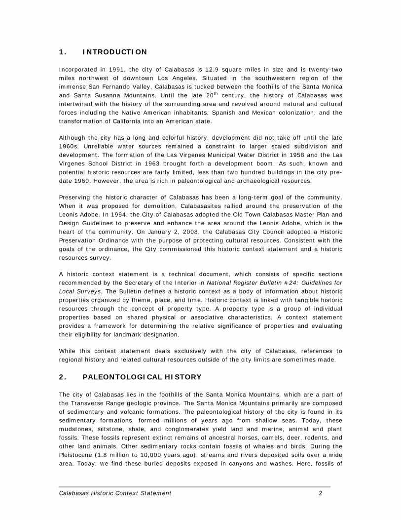
1. INTRODUCTION
Incorporated in 1991, the city of Calabasas is 12.9 square miles in size and is twenty-two miles northwest of downtown Los Angeles. Situated in the southwestern region of the immense San Fernando Valley, Calabasas is tucked between the foothills of the Santa Monica and Santa Susanna Mountains. Until the late 20th century, the history of Calabasas was intertwined with the history of the surrounding area and revolved around natural and cultural forces including the Native American inhabitants, Spanish and Mexican colonization, and the transformation of California into an American state.
Although the city has a long and colorful history, development did not take off until the late 1960s. Unreliable water sources remained a constraint to larger scaled subdivision and development. The formation of the Las Virgenes Municipal Water District in 1958 and the Las Virgenes School District in 1963 brought forth a development boom. As such, known and potential historic resources are fairly limited, less than two hundred buildings in the city pre-date 1960. However, the area is rich in paleontological and archaeological resources.
Preserving the historic character of Calabasas has been a long-term goal of the community. When it was proposed for demolition, Calabasasites rallied around the preservation of the Leonis Adobe. In 1994, the City of Calabasas adopted the Old Town Calabasas Master Plan and Design Guidelines to preserve and enhance the area around the Leonis Adobe, which is the heart of the community. On January 2, 2008, the Calabasas City Council adopted a Historic Preservation Ordinance with the purpose of protecting cultural resources. Consistent with the goals of the ordinance, the City commissioned this historic context statement and a historic resources survey.
A historic context statement is a technical document, which consists of specific sections recommended by the Secretary of the Interior in National Register Bulletin #24: Guidelines for Local Surveys. The Bulletin defines a historic context as a body of information about historic properties organized by theme, place, and time. Historic context is linked with tangible historic resources through the concept of property type. A property type is a group of individual properties based on shared physical or associative characteristics. A context statement provides a framework for determining the relative significance of properties and evaluating their eligibility for landmark designation.
While this context statement deals exclusively with the city of Calabasas, references to regional history and related cultural resources outside of the city limits are sometimes made.
2. PALEONTOLOGICAL HISTORY
The city of Calabasas lies in the foothills of the Santa Monica Mountains, which are a part of the Transverse Range geologic province. The Santa Monica Mountains primarily are composed of sedimentary and volcanic formations. The paleontological history of the city is found in its sedimentary formations, formed millions of years ago from shallow seas. Today, these mudstones, siltstone, shale, and conglomerates yield land and marine, animal and plant fossils. These fossils represent extinct remains of ancestral horses, camels, deer, rodents, and other land animals. Other sedimentary rocks contain fossils of whales and birds. During the Pleistocene (1.8 million to 10,000 years ago), streams and rivers deposited soils over a wide area. Today, we find these buried deposits exposed in canyons and washes. Here, fossils of
Calabasas Historic Context Statement 3
“Ice Age” animals such as mammoths, sloths, and dire wolfs are recovered.
The volcanic formations include Miocene-age flow breccias, tuffs, basalts, and volcanic materials. Because of the molten origin of the volcanic rocks, the volcanic formations are considered poor candidates for containing fossil plants or animals. But these formations tell the story of land formation and history of the evolution of the Santa Mountains within the city boundaries.
The letter report by Samuel McLeod, Vertebrate Paleontology Department, Natural History Museum of Los Angeles County (NHM), (Appendix II), contains more details on the city’s fossil localities.
For the city of Calabasas, significant fossils are found in the marine and non-marine Miocene-age sedimentary deposits and in the later Quaternary deposits. Sedimentary deposits, identified within the Lower Topanga Formation, in the south central portion of the city, date to the early to middle Miocene (about 33 to 13 million years old). The NHM collected fossils from localities in the non-marine Fernwood Member of the Lower Topanga Formation, which included specimens of fossil undetermined carnivore (Carnivora), horse (Equidae), camel (Camelidae), deer (Cervidae), and pocket mouse (Proheteromys). From the marine portion of the Lower Topanga Formation in this area, fossil specimens of eagle ray (Myliobatidae), and turtle (Testudinidae) were collected.
Fossil localities have been discovered along Old Topanga Road, on the south side of Calabasas Highlands, which date to the middle Miocene (about 14 million years ago). Deposits from the Upper Topanga Formation have yielded several significant fish fossils, including eagle ray (Myliobatis), bonito shark (Isurus), snaggletooth shark (Hemipristis), basking shark (Cetorhinus), giant sea bass (Stereolepis), grouper (Lompoquia), herring (Ganolytes cameo), sea cows (Dugongidae), and a primitive baleen whale (Nannocetus).
From the Lower and Upper Modelo Formation, which date to the late Miocene (about 13.5 to 2.9 million years ago), the NHM has collected vertebrate fossils that include older specimens of shearwater (Puffinus) and lanternfish (Myctophidae), and two undetermined baleen whale (Mysticeti). Also, in Las Virgenes Canyon, the Modelo Formation produced the holotype specimen of the fossil cormorant (Phalacrocorax femoralis). A holotype specimen is a fossil that serves as the basis for a species new to science. Just outside the city boundaries to the east, paleontologists collected a rare fossil specimen of leatherback turtle (Psephophorus) from the Modelo Formation.
Within the city, in the older Quaternary deposits that underlie the surficial deposits, ice age vertebrate fossils such as horse (Equus), and ground sloth (Paramylodon) have been found. And, just north of the city boundaries, the older Quaternary yielded a fossil specimen of mastodon (Mammutidae).
3. ARCHAEOLOGICAL HISTORY
Calabasas lies within a region of well-known Native American activity. The archaeological record begins with early inhabitants of the area by 7,000 years ago1 and continues to the
1 Boxt M., and B. Rechtman, “Archaeological Investigation at LAN-711,” in Journal of New World Archaeology, pp: 8-29.

Calabasas Historic Context Statement 4
establishment of the Spanish missions. During the prehistoric period in this area, people adapted tools, foods, and occupational locations to respond to evolving political and natural environments.2
Many archaeological sites in the region of Calabasas yield numerous ground stone artifacts such as metates, manos, bowls, soapstone objects, and grinding slabs. These grinding implements suggest that these early people were hunter-gatherers who captured small game but also spent much time collecting and processing wild seeds, roots, and other vegetable materials. Several plant communities existed within the Santa Monica Mountains that provided important food resources and raw materials in prehistoric times. These include the chaparral, coastal sage scrub, grasslands, southern oak woodlands and riparian communities.
Approximately, 5,000 years ago, coastal people in the area begin relying more on marine resources. Near shore and deep sea fish remains appear more often in archaeological site refuse. Inland, acorn-processing technology developed with the use of the mortar and stone pestle. The mortar and pestle serves as the “type artifact” that defines this change. Smaller projectile points also appear during this time period, and suggest technological changes in game hunting.
The archaeological records indicate several artifact changes about 1,500 years ago, which suggest new cultural practices for the region. Soapstone bowls, tiny projectile points (arrowheads), steatite effigies, and cremations begin to appear. These artifacts and practices have been linked to the immigration of Shoshonean (Takic) people into the Los Angeles Basin. By 1,000 years ago, smoking pipes and Tizon Brownware pottery from the Colorado Desert also occur. For the Calabasas area, the local population continued to practice a gathering and hunting subsistence strategy, established political and trade ties to the coastal inhabitants, and lived in permanent villages.
When the Spanish arrived in the 16th century, they found several hundred people living in the Calabasas region. These people, known as Chumash, were highly organized and held a territory that stretched from the Los Angeles basin to Santa Barbara and inland to the San Joaquin Valley.3 Most archaeologists agree that the Chumash lived in this region starting 3,000 years ago. Their villages and campsites were connected by well-established trails. The main trail spanning Chumash territory passed through Calabasas. The Spanish used this trail and called it El Camino Real, the Royal Highway.
Calabasas lies on the eastern boundary of the Chumash territory where the people spoke Ventureno Chumash. Immediately to the east lived the Fernandeno-speaking Tongva or Gabrielino people. From mission and ethnographic records we know that the Chumash and Tongva represent different language groups and different cultures. The Chumash is in the Chumashan Family of the Hokan Stock.4 The Tongva are Takic-speakers, a member of the Uto-Aztecan language family.5
2 Moratto, M. J., California Archaeology. 3 Kroeber, A. L., “Handbook of the Indians of California,” Bureau of American Ethnology Bulletin. 4 Morrato, M. J., California Archaeology p. 535. 5 Kroeber, A. L., “Handbook of the Indians of California,” Bureau of American Ethnology Bulletin.
Calabasas Historic Context Statement 5
The archaeological record indicates that the Chumash found the mountains and coastal area especially abundant in plant foods, animal resources, and stone materials for the manufacture of stone tools. Remains of their seasonal hunting and plant processing areas and of their stone quarries abound in the mountains.6 Investigations by Campbell Grant and C. King indicate that the Chumash occupied a number of permanent and semi-permanent villages along the coast and major river drainages. A.L. Kroeber describes the Chumash as technologically advanced, and living in villages of 50 to 100 inhabitants near available water sources.
Early accounts of the lifestyles of the Chumash people at the time of European contact, is derived principally from diaries and journals recorded by early Spanish explorers such as Cabrillo, Vizcaíno, Portolá, Fages, Constansó, and Crespí, who traveled through this territory. These accounts, however, describe only the Santa Barbara coastal area, thus the inland populations remain largely unrecorded at the time of contact. Early Spanish accounts describe a people who lived in groups with circular houses constructed of poles lashed together in the center and covered with interwoven grasses. In some cases, the houses were furnished with beds on frames and stools made from whale vertebrae. The villages were often situated on high ground above a stream, which drained to the ocean. A village usually consisted of several houses, some as big as fifty feet in diameter, a sweathouse, storage facilities, a ceremonial enclosure, gaming area, and a cemetery placed away from the living area.7 The Chumash villages were composed of patrilineal descent groups, with several captains or chiefs.8 J. Harrington states that each village had at least one chief, with the position being achieved through patrilineal descent with village approval.9
The Chumash had a highly developed social organization that included proscribed behavior for male and female puberty ceremonies, marriage (generally monogamous with the exception of chiefs and captains), burial rituals and religious and shamanistic activities. King suggests that the Ventureno Chumash and the Tongva in the Santa Monica Mountains traded, socialized, and even intermarried with each other.10 Based upon the mission records, kinship ties between these two groups seemed to have been long-standing; they predated the arrival of the Spanish. For example, the historic village of El Escorpion at the western end of the San Fernando Valley, called Huama by the Chumash and Komikranga by the Tongva, had kinship ties between Chumash and Tongva settlements.11
Technologically, the Chumash produced varied and beautiful artifacts that ranged from large plank canoes to tiny shell and stone beads. Many of the artifacts were manufactured from steatite, procured principally from Santa Catalina Island. The finely made steatite artifacts include cooking vessels, beads, effigies, medicine tubes, and smoking pipes. Many of the steatite artifacts are incised and inlaid with shell pieces held in place with asphaltum. An unusual perforated stone, known as a donut stone, is often made from sandstone, is a characteristic Chumash artifact.12 Bowls made from oak and basketry also were produced by the Chumash and used in the procurement and processing of vegetal resources. Manos,
6 Leonard, N. Nelson III, “Natural and Social Environments of the Santa Monica Mountains (6000 B.C. to 1800 A.D.),” in Archaeological Survey Annual Report. 7 Grant, Campbell, “Chumash: Introduction,” in Handbook of North American Indians, p. 510. 8 Crespí, J., Fray Juan Crespí: Missionary Explorer on the Pacific Coast 1769-1774, p. 38. 9 Harrington, J., “Cultural Element Distributions, XIX: Central California Coast,” University of California Anthropological Records, p. 33. 10 King, C, Native American Indian Cultural Sites in the Santa Monica Mountains, p. 4-6. 11 King, C., Native American Placenames in the Santa Monica Mountains: First Draft, p. 4. 12 Grant, Campbell, “Chumash: Introduction,” in Handbook of North American Indians, p. 515.

Calabasas Historic Context Statement 6
metates, mortars, and pestles demonstrate that they processed plant materials such as acorns, pine nuts, and seeds. Plank canoes, fishing weights, and fishhooks indicate fishing technology. They exploited the abundant coastal shellfish resources, as shown by the dense shell middens along the coast, by shellfish remains found at inland sites, and from finely-made shell artifacts. Projectile points used for hunting are typically triangular in shape with a notched base or leaf-shaped with a rounded base.13
Following the period of exploration, Franciscan friars and Spanish soldiers established missions in the area, which abruptly changed the native life ways. Although, one-fourth of the Spanish Missions were established within the Chumash territory, written mission records are largely limited to vital statistics rather than descriptions.14 The mission period extended from 1769 to 1834 when the missions were secularized. The native inhabitants became forced laborers, first at missions and later at ranchos, and they were exposed to diseases for which they had no immunity. These diseases, along with other physical and cultural stresses, greatly reduced the aboriginal population and destroyed the traditional economic and social life ways. Ranching, farming, and living in towns replaced the centuries-old semi-sedentary village hunting and gathering lifestyles shown by archaeological remains. Today, many Chumash descendents live in the Calabasas area.
4. SPANISH PERIOD
The Spanish period of history in California begins with the exploration of the coast in the 16th century. Spanish explorer Juan Rodríquez Cabrillo was the first to chart and name the coastal harbors and islands of California. Spanish occupation of California actually began in 1769 with the establishment of Mission San Diego. The Franciscans subsequently established a chain of twenty-one missions that were linked by El Camino Real. Calabasas was located along this important transportation route, as well as the Anza Trail. To encourage the settlement of Alta California, the Spanish government also granted large tracts of land called ranchos. During the Spanish period of history, Calabasas was positioned between Rancho Las Virgenes and Mission San Fernando.
4.1 Early Exploration
Juan Rodríguez Cabrillo led the first European expedition to explore what is now the west coast of the United States. Cabrillo departed from the port of Navidad, Mexico, on June 27, 1542. 103 days into the journey, Cabrillo's ships entered San Diego Bay. He probably landed at Ballast Point where he claimed the land for Spain. Cabrillo described the bay as "a closed and very good harbor," which he called San Miguel. The name San Miguel was changed to San Diego sixty years later by another explorer, Sebastián Vizcaíno.
The expedition continued north to Monterey Bay and may have reached as far north as Point Reyes before storms forced the ships to turn back. Interestingly, the expedition failed to sight San Francisco Bay, which remained undiscovered until 1769. Discouraged by foul weather, Cabrillo decided to winter in the Channel Islands. There, after a fall incurred during a brief skirmish with Indians, Cabrillo shattered a limb and died of complications on January 3, 1543. Following Cabrillo's death, the disheartened crew again sailed north -- this time under the
13 Ibid, p. 515. 14 Ibid, p. 506.

Calabasas Historic Context Statement 7
leadership Bartolomé Ferrer. The expedition may have reached a latitude as far north as the Rogue River in Oregon but thrashing winter winds and spoiled supplies forced them to return to Mexico.
4.2 Portola Expedition
By the mid-18th century, the eastward push of Russian forts and the presence of traders at the mouth of the Columbia River insured that the settlement of Alta California was an important part of the massive reorganization of the northern frontier of New Spain launched in 1765. Under the direction of Visitador General José de Gálvez, the plans for a new chain of California missions were formulated. Don Gaspar de Portola, who had recently been appointed governor of Baja California, was put in charge of the expedition, while Father Junípero Serra was put in charge of the missionaries. Based in Baja California, four expeditions, two by land and two by sea, set off in 1769 to colonize Alta California. Of the 219 members of the original expedition, only half made it to San Diego. Many deserted along the way and a quarter died. As the expedition traveled north, they discovered the San Fernando Valley and named it Valle de los Encinos, Valley of the Oaks. They continued north and eventually found San Francisco Bay. On their return trip, they again entered the San Fernando Valley and possibly camped in the Calabasas area.
The first mission was founded in San Diego in 1769, and the final, twenty-first mission in Sonoma in 1823. Each mission was identified with one of four military districts, each with a presidio, which maintained troops to protect the colony from foreign invasion and maintain internal order. Presidios were constructed at San Diego, Monterey, San Francisco, and Santa Barbara. Of the three civilian pueblos founded, San Jose and Los Angeles have survived.
El Camino Real linked the missions. This route became an important stagecoach line used by Mexican and American settlers who formed towns along it. With only a few variations, this route is now the Ventura Freeway. This historic highway is commemorated by a series of mission bell markers, one of which is located in front of the building at 23532 Calabasas Road. The Camino Real Association placed these markers along El Camino Real in 1907. There is another marker on the portion of the Ventura Freeway that passes through Calabasas.
4.3 Anza Expeditions
Between 1774 and 1776, Juan Bautista de Anza led two overland expeditions from Sonora to Alta California. Such a route was needed for two reasons. First, supplying the missions and presidios by ship was risky and unreliable. Ships fell victim to weather conditions and pirates. Second, the King of Spain wanted the viceroy to accelerate the colonization of Alta California to thwart encroachments by other Europeans powers, and to assert control over San Francisco Bay.
In January 1774, Anza left Tubac, in present-day Arizona, with a contingent of twenty-one soldiers, two priests, two guides, mule drivers, servants, and various livestock and pack animals. On March 22, Anza and a portion of his expedition arrived at Mission San Gabriel, having successfully found a route through near waterless deserts and uncharted mountain passes. An overland route to Alta California was now available for use in transporting supplies and colonists to the outermost reaches of New Spain.
In October 1775, Anza, by then a lieutenant colonel, guided a group of 240 people from his

Calabasas Historic Context Statement 8
staging area in Tubac to California. The primary motive for the expedition was to establish a presidio and mission in the area of San Francisco Bay. Anza actively recruited young married couples, many from the lower classes, and the group included many women and children. Because of an unusually early and severe winter with record amounts of snow and ice, the trip was unexpectedly difficult. Food ran short, drinkable water was scarce, and many animals perished. Nevertheless, Anza’s was one of the most successful trips ever made overland to California. His party arrived in Monterey with four new babies. The only death was a woman in childbirth. In June 1776, the colonists, led by Anza’s second in command Lieutenant José Joaquín Moraga, continued their journey to San Francisco Bay.
Both expeditions entered Los Angeles County from the east past San Dimas and went on to Mission San Gabriel. During the 1775-76 journey, the colonists stayed at the mission for about six weeks while Anza and some soldiers went to San Diego to quell an Indian rebellion. Later, the colonists traveled west from the mission. From an account recorded by Father Pedro Front, scholars think the expedition followed the Los Angeles River through Griffith Park to the San Fernando Valley and to the Calabasas Creek vicinity.
On February 22, 1776 the colonists made camp in the Las Virgenes area. The exact location of the campsite is unknown, but is referred to in historical documents as “Agua Escondida” or Hidden Water. This could possibly be a destroyed spring in the Deer Springs tract off of Lost Hills Road in Calabasas. The park at 3701 Lost Hills Road is named Juan Bautista de Anza Park. Also, each spring the Anza en Calabasas commemoration, which was started in the 1980s, is held in the Santa Monica Mountains National Recreation Area.15
4.4 Spanish Land Grants
To further encourage the settlement of California, the Spanish government granted large tracts of land called ranchos. The land was located outside presidio, mission, and pueblo boundaries, and recipients were required to cultivate the land and to stock it with cattle or sheep. The rancho movement in California began in 1784 in what is now Los Angeles County. In that year several retired soldiers received permission from Governor Fages, their own commander, to put cattle on lands of their own choosing.
Rancho Las Virgenes, or El Rancho de Nuestra Senora La Reina de Las Virgenes as it was first called, was originally granted to Miguel Ortega in 1801 or 1802. It was one of the smallest of all the Spanish land grants in southern California, having only 17,760 acres. Ortega was married to Maria Rosa, a Chumash Indian and was appointed a council member of Los Angeles in January 1797 by Mayor Manuel Ramirez Arrellano. The grant included the area from Liberty Canyon on the east to the edge of present-day Westlake Village on the west, north to the Simi grant, and south to the Malibu Tapia grant. The Rancho Las Virgenes grant passed to Doña María and Antonia Machado Del Reyes. They built an adobe, now referred to as the Reyes Adobe in the city of Agoura Hills.
15 No Author, Anza Trail. Website: www.mountainsrestoriationtrust.org, accessed 10/2/2008; No Author, Juan Bautista de Anza National Historic Trail Guide: Los Angeles County. Website: www.solideas.com, accessed 10/2/2008.

Calabasas Historic Context Statement 9
4.5 Mission San Fernando
Father Lasuén, who succeeded Serra as Father Presidente of the Alta California missions, founded Mission San Fernando Rey de España on September 8, 1797. It was the seventeenth mission in the chain. Although the mission was supposed to relieve the long march between San Gabriel and San Buenaventura, the aged padre set it somewhat to the south because of the barren terrain and poor drainage of the middle area.
Unfortunately, the land best suited for the mission was already occupied by a Spanish settler, Francisco Reyes, mayor of Los Angeles. Sources differ with regard to Reyes’ willingness to give up the territory, some maintaining that he had received the grant from the King of Spain and was forcibly evicted from the rancho, while others claim that Reyes had simply squatted on the land and that his retirement was a graceful and obliging one. The records do show, however, that Reyes remained long enough to perform the duties of a patron at the dedication services, and that he was the godfather of the first child to be baptized at the mission.
Two months after the dedication, a small chapel was completed. The padres and their Indian converts, referred to as neophytes, continued to prosper and by 1806, San Fernando was producing hides, tallow, soap, cloth, and other mission products in considerable quantities. As they were relatively close to Los Angeles, they had a ready market. At the height of its prosperity, San Fernando owned 13,000 cattle, 8,000 sheep and its 2,300 horses was the third largest herd in the possession of the missions.
It was the accident of location that eventually brought the mission a unique distinction. Situated directly on the highway leading to the fast-growing community of Los Angeles, it soon became the most popular stopping off place for travelers on El Camino Real. The number of overnight visits at the prosperous mission increased so steadily that the padres kept adding to the convento, or "hotel" facilities. The result was the famous "long building" which today forms the major portion of the remaining mission structure.
The impact of the missions on the native population was profound. Prior to European settlement, there were more Indians living along the coast of California per square mile than any other part of the United States. Spanish colonization led to modification in Indian cultural practices and religious beliefs, but did not result in the complete acculturation and conversion process the Franciscans had hoped for. Indians selectively adopted elements of Spanish culture and Catholic beliefs and ignored others. The demise of cultural practices and religion is unfortunately related to the high mortality rate among mission neophytes. At the beginning of the mission period, Franciscans were able to recruit new Indians to replace the acculturated ones who died. By 1810, recruitment began to decline.
The decline in the neophyte population at San Fernando coincided with the decreasing productivity of the mission. Soon there were frequent times when the padres were barely able to supply the produce demanded by the military headquarters in Los Angeles. Further misfortune occurred during the earthquake of 1812 when a considerable amount of rebuilding was necessary to insure the safety of the buildings. From that time forward the padres at San Fernando fought a losing fight against the encroachment of new settlers.

Calabasas Historic Context Statement 10
Figure 1 – Calabasas was on the path of El Camino Real an important transportation route through California, and outside of the boundaries of the surrounding ranchos.

Calabasas Historic Context Statement 11
5. MEXICAN PERIOD During the Spanish period in California history, the economy was based on agriculture and livestock. In contrast to central New Spain, the colonists of Alta California found little mineral wealth and settled mainly along the coast. Mexico’s independence from Spain in 1821 opened Alta California to trade with other countries, especially the United States. Trade with the United States precipitated the economic detachment of Alta California from Mexico. The most dramatic and significant event of the Mexican period occurred in 1833, when the Mexican government secularized the missions. The vast landholdings of the missions were taken over by the government, which in turn awarded them to Californios. Soon huge and sprawling ranchos became the basic socio-economic unit.
5.1 Mexican Independence
The Mexican War of Independence started as an idealistic peasant’s rebellion against the colonial government, but finally ended as an unlikely alliance between the peasants and the Mexican-born upper classes. The armed conflict began on September 16, 1810. It was led by Miguel Hidalgo y Costilla, a Roman Catholic priest. The rebel army marched on Guanajuato, a major colonial mining center. The leading citizens barricaded themselves in a warehouse. The rebel army captured the warehouse on September 28th, and massacred or exiled the Spaniards and royalists. After several other battles, Hidalgo y Costilla was captured and executed. José María Morelos assumed the leadership of the revolutionary army. Under his direction the cities of Oaxaca and Acapulco were occupied. In 1813, the Congress of Chilpancingo was convened and on November 6th of that year, the Congress signed the first official document of independence. It was followed by a prolonged period of war. In 1815 Morelos was captured and executed. The tide of the war eventually changed in favor of the revolutionaries. When their victory became certain, the Viceroy of New Spain resigned. The Treaty of Cordoba, which recognized Mexican independence, was signed on August 24, 1821.
5.2 Missions and Ranchos
During Spanish rule the relationship between the missions and provincial government became increasingly tense as the Franciscans were pressured into giving up control over their land and neophytes. Mexico’s independence from Spain in 1821 removed trade restrictions that had up until then been imposed on the missions. Open trade allowed the missions to increase their productivity, thereby becoming a supply source for the settlers and travelers along El Camino Real. The Franciscans found themselves in control of a great deal of economic as well as spiritual power. However, disputes soon arose between the Franciscans and Mexican government over debts to the missions, taxes, and authority over neophytes. In 1822 Mexico’s legislature finally mandated the formal secularization of the missions, although the process was not completed until 1834.
When Governor Echeandia arrived in 1827, Father Ibarra, who headed Mission San Fernando, refused to renounce his allegiance to Spain. He was allowed, however, to remain at the mission because of the difficulty in getting another padre to replace him. In 1834, his deep hostility to the acts of the civil authorities made him desert the mission rather than be a party to the secularization process.

Calabasas Historic Context Statement 12
When Mission San Fernando was founded, the padres claimed over 120,000 acres of land, which encompassed most of San Fernando Valley. In 1845 Governor Pío Pico leased the mission lands to his brother Andres. The convento became his summer home. Further decline saw the church and convento used as a warehouse and stable, while the quadrangle became a hog farm. The following year, Pico sold about 116,000 acres of the San Fernando Valley to Eulogio de Celis. This huge grant became Rancho Ex-Mission de San Fernando. Calabasas is situated just outside the western boundary line of this rancho. Rancho Las Virgenes was located five miles to the west of the Calabasas. As such, Calabasas was considered public land.
In 1845, Joaquín Romero received half of Rancho El Escorpion (approximately 550 acres), which was originally part of the mission property. This was granted to him as a token of appreciation for his father's dedicated service to the mission. The mission padres gave the other half of El Escorpion to three of their neophytes. These new owners were Chumash Indians: Odon and his two brothers Urbano and Manuel. The square-shaped Rancho El Escorpion was located where the community of West Hills is now.
5.3 California Statehood
Due to a conflict over the boundary of Texas, the United States declared war against Mexico on May 13, 1846. Two months later, Mexico in turn declared war against the United States. American forces entered Los Angeles without encountering military resistance on August 13, 1846. The Treaty of Cahuenga ended the war in California on January 13, 1847. Lieutenant Colonel John C. Fremont of the American forces and Governor Andrés Pico of Mexico approved the treaty on January 13, 1847 at Campo de Cahuenga. The war in the entire Southwest ended with the Treaty of Guadalupe Hidalgo on February 2, 1848. Mexico ceded all of Alta California, New Mexico, and more land in Texas. Following the original American claim, the border of Texas was set at the Rio Grande. The United States paid $18,250,000 for the conquered land and assumed $3.25 million debt owed to United States citizens.
The Gold Rush started after gold was found at Sutter’s Mill on January 24, 1848 in Coloma, California. News of the discovery spread quickly and triggered a massive wave of immigration to the area. People came from as far as Great Britain, Germany, France, Spain, Chile, and Peru. The Chinese were the largest group from outside the United States. By the early 1850s, gold in the streambeds had been exhausted. Many of the miners bought land and settled in California.
Meanwhile, in September 1849, the first constitutional convention convened in Monterey. Subsequently, the State constitution was ratified on November 13, 1849. The United States Congress debated whether California should allow slavery or not. In the Compromise of 1850, Congress admitted California as a free state.

Calabasas Historic Context Statement 13
Figure 2 - Rancho Ex-Mission de San Fernando, 1869. Rancho El Escorpión is delineated as the square in the southern section.

Calabasas Historic Context Statement 14
6. AMERICAN PERIOD
After California was admitted to the Union as the thirty-first state, increasing numbers of European settlers made their homes in the Calabasas area. The U.S. Board of Land Commissioners was created to confirm the Spanish and Mexican land grants. The process took decades. During this time, many ranchos began to break up as families lost control over their land in court to other claimants because the title was unclear. Others were forced to sell portions of land to American and European settlers to help pay for taxes. In the meantime, the Homestead Act of 1862 enabled settlers to acquire 160 acres of land from public domain by filing a claim, paying a small fee, and living on the land for five years. Settlers rushed to claim any open land assuming it was public and owners had a difficult time evicting them until title could be established.
6.1 Influence of Basque Settlers
Basque is a geographical region on the border of France and Spain with its own language and culture. While Basques, such as Juan Bautista de Anza, were involved in early Spanish exploration, their discernible presence in the region dates from the California Gold Rush in 1849. By that time Basques were already established as sheepherders on the pampas of southern South America. Many joined the ranks of fortune-seekers to North America. When most failed to find gold they turned their attention to raising livestock.
One common but erroneous assumption about the Basques is that every immigrant from the Pyrenees had an extensive background in sheepherding. In point of fact there were few professional herders in the Basque Country itself and, ironically, practically none of them moved to the United States. Rather, what young Basque males brought to the American West was a rural upbringing that gave them some skill in caring for livestock, a propensity for hard work, and a willingness to undergo extreme hardship in order to advance financially.16
Most Basque men considered sheepherding a temporary occupation and opportunity to build a nest egg. While many used their nest eggs to return to Europe, by the turn of the century Basques in expanding numbers began to view the region as a permanent home. They increasingly took their wages in breeding stock, or used their wages to purchase shares of the flock they tended. They started purchasing ranches in order to continue operating under the new federal policies. Over time, Basques established themselves in close-knit communities in California, Oregon, Idaho, and Nevada.
Several Basques played important roles in the history of Calabasas. Indeed the very name Calabasas is attributed to Antonio Jauregui, a Basque farmer from Oxnard. So the story goes that in 182417, Jauregui was transporting a load of pumpkins, or gourds, in a crude horse drawn cart. He was traveling west along El Camino Real and was headed toward Los Angeles to sell his produce. When he reached the vicinity of Calabasas, a rattlesnake spooked his horses on the roadway. The panicked animals reared upward causing the cart to overturn. The entire load was strewn about the path and destroyed. There was nothing left for Jauregui to salvage, so he simply cleared the road and returned home, most likely in a very bad mood. In
16 Douglas, William, Basque Sheepherding in the American West. Website: www.csufresno.edu, accessed October 9, 2008. 17 According to his own family history, he did not arrive to the area until 1849. Bernstein, Sid, “250 Feast at Basque Reunion,” in Los Angeles Times, August 22, 1965, p. SF-A1.
Calabasas Historic Context Statement 15
a few months, hundreds of pumpkin plants sprouted where the damaged fruit was discarded along the sides of the road. From that point on, this site was referred to as "Las Calabazas" which in Spanish means, "the pumpkins" or "the gourds."18
Descendents of Jauregui continue to live in the area to this day. He married Mary Dominga Lavat, a French Basque who also immigrated to Los Angeles. One of their nine sons and daughters, Francisco married Isabella Gless, also a French Basque. They had thirteen children including Mary Antonia (Anna) who married into another clan of Basque, the Yrigoyen.19 In 1914, they purchased 700 acres north of Ventura Boulevard and raised sheep and cattle.20
6.2 Miguel Leonis
Located on the north side of Calabasas Road between Valley Circle Boulevard and Parkway Calabasas, one can find a well-preserved, two-story adobe house. Construction of this house began around 1844. The identity of the original builder is unknown. Sometime later, the adobe was restored and occupied by Miguel Leonis, for whom it was named.
Leonis was one of many Basque settlers in the Calabasas area. He was born on October 20, 1824 in the small village of Cambo-les Baines, France. Leonis arrived in Los Angeles in 1858 and went to work as a sheepherder for Joaquín Romero, who owned half of Rancho El Escorpión. Romero was reputedly a heavy drinker and allowed his rancho to deteriorate. Shortly after he was employed, Leonis was promoted to mayordomo, or ranch manager. When Romero's condition worsened, Leonis persuaded him to sell his interest in the ranch, including cattle and sheep, in 1861 for $100.
Under Leonis' ownership, the rancho prospered and his livestock increased in number. He felt the need to expand, and set his sights on the other half of El Escorpión, which was then owned by Espiritú, the daughter of Odon. Odon was the chief of the Chumash village of Humaliwo, which was located along the east bank of Malibu Creek near the coast. Espiritú married a man named Menendez, and they had a son named Juan. She eventually inherited Odon's holdings in Rancho El Escorpión. When Menendez died, he left Espiritú with a young son and no ranching experience. Espiritú and her son lived in an adobe located near the northeast corner of the rancho. Leonis seized the opportunity and asked the widow if he could graze some of his cattle upon her land. She agreed to allow him to use her property. Leonis probably contemplated that he could double the size of his rancho if he made the Indian woman his wife. Leonis and Espiritú were married in the Gabrielino tradition, by a contractual agreement. With this contract, Leonis gained the entire Rancho El Escorpión and all of Espiritú's cattle.
Leonis and Espiritú lived in the adobe house located within the rancho boundaries. In the 1870s, Leonis built a two-story barn on the rancho. The house and barn stood near the southwest corner of Bell Canyon Road and Valley Circle Boulevard. It was sometime between the late 1850s and the early 1860s when Leonis discovered the abandoned adobe located on land in the area known as Calabasas. The earthen adobe walls were two feet thick and there
18 Gaye, Laura, Last of the West Valley, p. 19. Another explanation for the name Calabasas is that it is derived from the Native American word “Calahuaso,” which means “place of the wild gourds.” 19 She married José Yrigoyen. 20 According to Laura Gaye, the Yrigoyen Ranch became the Warner Ranch 1926, but Warner Ranch is south of Ventura Boulevard and that property was not purchased by the Warner Brothers until in 1935.

Calabasas Historic Context Statement 16
were two levels to the original structure. Leonis restored the house and made it his place of residence.
The surrounding land was ideal for grazing. Under the Homestead Act of 1862, anyone could claim un-appropriated public land providing that they established residency and made improvements to the property. Leonis took advantage of homestead laws and gradually built an empire. Wherever Leonis livestock grazed, he would build a crude shack on the land, place one of his employees as a tenant, and then file a claim to the land. He amassed thousands of acres in this manner. He was constantly in conflict with many potential squatters. On many occasions he would round up these settlers and drag them off to jail. During the last fifteen years of his life, he was involved in over thirty court cases.
Leonis had over 100 employees, most of whom were Mexican and Indian. These workers were loyal but feared the wrath of El Basquo Grande, The Big Basque. Mounted and armed, these men served as Leonis' army of enforcers to intimidate and discourage any squatters. Leonis ruled like a feudal lord and was known throughout California as the "King of Calabasas."
When Leonis died in 1889 he left behind a large estate. In his will, he referred to Espiritú as a mere housekeeper and bequeathed to her a meager amount of money. Espiritú hired a lawyer, Stephen Mallory White, to help her reclaim the property, which was rightfully hers. With White's assistance, the widow won a claim granting her one-half of the Leonis estate.21 Espiritú then invited her son, Juan Menendez and his wife to live with her in the adobe. While banned from the Leonis household, Menendez moved to San Bernardino where he married and found work as a blacksmith. When he moved back with his mother, he built and operated his own blacksmith shop directly across the road from Leonis Adobe.
On April 10, 1906, Espiritú died at her home in Calabasas. Her son, Juan Menendez, and his family continued to live in the Leonis Adobe. It was Menendez, who in 1901 received the official United States Patent for the property where the adobe stood. Menendez built the present barn in 1912, replacing an older one built by Leonis. He also constructed a tank house, which he used for storing wine. Menendez sold the adobe to Lester and Frances Agoure in 1922 and died in 1924.
The Leonis Adobe along with the Calabasas area lacked an adequate supply of fresh water. The Agoures had to go to a well near Canoga Park to retrieve their water. This caused the Agoures and a group of local farmers to petition the City of Los Angeles for annexation in order to secure an improved water system from the large municipality. The annexation request by the Agoure family was granted by the City Council in 1922. This accounts for the odd boundary line between the City and County of Los Angeles in this vicinity. On a modern street map, one can see how the city boundary detours sharply to the west to include the Leonis Adobe, and only the Leonis Adobe.
The Agoures often hosted large parties and barbecues at their ranch. Lester enjoyed leading hunting parties into the nearby hills. Guests were always welcomed to stay for a few days at the adobe. They also owned a restaurant in Calabasas. In 1931, the Agoures lost the adobe and property through foreclosure. Just a few miles west of the adobe, a town known, as Independence was later renamed Agoura Hills in honor of the Agoure family.
21 No Author, “Miguel Leonis, An Unceremonious Burial, Legal Trouble Brewing,” in Los Angeles Times, 9/24/1899, p. 2.

Calabasas Historic Context Statement 17
After the departure of the Agoures, the Leonis Adobe went through a succession of owners. In the early 1930s, the adobe was used as a restaurant featuring chicken dinners and at one time was used as a retirement home. On August 6, 1962, the Los Angeles Cultural Heritage Board designated the adobe as the first Historical-Cultural Monument. In 1963, the structure was going to be razed to make way for a shopping center. In response, Catherine S. Beachy of Woodland Hills founded the Leonis Adobe Association. She led an effort to solicit state and local governments to purchase the property for historic preservation. These attempts failed, but Mrs. Beachy did not give up. On March 28, 1963, she bought the adobe and five surrounding acres. Renovations of the house began in 1965. It was restored as it appeared in the 1870s when Leonis occupied the house.
6.3 Homesteading Days
The Homestead Act of 1862 granted a free farm of 160 acres from un-appropriated public lands to any person who would occupy and improve it for five years. Some of the first American settlement in Calabasas was through people taking advantage of this policy. Settling in Calabasas was hard work though. There were wild animals and fires, no reliable source of water, and few roads. Lingering tensions developed between and among homesteaders over land boundaries and water rights. While some disputes led to violence, others were settled peacefully in court. In any case, Calabasas developed a reputation as a lawless frontier town.22 The Los Angeles Times reported that, “it is a cold day when a disturbance of some kind is not reported from Calabasas.”23
Ventura Road, formerly part of El Camino Real and now called Calabasas Road, was the main path of travel between Los Angeles and Ventura Counties in the late 19th century. Although Calabasas remained thinly populated, it became a stop for stagecoach lines that generally followed the former route of El Camino Real through Los Angeles County. In 1862 Charles McLaughlin and John Butterfield founded the Coast Line Stage Company.24 From Los Angeles, the southern terminal of the line, the stagecoach traveled to Rancho Encino, Calabasas, Newbury Park, and points beyond until it reached San Juan Bautista. Stagecoach stops not only provided a place for passengers to freshen up, eat, and occasionally sleep - but also served as post offices, since mail was delivered by stage. The precise location of the depot is unknown, but was most likely around either the Leonis Adobe or Weber’s Store or both at different periods of time. The Coast Line Stage Company operated until 1901.
Present-day Old Topanga Road also became an important link between the San Fernando Valley and Santa Monica. After the Long Wharf was built in Santa Monica in 1893, its development began to blossom. Old Topanga Road provided a vital route across the Santa Monica Mountains. Many of the early homesteaders built houses along Calabasas and Old Topanga Roads. The Mulholland Highway opened in 1924. The original section ended in Calabasas. Although it was unpaved, it was a popular scenic byway along the ridgeline of the Santa Monica Mountains for motorists.
22 No Author, “Out of Sight,” in Los Angeles Times, 3/20/1898, p. B1. 23 No Author, “A New Batch of Calabasasites in Court,” in Los Angeles Times, 12/30/1897, p. 18. 24 Stagecoach lines were primarily used for overland mail service, but also carried passengers throughout California in the late 19th century. There were several lines but the most famous was the Butterfield, which John Butterfield began in 1858. The 2,800-mile route began in St. Louis and ended in San Francisco. The Civil War brought an end to the mail line in 1861.
Calabasas Historic Context Statement 18
The Settler’s League was organized in Calabasas to defend the members’ claims in land disputes. By 1889, the Settler’s League had thirty members. There were so many lawsuits over land disputes and theft of poultry or livestock filed in Calabasas that a judge traveled from Los Angeles and used a store as the courthouse.25 Also contributing to the disputes was Harvey A. Branscomb, the Constable of Calabasas, who dominated the area after Miguel Leonis died. The more law violations, the more fees he could charge, so he reputably created trouble to increase his income.26 Branscomb was nearly killed in 1895 when he arrested Manuel Dominguez who was accused of stealing his neighbor’s hogs.27 The vigorous tactics he used in serving warrants became notorious. Eventually, he himself became the plaintiff in a number of cases, but he was never convicted.28
Life in Calabasas was not entirely unpleasant. Families in the area socialized through dances and went on trips to Los Angeles. The closest church was in Van Nuys, so people only went for special occasions and holidays. In 1918, Father Arthur Hutchinson came to Canoga Park. He celebrated mass at the Yrigoyen’s ranch, in a room above the store. Anna Yrigoyen and Josephine Coig decided to have a BBQ fundraiser for the church. With the proceeds, Father Hutchinson bought a lot on the corner of Sherman Way and Topanga Canyon Boulevard and started Our Lady of the Valley Parish Church in 1921.
In the 1900 census, most men identified their occupation as “farmer.” Grown sons were identified as “farm laborers.” In an unusual case, Robert Elliott only had one son, so he had fourteen servants that worked as farm laborers. He also had a cook from China named Jim Lem. Besides California and other states, the early settlers hailed from: Mexico, England, Ireland, Scotland, Wales, France, Germany, Portugal, Bohemia, Canada, Finland, and Switzerland. Many of the homesteaders were not just farmers, but also ran small businesses such as stores, inns, and garages. This was especially true for those with land along Calabasas Road, which continued to be the major transportation route. At first these business were scattered for several miles along Calabasas Road, but eventually a small business district developed around the Leonis Adobe.
Isaac Ijams, his wife Edith and three children homesteaded in 1885 next to the Palma y Mesa family. The Ijams’ homestead was somewhere around the present-day intersection of Park Centre and Calabasas Road. The Palma y Mesa family was to the east, probably to the north of where Commons Way is today. The Ijams also rented land on El Escorpion Ranch to grow grain.29 They built a small house and annexed an abandoned granary building to house a school. The post office was established at the Ijams’ home. Isaac Ijams would carry the mail on horseback or by cart and horse and had his daughter, Nettie, work as the postmaster. In 1899, the Ijams bought land in Toluca (now Studio City) and moved there.
Mary Perret homesteaded in the late 1880s. Mary ran a store with her second husband John Perret. In 1890, Mike Lordon built the store and ran it for two years until he got angry over a bill, attacked a customer, was shot and killed. Mary bought the store and then sold it to Anton
25 Gaye, Laura, Last of the West Valley, p. 46. 26 Mulholland, Catherine, Calabasas Girls: An Intimate History, 1885-1912. p. 39. 27 No Author, “Stabbed in the Back,” in Los Angeles Times, 2/26/1895, p. 10. 28 No Author, “Branscomb Discharged,” in Los Angeles Times, 6/27/1896, p. 9; No Author, “Branscomb Bondsmen,” in Los Angeles Times, 1/10/1897, p. 26; No Author, “Branscomb’s Case,” in Los Angeles Times, 7/7/1897, p. 5. 29 Mulholland, Catherine, Calabasas Girls: An Intimate History, 1885-1912, p. 40; Gaye, Laura, Last of the West Valley, p. 45.

Calabasas Historic Context Statement 19
Weber. The store and post office were northwest of the present-day intersection of Calabasas Parkway and Calabasas Road.
Anton and Anna Weber decided to homestead in Calabasas because they loved hunting in the area. They took over the Ijams’ property. Anton Weber replaced the post office and store building with a larger one in 1911. The Webers operated a barbershop, gas pump, post office, and restaurant. The part of their building that was used as a dance hall was rented to the County for use as a courthouse. A side door led into the living quarters, which the jurors used for their deliberations. The Webers also ran a commercial animal farm, where they raised deer, elk, quail, and pheasant.
Valentin Haas, Mary Perret’s first husband, and his son Jack settled in Calabasas by 1888. Jack worked at Workman Ranch, a grain ranch owned by the Los Angeles Farm and Milling Company in the San Fernando Valley.30 He then helped maintain roads in Calabasas and the southwest valley. Jack married the daughter of Isaac Ijams, Katie, and their family moved to Owensmouth. They still kept the ranch in Calabasas though and Jack commuted there to work it.
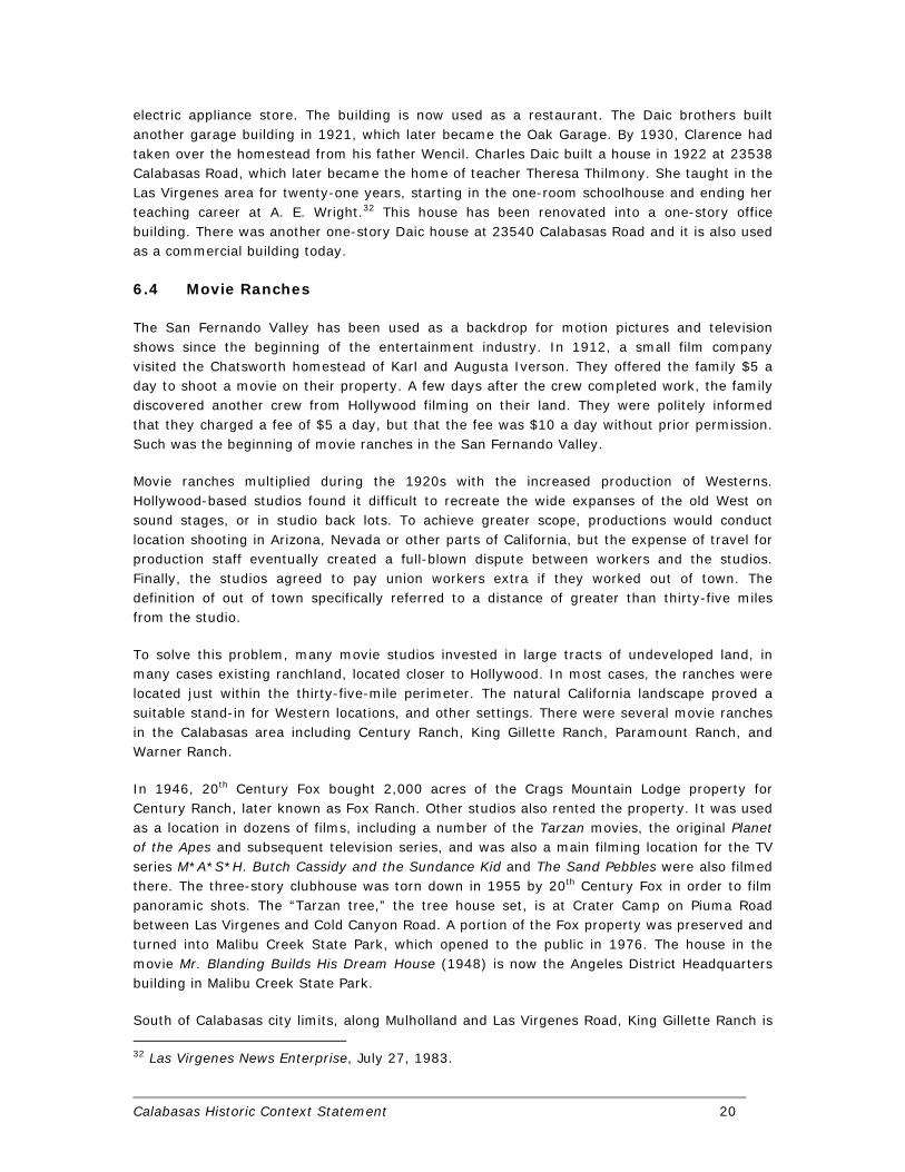
Samuel John Cooper, his wife Mary, and eight children lived on a ranch on Old Topanga Road. They moved to Norwalk from Canada, but after only a few months claimed 160 acres in Calabasas. He owned the Calabasas Grocery Store, known as Cooper’s, which also offered lodging and meals as Hunter’s Inn. The Coopers moved the building from Brent’s Junction (Ventura Road and Las Virgenes Road) to its present-day location across from the Leonis Adobe at 23504 Calabasas Road. After Samuel Cooper, Sr. died in 1901, his wife Mary moved to Los Angeles and rented their land. Mary, the daughter of Samuel and Mary decided to manage the homestead with her cousin Jessie Tucker. They boarded cows for other people to make money. The Cooper sons were Frank, Matt, Samuel Cooper, Jr. and Charles. Charles Cooper and his wife Alice Kimball continued to run Hunter’s Inn. After Charles died in 1914, Alice married Lawrence Kramer. They operated the store, renamed Kramer’s Grocery Store, until Lawrence Kramer retired in 1968. The property in succession then housed a saloon, restaurant, and antique store.
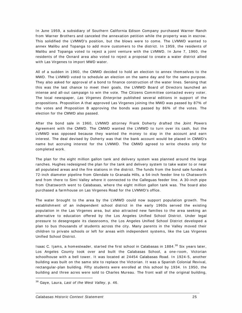
Frank Cooper owned the Oak Garage, next to the grocery store at 23532 Calabasas Road. It was completely reconstructed in 1935 after being damaged in the 1933 earthquake. Matt and Samuel Cooper, Jr. owned a pie factory in Los Angeles. By 1904, the flour dust had started affecting Samuel Cooper, Jr.’s health and he returned to the homestead. He married Rose Dunkerlay and became a major landowner in the area.31
The Daic family homesteaded in 1887 near the present-day Grape Arbor Park in Calabasas. Their homestead was named Grape Arbor Ranch and had a post office substation in 1893. Wencil and his wife Mary had fourteen children, but several died at birth. Most of the children attended the Liberty School, which Wencil helped found in 1896. It was conveniently located near their ranch. The Daic brothers: Joseph, Charles and Albert built a garage in 1915. They named it the Daic Bros. Repair Shop Garage. It was used as a “waiting room,” where messages were relayed. The present-day location is at 23528 Calabasas Road. The building is now the Calabasas Junction Shopping Center. Joseph Daic built a small building next door to the garage at 23536 Calabasas Road. He leased it to his brother-in-law Marx Cooper for an
30 Ibid, p. 69. 31 Gaye, Laura, Last of the West Valley, p. 68.
Calabasas Historic Context Statement 20
electric appliance store. The building is now used as a restaurant. The Daic brothers built another garage building in 1921, which later became the Oak Garage. By 1930, Clarence had taken over the homestead from his father Wencil. Charles Daic built a house in 1922 at 23538 Calabasas Road, which later became the home of teacher Theresa Thilmony. She taught in the Las Virgenes area for twenty-one years, starting in the one-room schoolhouse and ending her teaching career at A. E. Wright.32 This house has been renovated into a one-story office building. There was another one-story Daic house at 23540 Calabasas Road and it is also used as a commercial building today.
6.4 Movie Ranches
The San Fernando Valley has been used as a backdrop for motion pictures and television shows since the beginning of the entertainment industry. In 1912, a small film company visited the Chatsworth homestead of Karl and Augusta Iverson. They offered the family $5 a day to shoot a movie on their property. A few days after the crew completed work, the family discovered another crew from Hollywood filming on their land. They were politely informed that they charged a fee of $5 a day, but that the fee was $10 a day without prior permission. Such was the beginning of movie ranches in the San Fernando Valley.
Movie ranches multiplied during the 1920s with the increased production of Westerns. Hollywood-based studios found it difficult to recreate the wide expanses of the old West on sound stages, or in studio back lots. To achieve greater scope, productions would conduct location shooting in Arizona, Nevada or other parts of California, but the expense of travel for production staff eventually created a full-blown dispute between workers and the studios. Finally, the studios agreed to pay union workers extra if they worked out of town. The definition of out of town specifically referred to a distance of greater than thirty-five miles from the studio.
To solve this problem, many movie studios invested in large tracts of undeveloped land, in many cases existing ranchland, located closer to Hollywood. In most cases, the ranches were located just within the thirty-five-mile perimeter. The natural California landscape proved a suitable stand-in for Western locations, and other settings. There were several movie ranches in the Calabasas area including Century Ranch, King Gillette Ranch, Paramount Ranch, and Warner Ranch.
In 1946, 20th Century Fox bought 2,000 acres of the Crags Mountain Lodge property for Century Ranch, later known as Fox Ranch. Other studios also rented the property. It was used as a location in dozens of films, including a number of the Tarzan movies, the original Planet of the Apes and subsequent television series, and was also a main filming location for the TV series M*A*S*H. Butch Cassidy and the Sundance Kid and The Sand Pebbles were also filmed there. The three-story clubhouse was torn down in 1955 by 20th Century Fox in order to film panoramic shots. The “Tarzan tree,” the tree house set, is at Crater Camp on Piuma Road between Las Virgenes and Cold Canyon Road. A portion of the Fox property was preserved and turned into Malibu Creek State Park, which opened to the public in 1976. The house in the movie Mr. Blanding Builds His Dream House (1948) is now the Angeles District Headquarters building in Malibu Creek State Park.
South of Calabasas city limits, along Mulholland and Las Virgenes Road, King Gillette Ranch is
32 Las Virgenes News Enterprise, July 27, 1983.

Calabasas Historic Context Statement 21
named after King Camp Gillette, who started the Gillette Safety Razor Company. He bought 580 acres in 1926 and built a mansion there in 1929 designed by Wallace Neff. After his death in 1932, his wife sold the property to Clarence Brown, an MGM director. Brown built a private airstrip used for his elaborate Hollywood parties he held there. In 1952, the Claretian Order of the Catholic Church acquired the property and housed a seminary there. The name of the property became Claretville. Then it served as a day camp for children and was leased by Thomas Aquinas College. In 1978, Elizabeth Clare Prophet bought it and operated her New Age church there. In 1986, Soka University of America bought it for their campus. After Soka University moved to a new campus in 2005, the ranch became a park operated by the Santa Monica Mountains Conservancy, the Mountains Recreation and Conservation Authority, National Park Service, California State Parks, et al. The park opened in June 2007.
Paramount Ranch was part of the Rancho Las Virgenes and is primarily in Agoura Hills. Paramount Studios bought it in 1921 and built sets, which were used in movies like The Virginian. In 1952, William Hertz bought 326 acres of the south portion. He sold the property a few years later. The Paramount Sportsman’s Ranch built an automobile racetrack there, which opened in 1956. It was featured in the movies Devil’s Hairpin and Muntster, Go Home. From 1961 to around 1964, famous stuntman Charlie Aldrich, who worked at Corriganville Movie Ranch, began a performance troop at Paramount Ranch (then called Hangtown). From 1962 to 1978, actor Dee Copper leased the property. In 1980, the National Park Service bought a few hundred acres and rebuilt the western town sets. The rebuilt set was used from 1992 to 1997 to film the television show Dr. Quinn, Medicine Woman. The majority of the land has been subdivided into housing tracts.
Warner Ranch was the only movie ranch located within the present-day boundaries of Calabasas. Up until the release of The Jazz Singer in 1927, Warner Brothers was one of many struggling motion picture studios. The first feature-length motion picture with synchronized dialogue sequences, its release heralded the commercial ascendance of the "talkies" and the decline of the silent film era. After the phenomenal success of The Jazz Singer, Warner Brothers launched a major expansion. In 1928, they bought the Stanley Corporation of America and First National Pictures, which was located in Burbank. In 1935, Warner Brothers purchased 500 acres near Calabasas Creek and the vicinity of Mulholland Drive and Valmar Road.33 Dubbed Warner Ranch, it eventually grew to 2,800 acres with numerous outdoor sets.34 One of several movie stars under contract with Warner Brothers was Errol Flynn. He filmed several motion pictures on the Warner Ranch in Calabasas the first of which was The Adventures of Robin Hood (1938). While he thought he was too British to play a cowboy, Warner Brothers cast him in several Westerns, which were all filmed at Warner Ranch. They include: Virginia City (1940), San Antonio (1945), Montana (1950), and Rocky Mountain (1950). Warner Ranch is currently the site of the Calabasas Park subdivision and Calabasas Golf and Country Club, which was established there in 1968.
Warner Ranch is often confused with two other properties. In the 1940's, Harry Warner bought over 1,000 acres of land for his horse ranch, thus the area became knows as the Warner Ranch for awhile. In the 1980's, Warner sold off his land providing an opportunity for commercial development in the area now known as Warner Center. The back lot of Columbia
33 No Author, “Film Plant Expanding, Warners Plan Extensive Construction Program, Ranch Purchased,” in Los Angeles Times, 5/13/1936, p. 1. 34 McCurdy, Jack, “Final Scene for Movie Land of Make Believe,” in Los Angeles Times, 1/15/1961, p. SF1.

Calabasas Historic Context Statement 22
Pictures in Burbank was sometimes referred to as Columbia Ranch. When Columbia Pictures and Warner Brothers combined in 1971, Columbia Ranch became known as Warner Ranch.
For many decades movie ranches were a major component of the economy. They exposed people from the film industry to the Las Virgenes area, some of which decided to make it their home. Especially those people who shared the ideologies of the rural land that Westerns promoted. More importantly, movie ranches tied up large tracts of land as open space. While Warner Ranch in Calabasas was subsequently developed as Calabasas Park, others have been preserved as parkland by state and federal agencies.
6.5 Park Moderne and the Artists in Residence
Greater Los Angeles was one of the early hubs of modern movement in the United States. This can be partially attributed to the commission Frank Lloyd Wright received in 1915 to design a home and theater for Aline Barnsdall in Hollywood. Construction of the house, now called the Hollyhock House began in 1919; however, Wright left much of the supervision to his son, landscape architect Lloyd Wright, and to architect Rudolph Schindler, as Wright himself was working on the Imperial Hotel in Tokyo. Wright’s involvement in construction ended around 1921 when he and Barnsdall had a complete falling out. With the second floor of Hollyhock House still unfinished at this point, Barnsdall enlisted the help of Rudolph Schindler to complete the job in 1924. Schindler had been an assistant in Wright’s office for two years when he was sent to Los Angeles. He left in 1921 to open his own office.
Schindler and his friend Richard Neutra admired Wright’s work as architecture students in Vienna. But while Schindler immigrated to America in 1914, Neutra did not arrive until 1923. Neutra also worked for Wright, but left after only three months. In 1925, Schindler and Neutra renewed their friendship and briefly worked together. While their careers took different paths, they were both extremely influential in the development of modern architecture through their personnel promotion of modern ideals and concepts and the publication of their work in architectural magazines and journals. The second generation of modernists included Gregory Ain, John Lautner, Lloyd Wright, Pierre Konig, J.R. Davidson, Ray Kappe, Harwell Hamilton Harris, Whitney Smith, and Wayne Williams. Several worked for Wright as well as Schindler and Neutra. The work of these modernists; however, was confined mostly to residential buildings as the style was not fully embraced by the business community until after World War II. Nonetheless, it was the work of these early modernists that helped popularize the style after the war.
William Lingenbrink was a real estate developer who was an early patron of modern architecture. He was born in Holland in 1870, and moved to the United States as a child in 1882. In the early 1920s he developed the Silver Strand and Hollywood Beach areas in Ventura County.35 According to community folklore, he and C. Henry Taylor traded Samuel Cooper Jr. a bathtub for his tract of land. In reality, Lingenbrink, Taylor, and Cooper were partners in the subdivision they called Park Moderne. Cooper had some previous experience in real estate development in the area. In 1924 he subdivided two tracts of land off the Mulholland Highway (Tracts #9435 and #8550), which became known as the Highlands. Envisioned as an artist colony, Park Moderne included 174 lots organized along narrow
35 No Author, “Thousands in Southland Celebrate Independence,” in Los Angeles Times, 7/5/1927, p. A14; No Author, “Sudividers Purchase Big Ocean Frontage,” in Los Angeles Times, 11/1/1925, p. E14.

Calabasas Historic Context Statement 23
meandering streets named for birds that inhabited the area: Bluebird Drive, Blackbird Way, Hummingbird Way, Meadowlark Drive, Wrencrest Drive, and Sparrowdell. Oil was used to suppress the dust on the unpaved streets. To attract artists, Rudolf Schindler and Jock Detloff Peters were hired to design model homes and other features for the community such as footpaths, pools, fountains, and a pump house.
Due to the Depression, few of the houses were built and the area remained mostly undeveloped until the 1960s. The ownership of many of the unsold parcel reverted to Samuel Cooper Jr. and his wife Rose. The area was briefly marketed as “Hollywood Ranchitos.” Lots were offered for $175 each. Of the three houses Schindler designed: one remained an un-built project, one was built but subsequently demolished, and one remains. The design anticipated his Schindler Shelters, a series of low-cost prototypes, on which he worked from 1933 to 1939. Like many of his contemporaries during the Depression, Schindler was interested in prefabricated housing. He copyrighted his design for the Schindler Shelter, which provided for a factory-made unit consisting of a kitchen, bathroom, and laundry room, around which a simple shell enclosure of thin slabs of concrete would be constructed.
Peters was responsible for the design of the clubhouse and swimming pool and a series of fountains and ponds to complement Schindler’s model homes. He was best known for designing the interiors of Bullock’s Wilshire in Los Angeles and Hollander Shops in New York City, but he was much more than an interior designer. Of German birth, Peters was an architect, furniture designer, and art director for motion pictures.36 He was one of several avant-garde European designers to immigrate to southern California around World War I. His circle of friends included the likes of Neutra, Schindler, and Kem Weber. His first job in southern California was as the art director for Famous Players/Laskey. Prior to Park Moderne, Peters assisted Lingenbrink with the development of Silver Strand Beach near Oxnard.37
Park Moderne became a weekend retreat and a quiet place for artists to live and work. One of the first residents was the famed sculptor, Jan de Swart. His wife Ursula was the daughter of Jock Peters. Other notables included woodcarver Andy Anderson, cowgirl Jane Reed, artists Robert Witt Ames, Paul von Kleiben, and Olinka Hardy, songwriter Dick Colburn, authors Margaret Larson and Laura Gaye, and designers Walter Dorrer and Charles Gretz.
6.6 Post-War Community Development
Two major issues defined the post-war development of Calabasas: water and education. While most of the San Fernando Valley was annexed to the City of Los Angeles in 1915, the communities in the Las Virgenes area such as Calabasas remained independent. The completion of the Los Angeles Aqueduct in 1913 brought a reliable source of water to the San Fernando Valley for the first time. Water allowed for the intense agricultural development of the area, sparked the annexation to the City of Los Angeles, and contributed to the extinction of many independent smaller towns. When the population of Los Angeles began to explode in the middle of the 20th century, the vineyards and orchards were replaced with housing tracts.
The Las Virgenes area had a scarce supply of water, which hindered its development until the 1960s. Wells and tanks would go dry. Local water was also hard and corrosive. There was a
36 No Author, “Jock D. Peters,” in Los Angeles Times, 6/10/1934, p. A8. 37 Rollins, Bill, “Jock Peters Retrospective on Exhibit at West Hollywood’s Schindler House,” in Los Angeles Times, 3/25/1984, p. AC2.

Calabasas Historic Context Statement 24
small water distribution system in Agoura that drew from a horizontal well, but it only provided a little water. Residents of Agoura, Malibu Lake, and other local areas resorted to expensive water that was trucked into the area.
In 1954, the Agoura Chamber of Commerce decided to form a committee about the inadequate water supply. This group started investigating how to bring water into the area. Then in early 1955, an independent group, the Las Virgenes Water Committee, was founded. Its members were Ruby Berkeley, Robert Boyd, Elizabeth Ossetynska Hughes, Tommie Westminster and Lucille Piera. In late 1955, the committee inquired about joining the West Basin Municipal Water District. The Malibu and Topanga area had just joined this district, so the committee members thought Las Virgenes could pay for an extension north of the pipeline that was to be built from Charnock Wells to Malibu. The general manager of West Basin Municipal Water District said the district did not have enough water in Charnock Wells to also supply Las Virgenes. The committee then met with the general manager of the Metropolitan Water District (MWD) of Southern California, of which West Basin Municipal Water District was a member. The MWD was established in 1928 by a group of communities to bring water from the Colorado River to southern California via an aqueduct. The general manager of the MWD said that there was enough water at Charnock Wells for Las Virgenes, but that available twenty cubic feet per second (cfs) was not enough for the area’s future needs.
On October 20, 1955, Elizabeth Hughes and Ruby Berkeley proposed to two members of the Los Angeles Department of Water and Power (DWP) that Las Virgenes exchange its twenty cfs for twenty cfs of water from the DWP’s planned Granada Trunk Line. This line was going to come from a reservoir above Canoga Park. DWP Assistant Manager Sam Nelson said that the City of Los Angeles could not sell water outside its boundaries. When Hughes and Berkeley cited locations where this was already happening, Nelson insisted that the Las Virgenes area be annexed to the City of Los Angeles.
While looking into the costs of annexation, the committee talked to the Calleguas Municipal Water District (CMWD) in Ventura County about a joint venture. On August 9, 1957, the Las Virgenes Water Committee stated its policy goals of forming a municipal water district, annexing to the MWD, forming a joint venture with the CMWD, and favoring bonds for financing. In the summer of 1957, the committee got the support of the residents of Hidden Hills. Hidden Hills was founded in 1950, but residents still used ground water pumped into storage tanks.
After Hidden Hills supported the Las Virgenes Municipal Water District (LVMWD), the Los Angeles County Board of Supervisors set February 25, 1958 for an election for voter approval of the formation of a water district. At the election, 64% of voters approved the formation. They also elected the first Board of Directors with one member from the Calabasas/Monte Nido area (Division 2). The board convened on April 7, 1958. They proposed to enlist the support of the residents through a citizens committee. Over 300 people attended the first meeting on October 23, 1958.
Other problems surfaced. Many pockets of the Las Virgenes area were planning to annex to the City of Los Angeles. Warner Ranch in Calabasas, sections along Old Calabasas Road and the Ventura Freeway had annexation petitions during 1958. The LVMWD was afraid that these pockets would jeopardize the size and leverage of their district. The CMWD also was not too interested in a joint venture and was considering importing water from the DWP.
Calabasas Historic Context Statement 25
In June 1959, a subsidiary of Southern California Edison Company purchased Warner Ranch from Warner Brothers and canceled the annexation petition while the property was in escrow. This solidified the LVMWD’s position, but the blows were to come. The LVMWD wanted to annex Malibu and Topanga to add more customers to the district. In 1959, the residents of Malibu and Topanga voted to reject a joint venture with the LVMWD. In June 7, 1960, the residents of the Oxnard area also voted to reject a proposal to create a water district allied with Las Virgenes to import MWD water.
All of a sudden in 1960, the CMWD decided to hold an election to annex themselves to the MWD. The LVMWD voted to schedule an election on the same day and for the same purpose. They also asked for approval of a bond to finance construction of the water lines. Sensing that this was the last chance to meet their goals, the LVMWD Board of Directors launched an intense and all-out campaign to win the vote. The Citizens Committee contacted every voter. The local newspaper, Las Virgenes Enterprise published several editions in support of the propositions. Proposition A that approved Las Virgenes joining the MWD was passed by 87% of the votes and Proposition B approving the bonds was passed by 86% of the votes. The election for the CMWD also passed.
After the bond sale in 1960, LVMWD attorney Frank Doherty drafted the Joint Powers Agreement with the CMWD. The CMWD wanted the LVMWD to turn over its cash, but the LVMWD was opposed because they wanted the money to stay in the account and earn interest. The deal devised by Doherty was that the bank account would be placed in CMWD’s name but accruing interest for the LVMWD. The CMWD agreed to write checks only for completed work.
The plan for the eight million gallon tank and delivery system was planned around the large ranches. Hughes redesigned the plan for the tank and delivery system to take water to or near all populated areas and the fire stations in the district. The funds from the bond sale funded a 72-inch diameter pipeline from Glendale to Granada Hills, a 54-inch feeder line to Chatsworth and from there to Simi Valley where it connected to the Calleguas feeder line. A 30-inch pipe from Chatsworth went to Calabasas, where the eight million gallon tank was. The board also purchased a farmhouse on Las Virgenes Road for the LVMWD’s office.
The water brought to the area by the LVMWD could now support population growth. The establishment of an independent school district in the early 1960s served the existing population in the Las Virgenes area, but also attracted new families to the area seeking an alternative to education offered by the Los Angeles Unified School District. Under legal pressure to desegregate its classrooms, the Los Angeles Unified School District developed a plan to bus thousands of students across the city. Many parents in the Valley moved their children to private schools or left for areas with independent systems, like the Las Virgenes Unified School District.
Isaac C. Ijams, a homesteader, started the first school in Calabasas in 1884.38 Six years later, Los Angeles County took over and built the Calabasas School, a one-room, Victorian schoolhouse with a bell tower. It was located at 24454 Calabasas Road. In 1924-5, another building was built on the same site to replace the Victorian. It was a Spanish Colonial Revival, rectangular-plan building. Fifty students were enrolled at this school by 1934. In 1950, the building and three acres were sold to Charles Mureau. The front wall of the original building,
38 Gaye, Laura, Last of the West Valley, p. 46.

Calabasas Historic Context Statement 26
retaining wall, and steps up from the road were incorporated into the restaurant built at the site in 1981.
There were other independent elementary schools in the area, each with their own school board. In 1884, the Las Virgenes School was established. It was located on the east side of Las Virgenes Road, south of the present-day A.E. Wright Middle School. There was no on-site well and a student had to haul five gallons of water every school day. In the 1930s, a well was constructed, but there was still no indoor restroom. Twelve students were enrolled by 1934.
In 1896, the Liberty School District was created from the Las Virgenes and Calabasas Districts. The one-room schoolhouse of the Liberty School had a porch. It was on Liberty Grade near Las Virgenes Road and near the Daic ranch.
In 1913, the Cornell School was built at 30346 Cornell School Road. The Cornell School District was established from the southwest portion of the Liberty District. The schoolhouse had two wings and a central porch. By 1934, twenty students were enrolled. This is now the site of a single-family residence.
By the mid-1940s, the population of the area had increased. More and more children were being enrolled in schools. The Cornell School building was already at capacity. To alleviate this problem, Cornell School Board member Elmer Mojonnier asked Liberty School Board member Art Wright for a garage that belonged to the Liberty School. Mojonnier planned to move the garage to the Cornell School for use as another classroom. Wright had a larger vision. He thought that the children deserved a better building than a converted garage. He also learned from the County that a new State law would mandate that one-room schools form a unified school district. Wright called a community meeting to discuss a $100,000 bond issue. This caught the attention of the community, because the Liberty School District only had a $17,500 bonding capacity.
Wright met with the Assistant Superintendent for Los Angeles County Schools, Dr. Charles Carpenter. Carpenter said that the State school building program would help finance the bond to pay for a new elementary school. To become eligible for this program, the four existing districts combined into the Las Virgenes Union Elementary District in 1946. Mojonnier opposed the Agoura site that Wright wanted for the new elementary school building. The Las Virgenes Union Elementary School was eventually located on Las Virgenes Road. Rows of classrooms from the elementary school are still used at A. E. Wright Middle School, which stands at the 4029 N. Las Virgenes Road.
By 1957, 400 students were enrolled in the district. Seventh and eighth grade students could either attend Las Virgenes Elementary School for the last two years or Sutter Junior High in Canoga Park. Local high school students went to Canoga Park High, because Las Virgenes was part of the Los Angeles High School District. In the late 1950’s, the city of Los Angeles had two school districts: the Los Angeles Union Elementary District and the Los Angeles Union High School District. A movement to unify the districts into a single K-12 district started in 1936. In 1960, voters in the Los Angeles Elementary School District would decide whether to unite with the Los Angeles High School District.
Las Virgenes residents were debating whether to join the Los Angeles Unified School District (LAUSD) or keep the elementary district and send the high school students to Palos Verdes Estates, a distance of thirty-five miles.

Calabasas Historic Context Statement 27
On Election Day, Los Angeles residents voted to unify the school districts. Palos Verdes also formed its own unified school district in 1960. The only remnants of the old Los Angeles High School District, Topanga and Las Virgenes, decided to unify into the West County High School District. However, on October 3, 1961, Topanga voted to join the LAUSD. This left the boundaries of the remaining high school district the same as the Las Virgenes Elementary School District. The Unification Act of 1935 automatically unified a district when elementary and high school boundaries were the same. In July 1, 1962, Las Virgenes Unified School District (LVUSD) was established and had three years to plan and begin its own high school. A new five-person school board was elected. In the 1959-1960 school year, 470 students were enrolled from kindergarten through eighth grade.
In 1961, the LVUSD board passed a resolution that stopped giving parents the option of sending their children to Parkman Junior High School, a larger school in Woodland Hills. After unification, the LAUSD charged tuition to residents of the Las Virgenes area. In May 1962, the LVUSD chose a fifty-acre site west of Cheseboro, north of the Ventura Freeway and near Driver Road for the site. Still, residents and board members strongly disagreed on whether to join LAUSD or to construct a high school. To settle the controversy, the LVUSD board called for an annexation election in January 1963, but the LAUSD board did not consent to the annexation of the LVUSD. Superintendent Jack P. Crowther said that the LAUSD was dealing with a financial crisis and it was “not advisable at this time” for them to annex the LVUSD.
So then at the January 1963 election, the LVUSD called for a school bond and state loan to finance construction of a high school and three elementary schools. Opponents said that property taxes would increase too much and wanted to wait for the LVUSD’s term to expire. The organization the League for Better Education also opposed the bond because they thought that the LAUSD had better educational opportunities.
Proponents of the bond felt that a smaller district would be able to meet the needs of their children better than a larger district. Also, a future population boom would make good schools important. The population boom was expected because a reliable supply of water would soon become available in late 1963 from the Metropolitan Water District. The organization Committee for Las Virgenes Schools lobbied for an independent district.
The bond was defeated on January 29, 1963. Proposition 1, a measure to qualify the district for state aid, was four votes shy of a two-third majority. Proposition 4, a measure authorizing the district to take state bonds, was nine votes short. Proposition 2 and 3, measures authorizing the district to assume outstanding elementary and high school bonds, passed. Because of the narrow margin of defeat for Proposition 1 and 4, another election was called on April 16, 1963. A record turnout, 88% of eligible voters, approved the two propositions in April. On April 29, 1963, the LVUSD board voted to retain its independence.

Calabasas Historic Context Statement 28
Figure 3 – Calabasas School was constructed in 1890 on Calabasas Road.
Figure 4 – The early Victorian building was replaced by the one pictured below around 1925.
Calabasas Historic Context Statement 29
Figure 5 – Kramer’s Store, looking west on Calabasas Road during the early part of the 19th century.
Figure 6 – The Oak Garage was next to Kramer’s Store. This photograph was taken circa 1915.

Calabasas Historic Context Statement 30
Figure 7 – Park Moderne as seen in an aerial photograph from the late 1950s or early 1960s.
Calabasas Historic Context Statement 31
7. ASSOCIATED PROPERTY TYPES 7.1 Paleontological Resources
Following the guidelines of the Society of Vertebrate Paleontology, the paleontological sensitivity for the city of Calabasas is rated as high, except for the portion with volcanic bedrock. Any substantial excavations in the sedimentary deposits in the city should be closely monitored to quickly and professionally collect any specimens. Excavations in the Miocene deposits of the Lower Topanga Formation, the Upper Topanga Formation, the Lower Modelo Formation, or the Upper Modelo Formation, have a good chance of encountering significant vertebrate fossils. Excavations in Quaternary alluvium also could uncover significant vertebrate fossils. It is recommended that any fossils recovered during mitigation should be deposited in an accredited and permanent scientific institution for the benefit of current and future generations. Recommendations for the treatment of paleontological resources follow:
1. During grading activities, a qualified paleontologist shall be retained to conduct part-time monitoring to observe and retrieve any significant specimen that may be uncovered in the older Quaternary sediments, and full-time monitoring in the Miocene formations.
2. If vertebrate fossils or a buried deposit is uncovered, the paleontological monitor shall temporarily halt construction activities for the immediate area until the monitor can evaluate the significance of the find. The monitor would immediately contact the field manager and project personnel. Implementation of a recovery program would follow, if the fossils were determined significant.
3. Any recovered fossils shall be properly collected with photographs, field notes, and locations plotted on a USGS 7.5 minute topographic quadrangle. Fossils will be identified and catalogued, and stabilized for curation. Any recovered fossils shall be offered, on a first right-of-refusal basis, to a repository with a retrievable collection system and an educational and research interest in the materials.
4. A final monitoring report, including an itemized inventory and pertinent field data, shall be sent to the Lead Agencies as well as copies of the report to the Natural History Museum of Los Angeles and to the City of Calabasas.
7.2 Archaeological Resources
Studies of prehistoric sites recorded in Calabasas prove that the city contains a rich prehistoric heritage that deserves active preservation. The archaeological record includes resource gathering sites, hunting sites, small campsites, and village settlements. These sites are summarized in Appendix III. The archaeological record for the city of Calabasas, as with most urban areas, contains few, systematic, hand excavations, which provide the temporal and spatial data that are important for understanding the prehistoric uses of the area. Prehistoric artifacts and features that are found on the surface indicate that people were here long ago, and may indicate potential for finding more evidence of prehistoric activities. But surface artifacts provide an incomplete view of those activities. For example, initial surface investigations at site CA-LAN-712, near the east side, led archaeologists to describe the site as a small knoll-top area where people made and used chipped stone tools. But the site proved to be much more. Later subsurface investigations discovered a wider diversity of tool types, and

Calabasas Historic Context Statement 32
a greater area and time period of prehistoric use. Buried artifacts showed long-term habitation, and provided relative dates for this occupation. CA-LAN-712 was a rich source of information about prehistoric settlements and economic organizations in this area.
The archaeology of the area that includes the city of Calabasas has been compiled and summarized by Nelson Leonard (1971), C. W. Clewlow and David Whitley (1979) and Chester King (2000). The earliest evidence of prehistoric occupation dates to about 6,000 to 7,000 years ago. Early prehistoric activities in the inland areas of the Santa Monica Mountains appears limited to resource use; people collected plants for food and medicines, raw materials for baskets, stone materials for tools, and hunted for inland animals such as deer, rabbits, reptiles, and birds. While gathering these resources and hunting for animals, people maintained camps near reliable water supplies. In the city of Calabasas, sites CA-LAN-129, -315, -482, -836, -866, -868, -1133, -1135, -1325, -1884, -1885, and -1887 seem to represent this type of hunting and gathering behavior.
Over time, populations increased, and people used new tools and practices for exploiting the resources found inland. More people moved there and formed stable communities near reliable water supplies. They established trade contacts with other settlements, on the coast and further inland, in order to obtain desired items not readily available in their local area. They learned how to store food and other resources for the lean winter season. Sites CA-LAN-228, -760A, -1127, -1060, -867, -1883, -1886, and -3095 appear to represent this increase use of the inland region.
Spanish explorations and missions initiated the ethnohistoric period, and provided some historic documents that describe permanent villages of 50 to 100 people or more in the inland Santa Monica Mountains. Sites CA-LAN-229, -246, -420, and -711/712/869 appear to be locations where families lived on a year-round basis about 1,000 to 300 years ago. Sites CA-LAN-229 and -246 are recognized as major villages that existed when the missions were established in the area.
Some of these sites no longer exist. Others are known only from surface artifacts and features; because we do not know if they contain important subsurface remains, they should be preserved and protected for future research. Because subsurface investigations remove portions, or all, of a site, they should be undertaken only when absolutely necessary. Recommendations for the treatment of archaeological resources follow:
1. Revisit and update the conditions of known archaeological sites. Every known site can be described as (a) no longer existing, or (b) in danger of destruction or damage, or (c) currently safe.
2. For those sites where subsurface investigations have occurred, determine where the artifact collections are located. Most are probably at local universities. The purpose is not to re-locate the collections or to establish a new repository for collections; the purpose is to enhance local interest, pride, and sense of place for city residents by making collections more accessible to students, researchers, and the interested public to enhance their understanding of their prehistoric heritage.
3. Establish clear and reasonable procedures to identify, evaluate, and protect unknown archaeological sites.
Calabasas Historic Context Statement 33
7.3 Commercial Buildings
The earliest commercial activities in Calabasas took place in buildings that were not necessarily designed for that use. They were generally associated with the original homesteading families of Calabasas who operated businesses such as stores, restaurants, and inns from their properties. The Ijams, Perrets, and Webers are examples. In some cases, the businesses were operated out of their homes, or in additions with separate entrances. The only of these buildings still standing is Kramer’s Grocery Store. This building was constructed by the Coopers and has had many names including the Calabasas Grocery Store, Cooper’s Store, and Hunter’s Inn. The Coopers moved the building from Brent’s Junction (Ventura Road and Las Virgenes Road) to its present-day location across from the Leonis Adobe at 23508 Calabasas Road.
During the 1920s, Ventura Road (present-day Calabasas Road) emerged as the commercial core of the community. Calabasas would be a stopping point on the long journey between far-flung homesteads, so automobile-related businesses such gas stations and garages also opened here. Some of these businesses adaptively reused existing residential buildings and retain the characteristics of single-family residences. This is especially evident from the rear. Examples are Teresa’s Thimony’s house at 23538 Calabasas Road, the house at 23508 Calabasas Road, and the Daic Brother’s Garage or Calabasas Junction Shopping Center at 23528 Calabasas Road.
Most of the early commercial buildings have not survived due to the rapid development of the area in the later part of the 20th century and changes in zoning that have increased the allowable density. Thus, any surviving commercial buildings with adequate integrity should be considered for landmark designation. Integrity of location, association, and feeling are important in the evaluation of integrity. The basic design should be present, though much of the interior may have been remodeled. The original fenestration pattern should remain, however, it is expected that the doors and windows would have been replaced. The setting of Calabasas Road has been dramatically altered, as most of the original, authentic buildings have not survived. However, many of the newer buildings do imitate the style of the original buildings and are compatible with the historic buildings. Physical attributes are the heights of one to two stories, siding, original materials, and some structural details. Associative attributes are some sort of access on Calabasas Road and connection to a known homesteading family.
In 1984 aerospace and defense contractor Lockheed Corp. hired the distinguished architecture firm of William L. Pereira and Associates to design a headquarters. Pereira was best known for his futuristic buildings such as Transamerica Pyramid in San Francisco and his master plans for Los Angeles International Airport (LAX) and the University of California at Irvine. The Lockheed Headquarters was one of his last completed commissions. Located at, 4500 Park Granada, the 20-acre campus is occupied by a 353,700 square foot three-story Late Mediterranean complex. Lockheed merged with Martin Mariette Corp., forming Lockheed Martin in 1994. The new company was based in Bethesda, Maryland. Countrywide Credit Industries Inc. purchased the campus in 1996 and relocated their headquarters from Pasadena. While the complex is not old enough to be considered for landmark designation at this time, this issue should be revisited in the future.

Calabasas Historic Context Statement 34
Figure 8 – Old Town Calabasas as seen in a 1952 aerial photograph.

Calabasas Historic Context Statement 35
7.4 Residential Buildings
The residences of the homesteading families of Calabasas were generally located along present-day Calabasas Road and Old Topanga Road. They have all been demolished with the exception of the Masson House at 23075 Mulholland Highway. Residential development occurred little by little through the early 20th century along these same two transportation routes. Houses tended to be relatively small and vernacular in style with gabled roofs and wood siding. The few that remain have been expanded upon.
In the 1920s, three residential subdivisions were laid out: the Topanga Canyon Road area and the Highlands in 1924 and Park Moderne in 1928. These subdivisions do not have a strong sense of cohesion because the houses were designed one by one and the development occurred over a long period of time.
Andrew Valdez owned the Topanga Canyon Road area. He is identified in the 1900 census as a 28-year old farmer. He owned his land free and clear and had one servant. Valdez Road is named after him. In 1924 Valdez entered into a partnership with Colodny and Colodny. Born in Vermont, Lippe and Faidorus Colodny were brothers of Russian Jewish ancestry. They subdivided 114 lots (Tract #7094) along Topanga Canyon Road in 1924. It appears that Colodny and Colodny also constructed several small houses. There is a drive named after them in Agoura Hills. Most of the older houses that survive have been substantially altered and expanded.
Samuel Cooper Jr. subdivided two tracts, #9435 and #8550, off Mulholland Highway in 1924, later known as the Calabasas Highlands. Cooper tried to impose order on the undulating terrain with rectilinear streets and standardized lots approximately 60 x 85 feet. The earliest houses in the Highlands can be described as Period Revival, Minimal Traditional, or Ranch style. They tend to be one story in height, covered with pitched roofs, and clad with wood siding. However, the subdivision remained mostly undeveloped until the 1960s.
The original houses in Park Moderne were either designed by Jock Peters or Rudolph Schindler in the early Modern style, or were designed by the original owners. These houses were very small, reflecting the means of the struggling artist who lived there. Sometimes they were no more than artist’s studios with kitchens and bathrooms.
There are a few mid-century Ranch houses scattered about Calabasas. Characterized by its low, horizontal emphasis and sprawling plan, the Ranch house enjoyed enormous popularity throughout the United States during the late 1950s and early 1960s. They can be further divided into the California Ranch and Modern Ranch styles. The California Ranch style applies traditional or Western-themed detailing to the Ranch house form. The Modern Ranch style was influenced by Modern architecture and includes large expanses of glass and minimal detailing.
Calabasas Park is a large-scale subdivision that occupies the area that was once Warner Ranch. Associated Southern Investment Company, a subsidiary of the Edison Company purchased Warner Ranch in 1959 and began planning an all-electric subdivision for 15,000 inhabitants. The plan was stifled for nearly ten years by a lawsuit filed by the Department of Water and Power, which had alternative plans for the site, a reservoir. The community includes an 18-hole golf course, 21-acre lake, and several types of housing. Julian George designed the landscaping of the lake area in 1968. Robert Trent Jones Junior and Senior laid out the golf course that same year. The surrounding condominiums and town houses (1974

Calabasas Historic Context Statement 36
and later) were designed by Dorman/Muselle Associates who chose the Spanish Colonial Revival style. While Calabasas Park is not old enough to be considered for landmark designation at this time, this issue should be revisited in the future.
There is a small cluster of houses on Oak Hollow and Pine Hollow that date from 1976. These houses were all designed by D. Hahn and developed by Norman Eichel. They may become eligible for landmark designation when they are older. Unique houses that may become eligible for landmark designation with age include the Benson Residence by Frank Gehry in the Calabasas Highlands and a geodesic dome house on Mulholland Drive.
Residential buildings may be eligible under Criteria A, B, or C. To be eligible under Criterion A, residential buildings must represent a broad pattern of community development such as early settlement. Such buildings must retain their integrity of location, feeling, and association from the period of significance. Many of the oldest houses in Calabasas have additions. Additions are allowable, but should respect the design, materials, and scale of the original portion of the building.
To be eligible for listing under Criterion B, residential buildings must be associated with persons of historic significance. They should retain their integrity from the period of time the significant individual lived there. The location, setting, design, feeling, and association must be strongly present in the evaluation of integrity. Examples include the Andy Anderson Residence at 22912 Bluebird Drive, the Jan de Swart Residence at 3910 Black Bird Way, the Olinka Hrdy Residence at 3917 Black Bird Way, the Paul von Kleiben Residence at 4062 Black Bird Way, and the Robert Witt Ames Residence at 4067 Black Bird Way.
To be eligible for listing under Criterion C, residential buildings must be representative of a prevalent architectural style or the work of a master designer, architect or builder. They should display most of the character-defining features of its style; and must retain integrity of design, materials, and workmanship that convey its period of construction.
7.5 Objects and Structures
Objects and structures that can be considered historically important in Calabasas are associated with Park Moderne, El Camino Real, or education. Examples include the pump house and fountain in Park Moderne, the El Camino Real bells in Old Town and along the freeway, and the old schoolhouse bell in front of A. E. Wright Middle School.

Calabasas Historic Context Statement 37
Figure 9 – The Highlands as in an aerial photograph from the late 1950s or early 1960s.

Calabasas Historic Context Statement 38
IDENTIFICATION AND EVALUATION METHODS
The preparation of this historic context statement was coordinated by Teresa Grimes and involved the participation of a number of individuals and organizations. Ms. Grimes is the Senior Architectural Historian at Christopher A. Joseph & Associates. The project team included Christina Chiang and Beth Padon. Ms. Chiang is an Architectural Historian at Christopher A. Joseph & Associates, and Ms. Padon is the Principal Archaeologist at Discovery Works, Inc. The City of Calabasas funded the project. Groups consulted included the Calabasas Historic Preservation Commission, the Calabasas Historical Society, and the Mountains Restoration Trust.
An extensive literature review was conducted on the history of Calabasas and the Las Virgenes area. Three books by local authors provide a personal glimpse at life in Calabasas during the early part of the 20th century: Laura Gaye’s Land of the West Valley and The Last of the Old West, and Catherine Mulholland’s Calabasas Girls: An Intimate History, 1885-1912. The history of the Las Virgenes Unified School District is documented in A History of the Las Virgenes School, by Georgia Luxenberg. A History of the Las Virgenes Municipal Water District was written by Gregory Graves. The information in these texts was confirmed and supported by original source materials including the U.S. Census, United States Geological Survey Topographical maps, United States Land Patents maps, aerial photographs, and archival materials found at the Oviatt Library at California State University Northridge and the Kathleen Beachy Collection of the Calabasas Historical Society. The Los Angeles Times chronicled the history of the Las Virgenes area including Calabasas going back to 1881. Many of the articles involved criminal activity and court cases for which Calabasas was notorious. However, the newspaper also covered community development issues such as transportation improvements, education, land subdivision, and public works.
The Vertebrate Paleontological Section of the Natural History Museum of Los Angeles County prepared the Paleontological Report in Appendix II.
On October 14 and 15, 2008, Discovery Works personnel researched the archives at the South Central Coastal Information Center, located at California State University Fullerton. The results of the records search revealed that over thirty-two prehistoric sites and one historic site have been formally recorded within the boundaries of the city of Calabasas. In addition, many archaeological sites are located adjacent to, and within one kilometer, of the city’s boundaries. The table in Appendix III only lists the known archaeological sites within the city boundaries. Three sources provided the majority of this information: the existing archaeological site records, survey reports, and the Cultural Resource Overview and Management Plan for the City of Calabasas General Plan EIR, by Robert Wlodarski and Matthew Conard dated September, 2007.
A study list of approximately 186 properties was developed by the City of Calabasas based upon the Los Angeles County Tax Assessor records. Most of the buildings on these properties were photographed. Some of the buildings were not photographed because they cannot be seen from the public right-of-way. Site-specific research was conducted to determine if any are significant within the periods and themes identified in this context statement. Building permit records were reviewed to determine the date of construction and subsequent alterations, as well as the names of the associated owners, architects and builders. In many cases, building permits were not available. Permits from Los Angeles County may have been

Calabasas Historic Context Statement 39
lost when they were transferred to the City of Calabasas, or work may have occurred without permits. Research was also conducted at the Los Angeles County Tax Assessor Archives to confirm dates of construction and establish a chain of ownership. The property information in the archives terminates in the early 1960s.
BIBLIOGRAPHY
General History Bearchell, Charles A. and Larry D. Fried, The San Fernando Valley: Then and Now. Northridge,
CA: Windsor Publications, Inc., 1988. Berger, John, The Franciscan Missions of California. New York, NY: Doubleday & Company,
Inc. 1948. Bertholdo, Stephanie, “Indian Hills Students Say Goodbye to Calabasas Campus,” in The
Acorn, June 26, 2008. Brown, Dave. “Early Spanish Discoverers of the Las Virgenes Area.” Personal notes and
research, 2009. California Coastal Commission, California Coastal Resources Guide. University of California
Press, 1992. Cordero, Jonathan, Cordero Family History. Website: www.sbcordero.net, accessed August 7,
2008. (Biography of Miguel Ortega.) Douglas, William, Basque Sheepherding in the American West. Website: www.csufresno.edu,
accessed October 9, 2008. Englehardt, Fr. Zephryrin, O.F.M., Missions and Missionaries of California, vols. 1-4. Santa
Barbara, CA: Mission Santa Barbara, 1929. Flint, Ralph, “Jock Peters,” in Creative Art, vol. 11, September 1932, p. 30-33. Garate, Donald, Juan Bautista de Anza: Basque Explorer in the New World. Reno, NV:
University of Nevada Press, 2003. Gaye, Laura, Land of the West Valley. Calabasas, CA: Gaye, 1975. ---------------, The Last of the Old West: A Book of Sketches about the Calabasas Area.
Encino, CA: Argold Press, 1965. Gebhard, David and Robert Winter, Los Angeles Architectural Guide. Leyton, UT: Gibbs Smith
Publisher, 1994. Gebhard, David, Schindler. New York, NY: Viking Press, 1971. Graves, Gregory, A History of the Las Virgenes Municipal Water District. Calabasas, CA:
LVMWD, 1993. Hinkin Sue, The History of the Viewpoint School. Calabasas, CA: Viewpoint Educational
Foundation, 2001. Hoag, Maury, Stagecoaching on the California Coast. Santa Barbara, CA: Fithian Press, 2001. Holmes, Phil, Devon Lang and Erin Evarts, Early Calabasas Vicinity History Summary.

Calabasas Historic Context Statement 40
Unpublished draft, September 8, 2005. Jorgensen, Lawrence C, The San Fernando Valley: Past and Present. Los Angeles, CA: Pacific
Rim Research, 1982. Kielbasa, John R., Historic Adobes of Los Angeles County. Pittsburg, PA: Dorrance Publishing
Inc., 1997. Lane, Richard, Basque Sheep Herders of the American West. Reno, NV: University of Nevada
Press, 1985. Luxenberg, Georgia, A History of the Las Virgenes Schools. Calabasas, CA: LVUSD, 1994. Mayers, Jackson, The San Fernando Valley. Walnut, CA: John D. McIntyre, 1976. Mulholland, Catherine, Calabasas Girls: An Intimate History, 1885-1912. Thousand Oaks, CA:
Catherine Mulholland, 1976. Neels, Mona, The South Side of Calabasas Road 23500 Block. Report on file at the Kathleen
Beachy Memorial Library, 1985. No Author, “History of Calabasas,” in Citizen’s Guide to Calabasas. Calabasas, CA: City of
Calabasas, 2001. No Author, “The Great Pumpkin,” in Calabasas, September/October, 2004, p. 118-123. No Author, United States Federal Census, various dates. No Author, “Schindler Shelters,” in American Architect, vol. 146, May 1935, p. 70-72. No Author, History of the Leonis Adobe. Website: www.leonisadobemuseum.org, accessed
October 2, 2008. No Author, Calabasas History. Website: www.cityofcalabasas.com, accessed August 5, 2008. No Author, Anza Trail. Website: www.mountainstrust.org, accessed October 2, 2008. No Author, Juan Bautista de Anza National Historic Trail Guide: Los Angeles County. Website:
www.solideas.com, accessed October 2, 2008. No Author, California Highways, Trails and Roads: El Camino Real. Website:
www.calhighways.org, accessed October 23, 2008. Robinson, W.W., The Story of the San Fernando Valley. Los Angeles, CA: Title Insurance and
Trust Company, 1961. Robinson, W.W., Land in California. Los Angeles, CA: University of California Press, 1948. Rolle, Andrew. California: A History. Wheeling, Illinois: Harlan Davidson, Inc., 2003. Rooney, Brian, Three Magical Miles: An Appreciation of the Past & Present of Malibou Lake &
Vicinity. Agoura Hills, CA: Cornell Preservation Organization, 2003. Schneider, Jerry, 20th Century Fox Ranch. Website:
http://employees.oxy.edu/jerry/century.htm, accessed August 7, 2008. -------------------- Paramount Ranch. Website: http://employees.oxy.edu/jerry/pararnch.htm,
accessed August 7, 2008.
Calabasas Historic Context Statement 41
Sherman, Robert G., Quiet on the Set! Motion Picture History at the Iverson Movie Location Ranch. Chatsworth, CA: Sherway Publishing Company, 1984.
Sheine, Judith. R.M. Schindler. New York, NY: Phaidon, 2001. Singer, Clay A. et al, A Preliminary Cultural Resources Report for the Old Town Calabasas
Master Plan, November 19, 1993. Wayne, Taryn Lang, Arlene E. Bernholtz, Rosemary Hulle and Robin Gensley Mitchell, The
Heritage of Local Film Making, Calabasas Historical Society. Los Angeles Times No Author, “The Leonis Case,” in Los Angeles Times, May 22, 1891, p. 2. No Author, “Mrs. White’s Story, A Rather Sensational Incident at Her Calabasas Ranch,” in Los
Angeles Times, August 27, 1891, p. 2. No Author, “Instantly Killed, The Fate of Calabasas Claim Jumper,” in Los Angeles Times,
December 17 1892, p. 5. No Author, “Board of Supervisors,” in Los Angeles Times, January 20, 1895, p. 8. (Article
discusses bids for the construction of bridge at Calabasas Station.) No Author, “Stabbed in the Back,” in Los Angeles Times, February 26, 1895, p. 10. No Author, “Santa Monica, To Build a Road to Calabasas,” in Los Angeles Times, August 9,
1895, p. 5. (Article discusses ways and means to further building a road from Santa Monica to Calabasas.)
No Author, “Bad Blood,” in Los Angeles Times, September 9, 1895, p. 5. No Author, “Board of Supervisors” in Los Angeles Times, October 3, 1895, p. 8. (Article
discusses road between Santa Monica and Calabasas.) No Author, “Branscomb Discharged,” in Los Angeles Times, June 27, 1896, p. 9. No Author, “Calabasas Roads,” in Los Angeles Times, September 17, 1896, p. 10. (Article
discusses the location of roads on government, in contrast to private land.) No Author, “A Prairie Fire, Houses and Property Destroyed Near Calabasas,” in Los Angeles
Times, September 23, 1896, p. 10. No Author, “Branscomb Bondsmen,” in Los Angeles Times, January 10, 1897, p. 26. No Author, “Branscomb’s Case,” in Los Angeles Times, July 7, 1897, p. 5. No Author, “A New Batch of Calabasasites in Court,” in Los Angeles Times, December 30,
1897, p. 18. No Author, “Leonis Case Settled,” in Los Angeles Times, January 21, 1898, p. 9. No Author, “Out of Sight,” in Los Angeles Times, March 20, 1898, p. B1. No Author, “Miguel Leonis, An Unceremonious Burial, Legal Trouble Brewing,” in Los Angeles
Times, September 24, 1899, p. 2. No Author, “The Millennium in Calabasas,” in Los Angeles Times, June 6, 1902, p. 11. (Article
discusses past lawlessness in Calabasas, and that it came to pass when the area was
Calabasas Historic Context Statement 42
properly surveyed.) No Author, “Thousands in Southland Celebrate Independence,” in Los Angeles Times, July 5,
1927, p. A14. (Article states that William Lingenbrink owns Silver Strand Tract.) No Author, “Sudividers Purchase Big Ocean Frontage,” in Los Angeles Times, November 1,
1925, p. E14. (Article states that William Lingenbrink owns Silver Strand and Hollywood Beach Tracts.)
No Author, “Jock D. Peters,” in Los Angeles Times, June 10, 1934, p. A8. No Author, “Film Plant Expanding, Warners Plan Extensive Construction Program, Ranch
Purchased,” in Los Angeles Times, May 13, 1936, p. 1. Scheuer, Philip, “Hollywood Develops ‘Ranch’ Complex,” in Los Angeles Times, October 18,
1936, p. C1. McCurdy, Jack, “Final Scene for Movie Land of Make Believe,” in Los Angeles Times, January
15, 1961, p. SF1. Bernstein, Sid, “250 Feast at Basque Reunion,” in Los Angeles Times, August 22, 1965, p. SF-
A1. Burleigh, Irv, “Community for 15,000 Planned in West Valley,” in Los Angeles Times, February
21, 1968, p. SF1. (Article discusses the development of Warner Ranch.) Rollins, Bill, “Jock Peters Retrospective on Exhibit at West Hollywood’s Schindler House,” in Los
Angeles Times, March 25, 1984, p. AC2. Archaeological Sources Boxt M., and B. Rechtman, “Archaeological Investigation at LAN-711,” in Journal of New World
Archaeology, Vol. 4, No. 4. October, p. 8-29, University of California, Los Angeles, 1981.
Crespí, J., Fray, Juan Crespí: Missionary Explorer on the Pacific Coast 1769-1774. Herbert E.
Bolton, ed. and trans. Berkeley: University of California Press, 1927. (Reprinted: AMS Press, New York, 1971.)
Grant, Campbell, “Chumash: Introduction,” in Handbook of North American Indians, Vol. 8,
California. Edited by Robert F. Heizer, Smithsonian, Washington, D.C., 1978, p. 505-515.
“Eastern Coastal Chumash,” in Handbook of North American Indians, Vol. 8, California. Edited by Robert F. Heizer, Smithsonian, Washington, D.C., 1978, p. 509-523.
Harrington, J., “Culture Element Distributions, XIX: Central California Coast,” in University of California Anthropological Records 7(1):1-46. Berkeley, 1942.
King, C., Native American Placenames in the Santa Monica Mountains: First Draft. Topanga
Anthropological Consultants, Topanga, California, 1992.
Native American Indian Cultural Sites in the Santa Monica Mountains. Prepared for the Santa Mountains and seashore Foundation funded under Cooperative Agreement No. 8540-94-003 with the National Park Service Pacific West Region, Santa Monica Mountains National Recreation Area. On file with the City of Calabasas, Planning Department, 2000

Calabasas Historic Context Statement 43
King, Chester, T. Blackburn, and Earnest Chandonet, “The Archaelogical Investigations of Three Sites on the Century Ranch, Western Los Angeles County, California,” in Archaeological Survey Annual Report 11:12-107. Los Angeles, University of California, 1968.
King, C. D., W. W. Bloomer, E. Clingen, B.E. Edberg, L. H. Gamble, J. E. Hammett, J. R.
Johnson, T. H. Kempermen, C. D. Pierce, and E. Wohlgemuth, Archaeological Investigations at Talepop. Ms. on file at the Office of Public Archaeology, Social Process Research Institute, University of California Santa Barbara, 1982.
Kroeber, A. L., “Handbook of the Indians of California,” Bureau of American Ethnology Bulletin,
78. Smithsonian Institution, Washington, D. C. Reprint, Dover Publications, New York, 1925.
Leonard, N. Nelson, III, “Natural and social environments of the Santa Monica Mountains
(6000 B.C. to 1800 A.D.),” in Archaeological Survey Annual Report 13:93-136. University of California, Los Angeles, 1971.
Moratto, M. J., California Archaeology. Academic Press: Orlando, 1984. Villanueva, Jeannie C., “Archaeological Investigations at LAn-712,” in Journal of New World
Archaeology, Vol. 14, No. 4, October, 1981, p. 30-48. Wallace, W. J., “A Suggested Chronology for Southern California Coastal Archaeology,” in
Southwestern Journal of Anthropology 11:3, 1955, p. 214-230. Whitley, David and Joseph Simon, "Phase II Archaeological Test Excavations at CA-LAN-129, -
129A, and 482, Calabasas, Western Los Angeles County, California." On file at the South Central Coastal Information Center, California State University, Fullerton, L-3230, 1993.
"Phase III Data Recovery at Archaeological Sites CA-LAN-760A/H and –867A, Calabasas, Los Angeles County, California." On file at the South Central Coastal Information Center, California State University, Fullerton, L-3329, 1994.
Wlodarski, Robert, "Results of an Extended Phase 1 Archaeological Study for CA-LAN-3095.
The Proposed 128 Unit Village at Calabasas Apartment Project, City of Calabasas, California." On file at the South Central Coastal Information Center, California State University, Fullerton, LA 6134, 2003.
Wlodarski, Robert and Matthew Conard, "Cultural Resource Overview and Management Plan
for the City of Calabasas General Plan EIR", September, 2007.
Calabasas Historic Context Statement 44
APPENDIX I: Chronological History Timeline of the Calabasas Area 1542 Cabrillo Expedition 1769 Portola Expedition 1781 Los Angeles Founded 1797 San Fernando Mission 1806 Mission San Fernando church completed. 1810 Construction begins on arched convento building. 1812 Earthquake damages mission. 1822 Alta California becomes province of Mexico. Mission convento completed. 1824 Calabasas is named. It is derived from the word “Calabazas,” the Spanish word
meaning “pumpkins,” “squash,” or “gourd.” The story is a Basque ranchero accidentally dumped a load of pumpkins where Calabasas is today and the next year hundreds of pumpkin plants grew there.
1834 Missions throughout California are secularized. 1845 Pío Pico becomes Governor and leases the San Fernando Valley to his brother, Andrés
Pico. Don Pio grants Rancho El Escorpion. 1846 After U.S. declares war on Mexico, Pío Pico sells the San Fernando Valley to Eulogio de
Celis. 1847 Andrés Pico surrenders California to Col. John Fremont at Rancho Cahuenga. 1850 California is admitted as 31st state in the union. 1857 Large earthquake topples mission buildings. 1858 Butterfield Overland Mail stage crosses San Fernando Valley three times per week,
stopping at Lopez Station depot in hills west of San Fernando. 1862 Andrés Pico transfers half ownership of the Valley to his brother Pío Pico. President
Abraham Lincoln restores church title to 170 acres around Mission San Fernando. The United States Land Commission clears the title for the 1,109-acre Rancho El Escorpion, thereby recognizing Romero and the three Indian brothers as the original patentees of the land grant.
1869 Issac Lankershim’s San Fernando Homestead Association buys half interest in Valley.
Post office opens at Lopez Station. 1871 Lankershim receives southern half of partitioned Valley. Miguel Leonis finagles
ownership of Rancho El Escorpion. 1873 U.S. government confirms legal title to old Rancho Ex-Mission San Fernando at
116,858 acres, the largest private land parcel in California. 1884 The Las Virgenes School, an elementary school, was begun. 1889 Miguel Leonis dies in wagon accident.

Calabasas Historic Context Statement 45
1890 The Calabasas School, an elementary school, was built at 24400 Calabasas. 1896 A jail was built next to “Hangman’s Tree” on north side of Calabasas Road. The jail
was moved to a site near the railroad line in Chatsworth in 1902. The Liberty School, an elementary school, was created. 1905 Weber’s Store or Calabasas Hotel was built. It was across the street from the
Calabasas Schoolhouse and had a post office, barbershop, café, courtroom and rooms for rent.
1906 Espirtu Leonis dies and is buried at the San Fernando Mission. 1913 Cornell School building built at 30346 Cornell School Road. 1922 Lester and Frances Agoure purchased the Leonis Adobe from Juan and Juana
Menendez. 1926 Peter Coig built the Calabasas Market at 23548 Calabasas Road. It was a Spanish
Colonial Revival commercial building with a market in one half and a restaurant in the other.
1941 Motion Picture Home was built and opened near the intersection of Calabasas Road
and Mulholland Drive in 1942. This is in Woodland Hills. 1947 Las Virgenes Union Elementary School District formed. 1958 Las Virgenes Municipal Water District founded. 1962 On August 6, the newly formed Cultural Heritage Board of the Municipal Art
Department of the City of Los Angeles officially designated the Leonis Adobe as “Historic Cultural Monument No. 1.”
Las Virgenes Unified School District established. 1965 The “Hangman’s Tree” was moved from the east side of Sagebrush Cantina to the
west side of the building due to the transportation of the Saturn 17 rockets from Port Hueneme to the Rocketdyne testing facilities.
1966 On May 21, the Leonis Adobe was opened as a museum to the public. 1975 On May 29, the Leonis Adobe was entered into the National Register of Historic Places. 1983 The Plummer House moved onto the Leonis Adobe property from Plummer Park in
West Hollywood.
Calabasas Historic Context Statement 46
APPENDIX II: Letter from Vertebrate Paleontological Section, Natural History Museum of Los Angeles County APPENDIX III: Table of Recorded Archaeological Sites In order to protect the Archaeological and Paleontological resources identified in Appendices II and III, these appendices are not included in this document. In conformance with the City’s Historic Preservation Ordinance and State and Federal policies and guidelines, all Archaeological and Paleontological records are considered confidential and are not available to the public. For questions regarding Archaeological and Paleontological resources, please contact the City of Calabasas Planning Division at (818) 224-1600.