Embed Size (px)
Citation preview
BUFFALO RIVER REMEDIAL
ACTION PLAN
2005 STATUS REPORT
PREPARED BY:
BUFFALO NIAGARA RIVERKEEPER DRAFT COPY, OCTOBER 2005
FUNDING PROVIDED BY THE UNITED STATES ENVIRONMENTAL PROTECTION AGENCY
Table of Contents
BUFFALO NIAGARA RIVERKEEPER BUFFALO RIVER REMEDIAL ACTION PLAN - 2005 STATUS REPORT ii
PAGE
LIST OF FIGURES AND TABLES…………………………………………………...... IV
ACKNOWLEDGEMENTS…………………………………………………………….. V
ACRONYMS AND ABBREVIATIONS…………………………………………………. VII
PREFACE………………………………………………………………………….… IX
EXECUTIVE SUMMARY…………………………………………………...………... XI
1 THE BUFFALO RIVER AREA OF CONCERN………………………………..… 1
1.1 CITY SHIP CANAL…………………………………………...………. 2
2 BENEFICIAL USES AND IMPAIRMENTS………………...…………...……….. 9
3 DELISTING CRITERIA AND RESTORATION TARGETS……………………….. 11
4 BUFFALO RIVER REMEDIAL ACTION PLAN PROJECTS…………………….. 14
4.1 WATER QUALITY…………………………..…………………...…… 14
4.1.1 NYSDEC ROTATING INTENSIVE BASIN STUDIES…….….. 24
4.1.2 2002 NIAGARA RIVER/LAKE ERIE BASIN WATERBODY
INVENTORY AND PRIORITY WATERBODIES LIST ………… 25
4.1.3 MUNICIPAL & INDUSTRIAL WASTE WATER FACILITIES…. 26
4.1.4 MUNICIPAL SEWER SYSTEMS…………………………..…. 27
4.1.5 STORMWATER……………………………………………… 29
4.1.6 BUFFALO RIVER IMPROVEMENT CORPORATION (BRIC)… 31
Table of Contents
BUFFALO NIAGARA RIVERKEEPER BUFFALO RIVER REMEDIAL ACTION PLAN - 2005 STATUS REPORT iii
PAGE
4.2 CONTAMINATION……………………………………………..….…... 35
4.2.1 BUFFALO RIVER ENVIRONMENTAL DREDGING
FEASIBILITY STUDY …………………………………..…… 42
4.2.2 REMEDIATION OF INACTIVE HAZARDOUS WASTE SITES…. 44
4.3 FISH, WILDLIFE AND MACROINVERTEBRATES……………...….…… 57
4.3.1 ASSESSMENT OF POTENTIAL AQUATIC HABITAT
RESTORATION SITES……….……….………………….…… 60
4.3.2 FISH HEALTH & POPULATIONS……………………. ……… 64
4.3.3 HABITAT RESTORATION …………………………………… 70
5 COMPLEMENTARY PROJECTS……………………………………….….…… 79
5.1 PUBLIC ACCESS AND RECREATION………………………..…...……. 79
5.1.1 TIMES BEACH PUBLIC ACCESS PROJECT…………….…… 80
5.1.2 OHIO STREET PARK……………………………………..… 80
5.2 ENVIRONMENTAL EDUCATION AND PUBLIC INVOLVEMENT………. 82
5.2.1 BUFFALO RIVER PUBLIC OUTREACH EFFORTS…….……. 82
5.2.2 BUFFALO RIVER REPORT CARD………………….....……. 82
5.2.3 EDUCATION AND STEWARDSHIP PROGRAMS………..……. 83
5.2.4 ADDITIONAL PUBLIC INVOLVEMENT……………………... 84
5.3 LAND USE AND DEVELOPMENT……………………………………... 85
6 NEXT STEPS AND COMMITMENTS………………………………….……… 90
APPENDIX A…………………………………………………………..………….… 97
APPENDIX B………………………………………………………………………… 99
APPENDIX C………………………………………………………………………… 100
Figures and Tables
BUFFALO NIAGARA RIVERKEEPER BUFFALO RIVER REMEDIAL ACTION PLAN - 2005 STATUS REPORT iv
PAGE
1 THE BUFFALO RIVER AREA OF CONCERN
FIGURE 1-1 BUFFALO RIVER AOC MAP………………………………... 5
FIGURE 1-2 AOC AND ASSOCIATED WATERSHEDS MAP…………….… 6
FIGURE 1-3 CITY SHIP CANAL………………………………………….. 7
2 BENEFICIAL USE IMPAIRMENTS
TABLE 2-1 BUFFALO RIVER AOC BENEFICIAL USES………………… 10
3 DELISTING CRITERIA AND RESTORATION TARGETS
TABLE 3-1 SUMMARY OF DELISTING CRITERIA/RESTORATION
TARGETS…………………………………………….…….. 12
4 BUFFALO RIVER REMEDIAL ACTION PLAN PROJECTS
FIGURE 4-1 WATER QUALITY CONCERNS MAP……………………….. 33
TABLE 4-1 REMEDIATION STATUS OF HAZARDOUS WASTE SITES ….. 47
TABLE 4-2 INACTIVE HAZARDOUS WASTE SITE CODES……………... 54
FIGURE 4-2 INACTIVE HAZARDOUS WASTE SITES MAP…………….… 55
FIGURE 4-3 NATURAL AREAS MAP…………………………………….. 76
FIGURE 4-4 POTENTIAL AQUATIC HABITAT RESTORATION SITES…… 77
5 COMPLEMENTARY PROJECTS
FIGURE 5-1 BUFFALO RIVER INDUSTRIES MAP……………………….. 88
APPENDIX A HISTORICAL MAPS OF THE CITY SHIP CANAL…………… 95
Acknowledgements
BUFFALO NIAGARA RIVERKEEPER BUFFALO RIVER REMEDIAL ACTION PLAN - 2005 STATUS REPORT v
The Buffalo River Remedial Action Plan 2005 Status Report Update was prepared by
Buffalo Niagara Riverkeeper in cooperation with the New York State Department of
Environmental Conservation and the Buffalo River Remedial Advisory Committee.
Funding for RAP coordination is provided by the United States Environmental Protection
Agency.
REMEDIAL ADVISORY COMMITTEE Joseph Atkinson, PhD UNIVERSITY AT BUFFALO GREAT LAKES PROGRAM
Christopher Balduf PVS CHEMICALS, INC.
Barry Boyer, Esq. STATE UNIVERSITY OF NEW YORK AT BUFFALO
Frank DiMascio BUFFALO SEWER AUTHORITY
Helen Domske NEW YORK SEA GRANT/UNIVERSITY AT BUFFALO GREAT LAKES PROGRAM
Martin Doster NYS DEPT. OF ENVIRONMENTAL CONSERVATION
Mark Gaston ERIE COUNTY SOIL AND WATER CONSERVATION DISTRICT
David Gianturco, RAC Chairman BUFFALO NIAGARA RIVERKEEPER
Michael Greer US ARMY CORPS OF ENGINEERS
Michael Hamilton BUFFALO NIAGARA RIVERKEEPER/BUFFALO ORNITHOLOGICAL SOCIETY
Thomas R. Hersey, Jr. ERIE COUNTY DEPT. OF ENVIRONMENT AND PLANNING
Kim Irvine, PhD BUFFALO STATE COLLEGE
Jill Spisiak Jedlicka, RAP Coordinator BUFFALO NIAGARA RIVERKEEPER
Michael Raab ERIE COUNTY DEPT. OF ENVIRONMENT AND PLANNING
Mary Rossi ERIE COUNTY DEPT. OF ENVIRONMENT AND PLANNING
Byron Rupp US ARMY CORPS OF ENGINEERS
Jill Singer, PhD BUFFALO STATE COLLEGE
Mardell Sundown TONAWANDA BAND OF SENECAS
Gregory Sutton NYS DEPT. OF ENVIRONMENTAL CONSERVATION
Elizabeth Trometer US FISH & WILDLIFE SERVICE
John Whitney USDA-NRCS
Margaret Wooster BUFFALO NIAGARA RIVERKEEPER
Acknowledgements
BUFFALO NIAGARA RIVERKEEPER BUFFALO RIVER REMEDIAL ACTION PLAN - 2005 STATUS REPORT vi
BUFFALO NIAGARA RIVERKEEPER TEAM MEMBERS Jill Spisiak Jedlicka, RAP Coordinator
Julie Barrett O’Neill, Riverkeeper Executive Director
Robbyn Drake, Environmental Planner
Joe Ghosen, Technical Consultant
Todd Bolster, Research Associate
Copies of this report may be obtained: Buffalo Niagara Riverkeeper NYSDEC-Region 9 617 Main St., M108 270 Michigan Avenue Buffalo, New York 14203 Buffalo, New York 14203 www.fbnr.org NYSDEC-Division of Water USEPA-Region II Great Lakes Section 290 Broadway 625 Broadway New York, New York 10007-1866 Albany, New York 12233-3508 www.epa.gov
Support for the development of this document was provided by Robert Townsend, AOC
Coordinator, NYSDEC and Marie O’Shea, Niagara Frontier Program Manager, USEPA –
Region 2. Production of this Remedial Action Plan Status Report was made possible by a
grant from U.S. EPA’s Great Lakes National Program Office.
Acronyms & Abbreviations
BUFFALO NIAGARA RIVERKEEPER BUFFALO RIVER REMEDIAL ACTION PLAN - 2005 STATUS REPORT vii
ADA Americans with Disabilities Act ARCS Assessment and Remediation of Contaminated Sediments AOC Area of Concern BOA Brownfields Opportunity Area BOD Biological Oxygen Demand BOS Buffalo Ornithological Society BMP Best Management Practices BNR Buffalo Niagara Riverkeeper BUI Beneficial Use Impairment BRIC Buffalo River Improvement Corporation BSA Buffalo Sewer Authority CDF Confined Disposal Facility CERCLA Comprehensive Environmental Response, Compensation and Liabilities Act (also known as Superfund) CFPP Cornell Fish Pathology Project CSO Combined Sewer Overflow CWA Clean Water Act DDT Dichlorodiphenyltrichloroethane DELT Deformities, Eroded fins, Lesions and Tumors DEP Erie County Department of Environment and Planning (or ECDEP) DO Dissolved Oxygen EBPS Environmental Benefit Permit System EIS Environmental Impact Statement EPT Ephemeroptera, Plecoptera, Trichoptera (mayfly, stonefly, caddisfly taxa) FBNR Friends of the Buffalo Niagara Rivers FS Feasibility Study FY Fiscal Year GLNPO Great Lakes National Program Office GIS Geographic Information System IBI Index of Biotic Integrity IJC International Joint Commission IRM Interim Remedial Measures km Kilometers LTCP Long Term Control Plan LWRP Local Waterfront Revitalization Plan
Acronyms & Abbreviations
BUFFALO NIAGARA RIVERKEEPER BUFFALO RIVER REMEDIAL ACTION PLAN - 2005 STATUS REPORT viii
mgd million gallons per day mg/L milligram per liter MS4 Municipal Separate Storm Sewer System NFTA Niagara Frontier Transportation Authority NMC Nine Minimum Control NTU Nephelometric Units NYCRR New York Environmental Conservation Rules and Regulations NYS New York State NYSDEC New York State Department of Environmental Conservation (or DEC) NYSDOH New York State Department of Health (or DOH) NYSDOS New York State Department of State (or DOS) O&M Operation and Maintenance PAH Polycyclic (or polynuclear) aromatic hydrocarbon PCB Polychlorinated Biphenyl PSA Preliminary Site Assessment PWL Priority Waterbodies List RAC Remedial Advisory Committee RAP Remedial Action Plan RI Remedial Investigation RIBS Rotating Integrated Basin Studies ROD Record of Decision SEIS Supplemental Environmental Impact Statement SPDES State Pollution Discharge Elimination System SVOCs Semi-Volatile Organic Compounds TAG Technical Advisory Group TMDL Total Maximum Daily Load USACE United States Army Corps of Engineers UAW United Auto Workers USEPA United States Environmental Protection Agency USFWS United States Fish and Wildlife Service VCA Valley Community Association WRDA Water Resources Development Act YOY Young-of-Year
Preface
BUFFALO NIAGARA RIVERKEEPER BUFFALO RIVER REMEDIAL ACTION PLAN - 2005 STATUS REPORT ix
In 1989, a combined Stage 1 and Stage 2 Remedial Action Plan (RAP) was prepared for
the Buffalo River, as required for all Areas of Concern through the Great Lakes Water
Quality Agreement. (EPA specifies a three-stage RAP structure; Stage 1- Problem
Identification and Planning, Stage 2- Goals, Options and Recommended Actions, and
Stage 3- Restoration of Beneficial Uses.) Since the development of the Remedial Action
Plan, NYS Department of Environmental Conservation (DEC) in its role as RAP
Coordinator has tracked progress within the Buffalo River AOC through six Status
Reports (1989-2002).
In October 2003, the USEPA Great Lakes National Program Office (GLNPO) selected
Friends of the Buffalo Niagara Rivers (FBNR) to coordinate the implementation of the
Buffalo River Remedial Action Plan. Effective July 2005, FBNR changed its name to
Buffalo Niagara Riverkeeper.
With the assistance of the Remedial Advisory Committee (RAC), NYSDEC and other
governmental and non-governmental agencies and organizations, Riverkeeper has begun
to make significant progress towards delisting of the Buffalo River AOC. Efforts over
the last two years included a full re-assessment of all beneficial uses, creation of delisting
criteria, and identification of data gaps and needed projects. This 2005 Status Report
Update documents progress that has been made towards delisting during the period of
April 2002 through October 2005.
All previous Status Reports produced by NYSDEC (1989-2002) may be accessed as .pdf
files at the www.fbnr.org, or by using the following link:
http://www.fbnr.org/programs/tributary/buffalo_river/Buffalo_river.htm. These reports
are also available on CD-ROM by request from Riverkeeper.
Members of the Remedial Advisory Committee (RAC), Technical Advisory Groups
Preface
BUFFALO NIAGARA RIVERKEEPER BUFFALO RIVER REMEDIAL ACTION PLAN - 2005 STATUS REPORT x
(TAG), local agencies, stakeholders and project partners all contributed to the
development of the 2005 RAP Status Report Update.
Executive Summary
BUFFALO NIAGARA RIVERKEEPER BUFFALO RIVER REMEDIAL ACTION PLAN - 2005 STATUS REPORT xi
Buffalo Niagara Riverkeeper (formerly Friends of the Buffalo Niagara Rivers) was
selected to coordinate the Buffalo River Remedial Action Plan by USEPA in October
2003. Since that time, Riverkeeper has re-engaged the Remedial Advisory Committee
(RAC), re-evaluated the status of all 14 beneficial uses, developed Delisting
Criteria/Restoration Targets for five beneficial use impairments (BUIs), tracked Buffalo
River research and ongoing projects, and identified data gaps related to BUI assessment.
This 2005 RAP Status Report Update documents progress that has been made towards
delisting during the period of April 2002 through October 2005, as well as next steps and
commitments. In addition, it includes discussions on research conducted since the
inception of the RAP, interprets project findings and current efforts, as well as lays out
preliminary RAC recommendations, next steps and commitments for the AOC.
BUFFALO RIVER AOC OVERVIEW
• Covering nearly 440 square miles, the Buffalo River watershed includes Cayuga
Creek, Buffalo Creek and Cazenovia Creek. Land use in the upper watershed, or
“source area”, is primarily residential, farmland and wooded areas. Industrial
uses dominate the landscape in the lower 6.2 miles, or “impact area” of the AOC.
• The major sources of contamination in the AOC are contaminated bottom
sediments and non-point source pollution. There are 33 Combined Sewer
Overflow (CSO) outfalls and 45 inactive hazardous waste sites in the watershed.
• Contaminants of concern include PCBs, PAHs, heavy metals and industrial
organics. Water quality concerns include low dissolved oxygen, turbidity, and
bacteria. Habitat is severely altered, invasive plant species dominate the
landscape and fish consumption advisories exist for the AOC. Benthic
deformities within the navigational channel are 54.5%, and fish tumor rates range
from 14 to 87% for the six most commonly found species.
• The City Ship Canal, a 1.4 mile stretch adjacent to and connected to the mouth of
Executive Summary
BUFFALO NIAGARA RIVERKEEPER BUFFALO RIVER REMEDIAL ACTION PLAN - 2005 STATUS REPORT xii
the Buffalo River, has been a long-ignored part of the AOC. The canal is known
to hold some of the most highly contaminated sediments within the AOC, there is
undetermined impact of contaminated groundwater, and very little benthic or
fishery data exists for the Canal.
BENEFICIAL USE IMPAIRMENTS
• All 14 beneficial uses were re-evaluated by the Remedial Advisory Committee in
2004. There are six known impairments including; restrictions on fish
consumption, fish tumors or other deformities, degradation of benthos, restrictions
on dredging, degradation of aesthetics, and loss of fish and wildlife habitat.
• There are three “likely” impairments, which include tainting of fish and wildlife
flavor; degradation of fish and wildlife populations; and bird or animal
deformities or reproductive problems. The two unknown impairments are
eutrophication or undesirable algae; and degradation of phytoplankton
populations. The Buffalo River RAC, through the assistance of Buffalo Niagara
Riverkeeper, will be conducting additional beneficial use assessments during the
next two fiscal years (2006-08).
DELISTING CRITERIA/RESTORATION TARGETS
• The Buffalo River RAC, with the assistance of Riverkeeper, developed delisting
criteria/restoration targets for 5 of the 6 “impaired” beneficial uses. Of these six
confirmed impairments, “loss of fish and wildlife habitat” is still being assessed
and evaluated and quantitative targets are under development.
• Additional research and information is needed for the five beneficial uses that are
defined as “likely impaired” or “unknown”. Data gaps include testing PAH levels
in fish and angler surveys (tainting); assessing bird, mammal and herp populations
(degradation of fish and wildlife populations); assessing bird/animal deformities;
quantifying algal and phytoplankton populations; and developing a
Executive Summary
BUFFALO NIAGARA RIVERKEEPER BUFFALO RIVER REMEDIAL ACTION PLAN - 2005 STATUS REPORT xiii
comprehensive habitat analysis and quantification within the AOC.
WATER QUALITY
• The Buffalo River is designated as a Class C waterway by NYSDEC. The major
factors that are known to affect water quality include dissolved oxygen, turbidity,
heavy metals, and bacteria. Degradation of the aesthetics in the lower river
continues to be a problem.
• The Buffalo River has never been fully assessed for eutrophication and the
possible presence of microcystins (toxic algae) has never been studied. There is
minimal data available regarding phytoplankton; therefore, an accurate
determination of its beneficial use status can not be made.
• The Buffalo River RAC has made nine preliminary recommendations regarding
water quality concerns to help make additional progress towards delisting:
i. Fully implement Stormwater Phase II regulations through the implementation
of best management practices and pollution prevention strategies;
ii. Implement non-point source (agricultural and other runoff) pollution
abatement practices in the upper watershed through a possible wet weather or
stormwater project.
iii. Continue erosion control measures in the upper watershed (i.e. Cayuga,
Buffalo and Cazenovia Creeks).
iv. Continue to address failing septic systems throughout the upper watershed.
v. Complete assessment and evaluation of nutrients and possible eutrophication,
algal populations and phytoplankton populations.
vi. Eliminate all SSOs in accordance with the Clean Water Act.
vii. Complete review and evaluation of BSA’s LTCP.
viii. Adopt long-term CSO control programs consistent with EPA’s National CSO
Policy and the Great Lakes Strategy.
Executive Summary
BUFFALO NIAGARA RIVERKEEPER BUFFALO RIVER REMEDIAL ACTION PLAN - 2005 STATUS REPORT xiv
ix. Identify gaps in data and research and obtain funding or develop programs to
fill these gaps.
• Project Updates include detailed information about the following: NYSDEC
Rotating Integrated Basins Studies (RIBS); 2002 Niagara River/Lake Erie Basin
Waterbody Inventory/Priority Waterbodies List; municipal and industrial
wastewater facilities; municipal sewer systems (Buffalo Sewer Authority Draft
Long-Term Control Plan, and sewer separation activities); stormwater
(stormwater coalition, illicit discharge trackdown, and impervious surface
modeling); and the Buffalo River Improvement Corporation (BRIC).
CONTAMINATION
• Two forms of contamination continue to affect the Buffalo River AOC; these
include contaminated bottom sediments, and upland contamination associated
with inactive hazardous waste sites, current industry or brownfields. Combined
with upper watershed sources, historical and current industrial activity resulted in
contamination of upland areas and sediments by metals, pesticides, PCBs, PAHs,
and industrial organics.
• River sediments are contaminated with cyanides and metals to levels that prohibit
open lake disposal. The dredge materials require controlled disposal at a
Confined Disposal Facility (CDF), and therefore result in the impairment of
beneficial use #10 (restrictions on dredging).
• Since the inception of the RAP, some 45 inactive hazardous waste sites have been
identified within the Buffalo River watershed. To date, all Phase I & II site
investigations have been concluded. Remedial Investigations, Feasibility Studies
or Interim Remedial Measures were completed at 42 of the 45 sites. The
remaining three are undergoing restoration planning or have entered voluntary
clean-up agreements.
Executive Summary
BUFFALO NIAGARA RIVERKEEPER BUFFALO RIVER REMEDIAL ACTION PLAN - 2005 STATUS REPORT xv
• The Buffalo River RAC has made six preliminary recommendations regarding
contamination concerns to help make additional progress towards delisting:
i. Complete the Buffalo River Environmental Dredging Feasibility Study by
April 2008;
ii. Apply to the Great Lakes Legacy Act or use USACE’s 312 Program for
funding by FY-2008 for contaminated sediment remediation in the Buffalo
River AOC;
iii. Support NYSDEC efforts to complete remediation of all 45 inactive
hazardous waste sites and continue monitoring leaching potential at sealed or
remediated sites;
iv. Track down illegal connections or illicit discharges to storm sewer lines;
v. Implement non-point source (agricultural and other runoff) pollution
abatement practices in the upper watershed through a possible wet weather or
stormwater project;
vi. Continue erosion control measures in the upper watershed (i.e.; Cayuga
Creek, Buffalo Creek and Cazenovia Creek).
• Project Updates include detailed information about the following: Feasibility
Study for Environmental Dredging within the Buffalo River AOC, and
remediation of inactive hazardous waste sites.
FISH AND WILDLIFE
• Fish consumption in the Buffalo River and Harbor is impaired due to a NYSDOH
health advisory that recommends eating no carp because of elevated PCB levels.
• A voluntary two-year bird survey and population assessment is currently
underway through the efforts of the Buffalo Ornithological Society (BOS) and
Canisius College. Minimal data from a 1993 fish and wildlife inventory exists
regarding wildlife and herpetological populations within the AOC.
Executive Summary
BUFFALO NIAGARA RIVERKEEPER BUFFALO RIVER REMEDIAL ACTION PLAN - 2005 STATUS REPORT xvi
• The Buffalo River RAC has identified information gaps regarding updated data
on tainting, wildlife populations, bird and animal deformities, and habitat
quantification. The RAC has made seven preliminary recommendations
regarding fish and wildlife to continue to make progress towards delisting:
i. Complete assessment and evaluation of mammal and herpetological
populations, and bird health throughout the AOC.
ii. Support NYSDEC and NYSDOH efforts for fish contaminant testing, with
recommendations to increase number of species tested and frequency of
testing to at least every 5 years.
iii. Complete an updated assessment of tainting in fish and wildlife through PAH
testing and angler surveys.
iv. Complete assessment, evaluation and quantification of habitat throughout the
AOC.
v. Implement projects/programs to preserve open space and increase wetland
areas and aquatic habitat.
vi. Implement invasive species eradication efforts.
vii. Prioritize sites identified in the Buffalo River Greenway Plan and identify
funding or programs to protect critical lands and improve/increase habitat.
• Project Updates include detailed information about the following: “Assessment of
Potential Aquatic Habitat Restoration Sites Within the Buffalo River AOC”
project; fish health and populations (fish consumption, tumors and deformities,
Buffalo River walleye restoration project, Goby Survey); and habitat restoration
(pocket parks, Seneca Bluffs, and DEC-managed sites).
COMPLEMENTARY PROJECTS
• Complementary projects are efforts that may have a direct or indirect impact on
the implementation of the Buffalo River RAP. The activities have not yet been
Executive Summary
BUFFALO NIAGARA RIVERKEEPER BUFFALO RIVER REMEDIAL ACTION PLAN - 2005 STATUS REPORT xvii
identified as specific RAP goals, and they are not directly related to the 14
beneficial uses.
• Project Updates include detailed information about the following: habitat
restoration (Times Beach and the Ohio Street Park); environmental education and
public involvement (outreach, Report Card and stewardship); and land use and
development (Greenway, bike path, Erie Canal Harbor, brownfields planning, and
local waterfront revitalization).
NEXT STEPS AND COMMITMENTS
• This includes a summary of plans and commitments for current and future
projects relating to the RAP. Wherever possible, timelines, responsible parties
and funding sources have been identified.
Buffalo River Area of Concern
BUFFALO NIAGARA RIVERKEEPER BUFFALO RIVER REMEDIAL ACTION PLAN - 2005 STATUS REPORT 1
1 THE BUFFALO RIVER AREA OF CONCERN The Buffalo River is located in the City of Buffalo, Erie County, in western New York
State. The river flows from the east and discharges into Lake Erie at the head of the
Niagara River.
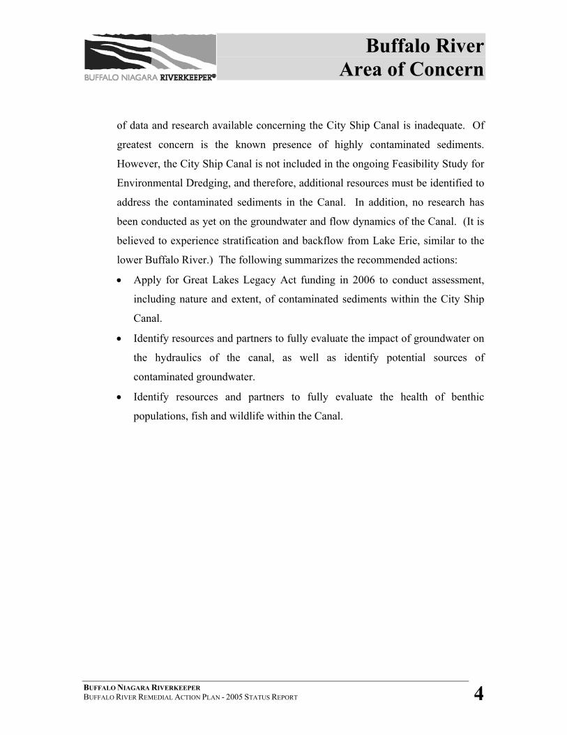
The Buffalo River Area of Concern “impact area” extends from the mouth of the Buffalo
River to the farthest point upstream at which the backwater condition exists during Lake
Erie’s highest monthly average lake level. The impact area is 6.2 miles (10 km) in
length. The AOC also includes the entire 1.4-mile (2.3 km) stretch of the City Ship
Canal, located adjacent to the river (see Figure 1-1). The AOC impact area is
characterized by historically heavy industrial development in the midst of a large
municipality.
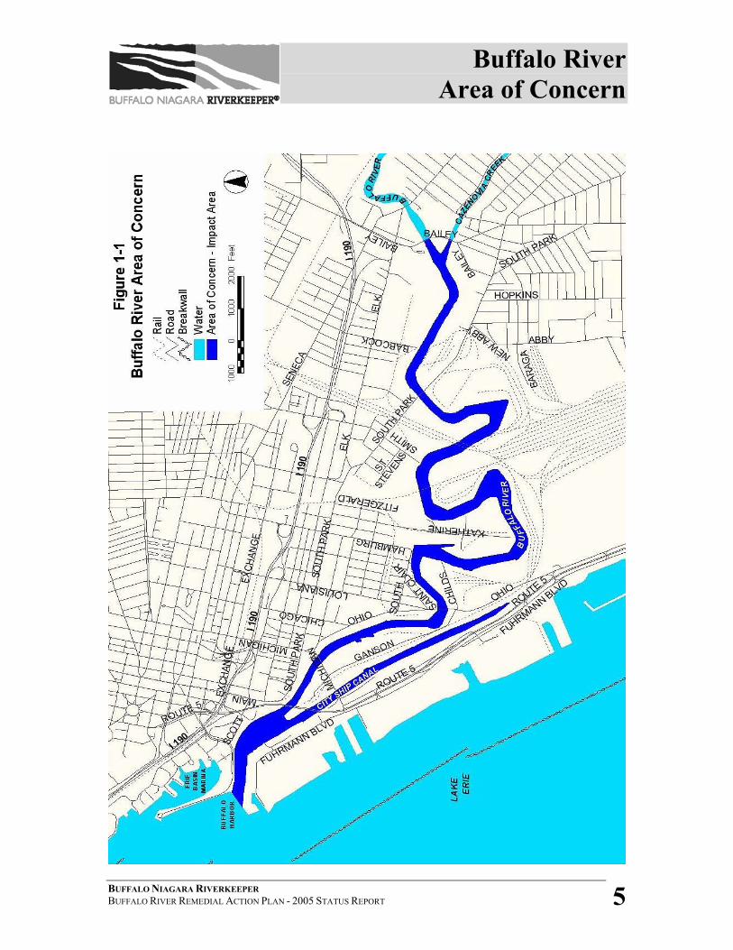
There are three major streams in the watershed that comprise the AOC “source area”:
Cayuga Creek, Buffalo Creek and Cazenovia Creek (see Figure 1-2). Land use in the
tributary watersheds primarily consists of residential communities, farmland, wooded
areas and parks interspersed with commercial land use. The total drainage area for the
Buffalo River watershed is approximately 440 square miles. An analysis of land use and
characteristics and habitat type will be initiated by Riverkeeper in Winter 2005, and will
quantify acreage by type (i.e.: industrial, forested, wetland, etc) from throughout the
AOC. In addition, beginning in Fall 2005, Buffalo State College will be conducting an
analysis of impervious vs. pervious surfaces throughout the AOC.
Presently, the major sources of contamination in the AOC are contaminated bottom
sediments and non-point source pollution generated throughout the watershed. There are
currently 33 CSO outfalls within the watershed that discharge into the Buffalo River and
three connections to the Buffalo sewer system from outside sewer districts that also
Buffalo River Area of Concern
BUFFALO NIAGARA RIVERKEEPER BUFFALO RIVER REMEDIAL ACTION PLAN - 2005 STATUS REPORT 2
overflow into the river during storm events. There are 45 inactive hazardous waste sites
within the AOC and contaminants of concern include polychlorinated biphenyls (PCBs),
polycyclic aromatic hydrocarbons (PAHs), metals, and industrial organics. Water quality
concerns include dissolved oxygen levels, turbidity, and bacterial contamination.
Potential habitat areas (riparian and aquatic) are limited due to contamination,
development and an altered shoreline. Invasive plant and animal species threaten
diversity and quality of habitat. Fish consumption advisories exist for the AOC and
recent research indicates a highly elevated deformity and tumor rate for benthic
organisms and numerous fish species.
1.1 CITY SHIP CANAL (BUFFALO SHIP CANAL) During the 1840’s, the Buffalo Harbor had reached its capacity, and overcrowding
of lake vessels and lack of harbor facilities and mooring sites had become
problems for the City of Buffalo.1 In 1847, Mayor Elbridge Gerry Spaulding
sought to ease the pressure through numerous improvements to the Buffalo River
(then known as Buffalo Creek), including the construction of a new ship canal2.
The canal, completed in 1850, was originally known and officially designated as
the “E. B. Blackwell Canal” after the contractor responsible for construction. By
resolution of the common council, the Blackwell Canal was officially renamed the
City Ship Canal3 in 1953. The waterway is sometimes referred to as the Buffalo
Ship Canal.
The canal was widened in 1873 to one hundred and forty feet wide and fifteen
feet deep. In 1883, the Buffalo Creek Railway Company applied for and obtained
permission to extend the canal in a southerly direction into its own lands. This
portion of land is now considered the Lehigh Valley Railroad property4. One
historical document suggests that, in 1884, the canal culminated in the Tifft Farm
Basins, and may have since been backfilled along with numerous other canals in
Buffalo River Area of Concern
BUFFALO NIAGARA RIVERKEEPER BUFFALO RIVER REMEDIAL ACTION PLAN - 2005 STATUS REPORT 3
Buffalo to abate nuisance problems associated with stagnant waters5. Four slips
cutting between the canal and the Buffalo River at the time were used by ships for
unloading. These have since been filled, and the northern tip of the peninsula
removed, to open up the Inner Harbor6. For historical maps of the City Ship
Canal in 1901 and 1948, see Appendix A.
CURRENT CONDITIONS
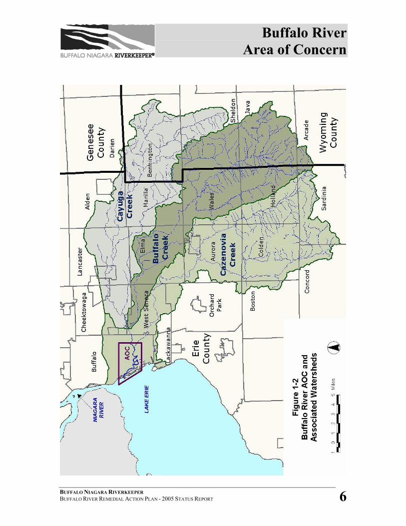
The City Ship Canal has always been considered part of the Buffalo River Area of
Concern, although it was never explicitly described or defined in the original RAP
document (see Figure 1-3). The industrial history of the canal mirrors that of the
Buffalo River; however, the hydraulics and adjacent land uses are much different.
To date, very little research has been completed regarding the Canal. Sediment
testing performed during the 1980s as part of the Assessment and Remediation of
Contaminated Sediments (ARCS) program suggests that the Canal is home to
some of the worst contaminated sediments within the AOC. Limited fishery data
suggests a relatively diverse fish population at the head of the canal. Anecdotal
evidence has indicated the possibility of contaminated groundwater issues, but
there is no known data available to support this suspicion. Local residents have
been seen accessing the head of the Canal for fishing.
A portion of the City Ship Canal is considered a federal navigation channel for
USACE purposes. The authorized portion of the project is 125 feet wide and
5500 feet in length, with a depth of 23 feet7. Minimum depths due to shoaling
have been recorded at 18 feet. The City Ship Canal contains four docks: General
Mills, Toledo Dock Exchange, Buffalo Dock Forwarders and ADM Milling Co8.
RAC RECOMMENDATIONS
The Buffalo River Remedial Advisory Committee acknowledges that the amount
Buffalo River Area of Concern
BUFFALO NIAGARA RIVERKEEPER BUFFALO RIVER REMEDIAL ACTION PLAN - 2005 STATUS REPORT 4
of data and research available concerning the City Ship Canal is inadequate. Of
greatest concern is the known presence of highly contaminated sediments.
However, the City Ship Canal is not included in the ongoing Feasibility Study for
Environmental Dredging, and therefore, additional resources must be identified to
address the contaminated sediments in the Canal. In addition, no research has
been conducted as yet on the groundwater and flow dynamics of the Canal. (It is
believed to experience stratification and backflow from Lake Erie, similar to the
lower Buffalo River.) The following summarizes the recommended actions:
• Apply for Great Lakes Legacy Act funding in 2006 to conduct assessment,
including nature and extent, of contaminated sediments within the City Ship
Canal.
• Identify resources and partners to fully evaluate the impact of groundwater on
the hydraulics of the canal, as well as identify potential sources of
contaminated groundwater.
• Identify resources and partners to fully evaluate the health of benthic
populations, fish and wildlife within the Canal.
Buffalo River Area of Concern
BUFFALO NIAGARA RIVERKEEPER BUFFALO RIVER REMEDIAL ACTION PLAN - 2005 STATUS REPORT 5
Buffalo River Area of Concern
BUFFALO NIAGARA RIVERKEEPER BUFFALO RIVER REMEDIAL ACTION PLAN - 2005 STATUS REPORT 6
Buffalo River Area of Concern
BUFFALO NIAGARA RIVERKEEPER BUFFALO RIVER REMEDIAL ACTION PLAN - 2005 STATUS REPORT 7
Buffalo River Area of Concern
BUFFALO NIAGARA RIVERKEEPER BUFFALO RIVER REMEDIAL ACTION PLAN - 2005 STATUS REPORT 8
SECTION 1 – REFERENCES 1 City of Buffalo website, August 2005 http://history.buffalonet.org/1840-50.html. 2 Buffalo Architecture and History, Spaulding Index, August 2005 http://ah.bfn.org/h/spauld/index.html 3 Nobel E. Whitford, History of the Canal System of New York, Chapter 13, 1906, August 2005 http://www.history.rochester.edu/canal/bib/whitford/old1906/chapter13.htm. 4 Whitford Ch. 13. 5Quintus, John and Thomas Symons, eds., “History of Buffalo Harbor, its Construction and Improvement During the Nineteenth Century”, (compiled from records in the US engineers office Buffalo NY), August 2005 http://historical.library.cornell.edu. 6 Nautical and historical information, August 2005 http://buffalosailor.com/heritage.htm. 7United States Army Corps of Engineers, Notice to Navigation Interests L03-21- Condition of Federal Navigation Channel, Buffalo River and Ship Canal, Buffalo, New York, (2003). 8 USACE, Port Series 41 - The Ports of Buffalo, Rochester, Oswego, and Ogdensburg, NY, (2001).
Beneficial Uses and Impairments
BUFFALO NIAGARA RIVERKEEPER BUFFALO RIVER REMEDIAL ACTION PLAN - 2005 STATUS REPORT 9
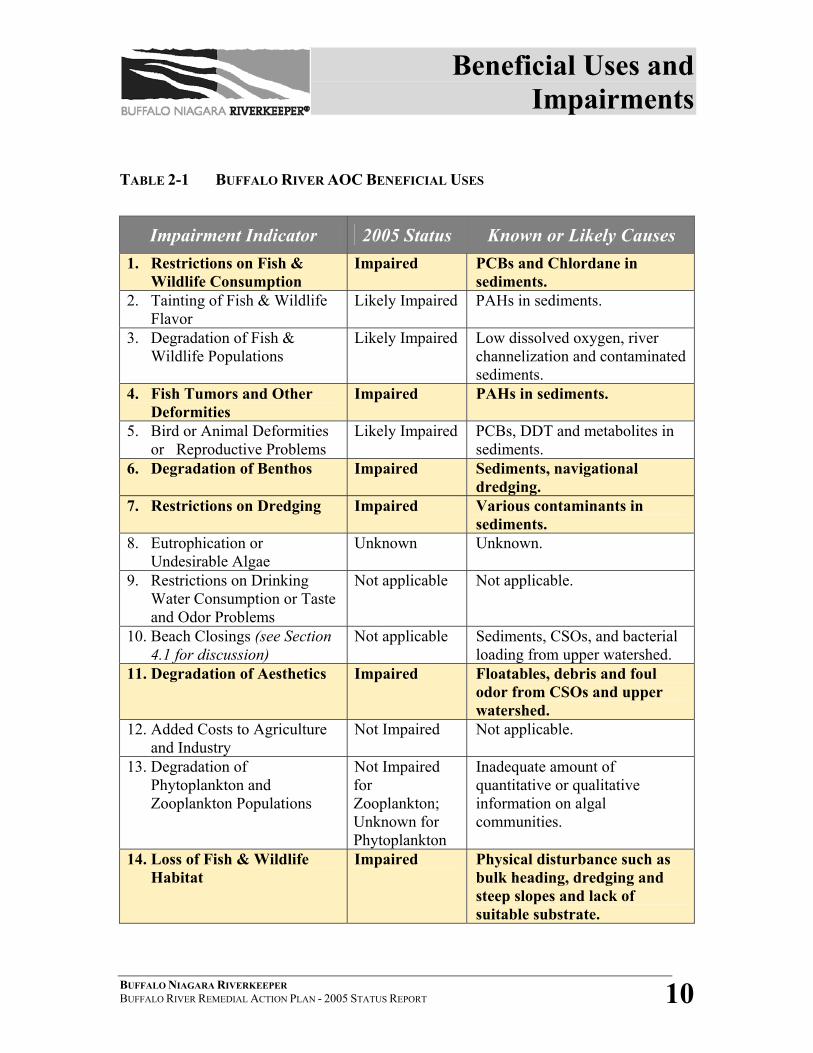
2 BENEFICIAL USES AND IMPAIRMENTS The International Joint Commission determines the listing and delisting of an Area of
Concern based upon the impairment of fourteen identified Beneficial Uses. In 1989, the
Buffalo River RAP determined five of the fourteen Beneficial Uses to be “impaired”,
with another three listed as “likely impaired.” In the fifteen years since the original RAP
was written, there has been a significant amount of research and restoration within the
Buffalo River AOC. However, this work has not yet translated into the delisting of any
impairments. In fact, after a complete review of all 14 Beneficial Uses in 2004, one more
impairment has been added to the list- “Degradation of Aesthetics”. This does not
necessarily reflect lack of progress in improving the river’s health, but rather that
progress has not reached a level that would allow a Beneficial Use Impairment (BUI) to
be delisted or considered restored. See Table 2-1 on the following page for a summary of
the updated status of all Buffalo River AOC Beneficial Uses.
The Buffalo River Remedial Advisory Committee (RAC) through the assistance of
Buffalo Niagara Riverkeeper will be conducting additional Beneficial Use assessments
and evaluations during the next two fiscal years (2006-08). The six uses that have been
determined as “likely impaired”, “unknown”, or assessments that are incomplete include:
tainting of fish and wildlife flavor, degradation of fish and wildlife populations, bird or
animal deformities or reproductive problems, eutrophication or undesirable algae,
degradation of phytoplankton populations, and loss of fish and wildlife habitat.
Beneficial Uses and Impairments
BUFFALO NIAGARA RIVERKEEPER BUFFALO RIVER REMEDIAL ACTION PLAN - 2005 STATUS REPORT 10
TABLE 2-1 BUFFALO RIVER AOC BENEFICIAL USES
Impairment Indicator 2005 Status Known or Likely Causes 1. Restrictions on Fish &
Wildlife Consumption Impaired PCBs and Chlordane in
sediments. 2. Tainting of Fish & Wildlife
Flavor Likely Impaired PAHs in sediments.
3. Degradation of Fish & Wildlife Populations
Likely Impaired Low dissolved oxygen, river channelization and contaminated sediments.
4. Fish Tumors and Other Deformities
Impaired PAHs in sediments.
5. Bird or Animal Deformities or Reproductive Problems
Likely Impaired PCBs, DDT and metabolites in sediments.
6. Degradation of Benthos Impaired Sediments, navigational dredging.
7. Restrictions on Dredging Impaired Various contaminants in sediments.
8. Eutrophication or Undesirable Algae
Unknown Unknown.
9. Restrictions on Drinking Water Consumption or Taste and Odor Problems
Not applicable Not applicable.
10. Beach Closings (see Section 4.1 for discussion)
Not applicable Sediments, CSOs, and bacterial loading from upper watershed.
11. Degradation of Aesthetics Impaired Floatables, debris and foul odor from CSOs and upper watershed.
12. Added Costs to Agriculture and Industry
Not Impaired Not applicable.
13. Degradation of Phytoplankton and Zooplankton Populations
Not Impaired for Zooplankton; Unknown for Phytoplankton
Inadequate amount of quantitative or qualitative information on algal communities.
14. Loss of Fish & Wildlife Habitat
Impaired Physical disturbance such as bulk heading, dredging and steep slopes and lack of suitable substrate.
Delisting Criteria & Restoration Targets
BUFFALO NIAGARA RIVERKEEPER BUFFALO RIVER REMEDIAL ACTION PLAN - 2005 STATUS REPORT 11
3 DELISTING CRITERIA AND RESTORATION TARGETS Buffalo Niagara Riverkeeper’s first management goal as Buffalo River RAP Coordinator
has been the creation of clear delisting criteria and restoration targets for the six
recognized Beneficial Use Impairments (BUIs). Riverkeeper developed the criteria after
a re-evaluation of the status of the BUIs by the Remedial Advisory Committee through
three Technical Advisory Groups (Sediments, Water Quality, and Habitat & Environs).
Local, regional and statewide experts from relevant scientific fields also contributed to
development of the criteria. The suggested criteria have been shared with the public at
several Buffalo River forums, offering community residents an opportunity to participate
in the RAP process.
Table 3-1 on the following page summarizes the delisting criteria/restoration targets for
five of the six known beneficial use impairments. Of the confirmed impairments, “loss of
fish and wildlife habitat” is still being assessed and evaluated and quantitative targets are
under development. As described in Section 2, additional research and information is
needed for the remaining beneficial uses that are defined as “likely impaired”,
“unknown” or are incomplete.
Delisting Criteria & Restoration Targets
BUFFALO NIAGARA RIVERKEEPER BUFFALO RIVER REMEDIAL ACTION PLAN - 2005 STATUS REPORT 12
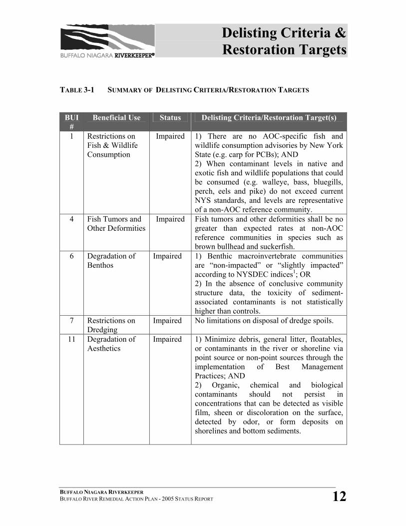
TABLE 3-1 SUMMARY OF DELISTING CRITERIA/RESTORATION TARGETS
BUI #
Beneficial Use Status Delisting Criteria/Restoration Target(s)
1 Restrictions on Fish & Wildlife Consumption
Impaired 1) There are no AOC-specific fish and wildlife consumption advisories by New York State (e.g. carp for PCBs); AND 2) When contaminant levels in native and exotic fish and wildlife populations that could be consumed (e.g. walleye, bass, bluegills, perch, eels and pike) do not exceed current NYS standards, and levels are representative of a non-AOC reference community.
4 Fish Tumors and Other Deformities
Impaired Fish tumors and other deformities shall be no greater than expected rates at non-AOC reference communities in species such as brown bullhead and suckerfish.
6 Degradation of Benthos
Impaired 1) Benthic macroinvertebrate communities are “non-impacted” or “slightly impacted” according to NYSDEC indices1; OR 2) In the absence of conclusive community structure data, the toxicity of sediment-associated contaminants is not statistically higher than controls.
7 Restrictions on Dredging
Impaired No limitations on disposal of dredge spoils.
11 Degradation of Aesthetics
Impaired 1) Minimize debris, general litter, floatables, or contaminants in the river or shoreline via point source or non-point sources through the implementation of Best Management Practices; AND 2) Organic, chemical and biological contaminants should not persist in concentrations that can be detected as visible film, sheen or discoloration on the surface, detected by odor, or form deposits on shorelines and bottom sediments.
Delisting Criteria & Restoration Targets
BUFFALO NIAGARA RIVERKEEPER BUFFALO RIVER REMEDIAL ACTION PLAN - 2005 STATUS REPORT 13
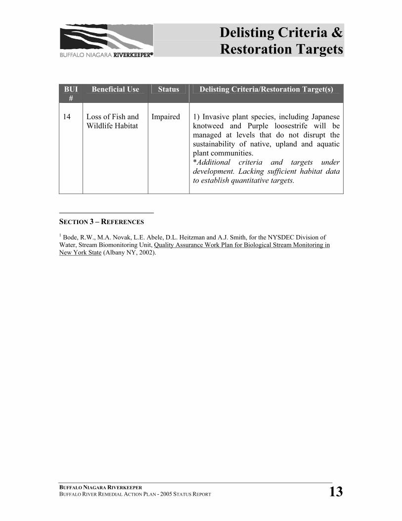
BUI #
Beneficial Use Status Delisting Criteria/Restoration Target(s)
14
Loss of Fish and Wildlife Habitat
Impaired
1) Invasive plant species, including Japanese knotweed and Purple loosestrife will be managed at levels that do not disrupt the sustainability of native, upland and aquatic plant communities. *Additional criteria and targets under development. Lacking sufficient habitat data to establish quantitative targets.
SECTION 3 – REFERENCES 1 Bode, R.W., M.A. Novak, L.E. Abele, D.L. Heitzman and A.J. Smith, for the NYSDEC Division of Water, Stream Biomonitoring Unit, Quality Assurance Work Plan for Biological Stream Monitoring in New York State (Albany NY, 2002).
Buffalo River RAP: Water Quality
BUFFALO NIAGARA RIVERKEEPER BUFFALO RIVER REMEDIAL ACTION PLAN - 2005 STATUS REPORT 14
4 BUFFALO RIVER REMEDIAL ACTION PLAN The following subsections include information regarding water quality, contamination,
and status of fish and wildlife in the Buffalo River AOC. The information and activities
described in Section 4 will provide data that will be utilized to further RAP goals and to
fill information gaps for the RAP.
4.1 WATER QUALITY The following beneficial use impairments, or likely impairments, are directly
related to the water quality in the Buffalo River AOC:
Impaired:
BUI #11- Degradation of Aesthetics
BUI #10- Beach Closings (Not Applicable to AOC, but directly related to
primary and secondary contact)
Likely Impaired or Unknown:
BUI # 3- Degradation of Fish and Wildlife Populations
BUI #8- Eutrophication or Undesirable Algae
BUI #13- Degradation of Phytoplankton and Zooplankton Populations
(Zooplankton Not Impaired, Unknown status for Phytoplankton)
Water quality in the Buffalo River is determined by taking the mean
concentrations of a variety of parameters (pH, turbidity, color, temperature,
bacteria, dissolved oxygen, and concentrations of toxic substances such as metals,
organic compounds and radioactive materials) and comparing these values to a set
of standards under the New York State stream classification system. The
resulting classification becomes the basis for restoration of impaired best uses of
the river. The Buffalo River currently has a “Class C” designation, upgraded
Buffalo River RAP: Water Quality
BUFFALO NIAGARA RIVERKEEPER BUFFALO RIVER REMEDIAL ACTION PLAN - 2005 STATUS REPORT 15
from a “Class D” since the original RAP was written. According to NYSDEC,
the best use of the Buffalo River has been identified as “fishing, with waters
suitable for fish propagation and survival.” In addition, “water quality shall be
suitable for primary and secondary contact recreation, although other factors may
limit the use for these purposes.”1
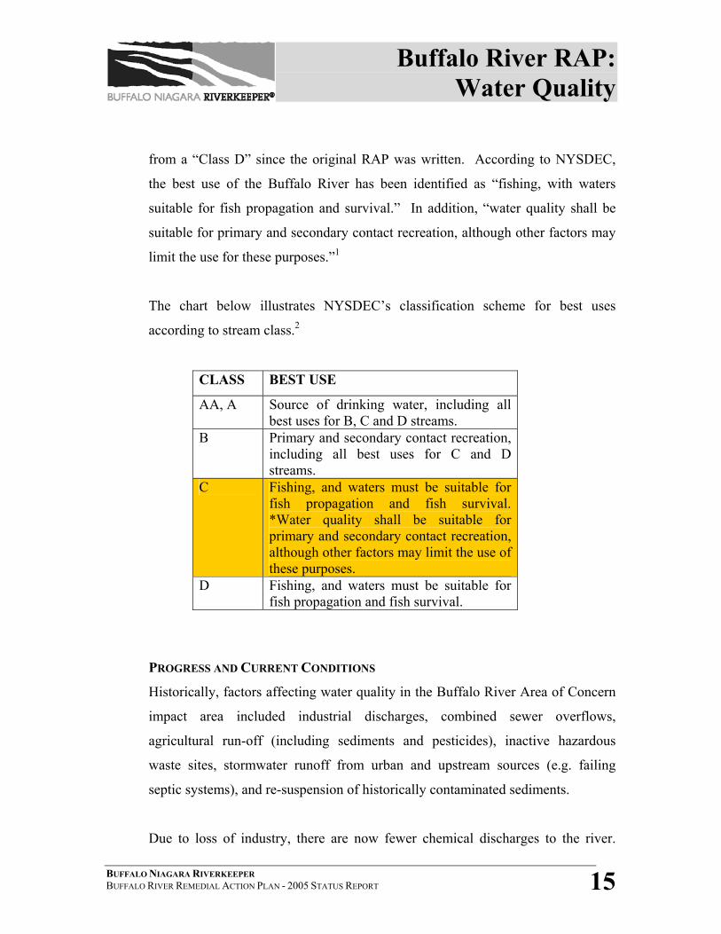
The chart below illustrates NYSDEC’s classification scheme for best uses
according to stream class.2
CLASS BEST USE
AA, A Source of drinking water, including all best uses for B, C and D streams.
B Primary and secondary contact recreation, including all best uses for C and D streams.
C Fishing, and waters must be suitable for fish propagation and fish survival. *Water quality shall be suitable for primary and secondary contact recreation, although other factors may limit the use of these purposes.
D Fishing, and waters must be suitable for fish propagation and fish survival.
PROGRESS AND CURRENT CONDITIONS
Historically, factors affecting water quality in the Buffalo River Area of Concern
impact area included industrial discharges, combined sewer overflows,
agricultural run-off (including sediments and pesticides), inactive hazardous
waste sites, stormwater runoff from urban and upstream sources (e.g. failing
septic systems), and re-suspension of historically contaminated sediments.
Due to loss of industry, there are now fewer chemical discharges to the river.
Buffalo River RAP: Water Quality
BUFFALO NIAGARA RIVERKEEPER BUFFALO RIVER REMEDIAL ACTION PLAN - 2005 STATUS REPORT 16
Levels of PCBs, PAHs and pesticides in the water column have declined since the
1970’s. Suspended sediment concentrations have declined as well.
Over the past 15 years, extensive technical research has been devoted to Buffalo
River water quality issues. Though not all questions about this complex system
have been answered, the data generated to date allow for some general
observations and hypotheses. We now have a better understanding of the
hydrology of the river and how factors such as natural flow rates, its relationship
and mixing with Lake Erie water, and navigational dredging activities affect water
quality.
Today, the major factors that are known to affect water quality in the Buffalo
River are: 1) low dissolved oxygen, 2) turbidity, 3) heavy metals such as iron,
mercury, zinc, lead and copper, and 4) bacterial contamination.
DISSOLVED OXYGEN
Dissolved oxygen has been linked to the likely impairment of beneficial use #3 –
“Degradation of Fish and Wildlife Populations.” The NYSDEC water quality
standard for DO for “nontrout waters” such as the Buffalo River is as follows:
“the minimum daily average shall not be less than 5.0 mg/L, and at no time
shall the DO concentration be less than 4.0 mg/L”.
Low dissolved oxygen levels (<4.0 mg/L) are generally observed during the
warmer part of the summer, but can occur during dry-weather periods when the
River has minimal water movement or during watershed-wide storms and CSO
events.3
Buffalo River RAP: Water Quality
BUFFALO NIAGARA RIVERKEEPER BUFFALO RIVER REMEDIAL ACTION PLAN - 2005 STATUS REPORT 17
Extensive research has been conducted in recent years regarding DO in the
Buffalo River and the results remain consistent. According to Irvine, et al.,
several dissolved oxygen modeling studies conducted for the river (Blair 1992,
Wight 1995, Hall 1997) concluded the following: i) stratification in the river at
low flows reduced aeration (from mixing); ii) high sediment oxygen demand,
together with long residence times due to system hydraulics and background
BOD, can produce low dissolved oxygen; and iii) CSOs to the river had minimal
impact on dissolved oxygen.4
As recently as 2003-04, water quality analysis conducted as part of the
“Assessment of Aquatic Habitat Restoration Sites” project indicates that DO
levels were frequently below state guidelines within the dredged portion of the
AOC, while levels upstream of the dredged channel generally were above state
guidelines. At specific habitat sites, DO tended to be lower near the riverbed than
higher in the water column.5
It is important to note that most of the water quality research and modeling
conducted to date reflects the inputs of Lake Erie water through the Buffalo River
Improvement Corporation (BRIC) pumping system. See more detailed discussion
regarding BRIC at the end of this section.
TURBIDITY
Because of the combination of naturally occurring slow flow rates and inputs
from stormwater runoff in the upper watershed, the Buffalo River remains
relatively turbid. NYSDEC’s RIBS sampling in 2001 indicated a range of 8.68-
14.1 NTUs for the Buffalo River. (However, the lone sampling point for RIBS is
near the mouth of the river where it is expected that suspended solids will have
already begun settling out and most likely show a lower turbidity). Research
Buffalo River RAP: Water Quality
BUFFALO NIAGARA RIVERKEEPER BUFFALO RIVER REMEDIAL ACTION PLAN - 2005 STATUS REPORT 18
associated with the Buffalo Sewer Authority’s Long-Term Control Plan has
indicated that sharp increases in turbidity are directly related to storm events
within the watershed, and that dry-weather turbidity is generally <20 NTU. As
recently as 2003-04, water quality analysis conducted as part of the “Assessment
of Aquatic Habitat Restoration Sites” showed that during dry periods, turbidity
remained relatively low (<20 NTU) in the upper 1m at all 10 potential habitat
restoration sites, and increased to about 20-100 NTU near the riverbed. Turbidity
sharply increased during storm events, occasionally reaching values of 1,000
NTU. 6
Turbidity is also suspected to contribute to the likely impairment of Beneficial
Use #3- “Degradation of Fish and Wildlife Populations.” Fish feeding and
spawning may be affected by high turbidity, since most fish feed by sight, and
high turbidity would affect their ability to see prey. High turbidity would likely
indicate high rates of sedimentation, which may also impact eggs on the riverbed.
It is also important to note that high turbidity may be the result of loss of habitat
from throughout the AOC. There is a lack of shoreline vegetation to reduce
runoff and prevent erosion. The historical loss of wetlands throughout the AOC
contributes to the problem, since wetlands would have helped filter out some of
the suspended sediments.7
Currently, there are no numerical turbidity standards that exist in New York State
for a Class C stream. The NYSDEC narrative standard is as follows:
“No increase that will cause a substantial visible contrast to natural
conditions.”
Before a delisting target can be developed regarding turbidity, the Remedial
Buffalo River RAP: Water Quality
BUFFALO NIAGARA RIVERKEEPER BUFFALO RIVER REMEDIAL ACTION PLAN - 2005 STATUS REPORT 19
Advisory Committee needs to make the determination of what kind of fishery the
Buffalo River should support and what comprises its true “natural condition”. At
this time, the Buffalo River is representative of a warmwater fishery.
HEAVY METALS
Since the development of the original RAP, metals of concern in the water
column have been associated with inactive hazardous waste disposal sites and the
discharges from industrial wastewater treatment facilities.8 The chemicals of
concern included arsenic, barium, copper, iron, lead, manganese, zinc and
cyanides.
Water column sampling conducted through the 2001 RIBS program at the Ohio
Street sampling site indicated iron to be a parameter of concern. However, iron
has been consistently detected at elevated levels throughout the watershed and
may be naturally occurring.
NYSDEC-Region 9 has recently completed (September 2005) sediment sampling
in the Buffalo River AOC in association with the Feasibility Study for
Environmental Dredging. In addition to sediment cores, DEC collected 20
surface water samples at site locations that have the actual or highest potential for
human contact. Water samples will be tested for metals, PAHs (SVOCs),
pesticides and PCBs, and total suspended solids. Results are expected in Fall
2005.
BACTERIAL CONTAMINATION
Fecal coliform continues to be a problem in the Buffalo River, and recent research
associated with BSA’s LTCP has shown that the majority of fecal coliform
loading is coming from the upper watershed. Even though there are no bathing
Buffalo River RAP: Water Quality
BUFFALO NIAGARA RIVERKEEPER BUFFALO RIVER REMEDIAL ACTION PLAN - 2005 STATUS REPORT 20
beaches on the Buffalo River, and therefore no official “impairment” of BUI #10
– “Beach Closings,” primary and secondary recreational contact with the River
occurs frequently.
Research has indicated that fecal coliform levels decrease downstream as the
result of at least two factors; 1) Lake Erie mixes with the Buffalo River and
dilutes the concentration, and 2) fecal coliform levels were significantly
correlated with total suspended solid concentrations, and data shows turbidity
levels decreasing downstream in association with sediment deposition.9
The Erie County Water Quality Committee has begun to focus on evaluation and
abatement of upstream sources, including failing septic systems and suburban
stormwater runoff.10
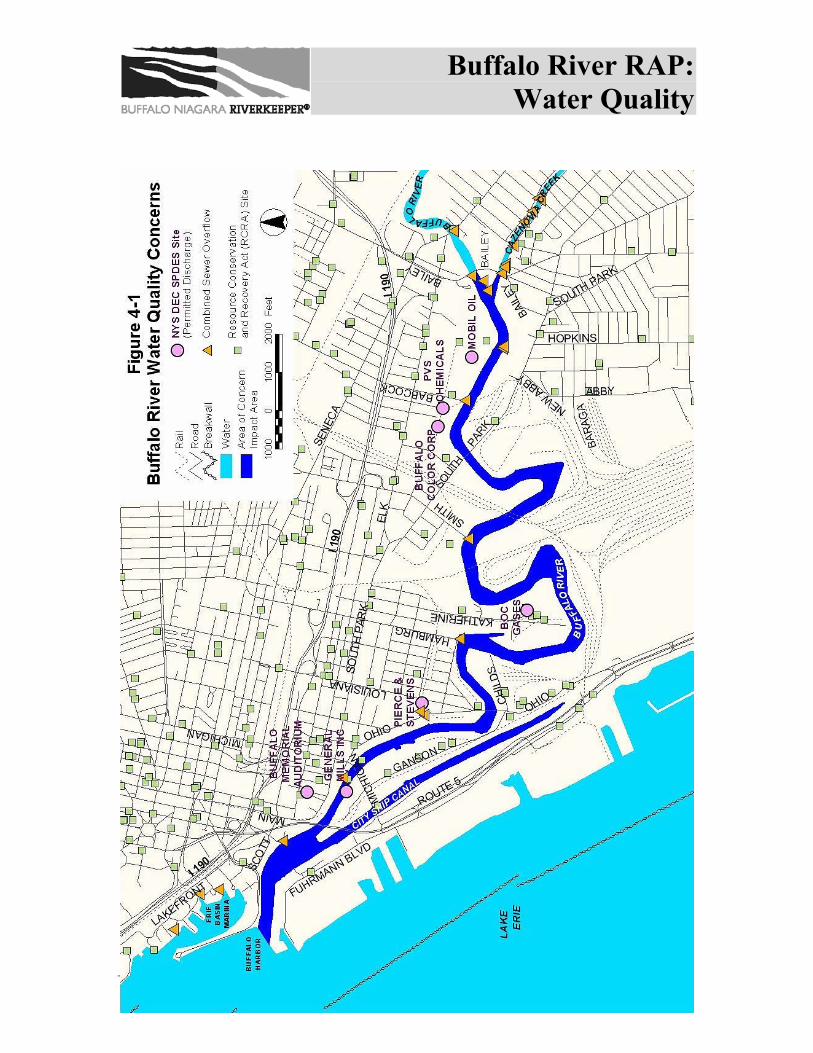
CSOs also continue to be a source of fecal coliform, metals, and suspended solids.
There are 17 Combined Sewer Overflows releasing stormwater and sewage
directly into the Buffalo River from the border of West Seneca to Buffalo Harbor.
In total, there are 33 CSOs throughout the watershed that ultimately discharge
into the river (see Figure 4-1). There are 3 connections to the Buffalo Sewer
System from outside sewer districts that also overflow into the Buffalo River
during storm events.11
The Buffalo Sewer Authority (BSA) recently completed its draft Long Term
Control Plan (LTCP) that identifies best management practices for CSO
abatement. Some of the extensive water quality analyses performed by BSA in
the LTCP process will not be applied to the Buffalo River because of its
previously mentioned “C” classification. Any discussion of alternatives for CSO
abatement in the Buffalo River will be limited by this classification.
Buffalo River RAP: Water Quality
BUFFALO NIAGARA RIVERKEEPER BUFFALO RIVER REMEDIAL ACTION PLAN - 2005 STATUS REPORT 21
The current stream classification – which only acknowledges a best use as being
suitable for primary contact recreation if “other factors do not limit” these uses–
does not reflect the actual use of the Buffalo River by local residents. Primary
and secondary contact occurs on a daily basis during the warm weather months,
regardless of weather conditions. Confirmed by public outreach efforts,
community discussions and river observations, members of the community
continue to remain oblivious or apathetic to the health threats as evidenced by
anglers utilizing the CSO outfalls for fishing and area youth using these outfalls
and rail bridges for swimming access. The water quality studies associated with
the aforementioned draft LTCP have indicated that in addition to CSO inputs, a
large portion of the fecal coliform contamination is generated within the upper
watershed. However, potential improvements in fecal coliform contamination are
not evaluated in the draft LTCP because this water quality standard does not
apply to receiving waters with the NYSDEC “C” classification.
Any improvement to human health risk, as well as fishery and benthic organisms,
must be addressed through CSO abatement and on a watershed basis. The
Buffalo River RAC is evaluating several options to the stream classification
conundrum- should the classification represent what the status of the river is now,
or what the goal for the river is in the future? Options that have been discussed
include: upgrading the river to a “B” classification; requiring warm-weather
disinfection at CSO outfalls; development of a watershed management plan; and a
push for implementation of statewide TMDLs.
OTHER PARAMETERS
A 1992 study provided the first detailed examination of attached algae (especially
diatoms) in the Buffalo River AOC12. In that study, a clear pattern of abundance
of the attached green algae, Cladophora, and nutrient-tolerant attached diatoms
Buffalo River RAP: Water Quality
BUFFALO NIAGARA RIVERKEEPER BUFFALO RIVER REMEDIAL ACTION PLAN - 2005 STATUS REPORT 22
were observed. Though much of the river was composed mainly of the nutrient-
tolerant diatoms, this was not considered an indication of a significantly degraded
environment.13
The Buffalo River has never been fully assessed or evaluated for eutrophication
(BUI #8), and more specifically the possible presence of microcystins, or toxic
algae has never been studied.
Zooplankton populations have been determined to be “not impaired”. Findings
from a 1992 survey indicate that, overall, the zooplankton community in the river
appears to be at least as diverse as that in the inshore areas of Lake Erie, and does
not reflect the impacted nature of the river to nearly the extent of the benthic
macroinvertebrate community (Snyder 1993). 14
Conversely, not enough information and data exists for phytoplankton populations
(BUI #13) to make an accurate determination of its status. Phytoplankton is a
good indicator of a waterbody’s trophic state and potential for fish production.
Initial sampling in 1978 by Frederick and Booth looked at three locations in the
lower Buffalo River. The study revealed that the highest concentrations of
phytoplankton in the river occurred in the upstream portion and progressively
decreased downstream towards the mouth. A subsequent survey in 1992 at four
sites revealed a general absence of Cyanophyta (blue-green algae) at the upper
and lower reaches of the river, but abundant levels in the meandering section of
the river. The green algae, Scenedesmus, were found throughout the river in
relatively high numbers. Schero15 suspected that this may reflect the ability of the
algae to survive in the turbid, organically enriched waters of the Buffalo River. 16
The Buffalo River RAC is currently developing a request for proposals for work
Buffalo River RAP: Water Quality
BUFFALO NIAGARA RIVERKEEPER BUFFALO RIVER REMEDIAL ACTION PLAN - 2005 STATUS REPORT 23
associated with the assessment and evaluation of beneficial uses #8 and #13. Data
collection and analysis is expected to be completed by September 2008.
Aesthetic issues related to water quality continue to be a concern in the Buffalo
River AOC. In addition to the problem with floatables and general litter/debris
coming from the upper watershed, there continues to be a problem with organic,
chemical and biological contaminants that are detected as visible sheen, film
and/or discoloration on the surface, as well as odor and deposits on the shoreline.
RAC RECOMMENDATIONS
The Buffalo River RAC has recommended the following preliminary steps in
order to make progress towards delisting. These recommendations will be further
refined, expanded and prioritized as the updated Buffalo River Remedial Strategy
is developed.
• Fully implement Stormwater Phase II regulations through the implementation
of best management practices and pollution prevention strategies.
• Implement non-point source (agricultural and other runoff) pollution
abatement practices in the upper watershed through a possible wet weather or
stormwater project.
• Continue erosion control measures in the upper watershed (i.e. Cayuga,
Buffalo and Cazenovia Creeks).
• Continue to address failing septic systems throughout the upper watershed.
• Complete assessment and evaluation of nutrients and possible eutrophication,
algal populations and phytoplankton populations.
• Eliminate all SSOs in the Buffalo River watershed in accordance with the
Clean Water Act (Town of Cheektowaga – Broadway and Union, Vern Lane
near Joanne, and Vern Lane at Constance; Village of Depew – Borden Road at
old wastewater treatment plant).
Buffalo River RAP: Water Quality
BUFFALO NIAGARA RIVERKEEPER BUFFALO RIVER REMEDIAL ACTION PLAN - 2005 STATUS REPORT 24
• Complete review and evaluation of BSA’s LTCP.
• Adopt long-term CSO control programs consistent with EPA’s National CSO
Policy and the Great Lakes Strategy.
• Identify gaps in data and research and obtain funding or develop programs to
fill these gaps.
PROJECT UPDATES
Water quality projects include those involving monitoring and restoration of
overall water quality, as well as specific abatement of bacterial contamination by
fecal coliform and Escherichia coli bacteria.
4.1.1 NYSDEC ROTATING INTEGRATED BASIN STUDIES (RIBS)
In 2000 and 2001, the rivers and streams of the Niagara River-Lake Erie
basin were sampled as part of the Rotating Integrated Basin Studies
portion (RIBS) of the Statewide Waters Monitoring Program.17 The RIBS
report was released in mid-2005.
The Buffalo River is one of three “permanent sites” in Region 9 sampled
every year. The sampling of the Buffalo River takes place at the Ohio
Street Bridge. Thirteen additional sites within the Buffalo River
watershed were also sampled in 2001. The basin is next scheduled for
monitoring during 2006. All data collected for this site and the thirteen
sites within the watershed can be found in the 2005 RIBS report.
The RIBS report is a quantitative summary of the concentrations of
chemical and physical constituents in the water column, sediments and
biological tissue. These concentrations are compared to assessment
criteria to determine if designated uses of the waterbody are supported.
Buffalo River RAP: Water Quality
BUFFALO NIAGARA RIVERKEEPER BUFFALO RIVER REMEDIAL ACTION PLAN - 2005 STATUS REPORT 25
The water quality data and information generated by the RIBS program
are used to support many monitoring and assessment functions within
NYSDEC Division of Water, including the development of the Waterbody
Inventory/Priority Waterbody List.18
The 2005 RIBS Assessment Summary for the Buffalo River site is as
follows:
• Water quality parameters of concern are iron, ammonia, water
temperature and dissolved oxygen
• Macroinvertebrate sampling (in the water column) indicated a slightly
impacted condition. The source of impacts is still considered to be
from municipal and industrial inputs.
• There continues to be a fish advisory for carp (eat none) due to PCB
contamination.
• No significant mortality or reproductive impairment of the Water Flea
(Ceriodaphnia dubia) was detected at this site.
• No bed sediments or suspended sediments were collected.
4.1.2 2002 NIAGARA RIVER/LAKE ERIE BASIN WATERBODY
INVENTORY AND PRIORITY WATERBODIES LIST
In order to fulfill requirements of the federal Clean Water Act, NYSDEC
must provide regular, periodic assessments of the quality of the water
resources in the state. The assessments reflect monitoring and water
quality information drawn from a number or programs and sources, both
within and outside NYSDEC. The Buffalo River AOC is part of the
Priority Waterbodies List (PWL).
Released in summer 2005, the 2002 PWL utilized RIBS monitoring data
Buffalo River RAP: Water Quality
BUFFALO NIAGARA RIVERKEEPER BUFFALO RIVER REMEDIAL ACTION PLAN - 2005 STATUS REPORT 26
that had been collected in 2001, though macroinvertebrate sampling was
conducted separately in 2000. The assessment of the Buffalo River AOC
for the PWL is based on sampling conducted at the Ohio Street bridge.
Known pollutants include priority organics (PCBs), while dissolved
oxygen, pathogens, and silt/sediment are considered to be suspected
pollutants. Known sources of pollutants include contaminated sediments,
habitat modification, hydromodification, and urban runoff. Suspected
pollutant sources include combined sewer overflows, and possible
pollutant sources include industrial sites, landfills, municipal and storm
sewers. Fish consumption is considered to be “impaired”, and aquatic life
and recreation are considered “stressed”.
4.1.3 MUNICIPAL & INDUSTRIAL WASTE WATER FACILITIES
Discharge permit monitoring and renewals are ongoing. Under the DEC’s
Environmental Benefit Permit System (EBPS), State Pollution Discharge
Elimination System (SPDES) permits are periodically assessed and
modified. A prioritized list of the permits to be evaluated during the year
is published every April in the Environmental Notice Bulletin; no SPDES
permits in the Buffalo River Basin are scheduled for technical review
during the 2005-2006 fiscal year. There are 8 facilities with SPDES
permits on the Buffalo River (see Figure 4-1 for locations).
These are:
• Worthington Business Center, Stormwater
• Buffalo & Pittsburg Railroad Buffalo Creek Yard (Norfolk and
Western Railroad Company), Sanitary
• BOC Group, Inc., Cooling
Buffalo River RAP: Water Quality
BUFFALO NIAGARA RIVERKEEPER BUFFALO RIVER REMEDIAL ACTION PLAN - 2005 STATUS REPORT 27
• Buffalo Color Corporation, Cooling
• PVS Chemicals, Inc., Cooling
• Mobil Oil Corporation, Stormwater
• General Mills, Inc., Cooling (GM also holds a SPDES permit for
groundwater discharge into the City Ship Canal)
• Pierce and Stevens Corporation, Cooling
4.1.4 MUNICIPAL SEWER SYSTEMS
4.1.4(A) BSA LONG TERM CONTROL PLAN
In accordance with the USEPA’s 1994 CSO Control Policy, a
Draft CSO Long Term Control Plan has been prepared by the
Buffalo Sewer Authority (BSA) and is presently being reviewed
by NYSDEC.
The BSA is required under the terms of its State Pollution
Discharge Elimination System (SPDES) permit (Permit No. 9-
1402-00154/00002) to implement Best Management Practices
(BMPs) for CSOs and to develop a CSO Abatement Plan. The
BMPs are equivalent to Nine Minimum Controls (NMCs) required
under the USEPA CSO Control Policy.19
The LTCP was completed in three stages: system mapping, data
collection and model development; district specific planning; and
system-wide long term control plan development. As of June
2005, BSA has invested nearly $8 million in the development of
the LTCP. It is expected that the plan will be publicly released by
early 2006.
Buffalo River RAP: Water Quality
BUFFALO NIAGARA RIVERKEEPER BUFFALO RIVER REMEDIAL ACTION PLAN - 2005 STATUS REPORT 28
The BSA held at least two public hearings on the LTCP, one at the
beginning of its development and another after preliminary results
had been compiled. There will also be an opportunity for public
comment on the plan following its release.
4.1.4(B) SEWER SEPARATION
Sewer separation in Kaisertown (the area of Buffalo near the West
Seneca border) is almost complete. The project is part of an
initiative that separates combined sewers into two separate sewers;
one dedicated to stormwater, the other to waste water. The BSA
will be adding 5,000 feet of new sewers ranging in size from 10-27
inches. The purpose of this separation work is threefold: 1) to
reduce stormwater inputs to the wastewater treatment plant which
increases the plants capacity to treat sanitary sewage, 2) reduce the
frequency and volume of combined sewer overflow (CSOs) events,
and 3) diminish the incidences of sewer back-ups into homes and
other private properties.20
The Kaisertown separation project will redirect stormwater into the
permitted CSO near the Sloan Drain (near South Ogden Street).
The separation effort supports the current focus of the BSA, which
is to maximize the performance of the existing sewer system
infrastructure. 21
In addition, the Barnard Street CSO (#034) has been converted into
a stormwater only discharge. This will eliminate the amount of
septic sewage that had previously entered the Buffalo River from
this location.
Buffalo River RAP: Water Quality
BUFFALO NIAGARA RIVERKEEPER BUFFALO RIVER REMEDIAL ACTION PLAN - 2005 STATUS REPORT 29
4.1.5 STORMWATER
Non-point source pollution (from stormwater runoff, septic systems and
CSO inputs) is the major source of contaminants generated in the upper
watershed. Stormwater pollution from throughout the Buffalo River
watershed contributes greatly to most of the BUIs for the river.
4.1.5(A) STORMWATER COALITION
Erie County Department of Environment and Planning (ECDEP)
received a $500,000 grant from NYSDEC in 2004 for a Western
New York Stormwater Pollution Prevention Implementation
Project. ECDEP initiated a regional strategy to assist local
municipal governments, in Erie and Niagara Counties, in
understanding and complying with the U.S. Environmental
Protection Agency’s Stormwater Phase II regulations. This strategy
includes formation of the Western New York Stormwater
Coalition, a group consisting of representatives of Erie County,
Niagara County, several local and state government agencies, 41
regulated municipalities and environmental consultants. For the
past three years, the members of the Coalition have met on a
monthly basis to collaborate on developing and implementing a
comprehensive stormwater management program. The Coalition
utilizes a workgroup format to address the six minimum controls
that the regulations require. Each workgroup is responsible for
developing their respective components of the stormwater
management program. Erie County staff coordinates the activities
of the Coalition, maintain an e-mail distribution list and perform
administrative duties on behalf of the Coalition.
Buffalo River RAP: Water Quality
BUFFALO NIAGARA RIVERKEEPER BUFFALO RIVER REMEDIAL ACTION PLAN - 2005 STATUS REPORT 30
There are six minimum controls to the Phase II regulations:
1. Public education & outreach
2. Public participation & involvement
3. Illicit discharge detection & elimination
4. Construction site runoff control
5. Post-construction site runoff control
6. Pollution prevention & good housekeeping for municipal
operations
When successfully implemented, these measures are expected to
significantly reduce the volume of pollutants discharged into
receiving bodies of water.22
4.1.5(B) ILLICIT DISCHARGE TRACKDOWN & IMPERVIOUS SURFACE
MODELING
Beginning in 2006, Buffalo State College-Department of
Geography and Planning will begin an Illicit Discharge Trackdown
project in conjunction with the Phase II Stormwater efforts with
Erie County. Over 40 regulated municipalities in Erie and Niagara
Counties are being evaluated as part of this project, which is
expected to help establish stormwater parameters for all
municipalities. As of September 2005, approximately 80% of the
areas have been mapped, totaling approximately 3,600 outfalls.
The project is divided into three stages: 1) identify stormwater
outfalls, 2) prioritize the outfalls based on discharge location and
surrounding land use, and 3) establish a rotating monitoring
program to identify and track down any illicit dry weather
discharges or illegal connections to the stormwater systems. This
Buffalo River RAP: Water Quality
BUFFALO NIAGARA RIVERKEEPER BUFFALO RIVER REMEDIAL ACTION PLAN - 2005 STATUS REPORT 31
monitoring, along with the identification of potential upstream
sources, will allow participating municipalities to track down the
sources of the illicit dry weather discharges. It is expected that all
information and data generated from this project will be publicly
available through Erie County’s website in early 2006.23
Buffalo State College will be conducting an impervious surface
assessment for the entire Niagara River Watershed beginning in
2005. A model application for a subset of the watershed will also
be conducted, which most likely will be for the Buffalo River. The
thesis work by a graduate student is expected to provide useful
data on the percentage of impervious surfaces in the Buffalo River
watershed, which will help the RAC develop delisting criteria and
restoration targets for BUI #14- “Loss of Fish and Wildlife
Habitat.”
4.1.6 Buffalo River Improvement Corporation (BRIC)
Due to industrialization of the river, by the mid-1960’s the river channel
had expanded to hundreds of times its original volume, and the residence
times for pollutants climbed proportionally. The resulting high
temperatures and acidity prevented effective use of the river as a source of
industrial cooling water. To alleviate these effects, a consortium of
industries formed the Buffalo River Improvement Corporation (BRIC).
The BRIC constructed a pumping station and service main so that Lake
Erie water could be pumped (from approximately 2 miles south of the
mouth of the Buffalo River) to the plants for cooling and then be
discharged into the river to augment flow. Although the BRIC pump rate
amounted to only 20% of total annual flow in the river, it is reported to
Buffalo River RAP: Water Quality
BUFFALO NIAGARA RIVERKEEPER BUFFALO RIVER REMEDIAL ACTION PLAN - 2005 STATUS REPORT 32
have contributed more than 90% of flow during summer low flow
conditions (Sauer 1979).24
The BRIC system was designed to supply 120 million gallons per day
(mgd) for industrial use. Due to industrial plant closures and process
shutdowns, only one company continues to utilize as well as manage
BRIC, and that is PVS Chemicals, Inc. PVS Chemicals estimates that the
flows will not exceed 5-6 mgd during 2005, with an operational cost
ranging from $24,000-$40,000 per month. It is yet unclear what impact, if
any, this reduced flow will have on the Buffalo River.
The Buffalo River RAC Water Quality Technical Advisory Group has
discussed flow modeling using hypothetical increased BRIC flows to
address the low dissolved oxygen issue. The RAC agrees that no one
company or entity should bear the burden of additional BRIC costs if
flows are increased at some point in the future for the purpose of habitat
or water quality improvement.
Buffalo River RAP: Water Quality
BUFFALO NIAGARA RIVERKEEPER BUFFALO RIVER REMEDIAL ACTION PLAN - 2005 STATUS REPORT 33
Buffalo River RAP: Water Quality
BUFFALO NIAGARA RIVERKEEPER BUFFALO RIVER REMEDIAL ACTION PLAN - 2005 STATUS REPORT 34
SECTION 4.1 – REFERENCES 1 New York State Department of Environmental Conservation, Classifications- Surface Waters and Ground Waters, 6 NYCRR Part 701. 2Scott Stoner, Quality Assurance Officer, NYSDEC – Albany, Personal communication, 2005. 3 Kim Irvine, et al., “Continuous Monitoring of Conventional Parameters to Assess Receiving Water Quality in Support of Combined Sewer Overflow Abatement Plans”, Water Environment Research, Vol. 77, No. 3, September/October 2005. 4 Kim Irvine, et al., “Sampling and Modeling Approaches to Assess Water Quality Impacts of Combined Sewer Overflows- The Importance of a Watershed Perspective”, Journal of Great Lakes Research, 31, 2005: 105-115. 5 Kim Irvine et al., Assessment of Potential Aquatic Habitat Restoration Sites in the Buffalo River AOC, October 2005. 6 Irvine et al.. 7 Betsy Trometer, USFWS Fishery Biologist, Personal communication, 2005. 8 NYSDEC, Buffalo River Remedial Action Plan (1989) 9 Kim Irvine, et al., “Sampling and Modeling Approaches to Assess Water Quality Impacts of Combined Sewer Overflows- The Importance of a Watershed Perspective”, Journal of Great Lakes Research, 31, 2005: 105-115. 10 Irvine, et al.: 112. 11 Buffalo Sewer Authority, System-Wide Long Term Control Plan for CSO Abatement, (Orchard Park: Malcolm Pirnie, 2004). 12 Poole, E. Ann, E. Kozuchowski, C. Lowie for the Erie County Department of Environment and Planning, Fish and Wildlife Habitat Restoration on the Buffalo River, Buffalo, NY (August, 1994). 13 Poole 1994. 14 Poole 1994. 15 Poole 1994. 16 Poole 1994. 17 NYSDEC, Rotating Integrated Basin Studies - The Niagara River-Lake Erie Drainage Basin, Sampling Years 2000-2001, (February 2005). 18 NYSDEC, RIBS (2005). 19 Buffalo Sewer Authority, System-Wide Long Term Control Plan for CSO Abatement, (Orchard Park: Malcolm Pirnie, 2004). 20 Frank DiMascio, BSA, Personal communication, 11-15-05. 21 Frank DiMascio, BSA, Personal communication, 11-15-05. 22 Mary Rossi, ECDEP, Personal communication, 2005. 23 Thomas R. Hersey, Jr., ECDEP, Personal communication, 2005. 24 Poole, E. Ann, E. Kozuchowski, C. Lowie for the Erie County Department of Environment and Planning, Fish and Wildlife Habitat Restoration on the Buffalo River, Buffalo, NY (August, 1994).
Buffalo River RAP: Contamination
BUFFALO NIAGARA RIVERKEEPER BUFFALO RIVER REMEDIAL ACTION PLAN - 2005 STATUS REPORT 35
4.2 CONTAMINATION The following beneficial use impairments, or likely impairments, are directly
related to sediment and upland contamination in the Buffalo River AOC:
Impaired:
BUI #1 – Restrictions on Fish & Wildlife Consumption
BUI #4 – Fish Tumors and Other Deformities
BUI #6 – Degradation of Benthos
BUI #7 – Restrictions on Dredging
BUI #14 – Loss of Fish & Wildlife Habitat
Likely Impaired:
BUI # 2 – Tainting of Fish and Wildlife Flavor
BUI #3 – Degradation of Fish and Wildlife Populations
BUI #5 – Bird or Animal Deformities or Reproductive Problems
Two forms of contamination afflict the Buffalo River watershed- contaminated
river bottom sediments and upland contamination associated with inactive
hazardous waste sites or current industry. Recent research has indicated that the
majority of the known beneficial use impairments within the Buffalo River AOC
are either caused by or related to the presence of contaminated sediments.
PROGRESS AND CURRENT CONDITIONS
The industrial boom experienced by the City of Buffalo from the early 1900s
through the 1950s resulted in a legacy of contaminated sediment in the Buffalo
River. Grain elevators and lumber mills, coal, iron, steel and petroleum
manufacturing facilities thrived along the river, utilizing the water supply for
cooling, shipping and waste disposal. Combined with upper watershed sources,
Buffalo River RAP: Contamination
BUFFALO NIAGARA RIVERKEEPER BUFFALO RIVER REMEDIAL ACTION PLAN - 2005 STATUS REPORT 36
this manufacturing activity resulted in contamination of sediments by metals,
pesticides, polychlorinated biphenyls (PCBs), polynuclear aromatic hydrocarbons
(PAHs), and industrial organic materials. Remnants of Buffalo’s industrial
heritage, including abandoned grain elevators, brownfields, and inactive
hazardous waste sites, still dominate the landscape along the lower 6.2 miles of
the river.1
SEDIMENTS
The Buffalo River is a navigable channel maintained by the US Army Corps of
Engineers at a depth of 22 feet below low lake level datum. The USACE
conducts navigational dredging every two to three years to facilitate lake vessel
access to industry along the river. In 1986 commercial lake freighters made
approximately forty trips up the Buffalo River and City Ship Canal.2
According to the shipping logs for the Michigan Street Lift Bridge, as of 2005
only two companies along the Buffalo River continue to receive lake shipments.
(Shipping data could not be acquired for the City Ship Canal prior to the
completion of this Status Report). LaFarge Corporation received 24 lake
shipments of cement, and ADM Milling received 10 lake shipments of grain.
Both of these companies are located in the lower Buffalo River downstream of the
Ohio Street Bridge. In addition, BIDCo (Buffalo Industrial Diving Company) tug
boats made approximately 10 round trips for the year, but their annual frequency
is business dependent. Great Lakes Towing, which provides tug boats for lake
freighters entering all of Western New York’s navigable waterways, is also
dependent on the maintenance of the navigation channel. Great Lakes Towing
docks its tugs near the foot of Hamburg Street. Recreational usage of the Buffalo
River that also depends on the navigation channel is from tours on the Miss
Buffalo and Miss Buffalo II. These site-seeing vessels made approximately 12
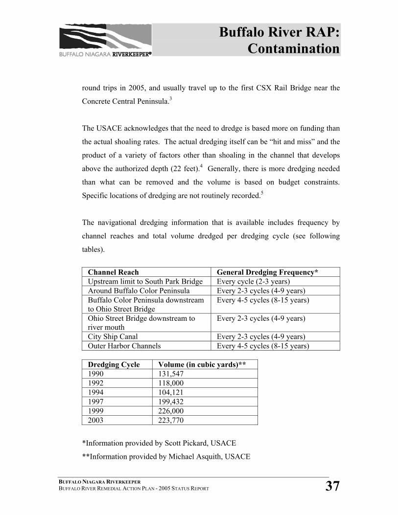
Buffalo River RAP: Contamination
BUFFALO NIAGARA RIVERKEEPER BUFFALO RIVER REMEDIAL ACTION PLAN - 2005 STATUS REPORT 37
round trips in 2005, and usually travel up to the first CSX Rail Bridge near the
Concrete Central Peninsula.3
The USACE acknowledges that the need to dredge is based more on funding than
the actual shoaling rates. The actual dredging itself can be “hit and miss” and the
product of a variety of factors other than shoaling in the channel that develops
above the authorized depth (22 feet).4 Generally, there is more dredging needed
than what can be removed and the volume is based on budget constraints.
Specific locations of dredging are not routinely recorded.5
The navigational dredging information that is available includes frequency by
channel reaches and total volume dredged per dredging cycle (see following
tables).
Channel Reach General Dredging Frequency* Upstream limit to South Park Bridge Every cycle (2-3 years) Around Buffalo Color Peninsula Every 2-3 cycles (4-9 years) Buffalo Color Peninsula downstream to Ohio Street Bridge
Every 4-5 cycles (8-15 years)
Ohio Street Bridge downstream to river mouth
Every 2-3 cycles (4-9 years)
City Ship Canal Every 2-3 cycles (4-9 years) Outer Harbor Channels Every 4-5 cycles (8-15 years)
Dredging Cycle Volume (in cubic yards)** 1990 131,547 1992 118,000 1994 104,121 1997 199,432 1999 226,000 2003 223,770
*Information provided by Scott Pickard, USACE
**Information provided by Michael Asquith, USACE
Buffalo River RAP: Contamination
BUFFALO NIAGARA RIVERKEEPER BUFFALO RIVER REMEDIAL ACTION PLAN - 2005 STATUS REPORT 38
The Buffalo River Environmental Dredging Feasibility Study currently underway
will evaluate navigational dredging efforts, and the impact of contaminated
sediments on the cost of dredging. More information regarding the Feasibility
Study is found in section 4.2.1
Although newly deposited sediment in the Buffalo River is much cleaner than
historical sediment, both the surficial and deeper sediments are known to be
contaminated from industrial activity. Sediment contaminated with PCBs, PAHs,
metals and industrial organic chemicals continues to be found throughout the
River and within the dredged navigational channel. River sediments at some
locations are also contaminated with cyanide and metals to levels that prohibit
open lake disposal of dredge materials.6 These dredge materials require
controlled disposal in a local Confined Disposal Facility- hence the impairment of
beneficial use #7, “Restrictions on Dredging”.
Sources for this ongoing contamination remain unconfirmed. Some possibilities
include sloughing of historical contamination from outside the dredge channel,
contamination transported from immediately upstream or from within the upper
watershed, or from leaching at inactive hazardous waste sites or existing industrial
sites.
In 2004, a collaborative effort between the USACE and Buffalo State College
resulted in the creation of a GIS-linked database of sediment data for the Buffalo
River AOC impact area. Sediment sampling data from the past 20 or more years
are organized in this database.
The University at Buffalo and Buffalo State College are completing a
collaborative effort related to Buffalo River sediment transport which includes a
Buffalo River RAP: Contamination
BUFFALO NIAGARA RIVERKEEPER BUFFALO RIVER REMEDIAL ACTION PLAN - 2005 STATUS REPORT 39
sediment trend analysis, side-scan sonar profiling and hydrodynamic profiling.
The data generated from the project should give researchers additional insight in
river-bottom sediment dynamics and sediment modeling applications.
Interpretation and analysis is expected to be completed in early 2006.
The University at Buffalo and Buffalo State College have also collaborated on a
sediment sampling and modeling effort that will attempt to identify pathways of
sediment transport. The “Assessment of Contaminants in the Lower Buffalo
River” project includes sediment coring at four sites on the River (Hamburg
Cove, Blue Tower Turning Basin, Smith Street Restoration Site and near
ExxonMobil). Suspended sediment samples were also taken upstream and
downstream. In addition, a detailed model for sediment transport and deposition
estimates for the Buffalo River AOC is being developed as part of a “Modeling of
Sediment Transport and Deposition on the Buffalo River” project. This model is
adopting a novel approach based on particle tracking to identify specific transport
pathways, as a means of evaluating environmental dredging operations. The
model will help identify the fate of sediment and associated contaminants entering
the Buffalo River AOC. A preliminary model was completed in September 2005
and final results are expected in early 2006.
Although numerous studies of sediment quality, transport and deposition have
been performed since 1986, no comprehensive study and analysis has been
conducted nor have remedial alternatives been identified.
On April 8, 2005, the USACE and Riverkeeper signed a landmark $2.1 million
cost share agreement that will define the nature and extent of sediment
contamination within the AOC impact area and assess remedial alternatives for
River sediment. Known as the “Buffalo River Environmental Dredging
Buffalo River RAP: Contamination
BUFFALO NIAGARA RIVERKEEPER BUFFALO RIVER REMEDIAL ACTION PLAN - 2005 STATUS REPORT 40
Feasibility Study” (FS), this 3-year study is the last step necessary prior to any
sediment remediation within the AOC impact area. Depending on the results of
the FS, the intention of the Remedial Advisory Committee is to pursue sediment
remediation funding from either the USACE’s 312 Program or USEPA’s Great
Lakes Legacy Act in FY 2008.
UPLAND CONTAMINATION
Since the inception of the Buffalo River RAP in 1989, some 45 inactive
hazardous waste sites within the Buffalo River AOC have been identified. These
include sites from the upper watershed along the three tributaries, Cayuga Creek,
Buffalo Creek and Cazenovia Creek.
New York State DEC has enacted an Inactive Hazardous Waste Disposal Site
Program (State Superfund program), in addition to the federal Comprehensive
Environmental Response, Compensation and Liability Act (CERCLA), also
known as Superfund, to ensure the identification, investigation and clean up of
sites where significant amounts of hazardous waste may exist. New York State
utilizes the Environmental Restoration Program, which provides funding under
the Clean Water/ Clean Air Bond Act of 1996 for remedial efforts. Also, the
Brownfield Clean Up Program and the Voluntary Clean Up Program create
private-public partnerships to promote remedial efforts of contaminated lands on a
volunteer basis. Ultimately, NYSDEC-Region 9 or USEPA-Region II coordinate
the clean up of all inactive hazardous waste sites within the Buffalo River AOC.
To date, all Phase I & II site investigations have been concluded for the 45 sites.
Remedial Investigations (RI), Feasibility Studies or Interim Remedial Measures
(IRM) were completed at 42 of the 45 sites. The remaining three are undergoing
restoration planning or entered voluntary clean-up agreements.
Buffalo River RAP: Contamination
BUFFALO NIAGARA RIVERKEEPER BUFFALO RIVER REMEDIAL ACTION PLAN - 2005 STATUS REPORT 41
Delisting has occurred at 21 sites. A site is delisted if “no consequential quantity
of hazardous wastes are present”. (“No consequential quantity” is an amount of
hazardous waste that does not create a significant threat to the environment.)
Delisting occurs when one of two conditions are present: 1) either a consequential
quantity of hazardous waste was never present at the site or, 2) an inconsequential
amount of hazardous waste is all that remains at the site as a result of remediation.
Ultimately, if the site is delisted, it is deemed clean by NYSDEC or USEPA.7
Nine sites have been “closed” with continued management. Remedial activity
continues at 5 sites (Steelfields LTD, Tifft & Hopkins Street, Buffalo Color Plant
Site, 90 Hopkins Street and Boone Park). Long-term operation and maintenance
continues at eight sites including Bern Metal, Sovereign Chemical, and Buffalo
Color Area D.
RAC RECOMMENDATIONS
The Buffalo River RAC has recommended the following actions regarding
contamination within the Buffalo River AOC in order to make progress towards
delisting. These recommendations will be further refined, expanded and
prioritized as the updated Buffalo River Remedial Strategy is being developed.
• Complete the Buffalo River Environmental Dredging Feasibility Study by
April 2008;
• Apply to the Great Lakes Legacy Act or use USACE’s 312 Program for
funding by FY-2008 for contaminated sediment remediation in the Buffalo
River AOC;
• Support NYSDEC efforts to complete remediation of all 45 inactive
hazardous waste sites and continue monitoring leaching potential at sealed or
remediated sites;
• Track down illegal connections or illicit discharges to storm sewer lines;
Buffalo River RAP: Contamination
BUFFALO NIAGARA RIVERKEEPER BUFFALO RIVER REMEDIAL ACTION PLAN - 2005 STATUS REPORT 42
• Implement non-point source (agricultural and other runoff) pollution
abatement practices in the upper watershed through a possible wet weather or
stormwater project;
• Continue erosion control measures in the upper watershed (i.e.; Cayuga
Creek, Buffalo Creek and Cazenovia Creek).
4.2.1 BUFFALO RIVER ENVIRONMENTAL DREDGING FEASIBILITY
STUDY
The U.S. Army Corps of Engineers, Buffalo District performed a
reconnaissance level study from 2001-2003, which determined that there
was federal interest in initiating a cost-shared feasibility study of
environmental dredging in the Buffalo River from Hamburg Street to the
confluence of Cazenovia Creek.
Section 312 of the Water Resources Development Act (WRDA) of 1990,
entitled: “Environmental Dredging,” authorizes the Secretary of the Army
to remove contaminated sediments from the navigable waters of the
United States. Section 312(a) provides for removal of contaminated
sediments outside the boundaries of and adjacent to a Federal navigation
project as part of the operation and maintenance of the project. Section
312(b) provides for removal of contaminated sediments for the purpose of
environmental restoration and water quality improvement if such removal
is requested by a non-federal sponsor and the sponsor agrees to pay 35
percent of the cost of removal and disposal. Section 205 of WRDA 1996
amended Section 312 by stating that priority of work be given to five
locations, one of which being the Buffalo Harbor and Buffalo River,
Buffalo, NY.8 The non-federal sponsor for the feasibility study is Buffalo
Buffalo River RAP: Contamination
BUFFALO NIAGARA RIVERKEEPER BUFFALO RIVER REMEDIAL ACTION PLAN - 2005 STATUS REPORT 43
Niagara Riverkeeper, who has agreed to cost share half of the $2.1 million
feasibility study which is expected to take three years.
A Feasibility Cost Share Agreement was signed between the Corps
Buffalo District and Riverkeeper on April 8, 2005. The expected
outcomes of the feasibility study include the following:
• Identification and quantification of potential Operation & Maintenance
(O&M) benefits
• Identification and quantification of potential environmental restoration
benefits
• Formulation of alternative plans that are consistent with the RAP
• Evaluation of alternative plans
• Coordination with stakeholders concerning the findings of the study
• Identification of a National Economic Development Plan and National
Ecosystem Restoration Plan
• Development of an Environmental Impact Statement (EIS)
• Development of a project cost estimate
• Identification of a reasonable construction schedule for the
recommended plan.9
A major project partner in the Feasibility Study, NYSDEC-Region 9
conducted a comprehensive sediment sampling program in the Buffalo
River AOC from Hamburg Street to the confluence of Cazenovia Creek in
August-September 2005. The 400 samples collected will be used to define
the nature and extent of sediment contamination within the AOC and the
data will be provided to the USACE to be used in the assessment of
remedial alternatives for River sediment.10
Buffalo River RAP: Contamination
BUFFALO NIAGARA RIVERKEEPER BUFFALO RIVER REMEDIAL ACTION PLAN - 2005 STATUS REPORT 44
The FS is a necessary last step prior to actual sediment remediation.
Depending on the results of the FS, the intention of the Remedial
Advisory Committee is to either pursue sediment remediation funding
through the USACE 312 Program or to request federal funding from
USEPA’s Great Lakes Legacy Act in FY 2008.
The Buffalo River RAC believes that in combination with the complete
clean up of inactive hazardous waste sites, the remediation of
contaminated sediments is required to delist most of the beneficial use
impairments or suspected impairments (BUIs #1, #2, #3, #4, #5, #6, #7,
#14) and to make substantial progress towards delisting the entire Buffalo
River Area of Concern.
4.2.2 REMEDIATION OF INACTIVE HAZARDOUS WASTE SITES
The following pages provide a detailed summary of all 45 Inactive
Hazardous Waste Sites within the Buffalo River AOC and watershed.
Note that Buffalo Color is broken down into 5 segments (Areas A through
D and the Plant Site), and each has its own site code.
Table 4-1 consists of basic information describing inactive hazardous
waste site clean up progress and the remaining chemical contaminant
concerns. This information was derived from the Environmental Site
Remediation Databases maintained by the NYSDEC Division of
Environmental Remediation. Additional information was supplied by the
NYSDEC Division of Environmental Remediation and the 2002 RAP
Status Report.
The information is categorized by sites according to the proximity to
Buffalo River RAP: Contamination
BUFFALO NIAGARA RIVERKEEPER BUFFALO RIVER REMEDIAL ACTION PLAN - 2005 STATUS REPORT 45
either a river or creek, and alphabetically within each respective
watercourse. The classification (or class) codes are based on the NYS
classifications in the Inactive Hazardous Waste Disposal Site Program 6
NYCRR Subpart 375-1.8, with the exception of those letters referencing
programs other than the Inactive Hazardous Waste Disposal Site Program
such as Voluntary Clean Up Programs. Table 4-2 provides a glossary of
all class codes and important acronyms found within Table 4-1.
Detailed information about the remediation status of sites that are not
delisted is readily available on the Environmental Site Remediation
Database. The database is accessible on-line at the NYSDEC
Environmental Remediation Databases web page,
www.dec.state.ny.us/apps/derfoil/index.cfm/. Click on the link for
“search environmental site remediation database” and enter a five-digit
site code. (Site codes can be found in Table 4-1).
The following highlights progress made on remediation of the 45 inactive
hazardous waste sites as of August 2005:
• 21 sites have been “delisted”;
• 1 site is “properly closed”;
• 8 sites are “closed with continued management”;
• 3 sites, action may be deferred because they do not present a
significant threat to the environment or human health;
• 6 sites continue to be a significant threat to environment, considered
“class 2”;
• 1 site is only temporarily classified because of lack of data;
• 1 site has not yet received a classification
Buffalo River RAP: Contamination
BUFFALO NIAGARA RIVERKEEPER BUFFALO RIVER REMEDIAL ACTION PLAN - 2005 STATUS REPORT 46
• 2 sites are currently undergoing remediation under the NYS Voluntary
or Brownfield Clean Up Programs
• 2 sites are currently undergoing remediation under the Environmental
Restoration Program.
Consult Appendix C for a thorough discussion on DEC’s Inactive
Hazardous Waste Disposal Site Program and a detailed update of sites
located within the AOC impact area. See Figure 4-1 for locations of all
sites that are not “delisted” within the entire watershed.
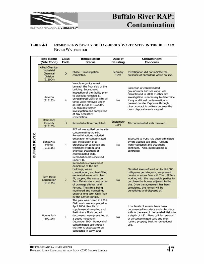
Buffalo River RAP: Contamination
BUFFALO NIAGARA RIVERKEEPER BUFFALO RIVER REMEDIAL ACTION PLAN - 2005 STATUS REPORT 47
TABLE 4-1 REMEDIATION STATUS OF HAZARDOUS WASTE SITES IN THE BUFFALO RIVER WATERSHED
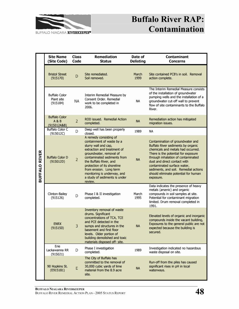
Buffalo River RAP: Contamination
BUFFALO NIAGARA RIVERKEEPER BUFFALO RIVER REMEDIAL ACTION PLAN - 2005 STATUS REPORT 48
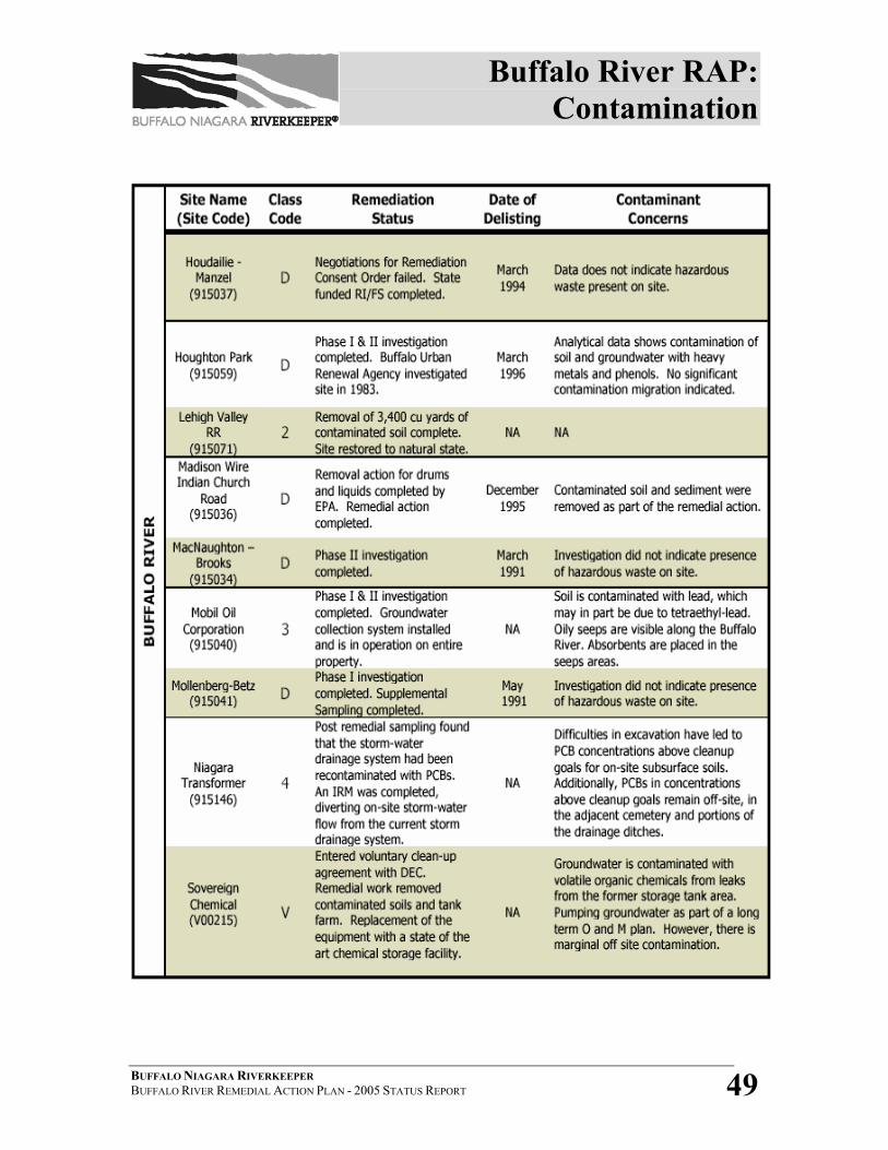
Buffalo River RAP: Contamination
BUFFALO NIAGARA RIVERKEEPER BUFFALO RIVER REMEDIAL ACTION PLAN - 2005 STATUS REPORT 49
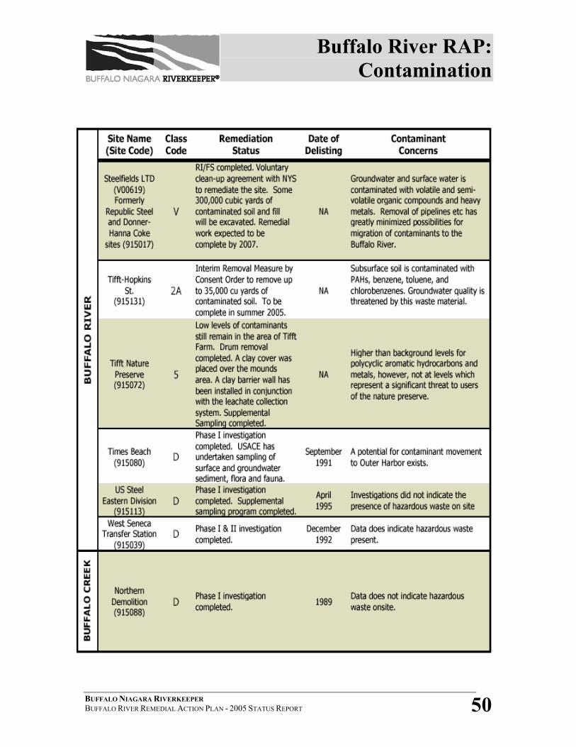
Buffalo River RAP: Contamination
BUFFALO NIAGARA RIVERKEEPER BUFFALO RIVER REMEDIAL ACTION PLAN - 2005 STATUS REPORT 50
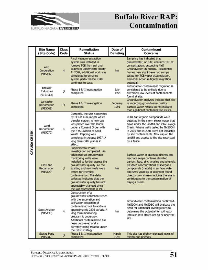
Buffalo River RAP: Contamination
BUFFALO NIAGARA RIVERKEEPER BUFFALO RIVER REMEDIAL ACTION PLAN - 2005 STATUS REPORT 51
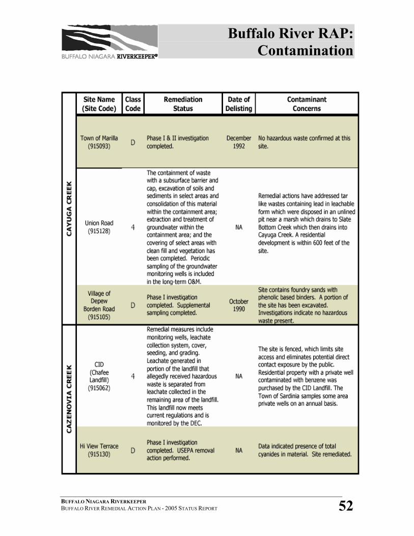
Buffalo River RAP: Contamination
BUFFALO NIAGARA RIVERKEEPER BUFFALO RIVER REMEDIAL ACTION PLAN - 2005 STATUS REPORT 52
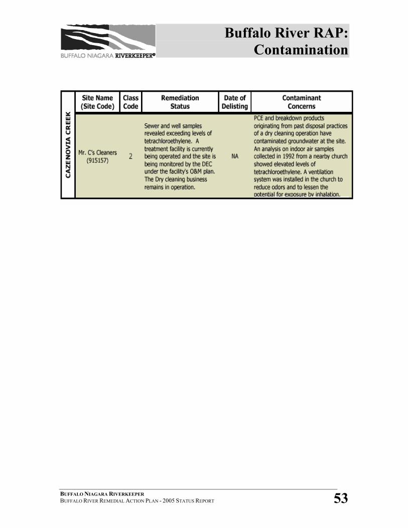
Buffalo River RAP: Contamination
BUFFALO NIAGARA RIVERKEEPER BUFFALO RIVER REMEDIAL ACTION PLAN - 2005 STATUS REPORT 53
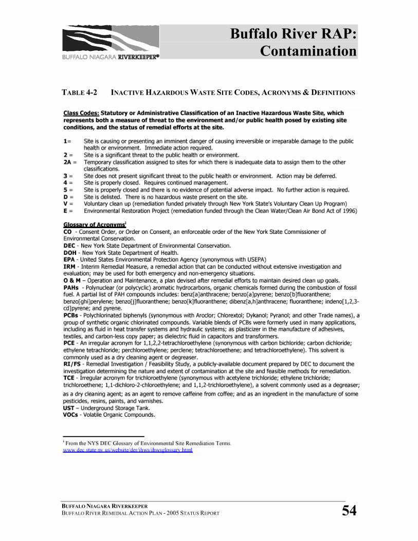
Buffalo River RAP: Contamination
BUFFALO NIAGARA RIVERKEEPER BUFFALO RIVER REMEDIAL ACTION PLAN - 2005 STATUS REPORT 54
TABLE 4-2 INACTIVE HAZARDOUS WASTE SITE CODES, ACRONYMS & DEFINITIONS
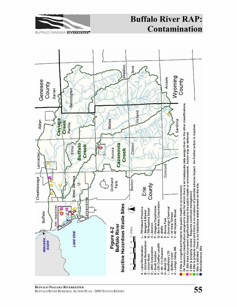
Buffalo River RAP: Contamination
BUFFALO NIAGARA RIVERKEEPER BUFFALO RIVER REMEDIAL ACTION PLAN - 2005 STATUS REPORT 55
Buffalo River RAP: Contamination
BUFFALO NIAGARA RIVERKEEPER BUFFALO RIVER REMEDIAL ACTION PLAN - 2005 STATUS REPORT 56
SECTION 4.2 – REFERENCES 1 USACE, Draft Management Plan and Feasibility Study Scope of Work- Buffalo River Environmental Dredging/Ecosystem Restoration (December 16, 2004). 2 NYSDEC, Buffalo River Remedial Action Plan (1989). 3 Larry Parks, Bridge Operator, City of Buffalo Office of Public Works, Personnel communication, 12/15/05 4 Scott Pickard & Byron Rupp, USACE, Personal communications, 3-10-05. 5 Michael Asquith, USACE, Personal communication, 11-5-05. 6 Sutton, Gregory, P.E., for NYSDEC-Region 9, Division of Environmental Remediation, Draft Field Sampling Plan for the Buffalo River Sediment Study (May 2005). 7 NYSDEC website, 2005 http://www.dec.state.ny.us/website/der/ihws/faqs.html#q21. 8 Rupp, Byron, for USACE, Buffalo River Fact Sheet (January 2005). 9 USACE, Draft Management Plan and Feasibility Study Scope of Work- Buffalo River Environmental Dredging/Ecosystem Restoration (December 16, 2004). 10 Sutton, Gregory, P.E., for NYSDEC-Region 9, Division of Environmental Remediation, Draft Field Sampling Plan for the Buffalo River Sediment Study (May 2005).
Buffalo River RAP: Fish & Wildlife
BUFFALO NIAGARA RIVERKEEPER BUFFALO RIVER REMEDIAL ACTION PLAN - 2005 STATUS REPORT 57
4.3 FISH, WILDLIFE & MACROINVERTEBRATES The following beneficial use impairments, or likely impairments, are directly
related to the health of fish, wildlife, and macroinvertebrate populations in the
Buffalo River AOC:
Impaired:
BUI #1- Restrictions on Fish & Wildlife Consumption
BUI #4- Fish Tumors and Other Deformities
BUI #6- Degradation of Benthos
BUI #14- Loss of Fish and Wildlife Habitat
Likely Impaired:
BUI #2- Tainting of Fish and Wildlife Flavor
BUI #3- Degradation of Fish and Wildlife Populations
BUI #5- Bird or Animal Deformities or Reproduction Problems
Fish and wildlife issues related to the Buffalo River AOC not only include
population numbers, diversity and overall health, but also habitat, corridors and
relationships to humans. For the purposes of this Status Report, a discussion on
macroinvertebrates (benthic organisms and those found in the water column) will
be included in this section.
The Buffalo River ecosystem once provided plentiful habitat for reproduction,
feeding and growth, and a migratory route for a myriad of fish, birds and wildlife.
Writings from the 1600s describe the Buffalo River as an extensive marsh with
temporary hunting and fishing camps built by native peoples along its shore. It is
believed that the quality of the river during this period must have been such as to
sustain a diverse and abundant warmwater fishery and wildlife community.1
Buffalo River RAP: Fish & Wildlife
BUFFALO NIAGARA RIVERKEEPER BUFFALO RIVER REMEDIAL ACTION PLAN - 2005 STATUS REPORT 58
Throughout the 1800s and into the 1900s the average resident times of sewage
and other pollutants in the river increased. By the 1920s, the Buffalo River had
become one of the most polluted rivers in the United States. It was described as a
“septic basin”, with 0% dissolved oxygen and high carbon dioxide (Wagner
1929), and “no fish were found in the river at this time” (Greeley 1929).2 It had
been noted that the benthic community was so impacted that not even sludge
worms were present.
PROGRESS AND CURRENT CONDITIONS
Fish consumption in the Buffalo River and Harbor is impaired due to a NYS DOH
health advisory that recommends eating no carp because of elevated PCB levels.
The sources of PCBs are attributed to contaminated sediment and previous
industrial inputs.3
In 2003, NYSDEC awarded FBNR funding for a 2-year aquatic habitat
assessment project. Researchers from Buffalo State College and Youngstown
University conducted research on water quality, fish health and populations,
benthic organism health and populations, adjacent land use, and recreational use
of the waterway. The data interpretation and the final report released in October
2005 have confirmed that the leading environmental obstacle for restoration of
most of the beneficial uses in the Buffalo River is contaminated sediments. (See
Section 4.3.1 for a detailed discussion of the project results.)
Prior to 2004, there had been little information regarding bird, mammal and
herpetological health and populations within the AOC. In spring 2005, a RAC
Advisor who is also a member of the Buffalo Ornithological Society (BOS),
coordinated an effort with Canisius College to conduct a bird survey and seasonal
population assessment throughout the AOC impact area and upper watershed.
Buffalo River RAP: Fish & Wildlife
BUFFALO NIAGARA RIVERKEEPER BUFFALO RIVER REMEDIAL ACTION PLAN - 2005 STATUS REPORT 59
This effort is being conducted entirely by BOS volunteers and Canisius students
under staff and will provide much needed baseline data of bird populations and
health within the AOC. Project completion is expected in spring 2007. Similar
volunteer assessment projects for mammal and herpetological populations are
being investigated.
The Buffalo River RAC is currently prioritizing projects based on the need to
complete all beneficial use assessment and evaluation. Identified gap areas
include: generating conclusive and updated data on tainting, wildlife populations,
bird and animal deformities, and habitat quantification. (These are in addition to
the data gap areas described in the water quality section- eutrophication and
phytoplankton populations). With the 5-year extension of the RAP Coordination
grant and expanded budget for scope of work, the RAC, with the assistance of
Buffalo Niagara Riverkeeper, will be able to use these resources to leverage
additional funds and partnerships to finally complete these assessments. Once
these assessments are finalized, delisting criteria and restoration targets can be
developed for the confirmed use impairments.
Buffalo Niagara Riverkeeper also received USEPA-Region II FY-’06 funding for
a habitat assessment and evaluation of the Niagara River watershed. The Buffalo
River and its watershed is a major tributary to the Niagara River system.
Information regarding habitat type and quantification will be generated from this
project during 2006-08. Once completed, the data generated from this study will
be synthesized with other beneficial use assessment results. It will be evaluated
and analyzed by the RAC and Riverkeeper, which will use the data to complete
the development of delisting criteria and restoration targets for the AOC.
Buffalo River RAP: Fish & Wildlife
BUFFALO NIAGARA RIVERKEEPER BUFFALO RIVER REMEDIAL ACTION PLAN - 2005 STATUS REPORT 60
RAC RECOMMENDATIONS
The Buffalo River RAC has recommended the following preliminary steps in
order to make progress towards delisting. These recommendations will be further
refined, expanded and prioritized as the updated Remedial Strategy is developed.
• Complete assessment and evaluation of mammal and herpetological
populations, and bird health throughout the AOC.
• Support NYSDEC and NYSDOH efforts for fish contaminant testing, with
recommendations to increase number of species tested and frequency of
testing to at least every 5 years.
• Complete an updated assessment of tainting in fish and wildlife through PAH
testing and angler surveys.
• Complete assessment, evaluation and quantification of habitat throughout the
AOC.
• Implement projects/programs to preserve open space and increase wetland
areas and aquatic habitat.
• Implement invasive species eradication efforts.
• Prioritize sites identified in the Buffalo River Greenway Plan and identify
funding or programs to protect critical lands and improve/increase habitat.
PROJECT UPDATES
The following is a list of ongoing or recently completed fish and wildlife projects
by various agencies, organizations, and stakeholders that will either 1) provide
data that will help fill some of the information gaps identified in the Buffalo River
RAP, or 2) make progress towards delisting.
4.3.1 ASSESSMENT OF POTENTIAL AQUATIC HABITAT RESTORATION
SITES WITHIN THE BUFFALO RIVER AREA OF CONCERN
In 2003, Buffalo Niagara Riverkeeper (formerly FBNR) received a grant
Buffalo River RAP: Fish & Wildlife
BUFFALO NIAGARA RIVERKEEPER BUFFALO RIVER REMEDIAL ACTION PLAN - 2005 STATUS REPORT 61
from the NYSDEC Great Lakes Protection Fund for assessing potential
aquatic habitat sites that complements the USACE Feasibility Study for
sediment clean-up options. Researchers from Buffalo State College and
Youngstown State- Ohio obtained and evaluated data on fish and benthic
populations; conducted water quality analysis; and surveyed vegetative
cover and community/recreational use.
The data generated will be used in the Feasibility Study and provide useful
data bases for decisions on remedial options. The characterization matrix
that has been developed for the 10 potential sites will assist decision
makers and stakeholders by providing a comprehensive assessment tool
regarding prioritization of potential restoration sites, including decisions
regarding sediment removal and/or stabilization. The study fully
documents the biological and physical characteristics of 10 potential sites
for the following (see Figure 4-4):
• Benthic features (Number of Benthic Families, Oligochaete Density,
EPT, Chironomid Density, Genera of Chironomid, Genus/species
Biotic Index of Chironomid, Chironomid Deformity)
• Fishery features (Larval and Juvenile Species Diversity, IBI, DELT)
• Limnological features (Water Temperature, pH, Turbidity, Dissolved
Oxygen, Conductivity)
• Physical characteristics (Bank Characteristics, Adjacent Land Use)
• Vegetation (% Overhanging Cover, Terrestrial/Aquatic Species
Richness, Terrestrial/Aquatic Exotic Species)
• Community river use
Buffalo River RAP: Fish & Wildlife
BUFFALO NIAGARA RIVERKEEPER BUFFALO RIVER REMEDIAL ACTION PLAN - 2005 STATUS REPORT 62
The project results, when synthesized with other bird/mammal and habitat
data, will offer updated information for the RAC to complete assessments
of beneficial uses (i.e.; degradation of fish and wildlife populations, and
loss of fish and wildlife habitat) by the end of 2008 and will ultimately be
used in the development of quantifiable delisting targets and an updated
remedial strategy.
The final report was completed in October 2005. The report and data can
be accessed on Riverkeeper’s website at www.fbnr.org. The following
summarizes some of the major fish and wildlife findings of the project:
• Larval fish sampling showed similar species diversity and abundance
in 2003-04 as compared to 1993 (8-10 species found). No site-specific
trends were observed. The adult/juvenile fish sampling showed
similar species diversity and abundance in 2003-04 compared to 1993
(15-20 species across all sites). The lowest species diversity occurred
at the sites in the upper-most and lower-most reaches of the AOC
impact area.
• For the river as a whole, DELT (Deformities, Eroded fins, Lesions,
and Tumors) anomaly scores in fish averaged 37%, which is much
higher than what would be expected for a moderately impacted (2-5%)
or unimpacted (<2%) river. The rate varied greatly among species,
with a low of 14% in pumpkinseed to an extremely high of 87% in
brown bullhead. The other most commonly found species had the
following DELT scores: common carp 67%, gizzard shad 51%,
largemouth bass 34%, and golden shiner 22%.
• The Buffalo River AOC continues to be dominated by a low diversity
benthic invertebrate community that is broadly tolerant of pollution
and environmental degradation. High densities of tubificid
Buffalo River RAP: Fish & Wildlife
BUFFALO NIAGARA RIVERKEEPER BUFFALO RIVER REMEDIAL ACTION PLAN - 2005 STATUS REPORT 63
oligochaetes (though lower than historic maxima), and their numerical
dominance of the benthos suggest poor environmental health.
Oligochaete densities were higher in the channel than at shoreline
habitat restoration sites. Fewer invertebrate families were collected in
this study than in the 1990s, possibly even indicating some reversal of
biotic recovery. Substantially more families occurred at shoreline sites
than in the navigational channel, although the habitat restoration sites
were still dominated by pollution-tolerant oligochaetes and
chironomids. Likewise, chironomid taxonomic richness was markedly
higher at the habitat sites than in the channel, but species largely
constituted pollution-tolerant species and genera. Chironomid
mouthpart deformities remain very high within the navigational dredge
channel, but interestingly, all of the rather limited number of larvae
from shoreline sites had developed normally.
• More than 50 plant species were collected from the Buffalo River
shoreline and herbaceous vegetation was well-developed at all sites.
The 10 restoration sites differed considerably in their development of
overhanging cover, ranging from 0-80%. Submerged macrophyte beds
are not extensive, but are present at most sites. The presence of
invasive plant species, including tree-of-heaven, Japanese knotweed,
purple loosestrife, and submerged Eurasian watermilfoil degrades
many of the potential restoration sites.
• Ecological integrity, as reflected by biota and water quality, certainly
has improved in the Buffalo River AOC, as compared to 1970’s
conditions. However, there does not appear to be any improvement
since the early 1990s. Habitat restoration measures such as improved
overhang cover, macrophyte plantings, eradication of exotic plant
species, removal of old dock pilings, naturalization of shorelines, or
Buffalo River RAP: Fish & Wildlife
BUFFALO NIAGARA RIVERKEEPER BUFFALO RIVER REMEDIAL ACTION PLAN - 2005 STATUS REPORT 64
removal of contaminated bed sediment could improve ecological
integrity at selected sites. Constraints on ecological integrity that may
prove more challenging to overcome include warmer water
temperatures and low dissolved oxygen levels.4
4.3.2 FISH HEALTH & POPULATIONS
4.3.2(A) FISH CONSUMPTION, TUMORS, AND DEFORMITIES
The following NYSDOH fish consumption advisories exist for the
Buffalo River AOC:
Eat no carp from the Buffalo River or Harbor (due to PCB
contamination);
Women of childbearing age and infants and children under the
age of 15 should not eat any species from the Buffalo River or
Harbor;
The following fish consumption advisories exist for Lake Erie and
may apply to fish found in the Buffalo River:
Women of childbearing age and infants and children under 15
are advised to eat no more than one meal per week of Chinook
salmon less than 19 inches, burbot, freshwater drum, lake
whitefish, rock bass and perch.
Women of childbearing age and infants and children under 15
are advised to eat no more than one meal per month of all other
fish from Lake Erie.
Other people should eat no more than one meal per week of
any Lake Erie fish species.5
Buffalo River RAP: Fish & Wildlife
BUFFALO NIAGARA RIVERKEEPER BUFFALO RIVER REMEDIAL ACTION PLAN - 2005 STATUS REPORT 65
Delisting criteria/restoration targets have been developed for the
Buffalo River AOC for BUI#1- Restrictions on Fish and Wildlife
Consumption and BUI #4- Fish Tumors and Other Deformities
(see BUI Chart, Table 3-1). Recommendations and advice were
gathered from numerous local and statewide fish and wildlife
experts during the development of these criteria/targets. Tainting
of fish and wildlife flavor, and degradation of fish and wildlife
populations (#2 and #3) are considered “likely impaired” but
further assessment is needed. The following paragraphs
summarize the research and discussions that took place in order to
establish the delisting criteria, as well as some of the decisions to
be made during the development of monitoring protocol and the
updated remedial strategy.
In April/May 2004, NYS DEC- Region 9 took carp samples from
the Buffalo River. As of summer 2005, these fish samples have
not yet been analyzed and no contaminant results are available.6
The NYS Department of Health (NYSDOH) coordinates fish
sampling with NYSDEC and noted that prior to 2004, the last
testing of Buffalo River carp for PCB contamination was over 10
years ago. There is no systematic monitoring protocol in place.
NYSDOH also asserted that in order for an advisory to be
removed, fish must show low levels of contaminants for at least 2
years (but could be from 1-5 years depending on quality and
consistency of data); furthermore, data and samples must have
adequate numbers and diversity. As removal of an advisory is
arbitrary and determination is made on a case-by-case basis, there
is no established protocol or timeframe. Citizens groups, or the
Buffalo River RAP: Fish & Wildlife
BUFFALO NIAGARA RIVERKEEPER BUFFALO RIVER REMEDIAL ACTION PLAN - 2005 STATUS REPORT 66
RAC, can put in requests to NYSDOH for specific sampling, but
NYSDOH cannot guarantee any response to comments or
requests.7
Species to be analyzed for consumption health concerns are chosen
based on past health advisories only (i.e., carp in the Buffalo
River). Other species that may be consumed, including walleye,
bass, bluegills, perch, eels and pike, were tested in 1993-94 and
determined not to pose a threat to human health. Other species can
be tested in the future if the NYSDOH changes criteria or begins
assessing levels of other contaminants, such as mercury.
Frequency of monitoring depends upon funding and staff
availability; historically, the Buffalo River has been sampled every
10-11 years. However, the ideal testing time frame would be every
5 years. NYSDEC agrees with RAC recommendations that brown
bullhead and suckerfish are best used as indicator species for tumor
studies.8
During August/September of 1997, composites of young-of-year
(y-o-y) fish were collected by NYSDEC from 35 near-shore
locations in New York’s Great Lakes basin, including the Buffalo
River. Composite y-o-y fish samples were analyzed for PCBs
(Aroclor 1016/1248, Aroclor 1254/1260 and PCB congeners),
organochlorine pesticides and mercury.9 The bluntnose minnows
sampled from the Buffalo River did not reflect changes or
improvements in contaminant levels from previous years'
samples.10
Buffalo River RAP: Fish & Wildlife
BUFFALO NIAGARA RIVERKEEPER BUFFALO RIVER REMEDIAL ACTION PLAN - 2005 STATUS REPORT 67
The Cornell Fish Pathology Project (CFPP) advised that causal
relationships between fish tumors and contaminants are difficult to
prove scientifically; a majority of fish tumors are caused by viruses
and genetics. CFPP suggests using a “reference community”
instead of a “control site” for sampling, and using “power of a test”
as a statistical reference in place of timeframes of incidences.
Enough fish should be collected from both the impaired waterbody
and a chosen reference community to make a statistically
significant comparison. CFPP also advises surveying fish tumors
in the waterbody and categorizing them accordingly: 1) tumors
caused virally; 2) tumors thought to be caused virally; and 3) those
with no known cause. Such a survey process will help to develop
baseline information.11
4.3.2(B) BUFFALO RIVER WALLEYE RESTORATION PROJECT
The information associated with the Walleye Restoration Project
will be used to assess and evaluate beneficial use #3- degradation
of fish and wildlife populations, and may be used to establish
delisting criteria/restoration targets (i.e.; the establishment of a
self-sustaining walleye population within the Buffalo River AOC).
In 2002, NYSDEC Lake Erie Fisheries Unit and Region 9
Fisheries Unit staff organized an advisory team including
representatives from Bison City Rod and Gun Club, ECDEP, Erie
County Federation of Sportsmen's Clubs, Erie County Fisheries
Advisory Board and Southtowns Walleye Association. The
advisory team has assisted with developing project
goals/objectives and has helped with logistical support for project
Buffalo River RAP: Fish & Wildlife
BUFFALO NIAGARA RIVERKEEPER BUFFALO RIVER REMEDIAL ACTION PLAN - 2005 STATUS REPORT 68
operations. This team’s goal, the Buffalo River Walleye
Restoration Project, is to restore a naturally reproducing, self-
sustaining walleye population in the Buffalo River. The project
aims to restore walleye abundance in order to create a high-quality,
springtime walleye sport fishery in the Buffalo River and enhance
summertime walleye sportfishing opportunities in adjacent areas of
Lake Erie and the Upper Niagara River.
The Buffalo River was selected as a candidate site for walleye
restoration principally because it is a large tributary to Lake Erie,
and on a lake-wide scale, other existing Lake Erie walleye
spawning stocks appear to use very large tributaries or open lake
shoals as spawning sites. DEC’s Lake Erie Fisheries Unit recently
completed a similar walleye project on Cattaraugus Creek with
some accompanying evidence for success.
Fish surveys in the Buffalo River during the 1980s and 1990s
indicated presence of walleye, but at relatively low levels of
abundance. However, directed surveys to detect presence of
spawning-phase adult walleye had not been performed. Spring
baseline monitoring to detect spawning-phase walleye by boat
shocker began in the Buffalo River in 2003 (2003-04 baseline
catches = zero adults detected), and will continue annually for the
duration of the project. Future presence/absence of spawning
walleye surveys will be the principle evaluation measure of the
success of this restoration effort.
Implementation of the plan continued in spring 2004, with DEC
Buffalo River RAP: Fish & Wildlife
BUFFALO NIAGARA RIVERKEEPER BUFFALO RIVER REMEDIAL ACTION PLAN - 2005 STATUS REPORT 69
Lake Erie Unit staff collecting a sufficient number of ripe adult
walleyes from Cattaraugus Creek and harvesting eggs and milt for
the restoration project. The main reason to use adjacent Lake Erie
walleye spawning stocks as an egg source is the concern for
maintaining genetic integrity of locally adapted walleye spawning
stocks where there are known, adjacent, self-sustaining walleye
populations and identifiable genetic stock structure in Lake Erie.
The fertilized eggs from Cattaraugus Creek were incubated at
DEC's Prendergast Hatchery (Chautauqua County). In May 2004,
approximately 105,000 available “surplus” Cattaraugus Creek
walleye fry from the Hatchery were stocked in the Lower Buffalo
River near the Seneca Street Bridge.
NYSDEC expects the surplus sac fry component to be stocked
annually during May, along with the scheduled pond-reared
fingerlings in June. Surviving stocked fish should return to spawn
in the Buffalo River as early as 2008. Walleye stocking will take
place annually for the next four to six years, with the goal of
establishing an adult population of 5,000 walleye by 2010. Over
the course of this stocking and monitoring effort, DEC might
identify other limiting factors for walleye restoration, and perhaps
recommend accompanying opportunities for habitat restoration.12
4.3.2(C) GOBY SURVEY- BUFFALO RIVER AND TRIBUTARIES
A U.S. Fish & Wildlife project will investigate goby presence in
the Buffalo River, Buffalo Creek, Cayuga Creek, and Cazenovia
Creek drainages. For the initial year of the goby project, an
Buffalo River RAP: Fish & Wildlife
BUFFALO NIAGARA RIVERKEEPER BUFFALO RIVER REMEDIAL ACTION PLAN - 2005 STATUS REPORT 70
exploratory survey was conducted to see how far upstream the fish
are located and determine their feeding habits. (USFWS has
already been collecting that type of data from Lake Erie tributaries
and the Erie Canal). Initial sampling began on May 31, 2005 and
extended through August. The pace of this project and the
individual creeks surveyed will depend upon the extent of the
gobies’ presence in the upper watershed.13
Several sampling techniques will be explored as water depth
within the system varies drastically. These may include bottom
trawls, beach seines, minnow traps, and electrofishing.
Researchers will note what type of habitat is present at each of the
sites sampled, if possible. Any juvenile walleye that are sampled
by researchers will also be reported to the NYSDEC for the
Buffalo River Walleye Restoration Project.
4.3.3 HABITAT RESTORATION
In December, 1993, the USFWS- Lower Great Lakes Fishery Resources
Office, and ECDEP cooperatively implemented a multi-year “Fish and
Wildlife Habitat Restoration Project”. The mission of the project was to:
To protect, conserve, enhance, and restore the aquatic and terrestrial
ecosystems of the Buffalo River to support a healthy diversity and
distribution of fish and wildlife communities and their habitats; and
To increase community appreciation and use of the Buffalo River.
Goals and objectives were also established for the Project, and are
summarized below:
Buffalo River RAP: Fish & Wildlife
BUFFALO NIAGARA RIVERKEEPER BUFFALO RIVER REMEDIAL ACTION PLAN - 2005 STATUS REPORT 71
Goal #1: Increased area of habitat capable of supporting a healthy
diversity and distribution of fish and wildlife communities, with emphasis
on self-sustaining native biota;
Goal #2: Heightened community awareness and appreciation of natural
resources;
Goals #3: Enhanced recreational opportunities for use of fish and wildlife
resources.
Five habitat restoration sites were identified; of which three “pocket
parks” have been completed (Ohio Street boat launch, foot of Smith
Street, Bailey Avenue peninsula); one is nearing completion (Seneca
Bluffs); and one is targeted for future restoration (Katherine Street
peninsula). (See Figure 4-3).
Though the four restoration projects have been successful in protecting
valuable habitat and public access to the River, they only represent 22
acres of land throughout the entire AOC. During the last decade, hundreds
of acres of public land, vacant land, or open space have been identified for
possible habitat and public access. In the past, many sites were chosen
based upon the premise of public ownership and public support, not
necessarily habitat or flood management value.
Two projects that are both near completion as of October 2005- the
“Assessment of Potential Aquatic Habitat Restoration Sites Project” and
the Buffalo River Greenway Implementation Plan- identify parcels and
lands that, if protected, can provide for an ecosystem-based approach
towards habitat restoration. However, quantification and a complete
assessment of habitat types within the AOC have not been completed and
Buffalo River RAP: Fish & Wildlife
BUFFALO NIAGARA RIVERKEEPER BUFFALO RIVER REMEDIAL ACTION PLAN - 2005 STATUS REPORT 72
will be addressed through an EPA-funded Habitat Assessment grant to
Buffalo Niagara Riverkeeper (see Section 4.3 for discussion). Combined
with an impervious surface analysis to be conducted by a Buffalo State
College graduate student, it is expected that all habitat assessment and
evaluation work for the AOC will be completed by the end of 2008. It is
then expected that delisting criteria/restoration targets will be completed
for BUI #14- Loss of Fish and Wildlife Habitat, and suspected BUI #3-
Degradation of Fish and Wildlife Populations.
4.3.3(A) “POCKET PARK” HABITAT RESTORATION PROJECTS
Recent activity at the three “pocket parks” (Ohio Street, Smith
Street and Bailey Avenue) consist of utilizing the County’s Inmate
Work Program to clean up the sites and to conduct invasive species
removal, particularly Japanese knotweed. Invasive species like
knotweed, purple loosestrife, phragmites, and mugwort, dominate
much of the riverine and upland landscape. There is no
quantification of acreage covered by invasive species in the AOC,
however species such as knotweed are present at nearly 100% of
the parcels identified for open space conservation or restoration.
Invasive species management has already been identified as a
qualitative delisting target for BUI #14- Loss of Fish and Wildlife
Habitat (see Table 3-1). In addition, several specific sites have
been identified (i.e.; the proposed Katherine Street Peninsula
pocket park) as potential sites for a pilot project to remove
invasives and implement a phyto-remediation program.
In 2004, approximately 50 trees at the Smith Street Habitat
Restoration site were wrapped with wire mesh fencing to protect
Buffalo River RAP: Fish & Wildlife
BUFFALO NIAGARA RIVERKEEPER BUFFALO RIVER REMEDIAL ACTION PLAN - 2005 STATUS REPORT 73
them from imminent beaver damage. Some 40 other trees were
destroyed by beavers at the site. Beaver management may be
considered part of a qualitative restoration criteria, as the presence
of beavers and subsequent damage is being seen along the Buffalo
River- particularly at the habitat restoration sites. 14
4.3.3(B) SENECA BLUFFS HABITAT RESTORATION PROJECT
The Erie County Department of Environment and Planning (DEP)
has completed Phase I of a natural habitat restoration effort in
south Buffalo at a location known as “Seneca Bluffs.” Currently,
funding is being sought for Phase II. Seneca Bluffs consists of
12.5 acres of floodplain located along the Buffalo River. Access to
the site is near the Seneca Street Bridge, between Elk Street and
Avon Place. (See Figure 4-3).
Seneca Bluffs was identified in 1994 as one of five unique and
critical habitat areas in need of protection. The site provides habitat
for a wide variety of flora and fauna, and is part of a larger wildlife
corridor along the river. Seneca Bluffs is also part of the Buffalo
River Greenway Trail and is one of the few critical habitat areas
(i.e., floodplain forest) that has been directly included in the
Greenway Trail design. Seneca Bluffs also is located within the
Great Lakes migratory bird flyway and less than 2 miles from Tifft
Nature Preserve and Times Beach. Site assets include distinct
habitat types such as floodplain island, emergent wetland, forested
floodplain, upland meadow, ~800 feet of eroding bluff, and 2500
linear feet of shoreline. A large diversity of migratory birds,
wading birds, and waterfowl make use of the site. Recreational
Buffalo River RAP: Fish & Wildlife
BUFFALO NIAGARA RIVERKEEPER BUFFALO RIVER REMEDIAL ACTION PLAN - 2005 STATUS REPORT 74
opportunities abound for local residents, including such activities
as fishing and hiking. Problems include the domination of ~85%
of the site by invasive and non-native plants. Unauthorized access
and abuse by off-road vehicles contributes to invasive species and
erosion problems. Illegal dumping of construction and demolition
debris, stolen cars, and general litter also contribute to the pollution
issue.
The Seneca Bluffs site consists primarily of an upper and lower
terrace. The Seneca Bluffs Habitat Restoration Project targeted 5
acres of the upper terrace for invasive species removal (Japanese
knotweed, mugwort, phragmites, garlic mustard, and purple
loosestrife) and restoration plantings. Removal of invasive plants
was achieved through brush hogging, tilling of surface material
and removal of plant and root wads. Seeding was conducted in
August 2004; planting and landscape restoration was completed in
October 2004 and includes 397 trees and 630 shrubs.
The project also included construction of an ADA trail, three
fishing access locations, a scenic overlook, a seasonal aquatic
habitat, improved parking facilities and site security measures. A
baseline survey of the site that included species identification was
completed.
4.3.3(C) NYSDEC MANAGED SITES- BUFFALO COLOR PENINSULA
AND ALLTIFT WETLANDS RESTORATION
Remediation of the Buffalo Color site which was previously
owned by Allied Signal, commenced in 1995 and included fish and
Buffalo River RAP: Fish & Wildlife
BUFFALO NIAGARA RIVERKEEPER BUFFALO RIVER REMEDIAL ACTION PLAN - 2005 STATUS REPORT 75
wildlife habitat restoration both upland and along the Buffalo
River shoreline. The site is immediately adjacent to the Smith
Street Habitat Restoration site (See Figure 4-3). The remediation
included the removal of 44,000 cubic yards of contaminated
sediment from the Buffalo River channel, placement of 42,000
tons of riprap for shoreline protection, nesting and feeding areas
for waterfowl, the installation of nine “fish pods” in the river to
allow for spawning and protection of fish and the planting of 3,800
pounds of special seed mixture to enhance wildlife habitat.15
NYSDEC conducts ongoing operations and maintenance activities
as part of the grasslands restoration project.
Current NYSDEC restoration work at the Alltift site (See Figure 4-
3) includes a wetlands project consisting of 12.5 acres of mixed
wetland habitat, including shallow emergence, deep emergence
and open water habitat. Plantings have been designed to enhance
native non-invasive wildlife. The landfill has also been designed
for future recreational opportunities. There is no official timetable
for the site. Currently the property will remain vacant but will be
maintained in accordance with the Department’s approved long-
term operation and maintenance plan. Remediation activities are
expected to be completed by the fall of 2005.16
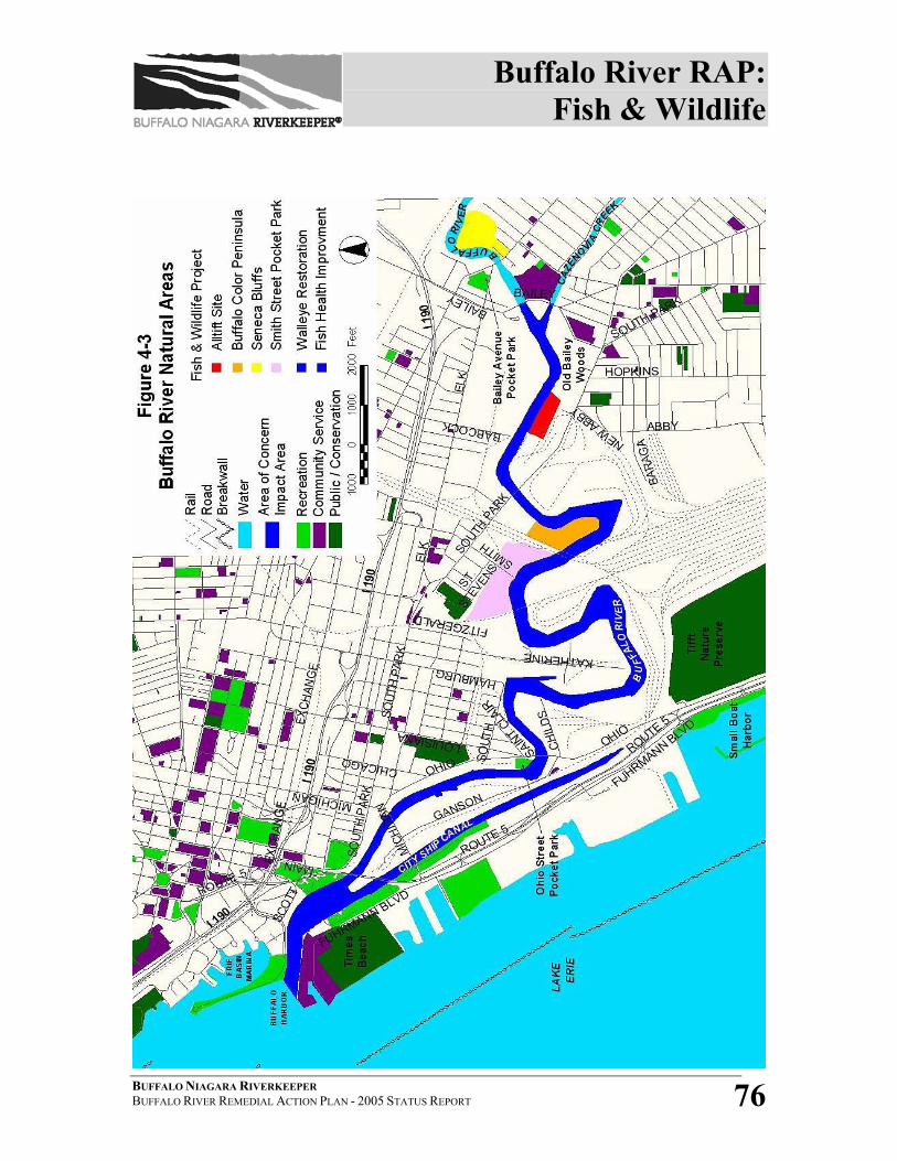
Buffalo River RAP: Fish & Wildlife
BUFFALO NIAGARA RIVERKEEPER BUFFALO RIVER REMEDIAL ACTION PLAN - 2005 STATUS REPORT 76
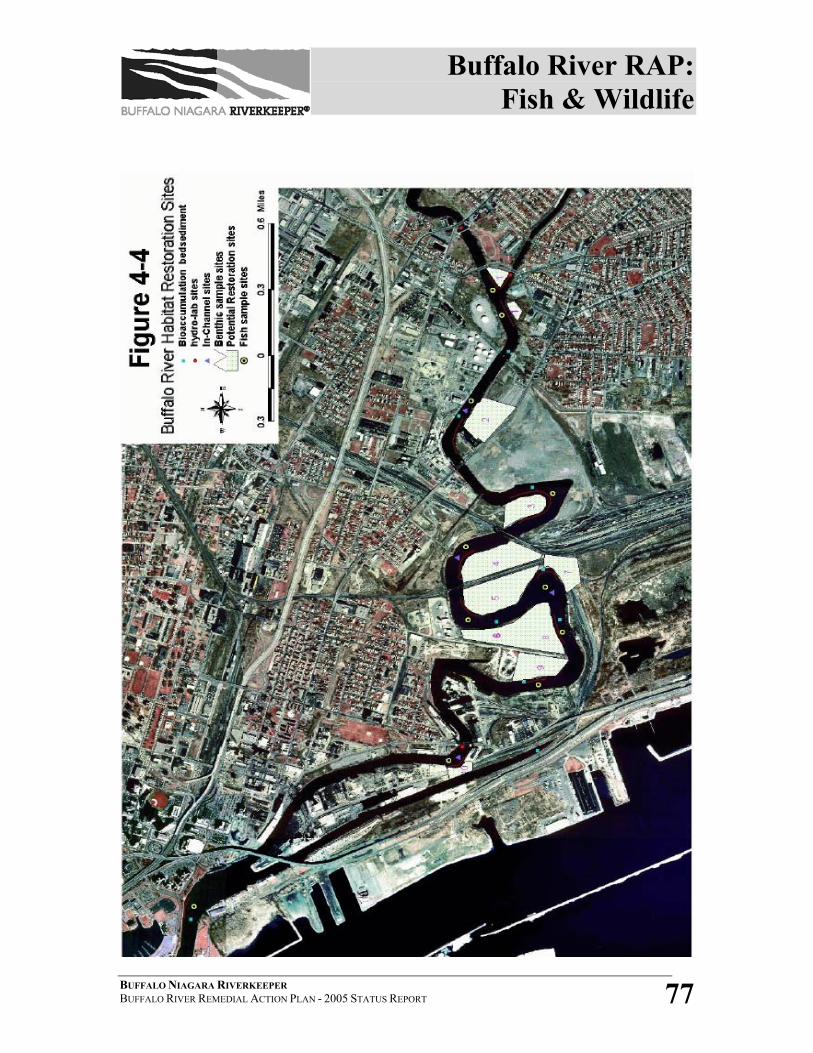
Buffalo River RAP: Fish & Wildlife
BUFFALO NIAGARA RIVERKEEPER BUFFALO RIVER REMEDIAL ACTION PLAN - 2005 STATUS REPORT 77
Buffalo River RAP: Fish & Wildlife
BUFFALO NIAGARA RIVERKEEPER BUFFALO RIVER REMEDIAL ACTION PLAN - 2005 STATUS REPORT 78
SECTION 4.3 - REFERENCES 1 Poole, E. Ann, E. Kozuchowski, C. Lowie for the Erie County Department of Environment and Planning, Fish and Wildlife Habitat Restoration on the Buffalo River, Buffalo, NY (August, 1994). 2 J. Hickey and Diane Mann-Klager for the USFWS, Assessment of Potential Habitat Restoration Areas Within the Buffalo River AOC (October 1993). 3 NYS DOH, 2002-03 Health Advisories (October 2002). 4 Kim Irvine, R. Snyder, T. Diggins, B. Sinn, C.F. Chuey, J. Jedlicka, J. Barrett O’neill, Assessment of Potential Aquatic Habitat Restoration Sites in the Buffalo River AOC, October 2005. 5 NYS DOH, 2005-2006 Health Advisories: Chemicals in Sportfish and Game, 2005 http://www.health.state.ny.us/nysdoh/fish/fish.pdf 6 Tim Preddice, NYSDEC-Albany, Personal community, 2005. 7 Tony Forti, NYSDOH, Personal communication, 2005. 8 Dr. Larry Skinner, NYS DEC, Personal communication, 2005. 9 Preddice, T., S. Jackling, and L. Skinner for NYS DEC, Contaminants in Young-of-Year Fish from Near-shore Areas of New York’s Great Lakes Basin (1997). 10 Tim Preddice, NYS DEC, Personal communication, 2005. 11 Dr. Paul Bowser, CFPP, Personal communication, 2005. 12 Don Einhouse and Mike Wilkinson, Fisheries Biologists at NYS DEC, Personal communication, 2005. 13 Mike Goehle, Aquatic Nuisance Species Coordinator, USFWS- Lower Great Lakes Fishery Resources Office, Personal communication, 2005. 14 Mary Rossi, ECDEP, Personal communication, 2005. 15 NYSDEC, 2002 Buffalo River RAP Status Report Update (2002). 16 Gregory P. Sutton, NYSDEC, Personal communication, 2005.
Complementary Projects: Public Access & Recreation
BUFFALO NIAGARA RIVERKEEPER BUFFALO RIVER REMEDIAL ACTION PLAN - 2005 STATUS REPORT 79
5 COMPLEMENTARY PROJECTS The following section includes information regarding public access, environmental
education, public participation and land use and development in the Buffalo River AOC.
These activities have not been identified as specific RAP goals, nor are they directly
related to the 14 Beneficial Use Impairments. However, each of these activities plays an
integral role in RAP implementation. Public access projects as well as land use and
development frequently correspond with habitat restoration; environmental education is
key to addressing non-point source pollution; and public participation is frequently a
requirement for studies and environmental actions (i.e.: Feasibility Study). Therefore, a
separate section has been included in the 2005 RAP Update for complementary projects
that may have direct or indirect impacts on the implementation of the Buffalo River RAP.
The following beneficial use impairments, or likely impairments, may be directly or
indirectly impacted by complementary projects in the Buffalo River AOC :
Impaired:
BUI #7- Restrictions on Dredging
BUI #11- Degradation of Aesthetics
BUI#14- Loss of Fish and Wildlife Habitat
Likely Impaired:
BUI # 3- Degradation of Fish and Wildlife Populations
5.1 PUBLIC ACCESS AND RECREATION Public access and recreation projects include enhancement of public access to the
Buffalo River and tributary creeks as well as improvement of the aesthetics of the
river and adjacent riparian areas.
Complementary Projects: Public Access & Recreation
BUFFALO NIAGARA RIVERKEEPER BUFFALO RIVER REMEDIAL ACTION PLAN - 2005 STATUS REPORT 80
5.1.1 TIMES BEACH PUBLIC ACCESS PROJECT
The Times Beach Public Access Project is a collaborative effort, with the
US Army Corps of Engineers conducting ecosystem restoration; Erie
County, in cooperation with the City of Buffalo, providing public access;
and the Times Beach Oversight Committee serving in an advisory
capacity. Project highlights include elevated boardwalks, ground-level
paths, bird watching blinds, overlook platforms and a bulletin-board style
information kiosk. The Times Beach Project provides safe public access
to one of the best birding areas in the Northeastern United States (see
Figure 4-3 for location).
The first phase of the Times Beach project restored the southeast portion
of the site. Improvements included a 6’ wide by ~750’ long stone path
trail, a 12’ x 28’ overlook platform; one bird watching blind, a parking lot
for 10 cars, an information kiosk, and limited fence repairs. Phase I was
completed in 2004. The second phase of the project encompasses the
majority of the site, stretching to the northwest boundary. Proposed
improvements include a system of 6’ wide stone trails and elevated
boardwalks totaling ~4,000 linear feet, two bird watching blinds, one
minor overlook platform, and complete fence repairs. Phase II has
recently received funding commitments and commenced in Fall 2005.1
5.1.2 OHIO STREET PARK
A partnership of public officials, private businesses and investors,
government agencies and community organizations plan to acquire ~4
acres of land along Ohio Street near Michigan Avenue for public access to
the Buffalo River. The park, which would include a pavilion, would be
the new home of the annual Buffalo Riverfest and other outdoor events,
Complementary Projects: Public Access & Recreation
BUFFALO NIAGARA RIVERKEEPER BUFFALO RIVER REMEDIAL ACTION PLAN - 2005 STATUS REPORT 81
and trails would connect the park to points on Buffalo’s waterfront.2
Riverkeeper has been a leading participant in this effort since its inception.
New York State has committed $500,000 to the creation of the park, and
Erie County will contribute $200,000 for land acquisition.3
SECTION 5.1 - REFERENCES 1 Mary Rossi, ECDEP, Personal communication, 2005. 2 Habuda, Janice, “Parks Proposed Along the Buffalo River,” The Buffalo News 14 July 2005. 3 “Buffalo River Project Moves Forward,” Front Page- West Seneca Edition 20 July 2005, Vol. 46, No. 47.
Complementary Projects: Environmental Education…
BUFFALO NIAGARA RIVERKEEPER BUFFALO RIVER REMEDIAL ACTION PLAN - 2005 STATUS REPORT 82
5.2 ENVIRONMENTAL EDUCATION AND PUBLIC
INVOLVEMENT Environmental education and public involvement projects include development of
public awareness and appreciation of the watershed, education of the public in
non-point source pollution issues and concerns, and encouragement of
environmental stewardship in local communities.
5.2.1 BUFFALO RIVER PUBLIC OUTREACH EFFORTS
Since 2004, Buffalo Niagara Riverkeeper has conducted three public
forums on the status of the Buffalo River. These community meetings
were held at the Peter Machnica Center in Kaisertown (May 2004), Valley
Community Center in the Valley (October 2004), and Old First Ward
Community Center in the First Ward (May 2005). Community members
were invited to take these opportunities to learn about progress on the
Buffalo River and offer their vision for Buffalo River restoration.
Individuals interested in fishing, birding, hiking, boating or otherwise
enjoying the Buffalo River waterfront attended. Outreach efforts also
included door-to-door discussions with community members. Community
feedback and input has been and will continue to be included in the
process to develop delisting criteria/restoration targets and as the RAC
updates the Remedial Strategy.
5.2.2 BUFFALO RIVER REPORT CARD
In 2004, the Remedial Advisory Committee prepared the baseline
information for a “Buffalo River Report Card”, an outreach piece designed
to give the general public a snapshot of the health and status of the Buffalo
Complementary Projects: Environmental Education…
BUFFALO NIAGARA RIVERKEEPER BUFFALO RIVER REMEDIAL ACTION PLAN - 2005 STATUS REPORT 83
River AOC, including the upper watershed. The Report Card has been
distributed to local government agencies and community leaders, and is
available for viewing as a .pdf file at www.fbnr.org. A complementary
document, the Buffalo River Citizen’s Report Card, encourages public
participation in the RAP process by allowing individuals to “grade” the
river and offer comments.
5.2.3 EDUCATION AND STEWARDSHIP PROGRAMS
The Valley Community Association has partnered with several
organizations to conduct education and stewardship programs on the
Buffalo River.
• Nature Ed-ventures will provide learning opportunities using the
Valley Nature Park and Habitat Trail on the Buffalo River.
• VCA uses the park to instill citizenship and character development in
program participants through cleanups and plantings.
• VCA also partners with Praxair, who conducts annual improvements
of the shoreline and park and has donated numerous trees.
• Ford Motor Company union UAW 897 has also joined the effort,
conducting cleanups, repairing the guardrail, and painting benches.
• Neighborhood residents have been encouraged to adopt the area, and
as a result, vandalism has been greatly reduced.1
Since 2003, Riverkeeper has conducted semiannual neighborhood
cleanups at 15 sites along the Buffalo River to encourage community
stewardship of the waterfront. The Buffalo River RAP and AOC are also
promoted as part of the annual Earth Day events and various festivals,
community events and community meetings throughout the watershed.
Complementary Projects: Environmental Education…
BUFFALO NIAGARA RIVERKEEPER BUFFALO RIVER REMEDIAL ACTION PLAN - 2005 STATUS REPORT 84
5.2.4 ADDITIONAL PUBLIC INVOLVEMENT
There will be numerous opportunities in 2006 for public involvement in
decision-making related to Buffalo River planning and policy. These
include public meetings for the Buffalo Sewer Authority’s Long-Term
Control Plan, Good Neighbor Planning Alliance, City of Buffalo
Brownfields Opportunity Area planning and Remedial Action Plan
implementation. Riverkeeper will continue to post information on public
meetings on its website and encourage stakeholder involvement.
SECTION 5.2 - REFERENCE 1 Peg Overdorf, Executive Director, Valley Community Association, Personal communication, 2005.
Complementary Projects: Land Use & Development
BUFFALO NIAGARA RIVERKEEPER BUFFALO RIVER REMEDIAL ACTION PLAN - 2005 STATUS REPORT 85
5.3 LAND USE AND DEVELOPMENT Although no specific actions have been taken regarding land use and development
during this reporting period, numerous projects are in the planning stage. (See
Figures 5-1 and 5-2 at the end of this section for a breakdown of current property
class codes and industrial usage of land surrounding the Buffalo River AOC
impact area). The following summarizes some of the current and active land
use/development activities within the AOC impact area:
• Buffalo River Greenway Implementation Plan- A final draft of the Buffalo
River Greenway Implementation Plan, a proposal to preserve and celebrate
the environmental and industrial heritage of the river, will be completed in
December 2005. The Plan will outline Greenway principles and guidelines,
summarize existing conditions and identify site-specific opportunities and
projects, as well as give detailed implementation procedures. The Buffalo
River Greenway Implementation Plan is being updated by Buffalo Niagara
Riverkeeper in conjunction with the RAP coordination project.
• Ohio Street Bicycle/Pedestrian Path- The “Greenway Trail” is a 2.5 mile
bicycle/pedestrian path that begins at Gallagher Beach on Buffalo’s outer
harbor and continues north to the US Coast Guard Base. Construction is
being completed in Fall 2005 on extension of the path from the NFTA DL&W
facility on South Park Avenue to Ohio Street, along the Buffalo River. The
trail will connect Ohio Street to the outer harbor without traversing the
Skyway. Project costs are $1.7 million.1 2
• Erie Canal Harbor Restoration- A waterfront infrastructure project which
includes reconstruction and restoration of historic and cultural features, a
transit plaza, waterfront esplanade, maritime facilities, access infrastructure
and a new Naval and Servicemen’s’ Park. Status of Project: Funding is
secured and construction of Naval Basin and Veteran’s Park in Buffalo
Harbor is completed. Supplemental EIS and re-design of remaining project
Complementary Projects: Land Use & Development
BUFFALO NIAGARA RIVERKEEPER BUFFALO RIVER REMEDIAL ACTION PLAN - 2005 STATUS REPORT 86
elements also are underway. New Naval Basin & Relocation of Vessels,
Veteran’s Park, and SEIS Scoping Report have all been completed.
Construction began in Fall 2004 with completion expected by Fall 20073
• Brownfields Opportunity Area (BOA) planning- A planning grant has been
awarded to the City of Buffalo from NYSDOS for a master plan development
for a portion of south Buffalo. The BOA includes 1800 acres from the
Buffalo River south to the Lackawanna border, east to Hopkins Road and west
to Lake Erie. The project is expected to last 18 months and is set to begin in
Fall 2005.4
• Local Waterfront Revitalization Plan (LWRP)- The City of Buffalo’s
LWRP is aimed at restoring and revitalizing the deteriorated and underutilized
areas of the waterfront by promoting development and redevelopment that
will meet the City’s goals and objectives for the waterfront.5 A Draft LWRP
was completed in May 2005 and is currently under review by various
stakeholders. The LWRP addresses economic development, tourism, public
access, conservation, water quality and brownfields redevelopment on the
City’s various waterways, including the Buffalo River and City Ship Canal.
• Bass Pro- A Bass Pro Outdoor World Store is being planned for the old
Memorial Auditorium as a key component to the Erie Canal Harbor
Restoration. The $100+ million project includes a Great Lakes/Erie Canal
Museum, with the entire project located adjacent to Buffalo Harbor. The
proposed project is anticipated to break ground in 2007, with an estimated
draw of 3-5 million patrons per year.
• Niagara Greenway- In September 2004, New York State created a 14-
member Niagara River Greenway Commission to facilitate the creation of a
Niagara River Greenway – “a linear system of state and local parks and
conservation areas linked by a network of multi-use trails within the greenway
area”. The commission must develop a plan and generic environmental
Complementary Projects: Land Use & Development
BUFFALO NIAGARA RIVERKEEPER BUFFALO RIVER REMEDIAL ACTION PLAN - 2005 STATUS REPORT 87
impact statement for the creation of the greenway designed to enhance
waterfront access, complement economic revitalization of the communities
along the river, and ensure the long-term maintenance of the greenway.
The Commission began meeting in July 2005, and in November 2005 issued a
Request for Proposals for development of the Greenway Plan. According to
the legislation, the plan must be submitted to the New York State
Commissioner of Parks no later than September 2006 after having been
endorsed by all of the municipalities within the Greenway area. Of interest to
the Buffalo River RAP, the Niagara River Greenway Plan will define how far
the Greenway extends up into the Buffalo River Area of Concern from the
River’s outlet at the mouth of the Niagara.
At least 17 environmental, sportsmen, and boating organizations with tens of
thousands of members have joined forces through the Niagara River
Greenway Campaign to ensure that the recently created Niagara River
Greenway fulfills its potential to safeguard the Niagara River ecosystem and
develop a sustainable, 21st century regional economy. The Campaign
mandates that the Greenway be ecologically sustainable, provide ample public
recreational access to the River, support heritage and marine based businesses
and actively involve local interests in the planning and management effort.
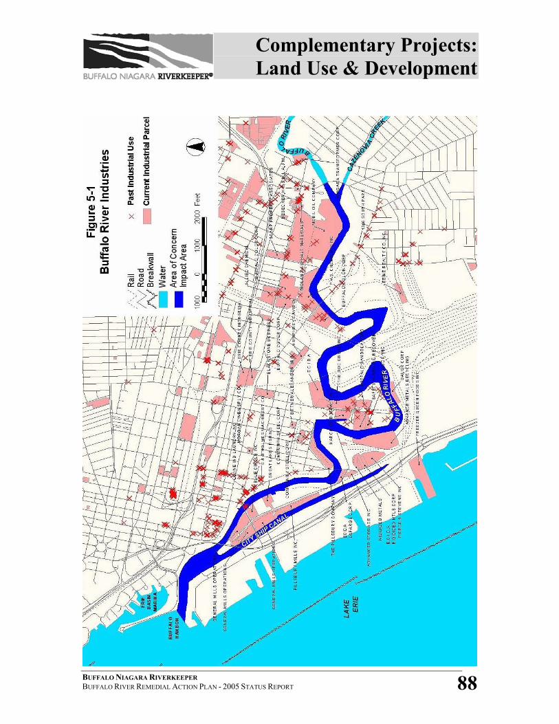
Complementary Projects: Land Use & Development
BUFFALO NIAGARA RIVERKEEPER BUFFALO RIVER REMEDIAL ACTION PLAN - 2005 STATUS REPORT 88

Complementary Projects: Land Use & Development
BUFFALO NIAGARA RIVERKEEPER BUFFALO RIVER REMEDIAL ACTION PLAN - 2005 STATUS REPORT 89
SECTION 5.3 - REFERENCES 1 Meckler, Lawrence, NFTA, Personal communication, 2005. 2 City of Buffalo website, 2005 http://www.ci.buffalo.ny.us/Files%5C1_2_1%5CBuffaloWaterfront%5CGreenway.pdf) 3 City of Buffalo website, 2005 http://www.ci.buffalo.ny.us/document_1786_186.html 4 Sandy Nasca, City of Buffalo, Personal communication, 2005. 5 City of Buffalo Office of Strategic Planning, Queen City in the 21st Century - Local Waterfront Revitalization Program (Draft LWRP) (May 2005).

Next Steps and Commitments
BUFFALO NIAGARA RIVERKEEPER BUFFALO RIVER REMEDIAL ACTION PLAN - 2005 STATUS REPORT 90
6 NEXT STEPS AND COMMITMENTS The following summarizes the next steps and commitments as discussed in previous
sections. Wherever possible, timelines, responsible parties and funding sources have
been identified.
BENEFICIAL USE IMPAIRMENTS
TASK: Complete the assessment of three “likely impaired” uses (BUI #2- Tainting of
Fish and Wildlife Flavor; BUI#3- Degradation of Fish and Wildlife Populations; and
BUI#5- Bird or Animal Deformities or Reproductive Problems).
RESPONSIBLE PARTIES: Riverkeeper, RAC and other project partners to be identified.
TIMELINE: To be completed by 2008.
FUNDING SOURCE: USEPA RAP Coordination grant to Riverkeeper has resources
dedicated to this task and will be leveraged to generate local match or in-kind as
needed.
TASK: Complete the assessment of the two “unknown” use impairments (BUI#8-
Eutrophication or Undesirable Algae; and BUI#13- Degradation of Phytoplankton).
RESPONSIBLE PARTIES: Riverkeeper, RAC and other project partners to be identified.
TIMELINE: To be completed by 2008.
FUNDING SOURCE: USEPA RAP Coordination grant to Riverkeeper has resources
dedicated to this task and will be leveraged to generate local match or in-kind as
needed.
TASK: Complete the assessment of BUI#14- Loss of Fish and Wildlife Habitat.
RESPONSIBLE PARTIES: Riverkeeper, RAC and other project partners to be identified.
TIMELINE: To be completed by 2008.
FUNDING SOURCE: USEPA RAP Coordination grant and USEPA Niagara River
Watershed Habitat Assessment Grant to Riverkeeper will be leveraged to generate
Next Steps and Commitments
BUFFALO NIAGARA RIVERKEEPER BUFFALO RIVER REMEDIAL ACTION PLAN - 2005 STATUS REPORT 91
local match or in-kind as needed. Buffalo State College graduate student will conduct
impervious vs. pervious surface analysis of the AOC as in-kind.
DELISTING CRITERIA/RESTORATION TARGETS
TASK: Upon completion of BUI evaluation and assessment, if necessary develop
criteria/targets for BUIs #2, #3, #5, #8, and #13.
RESPONSIBLE PARTIES: Riverkeeper and the RAC.
TIMELINE: Estimated completion by 2008.
FUNDING SOURCE: USEPA RAP Coordination grant to Riverkeeper.
TASK: Development of quantitative criteria/targets for BUI#14- Loss of Fish and
Wildlife Habitat.
RESPONSIBLE PARTIES: Riverkeeper and the RAC.
TIMELINE: Estimated completion by 2008.
FUNDING SOURCE: USEPA RAP Coordination grant to Riverkeeper.
TASK: Develop monitoring methods and protocols for the delisting of BUIs.
RESPONSIBLE PARTIES: Riverkeeper and the RAC.
TIMELINE: Commence in 2005 for known impairments. Estimated completion by
2008 for all determined impairments.
FUNDING SOURCE: USEPA RAP Coordination grant to Riverkeeper.
TASK: Develop updated remedial strategy for delisting or restoring BUIs.
RESPONSIBLE PARTIES: Riverkeeper and the RAC.
TIMELINE: Commence in 2005 for known impairments. Estimated completion by
2008 for all determined impairments.
FUNDING SOURCE: USEPA RAP Coordination grant to Riverkeeper.
Next Steps and Commitments
BUFFALO NIAGARA RIVERKEEPER BUFFALO RIVER REMEDIAL ACTION PLAN - 2005 STATUS REPORT 92
WATER QUALITY
TASK: Conduct 2006 RIBS sampling.
RESPONSIBLE PARTY: NYSDEC-Region 9
TIMELINE: Sampling in 2006. Report expected by 2008.
FUNDING SOURCE: Statewide Waters Monitoring Program- NYSDEC
TASK: Discharge Permit Monitoring and Renewal
RESPONSIBLE PARTY: NYSDEC-Region 9
TIMELINE: Annually.
FUNDING SOURCE: Environmental Benefit Permit System- NYSDEC
TASK: Long-Term Control Plan implementation
RESPONSIBLE PARTIES: BSA, NYSDEC-Region 9
TIMELINE: Sampling in 2006. Report expected by 2008.
FUNDING SOURCE: Statewide Waters Monitoring Program- NYSDEC
TASK: Phase II-Stormwater Regulations implementation
RESPONSIBLE PARTIES: NYSDEC, Erie County DEP, local municipalities
TIMELINE: Ongoing.
FUNDING SOURCE: NYSDEC and local municipalities.
TASK: Illicit Discharge Trackdown & Impervious Surface Modeling
RESPONSIBLE PARTIES: Buffalo State College, Erie County DEP
TIMELINE: Commence in late 2005. Expected completion by 2007.
FUNDING SOURCE: NYSDEC grant to Erie County DEP and USEPA grant to Buffalo
State College and ECDEP.
TASK: Maintain BRIC to augment flow of Buffalo River
Next Steps and Commitments
BUFFALO NIAGARA RIVERKEEPER BUFFALO RIVER REMEDIAL ACTION PLAN - 2005 STATUS REPORT 93
RESPONSIBLE PARTY: PVS Chemicals, Inc.
TIMELINE: Annually.
FUNDING SOURCE: PVS Chemicals, Inc.
CONTAMINATION
TASK: Implement intensive sediment sampling and analysis for lower Buffalo River.
RESPONSIBLE PARTIES: NYSDEC-Region 9, USACE, USEPA-GLNPO
TIMELINE: Summer 2005 – Spring 2006
FUNDING SOURCE: NYSDEC, USEPA-GLNPO
TASK: Implement Buffalo River Environmental Dredging Feasibility Study
RESPONSIBLE PARTIES: USACE, Riverkeeper
TIMELINE: Expected to be completed in 2008.
FUNDING SOURCE: USACE 312 Program, and Riverkeeper
TASK: Complete Mobil Oil Corporation (915040) remediation.
RESPONSIBLE PARTIES: Mobil Oil Corporation and NYSDEC-Region 9
TIMELINE: Not available.
FUNDING SOURCE: Undetermined.
TASK: Complete Steelfields LTD (915017) remediation.
RESPONSIBLE PARTIES: Steelfields LTD and NYSDEC-Region 9
TIMELINE: Expected completion in 2007.
FUNDING SOURCE: Undetermined.
TASK: Complete remedial work at Buffalo Color Plant (915184) site.
RESPONSIBLE PARTIES: Honeywell Corporation and NYSDEC-Region 9
TIMELINE: Expected completion in 2006.
Next Steps and Commitments
BUFFALO NIAGARA RIVERKEEPER BUFFALO RIVER REMEDIAL ACTION PLAN - 2005 STATUS REPORT 94
FUNDING SOURCE: Undetermined.
TASK: Complete Tifft-Hopkins St. (915131) contaminated soil removal.
RESPONSIBLE PARTIES: Honeywell Corporation and NYSDEC-Region 9
TIMELINE: Expected completion in 2005.
FUNDING SOURCE: Undetermined.
TASK: Complete remedial and park restoration activities at Boone Park (B00196).
RESPONSIBLE PARTY: NYSDEC
TIMELINE: Expected completion in 2005.
FUNDING SOURCE: Clean Water/Clean Air Bond Act Environmental Restoration
program.
TASK: Commence 90 Hopkins St. (E915181) lime material removal.
RESPONSIBLE PARTIES: City of Buffalo and NYSDEC
TIMELINE: Expected completion in 2006.
FUNDING SOURCE: Clean Water/Clean Air Bond Act Environmental Restoration
program.
FISH & WILDLIFE
TASK: Complete remediation and restoration work at Alltift site.
RESPONSIBLE PARTY: NYSDEC
TIMELINE: Expected completion in Fall 2005.
FUNDING SOURCE: NYSDEC
TASK: Bird Survey and Seasonal Population Assessment
RESPONSIBLE PARTY: Buffalo Ornithological Society, Canisius College
TIMELINE: Spring 2005 – Spring 2007.

Next Steps and Commitments
BUFFALO NIAGARA RIVERKEEPER BUFFALO RIVER REMEDIAL ACTION PLAN - 2005 STATUS REPORT 95
FUNDING SOURCE: In-kind through BOS and Buffalo State College.
TASK: Conduct annual fish stocking and electroshocking as part of the Buffalo River
Walleye Restoration Project.
RESPONSIBLE PARTY: NYSDEC-Region 9
TIMELINE: Annually through 2010.
FUNDING SOURCE: NYSDEC
TASK: Implement Goby Survey- Buffalo River and Tributaries project
RESPONSIBLE PARTY: USFWS-Lower Great Lakes Fishery Resources Office
TIMELINE: Commence in 2005.
FUNDING SOURCE: USFWS
COMPLEMENTARY PROJECTS
TASK: Complete Phase II of Times Beach Restoration
RESPONSIBLE PARTIES: Erie County DEP, USACE, City of Buffalo, NYS Office of
Parks, Recreation and Historic Preservation (OPRHP)
TIMELINE: Commence in 2005.
FUNDING SOURCE: NYS OPRHP secured $350,000 from the federal Land and Water
Conservation Fund which is administered by US Department of the Interior (DOI),
and the National Parks Service.
TASK: Ohio Street Park project
RESPONSIBLE PARTIES: NYS Assemblyman Mark Schroeder, Valley Community
Center, Erie County, City of Buffalo, Riverkeeper
TIMELINE: Commence in 2005.
FUNDING SOURCES: New York State, Erie County
Next Steps and Commitments
BUFFALO NIAGARA RIVERKEEPER BUFFALO RIVER REMEDIAL ACTION PLAN - 2005 STATUS REPORT 96
TASK: Environmental Education and Public Involvement (including public meetings,
forums, presentations, and clean-ups)
RESPONSIBLE PARTY: Riverkeeper
TIMELINE: Ongoing.
FUNDING SOURCES: Riverkeeper
TASK: Buffalo River Greenway Implementation Plan
RESPONSIBLE PARTY: Riverkeeper
TIMELINE: Ongoing.
FUNDING SOURCES: Undetermined.
TASK: Ohio Street Bicycle/Pedestrian Path
RESPONSIBLE PARTIES: NFTA, City of Buffalo, Erie County
TIMELINE: Expected completion by late 2005.
FUNDING SOURCES: Responsible parties.
TASK: Erie Canal Harbor Restoration
RESPONSIBLE PARTY: City of Buffalo
TIMELINE: Expected completion by Fall 2007.
FUNDING SOURCES: Responsible parties.
TASK: BOA and LWRP Planning
RESPONSIBLE PARTY: City of Buffalo
TIMELINE: Ongoing
FUNDING SOURCES: City of Buffalo, NYSDOS
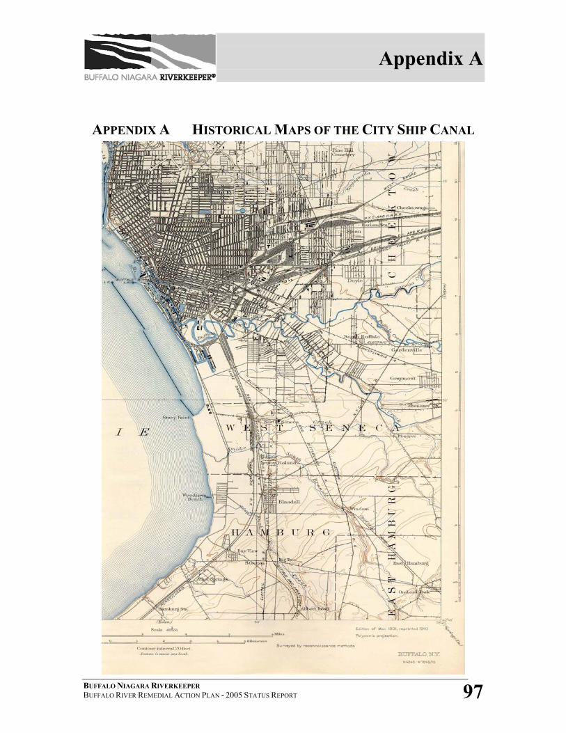
Appendix A
BUFFALO NIAGARA RIVERKEEPER BUFFALO RIVER REMEDIAL ACTION PLAN - 2005 STATUS REPORT 97
APPENDIX A HISTORICAL MAPS OF THE CITY SHIP CANAL
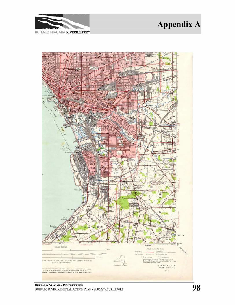
Appendix A
BUFFALO NIAGARA RIVERKEEPER BUFFALO RIVER REMEDIAL ACTION PLAN - 2005 STATUS REPORT 98
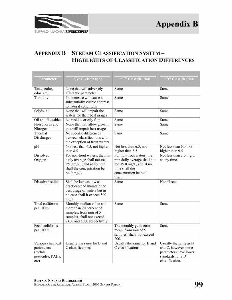
Appendix B
BUFFALO NIAGARA RIVERKEEPER BUFFALO RIVER REMEDIAL ACTION PLAN - 2005 STATUS REPORT 99
APPENDIX B STREAM CLASSIFICATION SYSTEM – HIGHLIGHTS OF CLASSIFICATION DIFFERENCES
Parameter “B” Classification “C” Classification “D” Classification
Taste, color, odor, etc.
None that will adversely affect the parameter
Same Same
Turbidity No increase will cause a substantially visible contrast to natural conditions
Same Same
Solids- all None that will impair the waters for their best usages
Same Same
Oil and floatables No residue or oily film Same Same Phosphorus and Nitrogen
None that will allow growth that will impair best usages
Same Same
Thermal Discharges
No specific differences between classifications with the exception of trout waters.
Same Same
pH Not less than 6.5, not higher than 8.5
Not less than 6.5, not higher than 8.5
Not less than 6.0, not higher than 9.5
Dissolved Oxygen
For non-trout waters, the min daily average shall not me <5.0 mg/L, and at no time shall the concentration be <4.0 mg/L
For non-trout waters, the min daily average shall not me <5.0 mg/L, and at no time shall the concentration be <4.0 mg/L
Not less than 3.0 mg/L at any time.
Dissolved solids Shall be kept as low as practicable to maintain the best usage of waters but in no case shall it exceed 500 mg/L
Same None listed.
Total coliforms per 100ml
Monthly median value and more than 20 percent of samples, from min of 5 samples, shall not exceed 2400 and 5000 respectively.
Same Same
Fecal coliforms per 100 ml
The monthly geometric mean, from min of 5 samples, shall not exceed 200.
Same
Various chemical parameters (metals, pesticides, PAHs, etc)
Usually the same for B and C classifications.
Usually the same for B and C classifications.
Usually the same as B and C, however some parameters have lower standards for a D classification.
Appendix C
BUFFALO NIAGARA RIVERKEEPER BUFFALO RIVER REMEDIAL ACTION PLAN - 2005 STATUS REPORT 100
APPENDIX C INACTIVE HAZARDOUS WASTE SITES WITHIN
THE BUFFALO RIVER AOC
BACKGROUND
New York State has enacted the Inactive Hazardous Waste Disposal Site Program to
ensure the identification, investigation and clean up of sites where significant amounts of
hazardous waste may exist. Within the Department of Environmental Conservation the
Division of Environmental Remediation, alongside the Divisions of Health and Law, are
responsible for ensuring the cleanup of inactive hazardous waste disposal sites across
New York State.
The remediation process begins with a Preliminary Site Assessment (PSA). The PSA
determines whether a site meets the state's definition of an inactive hazardous waste
disposal site. (Inactive hazardous waste disposal sites are defined by the confirmed
presence of on-site hazardous waste.) The responsible agency must also make a
determination of a public health and/or environmental risk.
When the presence of hazardous waste and the environmental/public health threat have
been confirmed, the site is then added to the State's official list of sites and is given a
classification code: Class 1 - imminent danger; Class 2 - significant threat; and Class 3 -
no significant threat. If no hazardous waste is documented, a site is delisted.
Class 1or 2 sites undergo a detailed investigation known as a remedial investigation (RI).
Through a process of sampling and laboratory analyses, the RI identifies the threat to
public health and the environment. Threats are determined by scope of contamination,
including the defined pathways of migration and the degree of contamination in surface
water, groundwater, soils, air, plants, and animals. A Feasibility Study (FS) is then
Appendix C
BUFFALO NIAGARA RIVERKEEPER BUFFALO RIVER REMEDIAL ACTION PLAN - 2005 STATUS REPORT 101
produced which uses RI information to develop a strategy that will eliminate the site's
threat to public health or the environment.
In some situations Interim Remedial Measures (IRM) are taken in lieu of the extensive
RI/FS stage. An IRM is a distinct set of planned actions for both emergency and non-
emergency situations that accelerates the entire remediation process.
After all studies have been completed a Record of Decision (ROD) is approved. The
ROD delineates the proposed remedial action plan. Remedial design and remedial
construction can begin. Eventually, after remedial work has been completed a hazardous
waste site may be reclassified. Sites either undergo continued maintenance and operation
or are delisted.
2002 BUFFALO RIVER RAP STATUS REPORT
The 2002 update demonstrated significant progress in the area of inactive hazardous
waste remediation. By the time of the completion of the 2002 report, all Phase I & II site
investigations have been concluded for currently identified inactive hazardous waste
sites. Furthermore, the Remedial Investigations and Feasibility Studies were completed
at 38 sites.
CURRENT STATUS OF SITES TRIBUTARY TO THE BUFFALO RIVER1
Steelfields LTD (Site No. V00619): This 218 acre site includes the former Republic
Steel Plant, Donner-Hanna Coke Plant, the Republic Steel Maintenance Facility and the
Donner-Hanna Coke Storage area (DEC site No. 915017). The RI/FS was completed in
January 2000. Steelfields Ltd took ownership of the site in 2000 as part of the bankruptcy
proceeding of the LTV Steel Corporation. At that time Steelfields also entered into a
Voluntary clean-up agreement with NYS to remediate the site for later development. As
part of the remediation approximately 300,000 cubic yards of contaminated soil and fill
Appendix C
BUFFALO NIAGARA RIVERKEEPER BUFFALO RIVER REMEDIAL ACTION PLAN - 2005 STATUS REPORT 102
will be excavated and either, treated, contained, recycled or disposed of off-site.
Remedial work is currently underway at the site and expected to be complete by 2007.
Tifft & Hopkins Street Site (Site No. 915131): Honeywell Corporation has entered into
a Consent Order with the NYSDEC to conduct a Interim Removal Measure to remove up
to 35,000 cubic yards of contaminated soil containing residues from the local dye making
industries. Work is expected to be completed by the summer of 2005.
Lehigh Valley Railroad (Site No. 915071): Honeywell Corporation has completed
removal of 3,400 cubic yards of contaminated soil containing residues from the local dye
making industries. The site is adjacent to the Tifft nature preserve and was restored to a
natural state.
Buffalo Color Plant Site (Site No. 915184): Honeywell Corporation has entered into a
Consent Order with the NYSDEC to perform a Interim Remedial Measure at the site. The
IRM consists of the installation of groundwater pumping wells and the installation of a
groundwater cut-off wall to prevent flow of site contaminants to the Buffalo River.
Remedial work is expected to be complete within one year.
Buffalo Color Area D (Site No. 915012): Remedial work was completed in 1998. The
activities consisted of the installation of a groundwater collection and treatment system
combined with a cap and barrier wall system. Remedial activities also included the
removal of approximately 40,000 cubic yards of impacted sediment from the Buffalo
River. Long term operation and maintenance of the property is currently being
performed.
90 Hopkins Street (Site No. E915181): The City of Buffalo has committed to the
removal of 30,000 cubic yards of lime material from the 8.9-acre site. The lime is a waste
Appendix C
BUFFALO NIAGARA RIVERKEEPER BUFFALO RIVER REMEDIAL ACTION PLAN - 2005 STATUS REPORT 103
product from former acetylene production industries that were located in the area. Run-
off from the piles has caused significant rises in pH in local waterways. Work is being
performed under the NYS 1996 Clean Water/ Clean Air Bond Act Environmental
Restoration program and is expected to be completed by 2006.
Sovereign Chemical (Site No. V00215): Sovereign Chemical entered into a voluntary
clean-up agreement with the NYSDEC to remediate their chemical storage area at the
Pierce and Stevens Facility on Ohio Street. The remedial work consisted of the removal
of the old tank farm, removal of contaminated soil and replacement of the equipment
with a state of the art chemical storage facility. As part of the work approximately 5,800
tons of contaminated soil containing solvents was excavated and properly disposed off-
site in 2003. The facility is currently pumping groundwater as part of a long term
operation and maintenance plan.
Boone Park (Site No. B00196): This 3 acre site consists of a public park that contains
surface soil contaminated with arsenic. Remedial and park restoration activities are being
performed under the NYS 1996 Clean Water/ Clean Air Bond Act Environmental
Restoration program and will be completed in the spring of 2005.
Bern Metal (Site No. 915135): The 3.5-acre site was remediated in 2002. The work
consisted of a cap system. Long-term operation and maintenance is currently underway.
Mobil Oil (Site No. 915040): The site is a 77 acres petroleum distribution and storage
facility. A groundwater collection system has been installed and is in operation on the
entire property. The Company has proposed additional remediation that is under review
by NYSDEC. A specific clean up schedule is not yet available.
Appendix C
BUFFALO NIAGARA RIVERKEEPER BUFFALO RIVER REMEDIAL ACTION PLAN - 2005 STATUS REPORT 104
APPENDIX C - REFERENCE 1 Marty Doster, NYS Department of Environmental Conservation, Region 9, Personal communication,
2005.


![Oswego River Remedial Action Plan Stage 1 [February 1990]](https://img.dokumen.tips/doc/110x75/616a25fb11a7b741a34f5404/oswego-river-remedial-action-plan-stage-1-february-1990.jpg)

