Embed Size (px)
Citation preview
BROOK FOREST CONSERVATION / MITIGATION BANK
Moosa Creek – San Luis River Watershed
Valley Center, San Diego County, California
Prospectus
Submitted to:
Interagency Review Team U.S. Army Corps of Engineers: Richard J. Van Sant
U.S. Fish and Wildlife Service: Janet Stuckrath San Diego Regional Water Quality Control Board: Alan Monji
California Department of Fish and Game: Bryand M. Duke National Oceanic and Atmospheric Administration’s, National Marine Fisheries Service: ______
Submitted by:
Michael D. Crews Development II, Inc. P.O. Box 300429
Escondido, CA 92030 Contact: Wes Peltzer
Email: [email protected] (760) 744-7125 (Office) (760) 744-8259 (Fax)
September __, 2012
Brook Forest Conservation/Mitigation Bank Prospectus
Brook Forest September 14, 2012
1
Section 1 Summary
The Brook Forest Conservation/Mitigation Bank consists of approximately 226 acres of raw land located in Valley Center south of Betsworth Road. The site has been examined by the U.S. Army Corps of Engineers (ACOE) and found to be suitable as a wetlands revegetation site. Based on biological surveys of the site completed between 1991 and 2012, the site contains both high quality uplands vegetation and a substantial wetlands establishment area. These biological surveys indicate that the site supports approximately 16.1 acres of Diegan Coastal Sage Scrub, 65.0 acres of Non-native Grassland, 18.9 acres of Southern Coast Live Oak Riparian Forest, 20.0 acres of Open Engelmann Oak Woodland, 6.3 acres of Southern Willow Scrub, 57.7 acres of Mafic Southern Mixed Chaparral, 8.3 acres of disturbed Mafic Southern Mixed Chaparral, 5.2 acres of Native Grassland, 20.9 acres of Extensive Agriculture, 0.3 acre of Disturbed Wetland, and about 7.3 acres of Disturbed Habitat. The Conservation/Mitigation Bank will also include the establishment of approximately 20.0 acres of ACOE wetlands and 4.0 acres of CDFG wetlands. The Brook Forest site consists of a large, contiguous block of biologically-rich land supporting a diversity of habitats and native species. The site contains a substantial ridge that dominates the central and southeast parts of the property. This ridge rises up from flatter areas to the north, northwest, and southwest. Elevations on the site range between approximately 1,246 and 1,630 feet above mean sea level (MSL). Soil-types found onsite consist of Clayey Alluvial Land (Co) in flat areas, Visalia Sandy Loams (VaB, VaC) on gentle slopes between 2 and 9 percent, Fallbrook Sandy Loams (FaE2, FaC2, FaD2) on slopes between 9 and 30 percent, Cieneba-Fallbrook Rocky Sandy Loams (CnE2, CnG2) on slopes between 9 and 65 percent, and Las Posas Stony Fine Sandy Loams (LrG) on steep slopes between 30 and 65 percent. Small areas of Vista coarse sandy loam (VsE2) and Placentia sandy loam (PeC) are also present in areas. Las Posas soils are known to support numerous rare and endemic plants, as well as various sensitive habitats and are an indicator of mafic vegetation. A few dirt tracks cross the property. One provides access to the uppermost elevations along the site’s central ridge. The lowest portions of the site currently support non-commercial agriculture (dry farming), with about 21 acres of the site currently being used for dry farming with grain crops. The balance of the habitat onsite consists of chaparral, sage scrub, grasslands, disturbed lands, and riparian vegetation. These can be delineated or differentiated into eleven generally discrete plant associations:
1. Diegan Coastal Sage Scrub (DCSS) – 16.1 acres 2. Non-native Grassland (NNG) – 65 acres 3. Southern Coast Live Oak Riparian Forest (SCLORF) – 18.9 acres 4. Open Engelmann Oak Woodland (OEOW) – 20 acres 5. Southern Willow Scrub (SWS) – 6.3 acres 6. Mafic Southern Mixed Chaparral (MSMC) – 57.7 acres
Brook Forest Conservation/Mitigation Bank Prospectus
Brook Forest September 14, 2012
2
7. Disturbed Mafic Southern Mixed Chaparral – 8.3 acres 8. Native Grassland (NG) – 5.2 acres 9. Extensive Agriculture – 20.9 acres 10. Disturbed Wetland – 0,3 acre 11. Disturbed Habitat (DH) – 7.3 acres
A major biological resource in the vicinity and associated with portions of the site is Moosa Creek, which traverses the valley in an east-to-west flow. Moosa Creek crosses the property from east to west in the northern portion of the project site paralleling Betsworth Road, from 200 feet to 500 feet south of the centerline of Betsworth Road. The length of the drainage area from entry on the east to where it exits the site on the west side of the property is about 3,200 linear feet. A second, less well-defined drainage course crosses the southwesterly corner of the property, draining from east to west. The drainage exiting the west side of the property extends for approximately 2,000 linear feet. Both a floodway and floodplain exist on-site as a result of drainage from Moosa Creek through the property. This is an area where dry farming has occurred over a many decades. The existing main creek bed averages about 30 feet in width and 2 to 3 feet in depth. The floodplain area lying north and south of the creek bed varies in width from 30 feet to 300 feet. Michael Crews Development II, a California corporation, is the Bank Sponsor and would be responsible for Bank design, entitlement, construction and long-term operations and management. Michael Crews Development II will construct and manage the Bank until all of the constructed wetlands and upland habitat are sold and the endowment is fully funded. Michael Crews Development II is seeking to permanently protect the site through the upland and wetlands mitigation banking process resulting in the placement of a conservation easement over the site and to provide wetlands and upland mitigation to help the agencies achieve their mitigation goals. At this time, it is proposed that Emerald Crest Conservancy hold the conservation easement on the property and that MKT Advisors hold the long-term management endowment.
Brook Forest Conservation/Mitigation Bank Prospectus
Brook Forest September 14, 2012
3
Section 2 Bank Establishment and Operation 2.1 RESPONSIBLE PARTIES Contact information is for the proposed Bank is provided below.
2.1.1 Bank Sponsor Contact Information Michael Crews Development II is the Bank Sponsor. Contact information for the Bank Sponsor is provided below. Michael Crews Development II P.O. Box 300429 Escondido, CA 92030 (760) 749-1919 Primary Contact: Wes Peltzer ([email protected]) Office: (760) 744-7125 Fax: (760) 744-8259
Project Biologist: Vince Scheidt ([email protected]) Office: (858) 457-3873 Cell: (858) 336-7106 Project Engineer: Michael Wunderlin ([email protected]) Office: (760) 743-2238 Cell: (760) 644-2944
Alternate Contacts: Michael Crews ([email protected]) or (760) 535-6165
2.1.2 Bank Sponsor Qualifications
Brook Forest Conservation/Mitigation Bank Prospectus
Brook Forest September 14, 2012
4
Michael Crews Development II is the owner of the 226 acre site and the same owners have owned this site since 2000. Over the last twelve years, the owners of Michael Crews Development II have spent substantial sums of money evaluating both the uplands habitat available on the site and the wetlands areas that can be established and preserved. Michael Crews Development II has assembled a seasoned team of experts to cover all aspects of the mitigation banking and land conservation including wildlife biologists and botanists, regulatory permitting specialists, conservation planners, licensed civil engineers, and a hydrologist. Michael Crews Development II applies a comprehensive watershed and ecosystem approach to fulfilling mitigation banking and conservation projects. As the land owner and bank/preserve operator, Michael Crews Development II assumes the responsibility for mitigation success. The team that Michael Crews Development II has formed for the Brook Forest Conservation/Mitigation Bank has recently successfully established the Red Mountain Conservation Bank located in Fallbrook, California. The Red Mountain Conservation Bank was approved by the United States Fish & Wildlife Service in January 2011. The Red Mountain Conservation Bank encompasses 557.78 acres of land that includes the preservation of Occupied Diegan Coastal Sage Scrub, Native Grassland, Coast Live Oak Woodland and Riparian Forest, and Mafic Southern Mixed Chaparral. The team members have also been involved in the establishment of other mitigation banks in the County including the Elfin Forest Recreation Reserve http://www.olivenhain.com/about-us/elfin-forest-recreational-reserve formed by the Olivenhain Municipal Water District, the Miller Valley Ranch Conservation/Mitigation Bank http://www.millervalleyranchmitigationbank.com and others.
2.1.3 Conservation Easement Holder (proposed) Emerald Crest Conservancy is proposed to hold the conservation easement. Emerald Crest Conservancy is authorized to hold this conservation easement pursuant to California Civil Code Section 815.3(a). Specifically, Emerald Crest Conservancy is a tax-exempt nonprofit organization qualified under Section 501(c)(3) of the Internal Revenue Code of 1986, as amended, qualified to do business in California, a qualified organization as defined in Section 170(h)(3) of the Internal Revenue Code and an organization which has as its primary and principal purpose and activity the protection and preservation of natural lands or resources in its natural, scenic, agricultural, forested, or open space conditions of use. Emerald Crest Conservancy 939 South Andreasen Drive Escondido, CA 92029 Contact: Michael Crews Telephone: (760) 535-6165 Fax: (760) 749-6083 E-mail: [email protected]
Brook Forest Conservation/Mitigation Bank Prospectus
Brook Forest September 14, 2012
5
2.1.4 Endowment Holder (proposed) The MKT Advisors is proposed to hold the long-term endowment. MKT Advisors 900 Canterbury Place, Suite 340 Escondido, CA 92025 Telephone: (760) 658-8780 Fax: (760) 658-8785 E-mail:[email protected]
2.2 BANK ESTABLISHMENT After the completion of the Public Notice comment period, a Bank Enabling Instrument (BEI) will be submitted for review by the Corps, USFWS, DFG, NMFS, and SDRWQCB (collectively referred to as the Interagency Review Team [IRT]). Once the comments received on the Draft Prospectus, Emerald Crest Development II will start preparing the BEI using the Corps and USFWS approved templates. According to the BEI template, transfer of credits may begin on the bank establishment date, and bank establishment requires the following:
• The BEI will be executed by the required Signatory Agencies,
• The Conservation Easement has been accepted by a Grantee approved by the Corps and other applicable Signatory Agencies and recorded in the Official Records of San Diego County, and;
• The Bank Sponsor has complied with its obligation to furnish the following financial
assurances in accordance with the requirements of the BEI:
o A Construction Security ensures that any construction will be completed as proposed.
o A Performance Security ensures that constructed habitat will function as planned.
o An Interim Management Security ensures that the Bank will be managed during
habitat establishment.
Brook Forest Conservation/Mitigation Bank Prospectus
Brook Forest September 14, 2012
6
o An Endowment Fund ensures that there is adequate funding to provide for the financial requirements of the long-term management of the Bank in accordance with the Long-term Management Plan.
2.3 BANK OWNERSHIP AND LONG-TERM MANAGEMENT
Michael Crews Development II is proposing to own and manage the Bank site for the foreseeable future. The mechanisms for constructing, protecting and managing habitat and conservation values will be described in the BEI and in supporting documents to the BEI which will be reviewed and approved by the IRT prior to Bank establishment. The BEI and supporting documents will include a description of baseline conditions and overall management, maintenance, and monitoring goals with specific tasks and timing of implementation. An Endowment Fund will be established to ensure that the monitoring and management expenses of the site will be funded in perpetuity. Deposits to the Endowment Fund will be made concurrent with the transfer of credits. The conservation easement recorded over the Bank property will exclude any easement areas that allow uses that are incompatible with conservation. The conservation easement will be held by an entity that is approved to hold an interest in mitigation lands as defined in California Government Code Section 65965. The conservation easement holder must be approved by the Corps and any other applicable Signatory Agencies.
2.4 ANTICIPATED NEED The Bank will provide high quality compensation for impacts to Diegan Coastal Sage Scrub, Non-native Grassland, Southern Coast Live Oak Riparian Forest, Open Engelmann Oak Woodland, Southern Willow Scrub, Mafic Southern Mixed Chaparral, and Native Grassland and for impacts to wetlands from various public and private projects. The County of San Diego has recently completed an update of its general plan known as GP 2020. The EIR completed for GP 2020 projects an increase of 71,540 housing units within the County upon build-out of the County. (GP 2020 EIR p. 1-44). The Board of Supervisors recently approved an additional increase of 2,863 dwelling units in response to property owner requests which will be processed through a County- sponsored general plan amendment. In addition, a project known as Lilac Hills Ranch has recently submitted a general plan amendment and tentative map to develop an additional 1.746 dwelling units on 610 acres of land in Valley Center. Collectively these projects will add 76,149 dwelling units in San Diego County at build-out.
Brook Forest Conservation/Mitigation Bank Prospectus
Brook Forest September 14, 2012
7
An examination of sensitive and protected upland habitat available within existing approved banks in San Diego County demonstrates there is a need for the additional upland credits being provided by the Brook Forest Conservation/Mitigation Bank. Native grassland is not available from any existing mitigation banks. Brook Forest will provide 5.2 acres of native grassland. Non-native grassland is not available in any existing mitigation banks in the County, except that some Non-native grassland is available at Daley Ranch, which can only be used by the City of Escondido for City projects and .3 acres of non-native grassland is available from the Red Mountain Conservation Bank. Brook Forest will provide 69.5 acres of Non-native Grassland. Oak riparian credits are presently available only at the Crestridge Bank in the non-coastal portion of Southwestern San Diego County. Brook Forest will provide 18.9 acres of Southern Coast Live Oak Riparian Forest. Engelmann Oak Woodland is presently available only at Daley Ranch within the City of Escondido. Brook Forest will provide 20 acres of Open Engelmann Oak Woodland. No Southern Willow Scrub habitat is presently available from any bank. Brook Forest will provide 6.3 acres of this habitat. No Southern Cottonwood-Willow Riparian Forest habitat is presently available from any bank. Brook Forest will provide 24 acres of this habitat. Currently only one approved bank in San Diego County offers wetlands credits. This is the Rancho Jamul Wetlands Mitigation Bank located in the southern portion of San Diego County. The Rancho Jamul Wetlands Mitigation Bank currently has a total of 12.4 wetlands credits still available for sale. However, these wetland credits can only be used for in kind impacts located in the San Diego Bay, Otay River, Sweetwater River and the Chollas Creek watersheds. These wetland credits could not be utilized for projects located in other portions in San Diego County. The Brook Forest Conservation Bank will provide 20 acres of ACOE wetlands credits and 4 acres of State wetlands credits in areas of San Diego County where no wetlands credits are presently available. The Pilgrim Creek Mitigation Bank previously had some wetlands credits available for sale, however, these credits were sold out last year. SANDAG, Caltrans and utility companies like SDG&E are potential purchasers of the wetlands mitigation credits because the linear nature of the projects often makes on-site mitigation neither practical nor desirable. Caltrans is currently planning on the widening of State Route 76 from a two-lane to a four lane highway connecting I-15 to I-5. Extensive “transportation hub” residential, commercial and civic development is planned at the intersection of State Route 76 and I-15. SDG&E is proceeding with upgrades to its transmission corridors in the San Diego region. Under the Congressionally approved “Grow the Forest” initiative, several billion dollars over the next five years has been appropriated to CPEN for military construction projects (MILCON). The 2012 MILCON plan anticipates funding a new crossing over the Santa Margarita River that is anticipated to require wetland mitigation. Additional CPEN projects resulting from a growing population and increased military activity on base are under environmental review. These projects are expected to require significant mitigation for impacts to wetlands. Caltrans is proposing improvements to a 27-mile stretch of I-5 beginning at La Jolla Village Drive in the City of San Diego and ending at Harbor Boulevard in the City of Oceanside. This will result in significant impacts to wetlands.
Brook Forest Conservation/Mitigation Bank Prospectus
Brook Forest September 14, 2012
8
The cities of San Marcos and Escondido are two of the fastest growing cities in San Diego County. Both cities are planning for extensive future population and job growth. The expansion of California State University at San Marcos is driving both commercial and residential growth. The Brook Forest Conservation Bank represents a unique opportunity to create a large scale wetlands establishment project which can benefit wetlands and upland wildlife resources within the Northern San Diego County region while supporting continued community growth and the CPEN mission. The Service Area for this project was selected because it includes the population centers, infrastructure development and military installations that will generate the impacts required to justify the size and capital resources necessary to create a conservation bank of this magnitude. As the market continues to evolve, the demand analysis summary can be updated to supplement mitigation demand and the timing of significant public and private projects needing the wetlands and upland habitat available at the Brook Forest Conservation/Mitigation Bank.
2.5 ANTICIPATED SCHEDULE The establishment of the 20.0 acres of ACOE wetlands and 4.0 acres of CDFG wetlands will occur after approval of the BEI. Initial activities will include the excavation of about 100,000 cubic yards of soils to create the wetlands establishment area in the current floodplain and adjacent to the floodway of Moosa Creek with subsequent planting of wetlands vegetation. Excavated soils to establish the wetlands will be placed in existing disturbed areas on the Bank site. No import or export of dirt will be necessary to create the wetlands establishment area. Planting and seeding may occur between November 15 and March 15 to take advantage of winter rains. Monitoring would begin before grading and the site preparation phase, and will continue throughout the wetland habitat establishment period. A conservation easement would be recorded on the site after creation of the wetlands establishment area. No further development of the site in the future would be allowed.
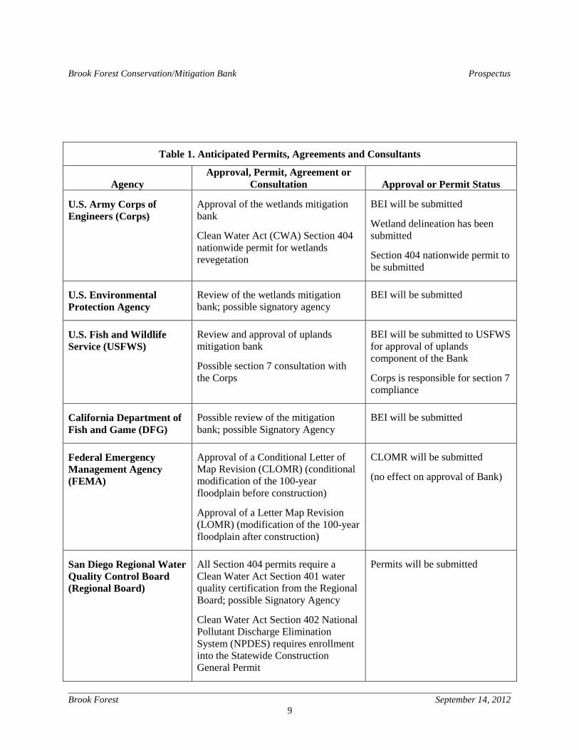
2.6 ANTICIPATED PERMITS, AGREEMENTS AND
CONSULTATIONS A list of anticipated permits, agreement and consultations is provided in Table 1. This list will be updated, as necessary, during the Bank entitlement process. The Corps has the authority to approve the wetlands component of the Bank and the USFWS has the authority to approve the uplands component of the Bank. However, other agencies may choose to participate in the process and become Signatory Agencies or Parties to the BEI, if deemed appropriate.
Brook Forest Conservation/Mitigation Bank Prospectus
Brook Forest September 14, 2012
9
Table 1. Anticipated Permits, Agreements and Consultants
Agency
Approval, Permit, Agreement or Consultation
Approval or Permit Status
U.S. Army Corps of Engineers (Corps)
Approval of the wetlands mitigation bank
Clean Water Act (CWA) Section 404 nationwide permit for wetlands revegetation
BEI will be submitted
Wetland delineation has been submitted
Section 404 nationwide permit to be submitted
U.S. Environmental Protection Agency
Review of the wetlands mitigation bank; possible signatory agency
BEI will be submitted
U.S. Fish and Wildlife Service (USFWS)
Review and approval of uplands mitigation bank
Possible section 7 consultation with the Corps
BEI will be submitted to USFWS for approval of uplands component of the Bank
Corps is responsible for section 7 compliance
California Department of Fish and Game (DFG)
Possible review of the mitigation bank; possible Signatory Agency
BEI will be submitted
Federal Emergency Management Agency (FEMA)
Approval of a Conditional Letter of Map Revision (CLOMR) (conditional modification of the 100-year floodplain before construction)
Approval of a Letter Map Revision (LOMR) (modification of the 100-year floodplain after construction)
CLOMR will be submitted
(no effect on approval of Bank)
San Diego Regional Water Quality Control Board (Regional Board)
All Section 404 permits require a Clean Water Act Section 401 water quality certification from the Regional Board; possible Signatory Agency
Clean Water Act Section 402 National Pollutant Discharge Elimination System (NPDES) requires enrollment into the Statewide Construction General Permit
Permits will be submitted
Brook Forest Conservation/Mitigation Bank Prospectus
Brook Forest September 14, 2012
10
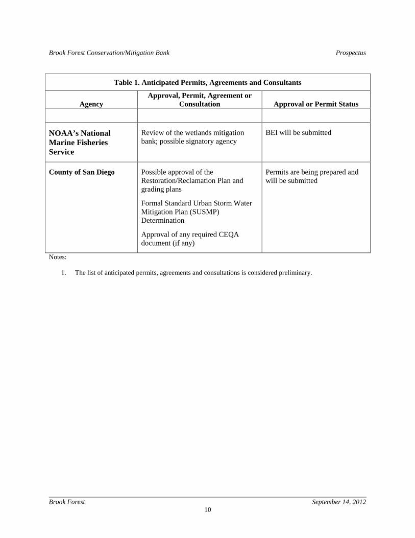
Table 1. Anticipated Permits, Agreements and Consultants
Agency
Approval, Permit, Agreement or Consultation
Approval or Permit Status
NOAA’s National Marine Fisheries Service
Review of the wetlands mitigation bank; possible signatory agency
BEI will be submitted
County of San Diego Possible approval of the Restoration/Reclamation Plan and grading plans
Formal Standard Urban Storm Water Mitigation Plan (SUSMP) Determination
Approval of any required CEQA document (if any)
Permits are being prepared and will be submitted
Notes:
1. The list of anticipated permits, agreements and consultations is considered preliminary.
Brook Forest Conservation/Mitigation Bank Prospectus
Brook Forest September 14, 2012
11
Section 3 Property Description 3.1 LOCATION The 226 acre Bank site is located in the unincorporated area of San Diego County in the community of Valley Center and is bordered by Betsworth Road to the north and Frace Lane to the west. The Valley Center Country Town area is approximately one-quarter of a mile to the east of the site. The site is located east of I-15 and north of Highway 78 in Valley Center. The site’s regional vicinity location is shown on the Regional Vicinity Map located at the end of this Prospectus as Figure 1. The project site and surrounding areas are shown on Figure 1A. The USGS map of the site is shown on Figure 2. The site is located in Sections 11, 12, and 14 of Township 11 South, Range #2 West. A USGS Quadrangle Map is provided as Figure 2. For the purpose of this Prospectus, the “Project Area” is defined as approximately 226 acres of land designated as San Diego County Assessor’s Parcel Numbers (APNs) 186-210-70; 185-274-08; 186-061-01; 186-061-02; 186-061-03; 186-210-02 and 186-210-18. The Bank Property will exclude various access, road and/or utility easements on-site. At the time of preparing this Prospectus, the Bank Property is estimated at approximately 224 acres. However, additional work will be required to finalize the boundaries of the Bank Property.
3.2 OWNERSHIP STATUS The Bank site is private property owned by the Bank Sponsor, Michael Crews Development II. The site is vacant with about 21 acres currently being dry farmed with grain crops.
3.3 CURRENT AND HISTORIC LAND USES The site consists of raw land largely in its natural condition traversed by dirt roads. The current land use is dry farming with grain crops on approximately 21 acres of the site. There are three (3) existing wells on the site. One of these wells is located north of Moosa Creek near Betsworth Road. The two other wells are located slightly south of Moosa Creek in the center of the site west of Betsworth Road. The three existing wells produce about 27 gallons per minute which equates to about 35,000 gallons of water per day. Water from these three wells can be used to supplement the initial irrigation of the wetlands plants. These wells have not been used in the dry farming operations. Access to the site is over Betsworth Road via Lilac Road and Valley Center Road north of the project site.
Brook Forest Conservation/Mitigation Bank Prospectus
Brook Forest September 14, 2012
12
A review of historic photographs and topographical maps indicates the site was assembled into its present configuration in 1934. Dry farming in the lower areas of the site commenced after the Second World War and has continued to date. Several former stock ponds existed on the site, which have now been removed. The property was purchased by the current beneficial owners in 2000. Development of the site for residential housing was proposed and an environmental impact report for the proposed development was drafted in October 2003. Some grading of dirt roads on the site occurred during this period and numerous sewer percolation test borings were installed in lower parts of the site and the areas of moderate elevation of the flanks of the central ridge. However, this subdivision was never carried out and the present plans are to use the site as a Conservation/Mitigation bank. North of the project site numerous small private roads connect to Betsworth and Lilac Roads serving single family residences on large lots in the foothills. The town center of Valley Center, which is approximately one-quarter mile east of the site, is characterized by rural commercial facilities and services that are limited in scale and intensity. Land uses surrounding the project site include rural residential areas, scattered farms and undeveloped land. Some residential lots contain agricultural components on site for personal uses or as feed materials for private livestock or horses. Nearby land uses include:
• North: Betsworth Road forms the northern border of the property. Beyond Betsworth Road is an area of single-family dwellings on large half-acre lots.
• South: The area adjoining the property to the south is occupied by scattered rural-
residential properties with some agricultural fields and undeveloped land.
• East: The area adjoining the site to the east is undeveloped land which appears to be similar to the lower-elevation parts of the property. The community of Valley Center is about one-half mile east of the site.
• West: Frace Lane (also called Country Club Lane) forms the western border of the
property. Beyond Frace Lane are open fields similar to the lower-elevation parts of the property. It appears that most of this land is presently fallow from former agricultural uses.
The site is within the Valley Center Community Plan Area of the County of San Diego. The Valley Center Community Plan Area (CPA) is comprised of approximately 94 square miles in the unincorporated area of northern San Diego County. The Valley Center CPA is characterized by its unique topographic features, its agricultural activities and its predominance of estate residential development. The rural character of the community results from the low population density and the prevalence of large areas of open space provided by agriculture. Crop production
Brook Forest Conservation/Mitigation Bank Prospectus
Brook Forest September 14, 2012
13
in Valley Center is heavily weighted towards avocado production and citrus. The Valley Center CPA contains several types of native plant communities including sensitive riparian and oak woodlands, chaparral and coastal sage scrub which provide habitat for a diversity of wildlife species. Rare and endangered plants and animals have been identified in these natural areas. The Valley Center Plan Area contains scenic steep hillsides, canyons and ridgelines, and numerous bands of riparian woodland on Keys, Lilac, Couser and Moosa Creeks and their tributaries and expansive floodplains in the central valley. The Valley Center Plan Area includes some areas designated as Resource Conservation Areas (RCA) by the County. The RCA designation is used to identify lands requiring special attention in order to preserve significant natural resources in a manner best satisfying public and private objectives. The Moosa Creek RCA extends along a significant corridor running west of the project site. This area contains a large canyon with oak and riparian woodlands. The area is an important wildlife habitat because of the continuous nature of the woodlands and includes some chaparral covered slopes on the canyon sides for wildlife habitat. The Lancaster Mountain-Keys Canyon-Lilac Creek RCA is located in a lengthy corridor running east of the project site. This RCA is a long narrow area mainly important for the riparian and oak woodland habitats that exist in the stream bottom. Lancaster Mountain contains mixed chaparral, wildlife habitat and is a scenic landmark. The Bank is consistent with the existing general plan and zoning classifications for the site. Most of the site has been designated RL20 permitting one dwelling unit on 40 acres of land in the recently adopted County general plan. A small portion of the site is designated SR-1 and SR-2 in the General Plan permitting one dwelling unit for every acre (SR-1) or two dwelling units per acre (SR-2). One of the guiding principles of GP 2020 requires new development to set aside and protect critical lands and habitat on-site. The recently adopted Conservation Element of the County General Plan requires the County to monitor, manage, and maintain the regional preserve system facilitating the survival of native species and the preservation of healthy populations of rare, threatened or endangered species. (COS-1.3). The Conservation Element requires the County to support the acquisition of large tracts of land that have multiple resource preservation benefits (COS-1.8) and requires the County to support the proactive assemblage of biological preserve systems to protect biological resources and to facilitate development through mitigation banking opportunities (COS-1.6). Implementation of the Bank is consistent with the Moosa Creek RCA extending along a significant corridor running west of the site which contains a large canyon with protected oak and riparian woodlands and the Lancaster Mountains-Keys Canyon-Lilac Creek RCA which is located along the lengthy corridor running east of the project site that preserves riparian and oak woodland habitats that exist in the stream bottom.
3.4 CLIMATE The Valley Center basin is representative of a Mediterranean climate with dry, warm to hot summers and relatively cool, moist winters. Climatic variations within the watershed are the result of coastal influence and elevation. The dry season along the coast, May through October,
Brook Forest Conservation/Mitigation Bank Prospectus
Brook Forest September 14, 2012
14
is usually defined by morning fog and cloudiness. On average, about 266 days out of the year are clear, with the remaining 99 days being either cloudy or partly cloudy. The average winter minimum temperature near the coast is 46ºF with cooler inland temperatures that range from 30ºF in the Palomar Mountains with an occasional snowfall. The average summer temperature along the coast is about 69ºF; with temperatures inland that frequently exceed 90ºF. A majority of the precipitation falls during the months of November through April with snow occurring in the higher elevations of the mountains. (California Department of Fish and Game, 2009). The mean annual rainfall for the watershed is approximate 20 inches (10 inches at Oceanside).
3.5 TOPOGRAPHY The property is gently to steeply sloping, arising up from flatter areas in the north, northwest, and southwest. The site is dominated by a ridge in the central and southeast part of the property. Elevations on site range between approximately 1263 and 1630 feet Mean Sea Level (MSL). Moosa Creek traverses the site east to west over the northern one-third of the site. Moosa Creek traverse the valley in an east to west flow. Surface drainage drains westerly towards the San Luis Rey River.
3.6 GEOLOGY The Bank site is located in the Central Mountain Valley Section of the Peninsular Range Geomorphic Province of Southern California, which is a northwest-southeast trending of igneous and metamorphic rocks that includes the Southern California batholith. This geomorphic province encompasses an area that extends 125 miles from the Transverse Ranges in the Los Angeles Basin south to the Mexican Border and beyond for another 775 miles to the tip of Baja, California. In general, the province consists of rugged mountains underlain by Mesozoic igneous and metamorphic rocks to the east, and a dissected coastal plain underlain by Cenozoic sediments to the west. The province varies in width from approximately 30 to 100 miles. Soils underlying the site include eleven soil types. The soils in the lower parts of the site are classified as clayey alluvial land and consist of sediments with very low permeability. Other soil types, in the higher elevations, include sandy loam and gravelly sandy loam, with moderate to rapid permeability. Mafic and ultramafic materials are present in most slope areas. These contain significant quantities of iron, which oxidize and create the reddish soils found on portions of the Bank site.
3.7 SOILS Soils surveys have been completed of the Bank site. The Soil Survey of San Diego Area, California (Soil Conservation Service and Forest Service) was also accessed via http://websoilsurvey.ncros.usda.gov/app/HomePage.htm to determine the soils on site. As
Brook Forest Conservation/Mitigation Bank Prospectus
Brook Forest September 14, 2012
15
shown on Table 2 below, there are 11 soil types found on the site. However, on-site soils consist predominantly of Las Posas stony fine sandy loam (42.7% of the site), 30 to 65 percent slopes; Cieneba-Fallbrook rocky sandy loams (21.83% of the site), 9 to 30 percent slopes; Visalia sandy loam, 2 to 5 percent slopes; and Fallbrook sandy loam (13.11% of the site), 15 to 30 percent slopes (Table 2).
Table 2. Soil Types
Soil Type Acres Percentage LrG - Las Posas stony fine sandy loam 96.5 42.70% CnE2 - Cieneba-Fallbrook rocky sandy loams 49.34 21.83% VaB - Visalia sandy loam 42.98 19.02% FaE2 - Fallbrook sandy loam 29.63 13.11% FaC2 - Fallbrook sandy loam 2.49 1.10% FaD2 - Fallbrook sandy loam 1.47 0.65% VsE2 - Vista coarse sandy loam 1.43 0.63% CnG2 - Cieneba-Fallbrook rocky sandy loams 1.24 0.55% Co - clayey alluvial land 0.53 0.23% VaC - Visalia sandy loam 0.20 0.09% PeC - Placentia sandy loam 0.19 0.09%
Total 226 100.0% The Las Posas stony fine sandy loam which covers about 42.7 percent of the site consists of well drained, shallow to moderately deep sandy loams that have a clay loam and clay subsoil. Slopes are convex and range from 30 to 65 percent. In a representative profile, the surface layer is slightly acid sandy loam about 4 inches thick. The subsoil is slightly acid to moderately alkaline clay loam and clay that is typically 4 to 33 inches thick. At a depth of about 35 inches is deeply weathered granitic rock. The Cieneba-Fallbrook sandy loam which covers about 21.83 percent of the site consists of somewhat excessively drained, shallow sandy loams to a depth of about 10 inches. Slopes are convex and range from 9 to 30 percent. In a representative profile, the Cieneba-Fallbrook sandy loams surface layer is slightly acid coarse sandy loam about 10 inches thick. Deeply weathered granitic rock exists at a depth of about 10 inches. The Visalia sandy loam covers approximately 19.02 percent of the site and consists of well drained, shallow to moderately deep sandy loams. Slopes are convex and range from 2 to 5 percent.
Brook Forest Conservation/Mitigation Bank Prospectus
Brook Forest September 14, 2012
16
In a representative profile, the Visalia sandy loam surface layer consists of slightly acid sandy loam about 50 inches thick. The substratum is also sandy loam or fine sandy loam. The Fallbrook sandy loam is derived from alluvium from granite. Fallbrook sandy loam covers about 13.11 percent of the site. This consists of well drained, shallow to moderately deep sandy loam. Slopes are convex and range from 15 to 30 percent. In a representative profile, the surface layer of the Fallbrook sandy loam is slightly acid sandy loam about 2 inches thick. The subsoil is slightly acid to moderately alkaline clay loam and sandy loam about 20 inches thick. Deeply weathered granitic rock exists at a depth of about 30 inches.
3.8 HYDROLOGIC ASSESSMENT AND SAN LUIS REY
WATERSHED Michael Crews Development II retained Wunderlin Engineering to conduct an initial hydrologic assessment of the hydrologic feasibility of the Bank (see Attachment A). The initial hydrologic assessment indicates that approximately 20.0 acres of ACOE wetlands and 4.0 CDFG (state) wetlands can be established on-site by excavating an average of 1 foot to 3 feet of soil within the floodplain of Moosa Creek which runs through the project site. The initial hydraulic assessment found that the proposed grading within the Moosa Creek floodplain to a similar elevation as the existing flow line of Moosa Creek and increasing roughness to a level likely to be found with a mature riparian forest did not produce an increase in the elevation in the 100-year floodplain. The Bank site is part of the San Luis Rey River Valley Basin. The San Luis Rey River originates in the Palomar and Hot Springs Mountains, both over 6,000 feet above mean sea level and extends west over 55 miles to form a watershed with an area of approximately 360,000 acres, or 562 square miles. The river ultimately discharges to the Pacific Ocean at the western boundary of the City of Oceanside. Of the nine major watersheds in the San Diego Region, the San Luis Rey River Watershed is the third largest in terms of land area. (California Regional Water Quality Control Board, San Luis Rey River Watershed Urban Runoff Annual Report 2010-2011, p. 1.4). The Bank site is located near the eastern end of the Lower San Luis HA. The San Luis Rey Watershed or SLR Hydrologic Unit (HU) (903.00) is composed of three subbasins based on drainage patterns consisting of the Lower San Luis (HA903.1), Monserate (HA903.2), and Warner Valley (HA903.3). Over 54 percent of the land in the watershed is vacant or undeveloped. The next largest land uses in the watershed are residential (15 percent) and agriculture (14 percent). The highest concentration of population is located in the Lower San Luis HA. There are six federally recognized Tribal Indian Reservations with land in the watershed. (California Regional Water Quality Control Board, San Luis Rey River Watershed Urban Runoff Management Program Annual Report 2010-2011, p. 1-4). ). Approximately 649 acres of the Monserate subbasin watershed extends into Riverside County. (SANDAG 1998).
Brook Forest Conservation/Mitigation Bank Prospectus
Brook Forest September 14, 2012
17
The San Luis Rey River flows perennially in the Middle and Coastal Subbasins of the San Luis Rey watershed and intermittently in other portions of this basin. (California Department of Fish and Game, San Luis Rey River Basin Assessment (2010) p. 18). During typical rainfall years, the SLR River and the Southern Subbasin will retain surface flows in the winter and spring after significant rainfall events. For the most part, flows in these tributaries are influenced by agriculture, landscaping, and urban runoff. (California Department of Fish and Game, San Luis Rey River Basin Assessment (2010), Southern Subbasin p. 1). Moosa Canyon Creek which flows through the project site contains small sections of year round flow but are mostly intermittent streams. (Id. p. 2). Moosa Canyon Creek is a tributary to the San Luis Rey River that extends over approximately 13.7 river miles with permanent flow over 4.5 of these miles and intermittent flow over 4.7 of these river miles. (Id. p. 2). Moosa Canyon Creek traverses the site east to west over the northern one-third of the project. Flows from the San Luis Rey River during large storm events can peak between 177,000 to 224,000 cubic feet per second (CSF). Since construction of the Lake Henshaw dam in 1922, flood flows have been reduced but the potential for flood damage has increased due to the increasing urban development along the river floodplain (California Department of Fish and Game 2009). In the early 1990s, the Corps proposed to channelize the lower 7.6 miles of the San Luis Rey River from College Boulevard west of the Pacific Ocean in order to help ameliorate the increasing adverse effects of encroachment in the area (California Department of Fish and Game 2009). The channel bottom was to remain natural to allow for more natural flows and native wetland recruitment. In February 2008, the Corps implemented the current Corps Flood Control Project, which is an on-going effort to remove accumulated sediment and substantial areas of riparian vegetation form the estuary at the mouth of the river to College Boulevard (upstream of the project site) in order to accommodate flood-type flows along the riverbed (California Department of Fish and Game 2009). Riparian vegetation, including exotic species, is mowed, chipped, shredded, and/or removed to improve flood flows in the area. The current flood control project includes 7.2 contiguous miles of the San Luis Rey River, encompassing approximately 549 acres of channelized and unchannelized reaches of the river corridor upstream of the project site (California Department of Fish and Game 2009). Moosa Creek crosses the site east to west in the northern portion of the site, between 200 and 500 feet south of the centerline of Betsworth Road. The 100-year floodplain limits at the project site extend to each side of Moosa Creek as shown on Figure 3. The on-site watershed is approximately 6.4 square miles (4,100 acres) and has a mean annual rainfall of approximately 20 inches per year as discussed in the initial hydrologic assessment (Attachment A). The current owners of Michael Crews Development II have owned the Bank site since 2000. During this period, water has been observed running in Moosa Creek intermittently during heavy rains and during the winter and spring months between October and June. Eleven shallow groundwater monitoring holes have been drilled in the floodplain areas of Moosa Creek to evaluate the depth to groundwater throughout the Moosa Creek floodplain area. In addition to the 11 groundwater monitoring holes, there are 3 water wells located within the
Brook Forest Conservation/Mitigation Bank Prospectus
Brook Forest September 14, 2012
18
Moosa Creek floodplain on site that have been monitored to evaluate both surface water and groundwater conditions. Monitoring of the 11 shallow groundwater monitoring holes established that during the winter months when Moosa Creek is a flowing stream the shallow groundwater depths average about 2 feet. These areas will be used for the wetlands establishment areas by excavating an average of 1 foot to 3 feet of soil. The 3 existing water wells can be used to supplement the initial irrigation of the wetlands plants by supplying about 35,000 gallons per day of water. Observations of the depth of the existing wells and soil logs for these permitted wells show that the Moosa Creek floodplain area which extends through the site consists of the creek bed which has flowing surface water 2-5 months per year surrounded by a saturated soil layer of silty sand and clay about 20 feet in depth and 400 feet to 1,000 feet in width. These surface and groundwater evaluations are described in more detail in the initial hydrologic assessment (Attachment A). Approximately 50-60 acres of the site, consisting of the lower flattish area surrounding the site’s main ridge, were used for dry farming since the 1960s. At present approximately 21 acres of the site is used for dry farming. This dry farming has occurred in the area adjoining Moosa Creek where the wetlands will be established. Preliminary evaluations of the site indicate that approximately 20.0 acres of new ACOE (federal) wetlands and 4.0 acres of new CDFG (state) wetlands can be established on the portions of the site that includes the floodplain of Moosa Creek. The conceptual grading plan and the wetlands establishment plan is shown on Figure 3.
3.9 JURISDICATIONAL AREAS A Jurisdictional Wetland Delineation and Report has been prepared and submitted to the Corps for review (see Attachment B) to support the Jurisdictional Determination (JD). The delineation study area is the 226 acre Brook Forest Conservation/Mitigation site. The delineation indicates the presence of approximately 1.90 acres of potential ACOE (federal) wetlands and 7,185 linear feet of waters of the U.S. on the Bank site. In addition, the site supports approximately 4.30 acres of (CDFG) state wetlands and waters of the State.
3.10 WETLAND FUNCTIONS AND VALUES A typical wetland similar to Moosa Creek has various functions including:
• Energy dissipation (slowing down the flood waters)
• Surface and subsurface water storage and exchange (making water available to animals and percolation to recharge underground aquifers)
Brook Forest Conservation/Mitigation Bank Prospectus
Brook Forest September 14, 2012
19
• Particulate detention (holding sand, silt, and clay in the floodplain)
• Sediment mobilization, storage, transport, and deposition (moving and storing sediments)
• Removal of imported elements and compounds (moving sediment, leaves and similar materials downstream) and transport of organic matter
• Cycling of elements and compounds (recycling of nutrients from leaves and similar
materials)
• Providing habitat for plants and animals that prefer or tolerate periodic or permanent flooding and providing a means of connecting different types of habitat including providing wildlife corridors
Wetland values are properties of a wetland that are considered beneficial to humans such as wildlife habitat, recreation, aesthetics, education and timber, and fiber production. The wetland functions and values on the site are currently degraded as a result of prior grading and extensive agricultural operations conducted within the historic wetlands area for many years. Prior grading and agricultural activities on-site have reduced the extent of the floodplain through channelization of the floodway. This has resulted in a loss of the associated wetlands and riparian vegetation. The wetland and riparian areas have been degraded to the extent that they are no longer available for state and federally listed species including the Least Bell’s Vireo and others which likely occurred on the Bank site historically. The proposed project design would establish approximately 20.0 acres of new ACOE wetlands and 4.0 acres of CDFG wetlands in areas that have been non-wetlands for at least 50 years. The wetland functions associated with this segment of Moosa Creek would dramatically increase wetland values.
3.11 BIOLOGICAL RESOURCES A biological resources survey report for the Brook Forest Conservation Bank was completed by Vince Scheidt in August 2012. This survey report is attached as Attachment C. The 226 acre Brook Forest Conservation/Mitigation Bank consists of a large, continuous block of biologically-rich land supporting a diversity of habitats and native species. Detailed biological surveys of the site completed over a number of years indicate that the site supports approximately 16.1 acres of Diegan Coastal Sage Scrub, 65 acres of Non-native Grassland (a portion of which has been dry-farmed for decades), 18.9 acres of Southern Coast Live Oak Riparian Forest, 20 acres of Open Engelmann Oak Woodland, 6.3 acres of Southern Willow Scrub, 57.7 acres of Mafic Southern Mixed Chaparral, 8.3 acres of disturbed Mafic Southern Mixed Chaparral, 5.2 acres of Native Grassland, 20.9 acres of Extensive Agriculture, 0.3 acre of Disturbed Wetland, and 7.3 acres of
Brook Forest Conservation/Mitigation Bank Prospectus
Brook Forest September 14, 2012
20
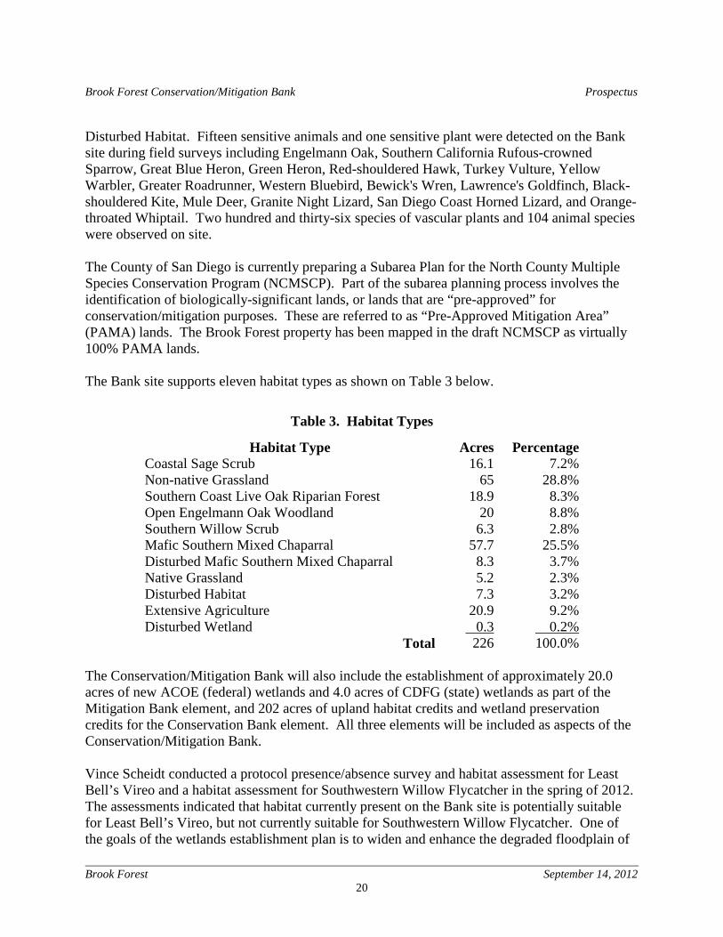
Disturbed Habitat. Fifteen sensitive animals and one sensitive plant were detected on the Bank site during field surveys including Engelmann Oak, Southern California Rufous-crowned Sparrow, Great Blue Heron, Green Heron, Red-shouldered Hawk, Turkey Vulture, Yellow Warbler, Greater Roadrunner, Western Bluebird, Bewick's Wren, Lawrence's Goldfinch, Black-shouldered Kite, Mule Deer, Granite Night Lizard, San Diego Coast Horned Lizard, and Orange-throated Whiptail. Two hundred and thirty-six species of vascular plants and 104 animal species were observed on site. The County of San Diego is currently preparing a Subarea Plan for the North County Multiple Species Conservation Program (NCMSCP). Part of the subarea planning process involves the identification of biologically-significant lands, or lands that are “pre-approved” for conservation/mitigation purposes. These are referred to as “Pre-Approved Mitigation Area” (PAMA) lands. The Brook Forest property has been mapped in the draft NCMSCP as virtually 100% PAMA lands. The Bank site supports eleven habitat types as shown on Table 3 below.
Table 3. Habitat Types
Habitat Type Acres Percentage Coastal Sage Scrub 16.1 7.2% Non-native Grassland 65 28.8% Southern Coast Live Oak Riparian Forest 18.9 8.3% Open Engelmann Oak Woodland 20 8.8% Southern Willow Scrub 6.3 2.8% Mafic Southern Mixed Chaparral 57.7 25.5% Disturbed Mafic Southern Mixed Chaparral 8.3 3.7% Native Grassland 5.2 2.3% Disturbed Habitat 7.3 3.2% Extensive Agriculture 20.9 9.2% Disturbed Wetland 0.3 0.2%
Total 226 100.0% The Conservation/Mitigation Bank will also include the establishment of approximately 20.0 acres of new ACOE (federal) wetlands and 4.0 acres of CDFG (state) wetlands as part of the Mitigation Bank element, and 202 acres of upland habitat credits and wetland preservation credits for the Conservation Bank element. All three elements will be included as aspects of the Conservation/Mitigation Bank. Vince Scheidt conducted a protocol presence/absence survey and habitat assessment for Least Bell’s Vireo and a habitat assessment for Southwestern Willow Flycatcher in the spring of 2012. The assessments indicated that habitat currently present on the Bank site is potentially suitable for Least Bell’s Vireo, but not currently suitable for Southwestern Willow Flycatcher. One of the goals of the wetlands establishment plan is to widen and enhance the degraded floodplain of
Brook Forest Conservation/Mitigation Bank Prospectus
Brook Forest September 14, 2012
21
Moosa Creek and in doing so, establish occupied habitat for Least Bell’s Vireo and possibly Southwestern Willow Flycatcher in the future. Vince Scheidt has commenced presence/absence surveys for the California Gnatcatcher. However, these focus surveys will not be completed until October 2012. The results of these focus surveys for the California Gnatcatcher will be submitted as part of the BEI.
3.12 CULTURAL RESOURCES An archaeological survey and evaluation of cultural resources on the Bank site was initially completed by an approved County consultant for archaeological and cultural resources in 2000 and revised in September 2004. No Native American cultural resources were identified on the site. Two small areas of archaeological significance were identified on the property. The two sites, SDI-15499 and SDI-15500H, were determined as prehistoric and historic respectively. The resources varied from rock enclosures to scattered historic artifacts. SDI-15499 is located on the southwest corner of the Bank site near Frace Lane. Artifacts recovered form this site suggest an Archaic cultural group that existed during prehistoric times. Artifacts recovered from the site include lithic production waste, milling tools, scrapers, bifaces, hammerstones, retouched and utilized flakes, bone, and marine shell. This prehistoric site is about 8,400 square meters in size and is all located within the southwest portion of the site. SDI-15500H consists of scattered historic refuse and a stacked rock wall in a .52 acre area located south of the floodway and floodplain of Moosa Creek in the north central portion of the site. Archaeological resources identified at this site consisted of artifacts and a rock wall that appeared to be associated with a previous homestead on the site in the late 1880s and 1930s. Artifacts recovered form this site included undifferentiated glass fragments, brick fragments, window glass fragments, metal fragments such as square and round nails, household and kitchen items, and a large mammal bone. The general period for the building materials appears to be in the 1880s, while the household items were predominantly from the 1930s. Both of the historic sites will be preserved as part of the open space conservation easement that will be placed on the site. Neither of these historic sites is located in the area where wetlands establishment is proposed or within the disturbed area that will be used for placement of the excavated soils from the wetlands establishment area. Accordingly, activities associated with creation of the Bank will not impact these resources and their preservation in the open space easement will not impact them.
3.13 PHASE I ENVIRONMENTAL SITE ASSESSMENT Two Phase I Environmental Site Assessments were completed for the Bank site in August 2003 and December 14, 2011. The subject property was not found on any Standard Environmental
Brook Forest Conservation/Mitigation Bank Prospectus
Brook Forest September 14, 2012
22
Record as containing any hazardous or toxic waste. A review of historical information did not indicate that the property had been used in the past in a way that would represent a potential environmental threat or impact to the site. No high voltage electrical transformers were found on the property. A review of a statewide radon study did not indicate the site was within an area where radon is likely to be found in concentrations above the U.S. Environmental Protection Agency action limit of 4.0 picocuries per liter. The two assessments did not identify any evidence of any recognized environmental conditions or other potential environmental concerns in connection with the site. Based on the results of both investigations, no further environmental assessment of the property was recommended. The Phase I Environmental Site Assessments will be submitted as part of the BEI.
Brook Forest Conservation/Mitigation Bank Prospectus
Brook Forest September 14, 2012
23
Section 4 Development Plan 4.1 PROJECT GOALS The proposed project is the establishment of approximately 20.0 acres of high value ACOE wetlands and 4.0 acres of CDFG wetlands currently degraded by historic agricultural operations within the floodplain of Moosa Creek and the preservation of 202 acres of sensitive and protected uplands habitat and species. The newly-established habitat would provide regional compensation for impacts to wetlands and the establishment of an upland habitat bank as compensation for impacts to upland resources caused by public and private projects. Approval of the project would result in the following activities:
1. Restoring self-sustaining fluvial processes on site. 2. Improving and greatly expanding the existing riparian habitat and restoring the historic
riparian floodway thereby improving habitat values. Restoration of the historic floodway will provide habitat for state and federally listed species including the Least Bell’s Vireo, and possibly other special status species, such as the Southwestern Willow Flycatcher.
3. Improving the channel design to accommodate current and future flood flows.
4. The preservation of sensitive and protected habitats and species within both the wetlands and the uplands area of the Bank.
5. Permanent protection of the project site through recordation of a conservation easement on the property.
6. Permanent management and monitoring of the site funded by a non-wasting endowment fund.
4.2 CONCEPTUAL RESTORATION AND WETLAND
ESTABLISHMENT DESIGN Moosa Creek through the project site is degraded as a result of agricultural activities dating back to at least the Second World War. Portions of the floodplain on site have been filled due to prior agricultural grading operations. As recently as 1996, the floodway itself was entirely devoid of tree and shrub layer riparian elements. In contrast, both immediately upstream and some distance downstream from the project site, Moosa Creek is characterized as a broad floodplain with a braided drainage pattern and well-established trees including phreatophytes such as California Sycamore (Platanus racemosa).
Brook Forest Conservation/Mitigation Bank Prospectus
Brook Forest September 14, 2012
24
From a biological perspective, the Bank currently supports a combination of dry farmed lands on about 21 acres of the site and vacant, mostly natural land on the balance of the 226 acre property. Dry farming has occurred historically for a number of years in the area where the wetlands will be established. The channelized portion of Moosa Creek through the project site supports Southern Willow Scrub habitat and is dominated by Arroyo Willow, Black Willow, and various other riparian species. The wetlands creation plan proposes the rehabilitation of the historic Moosa Creek floodway through the project site and the re-establishment of the braided floodway via the removal of accumulated dirt in the floodplain areas of Moosa Creek. The revegetation and preservation on the site will result in a greatly broadened riparian corridor and significantly improved wildlife habitat. The 24-acre wetlands establishment area will be created on site by lowering the ground level within the Moosa Creek floodplain approximately 1 to 3 feet with the grade at the upstream and downstream limits to taper back to existing grade. Approximately 100,000 cubic yards of soil will be excavated from the Moosa Creek floodplain adjacent to the streambed to achieve the wetlands establishment area. Excavated soils will be loaded and transported to the existing disturbed areas on the Bank site. These disturbed areas consist of about 7.5 acres. The grading will be designed to have the upstream and downstream 100-year floodplains remain unchanged through the design of a combination of excavation and planting and a detailed HEC-RAS analysis. The conceptual grading and wetlands establishment plan are shown on Figure 3. A cross section of the grading and wetlands establishment area is shown on Figure 10 of the Initial Hydrologic Assessment (Attachment A). Additional information, including feedback from the resource agencies, is required to complete the conceptual design. The following information is considered preliminary.
4.2.1 Riparian Corridor Restoration Activities The proposed Bank design will take Moosa Creek which has been channelized and disconnected from its historic floodplain and restore it to wider, shallower, sinuous and braided form that is more connected to its floodplain origins. Restoration of Moosa Creek as proposed will improve various wetlands functions and values to:
• Create initial hydrologic conditions to support re-establishment of the riparian corridor and expansion of the riparian habitat
• Improve water quality through the removal of sediments in the floodplain and decreased
erosion through the establishment of high-value riparian vegetation
Brook Forest Conservation/Mitigation Bank Prospectus
Brook Forest September 14, 2012
25
• Improve habitats including foraging, roosting, nesting, for birds, mammals, amphibians, reptiles
• Increase the quality and diversity of aquatic and riverine habitat and general habitat
suitability by providing the hydrology and improving the native plant richness and wildlife habitat
• Expand and improve the wildlife corridor connectivity between sites upstream and
downstream of the Bank site through the creation of a broad and unbroken vegetation corridor across the property
• Improve habitats for special-status species including Least Bell’s Vireo and others
The proposed restoration activities will substantially increase wetland functions and values and provide for a greater number of ecological services including improved water quality, decreased sedimentation and erosion, and improved biological diversity and aesthetics.
4.2.2 Earthmoving and Planting Wetland construction activities will be conducted using equipment which may include scrapers, bulldozers, skiploaders, backhoes, and water trucks. Approximately 20.0 acres of ACOE wetlands and 4.0 acres of CDFG wetlands will be established within the floodplain of Moosa Creek through the Bank site by lowering the ground level through the Moosa Creek floodplain area an average of 1 to 3 feet. It is estimated that approximately 100,000 cubic yards of soil will be excavated from the Moosa Creek floodplain area adjacent to the streambed to establish the new wetlands. The excavated soils will be loaded and transported to the area of Disturbed Habitat on the Bank site. All areas receiving this soil will be revegetated to non-native grassland to improve the functioning of the upland component of the bank. No import or export of dirt from the property will be necessary to establish the 20.0 acres of ACOE wetlands and 4.0 acres of CDFG wetlands. The existing disturbed area on site provides a sufficient area to accommodate the 100,000 cubic yards. The grading and wetlands establishment plan is shown on Figure 3. A conceptual planting plan will be included in the BEI. The site may be planted with a combination of cuttings, nursery grown plants and seed. Irrigation of the wetland establishment area will be required during the plant establishment period. The following plant species are being evaluated for use during site revegetation:
• Arroyo Willow • Black Willow • Sandbar Willow
Brook Forest Conservation/Mitigation Bank Prospectus
Brook Forest September 14, 2012
26
• Western Cottonwood • California Sycamore • California Rose • California Blackberry • others as appropriate
4.3 SUCCESS CRITERIA AND MONTORING Performance standards or success criteria will be used as indicators of progress towards the achievement of habitat establishment goals. The performance standards will be assessed via various monitoring methods and are summarized below. Detailed success criteria will be included in the mitigation plan submitted with the BEI.
4.3.1 Performance Standards 4.3.1.1 Wetland Performance Standards Establish approximately 20.0 acres of ACOE wetlands and 4.0 acres of CDFG wetlands. This will support Southern Cottonwood-Willow Riparian Forest upon completion of the project.
• Year 2 Performance Standards
o Riparian areas must remain saturated within the primary root zone for a duration of time sufficient to maintain wetland hydrology (i.e. 14 or more consecutive days) or show reliable Group A or B primary wetland hydrology indicators as described in the Regional Supplement to the Corps of Engineers Wetland Delineation Manual: Arid West Region (ERDC/EL TR-08-28).
o At least 80% survival of riparian woody plantings or 50% absolute cover with
natives. o Absolute cover of invasive exotics (rated as high on the Cal-IPC list) shall be
maintained at 0%.
• Year 3 Performance Standards
o A new wetland delineation shall be conducted and document a minimum of 20.0 acres of ACOE wetlands on the site.
o Riparian Areas must remain saturated within the primary root zone one for a duration
of time sufficient to maintain wetland hydrology (i.e. 14 or more consecutive days) or
Brook Forest Conservation/Mitigation Bank Prospectus
Brook Forest September 14, 2012
27
show reliable Group A or B primary wetland hydrology indicators as described in the Regional Supplement to the Corps of Engineers Wetland Delineation Manual: Arid West Region (ERDC/EL TR-08-28).
o At least 60% survival of riparian plantings or 70% absolute cover with natives. o Absolute cover of invasive exotics (rated as high on the Cal-IPC list) shall be
maintained at 0%.
• Year 4 Performance Standards
o Riparian Areas must remain saturated within the primary root zone one for a duration of time sufficient to maintain wetland hydrology (i.e. 14 or more consecutive days) or show reliable Group A or B primary wetland hydrology indicators as described in the Regional Supplement to the Corps of Engineers Wetland Delineation Manual: Arid West Region (ERDC/EL TR-08-28).
o Site exhibits continued survival of planted riparian species and survival of naturally
recruited vegetation following removal of irrigation the previous fall. o Tree/shrub canopy cover will show a minimum 10% increase from the maximum
absolute cover recorded in the prior year. o Absolute cover of invasive exotics (rated as high on the Cal-IPC list) shall be
maintained at 0%.
• Year 5 Performance Standards
o A new wetland delineation shall be conducted and document a minimum of 20.0 acres of ACOE wetlands and 4.0 acres of CDFG wetlands on the site.
o Riparian Areas must remain saturated within the primary root zone one for a duration
of time sufficient to maintain wetland hydrology (i.e. 14 or more consecutive days) or show reliable Group A or B primary wetland hydrology indicators as described in the Regional Supplement to the Corps of Engineers Wetland Delineation Manual: Arid West Region (ERDC/EL TR-08-28).
o Site exhibits continued survival of planted riparian species and survival of naturally
recruited vegetation. o Site exhibits evidence of natural recruitment of common wetland plant species and
native riparian trees or shrubs.
Brook Forest Conservation/Mitigation Bank Prospectus
Brook Forest September 14, 2012
28
o Absolute cover of invasive exotics (rated as high on the Cal-IPC list) shall be maintained at 0%.
4.3.1.2 Upland Habitat Performance Standards Performance standards for the upland habitat on the project site will be determined as part of the Interim Management Security Analysis and Schedule and the Habitat Management Plan which will be included as part of the BEI. It is expected that the Interim Management activities will include the following: (1) Complete stabilization and revegetation of all disturbed areas that were recipients of soil materials removed from the historic floodplain. (2) An inspection of the site in conjunction with the approved Habitat Operator to review the condition of the property and to compare it to the description provided in the Habitat Management Plan (HMP); (3) Clearing the site of exotic invasive species, trash, and debris; (4) The construction of fencing, gates, and locks for the Bank site as specified in the BEI; and (4) The retention of a Habitat Operator to verify the accuracy of the previously conducted baseline survey of habitat and wildlife species and documentation of the status of exotic species (plants and animals) observed during the first year of management. This baseline documentation will be used to provide annual biological updates as well as 5-year biological progress reports. These Interim Management requirements may be modified by the IRT Team as part of their evaluation of the BEI. As part of the BEI, a Habitat Management Plan (HMP) will be submitted for approval by the IRT Team. The goal of this HMP will be to develop a process for maintaining in perpetuity the natural habitat existing on the Bank site. Among other things, it is anticipated that this HMP will require the following tasks: (1) the removal of exotic species on the Bank site; (2) working in conjunction with the Fire Marshal on issues such as brush management, emergency vehicle access, and related safety considerations; (3) exotic animal control; (4) the control of exotic and invasive plants; (5) the removal of any illegally dumped materials and cleaning up any litter; (6) removal of hazardous materials per County-approved procedures; (7) the removal of improper illegal encroachments; (8) maintenance of all Bank fencing, signage, gates, and locks; (9) the long-term biological monitoring of the Bank site which will analyze vegetative growth patterns, changes in floristic composition or diversity, and other factors related to habitat viability; (10) periodic surveys of on-site habitat; (11) the submission of an annual report summarizing the status of the Bank, the results of the periodic surveys, and all actions taken since the most recent surveys and evaluations; (12) the updating of a vegetation map showing current conditions for all lands within the Bank; (13) MSCP Covered Species monitoring including regular surveys; (14) controlling access and implementing a proactive monitoring program. The specific details of this HMP will be determined following submission and review of the HMP by the IRT Team.
Brook Forest Conservation/Mitigation Bank Prospectus
Brook Forest September 14, 2012
29
4.3.2 Monitoring Vegetation, both wetland and upland, will be monitored with monitoring taking place throughout the year. “Year 1” will be considered to be the end of the first year following the planting of the site with wetlands plants. Hydrology will be monitored in the newly established wetland areas and hydrology monitoring will coincide with the start of the growing season. “Year 1” will be considered to be the first spring following establishment of the wetlands on-site. 4.3.2.1 Wetland Vegetation Monitoring A biological monitoring program will be implemented to document the growth and development of the plants in the wetland revegetation area. The monitoring program will address the progress of the revegetation effort through a five-year study and analysis of vegetative growth patterns and changes in floristic composition. Both qualitative and quantitative documentation are required. The program will determine the need for remedial activities throughout the duration of the monitoring effort. Color photographs of the site showing the overall area, as well as representative specimens of each species planted, will be assembled to document the success of the revegetation plan. Permanent photo documentation points will be established by the end of the first year of biological monitoring, and photos will be taken from these points at each subsequent site monitoring visit.
Wetland monitoring will begin shortly before the first day of planting with an inspection of the revegetation area and the container stock. It will terminate at the end of a five year period. This five year period will begin at the successful completion of all initial revegetation activities, as specified in the BEI. If success criteria has not been achieved by the end of the five year maintenance and monitoring period it may be necessary to extend this period.
Letter-format reports summarizing the monitoring program and the vegetation establishment rate will be submitted as specified in the BEI as follows:
Year 1: Year-End Report
Year 2: Annual
Year 3: Annual
Year 4: Annual
Year 5: Annual
Each report shall include a qualitative and quantitative analysis of the wetlands establishment area. Monitoring and maintenance field data shall be included as an addendum to each report.
Brook Forest Conservation/Mitigation Bank Prospectus
Brook Forest September 14, 2012
30
Site photographs shall be provided as part of the monitoring reporting effort. The data that are compiled will clearly depict the height and cover of the native vegetation.
Reports shall be submitted as specified in the BEI no later than March 1st. Any significant issue or contingency that arises on the job site (e.g. plant survival issues, fire, or flooding) shall be reported in writing as specified in the BEI within two weeks from the date of the incident. Accompanying the report shall be a plan for remediation, with an implementation schedule and a monitoring schedule. 4.3.2.2 Upland Vegetation Monitoring A biological monitoring program will be implemented to document the growth and development of the plants in the upland habitat areas. The monitoring program will address the progress of the preserved upland habitat through a five-year study and analysis of vegetative growth patterns and changes in floristic composition. Both qualitative and quantitative documentation are required. The program will determine the need for remedial activities throughout the duration of the monitoring effort. Color photographs of the site showing the overall area, as well as representative specimens of each species planted (if any), will be assembled to document the success of the revegetation plan. Permanent photo documentation points will be established by the end of the first year of biological monitoring, and photos will be taken from these points at each subsequent site monitoring visit.
Upland vegetation monitoring will begin shortly before the first day of any planting with an inspection of any revegetation area and the hydroseed mix stock. It will terminate at the end of a five year period. This five year period will begin at the successful completion of all initial revegetation activities (if any), as specified in the BEI. If success criteria has not been achieved by the end of the five year maintenance and monitoring period it may be necessary to extend this period.
Letter-format reports summarizing the monitoring program and the vegetation establishment rate will be submitted as specified in the BEI as follows:
Year 1: Year-End Report
Year 2: Annual
Year 3: Annual
Year 4: Annual
Year 5: Annual
Each report shall include a qualitative and quantitative analysis of the preserved upland habitat areas. Monitoring and maintenance field data shall be included as an addendum to each report. Site photographs shall be provided as part of the monitoring reporting effort. The data that are compiled will clearly depict the height and cover of the native vegetation.
Brook Forest Conservation/Mitigation Bank Prospectus
Brook Forest September 14, 2012
31
Reports shall be submitted as specified in the BEI no later than March 1st. Any significant issue or contingency that arises on the job site (e.g. plant survival issues, fire, or flooding) shall be reported in writing as specified in the BEI within two weeks from the date of the incident. Accompanying the report shall be a plan for remediation, with an implementation schedule and a monitoring schedule. 4.3.2.3 Hydrology Monitoring Hydrology will be monitored by a variety of methods that may include shallow groundwater wells, test pits and staff gauges.
• Year 2 Monitoring Tasks
o Assess Hydrology.
• Year 3 Monitoring Tasks
o Assess Hydrology.
o Conduct a wetland delineation.
• Year 4 Monitoring Tasks
o Assess Hydrology. • Year 5 Monitoring Tasks
o Assess Hydrology.
o Conduct a wetland delineation.
Brook Forest Conservation/Mitigation Bank Prospectus
Brook Forest September 14, 2012
32
Section 5 Service Area The service area is the watershed, ecoregion, physiographic province, and/or other geographic area within which the Bank is authorized to provide compensatory mitigation. The service area should be appropriately sized to ensure that the aquatic resources provided will effectively compensate for adverse environmental impacts across the entire service area. The 2008 federal mitigation rule requires the Corps to take a watershed approach to compensatory mitigation. The primary factor the Corps uses in determining service areas is the needs of the surrounding watersheds. Other factors to be considered include the ecoregion and the economic viability of the bank. Mitigation banks typically involve larger and more ecologically valued parcels than permittee-responsible mitigation. Development of a mitigation bank requires a significant investment of financial resources in identifying and evaluating potential mitigation sites and conducting the rigorous analysis required to determine if the mitigation bank is financially feasible.
5.1 DESCRIPTION OF THE SERVICE AREA The Bank site is located within the Laguna-San Diego Coastal drainage unit that discharges into the Pacific Ocean from and including the Moro Canyon drainage basin in the north near Laguna Beach to the California-Baja California international boundary in the south. This drainage unit covers approximately 3,879 square miles and includes the following 8-digit hydrologic unit codes (HUCs):
• 18070301 San Juan Area = 496 square miles • 18070302 Santa Margarita Area = 750 square miles • 18070303 San Luis Rey-Escondido Area = 766 square miles • 18070304 San Diego Area = 1,390 square miles • 18070305 Cottonwood-Tijuana Area = 477 square miles
All of the watersheds within the proposed service area are located either within the San Diego Planning Area of the South Coast Hydrologic Region or in watersheds that drain into San Diego County as defined by the California Department of Water Resources. Topographically, most of the South Coast Region is composed of several large, undulating coastal and interior plains. Most of the rivers drain into the Pacific Ocean and many terminate in lagoons or wetlands areas that provide critical coastal habitat. The headwaters for many of the rivers are found in the relatively undeveloped coastal mountain ranges.
Brook Forest Conservation/Mitigation Bank Prospectus
Brook Forest September 14, 2012
33
The watersheds of the San Diego Planning Area are generally smaller than other watersheds in the South Coast Hydrologic Region. All of these watersheds generally flow east to west. The San Juan Watershed covers 496 square miles in San Diego, Orange and Riverside counties. Approximately 150 square miles (30%) of this area is located in northwest San Diego County almost entirely within the Camp Pendleton Marine Corps Base. (http://www.projectcleanwater.org/html/ws_san_juan.html). Drainage is provided by San Juan Creek and its tributaries which include Trabuco and Oso Creeks. Urbanization of the watershed is more extensive on the lower end of the watershed. (California Department of Water Resources 2009.) Issues of concern in the watershed include surface and groundwater quality degradation, habitat loss, channel bed erosion and invasive species. (http://www.projectcleanwater.org/html/ws_san_juan.html).
The 750-square mile Santa Margarita Watershed encompasses approximately 750 square miles in northern San Diego and southwestern Riverside counties. Of the total watershed area, approximately 27% is within San Diego County. The Santa Margarita River is formed near the City of Temecula in Riverside County at the confluence of the Temecula and Murrieta Creek systems. Once formed, the majority of the Santa Margarita River main stem flows within San Diego County through unincorporated areas, the community of Fallbrook, and the Marine Corps Base Camp Pendleton. (http://www.projectcleanwater.org/html/ws_santa_margarita.html). The Santa Margarita Watershed historically encompasses a region that includes the incorporated cities of Temecula, Hemet, Murrieta, and Oceanside, the Fallbrook Naval Weapons Station, a portion of USMCB Camp Pendleton and a portion of the unincorporated County of Riverside, as well as the County of Sam Diego. The main stem of the Santa Margarita River flows into Temecula Gorge and crosses the San Diego County line just north of Fallbrook. It then flows through the coastal plain encompassing portions of the USMCB Camp Pendleton before discharging into the Pacific Ocean at the Santa Margarita Estuary. (County of San Diego, Final Santa Margarita River Watershed Management Plan (2005) p. 10). Issues of concern in the watershed include surface and groundwater quality degradation, habitat loss, invasive species and channel bed erosion. (http://www.projectcleanwater.org/html/ws_santa_margarita.html). The 562-square mile San Luis Rey Watershed is located along the northern border of San Diego County. It is bordered to the north by the Santa Margarita River Watershed and to the south by the Carlsbad and the San Dieguito River Watersheds. The San Luis Rey River originates in the Palomar and Hot Springs Mountains and extends west over 55 miles to form a watershed with an area of approximately 360,000 acres or 562 square miles. The river ultimately discharges to the Pacific Ocean at the western boundary of the City of Oceanside. Of the nine major watersheds in the San Diego region, the San Luis Rey River Watershed is the third largest in terms of land area. (California Regional Water Quality Control Board, San Luis Rey River Watershed Annual Report January 2012 p. 1-4). The San Luis Rey River Watershed or SLR Hydrologic Unit (HU) (903.00) is comprised of three HAs, which have been delineated by the San Diego Regional Water Quality Control Board (RWQCB) based on drainage patterns: Lower San Luis (HA903.1), Monserate (HA903.2), and Warner Valley (HA903.3). Over 54% of the land in the watershed is vacant or undeveloped. The
Brook Forest Conservation/Mitigation Bank Prospectus
Brook Forest September 14, 2012
34
next largest land uses in the watershed are residential (15%) and agriculture (14%). The highest concentration of population is located in the Lower San Luis HA. There are six federally recognized Tribal Indian Reservations with land in the watershed. (Id. p. 1-4). About 49% of the land in the watershed is privately owned. Issues of concern in the watershed include surface water quality degradation, habitat loss, invasive species and channel bed erosion (http://projectcleanwater.org/html/ws_san_luis_rey.html). Agricultural and livestock operations, urban runoff, and sand mining operations are among the factors in local surface water quality issues. (California Department of Water Resources 2009.) The proposed service area for the Bank is located in the San Juan and Santa Margarita Watershed areas that drain into San Diego County and the San Luis Rey Watershed in Northern San Diego County Area and consists of portions of three 8-digit HUCs:
• 18070301 San Juan 1807030104 San Onofre Creek-Frontal Gulf of Santa Catalina
• 18070302 Santa Margarita River 1807030203 Lower Temecula Creek 1807030205 Santa Margarita River
• 18070303 Escondido Creek-San Luis Rey River
1807030301 Upper San Luis Rey River 1807030302 Middle San Luis Rey River 1807030303 Lower San Luis Rey River 1807030304 Escondido Creek 1807030305 San Marcos Creek-Frontal Gulf of Santa Catalina
These 8-digit HUCs share a similar climate, soils types, vegetation and wildlife, special status species and critical habitat and common watershed concerns related to surface water quality degradation, habitat loss, invasive species and channel bed erosion. Flooding in the region is predominately from winter storms that can produce large amounts of water in the steep upper watersheds resulting in sudden and severe flooding in the lowland areas.
5.2 JUSTIFICATION OF THE SERVICE AREA The proposed service area for the Bank includes the San Onofre Creek-Frontal Gulf of Santa Catalina, the Lower Temecula Creek and Santa Margarita River, segments of the Santa Margarita Watershed and the San Luis Rey Watershed that includes the Bank site. All of these watersheds are hydrologically connected and all of them either drain into portions of San Diego County or are located in San Diego County. The justification for the service areas is as follows:
• The portion of the Aliso Creek-San Onofre Watershed within the Bank’s service area drains into Camp Pendleton and is principally located within Camp Pendleton.
Brook Forest Conservation/Mitigation Bank Prospectus
Brook Forest September 14, 2012
35
• Approximately 27% of the Santa Margarita Watershed is within San Diego County and the portion of the Santa Margarita Watershed within the proposed Bank service area drains into San Diego County including portions of Camp Pendleton before discharging into the Pacific Ocean at the Santa Margarita Estuary.
• The Bank site is included within the 562 square mile San Luis Rey Watershed and the
San Luis Rey River ultimately discharges to the Pacific Ocean at the western boundary of the City of Oceanside.
• All of the watersheds included in the Bank are located within the same ecoregion as the
proposed Bank and have a similar climate, soils, watershed characteristics, and biology and similar issues of concern related to surface and groundwater quality degradation, habitat loss, channel bed erosion and invasive species.
• The service area includes the population centers in Northern San Diego County and
Riverside County which have been identified as major growth areas over the next 10 to 15 years after the economy recovers.
• The size of the Bank, approximately 226 acres, is relatively large and needs to be supported by a service area with a broad economic base.
• All of the watersheds proposed for inclusion in the Bank service area are hydrologically connected and drain into San Diego County.
• The Bank’s service area needs to be sufficiently broadbased that it is not conflict with the San Luis Rey Mitigation Bank being proposed near Oceanside.
• There is not a lot of land available within the San Luis Rey Watershed that can be restored. Caltrans has purchased numerous small and large parcels to develop the mitigation required for its large infrastructure projects.
• Restoration of the site has required a substantial investment of time and resources to research title issues, conduct site-specific analyses of groundwater, hydrology, geology, biology surveys, possible hazardous concerns, and planning. Fees and costs to entitle the Bank will require a substantial additional commitment of financial resources to prepare the Bank documents, construction drawings, permit applications and environmental compliance prior to construction.
• Construction for the Bank will be expensive due to the need to move approximately 100,000 cubic yards of soil and to relocate it on site to establish the ACOE and State wetlands.

Brook Forest Conservation/Mitigation Bank Prospectus
Brook Forest September 14, 2012
36
• The 226 acre Bank site offers a unique opportunity to preserve 202 acres of sensitive
habitat and to establish 20.0 acres of ACOE wetlands and 4.0 acres of CDFG wetlands not currently available in this area of the San Luis Rey River Watershed.
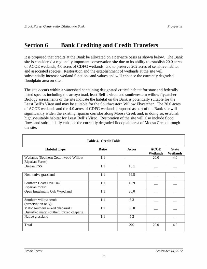
Brook Forest Conservation/Mitigation Bank Prospectus
Brook Forest September 14, 2012
37
Section 6 Bank Crediting and Credit Transfers It is proposed that credits at the Bank be allocated on a per-acre basis as shown below. The Bank site is considered a regionally important conservation site due to its ability to establish 20.0 acres of ACOE wetlands, 4.0 acres of CDFG wetlands, and to preserve 202 acres of sensitive habitat and associated species. Restoration and the establishment of wetlands at the site will substantially increase wetland functions and values and will enhance the currently degraded floodplain area on site. The site occurs within a watershed containing designated critical habitat for state and federally listed species including the arroyo toad, least Bell’s vireo and southwestern willow flycatcher. Biology assessments of the site indicate the habitat on the Bank is potentially suitable for the Least Bell’s Vireo and may be suitable for the Southwestern Willow Flycatcher. The 20.0 acres of ACOE wetlands and the 4.0 acres of CDFG wetlands proposed as part of the Bank site will significantly widen the existing riparian corridor along Moosa Creek and, in doing so, establish highly-suitable habitat for Least Bell’s Vireo. Restoration of the site will also include flood flows and substantially enhance the currently degraded floodplain area of Moosa Creek through the site.
Table 4. Credit Table
Habitat Type Ratio Acres ACOE
Wetlands State
Wetlands Wetlands (Southern Cottonwood-Willow Riparian Forest)
1:1 _______ 20.0 4.0
Diegan CSS
1:1 16.1 __ __
Non-native grassland
1:1 69.5 __ __
Southern Coast Live Oak Riparian forest
1:1 18.9 __ __
Open Engelmann Oak Woodland
1:1 20.0 __ __
Southern willow scrub (preservation only)
1:1 6.3 __ __
Mafic southern mixed chaparral + Disturbed mafic southern mixed chaparral
1:1 66.0 __ __
Native grassland
1:1 5.2 __ __
Total
202 20.0 4.0
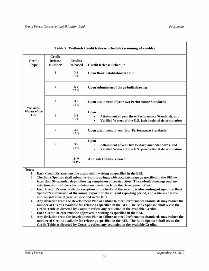
Brook Forest Conservation/Mitigation Bank Prospectus
Brook Forest September 14, 2012
38
Table 5. Wetlands Credit Release Schedule (assuming 24 credits)
Credit Type
Credit Release Number
Credits
Released
Credit Release Schedule
1
3.6
15%
Upon Bank Establishment Date
2
6.0
25%
Upon submission of the as-built drawing
3
3.6
15%
Upon attainment of year two Performance Standards
4
3.6
15%
Upon • Attainment of year three Performance Standards, and • Verified Waters of the U.S. jurisdictional determination
5
3.6
15%
Upon attainment of year four Performance Standards
6
3.6
15%
Upon • Attainment of year five Performance Standards, and • Verified Waters of the U.S. jurisdictional determination
Wetlands/ Waters of the
U.S.
24.0
100%
All Bank Credits released
Notes: 1. Each Credit Release must be approved in writing as specified in the BEI. 2. The Bank Sponsor shall submit as-built drawings, with accurate maps as specified in the BEI no
later than 90 calendar days following completion of construction. The as-built drawings and any attachments must describe in detail any deviation from the Development Plan.
3. Each Credit Release, with the exception of the first and the second, is also contingent upon the Bank Sponsor’s submission of the annual report for the current reporting period, and a site visit at the appropriate time of year, as specified in the BEI.
4. Any deviation from the Development Plan or failure to meet Performance Standards may reduce the number of Credits available for release as specified in the BEI. The Bank Sponsor shall revise the Credit Table as directed by Corps to reflect any reduction in the available Credits.
5. Each Credit Release must be approved in writing as specified in the BEI. 6. Any deviation from the Development Plan or failure to meet Performance Standards may reduce the
number of Credits available for release as specified in the BEI. The Bank Sponsor shall revise the Credit Table as directed by Corps to reflect any reduction in the available Credits.
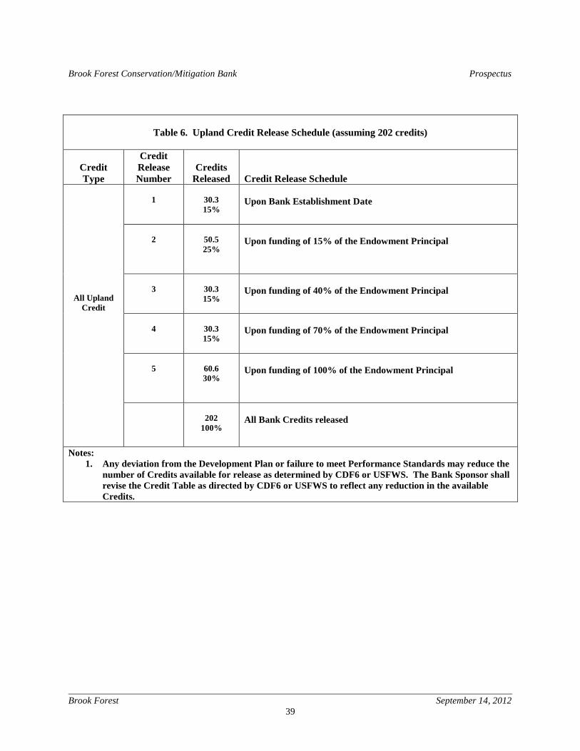
Brook Forest Conservation/Mitigation Bank Prospectus
Brook Forest September 14, 2012
39
Table 6. Upland Credit Release Schedule (assuming 202 credits)
Credit Type
Credit Release Number
Credits
Released
Credit Release Schedule
1
30.3 15%
Upon Bank Establishment Date
2
50.5 25%
Upon funding of 15% of the Endowment Principal
3
30.3 15%
Upon funding of 40% of the Endowment Principal
4
30.3 15%
Upon funding of 70% of the Endowment Principal
5
60.6 30%
Upon funding of 100% of the Endowment Principal
All Upland Credit
202
100%
All Bank Credits released
Notes: 1. Any deviation from the Development Plan or failure to meet Performance Standards may reduce the
number of Credits available for release as determined by CDF6 or USFWS. The Bank Sponsor shall revise the Credit Table as directed by CDF6 or USFWS to reflect any reduction in the available Credits.
Brook Forest Conservation/Mitigation Bank Prospectus
Brook Forest September 14, 2012
40
Section 7 References County of San Diego. Conservation Element County General Plan 2020 (2012). California Regional Water Quality Control Board. San Luis Rey River Watershed Urban Runoff Report 2010-2011. California Department of Fish and Game. San Luis Rey River Basin Assessment 2010. California Department of Fish and Game. 2009 Coastal Watershed Planning and Assessment Program. San Luis Rey River Assessment Report. California Department of Water Resources. 2009 California Water Plan Update 2009, Volume 3, Regional Reports, Chapter 5 South Coast Hydrologic Region. County of San Diego. Final Santa Margarita River Watershed Management Plan (2005). California Regional Water Quality Control Board. San Luis Rey River Watershed Annual Report January 2012. Scheidt, V. N. 2012. A Biological Resources Survey Report for the Brook Forest Conservation / Mitigation Bank Project, County Of San Diego. 37p. Scheidt, V. N. 2012. A Jurisdictional Wetland Delineation Report for the Brook Forest Conservation / Mitigation Bank, Valley Center, California. 64p. Wunderlin Engineering. August 2012 Initial Hydrologic Assessment of the Brook Forest Conservation Bank.

Brook Forest Conservation/Mitigation Bank Prospectus
Brook Forest September 14, 2012
41
C:\H\CLIENTS\Emerald\ProspectusV6.docx