Embed Size (px)
Citation preview
Brentwood - Pacific Palisades Report
Historic Districts, Planning Districts and Multi-Property Resources – 11/26/13
Page 1 of 118
Districts
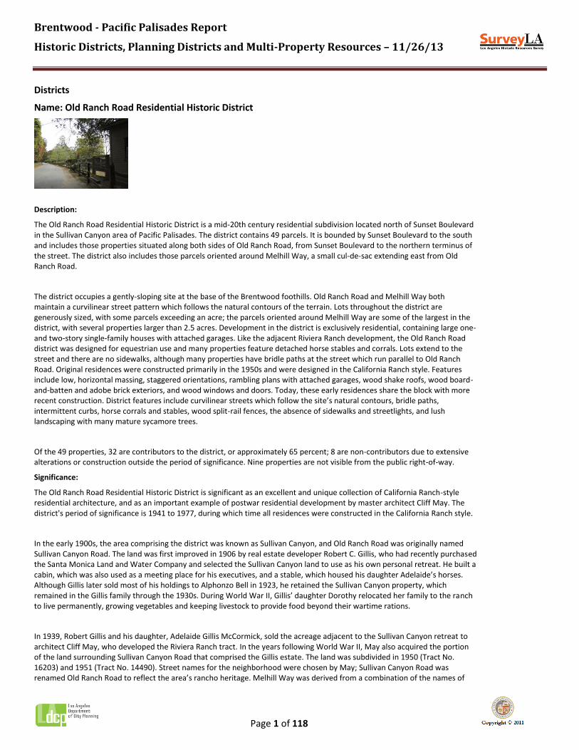
Name: Old Ranch Road Residential Historic District
Description:
The Old Ranch Road Residential Historic District is a mid-20th century residential subdivision located north of Sunset Boulevard in the Sullivan Canyon area of Pacific Palisades. The district contains 49 parcels. It is bounded by Sunset Boulevard to the south and includes those properties situated along both sides of Old Ranch Road, from Sunset Boulevard to the northern terminus of the street. The district also includes those parcels oriented around Melhill Way, a small cul-de-sac extending east from Old Ranch Road.
The district occupies a gently-sloping site at the base of the Brentwood foothills. Old Ranch Road and Melhill Way both maintain a curvilinear street pattern which follows the natural contours of the terrain. Lots throughout the district are generously sized, with some parcels exceeding an acre; the parcels oriented around Melhill Way are some of the largest in the district, with several properties larger than 2.5 acres. Development in the district is exclusively residential, containing large one- and two-story single-family houses with attached garages. Like the adjacent Riviera Ranch development, the Old Ranch Road district was designed for equestrian use and many properties feature detached horse stables and corrals. Lots extend to the street and there are no sidewalks, although many properties have bridle paths at the street which run parallel to Old Ranch Road. Original residences were constructed primarily in the 1950s and were designed in the California Ranch style. Features include low, horizontal massing, staggered orientations, rambling plans with attached garages, wood shake roofs, wood board-and-batten and adobe brick exteriors, and wood windows and doors. Today, these early residences share the block with more recent construction. District features include curvilinear streets which follow the site’s natural contours, bridle paths, intermittent curbs, horse corrals and stables, wood split-rail fences, the absence of sidewalks and streetlights, and lush landscaping with many mature sycamore trees.
Of the 49 properties, 32 are contributors to the district, or approximately 65 percent; 8 are non-contributors due to extensive alterations or construction outside the period of significance. Nine properties are not visible from the public right-of-way.
Significance:
The Old Ranch Road Residential Historic District is significant as an excellent and unique collection of California Ranch-style residential architecture, and as an important example of postwar residential development by master architect Cliff May. The district's period of significance is 1941 to 1977, during which time all residences were constructed in the California Ranch style.
In the early 1900s, the area comprising the district was known as Sullivan Canyon, and Old Ranch Road was originally named Sullivan Canyon Road. The land was first improved in 1906 by real estate developer Robert C. Gillis, who had recently purchased the Santa Monica Land and Water Company and selected the Sullivan Canyon land to use as his own personal retreat. He built a cabin, which was also used as a meeting place for his executives, and a stable, which housed his daughter Adelaide’s horses. Although Gillis later sold most of his holdings to Alphonzo Bell in 1923, he retained the Sullivan Canyon property, which remained in the Gillis family through the 1930s. During World War II, Gillis’ daughter Dorothy relocated her family to the ranch to live permanently, growing vegetables and keeping livestock to provide food beyond their wartime rations.
In 1939, Robert Gillis and his daughter, Adelaide Gillis McCormick, sold the acreage adjacent to the Sullivan Canyon retreat to architect Cliff May, who developed the Riviera Ranch tract. In the years following World War II, May also acquired the portion of the land surrounding Sullivan Canyon Road that comprised the Gillis estate. The land was subdivided in 1950 (Tract No. 16203) and 1951 (Tract No. 14490). Street names for the neighborhood were chosen by May; Sullivan Canyon Road was renamed Old Ranch Road to reflect the area’s rancho heritage. Melhill Way was derived from a combination of the names of
Brentwood - Pacific Palisades Report
Historic Districts, Planning Districts and Multi-Property Resources – 11/26/13
Page 2 of 118
May’s daughters, Melany and Hillary.
In keeping with Cliff May’s romanticized vision of the western lifestyle, the Old Ranch Road district was designed for equestrian, ranch-style living. May’s plan for the area called for expansive lots that followed the natural curve of the existing road and featured lush landscaping. Bridle paths were constructed along the winding streets and were defined by wooden split-rail fences. Each site also provided room for individual stables and corrals, which usually extended to the street.
Like the adjacent Riviera Ranch tract, development in Sullivan Canyon was initially restricted to California Ranch-style houses designed by May himself; many of the existing residences from the period appear to be designed by May or by other architects working in the same style. May reserved a 55-acre plot of land at the northern terminus of Old Ranch Road for his own personal use. In 1952, he began construction on “Mandalay,” his last and largest personal residence (also known as Cliff May House No. 5). The 7,000-square foot house was completed in 1956, although May would continue to make at least thirteen additions to the residence through 1978. Mandalay exemplified May’s philosophy of indoor-outdoor living, utilizing natural materials and architectural elements to achieve an earthy, rustic look. The property also included a large gate house at the entrance to the estate which featured horse stables and equipment rooms. Cliff May continued to reside at Mandalay until his death in 1989, utilizing the home not only as a personal residence but also as a showcase for prospective clients. Following the subsequent sale of the property by the May family, the main house was demolished in 1994 and a new residence was constructed on the estate. However, the Mandalay gate house remains and is highly intact.
Today, the Old Ranch Road Residential Historic District stands out from surrounding development as a unique concentration of California Ranch-style residential architecture, and as a cohesive postwar residential development designed by master architect Cliff May. Its equestrian use and shared planning features contribute to the district’s distinctively rustic feel and helps to convey a strong sense of time and place.

Brentwood - Pacific Palisades Report
Historic Districts, Planning Districts and Multi-Property Resources – 11/26/13
Page 3 of 118
Context 1:
Context: Architecture and Engineering, 1850-1980
Sub context: No Sub-context
Theme: Housing the Masses, 1880-1975
Sub theme: Ranch House Neighborhoods, 1938-1975
Property type: Post-War Suburb
Property sub type: Subdivision
Criteria: C/3/3
Status code: 3S;3CS;5S3
Reason: Significant as an excellent and unique collection of California Ranch-style residential architecture in Pacific Palisades.

Brentwood - Pacific Palisades Report
Historic Districts, Planning Districts and Multi-Property Resources – 11/26/13
Page 4 of 118
Context 2:
Context: Residential Development and Suburbanization, 1850-1980
Sub context: No Sub-context
Theme: Post-War Suburbanization, 1938-1975
Sub theme: Suburban Planning and Development, 1938-1975
Property type: Post-War Suburb
Property sub type: Subdivision(s)
Criteria: A/1/1
Status code: 3S;3CS;5S3
Reason: Significant as an important example of postwar residential development by master architect Cliff May.
Contributors/Non-Contributors:
Address: 1617 N MANDEVILLE CANYON ROAD
Type: Non-Contributor
Year built: 2000
Property type/sub type: Residential-Single Family; House
Architectural style: Other
Address: 1810 Melhill Way
Type: Not sure
Year built: 1957
Property type/sub type: Residential-Single Family; House
Architectural style: Unknown/not visible
Address: 1800 N MELHILL WAY
Type: Contributor
Year built: 1954
Property type/sub type: Residential-Single Family; House
Architectural style: Ranch, Traditional
Address: 1805 N MELHILL WAY
Type: Not sure
Year built: 1957
Property type/sub type: Residential-Single Family; House
Architectural style: Unknown/not visible

Brentwood - Pacific Palisades Report
Historic Districts, Planning Districts and Multi-Property Resources – 11/26/13
Page 5 of 118
Address: 1808 N MELHILL WAY
Type: Non-Contributor
Year built: 2007
Property type/sub type: Residential-Single Family; House
Architectural style: Unknown/not visible
Address: 1809 N MELHILL WAY
Type: Not sure
Year built: 1952
Property type/sub type: Residential-Single Family; House
Architectural style: Unknown/not visible
Address: 1812 N MELHILL WAY
Type: Not sure
Year built: 1955
Property type/sub type: Residential-Single Family; House
Architectural style: Unknown/not visible
Address: 2200 N Old Ranch Road
Type: Contributor
Year built: 1956
Property type/sub type: Residential-Ancillary Feature; Other
Architectural style: Spanish Colonial Revival
Address: 1640 N OLD RANCH ROAD
Type: Non-Contributor
Year built: 1991
Property type/sub type: Residential-Single Family; House
Architectural style: Unknown/not visible
Address: 1700 N OLD RANCH ROAD
Type: Non-Contributor
Year built: 1992
Property type/sub type: Residential-Single Family; House
Architectural style: Other

Brentwood - Pacific Palisades Report
Historic Districts, Planning Districts and Multi-Property Resources – 11/26/13
Page 6 of 118
Address: 1728 N OLD RANCH ROAD
Type: Contributor
Year built: 1957
Property type/sub type: Residential-Single Family; House
Architectural style: Ranch, Traditional
Address: 1730 N OLD RANCH ROAD
Type: Contributor
Year built: 1959
Property type/sub type: Residential-Single Family; House
Architectural style: Ranch, Traditional
Address: 1740 N OLD RANCH ROAD
Type: Contributor
Year built: 1956
Property type/sub type: Residential-Single Family; House
Architectural style: Ranch, Traditional
Address: 1741 N OLD RANCH ROAD
Type: Contributor
Year built: 1948
Property type/sub type: Residential-Single Family; House
Architectural style: Ranch, Traditional
Address: 1751 N OLD RANCH ROAD
Type: Contributor
Year built: 1951
Property type/sub type: Residential-Single Family; House
Architectural style: Ranch, Traditional
Address: 1755 N OLD RANCH ROAD
Type: Contributor
Year built: 1951
Property type/sub type: Residential-Single Family; House
Architectural style: Ranch, Traditional

Brentwood - Pacific Palisades Report
Historic Districts, Planning Districts and Multi-Property Resources – 11/26/13
Page 7 of 118
Address: 1759 N OLD RANCH ROAD
Type: Contributor
Year built: 1951
Property type/sub type: Residential-Single Family; House
Architectural style: Ranch, Traditional
Address: 1760 N OLD RANCH ROAD
Type: Contributor
Year built: 1974
Property type/sub type: Residential-Single Family; House
Architectural style: Ranch, Traditional
Address: 1763 N OLD RANCH ROAD
Type: Contributor
Year built: 1951
Property type/sub type: Residential-Single Family; House
Architectural style: Ranch, Traditional
Address: 1767 N OLD RANCH ROAD
Type: Contributor
Year built: 1952
Property type/sub type: Residential-Single Family; House
Architectural style: Ranch, Traditional
Address: 1768 N OLD RANCH ROAD
Type: Contributor
Year built: 1956
Property type/sub type: Residential-Single Family; House
Architectural style: Ranch, Traditional
Address: 1771 N OLD RANCH ROAD
Type: Contributor
Year built: 1951
Property type/sub type: Residential-Single Family; House
Architectural style: Ranch, Traditional

Brentwood - Pacific Palisades Report
Historic Districts, Planning Districts and Multi-Property Resources – 11/26/13
Page 8 of 118
Address: 1776 N OLD RANCH ROAD
Type: Contributor
Year built: 1950
Property type/sub type: Residential-Single Family; House
Architectural style: Ranch, Traditional
Address: 1778 N OLD RANCH ROAD
Type: Not sure
Year built: 1956
Property type/sub type: Residential-Single Family; House
Architectural style: Unknown/not visible
Address: 1780 N OLD RANCH ROAD
Type: Non-Contributor
Year built: 1991
Property type/sub type: Residential-Single Family; House
Architectural style: Ranch, Contemporary
Address: 1781 N OLD RANCH ROAD
Type: Contributor
Year built: 1951
Property type/sub type: Residential-Single Family; House
Architectural style: Ranch, Traditional
Address: 1784 N OLD RANCH ROAD
Type: Contributor
Year built: 1953
Property type/sub type: Residential-Single Family; House
Architectural style: Ranch, Traditional
Address: 1787 N OLD RANCH ROAD
Type: Contributor
Year built: 1977
Property type/sub type: Residential-Single Family; House
Architectural style: Ranch, Traditional

Brentwood - Pacific Palisades Report
Historic Districts, Planning Districts and Multi-Property Resources – 11/26/13
Page 9 of 118
Address: 1790 N OLD RANCH ROAD
Type: Contributor
Year built: 1957
Property type/sub type: Residential-Single Family; House
Architectural style: Ranch, Traditional
Address: 1800 N OLD RANCH ROAD
Type: Contributor
Year built: 1951
Property type/sub type: Residential-Single Family; House
Architectural style: Ranch, Traditional
Address: 1801 N OLD RANCH ROAD
Type: Non-Contributor
Year built: 2000
Property type/sub type: Residential-Single Family; House
Architectural style: Other
Address: 1805 N OLD RANCH ROAD
Type: Contributor
Year built: 1957
Property type/sub type: Residential-Single Family; House
Architectural style: Ranch, Traditional
Address: 1808 N OLD RANCH ROAD
Type: Contributor
Year built: 1959
Property type/sub type: Residential-Single Family; House
Architectural style: Ranch, Traditional
Address: 1813 N OLD RANCH ROAD
Type: Contributor
Year built: 1955
Property type/sub type: Residential-Single Family; House
Architectural style: Ranch, Traditional

Brentwood - Pacific Palisades Report
Historic Districts, Planning Districts and Multi-Property Resources – 11/26/13
Page 10 of 118
Address: 1818 N OLD RANCH ROAD
Type: Contributor
Year built: 1951
Property type/sub type: Residential-Single Family; House
Architectural style: Ranch, Traditional
Address: 1821 N OLD RANCH ROAD
Type: Not sure
Year built: 1952
Property type/sub type: Residential-Single Family; House
Architectural style: Unknown/not visible
Address: 1823 N OLD RANCH ROAD
Type: Non-Contributor
Year built: 1981
Property type/sub type: Residential-Single Family; House
Architectural style: Unknown/not visible
Address: 1824 N OLD RANCH ROAD
Type: Contributor
Year built: 1951
Property type/sub type: Residential-Single Family; House
Architectural style: Ranch, Traditional
Address: 1825 N OLD RANCH ROAD
Type: Not sure
Year built: 1960
Property type/sub type: Residential-Single Family; House
Architectural style: Unknown/not visible
Address: 1827 N OLD RANCH ROAD
Type: Not sure
Year built: 1962
Property type/sub type: Residential-Single Family; House
Architectural style: Unknown/not visible

Brentwood - Pacific Palisades Report
Historic Districts, Planning Districts and Multi-Property Resources – 11/26/13
Page 11 of 118
Address: 1830 N OLD RANCH ROAD
Type: Contributor
Year built: 1953
Property type/sub type: Residential-Single Family; House
Architectural style: Ranch, Traditional
Address: 1831 N OLD RANCH ROAD
Type: Contributor
Year built: 1949
Property type/sub type: Residential-Single Family; House
Architectural style: Ranch, Traditional
Address: 1835 N OLD RANCH ROAD
Type: Contributor
Year built: 1957
Property type/sub type: Residential-Single Family; House
Architectural style: Ranch, Traditional
Address: 1840 N OLD RANCH ROAD
Type: Contributor
Year built: 1952
Property type/sub type: Residential-Single Family; House
Architectural style: Ranch, Traditional
Address: 1900 N OLD RANCH ROAD
Type: Non-Contributor
Year built: 2013
Property type/sub type: Residential-Single Family; House
Architectural style: Unknown/not visible
Address: 2000 N OLD RANCH ROAD
Type: Not sure
Year built: 1946
Property type/sub type: Residential-Single Family; House
Architectural style: Unknown/not visible

Brentwood - Pacific Palisades Report
Historic Districts, Planning Districts and Multi-Property Resources – 11/26/13
Page 12 of 118
Address: 2002 N OLD RANCH ROAD
Type: Contributor
Year built: 1953
Property type/sub type: Residential-Single Family; House
Architectural style: Ranch, Traditional
Address: 2002 N OLD RANCH ROAD
Type: Contributor
Year built: 1953
Property type/sub type: Residential-Single Family; House
Architectural style: Ranch, Traditional
Address: 13141 W SUNSET BLVD
Type: Contributor
Year built: 1941
Property type/sub type: Residential-Single Family; House
Architectural style: Ranch, Traditional

Brentwood - Pacific Palisades Report
Historic Districts, Planning Districts and Multi-Property Resources – 11/26/13
Page 13 of 118
Name: Riviera Ranch Residential Historic District
Description:
The Riviera Ranch Residential Historic District is a mid-20th century residential subdivision located north of Sunset Boulevard in the eastern portion of Pacific Palisades. The district contains 31 parcels. It is bounded by Sunset Boulevard to the east and includes residential parcels oriented around the cul-de-sacs of Riviera Ranch Road, Old Oak Road, and Old Oak Lane. Parcels on the north side of Old Oak Road, which contain horse stables and horseback riding arenas, are not included in the district.
The district occupies flat terrain with a generally rectilinear street pattern; each street terminates at a cul-de-sac featuring a landscaped island. Of the five landscaped islands within the district, four islands feature mature trees and one island exhibits a significantly smaller tree, which may have been planted as a replacement for the original. Lots vary widely in size; interior lots are the smallest, ranging from one-half to three-quarters of an acre. The westerly lots oriented around cul-de-sacs are the largest, ranging from 1.3 to 2.7 acres. Development in the district is exclusively residential, containing large one- and two-story single-family houses with attached garages. Like the adjacent Old Ranch Road development, Riviera Ranch was designed for equestrian use and many properties feature horse stables and corrals. Lots extend to the street and are often defined by split-rail fences. Original residences were constructed primarily from the 1940s through the early 1950s, and were designed in the California Ranch style. Features include low, horizontal massing, staggered orientations, rambling plans with attached garages, winding driveways, wood shake or clay tile roofs, and stucco or wood board-and-batten cladding. District features include an insular street pattern of meandering cul-de-sacs, landscaped islands, intermittent curbs, horse corrals and stables, wood split-rail fences, the absence of sidewalks and streetlights, and lush landscaping with many mature trees.
Of the 31 properties, 15 are contributors to the district, or approximately 48 percent; 12 are non-contributors due to extensive alterations or construction outside the period of significance. Four properties are not visible from the public right-of-way.
Significance:
The Riviera Ranch Residential Historic District is significant as an excellent and unique collection of California Ranch-style residential architecture, and as an important example of postwar residential development by master architect Cliff May. The district’s period of significance is 1940 to 1979, during which time all residences were designed in the California Ranch style.
In the early 1900s, the area comprising the district was known as Sullivan Canyon. The land was first improved in 1906 by real estate developer Robert C. Gillis, who had recently purchased the Santa Monica Land and Water Company and selected the Sullivan Canyon land to use as his own personal retreat. Although Gillis later sold most of his holdings to Alphonzo Bell in 1923, he retained the Sullivan Canyon property, which remained in the Gillis family through the 1930s. In the late 1930s, Robert Gillis deeded the westerly portion of the land to his daughter, Adelaide Gillis McCormick, and that portion of the land became known as McCormick Ranch. In 1939, Robert Gillis and his daughter Adelaide sold the McCormick Ranch land to architect Cliff May and his partner, financier John A. Smith, for $96,000. May had previously visited the area with Alphonzo Bell, who encouraged him to buy the property. The land was subdivided in 1940 as Tract No. 11470 and became known as Riviera Ranch.
Like May’s later development on Old Ranch Road, Riviera Ranch was designed specifically for equestrian use. The tract name was chosen by May; initially, he had proposed the name Rancho San Vicente to emphasize the land’s history as the last remaining parcel of a land grant from the King of Spain. However, the men eventually settled on the name Riviera Ranch, drawing the name from the prestigious Riviera Country Club located just opposite the tract on the south side of Sunset Boulevard. The country club had recently gained prominence as an equestrian event facility for the 1932 Olympics, and the name highlighted the equestrian nature of the Riviera Ranch development as well as the leisurely affluent nature of the California country club lifestyle. Street names were also chosen by May to reflect the area’s natural surroundings; although the trees on the site were sycamores, May felt that “Old Oak” sounded more melodic than “Old Sycamore.”
Brentwood - Pacific Palisades Report
Historic Districts, Planning Districts and Multi-Property Resources – 11/26/13
Page 14 of 118
May’s plan for Riviera Ranch called for a single gated entrance on Sunset Boulevard, from which meandering roads led to a series of cul-de-sacs surrounded by small equestrian ranches. Initially, the site was planned as an enclave of 12 expansive estates; however, after John Smith completed a financial analysis, they realized that the rate of return would be greater with a higher number of homes on smaller lots. Eventually, the plan for Riviera Ranch evolved to include as many as 36 home sites on lots ranging from roughly one to three acres each. Houses were staggered in their orientation and plan with long driveways and featured lush landscaping, creating a sense of privacy within each lot. Bridle paths were constructed throughout the neighborhood and each property included room for a small corral and stable.
When the tract was first developed, deed restrictions dictated that houses in the district be limited to the California Ranch style. For at least the first ten years, Cliff May served as the architect of Riviera Ranch and defined its aesthetic. Clients paid one price, for which they received the land and a home designed by May. He created a portfolio of proposed model homes and worked with the subdivision’s early buyers on custom plans. Even among model homes the plans varied; designs were specific to each lot and intended to integrate within the surrounding landscape. However, all of the early homes designed by May throughout the 1940s and early 1950s shared a common design philosophy. Exteriors, particularly primary street- or neighbor-facing facades, were designed in the rustic California Ranch style and referenced the area’s early ranchos, featuring low, rambling designs with wood or stucco cladding and tiled or wood shake roofs. Private living areas included more modern features, such as informal, open floor plans and metal-framed glass window walls which opened out onto private patios and courtyards. Roof lines were raised on rear elevations to open up rooms to the surrounding landscape, and modern lanais and awnings were utilized to create outdoor living spaces.
One of the most effective promotional tools for the Riviera Ranch development was Cliff May’s personal residence, known as Cliff May House No. 3. Located near the entrance to the subdivision, the house was the first constructed in the tract and served as a showcase home for the development. Heavily advertised by May, the house opened to the public in October 1940, and drew over 1,000 visitors in the first month. The house was widely publicized, appearing in magazines such as Sunset, which used the house to illustrate a June 1944 article entitled “What’s the Future of the Ranch House?” Cliff May House No. 3, and indeed the development of Riviera Ranch in general, exemplified progressive regional design: it was highly adaptable, it encouraged outdoor living, and it celebrated Westerness. The house was also featured in several national publications, including House Beautiful and Sportologue, and the widespread publicity was instrumental in introducing new ideas about postwar residential design to the rest of the country. Elizabeth Gordon, the editor of House Beautiful, later described Cliff May House No. 3 as one of the most significant ranch houses in the country.
By the end of 1940, May claimed that more than $100,000 worth of residential construction was underway in Riviera Ranch, although much of the early development was speculative and driven by May’s portfolio of model homes. Although several houses were completed in 1940 and 1941, development in the subdivision came to an abrupt halt when World War II broke out, and construction on lots in the neighborhood did not begin again until 1946. It took eight years for completion in the tract to reach the critical halfway mark, which allowed for the placement of individual mail boxes in front of each house. Most of the development in Riviera Ranch was completed by Cliff May by 1951, although several later houses were constructed in accordance with deed restrictions in styles similar to May’s earlier work.
Today, the Riviera Ranch Residential Historic District stands out from surrounding development as a unique concentration of California Ranch-style residential architecture. More importantly, the district is significant as the most important example of residential development by master architect Cliff May. Riviera Ranch embodies California living as envisioned by Cliff May, representing the culmination of May’s ideas regarding the suburban ranch house and the carefree California lifestyle it represented. Today, the district’s continued equestrian use and shared planning features contribute to its distinctively rustic feel and help to convey a strong sense of time and place. Despite a relatively low percentage of contributors, the area’s significance is such that it qualifies as a historic district.

Brentwood - Pacific Palisades Report
Historic Districts, Planning Districts and Multi-Property Resources – 11/26/13
Page 15 of 118

Brentwood - Pacific Palisades Report
Historic Districts, Planning Districts and Multi-Property Resources – 11/26/13
Page 16 of 118
Context 1:
Context: Architecture and Engineering, 1850-1980
Sub context: No Sub-context
Theme: Housing the Masses, 1880-1975
Sub theme: Ranch House Neighborhoods, 1938-1975
Property type: Post-War Suburb
Property sub type: Subdivision
Criteria: C/3/3
Status code: 3S;3CS;5S3
Reason: Significant as an excellent and unique collection of California Ranch-style residential architecture in Pacific Palisades.
Context 2:
Context: Residential Development and Suburbanization, 1850-1980
Sub context: No Sub-context
Theme: Post-War Suburbanization, 1938-1975
Sub theme: Suburban Planning and Development, 1938-1975
Property type: Post-War Suburb
Property sub type: Subdivision(s)
Criteria: A/1/1
Status code: 3S;3CS;5S3
Reason: Significant as an important example of residential development by master architect Cliff May.
Contributors/Non-Contributors:
Address: 1500 N OLD OAK ROAD
Type: Contributor
Year built: 1940
Property type/sub type: Residential-Single Family; House
Architectural style: Ranch, Traditional
Address: 1507 N OLD OAK ROAD
Type: Non-Contributor
Year built: 1978
Property type/sub type: Residential-Single Family; House
Architectural style: Post Modern
Address: 1508 N OLD OAK ROAD
Type: Contributor
Year built: 1979
Property type/sub type: Residential-Single Family; House
Architectural style: Ranch, Traditional

Brentwood - Pacific Palisades Report
Historic Districts, Planning Districts and Multi-Property Resources – 11/26/13
Page 17 of 118
Address: 1511 N OLD OAK ROAD
Type: Contributor
Year built: 1941
Property type/sub type: Residential-Single Family; House
Architectural style: Ranch, Traditional
Address: 1520 N OLD OAK ROAD
Type: Not sure
Year built: 1940
Property type/sub type: Residential-Single Family; House
Architectural style: Unknown/not visible
Address: 1525 N OLD OAK ROAD
Type: Non-Contributor
Year built: 2000
Property type/sub type: Residential-Single Family; House
Architectural style: Other
Address: 1536 N OLD OAK ROAD
Type: Contributor
Year built: 1951
Property type/sub type: Residential-Single Family; House
Architectural style: Ranch, Traditional
Address: 1550 N OLD OAK ROAD
Type: Non-Contributor
Year built: 0
Property type/sub type: Other; Vacant Lot
Architectural style: Not Applicable
Address: 1561 N OLD OAK ROAD
Type: Non-Contributor
Year built: 1940
Property type/sub type: Residential-Single Family; House
Architectural style: Other
Brentwood - Pacific Palisades Report
Historic Districts, Planning Districts and Multi-Property Resources – 11/26/13
Page 18 of 118
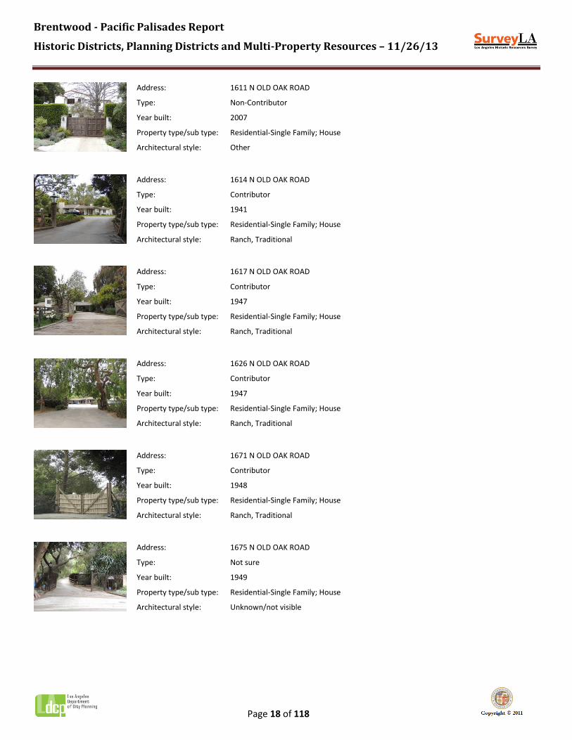
Address: 1611 N OLD OAK ROAD
Type: Non-Contributor
Year built: 2007
Property type/sub type: Residential-Single Family; House
Architectural style: Other
Address: 1614 N OLD OAK ROAD
Type: Contributor
Year built: 1941
Property type/sub type: Residential-Single Family; House
Architectural style: Ranch, Traditional
Address: 1617 N OLD OAK ROAD
Type: Contributor
Year built: 1947
Property type/sub type: Residential-Single Family; House
Architectural style: Ranch, Traditional
Address: 1626 N OLD OAK ROAD
Type: Contributor
Year built: 1947
Property type/sub type: Residential-Single Family; House
Architectural style: Ranch, Traditional
Address: 1671 N OLD OAK ROAD
Type: Contributor
Year built: 1948
Property type/sub type: Residential-Single Family; House
Architectural style: Ranch, Traditional
Address: 1675 N OLD OAK ROAD
Type: Not sure
Year built: 1949
Property type/sub type: Residential-Single Family; House
Architectural style: Unknown/not visible

Brentwood - Pacific Palisades Report
Historic Districts, Planning Districts and Multi-Property Resources – 11/26/13
Page 19 of 118
Address: 1681 N OLD OAK ROAD
Type: Non-Contributor
Year built: 2003
Property type/sub type: Residential-Single Family; House
Architectural style: Unknown/not visible
Address: 13201 W OLD OAK LANE
Type: Contributor
Year built: 1949
Property type/sub type: Residential-Single Family; House
Architectural style: Ranch, Traditional
Address: 13211 W OLD OAK LANE
Type: Contributor
Year built: 1951
Property type/sub type: Residential-Single Family; House
Architectural style: Ranch, Traditional
Address: 13216 W OLD OAK LANE
Type: Non-Contributor
Year built: 2000
Property type/sub type: Residential-Single Family; House
Architectural style: Other
Address: 13225 W OLD OAK LANE
Type: Non-Contributor
Year built: 2005
Property type/sub type: Residential-Single Family; House
Architectural style: Other
Address: 13230 W OLD OAK LANE
Type: Contributor
Year built: 1951
Property type/sub type: Residential-Single Family; House
Architectural style: Ranch, Traditional

Brentwood - Pacific Palisades Report
Historic Districts, Planning Districts and Multi-Property Resources – 11/26/13
Page 20 of 118
Address: 13235 W OLD OAK LANE
Type: Non-Contributor
Year built: 1988
Property type/sub type: Residential-Single Family; House
Architectural style: Unknown/not visible
Address: 13243 W OLD OAK LANE
Type: Non-Contributor
Year built: 1990
Property type/sub type: Residential-Single Family; House
Architectural style: Other
Address: 13160 W RIVIERA RANCH ROAD
Type: Contributor
Year built: 1950
Property type/sub type: Residential-Single Family; House
Architectural style: Ranch, Traditional
Address: 13181 W RIVIERA RANCH ROAD
Type: Contributor
Year built: 1948
Property type/sub type: Residential-Single Family; House
Architectural style: Ranch, Traditional
Address: 13214 W RIVIERA RANCH ROAD
Type: Contributor
Year built: 1948
Property type/sub type: Residential-Single Family; House
Architectural style: Ranch, Traditional
Address: 13215 W RIVIERA RANCH ROAD
Type: Non-Contributor
Year built: 0
Property type/sub type: Other; Vacant Lot
Architectural style: Not Applicable

Brentwood - Pacific Palisades Report
Historic Districts, Planning Districts and Multi-Property Resources – 11/26/13
Page 21 of 118
Address: 13222 W RIVIERA RANCH ROAD
Type: Contributor
Year built: 1949
Property type/sub type: Residential-Single Family; House
Architectural style: Ranch, Traditional
Address: 13233 W RIVIERA RANCH ROAD
Type: Non-Contributor
Year built: 2000
Property type/sub type: Residential-Single Family; House
Architectural style: Other
Address: 13238 W RIVIERA RANCH ROAD
Type: Not sure
Year built: 1951
Property type/sub type: Residential-Single Family; House
Architectural style: Unknown/not visible
Address: 13244 W RIVIERA RANCH ROAD
Type: Not sure
Year built: 1951
Property type/sub type: Residential-Single Family; House
Architectural style: Unknown/not visible

Brentwood - Pacific Palisades Report
Historic Districts, Planning Districts and Multi-Property Resources – 11/26/13
Page 22 of 118
Name: San Vicente Boulevard Commercial Historic District
Description:
The San Vicente Boulevard Commercial Historic District is a commercial block composed of three one- and two-story storefront buildings located along the south side of San Vicente Boulevard at Gorham Avenue in Brentwood. Constructed in 1928, these buildings are set at the sidewalk with no accommodation for parking. Taken together, they are triangular in plan to accommodate the three-sided lot. Designed in the Spanish Colonial Revival style, features include red clay tile roofs and parapets, simple cornices, smooth stucco exterior cladding, and large display windows. Original windows and doors are wood-frame. Most of the windows are replacements and some openings and storefronts have been altered. The two-story building at Gorham includes offices on the upper level. Non-original awnings and signage have been added. Other features of the district include concrete sidewalks, mature street trees, and a remnant period streetlight. All three properties are contributing resources to the historic district.
Significance:
The San Vicente Boulevard Commercial Historic District is significant as a cohesive collection of 1920s neighborhood commercial development along a streetcar line in Brentwood. This district represents the oldest intact remnant of Brentwood’s original commercial core. The period of significance is 1928, when all three of the buildings comprising this block were constructed.
The district occupies a portion of one tract, a re-subdivision of a section of Westgate, the original Brentwood subdivision, recorded in 1905. Grading for streets in Westgate began in 1904, with improvements to San Vicente in 1905. San Vicente Boulevard was laid out as a broad avenue with a wide center median for two sets of trolley tracks, flanked on each side by an oiled surface (later paved) with curbs for automobile traffic. In 1906, the Westgate streetcar line opened along San Vicente, making it the primary travel route through Brentwood and facilitating the opening of several adjacent residential tracts as well as subsequent commercial development. Initially, houses were built on the street. However, beginning in the 1920s, commercial buildings began to be built along this portion of San Vicente. By the end of World War II, the primary shopping district for the entire Brentwood community had grown up on San Vicente east of Bundy, totally eclipsing its original residential character. By 1949, the streetcar tracks had been replaced by the still extant coral trees.
The distinctive, three-part building that occupies the prominent intersection of San Vicente and Gorham Avenue was one of the earlier commercial improvements, constructed between 1927 and 1928. Developed to provide shopping and services to the adjacent residential neighborhoods, these buildings have seen a variety of retail tenants over the years. The westernmost storefront housed the Brentwood branch of the Los Angeles Public Library from 1935 to 1947; in the 1940s and 1950s this space was Brentwood Hardware & Supply, complete with an attached blade sign in the form of a saw. Immediately west of the hardware store was an associated feed lot, suggesting the persistence of equestrian modes of transportation.
Today, this stretch of San Vicente Boulevard contains a disparate collection of commercial uses from various periods, from mid-century commercial strips to more recent office buildings several stories high. In contrast, this modest collection of low-scale 1920s storefronts represents the style, scale and massing of the area’s earliest commercial development. Its prominent location, Spanish Colonial Revival design, and orientation to San Vicente Boulevard, continues to convey the early significance of San Vicente Boulevard as an important commercial and transportation corridor in Brentwood.

Brentwood - Pacific Palisades Report
Historic Districts, Planning Districts and Multi-Property Resources – 11/26/13
Page 23 of 118
Context 1:
Context: Commercial Development, 1850-1980
Sub context: No Sub-context
Theme: Streetcar Commercial Development, 1873-1934
Sub theme: No SubTheme
Property type: Streetcar Commercial District
Property sub type: No Sub-Type
Criteria: A/1/1&C/3/3
Status code: 3S;3CS;5S3
Reason: Significant as a cohesive collection of 1920s neighborhood commercial development along a streetcar line in Brentwood.

Brentwood - Pacific Palisades Report
Historic Districts, Planning Districts and Multi-Property Resources – 11/26/13
Page 24 of 118
Contributors/Non-Contributors:
Address: 11750 W SAN VICENTE BLVD
Type: Contributor
Year built: 1928
Property type/sub type: Commercial-Retail; Retail Store
Architectural style: Spanish Colonial Revival
Address: 11760 W SAN VICENTE BLVD
Type: Contributor
Year built: 1928
Property type/sub type: Commercial-Retail; Retail Store
Architectural style: Spanish Colonial Revival
Address: 11770 W SAN VICENTE BLVD
Type: Contributor
Year built: 1928
Property type/sub type: Commercial-Retail; Retail Store
Architectural style: Spanish Colonial Revival

Brentwood - Pacific Palisades Report
Historic Districts, Planning Districts and Multi-Property Resources – 11/26/13
Page 25 of 118
Name: Swarthmore Avenue Commercial Historic District
Description:
The Swarthmore Avenue Commercial Historic District is a 1950s neighborhood commercial center situated along a single block of Swarthmore Avenue, between Sunset Boulevard and Monument Street in Pacific Palisades. The district is triangular in plan and is bounded by Monument Street to the east; the alley behind the properties facing Sunset Boulevard to the west; and the rear lot lines of the properties facing Swarthmore Avenue to the north.
The district is a 2.8-acre site containing seven one- and two-story retail commercial storefronts spanning eight parcels on both sides of Swarthmore Avenue, as well as a surface parking lot situated behind the southerly buildings. (Per ZIMAS, this block is divided into 8 separate buildings; however, based on field observations of the primary facades, the block appears to contain 7 buildings.) Designed in the Mid-Century Modern style, buildings are set at the sidewalk and feature low, horizontal massing with a variety of rooflines defining each storefront. Storefronts are typically clad in smooth-finished stucco, although several also display stone or brick. Entrances are oriented towards Swarthmore Avenue and typically feature glass storefronts and large display windows; non-original awnings and signage have been added. Storefronts are occupied by neighborhood-serving businesses, such as restaurants, beauty salons, and retail boutiques. All of the buildings are contributors to the historic district. Additional features include concrete sidewalks and curbs, mature trees, period streetlights, and the associated surface parking lot to the rear.
Significance:
The Swarthmore Avenue Commercial Historic District is significant as a highly cohesive mid-century neighborhood commercial center in Pacific Palisades. The district’s period of significance is 1950-1958, when buildings in the district were constructed.
The area comprising the district was subdivided as Tract No. 16987 in 1950. Construction began that same year, continuing at a rate of approximately one building per year; the block was completed in 1958. The property, which became known as Pacific Palisades Village, was purchased by George C. Wilson and Robert L. Wilson, two brothers who operated a Santa Monica construction company known as Wilson Bros. George and Robert Wilson immigrated to the United States from Scotland in 1914 and eventually relocated to Santa Monica, where they worked as builders before establishing their own contracting business in the late 1920s. Under the Wilson Bros. umbrella, the two men served as contractors for nearby neighborhood commercial developments and worked with prominent architects such as S. Charles Lee. Over time, the brothers expanded their business from contracting to real estate development, purchasing commercial properties which they subsequently developed themselves for investment purposes.
Following the deaths of George and Robert Wilson, the Wilson family retained ownership of Pacific Palisades Village through a family trust for over sixty years. By the mid-2000s, a number of businesses in the district had been forced to close due to increasing rents and poor sales figures during the economic downturn, and several storefronts remained vacant. In 2012, the Wilson Family Trust decided to sell the Pacific Palisades Village, and the property was placed on the market for the first time since its inception. In late 2012, the property was purchased by real estate developer Rick Caruso and is currently slated for redevelopment.
Today, the Swarthmore Avenue Commercial Historic District stands out from surrounding development as a highly cohesive collection of mid-century retail commercial development. The district’s style, scale, massing, and pedestrian orientation all contribute to a strong sense of time and place as a 1950s neighborhood commercial center in Pacific Palisades.

Brentwood - Pacific Palisades Report
Historic Districts, Planning Districts and Multi-Property Resources – 11/26/13
Page 26 of 118
Context 1:
Context: Commercial Development, 1850-1980
Sub context: No Sub-context
Theme: Neighborhood Commercial Development, 1875-1960
Sub theme: Neighborhood Commercial Centers, 1875-1960
Property type: Neighborhood/Village Commercial Center
Property sub type: No Sub-Type
Criteria: A/1/1
Status code: 3S;3CS;5S3
Reason: Significant as a highly cohesive mid-century neighborhood commercial center in Pacific Palisades.

Brentwood - Pacific Palisades Report
Historic Districts, Planning Districts and Multi-Property Resources – 11/26/13
Page 27 of 118
Contributors/Non-Contributors:
Address: 1012 N SWARTHMORE AVE
Type: Contributor
Year built: 1953
Property type/sub type: Commercial-Retail; Retail Store
Architectural style: Modern, Mid-Century
Address: 1013 N SWARTHMORE AVE
Type: Contributor
Year built: 1957
Property type/sub type: Commercial-Retail; Retail Store
Architectural style: Modern, Mid-Century
Address: 1021 N SWARTHMORE AVE
Type: Contributor
Year built: 1958
Property type/sub type: Commercial-Retail; Retail Store
Architectural style: Modern, Mid-Century
Address: 1024 N SWARTHMORE AVE
Type: Contributor
Year built: 1954
Property type/sub type: Commercial-Retail; Retail Store
Architectural style: Modern, Mid-Century
Address: 1029 N SWARTHMORE AVE
Type: Contributor
Year built: 1951
Property type/sub type: Commercial-Retail; Retail Store
Architectural style: Modern, Mid-Century
Address: 1035 N SWARTHMORE AVE
Type: Contributor
Year built: 1950
Property type/sub type: Commercial-Food Service; Restaurant/Tavern
Architectural style: Modern, Mid-Century

Brentwood - Pacific Palisades Report
Historic Districts, Planning Districts and Multi-Property Resources – 11/26/13
Page 28 of 118
Address: 1049 N SWARTHMORE AVE
Type: Contributor
Year built: 1952
Property type/sub type: Commercial-Retail; Retail Store
Architectural style: Modern, Mid-Century

Brentwood - Pacific Palisades Report
Historic Districts, Planning Districts and Multi-Property Resources – 11/26/13
Page 29 of 118
Name: Uplifters Historic District
Description:
The Uplifters Historic District is an early-20th century recreational district located in the Rustic Canyon area of Pacific Palisades. The district contains 46 parcels. The district includes the former Uplifters Ranch gatehouse at 520 Latimer Road and extends north on Latimer Road to the Uplifters Ranch sign. The boundaries then expand to include the Rustic Canyon Recreation Center, those parcels surrounding Haldeman Road, and those parcels on the easterly side of Latimer Road, terminating at the northerly boundary of 20 Latimer Road.
The district occupies a gently-sloping site and is composed of a series of meandering streets which follow the natural contours of the landscape. Lots are modest in size compared with surrounding developments, with many lots smaller than a half-acre. Development is primarily residential, with one- and two-story single-family homes. Original residences were constructed primarily in the mid-1920s and exhibit a variety of rustic styles, including Craftsman bungalows and vernacular log-faced cabins. Features include wooden clapboard, log, or shingle cladding, wood windows and doors, and wood shake roofs. Several residences exhibit replaced wooden cladding which retains the rustic aesthetic of the district. Today, Uplifters residences share street with more recent construction, typically much larger in scale, and often obscuring views of the original houses.
The district also includes the Spanish Colonial Revival-style Uplifters Ranch clubhouse, now the Rustic Canyon Recreation Center. District features include streets which follow the natural contours of the landscape, intermittent curbs faced with concrete or cobblestone, cobblestone retaining walls, the absence of sidewalks and streetlights, and lush natural landscaping with many mature trees. A period wooden sign for Uplifters Ranch is suspended over Latimer Road, marking the original entrance to the site.
Of the 46 properties, 16 are contributors to the district, or approximately 35 percent; 21 are non-contributors due to extensive alterations or construction outside the period of significance. Nine properties are not visible from the public right-of-way.
Significance:
The Uplifters Historic District is significant as an excellent and unique example of early recreational development in Pacific Palisades. The district’s period of significance is 1922 to 1930, when the original buildings in the district were constructed.
The land comprising the district was first improved in the 1880s under the stewardship of Abbott Kinney. Kinney, a devoted horticulturalist, was appointed to the newly-created California Board of Forestry in 1885. Two years later, he persuaded landowners Senator John P. Jones and Arcadia de Baker to donate six acres of land in Rustic Canyon to the state for use as the country’s first Forestry Experimental Station. The Santa Monica Forestry Station opened in 1887; over the next several years, the station acquired fourteen additional acres and constructed a building for offices, seed storage, and exhibits. In 1895, Jones and Baker sold the acreage adjacent to the forestry station to George and Katherine Edmond, who constructed a ranch house on the property. For the next 25 years, the Edmonds’ only neighbors were the forestry station personnel, and their ranch was the only private residence in Rustic Canyon. In the 1920s, the Santa Monica Forestry Station was put up for sale. At the same time, George Edmond had passed away and his second wife, Julia, decided to sell the Edmond ranch. Although the Methodist Assembly initially made an offer for both properties, the church eventually opted to move west and develop the community of Pacific Palisades. Shortly thereafter, the land was subsequently purchased by the Uplifters.
The Uplifters were a selective social club that had grown out of the Los Angeles Athletic Club (LAAC). The idea for a social club originated with LAAC member Harry Marston Haldeman, who had previously formed a similar group within the Chicago Athletic Club before relocating to Los Angeles in 1909. Haldeman was soon appointed Fellowship Chairman of the LAAC and charged with organizing dinners and other social events. The success of these events led Haldeman to contemplate replicating the group

Brentwood - Pacific Palisades Report
Historic Districts, Planning Districts and Multi-Property Resources – 11/26/13
Page 30 of 118
he had founded in Chicago by creating a smaller, more select social club within the LAAC which would encourage artistic talent and promote lasting friendships. In 1913, Haldeman and a group of LAAC members met to formally establish the Uplifters. The name was chosen by member L. Frank Baum, author of the Oz books, and was selected in accordance with the group’s mission: “to uplift art, promote good fellowship, and build a closer acquaintance” among fellow members. The group was a diverse assembly of prominent Los Angeles businessmen as well as artists and celebrities; in addition to Baum and Haldeman, early members included composer Louis Gottschalk, Olympic athlete Snowy Baker, director Hal Roach, actor Harold Lloyd, and author Edgar Rice Burroughs. The Uplifters channeled their energy into recreational and creative endeavors, staging regular dinners, plays, and recitals. Haldeman also organized the Annual Outing, a week-long event held each year where members met at the beach for picnics, sports, and entertainment.
At the 1920 Annual Outing, the Uplifters discussed the idea of acquiring a country home for its members, where the activities of the Annual Outing could take place year-round. The group decided on the Rustic Canyon land, which comprised the forestry station and the Edmond ranch, and established a separate corporation, the Uplifters Country Home, to buy, build, lease, and maintain the land and facilities. Uplifters members were invited to purchase shares in the company and within months the group had raised the necessary funds to purchase the Rustic Canyon land. The Uplifters Ranch was officially dedicated in May of 1921, with the former Edmond ranch house serving as the Uplifters clubhouse.
Early development of the Uplifters Ranch was limited and devoted primarily to the creation of recreational facilities. Roads and paths were cleared and utilities were extended to the site, where initial construction consisted of a swimming pool, tennis courts, trap shooting range, an open-air amphitheater, and dormitories. In 1922, a brush fire destroyed the former Edmond ranch house, and the Uplifters established a building fund to construct a replacement facility. Architect William J. Dodd, an Uplifter member, was hired to design the new clubhouse, which was completed in 1923. Over time, as equestrian activities became a larger part of club life, facilities were improved and expanded to include a polo field, racetrack, riding arena and stables. The Uplifters also invested substantial funds in improving the roads and grading and terracing the landscape with plantings and cobblestone retaining walls. Over 500 trees, donated by individual members, were planted in 1925. Streets were named for prominent Uplifters leaders Harry Haldeman and Howard Latimer, who also constructed the first Uplifters houses.
While the land continued to be owned by the Country Home Corporation, club members who purchased four shares or more were permitted to lease a lot from the corporation and build a house. The design of the residences was restricted by the Country Home Board of Directors, which specified that cottages should be “left rustic” and painted brown, grey, or green. Approximately 40 Uplifters members constructed cottages along Latimer and Haldeman roads, which were used primarily for summer and weekend visits to the Ranch. The cottages displayed a range of rustic vernacular styles, including Craftsman and log cabin examples, and were clad in wooden clapboard, shingles, or logs. One of the earliest club members, Marco Hellman, had one of the most unique residences at the camp; Hellman acquired three log cabins from a movie set to form his seasonal residence. The cabins were originally utilized as set pieces for the 1923 film "The Courtship of Miles Standish." Following the completion of the film, Hellman had the cabins reassembled on adjoining lots on Haldeman Road.
In the 1930s, the Uplifters organization began to undergo a marked transformation. In 1929, after nearly a decade of financial confusion, controversy, and mismanagement, the Uplifters Social Club and the Uplifters Country Home were merged into one entity, which supervised both the social activities of the club as well as its real estate holdings. The financial effects of the Depression muted the activities of the club, and the Annual Outing was reduced from a week to four days before being discontinued in 1941. The Uplifters Ranch facilities were taken over by professional managers and were operated for profit, catering to outside events. The club’s real estate holdings were also affected: in an effort to meet growing financial obligations caused by loans and members’ unpaid bills, in the mid-1930s the Uplifters Country Home announced that cottage owners could no longer lease their properties; instead, they would be required to purchase their cottages at a value to be determined. The Country Home hired attorney Joseph Musgrove to meet with members and handle the negotiations. Many members with cottages who had suffered financial losses during the Depression were often unable to raise the sum necessary to buy their cottages outright. Musgrove purchased a number of cottages owned by original Uplifters Ranch founders, including those of Howard Latimer and Marco Hellman. Between 1936 and 1938, many founding Uplifters were forced out of their country homes and newer members began to make the Uplifters Ranch their year-round home.
The demise of the original Uplifters was accelerated by the outbreak of World War II. By 1941, Uplifters Ranch land was being sold for the first time to buyers who were not Uplifters members. In 1943, the financially distressed Uplifters Ranch property, which was nearing bankruptcy, was sold to Joseph Musgrove. Musgrove and his associates subdivided the land for

Brentwood - Pacific Palisades Report
Historic Districts, Planning Districts and Multi-Property Resources – 11/26/13
Page 31 of 118
development, selling off the polo field and facilities, and began to rent out the facilities to non-members. In 1947, the Uplifters club was disbanded and the Uplifters Ranch clubhouse was sold. The clubhouse was renovated and opened in 1950 as a privately-owned Racquet Club, but operated for only three years before being acquired by the City of Los Angeles as a city park in 1953. The clubhouse now serves as the Rustic Canyon Recreation Center; it was designated a Los Angeles Historic-Cultural Monument in 1999. The former Uplifters cottages, many of which reverted to private ownership by the late 1930s, are now maintained as full-time private residences. Over time, many properties have been altered and expanded to accommodate year-round living. In some cases, original Uplifters cottages have been maintained as guest houses for newer, larger residences constructed on the properties.
Today, the Uplifters Historic District stands out as a uniquely cohesive example of early recreational development in Pacific Palisades. Its shared planning features and distinctively rustic aesthetic help to convey a strong sense of time and place. Despite a relatively low percentage of contributors, the area’s significance is such that it qualifies as a historic district

Brentwood - Pacific Palisades Report
Historic Districts, Planning Districts and Multi-Property Resources – 11/26/13
Page 32 of 118

Brentwood - Pacific Palisades Report
Historic Districts, Planning Districts and Multi-Property Resources – 11/26/13
Page 33 of 118
Context 1:
Context: Other Context, 1850-1980
Sub context: No Sub-context
Theme: Event or Series of Events, 1850-1980
Sub theme: No SubTheme
Property type: Institutional
Property sub type: District
Criteria: A/1/1
Status code: 3S;3CS;5S3
Reason: Significant as an excellent and unique example of early recreational development in Pacific Palisades.
Contributors/Non-Contributors:
Address: 36 N HALDEMAN RD
Type: Contributor
Year built: 1924
Property type/sub type: Residential-Single Family; House
Architectural style: Other
Address: 19 N HALDEMAN ST
Type: Non-Contributor
Year built: 1936
Property type/sub type: Residential-Single Family; House
Architectural style: No style
Address: 20 N HALDEMAN ST
Type: Non-Contributor
Year built: 1949
Property type/sub type: Residential-Single Family; House
Architectural style: Other
Address: 29 N HALDEMAN ST
Type: Non-Contributor
Year built: 1922
Property type/sub type: Residential-Single Family; House
Architectural style: Ranch, Traditional

Brentwood - Pacific Palisades Report
Historic Districts, Planning Districts and Multi-Property Resources – 11/26/13
Page 34 of 118
Address: 32 N HALDEMAN ST
Type: Non-Contributor
Year built: 1923
Property type/sub type: Residential-Single Family; House
Architectural style: Other
Address: 33 N HALDEMAN ST
Type: Non-Contributor
Year built: 1923
Property type/sub type: Residential-Single Family; House
Architectural style: Other
Address: 34 N HALDEMAN ST
Type: Contributor
Year built: 1924
Property type/sub type: Residential-Single Family; House
Architectural style: Vernacular
Address: 35 N HALDEMAN ST
Type: Non-Contributor
Year built: 1927
Property type/sub type: Residential-Single Family; House
Architectural style: Other
Address: 37 N HALDEMAN ST
Type: Contributor
Year built: 1925
Property type/sub type: Residential-Single Family; House
Architectural style: Other
Address: 38 N HALDEMAN ST
Type: Non-Contributor
Year built: 2013
Property type/sub type: Residential-Single Family; House
Architectural style: Other

Brentwood - Pacific Palisades Report
Historic Districts, Planning Districts and Multi-Property Resources – 11/26/13
Page 35 of 118
Address: 43 N HALDEMAN ST
Type: Non-Contributor
Year built: 2000
Property type/sub type: Residential-Single Family; House
Architectural style: Other
Address: 44 N HALDEMAN ST
Type: Contributor
Year built: 1922
Property type/sub type: Residential-Single Family; House
Architectural style: Vernacular
Address: 45 N HALDEMAN ST
Type: Non-Contributor
Year built: 1930
Property type/sub type: Residential-Single Family; House
Architectural style: Other
Address: 46 N HALDEMAN ST
Type: Contributor
Year built: 1922
Property type/sub type: Residential-Single Family; House
Architectural style: Craftsman
Address: 47 N HALDEMAN ST
Type: Non-Contributor
Year built: 1947
Property type/sub type: Residential-Single Family; House
Architectural style: Other
Address: 48 N HALDEMAN ST
Type: Not sure
Year built: 1922
Property type/sub type: Residential-Single Family; House
Architectural style: Craftsman

Brentwood - Pacific Palisades Report
Historic Districts, Planning Districts and Multi-Property Resources – 11/26/13
Page 36 of 118
Address: 49 N HALDEMAN ST
Type: Contributor
Year built: 1924
Property type/sub type: Residential-Single Family; House
Architectural style: Craftsman
Address: 50 N HALDEMAN ST
Type: Non-Contributor
Year built: 1993
Property type/sub type: Residential-Single Family; House
Architectural style: Other
Address: 650 N HALDEMAN ST
Type: Non-Contributor
Year built: 1965
Property type/sub type: Residential-Single Family; House
Architectural style: Other
Address: 682 N HALDEMAN ST
Type: Non-Contributor
Year built: 1965
Property type/sub type: Residential-Single Family; House
Architectural style: Modern, Mid-Century
Address: 685 N HALDEMAN ST
Type: Non-Contributor
Year built: 1924
Property type/sub type: Residential-Single Family; House
Architectural style: No style
Address: 700 N HALDEMAN ST
Type: Non-Contributor
Year built: 1979
Property type/sub type: Residential-Single Family; House
Architectural style: Other
Brentwood - Pacific Palisades Report
Historic Districts, Planning Districts and Multi-Property Resources – 11/26/13
Page 37 of 118
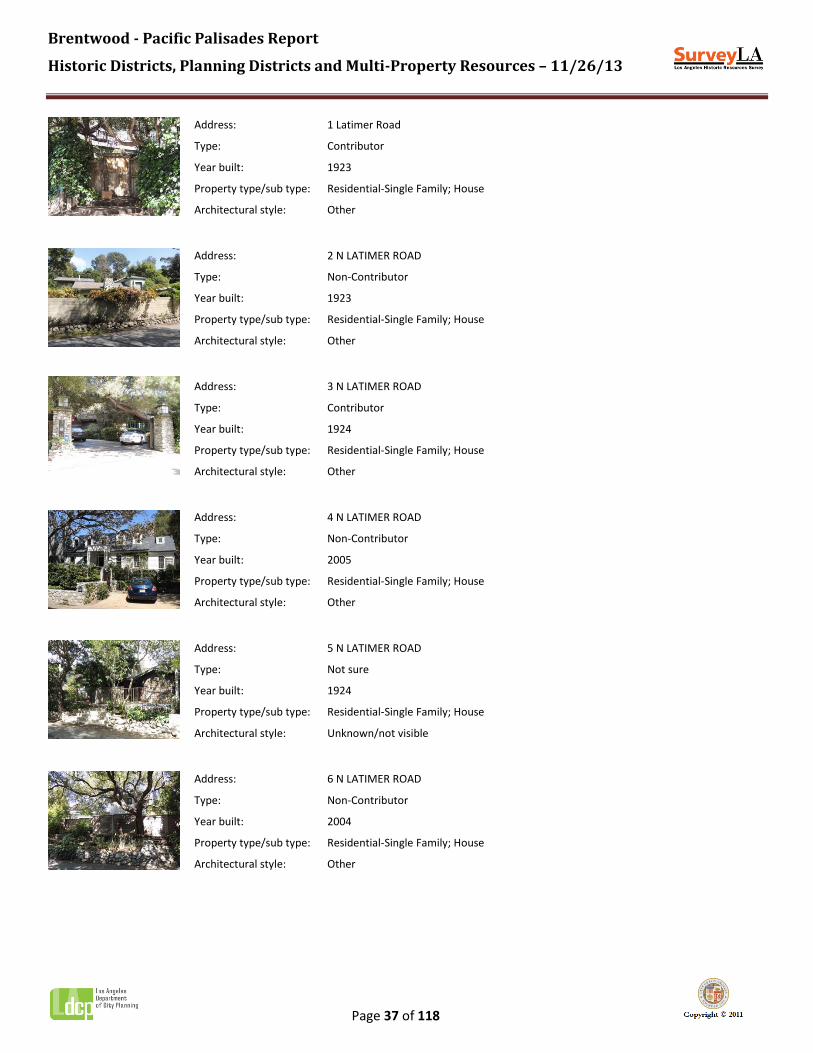
Address: 1 Latimer Road
Type: Contributor
Year built: 1923
Property type/sub type: Residential-Single Family; House
Architectural style: Other
Address: 2 N LATIMER ROAD
Type: Non-Contributor
Year built: 1923
Property type/sub type: Residential-Single Family; House
Architectural style: Other
Address: 3 N LATIMER ROAD
Type: Contributor
Year built: 1924
Property type/sub type: Residential-Single Family; House
Architectural style: Other
Address: 4 N LATIMER ROAD
Type: Non-Contributor
Year built: 2005
Property type/sub type: Residential-Single Family; House
Architectural style: Other
Address: 5 N LATIMER ROAD
Type: Not sure
Year built: 1924
Property type/sub type: Residential-Single Family; House
Architectural style: Unknown/not visible
Address: 6 N LATIMER ROAD
Type: Non-Contributor
Year built: 2004
Property type/sub type: Residential-Single Family; House
Architectural style: Other
Brentwood - Pacific Palisades Report
Historic Districts, Planning Districts and Multi-Property Resources – 11/26/13
Page 38 of 118
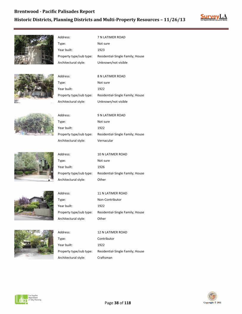
Address: 7 N LATIMER ROAD
Type: Not sure
Year built: 1923
Property type/sub type: Residential-Single Family; House
Architectural style: Unknown/not visible
Address: 8 N LATIMER ROAD
Type: Not sure
Year built: 1922
Property type/sub type: Residential-Single Family; House
Architectural style: Unknown/not visible
Address: 9 N LATIMER ROAD
Type: Not sure
Year built: 1922
Property type/sub type: Residential-Single Family; House
Architectural style: Vernacular
Address: 10 N LATIMER ROAD
Type: Not sure
Year built: 1926
Property type/sub type: Residential-Single Family; House
Architectural style: Other
Address: 11 N LATIMER ROAD
Type: Non-Contributor
Year built: 1922
Property type/sub type: Residential-Single Family; House
Architectural style: Other
Address: 12 N LATIMER ROAD
Type: Contributor
Year built: 1922
Property type/sub type: Residential-Single Family; House
Architectural style: Craftsman

Brentwood - Pacific Palisades Report
Historic Districts, Planning Districts and Multi-Property Resources – 11/26/13
Page 39 of 118
Address: 13 N LATIMER ROAD
Type: Non-Contributor
Year built: 1922
Property type/sub type: Residential-Single Family; House
Architectural style: Other
Address: 14 N LATIMER ROAD
Type: Contributor
Year built: 1923
Property type/sub type: Residential-Single Family; House
Architectural style: Vernacular
Address: 15 N LATIMER ROAD
Type: Non-Contributor
Year built: 2008
Property type/sub type: Residential-Single Family; House
Architectural style: Other
Address: 16 N LATIMER ROAD
Type: Not sure
Year built: 1923
Property type/sub type: Residential-Single Family; House
Architectural style: Unknown/not visible
Address: 17 N LATIMER ROAD
Type: Contributor
Year built: 1930
Property type/sub type: Residential-Single Family; House
Architectural style: Vernacular
Address: 18 N LATIMER ROAD
Type: Contributor
Year built: 1927
Property type/sub type: Residential-Single Family; House
Architectural style: Other

Brentwood - Pacific Palisades Report
Historic Districts, Planning Districts and Multi-Property Resources – 11/26/13
Page 40 of 118
Address: 19 N LATIMER ROAD
Type: Contributor
Year built: 1927
Property type/sub type: Residential-Single Family; House
Architectural style: Tudor Revival
Address: 20 N LATIMER ROAD
Type: Not sure
Year built: 1927
Property type/sub type: Residential-Single Family; House
Architectural style: Unknown/not visible
Address: 31 N LATIMER ROAD
Type: Contributor
Year built: 1923
Property type/sub type: Residential-Single Family; House
Architectural style: Vernacular
Address: 520 N LATIMER ROAD
Type: Not sure
Year built: 1923
Property type/sub type: Residential-Single Family; House
Architectural style: Other
Address: 601 N LATIMER ROAD
Type: Contributor
Year built: 1923
Property type/sub type: Institutional-Social Clubs/Meeting Halls; Clubhouse
Architectural style: Spanish Colonial Revival
Address: 601 N LATIMER ROAD
Type: Contributor
Year built: 1922
Property type/sub type: Institutional-Recreation; Public Park
Architectural style: Not Applicable
Brentwood - Pacific Palisades Report
Historic Districts, Planning Districts and Multi-Property Resources – 11/26/13
Page 41 of 118
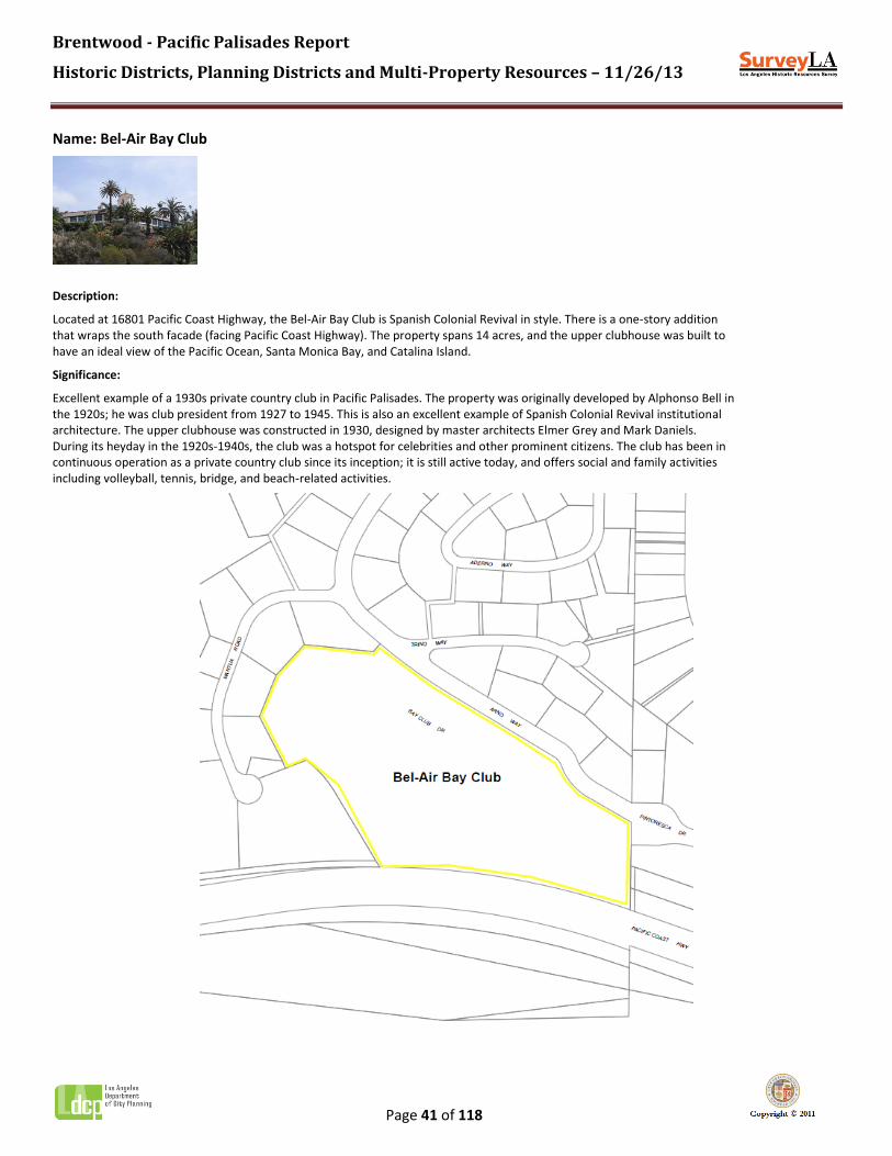
Name: Bel-Air Bay Club
Description:
Located at 16801 Pacific Coast Highway, the Bel-Air Bay Club is Spanish Colonial Revival in style. There is a one-story addition that wraps the south facade (facing Pacific Coast Highway). The property spans 14 acres, and the upper clubhouse was built to have an ideal view of the Pacific Ocean, Santa Monica Bay, and Catalina Island.
Significance:
Excellent example of a 1930s private country club in Pacific Palisades. The property was originally developed by Alphonso Bell in the 1920s; he was club president from 1927 to 1945. This is also an excellent example of Spanish Colonial Revival institutional architecture. The upper clubhouse was constructed in 1930, designed by master architects Elmer Grey and Mark Daniels. During its heyday in the 1920s-1940s, the club was a hotspot for celebrities and other prominent citizens. The club has been in continuous operation as a private country club since its inception; it is still active today, and offers social and family activities including volleyball, tennis, bridge, and beach-related activities.

Brentwood - Pacific Palisades Report
Historic Districts, Planning Districts and Multi-Property Resources – 11/26/13
Page 42 of 118
Context 1:
Context: Architecture and Engineering, 1850-1980
Sub context: No Sub-context
Theme: Mediterranean and Indigenous Revival Architecture, 1887-1952
Sub theme: Spanish Colonial Revival, 1915-1942
Property type: Institutional - Recreation
Property sub type: No Sub-Type
Criteria: C/3/3
Status code: 3CS;5S3
Reason: Excellent example of Spanish Colonial Revival institutional architecture in Pacific Palisades; work of master architects Elmer Grey and Mark Daniels. Due to alterations, including an addition on the south facade, the property does not retain sufficient integrity to be eligible for listing in the National Register.
Context 2:
Context: Public and Private Institutional Development, 1850-1980
Sub context: Private Recreation, 1880-1980
Theme: Private Recreation Facilities, 1880-1980
Sub theme: Country Clubs, 1880-1980
Property type: Institutional - Recreation
Property sub type: Country Club
Criteria: A/1/1
Status code: 3S;3CS;5S3
Reason: Excellent example of a 1930s private country club in Pacific Palisades.

Brentwood - Pacific Palisades Report
Historic Districts, Planning Districts and Multi-Property Resources – 11/26/13
Page 43 of 118
Name: Brentwood Country Club
Description:
Located at 590 South Burlingame Avenue. Bounded by San Vicente Boulevard, Montana Avenue, Gretna Green Way and Burlingame Avenue; the site comprises more than 129 acres, including an 18-hole golf course, driving range, tennis courts, swimming pool, and clubhouse. The original clubhouse was designed by noted Westside architect John Byers. It is said to be extant; however, it has been modified over time. The property also contains a variety of mature trees, including Eucalyptus along the perimeter that function as a windbreak.
Significance:
Sunset Fields Golf Club (later renamed Brentwood Country Club) was originally established in 1915 as a private club where wealthy Angelenos would gather. The club foreclosed in 1928 and was later purchased by King Carol of Romania, who reopened the facility as a public course. In 1932, the club hosted the running portion of the modern pentathlon event at the Summer Olympics. In 1947, the property was purchased by cousins Arthur Edmunds and Edward Zuckerman, making it one of the few clubs at the time that permitted the membership of Jews. Appears to be an excellent example of an early-20th century country club in Los Angeles; however, because it is not fully visible from the public right-of-way the evaluation could not be completed.

Brentwood - Pacific Palisades Report
Historic Districts, Planning Districts and Multi-Property Resources – 11/26/13
Page 44 of 118
Context 1:
Context: Public and Private Institutional Development, 1850-1980
Sub context: Private Recreation, 1880-1980
Theme: Private Recreation Facilities, 1880-1980
Sub theme: Country Clubs, 1880-1980
Property type: Institutional - Recreation
Property sub type: Country Club
Criteria: A/1/1
Status code: QQQ
Reason: Brentwood Country Club, originally established in 1915. Appears to be an excellent example of an early-20th century country club in Los Angeles. However, the property is not fully visible from the public right-of-way; therefore, the evaluation could not be completed.
Context 2:
Context: Cultural Landscapes, 1875-1980
Sub context: Designed Landscapes, 1875-1980
Theme: Private Recreational Facilities, 1880-1980
Sub theme: Golf Courses, 1880-1980
Property type: Landscape
Property sub type: Golf Course
Criteria: C/3/3
Status code: QQQ
Reason: Brentwood Country Club, a private golf course established in 1915. Appears to be an excellent example of an early-20th century golf course in Los Angeles. However, the property is not fully visible from the public right-of-way; therefore, the evaluation could not be completed.

Brentwood - Pacific Palisades Report
Historic Districts, Planning Districts and Multi-Property Resources – 11/26/13
Page 45 of 118
Name: Brentwood Country Mart
Description:
Located at 225 26th Street, this property contains a 30,000-square-foot open-air shopping and food center composed of multiple commercial buildings oriented around two courtyards. The Brentwood Country Mart contains 22 retail stores and 6 eateries. Designed in a country vernacular style, the mart features barn-like gambrel roofs, board-and-batten wood siding, and divided-light wood windows and doors in a variety of configurations. Other features include canvas awnings, signage for individual shops, built-in wooden seating, and wood tables and benches in the courtyard.
Significance:
Excellent and rare example of a 1940s open-air shopping and food center in Brentwood. The Brentwood Country Mart was originally developed in 1948 by the Herbert M. Bruch Corporation. Owners Louis M. Sentei and A.L. Levin sought to create a one-stop shopping center in the heart of Brentwood. The property was designed by noted Los Angeles architect Rowland Crawford, who developed plans for a complex of commercial buildings with a country feel. The design was intended to be reminiscent of the Farmers Market in the Fairfax District. Rowland's design remains highly intact, capturing the rural atmosphere of Brentwood at the time of its construction; people came to visit the Brentwood Country Mart on horseback, even in 1948. Originally, the Brentwood Country Mart included a post office, shoe repair shop, barber shop, and the Reddi Chick rotisserie chicken shop, all of which are still present today.

Brentwood - Pacific Palisades Report
Historic Districts, Planning Districts and Multi-Property Resources – 11/26/13
Page 46 of 118
Context 1:
Context: Commercial Development, 1850-1980
Sub context: No Sub-context
Theme: Neighborhood Commercial Development, 1875-1960
Sub theme: Neighborhood Commercial Centers, 1875-1960
Property type: Neighborhood/Village Commercial Center
Property sub type: No Sub-Type
Criteria: A/1/1
Status code: 3S;3CS;5S3
Reason: Excellent and rare example of a 1940s open-air shopping and food center in Brentwood.
Context 2:
Context: Commercial Development, 1850-1980
Sub context: No Sub-context
Theme: Commercial Identity, 1850-1980
Sub theme: No SubTheme
Property type: Commercial
Property sub type: No Sub-Type
Criteria: A/1/1
Status code: 5S3
Reason: Long-time shopping and food center in Brentwood; Brentwood Country Mart has been in continuous operation since 1948. The property appears to meet local criteria only and may not meet significance thresholds for National Register or California Register eligibility

Brentwood - Pacific Palisades Report
Historic Districts, Planning Districts and Multi-Property Resources – 11/26/13
Page 47 of 118
Name: Brentwood Park Residential Planning District
Description:
The Brentwood Park Residential Planning District is an early 20th-century residential subdivision located in the southwestern portion of Brentwood. The planning district contains approximately 500 parcels spanning some 350 acres. The district boundaries conform to those of the original 1906 tract, which is bounded by San Vicente Boulevard on the south, and includes both sides of Cliffwood Avenue on the east, and both sides of Rockingham Avenue on the west. The area is bisected on an east-west axis by Sunset Boulevard.
The district occupies a gently-sloping site at the base of the Brentwood foothills. Lots are generously sized, some exceeding an acre, allowing for large lawns and gardens. Development is exclusively residential, containing large one- and two-story single-family houses with detached garages. Original residences were constructed primarily in the 1920s through the 1950s, and exhibit a range of Period Revival architectural styles popular during that time – including American Colonial, Spanish Colonial, and Tudor – as well as early Modern and Ranch styles. Today these residences share the block with later infill, much of it constructed from the 1980s to the present. These more recent arrivals often mimic the same Period Revival styles of their predecessors, but at a somewhat larger scale. Features of the district include curvilinear streets which follow the site’s natural contours, concrete curbs, and the notable absence of sidewalks and period streetlights. The district does not have parkways or a uniform tree plan. However, individual lots are well landscaped, some with trees planted at the time of the original subdivision, creating a lush park-like setting. Many properties have high privacy walls or hedges, often limiting their visibility from the public right-of-way. The district’s most prominent planning features are its eight landscaped traffic circles, located primarily along South Bristol Avenue, which serves as the neighborhood’s north-south spine.
Significance:
The Brentwood Park Residential Planning District is significant as an important example of early 20th-century residential suburban planning developed along a streetcar line in Brentwood. While the area does not retain sufficient integrity or cohesion to qualify as a historic district, it may warrant special consideration in the local planning process.
One of Brentwood’s earliest subdivisions, the area comprising the planning district was originally subdivided in 1906 on 350 acres purchased by the Western Pacific Development Company from the Santa Monica Land and Water Company. The tract was accessed by the newly-laid Westgate streetcar line on San Vicente Boulevard. The distinctive layout of Brentwood Park incorporated 32 landscaped traffic circles, one at each intersection, and approximately the same number of ovals situated midblock. Streets curved gracefully to follow the contours of the land and at 75- to 180-feet wide were generously scaled. Lots were varied in size and shape and allowed for deep setbacks.
Promoters of the new development included William Lynton Brent, president of the Merchants Trust Company Bank, for whom Brentwood is named. The new subdivision was touted as an exclusive neighborhood of country estates with easy access to the heart of the city. John McLaren, famed designer of San Francisco’s Golden Gate Park, supervised the planting of some 87,000 trees and shrubs, including palms, sycamores, peppers, and live oaks, many of which continue to grace the neighborhood today. Restrictions were put in place to ensure the desirability of Brentwood Park into the future, including minimum lot size, deep setbacks, only one house per lot, and the prohibition of all non-residential uses.
Despite the reputed $1,000,000 investment by its backers, lot sales in Brentwood Park got off to a slow start, and by 1911 Western Pacific had sold a controlling interest to Dr. Herman Janss of the Braly-Janss Company. Publicity for the subdivision characterized the tract as an “ideal suburb” of “stately homes,” and the reported influx of “kings of finance” and “magnates” seems to justify the claim of it being a “millionaires’ colony.” Homes built during this first period of development ranged from large bungalows to mansions, and several prominent architects were employed, included F.P. Burnham of Chicago, as well as

Brentwood - Pacific Palisades Report
Historic Districts, Planning Districts and Multi-Property Resources – 11/26/13
Page 48 of 118
local masters such as Arthur Benton and Elmer Grey. Only a handful of properties remain from this period.
After ten years, only about 25 percent of the lots had been sold. However, sales and construction picked up markedly in the 1920s and 1930s. Reasons for the uptick likely included the area’s annexation to the City of Los Angeles in 1916, as well as the improvement and extension of Beverly Boulevard (now Sunset Boulevard) through Brentwood Park. Several prominent architects, including John Byers, Reginald Johnson, and Paul Williams, were called upon to design lavish homes in then-fashionable Period Revival styles. In the 1930s, Ranch style homes as well as early Modern houses, such as the Lloyd Wright-designed Avery House, began to appear. The post-World War II years saw the continuation of these trends, with traditional houses coexisting with homes designed by Modernists like Richard Neutra, Thornton Abell, and Craig Ellwood.
By the 1930s, Brentwood Park had established itself as a western counterpart to Beverly Hills and Hollywood, attracting numerous entertainment industry personalities to its estate-sized lots, a trend which continues to the present day. Perhaps the most celebrated at the time was Shirley Temple, whose 1935 residence, designed by noted Westside architects John Byers and Edla Muir, was widely published. Other star residents included Joan Crawford, Tyrone Power, Zasu Pitts, Cole Porter, Phyllis Diller, and Judy Garland.
Despite its significance, Brentwood Park does not possess sufficient integrity to qualify as a historic district. While the area generally retains consistency of massing, scale, and architectural style, it has experienced the widespread demolition and replacement of original residences with new construction. The cumulative effect of these demolitions has compromised the cohesion of the district as a whole. However, the district is unified by shared planning features which convey a strong sense of time and place. These include the curvilinear interior street pattern, eight original traffic circles and ovals, large residences on large lots, and an impressive collection of mature trees. All of these features contribute to an overall feeling of an early 20th-century Brentwood residential suburb. For these reasons, this area may warrant special consideration for local planning purposes.

Brentwood - Pacific Palisades Report
Historic Districts, Planning Districts and Multi-Property Resources – 11/26/13
Page 49 of 118
Context 1:
Context: Residential Development and Suburbanization, 1850-1980
Sub context: No Sub-context
Theme: Streetcar Suburbanization, 1888-1933
Sub theme: Suburban Planning and Development, 1888-1933
Property type: Streetcar Suburb
Property sub type: Subdivision
Criteria: A/1/1
Status code: 6LQ
Reason: Significant as an important example of early 20th-century residential suburban planning developed along a streetcar line in Brentwood. While the area does not retain sufficient integrity or cohesion to qualify as a historic district, it may warrant special consideration in the local planning process.

Brentwood - Pacific Palisades Report
Historic Districts, Planning Districts and Multi-Property Resources – 11/26/13
Page 50 of 118
Name: Brentwood School, East Campus
Description:
Located at 100 South Barrington Place, the district contains three original buildings situated along Layton Drive, at the northern end of the campus. These building date from the 1930s campus of the Brentwood Military Academy. Designed in the Spanish Colonial Revival style, these include two two-story buildings and one one-story building. Features include clay tile roofs; stucco, wood and brick cladding; wood-frame casement windows; carved wooden doors; and a decorative tower. The main building entrance features an elaborated surround with ornamental tilework. All of the buildings appear to be highly intact.
Significance:
Excellent and rare example of a 1930s private educational institution in Brentwood; also an excellent example of Spanish Colonial Revival institutional architecture. This property was formerly the site of the Brentwood Military Academy. Originally established as the Urban Military Academy in 1902 in Hollywood, the Academy was a boarding and day school for boys; at the time it was the only private boys’ school in Los Angeles. The Academy relocated to this site between 1930 and 1934 and constructed several buildings in the Spanish Colonial Revival style. Brentwood School was founded in 1972 when organizers purchased this property from the Academy, which had closed earlier that year. The site now comprises the East Campus of the Brentwood School, a private school teaching grades 7 to 12. Three of the original school structures dating from the 1930s remain; one has been renovated. Brentwood school has subsequently made additional improvements to the site and has expanded its campus southward.
Brentwood - Pacific Palisades Report
Historic Districts, Planning Districts and Multi-Property Resources – 11/26/13
Page 51 of 118
Context 1:
Context: Public and Private Institutional Development, 1850-1980
Sub context: Education, 1876-1980
Theme: Educational Development, 1900-1980
Sub theme: No SubTheme
Property type: Institutional - Education
Property sub type: No Sub-Type
Criteria: A/1/1
Status code: 3S;3CS;5S3
Reason: Excellent and rare example of a 1930s private educational institution in Brentwood.
Context 2:
Context: Architecture and Engineering, 1850-1980
Sub context: No Sub-context
Theme: Mediterranean and Indigenous Revival Architecture, 1887-1952
Sub theme: Spanish Colonial Revival, 1915-1942
Property type: Institutional - Education
Property sub type: Campus - Other
Criteria: C/3/3
Status code: 3S;3CS;5S3
Reason: Excellent example of Spanish Colonial Revival institutional architecture in Brentwood.

Brentwood - Pacific Palisades Report
Historic Districts, Planning Districts and Multi-Property Resources – 11/26/13
Page 52 of 118
Name: Brentwood Science Magnet School
Description:
Located at 740 Gretna Green Way, this elementary school is composed of two original school buildings, including a two-story main building and a one-story classroom building, connected by a covered breezeway. Both buildings designed in the Spanish Colonial Revival style, featuring stucco exterior cladding, clay tile roofs, and divided-light wood windows.
Significance:
Excellent example of a LAUSD elementary school representing the post-1933 Long Beach Earthquake period of school construction. Also, an excellent example of Spanish Colonial Revival institutional architecture in Brentwood.

Brentwood - Pacific Palisades Report
Historic Districts, Planning Districts and Multi-Property Resources – 11/26/13
Page 53 of 118
Context 1:
Context: Public and Private Institutional Development, 1850-1980
Sub context: Education, 1876-1980
Theme: Public Schools and the LAUSD, 1876-1980
Sub theme: Post-1933 Long Beach Earthquake, 1933-1945
Property type: Institutional - Education
Property sub type: Elementary School
Criteria: A/1/1&C/3/3
Status code: 3S;3CS;5S3
Reason: Excellent example of an LAUSD elementary school representing the post-1933 Long Beach Earthquake period of school construction.
Context 2:
Context: Architecture and Engineering, 1850-1980
Sub context: No Sub-context
Theme: Mediterranean and Indigenous Revival Architecture, 1887-1952
Sub theme: Spanish Colonial Revival, 1915-1942
Property type: Institutional - Education
Property sub type: Campus - Elementary School
Criteria: C/3/3
Status code: 3S;3CS;5S3
Reason: Excellent example of Spanish Colonial Revival institutional architecture in Brentwood.
Contributors/Non-Contributors:
Address: 731 S BUNDY DR
Type: Contributor
Year built: 1935
Property type/sub type: Institutional-Education; Elementary School
Architectural style: Spanish Colonial Revival
Address: 731 S BUNDY DR
Type: Contributor
Year built: 1935
Property type/sub type: Institutional-Education; Elementary School
Architectural style: Spanish Colonial Revival

Brentwood - Pacific Palisades Report
Historic Districts, Planning Districts and Multi-Property Resources – 11/26/13
Page 54 of 118
Name: Brentwood Sunset Apartments
Description:
Located at 237-289 South Barrington Avenue, this is a five-acre site containing 86 units in two 2- and 3-story residential buildings. Designed in the Mid-Century Modern style, building features include flat roofs, stucco cladding, and flush-mounted aluminum windows. Other features of the site include a detached garage building, two pools, rock walls and planters, and one-and-a-half acres of open space.
Significance:
Excellent example of a 1950s garden apartment in Brentwood. Former site of important local landscape business Evans & Reeves Nursery, which operated here from 1936 to 1957. In 1931, Bill Evans transformed his father's garden into a wholesale business that specialized in providing rare and exotic plants. On this site in 1936, Bill opened a commercial nursery and landscaping business called Evans & Reeves Landscaping with his brother Jack and a man named Jack Reeves. The nursery closed in 1957. In 1959, the site was developed with a co-operative called Brentwood Sunset Apartments (now Brentwood Sunset Condominiums). Comparison of aerial photos confirms that the original nursery buildings are no longer extant. However, some landscaping remains, including philodendron plants and coral trees. One of the coral trees now occupies a stone planter that bisects the sidewalk on Barrington Avenue.
Context 1:

Brentwood - Pacific Palisades Report
Historic Districts, Planning Districts and Multi-Property Resources – 11/26/13
Page 55 of 118
Context: Residential Development and Suburbanization, 1850-1980
Sub context: Multi-Family Residential Development, 1910-1980
Theme: Multi-Family Residential, 1910-1980
Sub theme: Garden Apartments, 1938-1960
Property type: Residential-Multi Family
Property sub type: Garden Apartment
Criteria: C/3/3
Status code: 3S;3CS;5S3
Reason: Excellent example of a 1950s garden apartment in Brentwood.

Brentwood - Pacific Palisades Report
Historic Districts, Planning Districts and Multi-Property Resources – 11/26/13
Page 56 of 118
Name: Brentwood Village Commercial Planning District
Description:
The Brentwood Village Commercial Planning District is a small commercial shopping center located near the intersection of Sunset Boulevard and S. Barrington Avenue in Brentwood. The district contains approximately 40 parcels on several small blocks. The majority of the properties are oriented around Barrington Court, which contains two U-shaped surface parking lots on either side of Barrington Avenue, with additional properties fronting Barrington Walk, a pedestrian street at the north end of Barrington Court. There are also a handful of buildings across the street to the north along the east side of S. Barrington Place.
The district is composed of approximately 20 one- and two-story commercial buildings reflecting a range of architectural styles from various periods. Buildings are set at the sidewalk, typically with large display windows and contemporary awnings and signage. While the original tracts were subdivided in the late 1920s, the extant buildings date from the late 1940s and later, some of which appear to have been subsequently altered. A notable exception is the 1939 Spanish Colonial Revival service station at the southeast corner of S. Barrington Avenue and Chayote Street, which is a designated Historic-Cultural Monument. Storefronts are occupied by neighborhood-serving businesses, such as restaurants, cleaners, and clothing boutiques. Features of the district include its distinctive interior street pattern, concrete sidewalks and curbs, concrete steps leading to Barrington Walk, diagonal surface parking, period streetlights, mature trees, and an ornamental fountain at the junction of Barrington Court and Barrington Walk.
Significance:
The Brentwood Village Commercial Planning District is significant as one of Brentwood’s original neighborhood commercial centers. While the area does not retain sufficient integrity or cohesion to qualify as a historic district, it may warrant special consideration for local planning purposes.
The area comprising the planning district encompasses portions of two tracts. The southern portion, which includes Barrington Court and Barrington Walk, is a part of Tract 9394, subdivided in 1927. The northern portion, which includes Barrington Place, is a part of Tract 10550, subdivided in 1929. Although the tracts were recorded around the time that Beverly Boulevard (now Sunset) was extended to the west on its march towards the sea, definitive development on the property did not actually occur until the late 1940s. Access to this portion of Brentwood was dependent on the automobile, rather than the streetcars that served San Vicente Boulevard; this was signaled in 1939 by the construction of a gas station in an elaborate Spanish Colonial Revival design, complete with tower.
The years following World War II saw a boom in residential housing construction in Brentwood. But the neighborhoods in the northern portion of the community were removed from the commercial services available further south on San Vicente. To meet this need, in late 1948, the Brentwood Village Business Association was formed. J. Stanley Anderson, vice-chairman of the association, noted that there was much interest by the residents of Westwood, Brentwood, and Bel-Air in plans for a “diversified shopping center” to be located at the intersection of Barrington Avenue and Sunset Boulevard. He went on to describe the new venture, saying that the buildings would be mostly of contemporary architecture, the center would be attractively landscaped, and that ample parking would be available.
Construction of the enclave – oriented around two horseshoe-shaped parking areas separated by Barrington Avenue, and extending along the adjacent streets of Barrington Place and Chayote Street – took place primarily between 1949 and 1958. Of the extant buildings, most were constructed in the 1950s, with some dating from the 1940s and 1960s. They were deliberately modest in scale, of one and two stories each, in keeping with the “village” theme. Some were rustic, with board-and-batten siding. Awnings shaded display windows. Tenants in Brentwood Village were neighborhood-serving, and included the Village Mart grocers; Brent-Air Pharmacy; the Nosh Box restaurant; shops offering ice cream, apparel, toys, record albums, and gifts;

Brentwood - Pacific Palisades Report
Historic Districts, Planning Districts and Multi-Property Resources – 11/26/13
Page 57 of 118
and service businesses such as a realtor, laundromat, and hair salon. The last major building during this period was a branch office of the Beverly Hills National Bank, designed by architect Richard Dorman and built in 1964, complete with a drive-in teller’s window and a special low deposit booth for children.
The formal opening of the Barrington Station post office in October 1949 helped launch Brentwood Village. The opening was a grand Hollywood affair, with many local celebrities participating. George Jessel was the Master of Ceremonies, and local residents Shirley Temple, Joan Crawford, Van Johnson, Linda Darnell, Zasu Pitts, Keenan Wynn and Ed Wynn planned to attend. Gary Cooper was sworn in as honorary mayor of Brentwood Village, and arrived on horseback. Four thousand people attended the event. Community events continued to be mounted by the Brentwood Village Chamber of Commerce (successor to the business association), including a Roaring Twenties event in 1958 and an annual Christmas tree lot whose sales benefitted the local boy scouts.
Despite its significance, Brentwood Village does not possess sufficient integrity or cohesion to qualify as a historic district. The majority of individual buildings have undergone a substantial degree of alteration – including changes to exterior cladding, windows, and storefronts. The cumulative impact of these alterations has compromised the integrity of the district as a whole. However, the district is unified by shared planning features which convey a strong sense of time and place. These include the central horseshoe layout with central parking area, modest scale and massing, neighborhood-serving commercial uses, and overall pedestrian orientation that have characterized Brentwood Village throughout its history. For these reasons, this area may warrant special consideration for local planning purposes.

Brentwood - Pacific Palisades Report
Historic Districts, Planning Districts and Multi-Property Resources – 11/26/13
Page 58 of 118
Context 1:
Context: Commercial Development, 1850-1980
Sub context: No Sub-context
Theme: Neighborhood Commercial Development, 1875-1960
Sub theme: Neighborhood Commercial Centers, 1875-1960
Property type: Neighborhood/Village Commercial Center
Property sub type: No Sub-Type
Criteria: A/1/1
Status code: 6LQ
Reason: Significant as one of Brentwood’s original neighborhood commercial centers. While the area does not retain sufficient integrity or cohesion to qualify as a historic district; it may warrant special consideration for local planning purposes.

Brentwood - Pacific Palisades Report
Historic Districts, Planning Districts and Multi-Property Resources – 11/26/13
Page 59 of 118
Name: Chautauqua Conference Grounds
Description:
Located at 15601 Sunset Boulevard, the site includes many historic structures, including the Temescal Camp Store, Woodland Hall, Stewart Hall, several original wood cabins, several later stucco cabins, and a number of residential buildings. Additional features of the park include stone steps and retaining walls, picnic areas, restroom buildings, surface parking lots, hiking trails, and mature natural landscaping.
Significance:
Significant as the site of the original Chautauqua Conference Grounds, established by Methodist minister Rev. Dr. Charles Holmes Scott, founder of Pacific Palisades. The site was established as a West Coast center for the Chautauqua Movement. The Chautauqua Movement originated on the East Coast near Chautauqua Lake in New York State, and was a means for people living in rural or isolated areas to have access to art, music, culture, history, and current events. The structures developed by Rev. Dr. Scott were built in 1922. In 1943, the land was purchased by the Presbyterian Synod and used as a private retreat location. In 1994, the land was acquired by the Santa Monica Mountains Conservancy for use as a public park. Today, the site is operated by the Los Angeles Department of Recreation and Parks as Temescal Gateway Park and Temescal Canyon Conference & Retreat Center. Many historic structures remain in use today.

Brentwood - Pacific Palisades Report
Historic Districts, Planning Districts and Multi-Property Resources – 11/26/13
Page 60 of 118
Context 1:
Context: Public and Private Institutional Development, 1850-1980
Sub context: Religion and Spirituality, 1850-1980
Theme: Religious Property Types, 1850-1980
Sub theme: No SubTheme
Property type: Institutional - Religion/Spirituality
Property sub type: Religious Campus
Criteria: C/3/3
Status code: 3S;3CS;5S3
Reason: Significant as the site of the original Chautauqua Conference Grounds, established by Methodist minister Rev. Dr. Charles Holmes Scott, founder of Pacific Palisades.

Brentwood - Pacific Palisades Report
Historic Districts, Planning Districts and Multi-Property Resources – 11/26/13
Page 61 of 118
Name: Crestwood Hills Recreation Center
Description:
Located at 1000 Hanley Avenue, this neighborhood park features grassy lawns, mature trees, and a recreation center building constructed circa 1950. Park site also includes the Crestwood Hills Cooperative Nursery School and the MHA Site Office; the site office is a designated Los Angeles Historic-Cultural Monument.
Significance:
Crestwood Hills Park and Recreation Center, a community park significant for its association with the Mutual Housing Association (MHA) cooperative housing development. The original landscape plan was designed by master landscape architect Garrett Eckbo. The property is now operated by the City of Los Angeles Department of Recreation and Parks. The MHA was formed in 1946 by four families wishing to pool their resources to build four houses on a large lot. The idea soon spread and the MHA eventually grew to include 500 families who jointly purchased 800 acres in an area of upper Kenter Canyon known as Crestwood Hills. The design team, led by architect Jones and Smith, along with structural engineer Edgardo Contini, developed a plan for a cooperative community of 500 houses, as well as land set aside for a park, a nursery school, gas station, and a grocery store. The development was a unique opportunity for the design team to experiment with new building materials, cost-effective building systems, and sensitive site planning. The plan was designed to preserve views and limit grading along the ridges, with individual houses sited down stepped lots or at odd angles to the street to maximize privacy. House designs featured concrete block foundations and chimneys, exposed redwood exterior siding, crushed green slate roofs, and broad expanses of plate glass. While never fully built out, the project was recognized as a signature achievement in postwar Modern architecture due to of its scale and innovative design. House designs were published in Arts & Architecture magazine, and the project won the AIA Award of Merit in 1952. The project’s ultimate success was that it allowed young families the opportunity to experience modern architecture within a modest budget. It is the only successful large-scale cooperative housing development in postwar California.

Brentwood - Pacific Palisades Report
Historic Districts, Planning Districts and Multi-Property Resources – 11/26/13
Page 62 of 118
Context 1:
Context: Residential Development and Suburbanization, 1850-1980
Sub context: No Sub-context
Theme: Post-War Suburbanization, 1938-1975
Sub theme: Suburban Planning and Development, 1938-1975
Property type: Tract/subdivision feature
Property sub type: Other
Criteria: A/1/1 & C/3/3
Status code: 3S;3CS;5S3
Reason: Community park significant for its association with the Mutual Housing Association. Crestwood Hills Park and Recreation Center was developed as part of the Mutual Housing Association (MHA) cooperative housing development, the only successful large-scale cooperative housing development in post-war California.
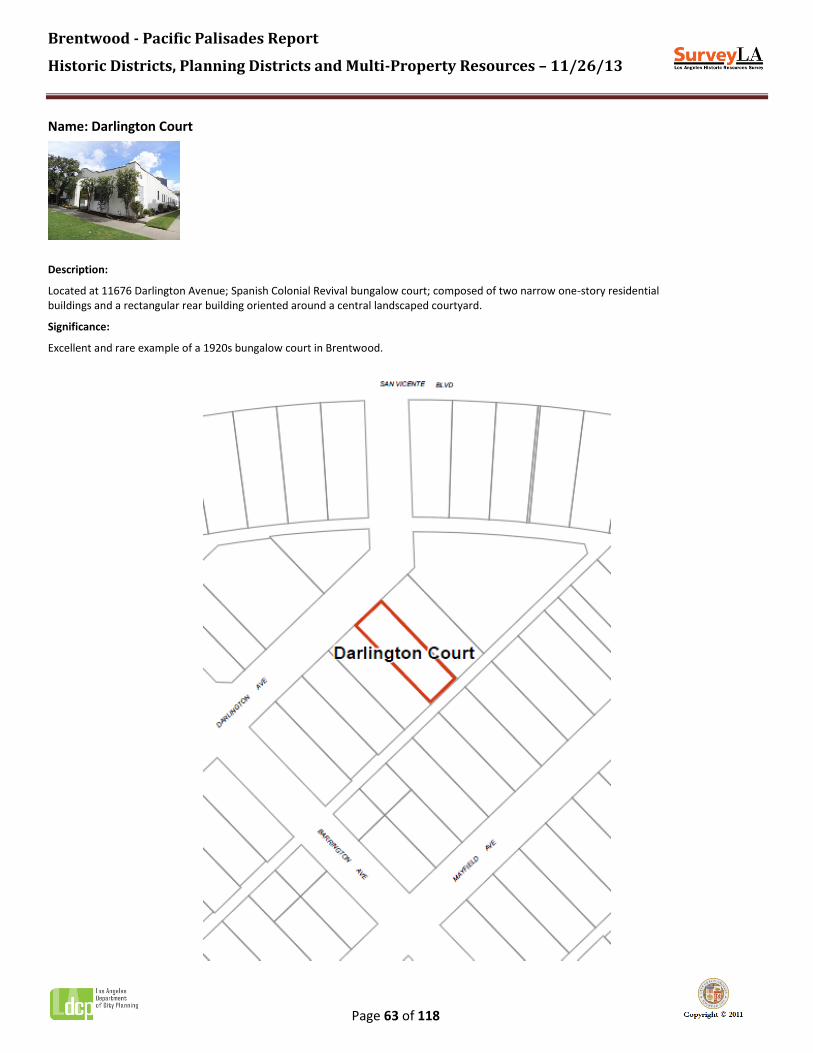
Brentwood - Pacific Palisades Report
Historic Districts, Planning Districts and Multi-Property Resources – 11/26/13
Page 63 of 118
Name: Darlington Court
Description:
Located at 11676 Darlington Avenue; Spanish Colonial Revival bungalow court; composed of two narrow one-story residential buildings and a rectangular rear building oriented around a central landscaped courtyard.
Significance:
Excellent and rare example of a 1920s bungalow court in Brentwood.

Brentwood - Pacific Palisades Report
Historic Districts, Planning Districts and Multi-Property Resources – 11/26/13
Page 64 of 118
Context 1:
Context: Residential Development and Suburbanization, 1850-1980
Sub context: Multi-Family Residential Development, 1910-1980
Theme: Multi-Family Residential, 1910-1980
Sub theme: The Bungalow Court, 1910-1939
Property type: Residential
Property sub type: Bungalow Court
Criteria: C/3/3
Status code: 3S;3CS;5S3
Reason: Excellent and rare example of a 1920s bungalow court in Brentwood.

Brentwood - Pacific Palisades Report
Historic Districts, Planning Districts and Multi-Property Resources – 11/26/13
Page 65 of 118
Name: Edgewater Towers
Description:
Located at 17350-17368 Sunset Boulevard, the property contains four high-rise luxury apartment towers occupying a large hillside site overlooking the Pacific Ocean. The four towers are configured as two pairs of attached towers. The northern most pair is eight stories in height; the southernmost pair is five stories. The project contains 148 residential units in all. The complex is designed in the Mid-Century Modern style and displays common features of the style, including, flat roofs, stucco wall cladding, horizontal bands of flush-mounted, metal-framed windows, projecting mullions, and recessed balconies. The buildings are set upon partially subterranean parking podiums. A pair of square stucco pillars mark the entrance to the site, which is controlled by a security gate house.
Significance:
Edgewater Towers; excellent and rare example of a 1960s apartment tower complex in Pacific Palisades. The original owner was Samuel J. Wilson; the complex was originally named Wilson Park. The project was designed by architect Donald Drazan. It was originally intended to include six luxury high-rise apartment towers containing a total of 400 units, making it the largest shoreline development of its kind on the Pacific Coast. At the time, the project was billed as the largest in the country to utilize pre-stressed, post-tension lift-slab construction. The first phase of construction included the four extant towers; a second phase comprising the two additional towers was never realized. The name was changed to Edgewater Towers around 1965. In 1980, the residential units were converted from rentals to condominiums.

Brentwood - Pacific Palisades Report
Historic Districts, Planning Districts and Multi-Property Resources – 11/26/13
Page 66 of 118
Context 1:
Context: Residential Development and Suburbanization, 1850-1980
Sub context: Multi-Family Residential Development, 1910-1980
Theme: Multi-Family Residential, 1910-1980
Sub theme: Apartment Houses, 1910-1980
Property type: Residential
Property sub type: Apartment Tower
Criteria: C/3/3
Status code: 3S;3CS;5S3
Reason: Excellent and rare example of a 1960s apartment tower complex in Pacific Palisades.

Brentwood - Pacific Palisades Report
Historic Districts, Planning Districts and Multi-Property Resources – 11/26/13
Page 67 of 118
Name: Evans Property
Description:
Evans Road, north of Sunset Boulevard, is a gently curved street, with no sidewalks. The area has a rustic quality, with mature trees and other landscaping. The property has been re-subdivided and contains later residential development. More research is needed to determine what original features remain from the Evans property.
Significance:
Appears to be a remnant of an early family residential estate in Pacific Palisades. The Evans Property formerly occupied the private street (now Evans Road) where Rustic Creek crosses Sunset Boulevard. This area was originally part of the Will Rogers Estate. In the 1940s, the property was purchased by three Evans brothers (Bill, Jack, and Bernard), and their brother-in-law Ira Hilgers. They ultimately constructed four residences, several bridges spanning the creek, and a small dam that created a pond. They planted the canyon with palms, ferns, camellias, azaleas, bromeliads, orchids, and other exotic plants. The Evans family established Evans and Reeves Nursery in Brentwood (1936-1957). More research is needed to determine what original features remain from the Evans property.

Brentwood - Pacific Palisades Report
Historic Districts, Planning Districts and Multi-Property Resources – 11/26/13
Page 68 of 118
Context 1:
Context: Other Context, 1850-1980
Sub context: No Sub-context
Theme: Event or Series of Events, 1850-1980
Sub theme: No SubTheme
Property type: Residential
Property sub type: District
Criteria: A/1/1
Status code: QQQ
Reason: Appears to be a remnant of an early family residential estate in Pacific Palisades. Originally part of the Will Rogers Estate, this property was purchased by the Evans family in the late-1940s; they constructed four family homes, landscaping, and other features on the property. More research is needed to determine what original features remain from the Evans property.

Brentwood - Pacific Palisades Report
Historic Districts, Planning Districts and Multi-Property Resources – 11/26/13
Page 69 of 118
Name: Getty Villa
Description:
Located at 17985 Pacific Coast Highway, the property contains an expansive museum campus. It occupies a 64 acre site on a hill overlooking the Pacific Ocean. However, the property is not visible from the public right-of-way; therefore, the evaluation could not be completed.
Significance:
The property contains a unique example of a 1970s art museum complex in Los Angeles. The Getty Villa is an educational center and museum dedicated to the study of the arts and cultures of Ancient Greece, Rome, and Etruria. The museum originated in 1954 when oil tycoon J. Paul Getty opened a gallery adjacent to his home in the Pacific Palisades. Quickly running out of room he built a second museum, The Getty Villa, on the property down the hill from the original gallery. Designed in 1974 by architects Stephen Garrett, Langdon & Wilson, and Machado & Silvetti, the Villa design was inspired by the Villa of Papyri at Herculaneum. Research indicates features of the site include a 105,500-square foot main museum building arranged in a square opening onto an Inner Peristyle courtyard; a 15,500-square foot cafe/store building; an outdoor 2,500-square foot entry pavilion; a 10,000-square foot indoor 250-seat auditorium; and a 450-seat outdoor Greek theater, all set within formal Roman-style gardens. On the hill above the museum are Getty's original private ranch house and the museum wing that Getty added to his home in 1954. These buildings are now used as offices, meeting rooms, and a library. The Getty Villa closed in 1997 for a substantial multi-year renovation, reopening in 2006. Additional research would be needed to determine the extent of alterations resulting from the renovation.

Brentwood - Pacific Palisades Report
Historic Districts, Planning Districts and Multi-Property Resources – 11/26/13
Page 70 of 118
Context 1:
Context: Public and Private Institutional Development, 1850-1980
Sub context: Cultural Development and Institutions, 1850-1980
Theme: Visual Arts, 1888-1980
Sub theme: Producing, Displaying and Supporting Visual Arts, 1888-1980
Property type: Institutional - Visual and Performing Arts
Property sub type: No Sub-Type
Criteria: A/1/1
Status code: QQQ
Reason: The property contains a unique example of a 1970s art museum complex in Los Angeles. However, the property is not visible from the public right-of-way. Also, more research would be needed to determine the extent of alterations resulting from the recent renovation. Therefore, the evaluation could not be completed.

Brentwood - Pacific Palisades Report
Historic Districts, Planning Districts and Multi-Property Resources – 11/26/13
Page 71 of 118
Name: Huntington Palisades Residential Planning District
Description:
The Huntington Palisades Residential Planning District is an early 20th-century residential subdivision overlooking the ocean in Pacific Palisades. The planning district spans approximately 226 acres on a mesa situated between Potrero and Santa Monica canyons. The district boundaries conform to those of the original 1926 tract, bounded by Sunset Boulevard on the north, Pacific Coast Highway on the south, Chautauqua Boulevard on the east, and Potrero Canyon Park on the west. Pampas Rica Boulevard forms the spine of the neighborhood.
The district occupies a gently sloping site atop the bluffs above the coastline. The site is graded with a distinctive street pattern, composed of broad meandering streets which form irregularly-shaped blocks. Development is exclusively residential, containing large one- and two-story single family homes with detached garages. Original residences were constructed primarily in the 1920s through the 1950s, and exhibit a range of Period Revival architectural styles popular during that time – including American Colonial, Spanish Colonial, and Tudor – along with various Ranch styles. Today, original residences share the block with more recent construction, some of which reference the architectural styles of their earlier neighbors. Features of the district include wide curvilinear streets which follow the site’s natural contours, concrete sidewalks and curbs, landscaped parkways with mature street trees, and period streetlights. A series of landscaped medians planted with palm and other trees runs the length of Pampas Ricas. The district also contains two landscaped traffic islands, located at Altata Drive and Ramos Place, and at Alva Drive and Toyopa Drive. A number of the original eucalyptus trees planted in the 1880s are still extant. A large undeveloped site along the south side of Corona del Mar overlooking the ocean serves as the community’s private park.
Significance:
The Huntington Palisades Residential Planning District is significant as an excellent example of residential suburban planning from the early automobile era in Pacific Palisades, as it comprises one of the community’s most important subdivisions. While the area does not retain sufficient integrity or cohesion to qualify as a historic district, it may warrant special consideration for local planning purposes.
The mesa west of Santa Monica Canyon was initially platted in 1887 by local developer Abbot Kinney. Shortly after planting several rows of eucalyptus trees, Kinney abandoned his plans to develop a fashionable subdivision on the site and sold the property to Southern Pacific Railroad tycoon, Collis P. Huntington. While it is said that Huntington planned to build himself a lavish home on the cliffs overlooking the Long Wharf, this was never realized.
In 1926, allegedly spurred by unwelcome rumors that the new Mount St. Mary’s campus would be built on the property, the Pacific Palisades Association purchased the 226-acre tract for a sum of $1,625,000. Under the leadership of Rev. Dr. Charles Holmes Scott, Methodist minister and founder of Pacific Palisades, the association sought to develop an exclusive new subdivision. Engineer W.W. Williams’ plans for the site featured gently curving streets that followed the contours of the land, and lots that capitalized on spectacular views to the ocean, canyon, and mountains. Street names were derived from William’s mining experiences in Mexico, except for Alma Real, which was named for his favorite Mexican singer.
The northern portion of the subdivision, recorded as Tract 9377, consisted of concentric streets fanning out from an oval block bordered by El Cerco Place and bisected by broad Pampas Ricas Boulevard, enhanced by a landscaped median. The largest lots were situated on the periphery, along Corona del Mar, Alma Real and Toyopa Drive. In all, approximately 600 homesites were provided, situated along 22 streets totaling over eight miles of roads. Landscape architect Mark Daniels, former director of National Parks in the administration of President Woodrow Wilson, oversaw the landscaping. Improvements included underground utilities, sewer connections to each lot, 60-foot paved streets, concrete curbing, and ornamental streetlights.

Brentwood - Pacific Palisades Report
Historic Districts, Planning Districts and Multi-Property Resources – 11/26/13
Page 72 of 118
In 1928, sales personnel predicted a lot sellout, citing “the general westward expansion of Los Angeles and the rapid growth of Santa Monica as evidence of rising interest.” Interest in the tract was raised further by the purchase of 12 ocean-view acres by Chicago millionaire Harold F. McCormick and his wife, opera star Ganna Walska, for a palatial estate. Eventually the property included the main house, guest house, a music facility, large garage, and accommodation for a staff of 60. (The estate has since been subdivided.) By the end of the 1920s, several homes had been constructed, many in the Spanish Colonial Revival style. However, the Crash of 1929 had a detrimental effect on lot sales. Home construction in Huntington Palisades continued at a relatively slow pace until after World War II, when construction accelerated and the subdivision was built out, primarily with the Ranch-style homes popular at the time.
Despite its significance, Huntington Palisades does not possess sufficient integrity or cohesion to qualify as a historic district. Many of the original residences have undergone some degree of alteration, or have been replaced new construction, the cumulative impact of which has compromised the cohesion of the district as a whole. However, the district is unified by shared planning features which convey a strong sense of time and place. These include its distinctive street pattern, landscaped medians and traffic islands, mature landscaping, period streetlights, and a general consistency of scale and massing. All of these features contribute to an overall feeling of an early Brentwood automobile suburb. For these reasons, this area may warrant special consideration for local planning purposes.

Brentwood - Pacific Palisades Report
Historic Districts, Planning Districts and Multi-Property Resources – 11/26/13
Page 73 of 118

Brentwood - Pacific Palisades Report
Historic Districts, Planning Districts and Multi-Property Resources – 11/26/13
Page 74 of 118
Context 1:
Context: Residential Development and Suburbanization, 1850-1980
Sub context: No Sub-context
Theme: Automobile Suburbanization, 1908-1937
Sub theme: Suburban Planning and Development, 1908-1937
Property type: Automobile Suburb
Property sub type: Subdivision
Criteria: A/1/1
Status code: 6LQ
Reason: Significant as an excellent example of residential suburban planning from the early automobile era in Pacific Palisades. While the area does not retain sufficient integrity or cohesion to qualify as a historic district, it may warrant special consideration for local planning purposes.

Brentwood - Pacific Palisades Report
Historic Districts, Planning Districts and Multi-Property Resources – 11/26/13
Page 75 of 118
Name: John Charles Thomas Estate
Description:
Located at 3100 Mandeville Canyon Road, this sprawling 48-acre hillside residential estate contains an approximately 12,000-square-foot main house. Other features include a tennis court with pavilion, separate guest houses, a caretaker's unit, a maintenance building, and a lake with waterfalls.
Significance:
Research indicates that this property contains an excellent example of American Colonial Revival architecture. Originally the private estate of American opera singer John Charles Thomas, the main residence was built in 1941, designed by master architect Paul R. Williams. The estate is currently the home of Glorya Kaufman, philanthropist and widow of Donald Kaufman, who partnered with Eli Broad to found homebuilding empire Kaufman and Broad, now known as KB Homes.

Brentwood - Pacific Palisades Report
Historic Districts, Planning Districts and Multi-Property Resources – 11/26/13
Page 76 of 118
Context 1:
Context: Architecture and Engineering, 1850-1980
Sub context: No Sub-context
Theme: American Colonial Revival, 1895-1960
Sub theme: American Colonial Revival, Late, 1940-1960
Property type: Residential
Property sub type: No Sub-Type
Criteria: C/3/3
Status code: QQQ
Reason: Research indicates that this property contains an excellent example of American Colonial Revival residential architecture by master architect Paul R. Williams. However, the property is not visible from the public right-of-way; therefore, the evaluation could not be completed.

Brentwood - Pacific Palisades Report
Historic Districts, Planning Districts and Multi-Property Resources – 11/26/13
Page 77 of 118
Name: La Finca de Nuestra Senora de Guadalupe Research Institute
Description:
Large residential property composed of four parcels. The front of the property, 560 to 566 East Channel Road, displays a carved wooden gate across the driveway reading "La Finca de Nuestra Senora de Guadalupe." Adjacent to the driveway, there is a one-story Spanish style building with brick construction, clay tile roof, and steel casement windows. A brick wall along the rest of the Channel Road frontage appears to be additional buildings set at the street. The back of the property, 561 to 565 Dryad Road, displays a brick garden wall with a carved wooden entrance gate flanked by brick piers and a clay tile roof above. A one-story Spanish style building, with stucco cladding, wood windows, and clay tile roof, is visible beyond the garden wall. Additional buildings on the property are not visible from the public right-of-way.
Significance:
This property contains the Jose Mojica Hacienda, originally constructed in 1929 for the Mexican opera star. The hacienda now houses the "La Senora Research Institute" established by Tish Nettleship. Nettleship purchased the property in 1976 and established the Institute, which focuses on research and preservation of the former Mexican Land Grant of the Rancho Boca de Santa Monica, on which Hacienda Mojica was built. Research suggests this property is also an excellent example of Spanish Colonial Revival residential architecture. The property contains the main residence constructed in 1928 by noted Glendale architect Merrill Baird, a chapel, and additional buildings, some of which may date to as early as the 1890s. It is unknown when Jose Mojica's residency ended; more research is needed to determine the period of significance. Also, the property is not visible from the public right-of-way; therefore, the evaluation could not be completed.

Brentwood - Pacific Palisades Report
Historic Districts, Planning Districts and Multi-Property Resources – 11/26/13
Page 78 of 118
Context 1:
Context: Architecture and Engineering, 1850-1980
Sub context: No Sub-context
Theme: Mediterranean and Indigenous Revival Architecture, 1887-1952
Sub theme: Spanish Colonial Revival, 1915-1942
Property type: Residential
Property sub type: Single-Family Residence
Criteria: C/3/3
Status code: QQQ
Reason: Research indicates that the property contains an excellent example of Spanish Colonial Revival residential architecture by noted Glendale architect Merrill Baird. However, the property is not visible from the public right-of-way; therefore, the evaluation could not be completed.
Brentwood - Pacific Palisades Report
Historic Districts, Planning Districts and Multi-Property Resources – 11/26/13
Page 79 of 118
Context 2:
Context: Public and Private Institutional Development, 1850-1980
Sub context: Cultural Development and Institutions, 1850-1980
Theme: Performing Arts, 1870-1980
Sub theme: Performing Artists in L.A., 1870-1980
Property type: Residential
Property sub type: Single-Family Residence
Criteria: B/2/2
Status code: QQQ
Reason: Hacienda Mojica; residence designed for Mexican opera star Jose Mojica. It is unknown when Mojica's residency ended; more research is needed to determine the period of significance. The property is not visible from the public right-of-way; therefore, the evaluation could not be completed.

Brentwood - Pacific Palisades Report
Historic Districts, Planning Districts and Multi-Property Resources – 11/26/13
Page 80 of 118
Name: Leo Carrillo Estate
Description:
This property is located at 639 East Channel Road; however, it is not visible from the public right-of-way.
Significance:
Leo Carrillo Estate; large residential estate built for actor and early California conservationist Leopoldo Antonio Carrillo. Also, research indicates the residence is an excellent example of Spanish Colonial Revival residential architecture, and a rare example of adobe brick construction. In 1932, Carrillo acquired 14 acres of land that extended to the end of Channel Road. His plans to construct a house out of fresh adobe were rejected by the City, so he found an old adobe brick kiln and constructed the house himself. The property was subdivided following his death in 1961. Carrillo played a key role in California's early preservation efforts; he helped the state to acquire Hurst Castle, the Los Angeles Arboretum, and the Anza-Borrego Desert State Park. He was eventually made a goodwill ambassador by the Governor. In return for his service to the state, the Leo Carrillo State Park was named in his honor. However, the property is not visible from the public right of way; therefore, the evaluation could not be completed.

Brentwood - Pacific Palisades Report
Historic Districts, Planning Districts and Multi-Property Resources – 11/26/13
Page 81 of 118
Context 1:
Context: Architecture and Engineering, 1850-1980
Sub context: No Sub-context
Theme: Mediterranean and Indigenous Revival Architecture, 1887-1952
Sub theme: Spanish Colonial Revival, 1915-1942
Property type: Residential
Property sub type: Single-Family Residence
Criteria: C/3/3
Status code: QQQ
Reason: Research indicates the property contains an excellent example of Spanish Colonial Revival residential architecture. However, the property is not visible from the public right-of-way; therefore, the evaluation could not be completed.
Context 2:
Context: Other Context, 1850-1980
Sub context: No Sub-context
Theme: Important Persons/Individuals, 1850-1980
Sub theme: No SubTheme
Property type: Residential
Property sub type: Single-Family Residence
Criteria: B/2/2
Status code: QQQ
Reason: Research indicates the property contains the long-time residence of actor and early California conservationist Leo Carrillo. However, the property is not visible from the public right-of-way; therefore, the evaluation could not be completed.

Brentwood - Pacific Palisades Report
Historic Districts, Planning Districts and Multi-Property Resources – 11/26/13
Page 82 of 118
Name: Malibu Village Mobile Home Park
Description:
Located 17015 Pacific Coast Highway, the property contains a mobile home park, with approximately 30 residences, set on a bluff overlooking Pacific Coast Highway. However the property is not fully visible from the public right-of-way; therefore, the evaluation could not be completed.
Significance:
Malibu Village Mobile Home Park, a rare example of a mobile home park in Pacific Palisades. More research is needed to determine the date of construction. Also, the property is not fully visible from the public right-of-way. Therefore, the evaluation could not be completed.

Brentwood - Pacific Palisades Report
Historic Districts, Planning Districts and Multi-Property Resources – 11/26/13
Page 83 of 118
Context 1:
Context: Other Context, 1850-1980
Sub context: No Sub-context
Theme: Design/Construction, 1850-1980
Sub theme: No SubTheme
Property type: Residential
Property sub type: District
Criteria: C/3/3
Status code: QQQ
Reason: Malibu Village Mobile Home Park, a rare example of a mobile home park in Pacific Palisades. More research is needed to determine the date of construction. Also, the property is not fully visible from the public right-of-way. Therefore, the evaluation could not be completed.

Brentwood - Pacific Palisades Report
Historic Districts, Planning Districts and Multi-Property Resources – 11/26/13
Page 84 of 118
Name: McCormick Estate
Description:
Located at 15040 to 15070 Corona del Mar, and 201 Alma Real Drive, this property comprises the original extent of the McCormick Estate developed in 1928. Along the street, the property is defined by a concrete and stucco wall capped with red brick trim. However, many of these properties are not fully visible from the public right of way; therefore, the evaluation could not be completed.
Significance:
The McCormick Estate, property of important industrialist and Chicago millionaire businessman, Harold F. McCormick. The McCormick family founded the International Harvesters Company, producers of agricultural machinery. In 1928, McCormick purchased these seven lots to be used as a summer residence by his sister Mary Virginia McCormick. Mary suffered from schizophrenia and was declared legally insane at age 19. She spent her entire life under custodial care in homes built especially for her. McCormick commissioned master architect Garrett Van Pelt to design an estate overlooking the Pacific Ocean including a main residence, servants' quarters, numerous outbuildings, and extensive landscaping. Mary resided at the estate until her death in 1941, after which the property was converted into the Merchant Marine Rest Home. The Home closed in 1945 and the land was subdivided for private residences. More research is needed to determine which of the existing residences date to the original estate; therefore, the evaluation could not be completed.

Brentwood - Pacific Palisades Report
Historic Districts, Planning Districts and Multi-Property Resources – 11/26/13
Page 85 of 118
Context 1:
Context: Other Context, 1850-1980
Sub context: No Sub-context
Theme: Event or Series of Events, 1850-1980
Sub theme: No SubTheme
Property type: Residential
Property sub type: District
Criteria: A/1/1
Status code: QQQ
Reason: Research indicates that the property contains portions of the original 1928 McCormick Estate. However, more research is needed to determine which of the existing residences date to the original estate; therefore, the evaluation could not be completed.

Brentwood - Pacific Palisades Report
Historic Districts, Planning Districts and Multi-Property Resources – 11/26/13
Page 86 of 118
Name: Metropolitan Water District of Southern California
Description:
Located at 1751 Sepulveda Boulevard, the Metropolitan Water District of Southern California station includes a main building and two water tanks. The main building is designed in the Mid-Century Modern style, with decorative concrete screens and globe pendant light fixtures flanking the main entrance.
Significance:
Example of a post-World War II Metropolitan Water District of Southern California station; water and power buildings from this era will be evaluated at a later date pending further research. No construction date available.

Brentwood - Pacific Palisades Report
Historic Districts, Planning Districts and Multi-Property Resources – 11/26/13
Page 87 of 118
Context 1:
Context: Public and Private Institutional Development, 1850-1980
Sub context: Government Infrastructure and Services, 1850-1980
Theme: Municipal Water and Power, 1916-1980
Sub theme: Distributing and Receiving Stations, 1916-1980
Property type: Institutional - Infrastructure
Property sub type: Distributing Station
Criteria: A/1/1
Status code: QQQ
Reason: Example of a post-World War II Metropolitan Water District of Southern California station; water and power buildings from this era will be evaluated at a later date pending further research.

Brentwood - Pacific Palisades Report
Historic Districts, Planning Districts and Multi-Property Resources – 11/26/13
Page 88 of 118
Name: Murphy Ranch/Josepho Ranch
Description:
Located at 1000 Rustic Canyon Road, this large hillside ranch property is situated off of the Sullivan Ridge Fire Road, in the mountains above The Riviera neighborhood of Pacific Palisades. The property is not accessible from the public right-of-way. However, research indicates that multiple features from the Josepho and Murphy Ranch eras remain. Features include the Josepho Ranch stable; the Murphy Ranch stone and wrought-iron entrance gate, power station, water tank, fuel tank, and servants' quarters; and five artist cottages designed by Lloyd Wright.
Significance:
Significant as large early ranch properties in the Santa Monica Mountains above Pacific Palisades. Murphy Ranch and Josepho Ranch were two separate parcels which at one time were combined to create an artist colony. In 1932, Josepho Ranch (northern parcel) was purchased by inventor and businessman Anatol Josepho from local developer Alphonso Bell. The Josephos hired architect George Anderson to plan a ranch house and outbuildings for the 100-acre estate, including a stable and inventor's cottage. In 1946, the Josephos sold their ranch to Felix Chapellet, who made a number of alterations to the property in preparation for converting it to a working ranch. However, his plans were unsuccessful and in 1949, Chapellet sold the ranch to Huntington Hartford. The neighboring property to the south was originally known as Murphy Ranch. Little is known about the original owner, Jessie M. Murphy, who purchased roughly fifty acres. Murphy hired architect Welton Beckett to create a site plan for the land and design a number of improvements, including a stone house, a steel garage, servants' quarters, a water tank, a fuel tank, and a power station. The property then passed to George and Winona Stevens, who began to develop the property on a much larger scale, perhaps for use as a compound for Nazi sympathizers. Improvement included an extensive irrigation network and widespread landscaping, including 3000-5000 fruit trees, paved roads, hillside stairways, a greenhouse, and a refrigerated locker. Following World War II, the Stevenses abandoned the upkeep of the ranch and sold the property to Huntington Hartford. Hartford was heir to the A&P supermarket empire, as well as a businessman and philanthropist, with a special interest in promoting the arts. In 1949, he purchased the adjoining Josepho and Murphy ranches to create an artists' colony. Hartford hired architect Lloyd Wright to design the plan for the colony, improve the existing ranch buildings, and construct twenty additional buildings to be used for artist housing. The original Murphy Ranch stone and wrought-iron entrance gate was utilized as the main gate for the colony. The artists' colony was closed in 1965, after Hartford suffered substantial financial losses. That same year, the land was sold and the property line between the two ranches was redrawn, leaving some features of the Josepho Ranch, such as the stable, on the Murphy Ranch property. The property eventually passed to the City of Los Angeles before being severely damaged by wildfires and subsequent flooding in the winter of 1978-79. The original Josepho Ranch House was destroyed, but several other structures survived.

Brentwood - Pacific Palisades Report
Historic Districts, Planning Districts and Multi-Property Resources – 11/26/13
Page 89 of 118
Context 1:
Context: Other Context, 1850-1980
Sub context: No Sub-context
Theme: Event or Series of Events, 1850-1980
Sub theme: No SubTheme
Property type: Residential
Property sub type: District
Criteria: A/1/1
Status code: QQQ
Reason: Significant as large early ranch properties in the Santa Monica Mountains above Pacific Palisades. This property is the site of the Josepho and Murphy Ranches, and later the Huntington Hartford artists' colony. Research indicates that multiple features remain at the site from these periods. However, the property is not accessible from the public right-of-way; therefore, the evaluation could not be completed.
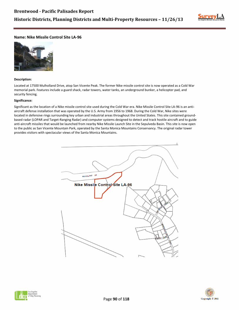
Brentwood - Pacific Palisades Report
Historic Districts, Planning Districts and Multi-Property Resources – 11/26/13
Page 90 of 118
Name: Nike Missile Control Site LA-96
Description:
Located at 17500 Mulholland Drive, atop San Vicente Peak. The former Nike missile control site is now operated as a Cold War memorial park. Features include a guard shack, radar towers, water tanks, an underground bunker, a helicopter pad, and security fencing.
Significance:
Significant as the location of a Nike missile control site used during the Cold War era. Nike Missile Control Site LA-96 is an anti-aircraft defense installation that was operated by the U.S. Army from 1956 to 1968. During the Cold War, Nike sites were located in defensive rings surrounding key urban and industrial areas throughout the United States. This site contained ground-based radar (LOPAR and Target-Ranging Radar) and computer systems designed to detect and track hostile aircraft and to guide anti-aircraft missiles that would be launched from nearby Nike Missile Launch Site in the Sepulveda Basin. This site is now open to the public as San Vicente Mountain Park, operated by the Santa Monica Mountains Conservancy. The original radar tower provides visitors with spectacular views of the Santa Monica Mountains.
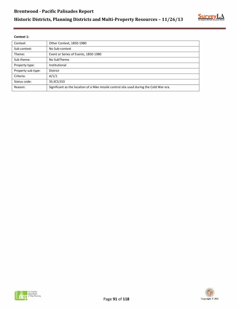
Brentwood - Pacific Palisades Report
Historic Districts, Planning Districts and Multi-Property Resources – 11/26/13
Page 91 of 118
Context 1:
Context: Other Context, 1850-1980
Sub context: No Sub-context
Theme: Event or Series of Events, 1850-1980
Sub theme: No SubTheme
Property type: Institutional
Property sub type: District
Criteria: A/1/1
Status code: 3S;3CS;5S3
Reason: Significant as the location of a Nike missile control site used during the Cold War era.

Brentwood - Pacific Palisades Report
Historic Districts, Planning Districts and Multi-Property Resources – 11/26/13
Page 92 of 118
Name: Pacific Palisades Bowl Mobile Estates
Description:
Palisades Bowl mobile home park is located at 16321 Pacific Coast Highway, overlooking the ocean in Pacific Palisades. The property contains approximately 170 mobile home sites, built at different times from 1954 to the present. Research indicates that the site also contains an office, a pool, a laundry, and a surface parking lot.
Significance:
Appears to be an excellent and rare example of a 1950s mobile home park in Pacific Palisades. Known as "Palisades Bowl," this mobile home park was established in 1954 as a rental community. Research suggests this site was operated as an auto camp as early as 1930, before becoming a mobile home park. In recent years, efforts have been made to convert the site to resident ownership. Over the years, the property has been threatened with redevelopment multiple times. The property is not fully visible from the public right-of-way; therefore, the evaluation could not be completed.

Brentwood - Pacific Palisades Report
Historic Districts, Planning Districts and Multi-Property Resources – 11/26/13
Page 93 of 118
Context 1:
Context: Other Context, 1850-1980
Sub context: No Sub-context
Theme: Design/Construction, 1850-1980
Sub theme: No SubTheme
Property type: Residential
Property sub type: District
Criteria: C/3/3
Status code: QQQ
Reason: Appears to be an excellent and rare example of a 1950s mobile home park in Pacific Palisades. However, the property is not fully visible from the public right-of-way; therefore, the evaluation could not be completed.

Brentwood - Pacific Palisades Report
Historic Districts, Planning Districts and Multi-Property Resources – 11/26/13
Page 94 of 118
Name: Palisades Elementary School
Description:
Located at 800 Via de la Paz, this property contains two original school buildings, including a two-story main building and a one-story classroom building attached by a breezeway. Both are designed in the Spanish Colonial Revival style. Features include hipped clay tile roofs, smooth stucco wall cladding, divided light wood framed windows, carved wooden doors, arched openings, and decorative tile details. The main building features a prominent three-story bell tower at the corner of Via de la Paz and Bowdoin Street.
Significance:
Excellent and rare example of LAUSD elementary school buildings in Pacific Palisades that pre-dates the 1933 Long Beach Earthquake; also, an excellent example of Spanish Colonial Revival institutional architecture.

Brentwood - Pacific Palisades Report
Historic Districts, Planning Districts and Multi-Property Resources – 11/26/13
Page 95 of 118
Context 1:
Context: Architecture and Engineering, 1850-1980
Sub context: No Sub-context
Theme: Mediterranean and Indigenous Revival Architecture, 1887-1952
Sub theme: Spanish Colonial Revival, 1915-1942
Property type: Institutional - Education
Property sub type: Campus - Elementary School
Criteria: C/3/3
Status code: 3S;3CS;5S3
Reason: Excellent example of Spanish Colonial Revival institutional architecture in Pacific Palisades.
Context 2:
Context: Public and Private Institutional Development, 1850-1980
Sub context: Education, 1876-1980
Theme: Public Schools and the LAUSD, 1876-1980
Sub theme: Pre-1933 Long Beach Earthquake, 1912-1933
Property type: Institutional - Education
Property sub type: Campus - Elementary School
Criteria: A/C; 1/3; 1/3
Status code: 3S;3CS;5S3
Reason: Excellent and rare example of LAUSD elementary school buildings in Pacific Palisades that pre-dates the 1933 Long Beach Earthquake.
Contributors/Non-Contributors:
Address: 800 N VIA DE LA PAZ
Type: Contributor
Year built: 1930
Property type/sub type: Institutional-Education; Elementary School
Architectural style: Spanish Colonial Revival
Address: 828 N VIA DE LA PAZ
Type: Contributor
Year built: 1930
Property type/sub type: Institutional-Education; Elementary School
Architectural style: Spanish Colonial Revival

Brentwood - Pacific Palisades Report
Historic Districts, Planning Districts and Multi-Property Resources – 11/26/13
Page 96 of 118
Name: Palisades High School
Description:
Located at 15777 Bowdoin Street, the campus contains numerous buildings constructed over time. The three main buildings, including two classroom buildings and an auditorium/gymnasium, are excellent examples of Mid-Century Modern institutional architecture with Expressionist details. Features include brick and stucco cladding, low-pitched folded plate roofs with wide overhanging eaves, arcades and balconies with slender steel supports, and steel-frame windows.
Significance:
Excellent example of Mid-Century Modern institutional architecture applied to a public high school. Palisades High School was established in 1961. While multiple buildings have been added over time, the three main buildings are original to the development and appear to be highly intact.

Brentwood - Pacific Palisades Report
Historic Districts, Planning Districts and Multi-Property Resources – 11/26/13
Page 97 of 118
Context 1:
Context: Architecture and Engineering, 1850-1980
Sub context: L.A. Modernism, 1919-1980
Theme: Post-War Modernism, 1946-1976
Sub theme: Mid-Century Modernism, 1945-1970
Property type: Institutional
Property sub type: No Sub-Type
Criteria: C/3/3
Status code: 3S;3CS;5S3
Reason: Excellent example of Mid-Century Modern institutional architecture applied to a public high school.

Brentwood - Pacific Palisades Report
Historic Districts, Planning Districts and Multi-Property Resources – 11/26/13
Page 98 of 118
Name: Paul Revere Charter Middle School
Description:
Located at 1450 Allenford Avenue, the school occupies an irregular-shaped parcel on the south side of Sunset Boulevard in Pacific Palisades. The original campus plan appears to be largely intact, with a number of one-story classroom buildings arranged among several landscaped and paved open patios. The classroom buildings feature shed roofs, stucco wall cladding, and divided-light wood-frame windows, and are connected by series of covered walkways with flat canopies supported by slender metal poles. The auditorium building is a large scale structure with poured concrete construction. Playing fields occupy the northernmost portion of the site, and surface parking lots run along the periphery. The property is not fully visible from the public right-of-way.
Significance:
Excellent example of a post-World War II Los Angeles Unified School District junior high school campus, reflecting LAUSD school planning and design concepts of the postwar period and the increase in facilities to accommodate postwar growth on the Westside of Los Angeles. Opened in 1955 as Palisades-Brentwoood Junior High School, the school was renamed Paul Revere Junior High within its first year. Originally serving grades 7-9, it became a charter middle school in 1994, now serving grades 6-8.

Brentwood - Pacific Palisades Report
Historic Districts, Planning Districts and Multi-Property Resources – 11/26/13
Page 99 of 118
Context 1:
Context: Public and Private Institutional Development, 1850-1980
Sub context: Education, 1876-1980
Theme: Public Schools and the LAUSD, 1876-1980
Sub theme: Post WWII Schools, 1946-1966
Property type: Institutional - Education
Property sub type: Middle School
Criteria: A/1/1&C/3/3
Status code: 3S;3CS;5S3
Reason: Excellent example of a post-World War II Los Angeles Unified School District elementary school campus, reflecting LAUSD school planning and design concepts of the postwar period and the increase in facilities to accommodate postwar growth on the Westside of Los Angeles.

Brentwood - Pacific Palisades Report
Historic Districts, Planning Districts and Multi-Property Resources – 11/26/13
Page 100 of 118
Name: Riviera Country Club
Description:
Located at 1250 Capri Drive, this property contains a Private golf and tennis club. Facilities include an 18-hole golf course, driving range, 26 tennis courts, fine dining venues, ballrooms, hotel rooms, and the original 1928 clubhouse. The property is surrounded by residences, with restricted access gates, it is not visible from the public right-of-way; therefore, the evaluation could not be completed.
Significance:
Significant as an early private country club in Pacific Palisades. The Riviera Country Club was first conceived in the early 1920s. The Los Angeles Athletic Club (LAAC) was in search of a site to develop a golf course and polo field, when local developer Alphonzo Bell offered the group land in Santa Monica Canyon, just south of Sunset Boulevard. Frank A. Garbutt, the head of the LAAC, joined Bell in putting together a syndicate to develop the new club and surrounding land. The golf course was designed by George C. Thomas, Jr. in 1927. The site was difficult, developed at a cost of over $200,000. At that time, it was the second most expensive course in the world. The natural features of the site were preserved as features of the course, including native trees, streams, and the barranca (ravine), which forms a natural hazard. The course fairways, which are covered with kikuyu grass, were re-planted after the 1938 flood. The clubhouse was designed by J. Bernard Richards and opened in 1928. Hollywood celebrities helped to promote the new club, including film stars Douglas Fairbanks and Mary Pickford. The Riviera Country Club began hosting the Los Angeles Open in 1929, and has hosted it ever since. The site also contains the Riviera Tennis Club. Founded in 1963, it is one of the oldest and largest tennis clubs in the western United States. This property appears to be an excellent example of an early-20th century country club in Los Angeles. However, it is not visible from the public right-of-way; therefore, the evaluation could not be completed.

Brentwood - Pacific Palisades Report
Historic Districts, Planning Districts and Multi-Property Resources – 11/26/13
Page 101 of 118
Context 1:
Context: Public and Private Institutional Development, 1850-1980
Sub context: Private Recreation, 1880-1980
Theme: Private Recreation Facilities, 1880-1980
Sub theme: Country Clubs, 1880-1980
Property type: Institutional - Recreation
Property sub type: Country Club
Criteria: A/1/1
Status code: QQQ
Reason: Riviera Country Club, established in 1927. The property appears to be an excellent example of an early-20th century country club in Los Angeles. However, it is not visible from the public right-of-way; therefore, the evaluation could not be completed.
Brentwood - Pacific Palisades Report
Historic Districts, Planning Districts and Multi-Property Resources – 11/26/13
Page 102 of 118
Context 2:
Context: Cultural Landscapes, 1875-1980
Sub context: Designed Landscapes, 1875-1980
Theme: Private Recreational Facilities, 1880-1980
Sub theme: Golf Courses, 1880-1980
Property type: Landscape
Property sub type: Golf Course
Criteria: C/3/3
Status code: QQQ
Reason: Riviera Country Club, a private golf course established in 1927. The property appears to be an excellent example of an early-20th century golf course in Los Angeles. However, it is not visible from the public right-of-way; therefore, the evaluation could not be completed.

Brentwood - Pacific Palisades Report
Historic Districts, Planning Districts and Multi-Property Resources – 11/26/13
Page 103 of 118
Name: Robert Taylor Ranch
Description:
Located at 3099 Mandeville Canyon Road, this property contains an approximately 100-acre estate. Only expansive lawns, a number of stable buildings, and the perimeter fence are visible from the public right-of-way.
Significance:
Research indicates that the property contains an excellent example of an early ranch estate in Brentwood. The Robert Taylor Ranch was originally designed for oil man Waite Phillips. Robert Taylor purchased the property in 1958 or 1959 and lived here until his death in 1969. Taylor's wife sold the ranch in 1972. The ranch property originally included a main residence designed in the Ranch style and attributed to master architect Robert Byrd, as well as horse stables and other outbuildings. A subsequent owner, Ken Roberts, renovated the ranch buildings around 1975, doubling the size of the main house to 12,000 sf, and converting the original stables into an office complex. According to real estate listings in 2012, the property also includes a pool, tennis court, and bridle paths, and five guest houses which are likely later additions. May be significant as an early and rare ranch property in Brentwood, and/or as the work of master architect Robert Byrd. However, property is not fully visible from the public right-of-way; therefore, the evaluation could not be completed.

Brentwood - Pacific Palisades Report
Historic Districts, Planning Districts and Multi-Property Resources – 11/26/13
Page 104 of 118
Context 1:
Context: Architecture and Engineering, 1850-1980
Sub context: No Sub-context
Theme: The Ranch House, 1930-1975
Sub theme: Traditional Custom Ranch House, 1930-1975
Property type: Residential
Property sub type: Single-Family Residence
Criteria: C/3/3
Status code: QQQ
Reason: Robert Taylor Ranch; may be significant as an early ranch estate in Brentwood, and/or as the work of master architect Robert Byrd. However, property is not fully visible from the public right-of-way; therefore, the evaluation could not be completed.

Brentwood - Pacific Palisades Report
Historic Districts, Planning Districts and Multi-Property Resources – 11/26/13
Page 105 of 118
Name: Self-Realization Fellowship, Lake Shrine
Description:
Located at 17190 Sunset Boulevard, the property comprises 10 acres on a hilltop overlooking the Pacific Ocean in Pacific Palisades. The property contains Santa Inez Lake, as well as extensive gardens, various monuments and memorials, museum/gift shop, windmill, Japanese junk, houseboat, and a three-story temple.
Significance:
Excellent and rare example of religious institutional development in Pacific Palisades; also, an excellent and unique example of a designed landscape. This site was originally part of the Inceville Film Studio, which opened in 1912. Production ceased in 1922 and most of the movie sets burned in a fire in 1924. The land became a sand and gravel quarry before being purchased by local developer Alphonzo Bell, who hydraulically graded the property for future development. However, the construction work activated several underground springs which caused the quarry to fill with water, forming what is now known as Lake Santa Inez, the only natural spring-fed lake in Los Angeles. The property sat vacant for more than a decade before being purchased in 1941 by Mr. and Mrs. H. Everett McElroy. McElroy was a set designer and assistant superintendent of construction of 20th Century Studios. The McElroys cleared the land and lake and terraced and landscaped the property. Using mostly found construction materials, they built a greenhouse, swinging bridge, mill house, and reproduction windmill. They also transported their Mississippi-style houseboat from Lake Mead and installed it on the lake. The McElroy's sold the property in the late 1940s, and it eventually passed to the Self-Realization Fellowship. The Fellowship constructed the Golden Lotus Archway, and officially dedicated the site on August 20, 1950. While most of the McElroy's improvements are extant, the Fellowship constructed multiple additions over time, including the Court of Religions, the Gandhi World Peace Memorial, and a museum/gift shop. A new 4,000 square foot temple was completed in 1996.

Brentwood - Pacific Palisades Report
Historic Districts, Planning Districts and Multi-Property Resources – 11/26/13
Page 106 of 118
Context 1:
Context: Public and Private Institutional Development, 1850-1980
Sub context: Religion and Spirituality, 1850-1980
Theme: Religious Property Types, 1850-1980
Sub theme: No SubTheme
Property type: Institutional - Religion/Spirituality
Property sub type: Religious Campus
Criteria: C/3/3
Status code: 3S;3CS;5S3
Reason: Excellent and rare example of religious institutional development in Pacific Palisades; long-time home of the Self-Realization Fellowship and Lake Shrine.

Brentwood - Pacific Palisades Report
Historic Districts, Planning Districts and Multi-Property Resources – 11/26/13
Page 107 of 118
Context 2:
Context: Other Context, 1850-1980
Sub context: No Sub-context
Theme: Design/Construction, 1850-1980
Sub theme: No SubTheme
Property type: Institutional
Property sub type: No Sub-Type
Criteria: C/3/3
Status code: 3S;3CS;5S3
Reason: Excellent and unique example of a designed landscape in Pacific Palisades.

Brentwood - Pacific Palisades Report
Historic Districts, Planning Districts and Multi-Property Resources – 11/26/13
Page 108 of 118
Name: 11901 Sunset Boulevard Garden Apartment
Description:
Early 1950s garden apartment complex composed of eleven two-story buildings oriented around a central landscaped courtyard. Buildings typically contain garages on the ground story with residential units above. Features include hipped roofs, vertical and horizontal wood siding, and divided light steel-framed windows.
Significance:
Appears to be an excellent and rare example of a garden apartment complex from the early 1950s in Brentwood. However, the property is not fully visible from the public right-of-way; therefore, the evaluation could not be completed.

Brentwood - Pacific Palisades Report
Historic Districts, Planning Districts and Multi-Property Resources – 11/26/13
Page 109 of 118
Context 1:
Context: Residential Development and Suburbanization, 1850-1980
Sub context: Multi-Family Residential Development, 1910-1980
Theme: Multi-Family Residential, 1910-1980
Sub theme: Garden Apartments, 1938-1960
Property type: Residential-Multi Family
Property sub type: Garden Apartment Complex
Criteria: C/3/3
Status code: QQQ
Reason: Appears to be an excellent and rare example of a garden apartment complex from the early 1950s in Brentwood. However, the property is not fully visible from the public right-of-way; therefore, the evaluation could not be completed.

Brentwood - Pacific Palisades Report
Historic Districts, Planning Districts and Multi-Property Resources – 11/26/13
Page 110 of 118
Name: Tahitian Terrace Mobile Home Park
Description:
Tahitian Terrace mobile home park is located at 16001 Pacific Coast Highway, overlooking the ocean in Pacific Palisades. The property contains approximately 156 mobile home sites, built at different times from 1961 to the present. Research indicates that the original post-and-beam recreation center building and pool are also extant.
Significance:
Appears to be an excellent and rare example of a 1960s mobile home park in Pacific Palisades. Tahitian Terrace was established in 1961, formally opening in June of 1962 as a rental community for seniors 55 and over. Today, the park offers mobile homes for purchase and all ages are welcome. Over the years, the property has been threatened with redevelopment multiple times. The property is not fully visible from the public right-of-way; therefore, the evaluation could not be completed.
Brentwood - Pacific Palisades Report
Historic Districts, Planning Districts and Multi-Property Resources – 11/26/13
Page 111 of 118
Context 1:
Context: Other Context, 1850-1980
Sub context: No Sub-context
Theme: Design/Construction, 1850-1980
Sub theme: No SubTheme
Property type: Residential
Property sub type: District
Criteria: C/3/3
Status code: QQQ
Reason: Appears to be an excellent and rare example of a 1960s mobile home park in Pacific Palisades. However, the property is not fully visible from the public right-of-way; therefore, the evaluation could not be completed.

Brentwood - Pacific Palisades Report
Historic Districts, Planning Districts and Multi-Property Resources – 11/26/13
Page 112 of 118
Name: The Riviera Residential Planning District
Description:
The Riviera Residential Planning District is an early 20th-century residential subdivision located in the eastern portion of Pacific Palisades. The planning district contains approximately 125 parcels. The district boundaries conform to those of the original 1924 and 1927 tracts, which are bounded generally by San Remo Drive to the east, Sunset Boulevard to the south, the properties on the west side of Monaco Drive and Amalfi Drive to the west, and Alta Mura Road to the north.
The district occupies a gently-sloping site at the base of the Santa Monica Mountains. Streets in the district are graded to follow the natural contours of the landscape and exhibit a curvilinear pattern, which forms irregularly-shaped blocks. Lots are generously sized, with some exceeding an acre. Development in the district is exclusively residential, containing large one- and two-story single-family houses. Original residences were constructed primarily from the mid-1920s through the 1950s and exhibit a range of Period Revival architectural styles that were popular at the time, including American Colonial, Spanish Colonial, and Tudor Revival, as well as some Ranch styles. Today, original residences share the block with more recent construction, some of which references the Period Revival styles of their early neighbors. Features of the district include wide curvilinear streets that follow the contours of the landscape, curbs and gutters faced with stone and granite, period streetlights, and the absence of sidewalks. A landscaped allée with two rows of mature palm trees runs the length of D’Este Drive, with a landscaped traffic island marking the western terminus of the street.
Significance:
The Riviera Residential Planning District is significant as an excellent example of residential suburban planning from the early automobile era in Pacific Palisades, as it comprises one of the community’s most important subdivisions. While the area does not retain sufficient integrity or cohesion to qualify as a historic district, it may warrant special consideration for local planning purposes.
In 1923, real estate developer Alphonzo Bell purchased 22,000 acres of unimproved land from the Santa Monica Land and Water Company and the Santa Monica Mountain Park Company. The purchase extended from Bel-Air west to the Pacific Ocean and included most of the land surrounding Pacific Palisades. Bell intended to subdivide the acreage into expansive upscale estates and felt that the area would be the ideal location to realize his plan of recreating the Italian Riviera. Bell had long been inspired by the climate and landscape of the Mediterranean, which resembled that of Southern California, and in early 1924 he traveled to Europe with his family to study the resorts and villages that dotted the Italian coastline. Later that same year, the Riviera tract was subdivided by the Riviera Corporation, a syndicate created by Bell and his partner, real estate John A. Vaughan, to oversee the development of the subdivision.
Bell’s plan for The Riviera called for an affluent suburb of “home estates” inspired by Italian and French architecture and accented with lush natural landscaping. Bell hired landscape architect Mark Daniels to plan the tract and design the landscape for the Riviera. Streets were designed to follow the natural contours of the site, with a landscaped allée flanked by palm trees extended the length of D’Este Drive to accommodate pedestrians and equestrians. Street names were chosen by Bell and his wife and were drawn from the family’s travels in Italy, France, and Spain. Neighborhood planning features were also inspired by concepts Bell discovered in Europe: “artistic electroliers” were fashioned after the lighting system found along the Riviera, and walkways, curbs, and driveways were faced with stone and granite to reduce traffic noise. Bell also purchased a nursery to provide trees and ornamental shrubbery for the subdivision, and Daniels spent over five months improving the property before it was opened to the public for inspection. Stringent deed restrictions, which were a hallmark of Bell’s residential developments, accompanied each lot.
While Bell was planning his new development, he was approached by the Los Angeles Athletic Club, which was searching for a

Brentwood - Pacific Palisades Report
Historic Districts, Planning Districts and Multi-Property Resources – 11/26/13
Page 113 of 118
site that would be large enough to accommodate a golf course and other sports facilities. The group had decided on a site in Santa Monica Canyon, which was near the site of the planned Riviera tract and planted with lemon trees. Realizing how attractive a nearby country club would be to potential homeowners, after several years of negotiations Bell agreed to sell the land to the Los Angeles Athletic Club at a deeply discounted price and the Riviera Country Club was officially opened in 1927.
With the development of the country club, Bell planned an expansion of The Riviera to the northwest, subdivided in 1927 as Tract No. 9313. Along with the extension of Sunset Boulevard, The Riviera sooner become a highly desirable residential enclave, attracting many Hollywood celebrities and other affluent Angelenos who appreciated the proximity to both the beach and the Riviera Country Club, a trend which continues to this day.
Despite its significance, the Riviera does not possess sufficient integrity to qualify as a historic district. Many of the district’s original residences have undergone some degree of alteration or have been replaced with newer construction, which has compromised the cohesion and integrity of the district as a whole. However, the district remains unified by shared planning features which convey a strong sense of time and place. Features include period streetlights, stone and granite curbs and gutters, the absence of sidewalks, a landscaped median and islands, and a general consistency of scale and massing. All of these features contribute to the overall feeling of an early Pacific Palisades automobile suburb. For these reasons, this area may warrant special consideration for local planning purposes.

Brentwood - Pacific Palisades Report
Historic Districts, Planning Districts and Multi-Property Resources – 11/26/13
Page 114 of 118
Context 1:
Context: Residential Development and Suburbanization, 1850-1980
Sub context: No Sub-context
Theme: Automobile Suburbanization, 1908-1937
Sub theme: Suburban Planning and Development, 1908-1937
Property type: Automobile Suburb
Property sub type: Subdivision
Criteria: A/1/1
Status code: 6LQ
Reason: Significant as an excellent example of residential suburban planning from the early automobile era in Pacific Palisades. While the area does not retain sufficient integrity or cohesion to qualify as a historic district, it may warrant special consideration for local planning purposes.

Brentwood - Pacific Palisades Report
Historic Districts, Planning Districts and Multi-Property Resources – 11/26/13
Page 115 of 118
Name: Villa Ruchello
Description:
Located at 609 East Channel Road, this property contains a large Mediterranean style villa occupying a 3.3 acre hillside lot. Architectural features include white stucco cladding, red clay tile roof, wood windows and doors in arched openings, an arcade with a vaulted ceiling, balconies, wrought iron ornamentation, decorative chimney caps, and terrazzo paving. Additional features of the site include a detached servants' quarters, a gate house set at the street, and extensive gardens. A pool, cabana building, greenhouse, and detached garage were added by a subsequent owner. On the street, the property displays a series of brick piers, and elaborate wrought iron entrance gates with lettering which reads "Villa Ruchello", and large decorative lanterns. The main residence is set at the rear of the lot and is not fully visible from the public right-of-way.
Significance:
Research indicates that the property contains an excellent example of Mediterranean Revival residential architecture in Pacific Palisades. This large residential estate was constructed in 1932 for insurance executive, Harold P. Cooper. Cooper named the estate Villa Ruchello (alternately "Villa del Ruscello"), which is Italian for "villa of the stream." The main residence was designed by noted English architect J. Thomas Payne in the Mediterranean style. Cooper resided here until 1975 when he sold the property. However, the property is not fully visible from the public right-of-way; therefore, the evaluation could not be completed.

Brentwood - Pacific Palisades Report
Historic Districts, Planning Districts and Multi-Property Resources – 11/26/13
Page 116 of 118
Context 1:
Context: Architecture and Engineering, 1850-1980
Sub context: No Sub-context
Theme: Mediterranean and Indigenous Revival Architecture, 1887-1952
Sub theme: Mediterranean Revival, 1887-1942
Property type: Residential
Property sub type: No Sub-Type
Criteria: C/3/3
Status code: QQQ
Reason: Research indicates that the property contains an excellent example of Mediterranean Revival residential architecture by noted English architect J. Thomas Payne. However, the property is not fully visible from the public right-of-way; therefore, the evaluation could not be completed.

Brentwood - Pacific Palisades Report
Historic Districts, Planning Districts and Multi-Property Resources – 11/26/13
Page 117 of 118
Name: Will Rogers Ranch
Description:
Ranch property located at 1501 Will Rogers Park Road. Research indicates that the property contains the ranch house, stables, corrals, riding ring, roping arena, polo field, golf course, and hiking trails.
Significance:
Estate of actor and humorist Will Rogers. Rogers purchased property in the Santa Monica Mountains in 1921 in order to establish a private ranch. Eventually, he would own 186 acres overlooking the ocean in what is now Pacific Palisades. The ranch consisted of a 31-room ranch house, a stable, corrals, riding ring, roping arena, polo field, golf course, and hiking trails. Rogers lived here with his family until his untimely death in a plane crash in 1935. His widow, Betty, died in 1944, at which time the ranch became a state park. The ranch house was listed in the National Register in 1971. The property is not visible from the public right-of-way; therefore, the evaluation could not be completed.

Brentwood - Pacific Palisades Report
Historic Districts, Planning Districts and Multi-Property Resources – 11/26/13
Page 118 of 118
Context 1:
Context: Entertainment Industry, 1908-1980
Sub context: No Sub-context
Theme: Residential Properties Associated with the Entertainment Industry, 1908-1980
Sub theme: Residential Properties Associated with Significant Persons in the Entertainment Industry, 1908-1980
Property type: Residential
Property sub type: Single-Family Residence
Criteria: B/2/2
Status code: QQQ
Reason: Estate of actor and humorist Will Rogers. The property is not fully visible from the public right-of-way; therefore, the evaluation could not be completed.