Embed Size (px)
Citation preview
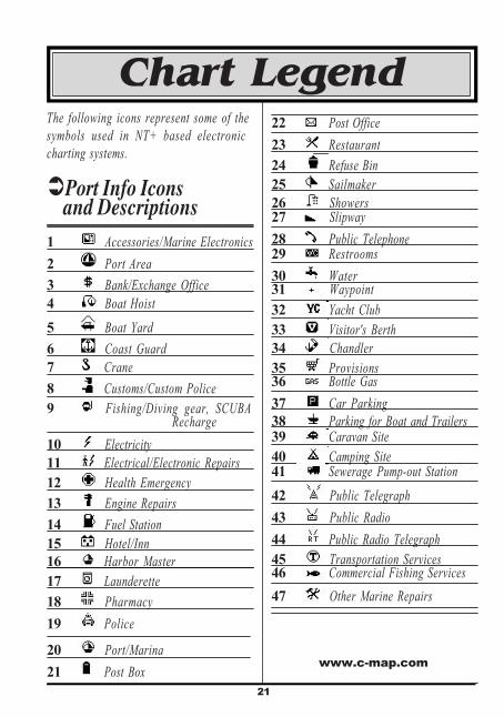
22
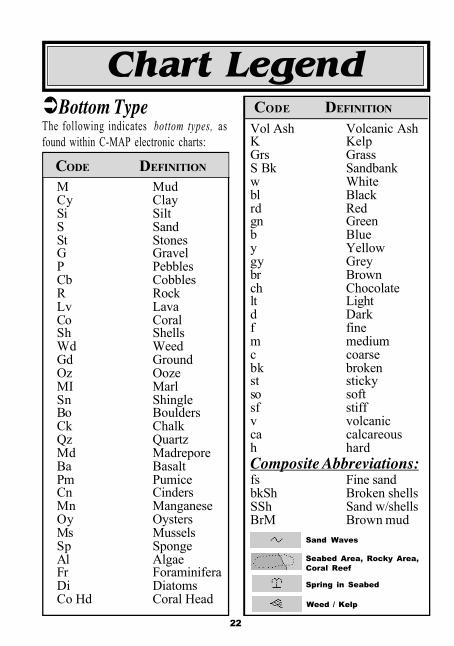
ÜBottom TypeThe following indicates bottom types, asfound within C-MAP electronic charts:
CODE DEFINITION
Vol Ash Volcanic AshK KelpGrs GrassS Bk Sandbankw Whitebl Blackrd Redgn Greenb Bluey Yellowgy Greybr Brownch Chocolatelt Lightd Darkf finem mediumc coarsebk brokenst stickyso softsf stiffv volcanicca calcareoush hardComposite Abbreviations:fs Fine sandbkSh Broken shellsSSh Sand w/shellsBrM Brown mud
Sand Waves
Seabed Area, Rocky Area,Coral Reef
Spring in Seabed
M MudCy ClaySi SiltS SandSt StonesG GravelP PebblesCb CobblesR RockLv LavaCo CoralSh ShellsWd WeedGd GroundOz OozeMI MarlSn ShingleBo BouldersCk ChalkQz QuartzMd MadreporeBa BasaltPm PumiceCn CindersMn ManganeseOy OystersMs MusselsSp SpongeAl AlgaeFr ForaminiferaDi DiatomsCo Hd Coral Head
CODE DEFINITION
Weed / Kelp
Chart Legend
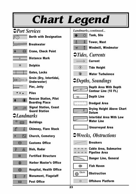
23
Chart LegendTank, Silo
Tower, MastWindmill, Windmotor
ÜTides, Currents
Landmarks, continued...
ÜWrecks, Obstructions
ÜDepths, Soundings
Breakers
Cable Area, SubmarinePipeline Area
Danger Line, General
Fish Haven
Obstruction
Offshore Platform
Depth Area With DepthContour Line (10 Ft.)Depth Line
Dredged AreaDrying Height Above ChartDatumIntertidal Area With LowWater Line
Unsurveyed Area
Current
Tide Height
Water Turbulence
Customs Office
Hospital, Health Office
Monument, Flagstaff
ÜPort ServicesBerth with Designation
Breakwater
Pier, Jetty
Rescue Station, PilotBoarding PlaceSignal Station, CoastGuard Station
ÜLandmarksBuildings
Chimney, Flare Stack
Church, Cemetery
Dish, Radar
Fortified Structure
Harbor Master’s Office
Post Office
Crane, Check Point
Distance Mark
Dolphin
Gates, LocksGroin (Dry, Intertidal,Underwater)
Piles
24
Chart Legend
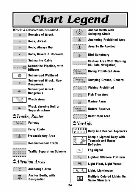
ÜNavAidsBuoy And Beacon Topmarks
Sample Lighted Buoy withTopmark and RadarReflectorFog Signal
Lighted Offshore Platform
Light Float, Light Vessel
Light, Lighthouse
Multiple Colored Lights OnSame Structure
Anchoring Prohibited Area
Anchor Berth withSwinging Circle
Area To Be Avoided
Bird Sanctuary
Caution Area With WarningRE: Safe Navigation)
Diving Prohibited Area
Dumping Ground, General
Fishing Prohibited
Fish Trap Area
Marine Farm
Nature Reserve
Restricted Area
Wrecks & Obstructions, continued...
Anchor Berth, withDesignation
Remains of Wreck
Rock, Awash
Rock, Always Dry
Rock, Covers & Uncovers
Submarine CableSubmarine Pipeline, withDiffuser
Submerged WellheadSubmerged Wreck, Non-DangerousSubmerged Wreck,Dangerous
Wreck Area
Wreck showing Hull orSuperstructure
ÜTracks, RoutesFairway
Ferry Route
Precautionary Area
Recommended Track
Traffic Separation Scheme
ÜAttention AreasAnchorage Area
25
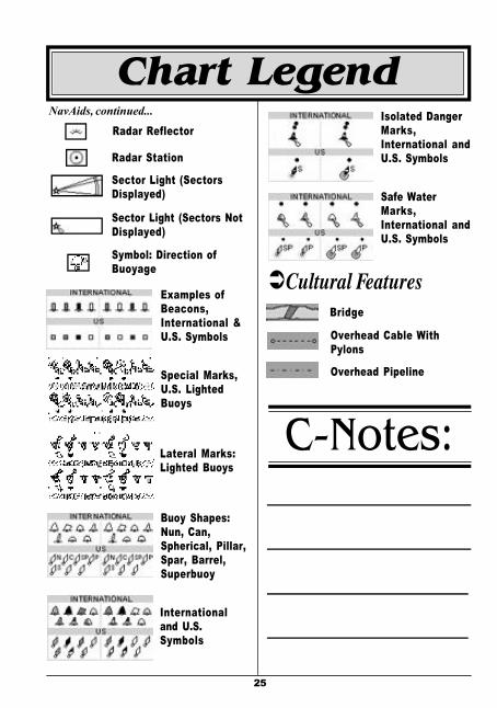
Isolated DangerMarks,International andU.S. Symbols
ÜCultural Features
Overhead Cable WithPylons
Overhead Pipeline
Safe WaterMarks,International andU.S. Symbols
Bridge
Radar ReflectorNavAids, continued...
Radar Station
Sector Light (SectorsDisplayed)
Sector Light (Sectors NotDisplayed)
Buoy Shapes:Nun, Can,Spherical, Pillar,Spar, Barrel,Superbuoy
Internationaland U.S.Symbols
Examples ofBeacons,International &U.S. Symbols
Lateral Marks:Lighted Buoys
Symbol: Direction ofBuoyage
Special Marks,U.S. LightedBuoys
C-Notes:
Chart Legend
![VFR AERONAUTICAL NAVIGATION CHART LEGEND AE… · AERONAUTICAL PT. INDOAVIS NUSANTARA Geo-informatics and Aeronautical Information Services. CHART LEGEND [25 Oct 2009] II-10 4.1 4.1](https://img.dokumen.tips/doc/110x75/60bd09c472c56d5ffc214633/vfr-aeronautical-navigation-chart-legend-ae-aeronautical-pt-indoavis-nusantara.jpg)