Embed Size (px)
Citation preview
1
Boreal Forested Glacial Ablation Plain Biophysical Setting
Interior Alaska
Conservation Status Rank: S4 (apparently secure)
Introduction
Forested glacial ablation plains are represented by mature trees and associated understory species growing
in a periglacial environment on ice-cored deposits. Through various geomorphic processes, glaciers may
accumulate rock, gravel and sand on their upper surfaces. Where this debris reaches a depth sufficient to
insulate roots, plants may colonize and a vegetated glacial ablation plain may develop (Figure 1). Areas
that are not subject to continual erosion or deposition of material will usually exhibit greater soil
development and in Alaska may eventually support mature conifer forests (USFS 2004). In boreal
ecoregions, seres occurring in this unique environment transition from pioneer Hedysarum alpinum-
Chamerion latifolium (alpine sweetvetch-dwarf fireweed) associations to mid-seral stands of Populus
balsamifera to mature Picea glauca-Betula neoalaskana forests (Figure 2; Molnia 2006, Rampton 1970,
Birks 1980). Additional study is required to evaluate whether these plant associations support unique
vegetation, rare plants, and/or wildlife habitat. Many of the ice-cored ablation plains may last 550 years,
ample time to allow forests to mature and even for secondary succession to occur (Rampton 1970, Birks
1980). However, in a rapidly warming climate, the melt processes that have produced these stable ablation
plains become a liability to their existence (Tarr and Martin 1914).
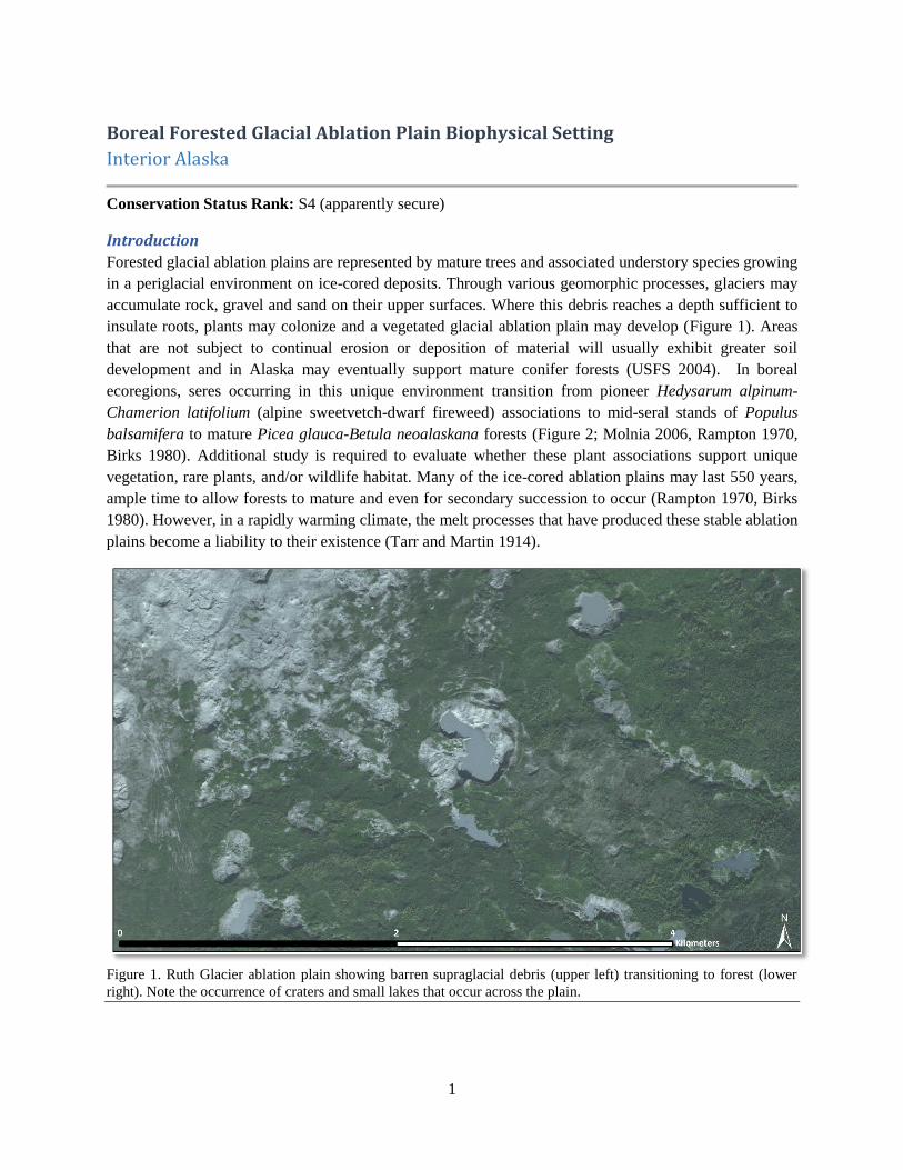
Figure 1. Ruth Glacier ablation plain showing barren supraglacial debris (upper left) transitioning to forest (lower
right). Note the occurrence of craters and small lakes that occur across the plain.
2
Distribution
Mature forests dominated or codominated by Picea glauca and Betula neoalaskana on ablation plains are
rare and occur as isolated pockets on the lower elevations of glaciers in the Alaska Range, Chugach
Mountains, Wrangell Mountains, and the St. Elias Mountains of the Yukon Territory, Canada. Younger
seral-stages occur on additional ablation plains, and are more common than the mature forests.
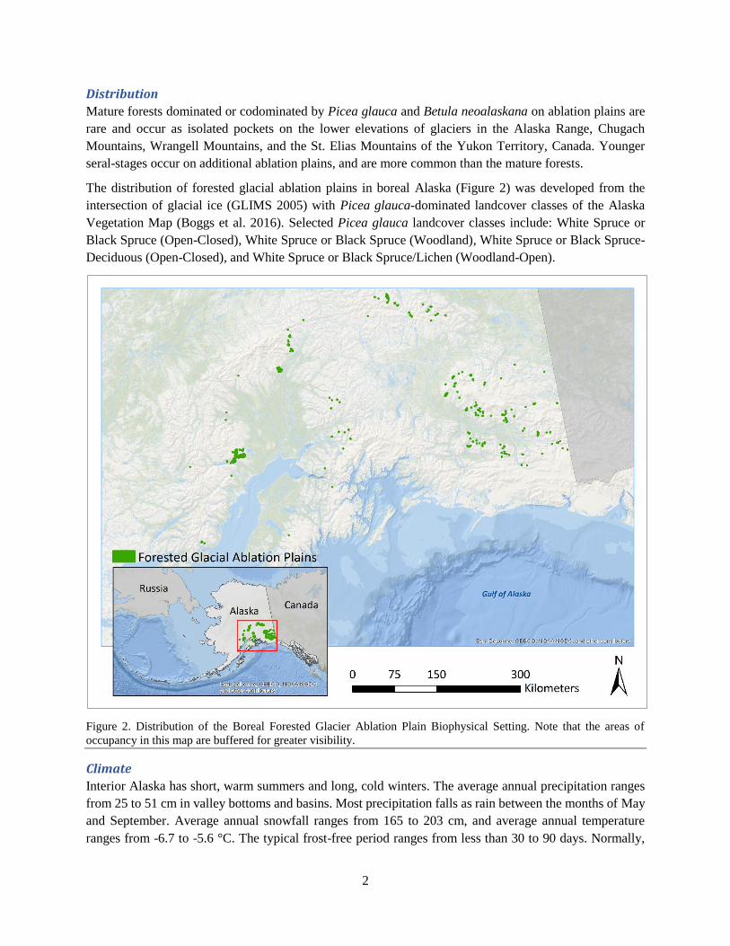
The distribution of forested glacial ablation plains in boreal Alaska (Figure 2) was developed from the
intersection of glacial ice (GLIMS 2005) with Picea glauca-dominated landcover classes of the Alaska
Vegetation Map (Boggs et al. 2016). Selected Picea glauca landcover classes include: White Spruce or
Black Spruce (Open-Closed), White Spruce or Black Spruce (Woodland), White Spruce or Black Spruce-
Deciduous (Open-Closed), and White Spruce or Black Spruce/Lichen (Woodland-Open).
Figure 2. Distribution of the Boreal Forested Glacier Ablation Plain Biophysical Setting. Note that the areas of
occupancy in this map are buffered for greater visibility.
Climate
Interior Alaska has short, warm summers and long, cold winters. The average annual precipitation ranges
from 25 to 51 cm in valley bottoms and basins. Most precipitation falls as rain between the months of May
and September. Average annual snowfall ranges from 165 to 203 cm, and average annual temperature
ranges from -6.7 to -5.6 °C. The typical frost-free period ranges from less than 30 to 90 days. Normally,
3
the temperature remains above freezing in river valleys and basins from mid-June through August (Moore
et al. 2004).
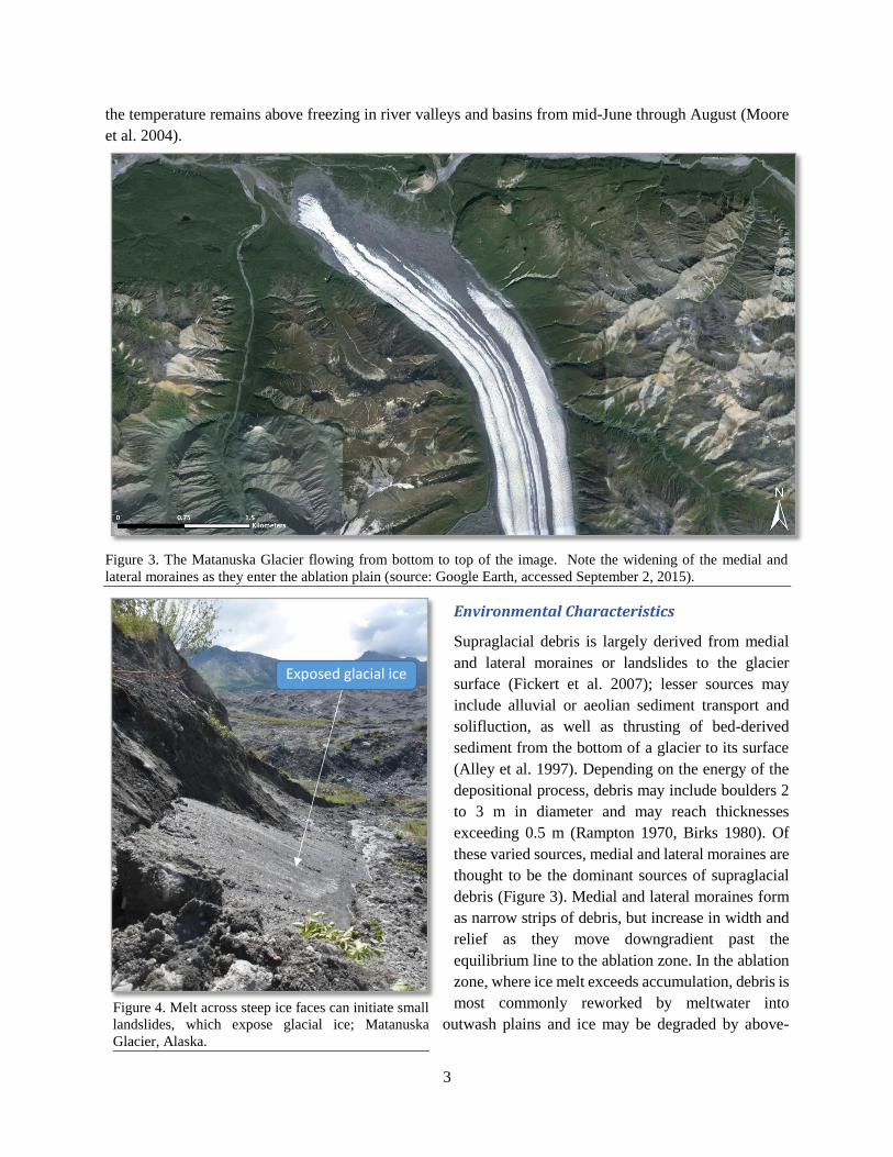
Figure 3. The Matanuska Glacier flowing from bottom to top of the image. Note the widening of the medial and
lateral moraines as they enter the ablation plain (source: Google Earth, accessed September 2, 2015).
Environmental Characteristics
Supraglacial debris is largely derived from medial
and lateral moraines or landslides to the glacier
surface (Fickert et al. 2007); lesser sources may
include alluvial or aeolian sediment transport and
solifluction, as well as thrusting of bed-derived
sediment from the bottom of a glacier to its surface
(Alley et al. 1997). Depending on the energy of the
depositional process, debris may include boulders 2
to 3 m in diameter and may reach thicknesses
exceeding 0.5 m (Rampton 1970, Birks 1980). Of
these varied sources, medial and lateral moraines are
thought to be the dominant sources of supraglacial
debris (Figure 3). Medial and lateral moraines form
as narrow strips of debris, but increase in width and
relief as they move downgradient past the
equilibrium line to the ablation zone. In the ablation
zone, where ice melt exceeds accumulation, debris is
most commonly reworked by meltwater into
outwash plains and ice may be degraded by above-Figure 4. Melt across steep ice faces can initiate small
landslides, which expose glacial ice; Matanuska
Glacier, Alaska.
Exposed glacial ice
4
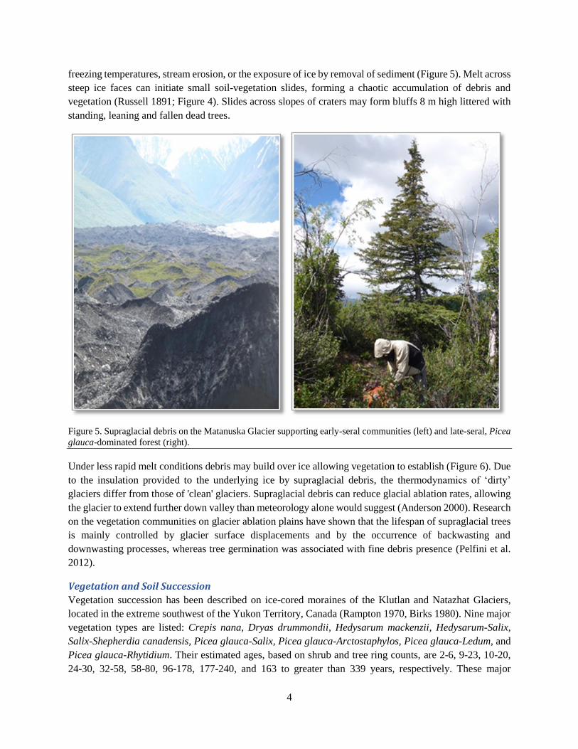
freezing temperatures, stream erosion, or the exposure of ice by removal of sediment (Figure 5). Melt across
steep ice faces can initiate small soil-vegetation slides, forming a chaotic accumulation of debris and
vegetation (Russell 1891; Figure 4). Slides across slopes of craters may form bluffs 8 m high littered with
standing, leaning and fallen dead trees.
Figure 5. Supraglacial debris on the Matanuska Glacier supporting early-seral communities (left) and late-seral, Picea
glauca-dominated forest (right).
Under less rapid melt conditions debris may build over ice allowing vegetation to establish (Figure 6). Due
to the insulation provided to the underlying ice by supraglacial debris, the thermodynamics of ‘dirty’
glaciers differ from those of 'clean' glaciers. Supraglacial debris can reduce glacial ablation rates, allowing
the glacier to extend further down valley than meteorology alone would suggest (Anderson 2000). Research
on the vegetation communities on glacier ablation plains have shown that the lifespan of supraglacial trees
is mainly controlled by glacier surface displacements and by the occurrence of backwasting and
downwasting processes, whereas tree germination was associated with fine debris presence (Pelfini et al.
2012).
Vegetation and Soil Succession
Vegetation succession has been described on ice-cored moraines of the Klutlan and Natazhat Glaciers,
located in the extreme southwest of the Yukon Territory, Canada (Rampton 1970, Birks 1980). Nine major
vegetation types are listed: Crepis nana, Dryas drummondii, Hedysarum mackenzii, Hedysarum-Salix,
Salix-Shepherdia canadensis, Picea glauca-Salix, Picea glauca-Arctostaphylos, Picea glauca-Ledum, and
Picea glauca-Rhytidium. Their estimated ages, based on shrub and tree ring counts, are 2-6, 9-23, 10-20,
24-30, 32-58, 58-80, 96-178, 177-240, and 163 to greater than 339 years, respectively. These major

5
vegetation types reflect a succession of vegetation related to moraine age and stability, with the Crepis nana
type invading the youngest, most disturbed moraines and the Picea glauca-Rhytidium type occupying the
oldest, most stable moraines. Soil development and humus accumulation parallel assembly of the plant
community. Soil nutrient levels are poor and nitrogen available to plants is primarily from atmospheric
based nitrogen (N2). A symbiotic relationship between actinobacteria Frankia and known N2-fixing plant
species including those from the genera Alnus, Dryas, Hedysarum, and Sheperdia facilitate nitrogen uptake
by early colonizing plants (Matthews 1992; Kohls et al. 2003).
During a field visit in July 2014 by the authors to the ablation plain of the Matanuska Glacier, a similar
chronosequence was observed and sampled. Here, the youngest sites are pioneered by Hedysarum alpinum-
Chamerion latifolium with a mixture of young Salix niphoclada and Populus trichocarpa (Figure 6).
Common pioneer bryophytes are Ceratodon purpureus and Leptobryum pyriforme. The substrate is
comprised of rock, sand and silt with a pH of 7.7 at 10 cm depth and no evidence of soil development.
Older sites support 1 to 2 m tall Populus trichocarpa, Salix niphoclada, and Salix alaskana over Hedysarum
alpinum and Chamerion latifolium, or Alnus viridis ssp. fruticosa. The bryophyte Ceratodon purpureus
persists in occurrence with Sanionia uncinata and Brachythecium albicans with the foliose lichen, Peltigera
canina is also present. Soil development is minimal, multiple surface cracks expose glacial ice and initiate
the slumping of soil and vegetation.
The oldest sites sampled supported mature Picea glauca-Betula neoalaskana forests 25 m in height with
20-30% cover and an understory of Salix glauca, Alnus viridis ssp. fruticosa, Shepherdia canadensis and
Linnaea borealis (Figure 6); Brachythecium albicans is the most common bryophyte. The forest soil had a
4 cm organic layer over a 10 cm thick B horizon comprised of 5% rock and 95% sand, with a pH of 6.7 at
10 cm depth. Here, soil cracks and active side slope slumps indicate the active melt of ground ice. Substrate
disturbance caused by subsurface melting creates a dynamic, early-seral vegetation community that
transitions to a more stable ablation plain with soil development.
Conservation Status
Rarity: Mature forests dominated by Picea glauca or Betula neoalaskana rarely develop on glacial ablation
plains and are only documented from five periglacial environments in Interior Alaska. Their estimated area
of occupancy is less than 7 km2.
Threats: Change in glacier movement threatens this system. In a rapidly warming climate, the melt
processes that have produced these stable ablation plains become a liability to their further existence (Tarr
and Martin 1914, Stephens 1969). In contrast, it is unclear as to whether advancing glaciers would support
an ablation plain stable enough to allow the development of forests.
Trend: Ice-cored ablation plains are estimated to last well beyond the time required for forests to mature
and even for secondary forest succession to occur (600 years; Rampton 1970, Birks 1980). Thus in the
absence of significant glacier recession or advance, change in the extent and condition of this system in not
expected. It is not known how increased ablation rates due to a warming climate will affect the maintenance
of this system.

6
Species of Conservation Concern
No animal or plant species of conservation concern are known or suspected to occur within this biophysical
setting. Additional study is required to evaluate whether this biophysical setting supports species of
conservation concern.
Plant Associations of Conservation Concern
No plant associations of conservation concern are known or suspected to occur within this biophysical
setting. Additional study is required to evaluate whether this biophysical setting supports plant associations
of conservation concern.
Classification Concept Source
The classification concept for this biophysical setting is based on Russell (1891).
Literature Cited
Alley, R. B., K. M. Cuffey, E. B. Evenson, J. C. Strasser, D. E. Lawson, and G. J. Larson. 1997. How
glaciers entrain and transport basal sediment: Physical constraints. Quat. Sci. Rev. 16:1017 – 1038, doi:
10.1016/S0277-3791(97)00034-6
Anderson, R. S. 2000. A model of ablation-dominated medial moraines and the generation of debris-
mantled glacier snouts: Journal of Glaciology Volume 46:459-469.
Birks, H. J. B. 1980. The present flora and vegetation of the moraines of the Klutlan Glacier, Yukon
Territory, Canada: a study in plant succession. Quaternary Research 14:60-86.
Figure 6. Supraglacial debris on the Matanuska Glacier supporting early-seral Hedysarum alpinum-Chamerion
latifolium plant association (left) and a late-seral Picea glauca/Salix forest association (right).

7
Boggs, K., T. V. Boucher, T. T. Kuo, D. Fehringer, and S. Guyer. 2016. Vegetation map and classification:
Northern, western and interior Alaska. Alaska Center for Conservation Science, University of Alaska
Anchorage, Anchorage, Alaska.
Fickert, T., D. Friend, F. Grüninger, B. Molnia, and M. Richter. 2007. Did Debris-Covered Glaciers Serve
as Pleistocene Refugia for Plants? A New Hypothesis Derived from Observations of Recent Plant
Growth on Glacier Surfaces. Arctic, Antarctic, and Alpine Research 39:245-257.
GLIMS (Global Land Ice Measurements from Space) and National Snow and Ice Data Center. 2005,
updated 2012. GLIMS Glacier Database, Version 1. [subset 40]. Boulder, Colorado USA. NSIDC:
National Snow and Ice Data Center. doi: http://dx.doi.org/10.7265/N5V98602. [accessed February
2016].
Kohls, S. J., D.D. Baker, C. van Kessel, J.O. Dawson. 2003. An assessment of soil enrichment by
actinorhizal N2 fixation using δ15N values in a chronosequence of deglaciation at Glacier Bay, Alaska.
Plant and Soil 254:11-17.
Matthews, J.A. 1992. The ecology of recently-deglaciated terrain. Cambridge University Press. 386 pp.
Molnia, B. F., 2006. Satellite Image atlas of the glaciers of the world. Alaska. U.S. Geological Survey
Professional Paper 1386-K, 750 pp.
NRCS 2004. Land resource regions and major land resource areas of Alaska. United States Department of
Agriculture – Natural Resources Conservation Service. Palmer, Alaska.
Pelfini, M., M. Santilli, G. Leonelli, M. Bozzoni. 2007. Investigating surface movements of debris-covered
Miage glacier, Western Italian Alps, using dendroglaciological analysis. Journal of Glaciology. 53
(180): 141-152.
Pelfini, M, G. Leonelli, M. Bozzoni, G. Diolaiuti, N. Bressan, D. Brioschi and A. Riccardi. 2012. The
influence of glacier surface processes on the short-term evolution of supraglacial tree vegetation: The
case study of the Miage Glacier, Italian Alps. The Holocene. 22 (8): 847-856.
Rampton, V. 1970. Neoglacial fluctuations of the Natazhat and Klutlan Glaciers, Yukon Territory, Canada.
Canadian Journal of Earth Sciences 7:1236-1263.
Russell, I. C. 1891. An expedition to Mount St. Elias. National Geographic Magazine 3:53-191.
Tarr, R. S., and L. Martin. 1914. Alaskan Glacier Studies. Washington, D.C.: National Geographic Society.
498 pp.
U.S. Forest Service. 2004. East Copper River Delta Landscape Assessment. Cordova Ranger District.
Chugach National Forest. 182 pp.