Embed Size (px)
Citation preview

BEDFORD COUNTY PLANNING COMMISSION AGENDA
Jefferson Forest High School Auditorium Forest, Va.
Tuesday, September 17, 2019 7:00 p.m. – Regular meeting
1. Approval of Agenda
2. Approval of Minutes
3. Citizen Comment Period
4. Public Hearings:
a) Special Use Permit SU200001 Chris Langley
Perrowville Townhomes
b) Zoning Ordinance Text Amendment Creation of an Airport “A” District
c) Rezoning application RZ200002 Bedford County Board of Supervisors Reclassification of properties from (AP) Agricultural/Rural Preserve & (R-1) Low Density Residential Districts to (A) Airport District
5. Old Business 6. New Business Appeals of Zoning Administrator decisions
to Bedford County Board of Zoning Appeals (a) Appeal AP200001 Liberty University
(b) Appeal AP200002 Liberty University
7. Adjourn

PLANNING COMMISSION
MINUTES
DRAFT
04/16/19 1 Planning Commission Minutes
BEDFORD COUNTY PLANNING COMMISSION MINUTES 1 April 16, 2019 2
3 The Planning Commission held a regular meeting Tuesday, April 16, 2019 in the Bedford 4 County Administration Building Boardroom with all Commissioners present with the exception 5 of Mr. Dawson and Mr. Mays. The Planning Commissioner seat for Election District 4 is 6 currently vacant. County staff present was Mr. Patrick Skelley, County Attorney, Mr. Gregg 7 Zody, Director of Community Development, Mr. Mark Jordan, Planner and Mrs. Patricia 8 Robinson, Administrative Manager. 9 10 Mr. Burdett called the meeting to order and determined a quorum was present to conduct 11 business. He asked if there were any additions, changes or deletions to the agenda. Mr. Zody 12 requested Item 6a under New Business be removed from the agenda. There being no additional 13 changes, Mr. Steele made a motion to approve the agenda as amended. Mr. Huff seconded the 14 motion. The motion carried with a vote of 4-0. 15 16 Mr. Burdett moved to Item 2 Approval of Minutes and asked if there were any changes to the 17 minutes of March 19, 2019. Mr. Steele requested the second occurrence of “Mr. Steele” be 18 changed to “Mr. Dawson” on page 1 line 24. Mr. Burdett requested the second occurrence of 19 “6,” on page 2 line 58 be verified and changed to the applicable lot number. There being no 20 additional changes Mr. Steele made a motion to approve the minutes as amended. Mr. Huff 21 seconded the motion. The motion carried with a vote of 4-0. 22 23 Mr. Burdett moved to Item 3 Citizen Comment Period and asked if there were any citizens to 24 speak regarding items not on the agenda. There being none Mr. Burdett closed the Citizen 25 Comment Period. 26 27 Mr. Burdett moved to Item 4a under Public Hearings and asked for the staff presentation for 28 Special Use Permit SU190003 for a Commercial Kennel. Mr. Mark Jordan stated the applicants 29 and owners of the subject property are Riverside Farms, LLC (Dr. Lora Ryan and Gerald Ryan), 30 7050 E. Lynchburg Salem Turnpike, Goode, VA. The authorized agent and engineer is Rodney 31 Pierson, Pierson Engineering and Surveying, 44 Catawba Road, Daleville, VA. The subject 32 property is located at 7140 and 7050 E. Lynchburg Salem Turnpike, Goode, VA, identified as 33 Tax Map 150-3-B and in Election District 2. The parcel consists of 33.25 acres. 34 35 Riverside Farms, LLC is requesting a special use permit for the expansion of an existing 36 Commercial Kennel. The request is for an additional 40’ x 70’ (2,800 sq. ft.) kennel building 37 containing twenty (20) runs. The applicant does not propose to change the zoning of the 38 property but requests approval of an amended special use permit to allow for the expansion of an 39 existing commercial kennel. A commercial kennel requires approval of a special use permit 40 (SUP) in the Agricultural Residential (AR) district. The property contains an existing veterinary 41 clinic (Riverside Veterinary Clinic), along with an existing kennel building with kennel runs, an 42 existing water therapy building, and associated parking. The current owners received approval 43 for a special use permit (SU060017) for a commercial kennel from the Bedford County Board of 44 Supervisors on June 12, 2006. Mr. Jordan offered to address any questions from the Planning 45 Commissioners. There were no questions from the Planning Commissioners. 46

DRAFT
04/16/19 2 Planning Commission Minutes
47 Mr. Burdett asked for the applicant’s presentation. Mr. Gerald Ryan of 7140 E. Lynchburg 48 Salem Turnpike Goode, Va. stated staff had explained the request thoroughly. 49 50 Questions/comments from the Commissioners to Mr. Ryan covered the following: (a) distance 51 of new kennel to the north west property line, (b) what is a kennel silencer and how does it work, 52 (c) will you use the same type of silencer or try a new type for the proposed expansion of the 53 kennel, (d) have you ever had any complaints about the dogs barking from the neighbors and (e) 54 is the new building totally enclosed? 55 56 Mr. Ryan addressed the questions from the Planning Commissioners as they were asked. 57 58 Mr. Burdett asked if there were any citizens to speaking regarding the proposed application. 59 David E. and Angela Tarr 126 East Otter Ridge Drive Goode, Va. and Mike Grishaw 1305 Bells 60 Mill Road Goode, Va. spoke regarding the proposed application. 61 62 The concerns raised were: (a) we can hear the dogs barking now when we are outside, (b) 63 addition of 20 more runs may increase the noise and be more than I am comfortable with, (c) can 64 you require a barrier of trees be planted if the silencer doesn’t work, (d) live across the river from 65 the kennel and can hear the dogs barking, (e) silencer is not working, (f) recommend an indoor 66 kennel if in a residential area, (g) noise from the dogs barking is increasing, (h) existing kennel is 67 on my side of his house on the river which draws the noise, (i) recommend the applicant check 68 into a new type of silencer, (j) are the dogs being fed inside or outside and (k) consider the 69 neighbors around the kennel. 70 71 Mr. Burdett asked Mr. Ryan if he would like to offer any rebuttal to the concerns raised by the 72 speakers. Mr. Ryan stated no. 73 74 The following issues/questions were asked by the Planning Commissioners to Mr. Ryan: (a) is 75 the applicant willing to address the concerns raised by the speakers, (b) could some trees be 76 planted as a buffer, (c) can a condition be placed on the application regarding a buffer and (d) are 77 the dogs inside the majority of the time? 78 79 Mr. Ryan stated he would check into a new type of silencer and determine if it would be more 80 effective than the one he uses now and determine if more than one silencer is needed. Mr. Ryan 81 stated he would be willing to plant more trees. He noted the dogs are fed outside in the morning 82 and inside in the evenings. The dogs are usually outdoors between 8:00 am – 4:00 pm weather 83 permitting. 84 85 Mr. Burdett closed the public hearing and asked for Planning Commission discussion and/or 86 action. The following comments/items were discussed by the Commissioners: (a) don’t think 87 the issue of the noise has been resolved, (b) will the applicant be willing to try other things later 88 if the silencers don’t work, (c) it will take more than trees to deal with the noise, (d) does the 89 existing hospital building block the noise from the expansion and (e) place a condition for a 90 buffer of trees and ask that you research other silencers. 91 92

DRAFT
04/16/19 3 Planning Commission Minutes
County Planner Mark Jordan noted there are alternative types of silencers. Mr. Burdett asked 93 how staff would want to be informed of the findings of Mr. Ryan’s research regarding the 94 silencers. How would staff enforce this condition? 95 96
Mr. Steele made a motion to recommend to the Board of Supervisors approval of 97 Special Use Permit SU190003 with the staff conditions and the additional condition 98 that a vegetative barrier be installed around the three open sides of the facility and 99 the owner investigate alternative and more effective kennel silencers. Mr. 100 Woodford seconded the motion. A roll call was taken. The motion carried with a 101 vote of 4-0. 102 103
Mr. Burdett moved to Item 5 Old Business. There was no Old Business. 104 105 Mr. Burdett moved to Item 6 New Business. Mr. Zody noted there may be a joint meeting with 106 the Board of Supervisors on May 21, 2019 for public hearings regarding towers for the 107 Broadband Authority. He noted he would keep the Planning Commissioners informed once a 108 decision has been reached. 109 110 There being no additional business Mr. Burdett called for motion to adjourn. Mr. 111 Woodford made a motion to adjourn. Mr. Steele seconded the motion. The motion carried 112 with a vote of 4-0. The meeting adjourned at 7:44 pm. 113 114 Respectfully submitted, 115 116 117 __________________________________ 118 Gregg Zody, Secretary 119 120 Approved by: 121 122 123 ___________________________________ 124 Jeff Burdett, Acting Chairman 125 126

DRAFT
05/21/19 1 Planning Commission Minutes
BEDFORD COUNTY PLANNING COMMISSION MINUTES 1 May 21, 2019 2
3 The Planning Commission held a regular meeting Tuesday, May 21, 2019 in the Bedford County 4 Administration Building Boardroom with all Commissioners present with the exception of Mr. 5 Mays. Mr. Dawson participated in the meeting remotely. The Planning Commissioner seat for 6 Election District 4 is currently vacant. County staff present was Mr. Patrick Skelley, County 7 Attorney, Mr. Jordan Mitchell, Mrs. Mariel Fowler, Planners and Mrs. Patricia Robinson, 8 Administrative Manager. 9 10 Mr. Burdett called the meeting to order and determined a quorum was present to conduct 11 business. He asked if there were any additions, changes or deletions to the agenda. There 12 being none, Mr. Huff made a motion to approve the agenda as presented. Mr. Steele seconded 13 the motion. The motion carried with a vote of 5-0. 14 15 Mr. Burdett moved to Item 3 Citizen Comment Period and asked if there were any citizens to 16 speak regarding items not on the agenda. There being none Mr. Burdett closed the Citizen 17 Comment Period. 18 19
Mr. Burdett moved to Item 3a under Public Hearings and asked for the staff presentation for 20 Special Use Permit SU190005 for a Wireless Communication Facility (Class 4). Mrs. Mariel 21 Fowler stated the property owner is the Saunders Volunteer Fire Company, Inc., P.O. Box 14, 22 Huddleston, Virginia 24104. The applicant is Verizon Wireless, c/o Stephen Waller, AICP, 8159 23 Cancun Court, Gainesville, Virginia 20155. The authorized agent for the applicant is Lori 24 Schweller, 321 East Main Street, Suite 400, Charlottesville, Virginia, 22902. The engineer for 25 the applicant is Tectonic Engineering Consultants, Inc. c/o Graham Evans, PE, 8639 Mayland 26 Drive, Suite 102, Richmond, Virginia, 23294. Tax Map #243-9-1 is located at 12253 Smith 27 Mountain Lake Parkway (Route 626) and accessible from this road. The property is 4.98 acres in 28 size according to County records and the application, located in Election District 2 and is zoned 29 PCD (Planned Commercial Development district). The request is for approval of a special use 30 permit to allow for the construction (galvanized steel) of a 195-foot above ground level (“AGL”) 31 monopole tower (“Wireless Communications Facility, Class IV” use) with a 4-foot lighting rod. 32 The proposed tower will be located within a 60’ x 75’ lease area on Tax Map #243-9-1 and have 33 twelve (12) panel antennas and associated components mounted on three sectors (stand-off 34 antenna mount). Verizon has identified the tower site as “part of a larger project that is geared 35 toward expanding Verizon’s network of services into areas of Bedford County that currently 36 have low to marginal levels of wireless coverage, while also providing additional wireless 37 network capacity by offloading the strains on existing sites that are currently overstressed with 38 data traffic”. The tower compound area (55’ x 45’) will be surrounded by a minimum of six (6) 39 foot tall chain link fence with a reverse-angled anti-climbing device spanned by vertically 40 separated strands of barbed wire at its top to prevent unauthorized entry into the compound area. 41 Verizon will place all ground equipment utilized for the co-location in the compound area with 42 space available for equipment and shelters for future co-locations, as there is capacity for three 43 additional wireless providers to co-locate on the tower. Verizon is proposing to install a 10-foot 44 wide landscaping buffer made up of a row of evergreen trees added to the eastern, southern, and 45 western sides of the compound for the purpose of screening the ground equipment from off-site 46

DRAFT
05/21/19 2 Planning Commission Minutes
views. Verizon will be using a 20-foot wide access and utility easement from Route 626 to enter 47 the site. 48
49
Mr. Burdett noted he failed to mention at the beginning of the public hearing that he works for 50 the Mariners Landing Water and Sewer Company. He noted they own the current easement of 51 which Verizon has requested the removal of part of that. He noted the Mariners Landing Water 52 and Sewer Company along with the Bedford Regional Water Authority (BRWA) are working 53 with Verizon on that issue. Mr. Burdett stated he does not view this as a conflict of interest since 54 Verizon has made changes requested by BRWA. 55
There were no questions from the Planning Commission to Mrs. Fowler. 56
57 Mr. Burdett asked for the applicant’s presentation. Mrs. Lori Schweller , Attorney with Williams 58 Mullen 321 East Main St. Suite 400 Charlottesville, VA 22902 spoke on behalf of Verizon. 59 Mrs. Schweller noted also present is Stephen Waller of GDN Sites a consultant for Verizon. She 60 provided an overview of the proposed request to include the need in the area for better cell 61 service, concept plan, balloon test locations, fall zones and proposed landscaping. The tower is 62 most visible on Off Shore Dr. and at the intersection of Deer Trail Dr. and Smith Mountain Lake 63 Parkway. A new site is required since Verizon is already located on two vertical structures 64 located within 2 miles and there are no additional collocations available. 65 66 Questions/comments from the Commissioners to Mrs. Schweller covered the following: (a) is 67 the proposed tower and the other two towers referenced going to have 5G capability and (b) 68 ensure the relocation of the easement for the tank is connected as it should be. 69 70 Mrs. Schweller noted they will have 4G capability initially. 5G currently in Verizon as well as 71 other carriers is intended to provide a shorter distance of service. It is typically put on small 72 poles, existing light or power poles and does not propagate nearly as far as the earlier 73 generations. It is more appropriate for more dense urban areas. 74 75 Mr. Burdett asked if there were any citizens to speaking regarding the proposed application. 76 There being no speakers Mr. Burdett closed the public hearing and asked for Planning 77 Commission discussion and/or action. 78 79
Mr. Steele made a motion to recommend to the Board of Supervisors approval of 80 Special Use Permit SU190005 with the staff conditions as presented. Mr. 81 Woodford seconded the motion. A roll call was taken. The motion carried with a 82 vote of 5-0. 83
84 Mr. Burdett moved to Item 3b under Public Hearings and asked for the staff presentation for 85 Special Use Permit SU190006 for a Wireless Communication Facility (Class 2). Mrs. Fowler 86 stated the property owner is the Saunders Volunteer Fire Company, Inc., 16538 Smith Mountain 87 Lake Parkway, Huddleston, Virginia 24104. The applicant is Verizon Wireless, c/o Isaac 88 Gonzales, 1813 Rady Court, Richmond, Virginia 23222. The authorized agent for the applicant 89 is Stephen Waller, AICP, 8159 Cancun Court, Gainesville, Virginia 20155. The engineer for the 90 applicant is Tectonic Engineering Consultants, Inc. c/o Graham Evans, PE, 8639 Mayland Drive, 91

DRAFT
05/21/19 3 Planning Commission Minutes
Suite 102, Richmond, Virginia, 23294. Tax Map #257-A-19A is located at 16538 Smith 92 Mountain Lake Parkway (Route 626) with direct access from this road, south of the intersection 93 with Anthony Home Road (private road). The property is 0.57 acres in size according to County 94 records and the application. The property is located in Election District 2 and zoned R-1(Low 95 Density Residential district). The request is for approval of a special use permit to allow for the 96 construction (galvanized steel) of a 80-foot above ground level (“AGL”) monopole tower 97 (“Wireless Communications Facility, Class 2” use) with a 4-foot lighting rod. The proposed 98 tower will be located within a 60’ x 60’ lease area on Tax Map #257-A-19A and have twelve 99 (12) panel antennas and associated components mounted on three sectors (stand-off antenna 100 mount). Verizon has identified the tower site as “part of a larger project that is geared toward 101 expanding Verizon’s network of services into areas of Bedford County that currently have low to 102 marginal levels of wireless coverage, while also providing additional wireless network capacity 103 by offloading the strains on existing sites that are currently overstressed with data traffic”. The 104 tower compound area (40’ x 40’) will be surrounded by a minimum of six (6) foot tall chain link 105 fence with a reverse-angled anti-climbing device spanned by vertically separated strands of 106 barbed wire at its top to prevent unauthorized entry into the compound area. Verizon will place 107 all ground equipment utilized for the co-location in the compound area with space available for 108 equipment and shelters for future co-locations, as there is capacity for one additional wireless 109 provider to co-locate on the tower. The proposed facility is located within a wooded area that 110 will be maintained to the eastern and southern sides of the compound. Verizon is proposing to 111 install an additional row of evergreen trees added to the northern and western sides of the 112 compound for the purpose of screening the ground equipment and lower portions of the tower 113 from off-site views. Verizon will be using a new 20-foot wide access and utility easement from 114 Route 626 to enter the site. 115 116 Questions from the Planning Commission to Mrs. Fowler covered the following: (a) site plan 117 reflects 60’x 60’ 3600 SF lease area and inside that area it reflects a proposed 40’ x 40’ 1600 SF 118 lease area – is the 1600 SF lease area contained within the fence. Mrs. Fowler stated yes. 119 120 Mrs. Fowler read into the record an email she received from Mr. Billy Overstreet dated 05-18-121 19. Mr. Overstreet was unable to attend the meeting. The email stated concerns or questions he 122 had regarding to the proposed request. 123 124 Mr. Burdett asked for the applicant’s presentation. Mrs. Lori Schweller, Attorney with Williams 125 Mullen 321 East Main St. Suite 400 Charlottesville, VA 22902 spoke on behalf of Verizon. 126 Mrs. Schweller noted also present is Stephen Waller of GDN Sites a consultant for Verizon. She 127 provided an overview of the proposed request to include the need in the area for better cell 128 service, concept plan, balloon test locations, fall zones and proposed landscaping. This tower 129 will service the citizens in this area of the lake as well as the marinas. The proposed area has 130 the most wooded coverage which will help to screen this short monopole from the surrounding 131 residences. There is a strong need for capacity in this area due to heavy usage by the residents, 132 marinas and lake traffic. The closest Verizon sites are 2.27 to 6.78 miles away and the proposed 133 site is in the middle of the existing towers within this area. 134 135 Questions from the Planning Commission to Mrs. Schweller covered the following: (a) are there 136 other carriers proposed for the tower, (b) what do you emit per channel, (c) was there a 137

DRAFT
05/21/19 4 Planning Commission Minutes
possibility of installing a 195’ tower in an area not in a subdivision that would give you the same 138 coverage possibly in an agricultural area and (d) do taller poles provide a better radius. 139 140 There was a brief discussion between Commissioner Dawson and Mr. George Condyles of 141 Atlantic Technology Consultants regarding how much to be emitted per channel. Verizon 142 representatives noted they are not RF engineers and could not address the question. 143 144 Mr. Burdett asked if there were any citizens to speaking regarding the proposed application. 145 Virginia N. Saunders 16518 Smith Mountain Lake Parkway Huddleston, VA 24104 spoke at the 146 meeting. Comments or concerns raised by Ms. Saunders as well as those expressed in the email 147 from Mr. Billy Overstreet covered the following: (a) how much of the tree line will be removed, 148 (b) how long will construction take, (c) will you put shrubberies around my property, (d) if no 149 shrubberies are placed around my property we will see lights 24/7, (e) if tower were to fall and 150 not collapse would it block our access road, (f) what is the strength and direction of RF in 151 relation to my home and the neighborhood, (g) long term health effects of exposure to the RF 152 generated and (h) how this will affect resale value of properties in the area. 153 154 Mrs. Schweller addressed the comment/concerns raised by the citizens. She noted the tower site 155 is 250 ft northeast from Mr. Overstreet’s property. There is heavy wooded buffer on both his 156 and the subject parcel so the visibility will be minimal if any. Mrs. Schweller referenced to 157 articles in the Wall Street Journal and a study in the Richmond, Va. regarding how cell towers 158 may or may not affect property values. RF energy is around us all the time whether or not there 159 is a cell tower near your home. Verizon complies with all regulatory requirements and RF 160 emission limitations. Health effects are covered by the Federal agencies. Mrs. Schweller stated 161 if Mr. Overstreet were a Verizon wireless customer or customer of another carrier collocating on 162 the tower there would be no reason why it should not benefit him. Currently there are no other 163 carriers proposed for this tower. Steven Waller noted two other sites were looked at for the tower 164 and provided information regarding why they were not used. He noted the two owners chose not 165 to have a tower located on their sites. 166 167 Mr. Burdett asked if Mrs. Schweller chose to offer any rebuttal to the concerns raised. She noted 168 we are not planning to clear any more than necessary. There will plantings on the side where 169 there is no coverage. Verizon is agreeable to take the landscaping all the way around the 10’ 170 buffer so there would be landscaping between the ground and the bottom of the pine trees. The 171 meeting packet included the engineer’s letter which explains how this monopole would buckle in 172 the event of high winds/ice. The monopole would fall within the boundaries of the property on 173 which it is located. Construction time is anticipated to be 4 – 6 weeks and the monopole will not 174 be lit at all since the site will not have a building. Verizon now uses a stand which will not 175 require any lights. Mrs. Schweller stated Verizon would accept a condition from the Planning 176 Commission regarding the trees being planted all around the site. 177 178 Mr. Burdett closed the public hearing and asked for Planning Commission discussion and/or 179 action. 180 181
Mr. Steele made a motion to recommend to the Board of Supervisors approval of 182 Special Use Permit SU190006 with the staff conditions as presented with the 183

DRAFT
05/21/19 5 Planning Commission Minutes
additional condition that the remaining two sides of the perimeter area be vegetated. 184 Mr. Woodford seconded the motion. A roll call was taken. The motion carried 185 with a vote of 5-0. 186
187 Mr. Burdett moved to Item 3c under Public Hearings and asked for the staff presentation for 188 Special Review Project SRP190001 for broadband internet. Mr. Jordan Mitchell stated the Code 189 of Virginia § 15.2-2232 and Section 30-23 of the Bedford County zoning ordinance require 190 localities to confirm that proposed public projects not shown in the adopted Comprehensive Plan 191 be reviewed by the Planning Commission to determine if the facility is in conformance with the 192 Plan. Bedford County [Broadband Authority] has requested a determination for whether an 193 eleven (11) site system of ten (10) new towers and one (1) collocation on an existing tower for 194 the purpose of broadband deployment in Bedford County is “substantially in accord with the 195 adopted Comprehensive Plan” of Bedford County. 196 197 Bedford County is seeking a determination of substantial conformance with the Comprehensive 198 Plan (the Plan) for the construction ten (10) new tower sites and one (1) collocation on an 199 existing tower for the deployment of broadband internet throughout the County. The Broadband 200 Authority has worked since 2009 to find a solution to provide broadband internet to 201 underserved/un-served areas of Bedford County. The eleven (11) site system of tower 202 infrastructure as a partnership with Blue Ridge Towers will be able to provide countywide 203 broadband internet access. The locations of these towers are on tax maps 17A3-126-4, 17A3-204 126-5, 55-A-16A, 127B-1-17, 152-A-41C, 15-A-47D, 244-A-11A, 123-A-39C, 208-A-29, 173-205 A-142 and 63-A-62A. These towers will be owned by Bedford County and Blue Ridge Towers 206 will be the provider. 207 208 Questions from the Planning Commission to Mr. Mitchell covered the following: (a) are these 209 monopoles and (b) is this all of the towers. 210 211 Mr. Mitchell noted 10 new towers are to be constructed and 1 collocation on an existing tower. 212 213 Mr. Burdett asked if there were any citizens to speak regarding this application. There being 214 none Mr. Burdett closed the public hearing and asked for Planning Commission discussion 215 and/or action. 216 217
Mr. Steele made a motion that the Planning Commission finds Special Review 218 Project SRP190001 in compliance with the Comprehensive Plan. Mr. Woodford 219 seconded the motion. A roll call was taken. The motion carried with a vote of 5-0. 220
221 Mr. Mitchell stated this application is not required to be approved by the Board of Supervisors. 222 The project will now move into the site plan stage for review by staff. 223 224 Mr. Burdett moved to Item 4 Old Business. There was no Old Business. 225 226 Mr. Burdett moved to Item 5 New Business. There was no New Business. 227 228

DRAFT
05/21/19 6 Planning Commission Minutes
There being no additional business Mr. Burdett called for motion to adjourn. Mr. Huff 229 made a motion to adjourn. Mr. Woodford seconded the motion. The motion carried with a 230 vote of 5-0. The meeting adjourned at 8:10 pm. 231 232 Respectfully submitted, 233 234 235 __________________________________ 236 Gregg Zody, Secretary 237 238 Approved by: 239 240 241 ___________________________________ 242 Jeff Burdett, Acting Chairman 243 244

Special Use Permit
SU200001
Perrowville Townhomes
Presenter: Jordan Mitchell 540-586-7616 ext 1393
540-586-2059 (fax) [email protected]

1
MEMORANDUM TO: Planning Commission
FROM: Jordan Mitchell, Planner DATE: August 29, 2019 SUBJECT: Special Use Permit #SU200001: Perrowville Townhomes SYNOPSIS
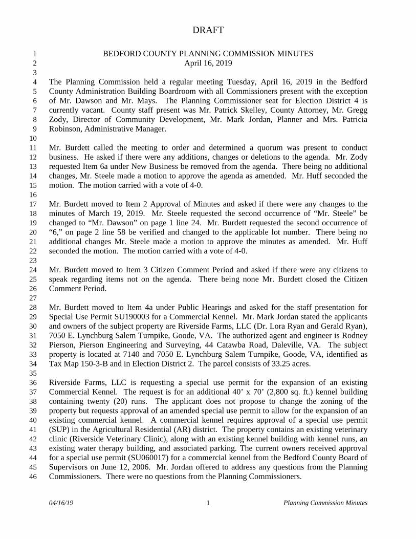
Chris Langley is requesting a special use permit for Tax Map Number 99-A-4A for the purpose of constructing 53 townhomes. The property is located in Election District #4.
BACKGROUND
Applicant/Property Owner The applicant is Chris Langley, 102 Oakley Avenue, Lynchburg, Virginia 24501. The property owner of the subject parcel is Linda Clark, 68126 Edgewater Beach Road, White Pigeon, Michigan 49099. Authorized Agent/Engineer The authorized agent for the applicant is Norman Walton, 317 Brook Park Place, Forest, Virginia 24551. Location Tax Map Number 99-A-4A is located across the street from the TEVA Pharmaceuticals Building (addressed as 2150 Perrowville Road) and adjacent to 2065 Perrowville Road. According to the concept plan and County records, the property is 8.6 acres in size. Proposed Change The applicant has requested a special use permit for the purpose of constructing 53 townhomes (“Townhouse” use) on Tax Map Number 99-A-4A. ANALYSIS
Zoning/Land Use Compatibility
The property (Tax Map #99-A-4A) is zoned R-2 (Medium Density Residential district) and is undeveloped. The surrounding properties (within a 1 mile radius) are zoned AR (Agricultural Residential district), R-1 (Low Density Residential district), R-2, PRD (Planned Residential Development district); PCD (Planned Commercial Development district); PID (Planned Industrial Development district); I-1 (Low-Intensity Industrial district). The uses of neighboring properties include residential (single-family), a clubhouse (amenity of the Farmington development), TEVA pharmaceutical, or remain undeveloped.

2
Generally, a “Townhouse” use may be compatible with the R-2 zoning district and surrounding area given that a special use permit with applicable general standards (S*) is required to establish the use in the zoning district. In addition to general standards, conditions can be placed on a special use permit to mitigate adverse impacts to aid the proposed use’s compatibility with the surrounding area. Zoning Ordinance The proposed use is classified as “Townhouse” which is permitted in the R-2 zoning district with the approval of a special use permit with general use standards (S*). The use definition from Article II (Definitions) reads:
TOWNHOUSE – A grouping of three (3) or more attached single-family dwellings in a row in which each unit has its own front and rear access to the outside, no unit is located over another unit, and each unit is separated from any other unit by one (1) or more common walls.
Section 30-82-14 in Article IV of the Zoning Ordinance contains the use and design standards for a “Townhouse” use (attached). The applicant will need to meet all of the use and design standards for the use. Comprehensive Plan The 2025 Bedford County Comprehensive Plan contains goals, objectives, and strategies that relate to the special use request:
Community Character, Design and Aesthetics A Preservation of the scenic beauty, pastoral character, and historic resources of the County
3.6 Planned residential and commercial development that is compatible with adjacent and surrounding neighborhoods.
Housing A Variety of safe, sanitary and affordable housing for all County residents
4.1 A variety of dwelling units in all price ranges
4.3 Housing development that provides a safe, sanitary and desirable places to live
Land Use An orderly, efficient, and compatible growth and land use pattern that is sensitive to the natural environment
9.1 Future development directed to areas already or proposed to be served with adequate public facilities that is compatible with and sensitive to the natural environment

3
The proposed development is planned in an area that has public water and sewer available to the property. The surrounding area around the site has various different types of housing (townhouses, apartments, single-family attached, single-family detached) as well as commercial and industrial uses. Project Impacts
This project has been reviewed by County agencies and the following information reflects their comments: Environmental Erosion and sediment control measures and stormwater management regulations will apply to the development of the site. Stormwater permit will be required if 1 acre or more will be disturbed. Land disturbing permit (LDP) will be needed if 10,000 square feet or greater is disturbed and/or within 200 feet of a body of water. Transportation A traffic narrative has been submitted to the County and VDOT for review. The proposed development of 53 townhouses will result in 482 peak hour trips (61% in one direction and 39% in the other). Right and left turn lanes are analyzed per VDOT’s access management guidelines. The proposed development will not require turn lanes or tapers per the traffic narrative. VDOT has reviewed the traffic narrative and determined that a Chapter 527 Traffic Impact Analysis will not be required for the development. Roadway improvements related to the project will be reviewed and determined at the site plan stage of this project should the special use permit be approved. Utilities The property is served by public water and sewer from the Bedford Regional Water Authority. Public Facilities Forest Middle School (post expansion) and Jefferson Forest High School have capacity to handle the additional development. However, Forest Elementary School is closed to all zone transfers and recently several neighborhoods were zoned out of the school in order to get out of the mobile classrooms. The School Board is currently studying an elementary facility report that addresses some of these issues. Possible solutions could include expansion of the existing school or construction of another school in the Forest area. Aesthetic/Visual The development will be visible to all adjoining properties and to those travelling along Perrowville Road. However, nearby uses of property are similar (portions of the adjoining Farmington Development have been developed with townhouses and apartments) or have higher intensity uses on them (Industrial & Commercial Uses).

4
CONDITIONS In accordance with Section 30-19-3 (C) of the Zoning Ordinance, the Board of Supervisors may attach (and Planning Commission may recommend) any conditions necessary to ensure the proposal meets the specific and general standards for the proposed use. The following conditions are recommended by staff:
1. Section 30-82-14 General Standards shall apply in perpetuity until the “Townhouse” use has been discontinued.
2. Any proposed lighting associated with the “Townhouse” use shall be directed downward and away from adjoining properties.
3. Large evergreen trees shall be planted in accordance with Section 30-92-4(C) in a 20 foot buffer yard along all property lines adjoining “Single Family, Detached” uses.
ATTACHMENTS 1. Location Map 2. Zoning Map 3. Future Land Use Map 4. Aerial Photograph (2018) 5. Special Use Permit Application 6. Concept Plan 7. Section 30-41, R-1 Low Density Residential District 8. Section 30-82-14, “Townhouse”, General Standards

FOREST RD 221PERROW
VILLE RD 663
HOOPER RD 662
IVY LAKE DR 1262
TY BLUFF RD 1263
FARM
INGTO
N DR
1276
MAY
S MILL
RD 662
DEERVIEW DR
LEJACK CIR 1279
IVY LAKE DR GROVEL
AND DR
CHESTNU
T GRO
VE DR
SHAKER LN
ROUTE 9969 9969
LEANDER DR 1292
HELMSDALE DR 1259
MAJESTIC VIEW LN
CEDARWOOD CT
RILEY RUN RD 1347
VIEW
POIN
T LN
CEDA
RBER
RY L
N
MILL DAM LN
GLADDEN CIR 646
IVY WEST CT 1261
OVE
RLAK
E AV
E
BREWINGTON DR 1237
CORPORATE PARK DR 930
HARBOROUGH DR 1284
DAYN
A CT
127
8
ELKRIDGE DR 1045
CARTERS STABLE RD
GREENBROOK CT 1229
IVY WOODS DR 1271
SCHOLA
R LN 90
67
Location Map

PERROWVILLE RD 663
FARMINGTON DR 1276
HELMSDALE DR 1259
HARBOROUGH DR 1284
CALLIE DR
GLADE S
PRIN
GS BLV
D 1258
BREWINGTON DR 1237
MADISON VIEW
DR
COMMONWEALTH CIR
DAYN
A CT
127
8
CASL
EY W
AY
PID
R-2
PRD
R-2
Zoning Map

RESIDENTIAL
INDUSTRIAL
PERROWVILLE RD 663
FARMINGTON DR 1276
HELMSDALE DR 1259
HARBOROUGH DR 1284
CALLIE DR
GLADE S
PRIN
GS BLV
D 1258
BREWINGTON DR 1237
MADISON VIEW
DR
COMMONWEALTH CIR
DAYN
A CT
127
8
CASL
EY W
AY
Future Land Use Map

PERROWVILLE RD 663
FARMINGTON DR 1276
HELMSDALE DR 1259
HARBOROUGH DR 1284
CALLIE DR
GLADE S
PRIN
GS BLV
D 1258
BREWINGTON DR 1237
MADISON VIEW
DR
COMMONWEALTH CIR
DAYN
A CT
127
8
CASL
EY W
AY
Virginia Geographic Information Network (VGIN)
Aerial Photograph (2018 VGIN)


© 2019 Microsoft Corporation © 2019 HERE
1
COVER SHEET
CHRIS LANGLEY
EMAIL: [email protected]
17 W. NELSON STREET
PHONE: 540-464-9001 FAX: 540-464-5009
PHONE: 434-525-5985 FAX: 434-525-5986
317 BROOK PARK PLACE
LEXINGTON, VIRGINIA 24450
FOREST, VIRGINIA 24551
BEDFORD, VA
PERROWVILLE ROAD
SPECIAL USE PERMIT FOR
TOWNHOUSES
19230 3
VICINITY MAP - NOT TO SCALE
1500 100
GRAPHIC SCALE
1"=100'

2
BOUNDARY
CHRIS LANGLEY
EMAIL: [email protected]
17 W. NELSON STREET
PHONE: 540-464-9001 FAX: 540-464-5009
PHONE: 434-525-5985 FAX: 434-525-5986
317 BROOK PARK PLACE
LEXINGTON, VIRGINIA 24450
FOREST, VIRGINIA 24551
BEDFORD, VA
PERROWVILLE ROAD
SPECIAL USE PERMIT FOR
TOWNHOUSES
19230 3
3000 150
GRAPHIC SCALE
1"=150'

3
UTILITIES
CHRIS LANGLEY
EMAIL: [email protected]
17 W. NELSON STREET
PHONE: 540-464-9001 FAX: 540-464-5009
PHONE: 434-525-5985 FAX: 434-525-5986
317 BROOK PARK PLACE
LEXINGTON, VIRGINIA 24450
FOREST, VIRGINIA 24551
BEDFORD, VA
PERROWVILLE ROAD
SPECIAL USE PERMIT FOR
TOWNHOUSES
19230 3
3000 150
GRAPHIC SCALE
1"=150'
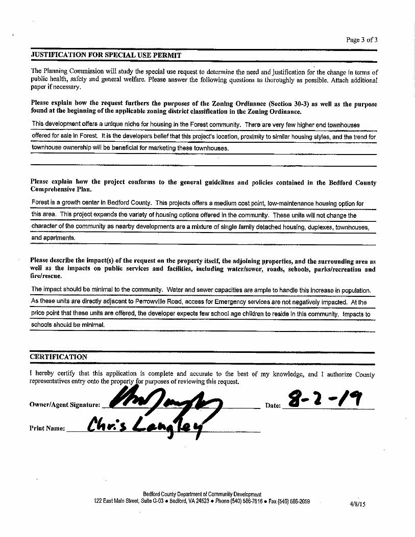
ARTICLE III. - DISTRICT REGULATIONS
Sec. 30-41. - R-1 Low density residential district.
Sec. 30-41-1. Purpose.
The R-1, Low density residential district is established for areas of the county within the urban service area with existing low-middle density residential development, with an average density of from one (1) to three (3) units per acre, and land which appears appropriate for such development. The R-1 district is intended to provide the highest degree of protection from potentially incompatible uses and residential development of a significantly different density, size, or scale, in order to maintain the health, safety, appearance, and overall quality of life of existing and future neighborhoods.
In addition to single-family residences, only uses of a community nature which are generally deemed compatible and permitted in the R-1 district. This would include parks and playgrounds, schools, and other similar neighborhood activities.
Sec. 30-41-2. Permitted uses.
Permitted uses shall be as listed in section 30-79.
Sec. 30-41-3. Site development regulations.
General standards. For additional, modified, or more stringent standards for specific uses, see article IV, Use and Design Standards.
(a) Minimum lot requirements:
(1) All lots served by private well and sewage disposal systems:
a. Area: One (1) acre (forty-three thousand five hundred sixty (43,560) square feet).
b. Frontage: One hundred (100) feet on a publicly owned and maintained street.
c. Lot Width: One hundred (100) feet.
(2) Lots served by either public sewer or water:
a. Area: Twenty thousand (20,000) square feet.
b. Frontage: Seventy-five (75) feet on a publicly owned and maintained street.
c. Lot width: Seventy-five (75) feet.
(3) All lots served by both public sewer and water:
a. Area: Ten thousand (10,000) square feet.
b. Frontage: Sixty (60) feet on a publicly owned and maintained street.
c. Lot Width: Sixty (60) feet.
(b) Minimum setback requirements:
(1) Front yard:
a. Principal structures: Thirty (30) feet.
b. Accessory structures: Thirty (30) feet or behind the front building line, whichever distance is less.
(2) Side yard:
a. Principal structures: Ten (10) feet.

b. Accessory structures: Ten (10) feet when between front and rear building lines and three (3) feet when behind the rear building line and ten (10) feet when in front of the front building line.
(3) Rear yard:
a. Principal structures: Twenty-five (25) feet.
b. Accessory structures: Three (3) feet.
(4) Where a lot fronts on more than one (1) street, front yard setbacks shall apply to all streets.
(5) The expansion of a legally established nonconforming structure into the required side or rear yard shall be permitted provided the expansion does not encroach into the required yard any greater than the existing encroachment.
(c) Maximum height of structures:
(1) Height limitations:
a. Principal structures: Thirty-five (35) feet.
b. Accessory structures: Thirty-five (35) feet.
(Ord. of 2-26-2001, App. A; Ord. of 6-10-2013, pt. II; Ord No. O-071116-09, 7-11-2016, pt. I)
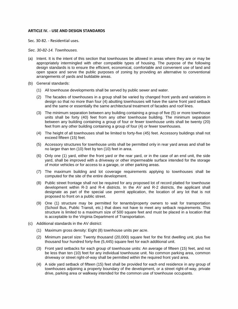
ARTICLE IV. - USE AND DESIGN STANDARDS
Sec. 30-82. - Residential uses.
Sec. 30-82-14. Townhouses.
(a) Intent. It is the intent of this section that townhouses be allowed in areas where they are or may be appropriately intermingled with other compatible types of housing. The purpose of the following design standards is to ensure the efficient, economical, comfortable and convenient use of land and open space and serve the public purposes of zoning by providing an alternative to conventional arrangements of yards and buildable areas.
(b) General standards:
(1) All townhouse developments shall be served by public sewer and water.
(2) The facades of townhouses in a group shall be varied by changed front yards and variations in design so that no more than four (4) abutting townhouses will have the same front yard setback and the same or essentially the same architectural treatment of facades and roof lines.
(3) The minimum separation between any building containing a group of five (5) or more townhouse units shall be forty (40) feet from any other townhouse building. The minimum separation between any building containing a group of four or fewer townhouse units shall be twenty (20) feet from any other building containing a group of four (4) or fewer townhouses.
(4) The height of all townhouses shall be limited to forty-five (45) feet. Accessory buildings shall not exceed fifteen (15) feet.
(5) Accessory structures for townhouse units shall be permitted only in rear yard areas and shall be no larger than ten (10) feet by ten (10) feet in area.
(6) Only one (1) yard, either the front yard or the rear yard, or in the case of an end unit, the side yard, shall be improved with a driveway or other impermeable surface intended for the storage of motor vehicles or for access to a garage, or other parking areas.
(7) The maximum building and lot coverage requirements applying to townhouses shall be computed for the site of the entire development.
(8) Public street frontage shall not be required for any proposed lot of record platted for townhouse development within R-3 and R-4 districts. In the AV and R-2 districts, the applicant shall designate as part of the special use permit application, the location of any lot that is not proposed to front on a public street.
(9) One (1) structure may be permitted for tenants/property owners to wait for transportation (School Bus, Public Transit, etc.) that does not have to meet any setback requirements. This structure is limited to a maximum size of 500 square feet and must be placed in a location that is acceptable to the Virginia Department of Transportation.
(c) Additional standards in the AV district:
(1) Maximum gross density: Eight (8) townhouse units per acre.
(2) Minimum parcel size: Twenty thousand (20,000) square feet for the first dwelling unit, plus five thousand four hundred forty-five (5,445) square feet for each additional unit.
(3) Front yard setbacks for each group of townhouse units: An average of fifteen (15) feet, and not be less than ten (10) feet for any individual townhouse unit. No common parking area, common driveway or street right-of-way shall be permitted within the required front yard area.
(4) A side yard setback of fifteen (15) feet shall be provided for each end residence in any group of townhouses adjoining a property boundary of the development, or a street right-of-way, private drive, parking area or walkway intended for the common use of townhouse occupants.

(5) Minimum rear yard setback: Twenty-five (25) feet.
(6) Minimum lot size for individual townhouse lots: Two thousand (2,000) square feet for interior lots and two thousand five hundred (2,500) square feet for end lots.
(7) Minimum width for individual townhouse lots: Twenty (20) feet, measured from center of wall to center of wall, or outside of end wall.
(8) Maximum number in a group or block of townhouses: Four (4) townhouse units.
(9) The maximum building and lot coverage shall comply with the requirements for the AV district.
(10) When a townhouse development adjoins a single-family dwelling, a Type C buffer yard as described more fully in article V shall be provided.
(d) Additional standards in the R-2 district:
(1) Maximum gross density: Eight (8) townhouse units per acre.
(2) Minimum parcel size: Twenty thousand (20,000) square feet for the first dwelling unit, plus five thousand four hundred forty-five (5,445) square feet for each additional unit.
(3) Front yard setbacks for each group of townhouse units: An average of fifteen (15) feet, and not be less than ten (10) feet for any individual townhouse unit. No common parking area, common driveway or street right-of-way shall be permitted within the required front yard area.
(4) A side yard setback of fifteen (15) feet shall be provided for each end residence in any group of townhouses adjoining a property boundary of the development. Where a group of townhouses adjoin private drive or parking area or walkway intended for the common use of townhouse occupants, the side yard setback shall be ten (10) feet.
(5) Minimum rear yard setback: Twenty-five (25) feet.
(6) Minimum lot size for individual townhouse lots: Two thousand (2,000) square feet for interior lots and two thousand five hundred (2,500) square feet for end lots.
(7) Minimum width for individual townhouse lots: Eighteen (18) feet, measured from center of wall to center of wall or outside end wall.
(8) Maximum number in a group or block of townhouses: Ten (10) townhouse units.
(9) Maximum coverage for townhouse developments:
a. Building coverage: Thirty-five (35) percent.
b. Lot coverage: Sixty (60) percent.
(e) Additional standards in the R-3 district:
(1) Maximum gross density: Twelve (12) townhouse units per acre.
(2) Minimum parcel size: Seven thousand two hundred (7,200) square feet for the first dwelling unit, plus three thousand six hundred thirty (3,630) square feet for each additional unit.
(3) Front yard setbacks for each group of townhouse units: An average of fifteen (15) feet, and not be less than ten (10) feet for any individual townhouse unit. No common parking area, common driveway or street right-of-way shall be permitted within the required front yard area.
(4) A side yard setback of fifteen (15) feet shall be provided for each end residence in any group of townhouses adjoining a property boundary of the development. Where a group of townhouses adjoin a private drive or parking area or walkway intended for the common use of townhouse occupants, the side yard setback shall be ten (10) feet.
(5) Minimum rear yard setback: Twenty-five (25) feet.
(6) Minimum lot size for individual townhouse lots: One thousand eight hundred (1,800) square feet for interior lots and two thousand three hundred (2,300) square feet for end lots.

(7) Minimum width for individual townhouse lots: Eighteen (18) feet, measured from center of wall to center of wall or outside end wall.
(8) Maximum number in a group or block of townhouses: Ten (10) townhouse units.
(9) Maximum coverage for townhouse developments:
a. Building coverage: Forty (40) percent.
b. Lot coverage: Sixty-five (65) percent.
(f) Additional standards in the R-4 district:
(1) Maximum gross density: Eighteen (18) townhouse units per acre.
(2) Minimum parcel size: Seven thousand two hundred (7,200) square feet for the first dwelling unit, plus two thousand four hundred twenty (2,420) square feet for each additional unit.
(3) Front yard setback for each group of townhouse units: an average of fifteen (15) feet, and not less than ten (10) feet for any individual townhouse unit. Common parking areas, driveways, and rights-of-way may be permitted within the front yard setback.
(4) A side yard setback of fifteen (15) feet shall be provided for each end residence in any group of townhouses adjoining a property boundary of the development. Where a group of townhouses adjoin a private drive or parking area or walkway intended for the common use of townhouse occupants, the side yard setback shall be ten (10) feet.
(5) Minimum rear yard setback: Twenty-five (25) feet.
(6) Minimum lot size for individual townhouse lots: One thousand six hundred (1,600) square feet for interior lots and two thousand one hundred (2,100) square feet for end lots.
(7) Fifty (50) percent of the individual townhouse lots shall be allowed to have a minimum width of fourteen (14) feet, measured from center of wall to center of wall. The remaining lots shall have a width greater than fourteen (14) feet.
(8) Maximum number in a group or block of townhouses: Ten (10) townhouse units.
(9) Maximum coverage for townhouse developments:
a. Building coverage: Forty-five (45) percent.
b. Lot coverage: Seventy (70) percent.
(Ord. No. O042219-04, pt. VI, 4-22-2019)

Proposed Zoning Ordinance Text
Amendment
Creation of Airport District
Presenter: Gregg Zody 540-586-7616 ext 1252
540-586-2059 (fax) [email protected]
COUNTY OF BEDFORD, VIRGINIA COUNTY ADMINISTRATION BUILDING
122 EAST MAIN STREET, SUITE G-03 BEDFORD, VIRGINIA 24523
_________________________________________
D E P AR T M E N T O F CO M M U N I T Y D E V E L O P M E N T D I V I S I O N O F P L A N N I N G
_________________________________________
540-586-7616 -TELEPHONE 540-586-2059 -TELEFACSIMILE [email protected] - E-MAIL www.bedfordcountyva.gov
TO: Planning Commission
FROM: Gregg Zody, Director GZ DATE: August 30, 2019 SUBJECT: Zoning Ordinance Text Amendment To Create An "Airport" District ______________________________________________________________________________
Background On Monday, August 12, 2019, the Board of Supervisors unanimously passed a resolution (Attachment 1) directing staff to accomplish two objectives: 1) Draft a text amendment creating an airport zoning district for New London Airport and Smith Mountain Lake Airport; and 2) Initiate a rezoning from the two airports' present zoning districts, Agricultural/Rural Preserve (New London Airport - AP) and Low Density Residential (Smith Mountain Lake Airport - R-1) to the Airport (A) district. Both the New London Airport and Smith Mountain Lake Airport are pre-existing, non-conforming uses containing pre-existing, non-conforming structures. Section 30-24 (Nonconforming Uses and Structures; Generally) severely restricts any expansion of those facilities. If either facility wanted to expand beyond the limits stated in Sec. 30-24 and a special use permit was not a codified option, then they could pursue a rezoning to a district (a planned unit development, such as Planned Development (PD1)), which would allow the respective facilities to craft their own district with the caveat that on-site public water and sewer must be available within two years of approval. In early 2019, Liberty University submitted a rezoning application to change the airport's current zoning, AP, to Planned Commercial District (PCD) accompanied with a special use permit (SUP) for a general aviation facility, which is permitted via SUP in the PCD. On March 18, 2019 Liberty University postponed the public hearing scheduled for March 19, 2019 so they could conduct a public meeting to discuss issues with the neighbors, which to our knowledge did not occur. That particular application expires on September 16, 2019. Since that postponement, staff met with representatives from Liberty University regarding previous preliminary determination letters drafted by staff in response to questions from Liberty University regarding their limits of expansion. This conversation has been on-going since late 2015, resulting in at least four letters from staff to Liberty University. As time progressed between 2015 and the present, staff corrected itself on several issues regarding the expansion and relocation of structures and uses (i.e. the runway), based on erroneous interpretations of Sec. 30-24. A "determination" letter was issued on April 9, 2019 which was appealed by Liberty University on August 1, 2019. Staff then followed up with a final formal determination letter at the direction of the BOS on July 26, 2019, which was appealed by Liberty University on August 23, 2019. As directed by the BOS, the appeals will be heard on September 24, 2019.

COUNTY OF BEDFORD, VIRGINIA ________________________________________________________
D E P A R T M E N T O F C O M M U N I T Y D E V E L O P M E N T
D I V I S I O N O F P L A N N I N G Page 2
Airport District In response to the BOS' resolution, staff drafted the attached Airport zoning district to address the non-conformity status of both the New London Airport and Smith Mountain Lake Airport. With a limited window of time for staff to research how other rural localities have addressed Airport districts or FAA and VDOA requirements, Staff used the Lynchburg airport zoning district code (Attachment 2) as a model foundation for this code and incorporated development standards and potential by-right uses that are typically associated with a small, rural airport because staff does not foresee either airport as a regional air transportation facility similar to a larger facility, such as the Roanoke-Blacksburg Regional Airport. Staff's position has always been that pre-existing, non-conforming structures should either take the necessary procedural steps to come into conformity with all applicable zoning and building codes or eventually be removed, such as an old store, house, or other structure. By the Board voting unanimously to direct staff to initiate the zoning text amendment, it is clear that the Board recognizes the value of both facilities. Furthermore, it is reasonable for staff to endorse the notion that codifying the existence of two airports in the County are clearly beneficial to the community at large in terms of economic development opportunities, additional tax revenue, and offering alternative modes of transportation, as long as consideration is given to adjacent property owners' existing uses. With the attached draft ordinance (Attachment 3), staff's position is to relatively maintain both facilities' current scale of operations because of their location in rural areas with adjacent uses ranging from agriculture to residential uses, with very limited commercial activity located on-site nor in adjacent districts. It is staff's position that any improvements and expansion of either facility should be sensitive to existing rural character of the area and realize the increase of additional traffic on existing two-lane roads serving either site raises concerns about the respective roads' capacity limitations, and other public infrastructure, such as fire and rescue, and water/sewer. It is therefore recommended by staff that the Planning Commission give careful consideration to the uses proposed by staff and evaluate which uses are appropriate for rural-scale airports that will have not have an adverse impact on surrounding properties, nor the existing transportation network or public infrastructure. Staff was directed to share their initial draft with Liberty University's outside counsel, who provided staff with suggested edits. Staff rejected the majority of the edits and modified others as necessary to the safe operation of the airport use and to keep the Airport district scaled and sensitive to adjacent land uses. With regards to the Smith Mountain Lake airport facility, staff received feedback from the property owner on August 28, 2019, and because his airport is regulated by VDOA, and not FAA, he voiced concerns about the ordinance, particularly some of proposed regulations are more FAA-oriented, such as the setbacks and fencing. Staff has attempted to address his concerns in a meaningful manner so as not to hamper his existing operation nor future development plans for the facility, if any. Airport Overlay Zone, VDOA, and FAA Staff received an email late afternoon on August 27th, 2019, from the Senior Planner at the Virginia Department of Aviation (VDOA) inquiring about the draft ordinance, as they noticed an article in a State trade journal regarding this effort VDOA staff offered to review and comment on County staff's draft, and while staff did note to VDOA our limited timeframe per the BOS' resolution, County staff wanted that expertise to review the draft to ensure we receive input from qualified professionals on what a good

COUNTY OF BEDFORD, VIRGINIA ________________________________________________________
D E P A R T M E N T O F C O M M U N I T Y D E V E L O P M E N T
D I V I S I O N O F P L A N N I N G Page 3
airport zoning district should contain, at a minimum. Staff received VDOA's review late Friday afternoon, August 30th and have included it in this packet for discussion (Attachment 4). Again, due to the short window of developing an ordinance, staff was not afforded the opportunity to diligently research the means to ensure existing and future facilities will be compliant with existing VDOA or FAA regulations/requirements. The Airport Overlay Zone, which is required by State Code for every locality with an aviation facility, is already codified (Sec. 30-72) covering both the New London and Smith Lake facilities. Any future expansion at either airport, may require a Comprehensive Plan and Zoning Ordinance Map amendment to ensure compliance with the overlay district coverage proscribed in the State Code, as referenced in Sec. 30-72. Lastly, staff has listed some concerns about the future plans for either facility:
• Flight school: How many students are currently enrolled? How many are expected if the Airport district and rezoning is approved?
• Flight school: Will a new facility be constructed for teaching purposes? • Flight school: How many touch and gos, landings, and take-offs can be anticipated? • Flight schedule: What is the estimated number of current arrival and departures? • Flight schedule: What is the anticipated number of future arrival and departures? • Flight schedule: Are there currently night flights departing or arriving? • Flight schedule: Are night flights appropriate for either facility and how does that impact adjacent
property owners and their enjoyment of their property?
Comprehensive Plan Relationship The Comprehensive Plan Future Land Use Designation is Agricultural/Natural Resource Stewardship for the New London Airport and Smith Mountain Lake Airport is designated Residential.
Agricultural/ Natural Resource Stewardship Areas High resource value areas based on soil types, environmental sensitivity, or other unique land characteristics. Includes areas that are preserved from development through public or private conservation efforts. Clustering of housing units is supported in this district. The continued practice of land use assessment taxation is also considered a vital component in the conservation efforts of these areas. Residential Residential areas located in close proximity to urban services and roads capable of handling higher traffic volumes. These are areas for single-family detached and attached units and apartments/condominiums. Small-scale neighborhood and/or lifestyle commercial (such as small convenience markets and marinas) is allowed where appropriate in this zone. Clustering of housing units is supported in this district.

COUNTY OF BEDFORD, VIRGINIA ________________________________________________________
D E P A R T M E N T O F C O M M U N I T Y D E V E L O P M E N T
D I V I S I O N O F P L A N N I N G Page 4
The Plan does identify each airport with specific descriptions about their current uses. Chapter 6 (Transportation) states the following:
Air There are two general utility airports in the County, New London and Smith Mountain, as well as several private landing fields. In addition, Lynchburg and Roanoke Regional airports are easily accessible from Bedford County. New London New London airport is located off Virginia Route 811 approximately 10 miles south of Forest and 14 miles east of the Town of Bedford. The hard surface runway is 3,200 feet in length and 40 feet wide. It has runway markers and lights for night flying. The New London Airport is attended in the daytime. It frequently hosts recreational “fly-ins” and on occasional weekends doubles as a drag strip. Smith Mountain Smith Mountain Airport, located east of Moneta, has a hard surface runway of 3,058 feet in length and is 50 feet wide. In addition, the airport is equipped with a rotary beacon and runway markers and lights. The airport is attended during daytime hours. Limited services are available.
Objectives and Strategies (Chapter 6) 6.4 Opportunities for greater use of the County and region’s rail and airport facilities.
6A. Transportation Plan. 6D. Proffer Guidelines. 6I. Alternative Funding Sources.
Attachments 1. August 12, 2019 Board of Supervisors Resolution 2. City of Lynchburg Code 3. Draft Ordinance 4. August 30, 2019 VDOA Review of Draft Ordinance
CC: Robert Hiss, County Administrator Patrick J. Skelley, County Attorney Board of Supervisors

At a regular meeting of the Board of Supervisors of the County of Bedford, Virginia held at the Bedford County Administration Building on the 12th day of August 2019, beginning at 7:00 pm.: MEMBERS: VOTE: Tommy W. Scott, Chairman Yes Andrew D. Dooley, Vice-Chairman Yes Bill Thomasson Yes Edgar Tuck Yes Charla Bansley Yes John Sharp Yes Kevin S. Willis Yes On motion of Supervisor Sharp, which carried by a vote of 7-0, the following was adopted:
A RESOLUTION
TO INITIATE THE CREATION OF A ZONING ORDINANCE DISTRICT
AND THE INITIATION OF ZONING MAP AMENDMENTS
WHEREAS, since 2015 Staff has worked with Liberty University to resolve land use issues at the
New London Airport as it relates to its non-conformity status for both existing structures and use;
WHEREAS, current County Code related to pre-existing non-conforming uses and structures limits
Liberty University's ability to lawfully expand both the uses and structures;
WHEREAS, at the direction of the Board of Supervisors, staff made several recommendations to
resolve the code-based conflicts.
NOW, THEREFORE, BE IT RESOLVED, by the Bedford County Board of Supervisors that the Board
does hereby direct staff to: 1) draft a Zoning Ordinance Amendment creating an "Airport" (A) district; and
2) initiate zoning map amendments for the New London Airport from Agricultural/Rural Preserve (AP) to
Airport (A) and the Smith Mountain Lake Airport from Low Density Residential (R-1) to Airport (A).
A Copy-Teste:
Robert Hiss County Administrator

Airport District Draft Ordinance _GZ final draft 08292019
ARTICLE II. - DEFINTIONS 30-28. - Definitions Snackbar - defined as an accessory use that is subordinate and incidental to an otherwise approved use, is limited to a maximum of one thousand (1,000) square feet or twenty-five percent (25%) of the square footage of the principal structure which contains said accessory use, whichever is less. Such size limitation applies to that area of the snack bar use which includes food and beverage preparation, storage, serving and seating area directly associated with the snack bar use. ARTICLE III. - DISTRICT REGULATIONS 30-77-7. Airport Purpose This district serves two purposes; First to acknowledge two existing airports, New London and Smith Mountain Lake and allow them to operate as a by-right use in this district subject to certain accessory uses in Sec. 30-79, Permitted Uses By District. Secondly, this district also establishes standards for future airports in the County to promote economic development and to provide for an additional means of transportation. An airport, air landing field or other air transportation facility (General or Private Aviation Facilities) may be approved for a rezoning to the Airport district if the proposed facility meets the following standards: (a) The proposed facility will meet the standards and requirements of the Federal Aviation
Administration (FAA) or the Virginia Department of Aviation (VDOA) as applicable to the facility type, and the Code of Bedford County Sec. Sec. 30-72. - AO Airport overlay district.
(b) The airport is of such size, with the runways so located, that the operation thereof, in
accordance with the standards and requirements of the FAA and/or VDOA (as applicable to the facility type), and the Code of Bedford County, Sec. 30-72. - AO Airport overlay district.
(d) Every land area used by any aircraft under its own power shall be provided with a dustless
surface.
(e) No area used by any aircraft under its own power shall be located within a distance of two hundred (200) feet from any property line; one thousand (1,000) feet from any public or private institution where airport operations could interfere with the work of the institutions, including schools, hospitals, sanatoriums, and churches; or one thousand (1,000) feet from any residential or commercial zones on the approach and departure ends of the runway. Buildings, hangars, or other structures shall be at least two hundred (200) feet from any property line and no parking of vehicles shall be allowed within one hundred (100) feet of any property line. Existing conditions at Smith Mountain Lake Airport are exempt from this requirement.

Airport District Draft Ordinance _GZ final draft 08292019
(f) At facilities where required by either FAA or VDOA, the airport shall be surrounded by a fence not less than six (6) feet in height, with suitable gates, effectively controlling access to such area.
(g) Appropriate accessory uses may be permitted, such as aviation fuel sales, manned flight training, a snackbar, airline business offices, auto rental agencies, and service and maintenance facilities and other services and facilities as typically found at a General Aviation Facility. A special use permit is required for additional accessory uses normally not associated with a General Aviation Facility.
(h) The application shall be referred to the FAA and/or VDOA as applicable for the report of such agency as to whether operations relating to such airport will interfere with those of other existing or proposed airports in the vicinity.
(i) Adequate off-street parking and loading spaces shall be provided to serve airport activities and accessory uses. The number of parking and loading spaces to be required shall be determined by the Zoning Administrator, based on using acceptable industry publications (i.e Institute of Transportation Engineers, Urban Land Institute, American Planning Association, etc.) or from a study prepared by a traffic engineering firm. Once the study is submitted, the findings are reviewed by the Zoning Administrator to set a minimum parking requirement for a use(s) based on the information provided.
(j) An airport approved as such under this Section shall be exempt from Section 30-87-9 (Broadcasting towers, radio), but only with regard to communication, radar, and microwave towers for ground control, flight control, air traffic control, and other communications ancillary and necessary to the operation of a general aviation facility.
(k) An airport approved as such under this Section shall be exempt from Section 30-91 (Off-street parking, stacking, and loading), but only to the extent that adequate parking is provided to accommodate the principle use and to accommodate the disabled, per Section 30-91-3. Notwithstanding the foregoing, all other provided parking shall comply with Section 30-91.
(l) An airport approved as such under this Section shall be exempt from Section 30-93 (Signs) with regard to signs that (i) are ancillary and necessary to ground or traffic control operations of the airport or (ii) are not visible from, or cannot be read without enhanced aid to vision from, any public right of way or adjacent residential district. Electronic message signs are prohibited in this district.
(m) An airport approved as such under Section 30-77-7 shall be exempt from Section 30-94 (Exterior lighting). Notwithstanding the foregoing, all buildings, structures, and parking facilities within one hundred (100) feet of any adjacent property not within the Airport district shall comply with Section 30-94 except to the extent that such lighting is required for runways, taxiways, or other flight related purposes or otherwise required by federal or state governmental authority, law, rule, or regulation for the operation of a general aviation airport.
(n) “Educational Facilities, College/University” and “Industry, Type I” uses shall require public water and sewer.

Airport District Draft Ordinance _GZ final draft 08292019
Sec. 30-79. - Permitted uses by district.
Sec. 30-79-1. Purpose.
The purpose of this table is to show the uses permitted in each of the zoning districts. Specific requirements for districts and uses are found in article III and article IV herein.
Sec. 30-79-2. Permitted use table.
Permitted uses by district shall be as shown in the following table where: "R" Indicates a use by right
"S" Indicates a special use "*" Indicates more stringent standards as specified in article IV
USES AP AR AV R-1 R-2 R-3 R-4 PRD RMH C-1 C-2 NC PCD
I-1 I-2 PID EP
A
Civic Uses
Educational Facilities, College/University
R*
R*
R* R* R* R*
R*
S*
Utility Services, Minor R R R R R R R R
R R R R R R R R R
Office Uses
General Office
R*
R*
R* R* R* R* R* R* R* R*
R*
Commercial Uses
Automobile Rental/Leasing
S
R* S* R*
R* R*
R*
Business Support Services
R
R
S
R*
Food Truck
R* R* R* R* R* R*
R* R* R* R*
R*
Industrial Uses
Industry, Type I R S
S
S R R R
R*

Airport District Draft Ordinance _GZ final draft 08292019
USES AP AR AV R-1 R-2 R-3 R-4 PRD RMH C-1 C-2 NC PCD
I-1 I-2 PID EP
A
Miscellaneous Uses
Aviation Facilities, General
S* S* S* S* S* S* S* S*
R*
Aviation Facilities, Private
S* S* S*
S*
S
S R R S
R*
Outdoor Gatherings S* S* S* S* S* S* S* S*
R R R R
R*
(Ord. of 7-9-2001; Ord. of 2-26-2001, App. A; Ord. of 2-11-2002; Ord. of 3-7-2005; Ord. No. O-0307-64, 3-26-2007; Ord. No. O-0707-169, 7-23-2007; Ord. No. O-0508-111(R), 5-27-2008; Ord. No. O-0508-112(R), 5-27-2008; Ord. No. O-1108-241, 11-12-2008; Ord. No. O-1108-242, 11-12-2008; Ord. No. O-0211-32(R), 2-28-2011; Ord. No. O-0911-139, 9-26-2011; Ord. No. O-0312-28, 5-26-2012; Ord. No. O-0213-024, pt. II, 2-25-2013; Ord. No. O-0413-042, pts. I—VII, 4-22-2013; Ord. of 6-10-2013, pts. III, V; Ord. No. O0713-087, pt. III, 7-22-2013; Ord. No. O-120814-02, pt. II, 12-8-2014; Ord. No. O-051115-05, pt. I, 5-11-2015; Ord. No. O-071315-08, pt. II, 7-13-2015; Ord. No. O-032816-03, pt. I, 3-28-2016; Ord. No. O-061316-09, 6-13-2016; Ord. No. O-032717-05, pt. II. 3/27/2017; Ord. No. O07231808, pt. II, 7-23- 2018)
Sec. 30-7. - Establishment of districts.
(a) The following are established as Bedford County zoning districts:
Agricultural Districts:
AP Agricultural/Rural Preserve District
AR Agricultural/Residential District
AV Agricultural Village Center District
Residential Districts:
R-1 Low Density Residential District

Airport District Draft Ordinance _GZ final draft 08292019
R-2 Medium Density Residential District
R-3 Medium Density Multifamily Residential District
R-4 High Density Multifamily Residential District
PRD Planned Residential Development District
R-MH Manufactured Home Overlay District
RCO Residential Cluster Overlay District (Reserved)
Civic
A Airport
Commercial Districts:
NC Neighborhood Commercial District
C-1 Office District

211 | P a g e
Airport District Draft Ordinance _GZ final draft 08292019
C-2 General Commercial District
PCD Planned Commercial Development District
Industrial Districts:
I-1 Low-Intensity Industrial District
I-2 Higher-Intensity Industrial District
PID Planned Industrial Development District
Special Purpose Districts:
HO Historic Overlay District
PO Park Overlay District
AO Airport Overlay District
ECO Emergency Communications Overlay District
RRCO Roanoke River Conservation Overlay District
WHP Well-head Protection Overlay District
CO Corridor Overlay District
The location and boundaries of these zoning districts are shown on the official zoning map.
(Ord. No. O120913-10, 12-9-2013)

212 | P a g e
Airport District Draft Ordinance _GZ final draft 08292019
APPENDIX A. - BEDFORD COUNTY ZONING ORDINANCE SITE DEVELOPMENT REGULATIONS
Zone
Description
Min Lot Requirements
Min Setback Requirements
Max
Height
Max Coverage
Units/ Acre
Area Front Width Front Side Rear Bldg. Lot
AP Agricultural/Rural
Preserve 1.5 Ac. 150' 150' 35' 10' 25' 45' N/A N/A <1
AR Agricultural/Residential 1 Ac. 100' 100' 35' 10' 25' 45' N/A N/A
<1
AV
Agricultural Village Center
1 Ac.
100'
100'
35'
10'
25'
35'
N/A
N/A
1 - 3
20,000 SF
75' 75' 35' 10' 25' 35' N/A N/A
R1 Low Density Residential
1 Ac. 100' 100' 30' 10' 25' 35' N/A N/A
1 - 3 20,000
SF
75'
75'
30'
10'
25'
35'
N/A
N/A
10,000 SF
60'
60'
30'
10'
25'
35'
N/A
N/A
R2 Medium Density
Residential 1 Ac. 100' 100' 30' 10' 25' 35' N/A
N/A
1 - 6 20,000
SF 75' 75' 30' 10' 25' 35' N/A
N/A
10,000 SF
60'
60'
30'
10'
25'
35'
N/A
N/A
R3 Medium Density
Multifamily Residential 1 Ac. 100' 100' 30' 10' 25' 35' N/A N/A 6 - 12
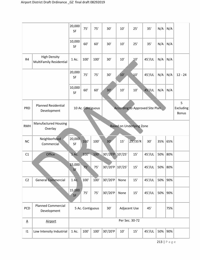
213 | P a g e
Airport District Draft Ordinance _GZ final draft 08292019
20,000 SF
75'
75'
30'
10'
25'
35'
N/A
N/A
10,000 SF
60' 60' 30' 10' 25' 35' N/A N/A
R4 High Density
MultiFamily Residential 1 Ac. 100' 100' 30' 10' 10' 45'/UL N/A N/A
12 - 24 20,000
SF
75'
75'
30'
10'
10'
45'/UL
N/A
N/A
10,000 SF
60' 60' 30' 10' 10' 45'/UL N/A N/A
PRD
Planned Residential Development
10 Ac. Contiguous
According to Approved Site Plan
5 Excluding
Bonus
RMH Manufactured Housing
Overlay Based on Underlying Zone
NC Neighborhood
Commercial 20,000
SF 100' 100' 30' 15' 25'/35'R 30' 35% 65%
C1 Office 1 Ac. 100' 100' 30'/20'P 10'/25' 15' 45'/UL 50% 80%
15,000 SF
75' 75' 30'/20'P 10'/25' 15' 45'/UL 50% 80%
C2 General Commercial 1 Ac. 100' 100' 30'/20'P None 15' 45'/UL 50% 90%
15,000 SF
75'
75'
30'/20'P
None
15'
45'/UL
50%
90%
PCD Planned Commercial
Development 5 Ac. Contiguous 30' Adjacent Use 45'
75%
A Airport Per Sec. 30-72
I1 Low Intensity Industrial 1 Ac. 100' 100' 30'/20'P 10' 15' 45'/UL 50% 90%

15,000 SF
75'
75'
30'/20'P
10'
15'
45'/UL
50%
90%
I2 High Intensity
Industrial 1 Ac. 100' 100' 30'/20'P 10' 15' 125'/UL 75% 90%
20,000 SF
100' 100' 30'/20'P 10' 15' 125'/UL 75% 90%
PID
Planned Industrial Development
15 Ac. Contiguous
30'
Adjacent Use
45/UL
75%
EP Explore Park According to Approved Site Plan
AO Airport Overlay
ECO
Emergency Communications
Overlay
RRCO
Roanoke River Conservation Overlay
FO Floodplain Overlay (repealed
7/12/2010)
WHP Well Head Protection
Overlay
CO Corridor Overlay Underlying Zoning District (6/10/2013)
WCO
Wireless Communications
Overlay


REZONING
APPLICATION RZ200002
Reclassification of properties from
(AP) Agricultural/Rural Preserve District
& (R-1) Low Density Residential District
To
Airport District “A”
Presenter: Gregg Zody 540-586-7616 ext 1252
540-586-2059 (fax) [email protected]
COUNTY OF BEDFORD, VIRGINIA COUNTY ADMINISTRATION BUILDING
122 EAST MAIN STREET, SUITE G-03 BEDFORD, VIRGINIA 24523
_________________________________________
D E P AR T M E N T O F CO M M U N I T Y D E V E L O P M E N T D I V I S I O N O F P L A N N I N G
_________________________________________
540-586-7616 -TELEPHONE 540-586-2059 -TELEFACSIMILE [email protected] - E-MAIL www.bedfordcountyva.gov
TO: Planning Commission
FROM: Gregg Zody, Director GZ DATE: August 30, 2019 SUBJECT: Rezoning Certain Parcels Zoned AP (New London Airport) and R-1 (Low Density Residential) to
"Airport" _____________________________________________________________________________
Background On Monday, August 12, 2019, the Board of Supervisors unanimously passed a resolution (Attachment 1) directing staff to accomplish two objectives: 1) Draft a text amendment creating an airport zoning district for New London Airport and Smith Mountain Lake Airport; and 2) Initiate a rezoning from the two airports' present zoning districts, Agricultural/Rural Preserve (New London Airport - AP) and Low Density Residential (Smith Mountain Lake Airport - R-1) to the Airport (A) district. Both the New London Airport and Smith Mountain Lake Airport are pre-existing, non-conforming uses containing pre-existing, non-conforming structures. Section 30-24 (Nonconforming Uses and Structures; Generally) severely restricts any expansion of those facilities. Rezoning New London Airport (Tax Map Numbers: 170-A-34, 170-A-30A, 170-3-A1, 170-3-A, 187-A-3A, 187-A-2A, 170-3-B, 170-A-29A, and 170-A-30). Total acreage is approximately 474.1 acres Site is located at on New London Road (Route 709), and buffered to the southeast by Bethel Church Road (Route 711). The site entrance is located slightly less than three (3) miles from the intersection of Route 811 and Route 460. Liberty University owns nine (9) parcels as part of the airport use. It, like all of the adjacent property, is zoned AP. R-1 zoning is located less than 1/2 mile northeast from the airport. Adjacent land use conditions in the districts are generally agricultural, low density residential, with the pre-dominant zoning being AP. Smith Mountain Lake Airport (Tax Map Numbers: 243A-12-A, 243A-12-E-1, 243A-12- E-7, 243-A-12-G, 243A-12-H, and 243A-1-A-2). Total acreage is approximately for this facility is 42 acres. Site is located on 1090 Cutlass Road, which is located approximately .30 miles south of the intersection with Route 853 (Airport Road). Buccaneer Road connects Airport Road with Cutlass Road.

COUNTY OF BEDFORD, VIRGINIA ________________________________________________________
D E P A R T M E N T O F C O M M U N I T Y D E V E L O P M E N T
D I V I S I O N O F P L A N N I N G Page 2
Smith Mountain Lake Airport LLC owns six (6) parcels as part of the airport use. It, like all adjacent property, is zoned R-1. There is Agricultural Residential-zoned property to the north, and Planned Commercial Development (PCD district located around Huddleston) property to the northeast, and Planned Residential Development (PRD) to the east and southeast, respectively. None of the three districts are adjacent to the site. Adjacent land uses are primarily low density residential, with a subdivision located to the west of the property, and Mariners Landing comprises the majority, if not all, of the property zoned PRD. Comprehensive Plan Relationship The Comprehensive Plan Future Land Use Designation is Agricultural/Natural Resource Stewardship for the New London Airport and Residential for the Smith Mountain Lake Airport, which states:
Agricultural/ Natural Resource Stewardship Areas High resource value areas based on soil types, environmental sensitivity, or other unique land characteristics. Includes areas that are preserved from development through public or private conservation efforts. Clustering of housing units is supported in this district. The continued practice of land use assessment taxation is also considered a vital component in the conservation efforts of these areas.
Residential Residential areas located in close proximity to urban services and roads capable of handling higher traffic volumes. These are areas for single-family detached and attached units and apartments/condominiums. Small-scale neighborhood and/or lifestyle commercial (such as small convenience markets and marinas) is allowed where appropriate in this zone. Clustering of housing units is supported in this district.
While the Comprehensive Plan does not mention either airport in the aforementioned future land use designation description, the Plan does identify each airport with specific descriptions about their current uses. Chapter 6 (Transportation) states the following:
Air There are two general utility airports in the County, New London and Smith Mountain, as well as several private landing fields. In addition, Lynchburg and Roanoke Regional airports are easily accessible from Bedford County. New London New London airport is located off Virginia Route 811 approximately 10 miles south of Forest and 14 miles east of the Town of Bedford. The hard surface runway is 3,200 feet in length and 40 feet wide. It has runway markers and lights for night flying. The New London Airport is attended in the daytime. It frequently hosts recreational “fly-ins” and on occasional weekends doubles as a drag strip. Smith Mountain Smith Mountain Airport, located east of Moneta, has a hard surface runway of 3,058 feet in length and is 50 feet wide. In addition, the airport is equipped with a rotary beacon and runway markers and lights. The airport is attended during daytime hours. Limited services are available.

COUNTY OF BEDFORD, VIRGINIA ________________________________________________________
D E P A R T M E N T O F C O M M U N I T Y D E V E L O P M E N T
D I V I S I O N O F P L A N N I N G Page 3
Objectives and Strategies (Chapter 6) 6.4 Opportunities for greater use of the County and region’s rail and airport facilities. 6A. Transportation Plan. 6D. Proffer Guidelines. 6I. Alternative Funding Sources.
Attachments 1. BOS Resolution August 12, 2019 2. Location Map - New London Airport 3. Aerial Map - New London Airport 4. Zoning Map - New London Airport 5. Comprehensive Plan Future Land Use Designations - New London Airport 6. Location Map - Smith Mountain Lake Airport 7. Aerial Map - Smith Mountain Lake Airport 8. Zoning Map - Smith Mountain Lake Airport 9. Comprehensive Plan Future Land Use Designations - Smith Mountain Lake Airport
CC: Robert Hiss, County Administrator Patrick J. Skelley, County Attorney Board of Supervisors

At a regular meeting of the Board of Supervisors of the County of Bedford, Virginia held at the Bedford County Administration Building on the 12th day of August 2019, beginning at 7:00 pm.: MEMBERS: VOTE: Tommy W. Scott, Chairman Yes Andrew D. Dooley, Vice-Chairman Yes Bill Thomasson Yes Edgar Tuck Yes Charla Bansley Yes John Sharp Yes Kevin S. Willis Yes On motion of Supervisor Sharp, which carried by a vote of 7-0, the following was adopted:
A RESOLUTION
TO INITIATE THE CREATION OF A ZONING ORDINANCE DISTRICT
AND THE INITIATION OF ZONING MAP AMENDMENTS
WHEREAS, since 2015 Staff has worked with Liberty University to resolve land use issues at the
New London Airport as it relates to its non-conformity status for both existing structures and use;
WHEREAS, current County Code related to pre-existing non-conforming uses and structures limits
Liberty University's ability to lawfully expand both the uses and structures;
WHEREAS, at the direction of the Board of Supervisors, staff made several recommendations to
resolve the code-based conflicts.
NOW, THEREFORE, BE IT RESOLVED, by the Bedford County Board of Supervisors that the Board
does hereby direct staff to: 1) draft a Zoning Ordinance Amendment creating an "Airport" (A) district; and
2) initiate zoning map amendments for the New London Airport from Agricultural/Rural Preserve (AP) to
Airport (A) and the Smith Mountain Lake Airport from Low Density Residential (R-1) to Airport (A).
A Copy-Teste:
Robert Hiss County Administrator

NEW
LOND
ON
RD 7
09
BLAC
KWAT
ER R
D 66
8
BETHEL CHURCH RD 711
EVINGTON RD 811
WYATTS WAY 24
SWISHER DR
NEW LO
NDON RD 81
1
WHEELS DR
LICK RUN FARM RD
BLAC
KBER
RY LN
SABER CT
WILLARD MANOR LN
SUNRAY DR
S FA
IRW
AY D
R 13
45
Location Map

NEW LONDON RD 709
BETHEL CHURCH RD 711
EVINGTON RD 811
SWISHER DR
WHEELS DR
LICK RUN FARM RD
BLAC
KBER
RY LN
WILLARD MANOR LN
SUNRAY DR
PEACE VALLEY RD
Virginia Geographic Information Network (VGIN)
Aerial Photograph (2018)

NEW LONDON RD 709
BETHEL CHURCH RD 711
EVINGTON RD 811
SWISHER DR
WHEELS DR
LICK RUN FARM RD
BLAC
KBER
RY LN
WILLARD MANOR LN
SUNRAY DR
PEACE VALLEY RD AP
R-1
R-1Zoning Map
AGRICULTURAL/NATURAL RESOURCE STEWARDSHIP
RESIDENTIALNEW LONDON RD 709
BETHEL CHURCH RD 711
EVINGTON RD 811
SWISHER DR
WHEELS DR
LICK RUN FARM RD
BLAC
KBER
RY LN
WILLARD MANOR LN
SUNRAY DR
PEACE VALLEY RD
Future Land Use Map
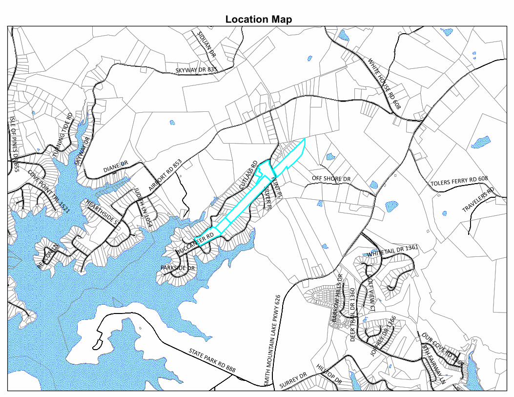
AIRPORT RD 853
SMIT
H M
OU
NTA
IN L
AKE
PKW
Y 62
6
SKYWAY DR 835
BUCCANEER RD
STATE PARK RD 888
SURREY DR
CUTL
ASS R
D
DIANE DR
WHITE HOUSE RD 608
DEER
TRA
IL D
R 13
60
SKYW
AY D
R
TOLERS FERRY RD 608OFF SHORE DR
SIDUAN DR
TURN
ING
TIDE
RD
BEACO
N LN
TRAVELERS RD
ISLE OF PIN
ES DR 655 COVE POINT TRL 1521
HEARTHSIDE ST
OUR COVE RD 1367HILLTOP DR
WHITETAIL DR 1361
PARKSIDE DR
FLINT PL
JOFF
REY
DR 1
366
SILVER PL
GOLF VIEW
CT
BARR
OW
HIL
LS D
R
8TH FAIRWAY LN
JUDITH LN 1054
Location Map

BUCCANEER RD
CUTL
ASS R
D
AIRPORT RD 853
MOODY M
ILL LN
OFF SHORE DR FLINT PL
SILVER PL
BENNI CT
BARBURY CT
Virginia Geographic Information Network (VGIN)
Aerial Photograph (2018 VGIN)

BUCCANEER RD
CUTL
ASS R
D
AIRPORT RD 853
MOODY M
ILL LN
OFF SHORE DR FLINT PL
SILVER PL
BENNI CT
BARBURY CT
R-1
AR
PCD
Zoning Map

RESIDENTIAL
AGRICULTURAL/NATURAL RESOURCE STEWARDSHIP
COMMERCIAL
BUCCANEER RD
CUTL
ASS R
D
AIRPORT RD 853
MOODY M
ILL LN
OFF SHORE DR FLINT PL
SILVER PL
BENNI CT
BARBURY CT
Future Land Use Map