Embed Size (px)
Citation preview
BASELINE MARINE REPORT
Marine aquaculture development zones for fin
fish cage culture in the Eastern Cape
April 2012
S. Porter, K. Hutchings, B.M. Clark
Prepared for:
Directorate Sustainable Aquaculture Management: Aquaculture Animal Health
and Environmental Interactions
Department of Agriculture, Forestry and Fisheries
i
Executive Summary
An Environmental Impact Assessment (EIA) for the development of two marine aquaculture
development zones (ADZs) specific for fin fish cage farming in the sea off the Eastern Cape Province is
being undertaken on behalf of the the Directorate Sustainable Aquaculture Management: Aquaculture
Animal Health and Environmental Interactions within the Department of Agriculture, Forestry and
Fisheries- DAFF. This marine baseline report constitutes a section of the Draft Scoping Report (DSR) for
this EIA. The DAFF mariculture policy aims to promote growth in the industry, as it envisions benefits of
skills-based job creation in poor coastal communities and increased seafood production to compensate
for dwindling catches of wild stocks. This report reviews the site selection methodology used in a
Strategic Environmental Assessment (SEA) that identified the four potential ADZs in the Eastern Cape
Province, and briefly identifies the generic potential environmental impacts of sea cage fish farming.
The current state of knowledge of the physical oceanography, marine ecology and fisheries of the region
is reviewed and the proposed baseline marine surveys to be undertaken over the next 12 months are
presented.
The proposed ADZs in the Eastern Cape Province were identified during a SEA of the entire South African
coastline using systematic-based spatial analyses that considered defined criteria work shopped a-priori
with industry stakeholders. The analysis yielded four potential sites in the Eastern Cape for caged fin fish
aquaculture. Many of the potential impacts of fin fish caged aquaculture such as pollution, habitat
alteration and user conflict can be mitigated by correct site selection as employed in the spatial
analyses. Other potential impacts can be mitigated by astute animal husbandry and adaptive
management strategies.
The potential ADZs situated in Algoa Bay and St Francis Bay, occur in an area where two large current
systems of different temperatures undergo mixing. In addition, periodic upwelling may occur near the
rocky headlands of the bays during easterly winds that can cause sharp drops in temperature.
Temperature and current dynamics are therefore complex and vary over small spatial scales within each
of the bays. In situ monitoring of the physical oceanography of Algoa Bay is therefore to be carried out
over the next 12 months at the two most favourable ADZs using acoustic-Doppler current profilers
(ADCPs), thermister strings and single beam echo-sounding for accurate bottom type characterisation
and depth profiling.
The area is also known to support a high biodiversity of marine life, particularly reef-associated
invertebrates and fish as well as several breeding colonies of endangered or vulnerable seabirds.
Valuable fisheries particularly for chokka squid are also prominent. Baseline ecological monitoring of
the sandy macrofauna is therefore to be carried out within the footprint of the proposed ADZs before
any development so that potential impacts can be detected and proactively managed and mitigated.
iii
Table of Contents
1 Introduction .............................................................................................................................. 1
2 Potential marine environmental impacts and mitigation of fin fish cage farming .................. 2
3 Summary of the site selection process..................................................................................... 3
4 Physical oceanography ........................................................................................................... 11
4.1 Algoa Bay ................................................................................................................................ 13
4.2 St Francis Bay .......................................................................................................................... 14
5 Marine ecology ....................................................................................................................... 15
6 Fisheries & other industries ................................................................................................... 19
7 Current marine monitoring .................................................................................................... 20
8 References .............................................................................................................................. 25
iv
Acronyms
ADZ Aquaculture Development Zone
CSIR Council for Scientific and Industrial Research
DAFF Department of Agriculture, Forestry and Fisheries
DEAT Department of Environmental Affairs & Tourism
DEA Department of Environmental Affairs
DST Department of Science and Technology
EA Environmental Authorization
EIA Environmental Impact Assessment
GIS Geographical Information System
IBA Important Birding Area
MCM Marine and Coastal Management
MPA Marine Protected Area
NEMA National Environmental Management Act
SADCO South African Data Centre for Oceanography
SANBI South African National Biodiversity Institute
SEA Strategic Environmental Assessment
1
1 Introduction
The stated purpose of establishing Aquaculture Development Zones (ADZs), as presented by the
Directorate Sustainable Aquaculture Management: Aquaculture Animal Health and Environmental
Interactions, in the Department of Agriculture, Forestry and Fisheries (DAFF), is to encourage investor
and consumer confidence in the marine aquaculture industry in South Africa, and also to create
incentives for industry development, provide marine aquaculture services, manage risk associated with
aquaculture, and provide skills development and employment for coastal communities. A Strategic
Environmental Assessment (SEA) conducted by Anchor Environmental Consultants (2011) has identified
four potential sites in the Eastern Cape. The DAFF has identified the Eastern Cape as a priority region for
establishing ADZs in South Africa. Three of the identified sites are in Algoa Bay, and a fourth site is off
Jeffery’s Bay (accessible from Port St Francis). Based on the relative expected cost to other industry,
two of the Algoa Bay sites have been selected for further detailed investigation and Environmental
Impact Assessment (EIA), whilst the third Algoa Bay site and the St Francis Bay site are to be considered
as alternatives in the EIA process.
The two sites in Algoa Bay that are the focus of the EIA are referred to as Algoa 2 and Algoa 3 (previously
called Port Elizabeth2 (Coega2) and Port Elizabeth3 (Coega3) in the SEA report) and can be accessed
from either Port Elizabeth or Coega harbours. These potential ADZs were identified using a number of
criteria workshopped with stakeholders from government and industry using a spatial GIS-based analysis
and a post-hoc ranking system.
In situ baseline assessments of both biology and oceanography are to commence in February 2012 and
will run for a period of 12 months. Ecological analyses will include assessing the sandy macrofaunal
communities while oceanography will focus on quantifying depth and bottom type, wave and current
dynamics as well as temperature measurements. The in situ oceanographic data will be used to verify if
the proposed ADZs delineated in the desktop-based SEA are suitable for fin fish cage culture. Biological
data will be utilised for monitoring purposes should the development (i.e. ADZs) be authorised.
This report provides a summary of what has been undertaken thus far in terms of the delineation of
ADZs, progress to date and planned baseline assessments on the biology and physical oceanography. In
addition it provides a review of existing knowledge on the marine ecology and physical oceanography of
the study area.
2
2 Potential marine environmental impacts and mitigation
of fin fish cage farming
The potential environmental impacts of sea based finfish cage culture are briefly discussed and
mitigation measures that can be partly addressed at the SEA level are identified. Potential impacts
include:
The incubation and transmission of fish disease and parasites from captive to wild populations.
Mitigation relies on sound animal health management and biosecurity.
Pollution of coastal waters due to the discharge of organic wastes. Mitigation includes the use
of species and system specific feeds in order to maximize food conversion ratios, rotation of
cages within a site to allow recovery of benthos, and sensible site selection (sufficient depth,
current speeds and suitable sediment type).
Escape of genetically distinct fish that compete and interbreed with wild stocks that are often
already depleted. Mitigation measures include suitable design and maintenance of cages to
minimize escapes and use of sufficient brood stock with similar genetic structure to local wild
populations.
Chemical pollution of marine food chains (& potential risk to human health) due to the use of
therapeutic chemicals in the treatment of cultured stock and antifouling treatment of
infrastructure. Recommended mitigation includes the responsible storage and use of the
minimum required quantities of (preferably biodegradable) chemicals.
Fish cages pose a physical hazard to cetaceans and other marine species that may become
entangled in ropes and nets. Mitigation measures include site selection that excludes important
migration, feeding or aggregation sites; and the use of correct and durable cage netting that
minimizes entanglements.
Piscivorous marine animals (including mammals, sharks, bony fish and birds) attempt to remove
fish from the cages and may become tangled in nets and damage nets leading to escapes and
stress or harm the cultured stock. Farmers tend to kill problem predators or use acoustic
deterrents. Effective mitigation may be achieved through the use of appropriate predator
mesh, proper feed storage and feeding and removal of dead fish from cages.
Localised habitat alteration and impacts (such as changes in wave action and sediment
transport). Can only be mitigated through site selection and farm design.
User conflict due to exclusion from mariculture zones for security reasons or negative impacts
on tourism and coastal real estate value due to negative aesthetic impacts of fish farms. Can be
partly mitigated by site selection and consultation with other users.
3
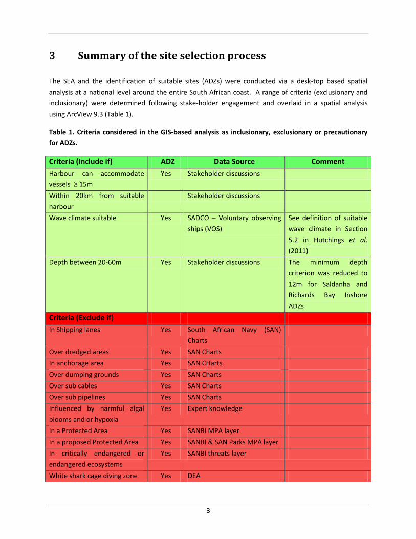
3 Summary of the site selection process
The SEA and the identification of suitable sites (ADZs) were conducted via a desk-top based spatial
analysis at a national level around the entire South African coast. A range of criteria (exclusionary and
inclusionary) were determined following stake-holder engagement and overlaid in a spatial analysis
using ArcView 9.3 (Table 1).
Table 1. Criteria considered in the GIS-based analysis as inclusionary, exclusionary or precautionary
for ADZs.
Criteria (Include if) ADZ Data Source Comment
Harbour can accommodate
vessels ≥ 15m
Yes Stakeholder discussions
Within 20km from suitable
harbour
Stakeholder discussions
Wave climate suitable Yes SADCO – Voluntary observing
ships (VOS)
See definition of suitable
wave climate in Section
5.2 in Hutchings et al.
(2011)
Depth between 20-60m Yes Stakeholder discussions The minimum depth
criterion was reduced to
12m for Saldanha and
Richards Bay Inshore
ADZs
Criteria (Exclude if)
In Shipping lanes Yes South African Navy (SAN)
Charts
Over dredged areas Yes SAN Charts
In anchorage area Yes SAN CHarts
Over dumping grounds Yes SAN Charts
Over sub cables Yes SAN Charts
Over sub pipelines Yes SAN Charts
Influenced by harmful algal
blooms and or hypoxia
Yes Expert knowledge
In a Protected Area Yes SANBI MPA layer
In a proposed Protected Area Yes SANBI & SAN Parks MPA layer
In critically endangered or
endangered ecosystems
Yes SANBI threats layer
White shark cage diving zone Yes DEA
4
In intense upwelling cells Yes Expert knowledge **
In current of ≥ 150cm.S-1 Yes Aghulas Current (Roberts et
al. 2010 & Average SST)
Within influence of waste
outfalls & industrial waste
Yes B. Newman, CSIR
Criteria (Precautionary)
Within influence of river plume Yes Plume extent modelling, mean
annual runoff & water quality
index (Google Earth, Harrison
et al. 2000)
Depends on fish species
farmed. E.g. avoid for
Yellowtail
East coast upwelling cells Yes Expert knowledge **
Military practice area Yes SAN Charts
Administered harbour area Yes SAN Charts
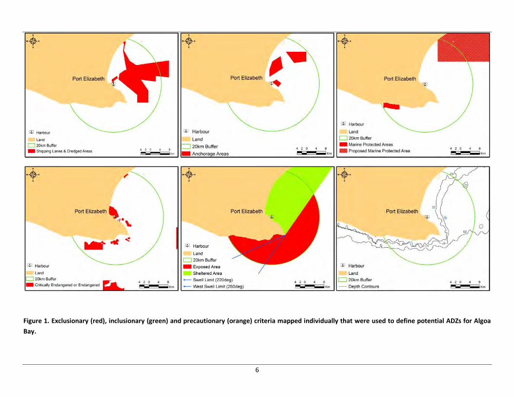
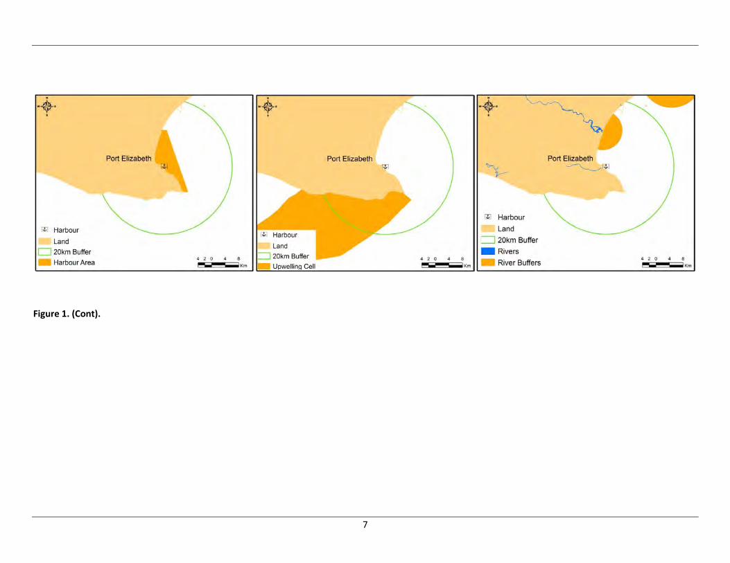
Each of the above criteria was spatially mapped and suitable zones for marine aquaculture delineated
(Figure 1 and Figure 2). Sites identified from this analysis were then scored according to logistical (e.g.
distance from suitable port, water depth) and environmental considerations (distance from marine
protected areas, upwelling cells) so that they could be ranked in terms of suitability. Finally, the South
African National Biodiversity Institute (SANBI) “Cost to industry layer” was used to evaluate the potential
cost to existing marine industries, of declaring any of these sites as ADZs (see Hutchings et al. 2011).
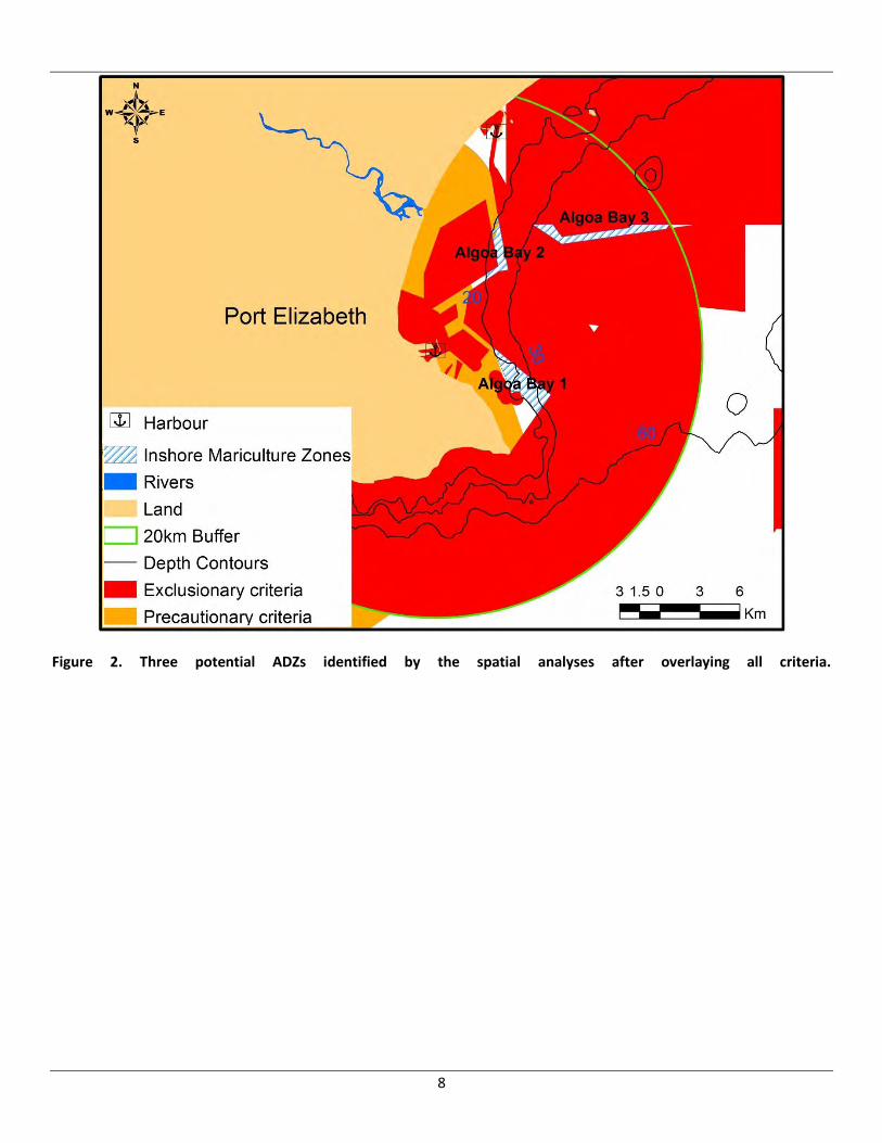
On this basis, three potential ADZ sites in Algoa Bay were earmarked for detailed in situ analyses and EIA
evaluation. These are here on referred to as Algoa Bay 1, 2 and 3 and can be accessed from either Port
Elizabeth or Coega harbours (Figure 2). Algoa Bay 1 remains a possible option but would incur a
relatively high cost to industry and will be more seriously considered should either Algoa Bay 2 or 3 be
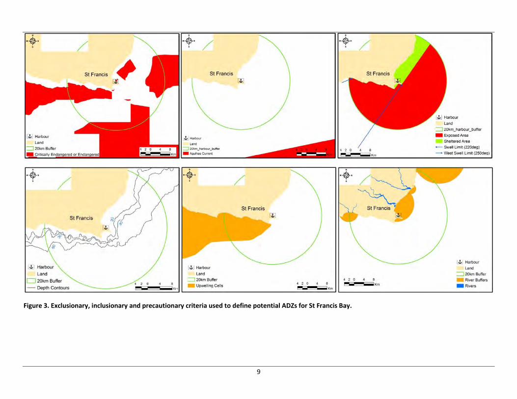
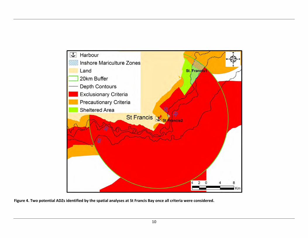
found unsuitable. A further site was also identified in St. Francis Bay (St. Francis 1) and is considered to
be a potential alternative to the Algoa Bay sites (Figure 3 and Figure 4). St Francis 1 is less favourable
than the Algoa Bay sites because it is further from a suitable harbour and is more likely to experience
greater wave action as a result of refraction. More detail on the entire site selection process and
analysis can be found in the paragraph below and in Hutchings et al. (2011).
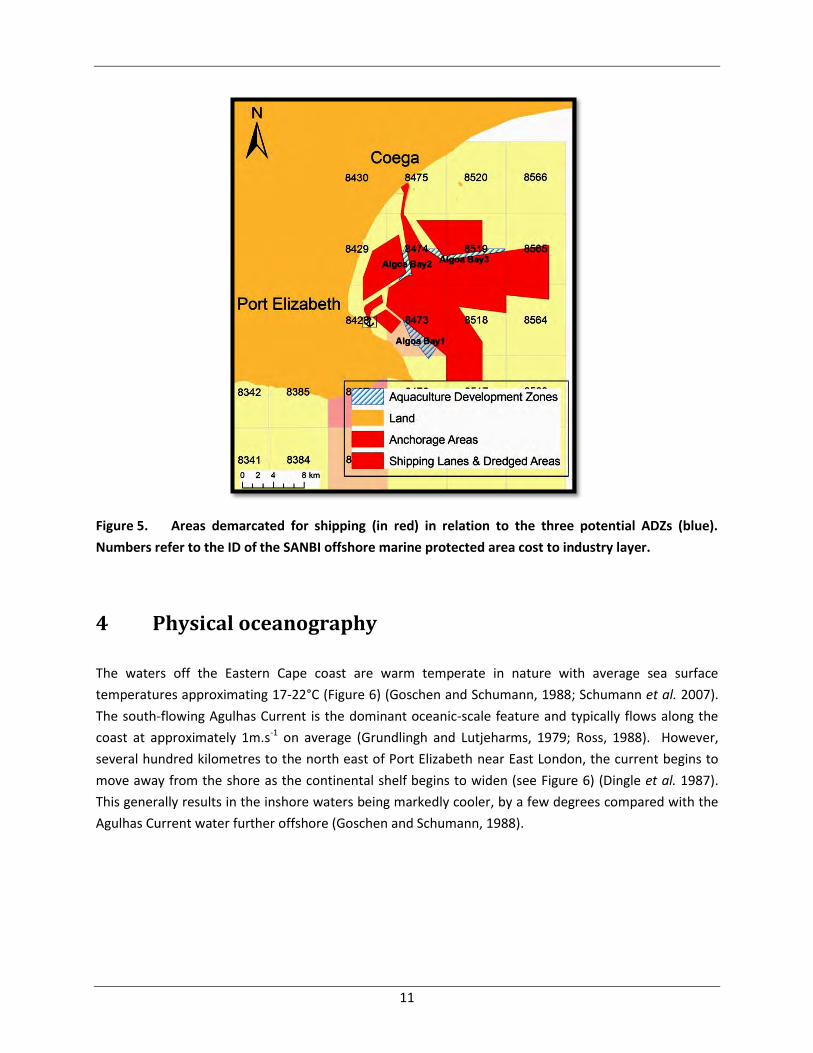
Industries contributing to the general cost of each grid cell encompassing the proposed ADZs in Algoa
Bay have been identified by SANBI (Sink, K. pers. Comm.). Three industries were identified through this
process as potentially being affected by the proposed ADZs; namely shipping, chokka-squid fishing and
linefishing. It should be noted though, that all demarcated shipping lanes and anchorage areas were
specifically excluded from the potential ADZ sites (see Figure 5 below). Any residual cost attributed to
the shipping industry within the ADZ sites is thus mostly due to the coarse resolution of the grid that
comprises the SANBI COST layer (see the relative sizes of the SANBI Cost to Industry grid cells on Figure 5
below). In terms of chokka-squid effort, SANBI COST cell ID 8473 (encompassing Algoa Bay1) has the
highest effort followed by cell ID 8519 (encompassing Algoa Bay3), while ID 8474 has no chokka-squid
5
effort (Figure 5, Sink, K. pers. comm.). Regarding linefish, cell IDs 8473 and 8519 include modest levels
of fishing effort while cell ID 8474 includes zero effort (Figure 5, Sink, K. pers. comm.). Although chokka-
squid effort and linefish effort were not variables used in the spatial analysis to rule out areas of the
coast for potential mariculture, a similar scenario to that of the shipping lanes and anchorage areas may
be occurring. Therefore, finer-scale data will be sought from the respective industries themselves to
determine the extent to which the selected ADZs sites could potentially impact on these two fishery
sectors.
If in situ analyses and the EIA give support for the development of the ADZs, the most probable
infrastructure to be employed in the ADZS are inshore floating cages similar to those already being used
experimentally in Algoa Bay. Indigenous fish species such as yellowtail (Seriola lalandi) in less turbid
water, and dusky (Argyrosomus japonicas) and silver kob (A. inodorus) in areas more prone to riverine
influence are the likely species that will be cultured in Algoa Bay.
6
Figure 1. Exclusionary (red), inclusionary (green) and precautionary (orange) criteria mapped individually that were used to define potential ADZs for Algoa
Bay.
7
Figure 1. (Cont).
8
Figure 2. Three potential ADZs identified by the spatial analyses after overlaying all criteria.
9
Figure 3. Exclusionary, inclusionary and precautionary criteria used to define potential ADZs for St Francis Bay.
10
Figure 4. Two potential ADZs identified by the spatial analyses at St Francis Bay once all criteria were considered.
11
Figure 5. Areas demarcated for shipping (in red) in relation to the three potential ADZs (blue).
Numbers refer to the ID of the SANBI offshore marine protected area cost to industry layer.
4 Physical oceanography
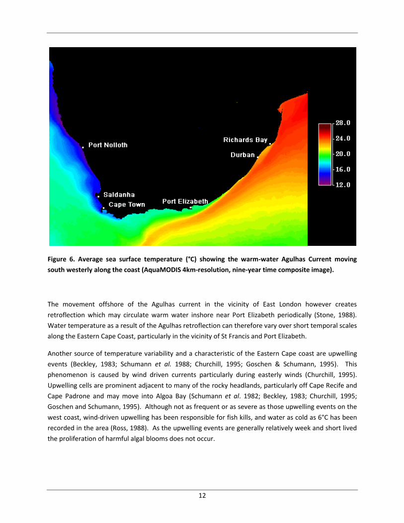
The waters off the Eastern Cape coast are warm temperate in nature with average sea surface
temperatures approximating 17-22°C (Figure 6) (Goschen and Schumann, 1988; Schumann et al. 2007).
The south-flowing Agulhas Current is the dominant oceanic-scale feature and typically flows along the
coast at approximately 1m.s-1 on average (Grundlingh and Lutjeharms, 1979; Ross, 1988). However,
several hundred kilometres to the north east of Port Elizabeth near East London, the current begins to
move away from the shore as the continental shelf begins to widen (see Figure 6) (Dingle et al. 1987).
This generally results in the inshore waters being markedly cooler, by a few degrees compared with the
Agulhas Current water further offshore (Goschen and Schumann, 1988).
12
Figure 6. Average sea surface temperature (°C) showing the warm-water Agulhas Current moving
south westerly along the coast (AquaMODIS 4km-resolution, nine-year time composite image).
The movement offshore of the Agulhas current in the vicinity of East London however creates
retroflection which may circulate warm water inshore near Port Elizabeth periodically (Stone, 1988).
Water temperature as a result of the Agulhas retroflection can therefore vary over short temporal scales
along the Eastern Cape Coast, particularly in the vicinity of St Francis and Port Elizabeth.
Another source of temperature variability and a characteristic of the Eastern Cape coast are upwelling
events (Beckley, 1983; Schumann et al. 1988; Churchill, 1995; Goschen & Schumann, 1995). This
phenomenon is caused by wind driven currents particularly during easterly winds (Churchill, 1995).
Upwelling cells are prominent adjacent to many of the rocky headlands, particularly off Cape Recife and
Cape Padrone and may move into Algoa Bay (Schumann et al. 1982; Beckley, 1983; Churchill, 1995;
Goschen and Schumann, 1995). Although not as frequent or as severe as those upwelling events on the
west coast, wind-driven upwelling has been responsible for fish kills, and water as cold as 6°C has been
recorded in the area (Ross, 1988). As the upwelling events are generally relatively week and short lived
the proliferation of harmful algal blooms does not occur.
13
4.1 Algoa Bay
Temperature, salinity, nutrients and ocean current dynamics have been studied in Algoa Bay by Goschen
and Schumann (1988, 2011) and Schumann et al. (2007). The Agulhas Current plays an intermittent role
in determining the current and temperature structure in Algoa Bay while prevailing winds are important
on the wider shelf areas as one moves inshore (Goschen and Schumann 2011). Current speeds of less
than 10 cm.s-1 have been measured most frequently within the bay (Roberts, 1990; Schumann et al.
2007), although currents exceeding 20 cm.S-1 are not uncommon (Schumann et al. 2007). However,
currents in the bay are known to be highly variable in both direction and magnitude and show
considerable variation depending on where in the bay they are measured (see Harris, 1978; Goschen
and Schumann, 1988; Roberts, 1990; Schumann et al. 2005).
Two types of water masses have been documented to move into Algoa Bay, namely warm Agulhas
Current water and cold upwelled water originating from upwelling at Cape Recife. Warm water from
the Agulhas Current is associated with occasional large meanders shorewards as the current moves
southward. On the other hand, cold upwelled water originating from Cape Recife during relatively
short-lived easterly winds, particularly during summer, is known to move into the bay when the wind
switches to a westerly direction shortly after upwelling has occurred (Schumann et al. 1982; Goschen
and Schumann, 1995). Upwelling occurs along this stretch of coast because the orientation is such that
the easterly wind has an offshore component, which combined with Ekman transport and the steep and
prominent bathymetry, readily draws cold bottom water to the surface within the inertial period of 21 h
(for this latitude) (Roberts, 2005). Upwelled water moving into the bay has been known to cause sharp
changes in temperature by approximately 8°C within a 24 hour period (Goschen and Schumann, 1995).
Yearly-average minimum temperatures are found in winter of 14-15°C and maximum average
temperatures in summer of 20-22°C (Beckley, 1983 & 1988; Schumann et al. 2005). A strong
thermocline is evident in summer in water deeper than 15 m characterised by fairly intense gradients of
up to 3°C.m-1, whereas in winter conditions are homogenous (Schumann et al. 2005).
Salinity remains relatively constant within Algoa Bay and close to natural oceanic water for the region of
35.2 ‰ (Schumann 1988). However, close to the mouth of the Swartkops River and at the New Brighton
Pier outfall, salinity as low as 34.7 ‰ has been measured, although it remains only in the top 5 m of
water and does not penetrate deeper (Schumann et al. 2005).
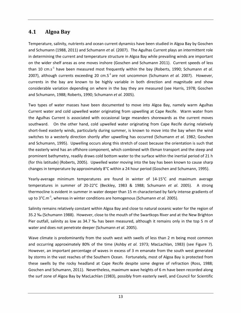
Wave climate is predominantly from the south west with swells of less than 2 m being most common
and occurring approximately 80% of the time (Ashby et al. 1973; MacLachlan, 1983) (see Figure 7).
However, an important percentage of waves in excess of 3 m emanate from the south west generated
by storms in the vast reaches of the Southern Ocean. Fortunately, most of Algoa Bay is protected from
these swells by the rocky headland at Cape Recife despite some degree of refraction (Ross, 1988;
Goschen and Schumann, 2011). Nevertheless, maximum wave heights of 6 m have been recorded along
the surf zone of Algoa Bay by MacLachlan (1983), possibly from easterly swell, and Council for Scientific
14
and Industrial Research (CSIR, 1987) buoy-data have recorded wave heights of between 0.5-5.0 m (87%
of waves between 1-3 m) in summer and between 1.0-6.5 m in winter approaching the Bay at Cape
Recife.
Figure 7. Wave rose showing the direction, proportion and magnitude of waves experienced offshore
of the St Francis-Algoa bay region. Data from SADCO Voluntary Observing Ships for a 30-year period.
4.2 St Francis Bay
Oceanographic data on St Francis Bay is scant, but is likely to be similar to Algoa Bay as it is situated in
close proximity to Algoa Bay (the adjacent bay to the west) and has comparable morphology and
orientation to the ocean. It is therefore likely to be affected by similar periodic warm-water intrusions
from Agulhas retroflections in addition to upwelling events emanating from Cape Recife (to the east)
and the rocky headland at Seal Point (to the west) (Schumann et al. 1982; Schumann, 1999; Churchill,
1995; Roberts, 2005). These upwelling events would be triggered by the same mechanisms as those
upwelling events effecting Algoa Bay and adjacent parts of the coast (see Schumann et al. 1982 and
Roberts, 2005). Average temperatures in St Francis Bay would be similar to Algoa Bay as would
15
temperature variability and sharp changes of a few degrees within a 24hr period are likely to occur
periodically (Figure 6).
Currents within St Francis Bay are difficult to predict and are probably complex like those in Algoa Bay.
A localised and relatively small decrease in salinity can be expected in the vicinity of the Kromme River
similar to that experienced near the mouth of the Swartkops River in Algoa Bay, as the two rivers have
similar mean annual discharges (105 & 84 m3 x 106, according to Heydorn and Tinley, 1980). Wave
climate is expected to be similar to that experienced in Algoa Bay. Indeed, similar maximum wave
heights of 5.6 m bearing 210° have been recorded approaching the coast a few kilometres to the west
(Eskom, 2010). The reader is therefore referred to the above description on wave climate of Algoa Bay
and to Figure 7.
5 Marine ecology
Algoa and St Francis Bays fall within the warm temperate Agulhas Bioregion, one of four inshore
bioregions spanning the coast of South Africa (Emanuel et al. 1992; Bustamante and Branch, 1996;
Turpie et al. 2000; Branch et al. 2010). This bioregion extends from the Mbashe River in the Eastern
Cape west to Cape Point. It is an important area of mixing where warm Agulhas Current water mixes
with cool Benguela Current water. The shelf margin also extends considerably further offshore relative
to the east and west of this bioregion (Emery and Uchupi, 1975). These characteristics of the coast play
an important role in providing habitat for many organisms and contribute to the maintenance of
important fisheries (see Wallace et al. 1984). The wide oceanic shelf provides and an array of habitats
and the temperature mixing also plays a large role in accounting for the highest number of endemic fish
species along the South African coast (Turpie et al. 2000).
On intertidal reefs, red algae dominate particularly Plocamium corallorhiza, P. Cornutum, Pterosiphonia
cloiophylla, Hypnea spicifera, Chondrococcus hornemannii, Gigartina paxillata, Laurencia flexuosa and
articulated corallines Amphiroa bowerbankii, A. ephedraea, Arthrocardia duthiae, Cheilosporum
cultratum, Corallina sp. and Jania sp. (Seagrief, 1988). Brown algae are also an important component,
particularly species of Dictyota and Dictyopteris, Zonaria subarticulata, Ecklonia biruncinata and
Iyengaria stellata. Green algae such as Caulerpa filiformis, C. racemosa, Bryopsis spp. and Codium spp.
play a subordinate role to intertidal community composition (Seagrief, 1988). On intertidal and shallow
subtidal reefs grazers and filter feeders are the most prolific fauna. In particular molluscs such as Perna
perna and Petella cochlear and the ascidian Pyura stolonifera dominate the infratidal and shallow
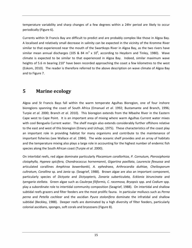
subtidal (Beckley, 1988). Deeper reefs are dominated by a high diversity of filter feeders, particularly
colonial ascidians, sponges, soft corals and bryozoans (Figure 8).
16
Figure 8. A typical subtidal reef found in the St. Francis-Algoa bay area of the Agulhas Bioregion.
Subtidal trawl and dredge surveys conducted mainly over soft bottom habitats from Mossel Bay to Cape
Padrone recorded high diversities of polychaetes (56 species of bristleworms), followed by gastropods
(53 species of snails) , ophiuroids (9 species of brittlestar) and mysids (4 species of shrimps) (Wallace et
al. 1984).
Wallace et al. (1984) also sampled the inshore ichthyofauna using otter-nets, blanket nets, try nets,
scoop-nets and dredges in an effort to gain an understanding of the fish community composition and
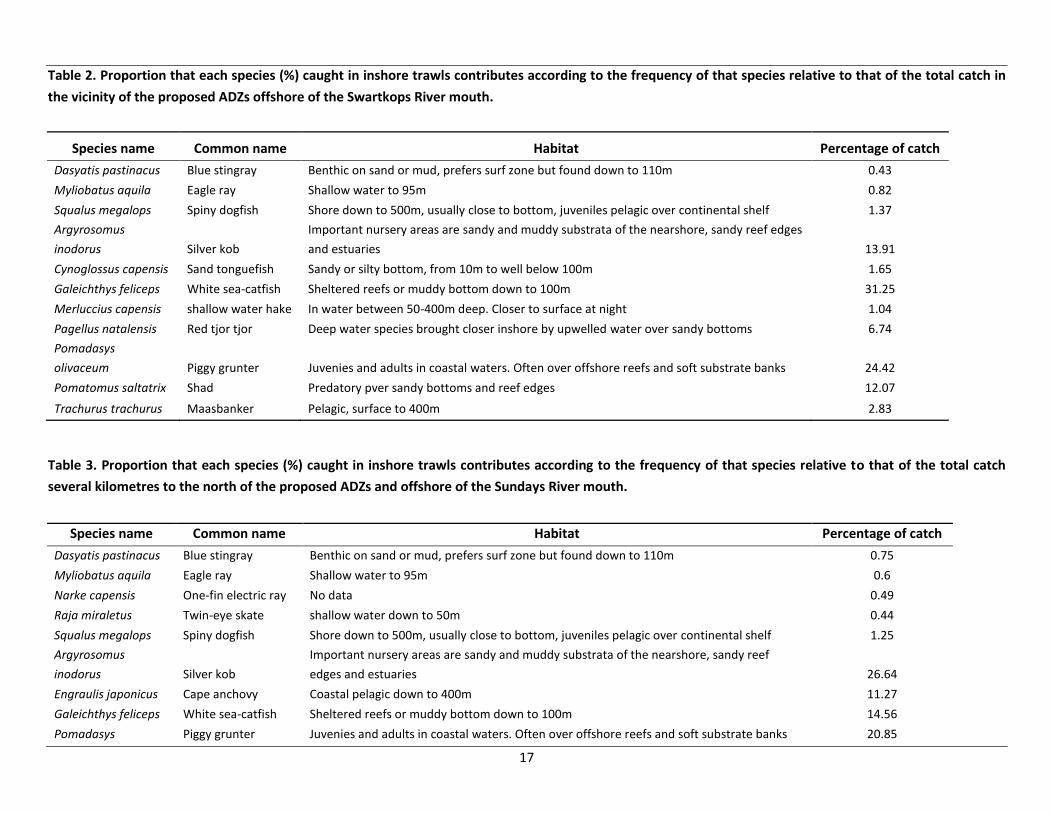
their dependence on estuaries and inshore areas as nursery grounds. Table 2 summarizes those species
comprising the catch (according to their relative frequencies) in the vicinity of the Swartkops River
where the ADZs Algoa Bay 2 & 3 are proposed. Table 3 list those species comprising the catch a few
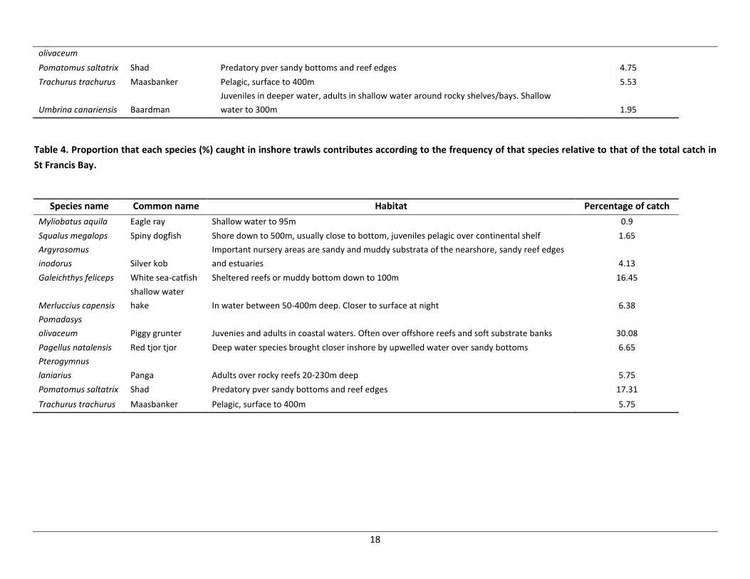
kilometres north of the proposed ADZs off the Sundays River mouth. Wallace et al. (1984) conducted
the same survey in St Francis Bay and these catches are summarised in Table 4.
17
Table 2. Proportion that each species (%) caught in inshore trawls contributes according to the frequency of that species relative to that of the total catch in
the vicinity of the proposed ADZs offshore of the Swartkops River mouth.
Species name Common name Habitat Percentage of catch
Dasyatis pastinacus Blue stingray Benthic on sand or mud, prefers surf zone but found down to 110m 0.43
Myliobatus aquila Eagle ray Shallow water to 95m 0.82
Squalus megalops Spiny dogfish Shore down to 500m, usually close to bottom, juveniles pelagic over continental shelf 1.37
Argyrosomus
inodorus Silver kob
Important nursery areas are sandy and muddy substrata of the nearshore, sandy reef edges
and estuaries 13.91
Cynoglossus capensis Sand tonguefish Sandy or silty bottom, from 10m to well below 100m 1.65
Galeichthys feliceps White sea-catfish Sheltered reefs or muddy bottom down to 100m 31.25
Merluccius capensis shallow water hake In water between 50-400m deep. Closer to surface at night 1.04
Pagellus natalensis Red tjor tjor Deep water species brought closer inshore by upwelled water over sandy bottoms 6.74
Pomadasys
olivaceum Piggy grunter Juvenies and adults in coastal waters. Often over offshore reefs and soft substrate banks 24.42
Pomatomus saltatrix Shad Predatory pver sandy bottoms and reef edges 12.07
Trachurus trachurus Maasbanker Pelagic, surface to 400m 2.83
Table 3. Proportion that each species (%) caught in inshore trawls contributes according to the frequency of that species relative to that of the total catch
several kilometres to the north of the proposed ADZs and offshore of the Sundays River mouth.
Species name Common name Habitat Percentage of catch
Dasyatis pastinacus Blue stingray Benthic on sand or mud, prefers surf zone but found down to 110m 0.75
Myliobatus aquila Eagle ray Shallow water to 95m 0.6
Narke capensis One-fin electric ray No data 0.49
Raja miraletus Twin-eye skate shallow water down to 50m 0.44
Squalus megalops Spiny dogfish Shore down to 500m, usually close to bottom, juveniles pelagic over continental shelf 1.25
Argyrosomus
inodorus Silver kob
Important nursery areas are sandy and muddy substrata of the nearshore, sandy reef
edges and estuaries 26.64
Engraulis japonicus Cape anchovy Coastal pelagic down to 400m 11.27
Galeichthys feliceps White sea-catfish Sheltered reefs or muddy bottom down to 100m 14.56
Pomadasys Piggy grunter Juvenies and adults in coastal waters. Often over offshore reefs and soft substrate banks 20.85
18
olivaceum
Pomatomus saltatrix Shad Predatory pver sandy bottoms and reef edges 4.75
Trachurus trachurus Maasbanker Pelagic, surface to 400m 5.53
Umbrina canariensis Baardman
Juveniles in deeper water, adults in shallow water around rocky shelves/bays. Shallow
water to 300m 1.95
Table 4. Proportion that each species (%) caught in inshore trawls contributes according to the frequency of that species relative to that of the total catch in
St Francis Bay.
Species name Common name Habitat Percentage of catch
Myliobatus aquila Eagle ray Shallow water to 95m 0.9
Squalus megalops Spiny dogfish Shore down to 500m, usually close to bottom, juveniles pelagic over continental shelf 1.65
Argyrosomus
inodorus Silver kob
Important nursery areas are sandy and muddy substrata of the nearshore, sandy reef edges
and estuaries 4.13
Galeichthys feliceps White sea-catfish Sheltered reefs or muddy bottom down to 100m 16.45
Merluccius capensis
shallow water
hake In water between 50-400m deep. Closer to surface at night 6.38
Pomadasys
olivaceum Piggy grunter Juvenies and adults in coastal waters. Often over offshore reefs and soft substrate banks 30.08
Pagellus natalensis Red tjor tjor Deep water species brought closer inshore by upwelled water over sandy bottoms 6.65
Pterogymnus
laniarius Panga Adults over rocky reefs 20-230m deep 5.75
Pomatomus saltatrix Shad Predatory pver sandy bottoms and reef edges 17.31
Trachurus trachurus Maasbanker Pelagic, surface to 400m 5.75
19
Species composition among the three areas is relatively similar, as one would expect, although there are
some differences in the rank contribution of species to the overall catch, probably due to local scale
determinants.
The fish in turn, support colonies of birds and seals that reside on two groups of three islands each. One
group comprises the large St Croix Island with smaller stacks of Jahleel and Brenton Rocks. St Croix
Island lies 4 km from the coast and is situated between the Coega and Sundays river mouths. This rocky
12 ha island rises to 58 m and has very little vegetation. The second island group consists of Bird, Seal
and Stag Islands, and lies near Cape Padrone, 7 km from the coastal Woody Cape Nature Reserve. Bird
Island (19 ha) is the largest of the Algoa Bay islands and is relatively flat rising by only 9 m. Seal Island is
much smaller (0.6 ha) lying 360 m north of Bird Island, and Stag Island is even smaller (0.1 ha), lying
320 m north-west of Bird Island (Bird Life International, 2012).
Much of the island group is covered by sparse growth of mixed vegetation dominated by the fleshy
herbs that form patches of thicket that provide cover for some seabirds. The Algoa Bay Islands are of
considerable importance as they are the only islands along a 1,777 km stretch of coastline between
Cape Agulhas and Inhaca Island in Mozambique (see Barnes, 1998; Bird Life International, 2012).
These islands are home to many endangered, vulnerable and near-threatened birds including breeding
colonies of African penguins (Crawford et al. 1990; Barnes 1998), Cape gannet (Crawford, 1997b; Barnes,
1998), African black oystercatchers (Martin, 1997), Roseate tern (Randall et al. 1991; Crawford, 1997a)
and winter visiting Antarctic terns (Williams, 1997). In addition, this is the eastern most distribution of
the Cape fur seal and breeding takes place on Black Rocks in Algoa Bay (Mills and Hes, 1997). All islands
are protected areas and components of them are located within Important Birding Areas (IBAs) (Barnes
1998; Bird Life International, 2012a).
The diversity of organisms, many of which are endemic, endangered or use Algoa Bay as an important
breeding area has led to the establishment of the no-take Bird Island Marine Protected Area (MPA) and
the no-take Sardinia Bay MPA located approximately 16 km to the west of Algoa Bay. In addition, the
proposed Addo-Elephant Park MPA, if proclaimed would cover an area of 137 773 ha from Cape
Padrone to Coega Harbour and encompass all islands within Algoa Bay.
6 Fisheries & other industries
There are a number of important fisheries and other industries, particularly tourism, which may be in
direct conflict with the proposed ADZs in Algoa Bay and ST Francis Bay. Data on these fisheries and
industries is currently being collected and will be made available in future reports. Fisheries and
industries identified thus far that may be of concern include: traditional linefish, demersal shark long
line, hake long line, small pelagics, inshore sole and hake, squid, and ecotourism.
20
7 Current marine monitoring
In situ baseline surveys of the ecology and oceanography of Algoa Bay and the immediate footprints of
the proposed ADZs commenced in February 2012 and will continue for a period of a year. Ecological
analyses will include baseline assessments of the macrobenthic community and any rare/unique
habitats. Should the development of the ADZs go ahead, these data will be used for future comparison
and ecological monitoring to detect any potential changes in marine communities due to aquaculture.
Ecological analyses are being conducted by SCUBA divers and benthic grab samplers in the footprint of
the proposed ADZs. Biological samples are being preserved and taken back to the laboratory for
identification by experts.
Oceanographic variables including current and temperature profiles, wave climate, depth and bottom
type are being assessed within the footprint of each of the ADZs. Acoustic-Doppler current profilers
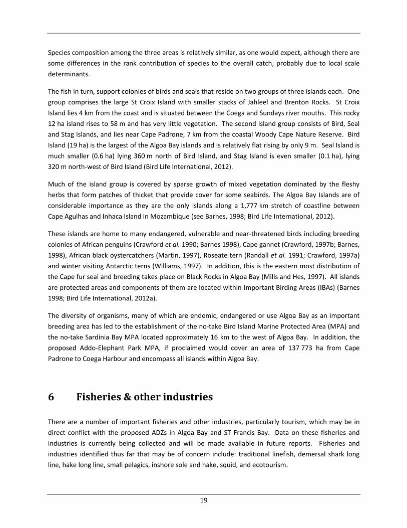
(ADCPs) have been deployed in the two preferred sites (Algoa 2 and 3) to quantify the wave climate
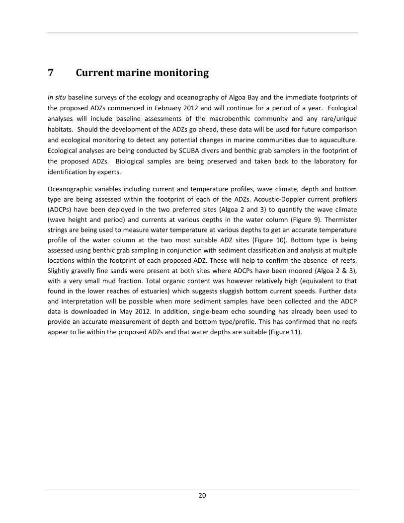
(wave height and period) and currents at various depths in the water column (Figure 9). Thermister
strings are being used to measure water temperature at various depths to get an accurate temperature
profile of the water column at the two most suitable ADZ sites (Figure 10). Bottom type is being
assessed using benthic grab sampling in conjunction with sediment classification and analysis at multiple
locations within the footprint of each proposed ADZ. These will help to confirm the absence of reefs.
Slightly gravelly fine sands were present at both sites where ADCPs have been moored (Algoa 2 & 3),
with a very small mud fraction. Total organic content was however relatively high (equivalent to that
found in the lower reaches of estuaries) which suggests sluggish bottom current speeds. Further data
and interpretation will be possible when more sediment samples have been collected and the ADCP
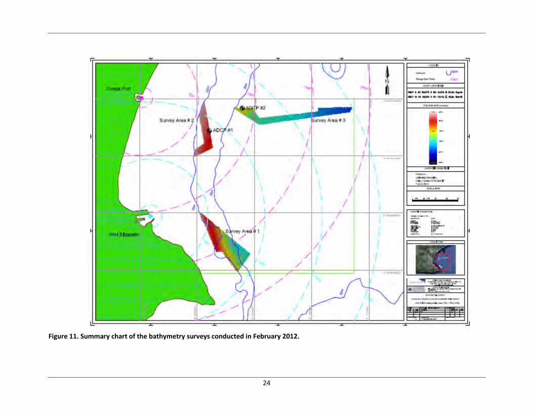
data is downloaded in May 2012. In addition, single-beam echo sounding has already been used to
provide an accurate measurement of depth and bottom type/profile. This has confirmed that no reefs
appear to lie within the proposed ADZs and that water depths are suitable (Figure 11).
21
Figure 9. ADCP mooring to be deployed in Algoa Bay. The blue PVC tubes on the ADCP mooring are filled with concrete and are approximately 1m in length.
22
Figure 10. Schematic showing the design of the thermister string to be deployed in Algoa Bay. Nos
1-5 depict the positions of the temperature loggers. A steel anchor of 150 kg is used to secure the
device and two large sub-surface buoys ensure that the string stays upright.
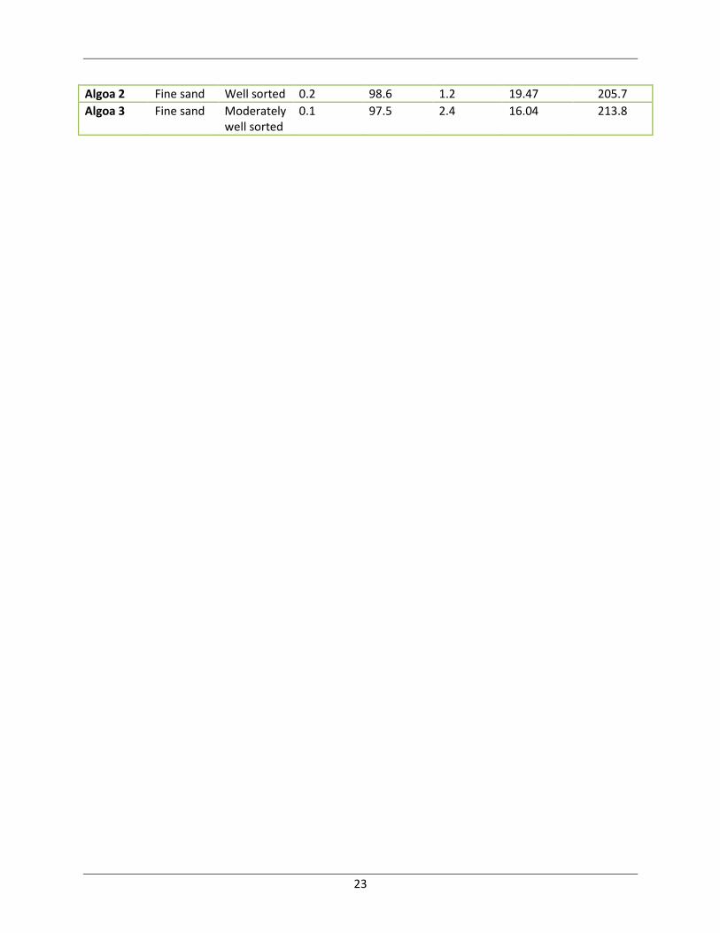
Table 5. Sediment characteristics at the ADCP deployment sites in Algoa 2 and Algoa 3.
Site Type Sorting % gravel %sand %mud %TOC Ave. Particle size (µm)
0 Steel anchor
No. 5 (20 m)
No.4 (16 m)
No.3 (12 m)
No.2 (8 m)
No.1 (4 m)
23
Algoa 2 Fine sand Well sorted 0.2 98.6 1.2 19.47 205.7
Algoa 3 Fine sand Moderately well sorted
0.1 97.5 2.4 16.04 213.8
24
Figure 11. Summary chart of the bathymetry surveys conducted in February 2012.
25
8 References
Barnes, K.N. 1998. Important bird areas of the Eastern Cape. In: The important bird areas of southern
Africa. Barnes, K.N. (ed.). pp. 197-218.
Beckley, L.E. 1983. Sea-surface temperature variability around Cape Recife, South Africa. South African
Journal of Science 79: 436-438.
Beckley, L.E. 1988. Marine invertebrates. In: R. Lubke, F. Gess and M. Bruton (eds.). A field guide to the
eastern cape coast. Grahamstown Centre of the Wildlife Society of Southern Africa, Grahamstown.
Beckley, L.E. 1988. Spatial and temporal variability in sea temperatures in Algoa Bay, South Africa. South
African Journal of Science 84: 67-69.
BirdLife International. 2012. Important Bird Areas factsheet: Algoa Bay Island Nature Reserve.
Downloaded from http://www.birdlife.org on 14/02/2012.
Bird Life International, 2012a. http://www.birdlife.org/ on 14/02/12.
Branch, G., Griffiths, C., Branch, M. And Beckley, L. 2010. Two Oceans: a guide to marine life of southern
Africa. Struik Publishers (Pty) Ltd.
Bustamante, R. and Branch, G. 1996. Large scale patterns and trophic structure of southern African
rocky shores: the roles of geographic variation and wave exposure. Journal of Biogeography 23: 339-
359.
Churchill, J.R.S. 1995. Coastal ocean dynamics off Port Elizabeth, Algoa Bay. Msc thesis, University of
Port Elizabeth.
Crawford, R.J.M., Williams, A.J., Randall, R.M. and Randall, B.M. et al. 1990. Recent population trends of
Jackass Penguins Spheniscus demersus off southern Africa. Biological Conservation 52: 229-243.
Crawford, R.J.M. 1997a. Roseate tern Sterna dougallii. In: The atlas of southern African birds. Vol. 1:
Non-passerines. Harrison, J.A., Allan, D.G., Underhill, L.G., Herremans, M., Tree, A.J., Parker, V. and
Brown, C.J. (eds.). pp. 479. BirdLife South Africa, Johannesburg.
Crawford, R.J.M. 1997b. Cape Gannet Morus capensis. In: The atlas of southern African birds. Vol. 1:
Non-passerines. Harrison, J.A., Allan, D.G., Underhill, L.G., Herremans, M., Tree, A.J., Parker, V. and
Brown, C.J. (eds.). pp. 28-29. BirdLife South Africa, Johannesburg.
CSIR, 1987. Council for Scientific and Industrial Research. Unpublished Cape Recife wave rider buoy data.
26
Dingle, R.V., Birch, G.F., Bremner, J.M., De Decker, R.H., Du Plessis, A. et al. 1987. Deap-sea sedimentary
environments around southern Africa (South-East Atlantic and South-West Indian oceans). Annuals of
the South African Museum 98: 1-27.
Emanuel, B., Bustamante, R., Branch, G., Eekhout, S. and Odendaal, F. 1992. A zoogeographic and
functional approach to the selection of marine reserves on the west coast of South Africa. South African
Journal of Marine Science 12: 341-354.
Emery, K.O. and Uchupi, E. 1975. Continental margin off western Africa: Cape St Francis (South Africa) to
Walvis Ridge (South-West Africa). AAPG Bulletin 59. DOI: 10.1306/83D91C09-16C7-11D7-
8645000102C1865D
Eskom. 2010. Eskom Holdings Limited. Environmental impact assessment for the proposed nuclear
power station (‘nuclear-1’) and associated infrastructure: Oceanographic specialist report, J27035.
Goschen, W.S. and Schumann, E.H. 1988. Ocean current and temperature structures in Algoa Bay and
beyond in November 1986. South African Journal of Marine Science 7: 101-116.
Goschen, W.S. and Schumann, E.H. 1995. Upwelling and the occurrence of cold water around Cape
Recife, Algoa Bay, South Africa. South African Journal of Marine Science 16: 57-67.
Goschen, W.S. and Schumann, E.H. 2011. The physical oceanographic processes of Algoa Bay, with
emphasis on the western coastal region: A synopsis of the main results of physical oceanographic
research in and around Algoa Bay up until 2010. SAEON and IMT.
Grundlingh, M.L. and Lutjeharms, J.R.E. 1979. Large-scale flow patterns of the Agulhas Current system.
South African Journal of Science 75: 269-270.
Harris, T.F.W. 1978. Review of coastal currents in southern African waters. Republic of South Africa
Natural Science Programs 30: 103 pp.
Heydorn, A.E.F. and Tinley, K.L. 1980. Estuaries of the Cape part 1. Synopsis of the Cape Coast. CSIR
Research Report 380. CSIR, Pretoria.
Hockey, P.A.R. 1983. The distribution, population size, movements and conservation of the African Black
Oystercatcher Haematopus moquini. Biological Conservation 25: 233-262.
Hutchings, K., Porter, S., Clark, B.M. and Sink, K. 2011. Strategic environmental assessment:
Identification of potential marine aquaculture development zones for fin fish cage culture. Draft October
2011. Available at:
http://www.anchorenvironmental.co.za/index.php?option=com_content&view=article&id=27&Itemid=
29
27
Maclachlan, A. 1983. The ecology of sandy beaches in the Eastern Cape, South Africa. In: Sandy Beaches
as ecosystems, Junk, The Hague, Netherlands.
Martin, A.P. 1997. African black oystercatcher Haematopus moquini. In: The atlas of southern African
birds. Vol. 1: Non-passerines. Harrison, J.A., Allan, D.G., Underhill, L.G., Herremans, M., Tree, A.J., Parker,
V. and Brown, C.J. (eds.). pp. 374-375. BirdLife South Africa, Johannesburg.
Mills, G. and Hes, L. 1997. The complete book of southern African mammals. Struik Publishers, Cape
Town.
Randall, R.M., Randall, B.M. and Ralfe, M. 1991. Roseate terns in South Africa: population size, revision
of previous estimate and conservation. Bontebok 7: 1-6.
Roberts, M.J. 1990. Dispersion of a buoyant effluent discharged into the nearshore waters of Algoa Bay.
MSc thesis. University of Port Elizabeth.
Roberts, M.J. 2005. Chokka squid (Loligo vulgaris reynaudii) abundance linked to changes in South
Africa’s Agulhas Bank ecosystem during spawning and the early life cycle. ICES Journal of Marine Science
61: 33-55.
Ross, G.J.B. 1988. Coastal hydrography. In: R. Lubke, F. Gess and M. Bruton (eds.). A field guide to the
eastern cape coast. Grahamstown Centre of the Wildlife Society of Southern Africa, Grahamstown.
Schumann, E.H. 1999. Wind-driven mixed layer and coastal upwelling processes off the south coast of
South Africa. Journal of Marine Research 57: 671-691.
Schumann, E.H., Ross, G.J.B. and Goschen, W.S. 1988. Cold water events in Algoa Bay and along the
Cape south coast, South Africa, in March/April 1987. South African Journal of Science 84: 579-584.
Schumann, E.H., Perrins, L.-A. and Hunter, I.T. 1982. Upwelling along the south coast of the Cape
Province, South Africa. South African Journal of Science 78: 238-242.
Seagrief, S. 1988. Marine algae. In: R.A. Lubke, F.W. Gess & M.N. Bruton (eds.). A field guide to the
eastern cape coast. Grahamstown Centre of the Wildlife Society of Southern Africa, Grahamstown.
Stone, A.W. 1988. Climate and weather. In: R.A. Lubke, F.W. Gess and M.N. Bruton (eds.). A field guide
to the eastern cape coast. Grahamstown Centre of the Wildlife Society of Southern Africa,
Grahamstown.
Turpie, J., Beckley, L. and Katua, S. 2000. Biogeography and the selection of priority areas for
conservation of South African coastal fishes. Biological Conservation 92: 59-72.
28
Wallace, J.H., Kok, H.M., Buxton, C.D. and Bennet, B. 1984. Inshore small-mesh trawling survey of the
Cape south coast. Part 1. Introduction, methods, stations and catches. South African Journal of Zoology
19: 155-164.
Williams, A.J. 1997. Antartic tern Sterna vittata. In: The atlas of southern African birds. Vol. 1: Non-
passerines. Harrison, J.A., Allan, D.G., Underhill, L.G., Herremans, M., Tree, A.J., Parker, V. and Brown,
C.J. (eds.). pp. 478. BirdLife South Africa, Johannesburg.