Embed Size (px)
Citation preview
albatifair-
McCLELLAN-KERR RIVER NAVIGATION SYSTEM
BANK STABILIZATION Npproued f4ir public relssise distribution unlimited
Submitted to U \R \Y ENGINEER
C) MIME FOR
-Tr
CURTER RESOURCES KINGM Vs.1 BUILDING
FORT BELVOIR VIRGINIA 22060
by the U. 5. Army Engineer Division, Southwestern
Dallas, Texas 75202
MARCH 1980
RESEARCH REPORT 80-R3 _ _
;011 .-.10.:31r
Copies may be purchased from:
National Technical Information Service U.S. Department of Commerce Springfield, Virginia 22151
This report is not to be construed as necessarily representing the views of the Federal Government nor of the U.S. Army Corps of Engineers.
Unclassified SECURITY CLASSIFICATION OF THIS PAGE (When Data Entered)
,
REPORT DOCUMENTATION PAGE READ INSTRUCTIONS BEFORE COMPLETING FORM
I. REPORT NUMBER 2. GOVT ACCESSION NO. 3. RECIPIENT'S CATALOG NUMBER
IWR Research Report 80-R3 4. TITLE (and Subtitle) 5. TYPE OF REPORT & PERIOD COVERED
McClellan-Kerr River System Research
6 PERFORMING ORG. REPORT NUMBER
7. AUTHOR(A) 8. CONTRACT OR GRANT NUMBER(e)
80-R3
9. PERFORMING ORGANIZATION NAME AND ADDRESS 10. PROGRAM ELEMENT, PROJECT, TASK AREA & WORK UNIT NUMBERS
U.S. Army Engineer Division, Southwestern
Dallas, Texas 75202
11. CONTROLLING OFFICE NAME AND ADDRESS 12. REPORT DATE
U.S. Army Engineer, Institute for Water Resources March 1980 13 NUMBER OF PAGES
Fort Belvoir, VA 22060 27
14. MONITORING AGENCY NAME & ADDRESS(if different from Controlling Office) 15. SECURITY CLASS. (of this report)
Unclassified
15e, DECLASSIFICATION/DOWNGRADING SCHEDULE
16. DISTRIBUTION STATEMENT (of this Report)
Unlimited
17 DISTRIBUTION STATEMENT (of the abstract entered In Block 20, if different from Report)
18. SUPPLEMENTARY NOTES
Dr. Robert Summitt was principal author and project manager.
19. KEY WORDS (Continue on reverse side if necessary and identify by block number)
Project Development Upstream & Tributary Reservoirs Project Benefits Physical & Envioronmental Effects Need for Bank Stabilization Economic Effects Work Completed
20. ABSTRACT ('C'entAsue ees reverse stab Ft mecerreary and identity by block number)
This report is to present data and information which reveal the nature and
extent of the effect of the bank stabilization works, as an integral part of
the McClellan-Kerr Arkansas River Navigation Project, Identifying economic
effects will be the primary thrust of this report,
, DD FORM 1473
I JAN 73 / EDITION OF / NOV 65 IS OBSOLETE Unclassified SECURITY CLASSIFICATION OF THIS PAGE (When Data Entered)

SECURITY CLASSIFICATION OF THIS PAGE(Whon Data Entered)
SECURITY CLASSIFICATION OF THIS P AGE(When Data Entered)
McClellan-Kerr River
Navigation System
1 BANK STABILIZATION
A Report Submitted to the:
U.S. Army Engineer Institute for Water Resources Kingman Building
Fort Belvoir, Virginia 22060
by the U.S. Army Engineer Division, Southwestern
Dallas, Texas 75202
March 1980 IWR Report 80-R3
BANK STABILIZATION
McClellan-Kerr River Navigation System
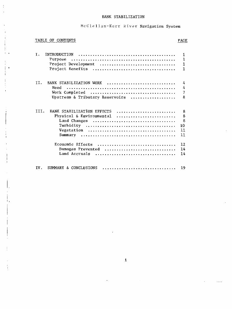
TABLE OF CONTENTS PAGE
I. INTRODUCTION 1 Purpose 1 Project Development 1 Project Benefits 1
II. BANK STABILIZATION WORK 4 Need 4 Work Completed 7 Upstream & Tributary Reservoirs 8
III. BANK STABILIZATION EFFECTS 8
Physical & Environmental 8 Land Changes 8 Turbidity 10 Vegetation 11 Summary 11
Economic Effects 12 Damages Prevented 14 Land Accruals 14
IV. SUMMARY & CONCLUSIONS 19
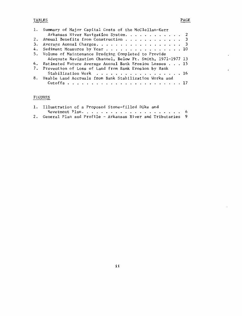
TABLES PAGE
1. Summary of Major Capital Costs of the McClellan-Kerr Arkansas River Navigation System 2
2. Annual Benefits from Construction 3 3. Average Annual Charges 3 4. Sediment Measures by Year 10 5. Volume of Maintenance Dredging Completed to Provide
Adequate Navigation Channel, Below Ft. Smith, 1971-1977 13 6. Estimated Future Average Annual Bank Erosion Losses . . . 15 7. Prevention of Loss of Land from Bank Erosion by Bank
Stabilization Work 16 8. Usable Land Accruals from Bank Stabilization Works and
Cutoffs 17
FIGURES
1. Illustration of a Proposed Stone-filled Dike and Revetment Plan 6
2. General Plan and Profile - Arkansas River and Tributaries 9
BANK STABILIZATION
McCellan-Kerr River Navigation System
I. INTRODUCTION.
Purpose. The purpose of this study and report is to present data and information which reveal the nature and extent of the effect of the bank stabilization works, as an integral part of the McClellan-Kerr Arkansas River Navigation Project. Identifying economic effects will be the primary thrust of this report, with limited treatment of the physical and environmental effects. Environmental aspects are the subject of another specific study and report contracted by the Little Rock District, Corps of Engineers.
Project Development. The development of the Arkansas River for navigation, flood control, hydroelectric power generation and other purposes was the largest civil works project ever undertaken by the Corps of Engineers. It was authorized by Congress in the River and Harbor Act of July 24, 1946, and construction began in 1949. In 1971 Congress designated it as the McClellan-Kerr Arkansas River Navigation System. Navigation reached Little Rock, Arkansas, in December 1968; Fort Smith, Arkansas, in December 1969; and Catoosa, Oklahoma, at the head of navigation, in December 1970. A minimum depth of 9 feet is maintained along the navigation channel, and the width of the channel varies from 300 feet in the White River and the Arkansas Post Canal to 250 feet on the Arkansas River and 150 feet on the Verdigris.
Although seven upstream lakes in eastern Oklahoma have a major role in the operation of the McClellan-Kerr Arkansas River Navigation System, only three lakes are a part of the Navigation System. Keystone Lake is located on the Arkansas River above Tulsa, Oklahoma, Oologah Lake on the Verdigris River and Eufaula Lake on the Canadian River. The purposes of these lakes include navigation, flood control, municipal and industrial water supply, hydroelectric power, recreation, and fish and wildlife.
Project Benefits. This completed project includes multiple benefits which accrue from low-cost water transportation, reduction of flood damages, generation of hydroelectric power, channel stabilization, pro-vision of water supply, enhancement of fish and wildlife, recreation, and redevelopment. The type of the specific benefit determines the nature and extent of the effects from each. For example, flood damage reduction and water supply storage supplied affect the local and regional areas in Arkansas and Oklahoma, while hydroelectric power produced is distributed in Arkansas, Kansas, Texas, Oklahoma, Missouri and Louisiana. Reduced cost of water transportation has widespread effects upon economies of the region, the Nation, and international trade.
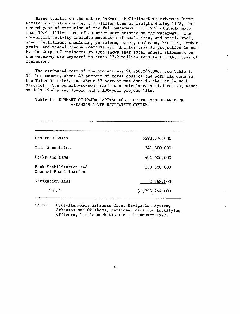
Barge traffic on the entire 448-mile McClellan-Kerr Arkansas River Navigation System carried 5.7 million tons of freight during 1972, the second year of operation of the full waterway. In 1978 slightly more than 10.0 million tons of commerce were shipped on the waterway. The commercial activity includes movements of coal, iron, and steel, rock, sand, fertilizer, chemicals, petroleum, paper, soybeans, bauxite, lumber, grain, and miscellineous commodities. A water traffic projection issued by the Corps of Engineers in 1965 shows that total annual shipments on the waterway are expected to reach 13.2 million tons in the 14th year of operation.
The estimated cost of the project was $1,258,244,000, see Table 1. Of this amount, about 47 percent of total cost of the work was done in the Tulsa District, and about 53 percent was done in the Little Rock District. The benefit-to-cost ratio was calculated at 1.5 to 1.0, based on July 1968 price levels and a 100-year project life.
Table 1. SUMMARY OF MAJOR CAPITAL COSTS OF THE McCLELLAN-KERR ARKANSAS RIVER NAVIGATION SYSTEM.
Upstream Lakes $290,676,000
Main Stem Lakes 341,300,000
Locks and Dams 494,000,000
Bank Stabilization and 130,000,000 Channel Rectification
Navigation Aids 2,268,000
Total $1,258,244,000
Source: McClellan-Kerr Arkansas River Navigation System, Arkansas and Oklahoma, pertinent data for testifying officers, Little Rock District, 1 January 1973.
2
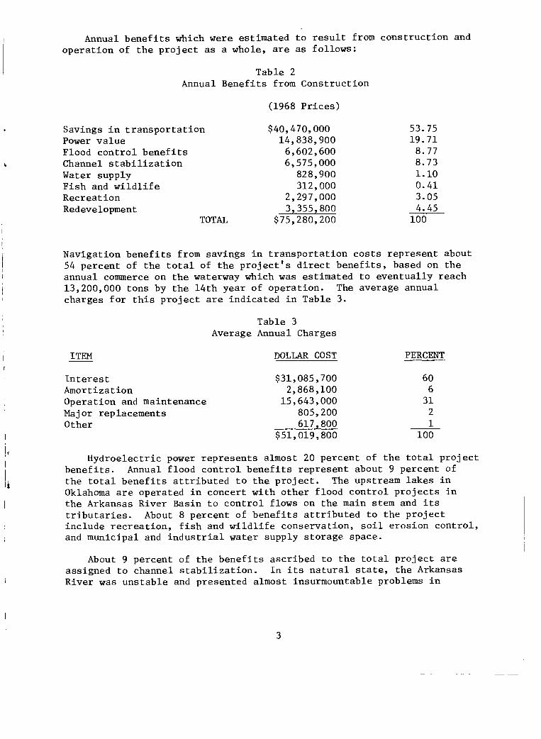
Annual benefits which were estimated to result from construction and operation of the project as a whole, are as follows:
Table 2 Annual Benefits from Construction
(1968 Prices)
Savings in transportation $40,470,000 53.75 Power value 14,838,900 19.71 Flood control benefits 6,602,600 8.77 Channel stabilization 6,575,000 8.73 Water supply 828,900 1.10 Fish and wildlife 312,000 0.41 Recreation 2,297,000 3.05 Redevelopment 3,355,800 4.45
TOTAL $75,280,200 100
Navigation benefits from savings in transportation costs represent about 54 percent of the total of the project's direct benefits, based on the annual commerce on the waterway which was estimated to eventually reach 13,200,000 tons by the 14th year of operation. The average annual charges for this project are indicated in Table 3.
Table 3 Average Annual Charges
ITEM DOLLAR COST PERCENT
Interest $31,085,700 60 Amortization 2,868,100 6 Operation and maintenance 15,643,000 31 Major replacements 805,200 2 Other 617,800 1
$51,019,800 100
Hydroelectric power represents almost 20 percent of the total project benefits. Annual flood control benefits represent about 9 percent of the total benefits attributed to the project. The upstream lakes in Oklahoma are operated in concert with other flood control projects in the Arkansas River Basin to control flows on the main stem and its tributaries. About 8 percent of benefits attributed to the project include recreation, fish and wildlife conservation, soil erosion control, and municipal and industrial water supply storage space.
About 9 percent of the benefits ascribed to the total project are assigned to channel stabilization. In its natural state, the Arkansas River was unstable and presented almost insurmountable problems in
3
making it suitable for navigation. Carrying a heavy sediment load and subject to wide and frequent fluctuations, the river could change from a mere trickle of water to a rushing torrent, switching its course and destroying improvements along its banks. Bank stabilization and channel rectification works now provide a relatively stable channel suitable for modern barge traffic. Revetments, dikes, channel cutoffs, and dredging stabilize the balks, as well as realign and deepen the designated navi-gation channel. Control of the channel width and depth allows more efficient use of water releases necessary for maintaining minimum depths and width for navigation on the waterway. Dredging is required to assist in the establishment of a long-term stabilized channel.
II. BANK STABILIZATION WORK
The Arkansas River is an alluvial stream. An alluvial stream is de-fined as one flowing in a channel formed by the stream in sedimentary material previously trc-sported and deposited by the stream. Alluvial rivers are characterized by their meandering habits. An appreciation of the meandering formation and the principal factors affecting meanders and caving banks is a prerequisite to understanding of the various changes that occur when a channel is stabilized. The types of meanders normally found along alluvial rivers creates or forms bars, beaches, and traveling bars. The Arkansas River is considered a medium size alluvial river.
An examination of the Arkansas River before stabilization and rectifi-cation was completed will contribute to understanding changes attributable to bank stabilization works. The preproject suspended sediment load was 105 million tons per year at Little Rock. About 24 percent of this sediment was suspended bed material consisting primarily of sand. The sediment was obtained from caving the banks and removal of material from the bottom of the river. The river picks material at one location and then deposits it downstream at another location depending on the charac-teristics of the river. The cycle is then repeated downriver. How the river moves material along its path depends on several factors; the major ones being the volume of flow, the water surface slope, and the size of material in the river channel.
Need. Information from Congressional House Document No. 758 made specific mention of project aspects which reveal the need for sediment control and bank stabilization.
The records of past attempts to improve the Arkansas River for navigation by snagging, dredging, and regulation, together with the knowledge of the characteristic periods of low flow and large sediment load of the stream, show conclusively that the only practicable method of providing for dependable navigation is by canalization with adequate provisions for sediment control.
4
....Extensive bank-stabilization works would be required in the reach of the waterway from the mouth of the Verdigris River to the Mississippi River....
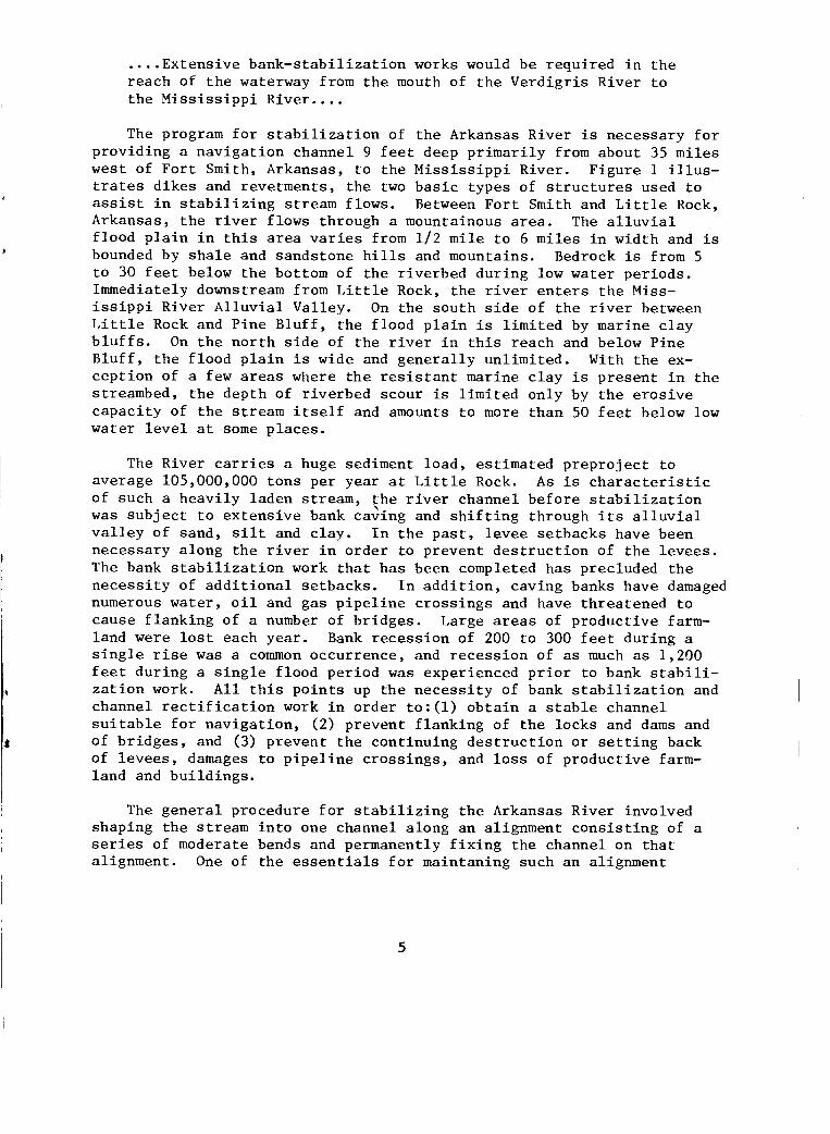
The program for stabilization of the Arkansas River is necessary for providing a navigation channel 9 feet deep primarily from about 35 miles west of Fort Smith, Arkansas, to the Mississippi River. Figure 1 illus-trates dikes and revetments, the two basic types of structures used to assist in stabilizing stream flows. Between Fort Smith and Little Rock, Arkansas, the river flows through a mountainous area. The alluvial flood plain in this area varies from 1/2 mile to 6 miles in width and is bounded by shale and sandstone hills and mountains. Bedrock is from 5 to 30 feet below the bottom of the riverbed during low water periods. Immediately downstream from Little Rock, the river enters the Miss-issippi River Alluvial Valley. On the south side of the river between Little Rock and Pine Bluff, the flood plain is limited by marine clay bluffs. On the north side of the river in this reach and below Pine Bluff, the flood plain is wide and generally unlimited. With the ex-ception of a few areas where the resistant marine clay is present in the streambed, the depth of riverbed scour is limited only by the erosive capacity of the stream itself and amounts to more than 50 feet below low water level at some places.
The River carries a huge sediment load, estimated preproject to average 105,000,000 tons per year at Little Rock. As is characteristic of such a heavily laden stream, the river channel before stabilization was subject to extensive bank caving and shifting through its alluvial valley of sand, silt and clay. In the past, levee setbacks have been necessary along the river in order to prevent destruction of the levees. The bank stabilization work that has been completed has precluded the necessity of additional setbacks. In addition, caving banks have damaged numerous water, oil and gas pipeline crossings and have threatened to cause flanking of a number of bridges. Large areas of productive farm-land were lost each year. Bank recession of 200 to 300 feet during a single rise was a common occurrence, and recession of as much as 1,200 feet during a single flood period was experienced prior to bank stabili-zation work. All this points up the necessity of bank stabilization and channel rectification work in order to:(1) obtain a stable channel suitable for navigation, (2) prevent flanking of the locks and dams and of bridges, and (3) prevent the continuing destruction or setting back of levees, damages to pipeline crossings, and loss of productive farm-land and buildings.
The general procedure for stabilizing the Arkansas River involved shaping the stream into one channel along an alignment consisting of a series of moderate bends and permanently fixing the channel on that alignment. One of the essentials for maintaning such an alignment
5

AT-:•:•• -
•
vtle.,tt eet."
-0
"••'—
ast......r......... 7.. ...„...-...9 ,e - , - • .4-- • Pee; 7 ":"---.41,1- et.7:-.7--;:- Z.,•_,-:••.:•-•re- •.• .
......4 =,:-...• • - 4 -.' '. -'''' .1....- - " — - - - a• - • - -- - - ''• - - - ' - ...: - -..-•- • • -- , - -,-... ::-, .---.11̀ -- e ..- ..- . --- --•-•--- : Thr,...._ -:-.■ •-• ''' ' * ' ' • '-'•- ..?•e___ e - - ... ,... -‘--- _-_ eg.••••- '
--, . :_----, r -1,=',..t. '..., , . • ' •,. • • , f .1. ge- „ • --- = 1- — - --
-e
fit -.•-• e---' '2. Z; **e---- ' • . --‘-e17-4- • ' r•"__ -.'•- • - -,s-,.--- --""" ' ' :'-*
-- • - , , - - •-• --.......
9 •••-%f
44Y0' 4■
• -L.:
-
t
Revetment
....—...., ■ e
_
dAii0 40■04,1t.....-1•16 mop
ditrAirea,,00,00
-;;_;0•;:i:L'attge.- ••••-••• •=`--1Zr- -
-
; 7023fir - - -
Figure 1. ILLUSTRATION OF A PROPOSED STONE-FILLED DIKE & REVETMENT PLAN
6
is that stabilization work in any section of the river be started at some fixed point, such as a natural rock outcrop or a manmade structure, upstream and worked progressively downstream to some other fixed loca-tion. Another important design procedure: "To the extent possible, the bend alignments were designed to follow the natural alignment of the river so as to minimize changes to the flow regime or characteristics of the river."/This has been accomplished by the use of:(1) revetments to stabilize the concave banks of bends, (2) dikes to close off secondary channels, to control the direction of flow from one bend to the next, and to fair-out the natural concave banks to a more desirable alignment, and (3) cutoff channels to eliminate long bends with small radii of curvature.
The Arkansas River is still subject to some shifting of alignment within the present control lines. Deviations, if left uncontrolled, may allow a deterioration of the alignment for the navigation channel and would permit severe damage to existing bank-stabilization structures. Minor additional contraction structures may be required to correct such deviations and also to improve navigation conditions in reaches where shoals have developed repeatedly and maintenance dredging has been required.
The Federal Government, together with local improvement districts, have invested more than $37,000,000 in the construction of levees to protect more than two and one-half million acres of agricultural and urban lands within the flood plain of the river between Tulsa and the mouth. Also, there were 118 crossings of the River in 1975 between Tulsa and the mouth, about 95 of these are in the Little Rock District area. These crossings consist of highways, railways, pipelines, water-lines, and transmission lines. Many of the pipelines carry petroleum products, including natural gas, to large industrial centers in the northern and eastern states. The loss of these crossings would have a far-reaching effect on a wide area of the nation and an immediate impact on military installations and defense industries. The construction of the bank stabilization work to date has resulted in its primary goal of establishing a stable navigation channel for about 336 miles along the river. This channel has provided dependable navigation since 1968 when the first portion of the waterway was opened and maintenance dredging has been slightly more than was anticipated because of the heavy sed-iment loads associated with high river flows. River banks along most of the channel have been stabilized, thereby preventing the loss of levees and much good farmland by bank caving. Before the stabilization work was built, caving banks destroyed levees or made it necessary to con-struct new levee setbacks to prevent flooding of large areas of valley land. The stabilized channel has also prevented damages and threats to the safety of bridges, powerlines and pipelines along the river.
Work Completed. Essentially all the bank stabilization work planned for the waterway has been completed. Within the Little Rock District,
1/ Source: Water Resources Development in Arkansas, 1973, Lower Mississippi Valley District, U.S. Army Corps of Engineers.
7
construction of dikes and revetments to stabilize the river banks and rectify the channel has been underway since 1949 with about 842,400 linear feet of dike and 1,324,900 linear feet of revetment included when the total work is accomplished over the navigation system from its beginning to mile 308 at Fort Smith, Arkansas, where Little Rock District responsibility ends and Tulsa District responsibility begins.
Upstream and Tributary Reservoirs. In addition to the four main stem reservoirs (Dardanelle, Ozark, Robert S. Kerr, and Webbers Falls), three reservoirs in eastern Oklahoma play a major role in the develop-ment and operation of the Arkansas River Navigation System. Keystone Reservoir is located on the Arkansas River above the navigable portion, and the other two reservoirs are located on its tributaries. These are Oologah on the Verdigris and Eufaula on the Canadian.
Other upstream reservoirs include Kaw on the Arkansas above Keystone, Tenkiller Ferry on the Illinois, and Pensacola, Markaham Ferry, and Fort Gibson on the Grand (Neosho) (Figure 2). These reservoirs were constructed to include low-flow regulation, sediment control, flood control, domestic and industrial water supply, enhancement of fish and wildlife habitat, recreation opportunities, and hydroelectric power generation.
III. BANK STABILIZATION EFFECTS
Physical and Environmental Effects. The bank stabilization and channel rectification program is an essential element of the multiple-purpose plan of development for the Arkansas River in Arkansas and Oklahoma which was authorized by the River and Harbor Act of 24 July 1946. A stable channel of suitable alignment, inherent in the develop-ment of a functional navigation project, is required to preclude flanking of the locks and dams as well as for navigation itself. Allowing the Arkansas River to flow in its natural uncontrolled state would not permit such beneficial uses of the channel.
Land Changes - Even though the river (in its uncontrolled state) caved banks as it flowed downstream, it did not change the total quantity of land. The amount of land in the river valley has remained relatively the same. However, the quality and quantity of productive land may vary significantly as the river meanders. As the river mean-dered across the valley, the banks caved at one location while a bar was built at another location. Many years will elapse before the quality of the land in these newly formed bars is as productive for agricultural uses as were the areas lost. The bank stabilization program has reduced the supply of sediment material the river may obtain from the banks and has decreased the angle of attack on sandbars in the river channel. Sediment storage in the upstream reservoirs has also sharply decreased the supply of material to the river. Within the stabilized channel the river now obtains most of its load from the bottom. The material from the bottom of the river is heavier and cleaner, leaving the flowing water cleaner.
8

SCALE OF MILES 10 0 10 20 30 40 50 331 NET_OOLOG A
F_ARKANSAS
KEYSTONE
wiAW
piiver MeumeIle fey
0
Four I Verchgns ver g
5 500
wsoo DARDANELLE
Pine Bluff s 4 t A
Arkansas Post Roane/LI'
0 'f i 1 j
ARKANSAS RIVER NAVIGATION SYSTEM
A Gr(ancl (Neosho) River
ENSACOLA
Muskogee
ORONO rn Ozark
K FAIIIVROB41
R(T S
WEBER
OZARK
EUFAULA çec enediah
100 500 450 400 350 300 250 200 150 100 50 0
VERDIGRIS RIVER-ARKANSAS RIVER NAVIGATION MILES
300
200
800
700
; 6°°
Figure 2 General Plan and Profile - Arkansas River and Tributaries
The bank stabilization and reservoirs appear to have influenced the turbidity. The upstream reservoirs remove some of the suspended sediment by detention. However, if the supply of sediment is available after the water is released from the reservoir, it may regain its full sediment load. The records indicate the stream flow is regaining less and less of its former load as the channel is making improvement at stabilizing as the supply of fine sediment is reduced. If the bank stabilization structures were not constructed, the banks would be caving as previously, the accrual of benefits from the project purpose of navigation would be greatly hampered, if not eliminated. The following figures will indicate how the supply of sediment material is being reduced. Tabulated in Table 4 are some quantities of sediment measured at selected gaging stations and the relation of streamflow and the amount of sediment moved.
Table 4 Sediment Measures by Year
Lock and Dam 13
Sediment River Flow Sediment Ton/Acre-Feet
Water Year Acre-Feet/Year Ton/Year River Flow
1971 14,460,000 3,784,400 .26 1973 51,150,000 36,441,400 .71 1975 46,870,000 14,408,100 .30 1976 14,990,000 2,036,200 .13
Dardanelle Lock and Dam
Sediment River Flow Sediment Ton/Acre-Feet
Water Year Acre-Feet/Year Ton/Acre River Flow
1964 7,142,000 5,203,000 .73 1969 34,540,000 6,813,700 .20 1973 55,640,000 11,283,600 .20 1976 15,850,000 602,109 .04
Little Rock; Murray Lock and Dam
Sediment River Flow Sediment Ton/Acre-Feet
Water Year Acre-Feet/Year Ton/Acre River Flow
1961 39,050,000 95,231,000 2.44 1964 21,030,000 21,552,000 1.02 1967 12,560,000 3,317,000 .26 1970 25,530,000 15,317,000 .60 1973 64,380,000 28,555,500 .44 1976 18,230,000 1,783,200 .01
10

Several factors influence the amount of material that the stream moves, such as the time of year of rises on the river and the size and duration of flow. However, the main control on the amount of sediment moved depends on the available supply. The supply will be picked up from the river bed and to some extent from the banks if it is available from either of these sources.
Vegetation - The bank stabilization and channel rectification has allowed the sandbars to stay at one location a sufficient length of time to grow willows, cottonwoods, and other types of plants. The vegetation on the bars reduces erosion during large flows on the river and removes some of the finer particles of sediment as the water flows through the growth on the bars. As the elevation of the top of the bars increases, it forces more of the flow to stay in the main channel when the next large flow occurs. The sandbars are generally divided into graveliferous, sand, and silt-clay-fine-sand layers. The finer material layers are the best to support vegetation and the vegetation is neces-sary to keep this material from being moved during the next large flow. This, in addition to the upstream reservoirs, reduces the turbidity in the river.
In a recent study entitled Environmental Effects of the Completed McClellan-Kerr Arkansas River Navigation System, there are some five major areas of effects which have been assessed. These are visual characteristics, bank stabilization, water quality, cultural, and ecology. The most significant visual changes identified were in the edge con-ditions and width of the waterway, in the vistas, in the grain character, and in the formation of in-stream lakes. The conclusion in this study was that bank stabilization had a positive effect on the Arkansas River in several ways, among which are a decreased turbidity, significant reduction in suspended sediment loads, and the formation of new habitat in backwater areas. The reduction in turbidity is linked to improved visual and aesthetic value as well as improved sport fishing. Prior to 1965, the average suspended sediment load ranged from 62 to 97 million tons/year whereas the estimate for the period 1965-1977 is only 10 million tons/year.
The backwater areas created by the dikes and revetments provide excellent habitat for fish and wildlife. There is some danger that routine and continued maintenance operations could destroy this habitat or prevent its effective use. In addition to providing valuable cover and spawning sites in the rock materials of the dikes and revetments, drift and debris tend to accumulate on or behind the pile and rockf ill dikes which further augment these purposes.
Summary - The major physical effects of the Navigation Project include maintaining channel width and depth suitable for navigation, control of river flows (high and low), creation of on-stream and tributary lakes, restriction of natural river movements by bank stabilization works,
11
alignment of river channels which created old river-bend cutoff areas, reduction of quantity of sediments flowing downstream, improvement in water quality, as well as reductuion in the flood damages. The environ-mental study referenced earlier concluded that the reduction in turbidity is linked to improved visual and aesthetic value, as well as improved sport fishing. Also, this study noted that the backwater areas created by the dikes and revetments provide excellent habitat for fish and wildlife.
The volume of maintenance dredging annually downstream from Fort Smith, Arkansas from 1971-1977 period is shown to vary from 1,000,000 cubic yards in 1971 to 4,500,000 cubic yards in 1973 when extremely high flows were experienced on the river (Table 5). The maintenance dredging volume from 1971 through 1977 averaged 2,470,000 cubic yards annually for the 7-year period. This average of 2.5 million cubic yards per year is slightly higher than the 2.2 million predicted in the design memo-randum and is more than double the 1.2 million cubic yards annually predicted in 1964 by the Arkansas River Operation and Maintenance Com-mittee for the years 1970-1975. The volume of maintenance dredging is expected to continue to decline as the amount of bed material in the channel approaches a near stable condition for the dominant flow regime of the Arkansas River. By the year 2000, much of the sediment storage in the larger reservoirs will be filled. Following that time sediment loads are anticipated to increase as less sediment is trapped.
Economic Effects. About seven, nine, and ten million tons of commerce were shipped by the waterway during 1976, 1977, and 1978, respectively, coming from or going to points in Illinois, Indiana, Missouri, West Virginia, Tennessee, Alabama, Arkansas, Oklahoma, Louisiana, Alabama, Texas, and Florida. Types of commodities moving by the waterway include iron and steel, coal, chemicals, sand and gravel, aggregate, rubber, fertilizers, petroleum, grains, wood and wood products, feed products, and other products. Five major public ports and a number of other ports are located along the navigation channel to handle tonnages shipped in and out of the area. Use of the waterway allows shippers to reduce their transport costs.
Hydroelectric power serves cities, industries and individuals in four states with electricity generated from a nonpolluting, renewable energy source. Recreation opportunities and its associated industries contribute significantly to the regional economy. A more stable water supply is provided to some cities as part of the great Arkansas Basin multiple-purpose plan from some upstream lakes.
Bank stabilization works make a significant contribution to the overall set of benefits which accrue to the entire System as a whole and are essential to maintaining a channel suitable for navigation, and the construction of bank stabilization and channel rectificaiton has prob-ably had the greatest impact upon water quality parameters, that is of decreasing turbidity and suspended sediment.
12
896,000
896,000
TABLE 5
VOLUME OF MAINTENANCE DREDGING COMPLETED TO PROVIDE ADEQUATE NAVIGATION CHANNEL, BELOW FT. SMITH, 1971-1977
MAINTENANCE DREDGING VOLUME ANNUAL 11 ACCUMULATIVE AVERAGE PREDICTED 21 PREDICTED 21 (Cu. Yrds.) (Cu. Yrds.) BY ARK. R. IN DESIGN
O&M COMMITTEE MEMORANDUMS
YEAR
1971 1,000,000
1972 2,500,000
1973 4,500,000
1974 4,300,000
1975 1,400,000
1976 1,900,000
1977 1,700,000
1980
2010
1,000,000
3,500,000
8,000,000
12,300,000
13,700,000
15,600,000
17,300,000
1,000,000
1,750,000
2,670,000
3,080,000
2,740,000
2,600,000
2,470,000
1,192,000 2,205,000
Maintenance dredging completed to maintain navigable depths below Fort Smith, Arkansas.
SOURCE: Reports on Yearly Activities, of Arkansas River Basin Coordinating Committee, by SWD printed yearly 1972-1978.
21 Maintenance Dredging on the Arkansas River Navigation Project August, 1975, US Army Corps of Engineers, Southwestern Division, Dallas, Texas, Table 1.
13
Damages Prevented - Flood damage prevention was estimated to occur from reduction and/or prevention of losses to lands, highways, railroads, utilities, levees and other properties from the mouth of the Verdigris River to the mouth of the Arkansas River, see Table 6. The losses estimated to occur were direct losses ($1,541,600) and indirect losses ($67,100) for the total direct and indirect losses ($1,608,700). Forty-two percent of the direct losses were attributed to highways, railroads, utilities and other, while 24 percent of the losses were due to levee setbacks. Twenty-two percent of the estimated total direct losses were from lands and 12 percent were from bank protection works. The area under study is from about mile 309 to mile zero which is ap-proximately the last two lines of Table 6. About three-fourths of all losses were expected to occur below mile 362, while one-fourth was expected to occur above mile 361.
A summary of all facilities, which cross the Arkansas River at various points, was developed from recent official Corps of Engineers Navigation Charts dated 1976. The summary of this publication reveals that 12 highway, 10 railroad, 63 utility, and 10 other crossings are presently in use as of July 1976 from Fort Smith, Arkansas, to the Arkansas Post Canal. These 95 facilities are being protected by these bank stabilization works from river mile 308 (Fort Smith, Arkansas) to river mile 22 (Pendleton Bridge-Arkansas Post Canal area).
Estimates, completed in November 1976, of prevention of loss of land by bank stabilization works amounted to slightly in excess of 6,000 acres over 290 river miles, see Table 7. Reach number one, the Fort Smith area, covering river miles 309 through 279 contained almost one-third, or 1950 acres, of the total area identified. A significant number of acres was identified in each of the eight reaches except within reach number three, the Dardanelle area, covering river miles 231 to 187, which had an insignificant amount of lands prevented from losses by bank stabilization works. This is probably due to the geographic or physical nature of this reach which made it unnecessary to provide any bank stabilization works.
Land Accruals - Usable land accruals from bank stabilization works have been identified to total almost 10,000 acres over the 290 river miles from just above Fort Smith, Arkansas, to the Arkansas Post Canal area (see Table 8) Of the eight reaches denoted, reach seven was identified as having no significant area of land accrual from bank stabilization works, while all other reaches have areas of land accruals ranging from 450 acres in reach five to 2560 acres in reach one.
Although a few areas in some reaches may be protected to the extent that it can be economically productive lands, these areas are still sub-ject to flooding when flows are high. In areas where land accruals are
14

192,600
170,800
235,000
27,400
Miles 361.8 to mile 111.2
Miles 111.2 to mile 0.0 (mouth)
126,500 $ 31,500 585,600 628,800
208,300 158,200 564,700 571,700
Table 6. ESTIMATED FUTURE AVERAGE ANNUAL BANK EROSION LOSSES
REACH LAND HWYS,PR,UTIL, LEVEE BANK TOTAL TOTAL DIRECT & OTHER SET-BACKS PROTECTION DIRECT AND INDIRECT
WORKS LOSSES LOSSES
Mile 460.2 (mouth of Verdigris) to mile 361.8
$ 72,900 $290,400 $ 28,000 $ 391,300 $ 408,200
TOTAL $335,300 $653,800 $362,800 $189,700 $1,541,600 $1,608,700
11 Includes estimated future average annual losses in the reaches that will be inundated by the Webbers Falls, Short Mountain, Ozark and Dardanelle Reservoirs.
SOURCE: US Army Corps of Engineers Report Estimated Average Annual Erosion-Control Benefits that would Accure to the Bank-Protection and Contration Works Included in Arkansas River Multiple-Purpose Plan, 1951.
Table 7. PREVENTION OF LOSS OF LAND FROM BANK EROSION BY BANK STABILIZATION WORK (by reach and by area)
Little Rock District, 1976
ACCUMULATIVE REACH GEOGRAPHIC LOCATION NAVIGATION MILE AREA AREA
(river mile) (acres) (acres)
1 Fort Smith, AR, to 309.6 - 279.0 1950 1950
2 Arbuckle Isl, Sebastian County, to 279.0 - 230.9 390 2340
3 Dardanelle Pool @ Spadra Creek, to 230.9 - 187.6 N/A 2340
4 AR River @ Petit Jean River, to 187.6 - 159.0 410 2750
5 AR River @ Cadron Creek, to 159.0 - 104.6 1240 3990
6 Chenault Isl, Pulaski County, to 104.6 - 85.5 620 4610
7 Below Lock & Dam 5, to 85.5 - 73.0 250 4860
8 Below Hwy 79 Bridge, to AR Post Canal 73.0 - 19.0 1190 6050
TOTAL 290.6 6050
I
Table 8. USABLE LAND ACCRUALS FROM BANK STABILIZATION WORKS & CUTOFFS (by reach and by area) 1976
AREA ACCRUED BY BANK STABILIZATION AREA ACCRUED IN
REACH NAVIGATION MILE WORKS RIVER BEND CUTOFFS (river miles) (acres) (acres)
1 309.6 - 279.0 1320 1240
2 279.0 - 230.9 670 920
3 230.9 - 187.6 170 990
4 187.6 - 159.0 290 610
5 159.0 - 104.6 280 170
6 104.6 - 85.5 260 2090
7 85.5 - 73.0 insignificant insignificant
8 73.0 - 19.0 420 540
TOTAL 290.6 3410 6560
17
taking place, it is estimated that, although many areas may recover in productivity, not all will recover their full productivity. Also, this process will be a gradual action taking many years to recover previous productivity, even partially.
These land accruals have resulted in two ways, (1) areas accruing along and behind the dikes and/or revetments, and (2) areas accruing in river bend cutoffs associated with bank stabilization works and project construction. Deposition of dredge spoil has also resulted in accruals to these areas. As shown in Table 8, about one-third of the total accrual is associated with dikes and revetments and about two-thirds of the total accrual is associated with built-up areas in river bend cutoffs.
The estimated economic values accruing from the bank stabilization works were classified into the following categories:
Direct damages prevented:
- damages prevented to lands, buildings, roads, bridges and other capital improvements
- land damage (5,500 acres annually)
- cost of setback levees
- cost of bank protection
Indirect damages prevented:
- losses associated with interruption of business and gainful occupation
"The principal benefits, other than navigation, that would accrue to the Multiple-Purpose Plan because of bank-protection works provided therein would be the reduction of direct and indirect losses resulting from property damage, expenditures for set-back levees, cost of piecemeal bank-protection work, and loss of business and gainful occupation; bene-fits from increasing the rate of building 1.11D land by accretion; and the enhancement in land values that would result from the sense of security inspired by the bank-protection works." (U.S. Army Corps of Engingeers, 1951)
Usable land accruals from bank stabilization works were estimated by Little Rock District personnel in 1976 to total about 3,400 acres, Table 6. These lands are expected to revert to a gallery forest providing protec-tion with wildlife habitat. These lands will become part and parcel of the bank stabilization process and will serve partially to enhance the buffer zone between the river and the protected areas.
The remaining area accrued in the river band cutoffs, estimated by LRD in 1976 to be about 6,500 acres, is already or is expected to be
18
productive for agricultural row crops. The most likely crop expected for use on these lands is soybeans. Yields of soybeans from these lands are estimated to average about 25 bushels per acre. Yields may vary from year to year widely above and below this average in direct response to the soil productivity, and degree or length of inundation from rises in depth of river flows.
In addition to protected productive lands from damage by erosion, no additional levee setbacks have been required to date even though extremely high river flows have been experienced. No bridges, railroads, or utility crossings losses have occurred of significant consequence. Losses which were anticipated to take place under the without project conditions have not occurred with the project in place; therefore, it is concluded that the project is functioning as anticipated and the full range of damages is being prevented and the benefits from the project continue to accrue.
IV. SUMMARY AND CONCLUSIONS
1. Bank stabilization and channel rectification are integral features of the approved multiple-purpose plan of development of the Arkansas River. The capital costs of the bank stabilization works were $119,300,000, or about 10 percent of the entire project cost of $1.2 billion. The construction of the bank stabilization works has resulted in the achieve-ment of its primary goal of a stable channel which is necessary for the navigation features of the project, and prevents damages to lands, levees, highways, pipelines, and other capital improvements along the River.
2. Economic effects of the bank stabilization have been significant and widespread. Millions of tons of commerce are shipped upon the waterway annually which allows millions of dollars in savings of transportation costs. These savings accrue from savings on tonnages shipped by water-way and from savings to shippers not using the waterway who enjoy reduced rates of other modes of transportation into or out of the area. Thousands of acres of productive agricultural lands are protected. Damages to highways, railroads, levees, utilities and to the navigation locks and dams are reduced or prevented amounting to thousands of dollars annually. In addition to those losses prevented from these bank stabili-zation works, indirect losses to business and gainful occupation have been reduced. Millions of dollars of investments have been made for economic developments, for transportation facilities, recreation facili-ties, and other facilities due in part to the stabilization works.
3. Almost 10,000 acres of land have been accrued from the project design and construction. An estimated 3400 acres behind the stabiliza-tion works, and almost 6600 acres of land area, have accrued in river bend cutoffs. Although some of these areas may recover productivity,
19

not all will recover their full productivity, and it will be a gradual process taking many years to recover that productivity even partially.
4. Bank stabilization works have had specific physical, environmental, and economic effects. The economic effects are far-reaching, including the local areas, the region, the Nation, as well as international impacts through trade. Stabilization works contribute significantly to the accrual of benefits which are obtained from this project. It is an essential feature allowing many of these benefits to accrue.
20
REFERCENCES
Bank Stabilization Study
1. Schmidgall, Tasso, Maintenance Dredging on the Arkansas River, page 459,
Rivers '76, Vol 1, American Society of Civil Engineers, 1976.
2. Arkansas River Basin; Arkansas, Oklahoma and Kansas; Navigation, Report of
the Chief of Engineers, U.S. Army Corps of Engineers, 1973
3. Arkansas River and Tributaries, Arkansas and Oklahoma, 7qth Congress, 2nd
Session, House Document No. 758, July 30, 1946.
4. Environmental Effects of the Completed McClellan -Kerr Arkansas River Navi-
gation System, 1978 by University of Arkansas, Fayetteville, AR and West
Arkansas Community College, Fort Smith, AR, for Little Rock District, US,
Army Corps of Engineers.
5. Estimated Average Annual Erosion-Control Benefits that Would Accrue to the
Bank Protection and Contraction Works Included in the Arkansas River Multiple-
Purpose Plan, U.S. Army Corps of Engineers, 1951,
6 McClellan-Kerr Arkansas River Navigation System, Arkansas and Oklahoma,
pertinent data for testifying officer, 1 January 1973, U.S. Army Corps of
Engineers, Little Rock District, and 6 January 1975.
7. Navigation Charts, McClellan-Kerr Arkansas River Navigation System, Catoosa,
Oklahoma, To Mouth of White River, July 1976, U.S. Army Corps of Engineers
Districts, Little Rock, Arkansas, and Tulsa, Oklahoma.
8. Report on Annual Activities of the Arkansas River Basin Coordinating Com-
mittee, prepared by U.S. Army Corps of Engineers, Southwestern Division,
1972-1978.
9. Water Resources Development in Arkansas, 1975, U.S. Army Corps of Engineers,
Southwestern Division, Dallas, Texas.
10. Brochure, McClellan-Kerr Arkansas River Navigation System, Revised 1972, by U.S. Army Corps Engineers Districts, Little Rock, Arkansas, and Tulsa,
Oklahoma.

igiomminaolfa--z- -- -
1 4 95,945— AG— Ft Belvoir