Embed Size (px)
Citation preview
Bandon River (Bandon) Drainage Scheme in association with
Appropriate Assessment Screening Report (i)
BANDON RIVER (BANDON) DRAINAGE SCHEME
APPROPRIATE ASSESSMENT SCREENING
1 ..... INTRODUCTION ................................................................................................................... 1 1.1 ..... General Introduction .................................................................................................................... 1 1.2 ..... Site Location and Designations ................................................................................................... 1 1.3 ..... Brief Description of The Proposed Development ........................................................................ 1 1.4 ..... Appropriate Assessment Process ............................................................................................... 2 1.5 ..... Reference Documents ................................................................................................................. 4
2 ..... APPROPRIATE ASSESSMENT SCREENING MATRIX ....................................................... 5 2.1 ..... Courtmacsherry Estuary cSAC/SPA (Site Codes: 001230 & 004219) ....................................... 5 2.2 ..... Clonakilty Bay cSAC/SPA (Site Codes: 000091 & 004081) ........................................................ 7 2.3 ..... Old Head of Kinsale SPA (Site Code: 004021) ........................................................................... 8 2.4 ..... Sovereign Islands SPA (Site Code: 004124) .............................................................................. 9 2.5 ..... Seven Heads SPA (Site Code: 004191) ................................................................................... 11 2.6 ..... Bandon River cSAC (Site Code: 002171) ................................................................................. 12
3 ..... Summary and Conclusions ............................................................................................... 16
Bandon River (Bandon) Drainage Scheme in association with
Appropriate Assessment Screening Report (ii)
LIST OF TABLES
Table 2.1 Courtmacsherry Estuary cSAC/SPA Screening Matrix
Table 2.2 Clonakilty Bay cSAC/SPA Screening Matrix
Table 2.3 Old Head of Kinsale SPA Screening Matrix
Table 2.4 Sovereign Islands SPA Screening Matrix
Table 2.5 Seven Heads SPA Screening Matrix
Table 2.6 Bandon River cSAC Screening Matrix
LIST OF FIGURES
Figure 1.1 Map of Study Area showing Natura 2000 sites being considered
Figure 1.2 EU Commission Appropriate Assessment Flow Diagram
Bandon River (Bandon) Drainage Scheme in association with
Appropriate Assessment Screening Report 1
1 INTRODUCTION
1.1 GENERAL INTRODUCTION
This report has been completed to examine the potential for the proposed works associated with and
prescribed by the Bandon River (Bandon) Drainage Scheme to impact on Natura 2000 sites in the
area. An EIS has been carried out in relation to this project and all the information contained in the
EIS has been used to inform the AA Screening process.
1.2 SITE LOCATION AND DESIGNATIONS
In the initial stages of the project, the Study Area for the proposed scheme encompassed a larger
area in order to allow for the consideration of all potential scheme options and their various impacts
on the receiving environment. The Study Area at the constraints study stage was described as ‘the
channel, floodplain and immediate surrounding areas of the River Bandon extending along the main
channel of the river’ from just downstream of Baxter’s Bridge, east of Bandon Town to just upstream
of the village of Ballinadee on the Bandon estuary, measuring approximately 18.08 square kilometres
in area. However as the scheme design progressed based on feedback from the constraints study
and other relevant assessments, the Study Area was refined to a more specific area, within which
impacts may occur. For most studies conducted as part of this EIS, the Study Area was reduced to
the channel, floodplain and immediate surrounding areas of the River Bandon extending from
Baxter’s Bridge to Curranure Townland or Inishannon Village. The works area itself includes the
Bandon River and its immediate surrounds from the weir in Bandon Town (E148930 N055030) to
O’Driscolls Bridge (E151640 N056950), approximately 3.6 kilometres downstream
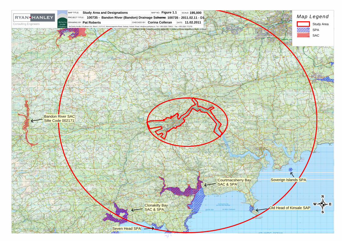
The study area and Natura 2000 sites identified are shown in Figure 1.1.
1.3 BRIEF DESCRIPTION OF THE PROPOSED DEVELOPMENT
The design of the proposed Bandon River (Bandon) Drainage Scheme has evolved through an initial
screening process of a range of potential engineering measures typically considered for flood
alleviation schemes, the development of potential options and finally the development of a preferred
scheme design.
The preferred scheme option consists of a combination of flood defences with dredging. The dredged
depth will be to 9.5 metres OD downstream of the weir and will extend over a distance of 3.6
kilometres. New flood defences will also be constructed downstream of Bandon Bridge and locally on
the left bank upstream of the weir and along the Bridewell River.
The proposed works comprising the Preferred Option for the Bandon River (Bandon) Drainage
Scheme are generally as follows;
Detailed Site Investigation comprising trial pits, dynamic probes, boreholes, rotary cores and
archaeological test trenches;
Deepening of the existing riverbed by 1.8m just downstream of Bandon Weir to 9.5mOD and
dredging for 3.6km (to O’Driscoll’s Bridge) at a gradient of 1/1000;
Underpinning of Bandon Bridge;
The replacement of the existing Pedestrian Bridge with a new Pedestrian Bridge;
McCarthy Keville O'Sullivan Ltd., Block 1, G.F.S.C, Moneenageisha Road, Galway, Ireland. Email: [email protected] Tel: +353 (0)91 735611 Fax: +353 (0)91 771279
MAP TITLE:
PROJECT TITLE:
DRAWING BY: CHECKED BY:
MAP NO.:
ISSUE NO.:
SCALE:
DATE:Pat Roberts Corina Colleran 11.02.2011
195,000100735 - 2011.02.11 - D1
Figure 1.1Study Area and Designations100735 - Bandon River (Bandon) Drainage Scheme
Ordnance Survey Ireland Licence No. AR0021811 © Ordnance Survey Ireland/Government of Ireland
Map Legend
SAC
SPA
Study Area
Clonakilty BaySAC & SPA
Bandon River SACSilte Code 002171
Courtmacsherry BaySAC & SPA
Old Head of Kinsale SAP
Soverign Islands SPA
Seven Head SPA
Bandon River (Bandon) Drainage Scheme in association with
Appropriate Assessment Screening Report 2
The provision of flood defence walls at various locations on the right and left banks of the
Bandon River through Bandon Town;
The provision of flood defence walls on the left and right banks of the Bridewell River on New
Road;
The provision of flood defence embankments downstream of Bandon Town on the right bank
and in localised areas along the left bank in Bandon Town;
Improvements to the existing flood defences on the Bridewell River in Bandon Town;
Improvements to the existing flood defences at the Bandon wastewater treatment plant;
The provision of removable flood barriers in particular areas;
The upgrading of an existing culvert and the provision of localised flood defences at the Mill
Stream;
The provision of a rock ramp fish pass and fish counter at Bandon weir;
The provision of fisheries mitigation measures within the dredged channel including the
provision of a thalweg which will generally emulate the existing riverbed features, in so far as
possible;
Miscellaneous ancillary works including local drainage and pumping stations behind flood
defences.
The proposed flood defences will comprise a combination of earthen embankments and reinforced
concrete walls.
It is noted that an existing flood defence embankment located on the right bank of the Bandon River
upstream of the existing weir, is currently being improved by the owner. On completion of these
improvements, the embankment will become part of the Bandon River (Bandon) Drainage Scheme.
1.4 APPROPRIATE ASSESSMENT PROCESS
The EU Habitats Directive requires an ‘Appropriate Assessment’ (AA) to be carried out where a plan
or project is likely to have a significant impact on a Natura 2000 site. Natura 2000 sites include
Special Areas of Conservation (SACs) and Special Protection Areas (SPAs). Appropriate
Assessment is referred to in Articles 6(3) and 6(4) of the EU Habitats Directive.
6(3) Any plan or project not directly connected with or necessary to the management of
the site but likely to have a significant effect thereon, either individually or in
combination with other plans or projects, shall be subject to appropriate assessment
of its implications for the site in view of the site's conservation objectives. In the light
of the conclusions of the assessment of the implications for the site and subject to
the provisions of paragraph 4, the competent national authorities shall agree to the
plan or project only after having ascertained that it will not adversely affect the
integrity of the site concerned and, if appropriate, after having obtained the opinion of
the general public.
6(4) If, in spite of a negative assessment of the implications for the site and in the
absence of alternative solutions, a plan or project must nevertheless be carried out
for imperative reasons of overriding public interest, including those of a social or
Bandon River (Bandon) Drainage Scheme in association with
Appropriate Assessment Screening Report 3
economic nature, the Member State shall take all compensatory measures
necessary to ensure that the overall coherence of Natura 2000 is protected. It shall
inform the Commission of the compensatory measures adopted.
Where the site concerned hosts a priority natural habitat type and/or a priority
species, the only considerations which may be raised are those relating to human
health or public safety, to beneficial consequences of primary importance for the
environment or, further to an opinion from the Commission, to other imperative
reasons of overriding public interest
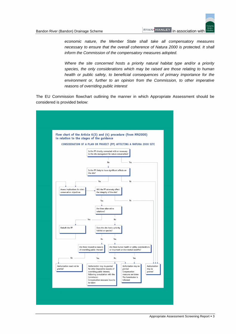
The EU Commission flowchart outlining the manner in which Appropriate Assessment should be
considered is provided below:
Bandon River (Bandon) Drainage Scheme in association with
Appropriate Assessment Screening Report 4
1.5 REFERENCE DOCUMENTS
This Appropriate Assessment Screening Exercise has been undertaken in accordance with
the following guidelines:
Managing Natura 2000 Sites: the provisions of Article 6 of the Habitats Directive
92/43/EEC
Assessment of Plans and Projects Significantly Affecting Natura 2000 Sites:
methodological guidance on the provisions of Article 6(3) and (4) of the Habitats
Directive 92/43/EE
Guidance Document on Article 6(4) of the Habitats Directive 92/43/EEC -
Clarification of the concepts of alternative solutions, imperative reasons of overriding
public interest, compensatory measures, overall coherence opinion of the
commission.
Appropriate Assessment of Plans and Projects in Ireland – Guidance for Planning
Authorities (DEHLG, 2009)
Screening of Natura 2000 sites for Impacts of Arterial Drainage Maintenance
Operations (OPW)
Bandon River (Bandon) Drainage Scheme in association with
Appropriate Assessment Screening Report 5
2 APPROPRIATE ASSESSMENT SCREENING MATRIX
For the purposes of this screening exercise the Natura 2000 sites (cSACs & SPAs) within a 15
kilometre radius of the original study area were identified as were any sites within the Bandon River
catchment that may have been outside the 15 kilometre radius. The Natura 2000 sites identified are
listed below together with the distance from the study area.
Courtmacsherry Estuary cSAC/SPA (Site Codes:001230 &004219) 6.5km.
Clonakilty Bay cSAC/SPA (Site Codes: 004081 &000091) 14km.
Old Head of Kinsale SPA (Site Code: 004021) 12km.
Sovereign Islands SPA (Site Code: 004124) 12.5km.
Seven Heads SPA (Site Code: 004191) 13km.
Bandon River cSAC (Site Code: 002171) 18.5km or 20km by river (within Bandon River
catchment)
A screening exercise to determine whether the proposed flood relief works are likely to have any
significant effects on the above Natura 2000 sites was carried out and is detailed below.
This screening report has been prepared in accordance with the European Commission guidance
document Assessment of Plans and Projects Significantly affecting Natura 2000 Sites:
Methodological Guidance on the provisions of Article 6(3) and 6(4) of the Habitats Directive
92/43/EEC (EC, 2001) and the Department of the Environment’s Guidance on the Appropriate
Assessment of Plans and Projects in Ireland.
2.1 COURTMACSHERRY ESTUARY CSAC/SPA (SITE CODES: 001230 & 004219)
DESCRIPTION OF PROJECT AND NATURA 2000 SITES
Brief Description of Project or Plan
The preferred scheme consists of a combination of flood defences with dredging. The dredged depth will be to 9.5 metres OD downstream of the weir and will extend over a distance of 3.6 kilometres. New flood defences will also be constructed within and downstream of Bandon Town and along the Bridewell River. Brief Description of Natura 2000 Site(s)
These designated sites are located approximately 6.5km to the south of the study area, are on the coast and are not located within the Bandon River catchment.
The estuary consists of the drowned valley of the Argideen River, which is now filled with sediments, resulting in an extensive mudflat. The site contains a complex of coastal habitats including ten habitats listed on Annex I of the EU Habitats Directive.
The Qualifying Interests of the Courtmacsherry Estuary cSAC are listed below:
Estuaries
Mudflats and sandflats not covered by seawater at low tide
Annual vegetation of drift lines
Perennial vegetation of stony banks
Salicornia and other annuals colonizing mud and sand
Atlantic salt meadows (Glauco-Puccinellietalia maritimae)
Bandon River (Bandon) Drainage Scheme in association with
Appropriate Assessment Screening Report 6
Mediterranean salt meadows (Juncetalia maritimi)
Embryonic shifting dunes
Shifting dunes along the shoreline with Ammophila arenaria (white dunes)
Fixed coastal dunes with herbaceous vegetation (grey dunes)
The site is of ornithological importance for the many waders and wildfowl that feed on the mud and sandflats. The winter flocks of Golden Plover (2,600) and Black-Tailed Godwit (110) constitute nationally important numbers and at least nine other species occur in significant levels for the region.
Full Site Synopsis provided in Appendix 1 of this Document.
ASSESSMENT CRITERIA
Describe the Individual Elements of the Project (either alone or in combination with other plans and projects) likely to give rise to impacts on the Natura 2000 Site(s)
None anticipated given that the designated sites are not within the catchment of the Bandon River and are located approximately 6.5 kilometres away with no direct connection to the study area.
Describe any likely direct, indirect or secondary impacts of the project ((either alone or in combination with other plans and projects) by virtue of: size and scale, land-take, distance from the Natura 2000 site or key features of the site, resource requirements, emissions, excavation requirements, transportation requirements, duration of construction, operation or decommissioning or other
None anticipated.
Describe any likely changes to the Natura 2000 site(s) as result of: reduction of habitat area, disturbance to key species, habitat or species fragmentation, reduction in species density, changes in key indicators of conservation value (e.g, water quality) and climate change
None anticipated.
Describe any likely impacts on the Natura 2000 site(s) as a whole in terms of: 1) interference with the key relationships that define the structure of the site and 2) interference with the key relationships that define the function of the site
None anticipated.
Provide indicators of significance as a result of the identification of effects set out above in terms of loss, fraqmentation, disruption, disturbance and changes to key elements of the site (e.g. water quality)
None anticipated.
Describe from the above those elements of the project or plan, or combination of elements, where the above impacts are likely to be significant or where the scale or magnitude of impacts is not known
None anticipated.
Table 2.1 Courtmacsherry Estuary cSAC/SPA AA Screening Matrix
On the basis of the Screening Matrix in Table 2.1 above, it can be concluded that the proposed
Bandon River (Bandon) Drainage Scheme is unlikely to significantly impact on the Courtmacsherry
Estuary cSAC/SPA when considering the possible nature of the works.
Bandon River (Bandon) Drainage Scheme in association with
Appropriate Assessment Screening Report 7
2.2 CLONAKILTY BAY CSAC/SPA (SITE CODES: 000091 & 004081)
DESCRIPTION OF PROJECT AND NATURA 2000 SITES
Brief Description of Project or Plan
The preferred scheme consists of a combination of flood defences with dredging. The dredged depth will be to 9.5 metres OD downstream of the weir and will extend over a distance of 3.6 kilometres. New flood defences will also be constructed within and downstream of Bandon Town and along the Bridewell River.
Brief Description of Natura 2000 Site(s)
These designated sites are located approximately 14km to the south west of the study area, are on the
coast and are not located within the Bandon River catchment.
Clonakilty Bay in west Cork is an inter-tidal expanse that stretches from Clonakilty to the open sea, and
comprises two small estuaries separated by Inchydoney Island. The site also includes adjacent sand
dunes and inland marshes, and therefore is a coastal complex with a good diversity of habitats
including several habitats listed on Annex I of the EU Habitats Directive. The Qualifying Interests of the
Clonakilty Bay cSAC are listed below:
Mudflats and sandflats not covered by seawater at low tide
Annual vegetation of drift lines
Embryonic shifting dunes
Shifting dunes along the shoreline with Ammophila arenaria (white dunes)
Fixed coastal dunes with herbaceous vegetation (grey dunes)
Atlantic decalcified fixed dunes (Calluno-Ulicetea)
This site is of high ornithological importance, particularly for its internationally important population of
Black-tailed Godwit. The ecology of the population has been studied in detail in recent years. In
addition, there are three species with populations of national importance.
Full Site Synopsis provided in Appendix 1 of this Document.
ASSESSMENT CRITERIA
Describe the Individual Elements of the Project (either alone or in combination with other plans
and projects) likely to give rise to impacts on the Natura 2000 Site(s)
None anticipated given that the designated sites are not within the catchment of the Bandon River and
are located approximately 14 kilometres away with no direct connection to the study area.
Describe any likely direct, indirect or secondary impacts of the project ((either alone or in
combination with other plans and projects) by virtue of: size and scale, land-take, distance from
the Natura 2000 site or key features of the site, resource requirements, emissions, excavation
requirements, transportation requirements, duration of construction, operation or
decommissioning or other
None anticipated.
Describe any likely changes to the Natura 2000 site(s) as result of: reduction of habitat area,
disturbance to key species, habitat or species fragmentation, reduction in species density,
Bandon River (Bandon) Drainage Scheme in association with
Appropriate Assessment Screening Report 8
changes in key indicators of conservation value (e.g, water quality) and climate change
None anticipated.
Describe any likely impacts on the Natura 2000 site(s) as a whole in terms of: 1) interference
with the key relationships that define the structure of the site and 2) interference with the key
relationships that define the function of the site
None anticipated.
Provide indicators of significance as a result of the identification of effects set out above in
terms of loss, fraqmentation, disruption, disturbance and changes to key elements of the site
(e.g. water quality)
None anticipated.
Describe from the above those elements of the project or plan, or combination of elements,
where the above impacts are likely to be significant or where the scale or magnitude of impacts
is not known
None anticipated.
Table 2.2 Clonakilty Bay cSAC/SPA AA Screening Matrix
On the basis of the Screening Matrix in Table 2.2 above, it can be concluded that the proposed
Bandon River (Bandon) Drainage Scheme is unlikely to significantly impact on the Clonakilty Bay
cSAC/SPA when considering the possible nature of the works.
2.3 OLD HEAD OF KINSALE SPA (SITE CODE: 004021)
DESCRIPTION OF PROJECT AND NATURA 2000 SITES
Brief Description of Project or Plan
The preferred scheme consists of a combination of flood defences with dredging. The dredged depth will be to 9.5 metres OD downstream of the weir and will extend over a distance of 3.6 kilometres. New flood defences will also be constructed within and downstream of Bandon Town and along the Bridewell River. Brief Description of Natura 2000 Site(s)
This designated site is located approximately 12km to the south east of the study area, is on the coast
and is not located within the Bandon River catchment.
The Old Head is the largest seabird colony on the south coast between the Bull Rock and the Saltee
Islands. It supports nationally important populations of Kittiwake (951 pairs in 2001) and Guillemot
(4,313 individuals in 2001), as well as smaller numbers of Fulmar (37 pairs), Shag (26 pairs), Herring
Gull (11 pairs) and Razorbill (59 occupied sites). The populations of Kittiwake and Razorbill have
declined since the late 1980s for reasons unclear but perhaps due to depleted prey stocks. Chough
and Peregrine, which breed elsewhere on the Head, are regularly seen within the site. The seabird
populations are well monitored. The site is a designated Refuge for Fauna.
Full Site Synopsis provided in Appendix 1 of this Document.
Bandon River (Bandon) Drainage Scheme in association with
Appropriate Assessment Screening Report 9
ASSESSMENT CRITERIA
Describe the Individual Elements of the Project (either alone or in combination with other plans
and projects) likely to give rise to impacts on the Natura 2000 Site(s)
None anticipated given that the designated site is not within the catchment of the Bandon River and is
located approximately 12 kilometres away with no direct connection to the study area.
Describe any likely direct, indirect or secondary impacts of the project ((either alone or in
combination with other plans and projects) by virtue of: size and scale, land-take, distance from
the Natura 2000 site or key features of the site, resource requirements, emissions, excavation
requirements, transportation requirements, duration of construction, operation or
decommissioning or other
None anticipated.
Describe any likely changes to the Natura 2000 site(s) as result of: reduction of habitat area,
disturbance to key species, habitat or species fragmentation, reduction in species density,
changes in key indicators of conservation value (e.g, water quality) and climate change
None anticipated.
Describe any likely impacts on the Natura 2000 site(s) as a whole in terms of: 1) interference
with the key relationships that define the structure of the site and 2) interference with the key
relationships that define the function of the site
None anticipated.
Provide indicators of significance as a result of the identification of effects set out above in
terms of loss, fraqmentation, disruption, disturbance and changes to key elements of the site
(e.g. water quality)
None anticipated.
Describe from the above those elements of the project or plan, or combination of elements,
where the above impacts are likely to be significant or where the scale or magnitude of impacts
is not known
None anticipated.
Table 2.3 Old Head of Kinsale SPA AA Screening Matrix
On the basis of the Screening Matrix in Table 2.3 above, it can be concluded that the proposed
Bandon River (Bandon) Drainage Scheme is unlikely to significantly impact on the Old Head of
Kinsale SPA when considering the possible nature of the works.
2.4 SOVEREIGN ISLANDS SPA (SITE CODE: 004124)
DESCRIPTION OF PROJECT AND NATURA 2000 SITES
Brief Description of Project or Plan
Bandon River (Bandon) Drainage Scheme in association with
Appropriate Assessment Screening Report 10
The preferred scheme consists of a combination of flood defences with dredging. The dredged depth will be to 9.5 metres OD downstream of the weir and will extend over a distance of 3.6 kilometres. New flood defences will also be constructed within and downstream of Bandon Town and along the Bridewell River.
Brief Description of Natura 2000 Site(s)
This designated site is located approximately 12.5km to the south east of the study area, is on the coast
and is not located within the Bandon River catchment.
The islands are important for breeding seabirds, with most on the eastern stack. A Cormorant colony
has been known since the late 1960s and in 1999 156 nests were counted. Herring Gulls and Great
Black-backed Gulls also breed, with 10 and 75 pairs respectively in 1999. The only other seabird which
has been recorded breeding in recent years is Black Guillemot, with 10 individuals in April 1999.
This site is of ornithological importance mainly for the breeding colony of Cormorant, which is the
largest in County Cork and is of National Importance. The population of Great Black-backed Gulls is
also of National Importance. The site provides a very safe refuge for the nesting birds. Regular
monitoring of the seabird populations has been carried out since the 1980s.
Full Site Synopsis provided in Appendix 1 of this Document.
ASSESSMENT CRITERIA
Describe the Individual Elements of the Project (either alone or in combination with other plans
and projects) likely to give rise to impacts on the Natura 2000 Site(s)
None anticipated given that the designated site is not within the catchment of the Bandon River and is
located approximately 12.5 kilometres away with no direct connection to the study area.
Describe any likely direct, indirect or secondary impacts of the project ((either alone or in
combination with other plans and projects) by virtue of: size and scale, land-take, distance from
the Natura 2000 site or key features of the site, resource requirements, emissions, excavation
requirements, transportation requirements, duration of construction, operation or
decommissioning or other
None anticipated.
Describe any likely changes to the Natura 2000 site(s) as result of: reduction of habitat area,
disturbance to key species, habitat or species fragmentation, reduction in species density,
changes in key indicators of conservation value (e.g, water quality) and climate change
None anticipated.
Describe any likely impacts on the Natura 2000 site(s) as a whole in terms of: 1) interference
with the key relationships that define the structure of the site and 2) interference with the key
relationships that define the function of the site
None anticipated.
Provide indicators of significance as a result of the identification of effects set out above in
Bandon River (Bandon) Drainage Scheme in association with
Appropriate Assessment Screening Report 11
terms of loss, fraqmentation, disruption, disturbance and changes to key elements of the site
(e.g. water quality)
None anticipated.
Describe from the above those elements of the project or plan, or combination of elements,
where the above impacts are likely to be significant or where the scale or magnitude of impacts
is not known
None anticipated.
Table 2.4 Sovereign Islands SPA AA Screening Matrix
On the basis of the Screening Matrix in Table 2.4 above, it can be concluded that the proposed
Bandon River (Bandon) Drainage Scheme is unlikely to significantly impact on the Sovereign Islands
SPA when considering the possible nature of the works.
2.5 SEVEN HEADS SPA (SITE CODE: 004191)
DESCRIPTION OF PROJECT AND NATURA 2000 SITES
Brief Description of Project or Plan
The preferred scheme consists of a combination of flood defences with dredging. The dredged depth will be to 9.5 metres OD downstream of the weir and will extend over a distance of 3.6 kilometres. New flood defences will also be constructed within and downstream of Bandon Town and along the Bridewell River.
Brief Description of Natura 2000 Site(s)
This designated site is located approximately 13km to the south east of the study area, is on the coast
and is not located within the Bandon River catchment.
The site includes sea cliffs and land adjacent to the cliff edge. The site is of special conservation
interest for breeding Chough, a Red Data Book species that is listed on Annex I of the EU Birds
Directive. The grazing regime results in a tight vegetation sward which is beneficial to Chough. The site
also supports a variety of breeding seabirds including Fulmar, Herring Gull, Great Black-backed Gull
and Cormorant. The site also supports a population of Peregrine which is listed on Annex I of the EU
Birds Directive.
Full Site Synopsis provided in Appendix 1 of this Document.
ASSESSMENT CRITERIA
Describe the Individual Elements of the Project (either alone or in combination with other plans
and projects) likely to give rise to impacts on the Natura 2000 Site(s)
None anticipated given that the designated site is not within the catchment of the Bandon River and is
located approximately 13 kilometres away with no direct connection to the study area.
Describe any likely direct, indirect or secondary impacts of the project ((either alone or in
combination with other plans and projects) by virtue of: size and scale, land-take, distance from
Bandon River (Bandon) Drainage Scheme in association with
Appropriate Assessment Screening Report 12
the Natura 2000 site or key features of the site, resource requirements, emissions, excavation
requirements, transportation requirements, duration of construction, operation or
decommissioning or other
None anticipated.
Describe any likely changes to the Natura 2000 site(s) as result of: reduction of habitat area,
disturbance to key species, habitat or species fragmentation, reduction in species density,
changes in key indicators of conservation value (e.g, water quality) and climate change
None anticipated.
Describe any likely impacts on the Natura 2000 site(s) as a whole in terms of: 1) interference
with the key relationships that define the structure of the site and 2) interference with the key
relationships that define the function of the site
None anticipated.
Provide indicators of significance as a result of the identification of effects set out above in
terms of loss, fraqmentation, disruption, disturbance and changes to key elements of the site
(e.g. water quality)
None anticipated.
Describe from the above those elements of the project or plan, or combination of elements,
where the above impacts are likely to be significant or where the scale or magnitude of impacts
is not known
None anticipated.
Table 2.5 Seven Heads SPA AA Screening Matrix
On the basis of the Screening Matrix in Table 2.5 above, it can be concluded that the proposed
Bandon River (Bandon) Drainage Scheme is unlikely to significantly impact on the Seven Heads SPA
when considering the possible nature of the works.
2.6 BANDON RIVER CSAC (SITE CODE: 002171)
DESCRIPTION OF PROJECT AND NATURA 2000 SITES
Brief Description of Project or Plan
The preferred scheme consists of a combination of flood defences with dredging. The dredged depth will be to 9.5 metres OD downstream of the weir and will extend over a distance of 3.6 kilometres. New flood defences will also be constructed within and downstream of Bandon Town and along the Bridewell River.
Brief Description of Natura 2000 Site(s)
This designated site is located approximately 18.5km to the west of the study area; it is located 20km
upstream of the study area within the Bandon River catchment.
Bandon River (Bandon) Drainage Scheme in association with
Appropriate Assessment Screening Report 13
The site consists of relatively short adjoining stretches of the Bandon and Caha Rivers. These rivers
flow in a southerly direction to the east of Dunmanway, Co. Cork. The site is important for a number of
reasons. It contains a small though very important example of the Annex I priority habitat Alluvial
Forest as well as good examples of another Annex I habitat - Floating River Vegetation. The Annex II
animal species Otter, Salmon (Salmo salar), Brook Lamprey (Lampetra planeri) and Freshwater Pearl
Mussel (Margaritifera margaritifera) occur. The populations of the Mussel are thought to be nationally
important. The Kingfisher, listed under Annex I of the E.U. Birds Directive, breeds along the river. The
Qualifying Interests of this cSAC are listed below:
Water courses of plain to montane levels with the Ranunculion fluitantis and Callitricho-
Batrachion vegetation
Alluvial forests with Alnus glutinosa and Fraxinus excelsior (Alno-Padion, Alnion incanae,
Salicion albae)
Brook Lamprey (Lampetra planeri)
Freshwater Pearl Mussel (Margaritifera margaritifera)
Full Site Synopsis provided in Appendix 1 of this Document.
ASSESSMENT CRITERIA
Describe the Individual Elements of the Project (either alone or in combination with other plans
and projects) likely to give rise to impacts on the Natura 2000 Site(s)
The proposed works will have no direct effect on any areas upstream of the weir in Bandon Town and
thus will have no direct effect on the Bandon River SAC. However, the in-stream works associated with
the proposed works have the potential to impact on the water quality of the watercourse and could
result in temporary negative impacts on fish species migrating upstream towards the cSAC. In addition,
fish passage could be blocked as a result of the proposed works. Therefore permanent or temporary
works modifying the bed or course of the river have potential to impact indirectly on fish species
migrating upstream towards the cSAC.
Describe any likely direct, indirect or secondary impacts of the project ((either alone or in
combination with other plans and projects) by virtue of: size and scale, land-take, distance from
the Natura 2000 site or key features of the site, resource requirements, emissions, excavation
requirements, transportation requirements, duration of construction, operation or
decommissioning or other
The scheme has been designed to promote the upstream migration of fish (Salmon and Lamprey) and
includes robust mitigation and best practice to ensure that this continues throughout the construction
period. In addition work methods to be employed follow best practice to avoid water pollution and avoid
the sensitive times of year for spawning and migrating Salmonids. Some of the best practice to be
employed is described below and ensures that there will be no significant impacts on the Bandon River
SAC, which is located over 20km upstream of the proposed works
The weir in Bandon Town has been identified as a block to the upstream passage of River Lamprey and
an impediment to the upstream passage of Salmon at present. The proposed works have the potential
to exacerbate this by effectively increasing the height of the weir, thereby preventing all upstream
migration. This will be mitigated through the construction of a rock ramp. This ramp will be
approximately 112 metres in length and five metres in width. It will be sloped at a gradient of 1: 24.5
Bandon River (Bandon) Drainage Scheme in association with
Appropriate Assessment Screening Report 14
and will be constructed using large boulders with a constant flow of water of at least approximately 300
mm over them. This gradient and flow will allow the passage of fish over the weir during any flow
conditions. There will be an excavated pool at the base of the ramp with a defined thalweg leading up to
it so that migrating fish are guided toward the ramp as opposed to the weir. This mitigation has been
successfully employed in various locations around Ireland and will ensure that the passage of Lamprey
over the weir is not blocked and the passage of Salmon is not impeded. This will improve on the
existing situation.
·The proposed works will only take place over approximately 60% of the width of the river at any one
time.
·Works will only be undertaken in the period May – September inclusive to avoid the periods of greatest
sensitivity for Salmonids.
·Whilst the methodology for carrying out these works has not been finalised at this point, it will include
measures to minimise the suspension and transfer of sediment downstream. These measures are likely
to include the use of silt barriers downstream of the works areas and removal of any accumulated silt,
construction of silt sumps downstream of the works areas, cofferdamming and dewatering of works
areas where concrete and other building works are proposed.
·Works will only be undertaken during normal working hours thus allowing the river to run clean for up to
14 hours per day.
·Rock will be broken out in such a manner as to ensure that fish passage up the river is possible at all
times. Either the broken rock will be graded to ensure that there is never an in surmountable lip or
portable rock ramps or fish ladders will be employed to allow continued fish passage.
·All works undertaken on the banks will be fully consolidated to prevent scour and run off of silt.
Consolidation may include use of protective and biodegradable matting (coirmesh) on the banks and
also the sowing of grass seed on bare soil.
·All concrete works will be carried out in dry conditions with no in-stream pouring of concrete. In areas
where concrete is required within the river channel such as the bridge piers and flood defence walls, a
dry working area will be created or pre-cast solutions will be used.
·There will be no refueling of machinery within the river channel. Refueling will take place at designated
locations at distances of greater than 30 metres from the watercourse.
·No vehicles will be left unattended when refueling and a spill kit including an oil containment boom and
absorbent pads will be on site at all times.
·Any fuel that is stored on the site will be in a double skinned, bunded container that will be located
within a designated works compound at a location that is removed from the river. All other construction
materials and plant will be stored in this compound. The compound will also house the site offices and
portaloo toilets. This compound will either be located on ground that is not prone to flooding or will be
surrounded by a protective earth bund to prevent inundation.
·All vehicles will be regularly maintained and checked for fuel and oil leaks.
Describe any likely changes to the Natura 2000 site(s) as result of: reduction of habitat area,
disturbance to key species, habitat or species fragmentation, reduction in species density,
changes in key indicators of conservation value (e.g, water quality) and climate change
Bandon River (Bandon) Drainage Scheme in association with
Appropriate Assessment Screening Report 15
The scheme has been designed to maximise the potential for the upstream migration of Salmonid fish
and to minimise of the potential for water pollution. It is unlikely that there will be any adverse impacts
on the Bandon River SAC
Describe any likely impacts on the Natura 2000 site(s) as a whole in terms of: 1) interference
with the key relationships that define the structure of the site and 2) interference with the key
relationships that define the function of the site
The scheme has been designed to maximise the potential for the upstream migration of Salmonid fish
and to minimise of the potential for water pollution. It is unlikely that there will be any adverse impacts
on the Bandon River cSAC
Provide indicators of significance as a result of the identification of effects set out above in
terms of loss, fraqmentation, disruption, disturbance and changes to key elements of the site
(e.g. water quality)
Changes in water levels, fish stocks, pearl mussel numbers and recruitment, Lamprey numbers and
areas with floating river vegetation within the cSAC would indicate changes to the cSAC but any
changes are highly unlikely to result from the proposed works as they are located over 20km
downstream and the scheme has been designed to maximise the potential for the upstream migration
of Salmonid fish and to minimise of the potential for water pollution.
Describe from the above those elements of the project or plan, or combination of elements,
where the above impacts are likely to be significant or where the scale or magnitude of impacts
is not known
The proposed development is unlikely to result in any significant impact on the Bandon River SAC
provided that the best practice and scheme design is adhered to when carrying out the project.
Table 2.6 Bandon River cSAC AA Screening Matrix
On the basis of the Screening Matrices above, it can be concluded that the proposed Bandon River
(Bandon) Drainage Scheme does not have the potential to impact significantly on any Natura 2000
site provided that the best practice and scheme design is adhered to when carrying out the project.
.
Bandon River (Bandon) Drainage Scheme in association with
Appropriate Assessment Screening Report 16
3 SUMMARY AND CONCLUSIONS
The purpose of this exercise is to provide the information to the competent authority (the Office of
Public Works) to fulfil their requirements in relation to Article 6(3) of the EU Habitats Directive, in
considering the potential for significant effects of the works on Natura 2000 sites.
The screening exercise concludes that there is no potential for significant impact on the following
Natura 2000 sites, mainly by virtue of the nature of the sites, the nature of the works proposed and
the distance of the sites from the proposed works and the fact that all but one are not located within
the Bandon River catchment. The River Bandon cSAC is located 20km upstream on the Bandon
catchment and could potentially have been impacted upon by the proposed scheme. However the
scheme design and best practice has ensured that the potential for significant impacts on this
designated site has been negated.
Courtmacsherry Estuary cSAC/SPA (Site Codes:001230 &004219) 6.5km.
Clonakilty Bay cSAC/SPA (Site Codes: 004081 &000091) 14km.
Old Head of Kinsale SPA (Site Code: 004021) 12km.
Sovereign Islands SPA (Site Code: 004124) 12.5km.
Seven Heads SPA (Site Code 004191) 13km.
Bandon River cSAC (Site Code: 002171) 20 km

Bandon River (Bandon) Drainage Scheme in association with
Appropriate Assessment Screening Report 17
Appendix 1
NPWS Site Synopses for Natura 2000 Sites
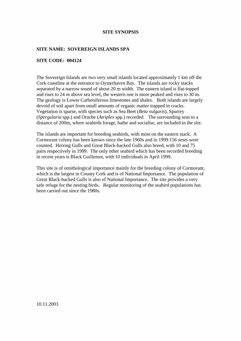
SITE SYNOPSIS SITE NAME: SOVEREIGN ISLANDS SPA SITE CODE: 004124 The Sovereign Islands are two very small islands located approximately 1 km off the Cork coastline at the entrance to Oysterhaven Bay. The islands are rocky stacks separated by a narrow sound of about 20 m width. The eastern island is flat-topped and rises to 24 m above sea level, the western one is more peaked and rises to 30 m. The geology is Lower Carboniferous limestones and shales. Both islands are largely devoid of soil apart from small amounts of organic matter trapped in cracks. Vegetation is sparse, with species such as Sea Beet (Beta vulgaris), Spurrey (Spergularia spp.) and Orache (Atriplex spp.) recorded. The surrounding seas to a distance of 200m, where seabirds forage, bathe and socialise, are included in the site. The islands are important for breeding seabirds, with most on the eastern stack. A Cormorant colony has been known since the late 1960s and in 1999 156 nests were counted. Herring Gulls and Great Black-backed Gulls also breed, with 10 and 75 pairs respectively in 1999. The only other seabird which has been recorded breeding in recent years is Black Guillemot, with 10 individuals in April 1999. This site is of ornithological importance mainly for the breeding colony of Cormorant, which is the largest in County Cork and is of National Importance. The population of Great Black-backed Gulls is also of National Importance. The site provides a very safe refuge for the nesting birds. Regular monitoring of the seabird populations has been carried out since the 1980s. 10.11.2003
SITE SYNOPSIS SITE NAME: CLONAKILTY BAY SPA SITE CODE: 004081 Clonakilty Bay in west County Cork is a wetland complex that stretches from the town of Clonakilty to the open sea. It comprises two small estuarine bays, Clonakility Harbour and Muckross Strand, separated by Inchydoney Island and its empoldered isthmus. Several small rivers flow into the site, notably the Fealge River. At low tide, substantial areas of sand and mud flats are exposed. The construction of a causeway across the inner part of Muckross Strand created an extensive wetland complex known as Cloheen Strand Intake. The site also includes a well-developed sand dune system, with embryonic dunes, marram dunes, fixed dunes and decalcified dune heath all represented. The dune types, as well as the intertidal sand and mud flats, are habitats that are listed on Annex I of the E.U. Habitats Directive. Intertidal sand and mud flats occupy the majority of the site area and these provide the main food resource for the wintering waterfowl. Sand flats dominate the inter-tidal area, although mud flats occur at the sheltered upper end of the inlets. The vegetation consists of algal mats (Enteromorpha spp.), with brown seaweeds (Fucus spp.) occurring where the shore is rocky. The invasive Common Cord-grass (Spartina anglica) occurs in places. The intertidal flats have a typical diversity of macro-invertebrates, including Lugworm (Arenicola marina), Peppery Furrow-shell (Scrobicularia plana), Ragworm (Hediste diversicolor), the marine bristle worms Nephtys hombergii and N. cirrosa, Laver Spire-shell (Hydrobia ulvae) and Common Cockle (Cerastoderma edule). The Cloheen Strand Intake wetland contains a fine range of habitats from saline lagoons, to brackish grasslands, open freshwater marsh and wet grassland. The saline influence is evident by the occurrence of species such as Saltmarsh Rush (Juncus gerardii) and Sea Rush (J. maritimus). This area provides the main roosting area for birds at high tide. Birds also roost elsewhere above the shoreline and on the sandy beach associated with the dune system at Inchydoney Island. The site contains a good diversity of wintering waterfowl, with over 8,000 birds occurring regularly. The site, however, is most noted for its population of Black-tailed Godwit (874) - figures given are average peaks for four of the 5 winters in the period 1995/96-1999/00), which is of international importance and comprises approximately 5% of the national total. Three species have populations of national importance: Shelduck (156), Ringed Plover (103) and Greenshank (33). Other species which occur regularly in significant numbers include Mute Swan (53), Wigeon (487), Teal (216), Oystercatcher (316), Golden Plover (857), Grey Plover (61), Lapwing (1,658), Knot (168), Dunlin (1,172), Bar-tailed Godwit (79), Curlew (599) and Redshank (252). The regular occurrence of Golden Plover and Bar-tailed Godwit is of note as both are listed on Annex I of the E.U. Birds Directive. An additional species listed on Annex I of this directive that has become regular in small
numbers in recent years is Little Egret. Grey Herons commonly use the site and a heronry exists in the trees near Clonakilty. Cloheen Strand Inlet is also a regular wintering site for up to 7 Short-eared Owls, an Annex I species. The site is a regular staging post for scarce autumn migrants, especially Little Stint, Curlew Sandpiper and Spotted Redshank. In most years it is also visited by vagrant waders from North America. This site is of high ornithological importance, particularly for its internationally important population of Black-tailed Godwit. The ecology of the population has been studied in detail in recent years. In addition, there are three species with populations of national importance. The bird populations have been monitored since the 1970s and the site is counted monthly each winter (September to March) as part of the Irish Wetland Bird Survey (I-WeBS). The site is a candidate Special Area of Conservation under the E.U. Habitats Directive. 16.4.2004
SITE SYNOPSIS SITE NAME: OLD HEAD OF KINSALE SPA SITE CODE: 004021 The Old Head is a 5 km long headland formed of steeply inclined beds of rock. These show a cross section of the transition between the Devonian and Carboniferous periods and so have considerable interest from a geological point of view. The SPA site comprises a section of the cliffs on the western side of the narrow isthmus leading to the Head. These are vertical rock cliffs providing optimum habitat for ledge nesting seabirds. Maritime grassland and heath occurs above the steep cliffs though part of this has now been converted to amenity grassland as a golf course. The cliff-top vegetation is characterised by such species as Autumn Gorse (Ulex gallii), Bell Heather (Erica cinerea), Bent Grasses (Agrostis spp.) and Heath Bedstraw (Galium saxatile), with Sea Campion (Silene maritima), Thrift (Ameria maritima), Wood Sage (Teucrium scorodonia) and Burnet Rose (Rosa pimpinellifolia) also present. The site includes the adjacent marine area to a distance of 200 m from the cliff base, where the seabirds forage, rest and socialise. The Old Head is the largest seabird colony on the south coast between the Bull Rock and the Saltee Islands. It supports nationally important populations of Kittiwake (951 pairs in 2001) and Guillemot (4,313 individuals in 2001), as well as smaller numbers of Fulmar (37 pairs), Shag (26 pairs), Herring Gull (11 pairs) and Razorbill (59 occupied sites). The populations of Kittiwake and Razorbill have declined since the late 1980s for reasons unclear but perhaps due to depleted prey stocks. Chough and Peregrine, which breed elsewhere on the Head, are regularly seen within the site. The seabird populations are well monitored. The site is a designated Refuge for Fauna. 7.2.2004
SITE SYNOPSIS SITE NAME: BANDON RIVER SITE CODE: 002171 The site consists of relatively short adjoining stretches of the Bandon and Caha Rivers. These rivers flow in a southerly direction to the east of Dunmanway, Co. Cork. Towards the southern end of the site the Bandon takes an easterly course. The predominant rock formations are Old Red Sandstone to the north and Carboniferous Slate stretching south of Dunmanway. Soils in the northern section consist of peats, podzols and skeletal soils. The southern section consists of alluvial soils and Brown Podzolics. The east-west exposure of Old Red Sandstone to the north of Dunmanway displays distinct ridgelines of bare rock with poor pasture and scrub. In this area around Lovers Leap the Bandon River cuts a narrow channel southwards, cascading over a series of rock steps through a narrow valley. Below this and above Long Bridge the river widens and meanders through a fertile floodplain. Immediately south of the Long Bridge the reduced flow gradient and broad, flat valley permit the main channel to split and extend into a network of braided streams forming islands. The site is important for a number of reasons. It contains a small though very important example of the Annex I priority habitat Alluvial Forest as well as good examples of another Annex I habitat - Floating River Vegetation. The Annex II animal species Otter, Salmon (Salmo salar), Brook Lamprey (Lampetra planeri) and Freshwater Pearl Mussel (Margaritifera margaritifera) occur. The populations of the Mussel are thought to be nationally important. The Kingfisher, listed under Annex I of the E.U. Birds Directive, breeds along the river. Wet broadleaved semi-natural woodland is found in an undisturbed area of braided river channels and islands below Dunmanway. The river channels are well defined and the islands appear solid. Canopy dominants are Hazel (Corylus avellana) (multi-stemmed) and Sessile Oak (Quercus petraea), with scattered Downy Birch (Betula pubescens), Ash (Fraxinus excelsior), Rusty Willow (Salix cinerea subsp. oleifolia) and Alder (Alnus glutinosa). There is a very sparse understorey composed of Whitethorn (Crataegus monogyna), Holly (Ilex aquifolium) and saplings of Hazel and Sessile Oak. Epiphytes are abundant on trees: Ivy (Hedera helix), Honeysuckle (Lonicera periclymenum) and bryophyte species such as Isothecium myosuroides. The ground flora is dominated by Ramsons (Allium ursinum), Wood Anemone (Anemone nemorosa), Ivy with abundant/scattered Lesser Celandine (Ranunculus ficaria), Wood Sedge (Carex remota) and Irish Spurge (Euphorbia hyberna). Goldilocks Buttercup (Ranunculus auricomus), a very rare plant in Co. Cork, has been recently recorded from this woodland.
Floating river vegetation is found along the length of the river and is dominated by Water-crowfoot (Ranunculus spp). Other aquatic plants found include Alternate
Water-milfoil (Myriophyllum alterniflorum), Broad-leaved Pondweed (Potamogeton natans) and four Water-starwort species (Callitriche spp.). Mosses present on rocks and attached to tree roots include Fontinalis antipyretica in slack flow areas and Fontinalis squamosa, Rhynchostegium riparioides and Amblystegium riparium in moderate flows. The landward fringe of deep pools supports Yellow Water-lily (Nuphar lutea), Bogbean (Menyanthes trifoliata), Marsh Marigold (Caltha palustris), Water Mint (Mentha aquatica) and Fool’s Water-cress (Apium nodiflorum). Shoreweed (Littorella uniflora) and Six-stamened Waterwort (Elatine hexandra) are two species of local importance which are found in the river. In moderate current flow below the Long Bridge, the larger stones are covered by the moss Brachythecium rivulare and the Liverwort Chiloscyphus polyanthos var. polyanthos. Boulders covered in Nostoc algae are probably of local occurrence in Ireland. The liverwort Riccardia chamaedryfolia and the moss Fissidens crassipes found under the Long Bridge are considered to be rare in Ireland. Heath in mosaic with wet grassland, exposed rock, scrub and improved grassland covers up to 30% of the site north of Long Bridge. Typical heath plants growing in association with the rocks are abundant Western Gorse (Ulex gallii), Ling Heather (Calluna vulgaris), Bell Heather (Erica cinerea), Cross-leaved Heath (E. tetralix), Tormentil (Potentilla erecta), Heath Grass (Danthonia decumbens), Stonecrops (Sedum spp.), small amounts of St Patrick’s Cabbage (Saxifraga spathularis) and many lichen species. Some small areas of woodland occur within the site north of Long Bridge. Tree species such as Sessile Oak, Beech (Fagus sylvatica), Scots Pine (Pinus sylvestris) and Downy Birch are found with an understorey of Holly, Hazel, Rowan and Rusty Willow. Two Red Data Book plant species have been recorded in the past from within or close to the site - Greater Broomrape (Orobanche rapum-genistae), a species that grows on the roots of legumes, and Small White Orchid (Pseudorchis albida), a species of upland pastures and heaths that is protected under the Flora Protection Order 1999. The river below Long Bridge is an important inland site in Cork for Mute Swan and approximately 20 individuals are present throughout the year along this stretch. Several hundred Snipe use the site during the winter. Other birds seen regularly within the site are Grey Heron, Cormorant and Mallard, while low numbers of Lapwing and Teal visit during the winter. The site supports many of the mammal species occurring in Ireland. Those which are listed in the Irish Red Data Book include Badger, Irish Hare, Daubenton’s Bat and Pipistrelle. The two bat species can be seen feeding along the river and roosting under the old bridges. Landuse at the site consists mainly of sheep grazing in the northern section and cattle grazing on improved grasslands below Lovers Leap and further south. In the area between Milleenanannig and Bealaboy Bridge land reclamation and drainage is taking place. In the area of exposed rock on the higher terrain above Ardcahan Bridge some land reclamation and forestry is carried out.

This site contains good examples of two habitats listed on Annex I of the E.U. Habitats Directive - alluvial forest and floating river vegetation - and supports populations of four Annex II species - Otter, Salmon, Brook Lamprey and Freshwater Pearl Mussel. The presence of a number of Red Data Book plant and animal species adds further interest to the site. 29.6.2001
SITE SYNOPSIS SITE NAME: COURTMACSHERRY ESTUARY SITE CODE: 001230 This site is located in West Cork, some 12 km south of Bandon and immediately east of the village of Timoleague. The estuary consists of the drowned valley of the Argideen River, which is now filled with sediments, resulting in an extensive mudflat. The site contains a complex of coastal habitats including ten habitats listed on Annex I of the EU Habitats Directive. Most of the mudflat is unvegetated, although in places Cord-grass (Spartina sp.) occurs. Saltmarsh has developed in a number of areas, the abundant species mostly being Sea Club-rush (Scirpus maritimus), Common Scurvygrass (Cochlearia officinalis), Sea Arrowgrass (Triglochin maritima), Sea Plantain (Plantago maritima), Thrift (Armeria maritima) and Saltmarsh Rush (Juncus gerardi). On the outer edges such species as Greater Sea-spurrey (Spergularia media), Lesser Sea-spurrey (S. marina) and Lax-flowered Sea-lavender (Limonium humile) occur, while on their landward edge of the saltmarsh frequently support Creeping Bent (Agrostis stolonifera), Red Fescue (Festuca rubra), Silverweed (Potentilla anserina), Soft Rush (Juncus effusus), Common Sorrel (Rumex acetosa) and others. A particularly well-developed intact saltmarsh occurs at Garranefeen Strand. The site also includes small areas of sand dune, sandy and shingle beaches, reedbeds of Common Reed (Phragmites australis), scrub, dry grassland, and areas of both wet and dry semi-natural broadleaved woodland, parts of which are dominated by species of Oak (Quercus sp.). Of note is the presence of the rare Red Data Book plant species, Sea-kale (Crambe maritima) on shingle, as well as the scarce grass, Tor-grass (Brachypodium pinnatum), on cliffs between Broadstrand and Wood Point. The occurrence of the EU priority habitat fixed dune is also of significance. The site is of ornithological importance for the many waders and wildfowl that feed on the mud and sandflats. The winter flocks of Golden Plover (2,600) and Black-Tailed Godwit (110) constitute nationally important numbers and at least nine other species occur in significant levels for the region - Wigeon (58), Mallard (69), Red-breasted Merganser (18), Oystercatcher (162), Lapwing (629), Dunlin (215), Bar-tailed Godwit (178), Curlew (731) and Redshank (139). Although these figures are the average peaks of 4 counts between 1984/85 and 1986/87, at times the numbers present far exceed those given. For example, in January 1992, 5,800 Golden Plover, 671 Wigeon, 731 Dunlin and 456 Oystercatchers were present. The spread of Cord-grass on parts of the mudflats poses a threat to the quantity of the area for feeding birds and pollution is an ever-present threat in such a wetland. Courtmacsherry Estuary is an important site for the complex of coastal habitats found there, including ten listed on Annex I of the EU Habitats Directive, and for the large numbers of birds that use the area.

22.3.2000
SITE SYNOPSIS SITE NAME: CLONAKILTY BAY SITE CODE: 000091 Clonakilty Bay in west Cork is an inter-tidal expanse that stretches from Clonakilty to the open sea, and comprises two small estuaries separated by Inchydoney Island. The site also includes adjacent sand dunes and inland marshes, and therefore is a coastal complex with a good diversity of habitats including several habitats listed on Annex I of the EU Habitats Directive. Sand flats dominate the inter-tidal area, although mud flats occur at the sheltered upper end of the inlets. The vegetation consists of algal mats (Enteromorpha spp.) with brown seaweeds (Fucus spp.) occurring where the coast is rocky. The invasive Cord-grass (Spartina sp.) occurs in places. The intertidal flats have a typical diversity of macro-invertebrates, including Arenicola marina, Scrobicularia plana, Hediste diversicolor, Nephtys hombergii, N. cirrosa, Hydrobia ulvae and Cerastoderma edule. Sand dunes grade from a strandline, colonised by Frosted Orache (Atriplex laciniata), Sea Sandwort (Honkenya peploides) and Sea Rocket (Cakile maritima), through to fixed dunes vegetated by grasses, small herbs and several species of orchid. They also support an interesting array of introduced plants, amongst which Great Mullein (Verbascum thapsus), Viper's-bugloss (Echium vulgare) and Teasel (Dipsacus fullonum) are the most noticeable. Embryonic shifting dunes and white Ammophila dunes are also represented. Of particular interest is a small area of decalcified dune heath with some Ulex europaeus. Inland of the western estuary, an extensive area of wetland occurs, which in itself contains a fine range of habitats from saline lagoons, to brackish grasslands, open freshwater marsh and Alder (Alnus glutinosa) scrub. Species found here are characteristic of marshy areas and include Creeping Bent (Agrostis stolonifera), Water Horsetail (Equisetum fluviatile), Marsh Cinquefoil (Potentilla palustris) and Marsh Willowherb (Epilobium palustre). The saline influence is evident by the occurrence of species such as Saltmarsh Rush (Juncus gerardii) and Sea Rush (J. maritimus). The site contains a good diversity and density of waterfowl, with over 7,000 waders and wildfowl occurring regularly. Seven species have populations of national importance: Shelduck (168), Grey Plover (76), Lapwing (2,509), Dunlin (1,508) Curlew (1,231), Redshank (263) and Greenshank (27). The site is most noted, however, for its population of Black-tailed Godwit (866), which is of international importance and comprises over 10% of the national total. Amongst the other species which occur, there are notable populations of Golden Plover and Bar-tailed Godwit, both of which are listed on Annex I of the EU Birds Directive. All counts given are average winter peaks over either two or three seasons from 1994/95 to 1996/97. Herons commonly use the site and a heronry exists in the trees near Clonakilty.
Otter spraints were found frequently during a recent survey of the marsh area. The site is under pressure from a number of sources, notably recreation and tourism developments and agricultural improvements, including drainage and fertiliser application. This site is of considerable scientific interest because it contains a good diversity of coastal habitats. These habitats show a succession from salt to freshwater influences and include six which are listed on Annex I of the EU Habitats Directive. Its value is enhanced considerably by the birdlife it supports. The occurrence of Black-tailed Godwit in internationally important numbers is particularly significant. The site also supports nationally important numbers of seven other species of waterfowl as well as two species listed on Annex I of the EU Birds Directive. 7.8.1999
SITE SYNOPSISSITE SYNOPSISSITE SYNOPSISSITE SYNOPSIS
SITE NAMESITE NAMESITE NAMESITE NAME: SEVEN HEADS SPA: SEVEN HEADS SPA: SEVEN HEADS SPA: SEVEN HEADS SPA
SITE CODESITE CODESITE CODESITE CODE: 004191: 004191: 004191: 004191
The Seven Heads SPA is situated to the south-west of the town of Courtmacsherry, Co. Cork. Itencompasses the sea cliffs of the Seven Heads peninsula north-east to Barry’s Point and alsothe cliffs of Dunworly Bay and Barry’s Cove. The site includes the sea cliffs, which rise to over50 m, notably south of Barry’s Point, and the land adjacent to the cliff edge (inland for 300 m).The high water mark forms the seaward boundary. Most of the site is underlain by Devoniansandstones, siltstones and mudstones; similar rocks of Carboniferous age also occur at theeastern and western ends of the site.
The site is a Special Protection Area (SPA) under the E.U. Birds Directive, of specialconservation interest for Chough.
Sea cliffs are the predominant habitat of the site; these occur along its length and are generallywell-vegetated by a suite of typical sea cliff species. Above the cliffs areas of heath, improvedgrassland, unimproved wet and dry grassland, freshwater marsh and arable land occur.
The site supports an important population of breeding Chough, a Red Data Book species that islisted on Annex I of the E.U. Birds Directive; 13 breeding pairs were recorded from the site in the1992 survey and 15 in the 2002/03 survey. In addition, flocks of up to 47 birds were noted inthe 1992 survey and up to 25 in the 2002/03 survey.
Landuse at the site is predominantly grazing by stock, but some arable farming is also carriedout, particularly on the Seven Heads Peninsula. The grazing regime, which results in a tightvegetation sward, is beneficial to Chough. Areas of semi-natural habitats occur in many placesadjacent to the breeding cliffs, interspersed between other areas of relatively intensive grassproduction. The habitats present are quite robust, and there are few noticeable activitiesnegatively impacting on the Chough population. However, changes in landuse, particularly areduction in grazing levels, could pose a threat to the species. One other potential threat is theresidue left in livestock dung due to the application of broad-spectrum anti-parasitic drugs.
The site supports a variety of breeding seabirds, i.e. Fulmar (18 pairs in 2002), Herring Gull (23pairs in 2002), Great Black-backed Gull (12 pairs in 2002) and Cormorant (45 pairs in 2006).The site is also used by Peregrine (2 pairs in 2002).
The Seven Heads SPA is of particular importance for Chough; it also supports a population ofPeregrine and a suite of breeding seabird species. The presence of Chough and Peregrine, bothspecies that are listed on Annex I of the E.U. Birds Directive, is of particular significance
13.11.2006


![Bandon recorder. (Bandon, Or) 1904-03-17 [p ]](https://img.dokumen.tips/doc/110x75/6187c824cc67ba0c723909da/bandon-recorder-bandon-or-1904-03-17-p-.jpg)


