Embed Size (px)
Citation preview
BioOne sees sustainable scholarly publishing as an inherently collaborative enterprise connecting authors, nonprofit publishers, academic institutions, researchlibraries, and research funders in the common goal of maximizing access to critical research.
Assessment of the Nature and the Rate of Coastal Erosion on the Mount CameroonCoastal Landscape, Southwest Region, CameroonAuthor(s): Mbongowo Joseph Mbuh, Raoul Étongué Mayer, and Tchawa PaulSource: Journal of Coastal Research, 28(5):1214-1224. 2012.Published By: Coastal Education and Research FoundationDOI: http://dx.doi.org/10.2112/JCOASTRES-D-10-00182.1URL: http://www.bioone.org/doi/full/10.2112/JCOASTRES-D-10-00182.1
BioOne (www.bioone.org) is a nonprofit, online aggregation of core research in the biological, ecological, andenvironmental sciences. BioOne provides a sustainable online platform for over 170 journals and books publishedby nonprofit societies, associations, museums, institutions, and presses.
Your use of this PDF, the BioOne Web site, and all posted and associated content indicates your acceptance ofBioOne’s Terms of Use, available at www.bioone.org/page/terms_of_use.
Usage of BioOne content is strictly limited to personal, educational, and non-commercial use. Commercial inquiriesor rights and permissions requests should be directed to the individual publisher as copyright holder.
www.cerf-jcr.org
Assessment of the Nature and the Rate of Coastal Erosionon the Mount Cameroon Coastal Landscape, SouthwestRegion, Cameroon
Mbongowo Joseph Mbuh{*, Raoul Etongue Mayer{, and Tchawa Paul1
{Department of Geography Geology, and PlanningMissouri State University901 S. National AvenueSpringfield, MO 65897, [email protected]
{Department of GeographyLaurentian University935 Ramsey Lake RoadSudbury, Ontario P3E 2C6, Canada
1Department of GeographyUniversity of Yaounde IYaounde, Cameroon
ABSTRACT
Mbuh, M.J.; Mayer, R.E., and Paul, T., 2012. Assessment of the nature and the rate of coastal erosion on the MountCameroon coastal landscape, Southwest Region, Cameroon. Journal of Coastal Research, 28(5), 1214–1224. CoconutCreek (Florida), ISSN 0749-0208.
The Mount Cameroon coastline is believed to be affected by two main morphological, dynamic, environmental problems:the erosion of the Atlantic slopes of the mountains and hills, and the accumulation of sediments on the continentalplatform. Erosion affects the coastal slopes, as evidenced by the existence of erosion domes observed both on the Atlanticslopes and the coastlines. Three factors explain the deterioration of the Cameroon coastline: (1) its location with avulnerable region known as the Cameroon Line, (2) the persistent impact of climate and oceanographic conditions, and(3) the topographic nature of the region. A high percentage of this coastal area’s water infiltrates the soil, weathering thepyroclastic material. Concentrated human population in the area accelerates some of the erosional processes. In fact,human activity could be the primary cause of the degradation; nevertheless, natural-erosion processes remain prominentin the ongoing degradation of this fragile environment.
The dynamics of waves and tides alter Mount Cameroon coastal features. The intensity of those waves and tides varyfrom place to place. The Mabeta mangrove and the surrounding coastal creeks experience a high rate of sedimentation.The area between Man O’ War Bay and Mabeta experiences intense weathering because the rocks are old. The areabetween Limbe and Batoke experiences a high rate of erosion caused primarily by wave action because of the poor erosiveaction of the few rivers. The high erosion could provide sediments to stabilise the coastline; however, the sediments donot finish their progression to the sea. Therefore, coastal development depends mainly on the coastal current, fluvialdischarge, and high rainfall in Debundscha. Tectonic variability associated with landslides also represents a significantnatural hazard in this complex environment.
ADDITIONAL INDEX WORDS: Southwest region of Cameroon, coastal erosion, accumulation of sediments andsedimentation, Cameroon line, persistent effects of climate, linear erosion, marine erosion.
INTRODUCTION
Active coastal processes differ considerably from one
environment to another because of the landforms to which
they give rise and the presence of humans. The coast forms
the interface between land and water, where various
geomorphic processes and distinctive landforms exist. Rapid
and unusual landform changes along the coastline can result
from large waves and tidal energy. The impact of these
changes on human installations can be either negative or
positive. Across the tropics, people depend entirely on
coastal-based resources for their livelihood (Cooke and Poor,
1974; Gresswell, 1976; Keith and Johnson, 1979). Human
settlements in the Mount Cameroon coastal environment
have experienced an increasingly severe range of environ-
mental problems related to both exogenic and endogenic
processes in the past two decades.
The Cameroon coastline is experiencing rapid natural
processes accelerated by human activities. Within this coastal
environment, active processes require large-scale atmospheric,
hydrologic, soil cycle, and biological exchange systems and
climatic changes. These processes and changes reach a peak in
June and decrease in September and October (Battistini et al.,
1982). The wave action on this coast is diffracted by the Bioko
Island which plays a protecting role to the Coastline (Battistini,
1985; Tricart, 1972). At Limboh Point, the wave amplitude
varies from 1.91–2.8 m. The wave weathers the littoral
platform, forming solid cones and bars almost 2–3 m in height.
On this coastal landscape, the Guinea currents reach the
surface water, which plunges into the reversed Equatorial-
North currents (Hori, 1977), and this contrary sub surface
current reaches the coast near Campo (Gabche and Angwe,
1997; Giresse et al., 1996). However, due to the irregularity of
the shore, these waves are capable of shaping the beaches
DOI: 10.2112/JCOASTRES-D-10-00182.1 received 23 November 2010;accepted in revision 21 March 2011.* Current address: Ozarks Environment and Water Resource Institute,Missouri State University, 901 S. National, Springfield, MO 65897.Published Pre-print online 1 June 2011.’ Coastal Education & Research Foundation 2012
Journal of Coastal Research 28 5 1214–1224 Coconut Creek, Florida September 2012
according to the different refraction or diffraction processes.
Equally on this coast, the tides are of low amplitude with a
range varying 1.5–4.5 m, depending on area, with an average
value of approximately 2 meters. Their most dramatic effects
are observed in the extensive mangrove complex estuaries like
Rio-Del-Rey and Tiko, where the current penetrates further
(Battistini et al., 1982; Folack, 1997).
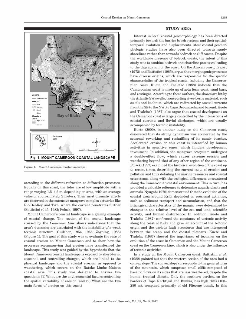
Mount Cameroon’s coastal landscape is a glaring example
of coastal change. The section of the coastal landscape
crossed by the Cameroon Line shows indications that the
area’s dynamics are associated with the instability of a weak
tectonic structure (Guilcher, 1954, 1955; Zogning, 1988)
(Figure 1). The goal of this study was to evaluate the rate of
coastal erosion on Mount Cameroon and to show how the
processes accompanying that erosion have transformed the
landscape. This study was guided by the hypothesis that the
Mount Cameroon coastal landscape is exposed to short-term,
seasonal, and controlling changes, which are linked to the
physical landscape and the coastal erosion, as opposed to
weathering, which occurs on the Batoke–Limbe–Mabeta
coastal axis. This study was designed to answer two
questions: (1) What are the environmental factors controlling
the spatial variability of erosion, and (2) What are the two
main forms of erosion on this coast?
STUDY AREA
Interest in local coastal geomorphology has been directed
primarily towards the barrier beach systems and their spatial-
temporal evolution and displacements. Most coastal geomor-
phologic studies have also been directed towards sandy
shorelines rather than towards bedrock or cliff coasts. Despite
the worldwide presence of bedrock coasts, the intent of this
study was to combine bedrock and shoreline processes leading
to the degradation of the coast. On the African coast, Tricart
(1972) and Battistini (1985), argue that morphogenic processes
have diverse origins, which are responsible for the specific
characteristics of the tropical coasts, including the Cameroo-
nian coast. Kuete and Tsalefac (1988) indicate that the
Cameroonian coast is made up of zeta form coast, sand bars,
and restingas. According to these authors, the shores are hit by
the Atlantic SW swells, transporting river-borne material, such
as silt and kaolinite, which are redirected by coastal currents
from the SE to the NW, to Cape Debundscha and beyond. Kuete
and Tsalefack (1987) also argue that coastal development on
the Cameroon coast is largely controlled by the interactions of
coastal currents and fluvial discharges, which are usually
accompanied by tectonic instability.
Kuete (2000), in another study on the Cameroon coast,
discovered that its strong dynamism was accelerated by the
seasonal reworking and reshuffling of its sandy beaches.
Accelerated erosion on this coast is intensified by human
activities in sensitive zones, which hinders development
investment. In addition, the mangrove ecosystem undergoes
a double-effect flow, which causes extreme erosion and
weathering beyond that of any other region of the continent.
Folack (1997) examined the historical evolution of the coast up
to recent times, describing the current state of erosion and
pollution and thus detailing the marine resources and coastal
ecosystems, along with the ecological differences encountered
along the Cameroonian coastal environment. This in turn, has
provided a valuable reference to determine aquatic plants and
animals. Nyugab (1978) demonstrated that the evolution of the
coastal area around Kribi depended on erosional activities,
such as sediment transport and accumulation, and that the
lithological characteristics of the margin were determined by
changes in the relative level of the sea and land, scientific
activity, and human disturbance. In addition, Kuete and
Tsalefac (1987) confirmed the constancy of tectonic activity
along the coast of Kribi and gave an account of the tectonic
origin and the various fault structures that are interposed
between the ocean and the coastal plateaux. Kuete and
Tsalefac (1987) showed the importance of tectonics on the
evolution of the coast in Cameroon and the Mount Cameroon
coast on the Cameroon Line, which is also under the influence
of tectonic activities.
In a study on the Mount Cameroon coast, Battistini et al.
(1982) pointed out that the western section of the area had a
convex slope. The convex slope corresponds to the general form
of the mountain, which comprises small cliffs composed of
basaltic flows on its sides that are less weathered, despite the
humid, tropical climate. Only the southern portion, on the
borders of Cape Nachtigal and Bimbia, has high cliffs (100–
250 m), composed primarily of old Pliocene basalt. In this
Figure 1. Mount Cameroon coastal landscape.
Coastal Erosion on Mount Cameroon 1215
Journal of Coastal Research, Vol. 28, No. 5, 2012
section, the slopes are highly weathered under the plant cover
and are regenerated locally only at the base, with neotectonic
activities having a dynamic role in the degradation of the
Mount Cameroon coast. In the Idenau sector of the coast,
Battistini (1989) observed the role of neotectonics in the
evolution of the coast and referenced the absence of beaches
on the high cliffs of Cape Nachtigal, demonstrating that the
coast along the Tiko Plain comprised a coastal foreshore and
weathered marine cliffs. Zogning (1988) also examined coastal
erosion at Mount Cameroon and concluded that the erosion was
linked to several active erosional processes, including cone
erosion, which is more rapid than material flows. Zogning
(1988) indicated that the high rate of volcanic structures, such
as the Debundscha complex and the Bota land, the isolated
cones of Mukandange, the Bota hill, the botanical gardens, and
Bimbia, are all highly influenced by marine erosion.
Several other authors studying this coastline, mention that
sea erosion has been repeated on the coastal cliffs, particularly
around Mukundange, where weathering and erosion affect the
middle of the cone differently. In studying marine erosion,
Tricart (1972), Battistini et al. (1982), Zogning (1988), and
Folack (1997) concluded that the Mount Cameroon coast is
generally regressing, and erosion is high compared with areas
affected by bed erosion. In addition, there is little linear
erosion, which may be because of the great porosity of the
volcanic formations and the low drainage network on the
landscape. Therefore, the mountain has few gullies, and many
valleys remain parched.
METHODS AND MATERIALS
Data Collection and AnalysisPreliminary tools for this study were topographic maps and
aerial photographs, which served as a guide for the identifica-
tion of sample-collection sites and a complete representation of
the geographic space. From these tools, the landscape was
examined to determine sampling locations in terms of
accessibility. Aerial photos taken in 1974 were analyzed and
compared with historical land marks to evaluate shoreline
retreat. Another traditional method used in this study was the
placing of erosion-reference stations on the eroding sections of
various cliffs, shores, and volcanic cones (Folack, 1997;
Gamblin, 1998; Paskoff, 1985). One year later, the erosion
references were measured to determine the rate at which
erosion was affecting the shoreline (Table 1).
As a result of the range of morphological units within
different sections of the coast, a systematic approach was used
to sample soils and count pebblest in both the seasonal drains
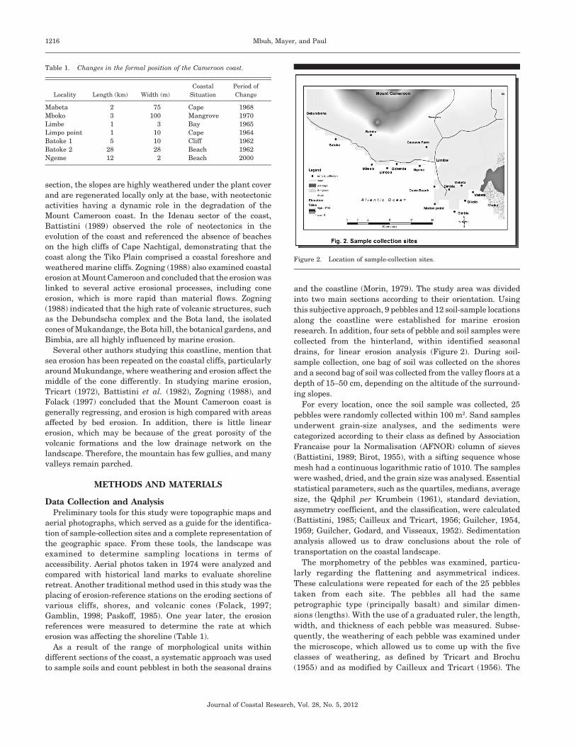
and the coastline (Morin, 1979). The study area was divided
into two main sections according to their orientation. Using
this subjective approach, 9 pebbles and 12 soil-sample locations
along the coastline were established for marine erosion
research. In addition, four sets of pebble and soil samples were
collected from the hinterland, within identified seasonal
drains, for linear erosion analysis (Figure 2). During soil-
sample collection, one bag of soil was collected on the shores
and a second bag of soil was collected from the valley floors at a
depth of 15–50 cm, depending on the altitude of the surround-
ing slopes.
For every location, once the soil sample was collected, 25
pebbles were randomly collected within 100 m2. Sand samples
underwent grain-size analyses, and the sediments were
categorized according to their class as defined by Association
Francaise pour la Normalisation (AFNOR) column of sieves
(Battistini, 1989; Birot, 1955), with a sifting sequence whose
mesh had a continuous logarithmic ratio of 1010. The samples
were washed, dried, and the grain size was analysed. Essential
statistical parameters, such as the quartiles, medians, average
size, the Qdphil per Krumbein (1961), standard deviation,
asymmetry coefficient, and the classification, were calculated
(Battistini, 1985; Cailleux and Tricart, 1956; Guilcher, 1954,
1959; Guilcher, Godard, and Visseaux, 1952). Sedimentation
analysis allowed us to draw conclusions about the role of
transportation on the coastal landscape.
The morphometry of the pebbles was examined, particu-
larly regarding the flattening and asymmetrical indices.
These calculations were repeated for each of the 25 pebbles
taken from each site. The pebbles all had the same
petrographic type (principally basalt) and similar dimen-
sions (lengths). With the use of a graduated ruler, the length,
width, and thickness of each pebble was measured. Subse-
quently, the weathering of each pebble was examined under
the microscope, which allowed us to come up with the five
classes of weathering, as defined by Tricart and Brochu
(1955) and as modified by Cailleux and Tricart (1956). The
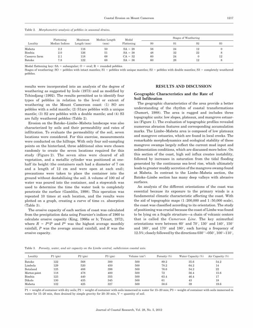
Table 1. Changes in the formal position of the Cameroon coast.
Locality Length (km) Width (m)
Coastal
Situation
Period of
Change
Mabeta 2 75 Cape 1968
Mboko 3 100 Mangrove 1970
Limbe 1 3 Bay 1965
Limpo point 1 10 Cape 1964
Batoke 1 5 10 Cliff 1962
Batoke 2 28 28 Beach 1962
Ngeme 12 2 Beach 2000
Figure 2. Location of sample-collection sites.
1216 Mbuh, Mayer, and Paul
Journal of Coastal Research, Vol. 28, No. 5, 2012
results were incorporated into an analysis of the degree of
weathering as suggested by Icole (1973) and as modified by
Tchindjang (1992). The results permitted us to identify four
types of pebbles in relation to the level or extent of
weathering on the Mount Cameroon coast: (1) SO are
pebbles with a solid mantle; (2) S1are pebbles with a unique
mantle; (3) S2 are pebbles with a double mantle; and (4) S3
are fully weathered pebbles (Table 2).
Erosion on the Batoke–Limbe–Mabeta landscape was also
characterized by soils and their permeability and rates of
infiltration. To evaluate the permeability of the soil, seven
locations were considered. For this exercise, measurements
were conducted on the hilltops. With only four soil-sampling
points on the hinterland, three additional sites were chosen
randomly to create the seven locations required for this
study (Figure 2). The seven sites were cleared of all
vegetation, and a metallic cylinder was positioned at one-
half its height (the containers each had a diameter of 7 cm
and a length of 12 cm and were open at each end);
precautions were taken to place the container into the
ground without destabilising the soil. A volume of 100 ml of
water was poured into the container, and a stopwatch was
used to determine the time the water took to completely
penetrate the surface (Gamblin, 1998). This operation was
repeated 10 times at each location, and the results were
plotted on a graph, creating a curve of time vs. absorption
(Table 3).
The erosive capacity of each section of coast was calculated
from the precipitation data using Fournier’s indices of 1960 to
calculate erosive capacity (King, 1966a or b; Tricart, 1972),
where R 5 P2/P and P2 was the highest average monthly
rainfall, P was the average annual rainfall, and R was the
erosive capacity.
RESULTS AND DISCUSSION
Geographic Characteristics and the Rate ofSoil Infiltration
The geographic characteristics of the area provide a better
understanding of the rhythm of coastal transformations
(Dumort, 1988). The area is rugged and includes three
topographic units: low slopes, plateaux, and mangrove estuar-
ies (Figure 1). The evaluation of topographic profiles revealed
numerous abrasion features and corresponding accumulation
marks. The Limbe–Mabeta area is composed of low plateaux
and mangrove estuaries, which are found in local creeks. The
remarkable morphodynamics and ecological stability of these
mangrove swamps largely reflect the current mud input and
sedimentation conditions, which are discussed more below. On
this section of the coast, high soil influx creates instability,
followed by increases in saturation from the tidal flooding
generated by the continuous sea-level rise, which ultimately
leads to greater muddy accretion of the mangrove swamp found
at Mabeta. In contrast to the Limbe–Mabeta section, the
Batoke–Limbe section has many deep valleys with abrasive
surfaces.
An analysis of the different orientations of the coast was
essential because its exposure to the primary winds is a
fundamental climatic characteristic affecting the coast. With
the aid of topographic maps (1 : 200,000 and 1 : 50,000 scale),
the coast was classified according to its orientation. The study
of positioning was crucial because the coast of Limbe was found
to be lying on a fragile structure—a chain of volcanic centers
that is called the Cameroon Line. The key azimuthal
orientations were between 60u and 70u, 130u and 140u, 150uand 160u, and 170u and 180u, each having a frequency of
12.5%; closely followed by the directions 030uu–050u, 100u–110u,
Table 2. Morphometric analysis of pebbles in seasonal drains.
Locality
Flattening
Median Indices
Maximum
Length (mm)
Median Length
(mm)
Modal
Flattening
Stages of Weathering
S0 S1 S2 S3
Mabeta 2.2 116 50 SA 5 28 56 24 12 0
Bimbia 2.0 126 51 SA 5 38 48 32 22 8
Cassava farm 2.1 118 68 CA 5 32 60 24 0 12
Batoke 7.8 122 68 SA 5 36 60 28 12 8
Modal flattening key: SA 5 subangular; O 5 oval; R 5 rounded pebbles.
Stages of weathering: SO 5 pebbles with intact mantles; S1 5 pebbles with unique mantles; S2 5 pebbles with double mantles; S3 5 completely weathered
pebbles.
Table 3. Porosity, water, and air capacity on the Limbe central, subdivision coastal axis.
Locality P1 (gm) P2 (gm) P3 (gm) Volume (cm3) Porosity (%) Water Capacity (%) Air Capacity (%)
Batoke 122 568 300 500 89.2 35.6 54.2
Limbola 129 520 450 500 78.2 64.2 14
Botaland 125 488 398 500 76.6 54.2 22
Morton point 118 478 400 500 72 56.4 15.6
Bimbia 123 440 355 500 63.4 46.4 17
Dikolo 130 435 345 500 61 43 18
Mabeta 132 425 327 500 58.6 39 19.6
P1 5 weight of container with dry soils; P2 5 weight of container with soils immersed in water for 15–20 min; P3 5 weight of container with soils immersed in
water for 15–20 min, then drained by simple gravity for 20–30 min, V 5 quantity of soil.
Coastal Erosion on Mount Cameroon 1217
Journal of Coastal Research, Vol. 28, No. 5, 2012
160u–170u, with 10% frequency; and the rest of the directions
were found with a frequency between 2.5% and 7.5%. The
dominant type of coastal orientation was between 31u and 70u,which is the direction of the Cameroon Line, with an area
between 130u and 180u and a frequency of 40% of the total
directions (Figures 1 and 3).
The total length of the coast was 49.78 km, with the area
containing a bearing of 130u–180u, and 40.7% of the total
orientation, whereas 56.8% of the area was orientated
between 30u and 70u. The region from Batoke to Man O’
War Bay has a NW–SE orientation, with the wind hitting the
coast in a southwesterly direction from the SW oceanic
winds. The cape Bimbia–Mabeta area is affected by wind
coming from the NE, with the coastlines orientated SW–NE
(Battistini et al., 1982; Crosnier, 1964; Fraser, Hall, and
Healey, 1998). By tabulating all the relevant wind data and
considering the orientation of the coast, the results of this
study have shown that the winds are pivotal in the overall
evolution of the coast (Figures 1 and 3).
The climate of the study area was mostly hot and humid,
with an annual temperature of 29.8uC and consistent and
abundant rains that are vital in the evolution of the coast. The
study of the morphodynamic, oceanographic, and bioclimatic
conditions along the coast permitted a better understanding of
the area that is under constant threat of degradation (Crosnier,
1964). The wave action on this coast is noteworthy because,
throughout the year, the convergence zone, where northern
and southern Hadley cells meet, shifts across the equator. This
region is under the influence of either a continental wind from
the NE or coastal winds from the SW all year-round (Fraser,
Hall, and Healey, 1998). The soil in this area is highly porous,
and the severity and speed of the wind are inconsistent because
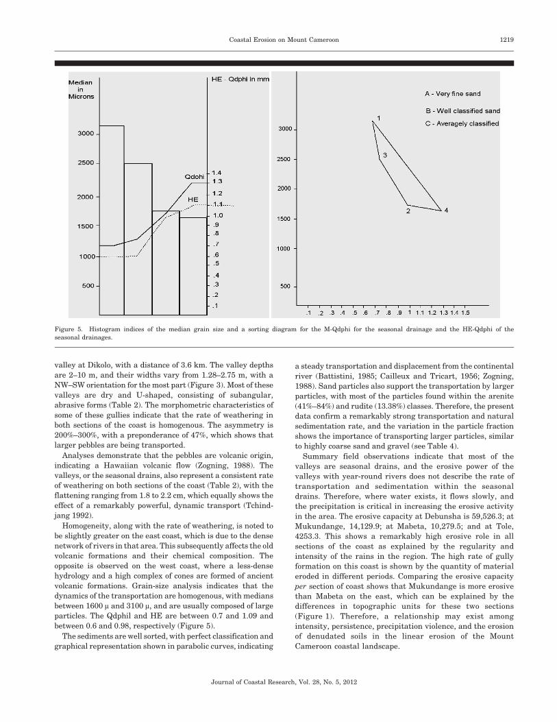
of the corresponding soils. Table 2 and Figure 4 indicate that
(a) two rain events, similar in duration and infiltration
intensity, do not generate the same effect; and (b) repetitive
storm events reduce the rate of infiltration and, therefore,
increase the surface flow by external saturation (Derruau,
1988). Also, the infiltration rate (K) changes significantly
regarding its primary water content during a rainfall.
Therefore, (1) on bare soil or after a long, dry period, K 5
120 mm/h; (2) on a humid soil, with some dryness (2–5 d
without rain ), K 5 80 mm/h; and (3) on intensely humid soil (at
2–5 h after rain), K 5 46 mm/h (Petit, 1990).
The soils in the study area have a high-porosity index,
varying between 58.6% and 89.2%; a high water volume
between 35.5% and 64% (Table 1); and an air capacity within
the upper layers of the soil of between 14% and 54.2%. The soils
on the west coast are more absorbent than are those on the east
coast; therefore, there is an accelerated transformation of the
soils as a result of this permeability (Figure 4). The analysis of
the geographic characteristics of the area has shown that the
coast is under the influence of several key physical factors,
including external formations, the geologic substrata, and
oceanographic and climatic conditions (Nobuyuki, 1976).
Linear ErosionThe exposure of the Mount Cameroon coast to the effects of
the sea seems to be extremely active, disturbing not only the
shores but also and equally the volcanic formations in place
(dykes and cones). To explain the importance of erosion on this
coast, Battistini et al. (1982) suggested that a weak supply of
water from the mountain rivers has a direct effect on coastal
erosion (Figure 1). The great porosity of the volcanic formation,
along with the hydrographic difficulties of the area, causes the
linear erosion to be extraordinarily low, when considering only
the intrinsic factors of the area. However, extrinsic factors,
such as the climate, accelerate the rate of linear erosion (King,
1966a or b). Most of the gullies found in this region are dry
because of the multitude of lava that flows to the coast
(Battistini et al., 1982; Nobuyuki, 1976). The deep dissections
currently being eroded along this coast are older formations
when compared with the age of other areas (Giresse et al.,
1996). The Batoke–Limbe section of the coast is made up of a
few gullies that end abruptly at the mountain and other gullies
that end in the ocean. The gullies of this section vary from 3.3 to
6.5 m deep, with a SW–NW orientation from the western slopes
of the mountain.
The Limbe–Mabeta area is made up of a dissection of
approximately 20 valleys. These valleys are all separated from
one another by distances ranging from 0.2 km to 1.2 km, with
the exception of the Bimbia valleys, which separate the last
Figure 3. Orientation of the coastline.
Figure 4. Soil permeability per section of the coast.
1218 Mbuh, Mayer, and Paul
Journal of Coastal Research, Vol. 28, No. 5, 2012
valley at Dikolo, with a distance of 3.6 km. The valley depths
are 2–10 m, and their widths vary from 1.28–2.75 m, with a
NW–SW orientation for the most part (Figure 3). Most of these
valleys are dry and U-shaped, consisting of subangular,
abrasive forms (Table 2). The morphometric characteristics of
some of these gullies indicate that the rate of weathering in
both sections of the coast is homogenous. The asymmetry is
200%–300%, with a preponderance of 47%, which shows that
larger pebbles are being transported.
Analyses demonstrate that the pebbles are volcanic origin,
indicating a Hawaiian volcanic flow (Zogning, 1988). The
valleys, or the seasonal drains, also represent a consistent rate
of weathering on both sections of the coast (Table 2), with the
flattening ranging from 1.8 to 2.2 cm, which equally shows the
effect of a remarkably powerful, dynamic transport (Tchind-
jang 1992).
Homogeneity, along with the rate of weathering, is noted to
be slightly greater on the east coast, which is due to the dense
network of rivers in that area. This subsequently affects the old
volcanic formations and their chemical composition. The
opposite is observed on the west coast, where a less-dense
hydrology and a high complex of cones are formed of ancient
volcanic formations. Grain-size analysis indicates that the
dynamics of the transportation are homogenous, with medians
between 1600 m and 3100 m, and are usually composed of large
particles. The Qdphil and HE are between 0.7 and 1.09 and
between 0.6 and 0.98, respectively (Figure 5).
The sediments are well sorted, with perfect classification and
graphical representation shown in parabolic curves, indicating
a steady transportation and displacement from the continental
river (Battistini, 1985; Cailleux and Tricart, 1956; Zogning,
1988). Sand particles also support the transportation by larger
particles, with most of the particles found within the arenite
(41%–84%) and rudite (13.38%) classes. Therefore, the present
data confirm a remarkably strong transportation and natural
sedimentation rate, and the variation in the particle fraction
shows the importance of transporting larger particles, similar
to highly coarse sand and gravel (see Table 4).
Summary field observations indicate that most of the
valleys are seasonal drains, and the erosive power of the
valleys with year-round rivers does not describe the rate of
transportation and sedimentation within the seasonal
drains. Therefore, where water exists, it flows slowly, and
the precipitation is critical in increasing the erosive activity
in the area. The erosive capacity at Debunsha is 59,526.3; at
Mukundange, 14,129.9; at Mabeta, 10,279.5; and at Tole,
4253.3. This shows a remarkably high erosive role in all
sections of the coast as explained by the regularity and
intensity of the rains in the region. The high rate of gully
formation on this coast is shown by the quantity of material
eroded in different periods. Comparing the erosive capacity
per section of coast shows that Mukundange is more erosive
than Mabeta on the east, which can be explained by the
differences in topographic units for these two sections
(Figure 1). Therefore, a relationship may exist among
intensity, persistence, precipitation violence, and the erosion
of denudated soils in the linear erosion of the Mount
Cameroon coastal landscape.
Figure 5. Histogram indices of the median grain size and a sorting diagram for the M-Qdphi for the seasonal drainage and the HE-Qdphi of the
seasonal drainages.
Coastal Erosion on Mount Cameroon 1219
Journal of Coastal Research, Vol. 28, No. 5, 2012

Marine ErosionMarine erosion is high along the coast of Cameroon. Many
have observed an internal drift of the Mount Cameroon coast
(Battistini et al., 1982; Hori, 1977; Morin (1979); Zogning and
Kuete, 1986) and the region of Kribi (Hori, 1977; Kuete and
Tsalefac, 1987). The Mount Cameroon coast exposed to the
action of the sea seems to be highly active, affecting both the
shores and the volcanic formations formed by lava flow (dykes
and cones). The erosion of cones is rapid on the Batoke–Limbe–
Mabeta coast because volcanic cones are less resistant to
erosion. Five of these cones are situated on the shoreline
affected by marine erosion: the Botaland, Botanical Gardens,
and Bimbia cones (Figure 1). Their maritime sections corre-
spond to cliffs 50–100 m high. These cliffs have evolved from
mudflows and the undercutting of their bases by waves
(Brunet-Moret, 1970). The speed of coastal regression and the
generations of trees and housing foundations that have
collapsed testify to the frequency of the erosive phenomena.
Remarkable weathering indices are also an indicated by the
number of landslides that have occurred in recent years. Such
events have disturbed many cubic meters of heterogeneous
material from altitudes of 80–100 m and higher; such is the
case with the Bimbia landslide in February 1984 (Zogning,
1988) and the Batoke rock fall in October 2000 (Lambi and
Nwana, 1991).
Analysis of the erosion on the coastlines, as presented in this
study, reveals a higher rate of weathering in the Limbe–Idenau
section than that in the Tiko–Limbe section. The flattening
indices, as well as the other indices, point to a higher rate of
transportation on the west coast vs. that on the east (Table 5).
The modal flattening also indicates a variation in these two
sections of the coast, with the Limbe–Idenau made up mostly of
rounded surfaces, whereas the Tiko–Limbe section has angular
surfaces. The asymmetry is 200%–300% for the Tiko section of
the coast and 100%–200% for the Limbe–Idenau section of the
coast, which can be explained by the high dissection and many
rivers that transport material down the stream. The study also
shows that the east coast has no large-sized pebbles, indicating
a marine regression happening at a slower pace (Figure 6).
Erosion is regular along the cliff, except in coastal orienta-
tion, which leads to the differential erosion observed on the
west and east coasts. Large and small cliffs generally show few
differences in morphology, accompanied by irregular traces,
many projections, and the accumulation of black sands,
without the development of coastal sands. However, the
cellular structure of coastal strands has developed at Botaland,
formed from the carving of the basalt into polygonal columns
(Battistini et al., 1982). Each cellular structure corresponds to
the stumping of a column, carried away by erosion. These
structures are affected by abrasion and weathering on the
borders of the stumps, creating the cellular forms and small,
rounded domes. At the summit of some of the domes, there are
holes covered with sand and basalt pebbles, which contribute to
their weathering (Battistini, 1985).
Grain-size analysis (Table 6) shows there is homogeneity in
the different sections of the coast, and most of the sediments are
well sorted and well classified, with only a few exceptions to the
average classification, which can be explained by their
orientation (Figure 2). The particle sizes vary, with the median
size between 110 m and 1180 m. The variations in the rate of
transportation and sedimentation show the different rhythms
of their evolution. Transportation seems to be unusually strong
Table 4. Grain-size analysis and seasonal drainage.
Locality Median Qdphi (mm) HE (mm) SO (mm) SK (mm) K (Q) AS (Q) SD
Mabeta 3100 0.70 0.60 1.3 0.3 1.4 1.2 0.8
Bimbia 2500 0.77 0.6 1.6 0.6 0.5 1.2 1.01
Cassava farm 1700 1.09 0.98 2.02 0.9 0.6 1.2 0.6
Batoke 1600 1.3 1.02 2.6 1.0 0.06 1.4 0.27
Source: Labwork, Mbuh (2000).
Q 5 quartiles; HE 5 heterometry indices; SO 5 Trask’s classification; SK 5 asymmetry coefficient; K 5 angularity; AS 5 average size; SD 5 standard
deviation.
Table 5. Modality of weathering and other parameters on the Cameroonian beaches.
Locality
Flattening
Median
Indices
Maximum
Length (mm)
Median
Length (mm)
Modal Flattening Stages of Weathering
SA OR S0 S1 S2 S3
Mabeta 2.1 105 66 32 20 52 20 12 16
Dikolo 2.5 123 67 40 24 52 44 0 4
Bimbia 2.3 110 68 28 36 72 20 0 8
Morton Point 2.6 112 72 28 44 100 0 0 0
Batoke 2.2 118 65 32 28 40 20 16 24
Mile six 2.3 114 76 44 32 80 20 0 0
Limbola 2.3 128 87 32 24 68 20 4 8
Bobende 2.6 130 102 48 32 72 28 0 0
Botaland 2.4 126 95 44 32 56 28 0 0
Modal flattening key: SA 5 subangular; O 5 oval; R 5 rounded pebbles.
Stages of weathering: SO 5 pebbles with intact mantles; S1 5 pebbles with unique mantles; S2 5 pebbles with double mantles; S3 5 completely weathered
pebbles.
1220 Mbuh, Mayer, and Paul
Journal of Coastal Research, Vol. 28, No. 5, 2012
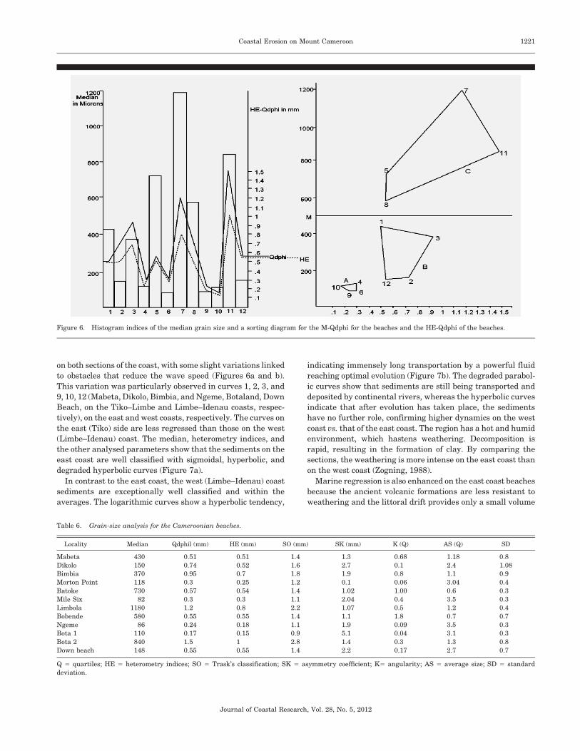
on both sections of the coast, with some slight variations linked
to obstacles that reduce the wave speed (Figures 6a and b).
This variation was particularly observed in curves 1, 2, 3, and
9, 10, 12 (Mabeta, Dikolo, Bimbia, and Ngeme, Botaland, Down
Beach, on the Tiko–Limbe and Limbe–Idenau coasts, respec-
tively), on the east and west coasts, respectively. The curves on
the east (Tiko) side are less regressed than those on the west
(Limbe–Idenau) coast. The median, heterometry indices, and
the other analysed parameters show that the sediments on the
east coast are well classified with sigmoidal, hyperbolic, and
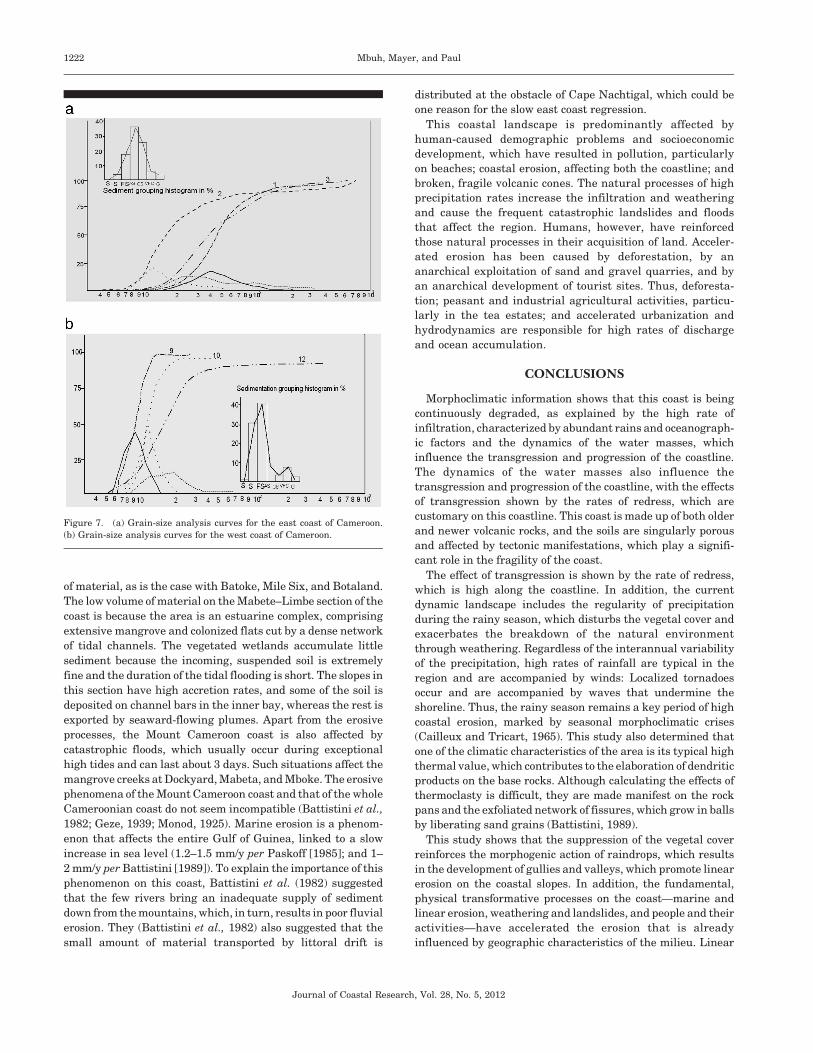
degraded hyperbolic curves (Figure 7a).
In contrast to the east coast, the west (Limbe–Idenau) coast
sediments are exceptionally well classified and within the
averages. The logarithmic curves show a hyperbolic tendency,
indicating immensely long transportation by a powerful fluid
reaching optimal evolution (Figure 7b). The degraded parabol-
ic curves show that sediments are still being transported and
deposited by continental rivers, whereas the hyperbolic curves
indicate that after evolution has taken place, the sediments
have no further role, confirming higher dynamics on the west
coast vs. that of the east coast. The region has a hot and humid
environment, which hastens weathering. Decomposition is
rapid, resulting in the formation of clay. By comparing the
sections, the weathering is more intense on the east coast than
on the west coast (Zogning, 1988).
Marine regression is also enhanced on the east coast beaches
because the ancient volcanic formations are less resistant to
weathering and the littoral drift provides only a small volume
Figure 6. Histogram indices of the median grain size and a sorting diagram for the M-Qdphi for the beaches and the HE-Qdphi of the beaches.
Table 6. Grain-size analysis for the Cameroonian beaches.
Locality Median Qdphil (mm) HE (mm) SO (mm) SK (mm) K (Q) AS (Q) SD
Mabeta 430 0.51 0.51 1.4 1.3 0.68 1.18 0.8
Dikolo 150 0.74 0.52 1.6 2.7 0.1 2.4 1.08
Bimbia 370 0.95 0.7 1.8 1.9 0.8 1.1 0.9
Morton Point 118 0.3 0.25 1.2 0.1 0.06 3.04 0.4
Batoke 730 0.57 0.54 1.4 1.02 1.00 0.6 0.3
Mile Six 82 0.3 0.3 1.1 2.04 0.4 3.5 0.3
Limbola 1180 1.2 0.8 2.2 1.07 0.5 1.2 0.4
Bobende 580 0.55 0.55 1.4 1.1 1.8 0.7 0.7
Ngeme 86 0.24 0.18 1.1 1.9 0.09 3.5 0.3
Bota 1 110 0.17 0.15 0.9 5.1 0.04 3.1 0.3
Bota 2 840 1.5 1 2.8 1.4 0.3 1.3 0.8
Down beach 148 0.55 0.55 1.4 2.2 0.17 2.7 0.7
Q 5 quartiles; HE 5 heterometry indices; SO 5 Trask’s classification; SK 5 asymmetry coefficient; K5 angularity; AS 5 average size; SD 5 standard
deviation.
Coastal Erosion on Mount Cameroon 1221
Journal of Coastal Research, Vol. 28, No. 5, 2012
of material, as is the case with Batoke, Mile Six, and Botaland.
The low volume of material on the Mabete–Limbe section of the
coast is because the area is an estuarine complex, comprising
extensive mangrove and colonized flats cut by a dense network
of tidal channels. The vegetated wetlands accumulate little
sediment because the incoming, suspended soil is extremely
fine and the duration of the tidal flooding is short. The slopes in
this section have high accretion rates, and some of the soil is
deposited on channel bars in the inner bay, whereas the rest is
exported by seaward-flowing plumes. Apart from the erosive
processes, the Mount Cameroon coast is also affected by
catastrophic floods, which usually occur during exceptional
high tides and can last about 3 days. Such situations affect the
mangrove creeks at Dockyard, Mabeta, and Mboke. The erosive
phenomena of the Mount Cameroon coast and that of the whole
Cameroonian coast do not seem incompatible (Battistini et al.,
1982; Geze, 1939; Monod, 1925). Marine erosion is a phenom-
enon that affects the entire Gulf of Guinea, linked to a slow
increase in sea level (1.2–1.5 mm/y per Paskoff [1985]; and 1–
2 mm/y per Battistini [1989]). To explain the importance of this
phenomenon on this coast, Battistini et al. (1982) suggested
that the few rivers bring an inadequate supply of sediment
down from the mountains, which, in turn, results in poor fluvial
erosion. They (Battistini et al., 1982) also suggested that the
small amount of material transported by littoral drift is
distributed at the obstacle of Cape Nachtigal, which could be
one reason for the slow east coast regression.
This coastal landscape is predominantly affected by
human-caused demographic problems and socioeconomic
development, which have resulted in pollution, particularly
on beaches; coastal erosion, affecting both the coastline; and
broken, fragile volcanic cones. The natural processes of high
precipitation rates increase the infiltration and weathering
and cause the frequent catastrophic landslides and floods
that affect the region. Humans, however, have reinforced
those natural processes in their acquisition of land. Acceler-
ated erosion has been caused by deforestation, by an
anarchical exploitation of sand and gravel quarries, and by
an anarchical development of tourist sites. Thus, deforesta-
tion; peasant and industrial agricultural activities, particu-
larly in the tea estates; and accelerated urbanization and
hydrodynamics are responsible for high rates of discharge
and ocean accumulation.
CONCLUSIONS
Morphoclimatic information shows that this coast is being
continuously degraded, as explained by the high rate of
infiltration, characterized by abundant rains and oceanograph-
ic factors and the dynamics of the water masses, which
influence the transgression and progression of the coastline.
The dynamics of the water masses also influence the
transgression and progression of the coastline, with the effects
of transgression shown by the rates of redress, which are
customary on this coastline. This coast is made up of both older
and newer volcanic rocks, and the soils are singularly porous
and affected by tectonic manifestations, which play a signifi-
cant role in the fragility of the coast.
The effect of transgression is shown by the rate of redress,
which is high along the coastline. In addition, the current
dynamic landscape includes the regularity of precipitation
during the rainy season, which disturbs the vegetal cover and
exacerbates the breakdown of the natural environment
through weathering. Regardless of the interannual variability
of the precipitation, high rates of rainfall are typical in the
region and are accompanied by winds: Localized tornadoes
occur and are accompanied by waves that undermine the
shoreline. Thus, the rainy season remains a key period of high
coastal erosion, marked by seasonal morphoclimatic crises
(Cailleux and Tricart, 1965). This study also determined that
one of the climatic characteristics of the area is its typical high
thermal value, which contributes to the elaboration of dendritic
products on the base rocks. Although calculating the effects of
thermoclasty is difficult, they are made manifest on the rock
pans and the exfoliated network of fissures, which grow in balls
by liberating sand grains (Battistini, 1989).
This study shows that the suppression of the vegetal cover
reinforces the morphogenic action of raindrops, which results
in the development of gullies and valleys, which promote linear
erosion on the coastal slopes. In addition, the fundamental,
physical transformative processes on the coast—marine and
linear erosion, weathering and landslides, and people and their
activities—have accelerated the erosion that is already
influenced by geographic characteristics of the milieu. Linear
Figure 7. (a) Grain-size analysis curves for the east coast of Cameroon.
(b) Grain-size analysis curves for the west coast of Cameroon.
1222 Mbuh, Mayer, and Paul
Journal of Coastal Research, Vol. 28, No. 5, 2012
erosion and sedimentation are particularly pronounced on this
coast, as shown by the pebble particle-size analysis, with
differentiation per unit of coastal dynamics, and is observed in
the regression curves (Figures 7a and b). The rates of
transportation, marine erosion, weathering, and linear erosion
each have a different rhythm. Changes in the formal position of
the coast (Table 1) shows that the regression is also occurring
in the mangrove estuaries of Mabeta and Mboko, which are the
only areas on the east coast where erosion was observed. That
erosion is caused by tornadic and human activities, which have
accelerated the rate of mangrove destruction (Folack, 1997).
This coast, from Cape Debunscha to Tiko, has undergone
severe erosion through harbour installation, shore use, and road
building along the shoreline, which interfere with the beach–
dune dynamics and have profoundly modified the coastal
morphology and the littoral dynamics. Urgent measures are
required to tackle the problems identified and their ramifica-
tions, measures that lead to a reduction in the current rate of
shoreline transformation. This is only a preliminary study of the
problems and further analysis is needed on (1) the management
of curvaceous cones and cliffs and the evaluation of bank erosion
of cones and cliffs, (2) the potentialities of the mangrove and its
role in the recycling of coastal resources that depend on the
mangrove for survival, and (3) the role of hedges in the evolution
of the coast so as to understand their effect on the coast and to
compare areas of the coast with and without the hedges.
The rapid growth of population, coastal activities, settle-
ment, deforestation, agriculture, and the industrial sector
within the Mount Cameroon coastal landscape have, however,
increased the rate of degradation processes in this area. The
industrial sector in this region has also largely contributed to
an increase in industrial wastes that are being discharged
without prior treatment into the watershed and lagoons that
are linked with the Gulf of Guinea, thus threatening the
marine life and people’s health (UNESCO, 1998). In fact, the
rapid population growth, along with the industrial, adminis-
trative, and commercial activities, has forced the people who
are the principal stakeholders in the degradation to encroach
on fragile zones, such as the shores and the scoriaceous cones
(Lambi, 1991 and Folack, 1998). In their search for the means
of survival, humans have rendered the region environmentally
unstable.
ACKNOWLEDGMENTS
This research was carried out with financial support from
the Cameroon Ministry of Higher Education; the Oceano-
graphic Research Centre at Limbe provided additional
support for field measurements. Dr. Tchindjang Mesmin, in
the Geomorphology laboratory in the Department of Geogra-
phy at the University of Yaounde-I, is also appreciated for his
assistance in field-sample analysis and interpretation of
results. Special thanks also go to Dr. Jean Folack of the
Limbe Oceanographic Centre.
LITERATURE CITED
Battistini, R., 1985. Travaux Francais recents ur la morphologie delittoraux volcaniques. Bulletin de l’Association des GeographesFrancais, pp. 85–92 [in French].
Battistini, R., 1989. Travaux du Laboratoire de Geographie PhysiqueAppliquee. Centre de Recherche de l’Universite de Bordeaux III,49p [in French].
Battistini, R.; Hinschberger, F.; Morin, S., and Zogning, A., 1982. Lelittoral du Mont Cameroun: etude geomorphologique. Review ofCameroon Geography, 1, 55–72 [in French].
Birot P., 1957. Les Methodes de la Geomorphologie: Collection Orbis,Paris: Presses Universitaires de France, 66(354), 97–124 [inFrench].
Brunet-Moret, Y., 1970. Etude des marees dans le fleuve Casmance.Cahiers Orstom serie Hydrologie, 7(4), 3–18 [in French].
Cailleux, A. and Tricart, J., 1956. Initiation a l’etude des Sables et desGalets, Volume 3. Paris: Centre de Documentation Universitaire,376p.
Cooke, R.U. and Doornkamp, J.C., 1974. Geomorphology in Environ-mental Management: An Introduction. Oxford, U.K.: ClarendonPress, 850p.
Crosnier, A., 1964. Fonds de Peche le Long des Cotes de la RepubliqueFederale du Cameroun. Cahiers Orstom serie Oceanographie. No.special. 132p [in French].
Derruau, M., 1988. Precis de Geomorphologie. Paris: Masson, 544p.Dumort, J.C., 1968. Carte geologique de reconnaissance a l’echelle du
1 : 500.000, Notice explicative sur la feulille Douala–Ouest, Direc-tion des mines et de la geologie du Cameroun, 69p.
Folack, J., 1997. Coastal Erosion Problems in Cameroon: MitigatingMeasures and Control Strategies. Boston, Massachusetts: Interna-tional Conference on Integrated Coastal Zone Management, 10p.
Folack, J., 1998. The state of coastal erosion in Cameroon. In: Ibe,A.C.; Awosika, L.G., and Aka, K. (eds.). Proceedings of the FirstSymposium on the IOCEA Cruise on Nearshore Dynamics andSedimentology of the Gulf of Guinea. Lagos, Nigeria: Centre forEnvironment and Development in Africa. pp. 181–187.
Fraser, P.J.: Hall, J.B., and Healey, J.R., 1998. Climates of the MountCameroon Region:Long and Medium Term Rainfall, Temperatureand Sunshine Data. Bangor: University of Wales, 56p.
Gabche, C.E. and Angwe, C.A., 1997. Coastal erosion and sedimen-tation in Cameroon. In: Evans, S.M.; Vanderpuye, C.J., and Armah,A.K. (eds.). Coastal Zone of West Africa: Problems and Manage-ment—Proceedings of the International Seminar. Cleadon, U.K.:Penshaw Press. 235p.
Gamblin, A. (ed.), 1998. L’Erosion Entre Nature et Societe: Dossiersdes Images Economique du Monde. Paris: SEDES, 335p.
Geze, B., 1939. Les sources dites ‘‘vauclusiennes’’ [The springsreferred to as ‘‘ vauclusian’’]. Sciences Naturelles [NaturalSciences], 1(6):171–80.
Giresse, P.; Megope-Foonde, J.-P.; Ngueutchoua, G.; Aloisi, J.-C.;Kuete, M., and Monteillet, J., 1996. Carte Sedimentologique duPlateau Continental du Cameroun. a l’echelle du 1 : 200.000. Paris:Institut Francais de Recherche Scientifique pour le Developement,ORSTOM. Notie Explicative 111. 46p.
Guilcher, A., 1954. Dynamique et morphologie des cotes sableuses deAfrique Atlantique. Cahiers d’Information Geographie (Paris), 1,57–68 [in French].
Guilcher, A., 1955. Geomorphologie de l’extremete septentrionale dubanc coralline Frsan ( Mer Rouge). Ann. Inst. Oceonogra., 30:55–100.
Guilcher, A., 1959. Coastal sand ridges and marshes and theircontinental environment near Grand Popo and Ouidah, Dahomey.In: Proceedings of the 2nd Coastal Geography Conference, BatonRouge, Louisiana, 189–212
Guilcher, A.; Goddard, A., and Visseaux E., 1952. Formes des plage ethoule sur le littoral des Landes des Gascogne. Revue de Geographiedes Pyrenees et du Sud-Ouest, 99–177.
Hori, N., 1977. Landforms and superficial deposits in the coastalregion of Cameroon. In: Kadomura, H. (ed.). GeomorphologicalStudies in the Forest and Savanna Areas of Cameroon. Sapporo,Japan: Hokkaido University, pp. 61–71.
Icole, M., 1973. Geochimie des Alterations dans les Nappes d’Alluvi-ons du Pieinont Occidental Nord- ‘ PyrdnCen. Essai de Paldopedo-logie Quaternaire. These Doc. Univ. Paris VI, 328p.
Keith, C. and Johnson, J.H., 1979. Coastal Geomorphology. Macmil-lan education LTD. 46p.
Coastal Erosion on Mount Cameroon 1223
Journal of Coastal Research, Vol. 28, No. 5, 2012
King, C.A.M., 1966a. Techniques in Geomorphology. London: EdwardArnold, Ltd., 342p.
King, C.A.M., 1966b. Beaches and Coasts. London: Edward Anold,Ltd., 389p.
Krumbein, W.C., 1961. The Analysis of Observational Data fromNatural Beaches. Washington, DC: Beach Erosion Board, ArmyCorps of Engineers Technical Memorandum 130.
Kuete, M., 1981. La Cote Kribienne, Quelques problemes morpholo-giques, Rev. De geo. du Cam. Vol VII, No. 2 p.137–147.
Kuete, M. and Tsalefac, M., 1987. Les secousses sismiques deSeptembre 1987 a Kribi: enseignement d’ordre geomorphologique.Revue de Geographie du Cameroun, 7(2), 149–156.
Lambi, C.M. and Nwana, B.S., 1991. Human interference andenvironmental instability: the case of the Limbe landslide. Revuede Geographie du Cameroun, 10(1), 44–52.
Morin, S., 1979. Introduction a la recherche en geomorphologie.Cahier du Departement de Geographie. 36p.
Michel, P., 1990. Geographie Physique Tropicale: Approche auxEtudes du Mileu—Morphogenese-Paysages. Paris: Karthala, 351p.
Monod, T., 1925. Isopodes et Amphipodes de l’expedition FrancaiseAntarctic Belge (S.Y. Belgica). Bulletin de museum d’Histoirenaturelle (Paris) 31:296–299.
Nyugab, S., 1979. Coastal Geomorphology: A Study of Landformsaround Kribi. Yaounde, Cameroon: University of Yaounde, DESdissertation, 80p.
Paskoff, R., 1985. Les Littoraux: Impact des Amenagement sur LeurEvolution. Paris: Masson, 184p.
Petit M., 1990. Geographie physique Tropicale. Approche aux etudesphysiques du Milieu, Morphogenese, Paysages, Paris, Karthala,ACCT, 351p.
Tchindjang, M., 1992. Les galets alteres de la region du Bamilekecentral (ouest-Cameroun) et leur signification paleoclimatique [Theweathered pebbles from central Bamileke (western Cameroon) andtheir peleoclimatic significance]. Cahiers Geologiques, 120, 1326–1344 [in French].
Tricart, J., 1972. The Landforms of the Humid Tropics, Forests andSavannas. London: Longmans, 285p.
Tricart, J. and Brochu, M. 1955. Le Grand Erg ancien du Trarza etCayor (sud-ouest de la Mauritanie et nord du Senegal) (The ancientGrande Erg of Trarza and Cayor, southwestern Mauritania andnorth Senegal). Revue de geomorphologie dynamique 6(4–6):145–176. (in French)
UNESCO, 1998. Rapport d’atelier regional: Methodologie de collectede donnees et de gestion du Littoral du Benin, Cameroun, Coted’Ivoire, Ghana, Nigeria, Lomie, 37p.
Zogning, A., 1988. Le Mont Cameroun: Un Volcan Actif. Yaounde,Cameroon: University of Yaounde, doctoral thesis, 447p.
Zogning A., Kuete M., 1986; L’equilibre ecologique du littoralcamerounais. Le Littoral guyanais. Fragilite de l’environnement.45:24–38.
1224 Mbuh, Mayer, and Paul
Journal of Coastal Research, Vol. 28, No. 5, 2012