Embed Size (px)
Citation preview
Assessing Impacts of Climate Change on Coastal Military Installations: Policy Implications
Prepared by:
Strategic Environmental Research and Development Program
US Department of Defense
January 2013
Report Documentation Page Form ApprovedOMB No. 0704-0188
Public reporting burden for the collection of information is estimated to average 1 hour per response, including the time for reviewing instructions, searching existing data sources, gathering andmaintaining the data needed, and completing and reviewing the collection of information. Send comments regarding this burden estimate or any other aspect of this collection of information,including suggestions for reducing this burden, to Washington Headquarters Services, Directorate for Information Operations and Reports, 1215 Jefferson Davis Highway, Suite 1204, ArlingtonVA 22202-4302. Respondents should be aware that notwithstanding any other provision of law, no person shall be subject to a penalty for failing to comply with a collection of information if itdoes not display a currently valid OMB control number.
1. REPORT DATE JAN 2013 2. REPORT TYPE
3. DATES COVERED 00-00-2013 to 00-00-2013
4. TITLE AND SUBTITLE Assessing Impacts of Climate Change on Coastal Military Installations:Policy Implications
5a. CONTRACT NUMBER
5b. GRANT NUMBER
5c. PROGRAM ELEMENT NUMBER
6. AUTHOR(S) 5d. PROJECT NUMBER
5e. TASK NUMBER
5f. WORK UNIT NUMBER
7. PERFORMING ORGANIZATION NAME(S) AND ADDRESS(ES) Strategic Environmental Research and Development Program(SERDP),Environmental Security Technology Certification Program(ESTCP),4800 Mark Center Drive, Suite 17D08,Alexandria,VA,22350-3605
8. PERFORMING ORGANIZATIONREPORT NUMBER
9. SPONSORING/MONITORING AGENCY NAME(S) AND ADDRESS(ES) 10. SPONSOR/MONITOR’S ACRONYM(S)
11. SPONSOR/MONITOR’S REPORT NUMBER(S)
12. DISTRIBUTION/AVAILABILITY STATEMENT Approved for public release; distribution unlimited
13. SUPPLEMENTARY NOTES
14. ABSTRACT
15. SUBJECT TERMS
16. SECURITY CLASSIFICATION OF: 17. LIMITATION OF ABSTRACT Same as
Report (SAR)
18. NUMBEROF PAGES
68
19a. NAME OFRESPONSIBLE PERSON
a. REPORT unclassified
b. ABSTRACT unclassified
c. THIS PAGE unclassified
Standard Form 298 (Rev. 8-98) Prescribed by ANSI Std Z39-18

This page intentionally left blank.
Assessing Impacts of Climate Change on Coastal Military Installations: Policy Implications
Prepared by:
Strategic Environmental Research and Development Program
US Department of Defense
January 2013 Recommended Citation: Strategic Environmental Research and Development Program. 2013. Assessing Impacts of Climate Change on Coastal Military Installations: Policy Implications. US Department of Defense.

This page intentionally left blank.

Assessing Impacts of Climate Change on Coastal Military Installations: Policy Implications
FRONT MATTER i
Acknowledgements
The preparation of this white paper was led by Dr. John A. Hall, Program Manager for Resource Conservation and Climate Change (RC), SERDP/ESTCP, under the direction of Dr. Jeffrey Marqusee, SERDP/ESTCP Executive Director. The technical foundation of this white paper draws on the work of four research projects funded by SERDP that are developing and testing the information, models, and tools needed to examine the potential climate change vulnerability of and impacts on coastal military installations. SERDP extends its appreciation to the Principal Investigators (PIs) of these projects and their research team members for their technical inputs and identification of examples to support this white paper. The PIs are: Dr. Joseph F. Donoghue, Florida State University (RC-1700); Dr. Kelly A. Burks-Copes, US Army Engineer Research and Development Center (RC-1701); Dr. Rob L. Evans, Woods Hole Oceanographic Institution (RC-1702); and Dr. Bart Chadwick, SPAWAR Systems Center (RC-1703). Support to SERDP for white paper development was provided by Joanne R. Potter, Dr. Peter A. Schultz, Michael J. Savonis, and Wendy S. Jaglom from ICF International. SERDP appreciates the ongoing guidance and support of the SERDP RC Technical Committee and thanks the military Services individuals who generously reviewed and provided input on this document. In particular, SERDP would like to acknowledge the following individuals for their contributions: Courtney St. John, Navy Task Force Climate Change; William Goran, US Army Corps of Engineers; and Kevin Knuuti, US Army Corps of Engineers. Finally, thanks go to Sam Figuli and other staff from HydroGeoLogic, Inc. whose ongoing support has been indispensable to the completion of this work.
Assessing Impacts of Climate Change on Coastal Military Installations: Policy Implications
FRONT MATTER ii
Table of Contents
Acknowledgements ........................................................................................................................................ i
Table of Contents .......................................................................................................................................... ii
List of Figures ............................................................................................................................................... iv
List of Boxes ................................................................................................................................................. iv
List of Acronyms ............................................................................................................................................ v
Preface ........................................................................................................................................................ vii
Executive Summary ....................................................................................................................... ES-1
Policy Context ...................................................................................................................................... ES-1
Policy Questions Regarding Climate Change Assessments and Adaptation Planning ......................... ES-2
Technical and Institutional Considerations to Inform Policy ............................................................... ES-2
Introduction ......................................................................................................................................1
Policy Context ........................................................................................................................................... 2
Why consider climate change now? ......................................................................................................... 3
Climate change interacts with the built and natural environment .......................................................... 4
Climate change effects interact with non-climate factors .................................................................... 4
Installation vulnerabilities include risks to both structural and operational components ................... 5
DoD and civilian initiatives to address climate change risk ...................................................................... 6
Military Services’ climate change vulnerability and impact assessment and adaptation activities ..... 6
Other Federal and national climate change vulnerability and impact assessment and adaptation activities ................................................................................................................................................ 7
Regional/local climate change vulnerability and impact assessment and adaptation activities .......... 8
SERDP coastal impact assessment research projects and other research................................................ 9
Policy Questions Regarding Climate Change Assessments and Adaptation Planning ........................... 13
Policy Question 1: Integrating climate change considerations ............................................................... 13
Policy Question 2: Technical guidance required ..................................................................................... 13
Policy Question 3: Degree of regional consistency ................................................................................. 14
Policy Question 4: Ensuring mission resilience ....................................................................................... 15
Policy Question 5: Coordination with civilian activities .......................................................................... 15
Technical and Institutional Considerations to Inform Policy............................................................... 16
Consideration 1: Integrating climate change into planning and management decisions ...................... 16
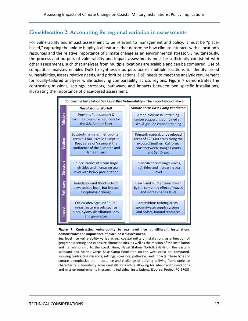
Consideration 2: Accounting for regional variation in assessments ....................................................... 17
The need for place-based impacts assessment .................................................................................. 18
Working across spatial scales .............................................................................................................. 20
Consideration 3: Using screening level versus detailed assessments .................................................... 21
Decision Types .................................................................................................................................... 21
Criticality ............................................................................................................................................. 22
Thresholds ........................................................................................................................................... 22
Assessing Impacts of Climate Change on Coastal Military Installations: Policy Implications
FRONT MATTER iii
Consideration 4: Selecting and applying future condition scenarios ..................................................... 23
Why use scenarios? ............................................................................................................................. 24
Selecting sea level change scenarios .................................................................................................. 25
Integrating scenario-planning with other long-range planning activities........................................... 26
Consideration 5: Matching analysis timeframes and spatial scales to decision types and planning horizons ................................................................................................................................................... 27
Consideration 6: Ensuring data quality ................................................................................................... 28
Consideration 7: Addressing uncertainty ................................................................................................ 31
Using an adaptive management approach ......................................................................................... 32
Consideration 8: Enabling the ongoing use of climate science in decisions ........................................... 33
References ....................................................................................................................................... 35
Appendix A: Project Fact Sheets ................................................................................................... A-35
Effects of Near-Term Sea Level Rise on Coastal Infrastructure (RC-1700) ........................................... A-2
Objective ........................................................................................................................................... A-2
Technical Approach ........................................................................................................................... A-2
Benefits ............................................................................................................................................. A-2
Findings to Date ................................................................................................................................ A-3
Risk Quantification for Sustaining Coastal Military Installation Assets and Mission Capabilities (RC-1701) ..................................................................................................................................................... A-4
Objective ........................................................................................................................................... A-4
Technical Approach ........................................................................................................................... A-4
Benefits ............................................................................................................................................. A-5
Findings to Date ................................................................................................................................ A-5
Shoreline Evolution and Coastal Resiliency at Two Military Installations: Investigating the Potential for and Impacts of Loss of Protecting Barriers (RC-1702) .......................................................................... A-7
Objective ........................................................................................................................................... A-7
Technical Approach ........................................................................................................................... A-8
Benefits ............................................................................................................................................. A-8
Findings to Date ................................................................................................................................ A-8
A Methodology for Assessing the Impact of Sea Level Rise on Representative Military Installations in the Southwestern United States (RC-1703) ........................................................................................ A-10
Objective ......................................................................................................................................... A-10
Technical Approach ......................................................................................................................... A-10
Benefits ........................................................................................................................................... A-10
Findings to Date .............................................................................................................................. A-11
Appendix B: An Illustrative Local Analytical Challenge—Normalizing Local Sea Level Data ............... B-1
Appendix C: Glossary ..................................................................................................................... C-1
Assessing Impacts of Climate Change on Coastal Military Installations: Policy Implications
FRONT MATTER iv
List of Figures
Figure 1: Coastal military installations are highly vulnerable to climate change. ..................................... 3 Figure 2: Installation systems are not equally vulnerable to climate change. ........................................... 5 Figure 3: Study area for the Eglin AFB Study. .............................................................................................. 9 Figure 4: Military installations located within the Hampton Roads area. ............................................... 10 Figure 5: Focus Areas of Shoreline Evolution Study. ................................................................................. 11 Figure 6: Beach retreat under future sea level rise increases susceptibility of coastal military
installations to inundation and flooding. ..................................................................................... 12 Figure 7: Contrasting vulnerability to sea level rise at different installations demonstrates the
importance of place-based assessment. ...................................................................................... 17 Figure 8: The predicted interaction of 2 meters of sea level rise with an existing sand shortage at Naval
Base Coronado. ............................................................................................................................. 19 Figure 9: National Climate Assessment Regions ....................................................................................... 20 Figure 10: Two-dimensional risk framework used by the New York City Climate Change Adaptation
Task Force. ..................................................................................................................................... 21 Figure 11: Coastal military installation infrastructure has unique damage response characteristics. ... 23 Figure 12: Example portrayal of future scenarios. .................................................................................... 24 Figure 13: Future scenarios for Southern California Study. ...................................................................... 25 Figure 14: Climate change stressors affect decisions over different timescales. .................................... 28 Figure 15: The sedimentary record can be used to obtain long-term storm histories. ........................... 31 Figure 16: Predictive uncertainty for sea level rise increases over time. ................................................. 32
List of Boxes
Box 1: Key Terms ...............................................................................................................................2 Box 2: Illustrative List of Coastal Installation Assets ............................................................................5 Box 3: Planning Event Horizon .......................................................................................................... 16 Box 4: Importance of the Quality of Elevation and Location Data ...................................................... 29
Assessing Impacts of Climate Change on Coastal Military Installations: Policy Implications
FRONT MATTER v
List of Acronyms
ADCIRC Advanced Circulation
ADH Adaptive Hydraulics
AFB Air Force Base
Bn Bayesian network
CMS Coastal Modeling System
DCERP Defense Coastal/Estuarine Research Program
DoD Department of Defense
EAFB Eglin Air Force Base
EPA Environmental Protection Agency
ESTCP Environmental Security Technology Certification Program
FEMA Federal Emergency Management Agency
GSSHA Gridded Surface-Subsurface Hydrologic Analysis
ICEMAPs Installation Complex Encroachment Management Action Plans
InSAR Interferometric Synthetic Aperture Radar
IPCC Intergovernmental Panel on Climate Change
LIDAR Light Detection and Ranging
MCBCL Marine Corps Base Camp Lejeune
MHW Mean High Water
MLLW Mean Lower Low Water
MSLR Mean Sea Level Rise
NAD83 North American Datum of 1983
NASA National Aeronautics and Space Administration
NAVD88 North American Vertical Datum of 1988
NCA National Climate Assessment
NFIP National Flood Insurance Program
NGS National Geodetic Survey
NIC National Intelligence Council
NOAA National Oceanic and Atmospheric Administration
NOS National Ocean Service
NPCC New York City Panel on Climate Change
NPS National Park Service
NRC National Research Council
NSN Naval Station Norfolk
PBL Planetary Boundary Layer
PI Principal Investigator
QDR Quadrennial Defense Review
RC Resource Conservation and Climate Change
Assessing Impacts of Climate Change on Coastal Military Installations: Policy Implications
FRONT MATTER vi
SERDP Strategic Environmental Research and Development Program
SLAMM Sea Level Affecting Marsh Model
SLR Sea Level Rise
SPAWAR Space and Naval Warfare Systems Command
SSPP Strategic Sustainability Performance Plan
SWAN Simulating Waves Nearshore
THIRA Threat Hazard Identification Risk Assessment
USACE US Army Corps of Engineers
USGCRP United States Global Change Research Program
USGS US Geological Survey
Assessing Impacts of Climate Change on Coastal Military Installations: Policy Implications
FRONT MATTER vii
Preface
Climate change will have serious implications for the ability of the Department of Defense (DoD) to maintain its natural and built infrastructure and to ensure military readiness. The 2010 Quadrennial Defense Review (QDR) requires DoD to conduct climate impact assessments at its permanent installations. Several studies have been completed or are currently underway by the military Services. In particular, the Strategic Environmental Research and Development Program (SERDP) has funded four research projects that are developing and testing the information, models, and tools needed to examine climate change impacts on coastal installations.
This experience, as well as other advances in scientific understanding and scenario development associated with coastal environs, makes vulnerability and impact assessment of coastal military installations an appropriate arena for DoD and the military Services to pilot efforts to develop policy and guidance to respond to climate change challenges. It also provides an opportunity to build the necessary institutional structures and relationships—especially between the policy, user, and scientific communities—to facilitate effective, efficient, timely, and ongoing responses.
As research progresses to better understand the vulnerability of military installations to climate change, SERDP has identified key policy questions that need to be addressed to ensure that climate change vulnerability and impact assessments are conducted effectively and assessment findings are appropriately used to inform decisions. This is necessary to ensure the ongoing capability of DoD to meet its mission, sustain its assets, and meet its stewardship requirements and responsibilities.
This white paper outlines an approach to address this new policy challenge. It draws on the lessons learned from the SERDP-funded research efforts in the context of coastal installations and on the expertise of individuals within the DoD community and other Federal agencies. The paper discusses several technical and institutional considerations that form a basis for developing policy and guidance.
Assessing Impacts of Climate Change on Coastal Military Installations: Policy Implications
EXECUTIVE SUMMARY ES-1
Executive Summary
The effects of climate change will adversely impact military readiness and Department of Defense (DoD) natural and built infrastructure unless these risks are considered in DoD decisions. Considerations of future climate conditions need to be incorporated into the planning, design, and operations of military facilities, as well as into the strategic infrastructure decisions facing the military Services and DoD as a whole.
This paper discusses the policy context and technical considerations related to these issues, drawing on lessons learned to date from four studies funded by the Strategic Environmental Research and Development Program (SERDP). This paper focuses on coastal installations, but may inform the Department’s overall approach to climate change.
Policy Context
DoD and the military Services have taken key policy measures that begin to address climate change. The 2010 Quadrennial Defense Review (QDR) requires DoD to conduct climate impact assessments. The Navy’s Climate Change Roadmap (2010) directs the Navy to assess, predict, and adapt to global climate change through a series of actions. A study conducted under the auspices of the Naval Studies Board by the National Research Council (NRC), National Security Implications of Climate Change for U.S. Naval Forces (2011), found that even the most moderate current trends in climate, if continued, will present new national security challenges. In response to Executive Order 13514 (Federal Leadership in Environmental, Energy, and Economic Performance, October 2009), DoD’s initial Strategic Sustainability Performance Plan (August 2010) identified a three-phase approach for DoD’s response to climate change risks and vulnerabilities. The QDR and Executive directives set a broad direction under which DoD can develop more specific policies to support effective assessment and adaptation measures.
The effects of climate change are being experienced now and are expected to increase in the coming years, even if aggressive greenhouse gas mitigation efforts are implemented globally. The interaction of climate change with geological and other environmental conditions in different regions will result in a variety of outcomes across the nation. Key coastal climate stressors include rising sea levels and changes in storm intensity and frequency, as well as changes in temperature and precipitation patterns. These changes will increase the vulnerability of military installations, including risks to facilities and infrastructure, natural areas, and operations. Climate models that simulate future climate conditions indicate that the impacts of climate change will grow with time and that the rates of warming and sea level rise in the 21st century will be greater than those in the 20th century. Given the anticipated magnitude and pace of future change, it is likely that many of the steps that can be taken to adapt will be less costly and most cost-effective if they are taken now, rather than in future decades.
A range of climate vulnerability and impact assessment and adaptation-related activities are currently underway within DoD and across Federal, state, and local governments. The Navy, Army, Air Force, Army Corps of Engineers, and several civil departments and agencies (e.g., National Oceanic and Atmospheric Administration (NOAA), National Aeronautics and Space Administration (NASA)) have climate change-related policy and research initiatives. SERDP is funding four projects at coastal installations designed to explore assessment methodologies to advance the state of practice. The National Climate Assessment (NCA) will provide a comprehensive overview of climate impacts on the nation and, through its
Assessing Impacts of Climate Change on Coastal Military Installations: Policy Implications
EXECUTIVE SUMMARY ES-2
sustained assessment process, will advance the use of scenarios for assessment and planning (draft release anticipated January 2013). These independent efforts provide opportunities for collaboration and resource sharing for scientific analysis and for coordination of assessment approaches and implementation of adaptation strategies.
Policy Questions Regarding Climate Change Assessments and Adaptation Planning
The need to address climate change vulnerability and impacts raises five key policy questions for DoD and the military Services.
Policy Question 1: Integrating climate change considerations: How can DoD and the military Services best integrate climate change considerations into planning and decision processes to ensure military readiness and asset protection?
Policy Question 2: Technical guidance required. What technical guidance is required from DoD and the military Services to enable high quality assessment and adaptation planning to support planning and management decisions?
Policy Question 3: Degree of regional consistency. How can DoD and the military Services best balance the need for comparable assessment results across diverse regions, installations, and mission purposes, with the need for flexibility in assessment approaches to address regional/local conditions and priorities?
Policy Question 4: Ensuring mission resilience. How can DoD and military Services investments at extant military installations as well as potential future base realignment and closure investments be made so that such decisions, at the installation level and in aggregate, ensure resilience of the military mission to climate change?
Policy Question 5: Coordination with civilian activities. How can DoD and the military Services ensure that external/civilian activities that may affect DoD installations and military readiness are effectively accounted for in installation and civilian strategies under climate change?
Technical and Institutional Considerations to Inform Policy
Eight technical and institutional considerations should be incorporated into DoD policies and guidance to ensure an effective and sustainable approach to enhancing military readiness and protecting DoD assets in the face of climate change. They are:
Consideration 1: Integrating climate change into planning and management decisions. Climate change adaptation should not be a separate decision-making process, but rather an aspect of overall management at the installation, Service, and Departmental levels.
Consideration 2: Accounting for regional variation in assessments. Effective vulnerability assessment must be “place-based,” capturing the unique biophysical features that determine how climate interacts with a location’s resources and the relative importance of climate change as an environmental stressor. At the same time, the process and
Assessing Impacts of Climate Change on Coastal Military Installations: Policy Implications
EXECUTIVE SUMMARY ES-3
outputs of vulnerability and impact assessments must be sufficiently consistent so that DoD can achieve comparability across regions.
Consideration 3: Using screening level versus detailed assessments. Not all adaptation decisions require detailed assessment. Screening assessments can be conducted at lower cost to quickly identify and prioritize the infrastructure and operations at installations that may be vulnerable. The level of assessment should match the nature of the decision at hand.
Consideration 4: Selecting and applying future condition scenarios. The use of scenarios allows DoD to consider a range of potential future climate conditions and levels of impacts, different degrees of risk tolerance, and, as a result, a robust set of adaptation actions. Effective use of scenarios can inform decision making under uncertainty.
Consideration 5: Matching analysis timeframes and spatial scales to decision types and planning horizons. Scenarios should be constructed using information at temporal and spatial scales that are consistent with the decisions being made. For example, one-time decisions concerning the construction of long-lived infrastructure will require different climate information than seasonal or annual decisions about operations.
Consideration 6: Ensuring data quality. Reliable and defensible analyses depend on data that are reputable and of good quality, consistently collected over time and via similar methods, and available and accessible to DoD. Data required include biophysical information, facility information, and elevation and location information.
Consideration 7: Addressing uncertainty. Documenting the types of uncertainty associated with projections of different climate variables—and their associated implications—is crucial for setting priorities. An adaptive management approach helps decision makers address uncertainty in the rate, magnitude, or direction of changes while taking action to reduce the risks of climate change.
Consideration 8: Enabling the ongoing use of climate science in decisions. Climate science is evolving rapidly. It is critical for DoD, the military Services, and decision makers to continually monitor scientific findings as more decision support information becomes available.
Assessing Impacts of Climate Change on Coastal Military Installations: Policy Implications
INTRODUCTION 1
Introduction
The effects of climate change will adversely impact military readiness and DoD natural and built infrastructure unless these risks are considered in DoD decisions. Environmental factors are already affecting DoD installations; as the climate continues to change, the nature and severity of these stressors will change as well. Many of the problems caused by changing climate stressors are expected to affect facilities located on and near the coasts; other impacts may affect inland installations as well. Considerations of future climate conditions need to be incorporated into the planning, design, and operations of military facilities, as well as in the strategic infrastructure decisions facing the military Services and DoD as a whole.
This white paper discusses key policy questions and technical and institutional considerations to inform DoD policymakers as they develop policy and guidance for assessing the vulnerability and resilience of military installations to future climate-related stressors. The scope of the discussion and findings is focused on coastal installations in the United States and territories, and addresses the vulnerabilities of these installations to potential climate change, including changes in climate variability. The findings of this white paper, however, also may inform the Department’s overall approach to climate change. This paper draws on lessons learned to date from four SERDP-funded research studies that are developing and testing the information, models, and tools needed to examine impacts on coastal installations, in addition to other analyses. The findings made herein are designed to enable a coordinated and effective approach to climate change vulnerability and impact assessments and to support adaptation planning across DoD and the military Services.
This paper discusses the following:
Policy drivers that set the context for climate change vulnerability and impacts assessments at military installations, as well as an overview of current activities within the military, civilian agencies, local governments, and the research community.
Key policy questions for DoD and the military Services that are raised by the need to address climate change vulnerability and impacts.
Technical and institutional considerations that influence how climate change vulnerability and impact assessments can be approached to support management decisions and develop policy requirements.
A set of appendices provides supporting documentation, a glossary of terms (a few key terms are provided in Box 1), and brief summary descriptions of the four SERDP-supported research projects that examined analytic approaches to vulnerability and impact assessment at coastal military installations.
Assessing Impacts of Climate Change on Coastal Military Installations: Policy Implications
INTRODUCTION 2
Policy Context
The potential implications of climate change impacts on mission readiness and DoD infrastructure are increasingly clear and key policy measures have been taken to address these challenges. The 2010 Quadrennial Defense Review (QDR) requires DoD to conduct climate impact assessments. The Navy’s Climate Change Roadmap (2010), signed by the Vice Chief of Naval Operations, directs the Navy to assess, predict, and adapt to global climate change through a series of actions. Under the auspices of the Naval Studies Board, the National Research Council (NRC) conducted a study titled, National Security Implications of Climate Change for U.S. Naval Forces (2011). The study found that even the most moderate current trends in climate, if continued, will present new national security challenges for the US Navy, Marine Corps, and Coast Guard. Although the timing, degree, and consequences of future climate change impacts remain uncertain, many changes are already underway in regions around the world, such as in the Arctic.
In addition, Executive Order 13514 (Federal Leadership in Environmental, Energy, and Economic Performance, October 2009) requires all Federal agencies to develop an agency Strategic Sustainability Performance Plan (SSPP). The DoD SSPP puts forward key policy initiatives—as an integral part of a sustainability framework—that directly address climate change vulnerability assessment and adaptation planning for DoD and the military Services. Under the authority of the above Executive Order, the Council on Environmental Quality also issued guidance for Federal agencies to develop Department-level vulnerability assessments and individual agency Adaptation Plans. As of this writing, DoD has initiated action related to these products in the form of an initial DoD Climate Change Adaptation Roadmap (DoD 2012) and plans to complete during FY13 its initial high-level vulnerability assessment and a more detailed adaptation planning document.
Box 1: Key Terms
Climate change vulnerability and impact assessment and adaptation planning comprise a rapidly developing, interdisciplinary field. Many of the concepts and terms highlighted in this paper continue to be refined. Below are definitions for four key terms that are used throughout the document. A glossary (Appendix C) provides definitions for additional terms.
Vulnerability: Degree to which a system is susceptible to, or unable to cope with, the adverse effects of climate change, including climate variability and extremes (NRC 2010). Vulnerability is a function of exposure, sensitivity, and adaptive capacity.
Impact: The positive or negative effect on the natural or built environment caused by climate variability or change. Climate variability and change can have multiple impacts on people and communities, infrastructure and the services it provides, and ecosystems and natural resources.
Risk: Combination of the magnitude of the potential consequence(s) of climate change impact(s) and the likelihood that the consequence(s) will occur (NRC 2010).
Adaptation: Action that can be implemented as a response to changes in the climate to harness and leverage its beneficial opportunities (e.g., expand polar shipping routes) or ameliorate its negative effects (e.g., protect installations from sea level rise) (NRC 2010).
Assessing Impacts of Climate Change on Coastal Military Installations: Policy Implications
INTRODUCTION 3
The roadmap articulates four broad goals that support the Department’s vision. These are:
1. Define a coordinating body to address climate change.
2. Utilize a robust decision-making approach based on the best available science.
3. Integrate climate change considerations into existing processes.
4. Partner with Federal agencies and allies on the challenges of climate change.
The QDR and Executive directives set a broad direction under which DoD can develop more specific policies to support effective assessment and adaptation measures. Decisions are being made today that will shape the vulnerability of the military’s assets and capabilities for many decades. Therefore, it is critical that the implications of future climate conditions are considered as these plans and investments are made. The coastal environs provide a strategic place in which DoD and the military Services can pilot efforts to develop appropriate policy and guidance related to climate change response and, further, to develop the institutional arrangements necessary to implement, learn from, and update such policy and guidance over time.
Why consider climate change now?
The effects of climate change are being experienced now and are expected to increase in the coming years. Even if greenhouse gas mitigation efforts are implemented successfully, the long time lags (on the order of a century) associated with the climate system’s response to increases in greenhouse gas concentrations in the atmosphere ensure that the Earth is committed to continued warming in the coming decades. Given this expectation of continued climate change in the 21st century, it is essential to pursue vulnerability and impact assessment and
adaptation planning.
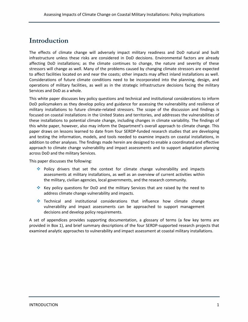
In many ways, coastal military installations have been on the front lines of climate change. Accompanying global-scale warming, global mean sea level has been increasing throughout the 20th century (Church and White 2011). Superimposed on the rise in sea level are regional-scale patterns in the variability of atmospheric and oceanic circulations, which at times (from years to decades) amplify or mask the effects of global-scale rise. In addition, local patterns of vertical land movement (e.g., related to land subsidence) can exacerbate the situation. Finally, coastal areas are exposed to tropical and extra-tropical storms, high tides, and high waves that can bring significant storm surge, flooding, heavy rain, and destructive winds. The interaction of the rising sea level and these intense events have resulted in significant impacts in coastal areas; in some locations, high-water and coastal flooding events are showing signs of becoming more frequent.
Although the effects of sea level rise (SLR) and storm activity are being felt today, addressing these impacts will take time. Planning for future DoD investments occurs over long time horizons; for capital investments, construction itself can take years. Understanding the long time frames required for major projects to be completed underscores the need to begin the process today. Moreover, once built, heavy
Figure 1: Coastal military installations are highly vulnerable to climate change. (Source: Project RC-1703)
Assessing Impacts of Climate Change on Coastal Military Installations: Policy Implications
INTRODUCTION 4
infrastructure and facilities at installations are in place for decades. Because of the long lifetime of infrastructure and other DoD decisions and investments, it is important that these investments be made resilient to future climate changes.
Climate models that simulate future climate conditions indicate that the impacts of climate change will grow with time and that the rates of warming and sea level rise in the 21st century will be greater than those in the 20th century. Given the anticipated magnitude and pace of future change, it is likely that many of the steps that can be taken to adapt will be less costly and most cost-effective if they are taken now, rather than in future decades.
Climate change interacts with the built and natural environment
Military installations are designed to withstand the presumed current impacts of the natural environment under the assumption of stationarity (i.e., future variations in the environment will reflect the variability experienced in the past). Facilities in low-lying areas are built to withstand flooding and structures with footings in streambeds are constructed to withstand the erosive forces of scour, for example. Environmental conditions, however, are never static: development patterns, changes in land uses, and natural ecological processes all contribute to a changing environmental context for military installations. Climate change adds an additional factor to these dynamics; in part, by changing the assumptions of stationarity. Moreover, changes in the climate interact with ongoing processes, upsetting the balance that currently exists between the natural and built environments and creating new conditions—and potential vulnerabilities—under which military installations will be built and operated.
Climate change effects interact with non-climate factors
The interaction of climate change with geological and other environmental conditions in different regions will result in a variety of outcomes. Vertical land movements, such as tectonic uplift, can counteract the effects of accelerated sea level rise. Places such as Sitka, Alaska have experienced significant uplift, and in some places sea level is actually falling. Of greater concern is land subsidence—where the land is sinking—that magnifies the impacts of sea level rise. For example, local subsidence rates at the Norfolk installation will create a more significant challenge for that facility than will be experienced at most other installations in the face of climate change.
More frequent or longer durations of heavy rainfall can cause local flooding in low-lying areas and swell rivers and streams; this can dramatically change erosion rates along banks and riverbeds and may also change the location of these waterways. Between 1958 and 2007, the northeastern United States experienced a 67 percent increase in the most intense precipitation events (USGCRP 2009). Development can further exacerbate the amount of run-off into water bodies by increasing the amount of impermeable surfaces at or near installations.
The effect of local sea conditions also must be considered under climate change. Even with no change in the intensity of tropical storms, higher sea levels can increase storm surge heights (in some locales in a non-linear manner) and thus the destructive potential of wave action. Wave heights and directions also influence the potential impact of storms.
The net effect of the interaction between changing climate conditions and existing natural and development processes can change local conditions, causing flooding, erosion, inundation, saline intrusion, and changes in currents. The resulting environmental dynamics can impact military installations across the world.
Assessing Impacts of Climate Change on Coastal Military Installations: Policy Implications
INTRODUCTION 5
Installation vulnerabilities include risks to both structural and operational components
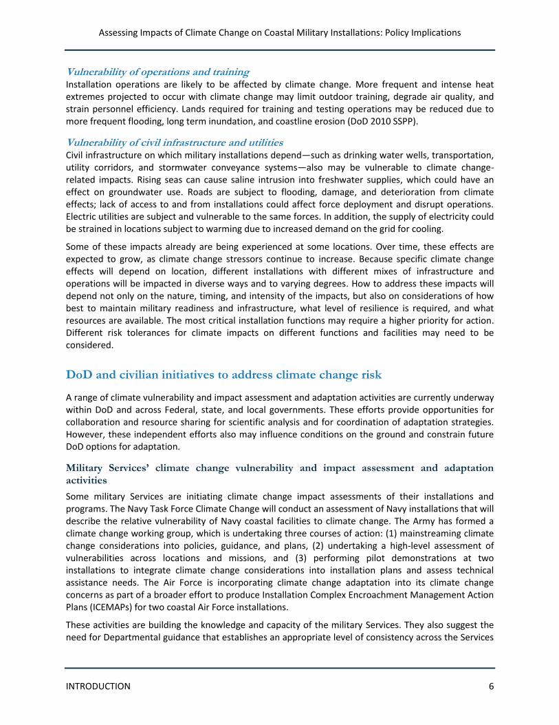
Military installations serve a variety of functions that are critical to the country’s defense. Installations include extensive infrastructure (such as buildings, equipment, roads, ports, and airports) that must be maintained and operated. They depend on and manage services necessary for installation operations, such as electricity, transportation, and water. Box 2 provides an illustrative list of coastal installation assets. In coastal areas, these installations, their operations, and even their missions are particularly vulnerable to the impacts of climate change, though the vulnerability of installation systems differs (see Figure 2). Inland installations face different but potentially significant climate effects as well.
Vulnerability of coastal assets About 10 percent of DoD coastal installations and facilities are located at or near sea level and are already vulnerable to flooding and inundation. Rising sea levels and more intense heavy downpours will make these conditions worse. The National Intelligence Council (NIC) estimated that more than 30 military installations in the continental United States were already facing elevated levels of risk from sea level rise (NIC 2008). An increasing frequency of extreme events, including storms and heat events, may damage assets and equipment.
The loss of natural areas, such as barrier islands and wetlands, is a fundamental factor determining vulnerability. These areas function as protective buffers, absorbing energy and water from storms and reducing their effects on coastal developments. Installation vulnerabilities may be exacerbated by the loss or compromise of protective wetlands, beaches, dunes, and other coastal ecosystems.
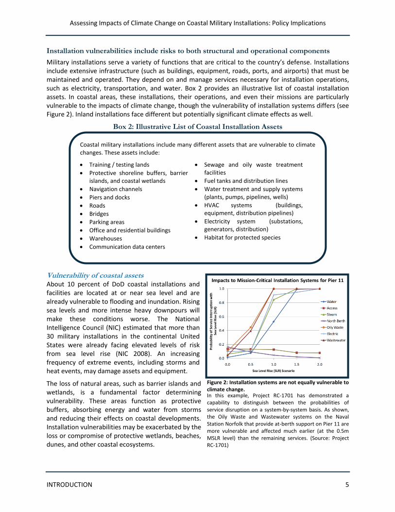
Box 2: Illustrative List of Coastal Installation Assets
Coastal military installations include many different assets that are vulnerable to climate changes. These assets include:
Training / testing lands
Protective shoreline buffers, barrier islands, and coastal wetlands
Navigation channels
Piers and docks
Roads
Bridges
Parking areas
Office and residential buildings
Warehouses
Communication data centers
Sewage and oily waste treatment facilities
Fuel tanks and distribution lines
Water treatment and supply systems (plants, pumps, pipelines, wells)
HVAC systems (buildings, equipment, distribution pipelines)
Electricity system (substations, generators, distribution)
Habitat for protected species
Figure 2: Installation systems are not equally vulnerable to climate change. In this example, Project RC-1701 has demonstrated a capability to distinguish between the probabilities of service disruption on a system-by-system basis. As shown, the Oily Waste and Wastewater systems on the Naval Station Norfolk that provide at-berth support on Pier 11 are more vulnerable and affected much earlier (at the 0.5m MSLR level) than the remaining services. (Source: Project RC-1701)
Assessing Impacts of Climate Change on Coastal Military Installations: Policy Implications
INTRODUCTION 6
Vulnerability of operations and training Installation operations are likely to be affected by climate change. More frequent and intense heat extremes projected to occur with climate change may limit outdoor training, degrade air quality, and strain personnel efficiency. Lands required for training and testing operations may be reduced due to more frequent flooding, long term inundation, and coastline erosion (DoD 2010 SSPP).
Vulnerability of civil infrastructure and utilities Civil infrastructure on which military installations depend—such as drinking water wells, transportation, utility corridors, and stormwater conveyance systems—also may be vulnerable to climate change-related impacts. Rising seas can cause saline intrusion into freshwater supplies, which could have an effect on groundwater use. Roads are subject to flooding, damage, and deterioration from climate effects; lack of access to and from installations could affect force deployment and disrupt operations. Electric utilities are subject and vulnerable to the same forces. In addition, the supply of electricity could be strained in locations subject to warming due to increased demand on the grid for cooling.
Some of these impacts already are being experienced at some locations. Over time, these effects are expected to grow, as climate change stressors continue to increase. Because specific climate change effects will depend on location, different installations with different mixes of infrastructure and operations will be impacted in diverse ways and to varying degrees. How to address these impacts will depend not only on the nature, timing, and intensity of the impacts, but also on considerations of how best to maintain military readiness and infrastructure, what level of resilience is required, and what resources are available. The most critical installation functions may require a higher priority for action. Different risk tolerances for climate impacts on different functions and facilities may need to be considered.
DoD and civilian initiatives to address climate change risk
A range of climate vulnerability and impact assessment and adaptation activities are currently underway within DoD and across Federal, state, and local governments. These efforts provide opportunities for collaboration and resource sharing for scientific analysis and for coordination of adaptation strategies. However, these independent efforts also may influence conditions on the ground and constrain future DoD options for adaptation.
Military Services’ climate change vulnerability and impact assessment and adaptation activities
Some military Services are initiating climate change impact assessments of their installations and programs. The Navy Task Force Climate Change will conduct an assessment of Navy installations that will describe the relative vulnerability of Navy coastal facilities to climate change. The Army has formed a climate change working group, which is undertaking three courses of action: (1) mainstreaming climate change considerations into policies, guidance, and plans, (2) undertaking a high-level assessment of vulnerabilities across locations and missions, and (3) performing pilot demonstrations at two installations to integrate climate change considerations into installation plans and assess technical assistance needs. The Air Force is incorporating climate change adaptation into its climate change concerns as part of a broader effort to produce Installation Complex Encroachment Management Action Plans (ICEMAPs) for two coastal Air Force installations.
These activities are building the knowledge and capacity of the military Services. They also suggest the need for Departmental guidance that establishes an appropriate level of consistency across the Services
Assessing Impacts of Climate Change on Coastal Military Installations: Policy Implications
INTRODUCTION 7
and leverages the expertise and knowledge developed by the Services to support military readiness and asset protection across DoD.
Other Federal and national climate change vulnerability and impact assessment and adaptation activities
Civilian Federal agencies are increasingly engaged in climate change vulnerability and impact assessment and adaptation work, focused on the potential risks to their respective missions. Among the most significant activities in relation to DoD efforts include the following:
In October 2011, the US Army Corps of Engineers (USACE) issued updated guidance for Civil Works programs to incorporate the effects of projected sea level change into all aspects of the project life cycle, including managing, planning, engineering, designing, constructing, operating, and maintaining USACE projects and systems of projects. The guidance applies to natural and managed ecosystems as well as human and engineered systems and requires that all phases of project implementation consider the sensitivity and adaptability of these systems to climate change and other related global changes. The guidance also requires that planning studies and engineering designs be evaluated under three scenarios of sea level change, that the sensitivity of alternative plans and designs be evaluated, that measures be identified to minimize adverse impact and maximize benefit, and that uncertainty be addressed.
As part of its agency climate change adaptation policy statement, the Federal Emergency Management Agency (FEMA) has identified seven high level actions to integrate climate change adaptation considerations into the Agency’s programs, policies, and operations. These include establishing partnerships with agencies, organizations, and the climate science community; studying the impacts of climate change on the National Flood Insurance Program (NFIP); evaluating how to incorporate climate change into grant investment strategies; working to understand how local communities will be impacted; incorporating climate change into building standards and practices; evaluating the effect of climate change on existing risk data and Threat Hazard Identification Risk Assessment (THIRA) development and operational planning; and promoting a climate change-ready workforce. FEMA has also funded a study, starting in 2008, about the impacts of climate change on the NFIP; signed a Memorandum of Agreement with the Environmental Protection Agency (EPA) to help communities become safer, healthier, and more resilient; and begun working with local entities on adaptation-related projects, in addition to other initiatives. In addition, FEMA is supporting the Strategic Foresight Initiative to identify long-term climate change trends and address the implications of these changes on emergency management strategies.
The National Aeronautics and Space Administration (NASA) is conducting climate change impacts assessments and adaptation planning for some of their facilities, some of which are near or co-located with DoD installations. These include the Stennis Space Center in Mississippi, which houses the Commander, Naval Meteorology, and other DoD offices, as well as Department of Energy, Department of Commerce, EPA, and State government offices; NASA’s Langley Research Center, located on the grounds of Langley Air Force Base; NASA’s Kennedy Space Center, adjacent to Patrick Air Force Base / Cape Canaveral

Assessing Impacts of Climate Change on Coastal Military Installations: Policy Implications
INTRODUCTION 8
Air Force Station; and NASA’s Dryden Flight Research Center, located at Edwards Air Force Base.
Federal agencies responsible for natural resource management and environmental protection are undertaking climate impact assessments to understand the ecological impacts of climate change. The US National Park Service (NPS) is developing guidance on adapting NPS Facilities to climate change. NPS is also developing risk screening tools to help characterize the vulnerability of facilities in coastal parks to sea level rise. EPA’s Climate Ready Estuaries Program is helping to shape the preparedness of participants in the National Estuaries Program—addressing the climate resilience of estuaries across the country. Some of these natural resources are located on military installations.
The National Oceanic and Atmospheric Administration’s (NOAA) Coastal Services Center is providing nationally applicable guidance for coastal vulnerability analyses through its web-based Digital Coast, which offers data and tools for coastal communities and natural resource managers to understand and manage climate stressors.
The National Climate Assessment (NCA) (quadrennial synthesis assessment to be released in draft form in January 2013) will provide a comprehensive overview of climate impacts on the nation, addressing specific impacts on critical sectors and regions, including the impacts of climate change on the coastal zone and its implications for military installations. The NCA will include updated national- and regional-level climate scenarios and global sea level rise scenarios.
The work underway by the above and other agencies is contributing to a rapidly developing body of knowledge and scientific practice across the government. It is important to also recognize, however, that these initiatives may affect regions in which DoD installations are located and that military personnel frequently are not engaged in these efforts. Coordination of vulnerability analyses and subsequent adaptation plans may be necessary to ensure that the needs of DoD installations are recognized and that DoD options are not precluded or undermined.
Regional/local climate change vulnerability and impact assessment and adaptation activities
A range of activities at the state and local level also are underway to address coastal infrastructure adaptation, often as part of broader regional adaptation plans. States such as California, Delaware, and Florida, and municipalities including New York, Miami, Mobile, Portland, Los Angeles, and Boston, among others, are addressing coastal infrastructure as part of their vulnerability and impact assessments and adaptation planning. Supported by the US Federal Highway Administration and Federal Transit Administration, several state and local agencies are assessing climate change impacts on transportation infrastructure and services.
State and regional efforts may affect planning conditions and the efficacy of adaptation options available to DoD installations. The effectiveness of some efforts—particularly those designed to reduce the vulnerability of energy systems and transportation—may influence DoD capacity to ensure installation readiness and to deploy forces. The resilience of transportation networks and pipelines affects the reliable transport of DoD forces and supplies, including fuel and energy supplies. The availability of transportation also affects DoD’s ability to provide support during emergency response and evacuation situations.

Assessing Impacts of Climate Change on Coastal Military Installations: Policy Implications
INTRODUCTION 9
SERDP coastal impact assessment research projects and other research
Research is rapidly advancing in the areas of climate science, vulnerability and impact assessment, and approaches to adaptation. SERDP is funding four projects at coastal installations designed to explore assessment methodologies to advance the state of practice. These and other military and civilian studies provide lessons learned that can inform DoD’s policy development. For the four SERDP projects, mean sea level rise (MSLR) scenarios were prescribed a priori (0.5, 1.0, 1.5, and 2.0 m). This is because the focus was not on predicting a particular future and specific impacts, but rather on model, tool, and method development. In addition, research focused on impacts to built infrastructure and only addressed natural infrastructure—such as barriers islands and coastal wetlands—in the context of their protective barrier functions. See Appendix A for additional information on these projects.
Eglin AFB Study, Florida (Project RC-1700; Effects of Near-Term Sea Level Rise on Coastal Infrastructure). This project, focused on Eglin Air Force Base (AFB) (shown in Figure 3), is developing the understanding, models, and tools to quantify the potential impact to coastal military infrastructure from near-term sea level rise and the attendant increases in hurricane activity. The project is modeling changes to natural coastal systems and infrastructure in response to various sea level and storm scenarios, including conducting uncertainty analyses. The project is using remote-sensing and survey data to characterize shoreline migration and barrier island morphology. In addition, a newly developed regional storm history for both historic and prehistoric time is being used by a storm model to create an ensemble of future storm tracks for the region. The purpose-built numerical coastal morphology model incorporates morphological, sea level rise, and storm climatology data to predict changes over the next century. The study is expected to enable cost-effective mitigation and adaptation strategies.
Figure 3: Study area for the Eglin AFB Study. (Source: Project RC-1700)
Assessing Impacts of Climate Change on Coastal Military Installations: Policy Implications
INTRODUCTION 10
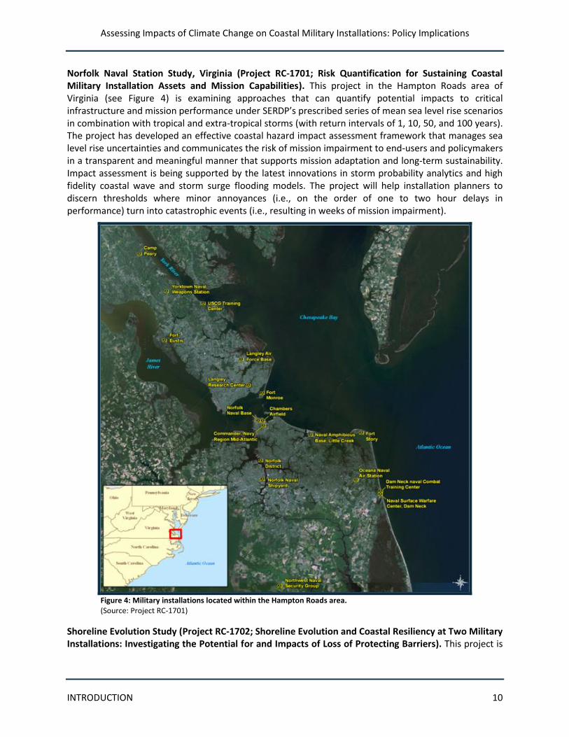
Norfolk Naval Station Study, Virginia (Project RC-1701; Risk Quantification for Sustaining Coastal Military Installation Assets and Mission Capabilities). This project in the Hampton Roads area of Virginia (see Figure 4) is examining approaches that can quantify potential impacts to critical infrastructure and mission performance under SERDP’s prescribed series of mean sea level rise scenarios in combination with tropical and extra-tropical storms (with return intervals of 1, 10, 50, and 100 years). The project has developed an effective coastal hazard impact assessment framework that manages sea level rise uncertainties and communicates the risk of mission impairment to end-users and policymakers in a transparent and meaningful manner that supports mission adaptation and long-term sustainability. Impact assessment is being supported by the latest innovations in storm probability analytics and high fidelity coastal wave and storm surge flooding models. The project will help installation planners to discern thresholds where minor annoyances (i.e., on the order of one to two hour delays in performance) turn into catastrophic events (i.e., resulting in weeks of mission impairment).
Figure 4: Military installations located within the Hampton Roads area. (Source: Project RC-1701)
Shoreline Evolution Study (Project RC-1702; Shoreline Evolution and Coastal Resiliency at Two Military Installations: Investigating the Potential for and Impacts of Loss of Protecting Barriers). This project is
Assessing Impacts of Climate Change on Coastal Military Installations: Policy Implications
INTRODUCTION 11
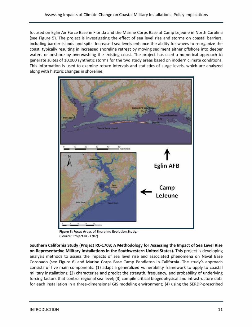
focused on Eglin Air Force Base in Florida and the Marine Corps Base at Camp Lejeune in North Carolina (see Figure 5). The project is investigating the effect of sea level rise and storms on coastal barriers, including barrier islands and spits. Increased sea levels enhance the ability for waves to reorganize the coast, typically resulting in increased shoreline retreat by moving sediment either offshore into deeper waters or onshore by overwashing the existing coast. The project has used a numerical approach to generate suites of 10,000 synthetic storms for the two study areas based on modern climate conditions. This information is used to examine return intervals and statistics of surge levels, which are analyzed along with historic changes in shoreline.
Figure 5: Focus Areas of Shoreline Evolution Study. (Source: Project RC-1702)
Southern California Study (Project RC-1703; A Methodology for Assessing the Impact of Sea Level Rise on Representative Military Installations in the Southwestern United States). This project is developing analysis methods to assess the impacts of sea level rise and associated phenomena on Naval Base Coronado (see Figure 6) and Marine Corps Base Camp Pendleton in California. The study’s approach consists of five main components: (1) adapt a generalized vulnerability framework to apply to coastal military installations; (2) characterize and predict the strength, frequency, and probability of underlying forcing factors that control regional sea level; (3) compile critical biogeophysical and infrastructure data for each installation in a three-dimensional GIS modeling environment; (4) using the SERDP-prescribed
Assessing Impacts of Climate Change on Coastal Military Installations: Policy Implications
INTRODUCTION 12
scenarios, characterize the expected physical effects of sea level rise within the region; and (5) evaluate the potential for impacts to installation infrastructure. This project will provide a military-relevant framework for assessing vulnerability to sea level rise as well as a visualization and analysis tool.
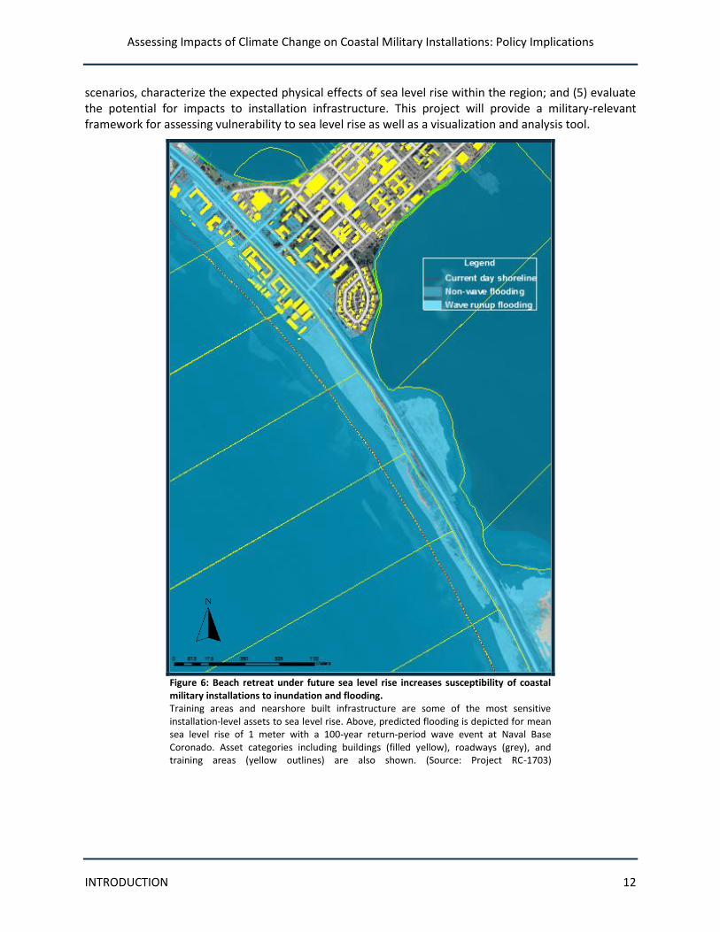
Figure 6: Beach retreat under future sea level rise increases susceptibility of coastal military installations to inundation and flooding. Training areas and nearshore built infrastructure are some of the most sensitive installation-level assets to sea level rise. Above, predicted flooding is depicted for mean sea level rise of 1 meter with a 100-year return-period wave event at Naval Base Coronado. Asset categories including buildings (filled yellow), roadways (grey), and training areas (yellow outlines) are also shown. (Source: Project RC-1703)
Assessing Impacts of Climate Change on Coastal Military Installations: Policy Implications
POLICY QUESTIONS 13
Policy Questions Regarding Climate Change Assessments and Adaptation Planning
The need to address climate change vulnerability and impacts raises questions for DoD and the military Services about the policies that may be required to ensure that appropriate and necessary steps are taken to ensure military readiness and maintain DoD assets. The SERDP-funded research at four coastal installations provides insights that can inform policy development across all coastal military facilities. The following five policy questions present key issues that need to be addressed.
Policy Question 1: Integrating climate change considerations
How can DoD and the military Services best integrate climate change considerations into planning and decision processes to ensure military readiness and asset protection?
To effectively account for climate change vulnerability and impacts, climate considerations need to be “mainstreamed” into planning and other decision processes. However, significant questions remain unanswered about how this can best be accomplished. The institutional levels at which various decisions should be made regarding the assessment of climate change impacts and the planning and implementation of adaptation strategies need to be determined. For example, decisions affecting national-level resource allocation, master plans, and installation-level asset management each require attention at different organizational levels and will require distinct types of climate information. Incorporating adaptive management practices—the iterative process of assessment, adaptation, monitoring, and evaluation—also will require specific policies. At each institutional level, the process of evaluation will require establishment of baseline conditions and evaluation metrics.
Policy Question 2: Technical guidance required
What technical guidance is required from DoD and the military Services to enable high quality assessment and adaptation planning to support planning and management decisions?
DoD and military Services managers will need technical guidance and support to ensure that aggregate mission capabilities and readiness are resilient to climate change. Technical guidance and support will facilitate well-informed planning and management decisions, effective allocation of resources for climate change vulnerability and impact assessment, and effective adaptation planning. Technical guidance can inform decisions about both extant and planned facilities. Technical support should include guidance on when to apply screening versus detailed assessments, so that the level of assessment is sufficient for the decision at hand and so that situations are identified for which a more detailed analysis is warranted. Guidance on resources to support vulnerability and impact assessment is needed to direct analysts to appropriate data sources and methodologies. Guidance also can help to inform a consistent
Assessing Impacts of Climate Change on Coastal Military Installations: Policy Implications
POLICY QUESTIONS 14
and logical prioritization process for determining adaptation actions in the short, intermediate, and long terms.
In addition to technical guidance, a variety of climate science information, data, and analysis is required to support impact and vulnerability assessment at the regional and installation levels. These informational needs include:
baseline data on geographic and biophysical conditions;
baseline inventory data on installation built and natural infrastructure that are related to climate vulnerability (e.g., precise location, elevation, condition, age);
multiple climate change scenarios on regional scales, updated routinely, to inform assessments; and
appropriate local forcing information for certain processes such as wave runup and storm surge.
Ensuring that the above information is high quality, current, relevant to local conditions, and accurately used across different purposes and applications is an additional challenge.
In addition, installations need to know about the vulnerabilities of services that are provided to them by sources outside the installation boundary. These services—including transportation, power, fuels, and communication services—are often critical to the ability of installations to maintain full operations. Sufficient information on regional vulnerabilities is often lacking, however.
Policy Question 3: Degree of regional consistency
How can DoD and the military Services best balance the need for comparable assessment results across diverse regions, installations, and mission purposes, with the need for flexibility in assessment approaches to address regional/local conditions and priorities?
The diverse geographic characteristics, biophysical conditions, and mission capabilities of military installations, as well as divergent climate change impacts in different regions of the country, mean that different assessment methodologies and assumptions are likely to be required to best address the characteristics of different locations. At the same time, national-level decisions will require some degree of comparability to accurately assess climate change vulnerability and impacts across diverse locations. A consistent understanding and approach is required to effectively balance these analytic needs. This includes consistency in the development and use of regional scenarios. Policy direction is needed on data sources, methods, and mechanisms to ensure high quality of analytic products. Policy direction also is required to clarify the institutional roles and authorities at different levels of assessment.
Assessing Impacts of Climate Change on Coastal Military Installations: Policy Implications
POLICY QUESTIONS 15
Policy Question 4: Ensuring mission resilience
How can DoD and military Services investments at extant military installations as well as base alignment investments be made so that such decisions, at the installation level and in aggregate, ensure resilience of the military mission to climate change?
Investments to maintain and improve facilities and capabilities at the installation level need to be made while cognizant of the potential vulnerabilities and impacts that each installation may be facing. The decisions at stake include base alignment investments and the design of aggregated capabilities, including consolidation, movement, or realignment. In addition, ongoing planning to maintain and improve facilities and capabilities at the installation level needs to consider potential vulnerabilities and impacts to capital, maintenance, and operations.
To address these issues, policy direction is required to incorporate climate vulnerability and impact considerations into investments and assessment of base alignment and capabilities decisions, as well as ongoing installation capital, maintenance, and operational plans. Coordination of vulnerability and impact assessment and adaptation planning across regions and installations can help ensure that analytic resources are used efficiently and that a consistent approach is applied across DoD.
Policy Question 5: Coordination with civilian activities
How can DoD and the military Services ensure that external/civilian activities that may affect DoD installations and military readiness are effectively accounted for in installation and civilian strategies under climate change?
Climate change impacts on military installations similarly affect the civilian lands and facilities in the surrounding region. Some neighboring landowners, Federal civilian agencies, regional and state governments, and municipalities are undertaking their own climate change vulnerability and impact assessments and developing adaptation plans. These actions may affect the conditions and response options available to military installations. The analysis and adaptation actions being undertaken by civilian organizations also may benefit the installation, defense infrastructure, and military readiness. Civilian roads leading into and out of military installations, for example, face climate change challenges and can have a bearing on installation activities. Strategies are needed to coordinate military installation and civilian efforts to the extent feasible to achieve optimal outcomes.
Assessing Impacts of Climate Change on Coastal Military Installations: Policy Implications
TECHNICAL CONSIDERATIONS 16
Technical and Institutional Considerations to Inform Policy
To address the five key policy considerations outlined above, it is necessary to understand the technical issues involved in analyzing climate change vulnerability. It is equally important to understand the institutional factors involved in effectively using climate change information to inform military installation, Service, and Departmental decision making. The following eight considerations, when incorporated into DoD policies and guidance, can help to ensure an effective and sustainable approach to enhancing military readiness and protecting DoD assets in the face of climate change.
Consideration 1: Integrating climate change into planning and management decisions
Vulnerability to climate change is one important factor among many that DoD managers need to consider in allocating resources to ensure that installation infrastructure is able to support DoD activities and ensure military readiness. Non-climate stresses on infrastructure (e.g., deterioration, obsolescence) interact with climate change stressors; the combined effects of these stressors must be taken into consideration as part of an overall asset management approach. In some cases, climate change considerations may be the critical consideration for project viability. Information about climate change impacts provided to decision makers at key planning and facility development stages will help ensure more resilient operations.
Climate change adaptation should not be a separate decision-making process, but rather an aspect of overall management at the installation, Service, and Departmental levels. The climate change vulnerability and impact assessment and adaptation process should be an ongoing and iterative process through which vulnerabilities are assessed, adaptation plans are formulated, actions are taken, performance is monitored and evaluated, and conditions are reassessed based on updated data and model projections. As much as possible, climate change considerations should be incorporated into extant planning, management design documents, instructions, and so on, in both the short- and long-term (see Box 3).
The Unified Facilities Criteria issued by DoD in May 2012 specifically incorporates consideration of changes in climatic conditions into planning decision criteria. This represents an excellent first step to incorporate climate change considerations into DoD planning and decisions.
In the Norfolk Naval Station Study, the study team focused on the piers and supporting services (e.g., electricity, water, steam) that provide at-berth support for the aircraft carrier piers on the northwest side of the installation. These systems (and individual assets) are designed to differing lifecycles (30 to 50 year periods) assuming stationarity (i.e., a status quo environment).
Under the various MSLR rates assessed in the project, both tactical (short-term) and strategic (long-term) initiatives to repair or replace these systems must consider the possibility of accelerated degradation rates. Furthermore, any “big-ticket” items (new, large infrastructure projects with high costs and long lifecycles exceeding 30 years) must now consider the threat of SLR and the risks of exacerbated storm damage in both their design and long-term operation and maintenance planning.
Source: Project RC-1701
Box 3: Planning Event Horizon
Assessing Impacts of Climate Change on Coastal Military Installations: Policy Implications
TECHNICAL CONSIDERATIONS 17
Consideration 2: Accounting for regional variation in assessments
For vulnerability and impact assessment to be relevant to management and policy, it must be “place-based,” capturing the unique biophysical features that determine how climate interacts with a location’s resources and the relative importance of climate change as an environmental stressor. Simultaneously, the process and outputs of vulnerability and impact assessments must be sufficiently consistent with other assessments, such that analyses from multiple locations are scalable and can be compared. Use of compatible analyses enables DoD to synthesize outputs across multiple locations to identify broad vulnerabilities, assess relative needs, and prioritize actions. DoD needs to meet the analytic requirement for locally-tailored analyses while achieving comparability across regions. Figure 7 demonstrates the contrasting missions, settings, stressors, pathways, and impacts between two specific installations, illustrating the importance of place-based assessment.
Figure 7: Contrasting vulnerability to sea level rise at different installations demonstrates the importance of place-based assessment. Sea level rise vulnerability varies across coastal military installations as a function of geographic setting and exposure characteristics, as well as the mission of the installation and its relationship to the coast. Here, Naval Station Norfolk (NSN) on the eastern seaboard and Marine Corps Base Camp Pendleton on the west coast are compared, showing contrasting missions, settings, stressors, pathways, and impacts. These types of contrasts emphasize the importance and challenge of utilizing unifying frameworks to characterize vulnerability across installations while allowing for site-specific conditions and mission requirements in assessing individual installations. (Source: Project RC-1703)
Assessing Impacts of Climate Change on Coastal Military Installations: Policy Implications
TECHNICAL CONSIDERATIONS 18
The need for place-based impacts assessment
Given the spatial heterogeneity of local and regional climate change and the impacts associated with those changes, it is critical for installation planners and managers to focus their analysis on the sensitive assets and facilities in their installation, the climate factors that affect these resources, and the environmental stressors that may be amplified by climate change.
Climate change itself will not be uniform across the globe. For example, higher latitudes will likely experience more warming than lower latitudes and some regions will experience increases in overall rainfall, while others will confront reductions in overall rainfall and soil moisture.
More importantly, different locations will respond to climate change in different ways because different processes control the coastal configuration. Topography, geomorphology, sedimentation patterns, regional atmospheric circulation patterns, and uplift/subsidence of the land surface will influence how sea level alters coastlines and leads to inundation. For example, changes in beach sand are a significant factor at Naval Base Coronado (Figure 8); other coastal installations may not be subject to this specific stressor. Ecosystems will have varied responses to warming, changes in precipitation, and changes in salinity (from sea level rise), depending on their species composition, the sensitivities of these species to climate conditions, and their respective abilities to migrate or adapt in situ. Infrastructure also will exhibit varied responses to climate change—some structures have been engineered with tolerances that exceed anticipated changes in climate and are less sensitive to such changes; other structures may perform marginally in the current climate and are more likely to fail under altered conditions.
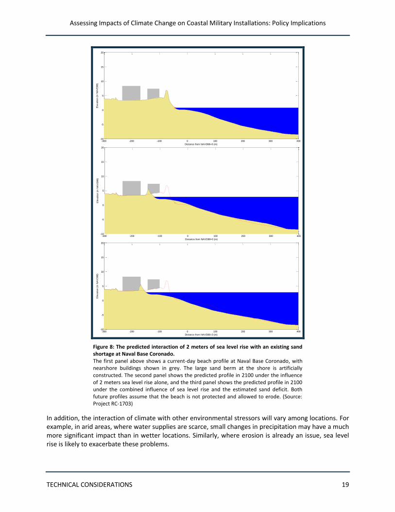
Assessing Impacts of Climate Change on Coastal Military Installations: Policy Implications
TECHNICAL CONSIDERATIONS 19
-300 -200 -100 0 100 200 300 400-10
-5
0
5
10
15
20
Distance from NAVD88=0 (m)
Ele
vation (
m N
AV
D88)
-300 -200 -100 0 100 200 300 400-10
-5
0
5
10
15
20
Distance from NAVD88=0 (m)
Ele
vation (
m N
AV
D88)
-300 -200 -100 0 100 200 300 400-10
-5
0
5
10
15
20
Distance from NAVD88=0 (m)
Ele
vation (
m N
AV
D88)
Figure 8: The predicted interaction of 2 meters of sea level rise with an existing sand shortage at Naval Base Coronado. The first panel above shows a current-day beach profile at Naval Base Coronado, with nearshore buildings shown in grey. The large sand berm at the shore is artificially constructed. The second panel shows the predicted profile in 2100 under the influence of 2 meters sea level rise alone, and the third panel shows the predicted profile in 2100 under the combined influence of sea level rise and the estimated sand deficit. Both future profiles assume that the beach is not protected and allowed to erode. (Source: Project RC-1703)
In addition, the interaction of climate with other environmental stressors will vary among locations. For example, in arid areas, where water supplies are scarce, small changes in precipitation may have a much more significant impact than in wetter locations. Similarly, where erosion is already an issue, sea level rise is likely to exacerbate these problems.
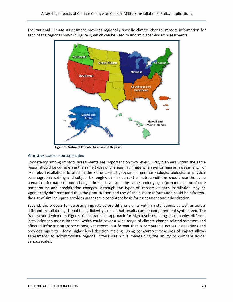
Assessing Impacts of Climate Change on Coastal Military Installations: Policy Implications
TECHNICAL CONSIDERATIONS 20
The National Climate Assessment provides regionally specific climate change impacts information for each of the regions shown in Figure 9, which can be used to inform placed-based assessments.
Figure 9: National Climate Assessment Regions
Working across spatial scales
Consistency among impacts assessments are important on two levels. First, planners within the same region should be considering the same types of changes in climate when performing an assessment. For example, installations located in the same coastal geographic, geomorphologic, biologic, or physical oceanographic setting and subject to roughly similar current climate conditions should use the same scenario information about changes in sea level and the same underlying information about future temperature and precipitation changes. Although the types of impacts at each installation may be significantly different (and thus the prioritization and use of the climate information could be different) the use of similar inputs provides managers a consistent basis for assessment and prioritization.
Second, the process for assessing impacts across different units within installations, as well as across different installations, should be sufficiently similar that results can be compared and synthesized. The framework depicted in Figure 10 illustrates an approach for high level screening that enables different installations to assess impacts (which could cover a wide range of climate change-related stressors and affected infrastructure/operations), yet report in a format that is comparable across installations and provides input to inform higher-level decision making. Using comparable measures of impact allows assessments to accommodate regional differences while maintaining the ability to compare across various scales.
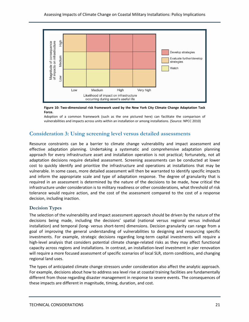
Assessing Impacts of Climate Change on Coastal Military Installations: Policy Implications
TECHNICAL CONSIDERATIONS 21
Figure 10: Two-dimensional risk framework used by the New York City Climate Change Adaptation Task Force. Adoption of a common framework (such as the one pictured here) can facilitate the comparison of vulnerabilities and impacts across units within an installation or among installations. (Source: NPCC 2010)
Consideration 3: Using screening level versus detailed assessments
Resource constraints can be a barrier to climate change vulnerability and impact assessment and effective adaptation planning. Undertaking a systematic and comprehensive adaptation planning approach for every infrastructure asset and installation operation is not practical; fortunately, not all adaptation decisions require detailed assessment. Screening assessments can be conducted at lower cost to quickly identify and prioritize the infrastructure and operations at installations that may be vulnerable. In some cases, more detailed assessment will then be warranted to identify specific impacts and inform the appropriate scale and type of adaptation response. The degree of granularity that is required in an assessment is determined by the nature of the decisions to be made, how critical the infrastructure under consideration is to military readiness or other considerations, what threshold of risk tolerance would require action, and the cost of the assessment compared to the cost of a response decision, including inaction.
Decision Types
The selection of the vulnerability and impact assessment approach should be driven by the nature of the decisions being made, including the decisions’ spatial (national versus regional versus individual installation) and temporal (long- versus short-term) dimensions. Decision granularity can range from a goal of improving the general understanding of vulnerabilities to designing and resourcing specific investments. For example, strategic decisions regarding long-term capital investments will require a high-level analysis that considers potential climate change-related risks as they may affect functional capacity across regions and installations. In contrast, an installation-level investment in pier renovation will require a more focused assessment of specific scenarios of local SLR, storm conditions, and changing regional land uses.
The types of anticipated climate change stressors under consideration also affect the analytic approach. For example, decisions about how to address sea level rise at coastal training facilities are fundamentally different from those regarding disaster management in response to severe events. The consequences of these impacts are different in magnitude, timing, duration, and cost.
Assessing Impacts of Climate Change on Coastal Military Installations: Policy Implications
TECHNICAL CONSIDERATIONS 22
Depending on the decisions that need to be addressed, the nature and extent of the data that need to be collected and used will differ; so too will the scenarios used to bound potential future conditions. Carefully matching the information needed to the type of decision being made can reduce costs and uncertainty. Decisions about low probability/high consequence events, such as high intensity storms, are a case in point. Disaster planners and managers are typically more interested in preparing for the worst outcomes because of the extreme consequences. Gathering increasingly precise data on the more probable but lower consequence possibilities does little to provide information in support of decisions about how to prevent or address severe impacts. In addition, understanding and accepting the amount of uncertainty involved is critical. The desired degree of confidence that a decision is correct dictates desired data quality, the degree to which simplifying assumptions are used, and how conservatively they are applied. If specific models or decision support tools are used, their inherent degree of complexity should match the data available and the decision to be made. Even though collecting and using more data than are needed should be avoided, failing to collect and use adequate data in an appropriate manner could lead to unclear outcomes or less than conservative assumptions.
Criticality
Analyzing the vulnerability of “critical” operations and infrastructure, rather than conducting a complete assessment of all assets and activities, can reduce resource requirements. At the installation level, strategic choices must be made to identify assets that are particularly critical to achieving the installation’s core purposes, as well as their corresponding failure pathways. Assets and services that are not as critical to the mission and objectives of an installation can be screened out to reduce resource requirements and ensure focus on the most important elements. The criticality of assets and services can be evaluated based on a number of criteria, including level of use, the importance of the asset to strategic functions, role in emergencies, etc. For example, operations affecting mission readiness for a majority of installation personnel are likely to be deemed critical. Failure pathways should be evaluated critically. Climate change may reveal new vulnerabilities not previously considered. At a strategic level, a similar analysis of the criticality of assets to mission accomplishment can be conducted. This will help the military Services and DoD to focus vulnerability and impact assessments on the highest priority assets.
Thresholds
For many types of infrastructure, impacts from environmental stressors occur only after certain performance or design thresholds are surpassed. For example, a sea wall will prevent any impacts from occurring for waves below a particular height. Once waves exceed this height, impacts will occur. Figure 11 shows the unique thresholds of different systems at Naval Base Coronado. Identifying thresholds as part of a screening process can provide important information to determine whether further action needs to be taken; however, once a threshold is exceeded based on a particular scenario, it makes little sense to evaluate more extreme scenarios in any detail for the particular decision involved. Examining the degree to which a piece of infrastructure is exposed can easily screen out less vulnerable infrastructure and associated installation operations. If the magnitude of a climate change-related stressor is not expected to affect a certain type of infrastructure during its useful lifetime, if at all, then the associated impact does not need to be examined in detail. On the contrary, priority within the vulnerability assessment should be given to infrastructure for which thresholds are already exceeded in the current climate (e.g., fleet vehicles that frequently break down during heat waves, areas of an installation that periodically flood during heavy rain or strong storm events), as well as assets that are likely to be stressed by future changes. Again, simplifying assumptions—such as making simple
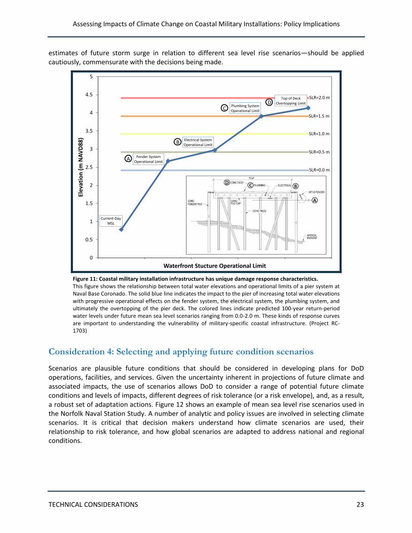
Assessing Impacts of Climate Change on Coastal Military Installations: Policy Implications
TECHNICAL CONSIDERATIONS 23
estimates of future storm surge in relation to different sea level rise scenarios—should be applied cautiously, commensurate with the decisions being made.
Current-Day MSL
Fender System Operational Limit
Electrical System Operational Limit
Plumbing System Operational Limit
Top of Deck Overtopping Limit
0
0.5
1
1.5
2
2.5
3
3.5
4
4.5
5El
evat
ion
(m
NA
VD
88
)
Waterfront Stucture Operational Limit
SLR=0.0 m
SLR=0.5 m
SLR=1.0 m
SLR=1.5 m
SLR=2.0 mD
C
B
A
Figure 11: Coastal military installation infrastructure has unique damage response characteristics. This figure shows the relationship between total water elevations and operational limits of a pier system at Naval Base Coronado. The solid blue line indicates the impact to the pier of increasing total water elevations with progressive operational effects on the fender system, the electrical system, the plumbing system, and ultimately the overtopping of the pier deck. The colored lines indicate predicted 100-year return-period water levels under future mean sea level scenarios ranging from 0.0-2.0 m. These kinds of response curves are important to understanding the vulnerability of military-specific coastal infrastructure. (Project RC-1703)
Consideration 4: Selecting and applying future condition scenarios
Scenarios are plausible future conditions that should be considered in developing plans for DoD operations, facilities, and services. Given the uncertainty inherent in projections of future climate and associated impacts, the use of scenarios allows DoD to consider a range of potential future climate conditions and levels of impacts, different degrees of risk tolerance (or a risk envelope), and, as a result, a robust set of adaptation actions. Figure 12 shows an example of mean sea level rise scenarios used in the Norfolk Naval Station Study. A number of analytic and policy issues are involved in selecting climate scenarios. It is critical that decision makers understand how climate scenarios are used, their relationship to risk tolerance, and how global scenarios are adapted to address national and regional conditions.
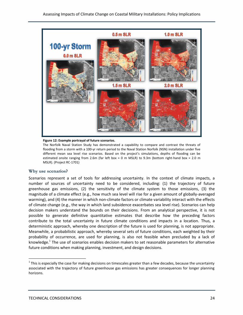
Assessing Impacts of Climate Change on Coastal Military Installations: Policy Implications
TECHNICAL CONSIDERATIONS 24
Figure 12: Example portrayal of future scenarios. The Norfolk Naval Station Study has demonstrated a capability to compare and contrast the threats of flooding from a storm with a 100-yr return period to the Naval Station Norfolk (NSN) installation under five different mean sea level rise scenarios. Based on the project’s simulations, depths of flooding can be estimated onsite ranging from 2.6m (far left box = 0 m MSLR) to 9.3m (bottom right-hand box = 2.0 m MSLR). (Project RC-1701)
Why use scenarios?
Scenarios represent a set of tools for addressing uncertainty. In the context of climate impacts, a number of sources of uncertainty need to be considered, including: (1) the trajectory of future greenhouse gas emissions, (2) the sensitivity of the climate system to those emissions, (3) the magnitude of a climate effect (e.g., how much sea level will rise for a given amount of globally-averaged warming), and (4) the manner in which non-climate factors or climate variability interact with the effects of climate change (e.g., the way in which land subsidence exacerbates sea level rise). Scenarios can help decision makers understand the bounds on their decisions. From an analytical perspective, it is not possible to generate definitive quantitative estimates that describe how the preceding factors contribute to the total uncertainty in future climate conditions and impacts in a location. Thus, a deterministic approach, whereby one description of the future is used for planning, is not appropriate. Meanwhile, a probabilistic approach, whereby several sets of future conditions, each weighted by their probability of occurrence, are used for planning, is also not feasible when precluded by a lack of knowledge.1 The use of scenarios enables decision makers to set reasonable parameters for alternative future conditions when making planning, investment, and design decisions.
1 This is especially the case for making decisions on timescales greater than a few decades, because the uncertainty
associated with the trajectory of future greenhouse gas emissions has greater consequences for longer planning horizons.
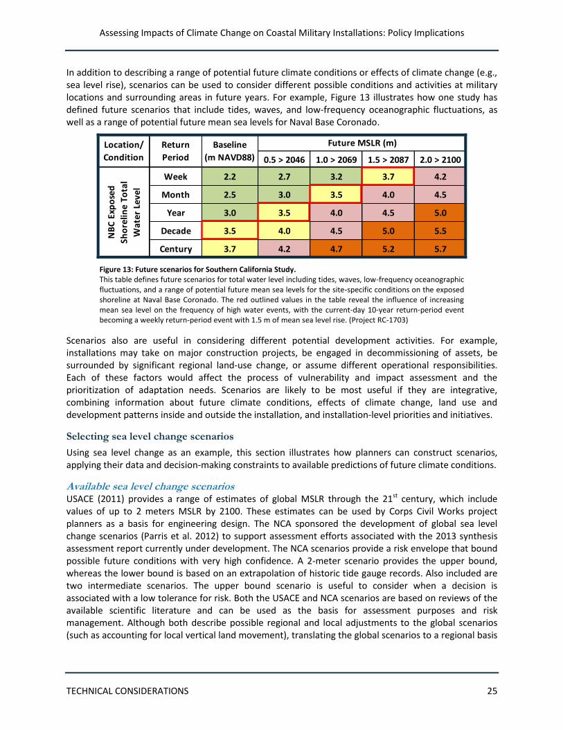
Assessing Impacts of Climate Change on Coastal Military Installations: Policy Implications
TECHNICAL CONSIDERATIONS 25
In addition to describing a range of potential future climate conditions or effects of climate change (e.g., sea level rise), scenarios can be used to consider different possible conditions and activities at military locations and surrounding areas in future years. For example, Figure 13 illustrates how one study has defined future scenarios that include tides, waves, and low-frequency oceanographic fluctuations, as well as a range of potential future mean sea levels for Naval Base Coronado.
0.5 > 2046 1.0 > 2069 1.5 > 2087 2.0 > 2100
Week 2.2 2.7 3.2 3.7 4.2
Month 2.5 3.0 3.5 4.0 4.5
Year 3.0 3.5 4.0 4.5 5.0
Decade 3.5 4.0 4.5 5.0 5.5
Century 3.7 4.2 4.7 5.2 5.7
Location/
Condition
Return
Period
Baseline
(m NAVD88)
Future MSLR (m)
NB
C E
xpo
sed
Sho
relin
e To
tal
Wat
er L
evel
Beach Training Areas –Silver Strand Training Complex North
Figure 13: Future scenarios for Southern California Study. This table defines future scenarios for total water level including tides, waves, low-frequency oceanographic fluctuations, and a range of potential future mean sea levels for the site-specific conditions on the exposed shoreline at Naval Base Coronado. The red outlined values in the table reveal the influence of increasing mean sea level on the frequency of high water events, with the current-day 10-year return-period event becoming a weekly return-period event with 1.5 m of mean sea level rise. (Project RC-1703)
Scenarios also are useful in considering different potential development activities. For example, installations may take on major construction projects, be engaged in decommissioning of assets, be surrounded by significant regional land-use change, or assume different operational responsibilities. Each of these factors would affect the process of vulnerability and impact assessment and the prioritization of adaptation needs. Scenarios are likely to be most useful if they are integrative, combining information about future climate conditions, effects of climate change, land use and development patterns inside and outside the installation, and installation-level priorities and initiatives.
Selecting sea level change scenarios
Using sea level change as an example, this section illustrates how planners can construct scenarios, applying their data and decision-making constraints to available predictions of future climate conditions.
Available sea level change scenarios USACE (2011) provides a range of estimates of global MSLR through the 21st century, which include values of up to 2 meters MSLR by 2100. These estimates can be used by Corps Civil Works project planners as a basis for engineering design. The NCA sponsored the development of global sea level change scenarios (Parris et al. 2012) to support assessment efforts associated with the 2013 synthesis assessment report currently under development. The NCA scenarios provide a risk envelope that bound possible future conditions with very high confidence. A 2-meter scenario provides the upper bound, whereas the lower bound is based on an extrapolation of historic tide gauge records. Also included are two intermediate scenarios. The upper bound scenario is useful to consider when a decision is associated with a low tolerance for risk. Both the USACE and NCA scenarios are based on reviews of the available scientific literature and can be used as the basis for assessment purposes and risk management. Although both describe possible regional and local adjustments to the global scenarios (such as accounting for local vertical land movement), translating the global scenarios to a regional basis

Assessing Impacts of Climate Change on Coastal Military Installations: Policy Implications
TECHNICAL CONSIDERATIONS 26
still remains an area of active research. An example of this research is a SERDP-funded project that will begin in CY13 and will develop regional sea level rise scenarios for the Pacific Islands.
Decision-making considerations Planners need to identify the timescale (see Consideration 5) for which infrastructure and operational decisions are being made. For example, the range of estimates of MSLR for near-term decades is much narrower than MSLR estimates for the end of the 21st century. Therefore, the anticipated service life of a facility needs to be considered when determining the timescale for climate change impacts that is relevant to the decision at hand. In addition, ecosystem responses may mitigate the effect of sea level rise, depending on how quickly sea level rise occurs. In these cases, the estimated rate of rise can have as important an influence on the degree of impact as can the time period itself. In short, the complex interactions of time frame, environmental processes, climate change, and facility conditions must all be considered as decisions are developed.
Planners also need to identify the limits of their risk tolerance. The level of risk of damage or disruption that is considered acceptable will vary for different facilities and functions. In some cases, certain impacts—such as infrequent minor flooding—may be tolerable, because the disruption to service is within acceptable standards. In other cases, even a temporary interruption of operations poses an unacceptable risk. Large magnitude events (e.g., landfall of a major hurricane) involve impacts that are much more difficult to tolerate even though they may occur infrequently. In addition, climate change could cause currently infrequent events to occur more frequently or with greater intensity, making them less tolerable. When considering climate risks to mission-critical facilities and services, the use of low-probability or infrequent but severe impact scenarios is warranted.
Local applications Planners also must be equipped with local or regional information (see Consideration 3) to translate global-scale information about sea level to their installations. This information includes (1) high spatial-resolution maps to determine which areas and infrastructure are at high risk of flooding and inundation; (2) estimates of local uplift or subsidence, which can offset or exacerbate the effect of sea level rise; and (3) historical information about storm frequency and intensity, which can provide a useful baseline or analog for understanding future flooding impacts (e.g., the 100-year flood becoming the 10-year flood).
Scenarios for other climate variables Planners can construct scenarios for other climate variables that are related to impacts (e.g., temperature, precipitation, streamflow) by accounting for local factors, as is necessary for sea level change; however, the approaches that are used to translate global and regional scenarios of these climate variables to the installation scale are different. Several sources for prediction information (e.g., NCA, IPCC) exist and can be combined with past historical observations of these variables available from NOAA, the US Geological Survey (USGS), NASA, and other agencies to put both recent trends and future predictions into context.
Integrating scenario-planning with other long-range planning activities
As discussed in Consideration 1, it is critical to integrate considerations of climate change with long-range planning activities (USACE 2011). Installation plans—such as capital investments in facility expansion or renovations, expanded training grounds, or advanced communications systems—should incorporate climate change conditions as part of the planning process. In addition, external long-range planning activities may significantly alter the conditions under which an installation will be operating. For example, if regional plans exist to develop coastline areas adjacent to military property and facilities,
Assessing Impacts of Climate Change on Coastal Military Installations: Policy Implications
TECHNICAL CONSIDERATIONS 27
this may raise the risks associated with sea level rise. For this reason, scenarios should try to take into account the planning goals not only of military installations but also of nearby communities and resource managers that may affect the future climate-related risks of installations.
Consideration 5: Matching analysis timeframes and spatial scales to decision types and planning horizons
Climate change scenarios can be developed for different planning horizons and spatial scales. Scenarios should be constructed using information at temporal and spatial scales that are consistent with the decisions being made. For example, one-time decisions concerning the construction of long-lived infrastructure (50 years or more) will require different climate information than seasonal or annual decisions about operations (e.g., equipment and staffing for erosion control measures). Figure 14 shows examples of climate stressors and affected decisions at different timescales. Similarly, decisions for individual installations require information about the local topography, local historical climate variability, and projected regional changes2, whereas decisions made on broad regional or national scales may utilize less detailed, coarser information.
Although establishing the spatial scale for decision making and climate information is relatively straightforward, determining temporal scales can be more complicated. For infrastructure, horizons for planning processes or expected service lifetimes can determine the timescales of interest. Many of the decisions associated with infrastructure, however, may commit a facility to a certain pathway of development (e.g., armoring of a shoreline) that persists beyond the lifetime of the structure itself. Understanding the flexibility (or lack of flexibility) associated with decisions also can be important to ensure that decisions are adaptive and do not unnecessarily preclude future options.
Monitoring changes in climate and responses over time can provide important validation of previous planning decisions. For decisions that retain some element of flexibility or contingency (e.g., sandbags will be used to protect vulnerable areas from flooding in the near term; over the longer term, infrastructure will be relocated farther inland), monitoring can indicate when a change in management is necessary. Effective monitoring relies on the maintenance of observations over time, as well as the ability to examine and utilize existing observational and monitoring systems (e.g., records of flood damage) with a climate lens. DoD and the military Services may need to consider new metrics that assess performance over time—readiness-related and otherwise—in response to a changing climate.
2 Due to limitations in computing power and our ability to simulate process that affect climate on local spatial
scales (approximately less than several hundred square miles), climate prediction information from global models is typically available only on coarser regional scales. Predictions for changes in some variables (e.g., temperature) may, but do not necessarily, vary considerably on these spatial scales.
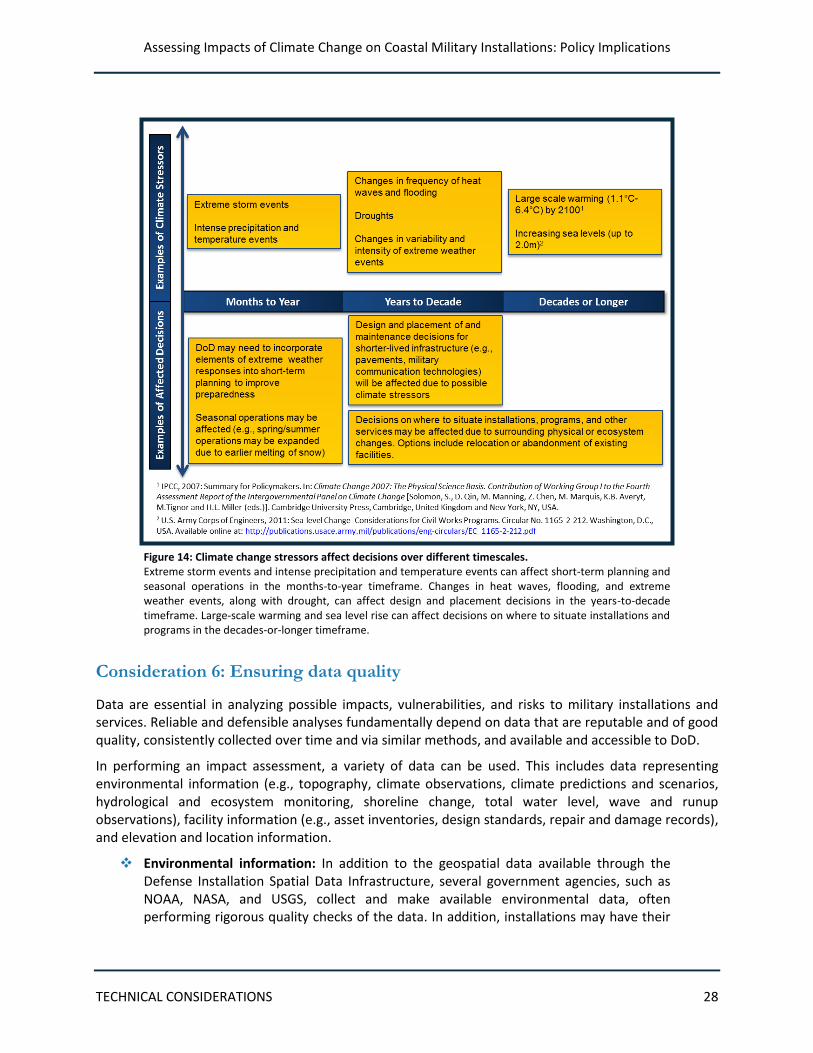
Assessing Impacts of Climate Change on Coastal Military Installations: Policy Implications
TECHNICAL CONSIDERATIONS 28
Figure 14: Climate change stressors affect decisions over different timescales. Extreme storm events and intense precipitation and temperature events can affect short-term planning and seasonal operations in the months-to-year timeframe. Changes in heat waves, flooding, and extreme weather events, along with drought, can affect design and placement decisions in the years-to-decade timeframe. Large-scale warming and sea level rise can affect decisions on where to situate installations and programs in the decades-or-longer timeframe.
Consideration 6: Ensuring data quality
Data are essential in analyzing possible impacts, vulnerabilities, and risks to military installations and services. Reliable and defensible analyses fundamentally depend on data that are reputable and of good quality, consistently collected over time and via similar methods, and available and accessible to DoD.
In performing an impact assessment, a variety of data can be used. This includes data representing environmental information (e.g., topography, climate observations, climate predictions and scenarios, hydrological and ecosystem monitoring, shoreline change, total water level, wave and runup observations), facility information (e.g., asset inventories, design standards, repair and damage records), and elevation and location information.
Environmental information: In addition to the geospatial data available through the Defense Installation Spatial Data Infrastructure, several government agencies, such as NOAA, NASA, and USGS, collect and make available environmental data, often performing rigorous quality checks of the data. In addition, installations may have their
Assessing Impacts of Climate Change on Coastal Military Installations: Policy Implications
TECHNICAL CONSIDERATIONS 29
own metrics or monitoring programs for nearby habitats or species that can provide information relevant to the impacts of climate change.
Facility information: Existing systems that provide monitoring or performance information about infrastructure assets or operations also may provide valuable local-scale information about climate impacts (or the effectiveness of adaptation options). Although these data sources may not be subject to rigorous quality checks, it is likely that they are collected in a standardized format that facilitates comparison across units at an installation, or even across installations.
Elevation and location information: For coastal assessments in particular, high quality and fine spatial resolution elevation and location information is of paramount importance. This applies to both topographic and infrastructure data and affects the degree to which flood routing, inundation, and storm surge determinations can be made. The quality and resolution of the elevation and location information affects the types of models that can be used, the impacts assessed, and the decisions that can be made with confidence (see Box 4).
Box 4: Importance of the Quality of Elevation and Location Data
Additional unique local data (e.g., records describing permafrost depth or integrity at a high latitude location) are likely to be needed beyond the data outlined above. To address this, individual installations
Without high quality and consistently characterized elevation and location data, such as those described below, the exposure of military assets to sea level rise and storm surge may be either under- or over-reported within and between installations.
• Elevation and location of assets, including buildings, roads, training grounds, and other important features. This information, typically derived from ground-based surveys and construction records, needs to be precisely and consistently aligned to specific aspects of these assets. For example, if a single elevation point for buildings is used, it needs to be tied to the same part of each building (e.g., elevation of the lowest above-ground point of the building).
• Ground surface elevation. Precise elevation maps are needed to assess the extent and depth of flooding or inundation. These maps are best derived from LIDAR (Light Detection and Ranging) data. Several data quality issues arise with this information, including the need to use consistent methods to process the LIDAR data to “clear” vegetation. Another key issue regarding future elevations is the need to account for subsidence or uplift of land, which can be done using InSAR (Interferometric Synthetic Aperture Radar) data or ground-based surveys.
• Sea surface elevation. See Appendix B for a description of how to ensure consistency in the characterization of sea surface elevation. This approach was developed through SERDP funding.
All of this information should be described in relation to a well-established vertical datum (e.g., NAVD88) and horizontal datum (e.g., NAD83) to ensure comparability across data sets.
Assessing Impacts of Climate Change on Coastal Military Installations: Policy Implications
TECHNICAL CONSIDERATIONS 30
may need to collect or develop their own data sources. In these cases, it is important that documentation and metadata (e.g., instrumentation and geolocation information) also are collected, such that it can be combined with the more standard, high-quality data sources described above.
It is not uncommon for the data sources that might be applied to vulnerability and impact assessments to suffer from key deficiencies. Some of the types of data problems that may exist include:
Data records may, in some cases, be short or contain temporal gaps, thereby making it difficult to establish a reliable baseline or assess the temporal trend. The temporal variability of natural processes can make it difficult to fully characterize the system, particularly when the events of interest occur infrequently (e.g., major hurricane strikes).
Observational locations, protocols, and equipment may have changed over time, even slightly, thereby introducing biases to the data.
Model projections of future conditions contain a number of uncertainties due to factors such as uncertainties about future greenhouse gas concentrations, inaccuracies in model representations of relevant processes, and lack of explicit representation of some physical or biological processes.
Challenges such as these can sometimes be remedied by carefully combining multiple data sources to help bridge data gaps, to extend the data back in time, or to corroborate information suggested by one data set. Another approach is to interpolate from data for surrounding areas. Figure 15 demonstrates how the Shoreline Evolution Study combined four different data records to obtain long-term storm histories. However, a high level of caution should be used when attempting to address data problems in these ways because it is possible to introduce new errors in the process.
A fundamental consideration is that the data used in vulnerability assessments will nearly always be less than ideal. Therefore, the uncertainties and errors of the underlying data should be explicitly accounted for in the conclusions that are drawn from vulnerability and impact analyses. The treatment of uncertainty is discussed further in the next section.
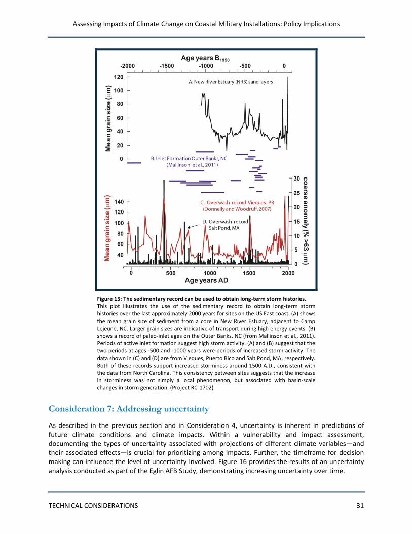
Assessing Impacts of Climate Change on Coastal Military Installations: Policy Implications
TECHNICAL CONSIDERATIONS 31
Figure 15: The sedimentary record can be used to obtain long-term storm histories. This plot illustrates the use of the sedimentary record to obtain long-term storm histories over the last approximately 2000 years for sites on the US East coast. (A) shows the mean grain size of sediment from a core in New River Estuary, adjacent to Camp Lejeune, NC. Larger grain sizes are indicative of transport during high energy events. (B) shows a record of paleo-inlet ages on the Outer Banks, NC (from Mallinson et al., 2011). Periods of active inlet formation suggest high storm activity. (A) and (B) suggest that the two periods at ages -500 and -1000 years were periods of increased storm activity. The data shown in (C) and (D) are from Vieques, Puerto Rico and Salt Pond, MA, respectively. Both of these records support increased storminess around 1500 A.D., consistent with the data from North Carolina. This consistency between sites suggests that the increase in storminess was not simply a local phenomenon, but associated with basin-scale changes in storm generation. (Project RC-1702)
Consideration 7: Addressing uncertainty
As described in the previous section and in Consideration 4, uncertainty is inherent in predictions of future climate conditions and climate impacts. Within a vulnerability and impact assessment, documenting the types of uncertainty associated with projections of different climate variables—and their associated effects—is crucial for prioritizing among impacts. Further, the timeframe for decision making can influence the level of uncertainty involved. Figure 16 provides the results of an uncertainty analysis conducted as part of the Eglin AFB Study, demonstrating increasing uncertainty over time.
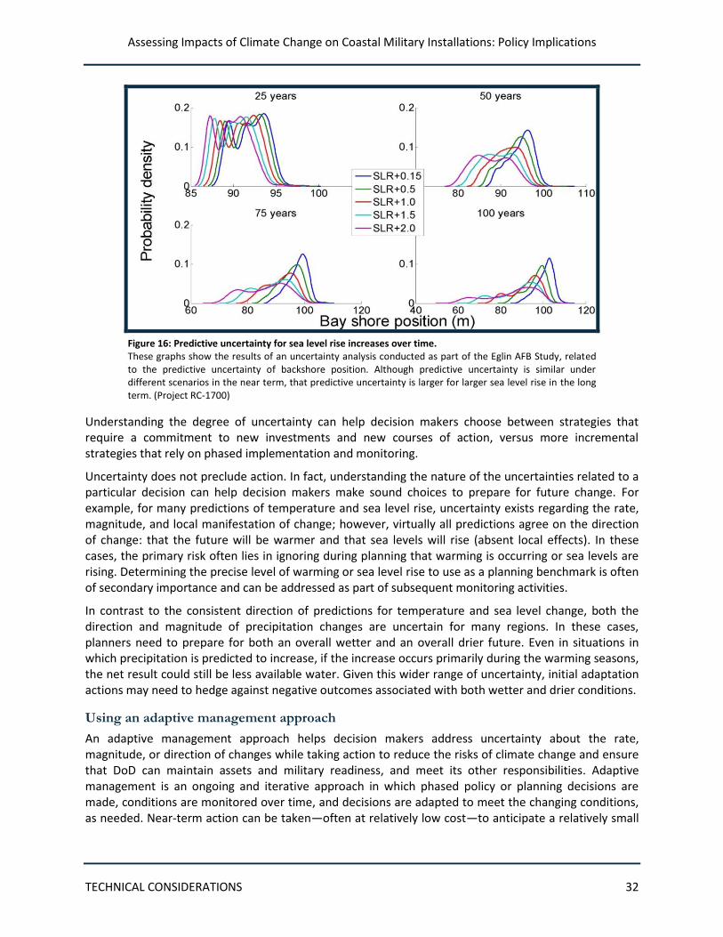
Assessing Impacts of Climate Change on Coastal Military Installations: Policy Implications
TECHNICAL CONSIDERATIONS 32
Figure 16: Predictive uncertainty for sea level rise increases over time. These graphs show the results of an uncertainty analysis conducted as part of the Eglin AFB Study, related to the predictive uncertainty of backshore position. Although predictive uncertainty is similar under different scenarios in the near term, that predictive uncertainty is larger for larger sea level rise in the long term. (Project RC-1700)
Understanding the degree of uncertainty can help decision makers choose between strategies that require a commitment to new investments and new courses of action, versus more incremental strategies that rely on phased implementation and monitoring.
Uncertainty does not preclude action. In fact, understanding the nature of the uncertainties related to a particular decision can help decision makers make sound choices to prepare for future change. For example, for many predictions of temperature and sea level rise, uncertainty exists regarding the rate, magnitude, and local manifestation of change; however, virtually all predictions agree on the direction of change: that the future will be warmer and that sea levels will rise (absent local effects). In these cases, the primary risk often lies in ignoring during planning that warming is occurring or sea levels are rising. Determining the precise level of warming or sea level rise to use as a planning benchmark is often of secondary importance and can be addressed as part of subsequent monitoring activities.
In contrast to the consistent direction of predictions for temperature and sea level change, both the direction and magnitude of precipitation changes are uncertain for many regions. In these cases, planners need to prepare for both an overall wetter and an overall drier future. Even in situations in which precipitation is predicted to increase, if the increase occurs primarily during the warming seasons, the net result could still be less available water. Given this wider range of uncertainty, initial adaptation actions may need to hedge against negative outcomes associated with both wetter and drier conditions.
Using an adaptive management approach
An adaptive management approach helps decision makers address uncertainty about the rate, magnitude, or direction of changes while taking action to reduce the risks of climate change and ensure that DoD can maintain assets and military readiness, and meet its other responsibilities. Adaptive management is an ongoing and iterative approach in which phased policy or planning decisions are made, conditions are monitored over time, and decisions are adapted to meet the changing conditions, as needed. Near-term action can be taken—often at relatively low cost—to anticipate a relatively small
Assessing Impacts of Climate Change on Coastal Military Installations: Policy Implications
TECHNICAL CONSIDERATIONS 33
degree of change (e.g., a relatively small increase in sea level and flood frequency). Should monitoring show that the changes were less than expected, then the initial response has effectively “bought time” and resources that might otherwise have been invested in a more substantial response were saved. On the other hand, if monitoring demonstrates that the rate of change was greater than anticipated (e.g., flooding exceeded initial expectations), the more substantial adaptive action could be taken.
This description of the adaptive management approach demonstrates an integral aspect of planning for climate impacts: an uncertain future requires re-assessment and iteration in management. Because the future is uncertain, the performance of adaptive strategies must be routinely scrutinized to determine if risks have been managed appropriately. Additionally, in anticipation of potential changes in course or strategy, near-term adaptive action should not preclude or hinder more substantial adaptive actions or otherwise commit planners to an inflexible path forward.
Although uncertainty is inherent in climate change predictions, DoD has the expertise to effectively address it. DoD is well-versed in making decisions under deep uncertainty regarding future conditions and needs for military operations. This expertise can be applied to the uncertainty associated with the potential risks of climate change.
Consideration 8: Enabling the ongoing use of climate science in decisions
Climate science is evolving rapidly and the sheer quantity of relevant climate information can be unmanageable. Because of the lengthy time horizons and complexity of variables involved, the magnitude of most impacts is not precisely known, even if their direction is known with relative certainty. Much remains to be discovered about how the changing climate will affect not only military installations, but the world as a whole. More is being learned on a daily basis. Climate scientists can help to determine the best data to use and provide guidance on how to interpret and apply the data that are available to support current decisions.
Because of the rapid evolution in climate science, it is critical to continually monitor scientific findings as new understanding and decision support information comes to light. Further, it is important to monitor the actual impacts of climate stressors as they occur. Incremental changes in the local environment can be indicators of longer-term trends. The collection of existing environmental data and routine monitoring of changing conditions will establish a robust foundation to inform policies and adaptation strategies. Tracking and evaluating these impacts is crucial to determine when to take action.
Climate information needs to be appropriately applied to the changing mission requirements of DoD over time. The long-term goal should be to integrate climate considerations into the ongoing processes of capital and operations planning at coastal installations. Current planning exists to reduce risk and improve mission readiness. Without mainstreaming climate considerations into existing planning procedures, critical vulnerabilities could be overlooked. Thus, climate-resilient planning should be integral, not separate from, standard infrastructure planning to better determine short- and long-term priorities for installations and the military Services.
Incorporating climate change considerations into existing planning processes will also reveal opportunities for efficient adaptation action as part of scheduled repair and construction projects. Major planned improvements to an existing installation present an opportunity for adaptation measures to be implemented at relatively low cost.
Adaptation strategies and policy approaches will need to evolve over time with changing circumstances and information. Projects and programs to improve resilience to climate change should be part of a
Assessing Impacts of Climate Change on Coastal Military Installations: Policy Implications
TECHNICAL CONSIDERATIONS 34
larger iterative strategy based on a continuous assessment and improvement process, relying on the results of periodic vulnerability and impact assessments. The viability of adaptation actions will need to be continually evaluated, and improvements to new or existing measures should be proposed in light of any changes in conditions. This adaptive management approach provides for greater management flexibility; allows for consideration of lessons learned in adaptation, both locally and globally; and takes advantage of the ever-increasing scientific understanding of climate changes.
Finally, the challenges posed by climate change demand a new relationship between the policy, user, and scientific communities, and a structure and process that supports this new relationship needs to be developed by DoD and the military Services. Iterative, continuous dialogues are necessary between these groups as understanding and information change—the iterative nature of responses demands an adaptive approach. The science community can serve both to inform decision makers of the requisite science needed to shape policy decisions and to translate scientific understanding into actionable information by end-users. The science-policy interface, in particular, requires formal institutionalization within DoD. This would position the Department and the military Services to competently address climate change and its uncertainties in policies and guidance and to be able to rapidly incorporate, in an ongoing fashion, new advances in scientific understanding of climate change, its impacts, and associated responses.
Assessing Impacts of Climate Change on Coastal Military Installations: Policy Implications
REFERENCES 35
References
Church, John A. and Neil J. White. 2011. Sea-Level Rise from the Late 19th to the Early 21st Century. Surveys in Geophysics, 2011, Volume 32, Numbers 4-5, Pages 585-602. Published online: 30 March 2011 with open access at Springerlink.com
Department of Defense (DoD). 2010a. Quadrennial Defense Review Report. February 2010. http://www.defense.gov/qdr/images/QDR_as_of_12Feb10_1000.pdf
Department of Defense (DoD). 2010b. Strategic Sustainability Performance Plan (SSPP). Fiscal Year 2010. Public Version. 26 August 2010. http://www.denix.osd.mil/sustainability/upload/DoD-SSPP-PUBLIC-26Aug10.pdf
Department of Defense (DoD). 2012. Department of Defense FY 2012 Climate Change Adaptation Roadmap. 18 September 2012.
Department of the Navy. 2010. Navy’s Climate Change Roadmap. http://www.navy.mil/navydata/documents/CCR.pdf
Flick, R.E., K. Knuuti, and S.K. Gill. 2012a. Matching Mean Sea Level Rise Projections to Local Elevation Datums. Journal of Waterway, Port, Coastal, and Ocean Engineering—American Society of Civil Engineers. doi: 10.1061/(ASCE)WW.1943-5460.0000145.
Flick, R.E., D.B. Chadwick, J. Briscoe, and K.C. Harper. 2012b. “Flooding” versus “Inundation.” Eos, Transactions of the American Geophysical Union. 93(38) 365-366.
Intergovernmental Panel on Climate Change (IPCC). 2007. Summary for Policymakers. In: Climate Change 2007: The Physical Science Basis. Contribution of Working Group I to the Fourth Assessment Report of the Intergovernmental Panel on Climate Change [Solomon, S., D. Qin, M. Manning, Z. Chen, M. Marquis, K.B. Averyt, M. Tignor and H.L. Miller (eds.)]. Cambridge University Press, Cambridge, United Kingdom and New York, NY, USA.
JP1-02. 2001 (as amended through 31 October 2009). Department of Defense Dictionary of Military and Associated Terms. 262 pp.
National Intelligence Council (NIC). 2008. National Security Implications of Global Climate Change Through 2030. 58 pp.
National Research Council (NRC). 2010. Adapting to the Impacts of Climate Change, America’s Climate Choices: Panel on Adapting to the Impacts of Climate Change.
Committee on National Security Implications of Climate Change for U.S. Naval Forces and National Research Council. 2011. National Security Implications of Climate Change for U.S. Naval Forces. http://www.nap.edu/catalog.php?record_id=12914
NPCC. 2010. New York City Panel on Climate Change. Adaptation Assessment Guidebook, Appendix B of Climate Change Adaptation in New York City: Building a Risk Management Response. Appearing in Annals of the New York Academy of Sciences. 1196(1) 229-291, 2010 Report http://onlinelibrary.wiley.com/doi/10.1111/nyas.2010.1196.issue-1/issuetoc
Assessing Impacts of Climate Change on Coastal Military Installations: Policy Implications
REFERENCES 36
Parris, A., P. Bromirski, V. Burkett, D. Cayan, M. Culver, J. Hall, R. Horton, K. Knuuti, R. Moss, J. Obeysekera, A. Sallenger, and J. Weiss. 2012. Global Sea Level Rise Scenarios for the US National Climate Assessment. NOAA Tech Memo OAR CPO-1. 37 pp.
Parry, M.L., O.F. Canziani, J.P. Palutikof, P.J. van der Linden, and C.E. Hanson (eds.). 2007. Appendix I Glossary. Contribution of Working Group II [Impacts, Adaptation, and Vulnerability] to the Fourth Assessment Report of the Intergovernmental Panel on Climate Change. Cambridge University Press, Cambridge, United Kingdom and New York, NY, USA. 976 pp.
Parson, E., V. Burkett, K. Fisher-Vanden, D. Keith, L. Mearns, H. Pitcher, C. Rosenzweig, M. Webster, 2007. Global Change Scenarios: Their Development and Use. Sub-report 2.1B of Synthesis and Assessment Product 2.1 by the U.S. Climate Change Science Program and the Subcommittee on Global Change Research. Department of Energy, Office of Biological & Environmental Research, Washington, DC, USA, 106 pp.
Solomon, S., D. Qin, M. Manning, M. Marquis, K. Averyt, M.M.B. Tignor, H.L. Miller, Jr., Z. Chen (eds.), 2007. Annex 1, Glossary. Contribution of Working Group I [Physical Science] to the Fourth Assessment Report of the Intergovernmental Panel on Climate Change. Cambridge University Press, Cambridge, United Kingdom and New York, NY, USA. 996 pp.
US Army Corps of Engineers (USACE). 2011. Sea-Level Change Considerations for Civil Works Program. US Army Corps of Engineers, Circular No. 1165-2-212, Issued 1 October 2011. http://planning.usace.army.mil/toolbox/library/ECs/EC11652212Nov2011.pdf
USGCRP. 2009. Global Climate Change Impacts in the United States. Thomas R. Karl, Jerry M. Melillo, and Thomas C. Peterson (eds.). Cambridge University Press.
Weaver, C.P., R.J. Lempert, C. Brown, J.A. Hall, D. Revell, and D. Sarewitz. In Press. Improving the contribution of climate model information to decision-making: the value and demands of robust decision frameworks. Wiley Interdisciplinary Reviews: Climate Change.
Assessing Impacts of Climate Change on Coastal Military Installations: Policy Implications
APPENDIX A A-1
Appendix A: Project Fact Sheets
Fact sheets for the following projects are contained in this Appendix in the order shown:
Project RC-1700: Effects of Near-Term Sea Level Rise on Coastal Infrastructure Project RC-1701: Quantifying Risks of Climate Change and Sea Level Rise to Naval Station
Norfolk Project RC-1702: Shoreline Evolution and Coastal Resiliency at Two Military Installations:
Investigating the Potential for and Impacts of Loss of Protecting Barriers Project RC-1703: A Methodology for Assessing the Impact of Sea Level Rise on
Representative Military Installations in the Southwestern United States
Assessing Impacts of Climate Change on Coastal Military Installations: Policy Implications
APPENDIX A A-2
Effects of Near-Term Sea Level Rise on Coastal Infrastructure (RC-1700)
Objective
Global climate models predict an increasing rate of sea level rise over the next 100 years, which will result in greater storm surge levels. Additionally, some evidence predicts that future hurricanes will be stronger over this period, further exacerbating the impact of storm surge on coastal military facilities. As a result, Eglin Air Force Base, Florida, and similarly situated coastal military facilities will likely experience significant changes to environmental resources and man-made infrastructure due to shoreline retreat, increased flooding and erosion, increased seawater intrusion into coastal aquifers, and greater wind loads and storm surge.
The primary goal of this project is to develop models and understanding to quantify the potential impact and risk to coastal military infrastructure from near-term sea level rise and the attendant increases in hurricane activity. Specific objectives include: (1) identify and quantify the responses of coastal system components to sea level rise over the next century, (2) refine a large-scale numerical model for quantifying the hazard risk to coastal military facilities, (3) develop probability models for quantifying and managing uncertainty, and (4) enable development of cost-effective mitigation and adaptation strategies.
Technical Approach
This project is developing methods for modeling and understanding the potential effects of sea level change over the next century on coastal military installations. We are modeling changes to natural coastal systems and infrastructure in response to various sea level and storm scenarios. We are using remote-sensing and survey data to characterize shoreline migration and barrier island morphology. This process has resulted in a conceptual model for the evolution of the Santa Rosa Island barrier, site of major Eglin Air Force base infrastructure, plus a purpose-built numerical model. A regional storm history has been developed for use in the modeling effort, both for historic and prehistoric time. The historic database encompasses approximately 150 years. The prehistoric record, from coastal sediment cores, extends over several millennia. A storm model incorporates this history to create an ensemble of future storm tracks for the region. Our purpose-built numerical model of coastal morphology incorporates morphological, sea level rise, and storm climatology data to predict changes over the next century. Uncertainty analyses are employed to identify the data and process elements needed to improve confidence in the predictions. Results of the barrier island morphologic change predictions provide the basis for analyzing changes in groundwater and the impact of these changes on likely vegetation zones.
Benefits
The outcomes of this study will be used to evaluate how to make reliable predictions of future climate change effects on coastal infrastructure and natural coastal systems. The expected result will be to enable cost-effective mitigation and adaptation strategies to prepare for a warmer future. The methodology developed in this project will provide a set of unique tools to Department of Defense decision makers and the scientific community for predicting, mitigating, and adapting to the effects of sea level rise and associated phenomena (including storm surge) on coastal infrastructure. These predictive tools will be in a format that is readily available to use and apply to management decisions related to any coastal installation at risk from future sea level change.
Assessing Impacts of Climate Change on Coastal Military Installations: Policy Implications
APPENDIX A A-3
Findings to Date
The several scientific components of the overall project are working in concert to create an integrated set of methods for predicting the impacts of different sea level rise rates on a variety of different morphological features and natural resources serving protective or service functions on coastal military facilities. We are finding that substantial differences occur in the type and magnitude of impacts to built and natural infrastructure related to the different projected rates of sea level rise over the next century. For example, setting aside the issue of possible changes in the storm climate, the conceptual model resulting from the wide variety of collected existing data and the purpose-built numerical morphodynamic model both show that the rates of shore erosion and barrier island change are strongly coupled to the sea level rise rate. This, in turn, has a direct impact on the Eglin AFB facilities on Santa Rosa Island, on the coastal wetlands, and on the island’s groundwater resources. These responses are further affected by future scenarios that include changes in the hurricane climate. At this stage in the project, the individual project components have been independently productive (a large number of publications and conference presentations have been produced) and are proving to be mutually supportive. Detailed integration of the research into analysis methods will become an emphasis for the remainder of the project. (Anticipated Project Completion: December 2012)
Assessing Impacts of Climate Change on Coastal Military Installations: Policy Implications
APPENDIX A A-4
Risk Quantification for Sustaining Coastal Military Installation Assets and Mission Capabilities (RC-1701)
Objective
The best available scientific evidence indicates that increasing atmospheric concentrations of greenhouse gases are warming the atmosphere and the oceans and will do so at an accelerated rate in the future. As they warm, oceans expand and glaciers melt, resulting in an overall increase in ocean volume and a rise in sea level. At the same time, many coasts are eroding and subsiding, contributing to the overall rise in relative sea levels. Unfortunately for coastal communities, the rate of sea level rise appears to be accelerating. Increased storm damage, more rapid erosion and shoreline change, saltwater intrusion into aquifers, rising water tables, and changes in tidal prisms are all predicted to become problems to differing degrees along the coasts. These effects act as hazards to assets and capabilities on coastal military installations and pose a non-stationary risk to our nation’s security. At present, coastal military operations tend to view these changes as strategic concerns—sea level rise impacts might not be realized for several decades, uncertainties surrounding the magnitude of future climate change cloud the issues, and appropriately scaled tools to support risk-based decision making at the installation level are virtually nonexistent. Although commanders may be situationally aware of their installation’s vulnerabilities, demonstrable risk-based assessments have yet to be developed that can assist them in proactively adapting military systems, processes, and protocols to meet these pervasive threats.
The objective of this project is to develop and demonstrate an integrated, multi-criteria, multi-hazard impact assessment framework that will be suitable for evaluating changes in vulnerability or risk to coastal military installation assets and mission capabilities in the Hampton Roads region due to global climate change effects, with a focus on sea level rise (SLR) and associated phenomena.
Technical Approach
To meet this objective, the RC-1701 team developed a multi-scaled technical approach that involved six specific tasks including: (1) characterize the vulnerability of a group of installations in the Hampton Roads area, and select a location in which to demonstrate a risk-based assessment approach; (2) characterize the environment and predict potential changes to the coastline in this region; (3) simulate hurricanes and nor’easters moving across the region and then quantify the resultant “forcings” (winds, floodwater levels, and sedimentation) that in turn impact installation assets and capabilities; (4) devise a functional network model of the installation to capture the unique position and condition of its built infrastructure; (5) assess damage to structures and capabilities given the storm “forcings” at the local scale; and (6) quantify the risks of mission impairment due to coastal hazards simulated under a range of sea level rise scenarios considering system recovery efforts that occur after these events. The primary intent was to quantify the risks of mission impairment during and immediately after tropical and extratropical storms, assuming that sea level rise scenarios intensify these risks. The effort included a methodology to devise risk communication tools for end-users (installation planners and managers) in visually engaging mediums (i.e., tables, graphics, and risk maps) that would transparently convey the potential individual and collective asset impairment, as well as duration of impairment immediately following the storms.
Assessing Impacts of Climate Change on Coastal Military Installations: Policy Implications
APPENDIX A A-5
Benefits
The team’s Bayesian network-based risk assessment can provide the Department of Defense (DoD) with a transferable approach to evaluate asset and mission capability vulnerabilities to climate change effects at coastal military installations worldwide. Widespread implementation of this unique multi-criteria, multi-hazard approach will enable risk management decision making across military sites rather than strictly on a site-specific basis. This research will assist DoD in its efforts to achieve optimal allocations of risk mitigating efforts, placing climate-induced vulnerabilities in perspective with the effects of non-climate stressors.
Findings to Date
The RC 1701 team has completed construction of its tiered risk-based framework that quantifies the “forcings” (i.e., surge, winds, wave velocities, flood depths, and durations exacerbated by SLR) threatening the installation assets and missions on multiple scales for the project (focused on the Naval Station Norfolk, VA). It is important to note that the RC-1701 project team assumed future SLR based on five scenarios prescribed by SERDP (0 m, 0.5 m, 1.0 m, 1.5 m, and 2.0 m). This effort evolved in spiral phases beginning with a baseline characterization of the system and extending into a multi-criteria, multi-scaled assessment of impairment impacts.
Initially, a regional survey of geomorphological and geologic conditions was undertaken to characterize the shoreline setting and to estimate change over time under the various SLR scenarios with regards to subsidence and protection. These results were incorporated into an assessment of land-use conversion and coastal habitat switching using a spatially-explicit, raster-based ecosystem response model called Sea Level Affecting Marsh Model (SLAMM ver. 6.0). Multiple applications of this model allowed researchers to evaluate both the sensitivity of the tool’s parameterization and compare its results with a straight-line (purely inundation-based or “bathtub”) to forecast land cover change under the five SLR scenarios.
Regionally-based (western North Atlantic) surge and wave assessments were then conducted using these ecological and geomorphological outputs. All told, 17 individual hurricanes were simulated emulating 50-year and 100-year return periods with a changing coastline under five SLR scenarios using three numerical modeling tools. Hurricane winds were generated using the Planetary Boundary Layer (PBL) wind model referred to as TC96. Surge was simulated using the ADvanced CIRCulation (ADCIRC) model, whereas the waves were simulated using the Simulating WAves Nearshore model (SWAN). In addition, three historical nor’easters and two smaller storms (emulating the 1-year and 10-year return periods) were modeled to capture more frequent, but less severe events.
Next, nearshore hydrodynamic modeling using the Coastal Modeling System (CMS) was undertaken to calculate the local water surface elevation, current, and sediment transport under combined influence of sea level rise, surge, tide, waves, and wind. The regional and nearshore hydrodynamic modeling assessments were then coupled with an interior flood-routing assessment (using the GSSHA or Gridded Surface-Subsurface Hydrologic Analysis model), as well as a groundwater level assessment (using the ADH or Adaptive Hydraulics model) to capture precipitation, surface water depth, and infiltration and aquifer capacity reductions due to saltwater prism effects driven by SLR. These tools allowed the RC-1701 team to characterize and quantify “forcings” at a high-resolution, 10 m grid scale on the site.
A comprehensive inventory of assets and mission capabilities was developed for the installation and fragility curves were devised to estimate the probability of damage to these systems (water, steam, electricity, etc.) in a quantitative manner. A Bayesian network (Bn) was developed to quantify: (1) the probability of asset damage states and functionality, (2) the probability of loss in capability (i.e., service
Assessing Impacts of Climate Change on Coastal Military Installations: Policy Implications
APPENDIX A A-6
interruption), and (3) the probability of potential losses in mission performance (specifically the mission focused on providing at-berth support for aircraft carriers at specific piers). In addition to these preceding capabilities, the Bn can be used to support impact assessment and risk management activities including the assessment of alternative system designs and/or retrofits in advance of the storms and SLR, as well as to identify knowledge voids (areas in which more or better information on structural reliability should be obtained to improve the confidence in the network’s assessment capabilities).
Ultimately, installation vulnerabilities to climate change must be communicated to the end-users (installation planners and managers). To meet this challenge, a series of tables, graphics, and risk maps were developed that transparently convey the potential of not only impairment, but also duration of impairment immediately following a storm. Armed with this information, installation planners are now able to discern thresholds where minor annoyances (i.e., on the order of about one to two hours of delay in performance) turn into catastrophic events (i.e., resulting in weeks of mission impairment). These critical decision thresholds can then be communicated to the end-user in an actionable construct so that managers and policymakers can consider altering the status quo to incorporate proactive management strategies to prevent or anticipate impairments based on the quantified vulnerabilities.
Obviously, risk-informed decision making implemented within the traditional military planning process requires information produced through decision-relevant risk analysis conducted at the appropriate scales (i.e., local, regional, national, and global). In effect, the capabilities developed under the RC-1701 project afford installations the opportunity to evaluate the relative performance of existing conditions and future no-action conditions, as well as structural and non-structural risk mitigating alternatives to sustain military installation assets and mission capabilities at multiple scales. The final product of the RC-1701 study will provide DoD with a robust, scientifically defensible approach that transparently communicates vulnerabilities and impacts to the end-user and helps policymakers develop guidance to promote sustainability in the face of climate change and sea level rise. (Anticipated Project Completion: January 2013)
Assessing Impacts of Climate Change on Coastal Military Installations: Policy Implications
APPENDIX A A-7
Shoreline Evolution and Coastal Resiliency at Two Military Installations: Investigating the Potential for and Impacts of Loss of Protecting Barriers (RC-1702)
Objective
Sea level rise (SLR) has the potential to affect existing coastal infrastructure through both passive and dynamic mechanisms. Higher sea levels inundate coastal regions, leaving them more susceptible to flooding and damage from storms. The hazards associated with this passive inundation can be reasonably estimated using current tools; however, the coast is not a bathtub. Increased sea levels enhance the ability for waves to reorganize the coast, typically resulting in increased shoreline retreat by moving sediment either offshore into deeper waters or onshore by overwashing the existing coast. The predicted rates of mean sea level rise (MSLR) over the next century far exceed those experienced over the past several millennia, and the potential exists for historically unprecedented changes and increases in hazards, including the possibility for total loss of protective natural barriers.
Coastal barriers (barrier islands and spits) act as a buffer, protecting estuarine ecosystems and the upland from direct assault by the ocean, particularly during large storms. Under the conditions of moderate MSLR experienced over the last several millennia, barriers formed and migrated landward through overwash processes, maintaining themselves even as sea level slowly rose. The dramatically increased rates of predicted MSLR, however, exceed those seen in the last 6,000 years, raising a concern that barriers may be unable to survive intact. The loss of the protective barrier beach would leave the back-barrier regions exposed to the open ocean and to more frequent and severe storm-induced flooding.
Our research focuses on two installations: (1) Eglin Air Force Base, Florida and (2) Marine Corps Base Camp Lejeune, North Carolina. Both installations face open oceans and include coastal barriers that protect significant back-barrier infrastructure, meaning that they will dynamically respond to SLR (as opposed to fully engineered or protected harbors, which will mostly be passively affected by higher sea levels). Our study focuses on both the physical changes to the coast due to SLR and tropical cyclones.
Key questions that we address in our study of each site are:
1. How will these protecting barriers respond to 0.5 m, 1.0 m, 1.5 m, and 2.0 m of MSLR over the coming century? For these MSLR rates, what is the potential that barriers will no longer be able to keep up with sea level and will drown completely?
2. How will storms work in concert with SLR to exacerbate barrier loss?
To address these questions, we need to determine the natural oceanographic and sediment transport processes that control barrier morphology and migration (and potentially drowning). Although many models of coastal change have been developed, most of these models are highly calibrated and are intended to operate at the temporal scales of engineering projects, offering little possibility of forecasting behaviors that have never been seen. Other models that focus on long-term geologic timescales envision slow, steady changes, assuming that the coast maintains an equilibrium configuration. For each site, we have estimated the vulnerabilities from major storms based upon current climatology.
Assessing Impacts of Climate Change on Coastal Military Installations: Policy Implications
APPENDIX A A-8
Technical Approach
The project features an integrated field and modeling approach to understand the impacts of SLR on Eglin Air Force Base (EAFB) and Camp Lejeune (MCBCL). These sites were selected as they are both subject to relatively frequent impacts from tropical cyclones, yet have different tidal ranges and wave climates. In addition, several ongoing projects that are part of the Defense Coastal/Estuarine Research Program (DCERP) at MCBCL are providing detailed background data that can help inform our proposed work.
By coupling a suite of models, we will project the geomorphic response to 0.5 m, 1.0 m, 1.5 m, and 2.0 m of MSLR at each installation. The modeling consists of augmenting climatology using simulated tropical cyclone data at the Florida and North Carolina sites along with the projected storm surges and waves associated with each event. Barrier morphology evolves as a result of rising sea level, baseline wave conditions, and tropical cyclone storm impacts. Modeled future barrier conditions (determined probabilistically) are fed into hydrodynamic models of storm impacts to determine potential increases in inundation. These modeling efforts are directed by focused sedimentologic and geophysical investigations at both sites, which will reveal how the barriers have responded to past events and storm conditions.
Benefits
Although this research is focused on two specific sites, models to be developed will capture the essential underlying processes shaping the shoreline under conditions of accelerating sea level rise. As such, strategies will be portable to other barrier-fronted locations, including large stretches of the US East and Gulf Coasts. The loss of coastal barriers, which could occur if SLR rates cross an as-yet unknown threshold rate, would have huge economic and societal impacts. In addition, many military installations are housed in back-barrier settings to which this work could be extended.
Findings to Date
The impacts of storms on barrier systems are complex. On the one hand, storms move large volumes of sediment across the barrier (overwash flux) and, in doing so, promote the landward migration of the barrier, which is essential if the barrier is to survive under conditions of accelerated SLR. Large storms, however, can create breaks in the barrier, opening new inlets that, depending on the balance between storm return intervals and local sediment transport, may survive to enhance exchange between ocean and back-barrier. Modeling studies highlight the importance of overwash flux for barrier survival, as well as the role of wave climate in a given setting. These two parameters work in concert to shape the barrier in complex ways. Without overwash, a barrier will essentially drown in place, particularly for higher sea level rise rates; however, high overwash rates result in rapid landward migration of the barrier that may adversely affect critical infrastructure.
The impacts of storms in terms of surge levels and return intervals are highly dependent on geographic location. We have used a numerical approach to generate suites of 10,000 synthetic storms for our study areas based on modern climate conditions. Through this approach, we are able to examine return intervals and statistics of surge levels. The historical database of storms is limited in content and may miss the full spectrum of potential impacts for a given location. The impacts of large storms are demonstrated by the two Category 3 hurricanes that hit the Eglin AFB area in the last decade (Ivan (2004) and Dennis (2005)). LIDAR data show a pronounced shoreline and beach face retreat following Hurricane Ivan, accompanied by up to 1 m of vertical barrier accretion landward of the beach, caused by the process of barrier overwash. This suggests that these storms moved large volumes of sediment onto
Assessing Impacts of Climate Change on Coastal Military Installations: Policy Implications
APPENDIX A A-9
the barrier, as well as offshore. The suite of 10,000 synthetic hurricane strikes determine that, for Eglin, Category 3 hurricanes have a return interval of approximately 45 years, whereas large Category 5 storms are rare (every ~650 years). Analysis of storm surge, however, suggests that Category 3 and 4 storms can, in many cases, cause greater surge (and hence the potential for flood damage) than the larger Category 5 storms. The need for a regional modeling perspective is highlighted by storms that track northwest through the Gulf of Mexico a few hundred kilometers west of the southern Florida coast. These storms generate a “trapped” surge wave that builds up along the Gulf coast of Florida and moves northwest, producing a higher surge than would otherwise be predicted simply on the basis of the storm parameters.
Storminess is not a stationary parameter and increasingly strong evidence points towards more active periods of storms over the last ~5000 years. Cores collected in Choctawhatchee Bay and further to the east suggest that the Eglin region is no exception and has experienced periods of variable storminess over the last 4500 years, with a peak in activity around 1000 years ago. During this period of high storm frequency, the morphology of the Santa Rosa barrier island appears to have been altered such that exchange between the ocean and the Bay was enhanced, presumably through the opening of larger and more numerous inlets than exist today. Results further suggest that the bay has experienced different flooding regimes, presumably as a result of changes in storm activity and perhaps the rate of sea level change. An active hurricane interval around 2500 years ago may have eroded the barrier and made it significantly more susceptible to overwash. During these periods, the mainland would have received less protection from flooding. An extreme surge event around 700 years ago likely scoured a 2 km2 section of the bay bottom behind modern day East Pass. Lower storm activity permits the barrier to stabilize with large inlets closing. For example, in the relatively quiescent last 600 years, the inlet at the east end of the bay has shrunk, reducing tidal exchange with the estuary. Preliminary data suggest a similar story holds for Camp Lejeune, North Carolina. This result suggests that, even in the absence of substantial SLR, the region can exhibit different flooding states as a result of changes in storminess. (Anticipated Project Completion: May 2013)
Assessing Impacts of Climate Change on Coastal Military Installations: Policy Implications
APPENDIX A A-10
A Methodology for Assessing the Impact of Sea Level Rise on Representative Military Installations in the Southwestern United States (RC-1703)
Objective
Climate change has potential ramifications for national security, as recognized in legislation that directs the Department of Defense (DoD) to provide guidance to military planners to assess the risks of potential climate change. In addition, a study directed by a board of senior retired military officers recommended that DoD conduct assessments of the impact on US military installations of rising sea levels, extreme weather events, and other projected climate change impacts over the next 30 to 40 years. These concerns are reinforced by the projections from the fourth assessment of the Intergovernmental Panel on Climate Change (IPCC). Observations indicate that global average sea level rose at an average rate of 1.8 mm/year from 1961 to 2003, with the rate potentially increasing over the period 1993-2003 to about 3.1 mm/year based on short-term satellite records, and that the average rate increased from the 19th to the 20th century. Accelerated rates of mean sea level rise (MSLR) and associated phenomena contributing to potential impacts in the 21st century could lead to installation vulnerabilities, including loss of or damage to mission-essential infrastructure; loss or degradation of mission capabilities; loss of training and testing lands; loss of transportation means, facilities, and corridors; and increased potential for loss of life.
The objective of this project is to develop analysis methods for assessing the impacts of local SLR and associated phenomena on two US military installations in the southwestern United States (Naval Base Coronado and Marine Corps Base Camp Pendleton). Researchers are developing an analysis framework for determining military installation vulnerabilities under joint scenarios for four specified increases in local mean sea level (0.5 m, 1.0 m, 1.5 m and 2.0 m by 2100) and other regional-specific climatic responses as predicted over the next century, to enable use of this framework for assessing the potential vulnerabilities of any coastal military installation in the southwestern United States.
Technical Approach
Development of the framework and vulnerability assessment consist of five primary components: (1) adapt a generalized vulnerability framework for application to coastal military installations; (2) characterize and predict the strength, frequency, and probability of underlying forcing factors that control regional sea level using the predicted characteristics of these forcing factors to develop realistic assessment scenarios based on the joint probability of occurrence for a range of regional sea level conditions; (3) compile critical biogeophysical and infrastructure data for each installation within a three-dimensional GIS modeling environment; (4) under joint-MSLR scenarios, characterize the expected physical effects of sea level rise within the Southwest region; and (5) under each of the defined joint-MSLR scenarios, develop a GIS modeling system combined with infrastructure analysis that can be used to evaluate the potential for impact to infrastructure across the gradient of conditions present at the regional installations.
Benefits
This project will provide a military-relevant framework for assessing accelerated MSLR vulnerability, a cutting-edge visualization and analysis tool, and expert input to develop scientifically based scenarios of waves, tides, and storms and their implications for selected coastal military installations in the southwestern United States. Methodology will be developed to anticipate the scope of the physical effects of sea level rise and increased storm frequency and intensity on these installations. Physical
Assessing Impacts of Climate Change on Coastal Military Installations: Policy Implications
APPENDIX A A-11
effects will be evaluated within a three-dimensional analysis environment to assess the potential vulnerabilities of infrastructure, operations, and training at these installations. This framework and modeling tool will provide a basis for future analysis including further work toward development of possible adaptation options.
Findings to Date
We have developed an analysis framework to determine military installation vulnerabilities under increases in local mean sea level as projected over the next century, with a focus on assessment at coastal military installations in the southwest United States. The vulnerability assessment framework utilizes a risk-based paradigm that incorporates sources in the form of future sea level conditions; pathways of impact including inundation, flooding, erosion, and intrusion; and a range of military installation-specific receptors such as critical infrastructure and training areas. The framework is being tested through application at two critical DoD installations: Naval Base Coronado and Marine Corps Base Camp Pendleton. To support the methodology, we have developed detailed, high-resolution digital elevation models for the installations that are integrated with GIS-based installation infrastructure characteristics for each receptor category. As part of the development of these integrated models, we have standardized approaches for the utilization of vertical and horizontal datums and for the prioritization and fusion of multiple elevation data sources.
Methodologies have been developed to couple underlying scenarios for future sea level with projected sea level variability. A unique aspect of the scenario methodology is the capability to develop wave climate projections from General Circulation Model outputs and transform these to future wave conditions and total water level exposures for a range of return periods at specific coastal locations. Through this new methodology, we can generate a matrix of future total water level scenarios that can be used to assess the range of potential installation vulnerabilities. A fundamental characteristic revealed by this analysis is the progressively increasing frequency of current-day rare total water level events as a function of increasing future mean sea level, the so-called return-period creep. Using this approach, we have established scenarios that address exposure-specific requirements for wave-exposed shoreline areas, protected harbor areas, and coastal groundwater aquifers.
New, data-based methodologies also have been developed to predict the response of shorelines to future sea level conditions. These approaches are comprehensive in that they address both traditional beaches such as occur at Naval Base Coronado, as well as cliff-backed beaches that predominate at Camp Pendleton. The shoreline response models also are unique in that they integrate the long-term response of the shoreline to the combined effects of sea level rise and sand balance, with the short-term variability associated with future wave conditions. By linking these models to the spatially and temporally varying scenarios described above, we have created new shoreline surfaces that are then incorporated with the baseline elevation model to create complete future elevation scenario predictions for selected future sea level scenarios. These models also provide a measure of the expected variability of the shoreline position along the installation.
Utilizing the combination of the developed total water level scenarios, future elevation models for the installations, and surface water and groundwater hydrodynamic modeling, we are now developing assessment products for the defined exposure pathways of inundation, flooding, erosion, and intrusion. These assessment products will provide a basis for testing the vulnerability framework in quantifying the impacts to defined receptor categories. Finally, we are in the process of developing methodologies for assessment of potential SLR-related damage to DoD unique assets such as training areas and waterfront structures. In contrast to buildings, roads, and utilities, these assets have generally not been the subject
Assessing Impacts of Climate Change on Coastal Military Installations: Policy Implications
APPENDIX A A-12
of previous damage assessments. For example, we have developed methods for quantifying replacement costs for beach training areas, as well as methods to quantify operable beach width under future sea level rise scenarios. For waterfront structures, we are developing unique methods to establish damage response curves that address the progressive onset of damage as a function of water elevation for the piers and their critical infrastructure. Overall, the work to date represents a new, process-based capability for assessing sea level rise vulnerability at coastal DoD installations in the southwestern United States. (Anticipated Project Completion: May 2013)
Assessing Impacts of Climate Change on Coastal Military Installations: Policy Implications
APPENDIX B B-1
Appendix B: An Illustrative Local Analytical Challenge—Normalizing Local Sea Level Data
Projections of local sea level rise over the next century are crucial for estimating how inundation and flooding may change in the future and for assessing the associated potential vulnerabilities at specific military installations. The scientific community has published an array of global projections of mean sea level rise, but the degree of sea level rise is not uniform across regions. Therefore, these global projections need to be translated to the local scale to inform engineers and planners that are assessing the threat of rising seas to coastal infrastructure. If this translation from global scale to local scale does not occur, these assessments will not be tailored to local conditions and may produce false findings based on projections of sea level that are either too high or too low.
However, there are significant challenges to producing reasonable local sea level rise projections, including assessing the influence of factors such as local and regional ocean conditions and the subsidence and uplift of land. Other confounding factors are:
Global sea level rise projections do not always use the same starting year.
The inter-annual variability of the average sea surface level at a given location means that a single year may poorly represent the multi-year average sea level.
It is impossible to precisely compare sea level between two locations unless a reference datum is utilized.
To address these latter three challenges, Flick et al. (2012a) have, through support from SERDP, augmented the guidance from the US Army Corps of Engineers (USACE 2011) for estimating local mean sea level rise from global data. The following five steps outline the methodology, which may be implemented using local tide gage information:
1. Determine a 19-year reference period. The start year for the future scenario should be the midpoint of the 19-year period (e.g., 2000 is the midpoint for 1991 to 2009).
2. Calculate the 19-year average local sea level for the 19-year reference period by averaging the local monthly mean sea level data (e.g., from the NOAA National Ocean Service (NOS)).
3. Obtain the elevation of the local tide gage relative to the North American Vertical Datum 1988 (NAVD88) from NOS or the National Geodetic Survey (NGS).
4. Subtract the NAVD88 elevation from the 19-year mean sea level average to provide a mean sea level average that is relative to the NAVD88 elevation.
5. To create the future local sea level rise scenario, add the result from step 4 to the adjusted reference year elevation from the future global mean sea level scenario.
Additional steps generally need to be taken to account for subsidence/uplift and other factors that may cause local sea level change to be greater or less than the global average change. By making these adjustments, scientifically sound local sea level rise projections can be produced for use in coastal assessments at military installations.
Assessing Impacts of Climate Change on Coastal Military Installations: Policy Implications
APPENDIX C C-1
Appendix C: Glossary
Key terms used in this report are provided below. The source citation is provided, where appropriate. Some of the definitions that are drawn from other sources may have been edited from the original to maintain a consistent editorial style. In addition, some of those terms have been further annotated to provide additional context.
Adaptation Action that can be implemented as a response to changes in the climate to harness and leverage its beneficial opportunities (e.g., expand polar shipping routes) or ameliorate its negative effects (e.g., protect installations from sea level rise) (NRC 2010).
Adaptive capacity Ability of a system to adjust to climate change (including climate variability and extremes) to moderate potential damages, take advantage of opportunities, or cope with consequences (Parry et al. 2007).
Built infrastructure Basic equipment, utilities, productive enterprises, installations, and services essential for the development, operation, and growth of an organization, city, or nation (based on Parry et al. [2007] definition of infrastructure). This includes all building and permanent installations necessary for the support, deployment, redeployment, and military forces operations (e.g., barracks, headquarters, airfields, communications, facilities, stores, port installations, and maintenance stations (based on JP1-02 [2001] definition of infrastructure).
Climate Mean and variability of relevant quantities of the climate system over a period of at least a month. These quantities are most often surface variables such as temperature, precipitation, and wind. Climate in a wider sense is the state of the climate system, often characterized through statistics that may include the mean, standard deviation, and statistics of extremes, etc. A typical period of time over which to characterize the state of the climate system is 30 years, as defined by the World Meteorological Organization (Parry et al. 2007).
Climate (change) scenario
Plausible and often simplified representation of the future climate, based on an internally consistent set of climatological relationships and assumptions of radiative forcing, typically constructed for explicit use as input to climate change impact models. A ‘climate change scenario’ is the difference between a future climate scenario and the current climate (Parry et al. 2007).
Climate change Any change in climate over time, whether due to natural variability or as a result of human activity. Anthropogenic climate change, as defined by the United Nations Framework Convention on Climate Change, refers to a change in climate that is attributed directly or indirectly to human activity that alters the composition of the global atmosphere and that is in addition to natural climate variability observed over comparable time periods (based on Parry et al. 2007).
Assessing Impacts of Climate Change on Coastal Military Installations: Policy Implications
APPENDIX C C-2
Climate system System defined by the dynamics and interactions of five major components: atmosphere, hydrosphere, cryosphere, land surface, and biosphere. Climate system dynamics are driven by both internal and external forcing, such as volcanic eruptions, solar variations, or human-induced modifications to the planetary radiative balance, for instance via anthropogenic emissions of greenhouse gases and/or land-use changes (Parry et al. 2007).
Climate variability Variations of climate on all temporal and spatial scales beyond that of individual weather events. Variability may be due to natural internal processes within the climate system, or due to variations in natural or anthropogenic external forcing (Parry et al. 2007).
Downscaling Method that derives local- to regional-scale (typically 10 to 100 km) information from larger-scale models or data analyses (Parry et al. 2007). For climate information, downscaling can be accomplished by either statistical or dynamical (regional climate model) means.
Exposure Extent to which something is in contact with or subject to climate variations or changes.
Extreme event Event that is rare within its statistical reference distribution at a particular place. Definitions of ‘rare’ differ, but an extreme weather event would normally be as rare as or rarer than the 10th or 90th percentile. By definition, the characteristics of what is called ‘extreme weather’ may differ from place to place. Extreme weather events may typically include floods and droughts (Parry et al. 2007).
Flooding Although “flooding” and “inundation” often have been used interchangeably, some authors (Flick et al. 2012b) suggest that “flooding” better describes normally dry areas that become wet, but then eventually dry again. Moreover, Flick et al. (2012b) suggest that “flooding” should be reserved for water elevations above MLLW (Mean Lower Low Water), including periodic tidal flooding between MLLW and MHW (Mean High Water) and episodic flooding above MHW.
Forcing The influence a factor has in altering the balance of incoming and outgoing energy in the Earth-atmosphere system, and thereby its importance as a potential climate change mechanism (IPCC 2007). Examples of forcing factors include changes in the atmospheric concentrations of greenhouse gases such as carbon dioxide and methane, changes in the atmospheric concentration of tiny airborne particulate matter, changes in the reflectivity of the land surface, and changes in output from the sun.
Impact The positive or negative effect on the natural or built environment caused by climate variability or change. Climate variability and change can have multiple impacts on people and communities, infrastructure and the services it provides, and ecosystems and natural resources.
Assessing Impacts of Climate Change on Coastal Military Installations: Policy Implications
APPENDIX C C-3
Impact Assessment Practice of identifying and evaluating, in monetary and/or non-monetary terms, the effects of climate variability or change on natural and human systems (Parry et al. 2007).
It is often a quantitative assessment, in which some degree of specificity is provided for the associated climate, environmental (biophysical) process, and impact models. An evaluation of the uncertainties involved is a necessary and integral contribution to reported outcomes. It may require high resolution data. Impact assessment may lead to identification of adaptation strategies that can reduce system vulnerabilities.
Inundation Although “flooding” and “inundation“ often have been used interchangeably, some authors (Flick et al. 2012b) suggest that “inundation” better describes the condition of formerly dry areas becoming permanently submerged, such as when the annual average elevation of MLLW rises relative to land.
Likelihood Likelihood of an occurrence, outcome, or result, when this can be estimated probabilistically (Parry et al. 2007).
Mitigation Intervention to reduce the causes of changes in climate, such as through reducing emissions of greenhouse gases to the atmosphere and enhancing greenhouse gas sinks (NRC 2010; IPCC 2007). This definition differs substantively from, and should not be confused with, the definition provided in the Terminology and Index section of the Code of Federal Regulations, Protection of Environment, Council on Environmental Quality (40 CFR 1508.20), which considers a hierarchical approach and includes the concepts of avoiding environmental impacts, minimizing impacts, rectifying the impact, reducing or eliminating the impact over time, and compensating for the impact.
Natural (green) infrastructure
Features of the land and water environments, including their biota and associated ecological processes, that directly or indirectly support society. In a DoD context, this support may serve military readiness or provide protective functions for built infrastructure during extreme weather events. In the first case, natural ecological systems often provide needed training landscapes and training realism. These can range from the permafrost-controlled ecological systems of Alaska to the barrier islands off the coasts of several military installations. In the second case, coastal wetlands and barrier islands serve to protect mainland areas from the effects of storms. Natural infrastructure often implies interconnected ecosystems and other natural features that support characteristics of the water, vegetation, and soil that are essential to sustaining life.
Assessing Impacts of Climate Change on Coastal Military Installations: Policy Implications
APPENDIX C C-4
Prediction3 Result of an attempt to produce an estimate of the actual evolution of a quantity or set of quantities in the future. Because the future evolution of the climate system may be highly sensitive to initial conditions, such predictions are usually probabilistic in nature (adapted from Solomon et al. 2007).
Projection3 Potential future evolution of a quantity or set of quantities, often computed with the aid of a model. Projections are distinguished from predictions to emphasize that projections involve assumptions or scenarios concerning, for example, future socioeconomic and technological developments that may or may not be realized and are therefore subject to substantial uncertainty (adapted from Solomon et al. 2007).
Resilience Capability to anticipate, prepare for, respond to, and recover from significant multi-hazard threats with minimum damage to social well-being, the economy, and the environment (NRC 2010). Ability of a social or ecological system to absorb disturbances while retaining the same basic structure and ways of functioning, capacity for self-organization, and capacity to adapt to stress and change (Parry et al. 2007).
Risk Combination of the magnitude of the potential consequence(s) of climate change impact(s) and the likelihood that the consequence(s) will occur (NRC 2010).
Scenario3 Description of potential future conditions produced to inform decision making under uncertainty. Scenarios can help inform specific decisions, or they can provide inputs to assessments, models, or other decision-support activities when these activities need specification of potential future conditions. They also can provide various forms of indirect decision support, such as clarifying an issue’s importance, framing a decision agenda, altering habitual thinking, stimulating creativity, clarifying points of agreement and disagreement, identifying and engaging needed participants, or providing structure for analysis of potential future decisions (Parson et al. 2007).
Sensitivity Degree to which a system may be affected, either adversely or beneficially, by climate variability or change (Parry et al. 2007).
Vulnerability Degree to which a system is susceptible to, or unable to cope with, the adverse effects of climate change, including climate variability and extremes (NRC 2010). It is a function of exposure, sensitivity, and adaptive capacity.
3 Some authors (see Weaver et al. In Press) suggest that semantic confusion surrounds the use of prediction,
projection, and scenario and that in some applications, the terms are used as shorthand for describing a continuum of decreasingly confident statements about the future, from prediction through projection to scenario Weaver et al. (In Press) favor adopting functional definitions that relate how each conceptualization captured by a term relates to decision making; however, although this approach may better distinguish the usage of prediction and scenario, it may reduce the utility of projection in terms of adding functional clarity.
Assessing Impacts of Climate Change on Coastal Military Installations: Policy Implications
APPENDIX C C-5
Vulnerability assessment
Practice of identifying and evaluating the effects of climate change and climate variability on natural and human systems, so as to understand system sensitivity, exposure, and adaptive capacity.
In this report, we interpret this definition to imply a form of qualitative assessment or an assessment that is less quantitatively rigorous than an impact assessment. The degree of specificity in the climate, environmental process, and impact models is not as stringent as for an impact assessment, even when accompanied by an evaluation of the uncertainties involved. Moreover, from this perspective, data requirements, including their spatial granularity, can be more relaxed than what is required for an impact assessment. Vulnerability assessments, when defined this way, may best be tied to an initial screening process that may lead to the more detailed impact assessments for those locales and systems identified as most vulnerable or mission-critical.