Embed Size (px)
Citation preview

/
In Reply Refer p"o FO-2-1 May 4 , 19e7
Shell Offshore Tnc. A t ten t ion : Mr. G. D. Megl lHgan Post O f f i ce Box 60159 New Orleans* Louis iana 70160
Gentlemen:
Reference Is made t o youi I n i t i a l Plan o f Exp lo ra t ion and Environmental R jpor t received A p r i l 27 , 1987, f o r Leases OCS-G 7995 and 7998, Blocks 158 and 202, respect ive ly , Green Canyon Area. Th is plan Includes the a c t i v i t i e s proposed fo r Wells A through C 1n Block 158 and Wells A through C 1n Block 202.
In accordance w i t h 30 CFR 250.:)4, rev ised Deceinber 13, 1979, and our l a t t e r dated January 29 , 1979, t h i s plan I s hereby determined t o be complete and 1s now being considered f o r approva l .
Your plan c o n t r o l number 1s N-2689 and should be referenced 1n your communica t ion and correspondence concerning t h i s p l an ,
S incere ly yours,
D. J . Bourgeois Regional Supervisor F i e l d Operations
bcc: Lease OCS-G 7995 (OPS-3-2) (FILE ROOM) Lease OCS-G 7998 (OPS-3-2) (FILE ROOM)
tOPS-3~4 w/Publ lc I n f o . Copy o f the plan and ER (PUBLIC RECORDS)
ADGobertrdsl:4/28/87xpoecom
Office of Program Services
MAY 1 2 1987
Information Itrvices! lection
•t

# Shell Offshore Inc. A Subsidiary Of Shell Oi l Company
Ona Shell Square P. 0. Box 60159 New Orteent. Loule i re 70190
Offehore Reel Production Division
APR 27 1987
Regional Supervisor Office of Field Operations Minerals Management Service 1201 EliLwood Park Bouleverd Nev Orleans, LA 70123-2394
Dear Sir:
SUBJECT: PLAN OF EXPLORATION
Shell Offshore Inc . (SOI) herevith submits for your approval an I n i t i a l Plan of Exploration (POE) for the captioned leases.
This Plan It submitted In eccordance with 30 CFR 250.34, effective Deceaber 12, 1979, and subsequent guidelines. A search for Cultural Resources i s not required for the captioned leaser.
This Plan consists of a series of attachments describing details of our intended operations. The attachments ve desire to be exempted from disclosure under the Freedom of Information Act sre marked "Confidential."
The drilling rig ve propose to use, the semi-submersible ZANE BARNES, hae previously been approved for use ln the Galf of Mexico.
Dril l ing and other operations v i l l be conducted under the applicable provisions of OCS Orders and other reguletions, orders and notices Including those regerdlng the avoidance of potential dri l l ing hazards. Safety and pollution prevention and control v i l l be prime considers tions during e l l operations.
SOI ls submitting a Shallow Hazards Report for the subjr . leases under separate cover. Dri l l ing mey commence as early as June 1, 1987 l f the ZANE BARNES Is available.
SOI OCS-G 7995, GREEN CANYON BLOCK 158 SOI OCS-G 7998, GREEN CANYON BLOCK. 202 OFFSHORE LOUISIANA
« mmm
LC8709632P 0001.0.0

2
Should 7of require •dditional information, please contact A. t . Pickett at (504) 588-0198 or 588-6312.
ORIGINAL S*GNE3 G. D. MEG L. . I
G. D. Megllllgan
Divis ion Safety, Environmental & Adminietration Manager
ARPrCGW
Attachments cc: District Supervieor (v/ettachmente)
Houma D strict Miners s Menagement Service 1700 Grand Cal Hot. Road Station 1, Box 10U5 Houma, LA 70363
LC8709632P 0002.0.0
INDEX OF ATTACHMENTS PLAN OF EXPLORATION
SOI OCS-G 7995, GREEN CANYON BLOCK 158 SOI OCS-G 7998, GREEN CANYON BLOCK 202
OFFSHORE LOUISIANA
ATTACHMENT NO. OF NO. DESCRIPTION COPIES
1 Index of Attachments 9
2 Description of Ac t iv i t i e s 5*
3 Schedule of Act iv i t i e s 9
A P la t , Surface Location of Wells 9
5 P la t , Proposed Bottom-hole Locations and Depths 5*
6 Geologic Structure Map 5*
7 Cross Section 5*
8 L i s t , D r i l l i n g Mud Components and Additives 9
9 Comments, S p i l l Prevention, Control and 9 Countermeasure Plan
10 Comments, Air Emissions Data 9
11 Descript ion, Onshore Support F a c i l i t y 9
12 Support Vesse ls , Description, Trevel Frequency 9
13 P la t , Transportation Routes and Shore Base 9 Description
14 C e r t i f i c a t e of Consistency, Louisiana 9
15 S i t e - S p e c i f i c - Shsllow Hazards Dsts 5*
16 Environmental Report 9
•Conf ident ia l
Attachment 1
LC8709632P 0004.0.0

SCHEDULE OF ACTIVITIES PLAN OF EXPLORATION
SOI OCS-G 7995, GREEN CANYON BLOCK 158 SOI OCS-G 7998, GREEN CANYON BLOCK 202
OFFSHORE LOUISIANA
Exp lo ra to ry d r i l l i n g may commence as e a r l y as June 1, 1987, provided the r i g ZANE BARNES i s a v a i l a b l e . D r i l l i n g each l oca t i on i s expected to requi re sbout 110 days, thus i f a l l we l l s are d r i l l e d , the e n t i r e program would r equ i r e about 660 days.
LC8709632P 0006.0 .0
Attachment 3
B
•LOCK IM SOI
OCS-O 7*96
tML
aL
Y- wmm i •LOCK 208
SOI OCS-G 7998
Y - 10.074.240
GC 158 OCS-G 7916 A Sl 204T FSL 4 5832 FWI Of BUC ISS A SML 2914 FSI 4 7973 FWL Of BLK 156 B 7874* FSI 4 4023 FWL OF BLK 15B C 6083' FSL & 5944 FWL OF BLK ISB
GC 202 OCS-G 799B A 5790* FNL 4 4968 FEL OF BLK 202 8 375C FNL 4 6710 FEL OF BLK 202 C 1525 FNL 4 8094 FEL OF BLK 202
ATTACHMENT 4 •HlkLCPPSMQftf INC
(A SUMIMAMY Of BMCLL 0*L COMPANY)
mmi* mu ISCATUKI PLAN OF EXPLORATION
SOI OCSO 7995 BUL ISO SCM OCS-<3 799S BLK 303
IREEN CANTU MJCU til M OfTSHOftE LOUTSUMA

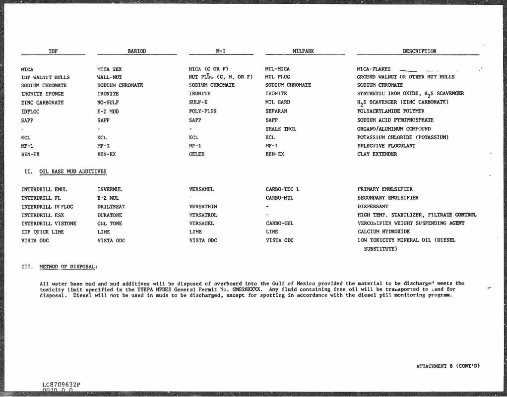
DRILLING MUD COMPONENTS AND ADDITIVES PLAN OF EXPLORATION
SOI OCS-G 7995, CREEN CANYOTTBLQCK 158 SCT OCg-g 7996; t^ETO CANVON BLOCT m
OFFSHORE LOUISIANA
I . ITEMS USED ON A ROUTINE BASIS
IDF BARIOD M - I MILPARK DESCRIPTION
IDF BAR BARITE/BARIOD M AR BARITE/MILBAR BARITE (BARIUM SULFATE)
IDF WYOMING BENTONITE AQUAGEL M- i GEL MILGEL BENTONITE
IDF LIGNITE CARBONOX TANNATHIN LIGCO LIGNITE
IFF CLS Q-BROXIN R D - l l l UNI CAL BLENDED LIGNOSULFONATE
CAUSTIC SODA CAUSTIC SODA CAUSTIC SODA CAUSTIC SODA SODIUM HYDROXIDE
ALUMINUM STEARATE ALUMINUM STEARATE ALUMINUM STEARATE ALUMINUM STEARATE ALUMINUM STEARATE
LIME LIME LIME LIME CALCIUM HYDROXIDE
IDF CAUSTICIZED CC-16 CAUSTILIG LIGCON BLENDED LIGNITE/CAUSTIC
SODA ASH SODA ASH SODA ASH SODA ASH SODIUM CARBONATE
SODIUM BICARBONATE BICARB BICARB BICARB BICARBONATE OF SODA
IDF HI-TEMP BARANEX RESINEX I I CHEMTROL-X/FILTREX SELECTED POLYMER BLEND
IDF DRILLING DETERGENT CON DET. DD M.D. DETERGENT
IDF DEFOAM BARA-DEFOAM I DEFOAM-A W.O. DEFOAM/ID-8 DEFOAMER (USUALLY ALCOHOL BASED)
IDF HYMUL AKTAFLOS DMS - NONIONIC MUD SURFACTANT
IDF CMC CMC OR CELLEX CMC CMC SODIUM CARBOXY METHYL CELLULOSE
SALT SALT SALT SALT SODIUM CHLORIDE
IDF STARCH IMPERMEX MY-LO-JEL MILSTARCH PREGELATINIZED STARCH
IDF AP-21 CYPAN OR WL-100 SP-101 CYPAN OR WL-100 SODIUM POLYACRYLATE
TDFLO DZXTRID POLY SAL PERM-LOSE ORGANIC POLYMER
DRISPAC/IDF-FLR DRISPAC OR PAC POLY-PAC DRISPAC POLYANIONIC CELLULOSE
GYPSUM GYP GYP GYP GYPSUM (PLASTER OF PARIS)
IDTEX HME/SUPERDRILL HME/SUPERDRIL HME/SUPERDRIL GILSONITE (TREATED) - NATURAL
HYDROCARBON
IDFREE BLACK MAGIC SUPERMIX (SFT) PIPE-LAX W BLACK MAGIC SUPERMIX (SFT) MUD CONCENTRATE FOR SPOTTING FLUID
TDLUBE TORQ TRIM LUBF-106 LUBRISAL ORGANIC LirBPICANT
ATTACHMBNT 8
LC8709632P 0019.0.0
IDF BARIOD M-I MILPARK DESCRIPTION
MICA
IDF WALNUT HULLS
SODIUM CHROMATE
IRONITE SPONGE
ZINC CARBONATE
IDPLOC
SAPP
KCL
MF-1
BEN-EX
MICA TEX
WALL-NUT
SODIUM CHROMATE
IRONITE
NO-. SULF
E-Z MUD
SAPP
KCL
MF-1
BEN-EX
MICA (C OR F)
NUT PLUo (C, M, OR F)
SODIUM CHROMATE
IRONITE
SULF-X
POLY-PLUS
SAPP
KCL
MF-1
GELEX
MIL-MICA
MIL PLUG
SODIUM CHROMATE
IRONITE
MIL CARD
SEPARAN
SAPP
SHALE TROL
KCL MF-1
BEN-EX
MICA-FLAKES
GROUND WALNUT OR OTHER NUT HULLS
SODIUM CHROMATE
SYNTHETIC IRON OXIDE, HjS SCAVENGER
H2S SCAVENGER (ZINC CARBONATE)
POLYACRYLAMIDE POLYMER
SODIUM ACID PYROPHOSPHATE
ORGANO/ALUMINUM COMPOUND
POTASSIUM CHLORIDE (POTASSIUM)
SELECTIVE FLOCULANT
CLAY EXTENDER
I I . OIL BASE MUD ADDITIVES
INTERDRILL EMUL
INTERDRILL FL
INTERDRILL DIFLOC
INTERDRILL ESX
INTERDRILL VI STONE
IDF QUICK LIME
VISTA ODC
INVERMUL
E-Z MUL
DRILTREAT
DURATONE
GEL TONE
LIME
VISTA ODC
VERSAMUL
VERSATHIN
VERSATROL
VERSAGEL
LIME
VISTA ODC
CARBO-TEC L
CARBO-MUL
CARBO-GEL
LIME
VISTA CDC
PRIMARY EMULSIFIER
SECONDARY EMULSIFIER
DISPERSANT
HIGH TEMP. STABILIZER, FILTRATE CONTROL
VERCOSIF1ER WEIGHT SUSPENDING AGENT
CALCIUM HYDROXIDE
lOW TOXICITY MINERAL OIL (DIESEL
SUBSTITUTE)
I I I . METHOD OF DISPOSAL:
Al l water base mud and aud additives w i l l be disposed of overboard into the Gulf of Mexico provided the material to be discharged sects the to x i c i t y l i m i t specified i n the USEPA NPDES General Permit No. GMG28XXXX. Any f l u i d containing free o i l w i l l be transported to iand for disposal. Diesel w i l l not be used in muds to be discharged, except for spotting in accordance with the diesel p i l l monitoring prograa.
ATTACHMENT 8 (CONT'D)
LC8709632P

SPILL PREVENTION, CONTROL AND COUNTERMEASURE PLAN PLAN OF EXPLORATION
SOI OCS-G 7995, GREEN CANYON BLOCK 158 SOI OCS-G 7998, GREEN CANYON BLOCK 202
OFFSHORE LOUISIANA
SOI'8 latest revisions to I t s " S p i l l Prevention, Control and Countermeasure Plan" were approved by the MMS on September 3, 1986. Tlie d r i l l i n g plans proposed herewith w i l l rely primarily on the s p i l l equipment stored at the Clean Gulf Associates based in Venice, Louisiana. Section I I I of the submitted plan l i s t s available equipment at these bases plus other bases from which additional equipment can be drawn. Section I I l i s t s the preventive measures to be taken to minimize o i l s p i l l s and the reporting procedures to be followed in the event that one occurs. Section VI provides a detailed discussion of the clesn-up procedures to bt i n i t i a t e d , including a l i s t i n g of the personnel thst make up the clean-up organization. The training of these personnel i s summarized in Section X I I . Assuming tvo hours to load out equipment and a 14-knot cruising speed, a fast response unit cen normally be on location i n 12 hours.
Attachment 9
LC8709632P 0007.0.0
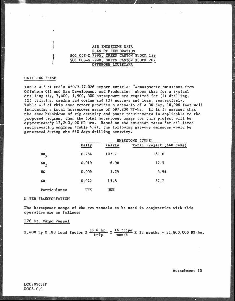
AIR EMISSIONS DATA PLAN OF EXPLORATION
SOI OCS-G 7995, GREEN CANYON BLOCK 158 SOI OCS-G 7998, GREEN CANYON BLOCK 202
OFFSNORE LOUISIANA
DRILLING PHASE
T a b l e A.2 of EPA's A50/3-77-026 Report e n t i t l e d "Atmospheric Emissions from O f f s h o r e O i l and Gas Development and Product ion" shows tha t f o r a t y p i c a l d r i l l i n g r i g , 3,400, 1,900, 300 horsepower are requ i red f o r (1) d r i l l i n g , ( 2 ) t r i p p i n g , cas ing and coring snd (3) surveys and l o g s , r e s p e c t i v e l y . T a b l e 4.3 of t h i s same report provides a scenario of a 30-day, 10,000-foot w e l l i n d i c a t i n g a t o t s l horsepower usage o f 597,200 HP-hr. I f l t i s assumed tha t t h e same breakdown o f r i g a c t i v i t y and power requirements i s app l i cab le to the proposed program, then the t o t a l horsepower usage f o r t h i s p r o j e c t v i l l be approximately 13,200,000 HP- \ T B . Based on the emission rates f o r o i l - f i r e d r e c i p r o c a t i n g engines (Table 4 . 4 ) , the f o l l o w i n g gaseous emissons would be generated during the 660 days d r i l l i n g a c t i v i t y .
EMISSIONS (TONS) Daily Yearly
NO X
0.284 103.7
so2 0.019 6.94
HC 0.009 3.29
CO 0.042 15.3
Particulates UNK UNK
T o t a l P ro j ec t (660 days)
187.0
12.5
5.94
27.7
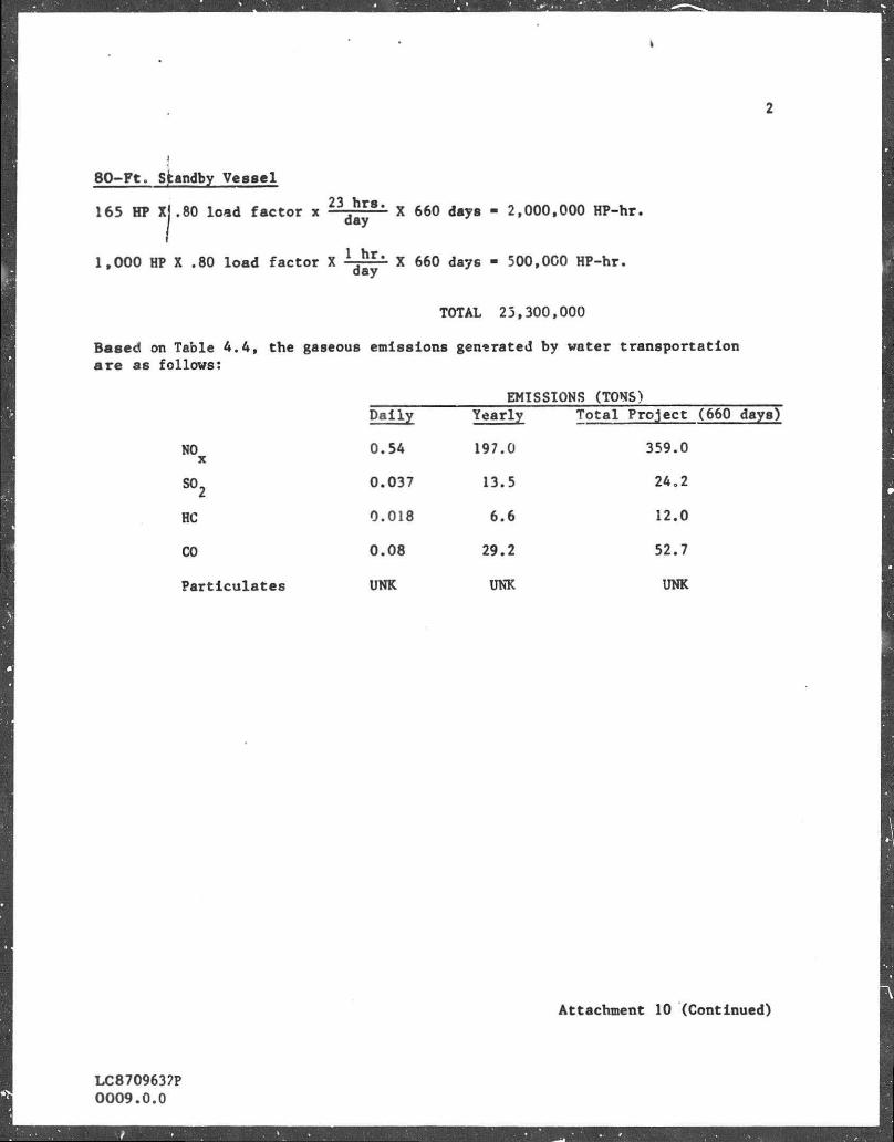
W.-TER TRANSPORTATION
The horsepower usage of the tvo vessels to be used i n con junc t ion v i t h t h i s o p e r a t i o n are as f o l l o v s :
176 F t . Csrgo Vessel
2,AOO hp X .80 load f a c t o r X 3 8 ; 6 h r - X
1 A j g f t 5 X 22 months - 22,800,000 HP-hr. t r i p month
Attachment 10
LC8709632P 0008.0 .0
2
4
80-Ft . Sfcandby Vessel
165 HP Xj.80 load fac tor x " j * " ' X 660 days - 2,000,000 HP-hr.
1,000 HP X .80 load factor X x 660 dsys - 500,000 HP-hr.
TOTAL 23,300,000
Based on Table 4 .4 , the gaseous emissions generated by water transportation are as follows:
EMISSIONS (TONS) Dai ly Yearly Total Project (660 days)
NO X
0.54 197.0 359.0
so2 0.037 13.5 24.2
HC 0.018 6.6 12.0
CO 0.08 29.2 52.7
Particulates UNK UNK UNK
LC8709637P 0009.0.0
Attachment 10 (Continued)

EXEMPTION CALCULATION FOR DRILLING, ACTIVITIES
The proposed Ijocation l s 90 miles from the nearest shorel ine. Therefore, the emission exemption (E) for the various pollutants i s as follows:
CO E - 3,400 ( 9 0 ) 2 / 3 - 68,200 tons/yesr
NO x
S0 2 E - 33.3 (90) - 3,000 ton3/yesr
HC
Particulates Annusl emissions from the d r i l l i n g cperations ( D r i l l i n g and Water Transportation) are:
Tons
NO 300.7 x
S02 20.44
HC 9.9
CO 44.5
Psrticulates UNK
The to t a l emission for any one pollutant does not exceed the exemption totals above; consequently, no further a i r quality review i s required for the emissions from the operations in connection with t h i s Plan.
Attachment 10 (Continued)
LC8709632P 0010.0.0
I
i
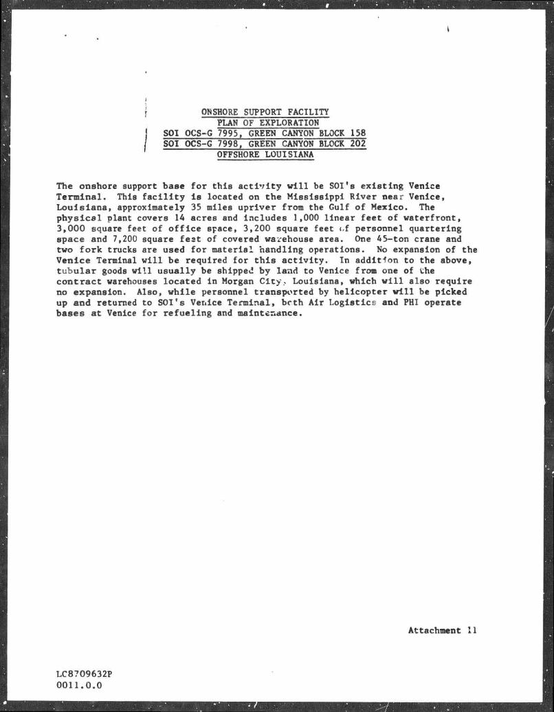
\ ONSHORE SUPPORT FACILITY PLAN OF EXPLORATION
SOI OCS-G 7995, GREEN CANYON BLOCK 158 SOI OCS-G 7998, GREEN CANYON BLOCK 202
OFFSHORE LOUISIANA
The onshore support base for this a c t i v i t y w i l l be SOI's exis t ing Venice Termina l . This f s c i l i t y i s located on the Mississ ippi River near Venice, L o u i s i a n a , approximately 35 miles upriver from the Gulf of Mexico. The p h y s i c a l plant covers 14 seres and includes 1,000 l inear feet of waterfront, 3,000 square feet of o f f i c e space, 3,200 square feet <,f personnel qusrterlng space and 7,200 square feat of covered warehouse area. One 45-ton crane and two fork trucks are used for material handling operations. No expansion of the Venice Terminal w i l l be required for t h i s a c t i v i t y . In addition to the above, tubular goods w i l l usual ly be shipped by land to Venice from one of the contract warehouses located in Morgan Ci ty? Louisiana, which w i l l also require no expansion. Also, while personnel transported by helicopter w i l l be picked up and returned to SOI's Venice Terminal, bcth Air Logist ics snd PHI operate bases at Venice for refuel ing and maintenance.
LC8709632P 0011.0.0
Attachment 11

SUPPORT VESSELS PLAN OF EXPLORATION
SOI OCS-G 7995, GREEN CANYON BLOCK 158 SOI OCS-G 7998, GREEN CANYON BLOCK 202
OFFSHORE LOUISIANA
ITEM SIZE OR MODEL USE TRIPS PER WEEK
boat 176'± Cargo 3 or 4
Boat 80'-100' Standby N.A
Helicopter Bell 206B, 212, 214, Crev Change and Misc. 18 to 20 or 412
LC8709632P 0012.0.0
Attachment 12

1 I I I ( l l l l l
?4
SHOAL S O U T H T I M B A L I E R
' r - -1—41—1 " EWING
I I I T I I ^
VENICE
M m N i 1
DRILLING AREA
SICCM C A N Y O N
- +-
_ — — WATER ROUTE
- AIR ROUTE
ATTACHMENT 13 $!SELL OFFSHORE INC.
IA SUBSIDIARY OF SHELL OIL COMf AHY)
LEASE VICINITY ft TRANSPORTATION ROUTES
PLAN OF EXPLORATION SOI OCS-0 7995 BLK. 158 SOI OCS-O 7996 BLK. 202
6REEN CANYON BLOCKS 158.202 OFFSHORE LOUISIANA

COASTAL ZONE MANAGEMENT CONSISTENCY CERTIFICATION
PLAN OF EXPLORATION Type of Plen
GREEN CANYON BLOCKS 158 A*ID 202 Areas and Blocks
SOI OCS-G 7995 AND 7998 Lease .lumbers
The proposed a c t i v i t i e s described ln d e t a i l in this Plsn comply with Louis iana '8 approved Coastal Resources Program and w i l l be conducted in e manner consistent with such programs.
Such findings are summarized on the f i n a l page of the atta hed Environmental Report (ER).
A request i s being made to the o f f i c i a l state journal , the State Times, published in Baton Rouge, for publication on May 11, 1987 of our notice of explorat ion plans.
SHELL OFFSHORE INC. (SOI) Operstor
G. D. MeglHigan Division Safety, Environmental
snd Administration Manager
Date
Attachment 14
LC8709632P 0013.0.0
I I (1) TITLE PAGE
759 Parkway Street J u p i t e r , F l o r i d a 33477
ENVIRONHENTAL REPORT (PLAN OF EXPLORATION)
GULF OF MEXICO: OFFSHORE LOUISIANA GREEN CANYON AREA
BLOCK 158 (OCS-G 7995)
BLOCK 202 (OCS-G 7998)
SHELL OFFSHORE INC.
8 APRIL 1987
Mr. T. M. Randolph Senior S t a f f Environmental Engineer
S h e l l Offshore Inc. One Sh e l l Square P.O. Box 61011
New Orleans, Louisiana 70161 Telephone: (504) 588-6468
"Applied Science and Technology"
AND

k i i
TABLE OF CONTENTS
PAGE
(1) TITLE PAGE 1
LIST OF FIGURES 1 V
(2) DESCRIPTION OF THE PROPOSED ACTION 1
(a) D e s c r i p t i o n of Proposed Travel Modes and Routes and 1 Frequency f o r Moving Supplies and Personnel t o and from the Offshore A c t i v i t y S i t e and the Onshore Bases
(b) I d e n t i f i c a t i o n of Support Bases and Number and Types of New 1 Workers Associated w i t h the Proposed A c t i v i t i e s . Reference
I s Also Made t o the Most Current Update of the Socioeconomic
Data Base Report
(c) I d e n t i f i c a t i o n of the Number, Location, and Size of Any New 1 Support F a c i l i t i e s That W i l l Need To Be Provided f o r the Proposed A c t i v i t i e s
(di D e s c r i p t i o n of Any New Techniques or Unusual Technology That 1 May A f f e c t Coastal Waters
(e) Maps Showing Location of the Proposed A c t i v i t i e s i n Relation 1 t o Each of the Affected States' Coastal Zones
( f ) For Development Operations Coordination Documents, the Means 3 Proposed t o Transport O i l and Gas t o Shor t from the Lease Area and the Routes To Be Followed and the Estimated Q u a n t i t i e s of O i l and Gas To Be Moved along Such Routes
(3) DESCRIPTION OF THE AFFECTED ENVIRONMENT AND IMPACTS 4
(a) Physical and Environmental 4
( i ) Commercial Fishing 4
( i i ) Shipping 7
( i i i ) Small C r a f t Pleasure Boating, Sport Fishing, and 7 Recreation
( i v ) C u l t u r a l Resources 8
(v) E c o l o g i c a l l y Sensitive Features 8
( v i ) E x i s t i n g Pipelines and Cables 1 0

s i i i
TABLE OF CONTENTS (CONTINUED)
l PAGE
| ( v i i ) Other M i n e r a l Uses 1 0
( v i i i ) Ocean Dumping A c t i v i t i e s 1 0
( i x ) Endangered o r Th rea t ened Species 1°
(b) Soc ioeconomic ^
(4) UNAVOIDABLE ADVERSE IMPACTS 1 2
(a) Summary o f the U n a v o i d a b l e Adverse Impac t s 12
(b) S t a t e m e n t Concern ing t h e Unavo idab le Adverse Impac t s 12
(5) REFERENCES 1 3
(6) FINAL STATEMENT 1 5

L I S T OF FIGURES
FIGURE j DESCRIPTION
1 , LOCATION OF GREEN CANYON AREA BLOCKS 158 AND 202 RELATIVE TO THE LOUISIANA COASTAL ZONE (ADAPTED FROM: USDOI, MMS, 1984).

1
(2) DESCRIPTION OF THE PROPOSED ACTIQN
(a) D e s c r i p t i o n of Proposed Trave l Modes and Routes and Frequency f o r Moving Supplies and Personnel to and from the Offshore A c t i v i t y S i te and the Onshore Bases
She l l Offshore Inc . plans to conduct exp lora tory a c t i v i t i e s i n
Green Canyon Area Blocks 158 and 202. Hel icopters and boats w i l l move
supplies and personnel to and f rom the o f f s h o r e and onshore locat ions. .
Helicopters w i l l make approximately 18 to 22 round t r i p s per week and
boats w i l l make approximately 14 round t r i p s per month. I f s e r v i c i n g
only the proposed lease area, he l i cop te r s and boats w i l l normally take
the most d i r e c t route, weather and t r a f f i c cond i t ions p e r m i t t i n g (see
Figure 1 ) .
(b) I d e n t i f i c a t i o n of Support Bases and Numher and Types of New Workers Associated w i t h the Proposed A c t i v i t i e s . Reference i s Also Made to the Most Current Update o f the Socioeconomic Data Base Report
The support base w i l l be loca ted i n Venice, Louis iana. The base i s
capable of p r o v i d i n g the services necessary f o r the proposed a c t i v i t i e s .
No new f a c i l i t i e s or workers w i l l be needed f o r the proposed a c t i v i t i e s .
The i n i t i a l OCS Socioeconomic Data Base Report w i l l be developed a f t e r
the MMS and the States of Alabama, Louis iana, and M i s s i s s i p p i have
i d e n t i f i e d t he s p e c i f i c parameters t o be addressed i n these semiannual
reports.
(c) I d e n t i f i c a t i o n of the Number, Loca t ion , and Size of Any New Support F a c i l i t i e s That W i l l Need t o be Provided f o r the Proposed A c t i v i t i e s
No new support f a c i l i t i e s w i l l be needed f o r the proposed
a c t i / i t i e s .
(d) D e s c r i p t i o n of Any New Techniques or Unusual Technology That May A f f e c t Coastal Waters
No new techniques or unusual technology w i l l be used dur ing the
proposed a c t i v i t i e s .
(e) Maps Showing Location o f the Proposed A c t i v i t i e s i n Re la t ion to Each of the A f f e c t e d States ' Coastal Zones
Figure 1 shows the l o c a t i o n o f the proposed a c t i v i t i e s i n r e l a t i o n
to each o f the a f f e c t e d S ta tes ' coas ta l zones. The proposed a c t i v i t i e s
w i l l take p lace i n waters adjacent t o the State o f Louis iana.


I • 3
( f ) For Development Operations Coordination Documents, the Means Proposed to Transport O i l and Gas to Shore from the Lease Area and
! the Routes To Be Followed and the Estimated Quant i t i e s ot Q i l and I Gas t o be Moved along Such Routes
j This Plan i s exp lo ra to ry . No o i l or gas w i ' l be produced f o r sale
f r o i i these proposed a c t i v i t i e s at t h i s t ime.

4
(3) DESCRIPTION OF THE AFFECTED ENVIRONMENT AND IMPACTS
(a) Physical and Environmental
( i ) Commercial Fishing
The proposed a c t i v i t i e s are located south of some of the most
productive f i s h i n g grounds i n the Gulf of Mexico* National Marine
Fisheries Service Zone 14, which i s located 150 km (81 nmi) north of the
lease area, accounted f o r approximately 7% of the commercial f i s h e r i e s
harvest from the western aj\d c e n t r a l Gulf of Mexico (USDOI, BLM, 1981,
Visual No. 5; USDOI, MMS, 1984, Visual No. 4-1). Gulf waters account f o r
approximately 30% of the t o t a l annual U.S. f i s h e r i e s harvest (USDC,
1982).
The Gulf f i s h e r y i s dominated by the s h e l l f i s h f i s h e r i e s . Shrimps,
crabs, and oysters (with smaller amounts of clams and scallops) are the
most valuable f i s h e r i e s and are usually worth three or four times more
than the greater volume of f i n f i s h catch (USDOI, BLM, 1979). The USDC
(1982) l i s t s the annual commercial f i s h e r i e s landings s t a t i s t i c s for the
northern Gulf coast area onshore from the lease area.
The shrimp fishery i n the Gulf of Mexico includes the brown (Penaeus
aztecus), white (P. s e t i f e r u s ) , and pink (P. duorarum) shrimps. These
species are taken almost e x c l u s i v e l y by t r a w l s i n depths ranging from
approximately 2 t o 73 m (6 t o 240 f t ) . These shrimps are
estuarine-dependent species which spawn i n the open ocean, go through a
series of l a r v a l phases i n the plankton, migrate during the p o s t - l a r v a l
phase t o the estuarine nursery areas, and then r e t u r n to the open Gr'.f as
adults. The USDOI, BLM (1977, V i s u a l No. 5) indicates the seasonal
v a r i a t i o n i i the habits of each of these species. The lease area i s
located outside of the major shrimp spawning grounds and migration routes
i n the northern Gulf (USDOI, MMS, 1984, Vi s u a l No. 4-1). Planktonic eggs
and l a r v a l stages of a l l commercially important shrimp species may occur
p e r i o d i c a l l y i n the lease area.
The blue crab (Callinectes sapidus) makes up 98% of the crab harvest
i n the Gulf of Mexico (Riley, 1970). I t s l i f e cycle i s s i m i l a r t o the
shrimps' i n t h a t i t has planktonic, estuarine, and open ocean phases.
Adults spend most of t h e i r l i v e s i n the estuaries; thus, the blue crab
harvest i s taken p r i m a r i l y inshore of the lease area. Gravid females
migrate t o the open Gulf t o release t h e i r eggs dur inq spr ing and summer.
Consequently, gravid females and p lank ton ic larvae may occur seasonally
in the lease area.
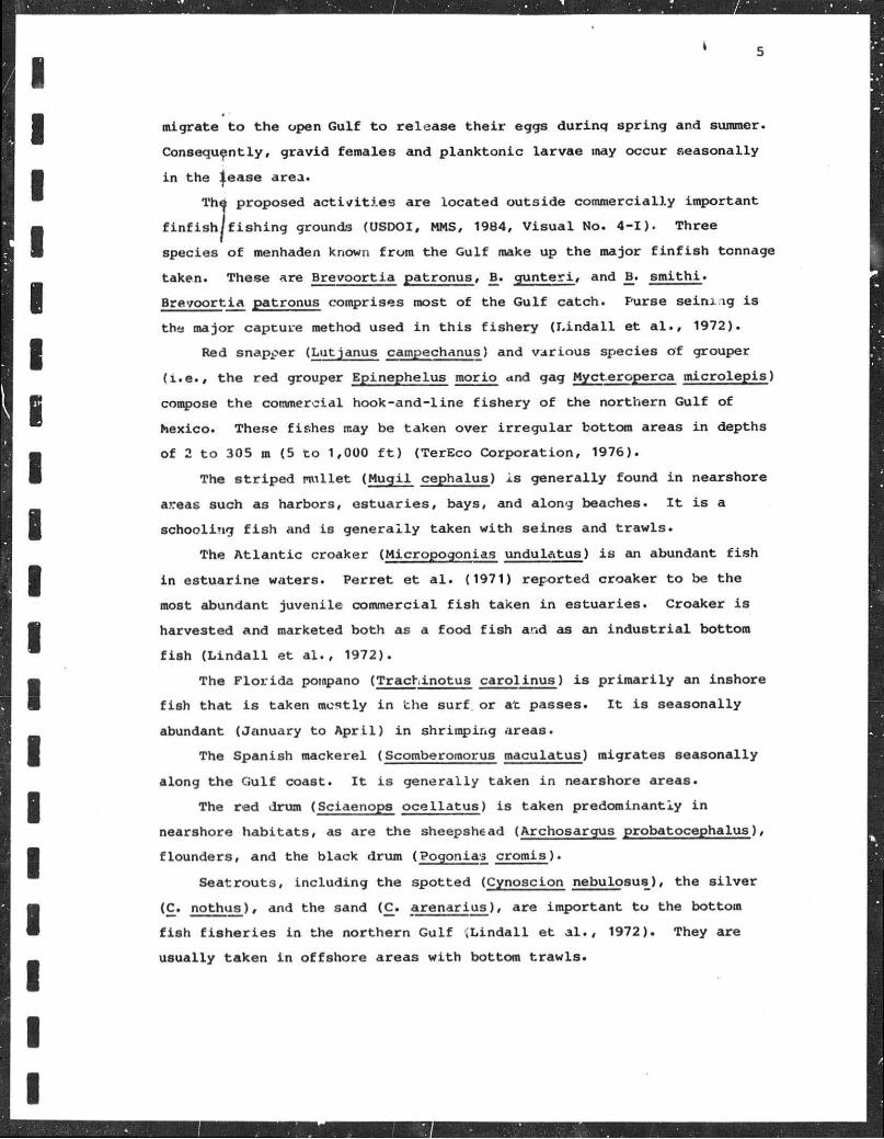
The proposed a c t i v i t i e s are located outs ide commercially important
f i n f i s h / f i s h i n g grounds (USDOI, MMS, 1984, V i s u a l No. 4 -1 ) . Three
species o f menhaden known f rom the Gulf make up the major f i n f i s h tonnage
taken. These are Brevoor t ia pat ronus , B. g u n t e r i , and B_. s m i t h i .
Brevoor t ia patronus comprises most of the Gulf ca tch. Purse se in ing i s
the major capture method used i n t h i s f i s h e r y ( L i n d a l l et a l . , 1972).
Red snapper (Lutjanus campechanus) and var ious species of grouper
( i . e . , the red grouper Epinephelus morio and gag Mycteroperca micro lep is )
compose the commercial hook-and-l ine f i s h e r y o f the northern Gulf of
hexico. These f ishes may be taken over i r r e g u l a r bottom areas i n depths
of 2 t o 305 m (5 t o 1,000 f t ) (TerEco Corpora t ion , 1976).
The s t r i p e d mullet (Mugi l cephalus) i s genera l ly found i n nearshore
a.Teas such as harbors, e s t u a r i e s , bays, and along beaches. I t i s a
schooling f i s h and is genera l ly taken w i t h seines and t r a w l s .
The A t l a n t i c croaker (Micropogonias undulatus) i s an abundant f i s h
i n es tuar ine waters. Perret et a l . (1971) repor ted croaker t o be the
most abundant juveni le commercial f i s h taken i n es tua r ies . Croaker i s
harvested and marketed both as a food f i s h ar.d as an i n d u s t r i a l bottom
f i s h ( L i n d a l l et a l . , 1972).
The F l o r i d a pompano (Trachinotus ca ro l inus ) i s p r i m a r i l y an inshore
f i s h t ha t i s taken mostly i n the surf or at passes. I t i s seasonally
abundant (January to A p r i l ) i n shrimping areas.
The Spanish mackerel (Scomberomorus maculatus) migrates seasonally
along the Gul f coast. I t i s genera l ly taken i n nearshore areas.
The red drum (Sciaenops o c e l l a t u s ) i s taken predominantly i n
nearshore h a b i t a t s , as are the sheepshead (Archosargus probatocephalus),
f lounders , and the black drum (Pogonias c romis ) .
Seat routs , inc lud ing the spot ted (Cynosclon nebulosus), the s i l v e r
(C. nothus) , and the sand (C. a r ena r iu s ) , are important t o the bottom
f i s h f i s h e r i e s i n the nor thern Gul f ^ L i n d a l l e t a l . , 1972). They are
usually taken i n o f f shore areas w i t h bottom t r a w l s .

6
TerEco Corporat ion (1976) describes some a d d i t i o n a l f i s h species of
the, northern Gul f which are impor tan t to commercial and/or sport
fishermen and t h e i r predominant method of capture . Most of the northern
Gulf f i shes are temperate, w i t h some incurs ions f rom Caribbean fauna.
They e x h i b i t seasonal d i s t r i b u t i o n and abundance f l u c t u a t i o n s r e l a t e d t o
oceanographic condi t ions (USOOI, MMS, 1984, p . 106). Many of the coas ta l
species ( e . g . , the croaker, Micropogonias undulatus) are
estuarine-dependent, because es tua r ies or coas ta l marshes are a c r i t i c a l
habitat du r ing some phase of t h e i r l i f e cycles . Rogers (1977) postula ted
a net inshore-of f shore movement f o r many demersal she l f f i s h species.
Thus, i t i s probable tha t many of these species may occur i n the lease
area at some phase of t h e i r l i f e cyc le s .
Eggs and larvae ( ich thyoplankton) of various commercially important
f i s h species are probably a lso present i n the lease area on occasion.
Sixty-nine f i s h species have been i d e n t i f i e d f rom zooplankton samples
taken along the northern Gulf coas t . Dominant taxa were the f a m i l i e s
Sparidae, L u t j a n i d a e , T r i g l i d a e , Serranidae, and Synodontidae.
Stenotomus capr inus , Pr is t ipomoides a q u i l o n a r i s , Prionotus pa ra la tus ,
Serranus atrobranchus, and Synodus foetens were the most important,
species (Chit tenden and Moore, 1976). Since the m a j o r i t y of
Lchthyoplankters are at the mercy o f water movements, t h e i r d i s t r i b u t i o n s
vary considerably w i t h space and t i m e . The primary f ac to r s i n f l u e n c i n g
ichthyoplankton i n the nor thern G u l f are the Loop Current , the
Mississ ippi River , and l o c a l r u n o f f . Due to " >atchiness" i n
d i s t r i b u t i o n s , presence and abundance of ich thyoplankton at any given
instance cannot be p red ic ted .
The proposed a c t i v i t i e s probably w i l l t empora r i ly degrade the water
qua l i ty i n the immediate v i c i n i t y o f the d r i l l s i t e due to discharges of
d r i l l i n g f l u i d s and c u t t i n g s . Th i s may cause c e r t a i n f i s h species t o
avoid the area . Commercial f i s h i n g may be a f f e c t e d t empora r i l y . The
s i tua t ion should rever t to normal as soon as d r i l l i n g i s completed.
Cumulative e f f e c t s of inc reas ing o i l and gas a c t i v ' .ies o f f the nor thern
Gulf coast on annual catches are as yet unknown. However, there are no
data to i n d i c a t e tha t o i l and gas a c t i v i t i e s are responsible f o r any
decline i n annual catches (USDOI, BLM, 1979, p . 181).
/
7
Any o i l s p i l l tha t would impact the sea f loor could conceivably k i l l
benthjic organisms such as shrimps or cause a v a r i e t y of sub le tha l
e f f e d t s . The p o t e n t i a l long-term e f f e c t s of a s p i l l on the benthos are
unclear because resu l t s of hydrocarbon analyses are inconclus ive (USDOI,
BLM, /1979, p . 160).
An o i l s p i l l would t empora r i l y degrade water q u a l i t y and introduce
toxins i n t o the water. Ichthyoplankton, i f present , may be k i l l e d or
f u n c t i o n a l l y impaired. However, most adul t f i s h e s encountering a s p i l l
and associated t o x i c water would probably e x h i b i t avoidance behavior.
This e f f e c t would oe temporary and f i shes should r e t u r n to the area a f t e r
dispersal of the s p i l l . No s i g n i f i c a n t or p e r s i s t e n t d i r e c t e f f e c t s from
an o i l s p i l l on f i s h populat ions would be expected. Recruitment from
surrounding areas should q u i c k l y replenish any a f f e c t e d ichthyoplankton
populations once the s p i l l has dispersed. Any s p i l l would be handled
according t o an o i l s p i l l contingency plan approved by the MMS.
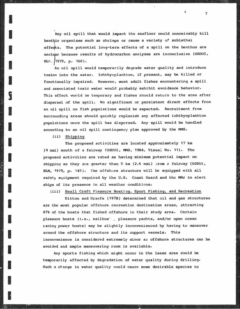
( i i ) Shipping
The proposed a c t i v i t i e s are located approximately 17 km
(9 nmi) south o f a fa i rway (USDOI, MMS, 1984, V i s u a l No. 11) . The
proposed a c t i v i t i e s are ra ted as having minimum p o t e n t i a l impact on
shipping as they are greater than 5 km (2.6 nmi) C'rora a fa i rway (USDOI,
BLM, 19/9, p . 145). The o f f s h o r e s t ruc tu re w i l l be equipped w i t h a l i
safet> equipment required by the U.S. Coast Guard and the MMJ?. t o a l e r t
ships of i t s presence i n a l l weather cond i t ions .
( i i i ) Small C r a f t Pleasure Boat ing , Sport F i s h i n g , and Recreation
D i t t o n and Graefe (1978) determined tha t o i l and gas s t ruc tures
are the most popular o f f sho re r ec rea t ion de s t i na t i on areas, a t t r a c t i n g
87% of the boats tha t f i s h e d o f f s h o r e i n t h e i r study area. Ce r t a in
pleasure boats ( i . e . , sa i lboa ' . pleasure yachts , and/or open ocean
racing power boats) may be s l i g h t l y inconvenienced by having t o maneuver
around the o f f s h o r e s t ruc tu re and i t s support vessels . This
inconvenience i s considered extremely minor as o f f s h o r e s t ruc tu res can be
avoided and ample maneuvering room i s a v a i l a b l e .
Any spor t s f i s h i n g which might occur i n the lease area could be
temporarily a f f e c t e d by degradation of water q u a l i t y du r ing d r i l l i n g .
Such a change i n water q u a l i t y cou ld cause some des i rab le species to
1

8
avoid the immediate lease area. However, any such e f f e c t s are expected
to be temporary and l o c a l i z e d and should not a f f e c t any f i s h e r y p o t e n t i a l
i n tihe area as a whole. Populat ions should r e tu rn t o normal once
d r i l l i n g i s completed.
l i v ) C u l t u r a l Resources
Coasta l Environments, I n c . (1977) has i d e n t i f i e d two types of
c u l t u r a l resources which may be found i n the northern Gulf of Mexico
area: (1) h i s t o r i c c u l t u r a l resources or shipwrecks; and (2) p r e h i s t o r i c
c u l t u r a l resources or traces o f previous ly undescribed human
c i v i l i z a t i o n s (USDOI, MMS, 1983, pp. 228-240). Approximately 82% of the
known shipwrecks are located w i t h i n 10 km (5 nmi) of shore, w i t h only a
small percentage occurr ing on the OCS (USDOI, BLM, 1979, p . 91 ) . Known
submarine a rcheo log ica l s i t e s are extremely r a re , w i t h none being
i d e n t i f i e d t o date i n Federal o f f s h o r e leas ing areas (USDOI, BLM, 1979,
p . 91).
The propossd a c t i v i t i e s are located outs ide the H i s t o r i c and
Prehis tor ic C u l t u r a l Resources High P r o b a b i l i t y Lines (USDOI, MMS, 1984,
Visual No. 11) and therefore are i n a large o f f s h o r e area where h i s t o r i c
and p r e h i s t o r i c resources are considered u n l i k e l y t o be found. An
archeological survey was not requ i red f o r t h i s lease area.
(v) gjcolc . i c a l l y S.nsi t i v e Features
Severa l areas ot environmental concern are located onshore of
the lease area. The Louieiana Coastal Zone Management Program has been
developed by the State t o regu la te the s i g n i f i c a n t land and water
a c t i v i t i e s between the outer l i m i t of the coastal waters and land up to
the In t r acoas t a l Waterway and/or the 1 0 - f t contour . Land uses which are
regulated are those that have a d i r e c t and s i g n i f i c a n t impact on the
coastal area r e q u i r i n g a State pe rmi t , and those which are requ i red by
Federal law t o be consis tent w i t h the management program (USDC and LDNR,
1980). The program provides f o r the p r o t e c t i o n of beaches, dunes,
wetlands, submerged grass beds, b a r r i e r i s l ands , oyster r ee f s , c u l t u r a l
resources, water q u a l i t y , a i r q u a l i t y , b i o l o g i c a l resources, and w i l d l i f e
habi ta t . Unique eco log ica l f ea tu res includr z o o l o g i c a l , b o t a n i c a l , and
geological format ions c h a r a c t e r i s t i c of coastal processes (Burk and
Associates, I n c . , 1975; USDC and LDNR, 1980). B i o l o g i c a l l y s ens i t i ve
areas of the n o r t h - c e n t r a l Gul f area include es tuar ine and coas ta l

ecosystems comprised of sa l t marshes, oyster beds, grass beds, b a r r i e r
beaches, and dunes (Coastal Environments, I n c . , 1980). These coas ta l
ecosystems c o n t a i n nursery areas f o r many species of economic importance
as well as h a b i t a t , rookeries, major overwin te r ing s i t e s , and nes t ing
areas fo r many endangered and threatens-3 species, such as the southern
bald eagle, brown pe l i can , golden eagle, osprey, red cockaded woodpecker,
American peregr ine f a l c o n , a i d var ious marine t u r t l e s (USroi , BLM, 1979,
Visual No. 3; Coastal Environments, I n c . , 1980; USDC and LDNR, 1980).
There are two e x i s t i n g "Special Management Areas" designated by the
Louisiana Coastal Management Program (USDC and LDNR, 1980, pp. 104-108).
These areas are the "Louisiana Offshore O i l Por t" (LOOP or Superport) and
the "Marsh I s l a n d W i l d l i f e Refuge and Game Preserve." The lease area i s
located 217 km (117 nmi) south-southeast of Marsh I s l and W i l d l i f e Refuge
and Game Preserve and 137 km (74 nmi) southwest o f the LOOP. None of the
proposed a c t i v i t i e s should have any e f f e c t upon these "Special Management
Areas."
Conspicuous areas ol environmental concern f o r Louisiana are
depicted by the USDOI, K M (1979, V i s u a l Nos. 1 and 4 ) , and the USDC and
LDNR (1980, F igure No. D-1).
The coas ta l zone area i s also of r ec rea t i ona l importance t o
residents and t o u r i s t s . Most r e c r e a t i o n a l a c t i v i t i e s focus on the area 's
water resources which include beaches, boat ing areas, and f i s h i n g areas.
The only o f f s h o r e areas of designated b i o l o g i c a l s i g n i f i c a n c e i n the
v i c i n i t y of Green Cany jn Area Blocks 153 and 202 are Ewing Bank, located
33 km (18 nini) west-northwest of the lease area, and Diaphus Bank,
located 28 km (15 nmi ' northwest of the lease area. The proposed
a c t i v i t i e s should hav» no e f f e c t on these pro tec ted areas of b i o l o g i c a l
s ign i f i cance or on remnant coas ta l banks, or oyster grounds.
While o i l s p i l l s dur ing d r i l l i n g operations are rare (Danenberger,
1976), the p o s s i b i l i t y of a s p i l l does e x i s t . O i l f o u l i n g i n any coastal
area could d i r e c t l y or i n d i r e c t l y a f f e c t a v a r i e t y of species, i n c l u d i n g
threatened or endangered species or species important to commercial ana
sport f i s h e r i e s . Di rec t e f f e c t s on b io ta would include f o u l i n g
( p a r t i c u l a r l y b i r d s ) , s u f f o c a t i o n ( p a r t i c u l a r l y f i s h e s and t u r t l e s ) , and
t o x i c i t y from contac t or from the inges t ion of o i l or contaminated food .
» 10
Any of these e f f e c t s could be l e t h a l , cause weakening, or cause a greater
s u s c e p t i b i l i t y t o predation. S i g n i f i c a n t ecological or economic impacts
c o u l i also r e s u l t from the f o u l i n g of oyster beds and h a b i t a t s . I n d i r e c t
effects would include the de s t r u c t i o n of c r i t i c a l h a b i t a t s , especially
breeding and nursery areas. Any e f f e c t s on endangered or threatened
species would be s i g n i f i c a n t .
O i l f o u l i n g of the coastal area could also have adverse
socioeconomic e f f e c t s . Tourism i s an important part of Gulf coast
economies. Removal of beach or other coastal areas from r e c r e a t i o n a l use
by o i l f o u l i n g would sign. -antly decrease tourism i n the a f f e c t e d area
and cause loss of income and a v a r i e t y of r i p p l e e f f e c t s i n l o c a l
economies.
Any s p i l l would be handled according t o an o i l s p i l l contingency
plan approved by the MMS. I f a s p i l l d i d occur during operations, i t i s
u n l i k e l y t h a t i t would a f f e c t any nearshore or onshore areas or
resources.
( v i ) E x i s t i n g Pipelines and Cables
There are no e x i s t i n g p i p e l i n e s or cables i n the lease area
(USDOI, MMS, 1986).
( v i i ) Other Mineral Uses
Other than p o t e n t i a l o i l and gas reserves., there are no known
mineral re-oorces i n the lease area,
( v i i i ) Ocean Dui;pj.nq A c t i v i t i e s
The proposed a c t i v i t i e s are not located i n an area designated
for ocean dumping a c t i v ' ' >ss =
( i x ) Endangered or Threatened Species
The USDOI, BLM (1979, p. 45) considers possible impacts of
lease a c t i v i t i e s on endangered species i n t h i s area of the Gulf to be
temporary, l o c a l i z e d , and chanca occurrences. I t has judged the
p o t e n t i a l impacts on endangered species to be remote p o s s i b i l i t i e s
without major p o t e n t i a l f o r d i r e c t e f f e c t s on any single species. I n
addition, i t has been deternined that lease a c t i v i t i e s w i l l not r e s u l t i n
the d e s t r u c t i o n or mod:fication of designated c r i t i c a l h abitats or
p o t e n t i a l c r i t i c a l h a b i t a t s . Onshore f a c i l i t i e s are located i n a
previously developed area and pcse no new or a d d i t i o n a l threat t o
endangered or threatened species.
Approximately s ix endangered species of cetaceans occur i n the Gu l f
of Mexico. They are the blue whale (Balaenoptera musculus), f i n whale
(Balaenoiptera physalus ) , humpback whale (Megaptera novaeangliae) / r i g h t
whale (Eubalaena g l a c i a l i s ) , s e i whale (Balaenoptera b o r e a l i s ) , and sperm
whale (pjryseter catodon) . Genera l ly , most of these la rger cetaceans
occur i n c o n t i n e n t a l she l f , s lope , or deep oceanic waters (USDOI, BLM,
1981). The s t a tu s and migra t ion pa t te rns of these species i n the Gulf of
Mexico are unknown (Lehman, 1982).
Several endangered or threatened species of sea t u r t l e s , i nc lud ing
the Kemp's r i d l e y (Lepidochelys k e m p i i ) , hawksbi l l (Eretmochelys
imbirca ta) , leatherback (Dermochelys cor iacea) , loggerhead (Caretta
ca re t t a ) , and green (Chelonia mydas), may occas iona l ly v i s i t the lease
area.
The pr imary danger to marine t u r t l e s would be poss ib le c o l l i s i o n s
w i t h boats. A d u l t t u r t l e s , e s p e c i a l l y loggerheads, seem t o be a t t r a c t e d
t o offshore s t r u c t u r e s f o r f eed ing and r e s t i n g (USDOI, BLM, 1979, p . 165)
increasing the p r o b a b i l i t y of c o l l i s i o n s . No c r i t i c a l h a b i t a t f o r any o f
th< a species i d known t o e x i s t i n the lease area (USDOI, BLM, 1979,
pp. 73-74).
(b) Socioeconomic
The i n i t i a l OCS Socioeconomic Data Base Report w i l l be developed
a f t e r the MMS and the States of Alabama, Louis iana , and Mis s i s s ipp i have
i d e n t i f i e d the s p e c i f i c parameters t o be addressed i n these semiannual
repor ts . No new personnel w i l l be needed f o r the proposed a c t i v i t i e s .

12
(4) UNAVOIDABLE ADVERSE IMPACTS
j
(a) r Summary o f the Unavoidable Adverse Impacts
(Offshore s t ruc tures w i l l r e s u l t i n minimal nav iga t iona l i n t e r f e rence
hips u s ing establ ished f a i r w a y s . However/ dur ing times of reduced
v i s i b i l i t y , vessels have the grea tes t p o t e n t i a l t o deviate f rom
established f a i rways and irmpact o f f s h o r e s t ruc tures (USDOI, BLM, 1979,
p . 230). Discharge of d r i l l i n g muds and cu t t i ngs and a i r emissions
during d r i l l i n g operations w i l l adversely a f f e c t marine organisms, water
and a i r q u a l i t y , and commercial f i s h i n g as described by the USDOI, BLM
(1979, pp. 229-231). These impacts are temporary, however, and w i l l be
l im i t ed t o an extremely small area. They are j u s t i f i e d by the na t iona l
interest i n d i scover ing and developing badly needed reserves of o i l and
gas. During the explora tory ope ra t ions , a l l discharges w i l l comply w i t h
a l l appl icable MMS and EPA requirements . No s i g n i f i c a n t adverse impacts
are expected. The proposed a c t i v i t i e s covered by t h i s Plan should not
result i n unavoidable impacts on wetlands, c u l t u r a l resources,
recreat ional a c t i v i t i e s , shore l ine aes thet ics , or other land uses.
(b) Statement Concerning the Unavoidable Adverse Impacts
None o f the environmental consequences expected dur ing normal
operations should produce s i g n i f i c a n t or cumulative adverse environmental
e f f e c t s . The e f f e c t s of a p o s s i b l e o i l s p i l l should have no o v e r a l l
cumulative or long-term e f f e c t on the environment, except i n the possible
event of contaminat ion of endangered marine species. A s p i l l would be
handled according t o an o i l s p i l l contingency plan approved by the
MMS. Thus, i t i s u n l i k e l y t h a t a s p i l l would occur dur ing operat ions and
a f f ec t any nearshore or onshore areas or resources. The proposed
a c t i v i t i e s ' should have no s i g n i f i c a n t impact on endangered species or
c r i t i c a l h a b i t a t . The i n f o r m a t i o n presented i n t h i s Environmental Report
indicates no c l e a r or present reason not to proceed w i t h the proposed
a c t i v i t i e s . Withdrawal o f the Plan would r e s u l t i n the loss of p o t e n t i a l
hydrocarbon p roduc t ion from t h i s area.

13
(5) REFERENCES
Burkf and Associates , I nc . 1975. Louisiana Coastal Resources Inven tory . V o l . I , Geographic areas o f p a r t i c u l a r concern. New Orleans, LA.
Chittenden, M. E . , J r . , and D. Moore. 1976. Composition of the ich thyofauna i n h a b i t i n g the 110-m bathymetric contour of the Gulf o f Mexico, Mis s i s s ipp i River t o the Rio Grande. Department of Marine Resources Informat ion Center f o r Marine Research, Texas A&M U n i v e r s i t y . 15 pp.
Coastal Environments, Inc . 1977. C u l t u r a l resources eva lua t ion of the nor thern Gulf of Mexico. Na t iona l Park Serv ice , Washington, D.C.
Coastal Environments, I nc . 1980. CPA-2, Offshore Mississippi-Alabama-F l o r i d a , b i o l o g i c a l l y s e n s i t i v e areas. Baton Rouge, LA.
Danenberger, E . P. 1976. O i l s p i l l s , 1971-1975. Gulf of Mexico outer continental shelf . USGS C i r c . No. 741.
Di t ton , R. B. and A. R. Graefe . 1978. Recreat ional Fishery Use of A r t i f i c i a l Reefs on the Texas Coast.. Department of Recreat ional Parks, Texas A&M U n i v e r s i t y . 155 pp.
Lehman, J . 1982 (personal communication). U.S. Department o f the I n t e r i o r , Minerals Management Service Gul f o f Mexico OCS O f f i c e , M e t a i r i e , LA.
L i n d a l l , W. N . , J r . , J . R. H a l l , J . E. Sykes, and E. L . Arno ld , J r . 1972. Louisiana Coastal Zone: Analyses o f Resources and Resource Development Needs i n Connection w i t h Estuar ine Ecology. Sections 10 and 13, Fishery Resources and t h e i r Needs. A repor t f o r the U.S. Army Corps of Engineers, New Orleans, LA. C o n t r i b u t i o n No. 14-17-002-430. 323 pp.
Perret, w. S.. B. B. B a r r e t t , W. R. Latapie , J . F. P i l l a r d , W. R. Mock, C. B. Adkins , W. J . Gaidry , and C. J . Whi te . 1971. Cooperative Gulf o f Mexico Estuarine Inventory and Study, Louis iana . Phase I , Area Desc r ip t i on and Phase I V , Bio logy . Louis iana W i l d l i f e and F i she r i e s Commission.
Riley, F. 1970. Fisheries o f the United S ta tes , 1969. U.S. Department the I n t e r i o r , Bureau o f Commercial F i s h e r i e s . C.F.S. No. 5300. 87 pp .
Rogers, R. M . , J r . 1977. Trophic i n t e r r e l a t i o n s h i p s of selected f i shes on the con t inen ta l she l f of the nor thern Gu l f o f Mexico. Ph.D. d i s s e r t a t i o n , Texas A&M U n i v e r s i t y . 229 p p .

1 14
TerEco Corporation. 1976. Ecological A&pects of the Upper Continental Slope of the Gulf of Mexico. A report f o r the U.S. Department of the? I n t e r i o r , Bureau of Land Management Gulf of Mexico OCS O f f i c e , NewfOrleans, LA. Contract No. 08550-CT4-12.
U.S. Department £ Commerce. 1982. Current Fisheries S t a t i s t i c s No. 8206. Fisheries of the United States, 1981. U.S. Apartment of Commerce, National Oceanic and Atmospheric A d m i n i s t r a t i j n .
U.S. Department of Commerce and Alabama Coastal Area Board. 1979. The Alabama Coastal Area Management Program and F i n a l Environmental Impact Statement. 264 pp.
U.S. Department of Commerce and Louisiana Department of Natural Resources. 1980. Louisiana Coastal Resources Program F i n a l Environmental Impact Statement. Louisiana Department of Natural Resources, Baton Rouge, LA.
U.S. Department of the I n t e r i o r , Bureau of Land Management. 1977. F i n a l Environmental Impact Statement. Proposed 1977 Outer Continental Shelf O i l and Gas Lease Sale 47, Gulf of Mexico.
U.S. Department of the I n t e r i o r , Bureau of. Land Management.. 1979- Fi n a l Environmental Impact Statement. Proposed 1979 Outer Continental Shelf O i l and Gas Lease Sals 58A, Western and Central Gulf Mexico. 131 pp.
U.S. Department of the I n t e r i o r , Bureau of Land Management. 1981. Fi n a l Environmental Impact Statement. Proposed 1981 Outer Continental Shelf O i l and Gas Lease Sales 67 and 69, Gulf of Mexico. 300 pp.
U.S. Department of the I n t e r i o r , Minerals Management. Service. 1983. F i n a l Regional Environmental Impact Statement. Gulf of Mexico. 1,004 pp.
U.S. Department of the I n t e r i o r , Minerals Management Service. 1984. F i n a l Environmental Impact Statement. Proposed O i l and Gas Lease Sales 94, 98, and 102. Gulf of Mexico. 752 pp.
U.S. Department of the I n t e r i o r , Minerals Management Service. 1986. ( P i p e l i n e Maps). Gulf of Mexico OCS O f f i c e , M e t a i r i e , I*A.

15
( 6 ) FINAL STATEMENT
i
Tc) t h e bes t o f our knowledge , t h e s e t o f f i n d i n g s i n c l u d e d i n the
E n v i r o n m e n t a l Report and P l an i n d i c a t e s t h a t each o f t h e p roposed
a c t i v i t i e s , t h e i r a s s o c i a t e d f a c i l i t i e s , and e f f e c t s are a l l c o n s i s t e n t
w i t h and comply w i t h the p r o v i s i o n s and g u i d e l i n e s o f t h e
L o u i s i a n a - a p p r o v e d Coas t a l Zone Management Program. The p roposed
a c t i v i t i e s w i l l be conduc ted i n a manner c o n s i s t e n t w i t h t h e C o a s t a l Zcne
Management Program as o u t l i n e d i n USDC and LDNR ( 1 9 8 0 ) .
The p r o p o s e d a c t i v i t i e s w i l l be c a r r i e d o u t and comple t ed w i t h t h e
guarantee o f t h e f o l l o w i n g i t e m s :
1) The bes t a v a i l a b l e and s a f e s t t e c h n o l o g i e s w i l l be u t i l i z e d
th roughou t t h e p r o j e c t . T h i s i n c l u d e s m e e t i n g a l l a p p l i c a b l e
r equ i rements f o r equipment t y p e s , g e n e r a l p r o j e c t l a y o u t , s a f e t y sys tems,
and equipment and m o n i t o r i n g sys tems .
2) A l l o p e r a t i o n s w i l l be cove red by an o i l s p i l l c o n t i n g e n c y p l a n
approved by t h e MMS.
3) A l l a p p l i c a b l e F e d e r a l , S t a t e , and l o c a l r e q u i r e m e n t s r e g a r d i n g
a i r e m i s s i o n s , water q u a l i t y , and d i s c h a r g e f o r t h e p roposed a c t i v i t i e s ,
as w e l l as any o t h e r p e r m i t c o n d i t i o n s , w i l l be c o m p l i e d w i t h