Embed Size (px)
Citation preview
Prepared for the Town of Arlington, Massachusetts by the Metropolitan Area Planning Council
April 2019
ARLINGTON HEIGHTS NEIGHBORHOOD ACTION PLAN
Acknowledgments
This report provides recommendations to revitalize and energize the historic Massachusetts Avenue commercial area in Arlington Heights. Thank you to all who participated throughout the process. This project is funded by an Equitable Transportation Oriented Development (eTOD) grant from the Barr Foundation and the Commonwealth of Massachusetts District Local Technical Assistance (DLTA) program administered by the Metropolitan Area Planning Council (MAPC).
This report was produced by the Metropolitan Area Planning Council with assistance from Carlos Javier Montanez, Principal Planner; Alexis Smith, Architect and Senior Regional Planner; Elise Harmon, Graphic Designer; Cynthia Wall, Principal Planner and Project Manager; and Joshua Weissman LaFrance, Planning Intern. Metropolitan Area Planning Council Marc D. Draisen, Executive Director Officers President: Keith Bergman, Town of Littleton Vice President: Erin Wortman, Town of Stoneham Secretary: Sandra Hackman, Town of Bedford Treasurer: Taber Keally, Town of Milton
The community leadership for this project was provided by:
Town of Arlington Jennifer Raitt, Director, Planning and Community Development Erin Zwirko, Assistant Director Allison Carter, Economic Development Coordinator Steering Committee Arlington Park and Recreation Dept. – Jon Marshall Arlington Department of Planning and Community Development – Allison Carter Arlington Public Works Dept. – Michael Rademacher Housing Corporation of Arlington – Pam Hallett Old Schwamb Mill – Janet O’Riordan and Ann LeRoyer Sunrise Senior Living – Mary Labadini Support Arlington Heights – Angie Hazard and Claudine Swartz
Table of Contents
Executive Summary and Zoning Recommendations ..................... Page 1 I. Context .................................................................................................. Page 5 II. What did we already know? ............................................................ Page 8 III. What did we find out? ..................................................................... Page 10 IV. What do we want to do now? ....................................................... Page 30 Appendices ........................................................................................... Page 45
1
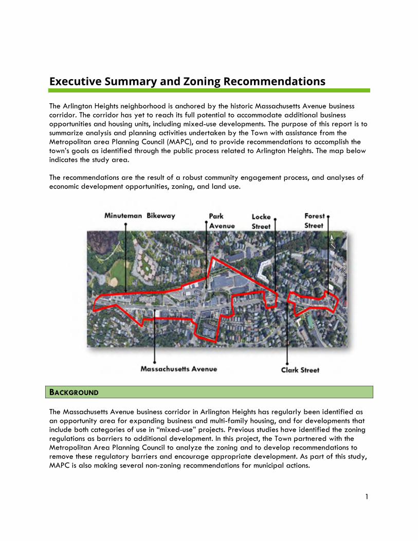
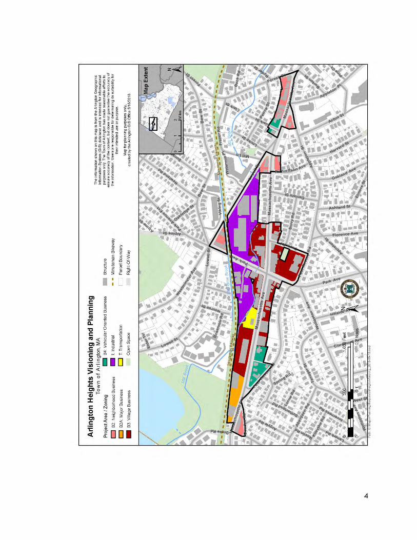
Executive Summary and Zoning Recommendations The Arlington Heights neighborhood is anchored by the historic Massachusetts Avenue business corridor. The corridor has yet to reach its full potential to accommodate additional business opportunities and housing units, including mixed-use developments. The purpose of this report is to summarize analysis and planning activities undertaken by the Town with assistance from the Metropolitan area Planning Council (MAPC), and to provide recommendations to accomplish the town’s goals as identified through the public process related to Arlington Heights. The map below indicates the study area. The recommendations are the result of a robust community engagement process, and analyses of economic development opportunities, zoning, and land use.
BACKGROUND The Massachusetts Avenue business corridor in Arlington Heights has regularly been identified as an opportunity area for expanding business and multi-family housing, and for developments that include both categories of use in “mixed-use” projects. Previous studies have identified the zoning regulations as barriers to additional development. In this project, the Town partnered with the Metropolitan Area Planning Council to analyze the zoning and to develop recommendations to remove these regulatory barriers and encourage appropriate development. As part of this study, MAPC is also making several non-zoning recommendations for municipal actions.
2
MAPC conducted two community forums and attended two steering committee meetings. The forums, in May and October 2018, provided valuable guidance on what the neighborhood residents and business owners wished to see in this location in terms of uses, heights, and design. KEY RECOMMENDATIONS 1. Create one entirely new business district to replace the existing four business districts.
The existing zoning (see map below) consists of 4 business districts and is confusing, duplicative and does not foster a cohesive business district. A single business district, tailored to the distinctive vision for the neighborhood, can solidify the corridor as a walkable mixed-use area. The new district, tentatively labeled the Arlington Heights Business (“AHB”) district, would include more as-of-right uses and dimensional and parking requirements tailored for the area. The business district should include all of the land zoned in any of the existing Business districts and the MBTA lot currently zoned Transportation. It should not include the land currently zoned Industrial.
2. Re-zone part of the existing Industrial District, the four acre “Gold’s Gym” site, as a Planned Unit Development (PUD). This “Gold’s Gym” parcel holds tremendous potential for redevelopment into housing, with some restaurant and retail use, as well as connectivity to the Minuteman Bikeway. A new site layout that incorporates the Bikeway and Mill Brook open space/recreation opportunities, as well as connections to Massachusetts Avenue, will be key to maximizing the development opportunities at this site. This may include phased development.
Many of the Town of Arlington’s existing PUD provisions should ensure a successful project if the site is rezoned; however, MAPC would suggest altering some of the existing PUD provisions to tailor the zoning more specifically for this site. A separate Arlington Heights PUD District is therefore proposed. The remainder of the current Industrial district in Arlington Heights, including the Arlington Lumber Company, should remain zoned Industrial. The Lumber Company is a catalyst for the “home improvement” cluster of stores in Arlington Heights: City Paint, Sherwin-Williams, Wanamaker’s Hardware, etc. It is a viable business, one of a few locally owned lumber stores in the area.
3. Provide for a tiered Environmental Design Review process. A tiered Environmental Design Review process would provide for different levels of review based on established criteria, such as type of development, size, etc. A new Administrative Environmental Design Review would allow for staff review of smaller projects, ensuring the design meets the Town’s standards without potentially lengthy time delays. 4. Review the existing Design Standards to ensure they reflect neighborhood specifics.
Review the existing Design Standards and possibly fine-tune them to include reference to and recommendations regarding the confluence of Massachusetts Avenue, the Minuteman Bikeway and the Mill Brook in Arlington Heights. Consider developing more detailed Design Guidelines for this zoning district to illustrate the Gold’s Gym site potential.
5. Work with the MBTA to better utilize the bus turn-around lot.
3
Located in the middle of the Arlington Heights Massachusetts Avenue corridor, this bus parking/turn-around area creates a gap in the business district, and presents potential if the Town can work with the MBTA to accommodate the buses while providing for development beyond the small, currently vacant structure. This site could also be redesigned to continue to accommodate the bus turnaround while at the same time providing a key open space location, allowing for a public gathering space which is currently missing from the Heights.
6. Explore ways in which creative place-making projects, both temporary and medium/long term, can bring vitality to the Heights and foster a more active and vibrant street life.
NEXT STEPS - SHORT TERM ACTIONS
1. Establish a zoning committee (the “AH Zoning Committee”), or work with the existing town-wide zoning committee, to continue exploring the zoning for Arlington Heights including the recommendations in this report.
2. Through this AH Zoning Committee and other outreach activities, support the changes to
multi-family and mixed-use zoning that are being proposed at the spring 2019 Annual Town Meeting, as these warrant articles will have impacts on the future actions needed in Arlington Heights.
3. Based upon the votes at the 2019 Town Meeting, town planning staff should work with the
AH Zoning Committee to determine the best options for future bylaw changes to implement the zoning changes in this report that are accepted by the Committee.
4. The Arlington Heights Zoning Committee should begin work immediately after spring town
meeting 2019 to prepare the recommended zoning changes for Arlington Heights, both the AHB District and the AH-PUD District, since the warrant for Town meeting 2020 closes in February 2020, only 8 months later.
5. Additional Short-term non-zoning actions could include:
a. Seek changes to local regulations (and if needed, to state limits on liquor licenses) to make it easier to open restaurants, as these are a major “wanted” element for the Heights;
b. Plan for more public events (historical re-enactments, street-closure dance parties, arts events) to draw crowds to the Heights, to meet the residents’ desires for more community events, and to support commercial activity by increasing visibility and foot traffic;
c. Begin negotiations with the MBTA regarding future temporary or permanent use of all or part of the bus turn-around for public events (dance parties, farmers’ markets, music events); try to host some events during the summer of 2019;
d. Coordinate with the implementation of the Arts and Culture Action Plan to plan locations of murals to provide visual interest and identity for the Heights, to support arts pop-ups in vacant storefronts, to plan for future installations (temporary or permanent) of public art, and to plan for community events;
e. Make the Heights a more desirable location to go to spend money by improving the ease of finding parking, improving walkability, and enhancing the experience of shopping here through targeted public and private improvements, etc.
4
5
SECTION I
Context
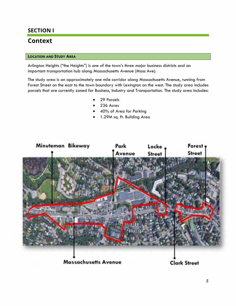
LOCATION AND STUDY AREA
Arlington Heights (“the Heights”) is one of the town’s three major business districts and an important transportation hub along Massachusetts Avenue (Mass Ave).
The study area is an approximately one mile corridor along Massachusetts Avenue, running from Forest Street on the east to the town boundary with Lexington on the west. The study area includes parcels that are currently zoned for Business, Industry and Transportation. The study area includes:
• 29 Parcels • 236 Acres • 40% of Area for Parking • 1.29M sq. ft. Building Area
6
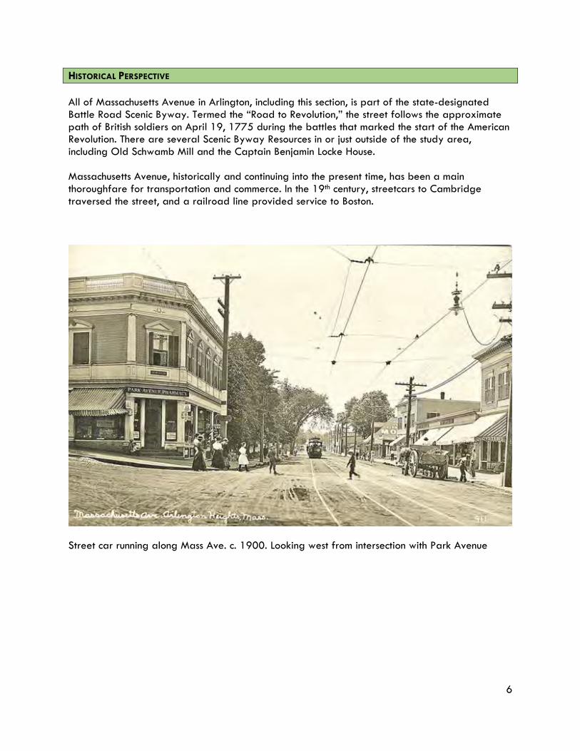
HISTORICAL PERSPECTIVE All of Massachusetts Avenue in Arlington, including this section, is part of the state-designated Battle Road Scenic Byway. Termed the “Road to Revolution,” the street follows the approximate path of British soldiers on April 19, 1775 during the battles that marked the start of the American Revolution. There are several Scenic Byway Resources in or just outside of the study area, including Old Schwamb Mill and the Captain Benjamin Locke House. Massachusetts Avenue, historically and continuing into the present time, has been a main thoroughfare for transportation and commerce. In the 19th century, streetcars to Cambridge traversed the street, and a railroad line provided service to Boston.
Street car running along Mass Ave. c. 1900. Looking west from intersection with Park Avenue
7
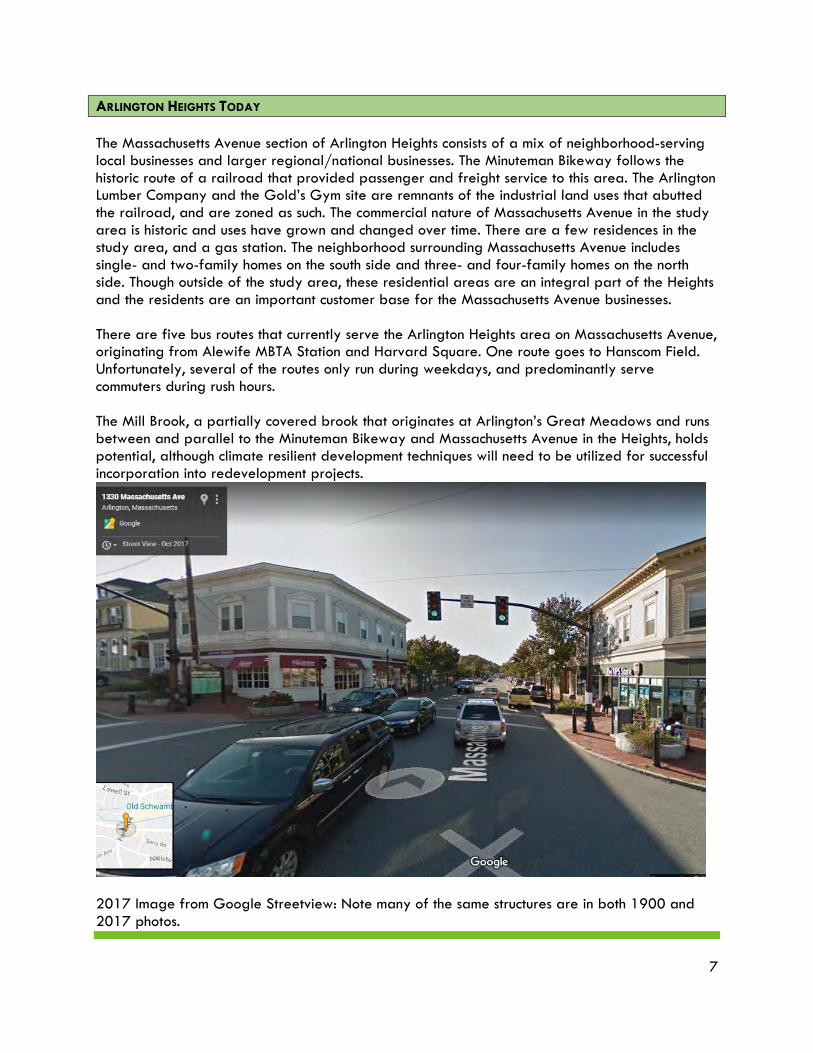
ARLINGTON HEIGHTS TODAY The Massachusetts Avenue section of Arlington Heights consists of a mix of neighborhood-serving local businesses and larger regional/national businesses. The Minuteman Bikeway follows the historic route of a railroad that provided passenger and freight service to this area. The Arlington Lumber Company and the Gold’s Gym site are remnants of the industrial land uses that abutted the railroad, and are zoned as such. The commercial nature of Massachusetts Avenue in the study area is historic and uses have grown and changed over time. There are a few residences in the study area, and a gas station. The neighborhood surrounding Massachusetts Avenue includes single- and two-family homes on the south side and three- and four-family homes on the north side. Though outside of the study area, these residential areas are an integral part of the Heights and the residents are an important customer base for the Massachusetts Avenue businesses. There are five bus routes that currently serve the Arlington Heights area on Massachusetts Avenue, originating from Alewife MBTA Station and Harvard Square. One route goes to Hanscom Field. Unfortunately, several of the routes only run during weekdays, and predominantly serve commuters during rush hours. The Mill Brook, a partially covered brook that originates at Arlington’s Great Meadows and runs between and parallel to the Minuteman Bikeway and Massachusetts Avenue in the Heights, holds potential, although climate resilient development techniques will need to be utilized for successful incorporation into redevelopment projects.
2017 Image from Google Streetview: Note many of the same structures are in both 1900 and 2017 photos.
8
SECTION II What Did We Already Know?
Previous Plans, Studies and Surveys Arlington has a long history of planning. The following plans provided guidance for this project. The key points relevant to Arlington Heights specifically are noted. Arlington Master Plan was completed and adopted by the Town in 2015. The Master Plan Goals relevant to Arlington Heights include:
• Encourage mixed-use development that includes affordable housing, primarily in well-established commercial areas;
• Provide a variety of housing options for a range of incomes, ages, family sizes, and needs;
• Preserve the “streetcar suburb” character of Arlington’s residential neighborhoods; • Strategically improve public infrastructure, including town properties, and access to
public parking; improve promotional and wayfinding signage; and • Enhance access to Minuteman Bikeway.
Arlington Housing Production Plan, adopted in 2016 The Housing Production Plan recommends integrating affordable units in a range of housing types into the fabric of Arlington’s existing neighborhoods through redevelopment of certain underutilized properties and reuse of existing buildings. Relevant HPP Goals include:
• Goal 2: Encourage mixed-income housing through mixed-use development in business districts.
o Strategy 1: Use zoning to actively encourage housing production on identified developable sites along commercial corridors and in other smart growth locations.
o Strategy 3: Amend dimensional regulations to facilitate production of multifamily housing through mixed-use development in commercial areas and other smart growth locations.
Support Arlington Heights This was a citizen-led effort to bring attention to the potential for additional retail and business opportunities in Arlington Heights. Many of the group’s organizers and followers were active participants in the public participation process for this study. The group sponsored a survey in 2016 and has an active Facebook Page with 120 members.
The Open Space Plan, adopted in 2015, helped to inform this project, in particular as relates to potential for redevelopment near the Mill Brook, the daylighting of currently culverted sections of that stream, the potential for a linear park to be established along this waterway, as well as the potential to provide better connections from Arlington Heights to the Minuteman Bikeway.
9
Zoning Bylaw: The Town has recently made strides towards updating its Zoning Bylaw to reflect the vision articulated in the Master Plan, which includes a number of recommendations to amend the Zoning Bylaw to encourage mixed-use development. At the spring 2016 Town Meeting, an amendment to the Zoning Bylaw that allows mixed-use development along commercial corridors by special permit passed with overwhelming support, as did parking reductions in high-density residential and business districts. At the spring 2018 Town Meeting, residents voted to recodify the Town’s Zoning Bylaw. The recodification substantially reorganized the Bylaw, removing inconsistencies, clarifying procedures, and making it simpler and more user-friendly. This recodification was extremely helpful in making Arlington’s zoning regulations more easily understandable.
The Arlington Arts & Culture Action Plan, completed in 2017, was another resource for this project. Relevant guidance includes art in public places, arts and culture festivals and community events in public places, promotion of art in vacant storefronts to improve vitality of business areas, and artistic amenities in public places (beautiful and functional benches, wayfinding, bike racks, banners, murals, etc.).
When the project began, there was a general consensus by Town officials and residents that the “Heights” had the same potential to be a destination in Arlington as the other 2 commercial districts. Residents were troubled by vacancies and a lack of desired uses. The goal of this project was to help discover why these conditions existed, and to recommend changes to the land use regulations that would spur the revitalization that the community wants to see.
10
SECTION III What Did We Find Out?
Public Process, Market Analysis, Zoning Analysis CURRENT PROJECT
The Town of Arlington applied for MAPC Technical Assistance Program (TAP) funds for a visioning and planning process for Arlington Heights. The area has been identified as an opportunity area for new growth, particularly mixed-use development. The project deliverables are recommendations for modifying the existing zoning to foster a thriving business district, including the creation of additional housing units. The project envisioned a robust public process, analysis of market conditions, and of course a zoning analysis to determine how the zoning might be adjusted to meet the community vision. Each of these is described in the following sections.
PUBLIC PROCESS – STEERING COMMITTEE
The Town convened a Steering Committee comprised of town officials, interested citizens and representatives of the business community. The Committee included representatives from the following groups:
• Arlington Park and Recreation Dept.;
• Arlington Department of Planning and Community Development;
• Arlington Public Works Dept.;
• Housing Corporation of Arlington;
• Old Schwamb Mill;
• Sunrise Senior Living; and
• Support Arlington Heights.
Two meetings were held with the Steering Committee. The first meeting introduced the project and presented a zoning overview. The second meeting reviewed the market analysis MAPC prepared.
In addition, two public forums were held. The process and results of these forums is included in the sections below. Input from both public forums was used to develop the zoning and other recommendations included in this report.
11
PUBLIC FORUM #1, MAY 23, 2018
The first Arlington Heights Community Forum was held on May 23, 2018 at the Dallin Elementary School. The purpose of the Forum was to introduce the Arlington Heights zoning project, to present the results of the Retail Market Demand Analysis for Arlington Heights Rezoning, and to obtain community feedback about what businesses and uses the attendees would like to see in the Heights. Feedback received at this forum was used to help develop a guiding vision for the Study Area and to enable the Town of Arlington and the Metropolitan Area Planning Council (MAPC) to work collaboratively to make recommendations on zoning and other changes that can facilitate redevelopment of parcels for additional local businesses, mixed-use, and multi-family housing.
Approximately 100 people were in attendance at this first Forum. There were three different opportunities for attendees to actively participate:
1) On the back of the Agenda, there were three questions focused on businesses in Arlington Heights (AH);
2) The “Table Exercise” provided copies of the Study Area map and asked for general information about the area;
3) The “Board Exercise” provided a paper ballot and asked about housing and design.
Results from each exercise are summarized below. There was some overlap between the “Agenda exercise” and the “Table exercise”, and the results are discussed both separately and as a combined group of answers.
Summary Observations
The majority of attendees were supportive of the existing goods and services available in Arlington Heights, but also identified the need to maintain storefronts and welcome new businesses, in particular retail and restaurants.
Attendees appreciated the local merchants, ease of access, and neighborhood “feel” of the area. The most sought-after additions included a coffee shop, ice cream shop, wine bar and additional restaurants.
Arlington Heights was considered to be relatively accessible, with slightly more than 50% of respondents indicating they regularly got there by bike or by walking. However, there is still a need for appropriate levels of parking, as 35% get there by car.
There was also a desire for a more cohesive district “feel.” Perhaps related to this, at least in part, there was an interest in more community gathering spaces and community events, and improvements to the public realm. There was also support for outdoor seating and public art installations.
Table discussions were generally more focused on economic development issues and how to support additional businesses; additional housing was also supported, especially as a means to support the local businesses and to enable more retail vibrancy.
12
The results of the Forum also indicated support for mixed-use projects including multi-family housing of 3 to 5 stories. Attendees were asked to rank six types of housing, from studios to affordable senior units, according to their overall first, second and third choice. Two-to-three bedroom units ranked first, followed by one-to-two bedroom styles. Affordable family housing outranked both studio apartments and affordable senior housing.
Forum #1 Exercises to Obtain Public Input:
Exercise #1. Questions on the back side of the meeting agenda
Participants were asked to provide input on the following:
• What is your favorite business in Arlington Heights? • How do you get to the businesses? Walk, Bike, Bus, Car? • What is missing? • Other Comments
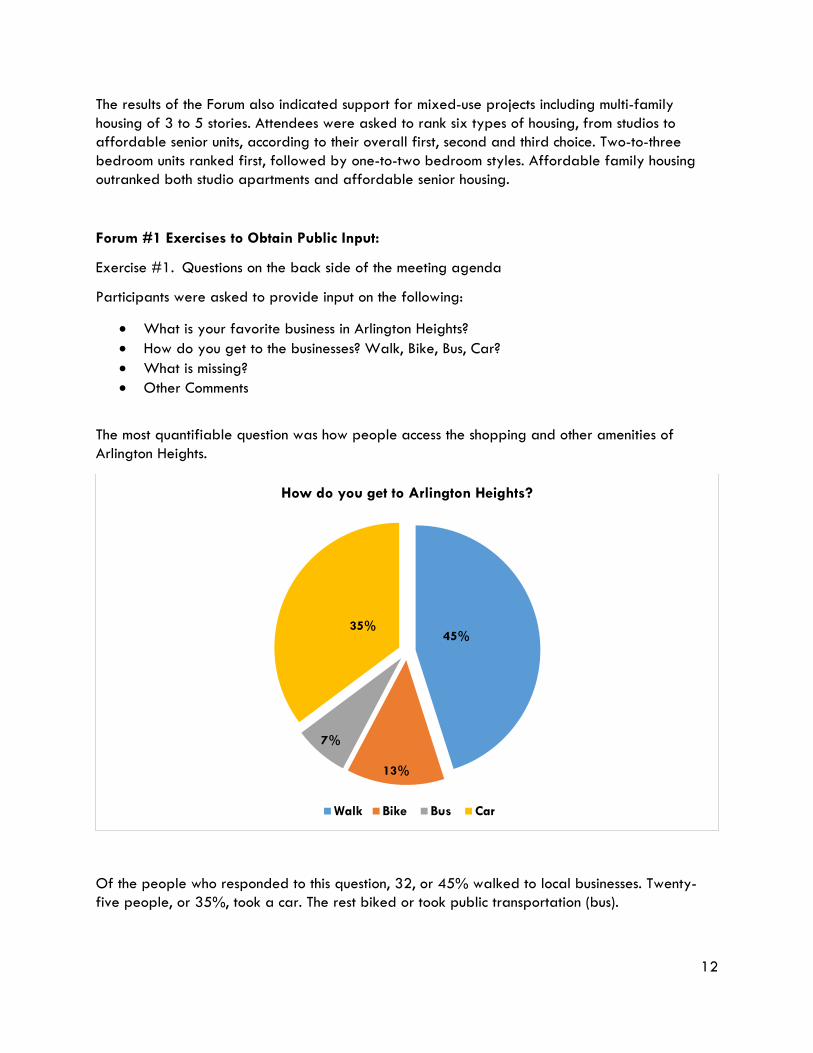
The most quantifiable question was how people access the shopping and other amenities of Arlington Heights.
Of the people who responded to this question, 32, or 45% walked to local businesses. Twenty-five people, or 35%, took a car. The rest biked or took public transportation (bus).
45%
13%
7%
35%
How do you get to Arlington Heights?
Walk Bike Bus Car
13
These results illustrate the need to continue to improve the bike/pedestrian-friendly nature of the Heights, while also recognizing that there will be a continuing need to provide adequate parking for vehicles for those who drive to the Heights. The need for parking was echoed in the table discussions as well.
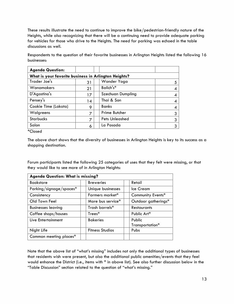
Respondents to the question of their favorite businesses in Arlington Heights listed the following 16 businesses:
Agenda Question: What is your favorite business in Arlington Heights? Trader Joe's 31 Wonder Yoga 5 Wanamakers 21 Balich's* 4 D'Agostino's 17 Szechuan Dumpling 4 Pensey's 14 Thai & Son 4 Cookie Time (Lakota) 9 Banks 4 Walgreens 7 Prime Butcher 3 Starbucks 7 Pets Unleashed 3 Salon 6 La Posada 3
*Closed
The above chart shows that the diversity of businesses in Arlington Heights is key to its success as a shopping destination.
Forum participants listed the following 25 categories of uses that they felt were missing, or that they would like to see more of in Arlington Heights:
Agenda Question: What is missing? Bookstore Breweries Retail Parking/signage/spaces* Unique businesses Ice Cream Consistency Farmers market* Community Events* Old Town Feel More bus service* Outdoor gatherings* Businesses leaving Trash barrels* Restaurants Coffee shops/houses Trees* Public Art* Live Entertainment Bakeries Public
Transportation* Night Life Fitness Studios Pubs Common meeting places*
Note that the above list of “what’s missing” includes not only the additional types of businesses that residents wish were present, but also the additional public amenities/events that they feel would enhance the District (i.e., items with * in above list). See also further discussion below in the “Table Discussion” section related to the question of “what’s missing.”
14
Exercise #2. Table Discussion
As part of the Table Discussion Exercise, participants were asked to provide their ideas related to the following questions:
• What do you like about Arlington Heights? What are the greatest assets? • What is missing? What are the critical issues to address? • What are the opportunities? • What is your vision for Arlington Heights?
This “Assets” question echoes, but is not quite the same as, the question asked in the “Agenda exercise” above, which was more directly related to retail. This table discussion question is broader, and has therefore resulted in a broader set of responses regarding assets.
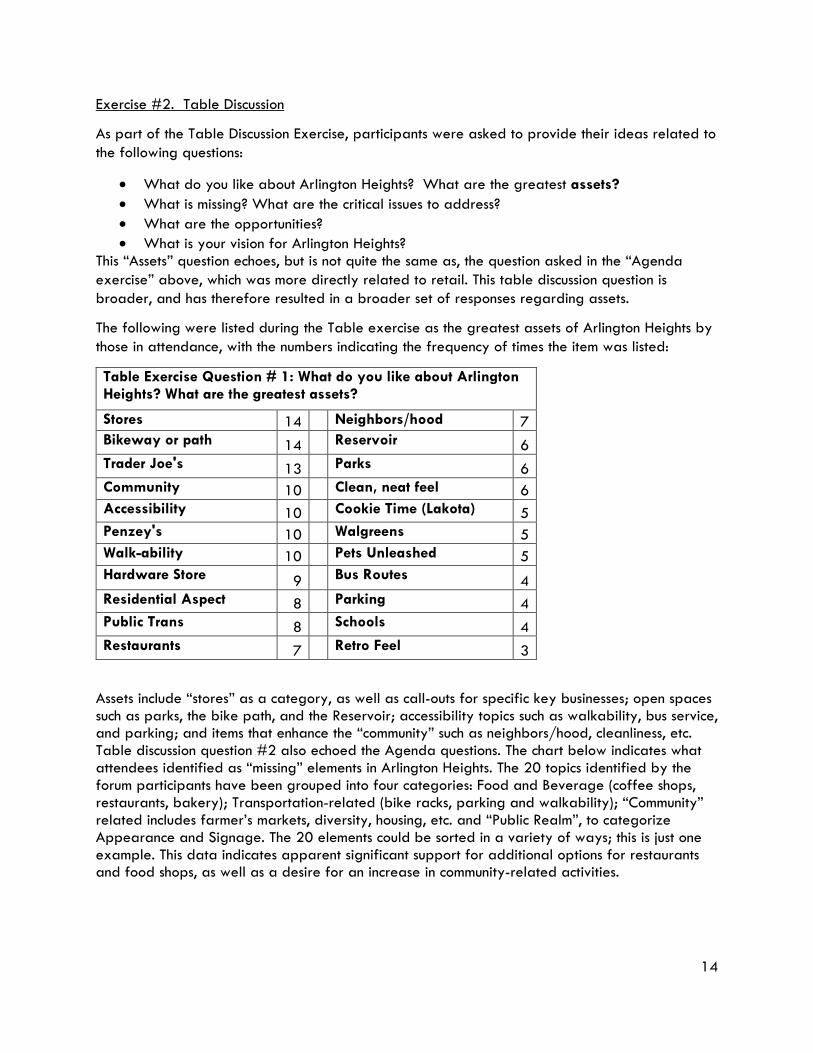
The following were listed during the Table exercise as the greatest assets of Arlington Heights by those in attendance, with the numbers indicating the frequency of times the item was listed:
Table Exercise Question # 1: What do you like about Arlington Heights? What are the greatest assets?
Stores 14 Neighbors/hood 7 Bikeway or path 14 Reservoir 6 Trader Joe's 13 Parks 6 Community 10 Clean, neat feel 6 Accessibility 10 Cookie Time (Lakota) 5 Penzey's 10 Walgreens 5 Walk-ability 10 Pets Unleashed 5 Hardware Store 9 Bus Routes 4 Residential Aspect 8 Parking 4 Public Trans 8 Schools 4 Restaurants 7 Retro Feel 3
Assets include “stores” as a category, as well as call-outs for specific key businesses; open spaces such as parks, the bike path, and the Reservoir; accessibility topics such as walkability, bus service, and parking; and items that enhance the “community” such as neighbors/hood, cleanliness, etc. Table discussion question #2 also echoed the Agenda questions. The chart below indicates what attendees identified as “missing” elements in Arlington Heights. The 20 topics identified by the forum participants have been grouped into four categories: Food and Beverage (coffee shops, restaurants, bakery); Transportation-related (bike racks, parking and walkability); “Community” related includes farmer’s markets, diversity, housing, etc. and “Public Realm”, to categorize Appearance and Signage. The 20 elements could be sorted in a variety of ways; this is just one example. This data indicates apparent significant support for additional options for restaurants and food shops, as well as a desire for an increase in community-related activities.
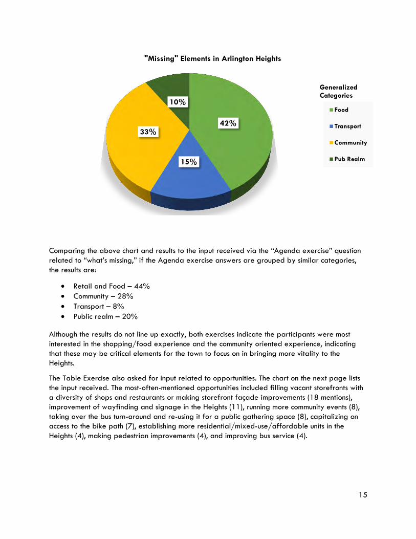
15
Comparing the above chart and results to the input received via the “Agenda exercise” question related to “what’s missing,” if the Agenda exercise answers are grouped by similar categories, the results are:
• Retail and Food – 44% • Community – 28% • Transport – 8% • Public realm – 20%
Although the results do not line up exactly, both exercises indicate the participants were most interested in the shopping/food experience and the community oriented experience, indicating that these may be critical elements for the town to focus on in bringing more vitality to the Heights.
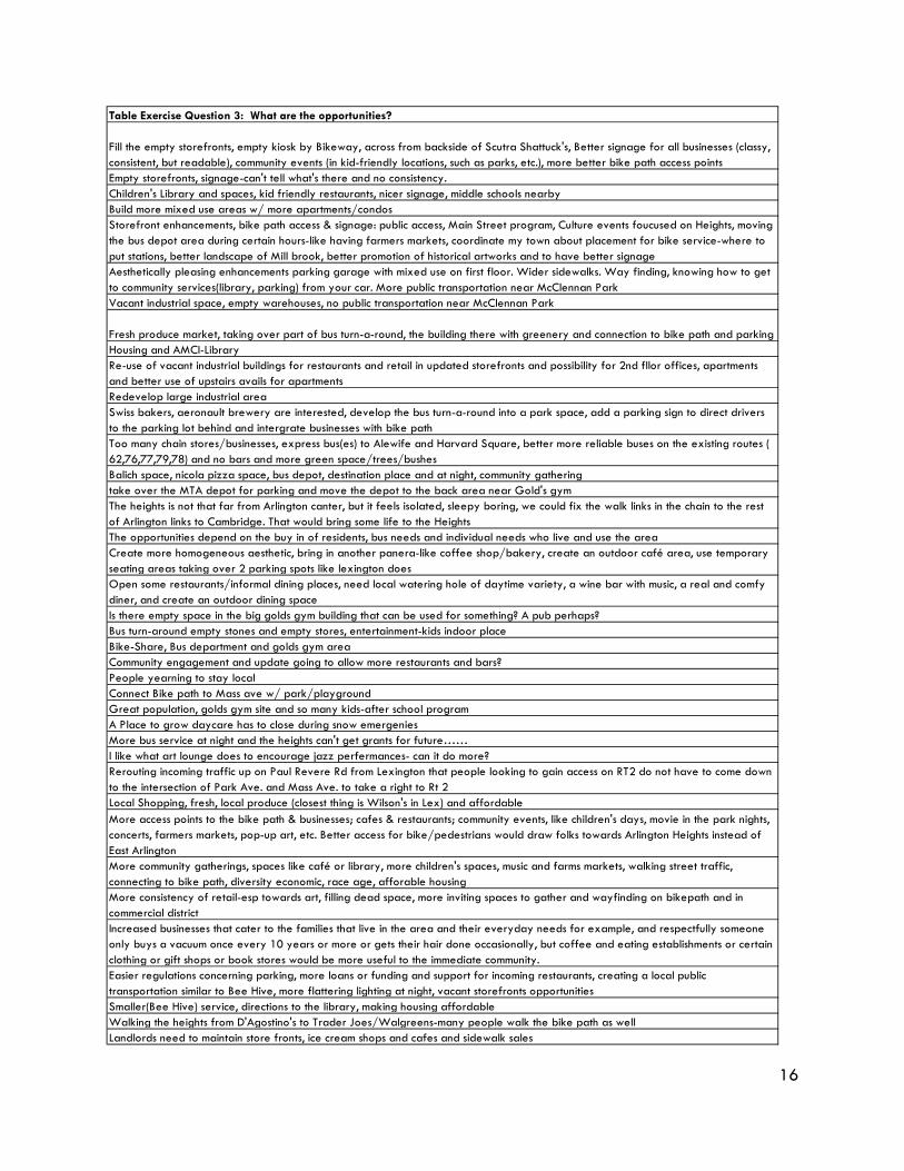
The Table Exercise also asked for input related to opportunities. The chart on the next page lists the input received. The most-often-mentioned opportunities included filling vacant storefronts with a diversity of shops and restaurants or making storefront façade improvements (18 mentions), improvement of wayfinding and signage in the Heights (11), running more community events (8), taking over the bus turn-around and re-using it for a public gathering space (8), capitalizing on access to the bike path (7), establishing more residential/mixed-use/affordable units in the Heights (4), making pedestrian improvements (4), and improving bus service (4).
42%
15%
33%
10%
"Missing" Elements in Arlington Heights
Food
Transport
Community
Pub Realm
Generalized Categories
16
Table Exercise Question 3: What are the opportunities?
Fill the empty storefronts, empty kiosk by Bikeway, across from backside of Scutra Shattuck's, Better signage for all businesses (classy, consistent, but readable), community events (in kid-friendly locations, such as parks, etc.), more better bike path access pointsEmpty storefronts, signage-can't tell what's there and no consistency.Children's Library and spaces, kid friendly restaurants, nicer signage, middle schools nearbyBuild more mixed use areas w/ more apartments/condosStorefront enhancements, bike path access & signage: public access, Main Street program, Culture events foucused on Heights, moving the bus depot area during certain hours-like having farmers markets, coordinate my town about placement for bike service-where to put stations, better landscape of Mill brook, better promotion of historical artworks and to have better signageAesthetically pleasing enhancements parking garage with mixed use on first floor. Wider sidewalks. Way finding, knowing how to get to community services(library, parking) from your car. More public transportation near McClennan ParkVacant industrial space, empty warehouses, no public transportation near McClennan Park
Fresh produce market, taking over part of bus turn-a-round, the building there with greenery and connection to bike path and parkingHousing and AMCI-LibraryRe-use of vacant industrial buildings for restaurants and retail in updated storefronts and possibility for 2nd fllor offices, apartments and better use of upstairs avails for apartmentsRedevelop large industrial areaSwiss bakers, aeronault brewery are interested, develop the bus turn-a-round into a park space, add a parking sign to direct drivers to the parking lot behind and intergrate businesses with bike pathToo many chain stores/businesses, express bus(es) to Alewife and Harvard Square, better more reliable buses on the existing routes ( 62,76,77,79,78) and no bars and more green space/trees/bushesBalich space, nicola pizza space, bus depot, destination place and at night, community gatheringtake over the MTA depot for parking and move the depot to the back area near Gold's gymThe heights is not that far from Arlington canter, but it feels isolated, sleepy boring, we could fix the walk links in the chain to the rest of Arlington links to Cambridge. That would bring some life to the HeightsThe opportunities depend on the buy in of residents, bus needs and individual needs who live and use the areaCreate more homogeneous aesthetic, bring in another panera-like coffee shop/bakery, create an outdoor café area, use temporary seating areas taking over 2 parking spots like lexington doesOpen some restaurants/informal dining places, need local watering hole of daytime variety, a wine bar with music, a real and comfy diner, and create an outdoor dining spaceIs there empty space in the big golds gym building that can be used for something? A pub perhaps?Bus turn-around empty stones and empty stores, entertainment-kids indoor placeBike-Share, Bus department and golds gym areaCommunity engagement and update going to allow more restaurants and bars?People yearning to stay localConnect Bike path to Mass ave w/ park/playgroundGreat population, golds gym site and so many kids-after school programA Place to grow daycare has to close during snow emergeniesMore bus service at night and the heights can't get grants for future……I like what art lounge does to encourage jazz perfermances- can it do more?Rerouting incoming traffic up on Paul Revere Rd from Lexington that people looking to gain access on RT2 do not have to come down to the intersection of Park Ave. and Mass Ave. to take a right to Rt 2Local Shopping, fresh, local produce (closest thing is Wilson's in Lex) and affordableMore access points to the bike path & businesses; cafes & restaurants; community events, like children's days, movie in the park nights, concerts, farmers markets, pop-up art, etc. Better access for bike/pedestrians would draw folks towards Arlington Heights instead of East ArlingtonMore community gatherings, spaces like café or library, more children's spaces, music and farms markets, walking street traffic, connecting to bike path, diversity economic, race age, afforable housingMore consistency of retail-esp towards art, filling dead space, more inviting spaces to gather and wayfinding on bikepath and in commercial districtIncreased businesses that cater to the families that live in the area and their everyday needs for example, and respectfully someone only buys a vacuum once every 10 years or more or gets their hair done occasionally, but coffee and eating establishments or certain clothing or gift shops or book stores would be more useful to the immediate community.Easier regulations concerning parking, more loans or funding and support for incoming restaurants, creating a local public transportation similar to Bee Hive, more flattering lighting at night, vacant storefronts opportunitiesSmaller(Bee Hive) service, directions to the library, making housing affordableWalking the heights from D'Agostino's to Trader Joes/Walgreens-many people walk the bike path as wellLandlords need to maintain store fronts, ice cream shops and cafes and sidewalk sales
17
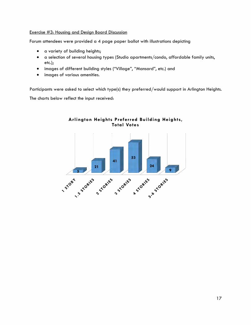
Exercise #3: Housing and Design Board Discussion
Forum attendees were provided a 4 page paper ballot with illustrations depicting
• a variety of building heights; • a selection of several housing types (Studio apartments/condo, affordable family units,
etc.); • images of different building styles (“Village”, “Mansard”, etc.) and • images of various amenities.
Participants were asked to select which type(s) they preferred/would support in Arlington Heights.
The charts below reflect the input received:
521
4153
249
Ar l ington Heights Prefer red Bui lding Heights, Total Votes
18
31
7
4
13
15
26
23
27 26 25
7
21
19 20
16
8
16
20
12
15
V I LLAGE COURTYARD CLASS ICAL MANSARD BLOCK
ARLINGTON HEIGHTS CHOICE OF BUILDING STYLES RESPONSES
Definitely Yes Yes No Definitely No
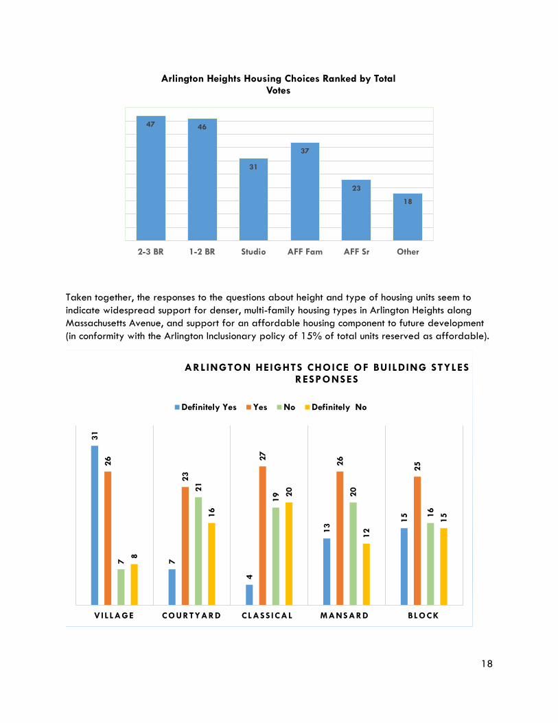
Taken together, the responses to the questions about height and type of housing units seem to indicate widespread support for denser, multi-family housing types in Arlington Heights along Massachusetts Avenue, and support for an affordable housing component to future development (in conformity with the Arlington Inclusionary policy of 15% of total units reserved as affordable).
47 46
31
37
23
18
2-3 BR 1-2 BR Studio AFF Fam AFF Sr Other
Arlington Heights Housing Choices Ranked by Total Votes
19
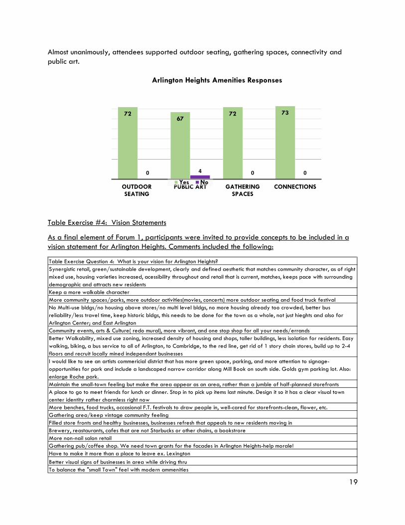
7267
72 73
0 4 0 0
OUTDOOR SEATING
PUBLIC ART GATHERING SPACES
CONNECTIONS
Arlington Heights Amenities Responses
Yes No
Almost unanimously, attendees supported outdoor seating, gathering spaces, connectivity and public art.
Table Exercise #4: Vision Statements
As a final element of Forum 1, participants were invited to provide concepts to be included in a vision statement for Arlington Heights. Comments included the following:
Table Exercise Question 4: What is your vision for Arlington Heights?Synergistic retail, green/sustainable development, clearly and defined aesthetic that matches community character, as of right mixed use, housing varieties increased, acessibility throughout and retail that is current, matches, keeps pace with surrounding demographic and attracts new residentsKeep a more walkable characterMore community spaces/parks, more outdoor activities(movies, concerts) more outdoor seating and food truck festivalNo Multi-use bldgs/no housing above stores/no multi level bldgs, no more housing already too crowded, better bus reliability/less travel time, keep historic bldgs, this needs to be done for the town as a whole, not just hieghts and also for Arlington Center; and East ArlingtonCommunity events, arts & Culture( redo mural), more vibrant, and one stop shop for all your needs/errandsBetter Walkability, mixed use zoning, increased density of housing and shops, taller buildings, less isolation for residents. Easy walking, biking, a bus service to all of Arlington, to Cambridge, to the red line, get rid of 1 story chain stores, build up to 2-4 floors and recruit locally mined independant businessesI would like to see an artists commericial district that has more green space, parking, and more attention to signage-opportunities for park and include a landscaped narrow corridor along Mill Book on south side. Golds gym parking lot. Also: enlarge Roche park.Maintain the small-town feeling but make the area appear as an area, rather than a jumble of half-planned storefrontsA place to go to meet friends for lunch or dinner. Stop in to pick up items last minute. Design it so it has a clear visual town center identity rather charmless right nowMore benches, food trucks, occasional F.T. festivals to draw people in, well-cared for storefronts-clean, flower, etc.Gathering area/keep vintage community feelingFilled store fronts and healthy businesses, businesses refresh that appeals to new residents moving inBrewery, reastaurants, cafes that are not Starbucks or other chains, a bookstroreMore non-nail salon retailGathering pub/coffee shop. We need town grants for the facades in Arlington Heights-help morale!Have to make it more than a place to leave ex. LexingtonBetter visual signs of businesses in area while driving thruTo balance the "small Town" feel with modern ammenities
20
PUBLIC FORUM #2, OCTOBER 4, 2018
A second forum was held on October 4, 2018. The main goal of this forum was to gather input from participants regarding the types/densities of uses, the associated parking, and public amenities such as open space that they would like to see in the future redevelopment of the 4-acre Gold’s Gym site, which represents one of the largest potential redevelopment sites in Arlington Heights. Elements such as the mix of uses selected for this location may reflect the participants’ broader goals for the Arlington Heights area, but specific design elements (e.g., height) may be more site-specific and should not be assumed to translate to the remainder of the Heights. Input received during this forum was used in preparing the draft Arlington Heights Planned Unit Development use table.
Meeting attendees were given a scaled map of the “Gold’s Gym” site and asked to imagine how they would like to see the site redeveloped in the future. They were also provided pieces of paper representing housing units, parking spaces, open space, retail and artisanal/fabrication space scaled at different square footages to aid in imagining the spatial requirements for each use category. In all, participants provided a total of 9 plans which represented the goals of those working in their groups.
Every plan included housing and retail. One plan did not include office space, while two did not include artisanal/fabrication space. All included open space, often emphasizing connectivity to Park Street and the existing Minuteman Bike Trail. Below is a summary of uses, by plan.
Plan # Total Housing Units
Total Retail Sq. Ft.
Total Office Sq. Ft.
Total Artisanal Sq. Ft.
Total Open Space Sq. Ft.
Total Parking Spaces
Plan 1 128-152 33,000 22,500 18,000 33,600 120
Plan 2 32 12,000 18,750 9,000 24,000 156
Plan 3 128 9,000 7,500 0 19,200 48
Plan 4 40 9,000 15,000 18,000 33,600 72
Plan 5 224 15,000 7,500 18,000 43,200 168
Plan 6 40 18,000 1,500 0 38,400 120
Plan 7 128 21,000 0 18,000 28,800 180
Plan 8 64 27,000 22,500 9,000 33,600 120
Plan 9 40 9,000 7,500 9,000 38,400 96
This exercise was an “informal” exercise, and is likely more illustrative of the goals of the participants than recommendations for actual specifics of proposed zoning. Some participants may not have directly connected the amount of square footage (or number of units) in a particular
21
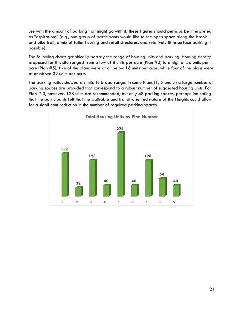
use with the amount of parking that might go with it; these figures should perhaps be interpreted as “aspirations” (e.g., one group of participants would like to see open space along the brook and bike trail, a mix of taller housing and retail structures, and relatively little surface parking if possible).
The following charts graphically portray the range of housing units and parking. Housing density proposed for this site ranged from a low of 8 units per acre (Plan #2) to a high of 56 units per acre (Plan #5); five of the plans were at or below 16 units per acre, while four of the plans were at or above 32 units per acre.
The parking ratios showed a similarly broad range. In some Plans (1, 5 and 7) a large number of parking spaces are provided that correspond to a robust number of suggested housing units. For Plan # 3, however, 128 units are recommended, but only 48 parking spaces, perhaps indicating that the participants felt that the walkable and transit-oriented nature of the Heights could allow for a significant reduction in the number of required parking spaces.
1 2 3 4 5 6 7 8 9
152
32
128
40
224
40
128
64
40
Total Housing Units by Plan Number
22
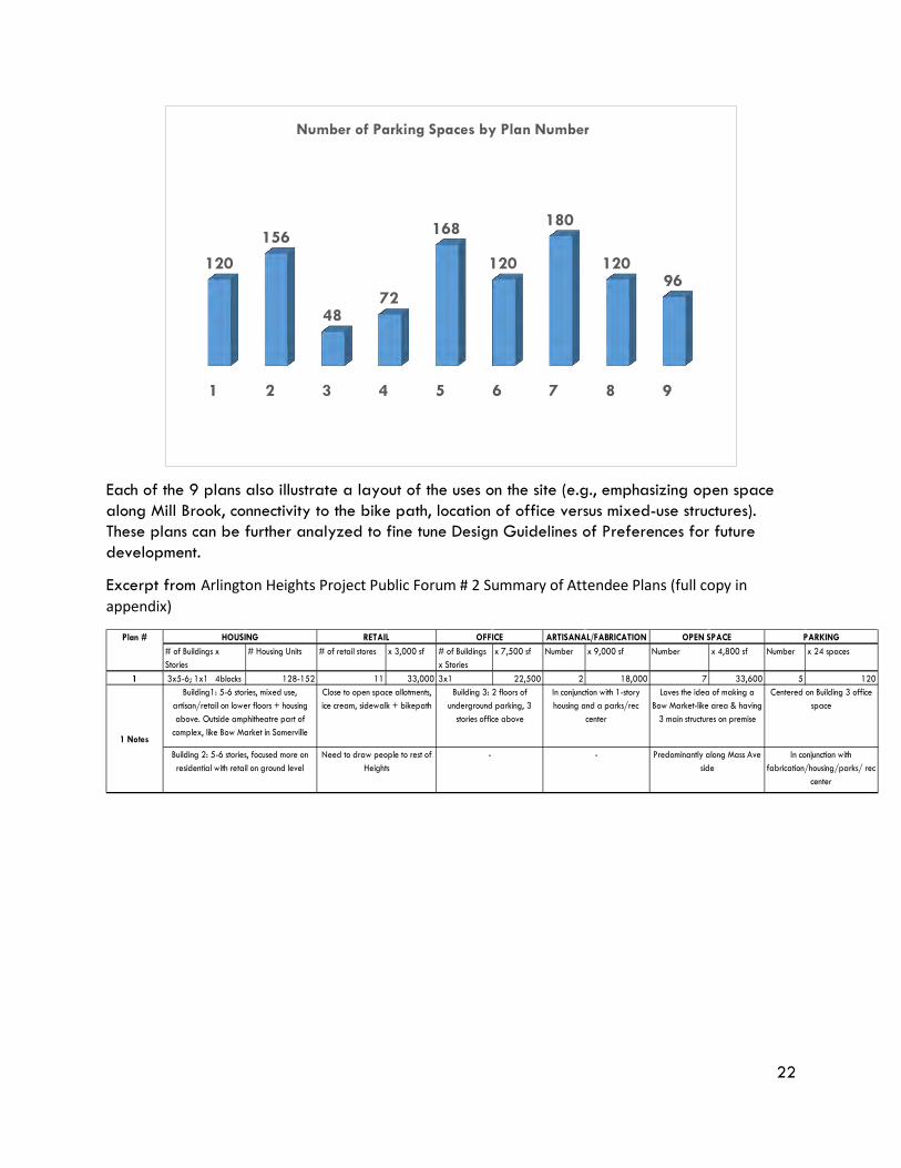
Each of the 9 plans also illustrate a layout of the uses on the site (e.g., emphasizing open space along Mill Brook, connectivity to the bike path, location of office versus mixed-use structures). These plans can be further analyzed to fine tune Design Guidelines of Preferences for future development.
Excerpt from Arlington Heights Project Public Forum # 2 Summary of Attendee Plans (full copy in appendix)
1 2 3 4 5 6 7 8 9
120
156
48 72
168
120
180
120 96
Number of Parking Spaces by Plan Number
# of Buildings x Stories
# Housing Units # of retail stores x 3,000 sf # of Buildings x Stories
x 7,500 sf Number x 9,000 sf Number x 4,800 sf Number x 24 spaces
1 3x5-6; 1x1 4blocks 128-152 11 33,000 3x1 22,500 2 18,000 7 33,600 5 120
PARKING
1 Notes
Building1: 5-6 stories, mixed use, artisan/retail on lower floors + housing above. Outside amphitheatre part of
complex, like Bow Market in Somerville
Close to open space allotments, ice cream, sidewalk + bikepath
Building 3: 2 floors of underground parking, 3
stories office above
In conjunction with 1-story housing and a parks/rec
center
Loves the idea of making a Bow Market-like area & having
3 main structures on premise
Centered on Building 3 office space
Building 2: 5-6 stories, focused more on residential with retail on ground level
Need to draw people to rest of Heights
Plan # HOUSING RETAIL OFFICE ARTISANAL/FABRICATION OPEN SPACE
- - Predominantly along Mass Ave side
In conjunction with fabrication/housing/parks/ rec
center
23
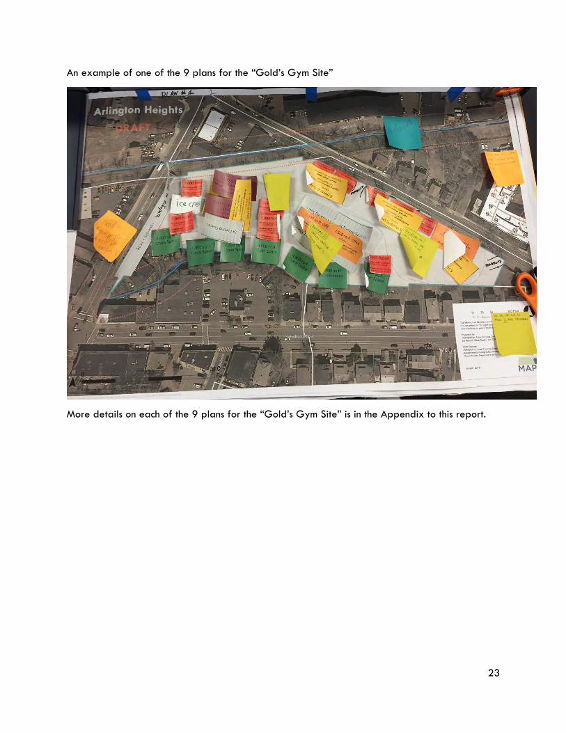
An example of one of the 9 plans for the “Gold’s Gym Site”
More details on each of the 9 plans for the “Gold’s Gym Site” is in the Appendix to this report.
24
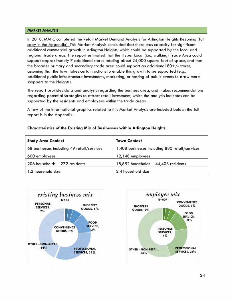
MARKET ANALYSIS
In 2018, MAPC completed the Retail Market Demand Analysis for Arlington Heights Rezoning (full copy in the Appendix). This Market Analysis concluded that there was capacity for significant additional commercial growth in Arlington Heights, which could be supported by the local and regional trade areas. The report estimated that the Hyper Local (i.e., walking) Trade Area could support approximately 7 additional stores totaling about 24,000 square feet of space, and that the broader primary and secondary trade area could support an additional 80+/- stores, assuming that the town takes certain actions to enable this growth to be supported (e.g., additional public infrastructure investments, marketing, or hosting of public events to draw more shoppers to the Heights).
The report provides data and analysis regarding the business area, and makes recommendations regarding potential strategies to attract retail investment, which the analysis indicates can be supported by the residents and employees within the trade areas.
A few of the informational graphics related to this Market Analysis are included below; the full report is in the Appendix.
Characteristics of the Existing Mix of Businesses within Arlington Heights:
Study Area Context Town Context
68 businesses including 49 retail/services 1,408 businesses including 880 retail/services
600 employees 12,148 employees
206 households 272 residents 18,652 households 44,408 residents
1.3 household size 2.4 household size
25
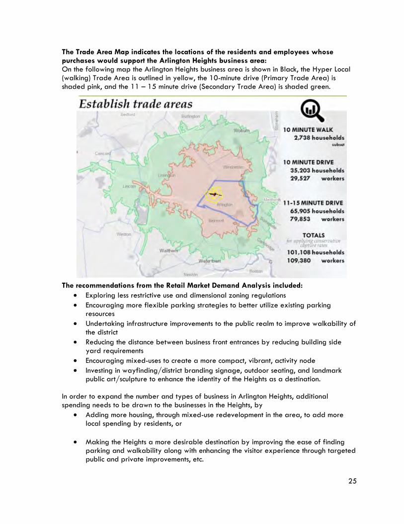
The Trade Area Map indicates the locations of the residents and employees whose purchases would support the Arlington Heights business area: On the following map the Arlington Heights business area is shown in Black, the Hyper Local (walking) Trade Area is outlined in yellow, the 10-minute drive (Primary Trade Area) is shaded pink, and the 11 – 15 minute drive (Secondary Trade Area) is shaded green. The recommendations from the Retail Market Demand Analysis included:
• Exploring less restrictive use and dimensional zoning regulations • Encouraging more flexible parking strategies to better utilize existing parking
resources • Undertaking infrastructure improvements to the public realm to improve walkability of
the district • Reducing the distance between business front entrances by reducing building side
yard requirements • Encouraging mixed-uses to create a more compact, vibrant, activity node • Investing in wayfinding/district branding signage, outdoor seating, and landmark
public art/sculpture to enhance the identity of the Heights as a destination. In order to expand the number and types of business in Arlington Heights, additional spending needs to be drawn to the businesses in the Heights, by
• Adding more housing, through mixed-use redevelopment in the area, to add more local spending by residents, or
• Making the Heights a more desirable destination by improving the ease of finding
parking and walkability along with enhancing the visitor experience through targeted public and private improvements, etc.
26
ZONING ANALYSIS Based upon the input received from the Steering Committee, the public forums, and Arlington Planning Department staff, MAPC developed the following set of Key Goals and Development Principles, which served to guide MAPC’s zoning analysis and recommendations.
Key Goals to Guide Zoning Recommendations
• Maintain the community standards that have made Arlington an attractive and desirable place to live, work, and visit;
• Simplify the existing zoning for the area. The more straight-forward and direct the zoning,
the easier for business owners, developers, etc. to invest in the community; and
• Streamline project permitting
Development Principles for Arlington Heights
• Facilitate additional restaurants, desired community retail and services, and housing;
• Provide for a mix of uses in new/rehabilitated structures; and
• Encourage connectivity between the Bikeway and restaurants/shops in the study area

27
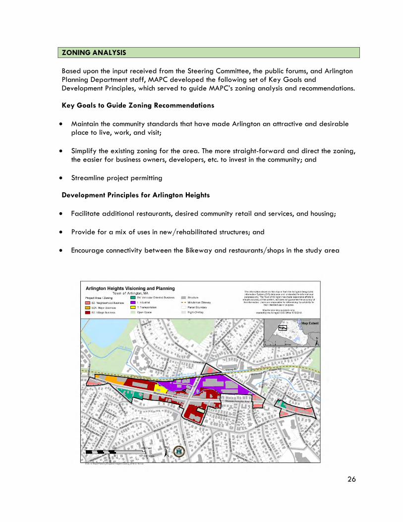
Zoning Overview: Zoning District, Dimensions and Uses Currently, land in the Study Area (see map) is zoned in the following four different Business districts, the Industrial District, and the Transportation district for the MBTA bus turn-around:
o B2 Neighborhood Business
o B2A Major Business
o B3 Village Business
o B4 Vehicular Oriented Business Each Business district includes Uses and Density and Dimensional Regulations. These are the key elements of zoning regulations because they specify what can be located where, and the allowable size of structures. Together with parking requirements, the dimensions prescribe how much of a given parcel can be developed. MAPC analyzed Dimensions and Uses, as summarized below.
Generalized Height and Use Characteristics in the Study Area Zoning Districts
Height Limit Uses/Comments
BUSINESS DISTRICTS Neighborhood Office (B-1) Not in study area – included for comparison
35 ft/3 stories 1 and 2 family homes;
Houses with 1st floor offices; offices
Neighborhood Business District (B-2)
35 ft/3 stories, 50 ft/4 stories for mixed-use
Retail and services oriented for pedestrians
Major Business District (B-2A)
40 ft/4 stories, 60 ft/5 stories for mixed-use
Retail and service establishments; medium density housing
Village Business District (B-3)
60 ft/5 stories Retail, services, offices. Mixed-use (Residential) encouraged. Pedestrian oriented
Vehicular Oriented Business District (B-4)
40 ft/4 stories, 60 ft/5 stories for mixed-use
Retail oriented toward automotive traffic; larger parking lots; includes auto sales, services stations. Town is encouraging shift to office, retail, services
INDUSTRIAL DISTRICT
Industrial District (I) 52 ft/4 stories Manufacturing, assembly, processing
Transportation District
28
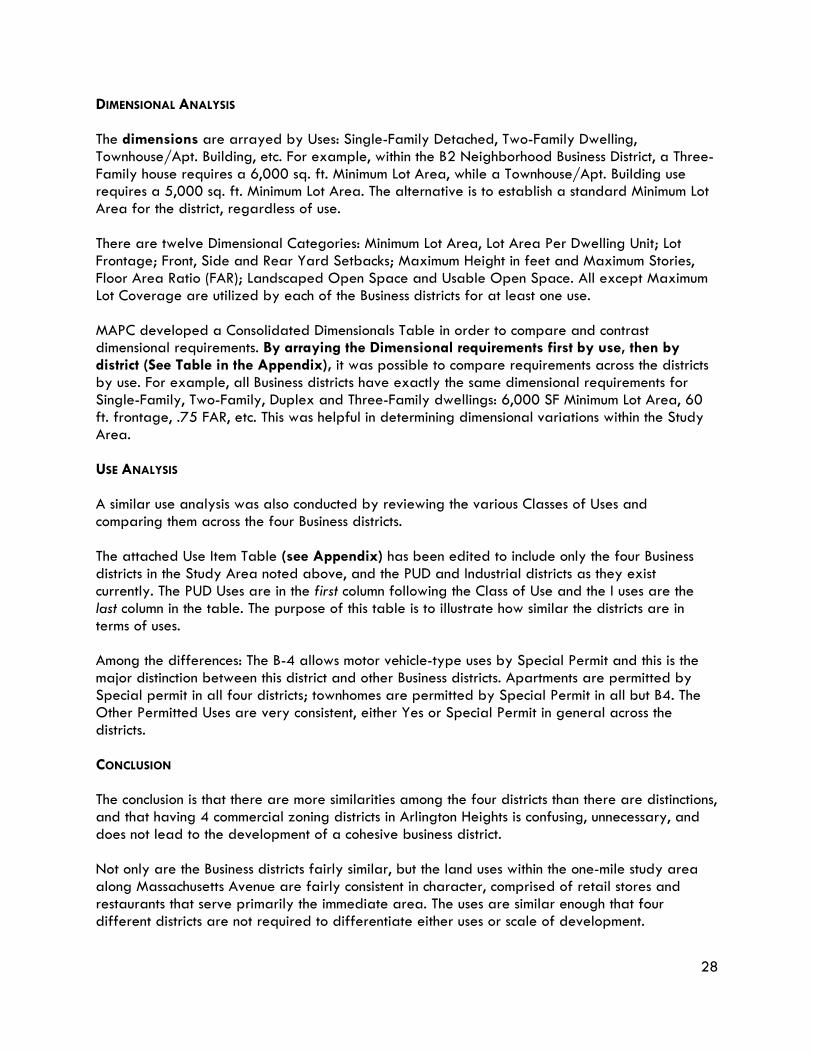
DIMENSIONAL ANALYSIS The dimensions are arrayed by Uses: Single-Family Detached, Two-Family Dwelling, Townhouse/Apt. Building, etc. For example, within the B2 Neighborhood Business District, a Three-Family house requires a 6,000 sq. ft. Minimum Lot Area, while a Townhouse/Apt. Building use requires a 5,000 sq. ft. Minimum Lot Area. The alternative is to establish a standard Minimum Lot Area for the district, regardless of use. There are twelve Dimensional Categories: Minimum Lot Area, Lot Area Per Dwelling Unit; Lot Frontage; Front, Side and Rear Yard Setbacks; Maximum Height in feet and Maximum Stories, Floor Area Ratio (FAR); Landscaped Open Space and Usable Open Space. All except Maximum Lot Coverage are utilized by each of the Business districts for at least one use. MAPC developed a Consolidated Dimensionals Table in order to compare and contrast dimensional requirements. By arraying the Dimensional requirements first by use, then by district (See Table in the Appendix), it was possible to compare requirements across the districts by use. For example, all Business districts have exactly the same dimensional requirements for Single-Family, Two-Family, Duplex and Three-Family dwellings: 6,000 SF Minimum Lot Area, 60 ft. frontage, .75 FAR, etc. This was helpful in determining dimensional variations within the Study Area. USE ANALYSIS A similar use analysis was also conducted by reviewing the various Classes of Uses and comparing them across the four Business districts. The attached Use Item Table (see Appendix) has been edited to include only the four Business districts in the Study Area noted above, and the PUD and Industrial districts as they exist currently. The PUD Uses are in the first column following the Class of Use and the I uses are the last column in the table. The purpose of this table is to illustrate how similar the districts are in terms of uses. Among the differences: The B-4 allows motor vehicle-type uses by Special Permit and this is the major distinction between this district and other Business districts. Apartments are permitted by Special permit in all four districts; townhomes are permitted by Special Permit in all but B4. The Other Permitted Uses are very consistent, either Yes or Special Permit in general across the districts. CONCLUSION The conclusion is that there are more similarities among the four districts than there are distinctions, and that having 4 commercial zoning districts in Arlington Heights is confusing, unnecessary, and does not lead to the development of a cohesive business district. Not only are the Business districts fairly similar, but the land uses within the one-mile study area along Massachusetts Avenue are fairly consistent in character, comprised of retail stores and restaurants that serve primarily the immediate area. The uses are similar enough that four different districts are not required to differentiate either uses or scale of development.
29
ZONING ANALYSIS CONCLUSIONS AND RECOMMENDATIONS The primary zoning recommendation is to consolidate Business districts, and the Transportation district because it applies to one parcel, into a single Business district applicable to Arlington Heights. This district would be tailored to Uses and Dimensions appropriate to the Heights, consistent with community vision. Many uses in the new district (tentative name: Arlington Heights Business (AHB) district) should be as of right, rather than requiring a special permit, although some uses such as multi-family and mixed-use may need to remain by special permit in order to ensure that the developments are responsive to abutters concerns and design guidelines/criteria.
PERMITTING ANALYSIS Thorough project review is important to communities in order to ensure that projects meet zoning and environmental requirements, and that new development/redevelopment is of a scale and character that is compatible with existing conditions, or an improvement on existing conditions. However, there are projects that are smaller in scale, often proposed by local business owners, that require minimal of review. Time is indeed money to these applicants, and sometimes just hiring an attorney to represent them before town boards is a trying and expensive process. In a community such as Arlington, with strong professional planning staff, there is no reason not to have a tiered Site Plan review process (see page 30 of A Best Practices Model for Streamlined Local Permitting at https://www.mass.gov/files/documents/2016/07/os/permitting-bestpracticesguide.pdf). Professional staff can review certain projects, leaving the more impactful projects for board review. As long as there is a public information process and the Arlington Redevelopment Board is apprised of the projects, this can be very successful. Criteria would need to be developed and adopted by the Town, either through Town Meeting for a change in the zoning, or a Redevelopment Board public hearing if done under the Board’s Rules and Regulations. Although most smaller projects would be delegated to the staff, the Redevelopment Board would reserve the right to its own review if the project was deemed to be controversial. These expedited reviews save time and money for the applicant and allow the Redevelopment Board to focus its energy on larger project review and planning work. An additional recommendation would be to streamline the permitting process by developing a new Administrative Environmental Design Review. This would allow for staff review of smaller projects, ensuring the design meets the Town’s and the community’s standards. The town would develop a design checklist for the smaller projects undergoing staff review and ensure that review results are communicated at the next Redevelopment Board meeting. The current public hearing-based Environmental Design Review would be revised to allow for staff review. Larger projects would follow the existing process. All projects in the new zoning district would be subject to Environmental Design Review either by staff or the ARB.

30
SECTION IV What Do We Want to Do Now?
One of the overall conclusions of this project is that there is not a need for the multiple business districts that exist side-by-side in the Heights, and that consolidation of these districts into a single district could provide greater clarity and efficiency in the permitting process and greater consistency of future development in the Arlington Heights Business (AHB) district. In addition, in order to open up additional development opportunities consistent with the goals expressed by participants in the Arlington Heights planning process, MAPC is recommending that the portion of the industrial District to the east of Park Drive (i.e., the “Gold’s Gym site”) be re-zoned as the Arlington Heights Planned Unit Development (PUD-AH) district. The components of the new AHB district, and the PUD-AH district, are discussed separately below. Each section also includes a Use Table comparison to illustrate the proposed zoning versus the current Use Table in the zoning. MAPC recommends Arlington proceed to draft the district based on these components, or request additional assistance from MAPC to do so. In addition, MAPC is recommending other short term, non-zoning, activities to add foot traffic, and thereby support the Arlington Heights businesses, as well as to add as sense of vibrancy and vitality to the area. This effort should be undertaken in concert with the efforts to implement the Arlington Arts and Culture Plan. These activities are listed after the zoning discussion below.
ZONING ELEMENTS TO CONSIDER IN THE NEW AHB DISTRICT
Proposed Uses: New AHB District The DRAFT Use Table below (beginning on page 35) shows an array of proposed Uses for the new Arlington Heights Business District, along with the existing B2, B2A, B3, and B4 district Use Item array for comparison. The proposed AHB use items are largely based on participant feedback during the public forums. It is important to note that multi-family units are recommended to only be allowed as part of mixed-use projects, to ensure that commercial space is included as first floor uses to maintain an active street-front in the Heights. Because there are a number of zoning change proposals going to Town Meeting vote in spring 2019, MAPC recommends that the details of the AHB zoning be finalized after the Town Meeting vote. In the meantime, MAPC recommends establishing a committee (or re-authorizing and providing a new mission for the existing steering committee for this project) that would
• Support the zoning changes proposed for spring 2019 Town Meeting • Read and discuss the zoning recommendations of this report • Immediately after spring 2019 town meeting, begin to work on final recommended zoning
language for Arlington Heights (both the AHB and AH-PUD), so it is ready for close of Warrant in early 2020
Proposed Dimensions: New AHB district Some of MAPC’s suggested dimensional changes for the AHB district reflect the Multi-family zoning (MF district) project (which MAPC is working on concurrently and the results of which are
31
being considered at the 2019 Spring Town Meeting) recommendations because it is our belief that mixed-use, multi-family projects are appropriate along Massachusetts Avenue, including in Arlington Heights. Consistent regulations will help to streamline permitting. These proposed dimensions were developed by looking at existing requirements, and the resultant impact on development. The goal is to encourage appropriate development and provide flexibility. Min. Lot Area 5,000 sf All uses, consistent across
district Lot Area/DU 800 sf Most likely will be more limited
byother site factors
Lot Frontage 30 ft
Front Yard Varies – Contextual with adjacent properties
Side Yard 0 ft
Rear Yard 20 feet FAR 2.0 Max Height 60 ft., 5 stories by right (but 1
story less if subject to height buffer)
Height buffer : Consistent with MF district recommendations, reduce distances to 25-50 feet. Rationale: These dimensions retain a reasonable degree of relief for adjacent residential parcels while not effectively lowering height limits across entire parcels. Height Setback: Similar to recommendation for Multi-family zoning project, require a stepback above the third story, rather than above the second story. Open space: Similar to recommendations for Multi-family zoning project, eliminate the usable open space requirement for multifamily and mixed-use development, and instead increase the landscaped open space requirement from 10% to 20% of gross floor area. Also, allow up to 25% of landscaped open space to occur on balconies or rooftops.
Parking Requirements: 1 space per unit. Encourage rideshare; require bicycle parking. Continue to allow for additional reduction in parking based on Transit accessibility per Section 6.1.5. Commercial parking requirements should remain per the existing zoning bylaw.
32
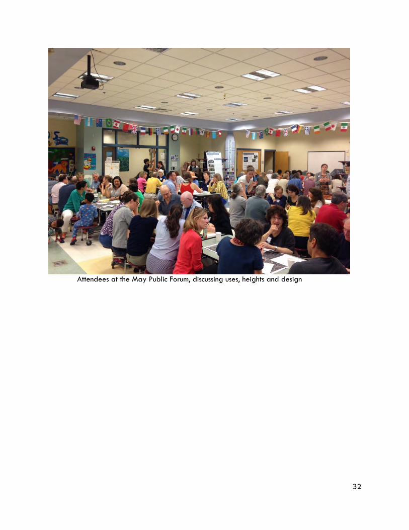
Attendees at the May Public Forum, discussing uses, heights and design
District Regulations / 5-33
33
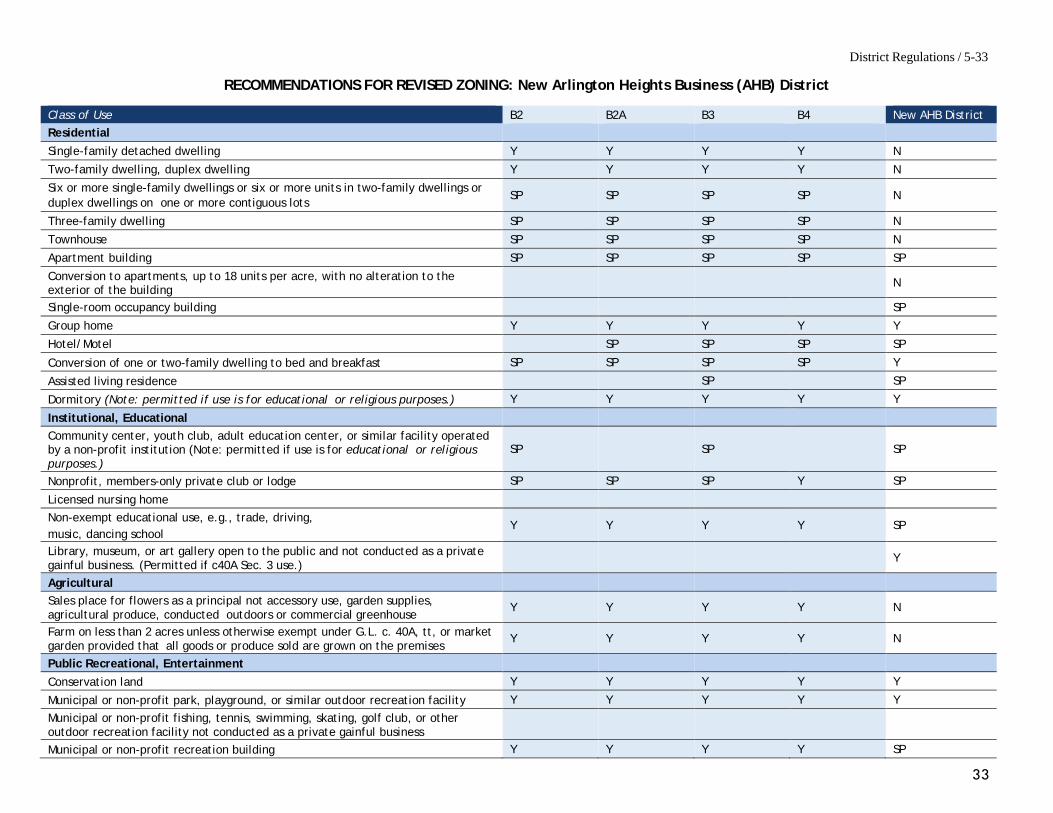
RECOMMENDATIONS FOR REVISED ZONING: New Arlington Heights Business (AHB) District
Class of Use B2 B2A B3 B4 New AHB District Residential
Single-family detached dwelling Y Y Y Y N
Two-family dwelling, duplex dwelling Y Y Y Y N
Six or more single-family dwellings or six or more units in two-family dwellings or duplex dwellings on one or more contiguous lots
SP SP SP SP N
Three-family dwelling SP SP SP SP N
Townhouse SP SP SP SP N
Apartment building SP SP SP SP SP
Conversion to apartments, up to 18 units per acre, with no alteration to the exterior of the building
N
Single-room occupancy building SP
Group home Y Y Y Y Y
Hotel/Motel SP SP SP SP
Conversion of one or two-family dwelling to bed and breakfast SP SP SP SP Y
Assisted living residence SP SP
Dormitory (Note: permitted if use is for educational or religious purposes.) Y Y Y Y Y
Institutional, Educational
Community center, youth club, adult education center, or similar facility operated by a non-profit institution (Note: permitted if use is for educational or religious purposes.)
SP SP SP
Nonprofit, members-only private club or lodge SP SP SP Y SP
Licensed nursing home
Non-exempt educational use, e.g., trade, driving, music, dancing school
Y Y Y Y SP
Library, museum, or art gallery open to the public and not conducted as a private gainful business. (Permitted if c40A Sec. 3 use.)
Y
Agricultural
Sales place for flowers as a principal not accessory use, garden supplies, agricultural produce, conducted outdoors or commercial greenhouse
Y Y Y Y N
Farm on less than 2 acres unless otherwise exempt under G.L. c. 40A, tt, or market garden provided that all goods or produce sold are grown on the premises
Y Y Y Y N
Public Recreational, Entertainment
Conservation land Y Y Y Y Y
Municipal or non-profit park, playground, or similar outdoor recreation facility Y Y Y Y Y
Municipal or non-profit fishing, tennis, swimming, skating, golf club, or other outdoor recreation facility not conducted as a private gainful business
Municipal or non-profit recreation building Y Y Y Y SP
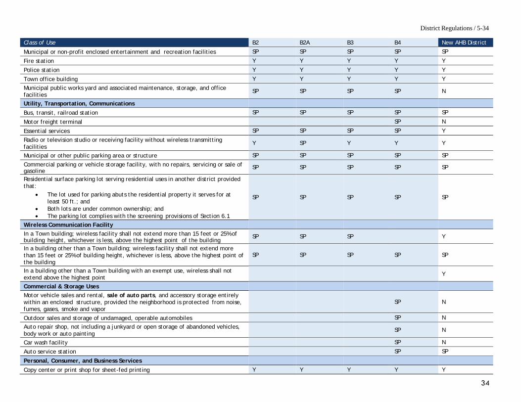
District Regulations / 5-34
34
Class of Use B2 B2A B3 B4 New AHB District
Municipal or non-profit enclosed entertainment and recreation facilities SP SP SP SP SP
Fire station Y Y Y Y Y
Police station Y Y Y Y Y
Town office building Y Y Y Y Y
Municipal public works yard and associated maintenance, storage, and office facilities
SP SP SP SP N
Utility, Transportation, Communications Bus, transit, railroad station SP SP SP SP SP
Motor freight terminal SP N
Essential services SP SP SP SP Y
Radio or television studio or receiving facility without wireless transmitting facilities
Y SP Y Y Y
Municipal or other public parking area or structure SP SP SP SP SP
Commercial parking or vehicle storage facility, with no repairs, servicing or sale of gasoline
SP SP SP SP SP
Residential surface parking lot serving residential uses in another district provided that:
• The lot used for parking abuts the residential property it serves for atleast 50 ft.; and
• Both lots are under common ownership; and• The parking lot complies with the screening provisions of Section 6.1
SP SP SP SP SP
Wireless Communication Facility In a Town building; wireless facility shall not extend more than 15 feet or 25% of building height, whichever is less, above the highest point of the building
SP SP SP Y
In a building other than a Town building; wireless facility shall not extend more than 15 feet or 25% of building height, whichever is less, above the highest point of the building
SP SP SP SP SP
In a building other than a Town building with an exempt use, wireless shall not extend above the highest point
Y
Commercial & Storage Uses Motor vehicle sales and rental, sale of auto parts, and accessory storage entirely within an enclosed structure, provided the neighborhood is protected from noise, fumes, gases, smoke and vapor
SP N
Outdoor sales and storage of undamaged, operable automobiles SP N
Auto repair shop, not including a junkyard or open storage of abandoned vehicles, body work or auto painting
SP N
Car wash facility SP N
Auto service station SP SP
Personal, Consumer, and Business Services Copy center or print shop for sheet-fed printing Y Y Y Y Y
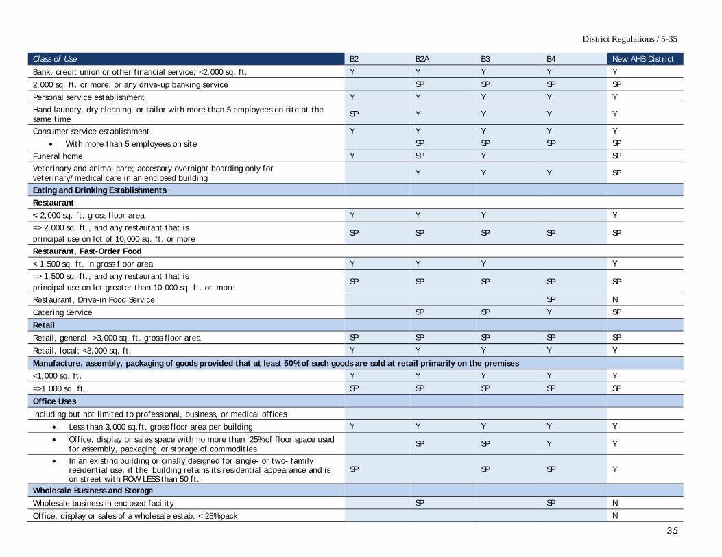
District Regulations / 5-35
35
Class of Use B2 B2A B3 B4 New AHB District
Bank, credit union or other financial service; <2,000 sq. ft. Y Y Y Y Y
2,000 sq. ft. or more, or any drive-up banking service SP SP SP SP
Personal service establishment Y Y Y Y Y
Hand laundry, dry cleaning, or tailor with more than 5 employees on site at the same time
SP Y Y Y Y
Consumer service establishment Y Y Y Y Y
• With more than 5 employees on site SP SP SP SP
Funeral home Y SP Y SP
Veterinary and animal care; accessory overnight boarding only for veterinary/medical care in an enclosed building
Y Y Y SP
Eating and Drinking Establishments
Restaurant
< 2,000 sq. ft. gross floor area Y Y Y Y
=> 2,000 sq. ft., and any restaurant that is principal use on lot of 10,000 sq. ft. or more
SP SP SP SP SP
Restaurant, Fast-Order Food
< 1,500 sq. ft. in gross floor area Y Y Y Y
=> 1,500 sq. ft., and any restaurant that is principal use on lot greater than 10,000 sq. ft. or more
SP SP SP SP SP
Restaurant, Drive-in Food Service SP N
Catering Service SP SP Y SP
Retail
Retail, general, >3,000 sq. ft. gross floor area SP SP SP SP SP
Retail, local; <3,000 sq. ft. Y Y Y Y Y
Manufacture, assembly, packaging of goods provided that at least 50% of such goods are sold at retail primarily on the premises <1,000 sq. ft. Y Y Y Y Y
=>1,000 sq. ft. SP SP SP SP SP
Office Uses
Including but not limited to professional, business, or medical offices
• Less than 3,000 sq.ft. gross floor area per building Y Y Y Y Y
• Office, display or sales space with no more than 25% of floor space used for assembly, packaging or storage of commodities
SP SP Y Y
• In an existing building originally designed for single- or two- family residential use, if the building retains its residential appearance and is on street with ROW LESS than 50 ft.
SP SP SP Y
Wholesale Business and Storage
Wholesale business in enclosed facility SP SP N
Office, display or sales of a wholesale estab. < 25% pack N
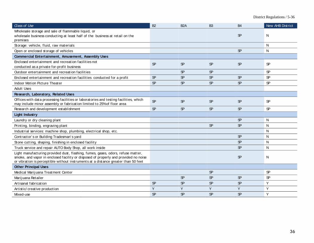
District Regulations / 5-36
36
Class of Use B2 B2A B3 B4 New AHB District
Wholesale storage and sale of flammable liquid, or wholesale business conducting at least half of the business at retail on the premises
SP N
Storage: vehicle, fluid, raw materials N
Open or enclosed storage of vehicles SP N
Commercial Entertainment, Amusement, Assembly Uses Enclosed entertainment and recreation facilities not conducted as a private for-profit business
SP SP SP SP SP
Outdoor entertainment and recreation facilities SP SP SP
Enclosed entertainment and recreation facilities conducted for a profit SP SP SP SP SP
Indoor Motion Picture Theater SP SP SP SP SP
Adult Uses
Research, Laboratory, Related Uses
Offices with data processing facilities or laboratories and testing facilities, which may include minor assembly or fabrication limited to 25% of floor area
SP SP SP SP SP
Research and development establishment SP SP SP SP SP
Light Industry
Laundry or dry cleaning plant SP N
Printing, binding, engraving plant SP SP N
Industrial services: machine shop, plumbing, electrical shop, etc. N
Contractor’s or Building Tradesman’s yard SP N
Stone cutting, shaping, finishing in enclosed facility SP N
Truck service and repair AUTO Body Shop, all work inside SP N
Light manufacturing provided dust, flashing, fumes, gases, odors, refuse matter, smoke, and vapor in enclosed facility or disposed of properly and provided no noise or vibration is perceptible without instruments at a distance greater than 50 feet
SP N
Other Principal Uses
Medical Marijuana Treatment Center SP SP
Marijuana Retailer SP SP SP SP
Artisanal fabrication SP SP SP SP Y
Artistic/creative production Y Y Y Y Y
Mixed-use SP SP SP SP Y
37
RE-ZONE GOLD’S GYM SITE AS PUD-AH This four acre site is the largest parcel in the Study Area. It holds tremendous potential for redevelopment into housing, with restaurant and retail use, as well as connectivity to the Minuteman Bikeway. As is noted above, this site was chosen as the topic for the October Public Forum, where participants were asked to provide their thoughts on what uses and site layout might be appropriate for redevelopment of the site. As is described in the Public Process in Section III above, each plan proposed by forum attendees included housing, retail and open space. One plan did not include office space, while two did not include artisanal/fabrication space. The location of the open space often emphasized connectivity to Park Street, the Mill Brook, and/or the existing Minuteman Bikeway.
The discussion and results of the second public forum, which focused on this location, are included above in Section III, with the detailed notes in the Appendix to this report. The spreadsheet in the Appendix indicates the types of uses attendees desired. Pictures of the site layouts prepared by the participant teams show the variety of ideas: from a focus on housing, to one on open space—even a new branch library! The site has many possibilities. OTHER CONSIDERATIONS FOR THE GOLD’S GYM SITE Proximity to Mill Brook is both a challenge and an opportunity. Construction near the day-lighted portions of the Brook will be subject to approval of the Town’s Conservation Commission. However, so much of the potential stream buffer of the Mill Brook is already paved, and any reconstruction on the property could be designed to actually improve stream quality. Potential development elements such as a river walk, outdoor seasonal seating for a coffee shop/wine bar, or a performance space all are possible. Linkages to the Minuteman Bikeway should also be incorporated into any redevelopment proposal to enable formal access from the Bikeway to Park Ave. and thereby to Arlington Heights. As climate issues are addressed, the amount of impervious surface, particularly on rebuilt (or never built) land, together with new stormwater regulations (federal MS 4 permits) will need to be carefully considered. Arlington’s existing PUD regulations provide flexibility and should be utilized wherever possible. MAPC recommends that, in general, the specific dimensions for the PUD-AH should mirror the AHB district, except that additional height, perhaps up to 65 ft, could be allowed because of the change in grade toward the rear of the site. The redevelopment of this site should also include design elements to improve circulation, such as a formal connection between Park Avenue and Lowell Street. The Design Standards for Arlington were adopted in 2015, and include sections on three corridors (Massachusetts Avenue, Mill Brook, and the Minutemen Bikeway) all of which come together and inter-relate in Arlington Heights. They should be reviewed in light of rezoning Massachusetts Avenue and the Multi-family zoning project. Additional detail may be helpful. If the Standards are not revised, perhaps Design Guidelines could be developed.

38
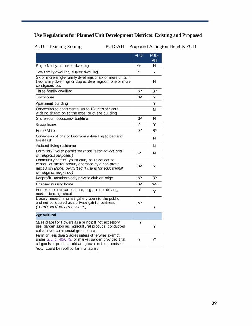
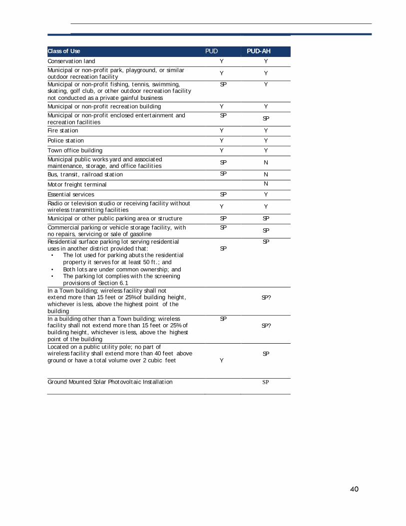
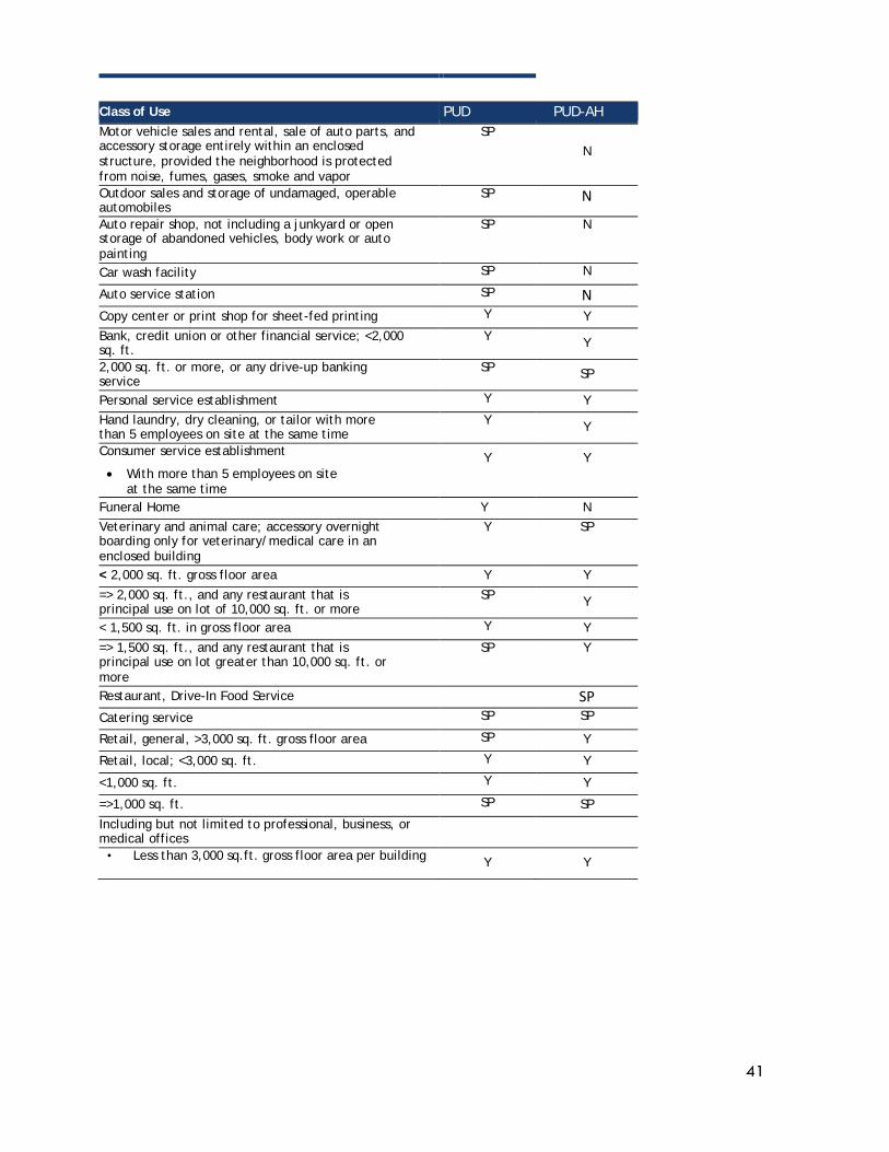
The Use Item Table below (beginning on the next page) shows potential uses that should be considered for this site, to make this Arlington Heights PUD (PUD-AH) meet more of the development goals identified through the public process for this Arlington Heights study.
39
Use Regulations for Planned Unit Development Districts: Existing and Proposed PUD = Existing Zoning PUD-AH = Proposed Arlington Heights PUD
PUD PUD- AH
Single-family detached dwelling Y+ N
Two-family dwelling, duplex dwelling Y Y Six or more single-family dwellings or six or more units in two-family dwellings or duplex dwellings on one or more contiguous lots
N
Three-family dwelling SP SP
Townhouse SP Y
Apartment building Y Conversion to apartments, up to 18 units per acre, with no alteration to the exterior of the building N
Single-room occupancy building SP N
Group home Y Y
Hotel/Motel SP SP
Conversion of one or two-family dwelling to bed and breakfast N
Assisted living residence N Dormitory (Note: permitted if use is for educational or religious purposes.)
SP N
Community center, youth club, adult education center, or similar facility operated by a non-profit institution (Note: permitted if use is for educational or religious purposes.)
SP
Y
Nonprofit, members-only private club or lodge SP SP
Licensed nursing home SP SP?
Non-exempt educational use, e.g., trade, driving, music, dancing school
Y Y
Library, museum, or art gallery open to the public and not conducted as a private gainful business. (Permitted if c40A Sec. 3 use.)
SP
Y
Agricultural
Sales place for flowers as a principal not accessory use, garden supplies, agricultural produce, conducted outdoors or commercial greenhouse
Y Y
Farm on less than 2 acres unless otherwise exempt under G.L. c. 40A, §3, or market garden provided that all goods or produce sold are grown on the premises
Y
Y*
*e.g., could be rooftop farm or apiary
40
Class of Use PUD PUD-AH Conservation land Y Y
Municipal or non-profit park, playground, or similar outdoor recreation facility Y Y
Municipal or non-profit fishing, tennis, swimming, skating, golf club, or other outdoor recreation facility not conducted as a private gainful business
SP Y
Municipal or non-profit recreation building Y Y Municipal or non-profit enclosed entertainment and recreation facilities
SP SP
Fire station Y Y
Police station Y Y
Town office building Y Y Municipal public works yard and associated maintenance, storage, and office facilities SP N
Bus, transit, railroad station SP N
Motor freight terminal N Essential services SP Y Radio or television studio or receiving facility without wireless transmitting facilities Y Y
Municipal or other public parking area or structure SP SP
Commercial parking or vehicle storage facility, with no repairs, servicing or sale of gasoline
SP SP
Residential surface parking lot serving residential uses in another district provided that:
• The lot used for parking abuts the residential property it serves for at least 50 ft.; and
• Both lots are under common ownership; and • The parking lot complies with the screening
provisions of Section 6.1
SP
SP
In a Town building; wireless facility shall not extend more than 15 feet or 25% of building height, whichever is less, above the highest point of the building
SP?
In a building other than a Town building; wireless facility shall not extend more than 15 feet or 25% of building height, whichever is less, above the highest point of the building
SP SP?
Located on a public utility pole; no part of wireless facility shall extend more than 40 feet above ground or have a total volume over 2 cubic feet
Y
SP
Ground Mounted Solar Photovoltaic Installation SP
DIS
TRIC
TS &
USE
S
41
Class of Use PUD PUD-AH Motor vehicle sales and rental, sale of auto parts, and accessory storage entirely within an enclosed structure, provided the neighborhood is protected from noise, fumes, gases, smoke and vapor
SP N
Outdoor sales and storage of undamaged, operable automobiles
SP N
Auto repair shop, not including a junkyard or open storage of abandoned vehicles, body work or auto painting
SP N
Car wash facility SP N Auto service station SP N Copy center or print shop for sheet-fed printing Y Y
Bank, credit union or other financial service; <2,000 sq. ft.
Y Y
2,000 sq. ft. or more, or any drive-up banking service
SP SP
Personal service establishment Y Y Hand laundry, dry cleaning, or tailor with more than 5 employees on site at the same time
Y Y
Consumer service establishment Y Y • With more than 5 employees on site
at the same time
Funeral Home Y N Veterinary and animal care; accessory overnight boarding only for veterinary/medical care in an enclosed building
Y SP
< 2,000 sq. ft. gross floor area Y Y
=> 2,000 sq. ft., and any restaurant that is principal use on lot of 10,000 sq. ft. or more
SP Y
< 1,500 sq. ft. in gross floor area Y Y
=> 1,500 sq. ft., and any restaurant that is principal use on lot greater than 10,000 sq. ft. or more
SP Y
Restaurant, Drive-In Food Service SP Catering service SP SP Retail, general, >3,000 sq. ft. gross floor area SP Y
Retail, local; <3,000 sq. ft. Y Y
<1,000 sq. ft. Y Y
=>1,000 sq. ft. SP SP
Including but not limited to professional, business, or medical offices
• Less than 3,000 sq.ft. gross floor area per building Y Y
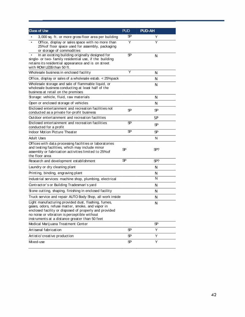
42
Class of Use PUD PUD-AH
• 3,000 sq. ft. or more gross floor area per building SP Y • Office, display or sales space with no more than
25% of floor space used for assembly, packaging or storage of commodities
Y Y
• In an existing building originally designed for single- or two- family residential use, if the building retains its residential appearance and is on street with ROW LESS than 50 ft.
SP
N
Wholesale business in enclosed facility Y N Office, display or sales of a wholesale estab. < 25% pack N Wholesale storage and sale of flammable liquid, or wholesale business conducting at least half of the business at retail on the premises
N
Storage: vehicle, fluid, raw materials N Open or enclosed storage of vehicles N Enclosed entertainment and recreation facilities not conducted as a private for-profit business SP SP
Outdoor entertainment and recreation facilities SP Enclosed entertainment and recreation facilities conducted for a profit
SP SP
Indoor Motion Picture Theater SP SP
Adult Uses N Offices with data processing facilities or laboratories and testing facilities, which may include minor assembly or fabrication activities limited to 25% of the floor area
SP
SP?
Research and development establishment SP SP?
Laundry or dry cleaning plant N Printing, binding, engraving plant N Industrial services: machine shop, plumbing, electrical h t
N
Contractor’s or Building Tradesman’s yard N Stone cutting, shaping, finishing in enclosed facility N Truck service and repair AUTO Body Shop, all work inside N Light manufacturing provided dust, flashing, fumes, gases, odors, refuse matter, smoke, and vapor in enclosed facility or disposed of properly and provided no noise or vibration is perceptible without instruments at a distance greater than 50 feet
N
Medical Marijuana Treatment Center SP
Artisanal fabrication SP Y
Artistic/creative production SP Y
Mixed-use SP Y D
ISTR
ICTS
& U
SES
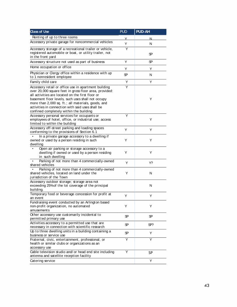
43
Class of Use PUD PUD-AH Renting of up to three rooms
Y N Accessory private garage for noncommercial vehicles Y N Accessory storage of a recreational trailer or vehicle, registered automobile or boat, or utility trailer, not in the front yard
Y SP
Accessory structure not used as part of business Y SP Home occupation or office Y Y Physician or Clergy office within a residence with up to 1 nonresident employee SP N
Family child care Y Y Accessory retail or office use in apartment building over 20,000 square feet in gross floor area, provided: all activities are located on the first floor or basement floor levels, such uses shall not occupy more than 2,000 sq. ft.; all materials, goods, and activities in connection with said uses shall be confined completely within the building
Y Y
Accessory personal services for occupants or employees of hotel, office, or industrial use; access limited to within the building
Y Y
Accessory off-street parking and loading spaces conforming to the provisions of Section 6.1 Y Y
• In a private garage accessory to a dwelling if owned or used by a person residing in such dwelling
Y
Y
• Open air parking or storage accessory to a dwelling if owned or used by a person residing in such dwelling
Y
Y
• Parking of not more than 4 commercially-owned shared vehicles Y Y?
• Parking of not more than 4 commercially-owned shared vehicles, located on land under the jurisdiction of the Town
Y
N
Accessory outdoor storage; storage area not exceeding 25% of the lot coverage of the principal building.
N
Temporary food or beverage concession for profit at an event Y Y
Fundraising event conducted by an Arlington based non-profit organization, no automated amusements
Y
Y
Other accessory use customarily incidental to permitted primary use SP SP
Activities accessory to a permitted use that are necessary in connection with scientific research SP SP?
Up to three dwelling units in a building containing a business or service use
SP Y
Fraternal, civic, entertainment, professional, or health or similar clubs or organizations as an accessory use
Y Y
Cable television studio and/or head end site including antenna and satellite reception facility
Y SP
Catering service
Y
44
OTHER RECOMMENDATIONS, INCLUDING SHORT-TERM NON-ZONING RECOMMENDATIONS PERMITTING As discussed in the Permitting Section, a tiered Environmental Design Review process would help expedite smaller projects while ensuring an appropriate level of review. ARLINGTON LUMBER COMPANY The Lumber Company’s restoration of the historic office structure is testament to their commitment to the wellbeing of this neighborhood. The Lumber Company is also a catalyst for the “home improvement” cluster of stores in Arlington Heights: City Paint, Sherwin-Williams, Wanamaker’s Hardware, etc. MAPC recommends keeping the Industrial zoning on this site in order to maintain the existing businesses, which are an important cluster for the Arlington Heights district. Short term, non-zoning, actions to support businesses and vitality of Arlington Heights Additional short-term, non-zoning actions could include:
• Seek changes to local regulations (and if needed, to state limits on liquor licenses) to make it easier to open restaurants, as these are a major “wanted” element for the Heights;
• Plan for more public events (historical re-enactments, street-closure dance parties, arts events) to draw crowds to the Heights in order to meet the residents’ desires for more community events and to support commercial activity by increasing visibility and foot traffic;
• Begin negotiations with the MBTA regarding future temporary or permanent use of all or part of the bus turn-around for public events (dance parties, farmers’ markets, music events); try to host some events during the summer of 2019;
• Coordinate with the implementation of the Arts and Culture Plan to plan locations of murals to provide visual interest and identity for the Heights, support arts pop-ups in vacant storefronts, to plan for future installations (temporary or permanent) of public art, and to plan for community events.
• Make the Heights a more desirable location to go to spend money by improving the ease of finding parking, improving walkability, and enhancing the experience of shopping here through targeted public and private improvements, etc.
45
Appendices 1. MAPC Edited Use Regulations for Business Districts, PUD and I districts ......................................... 46 2. Consolidated Zoning Dimension Review 11 x 17 size ........................................................................ 53 3. October Forum Plan Analysis Spreadsheet 11 x 17 size .................................................................. 56 4. Materials used at Forum 1 to gather feedback on Uses, scale of structures, and Design ........... 64 5. Retail Market Demand Analysis for Arlington Heights Rezoning ...................................................... 68
46
APPENDIX I: MAPC Edited Use Regulations for Business Districts,
PUD, and I Districts
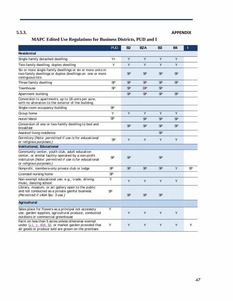
47
5.5.3. APPENDIX MAPC Edited Use Regulations for Business Districts, PUD and I
PUD B2 B2A B3 B4 I Residential
Single-family detached dwelling Y+ Y Y Y Y
Two-family dwelling, duplex dwelling Y Y Y Y Y Six or more single-family dwellings or six or more units in two-family dwellings or duplex dwellings on one or more contiguous lots
SP
SP
SP
SP
Three-family dwelling SP SP SP SP SP
Townhouse SP SP DP SP
Apartment building SP SP SP SP Conversion to apartments, up to 18 units per acre, with no alteration to the exterior of the building
Single-room occupancy building SP
Group home Y Y Y Y Y
Hotel/Motel SP SP SP SP
Conversion of one or two-family dwelling to bed and breakfast SP SP SP SP
Assisted living residence SP Dormitory (Note: permitted if use is for educational or religious purposes.)
SP Y Y Y Y
Institutional, Educational Community center, youth club, adult education center, or similar facility operated by a non-profit institution (Note: permitted if use is for educational or religious purposes.)
SP
SP
SP
Nonprofit, members-only private club or lodge SP SP SP SP Y SP
Licensed nursing home SP
Non-exempt educational use, e.g., trade, driving, music, dancing school
Y Y Y Y Y
Library, museum, or art gallery open to the public and not conducted as a private gainful business. (Permitted if c40A Sec. 3 use.)
SP
SP
SP
SP
Agricultural
Sales place for flowers as a principal not accessory use, garden supplies, agricultural produce, conducted outdoors or commercial greenhouse
Y Y
Y
Y
Y
Farm on less than 5 acres unless otherwise exempt under G.L. c. 40A, §3, or market garden provided that all goods or produce sold are grown on the premises
Y
Y
Y
Y
Y
Y
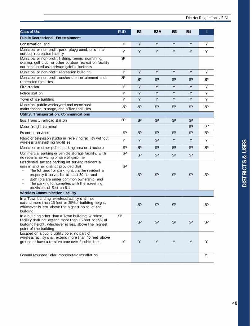
District Regulations / 5-31
48
Class of Use PUD B2 B2A B3 B4 I Public Recreational, Entertainment
Conservation land Y Y Y Y Y Y
Municipal or non-profit park, playground, or similar outdoor recreation facility Y Y Y Y Y Y
Municipal or non-profit fishing, tennis, swimming, skating, golf club, or other outdoor recreation facility not conducted as a private gainful business
SP
Municipal or non-profit recreation building Y Y Y Y Y Y Municipal or non-profit enclosed entertainment and recreation facilities
SP SP SP SP SP SP
Fire station Y Y Y Y Y Y
Police station Y Y Y Y Y Y
Town office building Y Y Y Y Y Y Municipal public works yard and associated maintenance, storage, and office facilities SP SP SP SP SP SP
Utility, Transportation, Communications
Bus, transit, railroad station SP SP SP SP SP
Motor freight terminal SP SP Essential services SP SP SP SP SP SP Radio or television studio or receiving facility without wireless transmitting facilities Y Y SP Y Y Y
Municipal or other public parking area or structure SP SP SP SP SP SP
Commercial parking or vehicle storage facility, with no repairs, servicing or sale of gasoline
SP SP SP SP SP
Residential surface parking lot serving residential uses in another district provided that:
• The lot used for parking abuts the residential property it serves for at least 50 ft.; and
• Both lots are under common ownership; and • The parking lot complies with the screening
provisions of Section 6.1
SP
SP
SP
SP
SP
SP
Wireless Communication Facility In a Town building; wireless facility shall not extend more than 15 feet or 25% of building height, whichever is less, above the highest point of the building
SP
SP
SP
SP
In a building other than a Town building; wireless facility shall not extend more than 15 feet or 25% of building height, whichever is less, above the highest point of the building
SP SP
SP
SP
SP
SP
Located on a public utility pole; no part of wireless facility shall extend more than 40 feet above ground or have a total volume over 2 cubic feet
Y
Y
Y
Y
Y
Y
Ground Mounted Solar Photovoltaic Installation Y
DIS
TRIC
TS &
USE
S
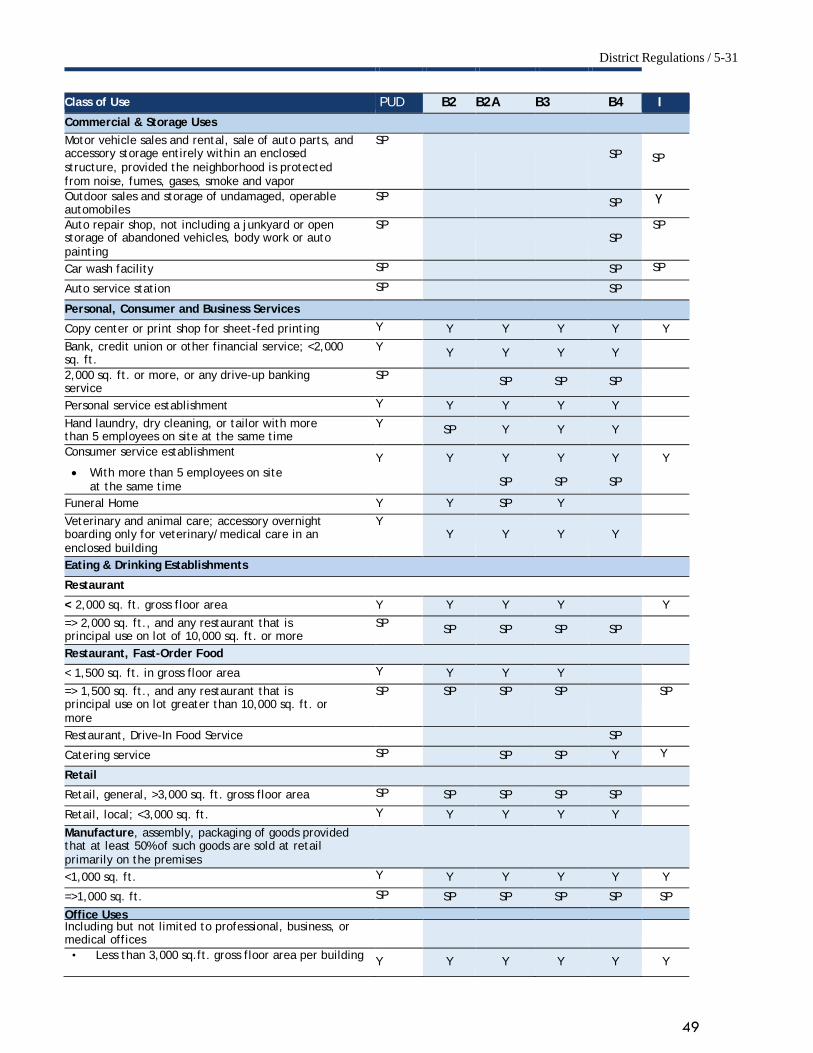
District Regulations / 5-31
49
Class of Use PUD B2 B2A B3 B4 I Commercial & Storage Uses Motor vehicle sales and rental, sale of auto parts, and accessory storage entirely within an enclosed structure, provided the neighborhood is protected from noise, fumes, gases, smoke and vapor
SP SP
SP
Outdoor sales and storage of undamaged, operable automobiles
SP SP Y
Auto repair shop, not including a junkyard or open storage of abandoned vehicles, body work or auto painting
SP SP
SP
Car wash facility SP SP SP Auto service station SP SP Personal, Consumer and Business Services
Copy center or print shop for sheet-fed printing Y Y Y Y Y Y Bank, credit union or other financial service; <2,000 sq. ft.
Y Y Y Y Y
2,000 sq. ft. or more, or any drive-up banking service
SP SP SP SP
Personal service establishment Y Y Y Y Y Hand laundry, dry cleaning, or tailor with more than 5 employees on site at the same time
Y SP Y Y Y
Consumer service establishment Y Y Y Y Y Y • With more than 5 employees on site
at the same time SP SP SP
Funeral Home Y Y SP Y
Veterinary and animal care; accessory overnight boarding only for veterinary/medical care in an enclosed building
Y Y
Y
Y
Y
Eating & Drinking Establishments
Restaurant
< 2,000 sq. ft. gross floor area Y Y Y Y Y
=> 2,000 sq. ft., and any restaurant that is principal use on lot of 10,000 sq. ft. or more
SP SP SP SP SP
Restaurant, Fast-Order Food
< 1,500 sq. ft. in gross floor area Y Y Y Y
=> 1,500 sq. ft., and any restaurant that is principal use on lot greater than 10,000 sq. ft. or more
SP SP SP SP SP
Restaurant, Drive-In Food Service SP Catering service SP SP SP Y Y Retail
Retail, general, >3,000 sq. ft. gross floor area SP SP SP SP SP
Retail, local; <3,000 sq. ft. Y Y Y Y Y
Manufacture, assembly, packaging of goods provided that at least 50% of such goods are sold at retail primarily on the premises <1,000 sq. ft. Y Y Y Y Y Y
=>1,000 sq. ft. SP SP SP SP SP SP
Office Uses Including but not limited to professional, business, or medical offices
• Less than 3,000 sq.ft. gross floor area per building Y Y Y Y Y Y
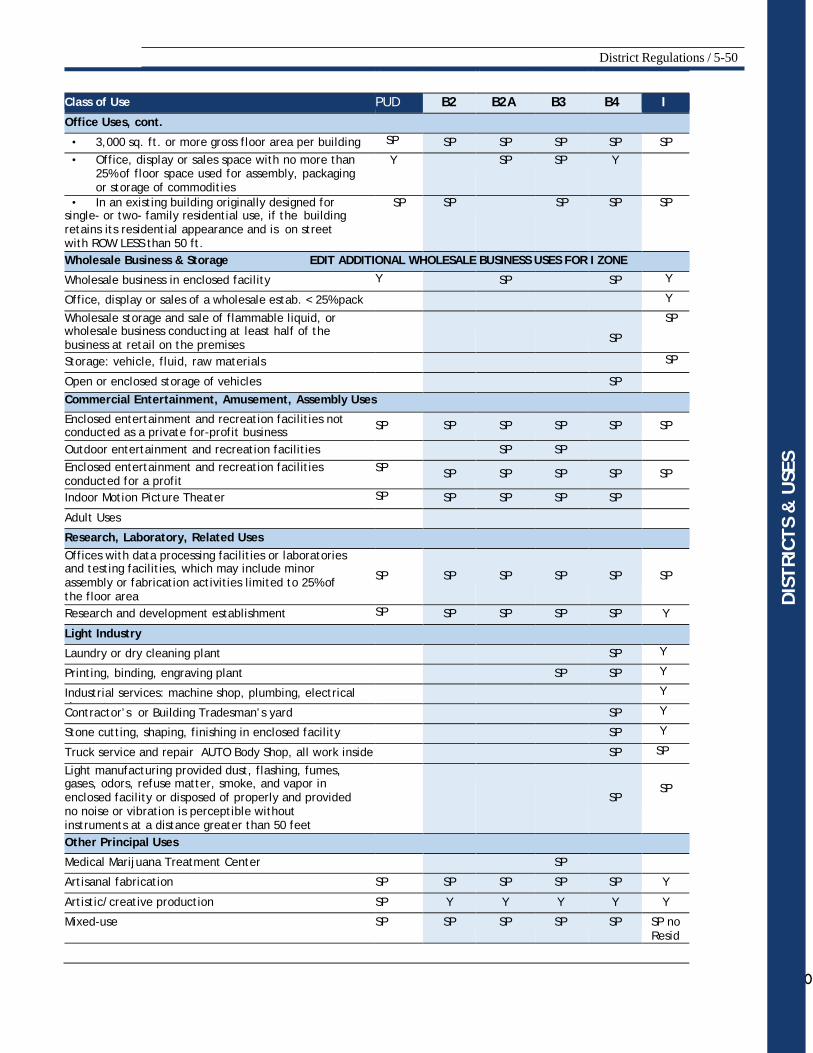
District Regulations / 5-50
50
Class of Use PUD B2 B2A B3 B4 I Office Uses, cont.
• 3,000 sq. ft. or more gross floor area per building SP SP SP SP SP SP • Office, display or sales space with no more than
25% of floor space used for assembly, packaging or storage of commodities
Y SP SP Y
• In an existing building originally designed for single- or two- family residential use, if the building retains its residential appearance and is on street with ROW LESS than 50 ft.
SP
SP SP SP SP
Wholesale Business & Storage EDIT ADDITIONAL WHOLESALE BUSINESS USES FOR I ZONE
Wholesale business in enclosed facility Y SP SP Y Office, display or sales of a wholesale estab. < 25% pack Y Wholesale storage and sale of flammable liquid, or wholesale business conducting at least half of the business at retail on the premises
SP
SP
Storage: vehicle, fluid, raw materials SP Open or enclosed storage of vehicles SP Commercial Entertainment, Amusement, Assembly Uses
Enclosed entertainment and recreation facilities not conducted as a private for-profit business SP SP SP SP SP SP
Outdoor entertainment and recreation facilities SP SP Enclosed entertainment and recreation facilities conducted for a profit
SP SP SP SP SP SP
Indoor Motion Picture Theater SP SP SP SP SP
Adult Uses
Research, Laboratory, Related Uses Offices with data processing facilities or laboratories and testing facilities, which may include minor assembly or fabrication activities limited to 25% of the floor area
SP
SP
SP
SP
SP
SP
Research and development establishment SP SP SP SP SP Y
Light Industry
Laundry or dry cleaning plant SP Y Printing, binding, engraving plant SP SP Y Industrial services: machine shop, plumbing, electrical h t
Y
Contractor’s or Building Tradesman’s yard SP Y Stone cutting, shaping, finishing in enclosed facility SP Y Truck service and repair AUTO Body Shop, all work inside SP SP Light manufacturing provided dust, flashing, fumes, gases, odors, refuse matter, smoke, and vapor in enclosed facility or disposed of properly and provided no noise or vibration is perceptible without instruments at a distance greater than 50 feet
SP
SP
Other Principal Uses
Medical Marijuana Treatment Center SP
Artisanal fabrication SP SP SP SP SP Y
Artistic/creative production SP Y Y Y Y Y
Mixed-use SP SP SP SP SP SP no Resid
DIS
TRIC
TS &
USE
S
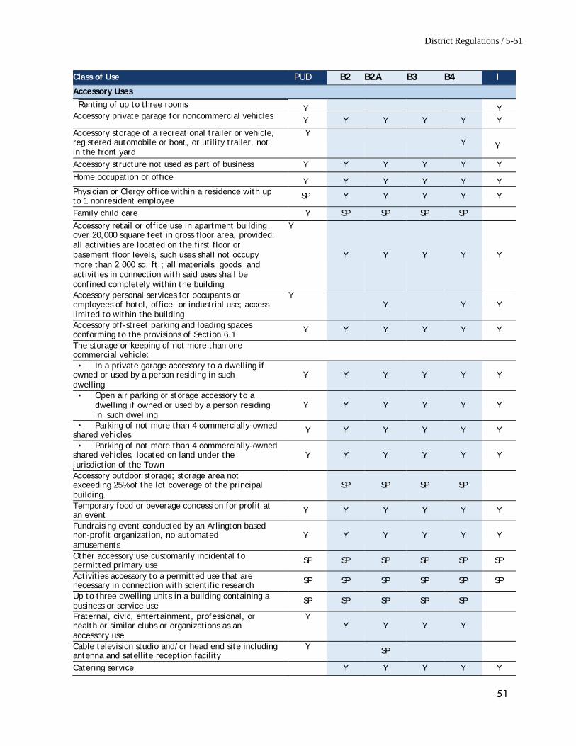
District Regulations / 5-51
51
Class of Use PUD B2 B2A B3 B4 I Accessory Uses
Renting of up to three rooms
Y Y Accessory private garage for noncommercial vehicles Y Y Y Y Y Y Accessory storage of a recreational trailer or vehicle, registered automobile or boat, or utility trailer, not in the front yard
Y Y
Y
Accessory structure not used as part of business Y Y Y Y Y Y Home occupation or office Y Y Y Y Y Y Physician or Clergy office within a residence with up to 1 nonresident employee SP Y Y Y Y Y
Family child care Y SP SP SP SP Accessory retail or office use in apartment building over 20,000 square feet in gross floor area, provided: all activities are located on the first floor or basement floor levels, such uses shall not occupy more than 2,000 sq. ft.; all materials, goods, and activities in connection with said uses shall be confined completely within the building
Y
Y
Y
Y
Y
Y
Accessory personal services for occupants or employees of hotel, office, or industrial use; access limited to within the building
Y Y
Y
Y
Accessory off-street parking and loading spaces conforming to the provisions of Section 6.1 Y Y Y Y Y Y
The storage or keeping of not more than one commercial vehicle:
• In a private garage accessory to a dwelling if owned or used by a person residing in such dwelling
Y
Y
Y
Y
Y
Y
• Open air parking or storage accessory to a dwelling if owned or used by a person residing in such dwelling
Y
Y
Y
Y
Y
Y
• Parking of not more than 4 commercially-owned shared vehicles Y Y Y Y Y Y
• Parking of not more than 4 commercially-owned shared vehicles, located on land under the jurisdiction of the Town
Y
Y
Y
Y
Y
Y
Accessory outdoor storage; storage area not exceeding 25% of the lot coverage of the principal building.
SP
SP
SP
SP
Temporary food or beverage concession for profit at an event Y Y Y Y Y Y
Fundraising event conducted by an Arlington based non-profit organization, no automated amusements
Y
Y
Y
Y
Y
Y
Other accessory use customarily incidental to permitted primary use SP SP SP SP SP SP
Activities accessory to a permitted use that are necessary in connection with scientific research SP SP SP SP SP SP
Up to three dwelling units in a building containing a business or service use
SP SP SP SP SP
Fraternal, civic, entertainment, professional, or health or similar clubs or organizations as an accessory use
Y Y
Y
Y
Y
Cable television studio and/or head end site including antenna and satellite reception facility
Y SP
Catering service Y Y Y Y Y

District Regulations / 5-52
52
This Page Intentionally Left Blank
53
APPENDIX II: Consolidated Zoning Dimension Review
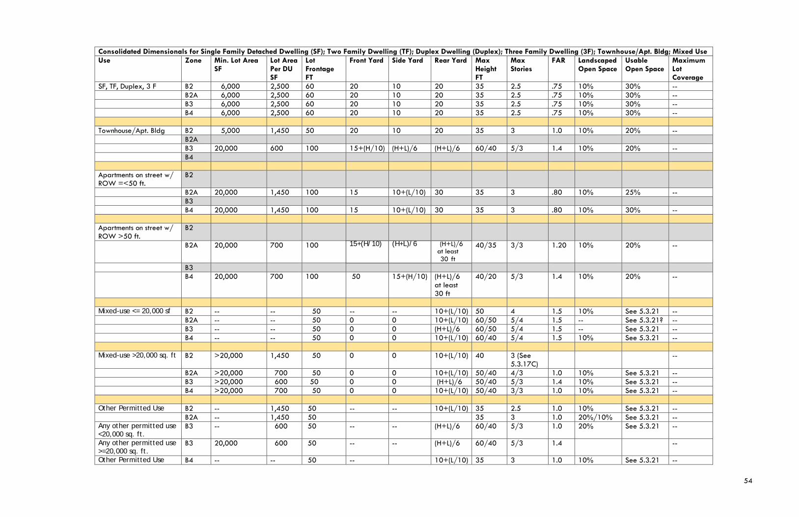
54
Consolidated Dimensionals for Single Family Detached Dwelling (SF); Two Family Dwelling (TF); Duplex Dwelling (Duplex); Three Family Dwelling (3F); Townhouse/Apt. Bldg; Mixed Use Use Zone Min. Lot Area
SF Lot Area Per DU SF
Lot Frontage FT
Front Yard Side Yard Rear Yard Max Height FT
Max Stories
FAR Landscaped Open Space
Usable Open Space
Maximum Lot Coverage
SF, TF, Duplex, 3 F B2 6,000 2,500 60 20 10 20 35 2.5 .75 10% 30% -- B2A 6,000 2,500 60 20 10 20 35 2.5 .75 10% 30% -- B3 6,000 2,500 60 20 10 20 35 2.5 .75 10% 30% -- B4 6,000 2,500 60 20 10 20 35 2.5 .75 10% 30% -- Townhouse/Apt. Bldg B2 5,000 1,450 50 20 10 20 35 3 1.0 10% 20% -- B2A B3 20,000 600 100 15+(H/10) (H+L)/6 (H+L)/6 60/40 5/3 1.4 10% 20% -- B4 Apartments on street w/ ROW =<50 ft.
B2
B2A 20,000 1,450 100 15 10+(L/10) 30 35 3 .80 10% 25% -- B3 B4 20,000 1,450 100 15 10+(L/10) 30 35 3 .80 10% 30% -- Apartments on street w/ ROW >50 ft.
B2
B2A 20,000 700 100 15+(H/10) (H+L)/6 (H+L)/6 at least 30 ft
40/35 3/3 1.20 10% 20% --
B3 B4 20,000 700 100 50 15+(H/10) (H+L)/6
at least 30 ft
40/20 5/3 1.4 10% 20% --
Mixed-use <= 20,000 sf B2 -- -- 50 -- -- 10+(L/10) 50 4 1.5 10% See 5.3.21 -- B2A -- -- 50 0 0 10+(L/10) 60/50 5/4 1.5 -- See 5.3.21? -- B3 -- -- 50 0 0 (H+L)/6 60/50 5/4 1.5 -- See 5.3.21 -- B4 -- -- 50 0 0 10+(L/10) 60/40 5/4 1.5 10% See 5.3.21 -- Mixed-use >20,000 sq. ft B2 >20,000 1,450 50 0 0 10+(L/10) 40 3 (See
5.3.17C) --
B2A >20,000 700 50 0 0 10+(L/10) 50/40 4/3 1.0 10% See 5.3.21 -- B3 >20,000 600 50 0 0 (H+L)/6 50/40 5/3 1.4 10% See 5.3.21 -- B4 >20,000 700 50 0 0 10+(L/10) 50/40 3/3 1.0 10% See 5.3.21 -- Other Permitted Use B2 -- 1,450 50 -- -- 10+(L/10) 35 2.5 1.0 10% See 5.3.21 -- B2A -- 1,450 50 35 3 1.0 20%/10% See 5.3.21 -- Any other permitted use <20,000 sq. ft.
B3 -- 600 50 -- -- (H+L)/6 60/40 5/3 1.0 20% See 5.3.21 --
Any other permitted use >=20,000 sq. ft.
B3 20,000 600 50 -- -- (H+L)/6 60/40 5/3 1.4 --
Other Permitted Use B4 -- -- 50 -- 10+(L/10) 35 3 1.0 10% See 5.3.21 --
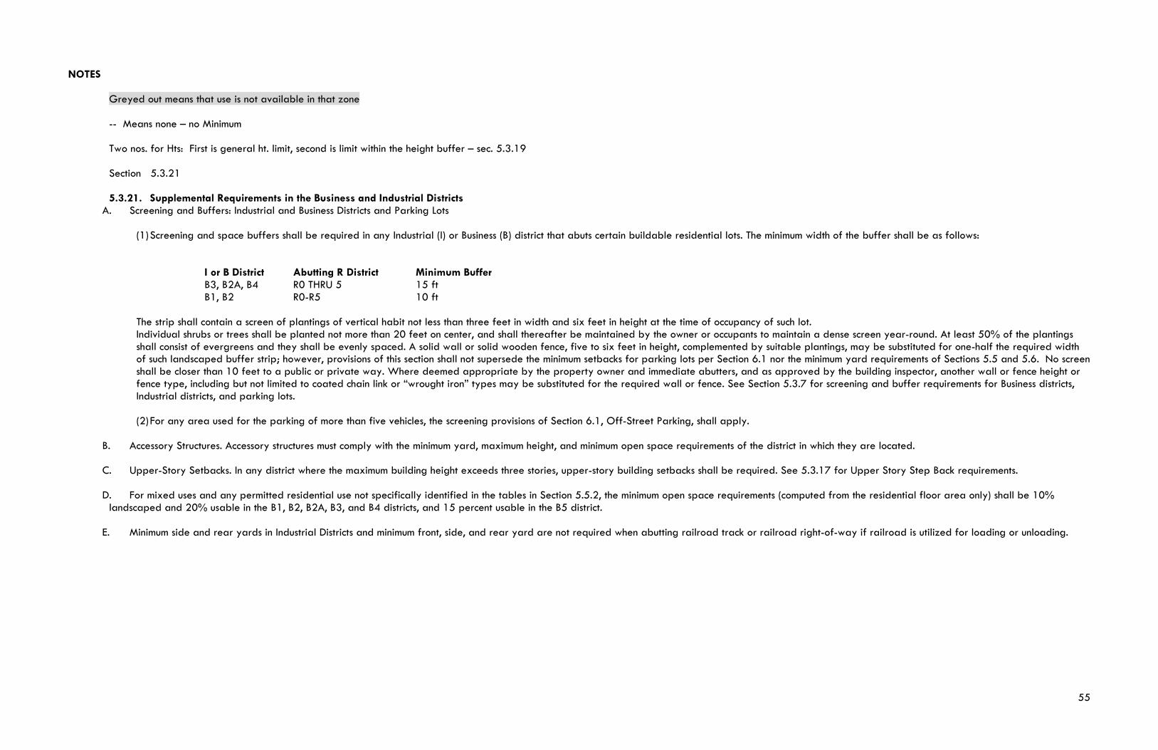
55
NOTES Greyed out means that use is not available in that zone -- Means none – no Minimum Two nos. for Hts: First is general ht. limit, second is limit within the height buffer – sec. 5.3.19 Section 5.3.21 5.3.21. Supplemental Requirements in the Business and Industrial Districts
A. Screening and Buffers: Industrial and Business Districts and Parking Lots
(1) Screening and space buffers shall be required in any Industrial (I) or Business (B) district that abuts certain buildable residential lots. The minimum width of the buffer shall be as follows:
I or B District Abutting R District Minimum Buffer B3, B2A, B4 R0 THRU 5 15 ft B1, B2 R0-R5 10 ft
The strip shall contain a screen of plantings of vertical habit not less than three feet in width and six feet in height at the time of occupancy of such lot. Individual shrubs or trees shall be planted not more than 20 feet on center, and shall thereafter be maintained by the owner or occupants to maintain a dense screen year-round. At least 50% of the plantings shall consist of evergreens and they shall be evenly spaced. A solid wall or solid wooden fence, five to six feet in height, complemented by suitable plantings, may be substituted for one-half the required width of such landscaped buffer strip; however, provisions of this section shall not supersede the minimum setbacks for parking lots per Section 6.1 nor the minimum yard requirements of Sections 5.5 and 5.6. No screen shall be closer than 10 feet to a public or private way. Where deemed appropriate by the property owner and immediate abutters, and as approved by the building inspector, another wall or fence height or fence type, including but not limited to coated chain link or “wrought iron” types may be substituted for the required wall or fence. See Section 5.3.7 for screening and buffer requirements for Business districts, Industrial districts, and parking lots.
(2) For any area used for the parking of more than five vehicles, the screening provisions of Section 6.1, Off-Street Parking, shall apply.
B. Accessory Structures. Accessory structures must comply with the minimum yard, maximum height, and minimum open space requirements of the district in which they are located. C. Upper-Story Setbacks. In any district where the maximum building height exceeds three stories, upper-story building setbacks shall be required. See 5.3.17 for Upper Story Step Back requirements. D. For mixed uses and any permitted residential use not specifically identified in the tables in Section 5.5.2, the minimum open space requirements (computed from the residential floor area only) shall be 10% landscaped and 20% usable in the B1, B2, B2A, B3, and B4 districts, and 15 percent usable in the B5 district. E. Minimum side and rear yards in Industrial Districts and minimum front, side, and rear yard are not required when abutting railroad track or railroad right-of-way if railroad is utilized for loading or unloading.
56
APPENDIX III: October Forum Plan Analysis Spreadsheet
APPENDIX III: October Forum Plan Analysis Spreadsheet
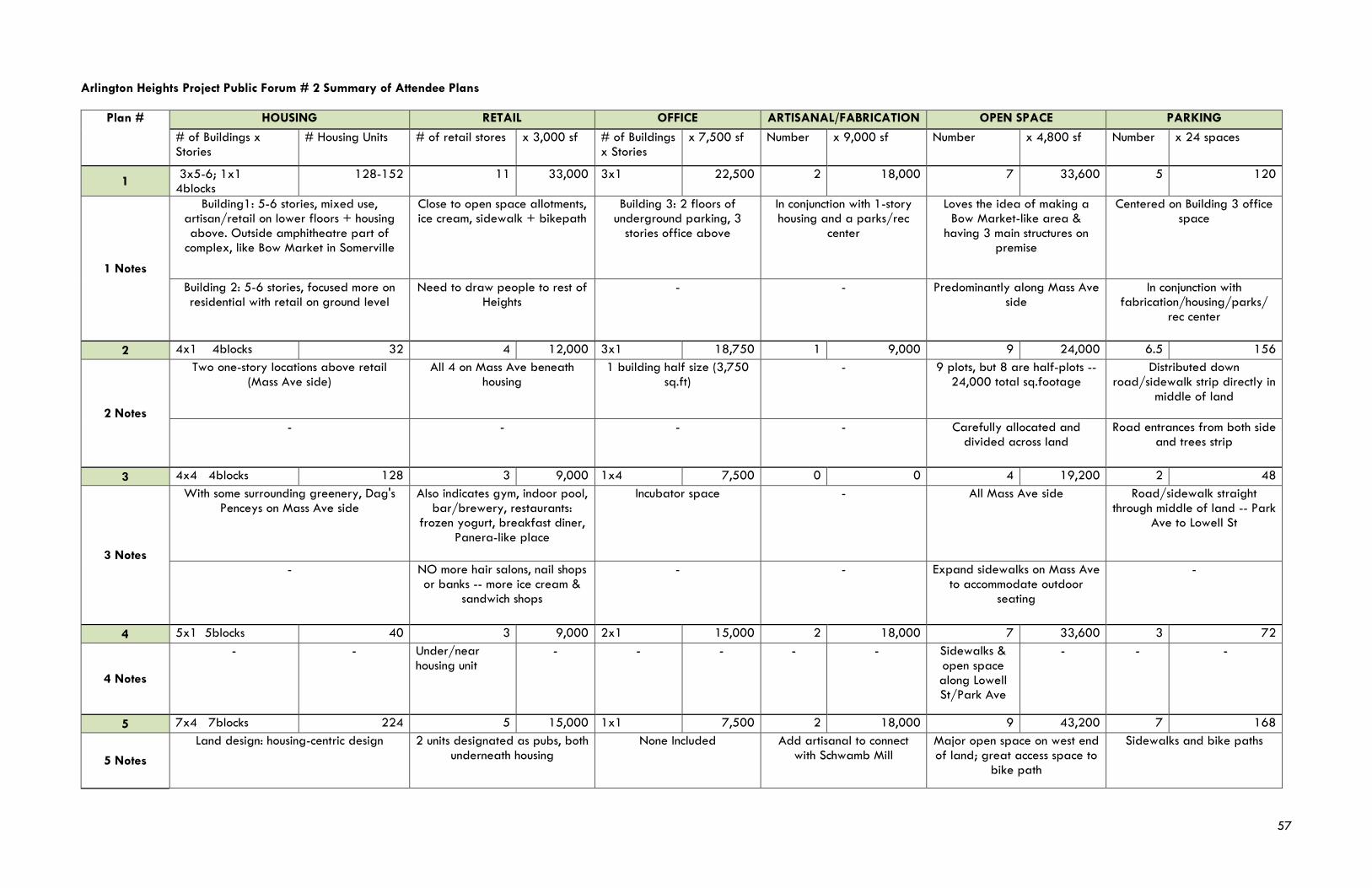
57
Arlington Heights Project Public Forum # 2 Summary of Attendee Plans
Plan # HOUSING RETAIL OFFICE ARTISANAL/FABRICATION OPEN SPACE PARKING # of Buildings x Stories
# Housing Units # of retail stores x 3,000 sf # of Buildings x Stories
x 7,500 sf Number x 9,000 sf Number x 4,800 sf Number x 24 spaces
1 3x5-6; 1x1 4blocks
128-152 11 33,000 3x1 22,500 2 18,000 7 33,600 5 120
1 Notes
Building1: 5-6 stories, mixed use, artisan/retail on lower floors + housing above. Outside amphitheatre part of
complex, like Bow Market in Somerville
Close to open space allotments, ice cream, sidewalk + bikepath
Building 3: 2 floors of underground parking, 3
stories office above
In conjunction with 1-story housing and a parks/rec
center
Loves the idea of making a Bow Market-like area &
having 3 main structures on premise
Centered on Building 3 office space
Building 2: 5-6 stories, focused more on residential with retail on ground level
Need to draw people to rest of Heights
- - Predominantly along Mass Ave side
In conjunction with fabrication/housing/parks/
rec center
2 4x1 4blocks 32 4 12,000 3x1 18,750 1 9,000 9 24,000 6.5 156
2 Notes
Two one-story locations above retail (Mass Ave side)
All 4 on Mass Ave beneath housing
1 building half size (3,750 sq.ft)
- 9 plots, but 8 are half-plots -- 24,000 total sq.footage
Distributed down road/sidewalk strip directly in
middle of land
- - - - Carefully allocated and divided across land
Road entrances from both side and trees strip
3 4x4 4blocks 128 3 9,000 1x4 7,500 0 0 4 19,200 2 48
3 Notes
With some surrounding greenery, Dag's Penceys on Mass Ave side
Also indicates gym, indoor pool, bar/brewery, restaurants:
frozen yogurt, breakfast diner, Panera-like place
Incubator space - All Mass Ave side Road/sidewalk straight through middle of land -- Park
Ave to Lowell St
- NO more hair salons, nail shops or banks -- more ice cream &
sandwich shops
- - Expand sidewalks on Mass Ave to accommodate outdoor
seating
-
4 5x1 5blocks 40 3 9,000 2x1 15,000 2 18,000 7 33,600 3 72
4 Notes
- - Under/near housing unit
- - - - - Sidewalks & open space along Lowell St/Park Ave
- - -
5 7x4 7blocks 224 5 15,000 1x1 7,500 2 18,000 9 43,200 7 168
5 Notes
Land design: housing-centric design 2 units designated as pubs, both underneath housing
None Included Add artisanal to connect with Schwamb Mill
Major open space on west end of land; great access space to
bike path
Sidewalks and bike paths
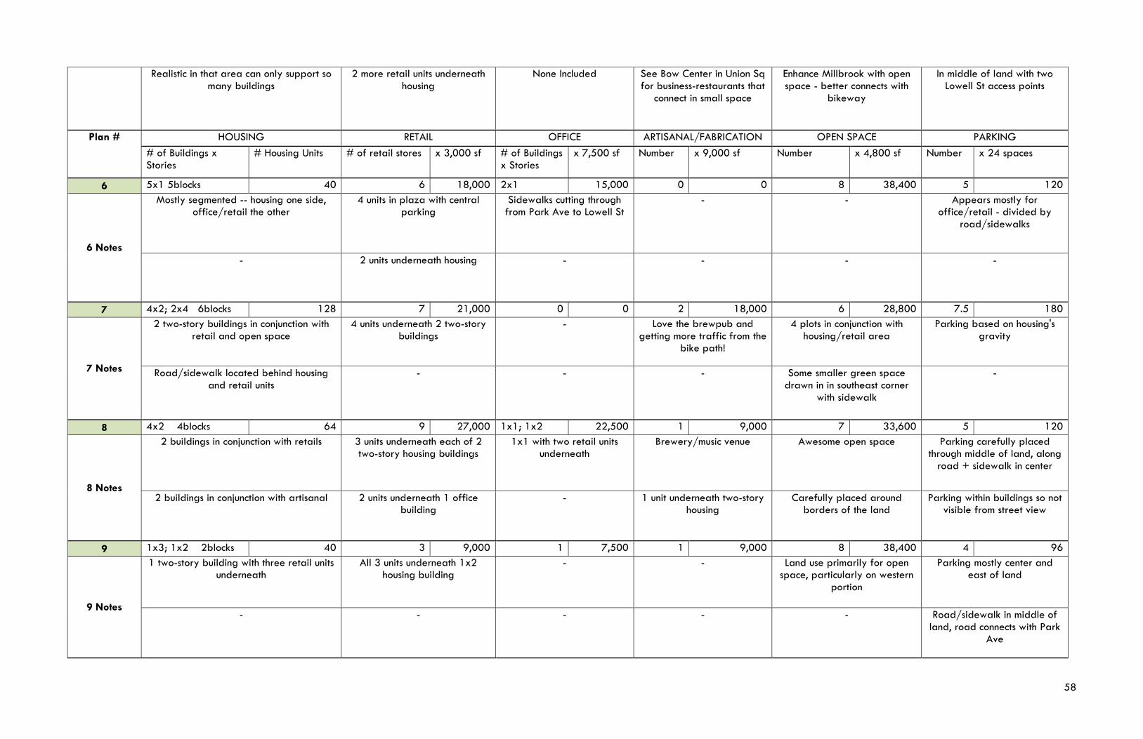
58
Realistic in that area can only support so many buildings
2 more retail units underneath housing
None Included See Bow Center in Union Sq for business-restaurants that
connect in small space
Enhance Millbrook with open space - better connects with
bikeway
In middle of land with two Lowell St access points
Plan # HOUSING RETAIL OFFICE ARTISANAL/FABRICATION OPEN SPACE PARKING # of Buildings x Stories
# Housing Units # of retail stores x 3,000 sf # of Buildings x Stories
x 7,500 sf Number x 9,000 sf Number x 4,800 sf Number x 24 spaces
6 5x1 5blocks 40 6 18,000 2x1 15,000 0 0 8 38,400 5 120
6 Notes
Mostly segmented -- housing one side, office/retail the other
4 units in plaza with central parking
Sidewalks cutting through from Park Ave to Lowell St
- - Appears mostly for office/retail - divided by
road/sidewalks
- 2 units underneath housing - - - -
7 4x2; 2x4 6blocks 128 7 21,000 0 0 2 18,000 6 28,800 7.5 180
7 Notes
2 two-story buildings in conjunction with retail and open space
4 units underneath 2 two-story buildings
- Love the brewpub and getting more traffic from the
bike path!
4 plots in conjunction with housing/retail area
Parking based on housing's gravity
Road/sidewalk located behind housing and retail units
- - - Some smaller green space drawn in in southeast corner
with sidewalk
-
8 4x2 4blocks 64 9 27,000 1x1; 1x2 22,500 1 9,000 7 33,600 5 120
8 Notes
2 buildings in conjunction with retails 3 units underneath each of 2 two-story housing buildings
1x1 with two retail units underneath
Brewery/music venue Awesome open space Parking carefully placed through middle of land, along
road + sidewalk in center
2 buildings in conjunction with artisanal 2 units underneath 1 office building
- 1 unit underneath two-story housing
Carefully placed around borders of the land
Parking within buildings so not visible from street view
9 1x3; 1x2 2blocks 40 3 9,000 1 7,500 1 9,000 8 38,400 4 96
9 Notes
1 two-story building with three retail units underneath
All 3 units underneath 1x2 housing building
- - Land use primarily for open space, particularly on western
portion
Parking mostly center and east of land
- - - - - Road/sidewalk in middle of land, road connects with Park
Ave
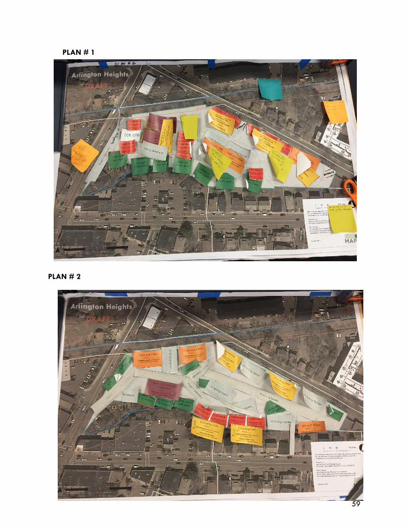
59
PLAN # 1
PLAN # 2
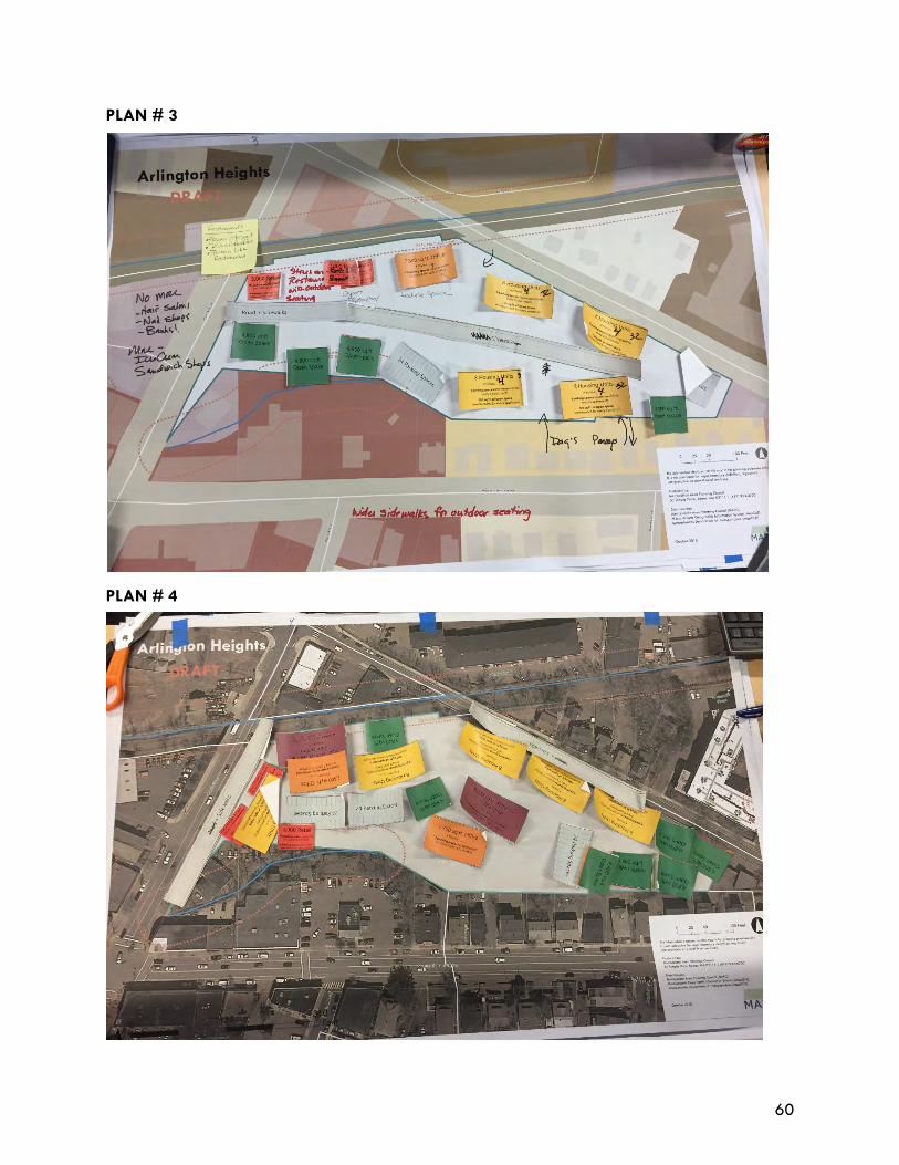
60
PLAN # 3
PLAN # 4
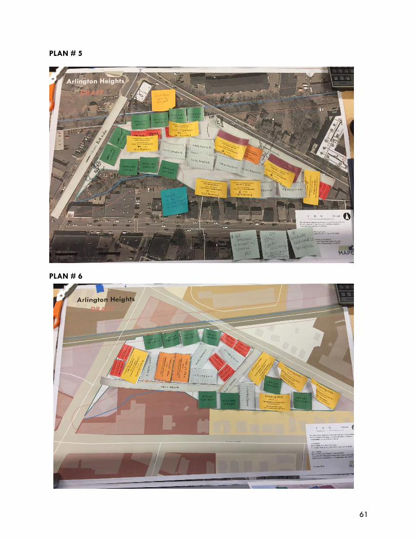
61
PLAN # 5
PLAN # 6
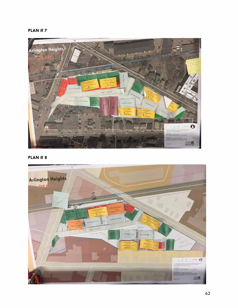
62
PLAN # 7
PLAN # 8
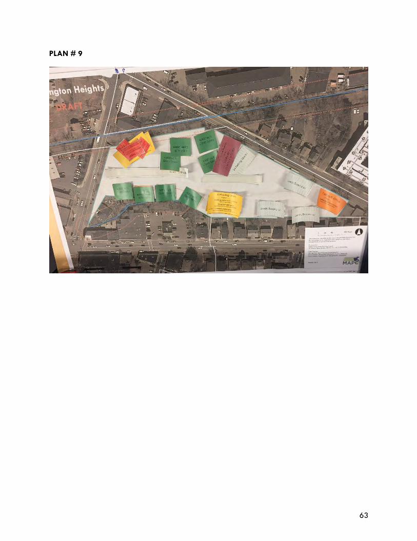
63
PLAN # 9
64
APPENDIX III: October Forum Plan Analysis Spreadsheet
APPENDIX IV: Materials used at Forum 1 to gather feedback on
uses, scale of structures, and design
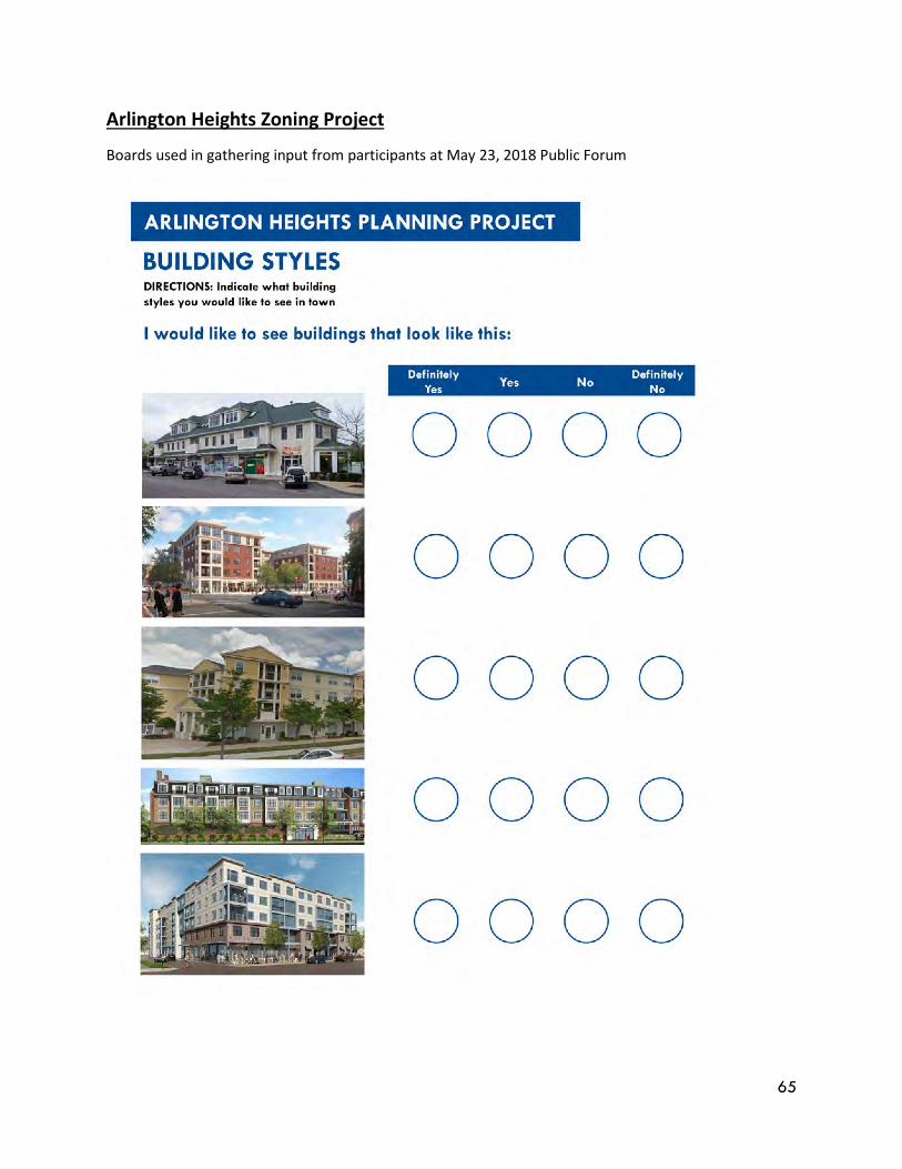
65
Arlington Heights Zoning Project
Boards used in gathering input from participants at May 23, 2018 Public Forum
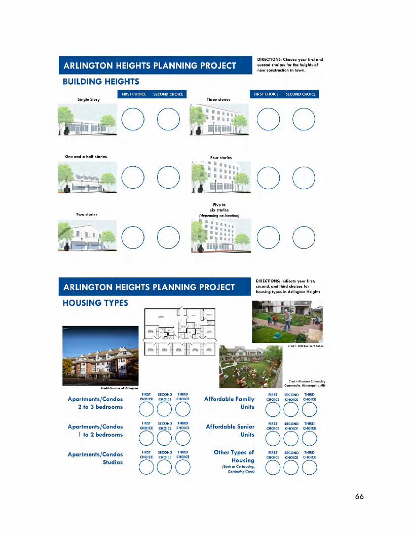
66
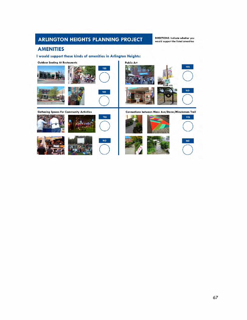
67
68
APPENDIX V: Retail Market Demand Analysis for Arlington Heights
Rezoning
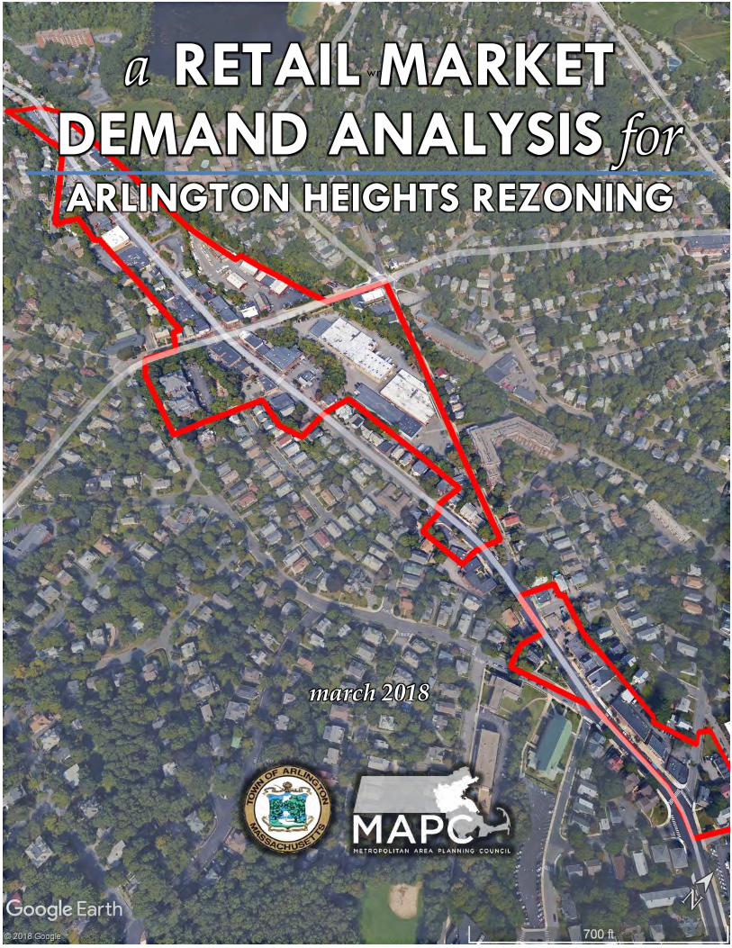
wre
a RETAIL MARKET DEMAND ANALYSIS for
ARLINGTON HEIGHTS REZONING
march 2018

.
This page has been left ostensibly blank for pagination purposes.
ACKNOWLEDGEMENTS
The Arlington Heights Retail Market Demand Opportunity Gap Analysis was conducted as part of
the Arlington Heights Rezoning Study. It was conducted in order to contextualize the planning and
rezoning study’s zoning and urban design framework analyses, and provide guidance to the
advisory committee and community for decision making.
Both analyses were conducted with funds from the State of Massachusetts’ District Local Technical
Assistance (DLTA), and the Planning for MetroFuture Technical Assistance (PMTA) programs. Such
funding enables the Metropolitan Area Planning Council (MAPC) to achieve its mission in providing
towns and cities with assistance in achieving equitable local smart growth that also benefits the
greater Boston region. MAPC is grateful to the Governor and the Legislature for their support and
funding of these programs.
MAPC Officers President, Keith Bergman, Town of Littleton Vice President, Erin Wortman, Town of Stoneham Secretary, Sandra Hackman, Town of Bedford Treasurer, Taber Keally, Town of Milton Executive Director, Marc Draisen, MAPC MAPC StaffCarlos Javier Montañez, Senior Regional Planner Cynthia Wall, Principal Planner, and Project Manager Acknowledgements for the generous assistance of the following individuals: Town of Arlington Adam Chapdelaine, Town Manager Jennifer Raitt, Director, Planning & Community Development Ali Carter, Economic Development Coordinator Workshop Participants and Community Stakeholders Special thanks to the workshop and other participants who provided feedback.
arlington heights retail market demand analysis APPENDIX – REZONING STUDY – MARCH 2018
1 of 31
TABLE OF CONTENT I. RETAIL MARKET DEMAND ANALYSIS ........................................ 3
A. TRADE AREAS ............................................................................................................................................... 9
B. RETAIL OPPORTUNITY GAP ANALYSIS ................................................................................................. 15
1. POTENTIAL RETAIL SQUARE FOOTAGE: HOUSEHOLD-SUPPORTABLE ...................................... 19
2. CONSUMER SPENDING HABITS OF HOUSEHOLDS WITHIN RETAIL TRADE AREAS ................ 20
C. SUPPLEMENTAL RETAIL DEMAND ANALYSIS: WORKER-SUPPORTABLE ....................................... 23
1. POTENTIAL RETAIL SQUARE FOOTAGE: WORKER-SUPPORTABLE ............................................. 23
D. TOTAL POTENTIAL RETAIL SQUARE FOOTAGE: HOUSEHOLD AND WORKER SUPPORTABLE . 24
E. EXISTING RETAIL INVENTORY ................................................................................................................. 25
II. POTENTIAL STRATEGIES TO ATTRACT RETAIL INVESTMENT ... 28
A. FLEXIBLE ZONING IN KEY AREAS TO ALLOW MIXED USE DISTRICTS .......................................... 28
B. URBAN DESIGN GUIDELINES & FRAMEWORK, & STREETSCAPE ENHANCEMENTS .................... 29
C. MARKETING CAMPAIGN ANNOUNCING NEW REDEVELOPMENT POTENTIAL .......................... 30
D. RESTAURANT SUCCESS ENHANCED BY LIQUOR LICENSES ............................................................. 31
arlington heights retail market demand analysis APPENDIX – REZONING STUDY – MARCH 2018
2 of 31
LIST OF TABLES AND FIGURES Table 1 Summary Data from Retail Market Trade Areas for Retail Market Demand Opportunity Gap
Analysis ...................................................................................................................................................... 11
Table 3 Retail Opportunity Gap Analysis for Arlington Heights Rezoning Study with Conversion of
Sales Dollars Using Assumptions into Total Potential Retail Square Footage - Household
Supportable .............................................................................................................................................. 17
Table 4 Abbreviated Retail Opportunity Gap Analysis ................................................................................. 18
Table 5. Retail Market Potential Estimate – Household Supportable ............................................................ 19
Table 2 Household Spending Habits ................................................................................................................... 22
Table 6 Worker Supported Potential Retail Square Footage ....................................................................... 23
Table 7 Total Household & Worker Supportable Retail Square Footage .................................................. 24
Table 8. Summary of Study Area Retail Inventory and Other Business Types ............................................. 26
Figure 1 Context Map of Arlington Town Boundary and Surrounding Communities ..................................... 6
Figure 2 Aerial View of the Town of Arlington with the Study Area in Red ................................................... 7
Figure 3 Study Area in Red within Town of Arlington ......................................................................................... 8
Figure 4 Arlington Heights Study Area in Greater Detail in Red ..................................................................... 8
Figure 5 Hyper-Local Walking, and Primary Local and Secondary Regional Driving Retail Market
Trade Areas with Arlington Boundary in Blue, and Study Area in Black Shaded Area ............... 9
Figure 6 Greater Detail of Hyper-Local Retail Trade Area with 5-Minute and 10-Minute Walking
Bands in Yellow, Study Area in Black, and Town Boundary in Blue ............................................... 10
Figure 7 Regional Retail Trade Area Competition: Major Shopping Centers within Trade Areas ......... 13
Figure 8 Context Map of Local Commercial Nodes & Areas with Study Area in Red ............................... 14
Figure 9 Business & Employee Summary for the Arlington Heights ................................................................ 27
Figure 10 Illustrative Concept for Potential New Mid-Block Circulation Connections for Potential
Redevelopment Opportunity Sites and Enhanced Connections to Regional Bike/Ped Trail ...... 29
Figure 11 Cargo container pop-up store in Copenhagen, Denmark. ............................................................... 31
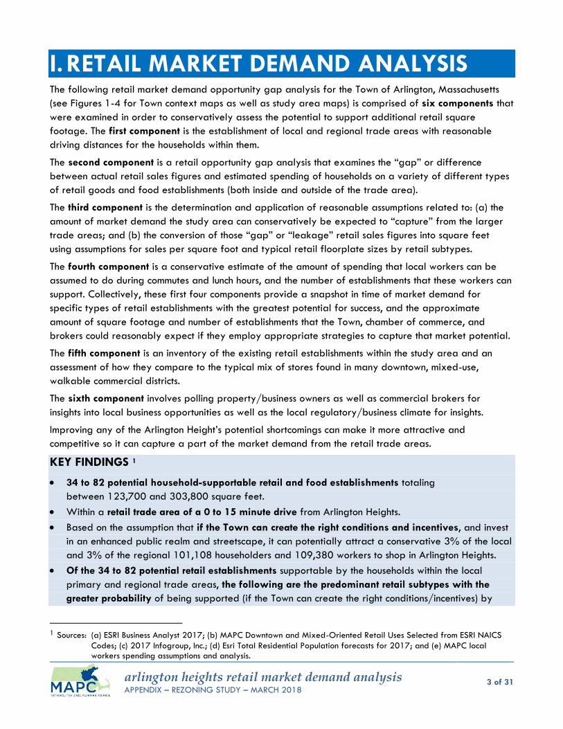
arlington heights retail market demand analysis APPENDIX – REZONING STUDY – MARCH 2018
3 of 31
I. RETAIL MARKET DEMAND ANALYSIS The following retail market demand opportunity gap analysis for the Town of Arlington, Massachusetts
(see Figures 1-4 for Town context maps as well as study area maps) is comprised of six components that
were examined in order to conservatively assess the potential to support additional retail square
footage. The first component is the establishment of local and regional trade areas with reasonable
driving distances for the households within them.
The second component is a retail opportunity gap analysis that examines the “gap” or difference
between actual retail sales figures and estimated spending of households on a variety of different types
of retail goods and food establishments (both inside and outside of the trade area).
The third component is the determination and application of reasonable assumptions related to: (a) the
amount of market demand the study area can conservatively be expected to “capture” from the larger
trade areas; and (b) the conversion of those “gap” or “leakage” retail sales figures into square feet
using assumptions for sales per square foot and typical retail floorplate sizes by retail subtypes.
The fourth component is a conservative estimate of the amount of spending that local workers can be
assumed to do during commutes and lunch hours, and the number of establishments that these workers can
support. Collectively, these first four components provide a snapshot in time of market demand for
specific types of retail establishments with the greatest potential for success, and the approximate
amount of square footage and number of establishments that the Town, chamber of commerce, and
brokers could reasonably expect if they employ appropriate strategies to capture that market potential.
The fifth component is an inventory of the existing retail establishments within the study area and an
assessment of how they compare to the typical mix of stores found in many downtown, mixed-use,
walkable commercial districts.
The sixth component involves polling property/business owners as well as commercial brokers for
insights into local business opportunities as well as the local regulatory/business climate for insights.
Improving any of the Arlington Height’s potential shortcomings can make it more attractive and
competitive so it can capture a part of the market demand from the retail trade areas.
KEY FINDINGS 1
34 to 82 potential household-supportable retail and food establishments totaling
between 123,700 and 303,800 square feet.
Within a retail trade area of a 0 to 15 minute drive from Arlington Heights.
Based on the assumption that if the Town can create the right conditions and incentives, and invest
in an enhanced public realm and streetscape, it can potentially attract a conservative 3% of the local
and 3% of the regional 101,108 householders and 109,380 workers to shop in Arlington Heights.
Of the 34 to 82 potential retail establishments supportable by the households within the local
primary and regional trade areas, the following are the predominant retail subtypes with the
greater probability of being supported (if the Town can create the right conditions/incentives) by
1 Sources: (a) ESRI Business Analyst 2017; (b) MAPC Downtown and Mixed-Oriented Retail Uses Selected from ESRI NAICS
Codes; (c) 2017 Infogroup, Inc.; (d) Esri Total Residential Population forecasts for 2017; and (e) MAPC local workers spending assumptions and analysis.

arlington heights retail market demand analysis APPENDIX – REZONING STUDY – MARCH 2018
4 of 31
untapped spending dollars: (a) 7-18 restaurants totaling 14,800 to 36,500-SF, (b) 2-18 clothing
stores totaling 3,400 to 35,600-SF, (c) 2-7 miscellaneous "other" retail stores totaling 5,200 to
13,600-SF, (d) 3-6 hardware stores totaling 23,600 to 50,700-SF, (e) 1-3 home furnishings stores
totaling 2,000 to 7,100-SF, (f) 1-3 office supplies stores totaling 4,800 to 13,300-SF, and (g) 2-3
electronics/appliance stores totaling 9,000 to 14,600-SF. A finer grain analysis of a subset within
a 10-minute walk and a 10-minute drive confirm overlapping localized demand for the following
retail subtypes: (a) 1-7 restaurants/eating places, and (b) 2-8 clothing stores.
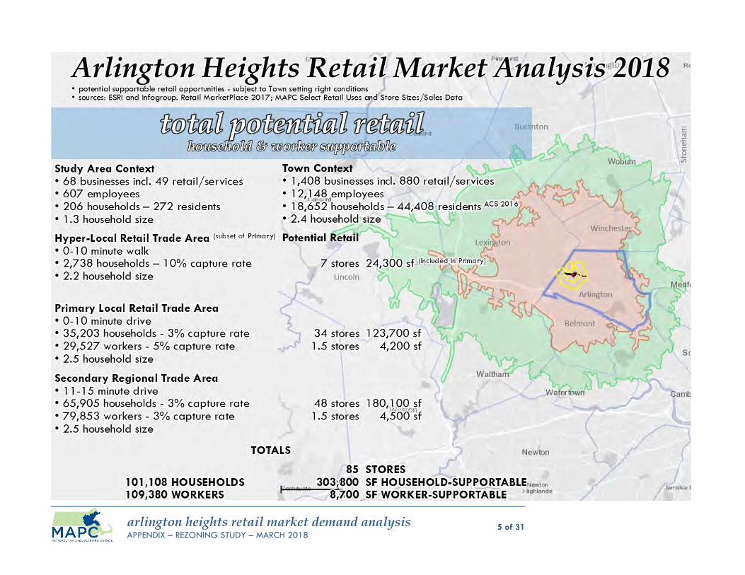
arlington heights retail market demand analysis APPENDIX – REZONING STUDY – MARCH 2018
5 of 31
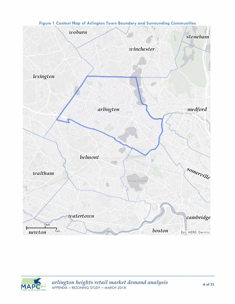
arlington heights retail market demand analysis APPENDIX – REZONING STUDY – MARCH 2018
6 of 31
Figure 1 Context Map of Arlington Town Boundary and Surrounding Communities
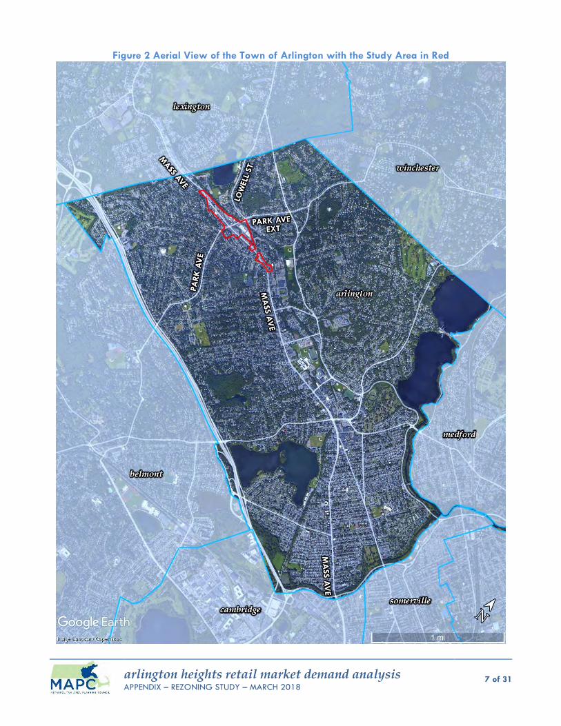
arlington heights retail market demand analysis APPENDIX – REZONING STUDY – MARCH 2018
7 of 31
Figure 2 Aerial View of the Town of Arlington with the Study Area in Red
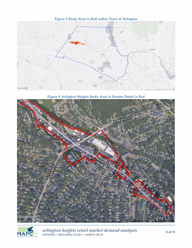
arlington heights retail market demand analysis APPENDIX – REZONING STUDY – MARCH 2018
8 of 31
Figure 3 Study Area in Red within Town of Arlington
Figure 4 Arlington Heights Study Area in Greater Detail in Red
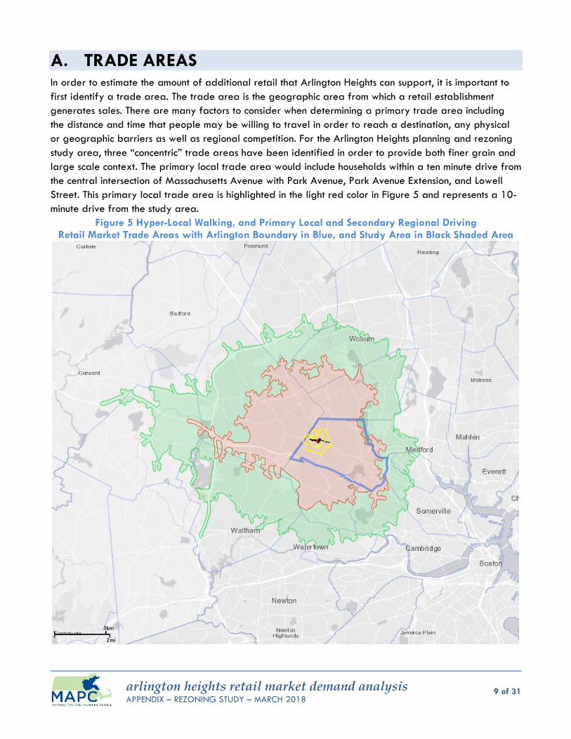
arlington heights retail market demand analysis APPENDIX – REZONING STUDY – MARCH 2018
9 of 31
A. TRADE AREAS In order to estimate the amount of additional retail that Arlington Heights can support, it is important to
first identify a trade area. The trade area is the geographic area from which a retail establishment
generates sales. There are many factors to consider when determining a primary trade area including
the distance and time that people may be willing to travel in order to reach a destination, any physical
or geographic barriers as well as regional competition. For the Arlington Heights planning and rezoning
study area, three “concentric” trade areas have been identified in order to provide both finer grain and
large scale context. The primary local trade area would include households within a ten minute drive from
the central intersection of Massachusetts Avenue with Park Avenue, Park Avenue Extension, and Lowell
Street. This primary local trade area is highlighted in the light red color in Figure 5 and represents a 10-
minute drive from the study area.
Figure 5 Hyper-Local Walking, and Primary Local and Secondary Regional Driving Retail Market Trade Areas with Arlington Boundary in Blue, and Study Area in Black Shaded Area
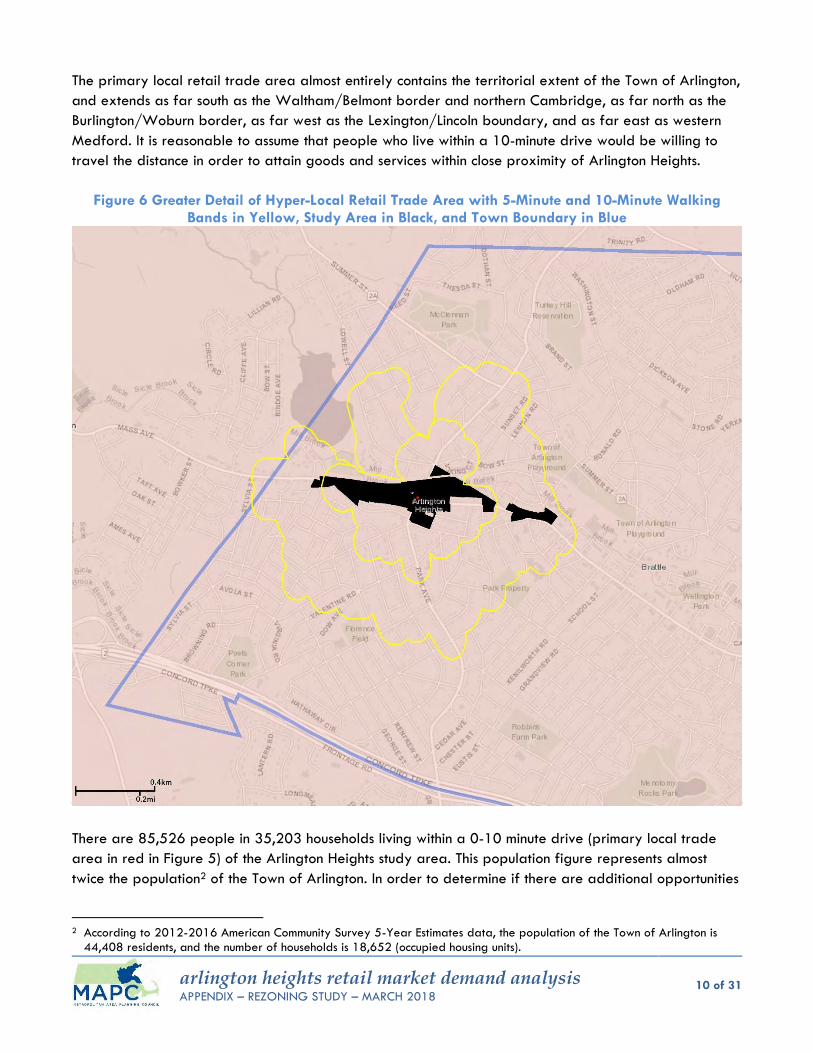
arlington heights retail market demand analysis APPENDIX – REZONING STUDY – MARCH 2018
10 of 31
The primary local retail trade area almost entirely contains the territorial extent of the Town of Arlington,
and extends as far south as the Waltham/Belmont border and northern Cambridge, as far north as the
Burlington/Woburn border, as far west as the Lexington/Lincoln boundary, and as far east as western
Medford. It is reasonable to assume that people who live within a 10-minute drive would be willing to
travel the distance in order to attain goods and services within close proximity of Arlington Heights.
Figure 6 Greater Detail of Hyper-Local Retail Trade Area with 5-Minute and 10-Minute Walking Bands in Yellow, Study Area in Black, and Town Boundary in Blue
There are 85,526 people in 35,203 households living within a 0-10 minute drive (primary local trade
area in red in Figure 5) of the Arlington Heights study area. This population figure represents almost
twice the population2 of the Town of Arlington. In order to determine if there are additional opportunities
2 According to 2012-2016 American Community Survey 5-Year Estimates data, the population of the Town of Arlington is
44,408 residents, and the number of households is 18,652 (occupied housing units).
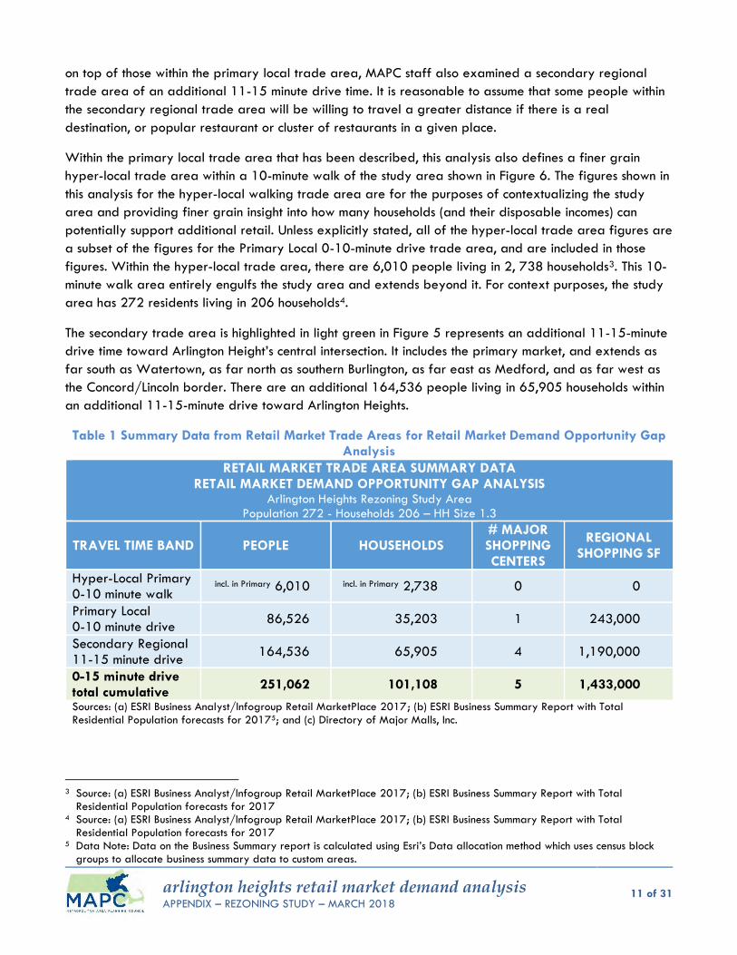
arlington heights retail market demand analysis APPENDIX – REZONING STUDY – MARCH 2018
11 of 31
on top of those within the primary local trade area, MAPC staff also examined a secondary regional
trade area of an additional 11-15 minute drive time. It is reasonable to assume that some people within
the secondary regional trade area will be willing to travel a greater distance if there is a real
destination, or popular restaurant or cluster of restaurants in a given place.
Within the primary local trade area that has been described, this analysis also defines a finer grain
hyper-local trade area within a 10-minute walk of the study area shown in Figure 6. The figures shown in
this analysis for the hyper-local walking trade area are for the purposes of contextualizing the study
area and providing finer grain insight into how many households (and their disposable incomes) can
potentially support additional retail. Unless explicitly stated, all of the hyper-local trade area figures are
a subset of the figures for the Primary Local 0-10-minute drive trade area, and are included in those
figures. Within the hyper-local trade area, there are 6,010 people living in 2, 738 households3. This 10-
minute walk area entirely engulfs the study area and extends beyond it. For context purposes, the study
area has 272 residents living in 206 households4.
The secondary trade area is highlighted in light green in Figure 5 represents an additional 11-15-minute
drive time toward Arlington Height’s central intersection. It includes the primary market, and extends as
far south as Watertown, as far north as southern Burlington, as far east as Medford, and as far west as
the Concord/Lincoln border. There are an additional 164,536 people living in 65,905 households within
an additional 11-15-minute drive toward Arlington Heights.
Table 1 Summary Data from Retail Market Trade Areas for Retail Market Demand Opportunity Gap Analysis
RETAIL MARKET TRADE AREA SUMMARY DATA RETAIL MARKET DEMAND OPPORTUNITY GAP ANALYSIS
Arlington Heights Rezoning Study Area Population 272 - Households 206 – HH Size 1.3
TRAVEL TIME BAND PEOPLE HOUSEHOLDS # MAJOR SHOPPING CENTERS
REGIONAL SHOPPING SF
Hyper-Local Primary 0-10 minute walk
incl. in Primary 6,010 incl. in Primary 2,738 0 0
Primary Local 0-10 minute drive
86,526 35,203 1 243,000
Secondary Regional 11-15 minute drive
164,536 65,905 4 1,190,000
0-15 minute drive total cumulative
251,062 101,108 5 1,433,000
Sources: (a) ESRI Business Analyst/Infogroup Retail MarketPlace 2017; (b) ESRI Business Summary Report with Total Residential Population forecasts for 20175; and (c) Directory of Major Malls, Inc.
3 Source: (a) ESRI Business Analyst/Infogroup Retail MarketPlace 2017; (b) ESRI Business Summary Report with Total
Residential Population forecasts for 2017 4 Source: (a) ESRI Business Analyst/Infogroup Retail MarketPlace 2017; (b) ESRI Business Summary Report with Total
Residential Population forecasts for 2017 5 Data Note: Data on the Business Summary report is calculated using Esri’s Data allocation method which uses census block
groups to allocate business summary data to custom areas.

arlington heights retail market demand analysis APPENDIX – REZONING STUDY – MARCH 2018
12 of 31
The secondary trade areas’ regional draw is important to the success of restaurants. The assumption
regarding regional competition is that if there is market demand for development and the Town positions
itself to create optimal local conditions within Arlington Heights, the Town should be able to draw in
businesses and customers from the region. If Arlington Heights is able to draw customers from farther
away, the Town could support additional retail.
As shown in Figure 7 there are approximately five major retail shopping centers within an immediate 15-
minute drive from Arlington Heights that will be direct competitors, including Middlesex Commons,
Burlington Crossroads, 3rd Avenue Burlington, the Watertown Mall, and the Arsenal Yards. According to
ESRI Business Analyst and Directory of Major Malls, Inc. data, these five shopping centers have
approximately 1,433,000 gross feet of leasable area. This will be a limiting factor that will influence
how much retail the market in Arlington Heights will be able to support.
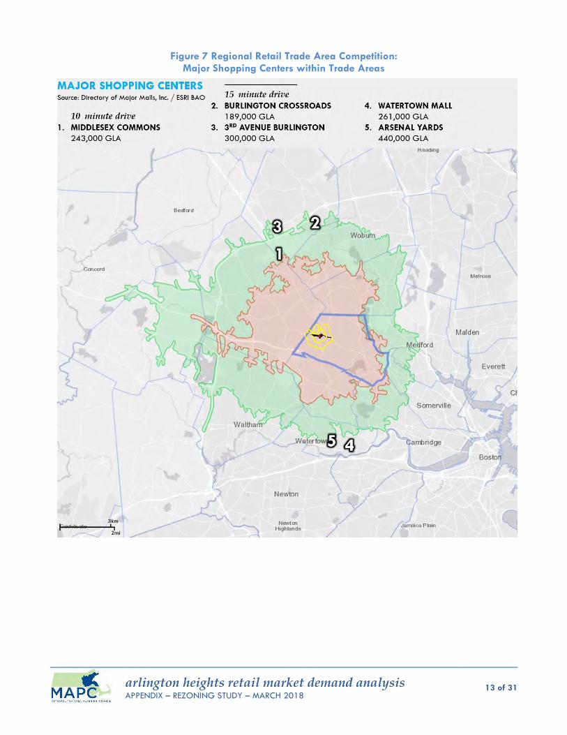
arlington heights retail market demand analysis APPENDIX – REZONING STUDY – MARCH 2018
13 of 31
Figure 7 Regional Retail Trade Area Competition: Major Shopping Centers within Trade Areas
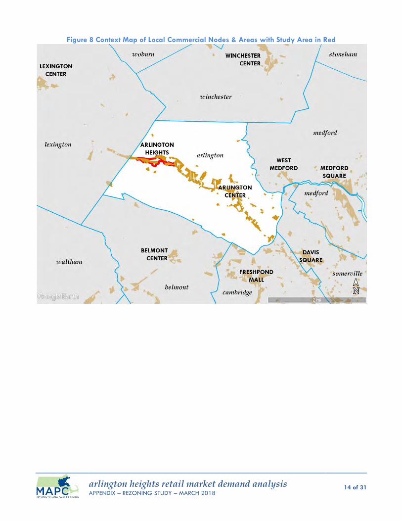
arlington heights retail market demand analysis APPENDIX – REZONING STUDY – MARCH 2018
14 of 31
Figure 8 Context Map of Local Commercial Nodes & Areas with Study Area in Red
arlington heights retail market demand analysis APPENDIX – REZONING STUDY – MARCH 2018
15 of 31
B. RETAIL OPPORTUNITY GAP ANALYSIS MAPC staff analyzed ESRI Business Analyst data within the defined trade areas in order to conduct a
retail gap analysis. A retail opportunity gap analysis examines the “gap” or difference between actual
retail sales figures and estimated spending of households on a variety of different types of retail goods
and food establishments (both inside and outside of a retail trade area). If the demand exceeds the
supply, there is “leakage,” meaning that residents must travel outside the area to purchase those goods.
In such cases, there is an opportunity to capture some of this spending within the market area to support
new retail investment. When there is greater supply than demand, there is a “surplus”, meaning consumers
from outside the market area are coming in to purchase these goods and services. In such cases, there is
limited or no opportunity for additional retail development.
Thus, the retail gap analysis provides a snapshot of potential opportunities for retailers to locate within
an area. In addition to the gap analysis based on how much potential retail square footage can be
supported by households, MAPC conducted an analysis for how much could be supported by local
workers.
Table 3 is a summary of the retail opportunity gap analysis by industry group for the primary local and
secondary regional trade areas (see Figure 5) with the incremental, non-cumulative figures for the
primary and secondary trade area bands. It is followed by an abbreviated cumulative summary in Table
3 for the total 0-15-minute drive trade area. The dollar figures in parentheses and red are negative
numbers indicate that there is a surplus of retail sales within the trade area (and that there is no
untapped disposable income to be had). In other words, there is a significant amount of dollars being
spent inside the trade area within that industry group, with many customers being drawn in from outside
the trade area. It can be viewed as measure of success for the existing businesses within that particular
industry group but also as a challenge for prospective businesses to set up shop and compete for
customers. The dollar figures in black are positive numbers that indicate a retail gap or “leakage” of
missed opportunity to outside of the trade area and represent potential opportunities for more retail
within the area.
Tables 3 and 5 indicate that overall, the 35,203 households within the primary local trade area that are
within a 10-minute drive can potentially support 4,123,000-SF of retail, of which the study area could
potentially capture 3% of that square footage (123,700-SF) for 34 potential retail establishments within
the study area. This was based on a conservative 3% capture rate assumption relative to the retail gap
dollar amount in sales potential for a number of MAPC-designated “downtown and mixed-use oriented
retail” NAICS uses with restaurants and clothing stores having the greatest potential.
There are additional opportunities when considering the secondary regional trade area, which has
65,905 additional households with potential untapped disposable household income based on ESRI
Business Analyst data estimates and actual sales figures. Within an additional 11-15-minute drive trade
area, approximately 3,694,000-SF of potential retail can be supported, of which the study area can
potentially capture 3% of that square footage (180,100-SF) for 48 additional establishments within the
study area. Of those 48 potential establishments, the following predominant downtown/mixed-use

arlington heights retail market demand analysis APPENDIX – REZONING STUDY – MARCH 2018
16 of 31
oriented retail sub-types have the greatest potential: restaurants, clothing, miscellaneous/other, and home
furnishings establishments.
As a point of clarification, due to the variation in the average sales per square foot and typical store
floorplate sizes by type of retail establishment, higher sales figures in Tables 3 and 4 do not necessarily
translate into a supportable establishment if that retail business requires a bigger store floorplate or has
to make higher sales per square foot in order to pay a lease.
The secondary regional trade area is particularly important to the success of potential restaurants which
oftentimes draw on expanded trade areas. Restaurants do not only depend on spending from the
households located within its trade area but also on customers who drive to or through the study area as
well as local office workers during lunch and commute hours. Given that the ability to potentially support
successful restaurants relies heavily on untapped spending dollars located within the outermost 11-15-
minute regional drive band, it will be a challenge to create physical, regulatory and marketing conditions
within Arlington Heights that will draw the interest of the shoppers in those households.
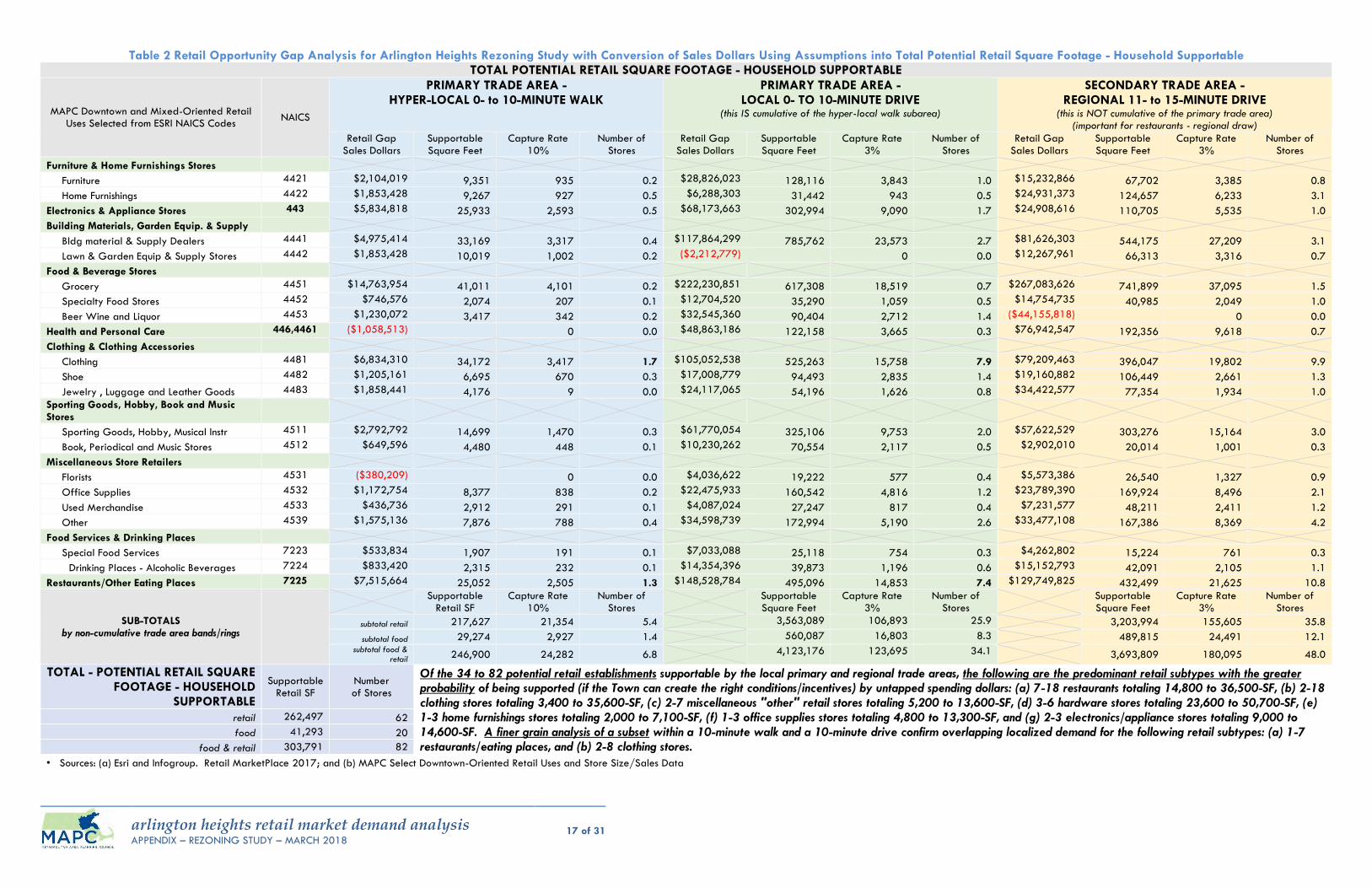
arlington heights retail market demand analysis APPENDIX – REZONING STUDY – MARCH 2018
17 of 31
Table 2 Retail Opportunity Gap Analysis for Arlington Heights Rezoning Study with Conversion of Sales Dollars Using Assumptions into Total Potential Retail Square Footage - Household Supportable TOTAL POTENTIAL RETAIL SQUARE FOOTAGE - HOUSEHOLD SUPPORTABLE
MAPC Downtown and Mixed-Oriented Retail Uses Selected from ESRI NAICS Codes
NAICS
PRIMARY TRADE AREA - HYPER-LOCAL 0- to 10-MINUTE WALK
PRIMARY TRADE AREA - LOCAL 0- TO 10-MINUTE DRIVE
(this IS cumulative of the hyper-local walk subarea)
SECONDARY TRADE AREA - REGIONAL 11- to 15-MINUTE DRIVE
(this is NOT cumulative of the primary trade area) (important for restaurants - regional draw)
Retail Gap Sales Dollars
Supportable Square Feet
Capture Rate 10%
Number of Stores
Retail Gap Sales Dollars
Supportable Square Feet
Capture Rate 3%
Number of Stores
Retail Gap Sales Dollars
Supportable Square Feet
Capture Rate 3%
Number of Stores
Furniture & Home Furnishings Stores
Furniture 4421 $2,104,019 9,351 935 0.2 $28,826,023 128,116 3,843 1.0 $15,232,866 67,702 3,385 0.8
Home Furnishings 4422 $1,853,428 9,267 927 0.5 $6,288,303 31,442 943 0.5 $24,931,373 124,657 6,233 3.1
Electronics & Appliance Stores 443 $5,834,818 25,933 2,593 0.5 $68,173,663 302,994 9,090 1.7 $24,908,616 110,705 5,535 1.0
Building Materials, Garden Equip. & Supply
Bldg material & Supply Dealers 4441 $4,975,414 33,169 3,317 0.4 $117,864,299 785,762 23,573 2.7 $81,626,303 544,175 27,209 3.1
Lawn & Garden Equip & Supply Stores 4442 $1,853,428 10,019 1,002 0.2 ($2,212,779) 0 0.0 $12,267,961 66,313 3,316 0.7
Food & Beverage Stores
Grocery 4451 $14,763,954 41,011 4,101 0.2 $222,230,851 617,308 18,519 0.7 $267,083,626 741,899 37,095 1.5
Specialty Food Stores 4452 $746,576 2,074 207 0.1 $12,704,520 35,290 1,059 0.5 $14,754,735 40,985 2,049 1.0
Beer Wine and Liquor 4453 $1,230,072 3,417 342 0.2 $32,545,360 90,404 2,712 1.4 ($44,155,818) 0 0.0
Health and Personal Care 446,4461 ($1,058,513) 0 0.0 $48,863,186 122,158 3,665 0.3 $76,942,547 192,356 9,618 0.7
Clothing & Clothing Accessories
Clothing 4481 $6,834,310 34,172 3,417 1.7 $105,052,538 525,263 15,758 7.9 $79,209,463 396,047 19,802 9.9
Shoe 4482 $1,205,161 6,695 670 0.3 $17,008,779 94,493 2,835 1.4 $19,160,882 106,449 2,661 1.3
Jewelry , Luggage and Leather Goods 4483 $1,858,441 4,176 9 0.0 $24,117,065 54,196 1,626 0.8 $34,422,577 77,354 1,934 1.0
Sporting Goods, Hobby, Book and Music Stores
Sporting Goods, Hobby, Musical Instr 4511 $2,792,792 14,699 1,470 0.3 $61,770,054 325,106 9,753 2.0 $57,622,529 303,276 15,164 3.0
Book, Periodical and Music Stores 4512 $649,596 4,480 448 0.1 $10,230,262 70,554 2,117 0.5 $2,902,010 20,014 1,001 0.3
Miscellaneous Store Retailers
Florists 4531 ($380,209) 0 0.0 $4,036,622 19,222 577 0.4 $5,573,386 26,540 1,327 0.9
Office Supplies 4532 $1,172,754 8,377 838 0.2 $22,475,933 160,542 4,816 1.2 $23,789,390 169,924 8,496 2.1
Used Merchandise 4533 $436,736 2,912 291 0.1 $4,087,024 27,247 817 0.4 $7,231,577 48,211 2,411 1.2
Other 4539 $1,575,136 7,876 788 0.4 $34,598,739 172,994 5,190 2.6 $33,477,108 167,386 8,369 4.2
Food Services & Drinking Places
Special Food Services 7223 $533,834 1,907 191 0.1 $7,033,088 25,118 754 0.3 $4,262,802 15,224 761 0.3
Drinking Places - Alcoholic Beverages 7224 $833,420 2,315 232 0.1 $14,354,396 39,873 1,196 0.6 $15,152,793 42,091 2,105 1.1
Restaurants/Other Eating Places 7225 $7,515,664 25,052 2,505 1.3 $148,528,784 495,096 14,853 7.4 $129,749,825 432,499 21,625 10.8
SUB-TOTALS by non-cumulative trade area bands/rings
Supportable
Retail SF Capture Rate
10% Number of
Stores Supportable Square Feet
Capture Rate 3%
Number of Stores
Supportable Square Feet
Capture Rate 3%
Number of Stores
subtotal retail 217,627 21,354 5.4 3,563,089 106,893 25.9 3,203,994 155,605 35.8
subtotal food 29,274 2,927 1.4 560,087 16,803 8.3 489,815 24,491 12.1 subtotal food &
retail 246,900 24,282 6.8
4,123,176 123,695 34.1 3,693,809 180,095 48.0
TOTAL - POTENTIAL RETAIL SQUARE FOOTAGE - HOUSEHOLD
SUPPORTABLE
Supportable Retail SF
Number of Stores
Of the 34 to 82 potential retail establishments supportable by the local primary and regional trade areas, the following are the predominant retail subtypes with the greater probability of being supported (if the Town can create the right conditions/incentives) by untapped spending dollars: (a) 7-18 restaurants totaling 14,800 to 36,500-SF, (b) 2-18 clothing stores totaling 3,400 to 35,600-SF, (c) 2-7 miscellaneous "other" retail stores totaling 5,200 to 13,600-SF, (d) 3-6 hardware stores totaling 23,600 to 50,700-SF, (e) 1-3 home furnishings stores totaling 2,000 to 7,100-SF, (f) 1-3 office supplies stores totaling 4,800 to 13,300-SF, and (g) 2-3 electronics/appliance stores totaling 9,000 to 14,600-SF. A finer grain analysis of a subset within a 10-minute walk and a 10-minute drive confirm overlapping localized demand for the following retail subtypes: (a) 1-7 restaurants/eating places, and (b) 2-8 clothing stores.
retail 262,497 62
food 41,293 20
food & retail 303,791 82
• Sources: (a) Esri and Infogroup. Retail MarketPlace 2017; and (b) MAPC Select Downtown-Oriented Retail Uses and Store Size/Sales Data
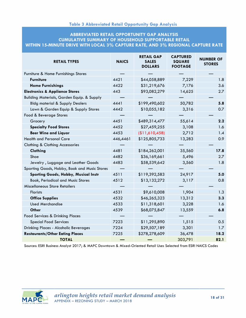
arlington heights retail market demand analysis APPENDIX – REZONING STUDY – MARCH 2018
18 of 31
Table 3 Abbreviated Retail Opportunity Gap Analysis
ABBREVIATED RETAIL OPPORTUNITY GAP ANALYSIS CUMULATIVE SUMMARY OF HOUSEHOLD SUPPORTABLE RETAIL
WITHIN 15-MINUTE DRIVE WITH LOCAL 3% CAPTURE RATE, AND 3% REGIONAL CAPTURE RATE
RETAIL TYPES NAICS RETAIL GAP
SALES DOLLARS
CAPTURED SQUARE
FOOTAGE
NUMBER OF STORES
Furniture & Home Furnishings Stores — — — —
Furniture 4421 $44,058,889 7,229 1.8
Home Furnishings 4422 $31,219,676 7,176 3.6
Electronics & Appliance Stores 443 $93,082,279 14,625 2.7
Building Materials, Garden Equip. & Supply — — — —
Bldg material & Supply Dealers 4441 $199,490,602 50,782 5.8
Lawn & Garden Equip & Supply Stores 4442 $10,055,182 3,316 0.7
Food & Beverage Stores — — — —
Grocery 4451 $489,314,477 55,614 2.2
Specialty Food Stores 4452 $27,459,255 3,108 1.6
Beer Wine and Liquor 4453 ($11,610,458) 2,712 1.4
Health and Personal Care 446,4461 $125,805,733 13,283 0.9
Clothing & Clothing Accessories — — — —
Clothing 4481 $184,262,001 35,560 17.8
Shoe 4482 $36,169,661 5,496 2.7
Jewelry , Luggage and Leather Goods 4483 $58,539,642 3,560 1.8
Sporting Goods, Hobby, Book and Music Stores — — — —
Sporting Goods, Hobby, Musical Instr 4511 $119,392,583 24,917 5.0
Book, Periodical and Music Stores 4512 $13,132,272 3,117 0.8
Miscellaneous Store Retailers — — — —
Florists 4531 $9,610,008 1,904 1.3
Office Supplies 4532 $46,265,323 13,312 3.3
Used Merchandise 4533 $11,318,601 3,228 1.6
Other 4539 $68,075,847 13,559 6.8
Food Services & Drinking Places — — — —
Special Food Services 7223 $11,295,890 1,515 0.5
Drinking Places - Alcoholic Beverages 7224 $29,507,189 3,301 1.7
Restaurants/Other Eating Places 7225 $278,278,609 36,478 18.2
TOTAL — — 303,791 82.1
Sources: ESRI Business Analyst 2017; & MAPC Downtown & Mixed-Oriented Retail Uses Selected from ESRI NAICS Codes
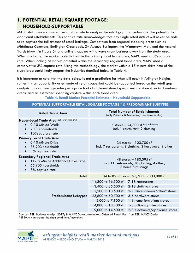
arlington heights retail market demand analysis APPENDIX – REZONING STUDY – MARCH 2018
19 of 31
1. POTENTIAL RETAIL SQUARE FOOTAGE:
HOUSEHOLD-SUPPORTABLE MAPC staff uses a conservative capture rate to analyze the retail gap and understand the potential for
additional establishments. This capture rate acknowledges that any single retail district will never be able
to re-capture the full amount of retail leakage. Competition from regional shopping areas such as
Middlesex Commons, Burlington Crossroads, 3rd Avenue Burlington, the Watertown Mall, and the Arsenal
Yards (shown in Figure 6), and online shopping will always draw business away from the study area.
When analyzing the market potential within the primary local trade area, MAPC used a 3% capture
rate. When looking at market potential within the secondary regional trade area, MAPC used a
conservative 3% capture rate. Using this methodology, the market within a 15-minute drive time of the
study area could likely support the industries detailed below in Table 4.
It is important to note that the data below is not a prediction for what will occur in Arlington Heights,
rather it is an opportunity or estimate of retail space that could be supported based on the retail gap
analysis figures, average sales per square foot of different store types, average store sizes in downtown
areas, and an estimated spending capture within each trade area.
Table 4. Retail Market Potential Estimate – Household Supportable
POTENTIAL SUPPORTABLE RETAIL SQUARE FOOTAGE * & PREDOMINANT SUBTYPES
Retail Trade Area Total Number of Establishments (only Primary & Secondary are incremental)
Hyper-Local Trade Area (subset of Primary)
0-10 Minute Walk
2,738 households
10% capture rate
7 stores – 24,300 sf incl. in Primary incl. 1 restaurant, 2 clothing
Primary Local Trade Area
0-10 Minute Drive
35,203 households
3% capture rate
34 stores – 123,700 sf incl. 7 restaurants, 8 clothing, 3 hardware, 3 other
Secondary Regional Trade Area
11-15 Minute Additional Drive Time
65,905 households
3% capture rate
48 stores – 180,095 sf incl. 11 restaurants, 10 clothing, 4 other,
3 home furnishings
Total 34 to 82 stores – 123,700 to 303,800 sf
Predominant Subtypes
14,800 to 36,500 sf 7-18 restaurants
3,400 to 35,600 sf 2-18 clothing stores
5,200 to 13,600 sf 2-7 miscellaneous “other” stores
23,600 to 50,700 sf 3-6 hardware stores
2,000 to 7,100 sf 1-3 home furnishings stores
4,800 to 13,300 sf 1-3 office supplies stores
9,000 to 14,600 sf 2-3 electronics/appliance stores
Sources: ESRI Business Analyst 2017; & MAPC Downtown/Mixed-Oriented Retail Uses from ESRI NAICS Codes * If Town can create the right conditions/incentives

arlington heights retail market demand analysis APPENDIX – REZONING STUDY – MARCH 2018
20 of 31
The primary local trade area which covers the area within a 0-10-minute drive can potentially support
123,700-SF of retail use or approximately 34 storefronts. The secondary regional trade area which
covers an additional 11-15-minute drive can potentially support more opportunities due to the larger
number of households within it. This area can potentially support an additional 180,100-SF of retail or
approximately 48 additional storefronts if the Town can overcome local challenges such as clear shared
parking areas, and creating an alluring streetscape with sidewalk extensions conducive to outdoor
seating, leisure, congregating and shopping. Overcoming this and other potential obstacles can help
Arlington Heights attract regional businesses.
In total, the entire 15-minute drive from the center of the Arlington Heights study area could potentially
support a cumulative total of 303,800-SF of retail including up to 82 stores. Of the 34 to 82 potential
retail establishments supportable by the households within the local primary and regional trade areas,
the following are the predominant retail subtypes with the greater probability of being supported (if
the Town can create the right conditions/incentives) by untapped spending dollars: (a) 7-18 restaurants
totaling 14,800 to 36,500-SF, (b) 2-18 clothing stores totaling 3,400 to 35,600-SF, (c) 2-7 miscellaneous
"other" retail stores totaling 5,200 to 13,600-SF, (d) 3-6 hardware stores totaling 23,600 to 50,700-SF,
(e) 1-3 home furnishings stores totaling 2,000 to 7,100-SF, (f) 1-3 office supplies stores totaling 4,800 to
13,300-SF, and (g) 2-3 electronics/appliance stores totaling 9,000 to 14,600-SF. A finer grain
analysis of a subset within a 10-minute walk and a 10-minute drive confirm overlapping localized
demand for the following retail subtypes: (a) 1-7 restaurants/eating places, and (b) 2-8 clothing stores.
When considering a strategy for attracting new retail establishments to a particular area, the Town and
chamber of commerce should consider factors such as:
Availability and quality of the retail space
Size of the spaces available
Location of the space- is this a place where many people are passing by?
Foot traffic
Rents and terms
Parking- is it available nearby or within a short walk?
Product or service price points
Marketing
Business plan and acumen
Infrastructure capacity, zoning and regulatory obstacles
Permitting and inspection processes
Although the potential exists for more retail, based on support from the numbers from the secondary
trade area, the amount captured may be less, dependent on the above factors.
2. CONSUMER SPENDING HABITS OF
HOUSEHOLDS WITHIN RETAIL TRADE AREAS In addition to examining and converting sales dollars using conservative assumptions into potential
supportable retail square footage, it is worth mentioning some of the consumer spending habits. These
habits can offer insight into what types of retail might be successful in Arlington Heights. Based on
available data from ESRI and Infogroup (see Table 2), there seems to be some differences between the
hyper-local, primary local and secondary regional retail trade areas with regards to median disposable
income, median household incomes, median age, and average household sizes. Overall, the hyper-local
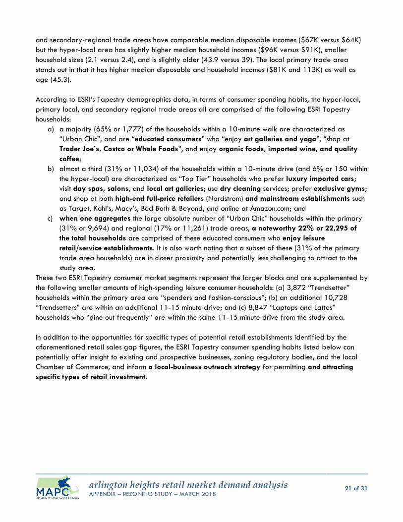
arlington heights retail market demand analysis APPENDIX – REZONING STUDY – MARCH 2018
21 of 31
and secondary-regional trade areas have comparable median disposable incomes ($67K versus $64K)
but the hyper-local area has slightly higher median household incomes ($96K versus $91K), smaller
household sizes (2.1 versus 2.4), and is slightly older (43.9 versus 39). The local primary trade area
stands out in that it has higher median disposable and household incomes ($81K and 113K) as well as
age (45.3).
According to ESRI’s Tapestry demographics data, in terms of consumer spending habits, the hyper-local,
primary local, and secondary regional trade areas all are comprised of the following ESRI Tapestry
households:
a) a majority (65% or 1,777) of the households within a 10-minute walk are characterized as
“Urban Chic”, and are “educated consumers” who “enjoy art galleries and yoga”, “shop at
Trader Joe’s, Costco or Whole Foods”, and enjoy organic foods, imported wine, and quality
coffee;
b) almost a third (31% or 11,034) of the households within a 10-minute drive (and 6% or 150 within
the hyper-local) are characterized as “Top Tier” households who prefer luxury imported cars;
visit day spas, salons, and local art galleries; use dry cleaning services; prefer exclusive gyms;
and shop at both high-end full-price retailers (Nordstrom) and mainstream establishments such
as Target, Kohl’s, Macy’s, Bed Bath & Beyond, and online at Amazon.com; and
c) when one aggregates the large absolute number of “Urban Chic” households within the primary
(31% or 9,694) and regional (17% or 11,261) trade areas, a noteworthy 22% or 22,295 of
the total households are comprised of these educated consumers who enjoy leisure
retail/service establishments. It is also worth noting that a subset of these (31% of the primary
trade area households) are in closer proximity and potentially less challenging to attract to the
study area.
These two ESRI Tapestry consumer market segments represent the larger blocks and are supplemented by
the following smaller amounts of high-spending leisure consumer households: (a) 3,872 “Trendsetter”
households within the primary area are “spenders and fashion-conscious”; (b) an additional 10,728
“Trendsetters” are within an additional 11-15 minute drive; and (c) 8,847 “Laptops and Lattes”
households who “dine out frequently” are within the same 11-15 minute drive from the study area.
In addition to the opportunities for specific types of potential retail establishments identified by the
aforementioned retail sales gap figures, the ESRI Tapestry consumer spending habits listed below can
potentially offer insight to existing and prospective businesses, zoning regulatory bodies, and the local
Chamber of Commerce, and inform a local-business outreach strategy for permitting and attracting
specific types of retail investment.
arlington heights retail market demand analysis APPENDIX – REZONING STUDY – MARCH 2018
22 of 31
Table 5 Household Spending Habits
ESRI TAPESTRY “TOP 3 MARKET SEGMENTS” DEMOGRAPHICS ON HOUSEHOLD SPENDING HABITS Source: 2018 ESRI and INFOGROUP
HYPER-LOCAL PRIMARY
0-10 MINUTE WALK (subset of local primary)
LOCAL PRIMARY 0-10 MINUTE DRIVE
(cumulative)
SECONDARY REGIONAL 11-15 MINUTE DRIVE
(cumulative)
Median Disposable Income
$66,847 $80,757 $64,497
Median Household Income
$96,470 $112,548 $91,130
Average Household Size
2.1 2.4 2.4
Median Age 43.9 45.3 39.0
ESRI Tapestry Household Spending Habits6
65% or 1,777 households 31% or 11,034 households 17% or 11,261 households
“Urban Chic” – Segment 2A Educated consumers. Avid moviegoers, and enjoy
art galleries and yoga. Tech-savvy uses PCs for
shopping, banking. Top market for Apple
computers. Shop at Trader Joe’s, Costco,
or Whole Foods. Eat organic foods, drink
imported wine, and truly appreciate a good cup of coffee.
“Top Tier” – Segment 1A Purchase or lease luxury cars
with the latest trim, preferably imports.
Frequently visit day spas and salons, use dry cleaning services, and exercise at exclusive clubs.
Visits to local art galleries. Shop at high-end retailers
such as Nordstrom (readily paying full price), as well as Target, Kohl’s, Macy’s, and Bed Bath & Beyond, and online at Amazon.com.
“Urban Chic” – Segment 2A Educated consumers. Avid moviegoers, and enjoy
art galleries and yoga. Tech-savvy uses PCs for
shopping, banking. Top market for Apple
computers. Shop at Trader Joe’s, Costco,
or Whole Foods. Eat organic foods, drink
imported wine, and truly appreciate a good cup of coffee.
27% or 740 households 28% or 9,694 households 16% or 10,728 households
“City Lights” – Segment 8A Price-conscious consumers,
they seek out deals on brands they like at warehouse clubs, Walmart, or Target.
Health-conscious consumers, who purchase low-calorie and low-fat food.
Prefer to bank in person. Price savvy but will pay for
quality brands they trust. Attuned to nature and the
environment, and when they can, purchase natural products.
“Urban Chic” – Segment 2A Educated consumers. Avid moviegoers, and enjoy
art galleries and yoga. Tech-savvy uses PCs for
shopping, banking. Top market for Apple
computers. Shop at Trader Joe’s, Costco,
or Whole Foods. Eat organic foods, drink
imported wine, and truly appreciate a good cup of coffee.
“Trendsetters” – Segment 3C Are spenders. Fashion-conscious residents
shop for essentials at discount and warehouse stores.
But buy branded apparel at Banana Republic, Nordstrom, Macy’s and Gap.
6% or 150 households 11% or 3,872 households 13% or 8,847 households
“Top Tier” – Segment 1A Purchase or lease luxury cars
with the latest trim, preferably imports.
Frequently visit day spas and salons, use dry cleaning services, and exercise at exclusive clubs.
Visits to local art galleries. Shop at high-end retailers
such as Nordstrom (readily paying full price), as well as Target, Kohl’s, Macy’s, and Bed Bath & Beyond, and online at Amazon.com.
“Trendsetters” – Segment 3C Are spenders. Fashion-conscious residents
shop for essentials at discount and warehouse stores.
But buy branded apparel at Banana Republic, Nordstrom, Macy’s and Gap.
“Laptops and Lattes” – Segment 3A
This is the top market for owning an iPod…laptop
Uses laundromats and dry cleaners frequently.
Favorite department store is Banana Republic.
Leisure time going to movies, dance performances, concerts, bars, nightclubs.
Dine out frequently.
6 Consumer preferences are estimated from data by GfK MRI.
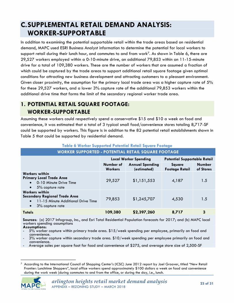
arlington heights retail market demand analysis APPENDIX – REZONING STUDY – MARCH 2018
23 of 31
C. SUPPLEMENTAL RETAIL DEMAND ANALYSIS: WORKER-SUPPORTABLE
In addition to examining the potential supportable retail within the trade areas based on residential
demand, MAPC used ESRI Business Analyst information to determine the potential for local workers to
support retail during their lunch hour, and commutes to and from work7. As shown in Table 6, there are
29,527 workers employed within a 0-10-minute drive, an additional 79,853 within an 11-15-minute
drive for a total of 109,380 workers. These are the number of workers that are assumed a fraction of
which could be captured by the trade areas to support additional retail square footage given optimal
conditions for attracting new business development and attracting customers to a pleasant environment.
Given closer proximity, the assumption for the primary local trade area was a higher capture rate of 5%
for these 29,527 workers, and a lower 3% capture rate of the additional 79,853 workers within the
additional drive time that forms the limit of the secondary regional worker trade area.
1. POTENTIAL RETAIL SQUARE FOOTAGE:
WORKER-SUPPORTABLE Assuming these workers could respectively spend a conservative $15 and $10 a week on food and
convenience, it was estimated that a total of 3 typical small food/convenience stores totaling 8,717-SF
could be supported by workers. This figure is in addition to the 82 potential retail establishments shown in
Table 5 that could be supported by residential demand.
Table 6 Worker Supported Potential Retail Square Footage
WORKER SUPPORTED - POTENTIAL RETAIL SQUARE FOOTAGE
Local Worker Spending Potential Supportable Retail
Number of Workers
Annual Spending (estimated)
Square Footage Retail
Number of Stores
Workers within Primary Local Trade Area
0-10 Minute Drive Time
5% capture rate
29,527 $1,151,553 4,187 1.5
Workers within Secondary Regional Trade Area
11-15 Minute Additional Drive Time
3% capture rate
79,853 $1,245,707 4,530 1.5
Totals 109,380 $2,397,260 8,717 3 Sources: (a) 2017 Infogroup, Inc., and Esri Total Residential Population forecasts for 2017; and (b) MAPC local workers spending assumptions Assumptions: - 5% worker capture within primary trade area. $15/week spending per employee, primarily on food and
convenience. - 3% worker capture within secondary trade area. $10/week spending per employee primarily on food and
convenience. - Average sales per square foot for food and convenience of $275, and average store size of 2,500-SF
7 According to the International Council of Shopping Center’s (ICSC) June 2012 report by Joel Groover, titled “New Retail
Frontier: Lunchtime Shoppers”, local office workers spend approximately $100 dollars a week on food and convenience during the work week (during commutes to and from the office, or during the day, i.e., lunch.
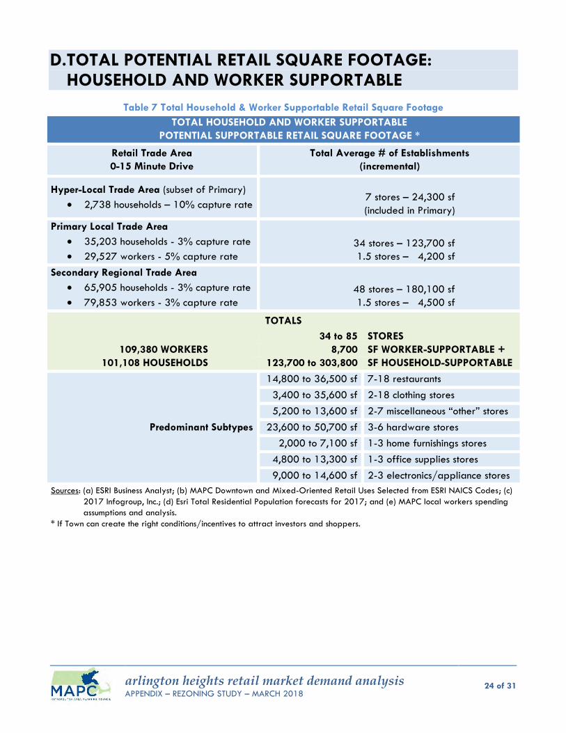
arlington heights retail market demand analysis APPENDIX – REZONING STUDY – MARCH 2018
24 of 31
D. TOTAL POTENTIAL RETAIL SQUARE FOOTAGE: HOUSEHOLD AND WORKER SUPPORTABLE
Table 7 Total Household & Worker Supportable Retail Square Footage
TOTAL HOUSEHOLD AND WORKER SUPPORTABLE
POTENTIAL SUPPORTABLE RETAIL SQUARE FOOTAGE *
Retail Trade Area
0-15 Minute Drive
Total Average # of Establishments
(incremental)
Hyper-Local Trade Area (subset of Primary)
2,738 households – 10% capture rate
7 stores – 24,300 sf
(included in Primary)
Primary Local Trade Area
35,203 households - 3% capture rate
29,527 workers - 5% capture rate
34 stores – 123,700 sf
1.5 stores – 4,200 sf
Secondary Regional Trade Area
65,905 households - 3% capture rate
79,853 workers - 3% capture rate
48 stores – 180,100 sf
1.5 stores – 4,500 sf
TOTALS
34 to 85 STORES
109,380 WORKERS 8,700 SF WORKER-SUPPORTABLE +
101,108 HOUSEHOLDS 123,700 to 303,800 SF HOUSEHOLD-SUPPORTABLE
Predominant Subtypes
14,800 to 36,500 sf 7-18 restaurants
3,400 to 35,600 sf 2-18 clothing stores
5,200 to 13,600 sf 2-7 miscellaneous “other” stores
23,600 to 50,700 sf 3-6 hardware stores
2,000 to 7,100 sf 1-3 home furnishings stores
4,800 to 13,300 sf 1-3 office supplies stores
9,000 to 14,600 sf 2-3 electronics/appliance stores
Sources: (a) ESRI Business Analyst; (b) MAPC Downtown and Mixed-Oriented Retail Uses Selected from ESRI NAICS Codes; (c)
2017 Infogroup, Inc.; (d) Esri Total Residential Population forecasts for 2017; and (e) MAPC local workers spending
assumptions and analysis.
* If Town can create the right conditions/incentives to attract investors and shoppers.
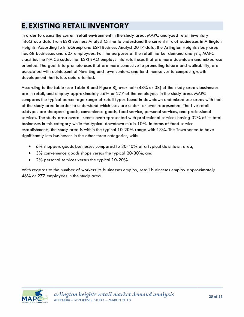
arlington heights retail market demand analysis APPENDIX – REZONING STUDY – MARCH 2018
25 of 31
E. EXISTING RETAIL INVENTORY In order to assess the current retail environment in the study area, MAPC analyzed retail inventory
InfoGroup data from ESRI Business Analyst Online to understand the current mix of businesses in Arlington
Heights. According to InfoGroup and ESRI Business Analyst 2017 data, the Arlington Heights study area
has 68 businesses and 607 employees. For the purposes of the retail market demand analysis, MAPC
classifies the NAICS codes that ESRI BAO employs into retail uses that are more downtown and mixed-use
oriented. The goal is to promote uses that are more conducive to promoting leisure and walkability, are
associated with quintessential New England town centers, and lend themselves to compact growth
development that is less auto-oriented.
According to the table (see Table 8 and Figure 8), over half (48% or 38) of the study area’s businesses
are in retail, and employ approximately 46% or 277 of the employees in the study area. MAPC
compares the typical percentage range of retail types found in downtown and mixed use areas with that
of the study area in order to understand which uses are under- or over-represented. The five retail
subtypes are shoppers’ goods, convenience goods, food service, personal services, and professional
services. The study area overall seems overrepresented with professional services having 32% of its total
businesses in this category while the typical downtown mix is 10%. In terms of food service
establishments, the study area is within the typical 10-20% range with 13%. The Town seems to have
significantly less businesses in the other three categories, with:
6% shoppers goods businesses compared to 30-40% of a typical downtown area,
3% convenience goods shops versus the typical 20-30%, and
2% personal services versus the typical 10-20%.
With regards to the number of workers its businesses employ, retail businesses employ approximately
46% or 277 employees in the study area.
arlington heights retail market demand analysis APPENDIX – REZONING STUDY – MARCH 2018
26 of 31
Table 8. Summary of Study Area Retail Inventory and Other Business Types
EXISTING RETAIL INVENTORY IN ARLINGTON HEIGHTS BY NAICS CODES AND MAPC DOWNTOWN/MIXED-USE RETAIL TYPES
Retail - MAPC Downtown & Mixed-Use Oriented Industry Groups
Businesses Typical
Downtown Business Mix
Employees
Number Percent Percent Number Percent
38 56% 277 46%
Shoppers Goods 4 6% 30-40% 15 2%
Furniture & Home Furnishings Stores 0 0% 0 0%
Electronics & Appliance Stores 0 0% 0 0%
Bldg Material & Garden Equipment & Supplies Dealers 2 3% 11 2%
Clothing & Clothing Accessories Stores 1 1% 1 0%
Sport Goods, Hobby, Book, & Music Stores 1 1% 3 0%
Convenience Goods 2 3% 20-30% 21 3%
Miscellaneous Store Retailers 2 3% 21 3%
Food Service 9 13% 10-20% 81 13%
Food & Beverage Stores 2 3% 30 5%
Food Services & Drinking Places 7 10% 51 8%
Personal Services 1 2% 10-20% 24 4%
Health & Personal Care Stores 1 2% 24 4%
Professional Services 22 32% 10% 136 22%
Information 0 0% 2 0%
Finance & Insurance 1 1% 5 1%
Real Estate, Rental & Leasing 3 4% 15 2%
Professional, Scientific & Tech Services 6 9% 21 3%
Other Services 12 18% 93 15%
Other - Non-Retail 30 44% 330 54%
Total Businesses 68 100% 607 100%
Source: ESRI Business Analyst 2018, and MAPC Analysis

arlington heights retail market demand analysis APPENDIX – REZONING STUDY – MARCH 2018
27 of 31
Figure 9 Business & Employee Summary for the Arlington Heights
arlington heights retail market demand analysis APPENDIX – REZONING STUDY – MARCH 2018
28 of 31
II. POTENTIAL STRATEGIES TO ATTRACT RETAIL INVESTMENT
A multi-pronged approach is needed to capture the potential retail market demand in Arlington Heights
trade area, attract potential shoppers to the retail district, encourage existing business/property owners
to expand or invest, and attract new retail businesses. Based on the retail market demand opportunity
gap analysis, even with a very conservative 3% capture rate assumption, the large numbers of
households with healthy disposable incomes can potentially support several dozen retail establishments.
A. FLEXIBLE ZONING IN KEY AREAS TO ALLOW MIXED USE DISTRICTS
A better mix of shoppers goods, convenience goods, and personal service uses should be a goal of the
Town’s economic development strategy for the study area, and would help create a thriving business
district. As part of an overall economic development strategy, it will need a mixed-used strategy to
encourage additional infill and/or redevelopment investment by potentially exploring less restrictive use
and dimensional regulations, and flexible shared parking strategies. Retail thrives in compact areas
where: (a) shoppers can park once, and go door to door to nearby establishments, and (b) nearby
residents and office workers can do local errands on foot.
Acknowledging that retail proximity is key to retail success, and to other uses such as residential and
office space, it is recommended that mixed-use zoning districts be created in targeted areas in order to
create a more compact retail/activity node. As part of the zoning strategy, front yard and side yard
setbacks should be examined in order to reduce the distance between the buildings and front doors of
retail establishments and developments, in order to encourage walking from one development to the
next. Potentially, minimum lot widths and frontages should be examined in order to reduce the storefront
entrance distances so that they are within a comfortable walking distance of approximately 60 feet or
less. In order to accommodate complementary residential and office uses, maximum building heights
and FARs should be explored to vertically accommodate such uses. As part of the rezoning, the
fragmented nature of many small business/commercial industrial districts within the study area should
be reexamined and consideration should be given to consolidating them toward the goal of simplicity for
existing and prospective businesses, and to create a compact, interconnected cohesive retail/activity
node. Lastly, shared parking strategies and parking ratios should be evaluated to “free up” more of the
land for people and buildings, and convert single-use parking lots that might remain vacant on
weeknights or weekends into shared/multi-use ones.
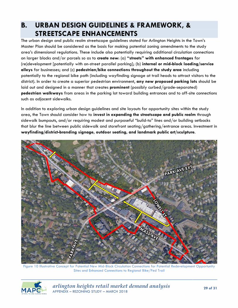
arlington heights retail market demand analysis APPENDIX – REZONING STUDY – MARCH 2018
29 of 31
B. URBAN DESIGN GUIDELINES & FRAMEWORK, & STREETSCAPE ENHANCEMENTS
The urban design and public realm streetscape guidelines stated for Arlington Heights in the Town’s
Master Plan should be considered as the basis for making potential zoning amendments to the study
area’s dimensional regulations. These include also potentially requiring additional circulation connections
on larger blocks and/or parcels so as to create new: (a) “streets” with enhanced frontages for
(re)development [potentially with on-street parallel parking]; (b) internal or mid-block loading/service
alleys for businesses; and (c) pedestrian/bike connections throughout the study area including
potentially to the regional bike path (including wayfinding signage at trail heads to attract visitors to the
district). In order to create a superior pedestrian environment, any new proposed parking lots should be
laid out and designed in a manner that creates prominent (possibly curbed/grade-separated)
pedestrian walkways from areas in the parking lot toward building entrances and to off-site connections
such as adjacent sidewalks.
In addition to exploring urban design guidelines and site layouts for opportunity sites within the study
area, the Town should consider how to invest in expanding the streetscape and public realm through
sidewalk bumpouts, and/or requiring modest and purposeful “build-to” lines and/or building setbacks
that blur the line between public sidewalk and storefront seating/gathering/entrance areas. Investment in
wayfinding/district-branding signage, outdoor seating, and landmark public art/sculpture.
Figure 10 Illustrative Concept for Potential New Mid-Block Circulation Connections for Potential Redevelopment Opportunity
Sites and Enhanced Connections to Regional Bike/Ped Trail
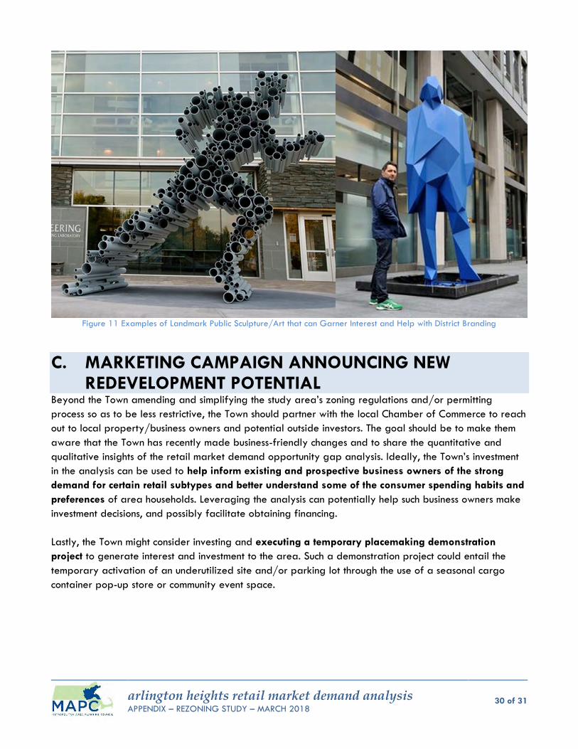
arlington heights retail market demand analysis APPENDIX – REZONING STUDY – MARCH 2018
30 of 31
Figure 11 Examples of Landmark Public Sculpture/Art that can Garner Interest and Help with District Branding
C. MARKETING CAMPAIGN ANNOUNCING NEW REDEVELOPMENT POTENTIAL
Beyond the Town amending and simplifying the study area’s zoning regulations and/or permitting
process so as to be less restrictive, the Town should partner with the local Chamber of Commerce to reach
out to local property/business owners and potential outside investors. The goal should be to make them
aware that the Town has recently made business-friendly changes and to share the quantitative and
qualitative insights of the retail market demand opportunity gap analysis. Ideally, the Town’s investment
in the analysis can be used to help inform existing and prospective business owners of the strong
demand for certain retail subtypes and better understand some of the consumer spending habits and
preferences of area households. Leveraging the analysis can potentially help such business owners make
investment decisions, and possibly facilitate obtaining financing.
Lastly, the Town might consider investing and executing a temporary placemaking demonstration
project to generate interest and investment to the area. Such a demonstration project could entail the
temporary activation of an underutilized site and/or parking lot through the use of a seasonal cargo
container pop-up store or community event space.
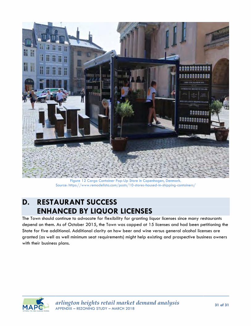
arlington heights retail market demand analysis APPENDIX – REZONING STUDY – MARCH 2018
31 of 31
Figure 12 Cargo Container Pop-Up Store in Copenhagen, Denmark.
Source: https://www.remodelista.com/posts/10-stores-housed-in-shipping-containers/
D. RESTAURANT SUCCESS ENHANCED BY LIQUOR LICENSES
The Town should continue to advocate for flexibility for granting liquor licenses since many restaurants
depend on them. As of October 2015, the Town was capped at 15 licenses and had been petitioning the
State for five additional. Additional clarity on how beer and wine versus general alcohol licenses are
granted (as well as well minimum seat requirements) might help existing and prospective business owners
with their business plans.