Embed Size (px)
Citation preview

ARCTIC 1000Expedition Notes & Journal
A Case Study in Long Distance Trekking Without Resupply
by Ryan Jordan | ryanjordan.com

Copyright (C) 2006-2011 by Ryan Jordan
Please do not distribute. For personal use only.
Much of the content herein was originally published at either ryanjordan.com, arctic1000.com, or backpackinglight.com. Some of the content herein
is owned by backpackinglight.com and licensed to Ryan Jordan for use and distribution.
Cover Photo by Ryan Jordan:
Roman Dial (L) and Jason Geck (R) with 20 days of food,trekking up the Wulik River drainage in Alaska’s Western Arctic.

Executive Summary
What follows is a compilation of documentation leading up to, written during, and reflected upon after, the Arctic 1000 expedition across Northern Alaska in 2006. Please consider it to be an exhaustive, and comprehensive case study in long distance trekking without resupply. I hope you find value in these pages.
Ryan Jordan September, 2011
Bozeman, Montana
Contents
Part 1. Expedition ScopePart 2. Expedition Planning Journal
Part 3. Expedition DispatchesPart 4. Selected Photo Essays
Part 5. Reflections by Ryan Jordan

Part 1. Expedition Scope

May 23, 2006: Press Release
Bozeman, Mont. - On June 11, 2006, Roman Dial, Ryan Jordan, and Jason Geck will begin an attempt of the first and longest ever unsupported trekking traverse of America’s most remote, roadless, uninhabited wilderness, a distance of 1000 km (600 mi).
Expedition Goals
This expedition is being undertaken by three adventurers who simply want to answer the question:
How far can a man walkin a remote wilderness
without resupply, outside support,and dependence upon foraging, hunting, or fishing?
The primary goals of the trek are thus
1. To complete the longest wilderness traverse in the U.S. by fair means, and
2. To be the first party to visit the most remote location in the U.S. by fair means.
3. Unsupported, Ultralight, and by Fair Means. They will carry all of their gear, food, and supplies for the entirety of the trek in backpacks. They will not forage, hunt, or fish. They will not resupply. They will not access roads or habitations for support. They will travel entirely on foot.
About The Route
The route will traverse the most remote (westernmost) region of Alaska's Brooks Range, starting at the Chukchi Sea near Point Hope and ending at either the indigenous habitation of Anaktuvuk Pass or the Alaskan Oil Pipeline Highway ("Haul Road") near Wiseman. This region is notable for two key characteristics: it is the largest contiguous roadless and uninhabited wilderness in America, and it contains America's remotest spot (defined by its distance from the nearest roads or habitations) in an area that is more than 15 times the area of the remotest spot in the contiguous U.S., SE of Yellowstone National Park.
The expedition intends not only to traverse the entire wilderness, but also traverse America's remotest spot en route. Total distance covered will be approximately 550-625 miles (~900-1000 km), depending on route conditions and the party's availability of remaining food towards the end of the trek.

Challenges & Risks
Mosquitoes. Polar and grizzly bears. Unpredictable terrain. Wading - and sometimes swimming - deep, swift rivers. Wet feet. Cold winds. Rain, fog, and snow. Staying warm with minimal clothing, sleep gear, and shelter. Taking enough food (but not too much) - and exercising the discipline to ration it. Managing the consumption of body fat as a calorie source. And of course, managing foot pain (a lot of it).
They will travel in ultralight style, sleep under tarps made with the lightest racing sailcloth materials, carry backpacks that weigh only 24 ounces but will carry 50 lbs (mostly food), and cook over bush fires. They will wear trail running shoes. They will travel at night, and sleep during the day - minimizing the amount of insulating gear they will have to carry. They will walk nearly 50 miles a day in the final third of the trek. And they will go ultralight: not including food and water, they will carry less than twenty pounds of gear - combined (< 7 lb/person).
Expedition member Ryan Jordan, Publisher of Backpacking Light Magazine and the BackpackingLight.com website, says "This expedition will be a serious test of ultralight trekking technique - it's absolutely mandatory that gear weight be ruthlessly eliminated so we can carry enough food to provide the caloric needs to complete this distance."

The People
Roman Dial is a Professor of Biology and Mathematics at Alaska Pacific University, an expedition adventure racer, and has trekked, skied, biked, and paddled some of the longest wilderness routes ever attempted in Alaska. Ryan Jordan is the publisher of Backpacking Light Magazine, pioneer of some of the longest unsupported long distance routes in the Northern Rockies and Yellowstone Ecosystems, and leading practitioner and educator about ultralight trekking style and technique. Jason Geck is an Instructor of GIS, Mathematics, and Outdoor Studies at Alaska Pacific University, reknowned wilderness athlete, and record-holder and 2005 champion of the Alaskan Mountain Wilderness Classic, considered to be the toughest adventure race in the world.
Expedition Sponsors
The expedition's title sponsor is BackpackingLight.com, the leading source of information and education about ultralight backpacking technique, gear, and style.
Other key sponsors include: ULA-Equipment (www.ula-equipment.com), Smartwool (www.smartwool.com), GoLite (www.golite.com), Pacific Outdoor Equipment (www.pacoutdoor.com), Cuben Fiber (www.cubenfiber.com), and Alaska Pacific University (www.alaskapacific.edu).
###

Goals
This expedition is being undertaken by three adventurers who simply want to know the answer to a simple question:
How far can a man walk in a remote wilderness without resupply, outside support, and dependence upon foraging, hunting, or fishing?
Key Objectives
1. To complete the longest wilderness traverse in the U.S. by fair means, between Point Hope, AK, and Anaktuvuk Pass, AK.
2. To be the first party to visit the most remote location (Near the Ipnavik River) in the U.S. by fair means.
Definitions
Wilderness Traverse – a route taken in a generally singular direction following natural major land features (e.g., mountain ranges) through an uninhabited tract of land without crossing and otherwise accessing existing road or habitation networks.
Habitations – organized permanent dwellings harboring communities of people capable of providing support, including, but not limited to gear, food, supplies, and medical assistance.
Longest Wilderness Traverse – that wilderness traverse defined by the longest distance in a generally singular direction between two roads or habitations.
Without Support – a route completed while carrying all food, supplies, and gear in a backpack, with no access to resupply or cache.
On Foot – that mechanism of travel by which all food and gear is carried in a backpack and propelled entirely on foot (i.e., “backpacking” or “trekking”) with no assistance from machines (e.g., bicycle or cart) or other modes of transport (e.g., skis, packraft, or hang glider).
By Fair Means – without support and on foot.
Most Remote Location – that singular place defined by its maximal distance in any direction from a road or habitation.

People
Ryan Jordan
Ryan Jordan is the Publisher of Backpacking Light Magazine and editor of the book Lightweight Backpacking and Camping. Jordan has pioneered more than a dozen routes of several hundred miles each without resupply in the Northern Rocky Mountain and Yellowstone Ecosystems. Jordan's latest projects include development of the 1,500-mile Intermountain Trail (IMT) from the Continental Divide in Montana to the Pacific Crest in California, and research in contiguous wilderness system modeling in the Continental U.S.
Roman Dial
Roman Dial is a Professor of Biology and Mathematics at Alaska Pacific University and has explored Alaskan wilderness by foot, paddle, pedal, and ski for over three decades. He has made full length traverses of the Brooks and Alaska Ranges and competed in adventure races world-wide. Dial is the Race Director for the Alaskan Mountain Wilderness Classic.
Jason Geck
Jason Geck is an Instructor of GIS, Mathematics, and Outdoor Studies at Alaska Pacific University and passionate Alaskan trekker, packrafter, surfer, and adventure racer. Jason was part of the team that shattered the record and won the 2005 Alaskan Mountain Wilderness Classic, considered by many to be the toughest expedition adventure race in the world.

Route
Beginning on Alaska's western coast (Chukchi Sea), the Arctic 1000 Expedition will leave Point Hope on June 11, 2006 and begin walking east, towards the "Haul Road" and the village of Wiseman, Alaska, more than 600 miles away.
Section 1: Point Hope to North Slope Ridges
Heavy packs, unpredictable terrain (including snow, tussocks, and swift rivers), and the need for physiological acclimitization will demand a slow, but necessarily purposeful pace.
• Distance: ~ 150 miles• Time: ~ 7 days• Type of terrain: peninsula beaches, tundra, river delta, and river valleys• Average distance traveled per day: ~20-22 miles• Average elevation gain per day: ~1,200 feet• Average pack weight per person: ~37 to 50 lbs
Section 2: North Slope Ridges
As packs get lighter, mileage and elevation gain increase dramatically as the party connects some of the longest and most topographically spectacular ridgelines found anywhere in the U.S., interspersed with some of the worst tussocks in the North. This section includes the hardest expected day of the first half of the trek (33 miles, 6400 feet of elevation gain with 30-pound packs), a crossing of the mighty Colville River, and an exact traverse of the remotest spot in America (to be verified by GPS), which lies 120 miles from the three nearest habitations.
• Distance: ~ 220 miles• Time: ~ 7 days• Type of terrain: mountain ridges, large river crossings, tundra, tussocks• Average distance traveled per day: ~29-33 miles• Average elevation gain per day: ~2,700 feet• Average pack weight per person: ~22 to 35 lbs
Section 3: Central Brooks Range
With mileage increasing to more than 40 miles per day, this section contains the five hardest days of the trek - all of them consecutive - through the rugged Central Brooks Range. This section includes perhaps the most difficult day of the journey - 47 miles of cross-country mountain travel with 4,700 feet of elevation gain.
• Distance: ~220 miles• Time: ~ 5 days

• Type of terrain: mountain passes, ridges, creekways• Average distance traveled per day: ~41-47 miles• Average elevation gain per day: ~4,900 feet• Average pack weight per person: ~11 to 20 lbs
Section 4 - Option 1: Hammond River Exit
This day deserves its own section, since it's the only day with sustained downhill travel. It promises to be a welcome reprieve from the previous five days, but with no apologies made for mileage.
• Distance: ~40 miles• Time: ~1 days• Type of terrain: down a river valley• Average distance traveled per day: ~40 miles• Average elevation gain per day: ~0 feet• Starting per person pack weight in this section: ~7-9 lbs
Section 4 - Option 2: Tinayguk River Exit
Option 2 will be considered as another alternative from Anaktuvuk Pass to Wiseman, depending on available remaining body fat and feet condition.Pick up packrafts at Anaktuvuk Pass, walk from Anaktuvuk Pass to the Tinayguk, packraft down to the Koyukuk, and trek into Wiseman.
Total: Point Hope to Wiseman
• Distance: ~620 miles• Total elevation gain: ~51,500 feet• # Roads Accessed: 0• # Trails Used: 0• # Resupplies: 0• # of meals hunted, foraged, or fished: 0• Amount of gear, food, and supplies carried on back for entire trek: 100%

Live Route Map
This route map used a Google API to update our position en route during the expedition that you could follow online.

Gear
About The Gear
The objectives are simple: Walk. Eat. Rest. With an emphasis on the first two.Ultralight gear is not a chosen style because "it's cool". It's absolutely mandatory.
Without ultralight gear, how can one carry the amount of calories required to travel nearly 1,000 km over some of the most difficult trekking terrain in North America?
Shoes, Footwear, and Foot Care
Shoes
We're all wearing trail running shoes. As of 5/22, we haven't decided whether we are taking one or two pair. Roman plans on using Salomon XA Pro's, Ryan is fairly well set on Montrail Vitesses (but is taking the Inov-8 O'330's to the gate in training, just to see...), and Jason's undecided.
Socks
We'll use a combination of Smartwool (Roman and Jason) and Darn Tough (Ryan) socks, all in a trail running cushion/light hiking style. We'll carry spare dry socks (Smartwool) for sleeping - with Ryan using PossumDown socks at night.
Footcare
The bulk of Roman's kit will be "pills, tape, and a needle". Ryan's adding Hydropel.
Packs
Expedition packs are being custom made by ULA Equipment and Brian Frankle of Logan, UT. The packs are "harness-style" packs with internal frames that mate with dry bags (from Pacific Outdoor Equipment) which are required to keep gear dry in prolonged rain and river swims/crossings. The packs are being designed to carry 50 pound loads in comfort, but weigh less than 24 ounces.
Active Clothing for Trekking, Wind, and Rain
We won't be moving slow on this trek. Active clothing will focus on a lightweight, breathable base layer setup (with capilene or wool hoody shirts and spandex shorts, combined with mosquito-proof pants). Rain gear will include a 6-ounce rain jacket (Patagonia Specter or GoLite Virga) and 3-ounce Pertex pant (Montane Featherlite). Hat and gloves will be that which is sewn into the base layer shirt.

Sleep System & Insulating Clothing
All synthetic: Polarguard Delta and Pertex Quantum. Custom clothing and quilts from Bozeman Mountain Works, including a hooded Cocoon Pullover (10 oz), Cocoon Pants (7 oz). Sleep system is as yet undecided but will be either a shared 3-person quilt, or if we split into two shelters (e.g., for increased bear safety), a 2-person quilt (25 oz) and a solo quilt (18 oz). Sleeping pads will include Pacific Outdoor Equipment Uberlite Pads (3 oz, Roman and Jason) and the Gossamer Gear Nightlight Torso (3 oz, Ryan).
Shelter
Tarps made by Dave Olsen at Oware USA (www.owareusa.com) using Cuben Fiber racing sailcloth that use carbon fiber trekking pole shafts for support.
At this point, we are as yet undecided on whether we'll be sharing a single 8' pyramid tarp or one pyramid tarp and one "half-pyramid" tarp (two shelters offer some advantages in terms of bear protection).
Cooking & Hydration
• Cooking: bush fires and a titanium pot.• Hydration: soft-sided bladders, one per person, Platypus & Nalgene Cantenes.
Navigation
Maps, compass, pencil, and one GPS to find and mark America's remotest spot.
Minor Essentials
Toothbrush, dermatone, headnets, tape, bug dope, pills, sunglasses, titanium spoons.
Journalism / Publishing Gear
• Nikon DSLR camera kit• Iridium / Hewlett-Packard Satellite PDA publishing system• Brunton Solaris solar panel
Food
A lot. About 45 pounds per person. Includes a bunch of mashed potatoes, cream of wheat, almond butter, Cadbury bars, Kellogg's Fruity Snacks, and Pringles. Details to be revealed later. Suffice to say that each person will be packing about 100,000 calories of food and another 50,000 calories of excess body fat (~15 lbs).

Sponsors
About our Sponsors
We are not gear testers. This is not a gear testing expedition. We didn't go out shopping for free gear. We knew exactly what we wanted, and are accepting no compromises simply to save a buck here and there on mediocre equipment or "do favors" for manufacturers in the interest of publicity for them. The gear you will read about below has already proven its worth by us in the field. Now it's time to put it to use when it really counts.
The companies we recognize below are not expedition sponsors in the usual sense. They are providers of goods and services that are among the very best in their industry. We're not here to endorse "brands" or companies, because, hey, even the companies listed below make some products that aren't quite, how shall we say, up to par... But the specific products we have selected, and the companies that make those products, certainly deserve to be mentioned as "best in class".
Title Sponsor
Backpacking Light Magazine
Backpacking Light Magazine provides ONLINE and PRINT magazine subscriptions to reviews, commentary, technical education, and narrative features about lightweight hiking and backcountry travel. Backpacking Light is providing editorial, satellite publishing, and public relations support to the expedition.
Visit BPL on the web: www.BACKPACKINGLIGHT.com
Key Sponsors
National Public Radio (NPR)
National Public Radio (NPR) will be providing coverage of and commentary about Arctic 1000. Alex Chadwick of NPR's Day to Day will be interviewing Ryan Jordan prior to and following the trek. In addition, Ryan will be checking in with Day to Day once or twice during the trek, to provide a summary of expedition progress in a live interview with Alex.
Visit NPR on the web: www.npr.org

Bozeman Mountain Works
Bozeman Mountain Works manufactures ultralight clothing and sleep systems, and is providing custom expedition gear, including synthetic insulating clothing (hooded pullovers and pants), synthetic quilts, and reinforced-mylar tarp shelters.
Visit BMW on the web: www.BozemanMountainWorks.com
Alaska Pacific University
Alaska Pacific University is a private, liberal arts university in Anchorage that supports the GIS research conducted by Geck and Dial used to map and analyze America's most remote wilderness. Part of the research including the identification of the precise location of America's most remote spot, as measured by its distance from a road or habitation. The expedition party will traverse this exact spot, locating in the interior of Alaska's North Slope of the Brooks Range.
Visit Alaska Pacific University on the web: www.ALASKAPACIFIC.edu
ULA Equipment
ULA Equipment manufactures lightweight backpacks in Logan, Utah. Brian Frankle worked with the expedition crew to design and manufacture custom internal frame backpacks that weigh less than 1.5 pounds while integrating with a dry bag for the packbag, required for river crossings, and capable of carrying a 50 pound load.
Visit ULA Equipment on the web: www.ULA-EQUIPMENT.com
Cuben Fiber
Cuben Fiber makes ultralight fiber-reinforced mylar racing sails. Interestingly, the fabric is waterproof. The expedition will be using two custom shelters manufactured by Oware USA made with Cuben Fiber fabrics, including a 14-ounce pyramid shelter (Jason & Roman) and a 9-ounce "half-pyramid" (Ryan).
Visit Cuben Fiber on the web: www.cubenfiber.com
Smart Wool
Smartwool manufacturers merino wool socks and base layer apparel. Smartwool has provided the expedition with lightweight hooded torso base layers that will be worn 24/7. Roman Dial and Jason Geck will be using Smartwool socks en route.
Visit Smartwool on the web: www.smartwool.com

GoLite
GoLite manufactures clothing and gear for lightweight hiking and other adventure sports. GoLite is providing the expedition's raingear, the new 6.0-ounce full zip, hooded, Virga jacket.
Visit GoLite on the web: www.GOLITE.com
Pacific Outdoor Equipment
Pacific Outdoor Equipment (POE) manufacturers RF-welded outdoor gear, including sleeping pads, dry bags, and packing systems. POE is providing the ultralight, 50-L dry bags that will serve as our backpack packbags (integrated with the ULA-Equipment pack frame-and-harness systems) that will protect our gear in the sustained rain and river crossings/swimmings.
Visit Pacific Outdoor Equipment on the web: www.PACOUTDOOR.com
Patagonia
Patagonia makes lightweight backcountry clothing, including the French Roast soft shell pants and Specter rain jackets worn by some of the expedition members.
Visit Patagonia on the web: www.patagonia.com
Other Sponsors
Darn Tough
Darn Tough is the only company to provide a lifetime warranty for their socks. Based on our testing, we can see why. Ryan Jordan will be using Darn Tough Socks on the expedition and has every intention of only taking a single pair for the entire trek.
Visit Darn Tough on the web: www.darntough.com
Headsweats
Headsweats manufactures ultralight polyester race caps that focus on moisture/sweat management.
Visit Headsweats on the web: www.headsweats.com
Hewlett-Packard
HP manufactures personal digital assistants, a.k.a. "palmtop" computers, including the popular iPAQ series, which are considered to be the only expedition-worthy PDA on the

market due to its temperature and moisture resistance. The expedition will use an iPAQ 2400 series PDA with an Iridium satellite phone and Pentax Optio WPi digital camera to report live updates and photography en route.
Visit Hewlett-Packard on the web: www.hp.com
Hydropel
Hydropel is the only lubricant based on a formulation of 30% dimethicone, and thus, it's the only lubricant with the longevity required to control blister formation and maceration in the continually wet and cold conditions of the Alaskan bush.
Visit Hydropel on the web: www.genesispharm.com
Inov-8
Inov-8 manufacturers ultralight trail racing shoes, used by Ryan Jordan during his training for the expedition.
Visit Inov 8 on the web: www.inov-8.com
Iridium
Iridium provides the most reliable satellite phone service on the North Slope, and will be used in conjunction with an Iridium satellite phone to deliver live dispatches and photography en route.
Visit Iridium on the web: www.iridium.com/
Light My Fire
Light My Fire makes firebuilding supplies, which the expedition will use (firestarters and firestarting material) to start cookfires in the severely wet and saturated conditions of the North Slope of Alaska.
Visit Light My Fire on the web: www.lightmyfire.se
Montane
Montane makes ultralight clothing, including the lightweight Montane Lightspeed wind jacket that Ryan Jordan will use on the trek.
Visit Montane on the web: www.montane.co.uk

Montrail
Montrail makes endurance trail footwear for ultrarunners and long distance hikers. Ryan will be using a single pair of Montrail Vitesse trail running shoes for the entire journey.
Visit Montrail on the web: www.montrail.com
Platypus Hydration
Platypus makes ultralight hydration systems, including the veritable Platypus bottles that will be used by expedition members for durable water storage.
Visit Platypus on the web: www.platypushydration.com/
Sea-to-Summit
Ryan will be using Sea-to-Summit Ultra-Sil Dry Sacks inside his main packbag as an additional layer of protection for his sleeping quilt, insulating clothing, and satellite phone / PDA electronics.
Visit Sea-to-Summit on the web: www.seatosummit.com
Suunto
Suunto manufactures wristtop computers, including the Suunto T6 (used by Ryan Jordan during training) and the Suunto S6, to be used on the expedition.
Visit Suunto on the web: www.suuntousa.com
Topo! Pro
National Geographic's Topo!PRO software is used by Ryan Jordan in GIS research on contiguous wilderness modeling, and is being used for route and geographic information analysis of the expedition area for Jordan's upcoming book on long distance trekking.
Visit Topo! Pro on the web: www.ngtopo.com
TypePad
Typepad is a provider of hosted blogging services, and is hosting the Arctic1000.com website.
Visit TypePad on the web: www.typepad.com

UDAP
UDAP makes bear spray in Nice Big Cans.
Visit UDAP on the web: www.udap.com

Part 2. Expedition Planning Journal

May 2. How Remote is Remote?
On April 19, Roman emailed Jason and I with some interesting commentary about the Arctic trek:
"If the remotest place we are walking to (i.e., a bench overlooking the Ipnavuk River) is more than 119 miles from the nearest town (i.e., Umiat, Ambler, and Atqasuk) or road (i.e., AK haul road) in every direction, then we will be in the heart of a wilderness that is bigger than a dozen Yellowstone National Parks. To surround a point with wilderness 119 miles in every direction requires 28.5 million acres, and that is actually just a piece of what the wilderness is where we are headed..."
“No doubt Ryan you have been to Yellowstone’s remotest corner, the Thorofare region, 30 miles or so from the road. That requires a wilderness of 1.8 million acres to surround it, so in some sense the place we are going is more than 15 times wilder.”
See the graphic: the little circle is the Thorofare wilderness (2 million acres). The middle circle is the wilderness surrounding the remotest spot in America (radius = 119 miles). The outermost circle has diameter equal to distance we hope to walk. I hope we are not biting off more than we can chew — or rather, knowing that we are biting off more than we can chew, I just hope we can swallow it."

May 2. Archimedes and Lookout Ridges
by Roman Dial
The Arctic 1000 expedition will traverse what may be some of the least-trekked terrain in the world: Archimedes and Lookout Ridges, on Alaska's North Slope.
For a satellite perspective view of this region, view this link:http://geogdata.csun.edu/alaska_panorama_atlas/page8/files/page8-1060-full.html
Our route follows the obvious "nicest line" in the image, starting at the lower right corner and following Archimedes Ridge left and toward the rear center of the image.

May 17. Training Notes
Ryan Jordan
Ryan's training regimen leading up the trek has focused almost 100% on trekking and trail running with an overnight pack, with 2-3 core and lower body strength workouts per week (3 hr/wk). Ryan spends four days a week on trails, dirt roads, snow, and bushwacking in the mountains of Southwest Montana.
• Tuesday/Wednesday. An overnight trekking at a brisk pace with moderate elevation gain (3000-5000 feet over the course of 30 miles, split between Tuesday evening and Wednesday morning) with a 20-25-pound pack. Average pace ~ 3.5 mph, range 2.5 – 4.5 mph. Location: Gallatin Range
• Fridays. Strength training focusing on a 15-mile trek with a 35-40 pound pack, with 4,500 feet of elevation gain in the first 4 miles, rolling mountain ridges/scree/snow for the next six miles, and a 5 mile trek downhill on trails to finish the day. Average pace ~3.0 mph, range 1.5 – 3.5 mph. Cumulative elevation gain ~ 6,000 to 7,000 feet. Locations: Gallatin Range, Bridger Range, Madison Range
• Saturdays. Distance training, carrying a light pack (< 12 lbs) and moving consistently fast for 35 or more miles on trails and dirt roads. Average pace ~4.0 mph+ overall, range 3.0 mph – 5.5 mph). Locations: Big Belt Mountains, Tetons, Yellowstone National Park, Crazy Mountains, Tobacco Root Mountains, Gallatin Range, Bridger Range, Bangtail Range
Roman Dial
Dial began in late December with walks with his wife in and near the city of Anchorage, Alaska.
• Late December through JanuaryM-F: 5-10 miles per day on roads and trails, 0-2000 foot elevation gain and a 10 pound pack, average speed ~4 mphOne weekend day: 20 miles in less than 7 hours
• FebruaryM, W, F: 5-10 miles per day on roads and trails, 0-2000 foot elevation gain and a 20 pound pack, average speed ~3.5 mphOne weekend day: 20 miles in less than 7 hours
• MarchM, W, F: 5-10 miles per day on roads and trails, 0-2000 foot elevation gain and a 30 pound pack, average speed ~3.0 mph

One weekend day: 20 miles in less than 7 hours
• AprilT, R: 5-10 miles per day on roads and trails, 0-2000 foot elevation gain and a 50 pound pack, average speed ~2.1 mphOne weekend day: 20 miles in less than 7 hours
• MayM, W, F: 5-10 miles per day on roads and trails, 0-2000 foot elevation gain and a 30 pound pack, average speed ~3 mphOne weekend day: 20 miles in less than 7 hours
Jason Geck
In preparation for the trek, Jason has been focusing on elevation gain hikes, trail running, and glacier skiing. Recent training locales include the usual Anchorage stomping grounds (Arctic Valley Road, Turnagain Trail, Chugach Mountains), as well as St. Paul, Pribilof Islands and the Eastern Brooks Range.
• Trail runs vary in length from 8 to 10 miles with light loads (< 10 pounds).
• Glacier research allows long days of training schlepping heavy loads of gear up and down glaciers.
• For heavier weight training, Jason carries a 30-35 pound backpack for 15 - 20 miles with 2500 - 5000 foot elevation gain.

May 17. How Far, How Fast, How Heavy?Predicting the range of an unsupported long distance trek
Roman Dial presents theory and formulae that can be used to predict the range of an unsupported trek. The mathematical models considers food weight consumed per day, base weight of gear, maximum mileage per day, and spits out estimates for duration of your trek and pack weight required to complete your desired distance - without resupply or support.
An interactive model simulator is included to tailor and calibrate the model to your own abilities and objectives.
Read an excerpt from the article here:
The problem is stated simply; how far can you go, on foot, and self-contained? No food drops, no foraging, no wheels, no motors. Everything you need, including food, you carry on your back. How far can you go and how long will it take? We can call this your maximum range.
No doubt you will say, "My maximum range depends on a whole host of factors." And I will agree, that, yes, it depends, but it will depend on less than you think. And by that I mean the predictions will meet with observations surprisingly well and without all the messy details that most of us would insist should be included.
In some ways this question of "How far how fast?" is a variation on adventure racing. However, as far as I know, nobody has organized a competition to see what the extreme maximum range might be: 50 people toed up at the start line, the only rule that everything needed is in the pack and the race is over after all racers have run out of food and marked their distance would help answer it. I offer some predictions.
My interest in maximum range stemmed from Alaskan "wilderness racing" during the early 1980's. It was then, before the Eco-Challenge, Raid Gauloise, the Southern Traverse in New Zealand, or even Ray's Way or GoLite - that a handful of us raced across large blocks of Alaskan wilderness, mostly un-trailed, over mountains, across rivers, past bears. These were big chunks, with straight line distances between roads in the 75 to 100 mile range. And we traveled very light.
The rules for the Alaska Mountain Wilderness Classic were brutally simple: start here, go there - where "there" was 150-250 miles away - carrying everything needed, including food, with you from start to finish. No help, no roads (usually one road was crossed), no motors, no pack animals. Instinctively I knew that a heavier pack meant a slower pace, and to a competitive person, a heavier pack meant a lesser chance of winning.

Like everyone who races more than once, I discovered that weight kills speed. Not only does weight kill speed, I found that weight kills distance. And by 1984, after three seasons of wilderness racing, I'd uncovered a ruthless calculus: it appeared that every pound dropped from my back increased my daily maximum by a mile.
The complete text of this article can be found at the following link, and has also been included in the Appendix of this book.
How Far, How Fast, How Heavy? Calculating the range for unsupported, long-distance hiking, by Roman Dial. Backpacking Light (http://www.backpackinglight.com/cgi-bin/backpackinglight/calculating_range_in_lightweight_backpacking.html), May 24, 2006.

May 29. Backpacks for Arctic Trekking
We went down several design avenues when selecting the right pack for an expedition like this.
It all came down to what sort of pack would be most appropriate for a route and environment like this. So, let's start with key features of the route, and location/season, that might affect pack selection:
1. It's going to get wet. A pack that absorbed as little water as possible, and was as effective as possible, at keeping water out of the packbag, are desirable features. This is a wet environment. It rains a lot, we're camping on wet ground, and we have dozens of rivers to cross - some that require swimming. The pack needs to keep the contents dry.
2. It needs to carry weight. We're humping 50+ pounds of food, and a little bit of gear, at the beginning. The pack also needs to be "soft" enough so as not to inhibit mobility while moving fast with very light loads towards the end, for our highest mileage days.
3. It needs to adapt to variable load volumes. This criterion alone elimintaes most of the packs on the market, which are poorly compressible in large volumes and don't generally carry gear on the outside well in larger volumes. All the gear needs to fit inside the packbag (for river crossings), yet the packbag must be adaptable to a rapidly shrinking load volume as the trip progresses. In other words, a small load must also result in a small pack (in contrast to a small load carried poorly in a big pack) in order to maximize our efficiency and comfort for high mileage days and rapid pace towards the end.
4. It must provide immediate access to all essential gear used throughout the day without having to access the packbag. That means we need to be able to reach two liters of water and 2000 calories of food without taking off the pack, and being able to grab wind and rain gear without opening the packbag. The goal here is twofold: we don't want to waste time dealing with gear, and we don't want to expose gear inside the packbag to the elements unnecessarily.
This criteria led the development of custom "dry bag harness" packs by ULA Equipment, affectionately and informally denoted as the "ULA Arctic Dry Pack". The packs are based on a design by Roman Dial for Alaska trekking and packrafting, and implemented in various forms in the past by Dana Design and Cascade Designs, and since then, pretty much "upgraded" to a state of dysfunctionality in some form or another by these and other manufacturers (or in the case of Cascade Designs, discontinued altogether).
The ULA Arctic Dry Pack integrates two key components: a dry bag and a harness.

About the Dry Bag. We have selected the Pacific Outdoor Equipment 65L Pneumo Dry Bag (12 oz / 340 g) for our packbag. We tested so-called ultralight dry bags from other manufacturers, including Outdoor Research (seal not waterproof under immersion, outer fabric absorbed significant quantities of water) and Sea to Summit (neither seals nor seams waterproof under immersion, poorly durable fabric*). The POE Pneumo proved to be completely waterproof at its closure, seams, and fabric, even under significant immersion pressure. It also offered slots at the bottom of the bag through which compression straps could be threaded to cinch a heavy load into the lumbar region of the pack harness. Finally, it comes with an air exchange valve, which is a very nice feature for (1) compressing the packbag as much as possible while hiking for best load stability, and (2) inflating the packbag for river crossings to improve flotation and minimize the net pressure of water against the packbag fabric during immersion.
* The Sea-to-Summit Ultra-Sil Dry Sacks deserve a fair assessment here. First, they are not designed or intended to withstand the water pressures of immersion. They are intended to provide rain protection to gear while packed inside a backpack. Ryan will be using Ultra-Sil Dry Sacks inside his main POE pack dry bag for his sleeping bag, insulating clothing, and satellite phone electronics.
The image to the right shows the packbag in "inflated" mode when in the harness.
About the Pack Harness. The ULA Arctic Dry Pack offers the following features, and weighs 24-30 oz (depending on size and other options):
• Dry Bag Compression System. One outer harness, one top cinch strap, and three sets of side cinch straps for securing the dry bag to the pack harness (see image to right).
• Replaceable / Customizable Back Pad. Can be adjusted to accomodate variable types of padding and frame stay configurations. For example, Ryan's backpad is constructed of a dual density foam and twin frame stay sleeves for load transfer.
• Wide, but Thinly Padded Hip Belt & Shoulder Straps. To maximize surface area for load transfer without inhibiting movement or binding under heavy weight (see image below).
• Large Hip Belt Pockets. Each pocket can hold 1,000 or more calories of food (see image below).
• Rear Mesh Pocket. Rear mesh pocket has three openings (center and two sides). Side openings have elastic drawcord closures and are accessible while wearing the pack. Perfect for water bottles. The center opening can be used to stash clothing,

more food, or trekking poles. (See image to right).
• Bear Spray Holster. Shoulder strap offers a bungee system for securing a can of bear spray.

June 3. Ultralight Shelters and Sleep Systems
Shelters
Our shelter strategy considers a number of criteria.
First, we want shelters that provide full perimeter protection - primarily for storms, and secondarily for bugs.
Second, they need to be light. We don't plan to spend a lot of time in them, especially later in the trek as our mileage increases. By the last few days, we anticipate only "4-hour nights" or so.
Third, the three of us will be sharing two shelters, primarily as a matter of style,* but some evidence suggests that parties camped in two shelters offer more strategic options in case of a bear encounter, and other evidence suggests that bears are less likely to mess with camps where two or more shelters are in close proximity together. Of course, most of the evidence is meaningless because bears are just plain unpredictable, so we have to ditch any rationalization here pretty quick. Onward.
* Ryan's kit is a solo kit (including shelter, sleep, and cook gear), while Roman and Jason's is a shared kit (shelter, sleep, and cook gear). We recognize that sharing all gear would save a few ounces, but would cause us to lose some flexibility in emergencies (e.g., we have some duplicity available in case of the need to split the party to facilitate a rescue or the failure of one of the shelters).
The shelter in the photo to the right is is the custom made shelter being shared by Roman and Jason - an 8' x 8' pyramid tarp with a 36" front zip, and upper vent. It weighs 13.4 oz (380 g).
Compare to conventional pyramid shelters of similar size, which weigh 28-32 oz (e.g., Black Diamond Megalite, GoLite Hex) or so, and you can see why weight savings in shelter can reap big benefits: 14 ounces of weight saved in a shelter = an additional 1800 Calories of food...
Ryan's shelter is a "half-

pyramid" solo size (photo right). It weighs about 9 oz and includes some ultralight 0.3 oz/sq.yd. perimeter mesh for a mosquito barrier.Both shelters will use our custom carbon fiber trekking poles to pitch (each pole weighs about 3.5 oz each with grip, tip, and basket). We'll be using 1mm diameter Spectra core guylines (with polyester sheath for knottability), and for the most part, tying the tarps off to rocks and brush.
Ground Cloth
A ground cloth will have to be considered a luxury item and left at home on this trek. We'll have to pay more attention to where we camp, and take advantage of our other gear to keep sleeping bags dry. Between backpacks, dry bags, sleeping pads, and raingear, crafting a dry bed on wet ground is not a difficult task. And with synthetic fill sleeping quilts and insulating clothing, some dampness is tolerable. To the right is a
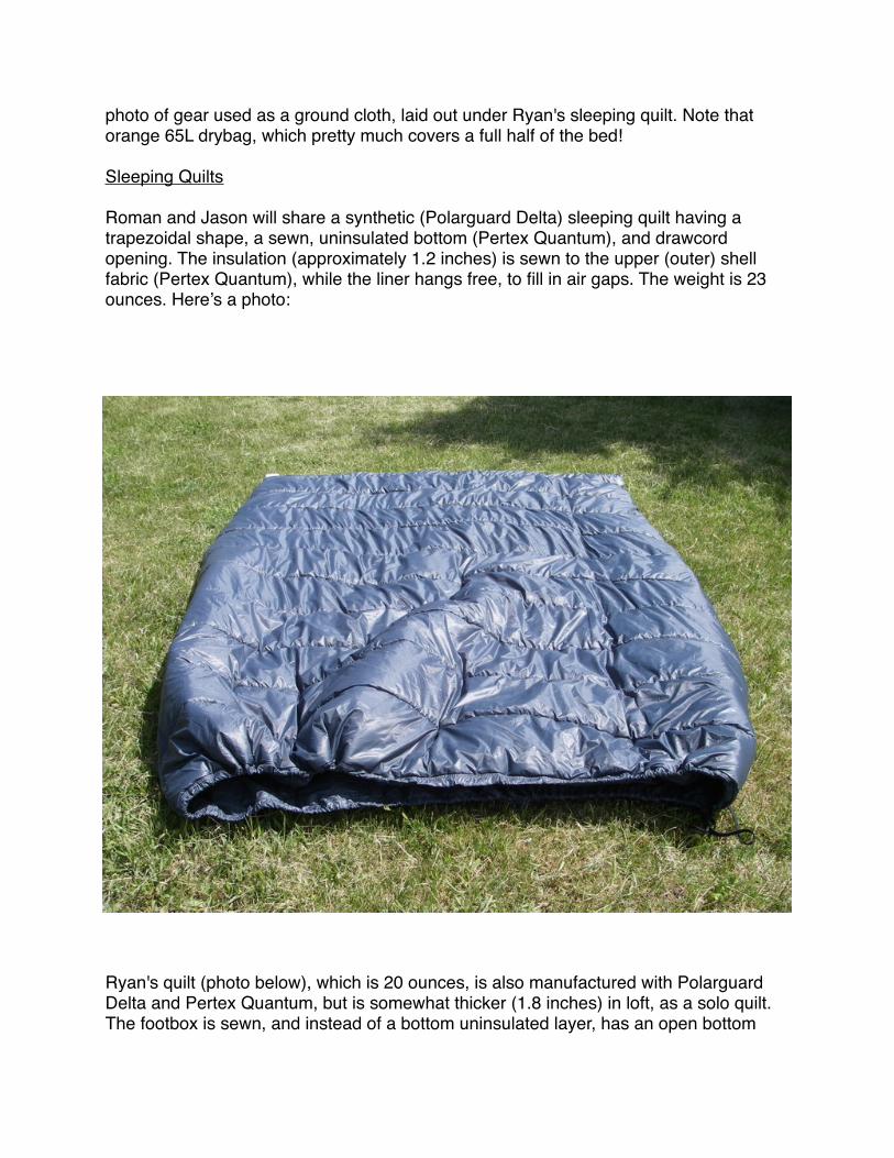
photo of gear used as a ground cloth, laid out under Ryan's sleeping quilt. Note that orange 65L drybag, which pretty much covers a full half of the bed!
Sleeping Quilts
Roman and Jason will share a synthetic (Polarguard Delta) sleeping quilt having a trapezoidal shape, a sewn, uninsulated bottom (Pertex Quantum), and drawcord opening. The insulation (approximately 1.2 inches) is sewn to the upper (outer) shell fabric (Pertex Quantum), while the liner hangs free, to fill in air gaps. The weight is 23 ounces. Here’s a photo:
Ryan's quilt (photo below), which is 20 ounces, is also manufactured with Polarguard Delta and Pertex Quantum, but is somewhat thicker (1.8 inches) in loft, as a solo quilt. The footbox is sewn, and instead of a bottom uninsulated layer, has an open bottom

with a "variable girth" and 0.1 oz of thin cord used as "laces" underneath it to minimize drafts into the sides of the quilt. Shown to the left is an upside-down view. This "arc" cross-sectional design was pioneered by ultralight backpacker Don Johnston of Maryland.
Insulating Clothing
1.2 and 1.8 inches of synthetic loft isn't exactly luxurious for June in the Arctic. Loft destruction, moisture absorption, and cold/wet/windy environmental conditions for three weeks with no guarantee to dry out gear can severely stress a sleep system. Thus, we are supplementing it with insulating clothing, also made with Pertex Quantum (as the shell and lining) and Polarguard Delta (as the insulation). Each of us will carry a set of hooded pullovers (~ 10 oz each) and pull-on pants (~ 7 oz each), to be used primarily as "dry" sleep clothing, and to wear while hiking in severely cold conditions, such as might occur immediately after swimming a river, or in the midst of a snow storm with high winds. A dedicated, dry pair of socks to crawl into every night will round out the system, to avoid the cumulative maceration of feet that occurs in the sustained cold and wet conditions we'll encounter, especially during the first two weeks of the trek.
Sleep Strategy
Another strategy we are employing to take maximum advantage of our minimal sleep system is the Midnight Sun: Near the summer solstice (June 21), the Arctic region enjoys daylight nearly 24 hours a day. Consequently, we'll hike the majority of our miles "at night" - when it's cooler and more comfortable for moving fast. Consequently, we'll sleep the majority of our hours "in the day" - when it's warmer and more comfortable for resting. This strategy allows us to bring less clothing than if we were following a more

conventional schedule and waste less energy (Calories!) due to overheating / cooling. This strategy doesn't really work at lower latitudes - it's too demoralizing to hike through such beautiful country at nighttime, and night hiking - in the dark - is simply slower.
So, this gives you some insight into our rationale for picking the window of June 11-July 1 for this trek. We are hoping to (1) take maximum advantage of daylight surrounding the summer solstice, (2) begin as soon as possible after the snow disappears from the Point Hope area, and (3) beat the massive onslaught of mosquitoes - and warm temperatures (which are no fun at all to hike in) - that comes to the Arctic around the Fourth of July. The real kicker here is daylight and temperatures. Once temperatures in the Arctic reach 60 degrees Fahrenheit, hiking fast becomes awfully tiring and the mosquito activity goes from bad to worse. If you wait until August to do this trek, when temperatures cool again, you have to battle darkness and increasingly unsettled weather, virtually eliminating any possibility of accomplishing the very high mileage days required for an unsupported traverse of this length.
Surely, we've given a bit of thought to the planning of the strategy and schedule. More surely, however, we are counting on our feet to hold up, our food to sustain us, and of course, no short course of luck, to see us on to Anaktuvuk Pass ... or beyond.

June 5: Crossing the Colville
Some say that our route crux will be the long days at the end.
Others, doing the same - day after day after day.
Still others: snow, tussocks, shale.
While others are emailing us with encouraging words about the Colville River crossing. "Good luck!" they say, or "You takin' a raft?" or "Bwahahahaha!"
Photo: http://www.airphotona.com/image.asp?imageid=4641. Photo forwarded to Arctic1000.com by Peter Vacco, veteran Brooks Range adventurer. This photo was taken about 25 miles SW of Umiat, not so far from where we'll cross it. Ahem.

June 7. Ultralight Simplicity
Gear for a long distance trek need not occupy much volume nor require an administrative logistician to manage.
Photo, top to bottom:
* Pack * Sleeping Pad * Sleeping Quilt * Insulating Clothing * Shelter * Wind and Rain Clothing * Miscellaneous Essantials (Toiletries, Foot Care, Repair) * Sat Phone / PDA / Camera (Left), Cook Kit (Right) * Maps, Notetaking, and a Long Handled Titanium Spoon
Gear shown in this photo is uncompressed. It does not include clothing worn. It occupies about 30 liters in the packbag, "leaving about 35 liters for food". In reality, the 95,000 Calories of food we'll be packing each (about 42 pounds) will occupy around 35 liters of packbag volume, so in order to have a secure dry bag closure on the (not really) 65L main packbag, we'll start the trek with a smaller drybag (15L) secured to the top of the pack. As food volume decreases, this small bag will be used for additional wet gear storage inside the pack.

June 7. Clothing
Clothing must be light and keep you warm. Beyond that, any features, such as "keeps you dry", or "pockets", or "makes you look good whether in the backcountry or a bistro" are a luxury. What follows is a discussion of clothing from one of the expedition members (Ryan) and the rationale behind his choices.
Base Layers
Ryan will wear GoLite Stride Shorts (3 oz) and a Smartwool Hoody (9 oz, permithrin-treated for mosquito repellency) that will hit the market later this year. The Hoody is a women's version, which fits trim (good for the Arctic) but reveals the belly button (bad for the Arctic). So, Ryan sewed an 8 inch extension of GoLite Lightweight C-Thru to the hem. Voila - a sealed waist, whether tucked or untucked. The other mod Ryan made is to sew the hood a little tighter so it seals. It seems that "hoodies" have become fashion pieces, which means the hoods on the hoodies are not so functional all the time. The hood is also Ryan's "warm" hat for the trek. The hoodie has thumbholes in the sleeves, which when combined with Ryan's spare pair of socks (= gloves) should keep his hands warm that first week...

Wind Layer
Like the base layer, the wind layer will also be worn most of the time. Patagonia French Roast soft shell pants (permithrin-treated, 9 oz) provide wind, bug, and some moisture protection for the legs, while a Montane Lightspeed Jacket (4.0 oz) offers wind protection for the top. Ryan's hacked the Lightspeed to simplify its function: removing the waist drawcord (saves weight, more comfortable tucked in) and inner hood lining (saves weight, improves breathability), and replacing the hood drawcord with small bits of elastic band (saves weight, simplifies hood use). Yes, there are lighter wind shirts, but none that really fit well - trim and long enough to cover the butt.
Rain Layer
As conditions worsen, on goes raingear, which includes the GoLite Virga Jacket (2-layer waterproof-breathable, 6 oz) and Mont-Bell Ultralight wind pants (water-resistant, 2.5 oz), both garments freshly Revivex'ed. Spare stuff sacks or used plastic food bags combined with spare socks protect hands during super cold conditions.
Insulating Clothing
The Bozeman Mountain Works Cocoon Hooded Pullover (10 oz) and Cocoon Pants (7 oz) provide core warmth for sleeping, cooking, and in the direst of circumstances, trekking. They are made with highly breathable shell materials (Pertex Quantum) and synthetic insulation (Polarguard Delta). The hood on the pullover, combined with the hood on the Hoody (above) provides head warmth at night in combination with Ryan's hoodless sleeping quilt. The only other piece of clothing carried in the pack is a pair of polypropylene stocking tights, from Sahale (1.6 oz), which are used for trekking on very cold days and as a sleep layer under the Cocoon clothing when other trekking clothing is soaking wet.
Headwear
Baseball cap (Headsweats Coolmax polyester, 1.6 oz, permithrin-treated), bridal veil mesh mosquito headnets (0.3 oz each x 2). Combine with hoods on the merino wool Hoody, wind shirt, rain jacket, and Cocoon Pullover for warmth / weather protection. No dedicated "warm cap".
Footwear
Montrail Vitesse shoes treated with Seam Grip on all exposed stitching and at usual glue junctions where delamination typically occurs as the shoe wears out. REI Spring Gaiters (Schoeller Dynamic) are stitched directly to the shoe to avoid the inevitable "gaiter strap wear". Darn Tough full cushion hiking socks (2 pair) keeps one pair dry for sleeping while offering a spare if one fails.

Handwear
No dedicated "warm gloves". Hoody has thumbholes and long sleeves into which hands can be tucked; spare socks can be used as mitts; stuff sacks as mitt shells; long sleeves on the wind shirt and rain jacket can be used for wind/water protection; long insulated sleeves on Cocoon Pullover can be used for warmth. Grabbing a cookpot of the woodfire stove can be accomplished with a sock.

June 8. On Food and Cooking
Long Distance Fuel Strategies
How much food to take? What kinds? How to package it?
To one extent or another, these three questions have caused the failures of some of my (Ryan's) previous unsupported expeditions, especially early on, when I first started to experiment with long distance treks without resupply in the late 1980s.
I failed in my first attempt to circumnavigate the Olympic Mountains because I ran out of food, lost an excessive amount of weight, and exited 2/3 of the way to the end of my route traveling only 15 miles a day - on trails - because I was underfueled. I was not expecting my caloric intake to skyrocket at around Day 10 (that point in time where my burnable body fat virtually ran out). After that trek, I nearly suffered from renal (kidney) failure and ended up in the hospital on IV's shortly thereafter sporting a not-so-smart 4.9% body fat.
In an attempt to fastpack Mt. Rainier's Wonderland Trail in two days, I brought plenty of food, but it was the wrong stuff. I finished the route, exhausted and vomiting. I was not expecting my taste buds to crave certain foods and not others while hiking for 18 hours

a day, but it's true. I picked out the Gummi bears and chocolate covered cherries but couldn't stand to eat another macadamia nut for another six years, and I arrived at my car at the end of the route with two pounds of nuts remaining.
Then, while hiking a 400 mile section (again, without support) of what is now the Pacific Northwest Trail, I experimented with lightweight packaging techniques: 1 mil poly bags.
Half my food exploded into a mixture of unpalatable powders, incessant rains completely soaked 15,000 calories and rendered them unusable, and my whole lot became a rodent magnet.
And so, through the years, I've learned my lessons.
Now, back to the questions: how much to take, of what kinds, and how to package it?
How Much to Take?
Calories of Food Packed = Calories of Energy Expended - Calories of Body Fat Consumed
This is not such an easy energy balance to solve, although the variety of empirical formulas that do exist tend to predict energy expenditures that are more sensitive to variables such as terrain, mileage, and elevation gain rather than individual physiology. So when you hear someone say, "Oh, I need that much because of my physiology," you should probably raise your eyebrow, but all the same, recognize that caloric needs depend on hiking efficiency, which is influenced in part by physiology.
There is enough data about food consumption and weight loss among the long distance hiking, mountaineering, and adventure racing communities that we know this much for Arctic 1000:
We'll probably need "about 130,000 Calories" to finish the trek to Wiseman, or at the very least, reach our goal of the "longest unsupported wilderness crossing" between Point Hope and Anaktuvuk Pass. That figures in about 50,000+ feet of cumulative elevation gain, 500-600 miles, and trailless terrain across Arctic tundra, riverbeds, tussocks, and shale. For trail hiking, I usually figure on about 100-150 Cal / mile with a light pack; for the Arctic, expect to consume 200 or more Cal / mile). The formula we use goes like this: complete a trek of 200 miles in same terrain, calculate your caloric consumption, extrapolate to 600 miles, multiply by some arbitrary long distance fudge factor (typically, 1.1 to 1.5), then toss in a few extra bags of Oreos for good measure.
OK, so it's not quite that haphazard, but you get the idea: previous experience counts for a lot in predicting future caloric needs.
A well-planned backcountry diet should target a caloric density of about 130-140+ Calories per ounce. 130,000 Calories, then, equates to an astonishing quantity of food:

about 60 pounds. We can't carry that much food, or we'll never make the mileage required early in the trek to proceed eastward at a reasonable pace without stress injuries.
And so, we have this beautiful thing called body fat, which stores about 3,500 Calories per pound and is burned with absolute efficiency. Thus, one might assume that carrying 15 pounds of extra body weight should equate to a surplus of 52,500 Calories.
Not exactly.
You see, you don't simply "burn body" fat while leaving the rest of your body components alone (such as protein stored in muscles and water stored everywhere). So, for every pound of solid body weight lost (ignoring water loss) that you burn in an extreme endurance exercise, you typically burn up fat:protein in a ratio somewhere between 1.5:1 (for lean endurance athletes) to 2.5:1 (for chunkier folk). For a conditioned male trekker having a typical body fat percentage of 14-17%, a ratio of 2:1 is a good guide. This is important because fat stores about 7 Cal / gram while protein stores about 4 Cal / g (i.e., 2,000 Cal / lb). At a 2:1 fat:protein ratio, your burnable body weight does not burn 3,500 Cal / lb, but about 3,000 Cal / lb.
Now, we can take our body fat percentage down to around 6% (which is extremely lean, and below which, your body's core function is compromised). To be safe (and conservative), I'd like to end the trek at a body fat percentage of 8%. So if we start off at 17%, I have a 9% deficit to work with, which at a body fat:protein loss ratio of 2:1, equates to about 13.5% of body weight I can lose.
I will weigh 155 lbs and have a body fat percentage of 16% when I start trekking Sunday. 13.5% of that body weight equals 21 pounds. I will figure on losing about 9 pounds of that as water weight (again, based on previous experience) and the other 12 pounds as body fat and protein, which gives me about 36,000 Calories of body weight to work with, with another 9,000 or so in reserve between 8% and 6% body fat composition.
So, if I expect to spend 130,000 Calories, and have 36,000 available in storage, then I need about 94,000 Calories in my pack. At a caloric density of 135 Cal / oz, that equates to a much more manageable number to carry: about 44 pounds.
I will be packing 95,200 Calories in 42.8 lbs.
Of What Kinds?
This question is far less simple, and far more important, to answer.
When your body is severely stressed, eating becomes a chore. My adage for long distance trekking without support suggests the complexity inherent here: everything looks good to eat, but virtually everything tastes bad.

So, the only way to figure out "what kinds of food" to eat on a long trek is to go on a long trek and see what tastes good. Then, increase the fractions of those food in your long distance diet.
On a trek like this, it's not about natural, organic, nutritious, or flavorful, and it's certainly not about what's worked (or hasn't) on your summer weeklong backpacking vacation in the Tetons.
It's about energy and your ability to fuel yourself with foods that are palatable even when you are puking your guts out.
If "chips, chocolate, nuts, and soft candy" (or some derivatives thereof) aren't your staple food source for extreme long distance fueling then you need to rethink you're strategy, because when you hit the wall, there simply isn't a whole lot of other things you can force down.
How to Package It?
Food packaging styles differ among even the most experienced long distance trekkers, so what follows is more suggestive than formulative.
My own personal approach for (a) severely wet conditions (b) on a physically demanding trek (c) in a remote environment where losing food is life-threatening is to (1) keep packaging simple and (2) keep packages protected from puncture, water entry, and animals.
Every meal is marked clearly with the week and day of the route (e.g., Week 2 - Day 12). In addition, each meal (separated into breakfast, lunch, and dinner) is marked with the weight of the package and the number of Calories of its contents. This way, food can be swapped between days, or otherwise shifted around, in response to unexpected changes in energy expenditure or physiology.
Finally, each meal is vacuum packaged for durable protection. Yes, there is a weight cost over packaging in 2 mil poly bags (about 10 oz for my food on this trek) but there is no need to pack food in separate bags. It just gets tossed in my pack, with no fear of puncture or moisture entry. The vacuum bags are odor proof and burn easily in even a mediocre wood fire if needed.
I keep unburned food packaging in a Watchful Eye Designs O.P. Sak. The beauty of this approach, in addition to be able to fill every nook and cranny of my pack with food packets to maximize usable volume of the packbag, is that I can lay all the food out and organize as needed without fear of getting it wet. Usually, this task is performed under my tarp, but it's nice to be able to lay it all out in the open as well, even if it's raining.

Our Diet
Ryan: Breakfast consists of cereal that can be eaten hot or cold (crushed wheat or a 7-grain blend) supplemented with dry whole milk, sunflower seeds, freeze dried strawberries, and clarified butter. Dinner is also a "one pot meal" that includes either mashed potatoes or ramen noodles with powdered cheese, TVP, whole dry milk, sour cream powder, clarified butter, and mild seasoning or gravy mix. I'll eat these meals every morning and night, except for the final three days, for which my entire caloric intake will consist of cold foods.
Lunches vary from week to week and are adjusted to meet increasing caloric demands. During Week 1, they consist of the basics: Green and Black's dark chocolate, Walker's butter shortbread, Balance bars, Sharkies fruit snacks, and Grandma's cookies.For Week 2, I add Oreo cookies, a small bag of pistachio nuts (nuts get old real fast), and Pringles. For Week 3, I add to that, more of everything (except the nuts, which I'll be quite sick of by then), unsalted almond butter, and king sized Snickers bars. By the end of the trek, my lunch weighs three pounds and includes 7,000+ Calories of food.
Roman / Jason: Breakfast includes Pop Tarts and/or a cereal mixture containing wheat cereal, milk powder, brown sugar, granola, cocoa, dried cherries, and butter. Dinner is as straightforward: ramen, mashed potatoes, or freeze dried pre-packs with olive oil to boost calories.
Lunch is a mixture of "chips, nuts, chocolate, and candy": Pringles, corn chips, Doritos, potato chips, Cadbury bars, flavored almonds, almond butter, and Starburst.
Each expedition member will be carrying approximately 42 pounds of food.
Daily Caloric Intake Summary
From below, you will see that caloric intake is increased each week as mileage increases (Week 1: 20 miles/day; Week 2: 30 miles/day; Week 3: 45 miles/day), terrain difficulty increases (Week 1: average daily cumulative elevation gain 1,200 ft; Week 2: 2,700 ft; Week 3: 4,900), and sleep decreases (Week 1: long rests; Week 2: moderate rests; Week 3: short rests).
• Week 1: ~ 1.5 lb of food / 3,000 Calories• Week 2: ~ 2.0 lb of food / 4,500 Calories• Week 3: ~ 3.0 lb of food / 7,000 Calories• Last 3 Days: ~ 3.2 lb of food / 7,300 Calories
Average caloric density: 138 Calories / Ounce

Cooking
Two cooking styles will be used on the trek. Roman and Jason will cook over open fires using a 2L titanium pot (8 oz). Ryan will use a 1L titanium pot (3 oz) and nesting woodfire stove (4 oz) custom built by Fritz at Bushbuddy of Canada.
Our firestarting kits include Tinder-Quik firestarting tinder, Light My Fire magnesium firestarters, a very few sacred Esbit cubes, and a mini-bic lighter that resides untouched in a footcare kit.
Willows are plentiful in the Arctic west of Anaktuvuk Pass, but in June, will be a bit on the damp side, leaving you with two options: big open fires using plenty of fuel, and tiny woodfire stoves that burn as hot as possible. We'll be using both of these strategies.
Cooking over fires gives us the option to get warm as we cook, and have plenty of hot meals without having to worry about metering fuel consumption. Even Ryan's solo woodfire stove cook kit (10 oz with pot, stove, and firestarting kit) provides a far lighter option than Esbit, alcohol, canned gas, or white gas for a trip of 20 days in length.
Final Notes
When the rubber meets the road, you start these types of journeys with quite a lot of trepidation about food issues and expected caloric expenditures. To resolve these fears, you always toss in the "extra ration" that never appears on a published gear list - that extra plastic jar of peanut butter - which buys you another 5,000 Calories for only two additional pounds...(sic)

June 9: Sobering Up at the 176th
Today, we visited the Alaska Air National Guard Unit, home of Bobby Schnell (who won the Alaskan Mountain Wilderness Classic with Jason Geck 2005), among other adventuring colleagues of our team.
I learned that these are the boys who will pluck us from the interior if things go seriously awry. I also got the sense that the same fellas will be watching us with a sense of ... duty? Or was it jealousy ;)
Fortunately, we're not counting on a Herc-fed bird (yeah, we'll be that remote) to yank us home, but it's nice to know they're there.
Our visit focused on the prevention of taxpayer chaos by learning some effective pain management techniques, which included some insider tips on blister treatment, local anesthesia, and a painkilling cocktail of over the counter meds that promises to keep us moving toward Anaktuvuk Pass.
And you all think we have a lot of gear at home? You should see their gear lockers...

Part 3: Expedition Dispatches

Day 1: Point of No-Hope
June 11Weather was not on our side today.
Our chartered Super Cub was unable to land at the airstrip in Point Hope. The cloud deck was too low - Point Hope was entrenched in bad weather that was to last for several more days.
So, we reviewed the pilot's aviation map and made a mid-air decision to fly into the first clear airstrip south of Point Hope: the Chukchi Sea native village of Kivalina.
We landed in a sea of mist on a spit at Kivalina and were picked up by the airstrip attendant, Eugene Wesley. We loaded our gear into his truck and hopped in. I have to admit, I wasn't sure where we were going or why we were in a truck. There were no roads out of town and I figured that we'd just start walking.
There are a few vehicles in Kivalina, but I'm not sure why. The village is only a few hundred yards from end to end. I suspect that some of the natives here work at the mine (Red Dog), and perhaps they use their trucks for transportation to work during the summer months. Most natives here, like in other remote villages, use snowmachines, four-wheelers, and motorboats (skiffs) for transportation and subsistence hunting and fishing. These vehicles work well on the open tundra, winter or summer, and get them to their hunting and fishing camps along the Kivalina and Wulik Rivers. Many old machines lie dead here, in a state of disrepair. We see one truck, its windows shattered, piled to the cab with snow.
We see dry salmon and sheefish hanging off racks, fruit of a productive start to the fishing season here. Caribou skins are also stretched on plywood, drying. Some are nailed to the sides of resident's homes, which are little more than plywood-sided shacks. A few have tin roofs.
The problem with a plan to "just start walking out of Kivalina" in early June is fraught with difficulties. There was really no place to walk to.
Kivalina sits on a spit that is being eroded into the Chukchi Sea at an alarming rate. They lost 50 feet of coastline last year alone. They are looking for a new village site, farther inland.
On the inland side of Kivalina sits a lagoon. It would be a long swim across the lagoon to start any sort of route leading into the Brooks Range.

To the north: swamps.
To the south: ice-choked sea and inland bays that effectively block off any route to the area's only meaningful road, that leads to the gigantic Red Dog Mine, some 50 or more miles inland.
After perusing the maps and evaluating our options, we decide we'll cross the lagoon by boat to the mouth of the Wulik River and begin our trek up the Wulik valley.
Eugene puts us in touch with Carlos, who knows enough English to negotiate a fair price for us to charter his boat across the lagoon and a few miles up the Wulik delta swamp. Fair price in Kivalina resembles something akin to highway robbery in normal places. Gas is expensive up here. Jobs are scarce. Prices are high. In addition to pooling all of our cash and providing Carlos with a stipend that won't buy him much gas for the future, we promise to ship him a crate of food from Anchorage upon our return.
We dress warm for the boat ride. Kivalina is dressed in a fine mist, product of a sea village. It's cold and the moisture invades our clothing, displaces warmth. The boat ride will be windy. Carlos has a 70 hp motor on a rather small skiff.
We pile our packs, and us, into the boat. Carlos adds a shotgun. I almost sit on a seal harpoon.
Soon, we are across the lagoon and motoring up the Wulik River, keeping watch for chunks of ice, submerged willow snags, dead caribou. We see it all.
The bird life is vibrant in the marshes. Shorebirds, birds of prey, waterfowl - they all form the cornerstone of this wet arctic ecosystem.
The Wulik runs muddy, high, and strong. It's a mighty river. Snow is melting fast in the moutains. Its banks are flooded. The higher we go, the more difficult it is for the motor to churn against the current.
By late afternoon, Carlos' boat motor breaks down, about 10 miles upriver. We drift a short ways downstream and beach the boat on a snowbank spilling through a willow thicket into the river.
Carlos can't restart his motor. He will drift back down to Kivalina. It will not be a short journey on this windy, braided, tangled river. We are worried about him. He calls it "sailing". He says, "One day, I sailed all the way from the mountains when my motor died." After looking at the map later that evening, I figured that he must have "sailed" nearly 60 river miles.

I looked back at Carlos, winked, and told him "At least you'll get home before dark..." He was pleased with my humor and flashed a grin featuring the aged teeth of an Alaskan native who knows more stories of the wild than we'll ever read about.
By 5:00 PM, we're hiking up the Wulik River.
We are heading up the Wulik River all the way to its source, where we will then cross over and meet our original route, somewhere north of here. All we have for the next several days is an aviation map...
We saw a herd of 13 muskoxen today and an arctic fox.
Our terrain was primarily good, firm snow, bad tussocks, good benches overlooking the river, and some bushwacking through barren willows, that have not yet sprouted their spring leafage.
We would stop close to 1 AM. We camp on a gravel bar. We are pleased with progress, in spite of these awfully heavy packs.
We are on our way. Excitement, trepidation, fatigue. Each feeling invades our full emotive state right now.
Anaktuvuk Pass seems so very far away.
- Ryan Jordan

Day 2: Bear!
June 12We're camped on a gravel bar, still in the Wulik River drainage.
We awoke to a muskox herd, standing sentinel over our camp today. They were close enough to see their long hair flowing gracefully in the morning breeze. They are huge creatures, made more so by the way they jog through the tussocks - piles of fur and skin flow this way and that. The natives call them omingmak, "the animal with skin like a beard." Their long hair hanging from their lower body sweeps the tops of the tussocks.
After we left camp, we encountered a few hours of pretty bad and slow tussocks, and then some good gravel and old river bed walking. In valleys occupied by windy rivers, old gravelbeds form as the river rechannels itself. The old beds are not obvious, unless you try to drive a tent stake into them, and then you'll find the gravel, only a few inches down. They are carpeted in dense moss, and sprout young willows. For the most part, today's progress was slow, owing primarily to heavy packs and adapting bodies.
At 10:00 PM we had a disconcerting experience.
Roman was leading the way, Ryan second, Jason third. As we were walking, Roman spooked a grizzly bear off his day bed and he lumbered up about 20 yards away from Roman. He had been sleeping, and seemed ... disoriented. He was close, too: I could tell that his teeth were yellow, a sign of age.
The bear stood up on his hind legs and was taking a good hard look at us, if not still a bit groggy. We walked up to Roman, and then started yelling at the bear, trying to make our collective three look like a larger threat to him.
The strange thing about encounters like this is, bears usually run once a group of people get together and yell and wave their arms like we did.
Or they just charge you.
However, this bear did neither, he was acting peculiarly and very curious and was making us quite nervous after several tense moments, especially as he took a few more steps towards us.
This was a large grizzly, for an inland bear (as opposed to the coastal brown bears of SE AK). He stood well over six feet in height and weighed perhaps 600

pounds - the size of a large, mature, male grizzly. He was well fed, healthy looking, and had a beautiful and variegated color pattern of darn brown (head), blond (stomach and face), and light brown (back and legs).
He made no aggressive behaviors and finally turned and moved off his bed a few steps. The bear turned around to look at us, and we continued yelling.
He was very slow to leave the area. We were a little spooked by the whole experience. Finally, he took off and went up to a ridge over looking the river, now about a hundred yards away, still turning to watch us.
When we walked by the bear's bed, Roman looked back and said "Oh my god!".
Jason and I turned around and we saw the horror of the situation.
A fresh moose kill.
We were lucky, and under the grace of God.
Have a great day.
- Ryan Jordan
Day 3: Wulik Ever End?
June 13Tired and bored of the never ending Wulik river, we followed it only until the gravel bars ran out and veered northwest into the foothills of the DeLong Mountains.
After some tussocks, we stayed mostly near ridges above the Wulik River. It felt great to be up high and in the mountains now.
En route we had views of the massive Red Dog Mine from about 12 miles distant.
The Red Dog Mine is a huge hard rock mining operation that shatters the wilderness character of this place. It's the world's largest zinc producer. The mine is open pit truck-and-shovel op that produces more than 600k tons annually of concentrated Zn and Pb (lead). The mine has been in operation since 1989. It has an estimated capacity of 85 million tons. It's not going to shut down anytime soon.
Nonetheless, it was a fascinating site and the sheer scale of the operation is impressive - from twelve miles away, it looks like a small city. It's an odd sight in this place, supposedly the remotest wilderness in America.
Corporate efforts convince the public that the mine is owned by an environmentally responsible company, Teck Cominco (headquartered in Canada of course, where mining companies find it easier to operate, profit, and declare bankruptcy). The reality, however, proves otherwise. The NPS released a report detailing extensive contamination along the haul road between the mine and the port, and aerial photographs suggest the presence of contamination deposits at the port, evidenced by the telltale reddish-orange contrail plumes seen by ships leaving the port.
The mine brings many high paying jobs, and revenue to native villages. But it's also bringing an increased sense of despair to natives, especially those in Kivalina, who value responsible stewardship of their land, which they truly see as a gift to be sustained.
We saw our first caribou herd of the day and a few large bull moose. These ones were alive and not being gaurded by bears.

Walking was good today, but hard. Carrying 55 lb packs up a mountain is hard work anyway you slice it, but it beats the tussocks and our route was an elegant one, covering about 18 miles and about 1,700+ feet of elevation gain.
Tonight we are camped back down on the Wulik River, where we have dry wood, water, and a good place to pitch shelters, out of the wind.
- Ryan Jordan
Day 4: Sharing the Arctic
June 14Today was a reminder that we are guests in a vast wilderness.
After walking a long stretch of aufeis (overflow ice) on the Wulik, we followed a wolf trail, accentuated with large wolf tracks nearly five inches in length. The alpha male, perhaps!
The size of those wolf tracks made us feel ... little.
Only a few hours into our walk, a huge white wolf scampered up to a tussocked bench above us, howling and barking for about 30 minutes. We talk with the wolf, howling back.
It answers us.
It was one of the most spectacular wolf encounters we've ever had.
In addition to walking alongside a herd of caribou, we saw more bears today as well.
First, a sow and two cubs, which we were able to "sneak past", since they were hidden above us by a swale.
Then, towards the end of the day, we encountered a mating pair at close range in a canyon of the Wulik.
Our side of the canyon.
Our only means of passing them was to "sneak by", which was too close - there was only fifty yards between the river and the canyon wall, and they had the better vantage point, with a complete view right down to the river.
Or, we could have climbed the high ridge above them, which would have required a 1000 foot climb on tired legs with heavy packs.
Or, we could cross the swift Wulik River in its single channel in the canyon, downstream of the bears. Only it was now swollen with runoff and cold, as it was late in the day.
We choose the river.

And so, we had a cold and swift belly deep crossing that was not without its excitement in the muddy water. I am three inches shorter than Jason, and four shorter than Roman, so I get a more exciting routine out of the deal: tap-dance-drift-repeat.
We walked into a cold north wind tonight with many river crossings, finally stopping to camp at 11 PM. We were cold, wet, and hungry.
A fire warms us and cooks our food. Our pyramid tarps shelter us from the breeze.
On a bench above our camp, which sits on a gravel bar between two channels, a sow and cub are rooting on the hillside.
They are not that far away.
I stay awake, watching them. They cross the ridge to the other side, out of sight.
I still stay awake for a long while, watching the empty ridge. Finally, I close my eyes because I'm tired. I'm still not convinced they are gone...
Eight bears in four days keeps the excitement high, but the end of the Wulik is now in sight.
- Ryan Jordan

Day 5: Kokpowruk River
June 15This was hard day of trekking.
24 miles of tundra, some elevation gain and ridge walking with a 51 lb pack.
It was also one of the most exhilarating.
Being high in the arctic alpine with north and east winds in our faces the entire time reminds you how precious life is at its simplest moments: walking, feeling, surviving.
Today we left the Wulik and followed one of its jumpable headwater streams to its source. I found it so hard to believe that this stream would turn into a roiling river larger than the Yellowstone River only a few days downstream. Up here, the flows were slow, and clear. The water, which we do not treat, tastes delicious, as wild waters do, when they are untainted.
We then crossed a low tundra divide into the Kokpowruk drainage. The gain, and subsequent loss, in elevation, were subtle. One minute, we left a tiny creek flowing back, away from us. The next, we were hiking firm tundra. The next, we encountered a new tiny creek, flowing forward.
It did not take long for the tiny creek to turn into a small and swift creek, where we yearned for our packrafts, to ride the cattle chute between its ice shelves!
We made many stream crossings today, many of which were banked with snow. At one point, I plunged my right foot into a black hole, where it landed on a rock with a pop in my ankle. It hurt briefly, like any ankle twist does, and then was fine for several hours.
Our animal encounters today focused on small herds of caribou and a real treat, a galloping wolverine at close range. It was a classic bi-colored adult, who stopped mid-stride directly across the river from us, stood up, and inspected us for a few seconds before moving on. If animals could talk, this one would have had the voice of Owen Wilson, and he would have said, "Ohh, dudes, you trekking tooooo?" before loping along his way.
Upon reaching the main fork of the Kokpowruk, we had our most exciting river crossing yet.

A tip-toe through chest deep and swift water where the river would carry us downstream between steps. At one point, I entered the deepest part of the channel, where water spilled over the collar of my jacket.
After wading, we climb a ridge and walk along some of the most beautiful terrain I've ever seen. A massive river below us to the left, a headwind in our faces, mountains behind us, tundra on the verge of greenup in the big valleys below, all lit up by the alpenglow of the midnight sun.
As we inch our way into camp, my foot is in great pain from the sprain. I write it off to the fatigue of carrying a heavy pack. I tell the others, "I'm starting to ache". They laugh, and almost in unison, Jason and Roman say, "Starting? We've been aching for awhile!"
I'm glad for the company I'm in.
I'm looking forward to a 12 hour camp on the banks of Kokpowruk.
The Delong mountains are now far behind us and the big ridges (Archimedes and Lookout) are in our sights
We will be near our original route tomorrow.
- Ryan Jordan

Day 6: Surprise! Creek
June 16Today we walked a series of ridges to Surprise Creek, a distance of about 24 miles.
Ridgetop winds were cold and stiff - strong enough to knock us off balance.
We wore most of our layers all day. It is cold and hostile in the part of the arctic.
Fortunately, we have a somewhat sheltered camp but getting here was fueled by the adrenaline surge brought on by another bear encounter.
This time, while walking a high bench below a ridge, a grizzly on the ridge spotted us from half a mile away and ran straight for us.
That's freaky.
Our hearts pounding, we tucked down under the bench hoping that the grizzly would come behind us catch our scent and give us a wind advantage for our bear spray. Wanting to put as much distance between us and the grizzly as possible before he hit the ridge, we nearly ran through the tussocks with our fifty pound packs.
What we expected would happen, did. The bear showed up behind us, on the bench, and downwind. And our fast pace put some distance between us and that point. But what we did not expect was the bear's time of arrival at that location.
He got there a whole lot earlier than we expected.
The bear then, with purpose and intent, walked towards us. Closer, closer, closer. He wasn't stopping. His head was down low.
"He's going to charge," Roman said.
"No he won't," I lied, as he stood up and sniffed us.
But we stood shoulder to shoulder, held our trekking poles above our heads, and yelled at the bear.
We yelled for a long time. He held his ground, we held ours.
Finally, he retreated, slowly, wandering around the scent trail we left.

Jason and I lost our voices yelling.
Tonight we are at a quiet, and serene camp on Surprise Creek at the base of one of the most scenic ridge walks so far. The ridges are decorated with parallel flutings caused by glaciers retreating in the last ice age. The patterns are beautiful, and we walk along the crest of the flutings.
I am still nursing my ankle sprain from Day 5 and the rest of the team has only a few minor blisters. My ankle is swollen and discolored, but I felt strong today, and woke up without pain. I soak it in the freezing creek, which feels wonderful.
Overall, we take inventory, and feel that we are in pretty good shape for carrying such heavy packs over long distances, and onward we go.
- Ryan Jordan

Day 7: Kokolik River
June 17We've now completed our first week of trekking.
This is our 3rd day of ridge war. Hiking along high rocky ridges, battling 30 mph winds
Often as headwinds.
24 miles today. It's been a long day with heavy packs. We are tired.
We are camped in a beautiful basin on the Kokolik River with a view of the snowcapped mountains of the Brooks Range in the distance, to the south of our camp.
A clear tributary to the Kokolik provides us with water for drinking, cooking, and washing our socks and feet. It is home to a good population of trout and grayling.
In the morning we'll cross the mighty Kokolik, the second of our five major river crossings on the trek. We look at the river tonight, and are nervous about crossing it in the morning.
We are off route. And now off our maps.
We have a GPS, but it has no useful nearby waypoints in it. And it certainly does not tell us the topography of the terrain to help us plan a route of least resistance.
So tomorrow, we'll try to find a route to the Utukok River from here, navigating by what bush pilots call, "with our own two eyes".
- Ryan Jordan

Day 9: Several Hundred Thousand Good Steps and One Bad OneJune 19We figure that between the 3 of us, we have taken more than 600,000 steps so far.
Unfortunately, one of them was bad: a single step I took more than 80 miles and five days ago.
That step plunged my right leg through the edge of an ice shelf on a small creek and ended with a hard impact on a rock. My foot stayed put, lodged in the crack made by a pair of bowling-ball sized rocks cemented into river gravel. My leg continued moving forward. A little too much, it seems. An purple, gold, and orange egg-sized bruise formed at the front of my lower leg, near the junction between the tibia, fibula, and talus bone.
But cold river crossings, ibuprofen and the body's own natural splint (i.e. inflammation) has kept me walking strong for the past three days.
Yesterday however, with inflammation going down, the stress of trekking became extremely painful, shutting down the nerve endings in my foot, causing it to go numb and lose strength.
We stopped early on an unknown creek (recall that we are ... off our maps), and called Roman's wife Peggy in Anchorage to identify a route to the nearest airstrip. We called a Bush Pilot in Kotzebue and arranged a pickup for me on the Utokok. My miles are now numbered, the strength in my leg now decaying rapidly. With tremendous heartache, I must exit, so that the expedition can continue.
We walked 15 miles yesterday (Day 8), and another 10 miles today to the Utokok River. Upon our arrival, we find a gravel bar where a bush plane can land.
The past few days have offered good rest, for Roman and Jason, who will continue the expedition to Anaktuvuk Pass, still 250 miles away.
This evening we explored a nearby hunting cabin and enjoyed a hard rainstorm under our ultralight tarps. Roman made repairs to secure a load lifter pack strap that was slipping, and tended to a minor foot infection on a blistered toe. Jason built a fire and cooked dinner.

I took my last solo evening walk of the trip, up and down the airstrip where I will fly out tomorrow. I watched Arctic Char feed in the shallows on the Utokok, wondered why 55 gallon barrels were dumped here and still leaking fuel, by the USGS and possibly others any years ago, why a Jager keeps dive bombing to within six inches of my head, how a bush plane can possibly land on a such a bumpy piece of ground, and how I'm going to cope with disappointment for sacrificing inordinate amounts of time over the past six months only to have a dream ripped out from under me with one bad step. Tears fall easily.
But there is much here to enjoy, too. The arctic is just starting to green up, mosquitoes are beginning to appear - enough to remind you to stay alert but not so many as to be annoying.
And caribou are calving.
We've been walking through calving grounds for the past few days and have seen several new born fawns with their wobbly legs. They are dark brown in color, and blend in superbly with the springtime vegetation.
The ecosystem that we are walking through is not only a massive one but also a beautiful, diverse and complex one.
It may well be America’s last great wilderness. Being here is a privelege I'm wholly and humbly grateful for.
- Ryan Jordan

Day 10: Welcome to the Colville
June 20High winds carved black clouds into fantastic shapes that spit rain on us all day.
My camera stayed in the pack.
We charged up a fine ridge - firm, level, and dry, marching uninterrupted for four hours. (Save a one hour detour to pass two bears digging for lemmings in the patchy tundra.)
Then the ridge ended - dead ended - into a plateau marking the head waters of the Colville River.
Four hours of tussocks and bog slogging across an endless moor followed.
The tussocks were big, like gallon size paint cans on 12 inch centers, and wet beneath.
The marsh grass between the tussocks was endless.
The plateau at 2100 ft was still thawing from the late spring, and the marsh waters were only two inches deep. But walking on the overlaying ice, our feet went numb.
We hustled out of the marsh to follow the edge of a lake toeing a "lemming runway", the only dry and level walking we found in that four hour stretch.
Heading south to escape the tussock sea, we climbed higher and looked north.
Tussocks as far as we could see.
...and Ryan is gone, it was the worst day of the trip.
- Roman Dial
Day 11: Sunny Solstice
June 21We camped high on the Colville, Alaska's longest clear water river (all the other are murky from glacial silt: the Yukon, the Kuskoquim, the Copper).
The weather was brilliant and the walking began fine.
We had a tail wind and cruised downstream, criss-crossing the river at will.
But then the tussocks started and they were essentially unavoidable.
At least 20 minutes of every hour was spent in soft,wet and lumpy tussocks.
There were also excellent miles of firm dry and relatively level terrain.
But always, eventually, tussocks.
The rest of the animals seemed to enjoy the longest day of the year too.
It's not been dark here, at 69 degrees north, since April.
Nor will it be dark until August.
Still, today marks the day of the Sun's zenith.
I measured the length of my shadow at noon, when the Sun was due south and comapred it to my height.
The two were about equal, making the Sun's angle close to 45 degrees. The highest it will be here all year.
We see caribuo practically always, they are always in view.
Many bands were bedded down during the heat of the day with their sentinal bull and a collection of cows and choclate brown fawns seemingly no bigger than tussocks.
Birds of all sorts distracted us from their nests.
Passerines and ducks exploded from underfoot, revealing clusters of eggs, hidden in the tundra.
Rough legged hawks reeled and screeched. While a ptarmigan plunges alarmingly close with explosive wooshes by our heads.

Ptarmigan males cocked and flew in their still white plumage.
Shorebirds dragged a wing, a convincing ploy.
While jagers looked like slacking students of shorebirds and haphazardly slapped, distracted.
Yes it was a fine and beautiful day and I was walking with a cheerful and strong companion.
The only thing wrong with the day, tussocks.
Tomorrow we'll try for the last line of good walking, Lookout Ridge.
- Roman Dial

Day 12: 31 Miles In A Day
June 22The morning was wet and windy. The wind amplified the rain, depressing us.
As we are a day and half behind schedule.
We headed 10 miles north, dropping 500 feet off the boggy rim of the Colville's sour smelling, tussock infested plateau, and down to the base of Lookout Ridge.
Lookout ridge stands 500 to 1000 feet above the surrounding terrain and runs east for 80 miles.
A narrow potential highway that will lead to within 15 miles our destination, the remotest spot in mainland America.
Lookout ridge is the end of an extensive ridge system. The long and narrow ridges offer dry, firm tundra and barren rock along the eroded tops of synclines in the Utukok, Kokolik and Kuparuk upper rims.
The ridges offer some of the best wilderness walking in the entire state of Alaska.
Fine views of the Brooks Range and the north slope stretch uninterrupted.
Interesting geologic features and amazing skyscapes, wildlife and wildflowers abound.
The landscape recedes as new vistas emerge with such delightful and exhilarating walking.
From our camp on the Colville, we made good time to the base of the massive Lookout Ridge.
We dressed in all of our traveling clothes to deal with the wind and the rain and the exposure of the high ridge.
Once on top, we marched on firm level ground, well drained even in the rain.
My feet followed the rhythm of three miles an hour, my trekking poles swinging forward with each refrain.
Jason marched forward fearful of the weather getting worse but it didn't - it got better.

Seven hours from camp, we'd made 20 miles.
Twelve hours from camp, we'd made 31 miles. We made a new camp, a cold one this time, as there is no wood.
Our feet sore and our shoulders aching, we will rest 12 hours and follow Lookout Ridge again tomorrow, hopefully for another 30 miles.
- Roman Dial

Day 13: Lookout Express
June 23Today started like any other day.
We slipped our tired feet, into our tired socks and laced up our tired shoes.
But, unlike the dozen mornings before, we had no cream of wheat, no hot drink, no fire.
We had camped in a gap in the ridge where there was no wood.
We drank cold water and had milk and granola for breakfast.
Angling up to the ridge, the ground was firm, dry and level.
We reached a broad ledge that paralleled the ridge top.
The sky was high and overcast, the wind to our backs.
"Wolverine!" cried Jason.
I looked up at the ridge crest 50 yards away and saw a marmot.
"It's a marmot...no look!"
And it turned, showing it's white stripe, low stocky body and true size, maybe twice the size of a marmot.
It climbed through the rocks and bolted, pausing once on the crest to look back at us.
We climbed to the crest, hoping to catch another look but instead, only smelled it's musty smell.
And, we found a highway.
A buffed out animal trail on soft ground followed the ridge top weaving through rock outcrops.
Rumpled green landscapes, ridges and folds, drainages and draws in the Utukok watershed reached as far as you could see.
To our right a vast yellow plain of the Colville's tussocks stretched uninterrupted except by ponds, lakes and lazy looping creeks to the Brooks Range.

Ahead the ridge rose and fell to a gap where it looked like the Colville's yellow tussocks had spilled over and infected a slope of the Utukok.
We made good time.
At the crest, we saw our only sign of humans in three days: a surveyors’ shed and benchmarks with the word "Out" and "1955" stamped on their disc shaped heads.
"Jason, there are fresh bear tracks on the trail."
He asked, "Which way are they going?"
I responded, "The same way we are, and they're biggest we've seen"
"You grabbed the bear spray from Ryan, right Roman?"
I spun around to see Jason grinning, the bear spray securely fastened to his shoulder strap.
After 3 hours and 10 miles, we hit the tussocks spilling over the ridgeline.
For the next four hours and 10 more miles, we would spend 10 to 20 minutes in tussocks, then 20 to 40 minutes on good ground, sometimes on dry rocky ground no wider than a country road.
Jason, who is red-green color blind seems particularly adept at picking out the good ground from the terrible tussocks. And as we'd fan out to seek our own ways it was he who usually called, "Hey Roman, it's good over here..."
We saw no caribou all day, for the first time since the beginning of the trek.
Here, there were fewer birds than anywhere else, with the exception of plump white snow buntings with ebony wings, and eagles with white patches at the base of their tail feathers.
By the end of the day, 12 hours and 30 miles from our cold camp of last night, we hobbled down to a campsite with willows, dry ground and a beautiful crystal clear creek looping around our campsite, and the midnight sun shining on the peaks of the Brooks Range to the south.
It's only two days from here to the remotest spot, but tomorrow we must cross the Colville.
- Roman Dial

Ridgewalking
June 24
The photo gives you some idea of the type of terrain found on the high ridges of the Western Arctic.
Here, on June 17, Roman is walking the crest of a ridge leading down to what will be our camp on Surprise Creek.
The ridgewalking, as Roman mentioned in Day 12's post, is a combination of firm (dry) tundra with dirt and shale. Out here, ridges provide fast, easy travel - that should be apparent from the photo!
Good terrain in the Arctic depends primarily on its capacity to hold water. Flatter sections on river benches, or those that drain snowfields, or even the upper sidehills of ridges very near their crests, drain water poorly and thus, promote the growth of tussocks and the formation of boggy conditions over the permafrost.

Often, we'd feel the permafrost (ice) with our trekking poles while hiking through perpetually shin deep, freezing water in tussocks and bogs. Your feet get cold fast in these conditions.
Beyond Surprise Creek, on June 18, we continued along the crests of the obvious flutings in the background of the photo. The flutings are thought to be caused by the deposition of lateral moraine during retreat of glaciers from the area. The crests of those flutings provide joyous walking! Only 20 feet off the crest, the walking quality is generally less agreeable soft dirt. During the rain, that dirt turns to mud and it gets wholly miserable.
Note the brown terrain to the right of the flutings on the ridge beyond the creek. That would be tussocks. It was preferable for us to climb significant elevation to the crest of ridges in order to avoid those types of areas!
I will pepper more photos in with the posts as they become relevant to the team's further journey, and include some other photos in the photo section of the site as well.
- Ryan Jordan from Bozeman, MT
PS: An update on my injury ... I have torn the tendon and ligament structure that connects the tibia to the fibula at the base of my lower leg, resulting from the stress of extreme dorsi flexion - the dramatic forward movement of the lower leg relative to a fixed, upward bend of the foot.
Had I been wearing boots, my tendon and ligament structure of the ankle might have been preserved (in a boot with a stiff collar) but the stresses would have been transferred upward, possibly resulting in the classic catastrophic ligament injuries of the knee, or a boot-top fracture of the tibia. I'm in a walking boot splint now. Recovery is expected in six weeks.
The physical pain I've dealt with for the past seven days pales in comparison to the emotional anguish of not being able to be with my companions right now.
Wind, rain, cold, even hours of tussocks and bogs:
I'd take it all back in a heartbeat if I could...

Arctic 1000 Featured in New York Times
June 24Trekkers Set Out in Search of the Middle of Nowhere
New York Times
By GREG THOMAS
"With 190 miles remaining in the first attempt to traverse 600 miles of Alaska's most remote terrain without resupplying or outside support, Roman Dial is fed up with tussocks."
More: http://www.nytimes.com/2006/06/24/sports/othersports/24outdoors.html

Sounds of an Arctic Wolf
June 25Early in the trek, while in the Wulik River drainage, we had been following the tracks of a large wolf for some time. They measured more than five inches in length (pad to pad) and four inches in width.
About 30 minutes from camp one morning, we spotted the wolf on the side of a bench overlooking the river, in a dense willow thicket. We wondered if it might be denning with pups, but we saw no other wolves.
The wolf was beautiful - large, muscular, and stark white.
It was also very interested in us. Curious perhaps. Threatened, possibly. After all, we were trespassing near to its turf. We elected to move out of the area as fast as possible to avoid disturbing the animal further.
But it followed us.
The wolf trotted along the top of the bench, remaining in our view along its skyline. We stayed a few hundred yards away, down in the gravel bars of the river.
For the next thirty minutes, the wolf would match our progress, barking and howling at us. We communicated with it as well, howling back. Each of our howls was matched with a reply. It was a fantastic, if not eerie, experience.
I was able to record the sounds of the wolf howling and barking with my digital camera. It's an Arctic gift that I'll treasure for a lifetime, and with great humility, I'd love to share it with this community.
- Ryan Jordan
Visit NPR.com to hear a recording of the Arctic Wolf, and an interview from America’s remotest spot.
http://www.npr.org/templates/story/story.php?storyId=5515370

Team Successfully Crosses Colville River
June 25I've just received word from Roman that they successfully swam the Colville River today and are now on its south shore and en route to America's remotest spot! The crossing was not without its drama, but they made it safely without incident. Stay tuned for the Day 14 dispatch later this evening.
- Ryan Jordan

Day 14 - Swimming the Colville
June 25Today we encountered the crux of the route and the question that has been nagging us all winter: will we be able to cross the Colville River?
Without a packboat, like an Alpacka packraft, or even a small Curtis Designs boat that can be used to ferry heavy packs, we knew the Colville would be a difficult crossing.
As one old Alaskan hand has noted to us, "Swim the Colville? You ain't gonna swim the Colville!" she laughed.
We reached its brushy north bank at about 4:30 pm this afternoon.
The Colville, now some sixty miles downstream of where we left it a few days ago so that we could have easier walking on Lookout Ridge, was like a new river: a gigantic version of itself.
Its valley floor was twice as wide. Its banks, three times as high. The willows, thick. Its bankside marshes, wide.
Strong west winds blew river dust and clouds that flew down the valley in waves.
The map indicated a braided section, and below us, indeed, were three channels.

The first two braids looked as serious as any other river crossing we'd made to this point, and the third channel, well, it required special preparations.
After scouting our route across, we hunkered down in the lee of the wind and packed for the crossings.
We loaded heavy things, such as food, on the bottom, then our insulating sleep clothes, sealed in ziplock bags inside our dry bags. Above those, we blew air into our water bladders, including the one-liter Nalgene Cantenes we used for water, and our Platypus Big Zips, now only partially full of foods such as olive oil and almond butter.
We each loaded our pockets with survival gear, in case we were forced to let go of our heavy packs. My Aloksak, contained in the kangaroo pocket of my Patagonia Specter pullover (rain jacket), contained maps, 1000 Calories of food, firestarter, satellite phone, and first aid kit. Jason carried a lighter and firestarter in his rain jacket pocket.
Finally, dressed in our raingear (Patagonia Specter pullovers and Montane Featherlite pants) over our travelling clothes (Patagonia Cool Weather Tights and Smartwool Hoody Pullovers), we rolled the seals over on our 65L dry bags, harnessed them into our packs, and blew air into the dry bag valves to inflate them as much as possible - like giant pillows - to aid flotation of the pack during the river crossing.
Nervous about the contraption, Jason tested the bouyancy of his 35-40 pound pack in a nearby pond. He pushed down on it, turned to me, and gave me a thumbs up.
We marched down to the river, and scrambled down its fifteen-foot high cutbank.
The first two channels went surprisingly easy - hip deep, they took just two minutes.
I reinflated my dry bag on the island, before the third channel, because the cold water cooled the air inside the dry bag, causing a reduction in volume of air in the bag.
The third channel was wide - maybe 30, 40, even 50 yards. I couldn't throw a rock across it at all. A submerged gravel bar angled diagonally across the deep channel. If we could follow this gravel bar, we could make our way at least two thirds across the width of the channel without swimming.

We followed this bar across and downstream to our bellies, the wind, and river current, to our backs.
Occasionally, I would step too far right and feel the deep main channel.
Our plan was when the water became too deep to wade, we would slip off our bouyant backpacks, and kick swim in a ferry position to the gravel bar.
After about two to three minutes of this, passing the cutbank on the far shore, I stepped into the channel, and lost the bottom, immediately slipping the backpack off and to my downstream shoulder. Towing it in my left arm, I kicked and swam for shore. Jason, right behind me, did the same.
Unfortunately, the wind caught my pack - too buoyant - and me - back to the central current and away from shore.
Never out of control, I stroked harder for shore, and after a minute or two, I could feel the bottom with both feet again.
"Roman, it's good! Stand up!" Jason was already standing.
We shouldered our packs, and waded to shore.
With a big, toothy grin, Jason put up his hand for a high five.
We'd done it. We crossed the Colville!
Jubilant and excited, we walked on, drying our clothes in the wind and sun, and continued preparing to reach America's remotest spot, now less than two days away.
- Roman Dial

Day 15 - Ultima Thule
June 26Today we walked 29 map miles. We walked the high banks of the broad, meandering Colville River through a virgin green landscape that was flat, not unlike the midwestern U.S.
We saw no animals and few birds.
On the high bluffs, we found chips of flint from ancient hunters who sat, and scanned for game, while chipping their stone tools.
Between the broad river marshes, and big tussock heads with weak necks, we found a thin strip of late spring: a band of brown vegetation and leafless willows below the melting snowbanks on the bluffs and above the green, marshy willow flats of the river. This strip made for good walking.
Around 8:30 PM, Jason spotted a band of Caribou bulls, strutting on the high bank. We climbed to their trail. Jason pulled out the GPS and read, "Hey, 9.2 miles, that way, to the remotest spot [in America]."
"That way" was in a direction perpindicular to the river, across what looked like an ocean of tussock heads and marsh, up, and then down, through two drainages. It was a gamble.
"Are we going for it?"
"Yep."
For four hours, we marched through knee-high tussocks, packed with green [peat] moss between them. Still, we made two miles an hour. We were amazed.
"Hey, let's just follow the GPS to Anaktuvuk [Pass]!" joked Jason.
We crested the final hill, and there it was: the remotest place in America, situated in the mouth of a shallow draw, with a gravel band above, and a cluster of pretty mountains behind it, and a hundred-foot cliff bank below it. It was a beautiful scene.
A clear water river rushed past the cliff and across gravel bars. Really, an idyllic setting, complete with willows and fine grained beaches for camping.
"I thought it was going to be in Tussock Hell," said Jason.

We made camp, fixed a big meal, and slept, only 1.2 miles from our Ultima Thule - that farthest place from anywhere.
- Roman Dial
Day 16 - The Grand Arrival of Mosquitoes
June 27Yesterday must have really taken it out of us.
Maybe it was that last nine mile push in a straight line after 20 miles, running, practically, through the tussocks and the willows up and down two drainages to reach America's remotest spot.
Anyway, we slept in late.
I patched a shoe, where holes had worn through the outer baby toe area, using a patch fabricated from a webbing accessory strap sewn with dental floss.
In any event, we didn't get started until about 3:00 PM.
The Ipnavik River was surprisingly deep, and cold. We had to "float" it, like the Colville.
An hour later, we were standing at the remotest spot in the U.S.
We snapped some pictures, were buzzed by mosquitoes, and beelined it for a ridge.
The willows are now fully leafed out, and even if they are only knee high, they are slow going. Leaves cause the branches to interlock, providing more bushwhacking resistance. It slows us down considerably.
We now prefer tussocks over willows!
With the green-up, have come the bugs. It's like somebody flipped a switch.
There were no bugs on June 25, and now, on June 26, there are many ... many ... many ... bugs. And by bugs, I mean mosquitoes - clouds of mosquitoes. I write this in the smoke of our campfire, to keep them somewhat at bay.
We had a close encounter with a band of twenty caribou yesterday, who also were obviously harrassed by the bugs. They were belly-deep in tussocks, and heading up to the same set of ridge trails we were descending.

We followed their route down a grassy draw to the Etivluk River. It was late, we were whupped. We decided not to cross the Etivluk tonight. We called it an early day - only 15 miles, but it's been seven days since we last made less than twenty miles in a day.
We need the rest.
Hopefully, tomorrow, we'll have enough energy to make maybe, 30 or 35 miles.
- Roman Dial

Brady, AK and America's Remotest Spot
June 27Did you know that America's remotest spot, near the Ipnavik River, did not used to be as remote as it is today?
If we define "remoteness" as the distance from roads and permanent habitations, then the former settlement of Brady, AK (N68.97, W158.47, see Satellite Map for location) would not only have made America's remotest spot less remote, but it would have skewed its location southwest of where it lies now.
Brady was established in about 1958 as a year-round "camp" of the United States Geological Survey. For the next few years, approximately twenty cabins were built and inhabitated there. The camp was eventually abandoned in about 1963. In 1977, the U.S. Army Corps of Engineers demolished all cabins but one, which remains today as a seasonal family cabin.
- Ryan Jordan
[Source: Bob Shears, Barrow, AK, as told to Ryan Jordan]

Day 17 - On the Edge of the Brooks Range
June 28Today we hiked our last ridgeline, this one a skywalk connecting the Etivluk River and its east fork. As Jason said, "This is awesome - it goes right down to the river. We saved the best for last!"
And it was true. For ten miles, we commanded panoramic views of the north slope, and Brooks Range, with firm dry footing, and not a bear in sight.
Our food is still plentiful, in spite of eating 1,000 calories every ten miles while hiking (for me, this means a 4.5 oz Cadbury Bar, a 2.5 oz mini-bag of Doritos or other chips, and a squirt or two of almond butter from a Platypus bottle).
We are also less concerned about eating more dinner and breakfast now, not so much because of hunger, but to lighten our packs.
Nevertheless, our packs seem surprisingly heavy for having been out for 17 days, and we just can't seem to break the 30 mile-a-day barrier by much. Today was no exception. After the dozen miles between the main and east fork of the Etivluk River, we hiked up the cobbles of the east fork's braided channels for another 18 miles, hobbling a bit at the end for our efforts.
We made camp on the only smooth, un-brushy place we could find. A dozen miles away lie the glacier-draped peaks of the Brooks Range.
We saw our first jet contrails of the trip, high over the peaks.
Today was the first day in three days we'd seen any sign of other modern-day human visit other than ours.
Tomorrow, we'll start our first day hiking in the high mountains. We are excited for the change.
- Roman Dial

Day 18 - Into the Brooks Range
June 29The fine weather is gone, replaced by rain clouds obscuring the mountains.
To lighten our loads, we've been eating bigger dinners. I overdid it last night with the olive oil. All day, I've felt ill, like I wanted to throw up.
Most of the day we trekked into a headwind with rain.
First we followed caribou trails over one pass, and then descended. The wind was chilling, and the rain intensified, swelling the creeks.
As we headed for the second pass we were forced to dress in all of our clothes: three layers on top, two layers on the bottom, plus our shells. We even shoved our foam pads under our raincoats, like a vest, for additional insulation.
Rain overflowed creek banks, and water spilled onto the bankside caribou trails.
We reached the head of the valley with the ridgeline obscured by clouds.
Consulting the map was not very informative. First the scale: we carry 1:250,000 scale maps to minimize the weight of the maps required to cover the vast area through which we are trekking. One inch equals four miles (one quarter inch per mile). Topographic details are further obscured under the protective plastic bags we use to house our maps. Water droplets on the outside of the plastic, from the rain, make map reading a difficult chore.
Up to here, wherever we wanted to go, there were game trails. In the absence of game trails, we didn't go there. We climbed higher, and it began to sleet and snow. The game trail we followed dead-ended in steep, sharp, loose, and slimy talus.
I tried to push the route farther, but it was slow going. Eventually Jason asked, "Roman, shouldn't we go back to the caribou trails?" So we descended, and took another trail, this one directly up the wall of the cirque. We stuffed our mouths with food to fight hypothermia and fatigue.
After fifteen hours of travelling, we finally crossed the divide and descended to

the valley below. We made only twenty-six miles, but they were the most difficult twenty-six miles we've made yet.
Our food bag is dwindling fast. My feet are hurt, blisters are now infected.
But birds are hatching, little ones, running around the tundra now. This area we passed through today had neat ice lenses, shoving big turfs of grass upward, looking like beach grasses planted atop pickup-sized loads of turf.
Also, we saw many caribou skulls - big, bull caribou skulls, antlers and all, buried in the tundra, with just the antlers and shovels exposed.
It's neat to be in the Brooks Range now.
- Roman Dial

Day 19 - Signs of Civilization
June 30According to our original schedule, we were supposed to be a day beyond Anaktuvuk Pass today. Realistically, we will reach Anaktuvuk Pass in about two more days.
Each day, we are able to trek for 10 miles pretty quickly. The next 10 miles come a bit hard. The final 10 is tough.
Right now, we do not have the emotional, mental, or physical ability to push for 10 more miles to accomplish 40 mile days.
As Jason says, "We aren't motivated for a race pace."
Personally, an old rock climbing injury forces my right foot to supinate (lean outward) while walking. This wore a hole in my sock, my shoe, and my baby toe the first week, back on the Wulik River. It took another week to clean up the minor infection that resulted from the blister there. This funny stride later blistered the second toe on my right foot. The two toes became infected, as our feet are wet all day, and often from marsh mud. So, to take care of ourselves, we make "12-hour camps" each day, and walk only 30 miles per day in about 12 hours. For everyone else out there, Jason has no blisters, his feet are awesome. [Before Ryan left, he suffered no blisters either, taping his problem spots (big toes and outside heels) for prophylactic purposes, using tincture of benzoin and leukotape. The tape stayed put for five days of continuously wet conditions, without causing maceration in the taped areas.]
Our food is disappearing alarmingly fast now. We brought about 42 pounds of food each, or so, and we are down to less than 10 pounds each now. Our packs are now under 25 pounds.
I'd like to describe our sleeping system, because it's pretty neat. We have a 14 ounce floorless tarp made of a racing sailcloth. It's held up by our two trekking poles, which we share, each carrying one pole during the day; they are held together by lashing removable accessory webbing straps from our backpacks. The poles are single piece poles made of carbon fiber [Stix, from BackpackingLight.com]. They are very strong, very stiff, and very light [3 oz per pole] - excellent trekking poles for the difficult terrain of the arctic - and late in the

day, we wouldn't be able to walk (hobble) without them. The lashed poles are then used to prop up the center of the tarp, like a pyramid.
The bottom of the pole passes through the center of a hole sewn into our two-person sleeping bag - which is a quilt, actually, with insulation on top, and a sheet of fabric on the bottom. It weighs only 20 ounces and provides about 1.2 inches of insulation over us. Between the quilt and the wet ground, we lay our pack harnesses and 3 oz torso sized foam pads for ground insulation. We use our dry bags, full of our food, as pillows.
We sleep in a lightweight insulated synthetic layers that stay packed in our dry bags all day. This is our camp and sleep clothing, dedicated dry wear since we often come into camp wet from weather and river crossings. The garments are of Ryan's design - a half-zip hooded Cocoon Pullover, and pull-on Cocoon pants. Combined, they provide an amazing amount of warmth for only a pound. We sleep very warm, even with such a thin sleeping bag on nights with temperatures near freezing. We are fortunate to have the first production prototypes of these pullovers, which won't hit the market until Fall 2007.
Sometimes we sleep in a headnet to keep the bugs off us. Altogether, this sleeping arrangement keeps us warm and dry in inclement conditions, in spite of its very light weight.
The hiking today was awesome - 20 miles of continuous caribou trails.
At one point, we came upon a foraging grizzly bear - digging holes in the ground, moving upwind from us. Jason, as usual, spotted him first, far away. We were able to slide into some gullies, and hide - duck, cover, and run slowly uphill to avoid being seen by the bear. Otherwise, we knew he'd run over to us to check us out. This is why we do our best to circumnavigate any bears and "sneak" by them without being seen. We were successful this time as well. We felt like we were in war, sneaking by the enemy.
After the 20 miles of continuous game trails, we came upon the Killik River valley, a broad, immense basin. Proceeding along the Killik River itself required us to navigate through multiple sloughs and channels, followed by a final 10 miles to camp in the rain. We pass alder bushes, moose, and robins. We haven't seen robins since the Wulik River valley at the beginning of the trek.
We saw and heard multiple planes today, and we came across human footprints -

the first we've seen in weeks, since the first few days of the trek. We had interesting feelings about these footprints. We are excited that people were nearby and the possibility of seeing them, and talking to them, was exciting to us. The footprints probably belonged to rafters, at their put-in location for a Killik River float trip.
Altogether, with footprints, trash on the lakeside, airplane drone, and jet contrails, we realize that we are nearing civilization again.
- Roman Dial

Day 20 - "Asking Why?" at the Arctic Divide
July 1The Arctic Divide is an imaginary line that separates waters that flow into the Arctic Ocean from those that flow into the Pacific Ocean.
This is a good time to ask the question, "Why did we come here?" Why have we left the comfort of home and subjected ourselves to grizzlies and river crossings, mosquitoes and tussocks - why visit the most remote spot - and why not do this trek in an easier style [such as might be accomplished with the support of air-dropped food caches or travelling partly with a packraft]?
Well, first, wilderness travel is therapeutic. It's a form of recreation, meditation, and contemplation of personal goals and spirituality. Jesus, and other wise men, visited the wilderness for insight. Others, not so wise, do it for the thrill. I'll admit that standing and holding your ground against a grizzly, or swimming a river, is [indeed] a thrill, but it's not why I'm here (but it does keep things exciting). Even dealing with hardship and deprivation keeps things stimulating in an existential way, it strengthens us.
But what about the most remote spot? Why [do we travel] here? Well, it is the wildest place that we Americans have left. It's the deepest interior, the heart of the last frontier. It's a place set back in time, where the only signs of man are stone-aged man. It's a place where we saw no claims, where we heard no signs of civilization. We saw no footprints, we saw no trash. It's a place where we walked through and across [fully] intact ecosystems, functionally essentially as they have since the last ice age.
And, if you are going to visit a place that is as far from technology as you can go, you might as well walk there - because walking is as close to animal travel as we can get. When you are walking, without skis, without wheels, without sleds, without boats, we have just our feet, and everything we need on our back, and in our heads. Then, it feels like you are matching the wilderness on your own animal terms.
In some way, we were able to express a deep respect and regard for this nation's wildest place by walking in, and walking out, independent, and self-reliant.
It's also a full-body challenge. On this journey, we put all of our years of past

experience to the test. For me, at age 45, it's kind of like a "cure for baldness", to borrow an expression from Jon Krakauer. It's the time between the strength and speed, but possible recklessness of youth, and the experience and wisdom, but probable frailty of old age - it's truly a once-in-a-lifetime achievement.
I guess that's why we're here.
We made 33 miles today. We started in buggy, 70-degree weather, walking passed potentilla, rose hips, and what looked like aspens on a hillside. Across the wind-swept plateau of the lichen-covered tundra of the arctic divide, the temperature is in the 40s. In between our two camps, the usual terrain: tussocks, low brush, creek crossings, and caribou trails.
Tomorrow, we will walk the final 44 miles to Anaktuvuk Pass, and civilization.
- Roman Dial
[Postscript, from Ryan Jordan]: I'm very proud of you guys. This journey has been a tremendous inspiration to me from the time we started planning it, six months ago. You found an answer to The Question ("Why?") that so many of us search for in our wilderness endeavors. Today's blog post confirmed that becoming deeply engaged in a wilderness experience, by avoiding resupply, mechanized travel, and pushing yourself at the very limits of your physical endurance, offers rewards that most wilderness travelers will never, ever understand. It is my sincere hope and desire that this trip never be recognized as some sort of "record attempt" or "self-grandification" of what we tried to do. It is with the greatest degree of humility that we have shared our insights into this experience, and this land, and it is my greatest hope that what we've done inspires others to find their own depth of wilderness experience because of its intrinsic value to your spiritual health, and not public aggrandization, pride, or desire to seek any sort of personal "self-worth". Many, many people asked me the "Why?" question. My answer, always, was this: "to seek humility..." So now, a message to the readers of Arctic1000.com: "Go, seek it."
Something hidden, go and find it. Go and look, beyond the ranges. - Rudyard Kipling

Anaktuvuk Pass Reached
July 3Update: Roman and Jason have completed a traverse between a habitation on Alaska's Chukchi Sea coast (the native village of Kivalina) and the most inland habitation in Alaska's Brooks Range, the native village of Anaktuvuk Pass. They still have "some" food remaining and are considering pushing forward to the Haul Road. More updates about today's progress, and tomorrow¹s actions, will be posted tomorrow.
- Ryan Jordan

Day 21 - 530 Miles from Kivalina
July 3After 23 hours, and 44 miles, we've reached Anaktuvuk Pass.
En route, we crossed the Continental Divide twice, struggled through the worst five miles of the trip, and stopped to take off our packs only five times.
The third time we stopped, we built a little fire, at 4 am on July 2. We took a "French adventure racer's break", removing our shoes, brewing tea, and making cream of wheat. It was a refreshing stop. We'd come about 24 miles in 12 hours, stumbling through flooded willows and struggling through a variety of willows, tussocks, and talus for the last four hours and making only five miles of progress during that time.
We'd given up caribou trails for a more direct line, but the line was slow.
After our two hour break, I was passing through birch brush and rocks, when I heard a "Squeak!" - and then again - "Squeak! Squeak!" - the squeak of persistence.
Expecting a rodent, I looked down to see two small vermin kits - little baby weasels. They were curious, so a pursed my lips, and squeaked back with a smooching sound. They coaxed their bodies out of their hole - milk chocolate on the top of their bodies and yellow custard on the bottom. Cute little creatures, they had short tails, short ears, and even furry little feet. They were very curious - darting around, only a yard or two from our feet. We guessed they must be young because they were so curious, and cute. We squeaked, they squeaked, and they darted in and out for at least five minutes while we talked with them. It was a great experience.
We moved on, climbing higher in search of good ground. Our super light and minimalist gear, and perhaps two days of food, let us move quickly, and at will. Jason commented, "These packs are so light, they're like nothing at all. Except, maybe a windbreak for our backs." And, he's right.
From a higher vantage, I looked ahead, and my spirits sagged. No end in sight of this horrible combination of brush, water, tussocks, and rocks. Then, looking down, I saw a linear feature that could only be one thing - an all-terrain vehicle (ATV) trail. We descended and found it, leading 20 miles to Anaktuvuk Pass. It

was a veritable "tussock-tamer" and we made the distance in seven and a half hours.
Now, at Anaktuvuk Pass, a village of perhaps 250 mountain Eskimos, and others, we take stock of our situation.
We are four days behind our original schedule. Jason has prior commitments to keep, and because we are late, he must leave from here. He's also out of lunch food. He has breakfast, for two people, for one day. I have dinner for two for one day, and two days' lunch remaining. We decide to split the dinners and lunch, and Jason will fly out tomorrow, back to Anchorage. Meanwhile, I will push on.
My feet are sore, but the infections, which I've treated with antibiotic ointment and nightly scrubbings, have seemed to curtailed somewhat. So I plan to finish the final 70 miles to the Dalton Highway (Haul Road), giving me an even 600 mile trek, in perhaps three weeks, and three days' time.
We'll see, and I'll keep you posted.
- Roman Dial

Day 22 - Monkey See, Monkey Want
July 5Well we pulled into Anaktuvuk Pass today at 2:30 pm. The first person we saw was across the airstrip - a hooded figure pushing a baby stroller.
"That's appropriate for this trip," said Jason, "since we've seen so many babies - caribou, birds, flowers, it only makes sense that the first person we see would be pushing a baby too."
Since Jason's flying out tomorrow, his first order of business was finding a place to stay, and eat, and it wasn't going to be in our pyramid tarp.
"What are you going to do?" he asked, "while I eat my bacon cheeseburger and sleep in a bed, Roman?"
"Monkey see, monkey want," I replied.
So I ate with Jason, trading in the olive oil and noodles I carried from Kivalina for a bacon cheeseburger at the Nunamut Camp restaurant.
Jason's boyish good looks had gone ruggedly hansome with his three-week beard, and soon, every high school girl in Anaktuvuk Pass (pop. 300) was in the place.
The biggest group crowded the table next to ours, giggling.
Jason left to call his girlfriend.
We each got a room, for $160 per person. We took showers and washed our clothes, and were asleep by 7:00 PM.
- Roman Dial

Day 23 - Almost Out
July 5I put Jason the 10:30 AM flight to Fairbanks, then traded out cream of wheat, brown sugar, and butter, for hash browns, two eggs, and blackened reindeer sausage back at the Nunamut.
I left town at noon.
It was soon 75 degrees under a sunny, calm sky.
I hurried along an ATV trail, unburdened of my camera, and my load, only the size of a day pack.
I had my sleep clothes, my cook pot, the pyramid tarp, firestarter, first aid kit, water bottle, satellite phone, and two days of food.
I made 22 miles in 7 hours, and a total of 38 miles in 15 hours, climbing over a 5400 foot pass en route.
The twisted and folded limestone mountains here, cut with gullies, spires, and waterfalls, are the most spectacular mountains on the route. This is the region that early wilderness advocate Bob Marshall named "Gates of the Arctic", and what an apt name it is.
As the alpenlight glowed, I hurried down through frosty meadows with ice on the ponds. I was thinking a lot about my wife, Peggy. Twenty years ago to the week, we spent a romantic month in these mountains, hiking and rafting. She was pregnant with our first child, a pregnancy barely two months old. I miss her, and my two kids.
I'm really glad to be almost out.
- Roman Dial

Day 24 - The Finish
July 6July 4, 2006: Dalton Highway, Mile Post 226
The cabin at Summit Lake, astride the Arctic Divide, is little more than a hollowed-out framed shell. Both windows were missing all their glass. The door, held shut with a rock, was missing its bottom quarter, eaten through by ground squirrels and bears.
I brushed aside some squirrel turds and settled on a plywood bench, exhausted.
The temperature was in the 20s.
I climbed into my sleeping clothes and got a fitful five hours of cold, uncomfortable sleep.
Nearby were two sets of tents. In the morning, I found that one held a trio of geology graduate students sampling lake cores for a climate change study. The other set of tents was filled by ten Boy Scouts, who didn't get up until after I'd left.
Today was sunny with building clouds. I hurried over tussocks to the far side of the pass. Without Jason, it was hard to judge my speed.
Doonerak, the most prominent peak in the area, loomed its menacing north face over my walk.
I cut a corner and tried to stay high, but was forced into brush and sidehilling.
There were no caribou trails, just thin, multi-use trails used by moose, wolf, bear - fresh bear. It made me nervous. In fact, all day I'd been nervous - criss-crossing streams, stumbling over rocks, charging down bear trails - alone. Alone, even the simplest mistake here is potentially serious. A swim, a trapped foot, a bear.
My feet ached deeply.
My infections healed, but a new problem had arisen in Anaktuvuk Pass - one inch splits on the soles of my feet, making them tender. All day, when faced with walking over fat, hard cobble rocks, or soft, slow sidehilling, I chose sidehilling. Until near the end, when I thought about Jason. During our long walks together, when our destination was near and the walking bad, Jason would fire it up and say, "I just want to get this one over with!" So I shook off my self-pitying limp, and fired it up, strided out.

I reached the Dalton Highway just after midnight, some 600 miles and 23 days, 8 hours, since Kivalina.
- Roman Dial

* Asterisk
July 6This walk, if ever to be considered a "record", likely needs an asterisk, since while not resupplied in Anaktuvuk Pass, I did swamp "camp" food for "fresh food".
And so be it.
No doubt, some Kiwi, or Scandinavian, could have skipped the temptation. But as Jason said, "I'd think there's something wrong with you, Roman, if you didn't eat in Anaktuvuk."
And besides, I did finish with two dinners and a breakfast remaining, although I ate my last chocolate bar an hour before the highway.
In fact, it seems that 600 miles may not actually be at the limits of human endurance.
So, I think I'll walk another mile or so down the road before I start hitchhiking.
I'm going home. I can't wait.
- Roman Dial

Arctic Traverse Completed - 1000 km - No Resupply
July 11
FOR IMMEDIATE RELEASE
Arctic 1000 Expedition Completes First Unsupported* Traverse of America's Largest and Most Remote Contiguous Wilderness, Visits America's Remotest Spot En Route
Bozeman, Mont. (July 11, 2006) - On July 4, a team of long distance trekkers completed the first and longest ever unsupported* trekking traverse of America's most remote, roadless, uninhabited wilderness, a distance of 1000 km (600 mi) across Alaska's western Arctic region from the Chukchi Sea to the Alaskan Pipeline.
En route, in addition to completing America's longest wilderness traverse, the party became the first to visit the most remote location in the U.S. by fair means - carrying all of their gear, food, and supplies for the entirety of the trek in their backpacks and traveling entirely on foot.
"We crested the final hill, and there it was: the remotest place in America, situated in the mouth of a shallow draw, with a gravel band above, and a cluster

of pretty mountains behind it, and a hundred-foot cliff bank below it. It was a beautiful scene." - Expedition Member Roman Dial, from America's Remotest Spot on June 25, 2006
Their route traversed the most remote (westernmost) region of Alaska's Brooks Range, starting at the Chukchi Sea near the Native village of Kivalina and ending at the Alaskan Oil Pipeline Highway ("Haul Road") near Wiseman. This region is notable for two key characteristics: it is the largest contiguous roadless, uninhabited, and unprotected wilderness in America, and it contains America's remotest spot (defined by its distance from the nearest roads or habitations) in an area that is more than 15 times the area of the remotest spot in the contiguous U.S., which lies SE of Yellowstone National Park.
They faced tremendous challenges, including trekking up to forty miles per day in the Alaskan bush and tundra, crossing the Brooks Range, swimming rivers swollen with snowmelt, standing down threatening grizzly bears, managing foot injuries, and trekking quickly to the end in the face of rapidly dwindling food supplies.
Early in the expedition, expedition member Ryan Jordan fell through a shelf of river ice and badly sprained an ankle, requiring the party to adjust their already precarious schedule, travel off their maps, and navigate to a safe location for a bush pilot to land. In another incident, they surprised a grizzly bear protecting a moose kill. On another day, they swam across one of the largest rivers in the Arctic. A few days later, they crossed the crest of the Brooks Range in a storm that threatened them with hypothermia. The closest they came to encountering human presence included occasional benchmarks more than fifty years old, squatter's cabins, and ancient Inpuiat caribou mittens (Photo: Jason geck peers into the remains of an ancient stone Inuksuk built by Inupiat caribou hunters).
The party completed the route in ultralight style, using fragile and lightweight gear considered absurdly inadequate by mainstream outdoor industry manufacturers. They slept under tarps made with the lightest racing sailcloth materials available, carried backpacks that weighed only 24 ounces but carried 55-60 lbs (mostly food), and cooked over bush fires. They wore trail running shoes - and carried no extra footwear. They traveled at night, and slept during the day - minimizing the amount of insulating gear they had to carry. The weight of their trekking gear, not including food and water, was less than seven pounds per person.
During the expedition, readers of the live satellite dispatches sent by the team to

their website, Arctic1000.com, expressed controversial opionions about the team's style and strategy, from their choice not to take guns for bear protection, to their use of a satellite phone to ensure safety in an emergency, to their use of running shoes as a means to trek through the Alaskan bush. "Our style, gear, and strategy - it's not for everyone," said Dial.
Expedition member Ryan Jordan, Publisher of Backpacking Light Magazine and the BackpackingLight.com website, says "This expedition was ambitious. There was never a guaranteed outcome of success, even towards the end. It was a serious test of ultralight trekking technique and gear, our own athletic abilities, and sheer power of will. It was the most engaging strategy I've ever used to enjoy a wilderness traverse. I was challenged, humbled, and richly rewarded on a deeply personal level."

Part 4. Selected Photo Essays

Tundra Vegetation Edges
Wulik River Highlands, DeLong Mountains, AKJune 13, 2006
Navigating in the Arctic is done in real time.
Looking at a map and planning your "route" can only take you so far. In reality, if you are to make any sort of meaningful progress, you must constantly remain aware of the ecological edges that provide good walking.
Whether it's travelling along game trails, the disturbance gradient of a rivercourse, or the vegetation edges of the tundra, being able to view terrain from afar and predict its resistance is a key step in efficient navigation.
June may be the best month to travel efficiently in the Arctic. Deciduous vegetation, such as birch and willow, has not yet sprouted much leafage, so bushwacking is accomplished with good visibility, and aufeis along the rivers provide safe, easy, and fast walking.
More challenging is the tundra, especially those sections of tundra that lie between ridges and valleys, comprised mostly of tussocks, bogs, and dense birch groves.
However, in June, colors of the vegetation are subtly distinguished. You can see the myriad vegetation types in this photograph, which shows a vast difference in walking quality between the lower section of the photo (tan, boggy, tussocks), darker brown and green in the mid section of the hillside (dense birch), and the glorious light green of firm, dry tundra!

The scenery here is nothing short of spectacular. The lush vegetation of the tundra floor provides marked contrast between the snow and rock of the distant mountains. Here, Roman is walking the skyline of a small ridge, backdropped by the DeLong Mountains that flank the Wulik River drainage.

Aufeis on the Wulik River
Wulik River, AKJune 14, 2006
Much of the best walking on the Wulik and other rivers and creeks in the early portion of the trek was done on "aufeis" - that magically frozen and flat ice caused by river overflow during very cold conditions.
In warm weather, aufeis is soft, wet, and cold. But in our cool temperatures, it was generally firm and made for fast progress.
This photograph captures one of the subtle beauties of the Western Arctic - Jason's reflection in a melting aufeis pool.
The DeLong Mountains are in the background, and we are approximately 50 miles from the coast of the Chukchi Sea.

Tussocks
Wulik River Valley, AKJune 14, 2006
While tussocks provide something less than "desirable" walking, sometimes the energy and time required to negotiate short sections are worth the alternatives - usually comprised of very long circumnavigation routes.It has been estimated that more than five trillion tussocks exist in Arctic Alaska.
The tussocks in this photo can be seen as the ball-shaped clumps of grasses. These are formed by sedge grasses known as Eriphora, commonly called "cottongrass" or "Alaskan cotton", after their fluffy seed clusters that get blown across the tundra later in the season.
These mounds are deceivingly ball-shaped. They look like "half-basketballs" and invite what Keith Nyitray (who traversed the length of the Brooks Range in 1989-1990 and wrote about his engaging adventure in National Geographic)

called the "Tussock Two Step", that action by which one might dance across the tops of the balls on tiptoes. Interestingly, Nyitray found that sneakers provided the most efficient means of walking through a field of tussocks, noting that crossing such fields in light shoes could be done "easily".
But here's the problem.
Tussocks aren't half-basketballs when they are mature.
They are top-heavy mushrooms that threaten your center of gravity to such a degree that no amount of ankle support or strength can stabilize you atop their crests.
Walking across their tops is extremely fatiguing and injury-prone.
So where does that leave you?
Carefully placing your feet in the usually-hidden crevices between the mushroom stalks, often not knowing how deep those crevices are, and whether they are lined with soft plants, bog water, ice, or in the worst cases, deep mud.
Most Arctic hikers report paces of less than one half mile per hour through the worst tussock fields. We managed a pace of about one mile per hour through these fields. Light shoes gave us the ability to negotiate precise foot placements, especially on the downstep, which allowed us to stride through tussock fields quickly, rather than simply place one foot at a time in a self-contained action.
From the air, and even from afar, tussock fields are benign looking, akin to "sucker holes" of easy terrain. It does not take long, however, for the Arctic tundra to make a sucker out of you and you learn to avoid them, if not for the facts that they are stressful on your body and provide slow passage, but for the fact that you must always be looking down at your feet for safety - you don't want to miss a moment of beauty or opportunity in this great ecosystem by staring at tussocks.
Even the tussocks, however, provide an intricate beauty that required me to get down upon my knees to appreciate. The delicate sedge grasses are narrow and sharp, for hardiness in the dessicating Arctic climate, but graceful as they blow in the breeze. The plants that occupy the trenches - heathers, ground birch, and marsh grass - are few in species. This is a simple microecology. But tussocks are not tussocks without those species, and they intertwine with each

other to form a cohesive whole not unlike the ecological colonies found in arboreal forests, microbiological biofilms, or high tundra lichen communities.
When you get on your hands and knees, view the beauty at the ground level, complete with its spiders, beetles, and lemmings, or when you watch the big animals stroll through the fields "gracefully enough" (be they caribou, musoxen, or grizzly bear), you realize that tussocks are as much a part of the Arctic experience as the great bear, the dramatic valleys, or the high ridges.

Wood Stove Cooking
Surprise Creek, AKJune 17, 2006
We are cooking exclusively with wood. Specifically, our wood source is dead and "driftwood" willow found in streamcourses.The wood is not always so dry, especially during the rain. Because the willows have not yet sprouted their vegetation, they offer no cover for dry tinder.
Generally, upon arrival in camp, while Roman and Ryan are setting up shelters, Jason is collecting wood and getting a fire going for cooking and warmth.
Fires are started using a magnesium firestarter and Tinder-Quik tabs (impregnated cotton). Half a tab is used in dry conditions, and up to two tabs in very wet conditions.
Roman and Jason are sharing a four-liter aluminum pot for cooking, and do their cooking over open fires. The technique involves creating a bed of coals,

placing the pot on top, and building a flame fire on the windward side of the pot. Wind is an asset in this technique, and it's never in short supply. Three or four liters comes to a boil far more rapidly than when using a conventional white gas, or lesser-powered gas stove. It's primary disadvantage is that it requires a bit of fuel, so in non-woody areas ... it's cold dinner and breakfast.
When their large pot of water heats up, a liter each goes into 32 oz Nalgene wide mouth Cantene bottles (2.5 oz) for hot chocolate. The rest is used for either dinner or breakfast, which is made directly in the pot. Roman is eating from the pot, Jason gets his ration scooped into a flat-stowed Orikaso bowl. Titanium spoons do the scooping into the business chambers.
Ryan cooks on a Bushbuddy Ultra stove (custom made by Fritz of Bushbuddy Canada to fit into a Snowpeak 0.9L pot), shown in the photo. Weight of the stove is 4 oz.
Tinder-Quik is used as a firestarter. Once it's lit, on goes a handful of usually damp willow tinder, a moldy conglomeration of leaves and twigs from the fall, easily scooped up from the base of willow bushes. Then, a ready supply of pencil-sized and larger twig sections feeds the fire. The advantage of the Bushbuddy is that it consumes very little fuel, leaves no fire scars, can be placed almost anywhere (including the inside of a vented tarp), burns damp wood well, and can boil water using some very compromised fuel sources, including tussock grass (in ready supply...) and dead vegetation commonly found above the willow line.
Ryan's cooking routing is to boil a pot of water, distribute about half into a cut-down Platypus bottle (0.2 oz) for a hot drink, and use the rest for either breakfast or dinner, diluting it some with cold water so it's ready to eat. We prefer soupy consistencies of our mashed potato and wheat cereal meals, they go down easier under the physical stress and force more fluids. We consume 8-10 liters of water per day.
The Bushbuddy stove is a dual-chamber design. The fire sits inside an inner chamber atop a mesh grid. Air is drawn into the holes at the bottom of the stove, heated in the double wall, and fed to the fire, creating very high ignition temperatures that allow poor fuel sources to be used, and very efficient burning of the fuel to fine ash.

Ultralight Tarp Camping
Surprise Creek, AKJune 17, 2006
Roman and Jason are sharing a 14-ounce pyramid tarp (background), and Ryan is using a 10-ounce "half-pyramid" tarp (foreground).The pyramid tarp is pitched with a center pole, formed by lashing together two trekking poles (we are using 3-oz per pole custom carbon poles with low-density foam grips and carbide tips) with removable webbing straps from the packs. Ryan is using a carbon fiber pole extender for the small tarp, similar to the "GoLite Pole Extender", but only 0.2 oz.
Most of the time, tarps are tied to willow bushes to stake them out. Rocks are used as well. We have a few titanium skewer stakes, but their effectiveness is limited to soft tundra benches above the creeks.
The tarps are holding up well in the wind and provide roomy refuge in the rain. They are made with an ultralight racing sailcloth by the Cuben Fiber sailmaking

company. This fabric will not hold up in high winds, so we choose our campsites pretty carefully.
For sleep gear, we all have Polarguard-insulated (Pertex Quantum shelled) pants (7 oz) and hooded pullovers (10 oz). Ryan combines this with a 20-ounce Polarguard Delta/Pertex Quantum hoodless quilt, and Roman and Jason are sharing a 23-ounce (less insulation) hoodless top bag. In the field, Roman and Jason sewed a center hole in their bag, to accomodate the tarp's center pole, to offer more comfort to their sleeping arrangements!
Ryan was using a Gossamer Gear Nightlight Torso Pad (3 oz) for his sleeping pad, while Roman and Jason were each using a POE Uberlite Micro (3 oz) torso foam pad. All of us used our backpacks, which have foam back padding, under our feet. Raingear, wind shirts, and dry bags are used for ground cloths in the perpetually wet ground conditions here. Small dry bags, partially inflated, are used for pillows!
Overall, we are finding these shelter and sleep systems to be more than adequate. Your body adapts to the chilly conditions at night and we hike late, so the number of hours we need real protection from the cold are limited. The only change the group might make if doing this trek again: Ryan might bring a lighter quilt, or eliminate the 7 oz insulating pants.

Flower Characteristics of the High Arctic
Unknown Ridge Above the Kokolik River DrainageJune 17, 2006
Flowers are starting to bloom in the Arctic, even up high on the barren ridges.The flowers of the ridges are quite different from the flowers found in the river valleys, and on the lower tundra.
They have adapted to cold, windy, dry, and generally, rather harsh conditions.
They grow very low to the ground. This one (photo) rises on a stem less than one inch from the ground surface.

Their petals form a parabolic shape, not unlike a satellite dish, to capture heat and provide a windless refuge for pollinating insects.
One of the most remarkable things we observed while hiking the ridges throughout the day, is that the flowers follow the low arctic sun throughout the day and night. Their parabolas piont towards the sunshine. The effect is most dramatic on clear days with bright sun.
It's easy to breeze by Arctic vegetation, especially up high. At rest breaks, we took our time to study the flora and get a feel for what life is like two inches off the ground on a high Arctic ridge.
This flower's beauty is appreciated only upon such close inspection, and you don't notice it while walking along. Like the variegated colors of its petals, the filaments that provide defense against dessication, the intricacies of its sexual center.
I wonder what it might be like to carry an 80 pound pack in the Arctic, whereby much of this micro beauty would be missed because of your lack of will to climb to the high ridges and peaks...
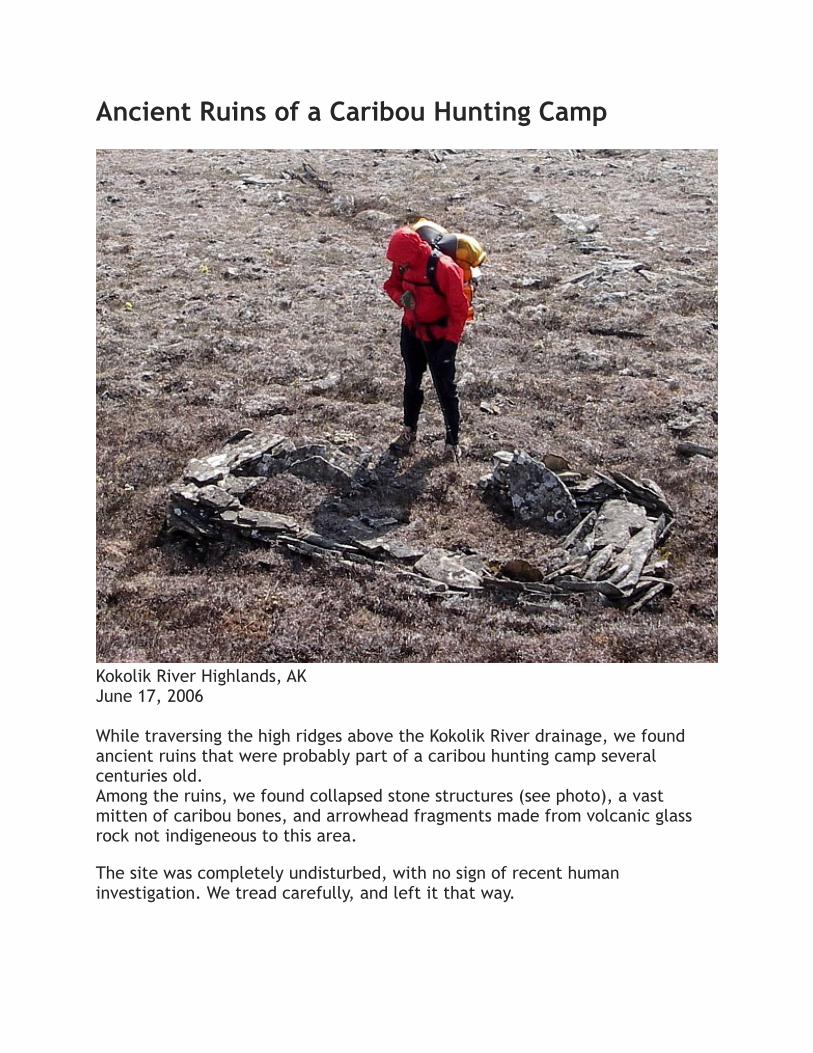
Ancient Ruins of a Caribou Hunting Camp
Kokolik River Highlands, AKJune 17, 2006
While traversing the high ridges above the Kokolik River drainage, we found ancient ruins that were probably part of a caribou hunting camp several centuries old.Among the ruins, we found collapsed stone structures (see photo), a vast mitten of caribou bones, and arrowhead fragments made from volcanic glass rock not indigeneous to this area.
The site was completely undisturbed, with no sign of recent human investigation. We tread carefully, and left it that way.

Slow-growing moss and lichen had overgrown much of the rock and mitten bones - evidence that this community camp was a relic from many generations ago.
Our cursory and undisturbing inspection made it impossible to accurately assess the purpose or time period of this camp.
However, the arrowhead fragments suggest that this camp came in a time where indigeneous caribou hunters had to employ more strategic tactics for hunting than what is done today.
Ancient Inupiat Indians used to build sophisticated corraling systems, consisting of (occupied) stone structures arranged in a "V" formation that would funnel caribou herds into valley constructions, where skilled hunters with bow and arrow, or spear, would make the final kill. The wide parts of the "V" would be found high on adjacent, parallel ridges. We suspect that the structures we found here comprised the widest parts of such a corral. The stone monuments are called inuksuks.
This hunting practice occured for centuries among the Inpupiat, and effectively ended in the mid-1940s, when the last of the Inupiat arrowheads were traded in for bullet and barrel.

River Crossing - Utokok River
Utokok River, AKJune 19, 2006
Crossing rivers in June is not the ideal means of travelling through the Arctic. Snowmelt causes high water volumes and cold water. Cool temperatures and high winds further contribute to the risk of hypothermia.But river crossings are necessary in order to make reasonable progress.
"Rules" of river crossings in such a remote area may not always reflect best practices. We keep our packs strapped to our bodies to improve stability, we use no aid lines, we do not cross in a line parallel to the current lest a fall by the upstream crosser takes out the other two like an errant bowling ball.
Instead, we rely on scouting crossings that are as safe as possible, and on our experience and familiarity with reading rivers and negotiating their currents.
We do not fight the currents, but let them take our steps where they may. Hip-deep or deeper crossings, like this one of the Utotok, are cold and dangerous.
For all of our deep crossings, we dress in all of our layers during the crossing to keep warm (think: wetsuit effect) and keep walking when we get to the other side to warm up and dry out.
On this crossing, we did not have the luxury of low morning river levels or "walking dry", since the airstrip for Ryan's pickup was located on the other side

of the river, and we needed to camp at the airstrip. Thus, we were crossing in the worst possible conditions: high water, cold temperatures, and no opportunity for activity after crossing.
After the crossing, we changed into dry insulating clothing, built a warm fire, and ate hot food to warm up.
Roman said, when packing his camera up for the crossing, that "I'm just going to check it out."
We knew better.
Translation: "I'm crossing here. Hopefully it will go!"
This crossing was particularly deep. Roman (shown in photo) will be up to his chest and bouncing along the bottom for most of the rest of this crossing. Ryan is four inches shorter...needless to say, Jason and Ryan negotiated a slightly shallower, but equally swift, and cold, crossing, a few hundred yards downstream, and Ryan still got to enjoy the feeling of tap dancing downstream in chest deep water.

Part 5. Reflections by Ryan Jordan
Unfulfilled Dreams in the Western Arctic
Originally Published in Backpacking Light Magazine, Issue 7

UNFULFILLED DREAMS IN THE WESTERN ARCTIC
by Ryan Jordan
Just after midnight on July 4, 2006, Roman Dial of Anchorage, AK, stepped onto the only road transecting Arctic Alaska and completed the first foot traverse of the Western Arctic without resupply, a distance of 620+ miles. in a blog published at arctic1000.com, Roman wrote on his final day: “my feet ached deeply.”
~
Exactly one year to the day—July 4, 2005—prior to Roman Dial completing the longest trek without support ever, I broke my back.
While visiting my parents in Seattle, I fell off my nine-year-old nephew’s skateboard while careening out of control down the steep hill that was responsible for many other cuts and bruises during my childhood. I cracked my sacrum and blew a disk, which thus ended an entire summer of backpacking for me. In spite of being reminded that I was too old to skateboard (let alone keep up with the younger generation, of which I used to be a member not so long ago, thank you very much), it did afford me the opportunity to lay on my stomach a lot, count carpet fibers, and dream of adventures that would come post-healing.
In the meantime, I would have to live vicariously through the adventures of others, which allowed me extra time for planning routes for clients that led busy lives and didn’t have time to do the research themselves. My job was simple: lead them from the airport to the trailhead and give them the gear and knowledge and maps they would need to embark on a backpacking vacation of lifetime.
And so, on the evening of August 15, 2005, while I was poring over route options in National Geographic Topo! for my friend Daniel’s September trek in the Yellowstone area, I received the telltale customized ding of an email from somebody on my “must read now” list.

It was from Roman.
Being stuck at home with a broken back and complaining incessantly about how unfair God was being to me (and recognizing that generally, these things aren’t terribly negotiable with a higher being), I would have jumped at the opportunity to just walk to the coffee shop. So, when Roman’s email arrived, it unleashed excitement from deep in my gut that would allow me to put my injury behind me and keep my eye on the future. As Roman would tell me many months later, “Having goals established will help [with healing], I think.”
So, like any responsible family man would do, I gave Roman’s proposal deep thought (well, as deep as you can get in 15 hours and 47 minutes) and hit the reply button the next day.
Three and a half hours later I received Roman’s reply.
Five hundred miles. No trails. No roads. No people. No resupply. All this, in America’s remotest wilderness.
After reading the email, I walked out of my office and peered toward the Bridger Ridge, the crest of which lies only seven miles from Backpacking Light’s HQ, but rises more than 4,000 feet from the valley floor here.

I would have to climb up, and down, and back up, and back down, that ridge many, many times with a heavy pack if I was to get in shape for Roman’s expedition.
And that’s when I smiled at the ridge, and thought to myself, “Oh yeah, count me in.”
Avoiding Starvation (In Theory)
The plan seemed simple enough. Fly to some point on Alaska’s western coast (the Chukchi Sea) and walk east until we hit a road. The distance should be between 500 and 600 miles. We would carry less than ten pounds of gear each, more than 45 pounds of food each, and try to average 30 miles a day for three weeks.
On paper, balancing pace, food consumption, and daily mileages proved to be a challenging exercise if we were to reach the Dalton Highway without running out of food. Some of our theory was founded on a mathematical model developed by Roman (“How Far, How Fast, How Heavy? Calculating the range for unsupported, long- distance hiking,” BackpackingLight. com, May 24, 2006). At the close of Roman’s article, he notes: “My goal is to soon find out if I can really make 500 miles in three weeks by crossing the wildest place in the United States.... That is, 528 miles in 17 days.”
Roman’s if qualifier had me worried. I knew this trek wasn’t a gimme, and there were certainly no opportunities out here for mulligans, but when Roman says “if,” you tend to wake up.
I had to convince myself that I could carry enough food for 600 miles, so I dove into the physiological research literature to create justification for my own ticket to the Chukchi, and developed a hacked up thesis that I published before the trek (“On Food and Cooking,” by Ryan Jordan, Arctic1000.com, June 8, 2006). I predicted that I’d need to carry 42.8 pounds of food. Needless to say, I bought a few extra jars of peanut butter in a Kotzebue grocery and stuffed them in my pack at the last minute out of pure, unadulterated fear of starvation.
America’s Remotest Spot
Roman and I would be joined by Jason Geck, an Alaskan adventure racer and GIS graduate student who, with Roman, had identified using precise

mapping techniques, the single point in America that lies farther than any other from a road or habitation. It happened to be this point, near the Ipnavik River in the Western Arctic, that our expedition would attempt to traverse.
The most remote spot in the contiguous United States, found in the heart of the SE corner of the 2,600-square mile wilderness complex comprised of SE Yellowstone National Park and the Washakie and Teton Wilderness areas of Wyoming, lies only 20 miles from the nearest road.
In contrast, the Ipnavik River’s hotspot, the remotest place in America, as discovered by Roman and Jason’s GIS efforts, lies 120 miles from the nearest civilization (the small native Inupiat villages of Atqasuk, Umiat, and Ambler) and more than 180 miles (as the crow flies) from the trans-Arctic Dalton Highway.
Ultralight Arctic Gear
Ultralight and Arctic don’t usually occupy the same sentence. It’s sort of understood among the Alaskan backpacking community (which, after researching their propensity for toting behemoth packs, I had no plans on joining) that if you’re not strong enough to carry enough gear to manage every possible risk in the Alaskan Bush, then you’ve got no business backpacking in the Alaskan Bush. After all, there are rivers to cross (and “you could lose your pack”), grizzly bears to battle (portable electric fences are becoming popular), fierce winds (“this is no place for anything but a four season expedition tent”), and of course, remoteness (“y’all could get stuck out there fer a long time, son . . . ”).
But carrying forty pounds of gear and another forty pounds of food - which may be entirely suitable for a ten day basecamping expedition, would comprise an impossible strategy for walking big miles.
So, while Roman was planning a route and collecting beta from photo- graphs, Google Earth, and mapping software, I worked on gear. After a few rounds of prototypes and testing, we had a fully-assembled kit for Arctic travel that weighed less than eight pounds per person, including a 13-ounce floorless pyramid tarp, a 23-ounce two-person synthetic sleeping bag, and synthetic insulating clothing that included a hooded jacket and pant set weighing just over a pound. We’d skimp on insulation in our clothing and sleep system by walking at night and sleeping during

the day, a benefit of the Arctic’s midnight sun of early summer. We skipped out on stoves and fuel (carrying only firestarters and pots for cooking), eliminated rain pants and ground cloths, and made the deci- sion to suffer under our 50+ pound initial loads with 24-ounce backpacks having minimal suspension components.
With food and gear (see companion gear list) and route in tow, we flew to the village of Kivalina on the Chukchi Sea coast and took our first steps towards the highway.
Prophecy
I hadn’t realized it at the time, but my email of August 16 (“there may be a moment or two in the future that I wished I had not answered your email”) was pure prophetic vision.
One of those “moments” came on July 20, 2006. At about 1:00 pm, 185 miles into this 600+ mile expedi- tion, I boarded a Cessna 2006 from a gravel bar on the upper Utokok River, my trek finished, because of an ankle injury that occurred five days and 85 miles earlier.
As the pilot steered the plane away from the Utokok highlands and into the foggy soup of the Western Brooks Range to find a route back to Kotzebue, I was wrought with distress. My expedition of a lifetime, the culmination of years of refining gear and technique for unsupported wilderness travel, gone. The transition time between cooking breakfast in the middle of America’s remotest wilderness and worrying about the logistics of getting back to Bozeman and dealing with yet another debilitating injury was about two minutes: the time required to embrace my trekking partners, climb into the 206, and sputter down and up off the Utokok gravel bar that has forever burned a place in my memory as my own personal wilderness hell.
At the time, I could care less about having walked 185 miles in the Arctic because there were still 400 miles left to go, and I couldn’t walk it. Chocolate, Pringles and tears fueled my flight back to Kotzebue. Upon landing after the two hour flight, I paid my fare, limped to an inn, checked into my room, and immediately threw up and began sobbing.
I heard the stinging voices of morality cops in my head: “Be thankful you’re alive!” they gleefully proclaimed. “At least you had the chance to

walk 185 miles! Most of us never get that opportunity! Good for you!” How about this one: “In the context of the world’s problems, your backpacking vacation doesn’t exactly measure up as something to spend a lot of effort worrying about, I mean...” And my personal favorite: “Praise God! This is an opportunity for spiritual growth!”
I couldn’t believe where I was— back in Kotzebue and going home: a cruel dream shared with the voices of obnoxious, imaginary companions.
“Several Hundred Thousand Good Steps and One Bad One”
That was the title of the dispatch we sent to the Arctic1000.com website on June 19, when I communicated my intentions to leave the expedition so that Roman and Jason could continue.
Four days earlier, while carrying a 50+ pound pack, my right leg plunged through a rotten snowbank flanking a small creek. The weight of the impact drove my foot into a vise of rock and snow, while the weight of my pack propelled my forward momentum and my ankle popped as a result of extreme dorsiflexion.
The injury was later verified by MRI to be a torn anterior talofibular ligament combined with syndesmosis. When professional football players undergo this type of injury, their season is over. But I was in the remotest wilderness in America, and I had to figure out how to walk another 85 miles to a gravel bar for a bush plane pickup.
And walk I did, strongly for the next three days, actually, keeping up with Roman and Jason’s pace to hammer out long days of 28, 27, and 25 miles on the 16th, 17th, and 18th of June, respectively. My ankle had been held intact by inflammation, allowing me to walk. Pain had been masked by 800 mg of ibuprofen and 1000 mg of acetominophen (the painkilling cocktail of over-the-counter medicines suggested by the PJ’s at the Alaska Air National Guard, and referred to in the Arctic1000. com blog entry on June 9, 2006). But at around 2 pm June 18, while descending in damp fog to a gap in a long ridge we had been walking, my lower leg went numb and I could no longer feel my foot placements. Every third step through tussocky terrain sent lightning bolts of pain into my hip and back, and nausea was taking over. Upon catching up with Roman and Jason, who were waiting for me at the gap, I knew I was done. From that moment forward, we changed our route to the Utokok River, electing to

walk easier (but slower) river valleys offering mild elevation changes, rather than hiking up and down the steeper ridge.
That night, after only 21 miles, we camped in the Tupikchak Creek drainage. Swelling in my foot had gone down, and it was now loose and floppy. I didn’t have many more miles in me, and our route to here had taken us off our maps. On June 17, I had written:
“We are off route. And now off our maps. We have a GPS, but it has no useful nearby waypoints in it. And it certainly does not tell us the topography of the terrain to help us plan a route of least resistance. So tomorrow, we’ll try to find a route to the Utukok River from here, navigating by what bush pilots call, “with our own two eyes.”
Personal Reflections
This narrative is as much a reflection of my personal relationship with the Arctic as much as about my experiences on a long walk.
To that end, walking (and hobbling) for 10 days through 185 miles of the most remote wilderness I’ve ever seen has given me a newfound appreciation for wild places, and recognition of a need to preserve them. They don’t need preservation for the sake of long distance walking, certainly. They need preservation, however, because vast swaths of untouched land are absolutely necessary for the maintenance of intact wild ecosystems, and for the personal growth that is afforded to those who visit, learn from, and respect them. Missing from the wilderness equation is the value that visitors to wild places bring to society as a whole. By sharing their experiences, and appreciation for these places, with other people, we expand our wilderness reach. I only hope that I’ve expanded yours.
Postscript
As I write this narrative, I continue to struggle with my injury: it brings both physical and emotional challenges. Physically, three months of intense physical therapy and six months of rehabilitation has failed. An MRI taken in December of 2006 suggests damage that is not correctable wihout surgical intervention. Emotionally, I’ve missed two summer seasons of backpacking due to injury and face the demons of age with each passing day.

However, my desire to heal and walk into the depths of the earth’s most remote wilds, unencumbered with the accoutrements of modern civilization, and with companions who share my desire to become fully engaged into an Arctic experience is alive and well.
Moreover, being so dependent on so little in the Arctic taught me that life at home is far too complex. We have too much stuff, too little time, and succumb to too many social pressures. My trek in the Arctic was more about the experience of walking with Roman and Jason than about the gear, the birds, or the bears. Shouldn’t gear, technique, and even wilderness itself then, be only a means to this greater end? My wife, Stephanie, and I have renewed our commitment not only to simplify our lifestyle, but renew and engage the relationships with the people we love the most—including each other. After my Arctic trek, I received no shortage of blog postings and emails from many well-wishing (and many not so well-wishing) people who offered me unlimited advice that sang out of tune, mostly, with my ideals.
Nearly all of it focused on preventing my injury and/or facilitating a more comfortable walk. If I can walk away from my Arctic trek in 2006 and embark on another sometime in the future with only one lesson to learn, it would be this:
I’d like not so much to bring my idea of civilized complexity back to my wilderness life, but to bring some of the beautifully simple Arctic back to my daily life.
Acknowledgments
Life’s challenges are no fun when tackled in a vacuum, alone. I couldn’t be allowed to be me without a tremendous support group of friends and family, and failure to recognize their support would negate any positive personal or social impacts that I may offer. My wife, Stephanie, and son, Chase, suffer loneliness of the highest magnitudes when I go for a walk. As I get older, I experience that loneliness as well when I leave. Any walk in life, be it wilderness or urban, will always be a lonely one in their absence, and any journey taken with them by my side lacks any suffering at all. Without their support in the days following my Arctic trek, my darkest hours would have been impenetrable. While I was holed up in Kotzebue trying to get back to Bozeman, Stephanie was my rock. Without

her telephone calls and email messages, Kotzebue would have indeed been a dark vacuum.
On June 20, after arriving back in Kotzebue, I called Peggy Dial. She knew I was flying out, and I wanted to let her know that I exited the Arctic in safety given the exciting weather conditions I experienced on the bush flight out. Peggy’s appreciation for my malaise and understanding of what I was going through will never be forgotten, and it was one of the most important five minute phone calls of my life, if for nothing else than to hear her say, “I’m sorry” and truly mean it.
Roman dial and Jason Geck proved to be trekking companions of the highest caliber. The opportunity to share a route with two people who have a passion to walk hard, be attuned to the wilds, and share mutual respect is a recipe I’ve not found often among my hiking companions. In particular, Roman has been a friend that has held me accountable when I’ve failed, encouraged me when I’ve been depressed, and praised me when I’ve succeeded, and I couldn’t ask for better mentorship.
The passionate staff of Backpacking Light Magazine keep the engines running when I’m away, and without them, I couldn’t even consider going on a walk. The fact that I am able to engage myself with the wilds indicates their dedication to our company and our cause. Special thanks go to Stephanie Jordan, Carol Crooker, Vic lipsey, Mike McCarthy, and Addie Morstad, who teamed up to make the right decisions while I was away.
To my dad, I owe heartfelt thanks for instilling in me a passion for outdoor places. To my Mom, who has questioned the sanity and safety of every trek and climb I’ve taken (that she knows about, at least), I owe thanks for her protective nature: indeed, it makes me feel loved. To both my parents, thank you for the unconditional love you’ve extended to me through the years. I love you both.
Postscript: October, 2010
In May of 2008 I underwent reconstructive ankle surgery on the ankle that I injured in the Arctic. It took two complete years of hard physical therapy and, eventually, some good hard trekking, to get my full strength back. My ankle is now in better shape than it ever has been, using lighter and less supportive footwear. Since the Arctic, I’ve been able to complete

the hardest trekking of my life. The lesson here: there is indeed light at the end of the tunnel, but the tunnel can be long.

Ryan’s Arctic 1000 Gear List

APPENDIX A
How Far, How Fast, How Heavy? Calculating the range for unsupported, long-distance hiking, by Roman Dial. Backpacking Light (http://www.backpackinglight.com/cgi-bin/backpackinglight/calculating_range_in_lightweight_backpacking.html), May 24, 2006.

How Far, How Fast, How Heavy?Calculating the range for unsupported, long-distance hikingFormulas and theory for predicting possible distances and times with ultralight gear for long distance backpacking.
by Roman Dial | 2006-05-24 03:00:00-06
IntroductionThe problem is stated simply; how far can you go, on foot, and self-contained? No food drops, no foraging, no wheels, no motors. Everything you need, including food, you carry on your back. How far can you go and how long will it take? We can call this your maximum range.
No doubt you will say, "My maximum range depends on a whole host of factors." And I will agree, that, yes, it depends, but it will depend on less than you think. And by that I mean the predictions will meet with observations surprisingly well and without all the messy details that most of us would insist should be included.
In some ways this question of "How far, how fast?" is a variation on adventure racing. However, as far as I know, nobody has organized a competition to see what the extreme maximum range might be: 50 people toed up at the start line, the only rule that everything needed is in the pack and the race is over after all racers have run out of food and marked their distance would help answer it. I offer some predictions.
BackgroundMy interest in maximum range stemmed from Alaskan "wilderness racing" during the early 1980's. It was then, before the Eco-Challenge, Raid Gauloise, the Southern Traverse in New Zealand, or even Ray's Way or GoLite - that a handful of us raced across large blocks of Alaskan wilderness, mostly un-trailed, over mountains, across rivers, past bears. These were big chunks, with straight line distances between roads in the 75 to 100 mile range. And we traveled very light.
The rules for the Alaska Mountain Wilderness Classic were brutally simple: start here, go there - where "there" was 150-250 miles away - carrying everything needed, including food, with you from start to finish. No help, no roads (usually

one road was crossed), no motors, no pack animals. Instinctively I knew that a heavier pack meant a slower pace, and to a competitive person, a heavier pack meant a lesser chance of winning.
Weight Kills Speed and DistanceLike everyone who races more than once, I discovered that weight kills speed. Not only does weight kill speed, I found that weight kills distance. And by 1984, after three seasons of wilderness racing, I'd uncovered a ruthless calculus: it appeared that every pound dropped from my back increased my daily maximum by a mile.
Without a pack, just food and raincoat wrapped around my waist, I could do up to 70 miles in a day, but with a 20 pound pack I was slowed to 50 miles and with a 30 pound pack a 40 mile day felt just as hard. Clearly, however, there were limits to this rule. I was not stopped by a 70 pound pack. Every moose season I slogged five miles to the road through muskeg and forest with 80 and 90 pound loads of fresh meat bending my back.
On the other end of the spectrum, as navigator on Team Hitec, I cut labels from my clothes, trimmed extra edges from our maps, then pursed my lips and blew to satisfy mandatory "survival whistle" requirements. All of this to take second in the notorious 1996 British Columbia Eco-Challenge. The point being that "every ounce counts" and so "when in doubt, leave it out," particularly when going from superlight to ultralight and winning is what it's all about. I turned to physics for inspiration.
Newtonian PhysicsFour hundred years ago Sir Isaac Newton pointed out that Work equals Force times Distance. Work is the energy needed to carry a heavy load over the landscape. The weight of the load is the Force against gravity. Each step forward requires a small Distance upward and here is where the work is done. Indeed the old-as-dirt adage that "a pound on your feet equals five on your back" follows because on average feet move, say, five inches upward with each step forward. Meanwhile the pack moves but an inch upward in the process. Thus the Work needed to move one pound of footwear one step is five times the Work needed to move one pound of pack weight, because the feet are lifted five times the Distance the pack is lifted. At least that's how I figure it.

So, equipped with Newton's theory
Work = Force * Distance
I solved qualitatively for Distance traveled as a function of the Force (= pack-weight),
Distance = Work ÷ Force.
I assumed that there was a maximum amount of work, SUPERMAN, that I was capable of doing so that Distance equaled SUPERMAN divided by Force (or pack-weight) giving
Distance = SUPERMAN ÷ Pack-weight.
SUPERMAN = Distance * Pack-WeightWhen the pack is heavy, an extra pound has little effect on maximum distance traveled in a day. But when the pack is very light, dropping a pound of pack weight significantly increases maximum distance.
Sketching the general shape of the curve showed that when a pack is heavy with moose meat or family camping gear, an additional pound has little effect on the maximum distance I can travel in a day. However, when I race and my pack is very light, dropping a pound - such as by whistling without a whistle or cutting margins and labels - allows me to go much farther. These are two results that any

reader with experience carrying a range of pack weights can relate to, I hope. But there was more hidden in the non-linearity of the relationship.
For instance, when I raced with a team it was normal that we had a team "ox" who had a higher SUPERMAN value than the rest of us. "Ox" could generally carry a heavier pack than everyone else and still travel the same distance in a day. The two distance by pack weight curves, one above the other, suggested that given two team mates with the same pack, shifting weight from the weaker to the stronger person sped up the weaker person more than it slowed "Ox." It was yet another application of Newton and it worked in every team based adventure race I ever competed in.
The rectangular hyperbolic curve (right) from Newton was a graph with weight on the horizontal or "x-axis" and the distance traveled on the vertical or "y-axis." Imagine my surprise when almost 20 years later the famous Ray Jardine sketched the inverse graph (where increasing distance is on the "x-axis" and decreasing pack-weight on the y-axis") and the gear manufacturer GoLite had made the Ray-Way graph their logo!
But what the visit with Newton really justified was the midrange linearity of the distance vs. pack-weight relationship. That is, in the 10-40 pound range it really was true that I went 50-20 miles with about the same amount of effort, if not pain. So, I asked myself, "What is my maximum range? That is, how far can I go with just a loaded backpack and no support crew, no food drops, no road crossings or villages? How much will I carry? And how long will it take?"
In 1985, as a graduate student in mathematics at the University of Alaska Fairbanks, I procrastinated my thesis work. Instead I focused on the empirical "one-pound-less is one-mile-more-per-day" relationship that I'd found while wilderness racing. The idea was to use this simple rule, convert pack weight into food plus gear weight, and then multiply by the number of days to see how far I could go carrying all my food and gear.
The wilderness racing rule said:
MAX_DISTANCE - PACK_WEIGHT = MILES_PER_DAY.

But my pack weight depended on two components as
PACK_WEIGHT = CAMP_GEAR + FOOD.
Substituting gave the relationship:
MILES_PER_DAY = MAX_DISTANCE - CAMP_GEAR - FOOD
where all weights were in pounds and distances in miles. To get total distance traveled I multiplied MILES_PER_DAY times DAYS so that
TOTAL_TRIP_DISTANCE = MILES_PER_DAY * DAYS = DAYS * (MAX_DISTANCE -
CAMP_GEAR - FOOD)
Finally, substituting FOOD with FOOD_PER_DAY * DAYS gives:
TOTAL_TRIP_DISTANCE = DAYS * (MAX_DISTANCE - CAMP_GEAR -
FOOD_PER_DAY * DAYS).
This then was the formula (see End Notes for nicer representation) for how far I could go, how long it would take, and how heavy my pack would be to do it. For instance, in 1984 my MAX_DISTANCE for one day of travel with no pack was 60 miles. My CAMP_GEAR weight was 15 pounds as it included a packraft and paddle, sleeping bag and pad, extra clothes, cross-country racing skis and poles, and shelter. I had also discovered that when racing, food substituted for sleep. That is, if I had plenty of food I could sleep less and on long expeditions that ran low on food, we slept more. So I carried 3 pounds as FOOD_PER_DAY. This all meant that
TOTAL_TRIP_DISTANCE = DAYS * (60 - 15 - 3 * DAYS) = 45 * DAYS - 3 * DAYS2
Which you may recall from your old algebra class is a parabola, an upside down "U". This "U" has a peak at 7.5 DAYS (calculus is the easiest way to get that, see

End Notes), when total trip distance is about 170 miles. In other words, a starting weight of 37.5 pounds would carry a strong racer 170 miles in 7 days 12 hours eating 3 pounds per day.
Editor's Note: Actual maximum range calculated is 168.75 miles. See End Notes for the maximum range equation.
I had also discovered that when racing, food substituted for sleep. That is, if I had plenty of food I could sleep less and on long expeditions that ran low on food, we slept more.
To test this expectation I put together a race, the 1985 Alaska Mountain Wilderness Classic from Mentasta to McKinley Park, which was 170 miles of hiking and/or cross-country skiing (on glaciers) plus a final 65 miles of packrafting down the Nenana River. Hank Timm won the race. His time was 7 days and 10 hours to the put in on the river. His starting pack weight was 37 pounds.
Estimating Maximum RangeUsing the two tables below, you can estimate what your maximum range might be. To use them, first decide what kind of effort you'd like to put forth. For instance, a packless effort of 40 miles per day is essentially a ten hour day walking at 4 mph on average. A 70 mile effort is 17.5 hours at 4 mph. Find what you know or think is your effort on the left column of the first table.
Next decide how "comfortable" you'd like to travel. This comfort level is measured by your base pack weight, the gear you carry (not including your shoes and daily clothes worn) without measuring food or water (indeed, the details outlined here would not work in deserts, but no doubt a similar approach using water might prove fruitful there). A base weight of five pounds is very uncomfortable for most people, while a base weight of 25 pounds is essentially car camping. Find the combination of comfort and effort in the table to identify your "Animal Factor." I imagine that an animal carries essentially nothing and puts forth an inhuman effort. The more effort and the less comfort the higher the "animal factor."

“Animal Factor” TableComfort = base weight in pounds (b)
Effort (MAX) b = 25 lbs b = 20 lbs b = 15 lbs b = 10 lbs b = 5 lbs
40 miles/day 15 20 25 30 35
45 miles/day 20 25 30 35 40
50 miles/day 25 30 35 40 45
55 miles/day 30 35 40 45 50
60 miles/day 35 40 45 50 55
65 miles/day 40 45 50 55 60
70 miles/day 45 50 55 60 65
75 miles/day 50 55 60 65 70
80 miles/day 55 60 65 70 75
Each entry gives Animal Factor (A), a combination of effort (MAX) willing and able to be put forth by an individual in one day on typical terrain carrying no weight, and comfort (b) required or desired by an individual, where comfort is base weight (b) of equipment carried in the pack (minus food, water). Light blue are comfortable recreationalists, purple are aggressive recreationalists, green are athletic adventure racers, and yellow are elite adventure racers. Red is a real hot dog.Animal Factor = MAX EFFORT - BASE WEIGHT = MAX - b
Each entry gives Animal Factor (A), a combination of effort (MAX) willing and able to be put forth by an individual in one day on typical terrain carrying no weight, and comfort (b) required or desired by an individual, where comfort is base weight (b) of equipment carried in the pack (minus food, water). Light blue are comfortable recreationalists, purple are aggressive recreationalists, green are athletic adventure racers, and yellow are elite adventure racers. Red is a real hot dog.Animal Factor = MAX EFFORT - BASE WEIGHT = MAX - b
Each entry gives Animal Factor (A), a combination of effort (MAX) willing and able to be put forth by an individual in one day on typical terrain carrying no weight, and comfort (b) required or desired by an individual, where comfort is base weight (b) of equipment carried in the pack (minus food, water). Light blue are comfortable recreationalists, purple are aggressive recreationalists, green are athletic adventure racers, and yellow are elite adventure racers. Red is a real hot dog.Animal Factor = MAX EFFORT - BASE WEIGHT = MAX - b
Each entry gives Animal Factor (A), a combination of effort (MAX) willing and able to be put forth by an individual in one day on typical terrain carrying no weight, and comfort (b) required or desired by an individual, where comfort is base weight (b) of equipment carried in the pack (minus food, water). Light blue are comfortable recreationalists, purple are aggressive recreationalists, green are athletic adventure racers, and yellow are elite adventure racers. Red is a real hot dog.Animal Factor = MAX EFFORT - BASE WEIGHT = MAX - b
Each entry gives Animal Factor (A), a combination of effort (MAX) willing and able to be put forth by an individual in one day on typical terrain carrying no weight, and comfort (b) required or desired by an individual, where comfort is base weight (b) of equipment carried in the pack (minus food, water). Light blue are comfortable recreationalists, purple are aggressive recreationalists, green are athletic adventure racers, and yellow are elite adventure racers. Red is a real hot dog.Animal Factor = MAX EFFORT - BASE WEIGHT = MAX - b
Each entry gives Animal Factor (A), a combination of effort (MAX) willing and able to be put forth by an individual in one day on typical terrain carrying no weight, and comfort (b) required or desired by an individual, where comfort is base weight (b) of equipment carried in the pack (minus food, water). Light blue are comfortable recreationalists, purple are aggressive recreationalists, green are athletic adventure racers, and yellow are elite adventure racers. Red is a real hot dog.Animal Factor = MAX EFFORT - BASE WEIGHT = MAX - b
Next, using your "animal factor," go to the second table. This table gives the maximum range based on "animal factor" and daily food requirements. Find the amount of food per day needed as a column and follow that column down to your "animal factor" row. Their intersection gives the maximum range in both miles and days for that combination. Curiously the miles per day to attain maximum range in that specified time is equal to the weight of the food carried in pounds. It should then be possible to calculate the starting pack weight by adding the comfort number (base pack weight) to the figure giving miles per day (which equals pounds of food to maximize range). This is equivalent to one half the sum of your base weight and effort.

Maximum Range TableAnimal Factor, A
Miles per day ƒ= 1.5 lbs/day ƒ= 2 lbs/day ƒ= 3 lbs/day
15 7.5 37 miles 28 miles 18 miles
5 days 4 days 3 days
20 10 68 miles 50 miles 32 miles
7 days 5 days 4 days
25 12.5 104 miles 78 miles 52 miles
9 days 7 days 5 days
30 15 150 miles 112 miles 75 miles
10 days 8 days 5 days
35 17.5 204 miles 153 miles 102 miles
12 days 9 days 6 days
40 20 267 miles 200 miles 133 miles
14 days 10 days 7 days
45 22.5 337 miles 253 miles 169 miles
15 days 12 days 8 days
50 25 416 miles 312 miles 208 miles
17 days 13 days 9 days
55 27.5 504 miles 378 miles 252 miles
19 days 14 days 10 days
60 30 600 miles 450 miles 300 miles
20 days 15 days 10 days
65 32.5 704 miles 528 miles 352 miles
22 days 17 days 11 days

70 35 816 miles 612 miles 408 miles
23 days 18 days 12 days
75 37.5 937 miles 703 miles 469 miles
24 days 19 days 13 days
Use Animal Factor value (A) found above to determine row and daily rations (ƒ) requirement to find column. Their intersection gives values for maximum range in miles (D) and required days (t). Note that miles per day is determined strictly by Animal Factor and that miles per day is also equivalent to total food weight carried. Days are rounded up to next whole day.
Use Animal Factor value (A) found above to determine row and daily rations (ƒ) requirement to find column. Their intersection gives values for maximum range in miles (D) and required days (t). Note that miles per day is determined strictly by Animal Factor and that miles per day is also equivalent to total food weight carried. Days are rounded up to next whole day.
Use Animal Factor value (A) found above to determine row and daily rations (ƒ) requirement to find column. Their intersection gives values for maximum range in miles (D) and required days (t). Note that miles per day is determined strictly by Animal Factor and that miles per day is also equivalent to total food weight carried. Days are rounded up to next whole day.
Use Animal Factor value (A) found above to determine row and daily rations (ƒ) requirement to find column. Their intersection gives values for maximum range in miles (D) and required days (t). Note that miles per day is determined strictly by Animal Factor and that miles per day is also equivalent to total food weight carried. Days are rounded up to next whole day.
Use Animal Factor value (A) found above to determine row and daily rations (ƒ) requirement to find column. Their intersection gives values for maximum range in miles (D) and required days (t). Note that miles per day is determined strictly by Animal Factor and that miles per day is also equivalent to total food weight carried. Days are rounded up to next whole day.
Finally, before you dismiss this out of hand, I ask you to compare your efforts to the table. I also ask you to recognize that a surprising amount of engineering and other mathematical modeling is robust in its predictions, in spite of its simplicity. Like the unsophisticated models we make to understand our parents as young children, models that work remarkably well for us, this model leaves out oh so much detail! And yet it seems to work well. In essence, it is a table of equivalent efforts, pushing the equivalents to their extreme.
You will notice that the approach does not consider the fact that the pack is growing lighter as the food weight dwindles. I have, of course, played with that idea and it leads to unreasonably high ranges. The approach also does not consider the ups and downs or the impermeability of some landscapes. Nor does it consider how the body breaks down in some cases or builds up in others. No, there are many, many things I do not consider. This is a simple model, one that works a bit like the rules of thumb we already use.
On June 11, 2006, Roman, Ryan Jordan (Backpacking Light publisher), and Jason Geck will begin an attempt of the first unsupported trekking traverse of America’s most remote, roadless, uninhabited wilderness, a distance of approximately 1000 kilometers (600 miles). Visit Arctic1000.com during the trek for live updates. Good luck guys!

Putting the Theory to the TestMy goal is to soon find out if I can really make 500 miles in three weeks by crossing the wildest place in the United States. My plan is to train my body to an effort level of 75 miles per day, then carry a base weight of 10 pounds for comfort, eating my usual two pounds of food per day (good for intermediate trips - longer trips I eat more, shorter trips I eat less), and strive for the predicted range of an animal factor of 65 and daily ration of two pounds. That is, 528 miles in 17 days. But no doubt Mike Kloser and Michael Tobin could make 700 miles in the same time period and at the same rations. You guys listening? There's an adventure racing scientist who's looking to test his hypothesis.
Editor's Note: Actual time to reach maximum range is calculated to be 16.25 days. See End Notes for the time to reach maximum range equation.

END NOTES

Camp on Surprise Creek. Ryan Jordan photo.
LEARN MORE
This compilation was originally released in draft form to students, clients, and participants in treks led by Ryan Jordan.
To learn more about lightweight backpacking, expedition planning, long distance trekking, and other related topics of interest, please visit Ryan online at
www.RYANJORDAN.com