Embed Size (px)
Citation preview
i
PHASE 1A LITERATURE REVIEW/ SENSITIVITY ASSESSMENT AND PHASE 1B ARCHAEOLOGICAL SURVEY
OLD SARATOGA TOWN HALL PROPERTY
30 FERRY STREET VILLAGE OF SCHUYLERVILLE
SARATOGA COUNTY, NEW YORK
Prepared for
The LA Group 40 Long Alley
Saratoga Springs, New York 12803
Prepared by
Curtin Archaeological Consulting, Inc. 61 Rowland Street
Ballston Spa, New York 12020 (518) 884-7105
Report Author:
Edward V. Curtin, Ph.D.
December 2012
ii
MANAGEMENT SUMMARY
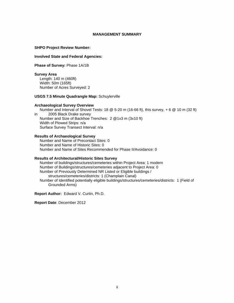
SHPO Project Review Number: Involved State and Federal Agencies: Phase of Survey: Phase 1A/1B Survey Area Length: 140 m (460ft) Width: 50m (165ft) Number of Acres Surveyed: 2 USGS 7.5 Minute Quadrangle Map: Schuylerville Archaeological Survey Overview Number and Interval of Shovel Tests: 18 @ 5-20 m (16-66 ft), this survey, + 6 @ 10 m (32 ft) in 2005 Black Drake survey Number and Size of Backhoe Trenches: 2 @1x3 m (3x10 ft) Width of Plowed Strips: n/a Surface Survey Transect Interval: n/a Results of Archaeological Survey Number and Name of Precontact Sites: 0 Number and Name of Historic Sites: 0 Number and Name of Sites Recommended for Phase II/Avoidance: 0 Results of Architectural/Historic Sites Survey Number of buildings/structures/cemeteries within Project Area: 1 modern Number of Buildings/structures/cemeteries adjacent to Project Area: 0 Number of Previously Determined NR Listed or Eligible buildings / structures/cemeteries/districts: 1 (Champlain Canal) Number of Identified potentially eligible buildings/structures/cemeteries/districts: 1 (Field of Grounded Arms) Report Author: Edward V. Curtin, Ph.D. Report Date: December 2012
iii
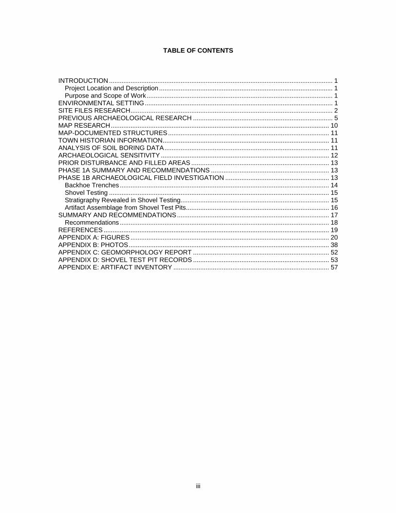
TABLE OF CONTENTS
INTRODUCTION ............................................................................................................................. 1 Project Location and Description ................................................................................................. 1 Purpose and Scope of Work........................................................................................................ 1
ENVIRONMENTAL SETTING......................................................................................................... 1 SITE FILES RESEARCH................................................................................................................. 2 PREVIOUS ARCHAEOLOGICAL RESEARCH .............................................................................. 5 MAP RESEARCH.......................................................................................................................... 10 MAP-DOCUMENTED STRUCTURES.......................................................................................... 11 TOWN HISTORIAN INFORMATION............................................................................................. 11 ANALYSIS OF SOIL BORING DATA............................................................................................ 11 ARCHAEOLOGICAL SENSITIVITY .............................................................................................. 12 PRIOR DISTURBANCE AND FILLED AREAS ............................................................................. 13 PHASE 1A SUMMARY AND RECOMMENDATIONS .................................................................. 13 PHASE 1B ARCHAEOLOGICAL FIELD INVESTIGATION .......................................................... 13
Backhoe Trenches ..................................................................................................................... 14 Shovel Testing ........................................................................................................................... 15 Stratigraphy Revealed in Shovel Testing................................................................................... 15 Artifact Assemblage from Shovel Test Pits................................................................................ 16
SUMMARY AND RECOMMENDATIONS..................................................................................... 17 Recommendations ..................................................................................................................... 18
REFERENCES .............................................................................................................................. 19 APPENDIX A: FIGURES ............................................................................................................... 20 APPENDIX B: PHOTOS................................................................................................................ 38 APPENDIX C: GEOMORPHOLOGY REPORT ............................................................................ 52 APPENDIX D: SHOVEL TEST PIT RECORDS ............................................................................ 53 APPENDIX E: ARTIFACT INVENTORY ....................................................................................... 57
1
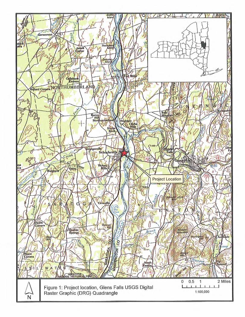
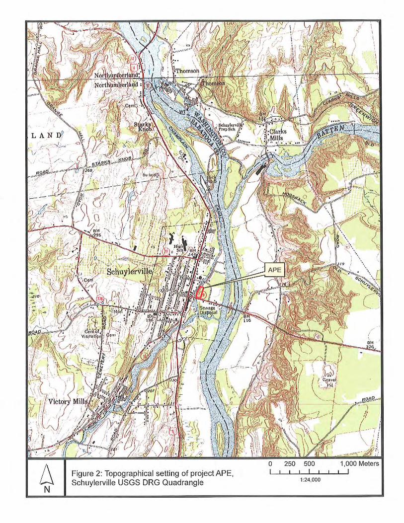
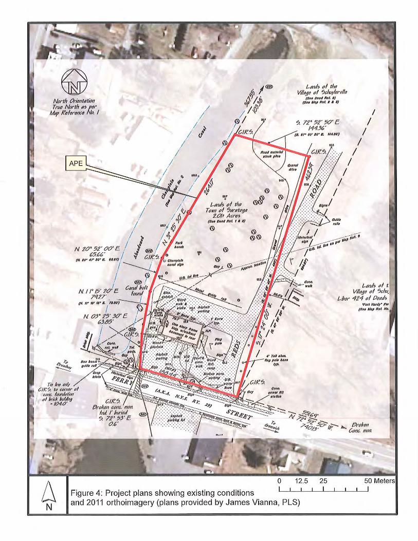
INTRODUCTION Project Location and Description Curtin Archaeological Consulting, Inc. has been retained by the Town of Saratoga via The LA Group to conduct a Phase 1A Literature Search/Sensitivity Assessment and a Phase 1B Archaeological Survey of the property of the old Saratoga Town Hall on Ferry Street, Village of Schuylerville, New York. The approximate 2 acre project site is located on the north side of Ferry Street adjacent on the west to Fort Hardy Park. The proposed project involves transfer of the property to the National Park Service for future visitor use facilities. The Phase 1A/1B survey was conducted to meet the procedures and information requirements of all federal, state and local regulatory processes. The report content and format are guided by the standards adopted by the New York Archaeological Council (NYAC) and recommended by the New York State Office of Parks, Recreation, and Historic Preservation (OPRHP). Purpose and Scope of Work The purpose of the Phase 1A/1B survey is to evaluate cultural resource sensitivity and to the extent possible, identify the presence or absence of archaeological sites within the project area. The scope of work for this undertaking includes: (1) assessment of the environmental setting and indications of prior disturbance; (2) compilation and interpretation of background information including site files research, map research, and documentary sources; (3) appropriate archaeological fieldwork; and (4) a report of findings with recommendations.
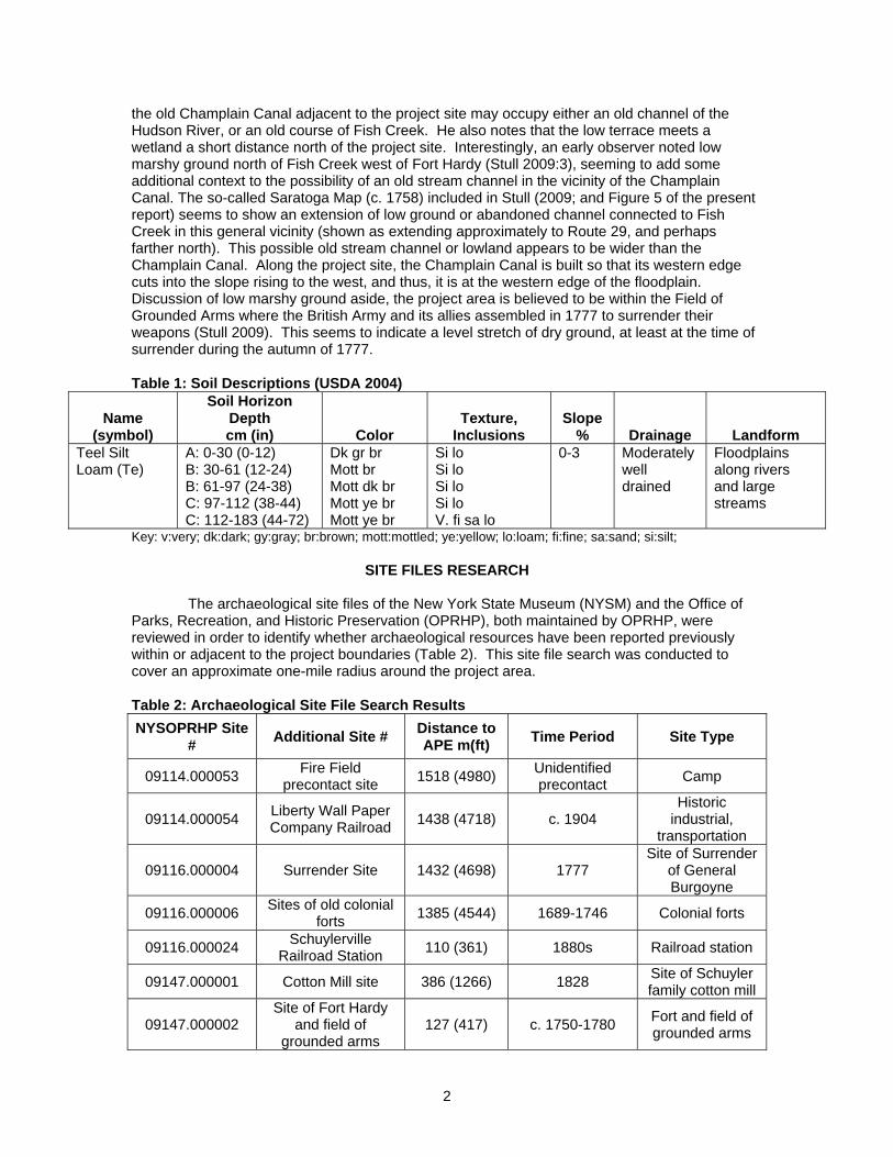
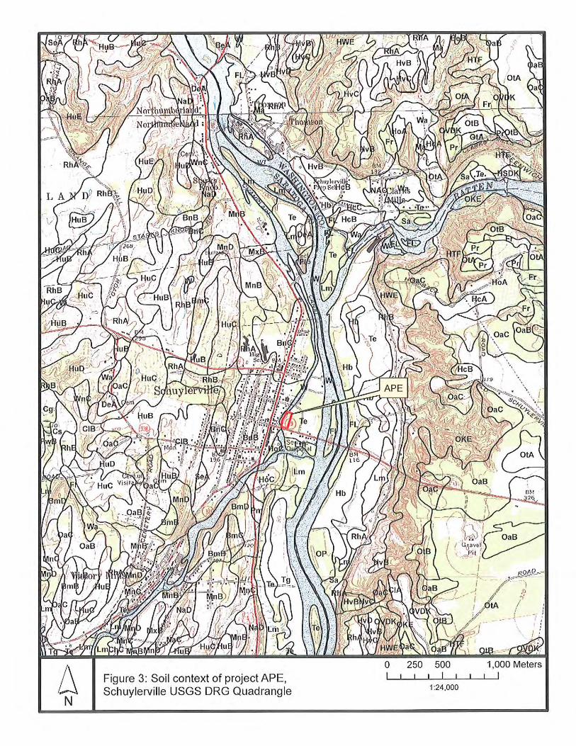
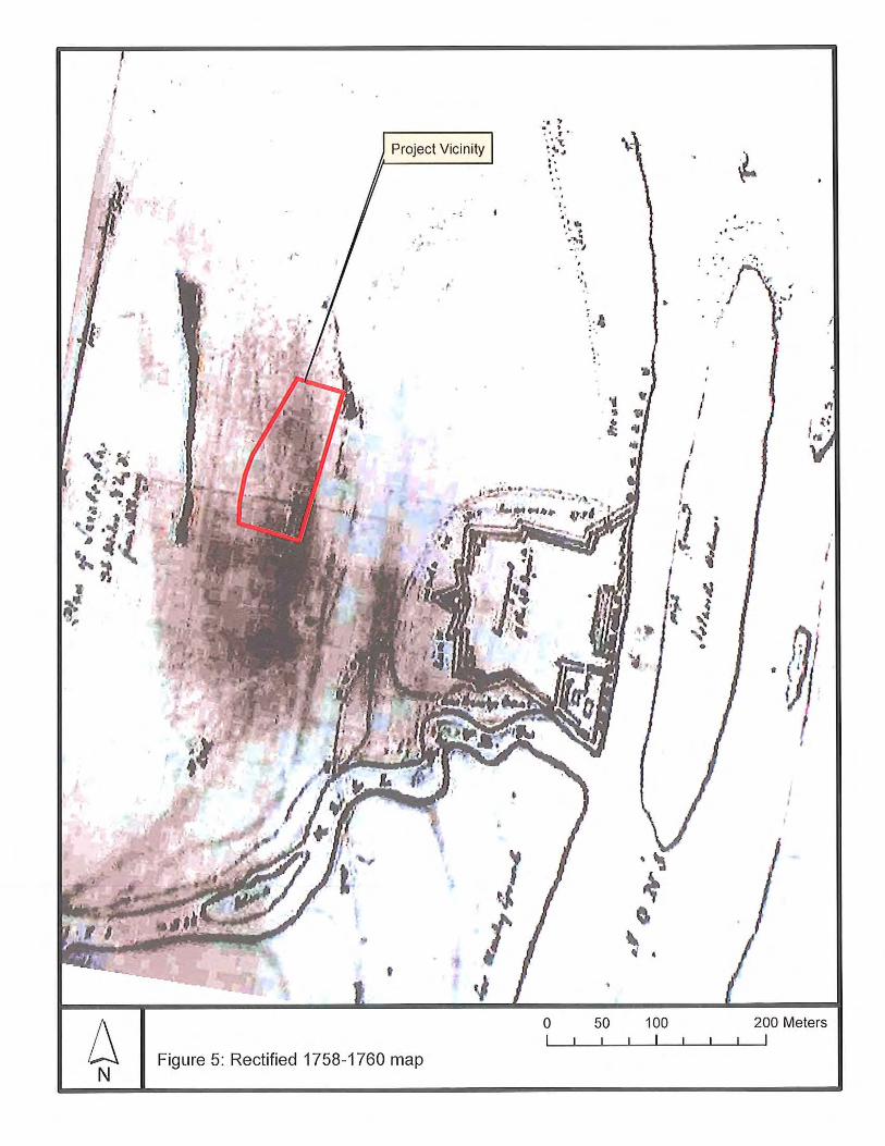
ENVIRONMENTAL SETTING The project parcel lies on a low terrace of the Hudson River floodplain just north of the confluence with Fish Creek. Elevation is approximately 100 feet above mean sea level. The project site is situated within the Hudson Valley subdivision of the Hudson-Mohawk Lowland physiographic province. As Cressey (1977:29) describes, the Hudson Valley “forms a 10- to 20-mile-wide lowland lying between the Helderberg Escarpment and the Catskills on the west and the Taconics on the east. North of Albany it is wide and flat, covered with glacial lake deposits” and, it can be added, floodplain alluvium along the upper Hudson within the old glacial lake basin. In terms of native vegetation, the state as a whole consists of a complex of northern hardwood species (excepting the Adirondacks and southeastern region) that can be divided into a typology of 5 specific forest zones, with the project parcel contained within the Oak-Northern Hardwood zone subdivision of this mosaic (De Laubenfels 1977). The Oak-Northern Hardwood zone is described primarily as a transition zone where oaks and the northern hardwood species alternate or intermingle, particularly on the moister and deeper soils along the Hudson valley. The soil within the project APE is mapped as Teel silt loam (USDA 2004; Table 1). The geomorphological analysis (Appendix C) provides a more refined assessment of soil at the project site. Here, excluding fill at the top of the stratigraphic column, the soil on-site is described as “very fine sand to fine sand, grading downward to very fine sand and silt” in an A-B1-B2 sequence to approximately 140-150 cm below ground surface. Soil borings taken at the former Town Hall building on site showed significant depths of fill, but below this fill recorded approximately 15 feet of silt and fine sand. The soil description of Teel silt loam is much less sandy than is apparent within the project site (see Table 1). Based on the analysis of geomorphologist David De Simone, the context of these soils is a low terrace of the Hudson River. A slightly higher terrace occupies the area to the east, all the way to the Hudson River. The high terrace contains areas of fill sometimes penetrated by shovel testing (Black and Yagy 2005; Stull 2009). Immediately to the west of the project site (and constructed in the western edge of the low terrace) is the old Champlain Canal. Edge portions of the canal towpath are within the project site. Dr. De Simone’s report indicates that the section of
2
the old Champlain Canal adjacent to the project site may occupy either an old channel of the Hudson River, or an old course of Fish Creek. He also notes that the low terrace meets a wetland a short distance north of the project site. Interestingly, an early observer noted low marshy ground north of Fish Creek west of Fort Hardy (Stull 2009:3), seeming to add some additional context to the possibility of an old stream channel in the vicinity of the Champlain Canal. The so-called Saratoga Map (c. 1758) included in Stull (2009; and Figure 5 of the present report) seems to show an extension of low ground or abandoned channel connected to Fish Creek in this general vicinity (shown as extending approximately to Route 29, and perhaps farther north). This possible old stream channel or lowland appears to be wider than the Champlain Canal. Along the project site, the Champlain Canal is built so that its western edge cuts into the slope rising to the west, and thus, it is at the western edge of the floodplain. Discussion of low marshy ground aside, the project area is believed to be within the Field of Grounded Arms where the British Army and its allies assembled in 1777 to surrender their weapons (Stull 2009). This seems to indicate a level stretch of dry ground, at least at the time of surrender during the autumn of 1777. Table 1: Soil Descriptions (USDA 2004)
Name (symbol)
Soil Horizon Depth cm (in) Color
Texture, Inclusions
Slope % Drainage Landform
Teel Silt Loam (Te)
A: 0-30 (0-12) B: 30-61 (12-24) B: 61-97 (24-38) C: 97-112 (38-44) C: 112-183 (44-72)
Dk gr br Mott br Mott dk br Mott ye br Mott ye br
Si lo Si lo Si lo Si lo V. fi sa lo
0-3 Moderately well drained
Floodplains along rivers and large streams
Key: v:very; dk:dark; gy:gray; br:brown; mott:mottled; ye:yellow; lo:loam; fi:fine; sa:sand; si:silt;
SITE FILES RESEARCH The archaeological site files of the New York State Museum (NYSM) and the Office of Parks, Recreation, and Historic Preservation (OPRHP), both maintained by OPRHP, were reviewed in order to identify whether archaeological resources have been reported previously within or adjacent to the project boundaries (Table 2). This site file search was conducted to cover an approximate one-mile radius around the project area. Table 2: Archaeological Site File Search Results NYSOPRHP Site
# Additional Site # Distance to APE m(ft) Time Period Site Type
09114.000053 Fire Field precontact site 1518 (4980) Unidentified
precontact Camp
09114.000054 Liberty Wall Paper Company Railroad 1438 (4718) c. 1904
Historic industrial,
transportation
09116.000004 Surrender Site 1432 (4698) 1777 Site of Surrender
of General Burgoyne
09116.000006 Sites of old colonial forts 1385 (4544) 1689-1746 Colonial forts
09116.000024 Schuylerville Railroad Station 110 (361) 1880s Railroad station
09147.000001 Cotton Mill site 386 (1266) 1828 Site of Schuyler family cotton mill
09147.000002 Site of Fort Hardy
and field of grounded arms
127 (417) c. 1750-1780 Fort and field of grounded arms
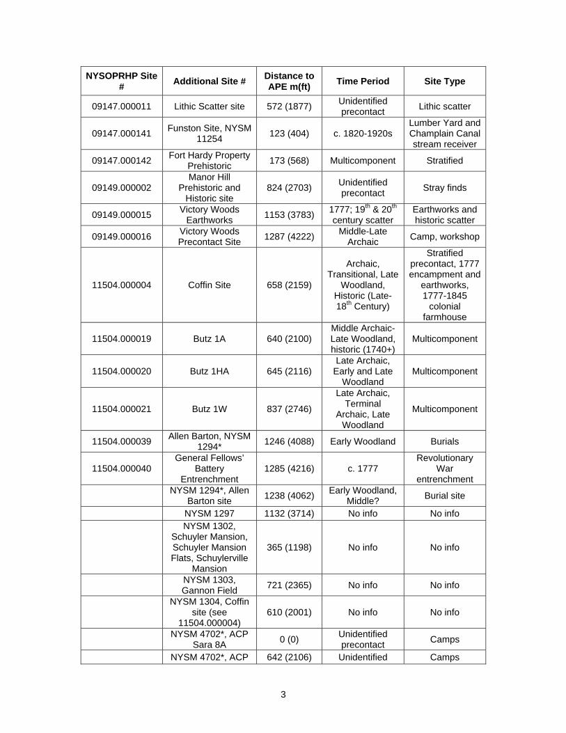
3
NYSOPRHP Site # Additional Site # Distance to
APE m(ft) Time Period Site Type
09147.000011 Lithic Scatter site 572 (1877) Unidentified precontact Lithic scatter
09147.000141 Funston Site, NYSM 11254 123 (404) c. 1820-1920s
Lumber Yard and Champlain Canal stream receiver
09147.000142 Fort Hardy Property Prehistoric 173 (568) Multicomponent Stratified
09149.000002 Manor Hill
Prehistoric and Historic site
824 (2703) Unidentified precontact Stray finds
09149.000015 Victory Woods Earthworks 1153 (3783) 1777; 19th & 20th
century scatter Earthworks and historic scatter
09149.000016 Victory Woods Precontact Site 1287 (4222) Middle-Late
Archaic Camp, workshop
11504.000004 Coffin Site 658 (2159)
Archaic, Transitional, Late
Woodland, Historic (Late-18th Century)
Stratified precontact, 1777 encampment and
earthworks, 1777-1845
colonial farmhouse
11504.000019 Butz 1A 640 (2100) Middle Archaic-Late Woodland, historic (1740+)
Multicomponent
11504.000020 Butz 1HA 645 (2116) Late Archaic,
Early and Late Woodland
Multicomponent
11504.000021 Butz 1W 837 (2746)
Late Archaic, Terminal
Archaic, Late Woodland
Multicomponent
11504.000039 Allen Barton, NYSM 1294* 1246 (4088) Early Woodland Burials
11504.000040 General Fellows’
Battery Entrenchment
1285 (4216) c. 1777 Revolutionary
War entrenchment
NYSM 1294*, Allen Barton site 1238 (4062) Early Woodland,
Middle? Burial site
NYSM 1297 1132 (3714) No info No info
NYSM 1302, Schuyler Mansion, Schuyler Mansion Flats, Schuylerville
Mansion
365 (1198) No info No info
NYSM 1303, Gannon Field 721 (2365) No info No info
NYSM 1304, Coffin
site (see 11504.000004)
610 (2001) No info No info
NYSM 4702*, ACP Sara 8A 0 (0) Unidentified
precontact Camps
NYSM 4702*, ACP 642 (2106) Unidentified Camps
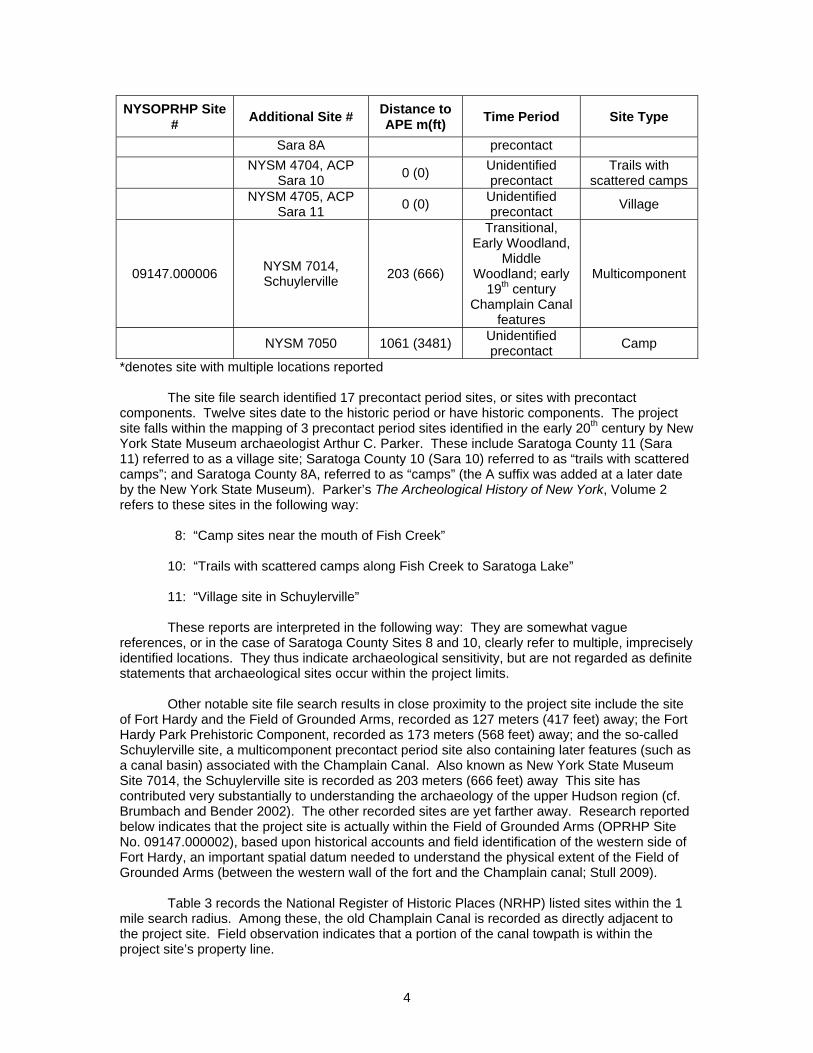
4
NYSOPRHP Site # Additional Site # Distance to
APE m(ft) Time Period Site Type
Sara 8A precontact
NYSM 4704, ACP Sara 10 0 (0) Unidentified
precontact Trails with
scattered camps
NYSM 4705, ACP Sara 11 0 (0) Unidentified
precontact Village
09147.000006 NYSM 7014, Schuylerville 203 (666)
Transitional, Early Woodland,
Middle Woodland; early
19th century Champlain Canal
features
Multicomponent
NYSM 7050 1061 (3481) Unidentified precontact Camp
*denotes site with multiple locations reported The site file search identified 17 precontact period sites, or sites with precontact components. Twelve sites date to the historic period or have historic components. The project site falls within the mapping of 3 precontact period sites identified in the early 20th century by New York State Museum archaeologist Arthur C. Parker. These include Saratoga County 11 (Sara 11) referred to as a village site; Saratoga County 10 (Sara 10) referred to as “trails with scattered camps”; and Saratoga County 8A, referred to as “camps” (the A suffix was added at a later date by the New York State Museum). Parker’s The Archeological History of New York, Volume 2 refers to these sites in the following way:
8: “Camp sites near the mouth of Fish Creek” 10: “Trails with scattered camps along Fish Creek to Saratoga Lake” 11: “Village site in Schuylerville”
These reports are interpreted in the following way: They are somewhat vague references, or in the case of Saratoga County Sites 8 and 10, clearly refer to multiple, imprecisely identified locations. They thus indicate archaeological sensitivity, but are not regarded as definite statements that archaeological sites occur within the project limits. Other notable site file search results in close proximity to the project site include the site of Fort Hardy and the Field of Grounded Arms, recorded as 127 meters (417 feet) away; the Fort Hardy Park Prehistoric Component, recorded as 173 meters (568 feet) away; and the so-called Schuylerville site, a multicomponent precontact period site also containing later features (such as a canal basin) associated with the Champlain Canal. Also known as New York State Museum Site 7014, the Schuylerville site is recorded as 203 meters (666 feet) away This site has contributed very substantially to understanding the archaeology of the upper Hudson region (cf. Brumbach and Bender 2002). The other recorded sites are yet farther away. Research reported below indicates that the project site is actually within the Field of Grounded Arms (OPRHP Site No. 09147.000002), based upon historical accounts and field identification of the western side of Fort Hardy, an important spatial datum needed to understand the physical extent of the Field of Grounded Arms (between the western wall of the fort and the Champlain canal; Stull 2009).
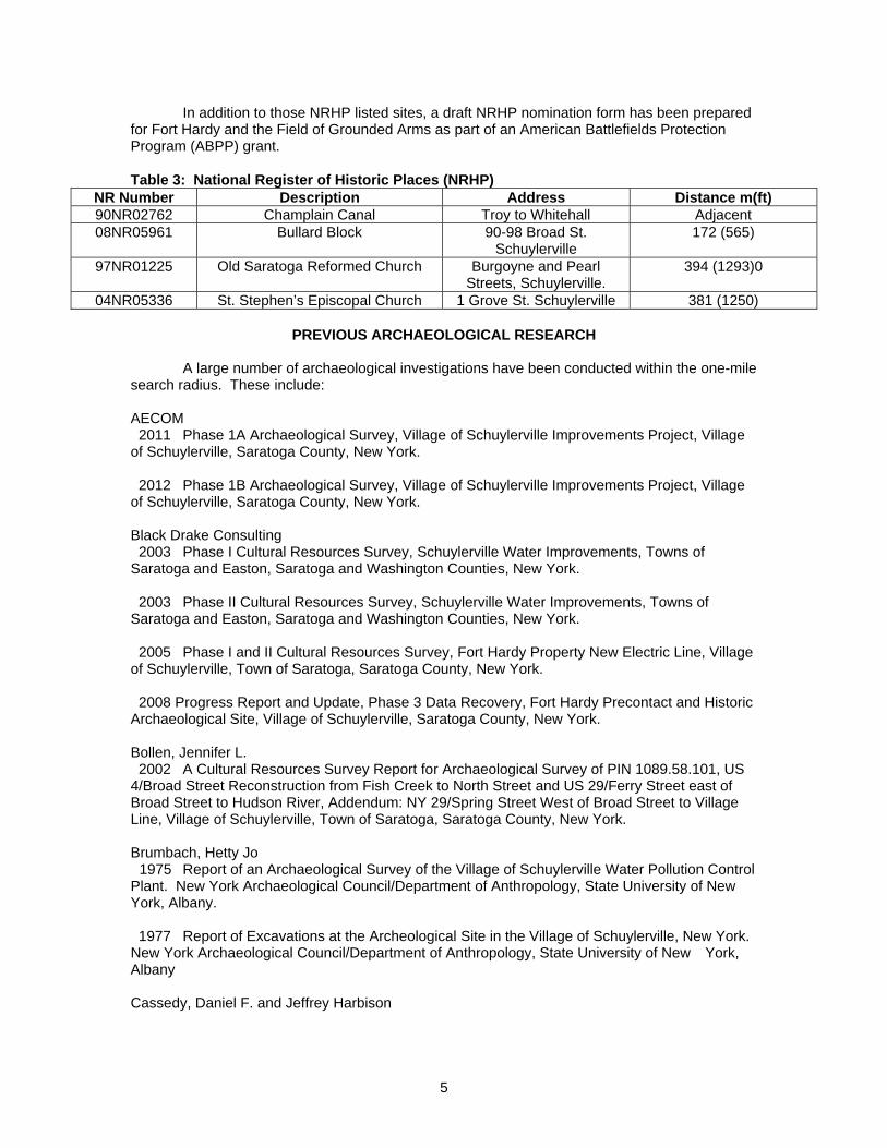
Table 3 records the National Register of Historic Places (NRHP) listed sites within the 1 mile search radius. Among these, the old Champlain Canal is recorded as directly adjacent to the project site. Field observation indicates that a portion of the canal towpath is within the project site’s property line.
5
In addition to those NRHP listed sites, a draft NRHP nomination form has been prepared for Fort Hardy and the Field of Grounded Arms as part of an American Battlefields Protection Program (ABPP) grant. Table 3: National Register of Historic Places (NRHP)
NR Number Description Address Distance m(ft) 90NR02762 Champlain Canal Troy to Whitehall Adjacent 08NR05961 Bullard Block 90-98 Broad St.
Schuylerville 172 (565)
97NR01225 Old Saratoga Reformed Church Burgoyne and Pearl Streets, Schuylerville.
394 (1293)0
04NR05336 St. Stephen’s Episcopal Church 1 Grove St. Schuylerville 381 (1250)
PREVIOUS ARCHAEOLOGICAL RESEARCH A large number of archaeological investigations have been conducted within the one-mile search radius. These include: AECOM 2011 Phase 1A Archaeological Survey, Village of Schuylerville Improvements Project, Village of Schuylerville, Saratoga County, New York. 2012 Phase 1B Archaeological Survey, Village of Schuylerville Improvements Project, Village of Schuylerville, Saratoga County, New York. Black Drake Consulting 2003 Phase I Cultural Resources Survey, Schuylerville Water Improvements, Towns of Saratoga and Easton, Saratoga and Washington Counties, New York. 2003 Phase II Cultural Resources Survey, Schuylerville Water Improvements, Towns of Saratoga and Easton, Saratoga and Washington Counties, New York. 2005 Phase I and II Cultural Resources Survey, Fort Hardy Property New Electric Line, Village of Schuylerville, Town of Saratoga, Saratoga County, New York. 2008 Progress Report and Update, Phase 3 Data Recovery, Fort Hardy Precontact and Historic Archaeological Site, Village of Schuylerville, Saratoga County, New York. Bollen, Jennifer L. 2002 A Cultural Resources Survey Report for Archaeological Survey of PIN 1089.58.101, US 4/Broad Street Reconstruction from Fish Creek to North Street and US 29/Ferry Street east of Broad Street to Hudson River, Addendum: NY 29/Spring Street West of Broad Street to Village Line, Village of Schuylerville, Town of Saratoga, Saratoga County, New York. Brumbach, Hetty Jo
1975 Report of an Archaeological Survey of the Village of Schuylerville Water Pollution Control Plant. New York Archaeological Council/Department of Anthropology, State University of New York, Albany. 1977 Report of Excavations at the Archeological Site in the Village of Schuylerville, New York. New York Archaeological Council/Department of Anthropology, State University of New York, Albany Cassedy, Daniel F. and Jeffrey Harbison
6
2005 Phase 1A Cultural Resources Assessment Report, Lock 5 Automated Water Column Sampling Station, Schuylerville, New York. Curtin, Edward V. 1992 Stage 1 Archaeological Survey, Schuyler Manor, Route 29, Village of Schuylerville, Saratoga County, New York. 1992 Stage 2 Archaeological Survey, Schuyler Manor, Route 29, Village of Schuylerville, Saratoga County, New York. 1994 Stage 1B Archaeological Survey, Manor Hill at Victory, Burgoyne Street and Gates Avenue Extension, Village of Victory, Saratoga County, New York. 1994 Stage 2 Archaeological Survey, Manor Hill at Victory, Burgoyne Street and Gates Avenue Extension, Village of Victory, Saratoga County, New York. Davis, Nancy L. 2003 A Cultural Resource Site Examination Report of PIN 1089.58.101, Soil Borings at the Funston Site and the Rt. 29 (Ferry Street) Causeway/Old Champlain Canal, Village of Schuylerville, Town of Saratoga, Saratoga County, New York. Davis, Nancy L. and Mark S. LoRusso 2001 A Cultural Resources Survey Report for Archeological Pre-Reconnaissance Survey and Architectural Survey of PIN 1089.58.101, US 4/Broad Street, Village of Schuylerville and Town of Saratoga, Saratoga County, New York. Dean, Robert E. 2002 Cultural Resource Reconnaissance Survey of PIN 1089.58.101, US 4/Broad Street, Liberty Street & Walnut Lane/Curtis Lumber Drainage Easements, Village of Schuylerville, Town of Saratoga, Saratoga County, New York. Addendum. Gimigliano, Michael H., Liana Hoodes, and David Church 1983 Finch’s Dry Dock, Schuylerville, New York, A Cultural Resources Mitigation Report. Cultural Resources Management Services. Hartgen Archeological Associates, Inc. 1991 Report for Archeological Potential and Field Reconnaissance, SEQR Parts 1 & 3, Northumberland Hydro-Electric Project, Town of Northumberland, Saratoga County, New York. 2003 Phase 1A Literature Review and Sensitivity Assessment and Phase 1B Archeological Field Reconnaissance, Saratoga Monument Parking Facility, Village of Victory, Town of Saratoga, Saratoga County, New York. 2005 Phase 1B Archeological Field Reconnaissance, Saratoga Monument Sewer, Village of Victory, Town of Saratoga, Saratoga County, New York. 2005 Phase I Archeological Survey, Schuylerville Central School District Additional Property Purchase, Town of Saratoga, Saratoga County, New York. 2007 Cultural Resource Reconnaissance Survey Report of Hudson Crossing Park, Towns of Northumberland and Saratoga, Saratoga County, New York. 2008 Phase 1A Report for Archeological Sensitivity and Phase 1B Archeological Reconnaissance, Schuylerville Central School, High School Addition, Spring Street, Village of Schuylerville, Saratoga County, New York.
7
2008 Phase 1A Literature Review and Phase 1B Archeological Field Reconnaissance, Schuylerville Central School District Drainage Improvement, Village of Schuylerville, Saratoga County, New York. 2009 Additional Archeological Work, Schuylerville Central School District, Towns of Northumberland and Saratoga, Saratoga County, New York. Henke, Janice S. 1979 Evaluation of Cultural Resources within Schuylerville-Victory Water Improvement System Study Area, Saratoga County, New York. LoRusso, Mark S. 1990 A Cultural Resource Survey Report of Upland Disposal Parcel, Town of Northumberland, Saratoga County, New York. 2001 A Cultural Resources Survey Report for an Architectural Survey Addendum of PIN 1089.58.101, US 4 and NY 29, NY 29/Spring Street portion, Village of Schuylerville, Saratoga County, New York. Mahlstedt, Thomas F. 1980 Archeological Impact Assessment, Saratoga Monument, Schuylerville, New York. Saratoga National Historical Park. Pratt, Peter P. and Marjorie K. Pratt 2006 Phase 1 Cultural Resource Survey, Schuylerville Cell Tower Site, Village of Schuylerville, Saratoga County, New York. Ross, Barbara
1994 Cultural Resource Survey of PIN 1089.47.109, BIN 1-00101-0, Rte. 4/Fish Creek, Village of Schuylerville, Town of Saratoga, Saratoga County, New York.
Stull, Scott/Hartgen Archeological Associates, Inc. 2009 Archaeological Investigation Final Report, Fort Hardy and the Field of Grounded Arms, Town of Saratoga, Saratoga County, New York. Several of the reports in this large group are discussed further below due to their direct relevance to the present survey: PIN 1089.58-101 Soil Borings at the Funston Site and Route 29 (Ferry Street) Causeway/Old Champlain Canal (Nancy Davis, New York State Museum, 2003) This investigation included a soil boring placed in the Champlain Canal at the Route 29 (Ferry Street) crossing. This soil boring found considerable evidence of disturbance within the canal associated with the replacement of a bridge by a culvert with 2 metal pipes about 1957. Modern green bottle glass and brick were found to a depth of 21.7 ft (6.6 m) below the top of the sediment in the canal. The artifacts were found in medium to fine gray sand as well as in an anomalous coarse gravel. Medium to fine gray sand without artifacts continued to a depth of 23.9 ft (7.3 m). The soil boring continued to a depth of 30 ft (9 m), with the soil changing to medium to coarse yellow to reddish brown sand at 23.9 ft (7.3 m). This soils boring provides additional information on conditions deep in the Hudson floodplain adjacent to the project site, and within the area of possible old creek or river channel. PIN 1089.58.101 US 4/Broad Street Reconstruction from Fish Creek to North Street and US 29/Ferry Street east of Broad Street to Hudson River, Addendum: NY 29/Spring Street west of Broad Street to village line (Jennifer L. Bollen, New York State Museum, 2002) This report included shovel testing along the north side of Route 29 (Ferry Street) between the Hudson River and the west side of the Champlain Canal. During this work, the
8
street frontage immediately in front of the former Saratoga Town Hall (within the present report’s APE) was not shovel tested due to the presence of pavement. Shovel test pits (STPs) F22 and F22.1 were excavated immediately east of Reds Road, adjacent to the northeastern corner of the former Town Hall property line. The artifact inventory records no artifacts for these STPs. STPs F23, F24, and F25 were excavated on the Champlain Canal towpath immediately west of adjacent of the present project. STPs 23 and 24 found numerous artifacts in the upper soil stratum, ranging in frequency from 11 to 36 per STP. The types of artifacts recovered included curved, bottle, and flat glass, whiteware, brick, asphalt, plastic, a nail, and unidentified iron/steel. Phase I and II Cultural Resources Survey, Fort Hardy Property New Electric Line (Andrew Black and Faye E. Yagy/Black Drake Consulting, 2005) This is a report of an archaeological survey conducted through the excavation of STPs along the east side of Reds Road, directly across Reds Road from the present project, and actually crossing the present project site’s property in its southeast section. Black Drake STPs 29-37 were excavated at 10 meter intervals within the present project site along the east side of Reds Road, and STP 27 was within or adjacent to the property line (Since the STPs in this area were given only odd numbers, this represents 6 STPs). These STPs were excavated to depths of 120-129 cm below ground surface, and encountered only fill. Two to three strata of fill were found. Where three strata were present, the upper stratum sometimes was yellow brown sandy loam; otherwise the upper stratum was gravelly and all lower strata were described as sandy gravel. The Black Drake survey continued north along Reds Road from STP 27. Fill continued in all strata in all STPs through STP 25. At STP 24, a buried A horizon was reached at 90 cm below surface, The buried A was reached but not exceeded below 2 or 3 fill strata through STP 16, while the buried B horizon was reached below the buried A at STP 15. This Fill-A-B stratigraphy was recorded through STP 7. In STPs 4-6, a C horizon was encountered below the B. In STPs 1-3, only the A and B horizons were found below the fill. The general stratigraphic sequence includes 2-3 fill strata differentiated most often by soil color (and replicating the color sequence of an A-B soil sequence) over a gray brown sandy loam buried A soil, overlying a yellow brown sandy loam B soil, overlying a light yellow brown sand C soil. The below-fill soil sequence compares somewhat favorably to the soil survey’s description of Teel silt loam, but has a sandier character at all levels. Black Drake’s survey found a chert flake in the B horizon at STP 9. Subsequently, a Phase 2 survey was performed in this area, identifying a concentration of chert flakes, fire cracked rocks, and soil stains in the lower part of the A and the upper part of the B (about 70 cm below surface, or 10-30 cm below the fill-buried A contact). This site appears to be about 25 meters long but with an undefined width. Its age is unknown. The most southern boundary of the archaeological site is across Reds Road and opposite the northeast corner of the present project site. It is in the setting that geomorphologist David De Simone has referred to as the higher river terrace. Across Red’s Road from the northern part of the project site, Black Drake STPs 12-15 encountered the buried A and B soils, but did not recover precontact period artifacts. STPs 16-24 reached the Buried A only, and did not recover artifacts of definite precontact origin (a piece of fire cracked rock was found with historic artifacts in the buried A at STP 16, and was not considered part of the archaeological site. No other possible precontact artifacts occurred directly opposite the former Town Hall project site). In addition to this information, the Blake Drake report (Black and Yagy 2005) contains a table providing a soil profile recorded by geoarchaeologist Dr. Julieann Van Nest of the New York State Museum for a portion of the floodplain in Fort Hardy Park closer to the Hudson River. This location is within the area that Dr. De Simone has referred to as the higher terrace, and is northeast of the former Saratoga Town Hall project site. The sequence reported by Dr. Van Nest is reproduced here:
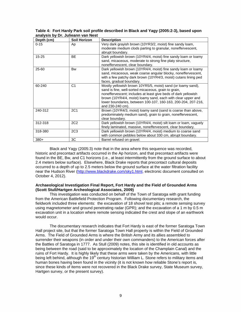
9
Table 4: Fort Hardy Park soil profile described in Black and Yagy (2005:2-3), based upon analysis by Dr. Julieann van Nest Depth (cm) Soil Horizon Description 0-15 Ap Very dark grayish brown (10YR3/2, moist) fine sandy loam,
moderate medium clods parting to granular, noneffervescent, abrupt boundary.
15-25 BE Dark yellowish brown (10YR4/4, moist) fine sandy loam or loamy sand, micaceous, moderate to strong fine platy structure, noneffervescent, clear boundary.
25-60 Bw Dark yellowish brown (10YR4/4, moist) fine sandy loam or loamy sand, micaceous, weak coarse angular blocky, noneffervescent, with a few patchy dark brown (10YR4/3, moist) cutans lining ped faces, gradual boundary.
60-240 C1 Mostly yellowish brown 10YR5/5, moist) sand (or loamy sand), sand is fine, well-sorted micaceous, grain to grain, noneffervescent; includes at least give beds of dark yellowish brown (10YR4/4, moist) loamy sand, each with clear upper and lower boundaries, between 100-107, 160-163, 200-204, 207-216, and 230-240 cm).
240-312 2C1 Brown (10YR4/3, moist) loamy sand (sand is coarse than above, predominately medium sand), grain to grain, noneffervescent, clear boundary.
312-318 2C2 Dark yellowish brown (10YR4/4, moist) silt loam or loam, vaguely finely laminated, massive, noneffervescent, clear boundary.
318-380 2C3 Dark yellowish brown (10YR4/4, moist) medium to coarse sand with common pebbles below about 330 cm, abrupt boundary.
380+ 3C Barrel refused on gravel. Black and Yagy (2005:3) note that in the area where this sequence was recorded, historic and precontact artifacts occurred in the Ap horizon, and that precontact artifacts were found in the BE, Bw, and C1 horizons (i.e., at least intermittently from the ground surface to about 2.4 meters below surface). Elsewhere, Black Drake reports that precontact cultural deposits occurred to a depth of up to 2.5 meters below the ground surface at the water filtration facility near the Hudson River (http://www.blackdrake.com/sky1.html, electronic document consulted on October 4, 2012). Archaeological Investigation Final Report, Fort Hardy and the Field of Grounded Arms (Scott Stull/Hartgen Archeological Associates, 2009) This investigation was conducted on behalf of the Town of Saratoga with grant funding from the American Battlefield Protection Program. Following documentary research, the fieldwork included three elements: the excavation of 18 shovel test pits; a remote sensing survey using magnetometer and ground penetrating radar (GPR); and the excavation of a 1 m by 0.5 m excavation unit in a location where remote sensing indicated the crest and slope of an earthwork would occur. The documentary research indicates that Fort Hardy is east of the former Saratoga Town Hall project site, but that the former Saratoga Town Hall property is within the Field of Grounded Arms. The Field of Grounded Arms is where the British Army and its allies assembled to surrender their weapons (in order and under their own commanders) to the American forces after the Battles of Saratoga in 1777. As Stull (2009) notes, this site is identified in old accounts as being between the road (said to be approximately the location of the Champlain Canal) and the ruins of Fort Hardy. It is highly likely that these arms were taken by the Americans, with little being left behind, although the 19th century historian William L. Stone refers to military items and human bones having been found in the vicinity (it is not known how reliable Stone’s report is, since these kinds of items were not recovered in the Black Drake survey, State Museum survey, Hartgen survey, or the present survey).
10
The Hartgen shovel test survey excavated STPs 1-9 in a line about 40-45 meters east of and generally parallel to Black Drake’s transect; and STPs 10-18 parallel to Route 29 (Ferry Street), between Route 29 and the community center. Hartgen’s work found extensive fill at the Fort Hardy site and in the portion of the Field of Grounded Arms within Fort Hardy Park. In some cases, the fill could not be penetrated. At STPs 1 and 3, possible buried A soils were found below fill at depths of 70 and 23 cm, respectively; subsoil was sampled below these levels in both STPs. The other STPs on this transect either encountered only fill, or found subsoil directly below fill, with the former topsoil (buried A horizon) missing. At STPs 10-18, fill thinned to the east, and buried A-B soil sequences were found in STPs 14-18. Fill was 17-46 cm deep along the eastern section of this transect (at STPs 14-18). The artifacts found were deposited in the 19th and 20th centuries (1 lithic flake was found in fill); nothing associated with Fort Hardy or the Field of Grounded Arms was found in the shovel test pits. The remote sensing survey recorded signals consistent with the occurrence of earthworks and ditches, and the small test unit placed to test the nature of this finding found a sloped surface consistent with the slope of an earthwork, plus 3 postmolds at the apparent top of the earthwork. The remote sensing and associated excavation effectively defines the western limit of the 1750s Fort Hardy in a position consistent with map analysis. The earthworks of the fort appear to extend about as far west as the community building in Fort Hardy Park. The area west of this to the Champlain Canal is considered to be part of the 1777 Field of Grounded Arms (Stull 2009:11). As a cultural resource with an ephemeral archaeological signature (Stull 2009:1), the Field of Grounded Arms is difficult (if not impossible) to address with archaeological methods. At the same time, it is a spatially definable historic place. Stull (2009:1) notes further that the Field of Grounded Arms has been identified for consideration in an inventory of historic and scenic sites produced and analyzed for the local preservation group Saratoga Plan (Dodson Associates, Ltd 2006). The analysis produced for Saratoga Plan identifies the Field of Grounded Arms as having high historical significance. The Field of Grounded Arms (including the former Saratoga Town Hall project site) has been included in a draft National Register of Historic Places nomination form prepared by Hartgen Archeological Associates, Inc.
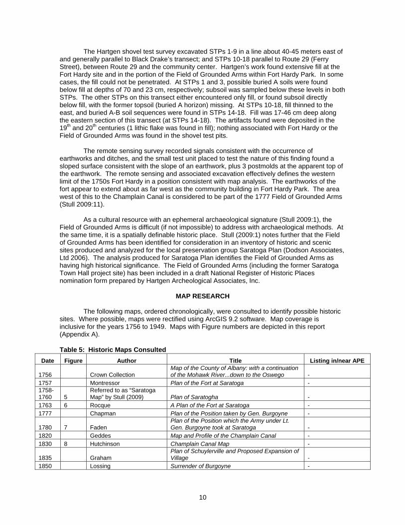
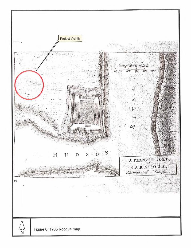
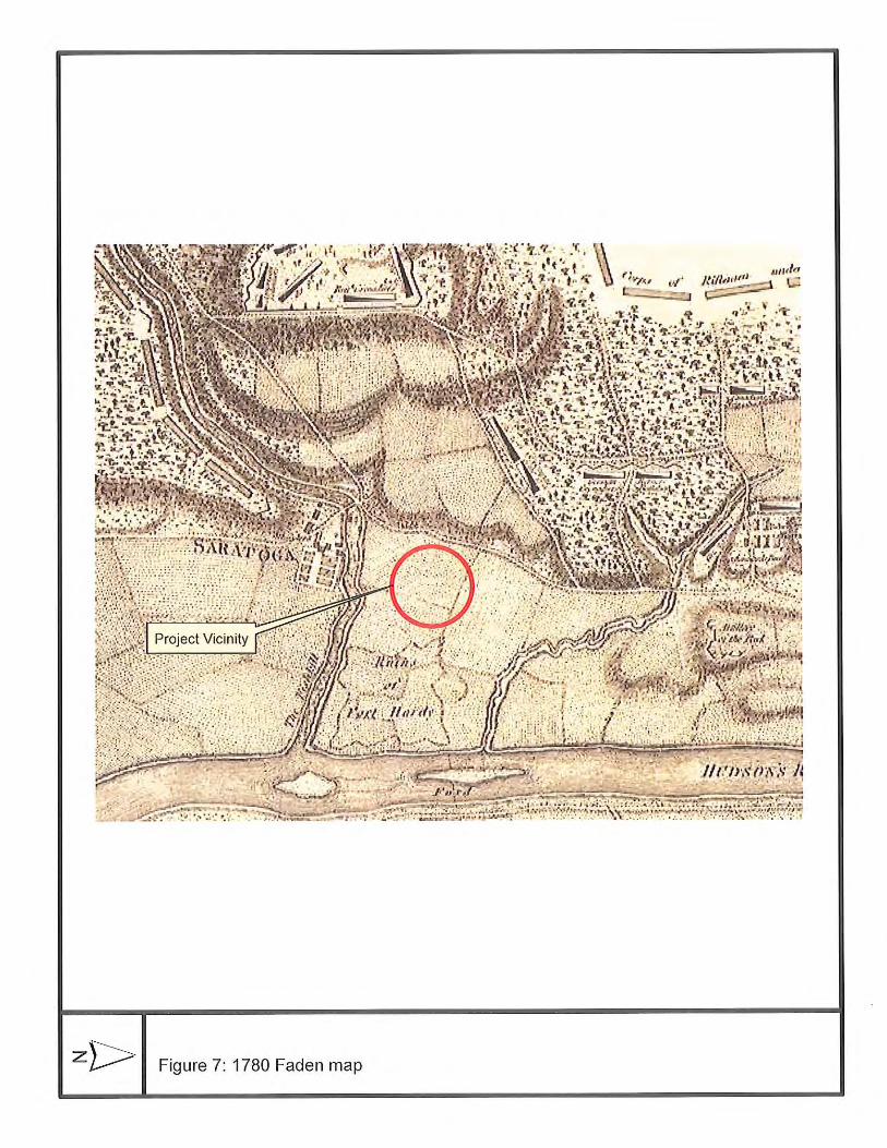
MAP RESEARCH The following maps, ordered chronologically, were consulted to identify possible historic sites. Where possible, maps were rectified using ArcGIS 9.2 software. Map coverage is inclusive for the years 1756 to 1949. Maps with Figure numbers are depicted in this report (Appendix A). Table 5: Historic Maps Consulted
Date Figure Author Title Listing in/near APE
1756 Crown Collection Map of the County of Albany: with a continuation of the Mohawk River...down to the Oswego -
1757 Montressor Plan of the Fort at Saratoga - 1758-1760 5
Referred to as “Saratoga Map” by Stull (2009) Plan of Saratogha -
1763 6 Rocque A Plan of the Fort at Saratoga - 1777 Chapman Plan of the Position taken by Gen. Burgoyne -
1780 7 Faden Plan of the Position which the Army under Lt. Gen. Burgoyne took at Saratoga -
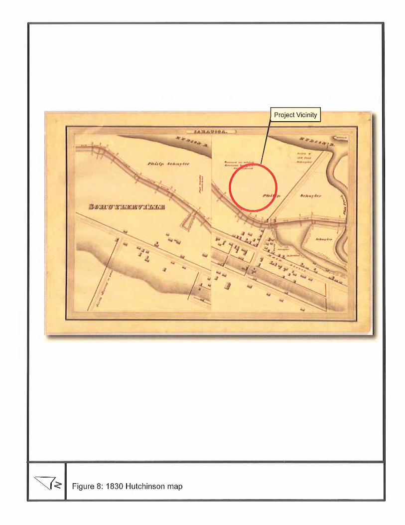
1820 Geddes Map and Profile of the Champlain Canal - 1830 8 Hutchinson Champlain Canal Map -
1835 Graham Plan of Schuylerville and Proposed Expansion of Village -
1850 Lossing Surrender of Burgoyne -
11
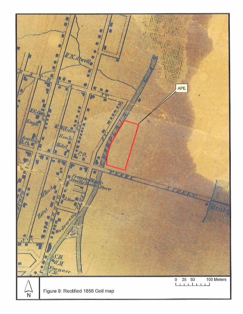
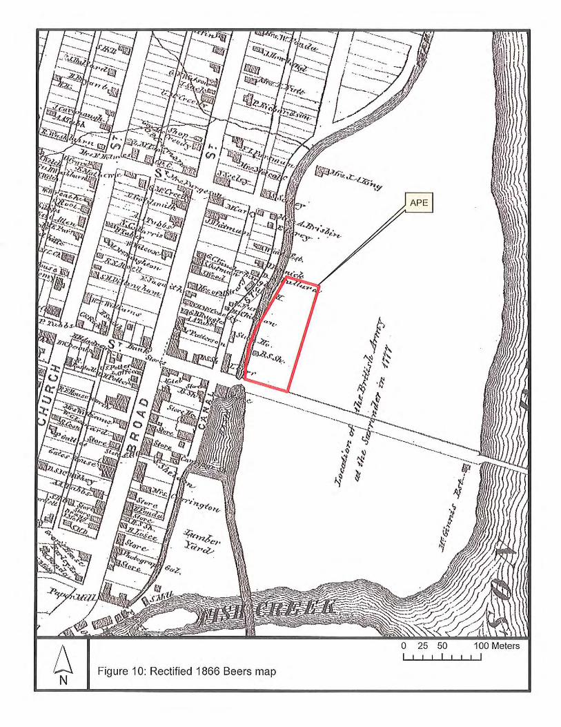
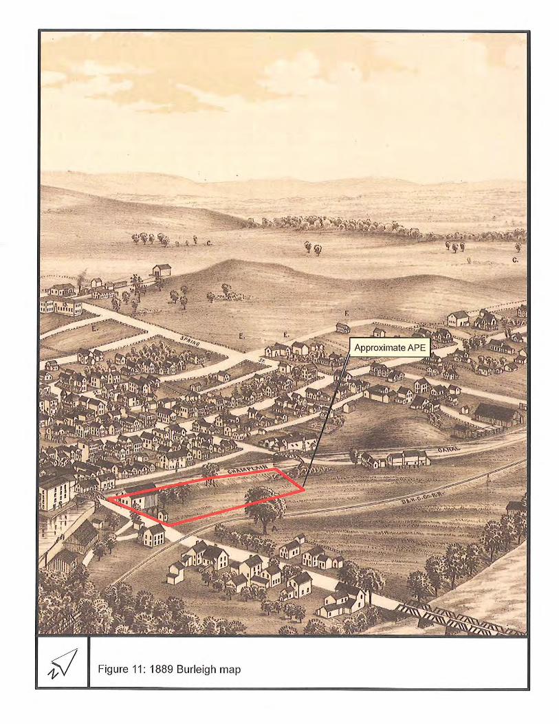
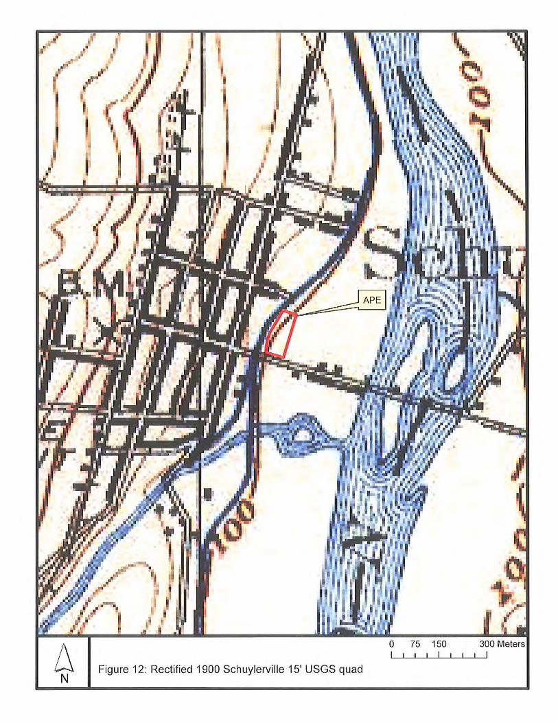
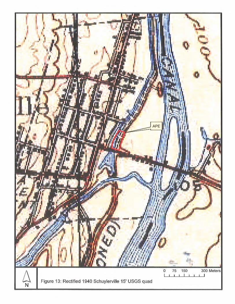
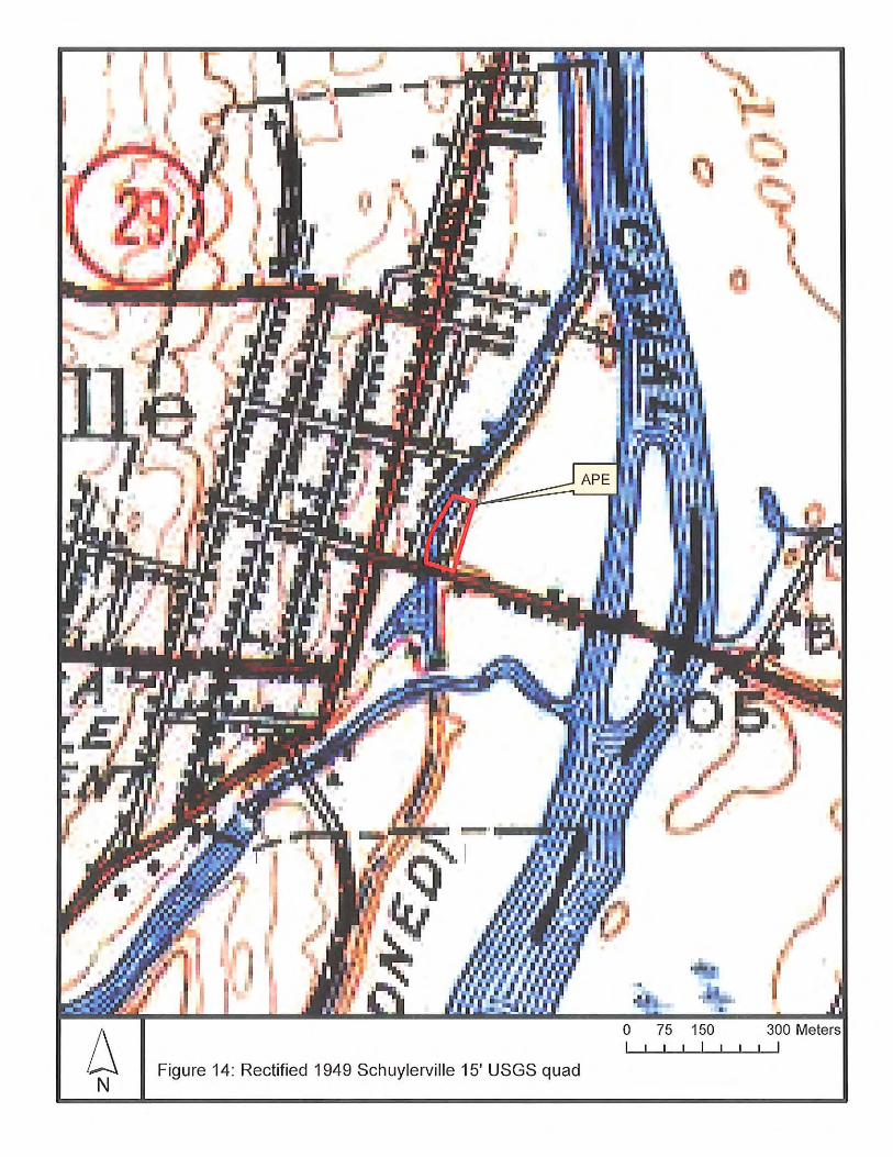
Date Figure Author Title Listing in/near APE 1856 9 Geil Map of Saratoga County - 1866 10 Beers Atlas of Saratoga County Blacksmith Shop 1889 11 Burleigh Schuylerville, NY 2 buildings 1900 12 USGS 15’ Schuylerville Quad - 1940 13 USGS 15’ Schuylerville Quad - 1949 14 USGS 15’ Schuylerville Quad -
MAP-DOCUMENTED STRUCTURES
The 16 historic maps reviewed for this survey are listed in Table 5. Many of these maps have been reproduced several times in archaeological surveys conducted in Schuylerville. Those most relevant for the present stud, in that they depict the relationship of the project site to Fort Hardy or specifically show conditions within the project site, are reproduced in Appendix A. The figure numbers of the reproduced maps are listed in Table 5. Most of the historic maps show no historic structures within the boundaries of the former Saratoga Town Hall property. However, the 1866 Beers atlas shows a blacksmith shop in the southwestern section of the project site. The mapped blacksmith shop location is beneath a deep deposit of fill (described below) where the former town hall building and its paved parking areas are sited. In addition, the 1887 Burleigh Company birds-eye view of Schuylerville appears to show a large two-story building and possibly a small one-story building in approximately the location of the existing (modern) town hall building. Both buildings front Ferry Street (Route 29) and open in front at ground level on the causeway leading to the canal crossing. The large two-story building is supported in the back by stilts. The blacksmith shop appears on no other maps, including the earlier Holmes Hutchinson canal map (1830; Figure 8) and Geil county map (1856; Figure 9). The buildings shown on the 1887 illustration do not appear on other maps, including subsequent maps such as the 1900, 1940, and 1949 15’ USGS quads (Figures 12-14). It is not known whether the large building show in the 1887 illustration is the blacksmith shop, although it seems too large and too close to the road to be the blacksmith shop. It is interesting to note the stilts in back and wonder whether drainage issues and high water table (discussed below, particularly in the Phase 1B survey) affected construction design. Given the unknown effect of the perspective drawing in the 1887 Burleigh illustration, it is not clear that the small building was actually inside the project boundary.
TOWN HISTORIAN INFORMATION During the geomorphological investigation on November 5, 2012, Town Historian Sean Kelleher visited the field team, identified and discussed the remote sensing study previously performed in Fort Hardy Park, and identified the former use of the town hall site within the APE as a landfill. This site is also referred to as constructed over a landfill by Stull (2009:9). Following the field visit, Mr. Kelleher graciously provided a copy of the remote sensing study (Stull 2009) to assist the present project.
ANALYSIS OF SOIL BORING DATA A geotechnical evaluation including numerous soil borings was provided by Dente Engineering in July, 2005 (this study is also referenced by Dr. De Simone, this report, Appendix C). Dente Engineering placed 10 soil borings in the immediate vicinity of the former Town Hall building and in its adjoining parking lots. An 11th soil boring was placed in the eastern section of the property, about 250 feet (75 meters) north of Route 29 (close to the location of STP 4/2 described in the Phase 1B survey below).
12
The immediate site and parking areas of the former town hall forms a terraced landform constructed on fill. An upper level of fill adjacent to Route 29 supports the building and the front parking lot, while a lower level of fill behind the building holds the back parking area. The depth of fill varied from 18-25 feet on the upper level, and from 10-15 feet in the lower level. The fill is described as “loose to firm sand, silt, gravel, brick, concrete, wood, mortar, ash, cinders and other miscellaneous debris.” Some of the soil below the fill is described as “remnants of the original topsoil layer” overlying “a five to ten foot thick layer of very soft/loose silt and/or fine sand with occasional inclusions and thin seams of organic matter.” Below the very soft/loose silt or fine sand occurred “loose fine to medium sand”. Bedrock was reached at 37-55 feet below grade, and sometimes the bedrock was covered with a thin layer of glacial till. The soil boring (B-11) in the backyard area north of the town hall building found approximately 8 inches (20 cm) of topsoil over 2 feet of brown fine sand with little silt overlying four feet of brown silt containing a trace of fine sand (and occasional roots). This slightly sandy silt is noted as saturated at 4-5 feet (120-150 cm) below surface, and it grades to a brown and gray mottled color at about 6 feet (183 cm). With depth increasing to 16 feet (480 cm), this soil grades to brown/orange/gray mottled fine sand, with gray silt and a “seam of roots and organics”. The soil continues to be noted as saturated. Various grades of gray sand are recorded below 16 feet (480 cm), with little silt or gravel noted to about 41 feet (1246 cm). Shale was encountered at 41 feet (1246 cm). Although these are very general descriptions, there are some similarities in the upper stratigraphy to the profile identified by Dr. Van Nest near the Hudson River. These include a 15-20 cm (6-8 in) topsoil (referred to as an Ap by Van Nest), and several feet of brown sandy soil (possibly corresponding to BE, Bw, and C horizons in Van Nest’s profile). Differences include apparent higher silt content below about 2-3 (60-90 cm) feet at Soil Boring 11 than occurred at the water filtration plant site, and the occurrence of impenetrable gravel at 380 cm in Van Nest’s profile. Differences and variation are no doubt associated with the variable aspects of floodplain formation laterally as well as vertically. Minimally, it seems that depositional conditions are somewhat similar in the upper 3-4 feet at both locations (until differences in silt content pertain). Since precontact artifacts were found rather continuously in the A, B and upper C zones at the filtration plant site, the Boring B-11 profile suggests archaeological sensitivity for precontact artifacts at least in undisturbed sandy soils of the upper 2-3 feet of sediment below fill in the project site.
ARCHAEOLOGICAL SENSITIVITY The Phase 1A research indicates that the project site is sensitive for the occurrence of precontact period archaeological sites. At the same time, the shovel testing conducted by Black Drake along Reds Road as well as Hartgen Archeological Associates in Fort Hardy Park (to the extent that the shovel tests penetrated through fill) tended not to find evidence of precontact sites. The exception is one seemingly small site found in the higher terrace context along Reds Road. It thus may be the case that the project site is sensitive for the occurrence of small precontact sites, however, it may occur in an area located between or adjacent to precontact sites. It is possible that the site found in the Black Drake survey represents higher ground preferentially occupied adjacent to an abandoned channel in the area referred to as the lower terrace, which may decrease precontact site sensitivity within the project location. The project site is not sensitive for the occurrence of Fort Hardy, since extensive, field-tested research indicates that this site occurs in Fort Hardy Park some 75 m (250 feet) to the east (Stull 2009). However, large numbers of troops reportedly camped near Fort Hardy during the French and Indian War (Stull 2009:3), suggesting sensitivity for French and Indian War campsites. In addition, the project site is within the 1777 Field of Grounded Arms, a location of historic significance where the British forces laid down their arms in surrender in 1777. Stull
13
(2009) refers to this kind of site as ephemeral at best, and it may not contain significant traces of artifacts. Nonetheless, it is a site of historic importance. With respect to potential archaeological resources of a later period, two (possibly three) 19th century structures are shown within the project site. The first of these is a blacksmith shop shown on the 1866 Beers atlas. The second is a large, two-story building (shown in the 1887 Burleigh Company view) apparently built partly on the Ferry Street (Route 29) causeway, and partly on stilts. The third possible structure is a small, one-story building just east of the large 2-story building, also on the 1887 Burleigh Company bird’s-eye view. These structures each appear on only one map, and so may not have been present over a long period of time. Thus, these sites may not have left a strong archaeological signature. More importantly, these sites are now covered by the deep fill that the former town hall and its parking areas sit upon. In addition, soil borings in this area only occasionally show an old topsoil below the fill, with the large majority of the boring logs showing no old topsoil. It therefore seems that the surfaces below the fill have been truncated or disturbed. As a result, the project site is not considered to be sensitive for the occurrence of late 19th century sites. At the same time, the great depth of fill in this location significantly greatly hinders archaeological exploration. The soil borings made in this area did not appear to encounter buried ground surfaces, except in the three occasions where remnants of the pre-fill topsoil were identified.
PRIOR DISTURBANCE AND FILLED AREAS The Champlain Canal towpath appears to be intact, and the southern portion of the backyard area appears to be undisturbed and not covered with fill. The area of the former Town Hall and its parking areas is covered with deep fill, and seems to have been at least partly disturbed prior to filling. It is noted that the geotechnical report refers to remnants of topsoil rather than topsoil uniformly below the fill in this location. In the boring logs, “topsoil” is recorded below fill in only 3 of the 10 borings. A driveway, parking, and stone and gravel (road material) storage area on the east and north sides of the property suggest other areas of prior disturbance, at least to upper soil levels. The parking/storage area in the north part of the property has a compacted surface and sits on fill; the deposit of fill extends across the northern section of the project area to the edge of the Champlain Canal towpath.
PHASE 1A SUMMARY AND RECOMMENDATIONS
Based on these findings, a Phase 1B survey is recommended. The recommended survey would include backhoe trenches in selected locations for geomorphological analysis and deep archaeological testing, as well as shovel testing for discovery of archaeological sites. A minimum STP depth of 50 cm is recommended. No shovel testing is recommended at obviously filled or paved locations at the former Town Hall site, the Champlain Canal towpath, and the northern part of the back yard and adjoining parking and materials storage area.
PHASE 1B ARCHAEOLOGICAL FIELD INVESTIGATION The Phase 1B field survey was conducted over the course of two days in November, 2012. On November 5, under gray skies, the backhoe trenching was performed by a Town crew under the guidance of Ed Curtin and David De Simone. On November 12, 2012, the shovel testing was performed by a crew of two experienced field archaeologists directed by Ed Curtin in warm, sunny weather. The locations of the back trenches and shovel test pits are shown in Figure 15. The Phase 1B field methodology was guided by Section 2.3.2 of the New York Archaeological Council Standards (1994) as well as guidelines provided by the New York State Office of Parks, Recreation, and Historic Preservation (May 2005). .
14
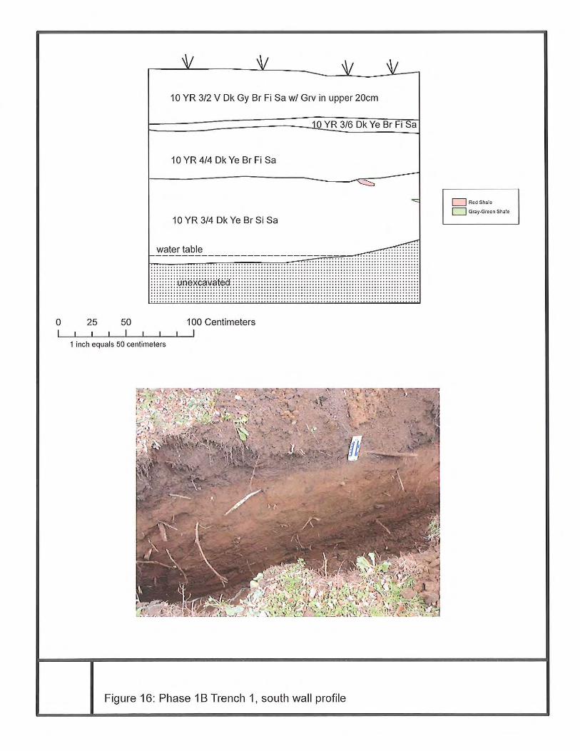
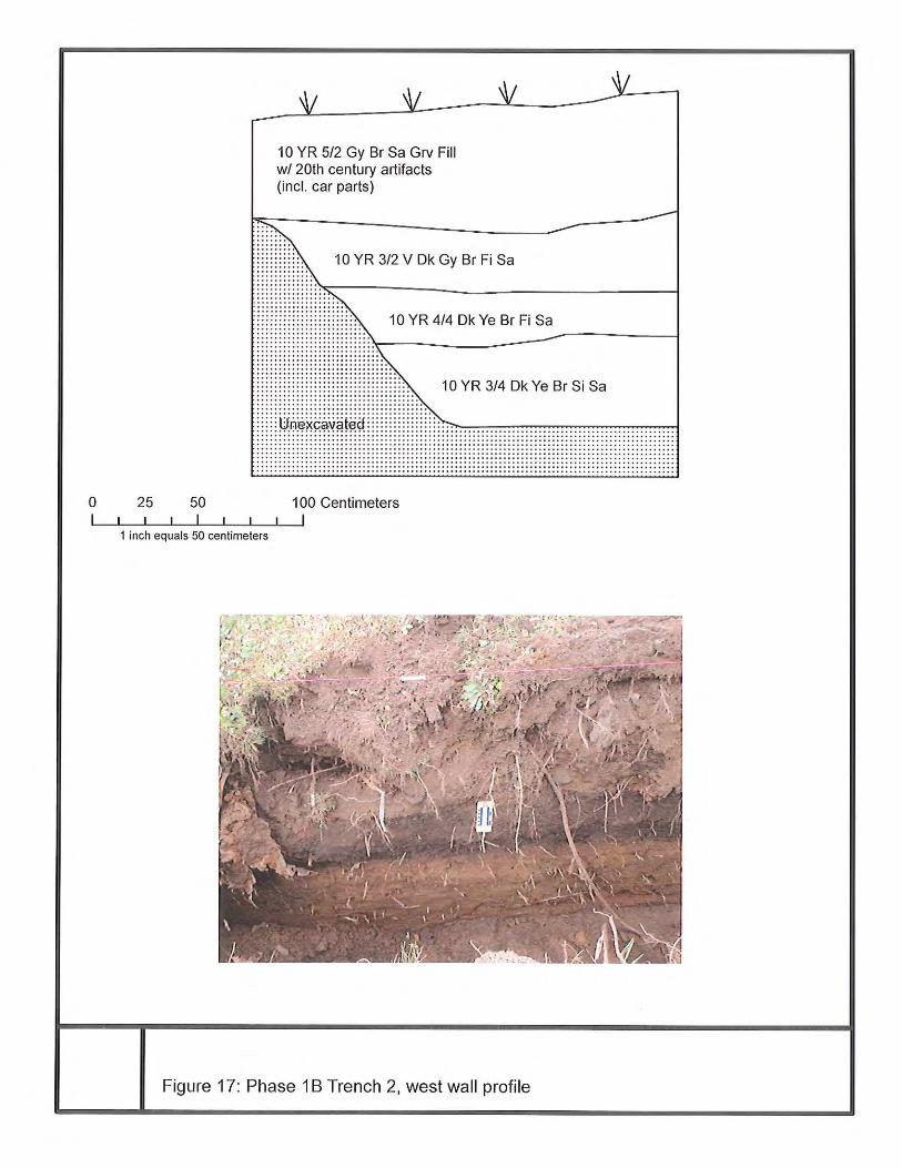
Backhoe Trenches Two backhoe trenches were placed in the backyard area at orientations parallel and perpendicular to the former town hall building (which generally oriented the trenches parallel and perpendicular to the Hudson River and Champlain Canal). The trenches were 3 meters long and up to 1 meter wide. Trench 1, perpendicular to the river and canal, was placed in an unfilled area, while Trench 2 was placed perpendicular to this but in a filled area near the edge of the fill deposit. These trenches are shown in profile drawings and photos in Figures 16 and 17. Additional photos are shown in Appendix C, where David De Simone analyzes the stratigraphy and comments on archaeological sensitivity for deeply buried sites (note: stratigraphic measurements in the present section of the report are based upon measured profile drawing and to small degrees, as discussed with Dr. De Simone, refine depths reported in Dr. De Simone’s report, Appendix C). Trench 1 was excavated to a maximum depth of 148 cm below ground surface. The stratigraphy identified included a 10YR3/2 very dark gray brown fine sand 35-40 cm thick. Gravel presumed residual from driving or parking in this area, or scattered from the nearby road material stockpiles occurred in the upper 20 cm. Immediately below the plowzone was a thin band of 10YR3/6 dark yellow brown fine sand, 5-10 cm thick. Below this occurred 10YR4/4 dark yellow brown fine sand about 40 cm thick. The lowest stratum was 10YR3/4 dark yellow brown silty sand observed from about 80-148 cm below ground surface. Although a careful search was made by thoroughly troweling the long sidewalls, no artifacts were identified. In addition, no artifacts were observed in the backdirt. Two presumably ice-rafted shale fragments were found in the lowest soil stratum (south wall), with the highest occurring close to the boundary between the upper and lower B soils (Figure 16). The water table was reached at 143 cm below ground surface, and excavation was not continued deeper due to the potential instability of the trench walls in contact with water. Finding the water table at this depth corresponds in general with the report of saturated soil found in 2005 at Soil Boring 11 by Dente Engineering. Trench 2 was excavated to a depth of 152 cm below ground surface (and terminated before water was encountered). Its stratigraphy was generally similar to the Trench 1 stratigraphy, with the following exceptions: the uppermost soil stratum was composed of fill containing automobile parts and other material, and the thin band of 10YR3/6 dark yellow brown fine sand seen immediately below the topsoil at Trench 1 did not occur here. The fill layer was 60 cm thick and composed of 10YR5/2 gray brown sandy gravel. The buried topsoil below the fill was 30-35 cm thick and composed of 10YR3/2 very dark gray brown fine sand. The upper subsoil below this was 10YR4/4 dark yellow brown fine sand 20-25 cm thick. Below this occurred 10YR3/4 dark yellow brown silty sand. Excavation was halted at 153 cm below ground surface, just above the expected level of the water table, in order to facilitate entering the trench. As at Trench 1, the long sidewalls were slowly and carefully troweled. However, no artifacts were identified below the fill. In addition, no artifacts were seen in the backdirt other than modern materials associated with the fill. The backhoe operators thought that at the some point in the past, someone who had owned a car repair business had disposed of material here. Geomorphologist David De Simone has described the below-fill stratigraphic sequence as A-B1-B2, and has noted some likely compression in Trench 2 due to the weight of fill. The B soils seem to be differentiated in terms of moisture content and increasing silt content with depth. No evidence of stable land surfaces buried below the topsoil was identified. During the excavation of the trenches, there was some speculation that water was leaking through the ground from the canal prism. Dr. De Simone has noted more recently that there was no visible seepage from the canal, and that the canal is elevated above the ground level at the trench locations. In addition, he draws a contrast between the seemingly impermeable canal walls and the clearly very permeable soil of the project site. The fact that
15
water perennially occurs at 4-5 feet (circa 140-150 cm) below the ground level within the project site is indicated by saturated soil encountered at this depth in Soil Boring 11 in 2005 (cf. Dente Engineering 2005). It seems possible that this may be an effect of water seeping through the ground several feet deep along the course of the old channel that Dr. De Simone has inferred in this area (as he has considered in an email to the author, November 30, 2012). In considering the sensitivity for the occurrence of precontact period archaeological sites based upon the geomorphological analysis, Dr. De Simone states that there is a “high probability for reaching pre-Contact age sediments beneath the areas trenched and beneath all of the low-lying floodplain terrace…there is a very good chance these sediments would contain pre-Contact materials” (this report, Appendix C). By email communication on November 30, 2012, Dr. De Simone clarified that this means pre-contact sediments possibly containing artifacts. Shovel Testing In the present survey, in areas that were not characterized by high slope, obvious disturbance, or deep fill, parallel transects of shovel test pits (STPs) were placed at intervals ranging from 5-15 m (16-50 ft) within the project APE. Adjustments were made due to tree roots and buried wires as described below. All soils were screened through ¼-inch mesh hardware cloth. The present Phase 1B fieldwork saw the deployment of 21 shovel test pits. Shovel testing was performed along 5 transects oriented grid north-south (45 degrees east of true north). Transect 1 was placed just east of the base of the Champlain Canal towpath. Its internal interval was 7.5-15 meters; a tree was avoided between STPs 1/2 and 1/3. Transect 2 was placed 5-10 meters east of Transect 1. Its internal interval was 15 meters. STP2/2 was shifted 5 meters east to avoid tree roots. Transect 3 was placed 10-15 meters east of Transect 2; its internal interval was 15 meters, and while maintaining the interval, it was adjusted to avoid a suspected buried phone cable between STPs 3/1 and 3/2. Closer to the small archaeological site identified by Black Drake, Transect 4 was set up with a reduced testing interval. It was 10 meters east of Transect 3 and its internal interval was 10 meters. Transect 5 was set up in an area of suspected prior disturbance near the driveway leading off of Reds Road, 10-12 meters east of Transect 4. Since its purpose was to confirm prior disturbance or impenetrable fill, its internal interval was set at 19-20 meters. Additional shovel testing within the southeast section of the property had been conducted by Black Drake on the other side of Red’s Road. However, these shovel test pits could not reach below deep fill. It is suspected that nearby STPs excavated by the New York State Museum also encountered fill. The State Museum also excavated STPs adjacent to the present project in the towpath of the Champlain Canal, as described earlier. These other shovel tests are depicted along with the present survey’s STPs in Figure 15.
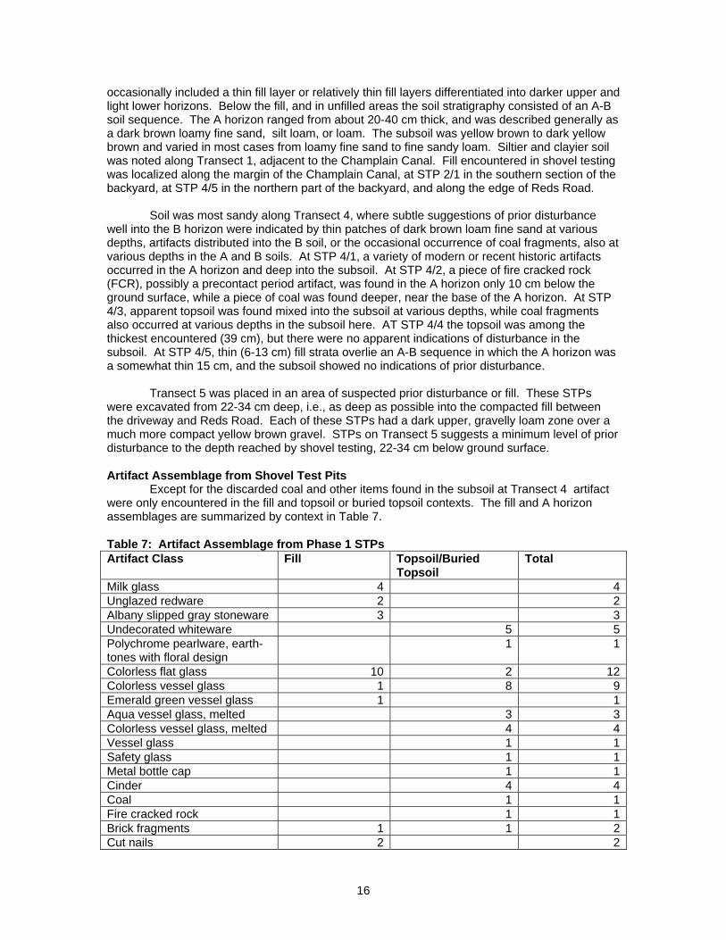
Table 6: Phase 1B STP Summary STPs n=
@5-20m +21no digs -3
Total 18
Three STPs (1/4, 2/4, and 3/5) were not excavated due to the presence of the canal towpath or more recent fill judged to be too deep to excavate through. However, they were deployed with pin flags to assist mapping the boundary of the fill mound. Table 6 provides a numerical summary of all Phase 1B STPs. Appendix D provides the complete list of STP field records and Figure 15 shows the location of all archaeological testing. Stratigraphy Revealed in Shovel Testing In general, except for areas with compact fill, the STPs were excavated 50-100 cm deep, with the majority excavated to 70 cm or deeper. The stratigraphy encountered in Transects 1-4
16
occasionally included a thin fill layer or relatively thin fill layers differentiated into darker upper and light lower horizons. Below the fill, and in unfilled areas the soil stratigraphy consisted of an A-B soil sequence. The A horizon ranged from about 20-40 cm thick, and was described generally as a dark brown loamy fine sand, silt loam, or loam. The subsoil was yellow brown to dark yellow brown and varied in most cases from loamy fine sand to fine sandy loam. Siltier and clayier soil was noted along Transect 1, adjacent to the Champlain Canal. Fill encountered in shovel testing was localized along the margin of the Champlain Canal, at STP 2/1 in the southern section of the backyard, at STP 4/5 in the northern part of the backyard, and along the edge of Reds Road. Soil was most sandy along Transect 4, where subtle suggestions of prior disturbance well into the B horizon were indicated by thin patches of dark brown loam fine sand at various depths, artifacts distributed into the B soil, or the occasional occurrence of coal fragments, also at various depths in the A and B soils. At STP 4/1, a variety of modern or recent historic artifacts occurred in the A horizon and deep into the subsoil. At STP 4/2, a piece of fire cracked rock (FCR), possibly a precontact period artifact, was found in the A horizon only 10 cm below the ground surface, while a piece of coal was found deeper, near the base of the A horizon. At STP 4/3, apparent topsoil was found mixed into the subsoil at various depths, while coal fragments also occurred at various depths in the subsoil here. AT STP 4/4 the topsoil was among the thickest encountered (39 cm), but there were no apparent indications of disturbance in the subsoil. At STP 4/5, thin (6-13 cm) fill strata overlie an A-B sequence in which the A horizon was a somewhat thin 15 cm, and the subsoil showed no indications of prior disturbance. Transect 5 was placed in an area of suspected prior disturbance or fill. These STPs were excavated from 22-34 cm deep, i.e., as deep as possible into the compacted fill between the driveway and Reds Road. Each of these STPs had a dark upper, gravelly loam zone over a much more compact yellow brown gravel. STPs on Transect 5 suggests a minimum level of prior disturbance to the depth reached by shovel testing, 22-34 cm below ground surface. Artifact Assemblage from Shovel Test Pits Except for the discarded coal and other items found in the subsoil at Transect 4 artifact were only encountered in the fill and topsoil or buried topsoil contexts. The fill and A horizon assemblages are summarized by context in Table 7. Table 7: Artifact Assemblage from Phase 1 STPs Artifact Class Fill Topsoil/Buried
Topsoil Total
Milk glass 4 4Unglazed redware 2 2Albany slipped gray stoneware 3 3Undecorated whiteware 5 5Polychrome pearlware, earth-tones with floral design
1 1
Colorless flat glass 10 2 12Colorless vessel glass 1 8 9Emerald green vessel glass 1 1Aqua vessel glass, melted 3 3Colorless vessel glass, melted 4 4Vessel glass 1 1Safety glass 1 1Metal bottle cap 1 1Cinder 4 4Coal 1 1Fire cracked rock 1 1Brick fragments 1 1 2Cut nails 2 2
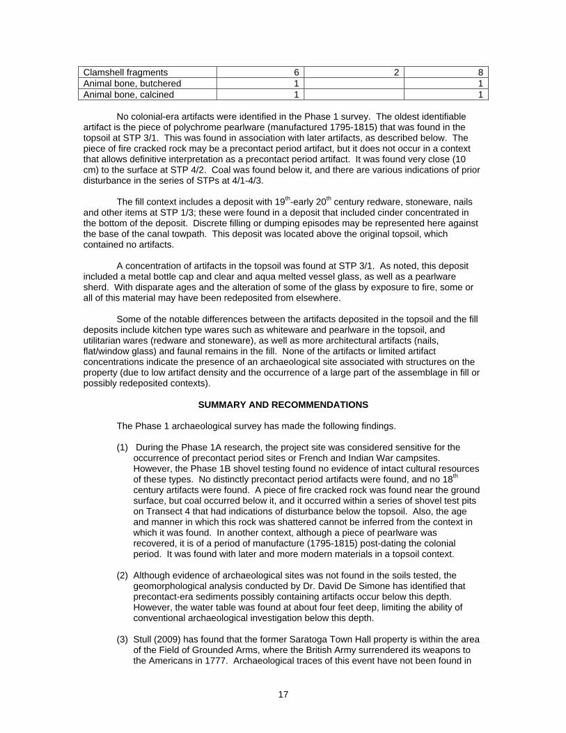
17
Clamshell fragments 6 2 8Animal bone, butchered 1 1Animal bone, calcined 1 1 No colonial-era artifacts were identified in the Phase 1 survey. The oldest identifiable artifact is the piece of polychrome pearlware (manufactured 1795-1815) that was found in the topsoil at STP 3/1. This was found in association with later artifacts, as described below. The piece of fire cracked rock may be a precontact period artifact, but it does not occur in a context that allows definitive interpretation as a precontact period artifact. It was found very close (10 cm) to the surface at STP 4/2. Coal was found below it, and there are various indications of prior disturbance in the series of STPs at 4/1-4/3. The fill context includes a deposit with 19th-early 20th century redware, stoneware, nails and other items at STP 1/3; these were found in a deposit that included cinder concentrated in the bottom of the deposit. Discrete filling or dumping episodes may be represented here against the base of the canal towpath. This deposit was located above the original topsoil, which contained no artifacts. A concentration of artifacts in the topsoil was found at STP 3/1. As noted, this deposit included a metal bottle cap and clear and aqua melted vessel glass, as well as a pearlware sherd. With disparate ages and the alteration of some of the glass by exposure to fire, some or all of this material may have been redeposited from elsewhere. Some of the notable differences between the artifacts deposited in the topsoil and the fill deposits include kitchen type wares such as whiteware and pearlware in the topsoil, and utilitarian wares (redware and stoneware), as well as more architectural artifacts (nails, flat/window glass) and faunal remains in the fill. None of the artifacts or limited artifact concentrations indicate the presence of an archaeological site associated with structures on the property (due to low artifact density and the occurrence of a large part of the assemblage in fill or possibly redeposited contexts).
SUMMARY AND RECOMMENDATIONS
The Phase 1 archaeological survey has made the following findings. (1) During the Phase 1A research, the project site was considered sensitive for the
occurrence of precontact period sites or French and Indian War campsites. However, the Phase 1B shovel testing found no evidence of intact cultural resources of these types. No distinctly precontact period artifacts were found, and no 18th century artifacts were found. A piece of fire cracked rock was found near the ground surface, but coal occurred below it, and it occurred within a series of shovel test pits on Transect 4 that had indications of disturbance below the topsoil. Also, the age and manner in which this rock was shattered cannot be inferred from the context in which it was found. In another context, although a piece of pearlware was recovered, it is of a period of manufacture (1795-1815) post-dating the colonial period. It was found with later and more modern materials in a topsoil context.
(2) Although evidence of archaeological sites was not found in the soils tested, the
geomorphological analysis conducted by Dr. David De Simone has identified that precontact-era sediments possibly containing artifacts occur below this depth. However, the water table was found at about four feet deep, limiting the ability of conventional archaeological investigation below this depth.
(3) Stull (2009) has found that the former Saratoga Town Hall property is within the area
of the Field of Grounded Arms, where the British Army surrendered its weapons to the Americans in 1777. Archaeological traces of this event have not been found in
18
this or other archaeological surveys that were conducted to the east; and in fact may not be identifiable due to either their absence (if fully recovered by the American forces), or sparse nature. However, although the Field of Grounded Arms is not associated with a recognizable archaeological component, it is nonetheless a site that may be eligible for inclusion in the National Register of Historic Places. A planning study prepared for Saratoga Plan has identified the Field of Grounded Arms site as historically significant. In addition, this site has been included within a larger area for which a National Register of Historic Places nomination form has been drafted under other auspices. This form was drafted by Hartgen Archeological Associates, Inc., and focuses on the extensive area including Fort Hardy and the Field of Grounded Arms.
(4) The literature review and archaeology reported by Stull (2009) shows that Fort Hardy
was located some distance east of the former town hall property, and would not be affected by the property transfer.
(5) The project site is immediately adjacent to the Champlain Canal, a National Register
of Historic Places property (and the eastern edges of the towpath appear to fall within the town hall property).
(6) A 19th century blacksmith shop (ca. 1866), a two-story building partly on stilts (ca.
1887), and possibly a smaller building to the east (ca. 1887) appear to have been within the project site, based upon a review of historic maps. However, the sites of these buildings are within the footprint of the deep fill associated with the former town hall structure and its parking areas. Soil borings provided by Dente Engineering indicate that (a) this area is covered with fill too deep to permit effective archaeological testing, and (b) the former topsoil below the fill at most is only partly intact. Thus, there are indications in the soil borings that are interpreted here as evidence of prior disturbance below the fill. As a result, these 19th century map documented structures are not identified as archaeological sites in need of further consideration.
Recommendations Based upon these findings, the following recommendations are made to address the concerns identified in the Phase 1 survey:
Precontact Period Archaeology: Should construction plans be developed that require the disturbance of soil more than four feet below the surface of the unfilled ground (or the original ground surface in filled areas, a sampling program using cores recovered for geoarchaeological study should be developed and implemented. An approach using cores is safer than open excavation in this context, and would eliminate the need for dewatering that would be required for open excavation approaches.
Field of Grounded Arms: Plans developed for the property should be developed with
respect to compatibility with interpreting, commemorating, and to the extent feasible preserving this portion of the Field of Grounded Arms as a significant historic site. Consultation with the New York State Office of Parks, Recreation and Historic Preservation must be conducted if federal or state funds or permits are involved with a project that may affect the Field of Grounded Arms.
Champlain Canal: Should construction plans be developed, they should include a
protection plan for the portion of the Champlain Canal towpath within or adjacent to the property. Consultation with the New York State Office of Parks, Recreation and Historic Preservation must be conducted if federal or state funds or permits are involved with a construction project adjacent to the Champlain Canal.
19
REFERENCES
Black, Andrew and Faye E. Yagy 2005 Phase I and Phase II Cultural Resources Survey, Fort Hardy Property New Electric Line, Village of Schuylerville, Town of Saratoga, Saratoga County, New York. Black Drake Consulting, Champlain, New York. Cressey, George B. 1977 Land Forms. In Geography of New York State, John H. Thompson, editor. New York:
Syracuse University Press. De Laubenfels, David J. 1977 Vegetation. In Geography of New York State, John H. Thompson, editor. Syracuse
University Press, New York. Dente Engineering, P.C. 2005 Geotechnical Evaluation for Saratoga Town Hall Building, Schuylerville, New York. Dente Engineering, P.C., Watervliet, New York. Dodson Associates, Ltd. 2006 Battles of Saratoga Preservation and Viewshed Protection Plan, Phase 1: Historic and Scenic Resource Inventory and Analysis, Old Saratoga on the Hudson Region, New York. Dodson Associates, Ltd., Ashfield, Massachusetts. Stull, Scott 2009 Archeological Investigation Final Report, Fort Hardy and the Field of Grounded Arms, Town of Saratoga, Saratoga County, New York. Hartgen Archeological Associates, Inc., Rensselaer, New York. United States Department of Agriculture (USDA) 2004 Soil Survey of Saratoga County, New York.

20
APPENDIX A: FIGURES


38
APPENDIX B: PHOTOS
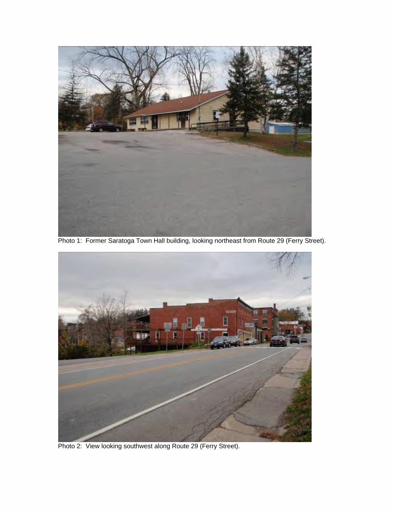
Photo 1: Former Saratoga Town Hall building, looking northeast from Route 29 (Ferry Street).
Photo 2: View looking southwest along Route 29 (Ferry Street).
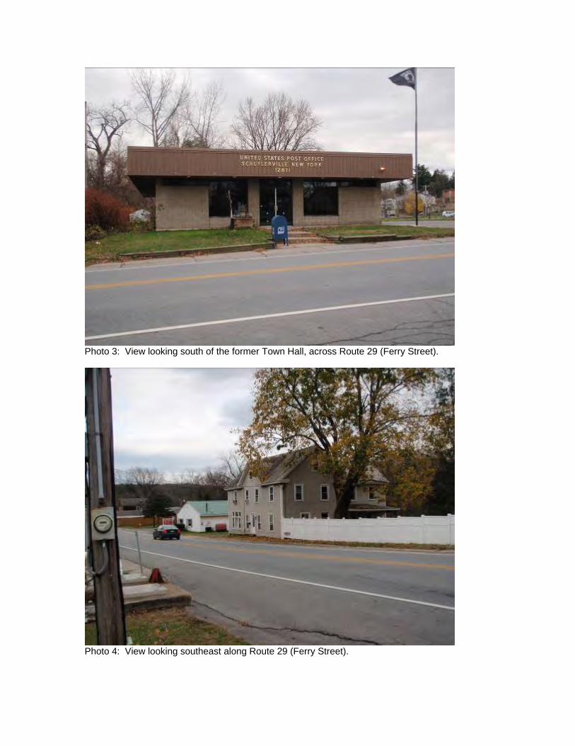
Photo 3: View looking south of the former Town Hall, across Route 29 (Ferry Street).
Photo 4: View looking southeast along Route 29 (Ferry Street).
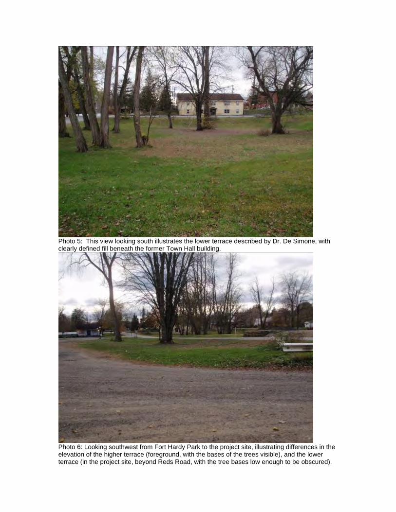
Photo 5: This view looking south illustrates the lower terrace described by Dr. De Simone, with clearly defined fill beneath the former Town Hall building.
Photo 6: Looking southwest from Fort Hardy Park to the project site, illustrating differences in the elevation of the higher terrace (foreground, with the bases of the trees visible), and the lower terrace (in the project site, beyond Reds Road, with the tree bases low enough to be obscured).
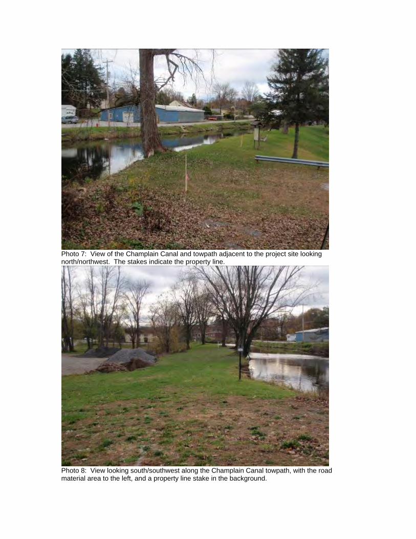
Photo 7: View of the Champlain Canal and towpath adjacent to the project site looking north/northwest. The stakes indicate the property line.
Photo 8: View looking south/southwest along the Champlain Canal towpath, with the road material area to the left, and a property line stake in the background.

52
APPENDIX C: GEOMORPHOLOGY REPORT

Geomorphology & Stratigraphy of the
Town Hall Building Property
30 Ferry St Schuylerville, NY
David J. De Simone, PhD.De Simone Geoscience Investigations
957 Babcock Lake RoadPetersburg, NY 12138
518-686-9809
Introduction
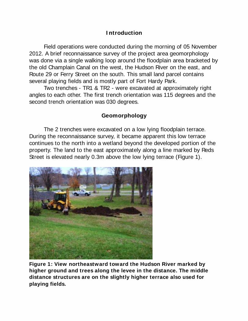
Field operations were conducted during the morning of 05 November 2012. A brief reconnaissance survey of the project area geomorphology was done via a single walking loop around the floodplain area bracketed by the old Champlain Canal on the west, the Hudson River on the east, and Route 29 or Ferry Street on the south. This small land parcel contains several playing fields and is mostly part of Fort Hardy Park. Two trenches - TR1 & TR2 - were excavated at approximately right angles to each other. The first trench orientation was 115 degrees and the second trench orientation was 030 degrees.
Geomorphology
The 2 trenches were excavated on a low lying floodplain terrace. During the reconnaissance survey, it became apparent this low terrace continues to the north into a wetland beyond the developed portion of the property. The land to the east approximately along a line marked by Reds Street is elevated nearly 0.3m above the low lying terrace (Figure 1).
Figure 1: View northeastward toward the Hudson River marked by higher ground and trees along the levee in the distance. The middle distance structures are on the slightly higher terrace also used for playing fields.
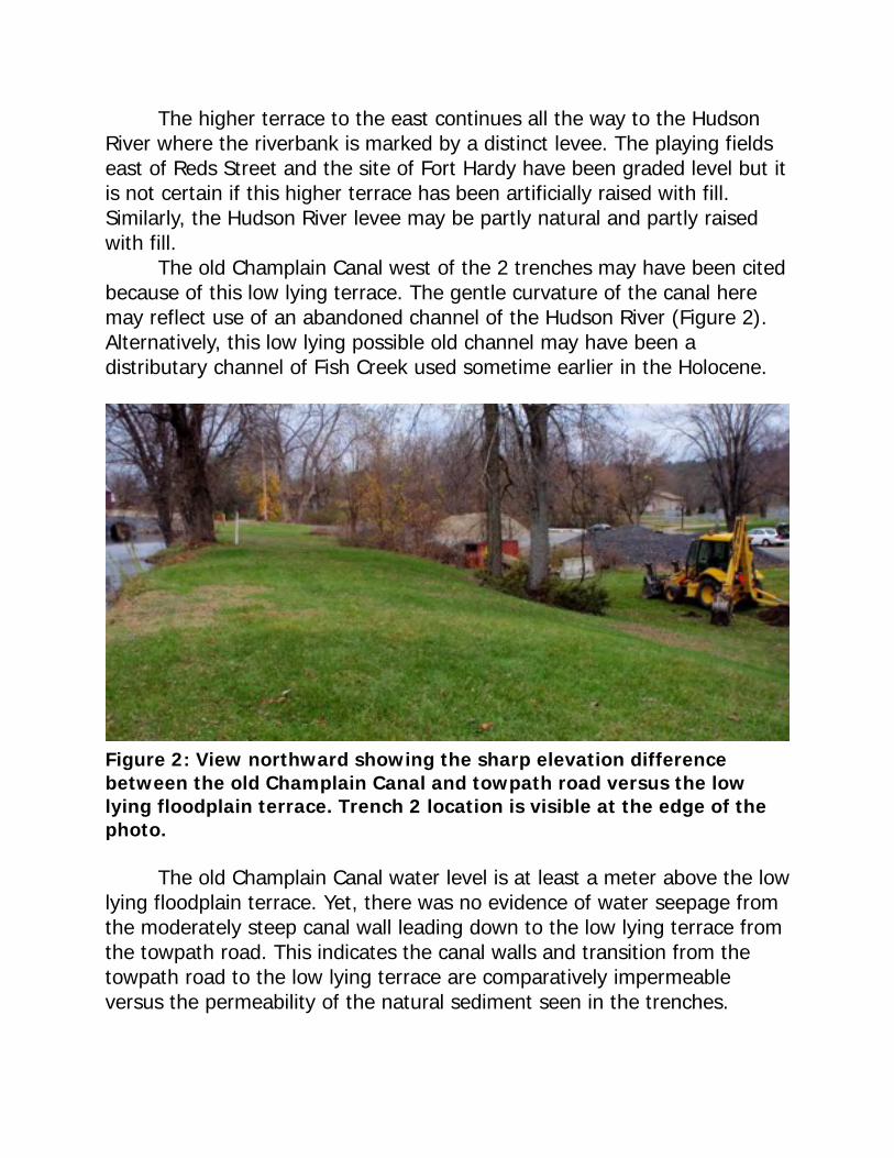
The higher terrace to the east continues all the way to the Hudson River where the riverbank is marked by a distinct levee. The playing fields east of Reds Street and the site of Fort Hardy have been graded level but it is not certain if this higher terrace has been artificially raised with fill. Similarly, the Hudson River levee may be partly natural and partly raised with fill. The old Champlain Canal west of the 2 trenches may have been cited because of this low lying terrace. The gentle curvature of the canal here may reflect use of an abandoned channel of the Hudson River (Figure 2). Alternatively, this low lying possible old channel may have been a distributary channel of Fish Creek used sometime earlier in the Holocene.
Figure 2: View northward showing the sharp elevation difference between the old Champlain Canal and towpath road versus the low lying floodplain terrace. Trench 2 location is visible at the edge of the photo.
The old Champlain Canal water level is at least a meter above the low lying floodplain terrace. Yet, there was no evidence of water seepage from the moderately steep canal wall leading down to the low lying terrace from the towpath road. This indicates the canal walls and transition from the towpath road to the low lying terrace are comparatively impermeable versus the permeability of the natural sediment seen in the trenches.
Stratigraphy
The sediment exposed in both trenches consisted of very fine sand to fine sand grading downward to very fine sand and silt. Both trenches revealed a thick, very well developed and apparently mature soil profile with ‘A’, ‘B1’ and ‘B2’ horizons. The soils map of Fort Hardy Parkidentifies the soil as Teel silt loam, a moderately well drained soil developed on recent alluvium along floodplains. The ‘A’ horizons in both trenches were approximately 28cm thick and were composed of organic matter with a granular texture and a well developed sub-horizontal platy structure (Figure 3). The platy structure was not well expressed in TR2 probably due to compaction from the overlying fill in TR2 that was not present in TR1. The inorganic matrix sediment was very fine sand to fine sand, well sorted. Color was very dark grayish brown. The sediment was massive with no bedding preserved and no indication of erosional unconformities. The ‘B1’ or upper ‘B’ horizons in both trenches were approximately 42cm thick with a dark yellowish brown color (Figure 4). The sediment consisted of fine sand to very fine sand, very well sorted, with a massive structure and no indication of erosional unconformities. Frequent burrow structures were present and the infilling of the burrows was a dark grayish brown color incorporating material from the overlying ‘A’ horizon. No charcoal or wood was observed but there were faint, wispy concentrations of organic matter. In TR1, an elongate sub-rounded shale pebble with a long dimension of 10cm suggested deposition by melt-out from river ice. The pebble was weathered in situ. The ’B2’ or lower ‘B’ horizon was approximately 70cm thick in TR1 and extended to the bottom of TR2. The color graded downward to a slightly darker yellowish brown in TR1 but there was a less distinct color variation between ‘B1’ and ‘B2’ in TR2. This may have been due to the ‘B2’ in TR1 being slightly wet, within the capillary fringe above the water table versus its dry counterpart in TR2. The water table was reached in TR1 at a depth of approximately 140cm. The water table was not reached in TR2 at a comparable depth. In TR2, decayed wood was noted near the ‘B1-B2’ boundary; wood was not sampled for any later analysis. In TR1, a second weathered shale pebble with a long dimension of 5cm was noted approximately 10cm below the ‘B1-B2’ boundary. This pebble was sub-angular and deeply weathered.
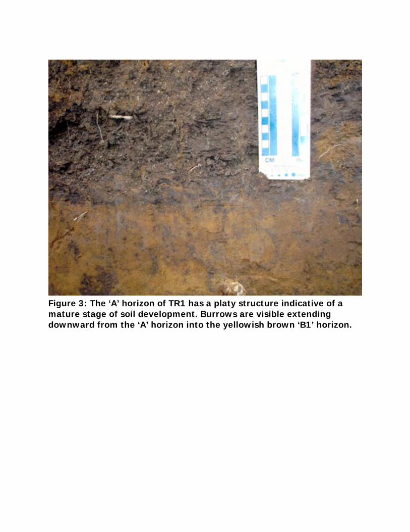
Figure 3: The ‘A’ horizon of TR1 has a platy structure indicative of a mature stage of soil development. Burrows are visible extending downward from the ‘A’ horizon into the yellowish brown ‘B1’ horizon.
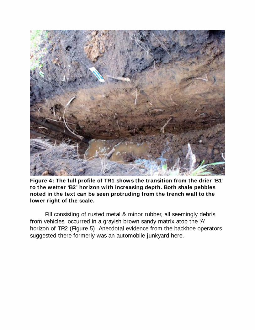
Figure 4: The full profile of TR1 shows the transition from the drier ‘B1’ to the wetter ‘B2’ horizon with increasing depth. Both shale pebbles noted in the text can be seen protruding from the trench wall to the lower right of the scale.
Fill consisting of rusted metal & minor rubber, all seemingly debris from vehicles, occurred in a grayish brown sandy matrix atop the ‘A’ horizon of TR2 (Figure 5). Anecdotal evidence from the backhoe operators suggested there formerly was an automobile junkyard here.
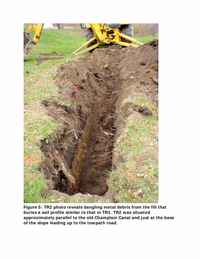
Figure 5: TR2 photo reveals dangling metal debris from the fill that buries a soil profile similar to that in TR1. TR2 was situated approximately parallel to the old Champlain Canal and just at the base of the slope leading up to the towpath road.
Potential for Pre-Contact Materials
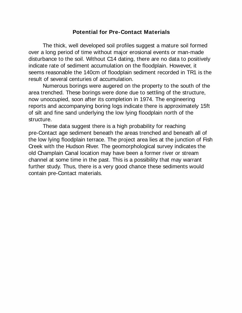
The thick, well developed soil profiles suggest a mature soil formed over a long period of time without major erosional events or man-made disturbance to the soil. Without C14 dating, there are no data to positively indicate rate of sediment accumulation on the floodplain. However, it seems reasonable the 140cm of floodplain sediment recorded in TR1 is the result of several centuries of accumulation. Numerous borings were augered on the property to the south of the area trenched. These borings were done due to settling of the structure, now unoccupied, soon after its completion in 1974. The engineering reports and accompanying boring logs indicate there is approximately 15ft of silt and fine sand underlying the low lying floodplain north of the structure. These data suggest there is a high probability for reaching pre-Contact age sediment beneath the areas trenched and beneath all of the low lying floodplain terrace. The project area lies at the junction of Fish Creek with the Hudson River. The geomorphological survey indicates the old Champlain Canal location may have been a former river or stream channel at some time in the past. This is a possibility that may warrant further study. Thus, there is a very good chance these sediments would contain pre-Contact materials.

53
APPENDIX D: SHOVEL TEST PIT RECORDS
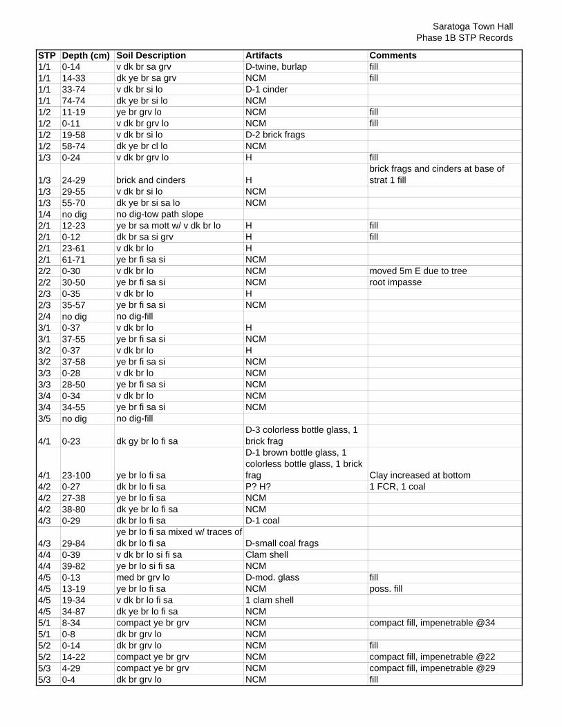
Saratoga Town HallPhase 1B STP Records
STP Depth (cm) Soil Description Artifacts Comments1/1 0-14 v dk br sa grv D-twine, burlap fill1/1 14-33 dk ye br sa grv NCM fill1/1 33-74 v dk br si lo D-1 cinder1/1 74-74 dk ye br si lo NCM1/2 11-19 ye br grv lo NCM fill1/2 0-11 v dk br grv lo NCM fill1/2 19-58 v dk br si lo D-2 brick frags1/2 58-74 dk ye br cl lo NCM1/3 0-24 v dk br grv lo H fill
1/3 24-29 brick and cinders Hbrick frags and cinders at base of strat 1 fill
1/3 29-55 v dk br si lo NCM1/3 55-70 dk ye br si sa lo NCM1/4 no dig no dig-tow path slope2/1 12-23 ye br sa mott w/ v dk br lo H fill2/1 0-12 dk br sa si grv H fill2/1 23-61 v dk br lo H2/1 61-71 ye br fi sa si NCM2/2 0-30 v dk br lo NCM moved 5m E due to tree2/2 30-50 ye br fi sa si NCM root impasse2/3 0-35 v dk br lo H2/3 35-57 ye br fi sa si NCM2/4 no dig no dig-fill3/1 0-37 v dk br lo H3/1 37-55 ye br fi sa si NCM3/2 0-37 v dk br lo H3/2 37-58 ye br fi sa si NCM3/3 0-28 v dk br lo NCM3/3 28-50 ye br fi sa si NCM3/4 0-34 v dk br lo NCM3/4 34-55 ye br fi sa si NCM3/5 no dig no dig-fill
4/1 0-23 dk gy br lo fi saD-3 colorless bottle glass, 1 brick frag
4/1 23-100 ye br lo fi sa
D-1 brown bottle glass, 1 colorless bottle glass, 1 brick frag Clay increased at bottom
4/2 0-27 dk br lo fi sa P? H? 1 FCR, 1 coal4/2 27-38 ye br lo fi sa NCM4/2 38-80 dk ye br lo fi sa NCM4/3 0-29 dk br lo fi sa D-1 coal
4/3 29-84ye br lo fi sa mixed w/ traces of dk br lo fi sa D-small coal frags
4/4 0-39 v dk br lo si fi sa Clam shell4/4 39-82 ye br lo si fi sa NCM4/5 0-13 med br grv lo D-mod. glass fill4/5 13-19 ye br lo fi sa NCM poss. fill4/5 19-34 v dk br lo fi sa 1 clam shell4/5 34-87 dk ye br lo fi sa NCM5/1 8-34 compact ye br grv NCM compact fill, impenetrable @345/1 0-8 dk br grv lo NCM5/2 0-14 dk br grv lo NCM fill5/2 14-22 compact ye br grv NCM compact fill, impenetrable @22 5/3 4-29 compact ye br grv NCM compact fill, impenetrable @295/3 0-4 dk br grv lo NCM fill

57
APPENDIX E: ARTIFACT INVENTORY
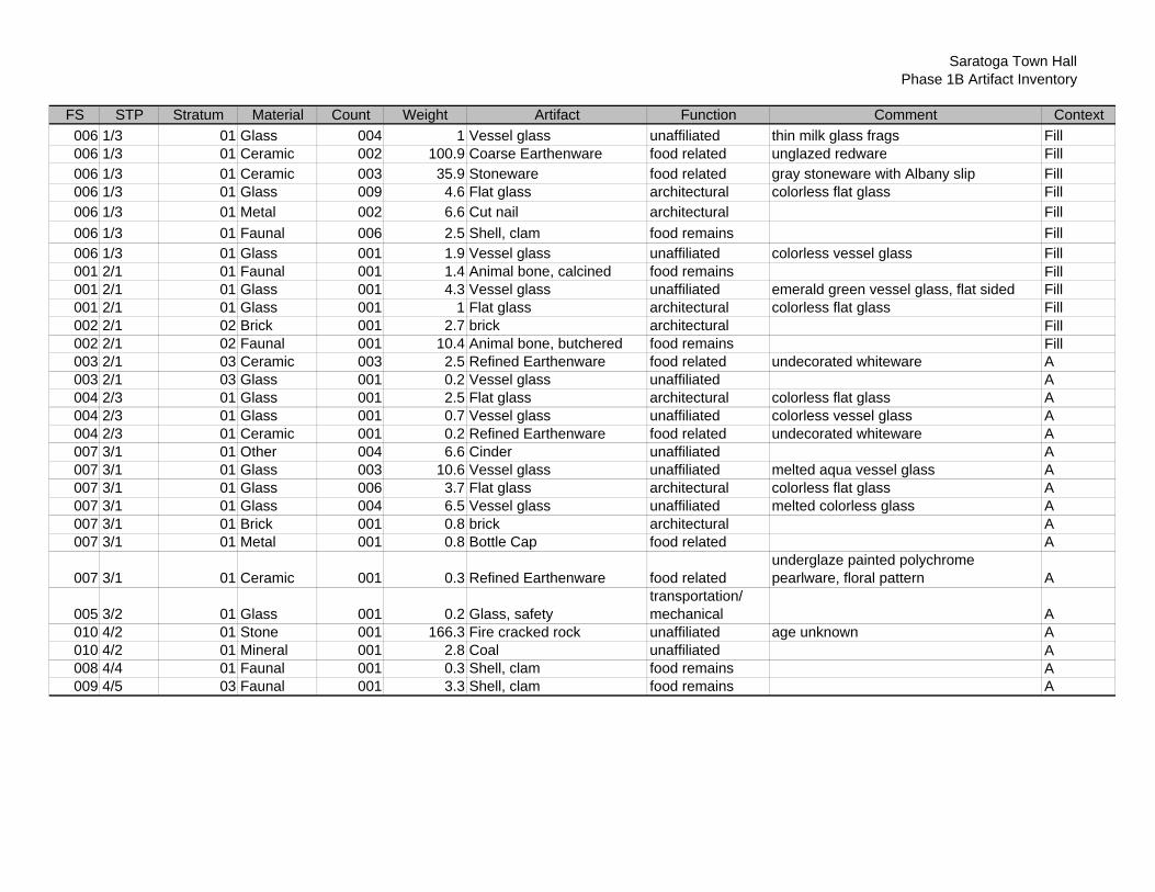
Saratoga Town HallPhase 1B Artifact Inventory
FS STP Stratum Material Count Weight Artifact Function Comment Context006 1/3 01 Glass 004 1 Vessel glass unaffiliated thin milk glass frags Fill006 1/3 01 Ceramic 002 100.9 Coarse Earthenware food related unglazed redware Fill006 1/3 01 Ceramic 003 35.9 Stoneware food related gray stoneware with Albany slip Fill006 1/3 01 Glass 009 4.6 Flat glass architectural colorless flat glass Fill006 1/3 01 Metal 002 6.6 Cut nail architectural Fill006 1/3 01 Faunal 006 2.5 Shell, clam food remains Fill006 1/3 01 Glass 001 1.9 Vessel glass unaffiliated colorless vessel glass Fill001 2/1 01 Faunal 001 1.4 Animal bone, calcined food remains Fill001 2/1 01 Glass 001 4.3 Vessel glass unaffiliated emerald green vessel glass, flat sided Fill001 2/1 01 Glass 001 1 Flat glass architectural colorless flat glass Fill002 2/1 02 Brick 001 2.7 brick architectural Fill002 2/1 02 Faunal 001 10.4 Animal bone, butchered food remains Fill003 2/1 03 Ceramic 003 2.5 Refined Earthenware food related undecorated whiteware A003 2/1 03 Glass 001 0.2 Vessel glass unaffiliated A004 2/3 01 Glass 001 2.5 Flat glass architectural colorless flat glass A004 2/3 01 Glass 001 0.7 Vessel glass unaffiliated colorless vessel glass A004 2/3 01 Ceramic 001 0.2 Refined Earthenware food related undecorated whiteware A007 3/1 01 Other 004 6.6 Cinder unaffiliated A007 3/1 01 Glass 003 10.6 Vessel glass unaffiliated melted aqua vessel glass A007 3/1 01 Glass 006 3.7 Flat glass architectural colorless flat glass A007 3/1 01 Glass 004 6.5 Vessel glass unaffiliated melted colorless glass A007 3/1 01 Brick 001 0.8 brick architectural A007 3/1 01 Metal 001 0.8 Bottle Cap food related A
007 3/1 01 Ceramic 001 0.3 Refined Earthenware food relatedunderglaze painted polychrome pearlware, floral pattern A
005 3/2 01 Glass 001 0.2 Glass, safetytransportation/ mechanical A
010 4/2 01 Stone 001 166.3 Fire cracked rock unaffiliated age unknown A010 4/2 01 Mineral 001 2.8 Coal unaffiliated A008 4/4 01 Faunal 001 0.3 Shell, clam food remains A009 4/5 03 Faunal 001 3.3 Shell, clam food remains A