Embed Size (px)
Citation preview
Dumfries and Galloway Council
L O C A L D E V E L O P M E N T P L A N 2
Archaeologically Sensitive Areas (ASAs)
T E C H N I C A L P A P E R
J A N U A R Y 2 0 1 8
www.dumgal.gov.uk

1
Technical Advice Note
Archaeologically Sensitive Areas (ASAs)
Contents:
Background 2
ASAs –Rural Areas 4
Descriptions of Rural ASAs 4
ASAs-Settlements 10
Descriptions of Settlement ASAs 10
Maps 1-42 15
Contacts and Further information 45
January 2013
2
Archaeologically Sensitive Areas
Background
In some parts of Dumfries and Galloway the archaeological interest is not confined to a
particular site but extends over large areas. In order to highlight to potential developers
of large scale projects such as wind farms, mineral extraction or forestry in rural areas,
or town centre developments in settlements, that there is a particular need to consider
these extensive archaeological interests and issues that might arise from their
proposals at an early stage, Archaeologically Sensitive Areas have been designated by
the Council and occur both within settlements and within rural areas.
Within the ASAs there are also individual archaeological sites from which particular
issues will arise, for example, the setting of a hill fort.
This Technical Advice Note contains background information, including maps, to inform
and support Policy HE4: Archaeologically Sensitive Areas.
Policy HE4: Archaeologically Sensitive Areas.
Note: The proposals maps of the Local Development Plan only show boundaries
where scale allows in the Rural areas. In Settlements the boundaries of ASA’s do
not show on the proposals maps.
This policy and the designated areas have been carried forward from the 1999 Structure
Plan and no changes have been made, apart from factual updates.
Two types of ASA have been identified:
Rural areas
Settlements
The purpose of this document is to highlight the justification for the designation of each
area in order that potential developers are aware of these matters at the earliest stages
of developing their proposals, in order that they can take them into account.
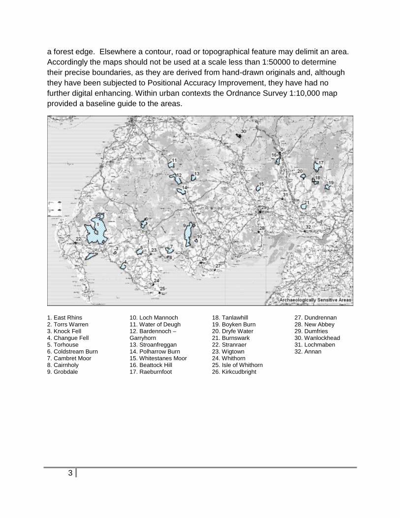
The base map used for drawing up the boundaries of the rural sensitive areas was the
Ordnance Survey 1: 50,000 map. In some cases the extent of the sensitive area follows
The Council will support development that safeguards the character, archaeological
interest and setting of Archaeologically Sensitive Areas (ASAs) as designated by the
Council.
Boundaries of ASAs are shown on the proposals maps
3
a forest edge. Elsewhere a contour, road or topographical feature may delimit an area.
Accordingly the maps should not be used at a scale less than 1:50000 to determine
their precise boundaries, as they are derived from hand-drawn originals and, although
they have been subjected to Positional Accuracy Improvement, they have had no
further digital enhancing. Within urban contexts the Ordnance Survey 1:10,000 map
provided a baseline guide to the areas.
1. East Rhins 2. Torrs Warren 3. Knock Fell 4. Changue Fell 5. Torhouse 6. Coldstream Burn 7. Cambret Moor 8. Cairnholy 9. Grobdale
10. Loch Mannoch 11. Water of Deugh 12. Bardennoch – Garryhorn 13. Stroanfreggan 14. Polharrow Burn 15. Whitestanes Moor 16. Beattock Hill 17. Raeburnfoot
18. Tanlawhill 19. Boyken Burn 20. Dryfe Water 21. Burnswark 22. Stranraer 23. Wigtown 24. Whithorn 25. Isle of Whithorn 26. Kirkcudbright
27. Dundrennan 28. New Abbey 29. Dumfries 30. Wanlockhead 31. Lochmaben 32. Annan
4
ASAs-Rural Areas
In some parts of the rural area, the archaeological interest is not confined to a particular
site but extends over large areas. Developments of large scale projects, such as wind
farms, mineral extraction or forestry can affect character, archaeological interest and
setting over a wide area. Developers should be aware that there is a particular need to
consider these extensive archaeological interests and issues that might arise from their
proposals at an early stage. As well as the potential for direct effects on sensitive
archaeological assets, there is also the potential for developments to have an effect on
the setting of features which will need to be taken into account and assessed when
considering development.
In defining these areas consideration has been given to the following sensitivities:-
Particularly good group survival and/or importance.
Landscape setting where this is a significant dimension of the
archaeological remains.
Areas where there is an existing or potential recreational aspect.
High density of archaeological remains worthy of preservation.
Rare group survival in an otherwise improved or already generally
afforested area.
Definition of rural archaeologically sensitive areas is based on the current state of
knowledge. Archaeological survey and research are ongoing and it is highly likely that
as surveys are carried out in the remaining unimproved uplands that previously
unrecorded remains will be discovered. Aerial photography and other forms of
archaeological prospection will increase understanding of lowland, improved areas.
Development proposed in areas of high archaeological potential, within or around ASAs,
where detailed survey has not been conducted, will probably require prior survey to be
carried out. This will help inform the proposal in order that archaeological remains can
be identified and mapped and to enable recommendations for preservation and
mitigation of effects to be made.
Description of Rural ASAs
The following is a description of the interest of the areas, starting in the west of the
region:
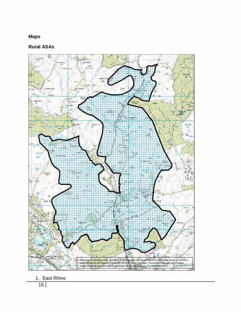
1. East Rhins NX 18 65
Archaeological survey of the best “East Rhins” carried out by the Royal Commission on
the Ancient and Historic Monuments of Scotland (RCAHMS), and published in 1987
5
revealed extensive, well-preserved archaeological remains in this generally peat-
covered landscape. In their twenty-fourth report to parliament, in 1988, the
Commissioners list 606 individual monuments falling within the survey area which they
consider to be “Most worthy of preservation”.
Historic Scotland followed up the survey by designating large numbers of scheduled
monuments.
The mapped sensitive area indicates ground where remains identified by RCAHMS are
concentrated, plus extensions to the east, outwith their survey area where the high
density is known to continue. Definition of the area is a simplification of available
information and there are substantial gaps in the archaeological distribution which it is
not possible to show at scale 1: 50,000. Generally however, developers and land
managers should be aware that large scale proposals in the East Rhins are likely to be
required to accommodate substantial areas of archaeological interest.
Reference: Royal Commission on the Ancient and Historic Monuments of Scotland
1987, ‘The Archaeological Sites & Monuments of Scotland, 26, East Rhins, Wigtown
District, Dumfries and Galloway’
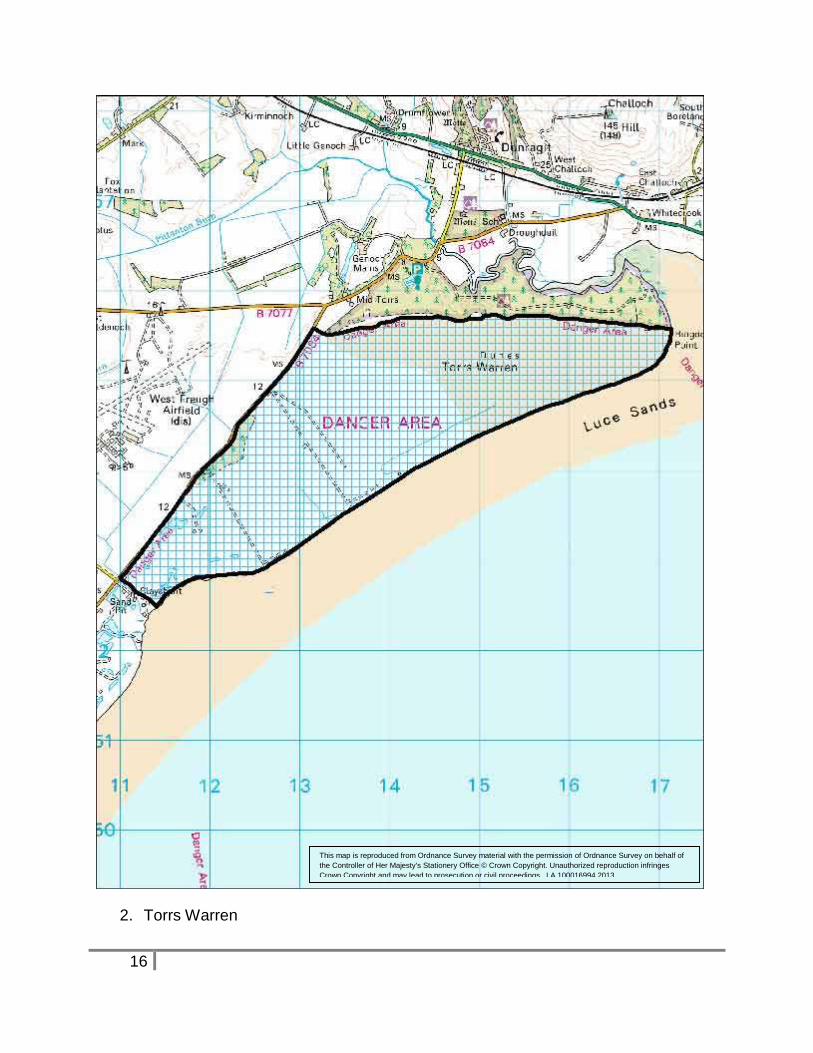
2. Torrs Warren NX 15 55
A vast collection of archaeological finds, ranging from the early prehistoric to the late
medieval has come from the eroding sand dunes at Torrs Warren prior to it becoming a
Ministry of Defence property and the dune system stabilising. It is an extremely
important area for early human settlement and all ground disturbance needs to be
monitored.
3. Knock Fell NX 25 55
Knock Fell is a prominent landmark of the Machars landscape, crowned by a prehistoric
fort which dominates the surrounding area.
To remain meaningful the open landscape setting must be maintained.
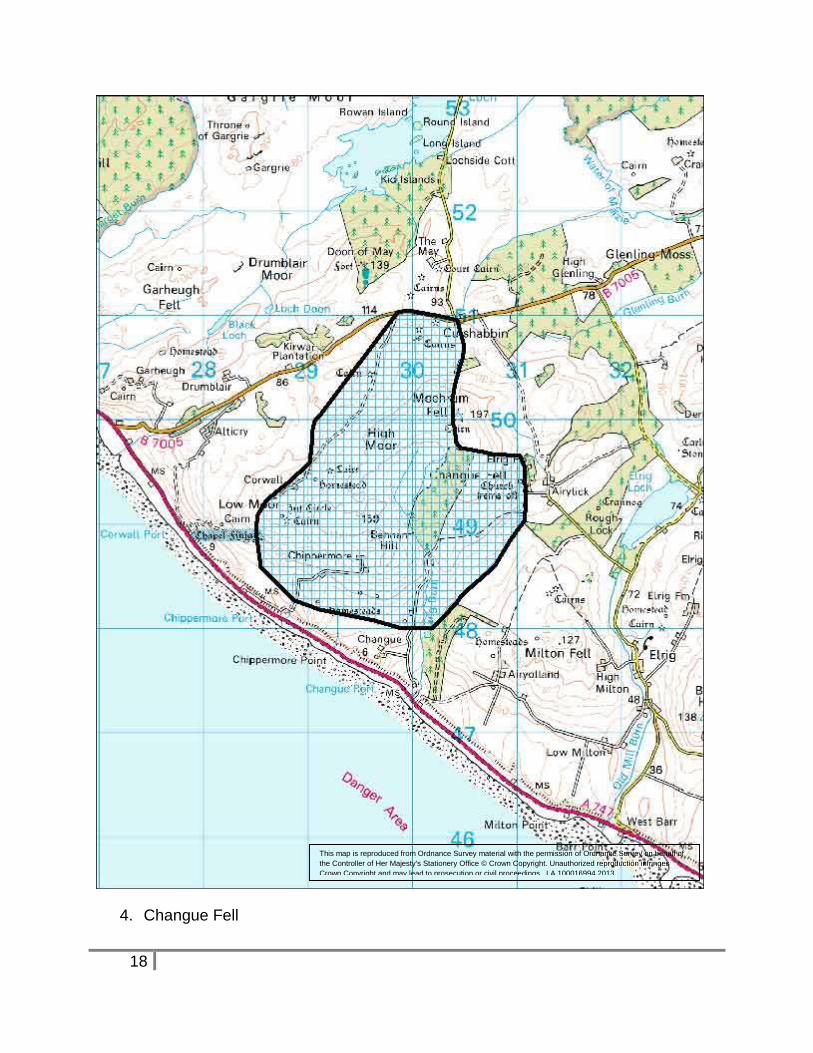
4. Changue Fell NX 30 50
Many good quality archaeological structures survive in the North West Machars. Where
the ground is improved the remains are ‘isolated’ features in a modern landscape.
There are however pockets of unimproved ground where landscapes of associated
structures can be identified. Changue Fell is of interest in this respect.
6
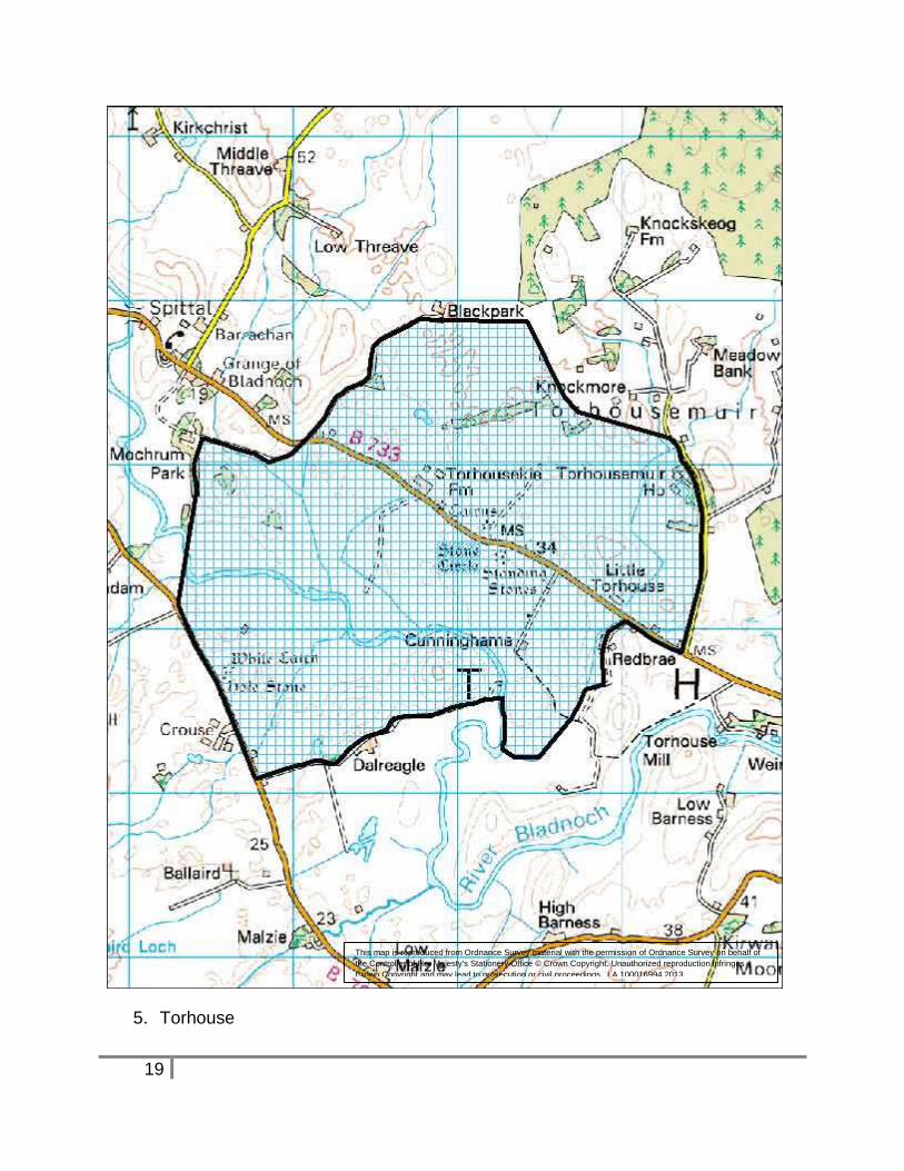
5. Torhouse NX 38 56
It is important to maintain the setting of Torhouse stone circle and associated features in
the open landscape setting of Bladnoch Valley. The site is one of the Region’s most
visited monuments and is in the care the Scottish Ministers.
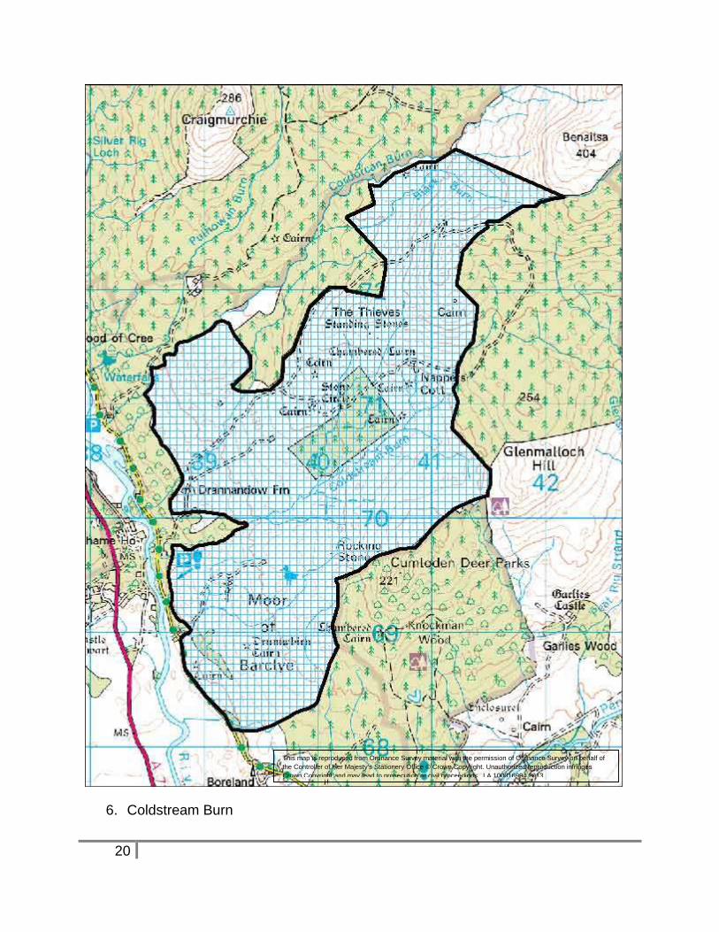
6. Coldstream Burn NX 40 70
The only known group of good quality early prehistoric monuments in the Cree valley
which survive in an open landscape setting, in addition to good groups of medieval and
post-medieval features. If subjected to detailed ground survey it is highly probable that
the record of prehistoric and more recent remains in this area would be considerably
increased.
Note: 2013 update. The southern part of this area at Barclye is owned by the Royal
Society for the Protection of Birds who have implemented a woodland planting scheme
that accommodates the archaeological interests.
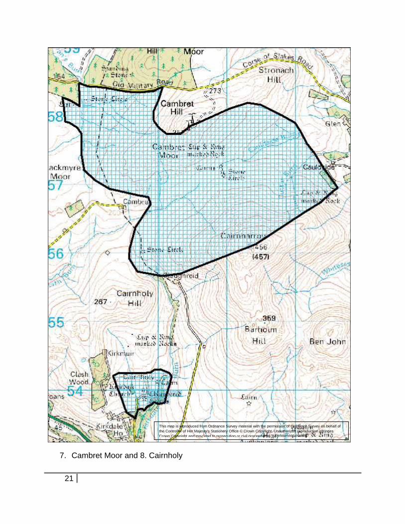
7. Cambret Moor NX 53 57
An excellent landscape of well preserved and varied Bronze Age structures survives in
unimproved ground on Cambret Burn offer exceptional research potential owing to
extensive peat cover and water-logged conditions in the valley bottom.
8. Cairnholy NX 52 54
The sensitive area is intended to highlight the existence of the Cairnholy chambered
cairns, rather than strictly define an edged zone. These monuments in the care of the
Scottish Ministers are a visitor attraction where landscape setting contributes
significantly to the interest of the site.
It is desirable that the open setting is maintained by sympathetic developments and
forest design in the surrounding landscape niche.
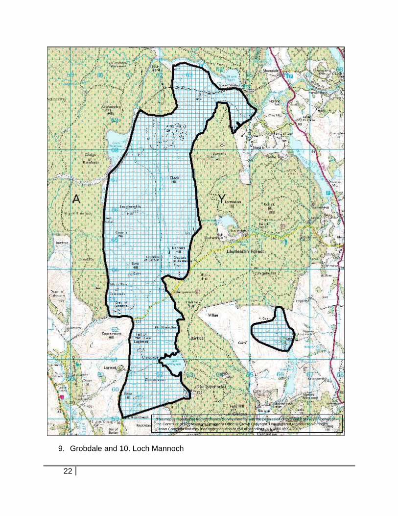
9. Grobdale NX 62 66
Ground survey by RCAHMS (1990) has revealed an extensive scatter of monuments in
this tract of unimproved moorland. The remains are particularly important since the
surrounding area is heavily afforested and was not subject to the same detailed ground
survey prior to afforestation.
7
10. Loch Mannoch NX 66 62
A previously known and important group of Bronze Age structures at the head of Loch
Mannoch has recently been extended as a result of ground survey by RCAHMS in
1990.
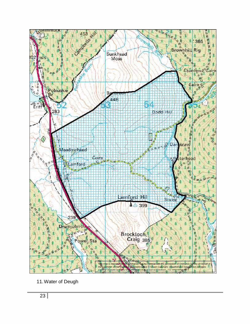
11. Water of Deugh NX 53 99
This area recognizes multi-period archaeological remains featuring in a Heritage Trail
promoted by Carspharin Heritage Group. Some of the remains featured on this trail are
tightly surrounded by afforestation, but should become more accessible through the
implementation of new forest plans. The western approach between Benbrack and
Lamford Hill is currently unplanted. This is the area indicated on the sensitivity map to
highlight the existence of the recreational trail in the area.
Note: 2013 update. In the 1970-80’s the land use of large areas of Carsphairn parish
changed from stock rearing on grazed pasture to commercial forestry. The community
was concerned about population decline and community well–being. Establishing a
series of heritage trails was a community initiative.
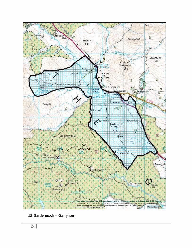
12. Bardennoch – Garryhorn NX 56 92
This area recognizes multi-period archaeological remains featuring in a Heritage Trail
promoted by Carsphairn Heritage Group. The high quality monuments are in a
spectacular landscape setting.
Note: 2013 update. In the 1970-80’s the land use of large areas of Carsphairn parish
changed from stock rearing on grazed pasture to commercial forestry. The community
was concerned about population decline and community well–being. Establishing a
series of heritage trails was a community initiative.
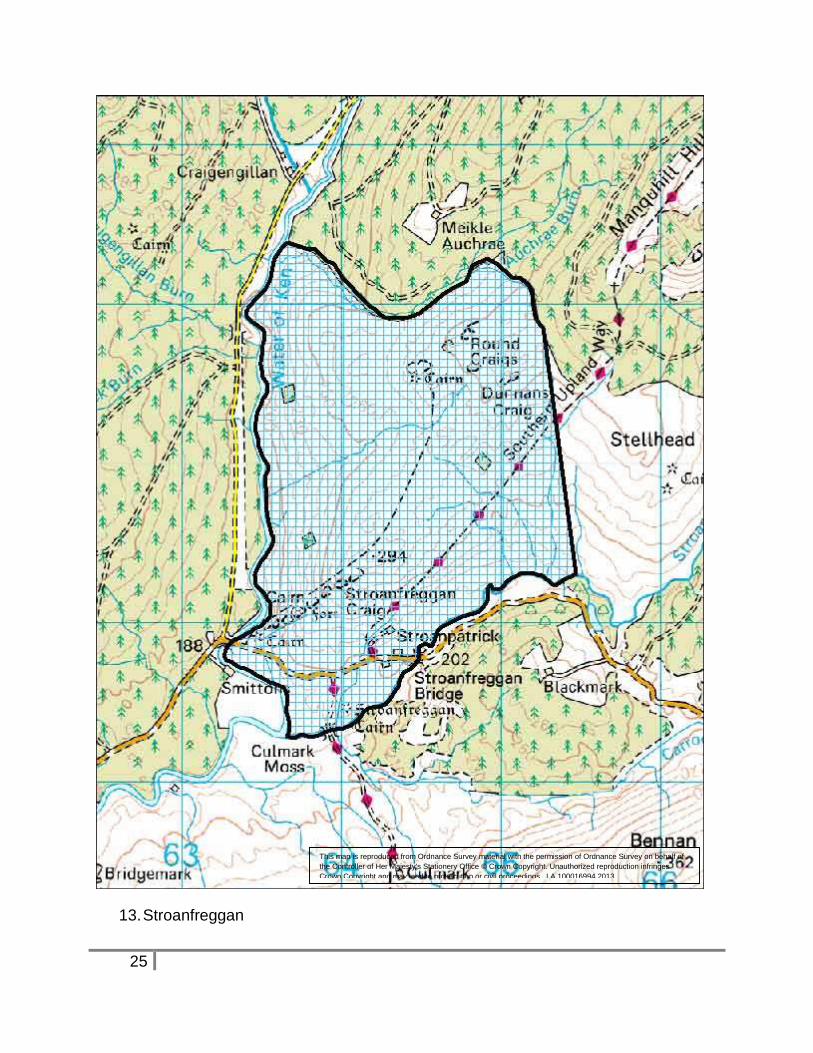
13. Stroanfreggan NX 64 91
This area recognizes multi-period archaeological remains featuring in a Heritage Trail
promoted by Carsphairn Heritage Group. The Southern Upland way passes through the
area. Important Mesolithic finds relating to the earliest human occupation of the region
have been made in the valley bottom.
Note: 2013 update. In the 1970-80’s the land use of large areas of Carsphairn parish
changed from stock rearing on grazed pasture to commercial forestry. The community
was concerned about population decline and community well–being. Establishing a
series of heritage trails was a community initiative.
8
14. Polharrow Burn NX 58 87
The Stewartry Environmentally Sensitive Area was rapidly surveyed for archaeological
remains in the 1990s. The resulting report states: “The north side of the Polharrow Burn
has a particularly rich and varied archaeological landscape worthy of preservation. An
isolated cairn, remains of cairn fields associated with isolated enclosures, deserted
farmsteads with extensive field systems, other traces of upland agricultural practices
and traces of minor industrial activity are all to be found on this side of the valley.
Although many of these monuments are quite common in upland areas, the sum total of
the landscape merits protection at a level below scheduling.” This area recognizes
these interests.
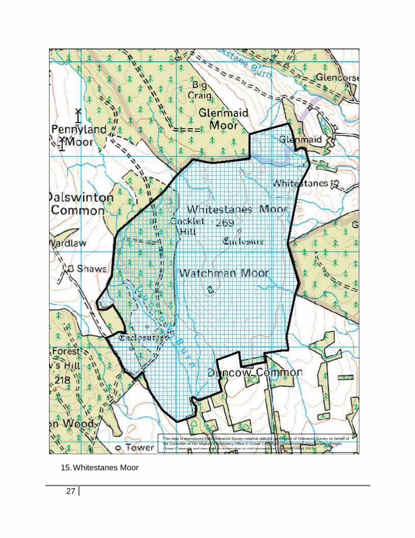
15. Whitestanes Moor NX 96 88
A remnant pocket of unimproved moorland in an otherwise generally improved or
afforested area where a number of archaeological remains have been identified. Partial
excavation of structures at NX 967 882 was carried out in the 1960’s, showing these to
be well preserved Bronze Age structures. The other remains identified on the moor
appear to be similar in date.
Although Bronze Age remains are extensive in other parts of the region e.g. East
Rhins, such landscapes of associated features are rare in lower Nithsdale and as a
group are thus of considerable interest.
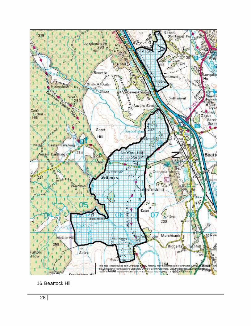
16. Beattock Hill NT 06 02
The unafforested tract of land west of Moffat extending from Coats Hill to Stidriggs
contains varied and extensive archaeological remains. Many structures belong to the
later prehistoric period, hill forts, enclosed and unenclosed settlements with associated
traces of cultivation. Areas of peat cover give potential for environmental analysis and
the opportunity to understand more fully the relationships between these various
elements of the prehistoric landscape.
The Southern Upland Way passes through the area.
Outwith the mapped sensitive area there are further important archaeological remains
e.g. Park Hill Fort and settlement NY 061 975, Stidriggs long cairn NY 041 987, Knock
Hill fort NT 073 004. The existence of these features in the locality adds to the general
interest of the area.
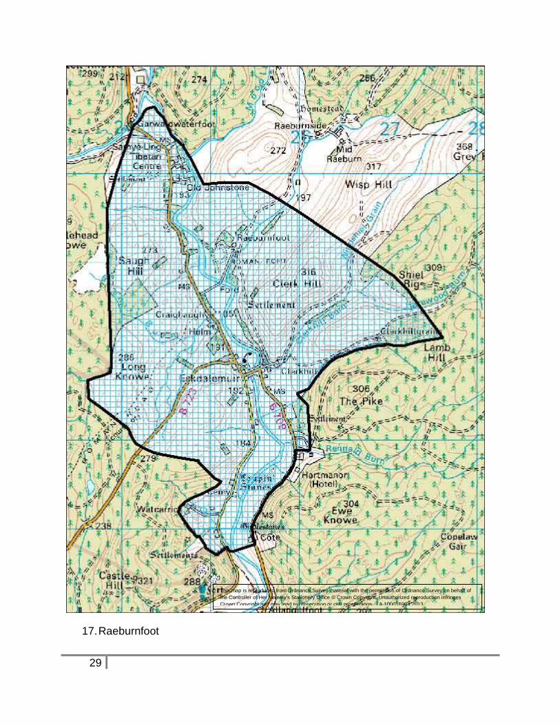
17. Raeburnfoot NY 25 99
Multi-period cluster of archaeological sites many first identified during ground survey by
RCAHMS published in 1980, and extensively re-surveyed for the RCAHMS volume
9
Eastern Dumfriesshire: An Archaeological Landscape, published in 1997. Their
significance of these monuments in open moorland is enhanced by extensive
surrounding afforestation that has enclosed and obscured archaeological sites in the
surrounding area.
Note: 2013 update. Implementation of forest plans has improved the landscape setting
of many monuments.
A number of sites have on site interpretation and feature in trails promoted by the
Forestry Commission, Archaeosites and the Eskdale Prehistoric Trail, (set up by the
Eskdale Archaeological Society).
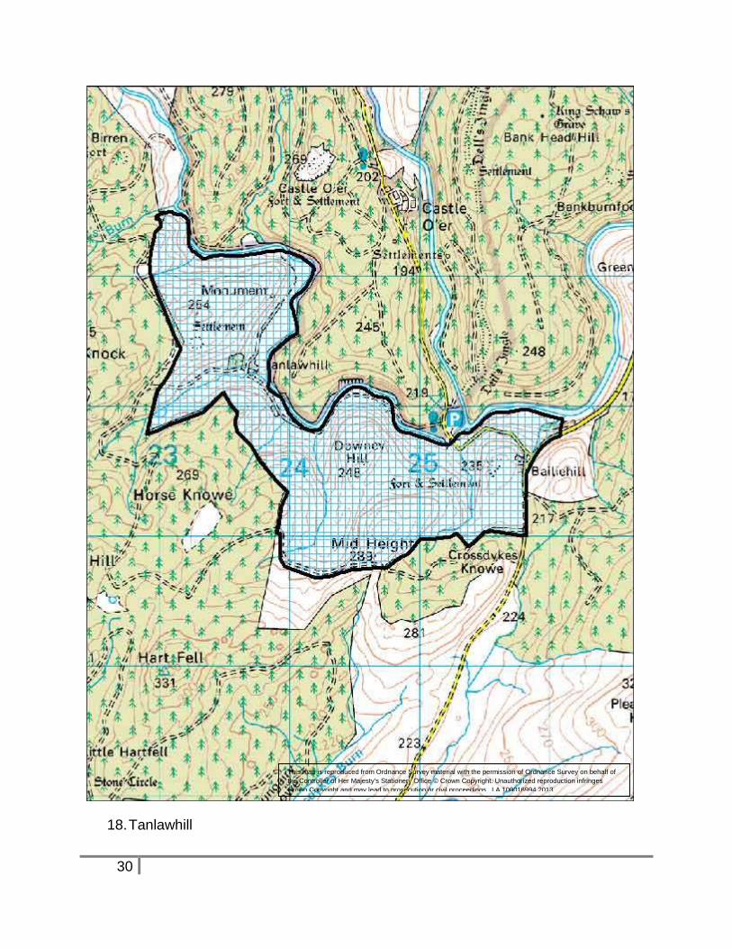
18. Tanlawhill NY 24 91
Corridor of good quality remains many first identified during survey published in 1980,
and extensively re-surveyed for the RCAHMS volume ‘Eastern Dumfriesshire: An
Archaeological Landscape” published in 1997. Many of these have been scheduled by
Historic Scotland.
This is a ‘window’ of upland archaeological landscape in an otherwise highly afforested
area.
19. Boyken Burn NY 30 88
An exceptional cluster of multi-period remains many first identified by RCAHMS during
survey published in 1980, and extensively re-surveyed for the RCAHMS volume
‘Eastern Dumfriesshire: An Archaeological Landscape” published in 1997. Many of
these features have now been scheduled by Historic Scotland.
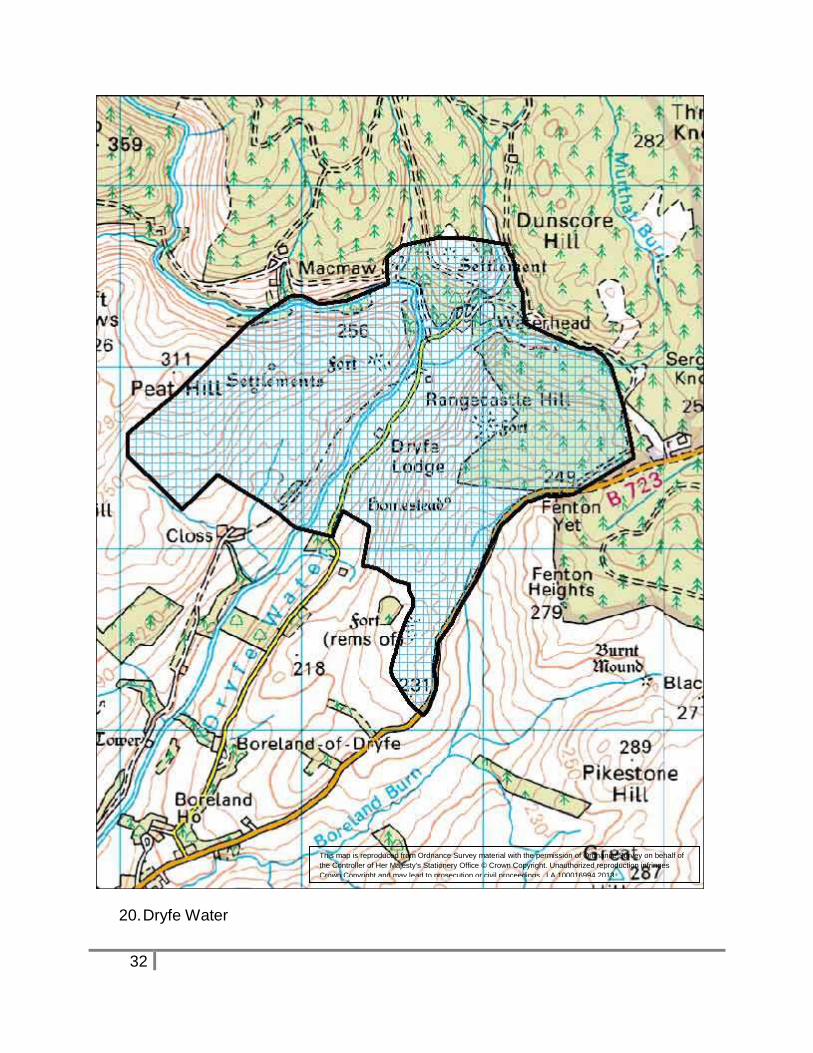
20. Dryfe Water NY 18 94
A concentration of archaeological remains dating from the later prehistoric survives in
good condition on the uncultivated hillsides around Waterhead. The fort on
Rangecastle Hill not only dominates the immediate area, but gives impressive views in
all directions, emphasizing its strategic location.
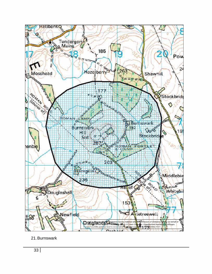
21. Burnswark NY 18 78
This flat topped hill, visible throughout Lower Annandale is the setting for an excellent
suite of archaeological remains. On the summit there is a Bronze Age cairn, the
region’s largest prehistoric fortification and an artillery redoubt, probably dating to the
late 17th century. The lower slopes are occupied by Roman siege works.
10
To remain meaningful, the open setting, allowing views both from, and onto the hill in
order to appreciate it’s a strategic importance and thus to give the monuments meaning,
must be maintained.
ASAs -Settlements
Several of the towns within the region have medieval, or earlier, origins. They were
deliberately planned as a result of royal or noble patronage. Key elements include
castles, churches, marketplaces and crosses, as well as a distinctive street layout, with
distinctive property boundaries in the form of long ‘burgage plots’ extending back from
the street frontage. In many cases this medieval pattern is still clearly visible in the
centre of the towns that developed around the historic core. As well as upstanding
buildings and features of architectural and historical interest, frequently recognized by
Conservation Area status, these areas also have a potential for below-ground remains.
The Scottish Burgh Survey, funded by Historic Scotland and its predecessors, has
produced reports on the history and development of medieval burghs which also
research and identify areas of archaeological interest. The boundaries of the ASAs are
informed by these reports and additional information that has come to light.
There are also a number of areas of interest in and around settlements that have
developed for a particular purpose, namely New Abbey, Dundrennan, Wanlockhead and
the Isle of Whithorn.
Appropriate archaeological investigations and recording will be required where
developments involve ground disturbance or significant change to historic structures.
The Council’s Archaeologist should be consulted at an early stage to advise on the
significance of any particular site and measures required.
Description of settlement ASAs
The following is a description of the interest of the settlement areas, starting in the west
of the region:
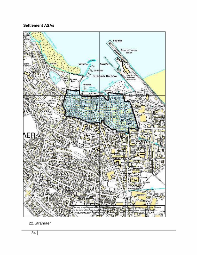
22. Stranraer Burgh NX 06 61
Stranraer is the principal town of Wigtownshire in recent times, at the south end of the
large and sheltered anchorage of Loch Ryan. It was founded in 1595 as a burgh of
barony under the superiority of the Adairs of Kinhilt, the owners of the Castle of St John,
and was created a royal burgh in 1617. Major expansion of both population and industry
took place in the later 18th century, and the 19th century saw intakes of land along the
11
shoreline. The sensitive area incorporates the castle, centre of the medieval town, and
the waterfront areas.
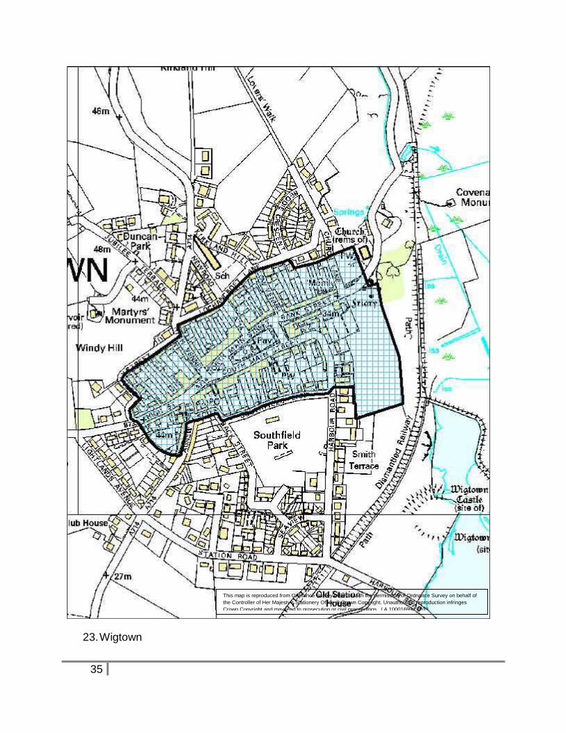
23. Wigtown Burgh NX 43 55
Although the burgh is not mentioned until 1292, the sheriffdom was in existence in
1263, and the evidence of Northumbrian and Viking crosses in the church indicates that
the town site was occupied several hundred years before that date. The royal burgh
was granted to Sir Malcolm Fleming by David II in 1341. Wigtown later reverted to the
Crown in 1455. The earthwork remains of the castle, which existed in 1291, lie to the
south of the town; the church lies at the eastern end overlooking Wigtown Bay, and
evidence suggests that the medieval Dominican friary was also located on the level
ground on the east side. The medieval town has classic plan with burgage plots
radiating from a broad market place, with gates or ports at the east and west ends. The
mercat cross has been moved from the west end of the market place to the gardens in
the centre.
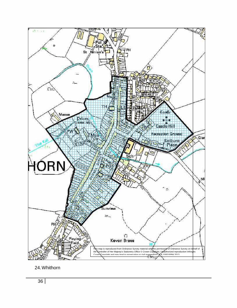
24. Whithorn Burgh NX 44 40
A small town existed at Whithorn, the cradle of Christianity in Scotland, by the early 5th
century, when St Ninian established it as the seat of a bishopric. The church, housing
the relics of St Ninian and a place of pilgrimage, was rebuilt as a cathedral and priory
church in the 12th century, the date of the earliest parts of the present ruin. Whithorn
was created an ecclesiastical burgh in a charter to the prior and convent of Candida
Casa by Robert I in 1325, and it was erected to royal burgh status by James IV in 1511.
By the 14th century the town had been moved from around the church to its current
location, built along either side of an extended marketplace, with ‘ports’ at both ends.
There are three clearly defined exits on the south-east side, leading to the Isle of
Whithorn.
Key features include the priory and surrounding area, the core of the medieval town with
the market place and distinctive burgage plots running back from it, the 18th century
expansions to the town and the area to the east of the town where the castle is
traditionally said to have been located.
25. Isle of Whithorn NX 47 36
The Isle of Whithorn is one of the most southerly villages and seaports in Scotland, lying
on the coast about three miles from Whithorn. It has been built around a naturally
sheltered harbour. The promontory is the location of a prehistoric fort, later re-occupied
in the early medieval period, and a 13th century chapel, used as a stopping off point for
pilgrims landing on Isle Head and making their way to Whithorn.
12
The isle is no longer a true island, though Ainslie's maps of the late 18th and early 19th
centuries do show the Isle as an island. The southerly part of the main street was
originally a causeway, with the harbour located on what was then the island. The open
aspect to and from the isle, across the harbour, should be maintained.
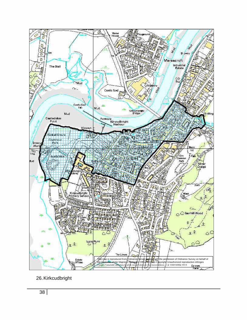
26. Kirkcudbright Burgh NX 68 51
The first notice of a burgh of Kirkcudbright occurs in 1330. The burgh remained in
Douglas hands until the 1455 forfeiture of that family. A charter of James II in 1455
made Kirkcudbright a 'free burgh', a grant which was confirmed in 1633 and again in
1641. The town was centred around the monastery of the Greyfriars, (built at the
western end of the original fortified motte) and the harbour, with the castle at
Castledykes forming the western edge of the town. Maclellan’s Castle and Greyfriars
formed the hub of the later medieval town. The sensitive area takes in the castles,
medieval core and the area to the north-east along the waterfront, where the town
expanded in the late 18th and early 19th centuries.
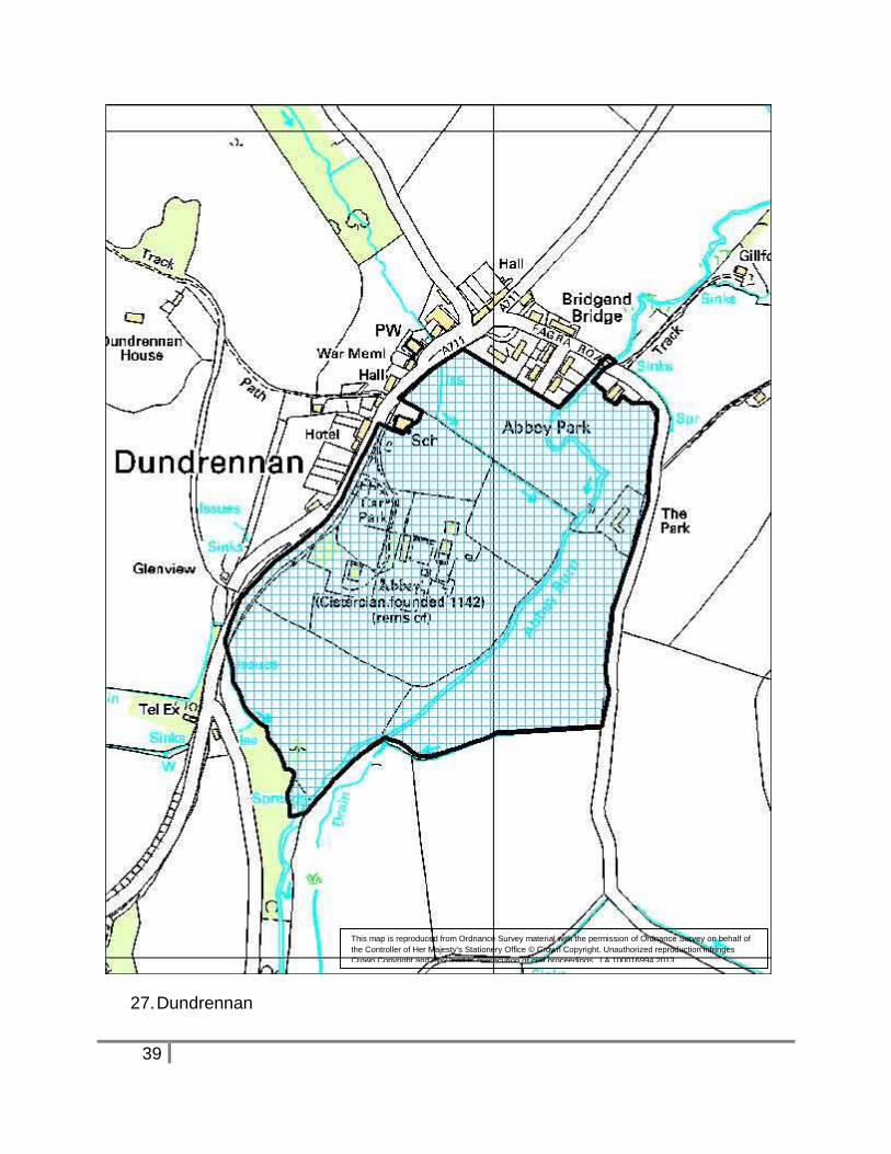
27. Dundrennan NX 74 47
Founded in 1142 by Fergus of Galloway, the abbey was home to a community of
Cistercian monks, originally from Rievaulx Abbey in Yorkshire. Mary, Queen of Scots,
after the Battle of Langside, spent her final night in Scotland here, in 1568. In 1587 the
abbey and lands passed to the Crown, and in 1621 it was annexed to the royal chapel
at Stirling. For many years the buildings were used as a quarry for the erection of
houses in the vicinity, but in 1842 steps were taken to repair and preserve what was left
of them. A medieval bridge, part of the abbey precinct, lies just to the north where it is
still in use for a public road.
The setting of this much-visited attraction at the open bottom of the valley, within its
precinct, is the primary element of this sensitive area.
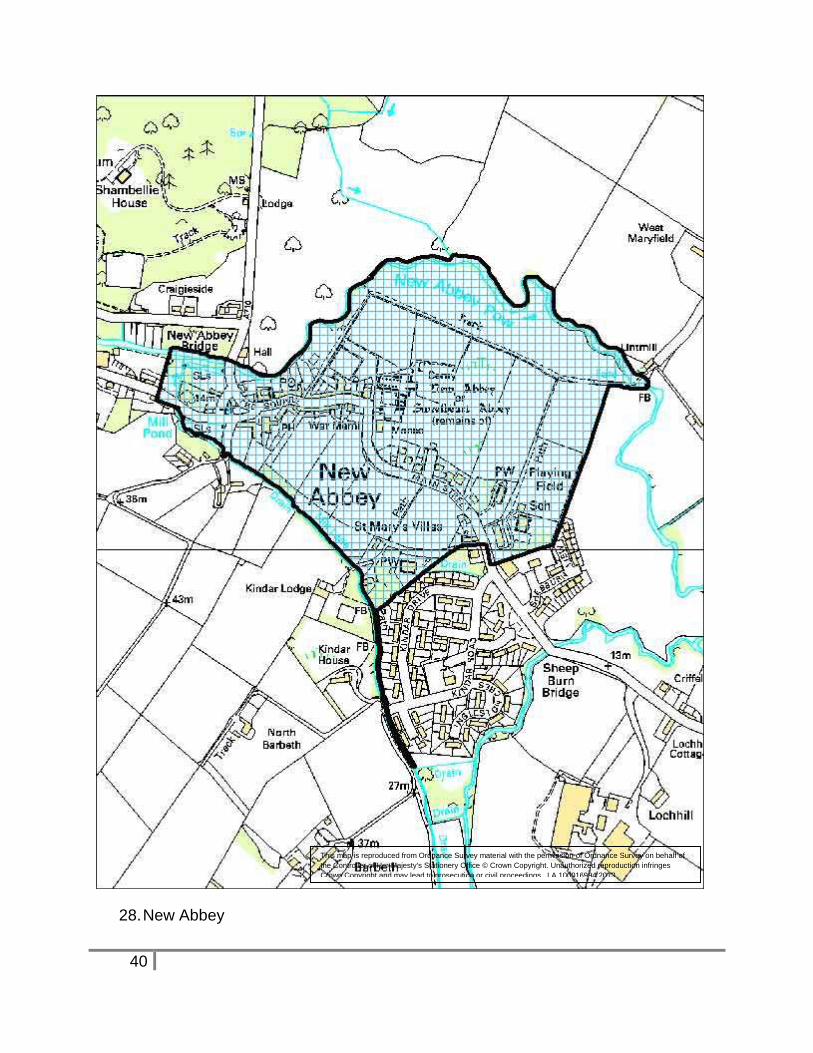
28. New Abbey NX 96 66
Sweetheart Abbey was founded in 1273 by Lady Dervorgilla of Galloway in memory of
her husband John Balliol. On her death, she was laid to rest next to her husband’s
embalmed heart and the Cistercian monks named their abbey in memory of her. The
immediate abbey precincts extended to 12 hectares and sections of the surrounding
wall can still be seen today. Much of the village is built within the precinct, and the
village also possess a fine watermill with mill pond and extensive lade system. There
are extensive designated areas in the village.
13
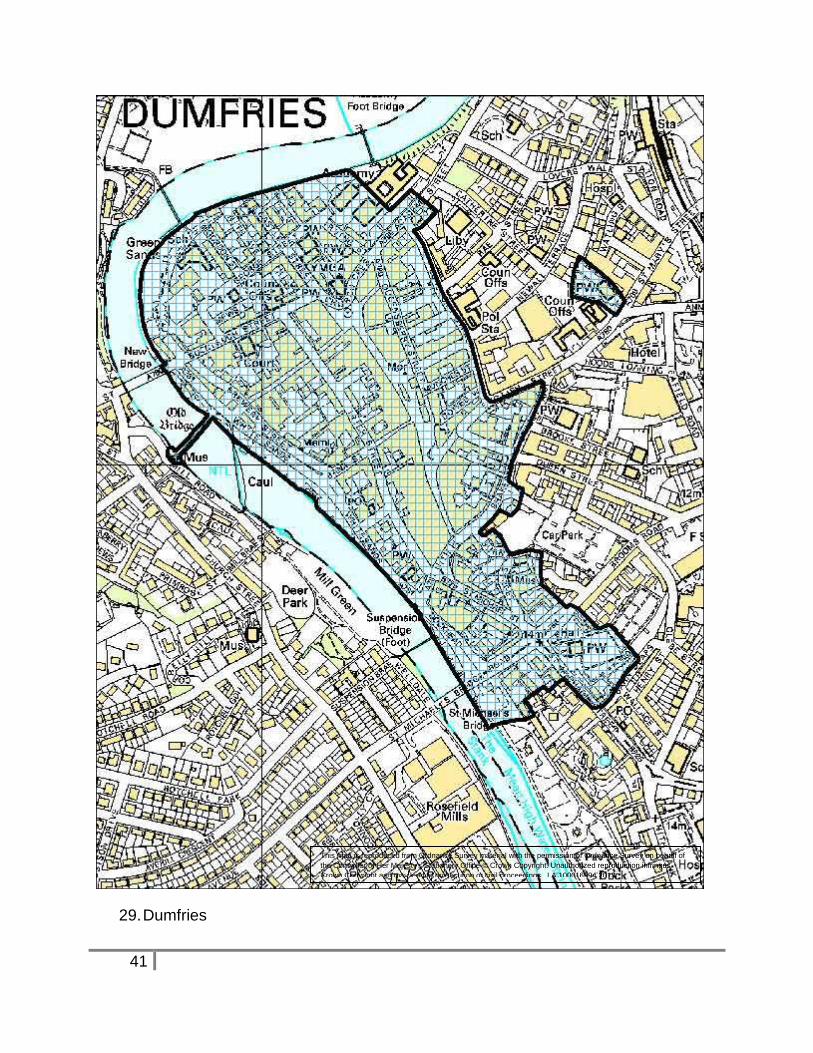
29. Dumfries Burgh NX 97 76
Dumfries was the first royal burgh in south-west Scotland, first mentioned around 1150
when Radulf, sub-king of Strathnith, granted land to the Hospital of St. Peter at York. A
royal charter of William the Lion, dating between 1179 and 1185, confers land 'between
the castle and the church' to Jocelin, bishop of Glasgow. It is thought to have become a
royal burgh shortly after that date, and its status was confirmed by a charter of Robert III
in 1385. The castle mentioned in the grant now lies under the Academy, and the church
is probably St. Michael’s Church, at the southern end of the town.
As a regional centre it had a long marketplace, widening from the Fish Cross at the
southern end to a broad northern end where Burns Statue Square now lies. The
burgage plots are still evident in the town’s layout, as are the ‘back raws’ of Irish Street
and Queensbury Street.
Friar’s Vennel leads from the west end of the town past the site of the Greyfriar’s
Monastery to the Whitesands and the crossing of the River Nith into Galloway at
Devorgilla’s Bridge. The medieval chapel of ‘Chrystal Mount’ lay on a hillock to the east
of the town, outside the town’s defences.
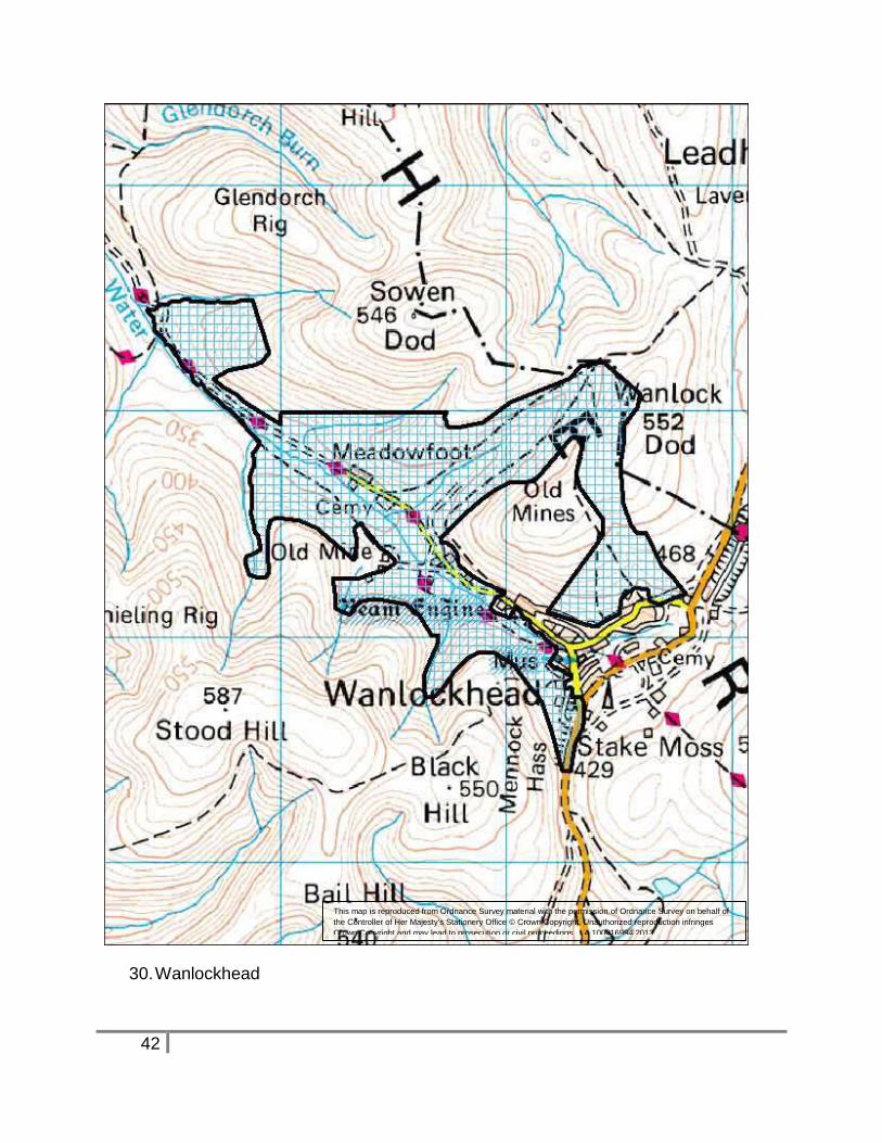
30. Wanlockhead NS 86 13
The areas around the village of Wanlockhead contain extensive above and below
ground remains of lead mining activity, mostly from the 18th and 19th century, but
including elements of earlier features. The mining remains are the single largest
designated scheduled site within the region. The ASA reflects the designated area.
31. Lochmaben Burgh NY 08 82
Lochmaben was founded before 1296 as a burgh of barony of the Bruces, lords of
Annandale, whose principal castle stood here. After the accession of Robert Bruce to
the throne in 1306, the lordship of Annandale, including the superiority over
Lochmaben, was granted to his nephew, Thomas Randolph, Earl of Moray, from whose
descendants it passed to the Earl of Douglas in 1409. Following the forfeiture of the
earldom of Douglas in 1440, Lochmaben came to be accepted as a royal burgh, and
was formally enrolled as one in 1605.
The town was built on an island of land surrounded by several lochs. The first castle lay
close to the town, in an area now occupied by the golf course, but the later castle lay at
the southern end of Castle Loch, with the town at the northern end.
The wide market place formed by the High Street, and the old churchyard have
medieval origins. The restored market cross is now in a public garden on Bruce Street.
14
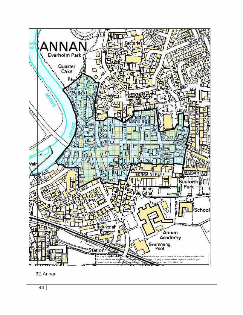
32. Annan Burgh NY 19 66
According to the Lanercost Chronicle, St. Malachy (c. 1148) cursed the Bruce family
and Annan, as a result of which it ceased to be a burgh. This may have happened about
the end of the 12th century when the river washed away part of Annan castle and
Lochmaben became the chief place of Annandale. Annan, like Lochmaben a Bruce
burgh in 1296, is not well documented for later times. Its earliest surviving charter is a
re-erection by James V in 1538/9 with the usual privileges of a royal burgh. Annan was
burnt by the English in 1317, by the Scots in 1376, and by the English again in 1516
and 1544 – the price for being close to the border. The key features are the medieval
high street and burgage plots, the bridge and riverside, and the massive castle
earthworks to the north of the town hall.
Excavations have revealed a boundary ditch on the east side of the town.
15
Maps
Rural ASAs
1. East Rhins
This map is reproduced from Ordnance Survey material with the permission of Ordnance Survey on behalf of
the Controller of Her Majesty's Stationery Office © Crown Copyright. Unauthorized reproduction infringes
Crown Copyright and may lead to prosecution or civil proceedings. LA 100016994 2013
16
2. Torrs Warren
This map is reproduced from Ordnance Survey material with the permission of Ordnance Survey on behalf of
the Controller of Her Majesty's Stationery Office © Crown Copyright. Unauthorized reproduction infringes
Crown Copyright and may lead to prosecution or civil proceedings. LA 100016994 2013

17
3. Knock Fell
This map is reproduced from Ordnance Survey material with the permission of Ordnance Survey on behalf of
the Controller of Her Majesty's Stationery Office © Crown Copyright. Unauthorized reproduction infringes
Crown Copyright and may lead to prosecution or civil proceedings. LA 100016994 2013
18
4. Changue Fell
This map is reproduced from Ordnance Survey material with the permission of Ordnance Survey on behalf of
the Controller of Her Majesty's Stationery Office © Crown Copyright. Unauthorized reproduction infringes
Crown Copyright and may lead to prosecution or civil proceedings. LA 100016994 2013
19
5. Torhouse
This map is reproduced from Ordnance Survey material with the permission of Ordnance Survey on behalf of
the Controller of Her Majesty's Stationery Office © Crown Copyright. Unauthorized reproduction infringes
Crown Copyright and may lead to prosecution or civil proceedings. LA 100016994 2013
20
6. Coldstream Burn
This map is reproduced from Ordnance Survey material with the permission of Ordnance Survey on behalf of
the Controller of Her Majesty's Stationery Office © Crown Copyright. Unauthorized reproduction infringes
Crown Copyright and may lead to prosecution or civil proceedings. LA 100016994 2013
21
7. Cambret Moor and 8. Cairnholy
This map is reproduced from Ordnance Survey material with the permission of Ordnance Survey on behalf of
the Controller of Her Majesty's Stationery Office © Crown Copyright. Unauthorized reproduction infringes
Crown Copyright and may lead to prosecution or civil proceedings. LA 100016994 2013
22
9. Grobdale and 10. Loch Mannoch
This map is reproduced from Ordnance Survey material with the permission of Ordnance Survey on behalf of
the Controller of Her Majesty's Stationery Office © Crown Copyright. Unauthorized reproduction infringes
Crown Copyright and may lead to prosecution or civil proceedings. LA 100016994 2013
23
11. Water of Deugh
This map is reproduced from Ordnance Survey material with the permission of Ordnance Survey on behalf of
the Controller of Her Majesty's Stationery Office © Crown Copyright. Unauthorized reproduction infringes
Crown Copyright and may lead to prosecution or civil proceedings. LA 100016994 2013
24
12. Bardennoch – Garryhorn
This map is reproduced from Ordnance Survey material with the permission of Ordnance Survey on behalf of
the Controller of Her Majesty's Stationery Office © Crown Copyright. Unauthorized reproduction infringes
Crown Copyright and may lead to prosecution or civil proceedings. LA 100016994 2013
25
13. Stroanfreggan
This map is reproduced from Ordnance Survey material with the permission of Ordnance Survey on behalf of
the Controller of Her Majesty's Stationery Office © Crown Copyright. Unauthorized reproduction infringes
Crown Copyright and may lead to prosecution or civil proceedings. LA 100016994 2013

26
14. Polharrow Burn
This map is reproduced from Ordnance Survey material with the permission of Ordnance Survey on behalf of
the Controller of Her Majesty's Stationery Office © Crown Copyright. Unauthorized reproduction infringes
Crown Copyright and may lead to prosecution or civil proceedings. LA 100016994 2013
27
15. Whitestanes Moor
This map is reproduced from Ordnance Survey material with the permission of Ordnance Survey on behalf of
the Controller of Her Majesty's Stationery Office © Crown Copyright. Unauthorized reproduction infringes
Crown Copyright and may lead to prosecution or civil proceedings. LA 100016994 2013
28
16. Beattock Hill
This map is reproduced from Ordnance Survey material with the permission of Ordnance Survey on behalf of
the Controller of Her Majesty's Stationery Office © Crown Copyright. Unauthorized reproduction infringes
Crown Copyright and may lead to prosecution or civil proceedings. LA 100016994 2013
29
17. Raeburnfoot
This map is reproduced from Ordnance Survey material with the permission of Ordnance Survey on behalf of
the Controller of Her Majesty's Stationery Office © Crown Copyright. Unauthorized reproduction infringes
Crown Copyright and may lead to prosecution or civil proceedings. LA 100016994 2013
30
18. Tanlawhill
This map is reproduced from Ordnance Survey material with the permission of Ordnance Survey on behalf of
the Controller of Her Majesty's Stationery Office © Crown Copyright. Unauthorized reproduction infringes
Crown Copyright and may lead to prosecution or civil proceedings. LA 100016994 2013

31
19. Boyken Burn
This map is reproduced from Ordnance Survey material with the permission of Ordnance Survey on behalf of
the Controller of Her Majesty's Stationery Office © Crown Copyright. Unauthorized reproduction infringes
Crown Copyright and may lead to prosecution or civil proceedings. LA 100016994 2013
32
20. Dryfe Water
This map is reproduced from Ordnance Survey material with the permission of Ordnance Survey on behalf of
the Controller of Her Majesty's Stationery Office © Crown Copyright. Unauthorized reproduction infringes
Crown Copyright and may lead to prosecution or civil proceedings. LA 100016994 2013
33
21. Burnswark
This map is reproduced from Ordnance Survey material with the permission of Ordnance Survey on behalf of
the Controller of Her Majesty's Stationery Office © Crown Copyright. Unauthorized reproduction infringes
Crown Copyright and may lead to prosecution or civil proceedings. LA 100016994 2013
34
Settlement ASAs
22. Stranraer
This map is reproduced from Ordnance Survey material with the permission of Ordnance Survey on behalf of
the Controller of Her Majesty's Stationery Office © Crown Copyright. Unauthorized reproduction infringes
Crown Copyright and may lead to prosecution or civil proceedings. LA 100016994 2013
35
23. Wigtown
This map is reproduced from Ordnance Survey material with the permission of Ordnance Survey on behalf of
the Controller of Her Majesty's Stationery Office © Crown Copyright. Unauthorized reproduction infringes
Crown Copyright and may lead to prosecution or civil proceedings. LA 100016994 2013
36
24. Whithorn
This map is reproduced from Ordnance Survey material with the permission of Ordnance Survey on behalf of
the Controller of Her Majesty's Stationery Office © Crown Copyright. Unauthorized reproduction infringes
Crown Copyright and may lead to prosecution or civil proceedings. LA 100016994 2013

37
25. Isle of Whithorn
This map is reproduced from Ordnance Survey material with the permission of Ordnance Survey on behalf of
the Controller of Her Majesty's Stationery Office © Crown Copyright. Unauthorized reproduction infringes
Crown Copyright and may lead to prosecution or civil proceedings. LA 100016994 2013
38
26. Kirkcudbright
This map is reproduced from Ordnance Survey material with the permission of Ordnance Survey on behalf of
the Controller of Her Majesty's Stationery Office © Crown Copyright. Unauthorized reproduction infringes
Crown Copyright and may lead to prosecution or civil proceedings. LA 100016994 2013
39
27. Dundrennan
This map is reproduced from Ordnance Survey material with the permission of Ordnance Survey on behalf of
the Controller of Her Majesty's Stationery Office © Crown Copyright. Unauthorized reproduction infringes
Crown Copyright and may lead to prosecution or civil proceedings. LA 100016994 2013
40
28. New Abbey
This map is reproduced from Ordnance Survey material with the permission of Ordnance Survey on behalf of
the Controller of Her Majesty's Stationery Office © Crown Copyright. Unauthorized reproduction infringes
Crown Copyright and may lead to prosecution or civil proceedings. LA 100016994 2013
41
29. Dumfries
This map is reproduced from Ordnance Survey material with the permission of Ordnance Survey on behalf of
the Controller of Her Majesty's Stationery Office © Crown Copyright. Unauthorized reproduction infringes
Crown Copyright and may lead to prosecution or civil proceedings. LA 100016994 2013
42
30. Wanlockhead
This map is reproduced from Ordnance Survey material with the permission of Ordnance Survey on behalf of
the Controller of Her Majesty's Stationery Office © Crown Copyright. Unauthorized reproduction infringes
Crown Copyright and may lead to prosecution or civil proceedings. LA 100016994 2013

43
31. Lochmaben
This map is reproduced from Ordnance Survey material with the permission of Ordnance Survey on behalf of
the Controller of Her Majesty's Stationery Office © Crown Copyright. Unauthorized reproduction infringes
Crown Copyright and may lead to prosecution or civil proceedings. LA 100016994 2013
44
32. Annan
This map is reproduced from Ordnance Survey material with the permission of Ordnance Survey on behalf of
the Controller of Her Majesty's Stationery Office © Crown Copyright. Unauthorized reproduction infringes
Crown Copyright and may lead to prosecution or civil proceedings. LA 100016994 2013

45
Contacts:
Council Archaeology Service, Planning and Environment, Militia House, English Street,
Dumfries, DG1 2HR. Telephone: 01387 260154
Further information:
Government Policy and Guidance:
Scottish Historic Environment Policy (SHEP) December 2011
Planning Advice Note 2/2011 Planning and Archaeology
Managing Change in the Historic Environment: Setting, Historic Scotland, 2010.