Embed Size (px)
Citation preview

537
Archaeological Investigation of the Landscape History of an OceanicAtoll: Majuro, Marshall Islands1
Toru Yamaguchi,2,5 Hajime Kayanne,3 and Hiroya Yamano4
Abstract: Historical ecology has provided the field of geoarchaeology in Oce-ania with the concept of an island landscape as a historical product, inventedfrom the dynamic interactions between natural processes and human agency.Since Davidson’s work in Nukuoro (1971) and Dye’s introduction to the prehis-tory of Majuro in the Marshall Islands (1987), systematic excavations of atollislets have also been based on this tenet. Following this concept, this studypresents a geoarchaeological examination of the long-term history of the pit-agricultural landscape in Laura Islet of Majuro Atoll, which now consists of195 pits showing remarkable undulation and anthropogenic vegetation on theirspoil banks. Our excavations, conducted since 2003, have revealed that humanhabitation on Laura began as early as 2,000 years ago, soon after the emergenceof the core islet, which probably followed a relative drop in sea level in the lateHolocene. Some centuries later, the inhabitants started excavating agriculturalpits for the cultivation of wet taro, probably Cyrtosperma spp. The subsequentsea-level decline would have enlarged the foraminiferal sediment; the islet thenextended its landform both oceanward and lagoonward as well as along thelongitudinal axis stretching north to south. The land accretion caused its inhab-itants to increasingly extend their activity space and readjust areas for habitation.It would also have enlarged the volume of the freshwater lens, prompting addi-tional construction of agricultural pits even in the area just behind the lagoon-side beach ridge. Most of the current landscape was formed by around 1,000years ago at the latest. Geoarchaeological synthesis of Pacific atolls will enablethe precise elucidation of local chronological relationships between land accre-tion and expansion of human activities.
More than 170 coral atolls are scattered inthe trade-wind zone from the westernmost
Caroline Islands to the easternmost TuamotuIslands (Figure 1). Their islets of foraminiferalsand and coral shingle lie on mid-Holoceneemergent reef flats, and a chain of these islets,which are covered with coconut trees, separatea turquoise lagoon from the surrounding navyblue ocean. On the surface, the scene appearsto be a typical oceanic paradise. Most of thesubaerial landforms, however, are no morethan 2–3 m in elevation and a few hundredmeters to less than a few kilometers at most inwidth. As such, they are highly susceptible toinundation by storm surges. Moreover, in theabsence of running surface water, some atollsfrequently suffer from droughts. Because ofthese and other factors, atolls have often beenstereotyped as being extremely marginal envi-ronments for human settlement. This over-simplified image tends to be reflected even inthe latest scientific reports on global warming,
Pacific Science (2009), vol. 63, no. 4:537–565: 2009 by University of Hawai‘i PressAll rights reserved
1 Research projects financially supported by theGlobal Environmental Research Fund, Ministry of Envi-ronment, Japan (2003–2007) and a Grant-in-Aid for Sci-entific Research from Ministry of Education, Culture,Sports, Science, and Technology, Japan (2006–2009).Manuscript accepted 21 January 2009.
2 Department of Ethnology and Archaeology, KeioUniversity, Japan.
3 Department of Earth and Planetary Science, TheUniversity of Tokyo, Japan.
4 Center for Global Environmental Research, Na-tional Institute for Environmental Studies, Japan.
5 Corresponding author (e-mail: [email protected]).

which lump atolls into the category of ‘‘smallisland countries.’’
Environmental diversity, however, is dis-cernible even within a single atoll. Near thecenter of the larger islets are remarkablebanks that are several meters higher than thesurrounding flat and low surfaces. Each ofthem encircles an agricultural pit dug intothe water table of the freshwater lens (Figure2). The pit is infilled with soil containingmuch humus enriched by the deliberate ad-ditions of vegetable compost to provide anutrient-rich layer. Colocasia and/or Cyrto-sperma tubers are planted in this wet ground,and tall trees of Chinese lantern (Hernandiasonora), Pacific rosewood (Cordia subcordata),and fish-poison tree (Barringtonia speciosa), aswell as coconut and breadfruit trees, grow onthe banks of the agricultural pits, shading theinterior so as to prevent the moisture of thehydromorphic terrain from evaporating.
The landscape, consisting of a chain oftopographic undulations and diverse vegeta-tion, contrasts with the prevailing image ofthe atoll environment. The main aim of thisstudy was to geoarchaeologically examine thepit-agriculture landscape on an oceanic atollas a historical product of the long-term inter-actions between two kinds of agents, naturaland human. In the 1990s some academicvolumes with the term ‘‘historical ecology’’in their titles were published, one of whichwas edited by C. L. Crumley (1994). Shestated that ‘‘historical ecology explores com-plex chains of mutual causation in human-environment relations and draws on conceptsfrom the natural sciences—biology, geology,climatology—and from ecology, archaeology,history, and socio-cultural anthropology’’(Crumley 1996:558) and pointed out the ef-fectiveness of its regional approach, encom-passing ‘‘the entire system, including both
Figure 1. Distribution of oceanic atolls and map of Majuro Atoll in the Marshall Islands.
538 PACIFIC SCIENCE . October 2009

human and nonhuman components’’ (Crum-ley 1994:5). Historical ecology is very closeto our geoarchaeological approach in the in-terdisciplinary research we have conductedon Majuro Atoll, Marshall Islands, since2003. Therefore, to begin, we offer a briefoverview of atoll studies in the contexts ofcultural ecology, environmental history, andhistorical ecology and then describe the land-scape history of pit agriculture on Majuro.
an overview of oceanic atollhistorical ecology
The idyllic image of an atoll has been stressednot only in the records of earlier Europeanexplorers but also in scholarly circles. Atollenvironments have often been viewed as
‘‘one of few possible simple ecological situa-tions in the tropics’’ (Thomas 1965:22), andtheir variability in size and precipitation wasapplied to explain certain selected culturaldifferences. In the 1950s and 1960s, culturalecology and cultural geography emphasizedthe limited quantity of land and general pau-city of resources (Bayliss-Smith 1990:57), asthese studies attempted to consider charac-teristics of atoll societies as adaptive strategiesto make the most efficient use of limited re-sources. The distinctive atoll environmentwas contrasted with that of high islands,masking the atolls’ environmental and geo-logical complexities (e.g., Sahlins 1958, Vaydaand Rappaport 1965:139).
In general, atolls have primarily been ofinterest to researchers whose perspectives are
Figure 2. Current landscape of pit agriculture in Majuro Atoll: a, matured Cyrtosperma in an agricultural pit, Laura; b,a well-controlled pit in Laura; c, a considerably disturbed pit where a small patch of Cyrtosperma remains; d, an aban-doned pit covered with Premna obtusifolia.
Landscape History of Majuro Atoll . Yamaguchi et al. 539

rooted in biogeography and ecology. For ex-ample, the U.S. Office of Naval Researchconducted a number of studies on Bikini andEniwetok in the Marshall Islands beforeatomic testing. In the beginning of his land-mark volume that synthesized atoll environ-ment and ecology Wiens (1962:xxi) statedthat ‘‘it must be kept in mind that peculiar-ities unique to certain atolls do occur.’’ Al-though acknowledging the uniformity ofatolls, he also appears to have conceptualized‘‘the holistic ecology of the atoll’’ (ibid.:xix),taking into account human-environmental in-teractions.
It is true that differences exist in annualand seasonal rainfalls among oceanic atollsthat are widely scattered in the trade-windzone extending west to east because the west-ern Pacific is closer to the convergence zonethan the eastern Pacific. The deviation of an-nual rainfall is discernible even within an is-land group. In the Marshall Islands, theseatolls extend nearly 1,200 km between 4� and12� N. The rainfall within this group in-creases from northwest to southeast alongthe island chain, ranging from less than 900mm to more than 4,000 mm in mean annualprecipitation (Taylor 1973). The freshwaterlenses sit atop saline water permeating theporous underground of atoll islets, and theirquality and volume are greatly affected by lo-cal precipitation. Their gradient within theMarshall Islands thus must be related to thevariety of vegetation. A phytogeographicalstudy of this island group indicates that wettaro, as well as banana and breadfruit trees,can generally be cultivated on atolls havingmore than 2,000 mm in mean annual precipi-tation (Stoddart 1992; see also Fosberg 1984).
Whitehead and Jones (1969) also con-ducted a study of the correlation betweenthe land area of islets and the number ofplant species on Kapingamarangi, which indi-cated a marked rise in the number of specieson islets more than 3.5 acres (1.4 ha) in size.Their detailed classification of indigenousand recently introduced species, however,suggested that the area-diversity curve wasgreatly exaggerated by the latter species. Asa result, they suggested that ‘‘the larger is-lands have been profoundly influenced by
humans through habitation, maintenance ofcoconuts, breadfruit, and taro, and the eventsof WWII’’ (ibid.:175).
These data have been referred to in vari-ous human ecological studies, some of whichindicated a correlation between land area,precipitation, and human population sizewithin the Marshall Islands (Williamson andSabath 1982, 1984). Bayliss-Smith (1990),who conducted a field survey of Ontong JavaAtoll in the Solomon Islands for his Ph.D.dissertation research, assessed the carryingcapacities of oceanic atolls in relation to thefrequency of droughts and hurricanes as wellas land area and precipitation. Since the1970s, in particular, human ecology has beenused to estimate the carrying capacities ofparticular atolls (e.g., Bayliss-Smith 1974).
Both human and cultural ecology haveconceptually relied on the assumption thathuman societies selectively use particular en-vironmental elements relevant to their tradi-tions or diffused technologies. As notedby Ballee (1998:3), however, these domains‘‘focused on how ‘natural’ environments—replete with given geophysical and biotic con-ditions—affected localized societies and theircultural development over time.’’ CliffordGeertz (1963) had already pointed out theimportance of a historical perspective to de-scribe the contrasting pattern of land use be-tween Java and outer islands of Indonesia inhis volume Agricultural Involution. However,most culture-ecological studies in the Pacific,with fewer available historical materials docu-menting long-term processes of ecologicalchange, tended to focus on synchronic rela-tionships between environment and culture,thus emphasizing the impact of the formeron the latter, even if using the notion ofadaptation. They appear to have contributedto the ambiguous distinction between envi-ronmental determinism and possibilism.
Adaptation is conceptualized as an ac-tive process of self-regulation that includesboth homeostasis and transformation. Thisis, however, a model with a logical problem,as Friedman (1979) has already described indetail. A homeostatic system needs a largerentity much like a ‘‘mystical superorganism’’(Cronon 1983:11) that organizes the elimina-
540 PACIFIC SCIENCE . October 2009

tion as well as the survival of its constitu-ents to maintain itself. The notion of trans-formation also implies a functional processthat tends toward a static goal decided in ad-vance by a large entity’s intentions and thus isnot historical but rather unilineal and predict-able. The analogy comparing culture-ecolog-ical systems to organisms or its imputationwith anthropomorphic qualities should becriticized for being teleological. Instead, indi-vidual constituents can be described in termsof their direct associations with others along acontinuous range of systems. In this sense,both ecological and cultural changes arisenot only from distinct events such as naturaldisasters and cultural contacts with othergroups but also from dialectical relationshipsbetween two kinds of agents, natural and hu-man. A chronological approach must there-fore be useful in describing their dynamics.
Environmental history follows such a view.It ‘‘begins by assuming a dynamic and chang-ing relationship between environment andculture, one as apt to produce contradictionsas continuities’’ (Cronon 1983:13). Somestudies have reexamined colonial and post-colonial histories focusing on how diseases,plants, and animals moved or were movedfrom one continent to another (e.g., Crosby1986). Although such studies, referred to as‘‘ecological imperialism,’’ are sometimescriticized as being too biologically determin-istic and Eurocentric (Arnold 1996:91), theycertainly made clear that human decisions in-itiated particular forms of systemic biologicalinteractions and thereby enhanced culturalbehaviors that affected their environment(Whitehead 1998:35).
Oceanic islands have a special appeal forenvironmental history in that any ecologicalchange is amplified by the effects of geo-graphical remoteness. Their isolation fromthe species pools of continents has caused in-sular ecosystems to become hypersensitive tothe introduction of exotic species transportedaccidentally or purposefully by humans (Mc-Neill 1994:299, 340–341) and to Europeanexploitation of island resources. For example,the exploitation of sandalwood and sea cu-cumber was increasingly active in the lateyears of the eighteenth and early decades of
the nineteenth centuries for trading with Chi-nese in Manila, the Philippines, and Canton,China (Shineberg 1966, Ward 1972). Thehuman agency accompanying such exploita-tion not only depleted the trading resourcesthemselves but also appears to have trans-ported exotic species such as pineapple,pumpkin, potato, and cattle for the provisionof foodstuffs to visiting vessels and to Euro-pean residents as well as their pet dogs andcats, which would have largely changed theprevious island biota. Oceanic atolls as wellhave not been immune from European ex-ploitation. One of the documented cases isthat of black-lipped pearl oysters (Pinctadamargaritifera) in the Tuamotu Islands, FrenchPolynesia; the study revealed historical entan-glements involving local islanders, externalentrepreneurs, and colonial administrations,which resulted in overexploitation and pres-ervation of oyster stock in atoll lagoons (Ra-paport 1995).
However, the interactions of natural pro-cesses and human agency are by no meansrestricted to the past 300 years of colonial ex-pansionism but began when humans firstcolonized the islands. Archaeology in the Pa-cific has contributed substantially to under-standing this issue from the viewpoint ofhistorical ecology, which incorporates datacollected from a variety of natural sciences,including geology, geomorphology, and pale-ontology, as noted by Kirch and Hunt (1997)in their landmark volume Historical Ecology inthe Pacific Islands. It is noteworthy that manystudies use the term ‘‘landscape’’ to scrutinizelong-term processes of dialectic interactionsbetween the process of nature and the workof humans, probably because positioning thenotion of landscape between the two enablesthe smooth combination of the natural andsocial sciences.
Although Kirch and Hunt’s volume didnot include any studies of atolls, except fora semiatoll of Aitutaki (Allen 1997), Weisler(2001a:6–8), who has systematically initiatedgeoarchaeological excavations in the Mar-shall Islands of eastern Micronesia, advo-cates examining chronological relationshipsof human settlements in relation to the geo-morphological formations of atoll islets and
Landscape History of Majuro Atoll . Yamaguchi et al. 541

anthropogenic alterations of atoll landscapesas a relevant topic in atoll archaeology.
atoll archaeology and late-holoceneislet formation
Several studies in the past few decadeshave focused on the settlement of atollsand long-term adaptations. A pioneeringstudy conducted by Davidson (1971, 1992) inthe 1960s focused on systematic excavationsalong a transect line between the ocean andthe lagoon shores of Nukuoro Atoll, CarolineIslands. Davidson showed that the topo-graphic undulations of Nukuoro Islet werehistorically produced by human activities, al-though some stratified sediments appear toreflect spoil deposits that had piled up from anearby agricultural pit rather than ‘‘house andyard floors of fresh coral gravel and accumu-lations of cooking and other rubbish’’ (Da-vidson 1971:21).
Some notable perspectives on atoll archae-ology were also offered by the Bishop Mu-seum Expedition to the Marshall Islands.One such contribution was the association ofhuman settlements with the land formationof atoll islets that coincided with the Holo-cene sea-level change (Dye 1987). It is readilypossible to find reef-flat deposits of cementedcoral rubble (also termed cap rocks, brecciasheets, or cemented rubble ramparts) exposedwithin the intertidal and supratidal positionsalong atoll beaches. These are thought to in-dicate the mid-Holocene hydroisostatic sea-level highstand (Buddemeier et al. 1975,Schofield 1977, Schoffin 1993, Nunn 1995),a conclusion that is supported by dated sam-ples of Tridacna shells imbedded within typi-cal emergent reef-flat deposits on Tarawa inKiribati and on Bikini and Enewetak atolls inthe Marshall Islands (Dickinson 1999:126).Some emergent reef flats seem to haveformed resistant surfaces upon which pinnedislets may nucleate (Dickinson 2004:262; seealso Schofield 1977), but the timing of late-Holocene sea-level fall was distinctly variable.The duration of highstand persisted until thefirst millennium A.D. around the TuamotuArchipelago (i.e., within the region of theSouth Pacific Superswell [SPS] and South
Pacific Isotopic and Thermal Anomaly[SOPITA], which are essentially coextensivefeatures delineating a region underlain byanomalous oceanic mantle). In contrast, thehighstand would have started to fall as earlyas 2,000 years ago in the central Pacific, in-cluding the Marshall Islands (Dickinson2003:491).
These regional variations of the late-Holocene sea-level fall tend to fit with varia-tions in initial human settlement on oceanicatolls. Several studies in the past few decadeshave offered evidence on the settlement ofoceanic atolls: the Caroline Islands (Davidson1967, 1971, Leach and Ward 1981, Craib1984 [1981], Fujimura and Alkire 1984, Intoh1984 [1981]), the Marshall Islands (Athens1984, Dye 1987, Schilz 1989, Thomas 1989,Shun and Athens 1990, Streck 1990, Beards-ley 1993, Weisler 1999a,b, 2000, 2001a,b,c,Yamaguchi et al. 2005), the Northern CookIslands (Chikamori and Yoshida 1988, Yama-guchi 1990, 2000, Chikamori 1998), Tuvalu(Takayama and Sato 1987), Tokelau (Best1988), the Line Islands (Sinoto 1973, Ander-son et al. 2000, Di Piazza and Pearthree2001), the Society Islands, and the Tuamotuarchipelago (Sinoto and McCoy 1974, Sinoto1976, Chazine 1982).
Radiocarbon ages of charcoal samples re-trieved from these excavations reveal a dis-tinction in the earlier phases of humanoccupation (Figure 3). Most Polynesian atollswere inhabited after ca. 1,000 years B.P. Theearliest charcoal age from easternmost ReaoAtoll in the Tuamotus shows 870G 80 yearsB.P. (N-2657) (Sinoto 1976), and those fromthe northern Cook Islands fall within a tem-poral range between 560G 50 years B.P.(WK-4094) from Tongareva (Yamaguchi2000) and 1,800 years B.P. from Pukapuka(N-5107) (Chikamori and Yoshida 1988). Al-though the Pukapukan earlier ages are some-what less reliable, Rakahanga and Manihikiatolls, located in the middle of the northernCook Islands, provided ca. 600–1,000 yearsB.P. for the earliest human settlement (Chi-kamori 1998), a finding that was supportedby our reexamination using more precise ac-celerator mass spectrometry (AMS) dating:830G 25 years B.P. (PLD-3916) from Raka-
542 PACIFIC SCIENCE . October 2009

hanga and 605G 25 years B.P. (PLD-5831)from Manihiki (unpubl. data). These agesfrom the northern Cook Islands are consis-tent with reliable ones of charcoal samplesfrom the Line Islands, 810G 50 years B.P.(Beta-142178) from Fanning Island (DiPiazza and Pearthree 2001), and 690G 80years B.P. (WK-7748) from Christmas Island(Anderson et al. 2000).
Many western atolls were inhabited earlierthan the discussed eastern ones. Some earlierages over 1,000 years B.P. were reportedfrom the western Caroline Islands, althoughthese ages are less reliable, having been takenfrom sources other than charcoal samples orfrom unknown materials. The most reliablecharcoal ages for earliest human settlementon oceanic atolls, however, have been ob-tained from the central Pacific including theMarshall Islands and Kiribati. These dateback to 1,500–2,000 years B.P.: 1,860G 60years B.P. (Beta-103903) from Utrok Atoll(Weisler 2001a), 1,920G 90 years B.P.(Beta-21310) from Kwajalein Atoll (Beardsley1993), 1,910G 70 years B.P. (Beta-79576)from Maloelap (Weisler 1999a), 1,660G 60years B.P. (Beta-74845) from Ujae (Weisler1999b), 2,050G 90 years B.P. (Beta-89960)from Nikunau in Kiribati (Di Piazza 1999),and our ages from Majuro Atoll described inthe following sections.
If the late-Holocene sea-level drop was re-gionally variable, as noted earlier, it is stillreasonable for archaeologists to investigatethe correlations between the chronologicalrelationship of human colonization and thegeomorphological formation of each atoll is-let. In the central Pacific, radiocarbon agesreported from Enewetak by Tracey andLadd include three yielded from apparentlyin situ corals. These were all from an eleva-tion of approximately 1 m above the currentmean sea level, and the radiocarbon agesranged from 1,900 to 3,300 years B.P.(Tracey and Ladd 1974; see also Buddemeieret al. 1975:1583–1584). We also observed anemergent microatoll on a cemented terrace inArno Atoll, and the close examination of itssample is in progress. It still remains unclear,however, whether popular terraces of ce-mented coral rubble, commonly observed
above mean sea level, represent emergentmid-Holocene reef flats or consolidateddeposits formed within the intertidalzone. Moreover, Woodroffe and Morrison(2001:258) pointed out that reef-island accre-tion occurred ‘‘on reefs in the West Indieswhere sea level has continued to rise duringthe late Holocene, implying that sea-levelfall is not necessary for reef-island for-mation.’’ Thus more samples of emergentmicroatolls or Tridacna shells in growth posi-tion on such cemented terraces must be col-lected and analyzed to reach a firm conclusion.
Archaeologists in Oceania can also useother materials that directly reflect the subae-rial land formation of atoll islets: unconsoli-dated calcitic deposits consisting of currentatoll islets. In fact, Dye (1987:4–5) has al-ready referred to radiocarbon-dated deposi-tional features collected from four MarshallIsland atolls and suggested that by ‘‘3,000years ago, then, enough sediment had accu-mulated’’ on coral reef flats. Most of the ma-terials Dye mentioned are, however, depositsof coral rubble or Tridacna shells in stormridges or embedded in cemented terraces(see Curray et al. 1970), and thus these radio-metric ages only show the upper limits of thesedimentary period and with a high degreeof uncertainty. In the central Pacific, in-cluding the Marshall Islands, foraminiferalsand accounts for much of the unconsolidatedsediment on atoll islets (Woodroffe and Mor-rison 2001). Because Calcarina and Baculogyp-sina tests among Foraminifera have severalspicules that are easily abraded in the processof transportation by wave action on reef flats,the samples preserving fresh spicules shouldbe effective in radiometric dating for calciticsand sedimentation (Yamano et al. 2001). Itis also proper that geoarchaeological studiesof atoll prehistory must devise a way to com-pare radiocarbon ages of terrestrial woodencharcoal samples with those of marine calciticsamples.
landscape of pit agriculture inmajuro atoll
The Marshall Islands consist of 29 atollsand five small coral islands that are spread
Landscape History of Majuro Atoll . Yamaguchi et al. 543


over approximately 2 million km2 of ocean.The earliest radiocarbon age from BikiniAtoll is 3,450G 60 years B. P. (Streck 1990),but this age is highly dubious and seems to befrom long-lived organic matter or old mate-rial from driftwood (Kirch and Weisler1994:292). From four atolls in this group,Utrok, Kwajalein, Maloelap, and Majuro, ra-diocarbon dates of ca. 2,000 years B.P. havebeen reported. These are comparable withthe earliest ages of settlement sites on highislands in East Micronesia. Atoll settlementwas once viewed as being a relatively latephenomenon compared with that of the highislands, which the Pacific islanders wouldhave settled first. However, it has becomeclear through archaeological investigationsthat some central Pacific atolls were settledcontemporaneously, as Alkire (1978:21) hadearlier hypothesized. One of the essential in-gredients for human habitation appears to bethe potential for wet taro cultivation in agri-cultural pits that were maintained by suffi-cient freshwater resources.
Majuro is situated at 7� N and 171� E, inthe southern part of the Marshall Islands(Figure 1). This atoll consists of more than60 islets on reef flats encircling a large lagoonmeasuring 41 by 11 km with the long axis ex-tending from east to west. The total land areais just under 10 km2. Most government build-ings are located on the eastern islets of Djar-rit, Uliga, and Delap. The largest and widestislet of Laura measures approximately 1.2km2 in area and 1,200 m at its widest pointbetween the lagoon and ocean shorelines(Figure 4).
To accurately measure the size and distri-bution of agricultural pits, we established a
grid system based on 0.0015� of latitude/longitude (equaling approximately 166 by166 m). Within the whole area of Laura, werecorded the upper edges of 195 agriculturalpits distributed near the center of the islet us-ing GPS (GpsMap76CSX, Garmin). Theseranged in size from 35 to 7,797 m2 in area,with more than half of the pits smaller than500 m2 (average ¼ 721 m2, SD ¼ 875.6).Some of the grid sections in the center ofthe islet, namely B6, B7, C6, and C7, are, inparticular, covered with a pit-agriculturallandscape consisting of undulating pits andspoil heaps with dense vegetation (Figure 4).
Colocasia (katak) and/or Cyrtosperma (iarajwaan) tubers, the latter prevailing in Majuro,are planted in these pits. When Cyrtosperma isfully grown, it measures more than 3 m inheight and produces tubers weighing 20–30kg (Figure 2a). The upper quarter of a ma-tured tuber is left after the harvest, and thecutting surface is dried for some days andthen replanted in moist soil. The seed tuber( pak) grows quickly and can be reharvestedwithin a year, whereas it takes 2–5 years fora small peripheral stalk (il ) to mature in pits.Cyrtosperma tubers have the highest carbohy-drate content per unit among the aroids andcan also withstand high water levels or evenflooding, provided that it does not result inan inflow of seawater. As a result, this speciesis more adaptable to the fluctuating watertable associated with tidal change (Lambert1982). This characteristic may be one reasonwhy Cyrtosperma is the main aroid grown onatolls in the Marshall Islands.
Majuro Atoll, in the far southeast of theMarshall Islands, averages about 3,500 mmin annual rainfall. Although the annual rain-
g—————————————————————————————————————————————————Figure 3. Time differences of earlier settlements on oceanic atolls, on the basis of conventional ages of charcoal sam-ples: W&C.Mc is West-Central Micronesia including Nukuoro (Davidson 1971, 1992) and Kapingamarangi (Leachand Ward 1981); MJ is Majuro in the Marshall Islands (Riley 1987, Rosendahl 1987, Yamaguchi et al. 2005); UJ isUjae (Weisler 1999b); KW is Kwajalein (Shun and Athens 1990, Beardsley 1993); ML is Maloelap (Weisler 1999a);UT is Utrok (Weisler 2001a,b); BK is Bikini (Streck 1990); W&C.Pl is West-Central Polynesia including Fanning(Sinoto 1973) and Christmas (Anderson et al. 2000, Di Piazza and Pearthree 2001) in the Line Islands, Fakaofo andAtafu (Best 1988) in the Tokelau Islands, and Funafuti and Vaitupu (Takayama and Sato 1987; T.Y., unpubl. data) inTuvalu; PUK is Pukapuka in the northern Cook Islands (Chikamori and Yoshida 1988, Yamaguchi 2000); RAK is Ra-kahanga (Yamaguchi 2000); MNH is Manihiki (Chikamori 1998, Yamaguchi 2000); TON is Tongareva (Yamaguchi1990, 2000); and E.Pl is East Polynesia including Rangiroa (T.Y., unpubl. data) and Reao (Sinoto 1976, Chazine 1982)in the Tuamotu Islands, and Tetiaroa (Sinoto and McCoy 1974) in the Society Islands.
Landscape History of Majuro Atoll . Yamaguchi et al. 545

Figure 4. Spatial distribution of agricultural pits and locations of excavated sites. This map is drawn on an IKONOSsatellite image, and Laura is divided into grids along each 0.0015� of latitude and longitude (each grid is approximately166 by 166 m). Agricultural pits are shown by blacked-out portions.

fall distribution on oceanic atolls is generallyseasonal and occurs in the wet season, thereis regional variation, which appears to becomparatively small in Majuro according toprecipitation data collected between 1955and 1972 (Taylor 1973). The Marshallesegovernment uses the Majuro airport (88 ha)to collect rainfall, storing it in huge water res-ervoirs of 37 million gallons (140,000 kl), tosatisfy the demand for freshwater for themore than 20 thousand people living on thisatoll. Serious water shortages have occurred,the most notable of which was during the1997–1998 El Nino event. Monthly rainfallwas less than 2.54 cm in the dry season be-tween February and April 1998, and residentscame to rely primarily on Laura’s freshwaterlens. It is estimated that 90% (March 1998)and 64% (May 1998) of the total drinkingwater that Majuro Water and Sewer Com-pany supplied during that period originatedfrom Laura (Presley 2005:18). Although theexcessive pumpage could have affected thesize and the quality of the freshwater lens,no serious damage or trouble, such as thewithering of Cyrtosperma, was reported fromthis heavy use. This islet has the largest catch-ment of rainfall, so its underground fresh-water lens could probably remain relativelyintact even during extensive droughts lastingseveral months.
As noted earlier, the freshwater sits atopsaline water permeating the porous under-ground of the islets, and its quality and vol-ume is also affected by tidal and seasonalfluctuations in the water table that cause dif-fusion between the two. Its magnitude is in-versely proportional to the width and size ofthe islets (Tracey et al. 1961). The permeabil-ity of underground sediments is more crucialto the fluctuation of water lenses. Accordingto a hydrogeological survey, the near-surfacelithological framework beneath Laura comesin two primary hydrologic units (Hamlin andAnthony 1987, Anthony et al. 1989). Thelower unit represents a porous aquifer oflimestone that was subaerially exposed andleached during a Pleistocene glacial-lowstandsea level. The upper unit is ‘‘an uncementedgrainstone composed of a heterogeneousmixture of moderately well-sorted foramini-
fera sand and fragments of coralline algae’’(Anthony et al. 1989:1068), and the lowersediment of the upper unit contains a rela-tively higher abundance of silt. This uncon-solidated unit is markedly less permeablethan the leached Pleistocene limestone andcoarse gravel deposited at the oceanside thatare more porous or have cavities (see alsoMarshall and Jacobson 1985, Peterson 1997).
Drillholes on Laura have revealed that theupper unit of fine sand is about 25 m thick onthe lagoonward edge and 16 m even inland.The sand’s relatively low permeability and itsthickness would prevent saline water frommoving upward from the lower porous aqui-fer into the freshwater lens (Underwood et al.1992). It is probably the accumulation of thisforaminiferal sand along with rich precipita-tion annually averaging approximately 3,500mm and the wide catchment of rainfall thatcause Laura to contain the largest freshwaterlens on the atoll, which sustains its varietyof vegetation, particularly Cyrtosperma, in theagricultural pits.
A Geoarchaeological Excavation of Pit-Agricultural Landscape Site MJ-Lr2-8
Although the inland portion of Laura todayhas been somewhat modified for the develop-ment of residential areas, it is still coveredwith dense vegetation and a chain of undulat-ing pits circled by spoil banks. Because mostremote atolls were not affected by alluvial orvolcanic deposits, there has been little surfaceaccumulation of soil in the past. As such, theonly soil deposition seen relates to that ofanthropogenic spoil from agricultural pits,which serve to protect intact A horizonsand cultural features as was demonstrated inprevious excavations (Riley 1987:216–217,Weisler 1999a). The 2003 excavation of siteMJ-Lr2-8 on a spoil bank also offered an op-portunity to examine the chronological for-mation of this pit-agricultural landscape onMajuro Atoll.
The top of the spoil bank was about 3 mabove the current mean sea level, and the bot-tom of the pits was 0.4 m above (Figure 5).This is remarkable considering that the isletis uniformally flat. A 2 by 4 m trench was ex-
Landscape History of Majuro Atoll . Yamaguchi et al. 547

cavated to an approximate depth of 150 cm,and intact stratified deposits were encoun-tered, composing roughly three strata exclud-ing surface humus (Figure 6). These includedthe following:
(1) The lowest stratum (Layer 7) was avery pale brown (10YR7/3), naturally accu-mulated sand deposit consisting of sand-sizefragments of coral, coralline algae, mollusks,and abundant large benthic Foraminifera(mostly Calcarina spp.).
(2) The second stratum (Layer 6), lyingjust on top of the natural stratum, containeddark gray sand (10YR4/1) and charcoal flecksand appears to be the earliest buried A hori-zon. The shallow pit of an earth oven (U1-Fe6) along the eastern profile contained alarge abundance of burned coral pebbles
and charcoal flecks, probably monocotyledontrunk and coconut endocarp, which dated to2,010 years B.P.
(3) The third stratum (Layer 2 to U1/Fe5)consisted of gray sand layers (10YR4/1–6/1)and earth ovens containing burned coral peb-bles and charcoal flecks. The componentsof these layers bear a resemblance to thoseof soil in the adjacent pits. Dolphin (probablyPeponocephala electra) vertebrae and turtleremains were retrieved along with bonesof pelagic, benthic, and reef fishes fromthe sediments of ovens as well as the spoillayers, which were roughly sifted through 10mm and 5 mm screens (Yamaguchi et al.2005:31). We also obtained five associated ra-diocarbon ages from charcoal flecks of Pacificrosewood and Chinese lantern, all of which
Figure 5. Schematic 3-D topography of an agricultural complex and location of site MJ-Lr2-8.
548 PACIFIC SCIENCE . October 2009

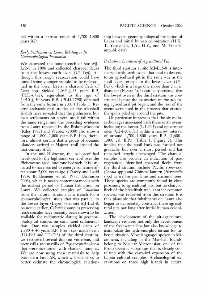
Figure6.
Schem
atic
3-D
stratigraphyofsite
MJ-Lr2-8
showingboth
walls,western
andeastern,andeigh
tconventional
ages
from
charcoal
samples.
fell within a narrow range of 1,700–1,800years B.P.
Early Settlement on Laura Relating to ItsGeomorphological Formation
We excavated the same trench of site MJ-Lr2-8 in 2006 and collected charcoal flecksfrom the lowest earth oven (U1-Fe6). Al-though this rough reexcavation could havecaused some younger samples to be redepos-ited in the lower layers, a charcoal fleck ofCocos spp. yielded 2,035G 25 years B.P.(PLD-6752), equivalent to the age of2,010G 50 years B.P. (PLD-2790) obtainedfrom the same feature in 2003 (Table 1). Re-cent archaeological studies of the MarshallIslands have revealed that the prehistoric hu-man settlements on several atolls fall withinthe same range, and the preceding evidencefrom Laura reported by the Bishop Museum(Riley 1987) and Weisler (2000) also show arange of 1,800–2,000 years B.P. It is, there-fore, almost certain that a group of oceanicislanders arrived at Majuro Atoll around thefirst century A.D.
In the mid-Holocene, the paleoreef haddeveloped to the highstand sea level over thePleistocene-aged limestone bedrock. It is esti-mated to have started to emerge sometime af-ter about 2,000 years ago (Tracey and Ladd1974, Buddemeier et al. 1975, Dickinson2003), which is nearly contemporaneous withthe earliest period of human habitation onLaura. We collected samples of Calcarinafrom the natural stratum at a trench for ageomorphological study that was parallel tothe lowest layer (Layer 7) at site MJ-Lr2-8.As noted earlier, Calcarina samples preservingfresh spicules have recently been shown to beavailable for radiometric dating in geomor-phological studies on coral sand sedimenta-tion. Our two samples yielded dates of2,380G 40 years B.P. From two earth ovens(U1-Fe5 and U2-Fe3) of the third stratum,we recovered several dolphin vertebrae, andpremaxilla and maxilla of Peponocephala electrathat were associated with charcoal samples.We are now using these materials to helpestimate a local DR, which will enable us tobetter estimate the chronological relation-
ship between geomorphological formation ofLaura and initial human colonization (H.K.,T. Yasukochi, T.Y., H.Y., and M. Yoneda,unpubl. data).
Prehistoric Invention of Agricultural Pits
The third stratum at site MJ-Lr2-8 is inter-spersed with earth ovens that tend to descendto an agricultural pit in the same way as thespoil layers, except for the lowest oven (U1-Fe5), which is a large one more than 2 m indiameter (Figure 6). It can be speculated thatthe lowest oven in the third stratum was con-structed before the excavation of the adjoin-ing agricultural pit began, and the rest of theovens were used in the process that createdthe spoils piled up around the pits.
Of particular interest is that the six radio-carbon ages associated with these earth ovens,including the lowest (U1-Fe5) and uppermostones (U2-Fe0), fall within a narrow intervalof around 1,700–1,800 years B.P. (1,600–1,800 cal. B.P.) (Table 1, Figure 7). Thisimplies that the spoil bank was formed notgradually but over a short period and hasremained largely unchanged. The charcoalsamples also provide an indication of pastvegetation. Identified charcoal flecks fromthe third stratum include Pacific rosewood(Cordia spp.) and Chinese lantern (Hernandiaspp.) as well as pandanus and coconut trees.These species are commonly found in closeproximity to agricultural pits, but no charcoalfleck of the breadfruit tree, another commonspecies, was retrieved from this stratum. It isthus plausible that inhabitants on Laura alsobegan to deliberately construct these agricul-tural pits not long after initial human coloni-zation.
The development of the pit-agriculturallandscape required not only the developmentof the freshwater lens but also knowledge tomanipulate the hydromorphic terrain for tu-ber cultivation. Most languages spoken in Mi-cronesia, including in the Marshall Islands,belong to Nuclear Micronesian, one of theProto-Oceanic subgroups that is closely cor-related with the eastward expansion of theLapita cultural complex. Archaeological ex-cavations on three high islands in central
550 PACIFIC SCIENCE . October 2009

TABLE 1
Radiocarbon Ages (AMS) from Our Excavations on Laura, Majuro Atoll
Lab. Codea Provenance Material
14CConventional
Delta13C
Cal. Yr(1s)
Cal. Yr(2s)
PLD-2016 MJ-Lr1-1 Fe 4 Unidentified 940G 25 �25.90 A.D. 1035–1065(32.6%)
A.D. 1085–1125(46.1%)
A.D. 1140–1155(21.3%)
PLD-2017 MJ-Lr1-1Layer 5(lower)
Unidentified 1025G 25 �23.90 A.D. 995–1025(100%)
PLD-6753 MJ-Lr2-9Test Trench1, Fe6
Monocotyledoneae 1605G 25 �23.76 A.D. 410–450(23.6%)
A.D. 410–540(95.4%)
A.D. 480–540(44.6%)
PLD-6754 MJ-Lr2-9Test Trench1, Fe7
Cordia spp. 1635G 25 �27.74 A.D. 380–440(62.7%)
A.D. 340–540(95.4%)
A.D. 490–510(5.5%)
PLD-6755 MJ-Lr2-9Test Trench2, Fe1
Monocotyledoneae 1005G 20 �24.14 A.D. 990–1035(68.2%)
A.D. 980–1050(87.4%)
A.D. 1090–1120 (6.6%)
A.D. 1140–1150 (1.4%)
PLD-6756 MJ-Lr2-9Test Trench2, Fe2
Monocotyledoneae 380G 25 �24.70 A.D. 1450–1510(54.1%)
A.D. 1440–1530(70.6%)
A.D. 1600–1620(14.1%)
A.D. 1570–1630(24.8%)
PLD-6757 MJ-Lr2-9Maintrench, Fe2
Pemphis acidula 405G 20 �26.33 A.D. 1440–1480(68.2%)
A.D. 1430–1510(88.7%)
A.D. 1600–1620 (6.7%)
PLD-2785(MTC-04413)
MJ-Lr2-8U2/Fe0
Cordia 1850G 45 �25.80 A.D. 125–235(97.0%)
PLD-2786(MTC-04414)
MJ-Lr2-8Layer 4
Pandanus gen. 1755G 45 �28.10 A.D. 230–345(94.6%)
PLD-2787(MTC-04415)
MJ-Lr2-8U1/Fe3
Cocos spp.? 1825G 45 �26.30 A.D. 130–240(100%)

Micronesia, namely, Chuuk, Pohnpei, andKosrae, have revealed sand-tempered plain-ware potsherds relating to the period around2,000 years B.P. Their attributes bear a re-semblance in form and technology to the lateLapita Plain Ware pottery tradition that ex-tended from the Bismarks westward as far asthe Reef-Santa Cruz Islands eastward after2,500 years B.P. (Athens 1990:29).
Thus, linguistic and archaeological evi-dence strongly indicate that the MarshallIslands were colonized from the south,probably somewhere from the southeasternSolomon–Vanuatu region (see Blust 1988[1984–1985]:58, Intoh 1997:22, Kirch2000:175). A recent archaeological excavationon Nikunau, a reef island in Kiribati, has alsorevealed two early earth ovens dating from
TABLE 1 (continued)
Lab. Codea Provenance Material
14CConventional
Delta13C
Cal. Yr(1s)
Cal. Yr(2s)
PLD-2788(MTC-04416)
MJ-Lr2-8U1/Fe4
Pandanus fruit 1720G 45 �25.40 A.D. 255–300(41.4%)
A.D. 320–385(58.6%)
PLD-5827 MJ-Lr2-8U2/Fe3
Monocotyledoneae 1740G 24 �23.11 A.D. 250–335(68.2%)
A.D. 230–390(95.4%)
PLD-2789(MTC-04417)
MJ-Lr2-8U1/Fe5
Cordia spp. 1770G 50 �25.70 A.D. 215–340(91.9%)
PLD-2790(MTC-04418)
MJ-Lr2-8U1/Fe6
Monocotyledoneae 2010G 50 �27.80 50 B.C.–A.D.60 (99.4%)
PLD-6752 MJ-Lr2-8U1/Fe6
Cocos spp. 2035G 25 �26.73 90 B.C.–75B.C. (8.6%)
160 B.C.–130B.C. (2.4%)
55 B.C.–A.D.5 (59.6%)
120 B.C.–A.D.30 (93.0%)
PLD-6758 MJ-Lr2-10Layer 2
Monocotyledoneae 1910G 25 �24.67 A.D. 65–125(68.2%)
A.D. 20–140(95.4%)
PLD-2791(MTC-0441)
MJ-Lr2-6 Fe1 Cocos spp.? 1285G 45 �24.40 A.D. 680–775(100%)
PLD-5828 MJ-Lr-S1 Fe1 Monocotyledoneae 488G 22 �26.13 A.D. 1415–1440(68.2%)
A.D. 1410–1445(95.4%)
PLD-5829 MJ-Lr-N2Layer 4a
Diospyros cf. ferrea? 1120G 25 �24.30 A.D. 890–905(9.7%)
A.D. 885–985(95.4%)
A.D. 910–970(58.5%)
PLD-6763 MJ-Lr-SeionLayer 9
Unknown broad-leaved tree
685G 25 �28.37 A.D. 1270–1300(57.9%)
A.D. 1270–1310(70.2%)
A.D. 1370–1380(10.3%)
A.D. 1360–1390(25.2%)
a PLD refers to measurements by Paleo Labo Co., Ltd., a Japanese commercial laboratory; MTC refers to measurements made byMALT (Micro Analysis Laboratory Tandem Accelerator) requested through Paleo Labo.
552 PACIFIC SCIENCE . October 2009

about 2,000 years B.P. (Di Piazza 1999),which suggest an indirect route passing fromthe south through a chain of atolls and coralislands in Kiribati. Although it would beworthwhile to examine whether Lapita peo-ples had practiced distinctive irrigation inMelanesia, they probably cultivated both spe-cies of Colocasia and Cyrtosperma at least ‘‘innaturally swampy swales behind the beachterraces where they made their home’’ (Kirch1997:211; see also Kirch and Lepofsky 1993).It seems possible that one of their groups,first encountering the strange environmentof isolated atolls, brought with them to Lauraseed tubers and the knowledge of cultivatingswamp taro by utilizing the hydromorphicterrain, thereby reproducing part of theirhomeland landscape on this new islet.
This is, however, the first phase of Laura’slandscape history, which was followed laterby phases associated with the expansion of
the pit-agricultural landscape and the expan-sion of habitation areas. Further excavationson Laura provide additional data on the se-quence of landscape history, briefly discussedin the next section.
archaeological sequence of thelandscape history of pit agriculture
As already noted, in the 1980s the U.S. Geo-logical Survey carried out a hydrogeologicalsurvey on the underground water lens ofLaura and reported estimated contour mapsof the water table and depth of the freshwaterlens (Hamlin and Anthony 1987: fig. 7, fig.30). Although their base map was not per-fectly overlain with IKONOS high-resolutionsatellite imagery and as such is not completelyaccurate, we can still estimate the spatial rela-tionship between the freshwater lens and dis-tribution of agricultural pits (Figure 8). Both
Figure 7. Calibrated ages (CALIB 5.0.1) of the earliest construction of agricultural pits, and the time difference withthe earliest phase of human habitation.
Landscape History of Majuro Atoll . Yamaguchi et al. 553

maps indicate a subtle spatial difference ofagricultural pits with the hydrogeologicalcore of the current freshwater lens. Residen-tial houses are now distributed around thecore area, where the thickness of the lens ismore than 30 ft (about 9 m) and the water ta-ble is more than 2 ft (about 60 cm). In addi-tion, some agricultural pits are scattered justbehind the lagoonside beach ridge. Thesedistributional characteristics tempt us to en-visage changes both of geomorphologicalcondition and land utilization that have beeninvolved in the historical construction of thecurrent landscape. Four more excavated sitescontributed to such an investigation; theseare approximately located along a transect linein the vicinity of the widest portion betweenLaura’s shorelines, lagoonward and ocean-ward: MJ-Lr2-6, MJ-Lr2-10, MJ-Lr2-9, andMJ-Lr1-1 (Figure 4, Table 1).
(1) Site MJ-Lr2-10 (Figure 9a). This site,located at the oceanward edge of the mainpit-agricultural area, was selected for an in-vestigation into the spatial extent of earlierpits. We excavated a 4 by 2 m trench ona spoil bank, which was surrounded withthree pits and approximately 80–100 cmhigher than the current paved road extend-ing north-south along the ocean coast ofLaura. Although in the 1980s the bank wasleveled and the upper layers of spoil werebulldozed, the lowest A horizon lying on nat-ural Foraminifera-rich deposits still remains.
The stratigraphy of a section profile con-sisted of four layers. Layer 4 could be dividedinto three sublayers that had naturally ac-cumulated: the lowest one (Layer 4c) com-prised light brownish gray foraminiferal sand(10YR6/2) with a large amount of coral cob-ble more than 100 mm in diameter, the mid-
Figure 8. Spatial relationship of Laura’s agricultural pits with (a) depth and ( b) water table of freshwater lens. Thecontour maps are modified from Hamlin and Anthony (1987: fig. 7 and fig. 30).
554 PACIFIC SCIENCE . October 2009

Figure 9. Profiles of four excavated trenches in Laura: (a) eastern section of Site MJ-Lr2-10, on a spoil bank at theoceanward edge of the main pit-agricultural area; (b) three sections of Site MJ-Lr2-9, a habitation site at the lagoon-side front of Site MJ-Lr2-8; (c) northern section of Site MJ-Lr1-1, on the spoil bank of a detached agricultural pitbehind the lagoonside beach ridge; (d ) northern section of Site MJ-Lr2-6, probably a camp site behind the oceanridge.

dle one (Layer 4b) consisted of slightlydarker foraminiferal sand (10YR6/3) with asmall amount of coral pebbles approximately10 mm in diameter, and the upper one (Layer4a) consisted of light gray fine sand (10YR7/2) containing foraminiferal tests with littlecoral gravel. Layer 3 was darker than Layer2 and was mainly composed of gray sand(10YR5/1) in which many charred fleckswere scattered with brittle coral fragmentsthat could have been burned in an earthoven. One piece of these flecks was dated to1,910G 25 years B.P. (PLD-6758). Thusthis layer suggests that the earliest habitationoccupied the area between MJ-Lr2-8 andMJ-Lr2-10 along the central transect line.Layer 2 mainly comprised pale brown sand(10YR6/3) and a large amount of coral peb-bles approximately 10 mm in diameter. Mostof the deposits were bulldozed, but thesewere probably spoils from the adjacent agri-cultural pits, suggesting that the inhabitantsappropriated the habitation area around thissite for farmland after 1,910 years B.P. Layer1 was the current surface containing verydark grayish brown humus soil (10YR3/2)and pale brown sand (10YR6/3), which layover the flattened Layer 2.
(2) Site MJ-Lr2-9 (Figure 9b). This site,located in the lagoonside front of MJ-Lr2-8,is within the area where the current fresh-water lens is thickest. In a 4 by 4 m excavatedunit, we observed many earth ovens as wellas postholes and found a burial feature of anadolescent. We also uncovered shell artifacts,including a Cassis chisel, a Tridacna spp. adze,and a Pinctada spp. fragment with a workededge by dry sieving with 10 mm mesh. Six ra-diocarbon ages from this site range between1,600 years B.P. and 400 years B.P. Thesefeatures suggest the definite possibility oflong-term habitation at this site. Here, wepresent a brief description of a section profileat Test Trench 1 located within the main ex-cavated unit; a study presenting the details ofthis excavation including evidence of humanskeletal remains is in preparation (S. Yoshidaand T.Y., unpubl. data).
Layer 3, naturally accumulated, could bedivided into two sublayers: the lower one(Layer 3b) comprised very pale brown coarse
sand (10YR8/3) including foraminiferal tests,and the upper one (Layer 3a) consisted ofslightly darker fine sand (10YR7/3). Eightfeatures including Fe3–Fe7 in Test Trench 1penetrated into Layer 3, most of which con-sisted mainly of grayish sand (10YR4/1 to10YR5/1) with blackish bands of charredgrains (10YR2/1 to 10YR3/1). Some features,such as Fe6 in Test Trench 1, containedburnt coral fragments and therefore wereidentified as earth ovens. A charred frag-ment of Monocotyledon from Fe6 and an-other fragment of Cordia spp. were datedat 1,605G 25 years B.P. (PLD-6753) and1,635G 25 years B.P. (PLD-6754), respec-tively. We also obtained three radiocarbonages from two earth ovens in Test Trench2: 1,005G 20 years B.P. (PLD-6755),1,044G 24 years B.P. (PLD-9188), and1,553G 25 years B.P. (PLD-9187). Layer 2,consisting of very dark gray sand (10YR3/1)and dark gray sand (10YR4/1), covered theseeight features. Four features, including Fe1and Fe2 in Test Trench 1, were dug downfrom Layer 2. A charcoal sample from thislayer and another one from an earth oven ob-served at the southern section profile of themain excavated area were dated at 380G 25years B.P. (PLD-6756) and 405G 20 yearsB.P. (PLD-6757).
(3) Site MJ-Lr1-1 (Figure 9c). This site isadjacent to a detached agricultural pit thatwas located behind the lagoonside beachridge and close to Laura United Church. A1.8 by 0.8 m test trench on the spoil bankcovered with heavy bushes was excavated.
The lowest natural deposit of Layer 6 con-sisted of light gray sand (10YR7/1 to 10YR7/2), which was similar to the current beachsediment of the lagoonside coast. Layer 5mainly consisted of very pale brown sandcontaining spots of gray (10YR5/1) sand,which was probably spoils piled up from theadjacent agricultural pit. A charcoal samplecollected from the lower part of this layerwas dated at 1,025G 25 years B.P. (PLD-2017). A thin band of gray sand (10YR5/1)was interspersed at the middle of Layer 5,and a charcoal sample was also dated at940G 25 years B.P. (PLD-2016). These twoages indicate that inhabitants started to ex-
556 PACIFIC SCIENCE . October 2009

ploit new spaces for agricultural pits aroundthe beginning of the second millennium.Layer 4 was of light yellowish brown sand(10YR6/4) without any charred flecks, theproperties of which were indistinct. Two un-identified features (Fe2 and Fe3) recorded onthe section profile were dug into Layer 5 andfilled with dark gray sand (10YR4/1) alongwith some spots of very pale brown sand(10YR7/3). Layer 3a was characterized by alarge amount of coral gravel 30 cm in diame-ter, which was heavily compacted with blacksoil grains (10YR1.7/1). Some parts (Layer3b) of dark gray sand (10YR4/1) underlaidthis level. A posthole approximately 70 cmlong (Fe1), filled with dark gray sand(10YR4/1), was dug from the surface level ofLayer 3a, and thus there is the high possibilitythat Layer 3 contained a house floor or ahouse platform. Layer 2a consisted of grayand dark gray sand (10YR5/1, 10YR4/1), inwhich some thin sediments of gray sand andblack soil (10YR4/1, 10YR2/1) were inter-spersed. This layer was spoils dug from theagricultural pit. Layer 1, the surface soil, con-tained very dark grayish brown soil (10YR3/2) with a large amount of coral gravel approx-imately 30 mm in diameter.
(4) Site MJ-Lr2-6 (Figure 9d ). This site islocated just behind the ocean ridge. A 2 by 2m trench was excavated by a geomorphologistin our group, who collected a sample of sedi-ments. A cultural feature was found on thenorthern section profile, and thus the trenchwas also archaeologically investigated.
Layer 4 was the lowest level with naturalsediment, composed of very pale brown sand(10YR7/3) with a small amount of coralgravel. Within this layer, we observed a thindeposit (Fe1) of dark gray sand (10YR4/1)that included a large amount of burnt coralgravel 40 mm in diameter and some fishbones. This suggests an earth oven; a charcoalsample, probably Cocos fragments, was datedat 1,285G 45 years B.P. (PLD-2791). Layer3 consisted of coarser grains of very palebrown sand (10YR7/3) and a large amountof coral cobble approximately 10–60 mm indiameter. This layer was probably derivedfrom a natural event such as a storm. Layer 2comprised finer grains of very pale brown
sand (10YR7/3). Layer 1, covering naturalsediments, was the surface humus of verydark gray soil (10YR3/1) with a large amountof coral gravel approximately 10–30 mm indiameter.
Based on excavation of these four units, inconjunction with data recovered from siteMJ-Lr2-8 (Figure 10), we can begin to con-struct a tentative sequence of landscape mod-ification. The first phase (ca. 2,000–1,900years B.P.) is that in which the earliest is-landers, who discovered the emergent atollislet, established their habitation in the mid-dle of its current landform between site MJ-Lr2-8 and site MJ-Lr2-10. Here they likelycultivated wet taro that they had transportedfrom their homeland. The second phase (ca.1,800–1,600 years B.P.) is that in which agri-cultural pits were excavated within the earliesthabitation space, which was then moved tothe lagoonside around site MJ-Lr2-9. Thethird phase (ca. 1,300–1,000 years B.P.) isthat during which the habitation space ex-panded lagoonward, and the back space ofthe ocean ridge was used for temporary fish-ing camps on the broad reef flat where fishtraps, or stone-walled fish weirs, still remain(U.S. Army Corps of Engineers 1989:21).The fourth phase (ca. 1,000 years B.P.) isthat in which inhabitants exploited new agri-cultural pits in front of their main habita-tions. They would also have extended theirhabitation space to the north and the southalong the lagoon shore in the third and thefourth phases. While our examination of ad-ditional excavated sites (MJ-Lr-N2, MJ-Lr4-1, MJ-Lr-S1 in Figure 4) in the northern andsouthern parts of Laura was in progress, weobtained three conventional ages falling with-in the range of the later phases from the low-est cultural layers, respectively: 1,120G 25years B.P. (PLD-5829), 685G 25 years B.P.(PLD-6763), and 488G 22 years B.P. (PLD-5828) (Table 1). These archaeological resultsstrongly indicate that the space of human ac-tivities has increasingly expanded in both as-pects of habitation and agricultural pits.
Advancing geomorphological and sedi-mentological studies provide informationconcerning the process of Laura’s formationwhen contextualized with radiometric ages of
Landscape History of Majuro Atoll . Yamaguchi et al. 557

foraminiferal sand samples (Yasukochi et al.2007; H.K., T. Yasukochi, T.Y., H.Y., andYoneda, unpubl. data). The beginning of thelate-Holocene sea-level drop enlarged theforaminiferal habitat and increased the vol-ume of sediment on the reef flat, which rap-idly formed the narrow core of the Laura islet
stretching along the north-south axis around2,300 years B.P.; the islet then extended itssubaerial landform to both sides of its north-ern and southern edges by 1,800 years B.P.The islet would have accreted both ocean-ward and lagoonward equally, and the currentshorelines of Laura were formed by 1,200
Figure 10. Tentative sequence of the landscape history of Laura’s pit agriculture.
558 PACIFIC SCIENCE . October 2009

and 1,000 years B.P., respectively. The accre-tion probably contributed to the enlargementof the volume of the freshwater lens, spa-tially moving its thickest portion into thelagoonside where finer and less-permeablesand sediments had accumulated. This ap-pears to be the main reason for the spatial dif-ference between the hydrogeological core ofthe current freshwater lens and the main dis-tribution of agricultural pits that had been ex-cavated in the earlier phases.
These conventional ages from foramini-feral samples are not yet corrected with thelocal marine reservoir effect, but ongoinggeoarchaeological analyses should elucidatethe details on how the historical interactionsbetween human agency and natural processesproduced the current landscape of Laura, in-cluding pit-agricultural complexes.
conclusions
During the mid-Holocene period, the paleo-reef had grown up to reach the highstandsea level over the bedrock of Pleistocenelimestone. It is estimated that the Holocenereef began to emerge sometime after around2,000 years B.P. (Tracey and Ladd 1974,Buddemeier et al. 1975) and was fully exposedwhen the subsequent sea-level decline firstcarried its high-tide level below the mid-Holocene low-tide level. This ‘‘crossover’’date is estimated to be around A.D. 1100 forthe Marshall Islands (Dickinson 2003). Ourgeoarchaeological evidence, however, indi-cates that sediment buildup from wave actionrapidly formed the subaerial core of Lauraon Majuro Atoll, on which the earliest is-landers established habitations beginningaround 2,000 years B.P. Monocotyledonoustrees such as Cocos and Pandanus probablywould have established themselves on theemergent landform. Colonizing groups, whoappear to have moved northward from Mela-nesia, may have cultivated wet taro, probablyCyrtosperma, in low-lying natural swampsbased on their knowledge derived from thelate Lapita cultural tradition. Some centurieslater, they deliberately excavated agriculturalpits to exploit the freshwater resource andprobably planted tall trees of Pacific rose-
wood (Cordia spp.) and Chinese lantern (Her-nandia spp.) on the spoil banks, as well aspandanus and coconut trees. The resultingorganic matter would have been an ideal fer-tilizer. It should be noted, however, that thereis no evidence currently that breadfruit treesexisted there in that period.
The subsequent relative sea-level drop inthe late Holocene probably enlarged theforaminiferal sediment, and the islet thenextended its landform both oceanward andlagoonward as well as along its north-southaxis (Yasukochi et al. 2007; see also Traceyand Ladd 1974, Dickinson 2003). The landaccretion caused its inhabitants to increas-ingly extend their activity space and readjustareas for habitation. It would also have en-larged the volume of the freshwater lens, andthus the thickest portion of the lens movedlagoonward. The enlargement of the fresh-water lens enabled additional construction ofagricultural pits even in the area just behindthe lagoonside beach ridge. The current land-scape of Laura would have been formed byaround 1,000 years B.P. Detailed geoarchaeo-logical synthesis can more precisely elucidatethe chronological relationship between isletaccretion and expansion of human activities.
This synthesis is not, however, a completereconstruction of the islet’s landscape his-tory. For example, some agricultural pits arenot utilized today, and we observed in 2006that the area of fully controlled pits for Cyr-tosperma cultivation was only 17% of the totalarea of 195 pits (Figure 2b). Many pits (45%)in which only small patches of cultivated Cyr-tosperma remain (Figure 2c) included a speciesof false elderberry (Premna obtusifolia), andother abandoned pits (35%) are completelycovered with this competitive species (Figure2d ). This condition, which is in constant flux,must be examined in association with notonly recent climatic fluctuation such as ElNino but also socioeconomic changes suchas the introduction of cash crops, the growingdependence on imported foods, and popula-tion movements in the colonial and postcolo-nial periods (cf. Catala 1957, Luomala 1974,Geddes 1983, Lawrence 1983, Watters andBanibati 1984, Kazama 2002).
Earlier studies of insular societies from a
Landscape History of Majuro Atoll . Yamaguchi et al. 559

cultural ecological perspective have tended todiscuss social and cultural diversity in termsof adaptive radiation to distinctive ecosys-tems such as high islands, raised atolls, andcoral atolls. However, there is no doubt thatoceanic islanders were in frequent contact be-tween islands. In East Polynesia, for example,a network of long-distance interaction wasestablished from the tenth to fifteenth centu-ries A.D. (Weisler 1997). Through this net-work, Pinctada shells, a superior material formaking fishhooks, were transported fromatolls to high islands and basalt adzes in theother direction. A fragment of basalt adze, al-though a surface collection, was found in the2006 field survey of Majuro Atoll, an indica-tion of the importance that exotic goods hadin these populations.
Transported species such as pigs, dogs,chickens, taro, breadfruit, bananas, andothers, collectively termed ‘‘portmanteau bi-ota’’ (Crosby 1986, McNeill 1994), also ac-companied prehistoric human migrations,although there is as yet no archaeological evi-dence of pigs and chickens in the MarshallIslands. Prehistoric exploitation also causedthe extinction or extirpation of endemic spe-cies, particularly flightless birds such as rails(e.g., Steadman 1997). It is also well knownfrom studies of various high islands in Oce-ania that agricultural activities on inlandslopes led to increased soil erosion. This soil,in turn, accumulated within river mouths toform alluvial plains that choked coral reefsystems but that subsequently supported thedevelopment of sophisticated irrigation sys-tems (e.g., Spriggs 1986, 1997). From such aprocess, a concept of ‘‘transported landscape’’has consequently stood out: the reiteration ofsimilar processes on newly colonized islands(Kirch 1984:135–139, Gosden and Head1994:114). Pit-agricultural complexes ob-served in atoll islets might also be viewed asanother case of a transported and anthropo-genically altered landscape.
Archaeologists in Oceania have scrutinizedthe interactions between two kinds of agency,human and natural, that produce the insularecosystems and landscapes currently seen. Itcannot be denied, however, that archaeologyhas stressed common and general processes
of interactions discernible on many islands.To elucidate and describe dynamic interac-tions between the two kinds of agency froma historical viewpoint, we must incorporatethe particularity of each island in our geo-archaeological studies of landscape history.The entanglement with historical anthropol-ogy, as well as field sciences, is a prospec-tive method toward achieving this aim; ourcontinued interdisciplinary effort on oceanicatolls should provide numerous clues to theseprocesses.
acknowledgments
Our research project on Majuro Atoll wasgreatly assisted by many people and by thegovernment of the Marshall Islands. In par-ticular, we express our special gratitude toMs. Atama Zedkeia (Leirojlaplap), Mr. JeltanLanki (Iroij), Ms. Takbar Ishigru (Leiroj),Mr. Charles Muller (Iroij), Ms. Erki Kios(Leiroj), Ms. Josepha Maddison (HPO), Mr.and Ms. Ladie Jack, Ms. Joubon Kabua, Mr.Isiah Alee, Mr. Titus Langimor, Mr. EleasKaios, Mr. William Lait, Mr. Risen Tarbwil-lin, and Mr. Royal Ceaser. We also deeplyappreciate Scott M. Fitzpatrick, two re-viewers, and editorial members who helpedimprove the manuscript.
Literature Cited
Alkire, W. H. 1978. Coral islanders. AHMPubl. Corp., Arlington Heights, Illinois.
Allen, M. S. 1997. Coastal morphogenesis,climatic trends, and Cook Islands pre-history. Pages 124–146 in P. V. Kirchand T. L. Hunt, eds. Historical ecology inthe Pacific islands: Prehistoric environ-mental and landscape change. Yale Uni-versity Press, New Haven, Connecticut.
Anderson, A., P. Wallin, B. Fankhauser, andG. Hope. 2000. Toward a first prehistoryof Kiritimati (Christmas ) Island, Republicof Kiribati. J. Polynesian Soc. 109 (3):273–293.
Anthony, S. S., F. L. Peterson, F. T. Macken-zie, and S. N. Hamlin. 1989. Geohydrol-ogy of the Laura fresh-water lens, Majuro
560 PACIFIC SCIENCE . October 2009

Atoll: A hydrogeochemical approach.Geol. Soc. Am. Bull. 101:1066–1075.
Arnold, D. 1996. The problem of nature: En-vironment, culture and European expan-sion. Blackwell Publishers, Oxford.
Athens, J. S. 1984. Archaeological reconnais-sance survey of 6 islets at Kwajalein Atoll,Marshall Islands. Report submitted to SeaEng., Inc., Honolulu. Available from U.S.Corps of Engineers, Honolulu, Hawai‘i.
———. 1990. Nan Madol pottery, Pohnpei.Micronesica, Suppl. 2:17–32.
Balee, W. 1998. Introduction. Pages 1–10in W. Balee, ed. Advances in historicalecology. Columbia University Press, NewYork.
Bayliss-Smith, T. P. 1974. Constraints onpopulation growth: The case of the Poly-nesian Outlier atolls in the precontact pe-riod. Hum. Ecol. 2 (4): 259–295.
———. 1990. Atoll production systems: Fishand fishing on Ontong Java Atoll, Solo-mon Islands. Pages 57–69 in D. E. Yenand J. M. J. Mummery, eds. Pacific pro-duction systems: Approaches to economicprehistory. Australian National University,Canberra.
Beardsley, F. R. 1993. Archaeological in-vestigations on Kwajalein Atoll, MarshallIslands. International Archaeological Re-search Institute, Inc., Honolulu.
Best, S. 1988. Tokelau archaeology: A pre-liminary report of an initial survey and ex-cavations. Bull. Indo-Pac. Prehist. Assoc.8:104–118.
Blust, R. 1988 (1984–1985). The Austrone-sian homeland: A linguistic perspective.Asian Perspect. 26 (1): 45–67.
Buddemeier, R. W., S. V. Smith, and R. A.Kinzie. 1975. Holocene windward reef-flat history, Enewetak Atoll. Geol. Soc.Am. Bull. 86:1581–1584.
Catala, R. 1957. Report on the Gilbert Is-lands: Some aspects of human ecology.Atoll Res. Bull. 59.
Chazine, J. M. 1982. Archaeological research(preliminary). Pages 267–347 in S. Hata-naka and N. Shibata, eds. Reao report, astudy of the Polynesian migration to theeastern Tuamotus. University of Kana-zawa, Japan.
Chikamori, M., ed. 1998. Archaeologicalstudies on the Cook Islands, Series 2. Oc-cas. Pap. Dep. Archaeol. Ethnol. KeioUniv. 12.
Chikamori, M., and S. Yoshida. 1988. An ar-chaeological survey of Pukapuka Atoll,1985 (preliminary report). Occas. Pap.Dep. Archaeol. Ethnol. Keio Univ. 6.
Craib, J. L. 1984 (1981). Settlement of UlithiAtoll, western Caroline Islands. Asian Per-spect. 24 (1): 47–55.
Cronon, W. 1983. Changes in the land: Indi-ans, colonists, and the ecology of New En-gland. Hill and Wang, New York.
Crosby, A. W. 1986. Ecological imperialism:The biological expansion of Europe, 900–1900. Cambridge University Press, Cam-bridge.
Crumley, C. L. 1994. Historical ecology: Amultidimensional ecological orientation.Pages 1–16 in C. L. Crumley, ed. His-torical ecology: Cultural knowledge andchanging landscapes. School of AmericanResearch Press, Santa Fe, New Mexico.
———. 1996. Historical ecology. Pages 558–560 in D. Levinson and M. Ember, eds.Encyclopedia of cultural anthropology.Vol. 2. Henry Holt and Co., New York.
Curray, J. R., F. P. Shepard, and H. H. Veeh.1970. Late Quaternary sea-level studies inMicronesia: CARMARSEL Expedition.Geol. Soc. Am. Bull. 81:1865–1880.
Davidson, J. M. 1967. Archaeology on coralatolls. Pages 363–375 in G. A. Highland,R. W. Force, A. Howard, and Y. H. Si-noto, eds. Polynesian culture history: Es-says in honor of K. P. Emory. Bernice P.Bishop Mus. Spec. Publ. 56.
———. 1971. Archaeology on NukuoroAtoll, a Polynesian Outlier in the easternCaroline Islands. Bull. Auckl. Inst. Mus. 9.
———. 1992. New evidence about the dateof colonisation of Nukuoro Atoll, a Poly-nesian Outlier in the eastern Caroline Is-lands. J. Polynesian Soc. 101 (3): 293–298.
Dickinson, W. R. 1999. Holocene sea-levelrecord on Funafuti and potential impactof global warming on central Pacific atolls.Quat. Res. 51:124–132.
———. 2003. Impact of mid-Holocenehydro-isostatic highstand in regional sea
Landscape History of Majuro Atoll . Yamaguchi et al. 561

level on habitability of islands in PacificOceania. J. Coastal Res. 19 (3): 489–502.
———. 2004. Impacts of eustasy and hydro-isostasy on the evolution and landforms ofPacific atolls. Palaeogeogr. Palaeoclimatol.Palaeoecol. 213:251–269.
Di Piazza, A. 1999. Te Bakoa Site: Two oldearth ovens from Nikunau Island (Repub-lic of Kiribati). Archaeol. Oceania 34:40–42.
Di Piazza, A., and E. Pearthree. 2001. An is-land for gardens, an island for birds andvoyaging: A settlement pattern for Kiriti-mati and Tabuaeran, two ‘‘mystery is-lands’’ in the northern Lines, Republic ofKiribati. J. Polynesian Soc. 110 (2): 149–170.
Dye, T., ed. 1987. Marshall Islands archaeol-ogy. Pac. Anthropol. Rec. 38.
Fosberg, F. R. 1984. Phytogeographic com-parison of Polynesia and Micronesia. Ber-nice P. Bishop Mus. Spec. Publ. 72:33–44.
Friedman, J. 1979. Hegelian ecology: Be-tween Rousseau and the world spirit.Pages 253–270 in P. C. Burnham andR. F. Ellen, eds. Social and ecological sys-tems. Academic Press, London.
Fujimura, K., and W. H. Alkire. 1984. Ar-chaeological test excavations on Faraulep,Woleai and Lamotrek in the CarolineIslands of Micronesia. Pages 65–149 inY. H. Sinoto, ed. Caroline Islands archae-ology: Investigations of Fefan, Faraulep,Woleai, and Lamotrek. Pac. Anthropol.Rec. 35.
Geddes, W. H. 1983. Atoll economy: Socialchange in Kiribati and Tuvalu. No. 2, Ta-biteuea North. Australian National Uni-versity, Canberra.
Geertz, C. 1963. Agricultural involution: Theprocesses of ecological change in Indone-sia.University of CaliforniaPress, Berkeley.
Gosden, C., and L. Head. 1994. Landscape:A usefully ambiguous concept. Archaeol.Oceania 29:113–116.
Hamlin, S. N., and S. S. Anthony. 1987.Ground-water resources of the Lauraarea, Majuro Atoll, Marshall Islands. U.S.Geol. Surv. Water-Resour. Invest. Rep.87-4047.
Intoh, M. 1984 (1981). Reconnaissance ar-
chaeological research on Ngulu Atoll inthe western Caroline Islands. Asian Per-spect. 24:69–80.
———. 1997. Human dispersals into Micro-nesia. Anthropol. Sci. 105 (1): 15–28.
Kazama, K. 2002. Persistence in giant swamptaro (Cyrtosperma chamissonis) and its cul-tivation pits under the socio-economicchange on Tabiteuea Atoll, southern Kiri-bati [in Japanese]. Ecosophia 10:101–120.
Kirch, P. V. 1984. The evolution of the Poly-nesian chiefdoms. Cambridge UniversityPress, Cambridge.
———. 1997. The Lapita peoples: Ancestorsof the oceanic world. Blackwell Publishers,Cambridge.
———. 2000. On the road of the winds: Anarchaeological history of the Pacific islandsbefore European contact. University ofCalifornia Press, Berkeley.
Kirch, P. V., and T. L. Hunt, eds. 1997.Historical ecology in the Pacific islands:Prehistoric environmental and landscapechange. Yale University Press, New Ha-ven, Connecticut.
Kirch, P. V., and D. Lepofsky. 1993. Polyne-sian irrigation: Archaeological and linguis-tic evidence for origins and development.Asian Perspect. 32 (2): 183–204.
Kirch, P. V., and M. I. Weisler. 1994. Ar-chaeology in the Pacific islands: An ap-praisal of recent research. J. Archaeol.Res. 2 (4): 285–328.
Lambert, M. 1982. Taro cultivation in theSouth Pacific. Handb. South Pac. Comm.22.
Lawrence, R. 1983. Atoll economy: Socialchange in Kiribati and Tuvalu. No. 4,Tamana. Australian National University,Canberra.
Leach, F., and G. Ward. 1981. Archaeologyon Kapingamarangi Atoll, a PolynesianOutlier in the eastern Caroline Islands.Stud. Prehist. Anthropol. 16. Universityof Otago, Otago, New Zealand.
Luomala, K. 1974. The Cyrtosperma systemicpattern: Aspects of production in the Gil-bert Islands. J. Polynesian Soc. 83:14–34.
Marshall, J. F., and G. Jacobson. 1985. Holo-cene growth of a mid-Pacific atoll: Tara-wa, Kiribati. Coral Reefs 4:11–17.
562 PACIFIC SCIENCE . October 2009

McNeill, J. R. 1994. Of rats and men: A syn-optic environmental history of the islandPacific. J. World Hist. 5:299–349.
Nunn, P. D. 1995. Holocene sea-level changesin the South and West Pacific. J. CoastalRes. Spec. Issue 17:311–319.
Peterson, F. L. 1997. Hydrogeology of theMarshall Islands. Pages 611–636 in H. L.Vacher and T. Quinn, eds. Geology andhydrogeology of carbonate islands. Devel-opments in Sedimentology 54. ElsevierScience, Amsterdam.
Presley, T. K. 2005. Effects of the 1998drought on the freshwater lens in theLaura area, Majuro Atoll, Republic of theMarshall Islands. Sci. Invest. Rep. 2005-5098. U.S. Dep. Inter., U.S. Geol. Surv.
Rapaport, M. 1995. Oysterlust: Islanders, en-trepreneurs, and colonial policy over Tua-motu lagoons. J. Pac. Hist. 30 (1): 39–52.
Riley, T. J. 1987. Archaeological survey andtesting, Majuro Atoll, Marshall Islands.Pages 169–270 in T. Dye, ed. Marshall Is-lands archaeology. Pac. Anthropol. Rec.38.
Rosendahl, P. H. 1987. Archaeology in east-ern Micronesia: Reconnaissance survey inthe Marshall Islands. Pages 17–168 in T.Dye, ed. Marshall Islands archaeology.Pac. Anthropol. Rec. 38.
Sahlins, M. D. 1958. Social stratificationin Polynesia. University of WashingtonPress, Seattle.
Schilz, A. 1989. Archaeological survey of theislands of the U.S. Army Kwajalein Atoll(USAKA), Republic of the Marshall Is-lands (Draft). Available from U.S. ArmyCorps of Engineers, Honolulu, Hawai‘i.
Schoffin, T. P. 1993. The geological effectsof hurricanes on coral reefs and the inter-pretation of storm deposits. Coral Reefs12:203–221.
Schofield, J. C. 1977. Late Holocene sealevel, Gilbert and Ellice Islands, west cen-tral Pacific Ocean. N. Z. J. Geol. Geophys.20 (3): 503–529.
Shineberg, D. 1966. The sandalwood trade inMelanesian economics, 1841–65. J. Pac.Hist. 1:129–146.
Shun, K., and J. S. Athens. 1990. Archaeo-logical investigations on Kwajalein Atoll,
Marshall Islands, Micronesia. Micronesica,Suppl. 2:231–240.
Sinoto, A. 1973. Fanning Island: Preliminaryarchaeological investigations of sites nearthe Cable Station. Pages 283–299 in K. E.Chave and E. A. Kay, eds. Fanning IslandExpedition: July and August 1972. Report73-13. Hawai‘i Institute of Geophysics,Honolulu. Available at Hamilton Library,University of Hawai‘i, Honolulu.
Sinoto, Y. H. 1976. Preliminary report ofarchaeological survey on Reao Atoll, Tua-motu Archipelago, French Polynesia, Ka-nazawa University 1976 Expedition.
Sinoto, Y. H., and P. C. McCoy. 1974.Archaeology of Teti‘aroa Atoll, SocietyIslands, interim report No. 1. Dep. ofAnthropol. Rep. 74-2. Bishop Museum,Honolulu.
Spriggs, M. 1986. Landscape, land use, andpolitical transformation in southern Mela-nesia. Pages 6–19 in P. V. Kirch, ed. Islandsocieties: Archaeological approaches toevolution and transformation. CambridgeUniversity Press, London.
———. 1997. Landscape catastrophe andlandscape enhancement: Are either orboth true in the Pacific? Pages 80–104 inP. V. Kirch and T. L. Hunt, eds. Histori-cal ecology in the Pacific islands: Prehis-toric environmental and landscape change.Yale University Press, New Haven, Con-necticut.
Steadman, D. W. 1997. Extinctions of Poly-nesian birds: Reciprocal impacts of birdsand people. Pages 51–79 in P. V. Kirchand T. L. Hunt, eds. Historical ecologyin the Pacific islands: Prehistoric envi-ronmental and landscape change. YaleUniversity Press, New Haven, Connecti-cut.
Stoddart, D. R. 1992. Biogeography of thetropical Pacific. Pac. Sci. 46:275–293.
Streck, C. F. 1990. Prehistoric settlement ineastern Micronesia: Archaeology on BikiniAtoll, Republic of the Marshall Islands.Micronesica, Suppl. 2:247–260.
Takayama, J., and A. Sato. 1987. The discov-ery of the Davidson type Ia hooks on Vai-tupu Island, Tuvalu. Tezukayama Univ.Rev. 55:29–49.
Landscape History of Majuro Atoll . Yamaguchi et al. 563

Taylor, R. C. 1973. An atlas of Pacific is-lands rainfall. (http: www.evac.ou.edu/srdc/taylor.html)
Thomas, P. E. J., ed. 1989. Report of thenorthern Marshall Islands natural diversityand protected areas survey, 7–24 Sept.1988 ( Jemo, Rongerik, Erikub, Taka, Wo-tho). South Pacific Regional Environ-mental Programme, Noumea, East-WestCenter, Honolulu.
Thomas, W. L., Jr. 1965. The variety ofphysical environments among Pacific is-lands. Pages 7–37 in F. R. Fosberg, ed.Man’s place in the island ecosystem: Asymposium. Bishop Museum Press, Hono-lulu.
Tracey, Jr., J. I., D. P. Abbott, and T. Arrow.1961. Natural history of Ifaluk Atoll:Physical environment. Bernice P. BishopMus. Bull. 222.
Tracey, Jr., J. I., and H. S. Ladd. 1974. Qua-ternary history of Eniwetok and Bikiniatolls, Marshall Islands. Proc. 2nd Int.Coral Reef Symp. 2:537–550.
Underwood, M. R., F. L. Peterson, and C. I.Voss. 1992. Groundwater lens dynamics ofatoll islands. Water Resour. Res. 28 (11):2889–2902.
U.S. Army Corps of Engineers. 1989. MajuroAtoll coastal resource atlas. Manoa Map-works, Pacific Coastal Resource Man-agement Program of the University ofHawai‘i Sea Grant Extension Service, andHonolulu Engineer District, Environmen-tal Resources Section, Honolulu.
Vayda, A. P., and R. A. Rappaport. 1965.Island culture. Pages 133–142 in F. R.Fosberg, ed. Man’s place in the island eco-system: A symposium. Bishop MuseumPress, Honolulu.
Ward, R. G. 1972. The Pacific beche-de-mertrade with special reference to Fiji. Pages93–123 in R. G. Ward, ed. Man in the Pa-cific islands. Clarendon Press, Oxford.
Watters, R., and K. Banibati. 1984. Atolleconomy: Social change in Kiribati andTuvalu. No. 3, Butaritari. Australian Na-tional University, Canberra.
Weisler, M. I., ed. 1997. Prehistoric long-distance interaction in Oceania: An inter-disciplinary approach. N. Z. Archaeol. As-soc. Monogr. 21.
———. 1999a. The antiquity of aroid pitagriculture and significance of buried A-horizons on Pacific atolls. Geoarchaeology14 (7): 621–654.
———. 1999b. Atolls as settlement land-scapes: Ujae, Marshall Islands. Atoll Res.Bull. 460.
———. 2000. Burial artifacts from theMarshall Islands: Description, dating andevidence for extra-archipelago contacts.Micronesica 33 (1/2): 111–136.
———. 2001a. On the margins of sustain-ability: Prehistoric settlement of UtrokAtoll, northern Marshall Islands. Br. Ar-chaeol. Rep. Int. Ser. 967, Oxford.
———. 2001b. Life on the edge: Prehistoricsettlement and economy on Utrok Atoll,northern Marshall Islands. Archaeol. Oce-ania 36:109–133.
———. 2001c. Precarious landscapes: Prehis-toric settlement of the Marshall Islands.Antiquity 75:31–32.
Whitehead, N. L. 1998. Ecological historyand historical ecology: Diachronic model-ing versus historical explanation. Pages30–41 in W. Balee, ed. Advances in histor-ical ecology. Columbia University Press,New York.
Whitehead, D. R., and C. E. Jones. 1969.Small islands and the equilibrium theory ofinsular biogeography. Evolution 23:171–179.
Wiens, H. J. 1962. Atoll environment andecology. Yale University Press, New Ha-ven, Connecticut.
Williamson, I., and M. D. Sabath. 1982. Is-land population, land area, and climate: Acase study of the Marshall Islands. Hum.Ecol. 10 (1): 71–84.
———. 1984. Small population instabilityand island settlement patterns. Hum.Ecol. 12 (1): 21–34.
Woodroffe, C. D., and R. J. Morrison. 2001.Reef-island accretion and soil develop-ment on Makin, Kiribati, central Pacific.CATENA 44:245–261.
Yamaguchi, T. 1990. Archaeological mono-graph of Tongareva (Penrhyn) Atoll.Pages 17–106 in M. Chikamori et al., eds.Archaeological studies on the Cook Is-lands, Series 1. Occas. Pap. Dep. Archaeol.Ethnol. Keio Univ. 10.
564 PACIFIC SCIENCE . October 2009

———. 2000. Cook Island ceremonial struc-tures: Diversity of marae and variety ofmeanings. Ph.D. diss., University of Auck-land, Auckland, New Zealand.
Yamaguchi, T., H. Kayanne, H. Yamano, Y.Najima, M. Chikamori, and H. Yokoki.2005. Excavation of pit-agriculture land-scape on Majuro Atoll, Marshall Islands,and its implications. Global Environ. Res.9 (1): 27–36.
Yamano, H., H. Kayanne, and N. Yonekura.2001. Anatomy of a modern coral reefflat: A recorder of storms and uplift in thelate Holocene. J. Sediment. Res. B 71 (2):295–304.
Yasukochi, T., H. Kayanne, T. Yamaguchi,and H. Yamano. 2007. Holocene deposi-tional process of Foraminifera-rich atollislands in the Pacific. Page 367 in Ab-stracts, 21st Pacific Science Congress.
Landscape History of Majuro Atoll . Yamaguchi et al. 565