Embed Size (px)
Citation preview
ArcGIS Runtime SDK 10.2.5 for WPF-ESRI.ArcGIS.Client Library
ESRI.ArcGIS.Client (Namespace)
NOTE: The object model diagram spans multiple pages, grouped by (Namespace).
GraphicsDataSource
DependencyObjectAbstract Class
Properties
IsSelectedBindingItemsSource
Methods
CreateDataPointGetDataPointLoadDataPointsOnItemsSourceCollectionChangedPrepareDataPointRefreshShouldCreateDataPoint
Events
CollectionChanged
PointDataSource
GraphicsDataSourceClass
Properties
DataSpatialReferenceXCoordinateBindingYCoordinateBinding
Methods
CreateDataPointPrepareDataPoint
DrawEventArgs
EventArgsClass
Properties
DrawModeGeometry
Graphic
DependencyObjectClass
Properties
AttributesGeometryMapTipSelectedSymbolTimeExtent
Methods
GetZIndexSelectSetZIndexUnSelect
Events
AttributeValueChangedMouseEnterMouseLeaveMouseLeftButtonDownMouseLeftButtonUpMouseMoveMouseRightButtonDownMouseRightButtonUpPropertyChanged
LayerInfoClass
Properties
DefaultVis ibilityIDMaxScaleMinScaleNameSubLayerIds
DynamicLayerInfoCollection
ObservableCollection<DynamicLayerInfo>Sealed Class
DynamicLayerInfo
LayerInfoSealed Class
Properties
Source
IRendererInterface
Methods
GetSymbol
ITemporalRenderer
IRendererInterface
Properties
LatestObservationRendererObservationRendererTrackRenderer
Methods
GetTrackID
ColorRangeClass
Properties
FromTo
IEnumerable<Graphic>INotifyCollectionChanged
INotifyPropertyChanged
ExtentEventArgs
EventArgsSealed Class
Properties
NewExtentOldExtent
FieldSealed Class
Properties
AliasDomainEditableFieldNameLengthNameNullableType
Methods
ToJson
Nested Types
FieldTypeEnum
IntegerSmallIntegerDoubleSingleStringDateGeometryOIDBlobGlobalIDRasterGUIDXMLUnknown
LayerDrawingOptionsCollection
ObservableCollection<LayerDrawingOptions>Sealed Class
LayerLegendInfoSealed Class
Properties
IsHiddenLayerDescriptionLayerLegendInfosLayerNameLayerTypeLegendItemInfosMaximumScaleMinimumScaleSubLayerID
LegendItemInfoSealed Class
Properties
DescriptionImageSourceLabel
LodSealed Class
Properties
Resolution
Methods
CompareTo
IComparable<Lod>
MapImageSealed Class
Properties
ErrorExtentHeightHrefScaleWidth
OpacityRangeClass
Properties
FromTo
ProgressEventArgs
EventArgsSealed Class
Properties
Progress
TileInfoSealed Class
Properties
HeightLodsOriginSpatialReferenceWidth
RendererStatic Class
Methods
FromJson
RampInterpolatorClass
Properties
ColorRangeOpacityRangeSizeRange
Methods
GetInterpolatedSymbolToJson
SizeRangeClass
Properties
FromTo
TemporalRenderer
DependencyObjectClass
Properties
LatestObservationRendererObservationRendererSymbolAgerTrackIdFieldTrackRenderer
Methods
GetSymbolGetTrackIDQueryLegendInfosToJson
Events
LegendChangedPropertyChanged
TimeClassBreaksAger
DependencyObjectClass
Properties
TimeClassesUnit
Methods
GetInterpolatedSymbolToJson
TimeClassBreakInfoClass
Properties
ColorMaximumAgeMinimumAgeOpacitySize
Methods
ToJson
TimeExtentSealed Class
Properties
EndStart
Methods
Intersects (+ 1 overload)OffsetToString
ISymbolInterpolatorIJsonSerializable
ITemporalRendererINotifyPropertyChangedILegendSupportIJsonSerializable
ISymbolInterpolatorIJsonSerializable
IJsonSerializable
VertexAddedEventArgs
EventArgsClass
Properties
DrawModeVertex
IAttributionInterface
Properties
AttributionTemplateILegendSupportInterface
Methods
QueryLegendInfos
Events
LegendChanged
ISublayerVisibilitySupportInterface
Methods
GetLayerVisibilitySetLayerVisibility
Events
Vis ibilityChanged
IProjectionServiceInterface
Properties
IsBusy
Methods
ProjectAsync
Events
ProjectCompleted
DrawModeEnum
NonePointPolylinePolygonRectangleFreehandArrowTriangleEllipseCircleLineSegment
JoinTypeEnum
LeftOuterJoinLeftInnerJoin
GestureTypeEnum
TapDoubleTapHoldDragFlickPinchStartedCompleted
TimeUnitEnum
DaysHoursMillisecondsMinutesMonthsSecondsWeeksYears
LayerSourceAbstract Class
Methods
ToJson
LayerMapSource
LayerSourceSealed Class
Properties
GdbVersionMapLayerID
Methods
ToJson
LayerDataSource
LayerSourceSealed Class
Properties
DataSourceFields
Methods
ToJson
DataSourceAbstract Class
Methods
ToJson
TableDataSource
DataSourceSealed Class
Properties
DataSourceNameGdbVersionWorkspaceID
Methods
ToJson
QueryDataSource
DataSourceSealed Class
Properties
GeometryTypeOIDFieldsQuerySpatialReferenceWorkspaceID
Methods
ToJson
JoinDataSource
DataSourceSealed Class
Properties
JoinTypeLeftTableKeyLeftTableSourceRightTableKeyRightTableSource
Methods
ToJson
RasterDataSource
DataSourceSealed Class
Properties
DataSourceNameWorkspaceID
Methods
ToJson
GraphicMouseEventArgs
EventArgsClass
Properties
GraphicOriginalSourceStylusDevice
Methods
GetPosition
GraphicMouseButtonEventArgs
GraphicMouseEventArgsSealed Class
Properties
HandledClusterer
DependencyObjectAbstract Class
Methods
CancelAsyncClusterGraphicsAsyncGetClusterChildElementsOnClusteringCompletedOnPropertyChangedSetClusterChildElements
Events
PropertyChanged
FlareClusterer
GraphicsClustererClass
Properties
FlareBackgroundFlareForegroundGradientMaximumFlareCount
Methods
ClusterGraphicsAsyncOnCreateGraphicQueryLegendInfos
Events
LegendChanged
GraphicsClusterer
ClustererAbstract Class
Properties
Radius
Methods
CancelAsyncClusterGraphicsAsyncOnCreateGraphic
INotifyPropertyChanged
ILegendSupport
NormalizationTypeEnum
NoneLogFieldPercentOfTotal
ClassBreakInfo
RendererInfoClass
Properties
MaximumValueMinimumValue
Methods
ToJson
NoDataInterpretationEnum
DefaultMatchAnyMatchAll
RenderingRuleSealed Class
Properties
RasterFunctionArgumentsRasterFunctionNameVariableName
Methods
ToJsonColorMapResultSealed Class
Properties
ColorMapError
HistogramsResultSealed Class
Properties
ErrorHistograms
HistogramSealed Class
Properties
CountsMaxMinSize
RasterTypeInfoSealed Class
Properties
DescriptionHelpName
RasterFunctionInfoSealed Class
Properties
DescriptionHelpName
RendererInfoClass
Properties
DescriptionLabelSymbol
Events
PropertyChanged
StringToInt32ArrayConverter
TypeConverterSealed Class
Methods
CanConvertFromCanConvertToConvertFromConvertTo
LayerDefinitionSealed Class
Properties
DefinitionLayerID
TableSealed Class
Properties
IDName
LayerTimeOptionCollection
List<TimeOption>Sealed Class
UniqueValueInfo
RendererInfoClass
Properties
Value
Methods
ToJson
UniqueValueMultipleFieldsInfo
RendererInfoClass
Properties
Values
Methods
ToJson
IJsonSerializable
INotifyPropertyChanged
IJsonSerializable IJsonSerializable
IGeodataTransformation
IJsonSerializableInterface
Properties
SpatialReference
IJsonSerializableInterface
Methods
ToJson
ISupportsDynamicImageByteRequestsInterface
Methods
GetImageData
GraphicCollection
ObservableCollection<Graphic>Class
Properties
IsReadOnly
Methods
AddRangeClearItemsInsertItemRemoveItemSetItem
ArcGISRuntimeStatic Class
Properties
AppDataPathInstallPathIsInitializedTempPath
Methods
InitializeSetLicense
GPResultImageLayer
DynamicMapServiceLayerSealed Class
Properties
DisableClientCachingImageFormatJobIdParameterNameProxyUrlTokenUrl
Methods
GetUrlInitialize
Nested Types
RestImageFormatEnum
PNG24JPG
HydrographicS57Layer
LayerClass
Properties
CellsReferenceScale
Methods
HitTestAsync (+ 1 overload)InitializeOnMapChangedOnPropertyChangedSearchAsync (+ 2 overloads)
Events
CellLoaded
Nested Types
S57CellLoadedEventArgs
EventArgsClass
Properties
CellError
MessageLayer
LayerSealed Class
Properties
DefaultSpatialReferenceMessageTypesSubLayersSymbolDictionaryTypeSymbolScaleFactor
Methods
GetMessageGetMessageGeometryGetMessageIsSelectedInitializeOnMapChangedOnPropertyChangedProcessMessage
Events
MouseEnterMouseLeaveMouseMove
ArcGISWebClientSealed Class
Properties
ClientCertificateCredentialsDefaultCachePolicyDisableClientCachingIsBusyProxyUrl
Methods
CancelAsyncDownloadStringAsyncDownloadStringTaskAsyncOpenReadAsyncOpenReadTaskAsyncPostMultipartAsyncPostMultipartTaskAsync
Events
DownloadStringCompletedOpenReadCompletedPostMultipartCompleted
Nested Types
HttpMethodsEnum
AutoGetPost
DownloadStringCompletedEventArgs
AsyncCompletedEventArgsClass
Properties
Result
OpenReadCompletedEventArgs
AsyncCompletedEventArgsClass
Properties
Result
PostMultipartCompletedEventArgs
AsyncCompletedEventArgsClass
Properties
Result
StreamContentClass
Properties
ContentTypeFilenameNameStream
IOAuthAuthorizeInterface
Methods
AuthorizeAsync
ArcGISImageServiceLayer
DynamicMapServiceLayerSealed Class
Properties
AllowedMosaicMethodsAllowRasterFunctionAttributionTemplateBandCountBandIdsCapabilitiesCompressionQualityCopyrightTextDefaultCompressionQualityDefaultMosaicMethodDefaultResamplingMethodDescriptionDisableClientCachingEditFieldsInfoFieldsHasColormapHasHistogramsHasRasterAttributeTableImageFormatInitialExtentInterpolationIsReadOnlyMaxDownloadImageCountMaxImageHeightMaxImageWidthMaxMosaicImageCountMaxRecordCountMaxValuesMeanValuesMensurationCapabilitiesMinValuesMosaicOperatorMosaicRuleNameNoDataNoDataColorNoDataInterpretationObjectIdFieldOwnershipBasedAccessControlPixelSizeXPixelSizeYProxyURLRasterFunctionInfosRasterTypeInfosRenderingRuleServiceDataTypeServiceDescriptionSingleFusedMapCacheSortFieldSortValueStdvValuesTimeExtentTokenUrlVersion
Methods
AddRastersDeleteRastersGetColorMapAsyncGetHistogramsAsyncGetRasterAttributeTableGetRasterCatalogItemsGetRasterInfoGetRasterKeyPropertiesGetRasterMetadataGetRasterThumbnailUriGetServiceKeyPropertiesGetSourceGetUrlInitializeQueryLegendInfosUpdateRaster
Events
LegendChanged
Nested Types
ImageServiceImageFormatEnum
PNG24JPGPNG8JPGPNGPNG32Default
ImageServiceInterpolationEnum
NearestNeighborBilinearInterpolationCubicConvolutionMajority
ArcGISLocalTiledLayer
TiledLayerClass
Properties
InitialExtentPath
Methods
DisposeGetTileSourceInitializeOnMapChangedQueryLegendInfos
Events
LegendChanged
ArcGISTiledMapServiceLayer
TiledMapServiceLayerClass
Properties
AttributionTemplateCapabilitiesClientCertificateCopyrightTextCredentialsDescriptionInitialExtentLayersMapNameMaxRecordCountProxyURLServiceDescriptionTablesTokenUnitsUrlVersion
Methods
GetAllDetailsGetDetailsGetLayerVisibilityGetTileSourceGetTileUrlInitializeQueryLegendInfos
Events
LegendChangedVisibilityChanged
DynamicLayer
LayerAbstract Class
Properties
BrightnessContrastGammaSupportsRotation
Methods
CancelGetSource
OnMapChangedOnProgressRefresh
Nested Types
OnImageCompleteDelegate
imageproperties
ILayerSupportsRotationInterface
Properties
SupportsRotation
ImageParametersSealed Class
Properties
DpiExtentHeightRotationTimeExtentWidthWrapAround
ImageResultClass
Properties
ExtentRotation
DynamicMapServiceLayer
DynamicLayerAbstract Class
Properties
ClientCertificateCredentials
Methods
GetSourceGetUrl
Nested Types
OnUrlCompleteDelegate
urlproperties
ElementLayer
LayerClass
Properties
ChildrenFullExtent
Methods
GetEnvelopeGetTimeExtentSetEnvelopeSetTimeExtent
GraphicsLayer
LayerClass
Properties
ClustererFullExtentGraphicsGraphicsSourceIsHitTestVisibleMapTipProjectionServiceRendererRendererTakesPrecedenceRenderingModeSelectedGraphicsSelectionColorSelectionCount
Methods
ClearSelectionFindGraphicsInHostCoordinates (+ 1 overload)FromGraphics (+ 1 overload)GetEnumeratorGetMapTipAutoPositionGetMapTipHideDelayGetMapTipHorizontalOffsetGetMapTipVerticalOffsetOnGraphicsSourceChangedOnLoadedOnMapChangedOnUnloadedQueryLegendInfosRefreshSetMapTipAutoPositionSetMapTipHideDelaySetMapTipHorizontalOffsetSetMapTipVerticalOffset
Events
LegendChangedMouseEnterMouseLeaveMouseLeftButtonDownMouseLeftButtonUpMouseMoveMouseRightButtonDownMouseRightButtonUp
Nested Types
MouseEventHandlerDelegate
sendere
MouseButtonEventHandlerDelegate
sendere
GraphicsLayerRenderingModeEnum
DynamicStatic
GroupLayer
GroupLayerBaseClass
Methods
OnChildLayersChangedOnChildLayersCollectionChangedOnChildLayersCollectionClearingQueryLegendInfos
Events
LegendChanged
GroupLayerBase
LayerAbstract Class
Properties
ChildLayersFullExtent
Methods
CancelEnumerateLeavesGetEnumeratorInitializeOnChildLayersChangedOnChildLayersCollectionChangedOnChildLayersCollectionClearingOnMapChanged
TextStyleEnum
NormalItalicOblique
DecorationEnum
NoneLineThroughUnderline
TextVerticalAlignmentEnum
BaselineTopMiddleBottom
LabelPlacementEnum
PointLabelPlacementAboveCenterPointLabelPlacementAboveLeftPointLabelPlacementAboveRightPointLabelPlacementBelowCenterPointLabelPlacementBelowLeftPointLabelPlacementBelowRightPointLabelPlacementCenterCenterPointLabelPlacementCenterLeftPointLabelPlacementCenterRightLinePlacementAboveAfterLinePlacementAboveAlongLinePlacementAboveBeforLinePlacementAboveStartLinePlacementAboveEndLinePlacementBelowAfterLinePlacementBelowAlongLinePlacementBelowBeforeLinePlacementBelowStartLinePlacementBelowEndLinePlacementCenterAfterLinePlacementCenterAlongLinePlacementCenterBeforeLinePlacementCenterStartLinePlacementCenterEndPolygonPlacementAlwaysHorizontal
LabelClassCollection
ObservableCollection<LabelClass>Sealed Class
LabelClassSealed Class
Properties
LabelExpressionLabelOptionsLabelPlacementMaxScaleMinScaleUseCodedValuesWhere
LabelOptionsSealed Class
Properties
AngleBackgroundColorBorderLineColorBorderLineSizeColorFontFamilyFontSizeFontStyleFontWeightHaloColorHaloSizeHorizontalAlignmentKerningOffsetXOffsetYRightToLeftTextDecorationVerticalAlignment
Layer
DependencyObjectAbstract Class
Properties
DisplayNameEffectFullExtentIDInitializationFailureIsInitializedMaximumResolutionMinimumResolutionOpacityShowLegendSpatialReferenceVisibleVisibleTimeExtent
Methods
CancelInitializeOnLayerChangedOnLoadedOnMapChangedOnPropertyChangedOnUnloaded
Events
InitializationFailedInitializedPropertyChanged
LayerCollection
ObservableCollection<Layer>Class
Properties
Item
Methods
ClearItemsGetFullExtent
Events
LayersInitialized
Nested Types
LayersInitializedHandlerDelegate
senderargs
LayerDrawingOptionsClass
Properties
LabelClassesLayerIDOpacityRendererScaleSymbolsShowLabels
TiledLayer
LayerAbstract Class
Properties
BrightnessContrastGammaTileInfo
Methods
CancelDisposeGetTileSource
InitializeOnMapChangedRefresh
Events
TileLoadedTileLoading
Nested Types
TileLoadEventArgs
EventArgsSealed Class
Properties
ColumnErrorImageSourceImageStreamLevelRow
TiledMapServiceLayer
TiledLayerAbstract Class
Methods
GetTileSourceGetTileUrl
Map
ControlSealed Class
Properties
ExtentIsLogoVisibleLayersMapGridMaximumResolutionMinimumResolutionPanDurationResolutionRotationScaleSnapToLevelsSpatialReferenceTimeExtentUseAcceleratedDisplayWrapAroundWrapAroundIsActiveZoomDurationZoomFactor
Methods
ArrangeOverrideMapToScreen (+ 1 overload)MoveLayerOnApplyTemplateOnCreateAutomationPeerPanToScreenToMapZoomZoomToZoomToResolution (+ 1 overload)
Events
ExtentChangedExtentChangingMapGestureMouseClickProgressPropertyChangedRotationChanged
Nested Types
MouseEventArgs
EventArgsClass
Properties
HandledMapPointScreenPointWheelDelta
MapGestureEventArgs
EventArgsSealed Class
Properties
GestureHandledMapPointScaleTranslate
Methods
DirectlyOverGetPosition
RotationChangedEventHandlerDelegate
sendere
ClassBreaksRenderer
DependencyObjectSealed Class
Properties
ClassesDefaultSymbolFieldNormalizationFieldNormalizationTotalNormalizationTypeRotationExpressionRotationType
Methods
GetSymbolQueryLegendInfosToJson
Events
LegendChangedPropertyChanged
SimpleRenderer
DependencyObjectSealed Class
Properties
DescriptionLabelRotationExpressionRotationTypeSymbol
Methods
GetSymbolQueryLegendInfosToJson
Events
LegendChangedPropertyChanged
SymbolRotationTypeEnum
ArithmeticGeographic
UniqueValueMultipleFieldsRenderer
DependencyObjectSealed Class
Properties
DefaultLabelDefaultSymbolFieldDelimiterFieldsInfosRotationExpressionRotationType
Methods
GetSymbolQueryLegendInfosToJson
Events
LegendChangedPropertyChanged
UniqueValueRenderer
DependencyObjectSealed Class
Properties
DefaultLabelDefaultSymbolFieldInfosRotationExpressionRotationType
Methods
GetSymbolQueryLegendInfosToJson
Events
LegendChangedPropertyChanged
AcceleratedDisplayLayers
GroupLayerBaseClass
Properties
MapGrid
Methods
InitializeOnChildLayersChangedOnChildLayersCollectionChangedOnChildLayersCollectionClearingOnMapChangedQueryLegendInfos
Events
LegendChanged
LatLonMapGridLabelStyleEnum
DecimalDegreesDegreesMinutesSeconds
LatLonMapGrid
MapGridSealed Class
Properties
LabelOffsetLabelPositionLabelStyle
MapGridAbstract Class
Properties
IsVisibleLevels
Methods
OnPropertyChanged
Events
PropertyChanged
MapGridLabelPositionEnum
GeographicTopLeftTopCenterTopRightMiddleLeftMiddleCenterMiddleRightBottomLeftBottomCenterBottomRightAllSides
MapGridLabelUnitsEnum
MetersMetersKilometers
MapGridLevelClass
Properties
AreLabelsVisibleAreLinesVisibleLabelColorLineColorLineWidth
MapGridLevelCollection
ObservableCollection<MapGridLevel>Sealed Class
Methods
ClearItemsOnCollectionChanged
MgrsMapGrid
MgrsMapGridBaseSealed Class
MgrsMapGridBase
MapGridAbstract Class
Properties
LabelOffsetLabelPositionLabelUnits
UsngMapGrid
MgrsMapGridBaseSealed Class
UtmMapGrid
MapGridSealed Class
ITimeAwareLayerIAttributionILegendSupport
ILegendSupport
ILegendSupportISublayerVisibilitySupportIAttributionICredentialsLayer
ISupportsDynamicImageByteRequests
ITimeAwareLayerIEnumerable<Graphic>ITimeAwareLayerILegendSupport
ILegendSupport
ITimeAwareLayerIEnumerable<Layer>
INotifyPropertyChanged
IDisposable
ISupportsTiledImageByteRequests
INotifyPropertyChangedIDisposableINativeMapOwner
IRendererINotifyPropertyChangedILegendSupportIJsonSerializableISupportsRotationExpressionIJsonSerializableNativeDisplay
IRendererINotifyPropertyChangedILegendSupportIJsonSerializableISupportsRotationExpressionIJsonSerializableNativeDisplay
IRendererINotifyPropertyChangedILegendSupportIJsonSerializableISupportsRotationExpressionIJsonSerializableNativeDisplay
IRendererINotifyPropertyChangedILegendSupportIJsonSerializableISupportsRotationExpressionIJsonSerializableNativeDisplay
ILegendSupportINativeMapOwner
INotifyPropertyChanged
MosaicRuleSealed Class
Properties
AscendingFIDsItemRenderingRuleLockRasterIdsMosaicMethodMosaicOperationSortFieldSortValueViewpointWhere
Methods
ToJson
RasterInfoSealed Class
Properties
BandCountBlockHeightBlockWidthExtentFirstPyramidLevelMaxPyramidLevelOriginPixelSizeXPixelSizeYPixelTypeStatistics
IdentityManagerSealed Class
Properties
ChallengeMethodChallengeMethodExCredentialsCurrentDefaultRefererEnabledServerInfosTokenGenerationRefererTokenValidity
Methods
AddCredentialFindCredential (+ 1 overload)FindServerInfoGenerateCredentialAsync (+ 1 overload)GenerateCredentialTaskAsync (+ 1 overload)GetCredentialAsync (+ 1 overload)GetCredentialTaskAsync (+ 1 overload)RegisterServersRemoveCredential
Nested Types
CredentialClass
Properties
AutoRefreshClientCertificateCredentialsExpirationDateGenerateTokenOptionsIsSslOAuthRefreshTokenPasswordTokenUrlUserName
Methods
RefreshTokenRefreshTokenTaskAsync
Events
PropertyChangedRefreshCompleted
ChallengeDelegateDelegate
urlcompleteHandlergenerateTokenOptions
ChallengeDelegateExDelegate
credentialRequestInfoscompleteHandlergenerateTokenOptions
GenerateTokenOptionsClass
Properties
OAuthAuthorizePreviousErrorProxyUrlRefererTokenAuthenticationTypeTokenValidity
CredentialRequestInfosClass
Properties
AuthenticationTypeResponseHeadersUrl
AuthenticationTypeEnum
TokenNetworkCredentialCertificate
OAuthClientInfoClass
Properties
CallbackUrlClientIdClientSecretOAuthAuthorizeRedirectUri
ServerInfoClass
Properties
OAuthClientInfoOwningSystemUrlServerUrlTokenAuthenticationTypeTokenServiceUrl
TokenAuthenticationTypeEnum
ArcGISTokenOAuthAuthorizationCodeOAuthImplicitOAuthClientCredentials
INotifyPropertyChanged
ArcGISDynamicMapServiceLayer
DynamicMapServiceLayerClass
Properties
AttributionTemplateCapabilitiesCopyrightTextDescriptionDisableClientCachingDynamicLayerInfosFullExtentGdbVersionImageFormatInitialExtentLayerDefinitionsLayerDrawingOptionsLayersLayerTimeOptionsMapNameMaxImageHeightMaxImageWidthMaxRecordCountProxyURLServiceDescriptionSupportsDynamicLayersTablesTimeExtentTimeInfoTokenUnitsUrlVersionVisibleLayers
Methods
CancelCreateDynamicLayerInfosFromLayerInfosGetAllDetailsGetDetailsGetLayerVisibilityGetSourceGetUrlInitializeQueryLegendInfosSetLayerVisibility
Events
LegendChangedVisibilityChanged
Nested Types
RestImageFormatEnum
PNG24JPGPNG8PNG32
ITimeAwareLayerILegendSupportISublayerVisibilitySupportIAttributionILayerSupportsRotationICredentialsLayer
FeatureLayer
GraphicsLayerClass
Properties
AttributionTemplateAutoSaveClientCertificateCredentialsDisableClientCachingEditUserNameExceededTransferLimitFullExtentGdbVersionGeometryHasEditsIgnoreServiceScaleRangeIsReadOnlyLayerInfoMaxAllowableOffsetModeObjectIDsOnDemandCacheSizeOutFieldsPreferredQueryResponseFormatProxyUrlReturnMReturnZSourceTextTimeExtentTimeOptionTokenUrlUseAdvancedSymbologyValidateEditsVersionWhere
Methods
AddAttachment (+ 3 overloads)DeleteAttachment (+ 1 overload)FromJsonInitializeIsAddAttachmentAllowedIsDeleteAllowedIsDeleteAttachmentAllowedIsGeometryUpdateAllowedIsUpdateAllowedOnGraphicsSourceChangedOnMapChangedQueryAttachmentInfos (+ 1 overload)QueryLegendInfosSaveEditsUndoEdits (+ 1 overload)UpdateUpdateAttachment (+ 3 overloads)
Events
BeginSaveEditsEndSaveEditsSaveEditsFailedUpdateCompletedUpdateFailed
Nested Types
QueryModeEnum
SnapshotOnDemandSelectionOnly
IAttribution
Draw
DependencyObjectClass
Properties
DrawModeFillSymbolIsEnabledLineSymbolMap
Methods
AddVertex CompleteDrawUndoLastVertex
Events
DrawBeginDrawCompleteVertexAdded
IMapTool
SnapDistanceSymbolVertexSymbol
ScreenAlignedRectangle
EditGeometry
DependencyObjectClass
Properties
EditVerticesEnabledIsEnabledMaintainAspectRatioMap
MoveEnabledRotateEnabledRotatePointSymbolScaleBoxSymbolScaleEnabledScalePointSymbol
VertexSymbol
Methods
CancelEditOnGeometryEditRedoLastEditStartEdit StopEdit UndoLastEdit
Events
GeometryEdit
Nested Types
ActionEnum
VertexAddedVertexRemovedVextedMovedEditCompletedEditStartedEditCanceledEditUndoneEditRedoneGeometryMovedGeometryScaledGeometryRotatedVertexMoved
GeometryEditEventArgs
EventArgsSealed Class
Properties
ActionGeometryGraphicNewItemsOldItems
MidVertexSymbol
SnapDistanceSymbol
Editor
DependencyObjectClass
Properties
AddAutoCompleteAutoSelectCancelActiveClearSelectionContinuousModeCutDeleteSelected
EditVerticesEditVerticesEnabledFreehandGeometryServiceClientCertificateGeometryServiceCredentialsGeometryServiceTokenGeometryServiceUrlGraphicsLayersLayerIDsMaintainAspectRatioMap
MoveEnabledProxyUrlReshapeRotateEnabled
Save
ScaleEnabled
SelectSelectionMode
UndoEditsUnion
Methods
GetIsTouchMagnifierEnabledGetSnapDistanceGetSnapKeyGetSnapToEdgeEnabledSetIsTouchMagnifierEnabledSetSnapDistanceSetSnapKeySetSnapToEdgeEnabled
Events
EditCompletedEditorActivated
Nested Types
ActionEventArgs
EventArgsClass
Properties
Action
CommandEventArgs
ActionEventArgsClass
Properties
CommandParameterLayers
EditEventArgs
ActionEventArgsSealed Class
Properties
Edits
ChangeSealed Class
Properties
GraphicLayer
EditActionEnum
AddRemoveCutDeleteSelectedClearSelectionSelectReshapeCancelEditVerticesSaveUndoEditsUnion
DrawFillSymbolDrawLineSymbol
MidVertexSymbol
RotatePointSymbol
ScaleBoxSymbol
ScalePointSymbol
SnapDistanceSymbol
VertexSymbol
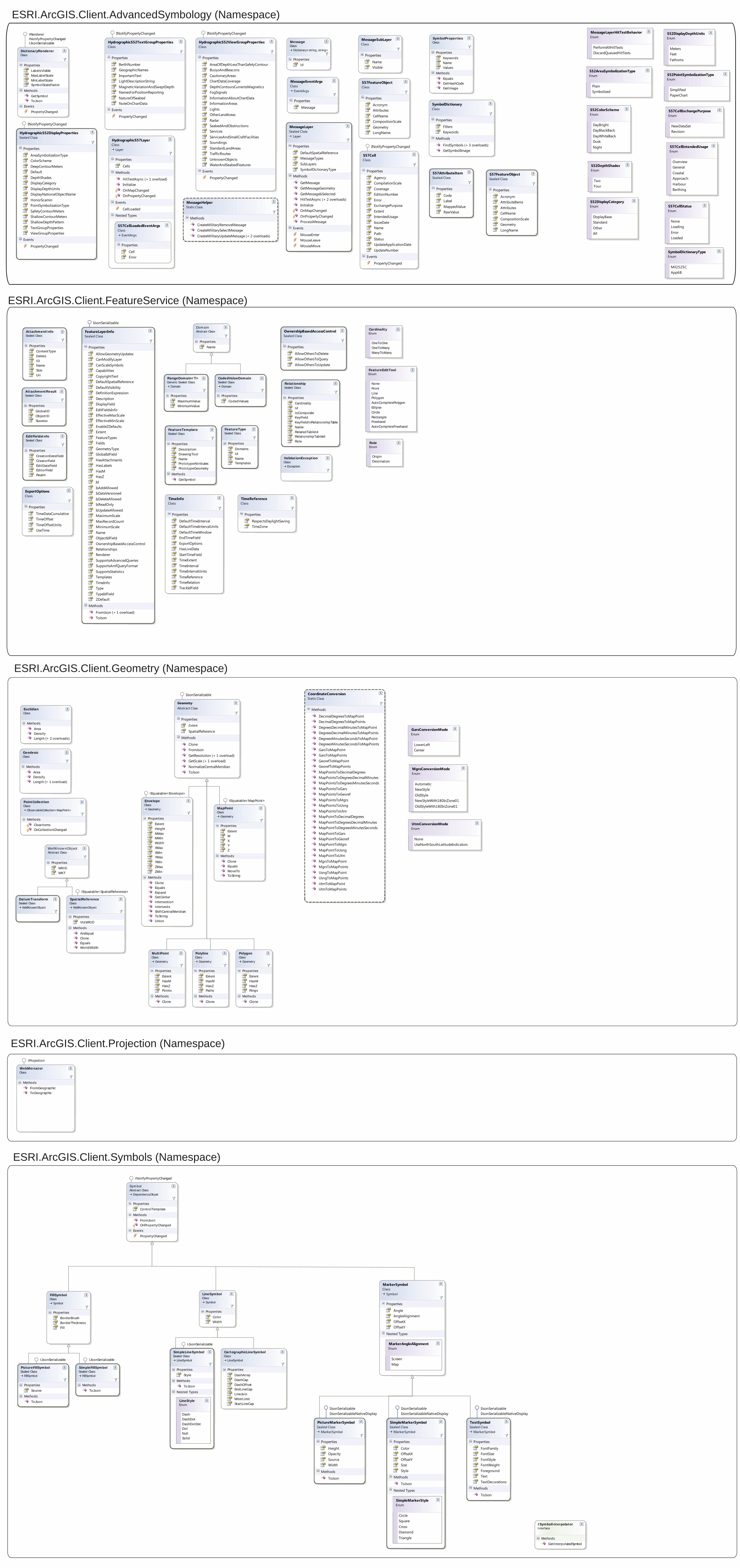
ESRI.ArcGIS.Client.AdvancedSymbology (Namespace)
ESRI.ArcGIS.Client.FeatureService (Namespace)
ESRI.ArcGIS.Client.Geometry (Namespace)
ESRI.ArcGIS.Client.Projection (Namespace)
ESRI.ArcGIS.Client.Symbols (Namespace)
AttachmentInfoSealed Class
Properties
ContentTypeDeleteIDNameSizeUri
AttachmentResultSealed Class
Properties
GlobalIDObjectIDSuccess
EditFieldsInfoSealed Class
Properties
CreationDateFieldCreatorFieldEditDateFieldEditorFieldRealm
FeatureTemplateSealed Class
Properties
DescriptionDrawingToolNamePrototypeAttributesPrototypeGeometry
Methods
GetSymbol
FeatureTypeSealed Class
Properties
DomainsIdNameTemplates
RelationshipSealed Class
Properties
CardinalityIdIsCompositeKeyFieldKeyFieldInRelationshipTableNameRelatedTableIdRelationshipTableIdRole
ValidationException
ExceptionClass
CardinalityEnum
OneToOneOneToManyManyToMany
FeatureEditToolEnum
NonePointLinePolygonAutoCompletePolygonEllipseCircleRectangleFreehandAutoCompleteFreehand
RoleEnum
OriginDestination
CodedValueDomain
DomainSealed Class
Properties
CodedValues
Dom ainAbstract Class
Properties
Name
RangeDomain<T>
DomainGeneric Sealed Class
Properties
MaximumValueMinimumValue
EuclidianClass
Methods
AreaDensifyLength (+ 2 overloads)
GeodesicClass
Methods
AreaDensifyLength (+ 1 overload)
PointCollection
ObservableCollection<MapPoint>Class
Methods
ClearItemsOnCollectionChanged
DatumTransform
WellKnownObjectSealed Class
SpatialReference
WellKnownObjectClass
Properties
VcsWKID
Methods
AreEqualCloneEqualsWorldWidth
WellKnow nObjectAbstract Class
Properties
WKIDWKT
IEquatable<SpatialReference>
Envelope
GeometryClass
Properties
ExtentHeightMMaxMMinWidthXMaxXMinYMaxYMinZMaxZMin
Methods
CloneEqualsExpandGetCenterIntersectionIntersectsShiftCentralMeridianToStringUnion
MapPoint
GeometryClass
Properties
ExtentMXYZ
Methods
CloneEqualsMoveToToString
MultiPoint
GeometryClass
Properties
ExtentHasMHasZPoints
Methods
Clone
Polygon
GeometryClass
Properties
ExtentHasMHasZRings
Methods
Clone
Polyline
GeometryClass
Properties
ExtentHasMHasZPaths
Methods
Clone
IEquatable<Envelope>
IEquatable<MapPoint>
WebMercatorClass
Methods
FromGeographicToGeographic
IProjection
CartographicLineSymbol
LineSymbolClass
Properties
DashArrayDashCapDashOffsetEndLineCapLineJoinMiterLimitStartLineCap
FillSymbol
SymbolClass
Properties
BorderBrushBorderThicknessFill
LineSymbol
SymbolClass
Properties
ColorWidth
PictureFillSymbol
FillSymbolSealed Class
Properties
Source
Methods
ToJson
SimpleFillSymbol
FillSymbolSealed Class
Methods
ToJson
SimpleLineSymbol
LineSymbolSealed Class
Properties
Style
Methods
ToJson
Nested Types
LineStyleEnum
DashDashDotDashDotDotDotNullSolid
Sym bol
DependencyObjectAbstract Class
Properties
ControlTemplate
Methods
FromJsonOnPropertyChanged
Events
PropertyChanged
IJsonSerializable IJsonSerializable
IJsonSerializable
INotifyPropertyChanged
ISymbolInterpolatorInterface
Methods
GetInterpolatedSymbol
DictionaryRendererClass
Properties
LabelsVisibleMaxLabelScaleMinLabelScaleSymbolScaleFactor
Methods
GetSymbolToJson
Events
PropertyChanged
Message
Dictionary<string, string>Class
Properties
Id
SymbolPropertiesClass
Properties
KeywordsNameValues
Methods
EqualsGetHashCodeGetImage
IRendererINotifyPropertyChangedIJsonSerializable
S52AreaSymbolizationTypeEnum
PlainSymbolized
S52PointSymbolizationTypeEnum
SimplifiedPaperChart
S52ColorSchemeEnum
DayBrightDayBlackBackDayWhiteBackDuskNight
S52DepthShadesEnum
TwoFour
S52DisplayDepthUnitsEnum
MetersFeetFathoms
S52DisplayCategoryEnum
DisplayBaseStandardOtherAll
HydrographicS52DisplayPropertiesSealed Class
Properties
AreaSymbolizationTypeColorSchemeDeepContourMetersDefaultDepthShadesDisplayCategoryDisplayDepthUnitsDisplayNationalObjectNameHonorScaminPointSymbolizationTypeSafetyContourMetersShallowContourMetersShallowDepthPatternTextGroupPropertiesViewGroupProperties
Events
PropertyChanged
HydrographicS52TextGroupPropertiesClass
Properties
BerthNumberGeographicNamesImportantTextLightDescriptionStringMagneticVariationAndSweptDepthNamesForPositionReportingNatureOfSeabedNoteOnChartData
Events
PropertyChanged
HydrographicS52ViewGroupPropertiesClass
Properties
AreaOfDepthLessThanSafetyContourBuoysAndBeaconsCautionaryAreasChartDataCoverageDepthContoursCurrentsMagneticsFogSignalsInformationAboutChartDataInformationAreasLightsOtherLandAreasRadarSeabedAndObstructionsServicesServicesAndSmallCraftFacilitiesSoundingsStandardLandAreasTrafficRoutesUnknownObjectsWaterAndSeabedFeatures
Events
PropertyChanged
HydrographicS57Layer
LayerClass
Properties
Cells
Methods
HitTestAsync (+ 1 overload)InitializeOnMapChangedOnPropertyChanged
Events
CellLoaded
Nested Types
S57CellLoadedEventArgs
EventArgsClass
Properties
CellError
MessageHelperStatic Class
Methods
CreateMilitaryRemoveMessageCreateMilitarySelectMessageCreateMilitaryUpdateMessage (+ 2 overloads)
MessageEventArgs
EventArgsClass
Properties
Message
MessageLayerHitTestBehaviorEnum
PerformAllHitTestsDiscardQueuedHitTests
MessageLayer
LayerSealed Class
Properties
DefaultSpatialReferenceMessageTypesSubLayersSymbolDictionaryType
Methods
GetMessageGetMessageGeometryGetMessageIsSelectedHitTestAsync (+ 2 overloads)InitializeOnMapChangedOnPropertyChangedProcessMessage
Events
MouseEnterMouseLeaveMouseMove
SymbolDictionaryTypeEnum
Mil2525CApp6B
MessageSubLayerClass
Properties
NameVisible
S57CellStatusEnum
NoneLoadingErrorLoaded
S57CellExchangePurposeEnum
NewDataSetRevision
S57CellIntendedUsageEnum
OverviewGeneralCoastalApproachHarbourBerthing
S57CellClass
Properties
AgencyCompilationScaleCoverageEditionNumberErrorExchangePurposeExtentIntendedUsageIssueDateNamePathStatusUpdateApplicationDateUpdateNumber
Events
PropertyChanged
S57FeatureObjectClass
Properties
AcronymAttributesCellNameCompositionScaleGeometryLongName
SymbolDictionaryClass
Properties
FiltersKeywords
Methods
FindSymbols (+ 3 overloads)GetSymbolImage
CoordinateConversionStatic Class
Methods
DecimalDegreesToMapPointDecimalDegreesToMapPointsDegreesDecimalMinutesToMapPointDegreesDecimalMinutesToMapPointsDegreesMinutesSecondsToMapPointDegreesMinutesSecondsToMapPointsGarsToMapPointGarsToMapPointsGeorefToMapPointGeorefToMapPointsMapPointsToDecimalDegreesMapPointsToDegreesDecimalMinutesMapPointsToDegreesMinutesSecondsMapPointsToGarsMapPointsToGeorefMapPointsToMgrsMapPointsToUsngMapPointsToUtmMapPointToDecimalDegreesMapPointToDegreesDecimalMinutesMapPointToDegreesMinutesSecondsMapPointToGarsMapPointToGeorefMapPointToMgrsMapPointToUsngMapPointToUtmMgrsToMapPointMgrsToMapPointsUsngToMapPointUsngToMapPointsUtmToMapPointUtmToMapPoints
GarsConversionModeEnum
LowerLeftCenter
UtmConversionModeEnum
NoneUseNorthSouthLatitudeIndicators
MgrsConversionModeEnum
AutomaticNewStyleOldStyleNewStyleWith180InZone01OldStyleWith180InZone01
GeometryAbstract Class
Properties
Extent
SpatialReference
Methods
CloneFromJsonGetResolution (+ 1 overload)GetScale (+ 1 overload)NormalizeCentralMeridianToJson
OwnershipBasedAccessControlSealed Class
Properties
AllowOthersToDeleteAllowOthersToQueryAllowOthersToUpdate
INotifyPropertyChanged
INotifyPropertyChanged INotifyPropertyChanged
INotifyPropertyChanged
IJsonSerializable
S57AttributeItemSealed Class
Properties
CodeLabelMappedValueRawValue
S57FeatureObjectSealed Class
Properties
AcronymAttributeItemsAttributesCellNameCompositionScaleGeometryLongName
FeatureLayerInfoSealed Class
Properties
AllowGeometryUpdatesCanModifyLayerCanScaleSymbolsCapabilitiesCopyrightTextDefaultSpatialReferenceDefaultVisibilityDefinitionExpressionDescriptionDisplayFieldEditFieldsInfoEffectiveMaxScaleEffectiveMinScaleEnableZDefaultsExtentFeatureTypesFieldsGeometryTypeGlobalIdFieldHasAttachmentsHasLabelsHasMHasZIdIsAddAllowedIsDataVersionedIsDeleteAllowedIsReadOnlyIsUpdateAllowedMaximumScaleMaxRecordCountMinimumScaleNameObjectIdFieldOwnershipBasedAccessControlRelationshipsRendererSupportsAdvancedQueriesSupportsAmfQueryFormatSupportsStatisticsTemplatesTimeInfoTypeTypeIdFieldZDefault
Methods
FromJson (+ 1 overload)ToJson
TimeInfoClass
Properties
DefaultTimeIntervalDefaultTimeIntervalUnitsDefaultTimeWindowEndTimeFieldExportOptionsHasLiveDataStartTimeFieldTimeExtentTimeIntervalTimeIntervalUnitsTimeReferenceTimeRelationTrackIdField
TimeReferenceClass
Properties
RespectsDaylightSavingTimeZone
ExportOptionsClass
Properties
TimeDataCumulativeTimeOffsetTimeOffsetUnitsUseTime
MarkerSymbol
SymbolClass
Properties
AngleAngleAlignmentOffsetXOffsetY
Nested Types
MarkerAngleAlignmentEnum
ScreenMap
PictureMarkerSymbol
MarkerSymbolSealed Class
Properties
HeightOpacitySourceWidth
Methods
ToJson
SimpleMarkerSymbol
MarkerSymbolSealed Class
Properties
ColorOffsetXOffsetYSizeStyle
Methods
ToJson
Nested Types
SimpleMarkerStyleEnum
CircleSquareCrossDiamondTriangle
TextSymbol
MarkerSymbolSealed Class
Properties
FontFamilyFontSizeFontStyleFontWeightForegroundTextTextDecorations
Methods
ToJson
IJsonSerializable
IJsonSerializableIJsonSerializableNativeDisplay
IJsonSerializableIJsonSerializableNativeDisplay
IJsonSerializableIJsonSerializableNativeDisplay
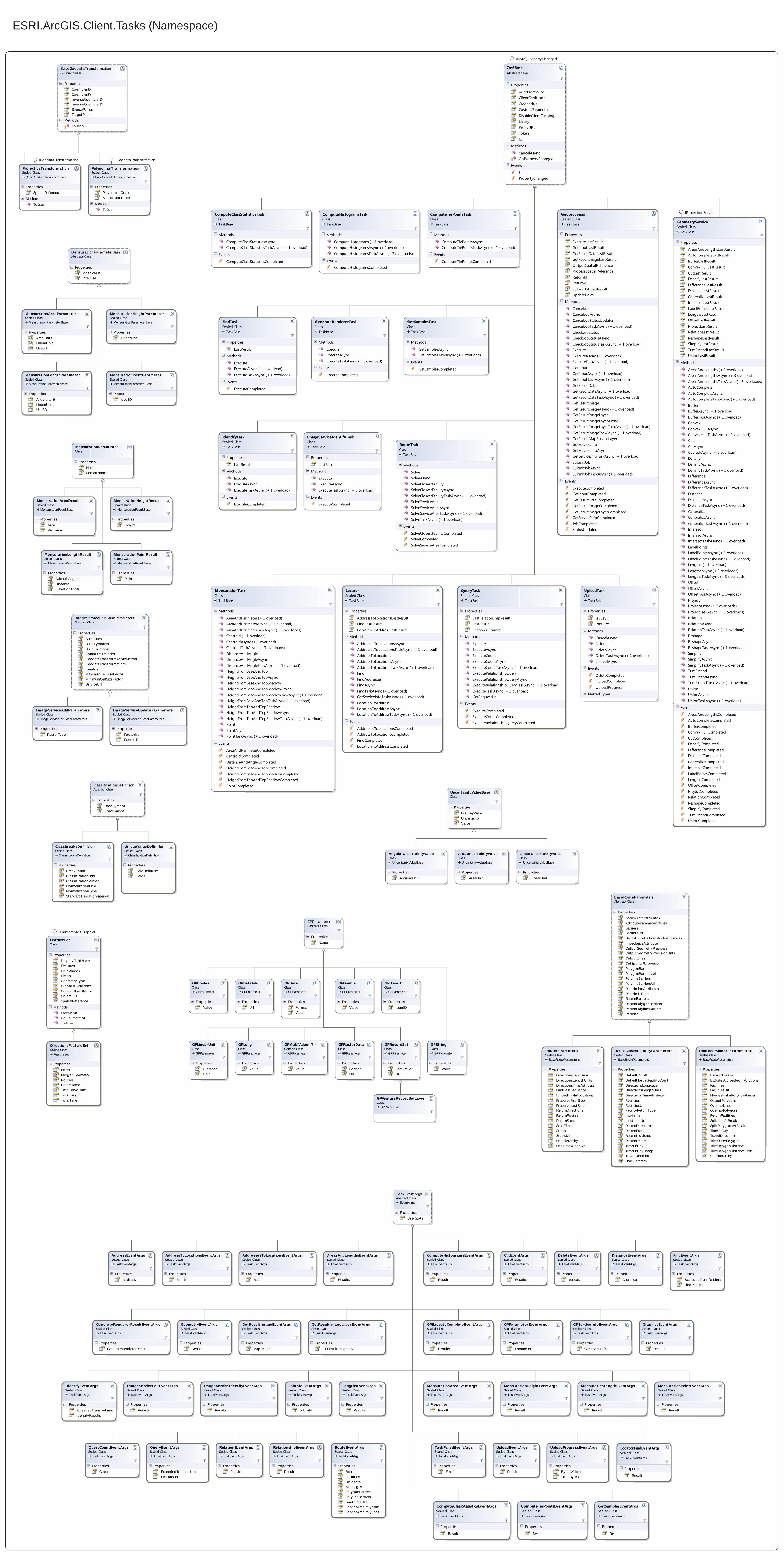
ESRI.ArcGIS.Client.Tasks (Namespace)
DirectionsFeatureSet
FeatureSetSealed Class
Properties
ExtentMergedGeometryRouteIDRouteNameTotalDriveTimeTotalLengthTotalTime
GPBoolean
GPParameterClass
Properties
Value
GPDataFile
GPParameterClass
Properties
Url
GPDate
GPParameterClass
Properties
FormatValue
GPDouble
GPParameterClass
Properties
Value
GPFeatureRecordSetLayer
GPRecordSetClass
GPItemID
GPParameterClass
Properties
ItemID
GPLinearUnit
GPParameterClass
Properties
DistanceUnit
GPLong
GPParameterClass
Properties
Value
GPMultiValue<T>
GPParameterGeneric Class
Properties
Value
GPParam eterAbstract Class
Properties
Name
GPRasterData
GPParameterClass
Properties
FormatUrl
GPRecordSet
GPParameterClass
Properties
FeatureSetUrl
GPString
GPParameterClass
Properties
Value
UncertaintyValueBaseClass
Properties
DisplayValueUncertaintyValue
LinearUncertaintyValue
UncertaintyValueBaseClass
Properties
LinearUnit
AreaUncertaintyValue
UncertaintyValueBaseClass
Properties
AreaUnit
AngularUncertaintyValue
UncertaintyValueBaseClass
Properties
AngularUnit
Mensurat ionParam eterBaseAbstract Class
Properties
MosaicRulePixelSize
MensurationLengthParameter
MensurationParameterBaseSealed Class
Properties
AngularUnitLinearUnitUse3D
MensurationAreaParameter
MensurationParameterBaseSealed Class
Properties
AreaUnitsLinearUnitUse3D
MensurationHeightParameter
MensurationParameterBaseSealed Class
Properties
LinearUnit
MensurationPointParameter
MensurationParameterBaseSealed Class
Properties
Use3D
BaseRouteParametersAbstract Class
Properties
AccumulateAttributesAttributeParameterValuesBarriersBarriersUrlDoNotLocateOnRestrictedElementsImpedanceAttributeOutputGeometryPrecis ionOutputGeometryPrecis ionUnitsOutputLinesOutSpatialReferencePolygonBarriersPolygonBarriersUrlPolylineBarriersPolylineBarriersUrlRestrictionAttributesRestrictUTurnsReturnBarriersReturnPolygonBarriersReturnPolylineBarriersReturnZ
RouteParameters
BaseRouteParametersSealed Class
Properties
DirectionsLanguageDirectionsLengthUnitsDirectionsTimeAttributeFindBestSequenceIgnoreInvalidLocationsPreserveFirstStopPreserveLastStopReturnDirectionsReturnRoutesReturnStopsStartTimeStopsStopsUrlUseHierarchyUseTimeWindows
RouteClosestFacilityParameters
BaseRouteParametersSealed Class
Properties
DefaultCutoffDefaultTargetFacilityCountDirectionsLanguageDirectionsLengthUnitsDirectionsTimeAttributeFacilitiesFacilitiesUrlFacilityReturnTypeIncidentsIncidentsUrlReturnDirectionsReturnFacilitiesReturnIncidentsReturnRoutesTimeOfDayTimeOfDayUsageTravelDirectionUseHierarchy
RouteServiceAreaParameters
BaseRouteParametersSealed Class
Properties
DefaultBreaksExcludeSourcesFromPolygonsFacilitiesFacilitiesUrlMergeSimilarPolygonRangesOutputPolygonsOverlapLinesOverlapPolygonsReturnFacilitiesSplitLineAtBreaksSplitPolygonsAtBreaksTimeOfDayTravelDirectionTrimOuterPolygonTrimPolygonDistanceTrimPolygonDistanceUnitsUseHierarchy
ComputeHistogramsEventArgs
TaskEventArgsSealed Class
Properties
Result
GraphicsEventArgs
TaskEventArgsSealed Class
Properties
Results
CutEventArgs
TaskEventArgsSealed Class
Properties
Results
GeometryEventArgs
TaskEventArgsSealed Class
Properties
Result
TaskEventArgs
EventArgsAbstract Class
Properties
UserState
TaskFailedEventArgs
TaskEventArgsSealed Class
Properties
Error
QueryEventArgs
TaskEventArgsSealed Class
Properties
ExceededTransferLimitFeatureSet
QueryCountEventArgs
TaskEventArgsSealed Class
Properties
Count
IdentifyEventArgs
TaskEventArgsSealed Class
Properties
ExceededTransferLimitIdentifyResults
FindEventArgs
TaskEventArgsSealed Class
Properties
ExceededTransferLimitFindResults
LengthsEventArgs
TaskEventArgsSealed Class
Properties
Results
DistanceEventArgs
TaskEventArgsSealed Class
Properties
Distance
AreasAndLengthsEventArgs
TaskEventArgsSealed Class
Properties
Results
RelationEventArgs
TaskEventArgsSealed Class
Properties
Results
AddressToLocationsEventArgs
TaskEventArgsSealed Class
Properties
Results
GPExecuteCompleteEventArgs
TaskEventArgsSealed Class
Properties
Results
JobInfoEventArgs
TaskEventArgsSealed Class
Properties
JobInfo
GPServiceInfoEventArgs
TaskEventArgsSealed Class
Properties
GPServiceInfo
GPParameterEventArgs
TaskEventArgsSealed Class
Properties
Parameter
GetResultImageEventArgs
TaskEventArgsSealed Class
Properties
MapImage
GetResultImageLayerEventArgs
TaskEventArgsSealed Class
Properties
GPResultImageLayer
AddressEventArgs
TaskEventArgsSealed Class
Properties
Address
AddressesToLocationsEventArgs
TaskEventArgsSealed Class
Properties
Result
GenerateRendererResultEventArgs
TaskEventArgsSealed Class
Properties
GenerateRendererResult
UploadEventArgs
TaskEventArgsSealed Class
Properties
Result
DeleteEventArgs
TaskEventArgsSealed Class
Properties
Success
UploadProgressEventArgs
TaskEventArgsSealed Class
Properties
BytesWrittenTotalBytes
ImageServiceEditEventArgs
TaskEventArgsSealed Class
Properties
Results
ImageServiceIdentifyEventArgs
TaskEventArgsSealed Class
Properties
Results
MensurationHeightEventArgs
TaskEventArgsSealed Class
Properties
Result
MensurationLengthEventArgs
TaskEventArgsSealed Class
Properties
Result
MensurationPointEventArgs
TaskEventArgsSealed Class
Properties
Result
MensurationAreaEventArgs
TaskEventArgsSealed Class
Properties
Result
RelationshipEventArgs
TaskEventArgsSealed Class
Properties
Result
RouteEventArgs
TaskEventArgsSealed Class
Properties
BarriersFacilitiesIncidentsMessagesPolygonBarriersPolylineBarriersRouteResultsServiceAreaPolygonsServiceAreaPolylines
MensurationResultBaseClass
Properties
NameSensorName
MensurationHeightResult
MensurationResultBaseSealed Class
Properties
Height
MensurationLengthResult
MensurationResultBaseSealed Class
Properties
AzimuthAngleDistanceElevationAngle
MensurationAreaResult
MensurationResultBaseSealed Class
Properties
AreaPerimeter
MensurationPointResult
MensurationResultBaseSealed Class
Properties
Point
Im ageServiceEditBaseParametersAbstract Class
Properties
AttributesBuildPyramidsBuildThumbnailComputeStatisticsGeodataTransformApplyMethodGeodataTransformationsItemIdsMaximumCellSizeFactorMinimumCellSizeFactorServiceUrl
ImageServiceAddParameters
ImageServiceEditBaseParametersSealed Class
Properties
RasterType
ImageServiceUpdateParameters
ImageServiceEditBaseParametersSealed Class
Properties
FootprintRasterID
Classificat ionDefinit ionAbstract Class
Properties
BaseSymbolColorRamps
ClassBreaksDefinition
ClassificationDefinitionSealed Class
Properties
BreakCountClassificationFieldClassificationMethodNormalizationFieldNormalizationTypeStandardDeviationInterval
UniqueValueDefinition
ClassificationDefinitionSealed Class
Properties
FieldDelimiterFields
BaseGeodataTransformationAbstract Class
Properties
CoefficientXCoefficientYInverseCoefficientXInverseCoefficientYSourcePointsTargetPoints
Methods
ToJson
ProjectiveTransformation
BaseGeodataTransformationSealed Class
Properties
SpatialReference
Methods
ToJson
PolynomialTransformation
BaseGeodataTransformationSealed Class
Properties
PolynomialOrderSpatialReference
Methods
ToJson
IGeodataTransformation IGeodataTransformation
FeatureSetClass
Properties
DisplayFieldNameFeaturesFieldAliasesFieldsGeometryTypeGlobalIdFieldNameObjectIdFieldNameObjectIDsSpatialReference
Methods
FromJsonGetEnumeratorToJson
IEnumerable<Graphic>
LocatorFindEventArgs
TaskEventArgsSealed Class
Properties
Result
ComputeClassStatisticsEventArgs
TaskEventArgsSealed Class
Properties
Result
ComputeClassStatisticsTask
TaskBaseClass
Methods
ComputeClassStatisticsAsyncComputeClassStatisticsTaskAsync (+ 1 overload)
Events
ComputeClassStatisticsCompleted
ComputeHistogramsTask
TaskBaseClass
Methods
ComputeHistograms (+ 1 overload)ComputeHistogramsAsync (+ 1 overload)ComputeHistogramsTaskAsync (+ 3 overloads)
Events
ComputeHistogramsCompleted
ComputeTiePointsEventArgs
TaskEventArgsSealed Class
Properties
Result
ComputeTiePointsTask
TaskBaseClass
Methods
ComputeTiePointsAsyncComputeTiePointsTaskAsync (+ 1 overload)
Events
ComputeTiePointsCompleted
FindTask
TaskBaseSealed Class
Properties
LastResult
Methods
ExecuteExecuteAsync (+ 1 overload)ExecuteTaskAsync (+ 1 overload)
Events
ExecuteCompleted
GenerateRendererTask
TaskBaseClass
Methods
ExecuteExecuteAsyncExecuteTaskAsync (+ 1 overload)
Events
ExecuteCompleted
GeometryService
TaskBaseSealed Class
Properties
AreasAndLengthsLastResultAutoCompleteLastResultBufferLastResultConvexHullLastResultCutLastResultDensifyLastResultDifferenceLastResultDistanceLastResultGeneralizeLastResultIntersectLastResultLabelPointsLastResultLengthsLastResultOffsetLastResultProjectLastResultRelationLastResultReshapeLastResultSimplifyLastResultTrimExtendLastResultUnionLastResult
Methods
AreasAndLengths (+ 1 overload)AreasAndLengthsAsync (+ 3 overloads)AreasAndLengthsTaskAsync (+ 5 overloads)AutoCompleteAutoCompleteAsyncAutoCompleteTaskAsync (+ 1 overload)BufferBufferAsync (+ 1 overload)BufferTaskAsync (+ 1 overload)ConvexHullConvexHullAsyncConvexHullTaskAsync (+ 1 overload)CutCutAsyncCutTaskAsync (+ 1 overload)DensifyDensifyAsyncDensifyTaskAsync (+ 1 overload)DifferenceDifferenceAsyncDifferenceTaskAsync (+ 1 overload)DistanceDistanceAsyncDistanceTaskAsync (+ 1 overload)GeneralizeGeneralizeAsyncGeneralizeTaskAsync (+ 1 overload)IntersectIntersectAsyncIntersectTaskAsync (+ 1 overload)LabelPointsLabelPointsAsync (+ 1 overload)LabelPointsTaskAsync (+ 1 overload)Lengths (+ 1 overload)LengthsAsync (+ 2 overloads)LengthsTaskAsync (+ 3 overloads)OffsetOffsetAsyncOffsetTaskAsync (+ 1 overload)ProjectProjectAsync (+ 2 overloads)ProjectTaskAsync (+ 3 overloads)RelationRelationAsyncRelationTaskAsync (+ 1 overload)ReshapeReshapeAsyncReshapeTaskAsync (+ 1 overload)SimplifySimplifyAsyncSimplifyTaskAsync (+ 1 overload)TrimExtendTrimExtendAsyncTrimExtendTaskAsync (+ 1 overload)UnionUnionAsyncUnionTaskAsync (+ 1 overload)
Events
AreasAndLengthsCompletedAutoCompleteCompletedBufferCompletedConvexHullCompletedCutCompletedDensifyCompletedDifferenceCompletedDistanceCompletedGeneralizeCompletedIntersectCompletedLabelPointsCompletedLengthsCompletedOffsetCompletedProjectCompletedRelationCompletedReshapeCompletedSimplifyCompletedTrimExtendCompletedUnionCompleted
Geoprocessor
TaskBaseSealed Class
Properties
ExecuteLastResultGetInputLastResultGetResultDataLastResultGetResultImageLastResultOutputSpatialReferenceProcessSpatialReferenceReturnMReturnZSubmitJobLastResultUpdateDelay
Methods
CancelJobCancelJobAsyncCancelJobStatusUpdatesCancelJobTaskAsync (+ 1 overload)CheckJobStatusCheckJobStatusAsyncCheckJobStatusTaskAsync (+ 1 overload)ExecuteExecuteAsync (+ 1 overload)ExecuteTaskAsync (+ 1 overload)GetInputGetInputAsync (+ 1 overload)GetInputTaskAsync (+ 1 overload)GetResultDataGetResultDataAsync (+ 1 overload)GetResultDataTaskAsync (+ 1 overload)GetResultImageGetResultImageAsync (+ 1 overload)GetResultImageLayerGetResultImageLayerAsyncGetResultImageLayerTaskAsync (+ 1 overload)GetResultImageTaskAsync (+ 1 overload)GetResultMapServiceLayerGetServiceInfoGetServiceInfoAsyncGetServiceInfoTaskAsync (+ 1 overload)SubmitJobSubmitJobAsyncSubmitJobTaskAsync (+ 1 overload)
Events
ExecuteCompletedGetInputCompletedGetResultDataCompletedGetResultImageCompletedGetResultImageLayerCompletedGetServiceInfoCompletedJobCompletedStatusUpdated
GetSamplesEventArgs
TaskEventArgsSealed Class
Properties
Result
GetSamplesTask
TaskBaseClass
Methods
GetSamplesAsyncGetSamplesTaskAsync (+ 1 overload)
Events
GetSamplesCompleted
IdentifyTask
TaskBaseSealed Class
Properties
LastResult
Methods
ExecuteExecuteAsyncExecuteTaskAsync (+ 1 overload)
Events
ExecuteCompleted
ImageServiceIdentifyTask
TaskBaseClass
Properties
LastResult
Methods
ExecuteExecuteAsyncExecuteTaskAsync (+ 1 overload)
Events
ExecuteCompleted
Locator
TaskBaseSealed Class
Properties
AddressToLocationsLastResultFindLastResultLocationToAddressLastResult
Methods
AddressesToLocationsAsyncAddressesToLocationsTaskAsync (+ 1 overload)AddressToLocationsAddressToLocationsAsyncAddressToLocationsTaskAsync (+ 1 overload)FindFindAddressesFindAsyncFindTaskAsync (+ 1 overload)GetServiceInfoTaskAsync (+ 1 overload)LocationToAddressLocationToAddressAsyncLocationToAddressTaskAsync (+ 1 overload)
Events
AddressesToLocationsCompletedAddressToLocationsCompletedFindCompletedLocationToAddressCompleted
MensurationTask
TaskBaseClass
Methods
AreaAndPerimeter (+ 1 overload)AreaAndPerimeterAsync (+ 1 overload)AreaAndPerimeterTaskAsync (+ 3 overloads)Centroid (+ 1 overload)CentroidAsync (+ 1 overload)CentroidTaskAsync (+ 3 overloads)DistanceAndAngleDistanceAndAngleAsyncDistanceAndAngleTaskAsync (+ 1 overload)HeightFromBaseAndTopHeightFromBaseAndTopAsyncHeightFromBaseAndTopShadowHeightFromBaseAndTopShadowAsyncHeightFromBaseAndTopShadowTaskAsync (+ 1 overload)HeightFromBaseAndTopTaskAsync (+ 1 overload)HeightFromTopAndTopShadowHeightFromTopAndTopShadowAsyncHeightFromTopAndTopShadowTaskAsync (+ 1 overload)PointPointAsyncPointTaskAsync (+ 1 overload)
Events
AreaAndPerimeterCompletedCentroidCompletedDistanceAndAngleCompletedHeightFromBaseAndTopCompletedHeightFromBaseAndTopShadowCompletedHeightFromTopAndTopShadowCompletedPointCompleted
QueryTask
TaskBaseSealed Class
Properties
LastRelationshipResultLastResultResponseFormat
Methods
ExecuteExecuteAsyncExecuteCountExecuteCountAsyncExecuteCountTaskAsync (+ 1 overload)ExecuteRelationshipQueryExecuteRelationshipQueryAsyncExecuteRelationshipQueryTaskAsync (+ 1 overload)ExecuteTaskAsync (+ 1 overload)GetRequestUri
Events
ExecuteCompletedExecuteCountCompletedExecuteRelationshipQueryCompleted
RouteTask
TaskBaseClass
Methods
SolveSolveAsyncSolveClosestFacilitySolveClosestFacilityAsyncSolveClosestFacilityTaskAsync (+ 1 overload)SolveServiceAreaSolveServiceAreaAsyncSolveServiceAreaTaskAsync (+ 1 overload)SolveTaskAsync (+ 1 overload)
Events
SolveClosestFacilityCompletedSolveCompletedSolveServiceAreaCompleted
TaskBaseAbstract Class
Properties
AutoNormalizeClientCertificateCredentialsCustomParametersDisableClientCachingIsBusyProxyURLTokenUrl
Methods
CancelAsyncOnPropertyChanged
Events
FailedPropertyChanged
UploadTask
TaskBaseClass
Properties
IsBusyPartSize
Methods
CancelAsyncDeleteDeleteAsyncDeleteTaskAsync (+ 1 overload)UploadAsync
Events
DeleteCompletedUploadCompletedUploadProgress
Nested Types
IProjectionService
INotifyPropertyChanged
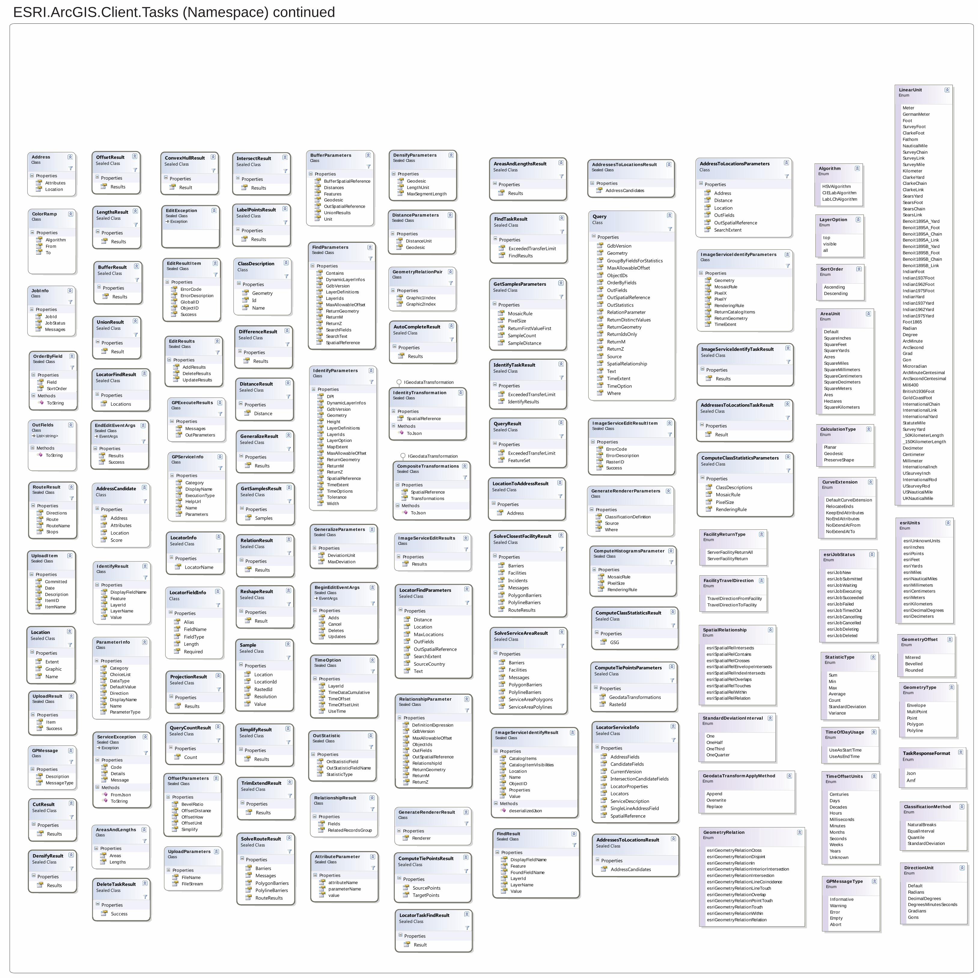
ESRI.ArcGIS.Client.Tasks (Namespace) continued
AddressClass
Properties
AttributesLocation
AddressesToLocationsResultSealed Class
Properties
AddressCandidates
AreasAndLengthsClass
Properties
AreasLengths
BeginEditEventArgs
EventArgsSealed Class
Properties
AddsCancelDeletesUpdates
BufferParametersClass
Properties
BufferSpatialReferenceDistancesFeaturesGeodesicOutSpatialReferenceUnionResultsUnit
AttributeParameterSealed Class
Properties
attributeNameparameterNamevalue
ComputeHistogramsParameterSealed Class
Properties
MosaicRulePixelSizeRenderingRule
CompositeTransformationsSealed Class
Properties
SpatialReferenceTransformations
Methods
ToJson
ColorRampClass
Properties
AlgorithmFromTo
DensifyParametersSealed Class
Properties
GeodesicLengthUnitMaxSegmentLength
DistanceParametersSealed Class
Properties
DistanceUnitGeodesic
IGeodataTransformation
EditException
ExceptionSealed Class
EditResultItemSealed Class
Properties
ErrorCodeErrorDescriptionGlobalIDObjectIDSuccess
EditResultsSealed Class
Properties
AddResultsDeleteResultsUpdateResults
EndEditEventArgs
EventArgsSealed Class
Properties
ResultsSuccess
FindParametersSealed Class
Properties
ContainsDynamicLayerInfosGdbVersionLayerDefinitionsLayerIdsMaxAllowableOffsetReturnGeometryReturnMReturnZSearchFieldsSearchTextSpatialReference
FindResultSealed Class
Properties
DisplayFieldNameFeatureFoundFieldNameLayerIdLayerNameValue
GeneralizeParametersSealed Class
Properties
DeviationUnitMaxDeviation
IdentityTransformationSealed Class
Properties
SpatialReference
Methods
ToJson
GenerateRendererParametersClass
Properties
ClassificationDefinitionSourceWhere
GenerateRendererResultClass
Properties
Renderer
GeometryRelationPairClass
Properties
Graphic1IndexGraphic2Index
GPExecuteResultsClass
Properties
MessagesOutParameters
GPMessageClass
Properties
DescriptionMessageType
GPServiceInfoClass
Properties
CategoryDisplayNameExecutionTypeHelpUrlNameParameters
IdentifyParametersClass
Properties
DPIDynamicLayerInfosGdbVersionGeometryHeightLayerDefinitionsLayerIdsLayerOptionMapExtentMaxAllowableOffsetReturnGeometryReturnMReturnZSpatialReferenceTimeExtentTimeOptionsToleranceWidth
IdentifyResultClass
Properties
DisplayFieldNameFeatureLayerIdLayerNameValue
IGeodataTransformation
ImageServiceEditResultItemSealed Class
Properties
ErrorCodeErrorDescriptionRasterIDSuccess
ImageServiceEditResultsClass
Properties
Results
JobInfoClass
Properties
JobIdJobStatusMessages
ImageServiceIdentifyParametersClass
Properties
GeometryMosaicRulePixelXPixelYRenderingRuleReturnCatalogItemsReturnGeometryTimeExtent
ImageServiceIdentifyResultSealed Class
Properties
CatalogItemsCatalogItemVisibilitiesLocationNameObjectIDPropertiesValue
Methods
deserializedJson
OutFields
List<string>Class
Methods
ToString
OutStatisticSealed Class
Properties
OnStatisticFieldOutStatisticFieldNameStatisticType
OrderByFieldSealed Class
Properties
FieldSortOrder
Methods
ToString
ParameterInfoClass
Properties
CategoryChoiceListDataTypeDefaultValueDirectionDisplayNameNameParameterType
TimeOptionSealed Class
Properties
LayerIdTimeDataCumulativeTimeOffsetTimeOffsetUnitUseTime
RelationshipParameterSealed Class
Properties
DefinitionExpression
MaxAllowableOffsetObjectIdsOutFieldsOutSpatialReferenceRelationshipIdReturnGeometryReturnMReturnZ
RelationshipResultClass
Properties
FieldsRelatedRecordsGroup
RouteResultSealed Class
Properties
DirectionsRouteRouteNameStops
ServiceException
ExceptionSealed Class
Properties
CodeDetailsMessage
Methods
FromJsonToString
UploadParametersClass
Properties
FileNameFileStream
UploadResultSealed Class
Properties
ItemSuccess
UploadItemSealed Class
Properties
CommittedDateDescriptionItemIDItemName
CurveExtensionEnum
DefaultCurveExtensionRelocateEndsKeepEndAttributesNoEndAttributesNoExtendAtFromNoExtendAtTo
FacilityTravelDirectionEnum
TravelDirectionFromFacilityTravelDirectionToFacility
FacilityReturnTypeEnum
ServerFacilityReturnAllServerFacilityReturn
CalculationTypeEnum
PlanarGeodesicPreserveShape
DirectionUnitEnum
DefaultRadiansDecimalDegreesDegreesMinutesSecondsGradiansGons
AreaUnitEnum
DefaultSquareInchesSquareFeetSquareYardsAcresSquareMilesSquareMillimetersSquareCentimetersSquareDecimetersSquareMetersAresHectaresSquareKilometers
ClassificationMethodEnum
NaturalBreaksEqualIntervalQuantileStandardDeviation
AlgorithmEnum
HSVAlgorithmCIELabAlgorithmLabLChAlgorithm
esriUnitsEnum
esriUnknownUnitsesriInchesesriPointsesriFeetesriYardsesriMilesesriNauticalMilesesriMillimetersesriCentimetersesriMetersesriKilometersesriDecimalDegreesesriDecimeters
esriJobStatusEnum
esriJobNewesriJobSubmittedesriJobWaitingesriJobExecutingesriJobSucceededesriJobFailedesriJobTimedOutesriJobCancellingesriJobCancelledesriJobDeletingesriJobDeleted
GeodataTransformApplyMethodEnum
AppendOverwriteReplace
GeometryTypeEnum
EnvelopeMultiPointPointPolygonPolyline
GeometryOffsetEnum
MiteredBevelledRounded
GeometryRelationEnum
esriGeometryRelationCrossesriGeometryRelationDisjointesriGeometryRelationInesriGeometryRelationInteriorIntersectionesriGeometryRelationIntersectionesriGeometryRelationLineCoincidenceesriGeometryRelationLineTouchesriGeometryRelationOverlapesriGeometryRelationPointTouchesriGeometryRelationTouchesriGeometryRelationWithinesriGeometryRelationRelation
StandardDeviationIntervalEnum
OneOneHalfOneThirdOneQuarter
GPMessageTypeEnum
InformativeWarningErrorEmptyAbort
LayerOptionEnum
topvis ibleall
LinearUnitEnum
MeterGermanMeterFootSurveyFootClarkeFootFathomNauticalMileSurveyChainSurveyLinkSurveyMileKilometerClarkeYardClarkeChainClarkeLinkSearsYardSearsFootSearsChainSearsLinkBenoit1895A_YardBenoit1895A_FootBenoit1895A_ChainBenoit1895A_LinkBenoit1895B_YardBenoit1895B_FootBenoit1895B_ChainBenoit1895B_LinkIndianFootIndian1937FootIndian1962FootIndian1975FootIndianYardIndian1937YardIndian1962YardIndian1975YardFoot1865RadianDegreeArcMinuteArcSecondGradGonMicroradianArcMinuteCentesimalArcSecondCentesimalMil6400British1936FootGoldCoastFootInternationalChainInternationalLinkInternationalYardStatuteMileSurveyYard_50KilometerLength_150KilometerLengthDecimeterCentimeterMillimeterInternationalInchUSsurveyInchInternationalRodUSsurveyRodUSNauticalMileUKNauticalMile
StatisticTypeEnum
SumMinMaxAverageCountStandardDeviationVariance
SortOrderEnum
AscendingDescending
TimeOfDayUsageEnum
UseAsStartTimeUseAsEndTime
SpatialRelationshipEnum
esriSpatialRelIntersectsesriSpatialRelContainsesriSpatialRelCrossesesriSpatialRelEnvelopeIntersectsesriSpatialRelIndexIntersectsesriSpatialRelOverlapsesriSpatialRelTouchesesriSpatialRelWithinesriSpatialRelRelation
TimeOffsetUnitsEnum
CenturiesDaysDecadesHoursMillisecondsMinutesMonthsSecondsWeeksYearsUnknown
OffsetParametersSealed Class
Properties
BevelRatioOffsetDistanceOffsetHowOffsetUnitSimplify
AddressToLocationsParametersClass
Properties
AddressDistanceLocationOutFieldsOutSpatialReferenceSearchExtent
LocationSealed Class
Properties
ExtentGraphicName
LocatorFindParametersSealed Class
Properties
DistanceLocationMaxLocationsOutFieldsOutSpatialReferenceSearchExtentSourceCountryText
LocatorFindResultSealed Class
Properties
Locations
AddressesToLocationsResultSealed Class
Properties
AddressCandidates
ComputeClassStatisticsParametersSealed Class
Properties
ClassDescriptionsMosaicRulePixelSizeRenderingRule
ClassDescriptionClass
Properties
GeometryIdName
ComputeClassStatisticsResultSealed Class
Properties
GSG
ComputeTiePointsParametersSealed Class
Properties
GeodataTransformationsRasterId
ComputeTiePointsResultSealed Class
Properties
SourcePointsTargetPoints
FindTaskResultSealed Class
Properties
ExceededTransferLimitFindResults
AreasAndLengthsResultSealed Class
Properties
Results
BufferResultSealed Class
Properties
Results
LabelPointsResultSealed Class
Properties
Results
LengthsResultSealed Class
Properties
Results
ProjectionResultSealed Class
Properties
Results
SimplifyResultSealed Class
Properties
Results
RelationResultSealed Class
Properties
Results
AutoCompleteResultSealed Class
Properties
Results
ConvexHullResultSealed Class
Properties
Result
CutResultSealed Class
Properties
Results
DensifyResultSealed Class
Properties
Results
DifferenceResultSealed Class
Properties
Results
DistanceResultSealed Class
Properties
Distance
GeneralizeResultSealed Class
Properties
Results
IntersectResultSealed Class
Properties
Results
OffsetResultSealed Class
Properties
Results
ReshapeResultSealed Class
Properties
Result
TrimExtendResultSealed Class
Properties
Results
UnionResultSealed Class
Properties
Result
GetSamplesParametersSealed Class
Properties
MosaicRulePixelSizeReturnFirstValueFirstSampleCountSampleDistance
GetSamplesResultSealed Class
Properties
Samples
SampleSealed Class
Properties
LocationLocationIdRastedIdResolutionValue
IdentifyTaskResultSealed Class
Properties
ExceededTransferLimitIdentifyResults
ImageServiceIdentifyTaskResultSealed Class
Properties
Results
AddressCandidateClass
Properties
AddressAttributesLocationScore
LocatorServiceInfoSealed Class
Properties
AddressFieldsCandidateFieldsCurrentVersionIntersectionCandidateFieldsLocatorPropertiesLocatorsServiceDescriptionSingleLineAddressFieldSpatialReference
LocatorInfoSealed Class
Properties
LocatorName
LocatorFieldInfoClass
Properties
AliasFieldNameFieldTypeLengthRequired
LocationToAddressResultSealed Class
Properties
Address
AddressesToLocationsTaskResultSealed Class
Properties
Result
LocatorTaskFindResultSealed Class
Properties
Result
QueryClass
Properties
GdbVersionGeometryGroupByFieldsForStatisticsMaxAllowableOffsetObjectIDsOrderByFieldsOutFieldsOutSpatialReferenceOutStatisticsRelationParameterReturnDistinctValuesReturnGeometryReturnIdsOnlyReturnMReturnZSourceSpatialRelationshipTextTimeExtentTimeOptionWhere
QueryResultSealed Class
Properties
ExceededTransferLimitFeatureSet
QueryCountResultSealed Class
Properties
Count
SolveRouteResultSealed Class
Properties
BarriersMessagesPolygonBarriersPolylineBarriersRouteResults
SolveClosestFacilityResultSealed Class
Properties
BarriersFacilitiesIncidentsMessagesPolygonBarriersPolylineBarriersRouteResults
SolveServiceAreaResultSealed Class
Properties
BarriersFacilitiesMessagesPolygonBarriersPolylineBarriersServiceAreaPolygonsServiceAreaPolylines
DeleteTaskResultSealed Class
Properties
Success
TaskResponseFormatEnum
JsonAmf
GdbVersion