Embed Size (px)
Citation preview
Aquatic EcologyTeacher Guide
Rocky Mountain National Park ServiceU.S. Department of Interior
Rocky Mountain National Park

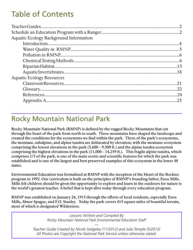
Lessons Written and Compiled ByRocky Mountain National Park Environmental Education Staff
---Teacher Guide Created by Nicole Sedgeley (11/2012) and Julia Temple (5/2013)
All Photos are Copyright the National Park Service unless otherwise stated.
Rocky Mountain National ParkRocky Mountain National Park (RMNP) is defined by the rugged Rocky Mountains that cut through the heart of the park from north to south. These mountains have shaped the landscape and created the conditions for the ecosystems we find within the park. Three of the park’s ecosystems, the montane, subalpine, and alpine tundra are delineated by elevation, with the montane ecosystem comprising the lowest elevations in the park (5,600 – 9,500 ft.) and the alpine tundra ecosystem comprising the highest elevations in the park (11,000 – 14,259 ft.). This fragile alpine tundra, which comprises 1/3 of the park, is one of the main scenic and scientific features for which the park was established and is one of the largest and best preserved examples of this ecosystem in the lower 48 states.
Environmental Education was formalized at RMNP with the inception of the Heart of the Rockies program in 1992. Our curriculum is built on the principles of RMNP’s founding father, Enos Mills. Mills felt children should be given the opportunity to explore and learn in the outdoors for nature is the world’s greatest teacher. A belief that is kept alive today through every education program.
RMNP was established on January 26, 1915 through the efforts of local residents, especially Enos Mills, Abner Spague, and F.O. Stanley. Today the park covers 415 square miles of beautiful terrain, most of which is designated Wilderness.
Table of Contents
Teacher Guides..............................................................................................................................2Schedule an Education Program with a Ranger.......................................................................2Aquatic Ecology Background Information Introduction........................................................................................................................4 Water Quality in RMNP...................................................................................................5 Pollution in RMNP............................................................................................................6 Chemical Testing Methods................................................................................................6 Riparian Habitat...............................................................................................................15 Aquatic Invertebrates.......................................................................................................18Aquatic Ecology Resources Classroom Resources.......................................................................................................21 Glossary.............................................................................................................................22 References.........................................................................................................................24 Appendix A......................................................................................................................25
Rocky Mountain National Park Education Program Goals
1. Increase accessibility to Rocky Mountain National Park for students from our gateway communities and under-served students who otherwise would not have the opportunity to visit the park.
2. Develop a variety of internal and external partnerships with other park operations, school districts, universities, professional educational organizations, agencies, friends groups, and various funding organizations.
3. Conduct workshops to train teachers to take a larger role in their student’s experience at Rocky Mountain National Park.
4. Develop distance learning opportunities to serve students from outside our visiting area.
Schedule an Education Program with a RangerField trips to national parks offer unique opportunities for studying and experiencing natural and cultural resources. Field trips are a great way to make abstract concepts from the classroom concrete. RMNP is an ideal outdoor classroom. It has a diversity of natural resources, easy spring and fall access, and is in close proximity to Front Range and Grand County communities.
Rocky Mountain National Park, like many national parks, offers ranger-led education programs. Heart of the Rockies, Rocky’s education program, provides free field and classroom based education programs, aligned to Colorado education standards. School groups should make reservations at least 6 months in advance. National Park entrance fee waivers may also be available for school visits. For further information or to schedule a program please contact Mark DeGregorio, Education Program Manager, at (970) 586-3777.
A variety of ranger-led education programs are offered seasonally. Programs in the spring and fall are generally similar focusing on a variety of park topics; programs in the winter are limited to snowshoeing programs and classroom programs focusing on winter. To see a list of the latest available programs please visit http://www.nps.gov/romo/forteachers/planafieldtrip.htm.
Teacher Guides Teacher guides have been developed by the education staff at RMNP and each focuses on a topic of significance to the Park. These guides serve as an introductory resource to the topic and the information provided is used by park educators to develop curriculum based education programs. Guides benefit teachers by providing the background information necessary to build a strong foundation for teaching students about specific park related topics; they may also be used as a resource for preparing students for field trips to RMNP. Each guide contains a resources and references section to provide for more in-depth study.
Aquatic EcologyBackground Information

4Rocky Mountain National Park - Aquatic Ecology Teacher Guide
IntroductionRocky Mountain National Park (RMNP) was set aside to protect and preserve the ecosystems, habitats, plants, animals, vistas, and water resources of the Rocky Mountains. Because these resources are protected and managed as part of a national park, they are available for everyone to enjoy and learn from. The protection of many of these resources, especially the water resources that begin here, is vital to the health of the park’s ecosystems and the many forms of life within.
Park managers have been entrusted with protecting the park’s water resources and ensuring the water which flows from the park into the surrounding rivers, lakes, reservoirs, and aquifers is uncontaminated and able to support healthy, diverse aquatic and riparian life.
RMNP is the source of headwaters for several major rivers of the Western United States, including the Colorado River from the west side of the park, and the Arkansas River, the Rio Grande, and the South Platte River (via the Big Thompson River) all originating on the east side of the Continental Divide. These rivers, along with the larger rivers into which they flow, provide water resources for most of the Western half of the United States.
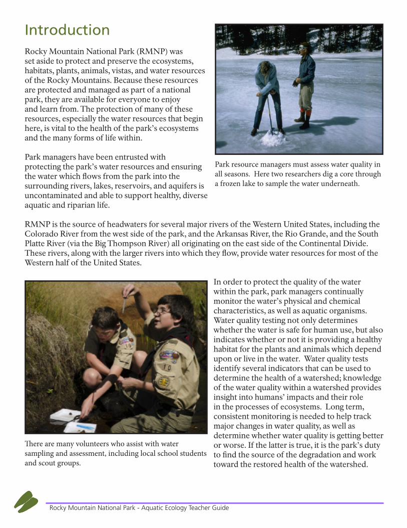
In order to protect the quality of the water within the park, park managers continually monitor the water’s physical and chemical characteristics, as well as aquatic organisms. Water quality testing not only determines whether the water is safe for human use, but also indicates whether or not it is providing a healthy habitat for the plants and animals which depend upon or live in the water. Water quality tests identify several indicators that can be used to determine the health of a watershed; knowledge of the water quality within a watershed provides insight into humans’ impacts and their role in the processes of ecosystems. Long term, consistent monitoring is needed to help track major changes in water quality, as well as determine whether water quality is getting better or worse. If the latter is true, it is the park’s duty to find the source of the degradation and work toward the restored health of the watershed.
Park resource managers must assess water quality in all seasons. Here two researchers dig a core through a frozen lake to sample the water underneath.
There are many volunteers who assist with water sampling and assessment, including local school students and scout groups.
5Rocky Mountain National Park - Aquatic Ecology Teacher Guide
Although RMNP is protected, it is still at risk of poor water quality due to air pollutants, which come down as rain, snow, or dry deposition; visitor use, more than 3 million people each year; and natural occurrence, such as forest fires and beetle infestations.
Air pollutants from the Front Range—originating from agricultural fertilizers, the urine and feces of ranch operations and feedlots, as well as cars and coal burning power plants—are brought by air currents to the high altitude peaks of RMNP. These pollutants are then deposited, either as dry deposition or integrated into rain drops and snowflakes, in the soils and waterways of the park. Due to the sulphur oxides and nitrogen oxides contained in these pollutants, the chemical makeup of the water and soil of the southern Rocky Mountains is changing, which could affect the plants, animals, and waterways of RMNP.
Understanding watershed structure and natural processes is crucial to internalizing the knowledge that human activities can either degrade or improve the condition of a watershed. Grasping the importance of an area’s water quality, animal populations, and riparian zones prepares students of today to be effective stewards in the future. As much data as possible is needed in order to spot trends in water quality, identify problems early on, and address the sources of these problems.
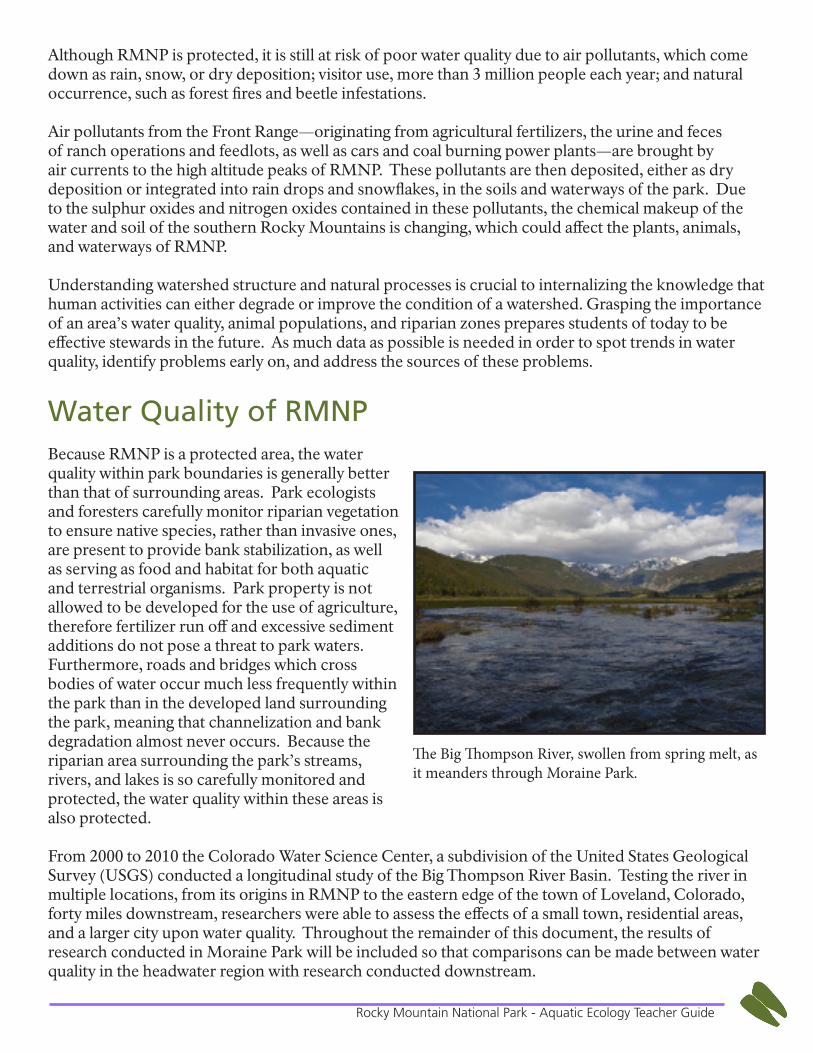
Water Quality of RMNPBecause RMNP is a protected area, the water quality within park boundaries is generally better than that of surrounding areas. Park ecologists and foresters carefully monitor riparian vegetation to ensure native species, rather than invasive ones, are present to provide bank stabilization, as well as serving as food and habitat for both aquatic and terrestrial organisms. Park property is not allowed to be developed for the use of agriculture, therefore fertilizer run off and excessive sediment additions do not pose a threat to park waters. Furthermore, roads and bridges which cross bodies of water occur much less frequently within the park than in the developed land surrounding the park, meaning that channelization and bank degradation almost never occurs. Because the riparian area surrounding the park’s streams, rivers, and lakes is so carefully monitored and protected, the water quality within these areas is also protected.
From 2000 to 2010 the Colorado Water Science Center, a subdivision of the United States Geological Survey (USGS) conducted a longitudinal study of the Big Thompson River Basin. Testing the river in multiple locations, from its origins in RMNP to the eastern edge of the town of Loveland, Colorado, forty miles downstream, researchers were able to assess the effects of a small town, residential areas, and a larger city upon water quality. Throughout the remainder of this document, the results of research conducted in Moraine Park will be included so that comparisons can be made between water quality in the headwater region with research conducted downstream.
The Big Thompson River, swollen from spring melt, as it meanders through Moraine Park.
6Rocky Mountain National Park - Aquatic Ecology Teacher Guide
Pollution in RMNPPollution can be divided into two categories, depending upon their origin: point-source and nonpoint-source pollution. However, when referring to RMNP, it may be more helpful to divide pollution sources into the categories of “local” and “distant” sources.
One source of pollution local to RMNP are the thousands of automobiles which enter and traverse the park each year. As fossil fuels are combusted and exhaust is released from vehicles, these compounds bond with atmospheric nitrogen, and are then deposited in the form of nitrate (NO3), which can cause an overproduction of aquatic plants. For more information regarding the harmful effects of high nitrate levels, see the “Nitrogen” section below.
Distant sources of pollution include smog from surrounding metropolitan areas and ammonia, nitrates, and phosphate from fertilizers used on crops on the front range. These pollutants are often brought by upslope wind patterns into the park boundaries, and enter waterways either through dry deposition or by bonding with a water molecule and coming to earth as precipitation. These airborne pollutants stimulate an overproduction of aquatic plants, which result in decreased levels of dissolved oxygen and increased water temperature.
Another factor to consider that can be local or distant is wildland fire. Wildfire is the forest disturbance that has the greatest potential to change watershed condition. Following wildfires, flood peak flows can increase dramatically, severely affecting stream physical conditions, aquatic habitat, aquatic biota, cultural resources, and human health and safety. Often, increased flood peak flows of up to 100 times those previously recorded, well beyond observed ranges of variability in managed watersheds, have been measured after wildfires. The most adverse effects from wildfires on water quality standards come from physical effects of the sediment and ash that are deposited into streams, but other chemical effects may be seen as well.
Chemical Testing
pHThe power of hydrogen (pH) test is a measure of the acidity of water and valued on a scale from 0 to 14 units. Acids produce hydrogen ions (H+), bases produce hydroxide ions (OH-). A pH of 7 has equal amounts of hydrogen ions (H+) and hydroxide ions (OH-) and is considered neutral. Water with a pH less than 7 is acidic, and the lower the pH, the stronger the acid; conversely, water with a pH greater than 7 is basic, again, with a higher pH indicating a stronger base.
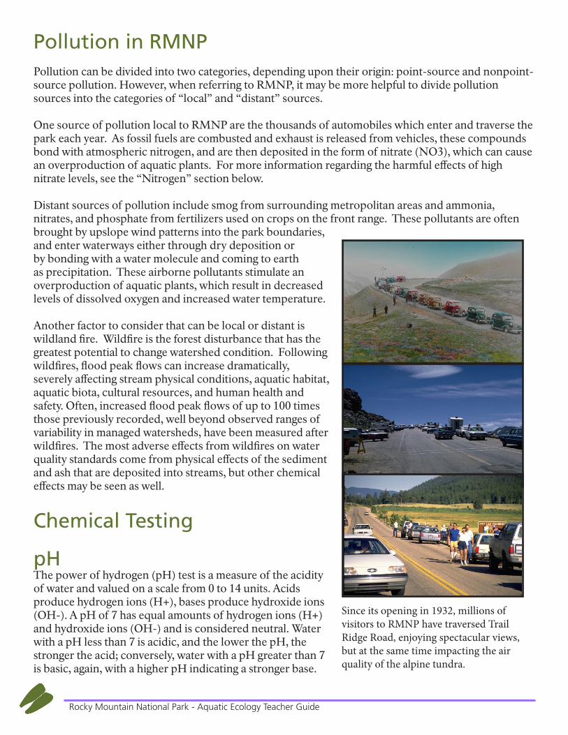
Since its opening in 1932, millions of visitors to RMNP have traversed Trail Ridge Road, enjoying spectacular views, but at the same time impacting the air quality of the alpine tundra.
7Rocky Mountain National Park - Aquatic Ecology Teacher Guide
pH is measured on a logarithmic scale, meaning that a 1.0 unit drop in pH is equivalent to a 10 fold increase in acidity. Therefore, a stream with a pH of 5.0 is 10 times more acidic than one with a pH of 6.0, and a stream with a pH of 4.0 is 100 times more acidic than one with a pH 6.0.
Effect on Aquatic LifeAnimals and plants are adapted to varying pH ranges optimal for their species; however most prefer a pH of 6.5 to 8.0. Depending upon the sensitivity of an aquatic organism, an abnormal increase or decrease of the pH of a body of water could be challenging, or may even result in death. pH levels can alter blood’s ability to retain oxygen, influence the state of metals in water, decrease the buffering capacity (alkalinity) of water, and be particularly harmful to organisms in early life stages. Lower pH levels (<5.5) particularly affect the immature stages of aquatic insects and fish by leaching heavy metals such as zinc, copper, lead, and cadmium into the water. The resulting high metal concentrations are often toxic to aquatic life, particularly for sensitive species such as trout.
Effect of TemperatureIn most cases, water pH is directly proportional to water temperature. As temperature increases, pH increases. Likewise, as water temperature decreases, chemical reactions occur more slowly and less frequently, thereby decreasing those reactions which could change pH.
Effects of Geology and Soil CompositionThe pH of water can also be altered by the geology of the watershed. Water which contacts limestone creates calcium carbonate and becomes more acidic, this acidic groundwater then erodes surrounding limestone to create unique karst topography. Streams and lakes that drain wetland bogs may also have low pH values, sometimes less than 5, because of humic acids derived from the slow breakdown of organic matter. The type of forest dominating a watershed can also affect water’s pH: for instance, the decomposition of coniferous needles tends to lower the pH of surrounding soil, in turn lowering the pH of groundwater percolating through these areas.
Acid RainEven water falling as rain can be acidic. Because it is exposed to atmospheric carbon dioxide, normal rainwater has a pH of 5.6 (slightly acidic); as the CO2 dissolves in the rainwater, carbonic acid is formed. Rainwater with a pH below 5.6 is considered acid rain. It is important to note that there are both naturally-occurring as well as anthropogenic causes for acidic rainwater.
Fire EffectsThe pH of water at a point in time is an indication of the balance of chemical equilibria in a water body. Its level affects the presence of some chemicals in the water. The pH of water can be affected by ash depositions immediately after a fire. In the first year after fire, increased pH values of the soil can also contribute to increased values of streamflow pH.
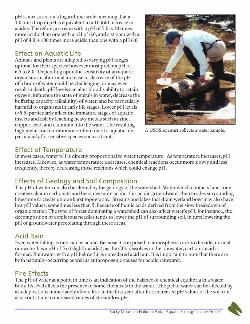
A USGS scientist collects a water sample.
8Rocky Mountain National Park - Aquatic Ecology Teacher Guide
Research in RMNPResearch conducted in Moraine Park indicated an average pH of 7.1, which is well within the 6.5 to 8.0 range of a healthy pH.
AlkalinityAlkalinity is the measurement of a body of water’s buffering capacity—which is the ability of a body of water to cope with the addition of an acid or base without the water’s overall pH changing. Poorly buffered waters, such as small streams in pristine areas, are likely to have large fluctuations in pH; whereas large, lowland rivers are normally well buffered and have a fairly stable pH.
Effect on Aquatic LifeBecause water alkalinity inhibits sudden changes in pH, this buffering ability helps to protect all forms of aquatic life from the effects of sudden acid addition. Although it is not known exactly how alkalinity mitigates toxic impacts from elevated metals, fish in high alkalinity waters have been observed to be able to withstand higher concentrations of metals, given equal water volumes. High water alkalinity also enables better algae and plant growth.
Effect of GeologyVariations in alkalinity can be attributed to the substrate and soils the water runs over and through. The main sources for natural alkalinity are rocks which contain carbonate, bicarbonate, and hydroxide compounds. Because limestone is rich in carbonates, waters flowing through limestone regions generally have high alkalinity - hence good buffering capacity. Conversely, areas rich in granites and sandstones tend to have low alkalinity, and therefore poor buffering capacity. Because carbonate molecules (CO3) are often bonded to calcium (Ca) in the natural world, and because water hardness is taken by measuring calcium carbonate (CaCO3), hard water tends to have high alkalinity, while soft water (not containing CaCO3) tends to have poor buffering capacity.
Fire EffectsWhen a wild land fire occurs, one of the principal concerns for a change in water quality is the introduction of sediment. Accumulations of litter and of other decomposed organic matter on the soil surface often function as a filter that removes bacteria and other biological organisms from overland flow. Rainfall-induced runoff and snowmelt that percolates through a litter layer or strip of organic matter can contain fewer bacteria than water that had not passed through the strip.
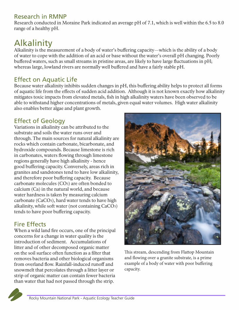
This stream, descending from Flattop Mountain and flowing over a granite substrate, is a prime example of a body of water with poor buffering capacity.
9Rocky Mountain National Park - Aquatic Ecology Teacher Guide
Therefore, the destruction of this layer or strip by burning might result in higher concentrations of bacterial and other biological organisms flowing overland to a stream channel.
Research in RMNPThere are many such small, pristine streams in RMNP, which do not have great buffering ability. Additionally, the predominately granite geology of the park causes waterways to have low alkalinity and a poor buffering capacity. By the time these small streams converge to form the Big Thompson River in Moraine Park, the alkalinity levels of 9.6 mg/L still indicate that even this larger, better buffered waterway is highly sensitive to dramatic fluctuations of pH.
Dissolved OxygenDissolved oxygen (DO) measures the presence of oxygen gas molecules (O2) in water. This does not include air bubbles in the water, but only oxygen at the molecular level dissolved in the water. This measurement is reported as a ratio of the mass of oxygen gas (mg) per unit volume of water (L). This number is then compared to the water temperature on a DO percent saturation chart, and the final DO result is expressed as a percent saturation. Ideally, the DO content and water temperature would be such that the waterway is 100% saturated. Water that maintains high dissolved oxygen levels is generally considered to be a good habitat; although saltwater, warm water, and water at high altitudes contain less dissolved oxygen, they can still be part of a health-sustaining ecosystem.
Effect on Aquatic LifeOxygen is necessary to sustain all living things, and must be present for many of the chemical reactions that take place in water. Most aquatic animals utilize the oxygen dissolved in water, rather than surfacing to take in air. Aquatic plants, through photosynthesis, release oxygen into the water throughout the daylight hours, leading to peak DO readings in the afternoon of warm days, however these levels will drop drastically overnight. Not only is dissolved oxygen necessary to sustain living organisms, it also has a crucial role in the decomposition of organic matter into sediment.
Barriers to Dissolved OxygenAlthough aquatic plants can do much to contribute DO to a body of water, riparian vegetation, water temperature, elevation, and the presence of riffles and boulders are also important. Riparian vegetation, specifically the presence of canopy cover, can significantly lower the temperature of a body of water.
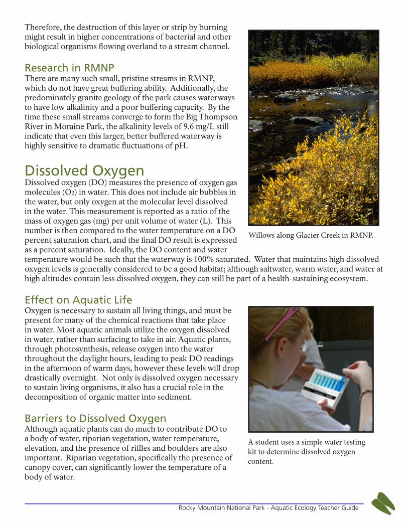
A student uses a simple water testing kit to determine dissolved oxygen content.
Willows along Glacier Creek in RMNP.
10Rocky Mountain National Park - Aquatic Ecology Teacher Guide
Because warm water molecules are more spread out and have larger spaces between them, DO molecules can more easily escape; whereas molecules in cold water are tightly packed, thus better at retaining DO. Just as it becomes more difficult for humans to take in oxygen at higher altitudes due to decreased atmospheric pressure, water, also, cannot dissolve as much oxygen at high elevations as it can closer to sea level. Fast-moving streams, tumbling over boulders and riffles, allow oxygen to penetrate into every level of the stream, rather than just the top few inches, as in stagnant bodies of water.
Human ActivitiesThere are several ways in which human activities and infrastructures can decrease DO. Nitrogen runoff from agricultural fields and lawn fertilizers often cause algae blooms, an excessive growth of aquatic plants; while the initial growth of these plants may contribute oxygen to surrounding waters, their inevitable death and decomposition decreases available oxygen. Likewise, when organic material (from waste water treatment plants or sewage overflows) enters waterways, its necessary decomposition also decreases dissolved oxygen levels. Given what is known about water temperature and water’s ability to retain dissolved oxygen, dams and the gradual release of their reservoir water create a lose-lose situation for DO: if water is released from the top of the reservoir, while it may have a higher DO content, it tends to be higher in temperature, and thus is not well-suited for retaining DO, whereas if water is released from the bottom of the reservoir, it will be lower in temperature, but will have significantly less DO than water from the top of the reservoir, due to the decomposition of organic materials which have settled at the bottom of the reservoir.
Research in RMNPThe elevation at RMNP varies between 7,860 in the montane forests and 14,259 at the summit of Long’s Peak. The high elevations throughout the park, and subsequent low air pressure, make it difficult for streams to absorb and retain dissolved oxygen. However, the bouldered and cobbled substrate of streams tumbling down the slopes causes the water to churn and this turbulence enables water to absorb more atmospheric oxygen than a stream meandering through a meadow would. Because water temperature is also a factor in determining the percent saturation, the typical range for DO in the waters of RMNP is between 5.4 ppm and 14.2 ppm. Research conducted at Moraine Park revealed a DO of 7.6 ppm with a median water temperature of 6.6°C, yielding a percent saturation of 60%.
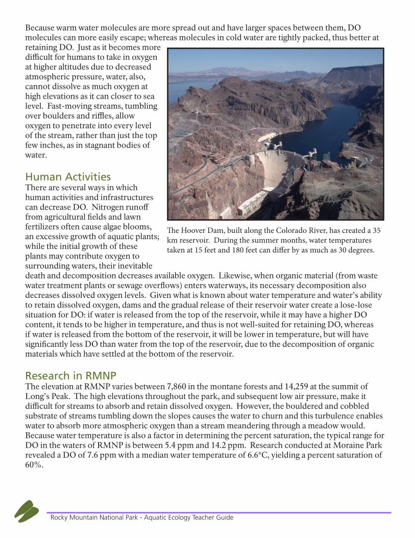
The Hoover Dam, built along the Colorado River, has created a 35 km reservoir. During the summer months, water temperatures taken at 15 feet and 180 feet can differ by as much as 30 degrees.
11Rocky Mountain National Park - Aquatic Ecology Teacher Guide
Dissolved Carbon DioxideAll animals, even aquatic ones, inhale oxygen and exhale carbon dioxide, while plants consume carbon dioxide and both produce and, to a lesser degree, consume oxygen. Therefore, a body of water’s levels of dissolved oxygen and dissolved carbon dioxide will be indirectly proportional. High levels of dissolved CO2 will not only indicate there is less oxygen available for aquatic animals, it will also decrease the animals’ ability to absorb and utilize what little dissolved oxygen is available to them. High levels of dissolved CO2 inhibit the ability of fish blood to transport oxygen, thereby increasing the stress upon them.
Human ActivitiesNitrogen runoff from agricultural fields and lawn fertilizers mentioned can lead to increased levels of dissolved carbon dioxide. The high nitrogen levels will stimulate the growth of aquatic plants which, when they die and begin to decompose, will release large amounts of CO2.
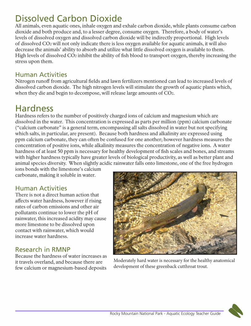
HardnessHardness refers to the number of positively charged ions of calcium and magnesium which are dissolved in the water. This concentration is expressed as parts per million (ppm) calcium carbonate (“calcium carbonate” is a general term, encompassing all salts dissolved in water but not specifying which salts, in particular, are present). Because both hardness and alkalinity are expressed using ppm calcium carbonate, they can often be confused for one another; however hardness measures the concentration of positive ions, while alkalinity measures the concentration of negative ions. A water hardness of at least 50 ppm is necessary for healthy development of fish scales and bones, and streams with higher hardness typically have greater levels of biological productivity, as well as better plant and animal species diversity. When slightly acidic rainwater falls onto limestone, one of the free hydrogen ions bonds with the limestone’s calcium carbonate, making it soluble in water.
Human ActivitiesThere is not a direct human action that affects water hardness, however if rising rates of carbon emissions and other air pollutants continue to lower the pH of rainwater, this increased acidity may cause more limestone to be dissolved upon contact with rainwater, which would increase water hardness.
Research in RMNPBecause the hardness of water increases as it travels overland, and because there are few calcium or magnesium-based deposits
Moderately hard water is necessary for the healthy anatomical development of these greenback cutthroat trout.
12Rocky Mountain National Park - Aquatic Ecology Teacher Guide
within the park boundary, the headwaters of the rivers which flow from RMNP have very low levels of hardness. However, these measures of hardness increase as the river flows downstream, passing over different substrates. Additionally, the hardness increases in the winter months, when the stream flow is lower, and decreases in the spring and summer months, as snowmelt from the mountains drastically increases the volume of water in the river bed.
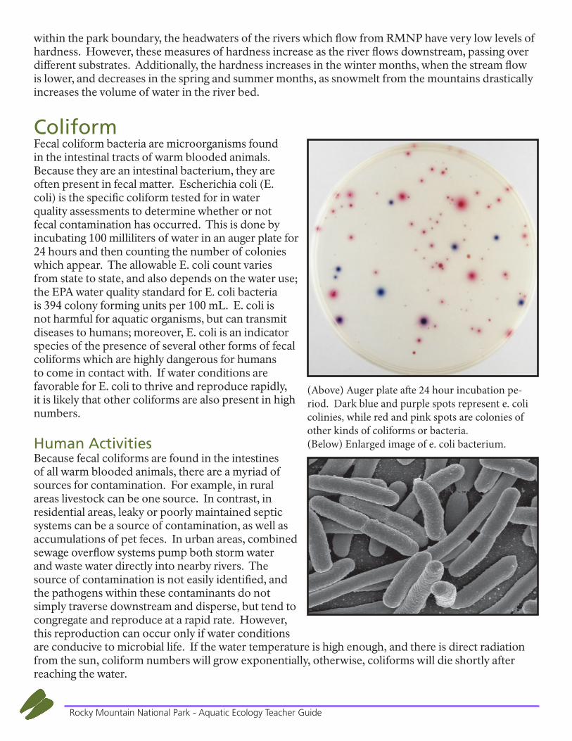
ColiformFecal coliform bacteria are microorganisms found in the intestinal tracts of warm blooded animals. Because they are an intestinal bacterium, they are often present in fecal matter. Escherichia coli (E. coli) is the specific coliform tested for in water quality assessments to determine whether or not fecal contamination has occurred. This is done by incubating 100 milliliters of water in an auger plate for 24 hours and then counting the number of colonies which appear. The allowable E. coli count varies from state to state, and also depends on the water use; the EPA water quality standard for E. coli bacteria is 394 colony forming units per 100 mL. E. coli is not harmful for aquatic organisms, but can transmit diseases to humans; moreover, E. coli is an indicator species of the presence of several other forms of fecal coliforms which are highly dangerous for humans to come in contact with. If water conditions are favorable for E. coli to thrive and reproduce rapidly, it is likely that other coliforms are also present in high numbers.
Human ActivitiesBecause fecal coliforms are found in the intestines of all warm blooded animals, there are a myriad of sources for contamination. For example, in rural areas livestock can be one source. In contrast, in residential areas, leaky or poorly maintained septic systems can be a source of contamination, as well as accumulations of pet feces. In urban areas, combined sewage overflow systems pump both storm water and waste water directly into nearby rivers. The source of contamination is not easily identified, and the pathogens within these contaminants do not simply traverse downstream and disperse, but tend to congregate and reproduce at a rapid rate. However, this reproduction can occur only if water conditions are conducive to microbial life. If the water temperature is high enough, and there is direct radiation from the sun, coliform numbers will grow exponentially, otherwise, coliforms will die shortly after reaching the water.
(Above) Auger plate afte 24 hour incubation pe-riod. Dark blue and purple spots represent e. coli colinies, while red and pink spots are colonies of other kinds of coliforms or bacteria.(Below) Enlarged image of e. coli bacterium.
13Rocky Mountain National Park - Aquatic Ecology Teacher Guide
Research in RMNPRiparian vegetation can both filter runoff which rainwater washes into streams, as well as keep the water temperature fairly low. The majority of streams which originate in the park have very healthy riparian areas and the most common source of coliforms are those coming from the fecal matter of wildlife. Therefore, the coliform counts in RMNP have historically been well below the EPA’s allowable limit.
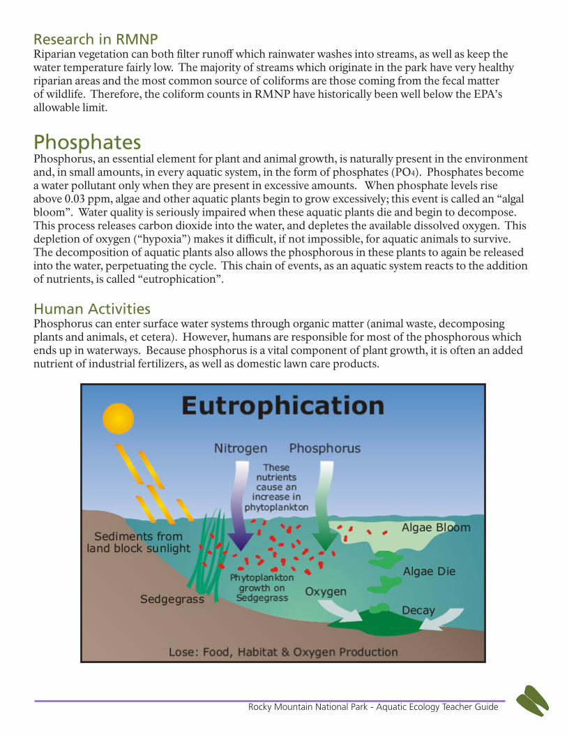
PhosphatesPhosphorus, an essential element for plant and animal growth, is naturally present in the environment and, in small amounts, in every aquatic system, in the form of phosphates (PO4). Phosphates become a water pollutant only when they are present in excessive amounts. When phosphate levels rise above 0.03 ppm, algae and other aquatic plants begin to grow excessively; this event is called an “algal bloom”. Water quality is seriously impaired when these aquatic plants die and begin to decompose. This process releases carbon dioxide into the water, and depletes the available dissolved oxygen. This depletion of oxygen (“hypoxia”) makes it difficult, if not impossible, for aquatic animals to survive. The decomposition of aquatic plants also allows the phosphorous in these plants to again be released into the water, perpetuating the cycle. This chain of events, as an aquatic system reacts to the addition of nutrients, is called “eutrophication”.
Human ActivitiesPhosphorus can enter surface water systems through organic matter (animal waste, decomposing plants and animals, et cetera). However, humans are responsible for most of the phosphorous which ends up in waterways. Because phosphorus is a vital component of plant growth, it is often an added nutrient of industrial fertilizers, as well as domestic lawn care products.
14Rocky Mountain National Park - Aquatic Ecology Teacher Guide
Effect on Aquatic LifeUnlike other nutrients, phosphorous does not have a gaseous stage, so once it has entered an aquatic system, it shall remain there unless physically removed—usually by dredging. As noted above, high phosphate levels increase plant growth, which, when the plants begin to decompose, will decrease available dissolved oxygen. Low DO levels make it difficult for any type of aquatic animal to survive for long. The Mississippi River delta is a prime example of the negative impact of phosphorous upon aquatic life. The Mississippi’s watershed encompasses 40% of the land mass of the continental United States, and much of this vast region is classified as agricultural land. Because of the vast amount of nutrients which make their way down to the mouth of the Mississippi, and because these nutrients decrease dissolved oxygen.
Fire EffectsSoil studies have reported increased levels of total phosphorous due to burning, indicating accelerated mobilization of phosphorous after burning. Phosphorus concentrations in overland flow from hillslopes of a watershed can increase as a result of burning, although these increases are not always sufficient to alter the quality of the watershed’s stream flow.
RMNPAccording to samples taken of the Big Thompson River below Moraine Park, even the highest recorded levels of orthophosphate and total phosphorous are well below the deleterious 0.03 ppm level. These findings are to be expected because of the complete absence of the two largest sources of phosphates in waterways: industrial fertilizers and commercial lawn care products.
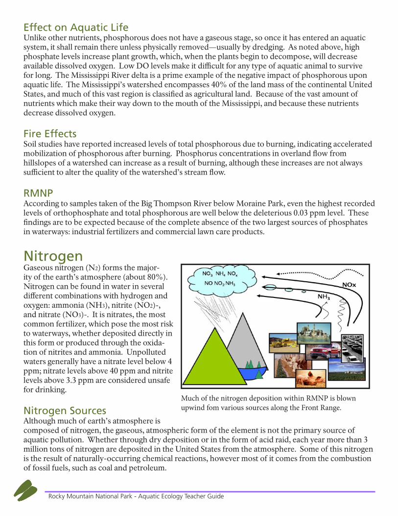
NitrogenGaseous nitrogen (N2) forms the major-ity of the earth’s atmosphere (about 80%). Nitrogen can be found in water in several different combinations with hydrogen and oxygen: ammonia (NH3), nitrite (NO2)-, and nitrate (NO3)-. It is nitrates, the most common fertilizer, which pose the most risk to waterways, whether deposited directly in this form or produced through the oxida-tion of nitrites and ammonia. Unpolluted waters generally have a nitrate level below 4 ppm; nitrate levels above 40 ppm and nitrite levels above 3.3 ppm are considered unsafe for drinking.
Nitrogen SourcesAlthough much of earth’s atmosphere is composed of nitrogen, the gaseous, atmospheric form of the element is not the primary source of aquatic pollution. Whether through dry deposition or in the form of acid raid, each year more than 3 million tons of nitrogen are deposited in the United States from the atmosphere. Some of this nitrogen is the result of naturally-occurring chemical reactions, however most of it comes from the combustion of fossil fuels, such as coal and petroleum.
Much of the nitrogen deposition within RMNP is blown upwind fom various sources along the Front Range.
15Rocky Mountain National Park - Aquatic Ecology Teacher Guide
Effect on Aquatic LifeLike phosphorous, nitrogen is a necessary element for the growth of all forms of life. Nitrates are essential for plant growth, although an overabundance of nitrates indicates a pollution problem, and can have harmful impacts upon all forms of aquatic life. As explained in detail previously, an overabundance of nitrates in rivers, lakes, and ponds can initiate an algae bloom. Such drastic growth of aquatic plants can block sunlight from filtering into the lower depths of these bodies of water, and as they decompose, will decrease dissolved oxygen levels and raise water temperature, both of which create a less-than-ideal habitat for aquatic animals. An overabundance of nitrates lessens the efficiency of aquatic animal’s respiration, thus decreasing the biodiversity of aquatic plants and animals.
Fire EffectsMost of the attention of hydrologists and watershed managers relative to water quality responses to fire focuses on nitrogen because it is highly mobile. The potential for increased nitrates in stream flow after burning is attributed mainly to accelerated mineralization and nitrification and reduced plant demand. These post fire effects are short lived, however, usually lasting only a year or so.
RMNPSimilar to phosphate levels within the park, because only a small portion of nitrogen deposition is naturally occurring, ammonia and nitrite levels within the park are miniscule, both being less than 1 ppm.
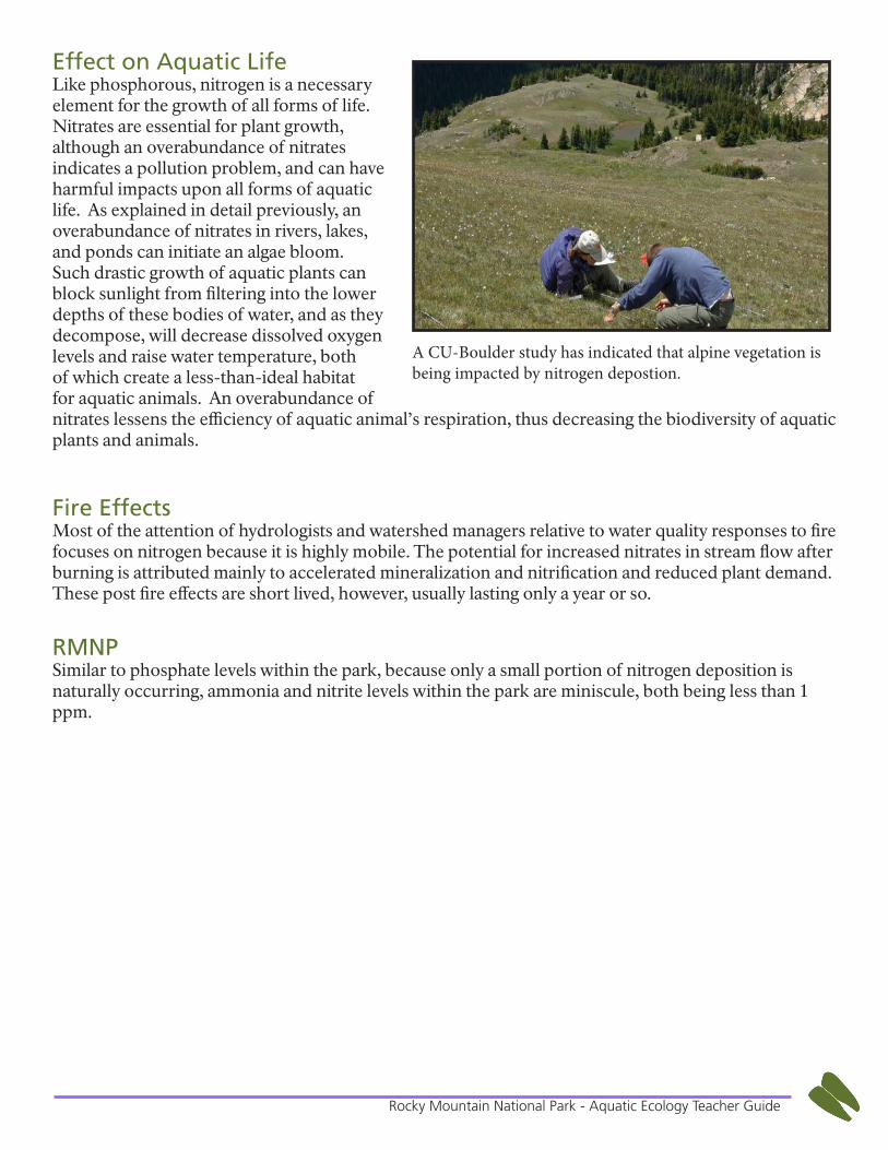
A CU-Boulder study has indicated that alpine vegetation is being impacted by nitrogen depostion.
16Rocky Mountain National Park - Aquatic Ecology Teacher Guide
Riparian Habitat
OverviewRiparian zone refers to the area adjacent to a river or stream. This strip of land between a body of water and nearby upland hills is a vital transition zone between terrestrial and freshwater ecosystems. Not only is land use an indicator of water quality, but the overall condition of surrounding lands, and the plants and animals this land is able to support will also be a factor to consider when assessing the health of a stream or river. An ideal riparian zone will allow its stream to meander back and forth across the landscape: this sinuosity creates alternating stream depths and a variety of water velocities throughout. Other desirable components include a buffer strip between the waterway and any nearby development, a variety of thick streamside vegetation, areas of shade, as well as direct sunlight, and some amount of plant litter and woody debris. Together these factors will provide ample habitat for numerous aquatic organisms: food from the aquatic plants, stable banks from the bankside vegetation, cool temperatures and adequate oxygen levels from the shaded areas.
FloraRiparian zone flora vary in RMNP depending upon elevation. Common native trees and shrubs, depending on location and elevation, include birch, aspen, willow, alder, and many forbes.
FaunaPerhaps you have heard the phrase “There’s always life on the edges”. This is referring to the abundance of animal activity which can be witnessed where two different ecosystems (riparian and montane, for instance) come together. These ecotones are especially preferred by animals because they can easily access the resources which each ecosystem offers. A variety of amphibians (frogs, toads, salamanders, newts) can typically be found in a water-bordering ecotone, and even a casual observer will notice the deer, raccoon, and coyote footprints in the mud along a stream. Researchers have also found that wider riparian zones indicate both greater populations of birds, and an increase in the diversity of bird species present.
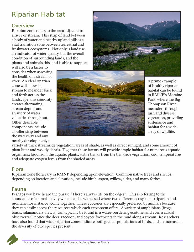
A prime example of healthy riparian habitat can be found in RMNP’s Moraine Park, where the Big Thompson River meanders through lush and diverse vegetation, providing sustenance and habitat for a wide array of wildlife.

17Rocky Mountain National Park - Aquatic Ecology Teacher Guide
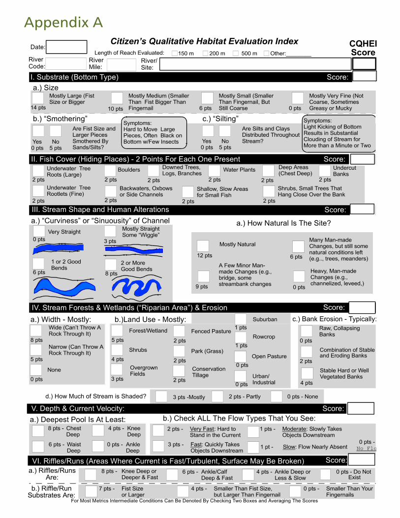
Riparian Habitat AssessmentOne tool that can be used to assess a raparian habitat is the Citizen’s Qualitative Habitat Evaluation Index (CQHEI). This index was developed by the Ohio Environmental Protection Agency as a “Citizens” companion to the Qualitative Habitat Evaluation Index (QHEI) used by the state’s professional staff. The purpose of the index is to provide a measure of the stream habitat and riparian health that generally corresponds to physical factors affecting fish and other aquatic life (i.e. macroinvertebrates). The CQHEI produces a total score that can be used to compare changes at one site over time or compare two different sites. For a copy of the CQHEI see Appendix A.
18Rocky Mountain National Park - Aquatic Ecology Teacher Guide
Aquatic Invertebrates
MacroinvertebratesBenthic macroinvertebrates are animals that are big enough (macro) to be seen with the naked eye. They lack backbones (invertebrate) and live at least part of their lives in or on the bottom (benthos) of a body of water. Macroinvertebrates include aquatic insects (such as mayflies, stoneflies, caddisflies, midges, and beetles), and snails, worms, freshwater clams, mussels, and crayfish. Because macroinvertebrates are towards the bottom of the aquatic food chain, their abundance and diversity are an integral component of a stable food web. Aquatic macroinvertebrates can also indicate much about the water quality of an area. Because these macroinvertebrates have varying tolerance levels to pollution, they are an excellent, long term indicator of pollutants. Chemical tests conducted on water samples provide a “snap shot” view of water quality. However, one must sample and inventory the aquatic macroinvertebrates in order to know if the water has been impaired on a long-term basis or if the chemical test results are simply reflecting a short term exposure to pollutants, which are quickly passing downstream. Aquatic macroinvertebrates can be classified in two ways: according to what or how they eat, or with respect to how much pollution they can tolerate.
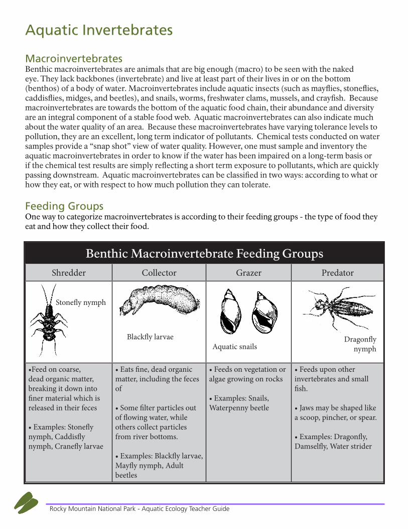
Feeding GroupsOne way to categorize macroinvertebrates is according to their feeding groups - the type of food they eat and how they collect their food.
Benthic Macroinvertebrate Feeding GroupsShredder Collector Grazer Predator
•Feed on coarse, dead organic matter, breaking it down into finer material which is released in their feces
• Examples: Stonefly nymph, Caddisfly nymph, Cranefly larvae
• Eats fine, dead organic matter, including the feces of
• Some filter particles out of flowing water, while others collect particles from river bottoms.
• Examples: Blackfly larvae, Mayfly nymph, Adult beetles
• Feeds on vegetation or algae growing on rocks
• Examples: Snails, Waterpenny beetle
• Feeds upon other invertebrates and small fish.
• Jaws may be shaped like a scoop, pincher, or spear.
• Examples: Dragonfly, Damselfly, Water strider
Stonefly nymph
Blackfly larvaeAquatic snails
Dragonfly nymph
19Rocky Mountain National Park - Aquatic Ecology Teacher Guide
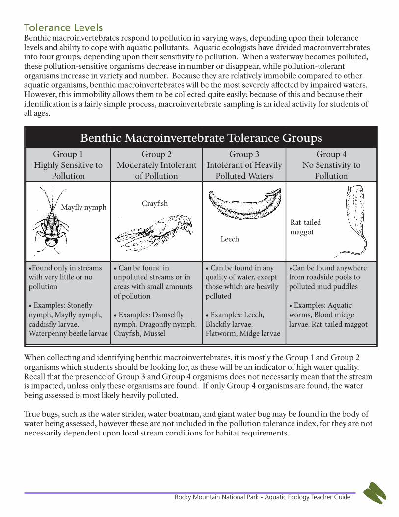
Tolerance LevelsBenthic macroinvertebrates respond to pollution in varying ways, depending upon their tolerance levels and ability to cope with aquatic pollutants. Aquatic ecologists have divided macroinvertebrates into four groups, depending upon their sensitivity to pollution. When a waterway becomes polluted, these pollution-sensitive organisms decrease in number or disappear, while pollution-tolerant organisms increase in variety and number. Because they are relatively immobile compared to other aquatic organisms, benthic macroinvertebrates will be the most severely affected by impaired waters. However, this immobility allows them to be collected quite easily; because of this and because their identification is a fairly simple process, macroinvertebrate sampling is an ideal activity for students of all ages.
When collecting and identifying benthic macroinvertebrates, it is mostly the Group 1 and Group 2 organisms which students should be looking for, as these will be an indicator of high water quality. Recall that the presence of Group 3 and Group 4 organisms does not necessarily mean that the stream is impacted, unless only these organisms are found. If only Group 4 organisms are found, the water being assessed is most likely heavily polluted.
True bugs, such as the water strider, water boatman, and giant water bug may be found in the body of water being assessed, however these are not included in the pollution tolerance index, for they are not necessarily dependent upon local stream conditions for habitat requirements.
Benthic Macroinvertebrate Tolerance GroupsGroup 1
Highly Sensitive to Pollution
Group 2 Moderately Intolerant
of Pollution
Group 3Intolerant of Heavily
Polluted Waters
Group 4No Senstivity to
Pollution
•Found only in streams with very little or no pollution
• Examples: Stonefly nymph, Mayfly nymph, caddisfly larvae, Waterpenny beetle larvae
• Can be found in unpolluted streams or in areas with small amounts of pollution
• Examples: Damselfly nymph, Dragonfly nymph, Crayfish, Mussel
• Can be found in any quality of water, except those which are heavily polluted
• Examples: Leech, Blackfly larvae, Flatworm, Midge larvae
•Can be found anywhere from roadside pools to polluted mud puddles
• Examples: Aquatic worms, Blood midge larvae, Rat-tailed maggot
Mayfly nymph Crayfish
Leech
Rat-tailed maggot
Aquatic EcologyResources

21Rocky Mountain National Park - Aquatic Ecology Teacher Guide
Classroom Resources
Books for Elementary Students Around the Pond by Lindsay Barrett George Beaver at Long Pond by William T. George & Lindsay Barrett George Box Turtle at Long Pond by William T. George In the Small, Small Pond by Denise Fleming Make Way for Ducklings by Robert McCloseky My Water Comes from the Mountains by Tiffany Fourment River of Life by Debbie S. Miller Running Wild: The adventures of two raindrops by John Gunn & Ben Brown What’s In the Pond by Anne Hunter
Books for Secondary Students Beyond the Hundredth Meridian: John Wesley Powell and the second opening of the west by Wallace Stegner Cadillac Desert: the American west and its disappearing water by Marc Reisner Running Dry: A journey from source to sea down the Colorado River by Jonathan Waterman Walden by Henry David Thoreau Watchers at the Pond by Franklin Russell
Video Resources (upper elementary to secondary students) “Chasing Water” featuring Jonathan Waterman and Pete McBride (can be found on youtube) “Remains of a River” featuring Will Stauffer-Norris and Zak Podmore (http://www.youtube. com/watch?v=O8CXQkXlYg8) “Tapped” documentary on the bottled water business and its effect upon aquatic systems
Web Resources Stream assessment data for numerous study sites throughout Colorado. http://co.water.usgs.gov/ Detailed instructions of how to use the CQHEI. http://www.epa.state.oh.us/portals/35/documents/qheimanualjune2006.pdf
Numerous video or audio podcasts. Select “audio” from the drop down box and search for “streams”, or select “videos” in the drop down and search for aquatic ecology. Several are available in both English and Spanish. http://gallery.usgs.gov/
Check with your local extension office or your state’s Department of Natural Resources for more information on stream monitoring in your area or to order water testing materials.
22Rocky Mountain National Park - Aquatic Ecology Teacher Guide
GlossaryAbiotic - non-living components of an ecosystem.
Alkalinity - the ability of a stream to resist changes in pH.
Aquatic - of or relating to water.
Benthic - of or relating to or happening on the bottom of a body of water.
Coliform - Indicates the presence of sewage or fecal contamination.
Dissolved Carbon Dioxide - the amount of carbon dioxide available in the water to aquatic organisms.
Dissolved Oxygen - the amount of oxygen available in the water to aquatic organisms.
Ecology - the branch of biology that deals with the relations of organisms to one another and to their physical surroundings.
Ecosystem - A biological community of interacting organisms and their physical environment.
Eutrophication - a process in which an algal bloom forms as a result of too much nitrogen in the water.
Habitat - Location where an organism lives, which provides everything it needs to survive: food, water, shelter, and space.
Hardness - the amount of calcium & magnesium in the stream from rock weathering. Hardness is generally associated with a greater number of species of fish & plants.
Invertebrate - an animal lacking a backbone.
Macroinvertebrate - invertebrates visible to the naked eye.
Nitrogen - is deposited into the water from fertilizers and atmospheric fossil fuel exhaust, most harmful when bonded with oxygen in the form of nitrate (NO3), acts as a fertilizer for aquatic plants
Nonpoint-source Pollution - refers to both water and air pollution from diffuse sources. Nonpoint source water pollution affects a water body from sources such as polluted runoff from agricultural areas draining into a river, or wind-borne debris.
pH - the measure of acidity & alkalinity (base). pH determines the rate of biochemical reactions.
Phosphates – phosphorous bonded with oxygen (PO4), deposited into the water from fertilizers and detergents and acts as a fertilizer for aquatic plants.

23Rocky Mountain National Park - Aquatic Ecology Teacher Guide
Point - source Pollution - a point source of pollution is a single identifiable localized source of air, water, ther-mal, noise or light pollution.
Riparian - the ecosystem existing directly around a stream, river, or lake.
Watershed - an area or region drained by a river, river system, or other body of water
24Rocky Mountain National Park - Aquatic Ecology Teacher Guide
ReferencesCitizen’s qualitative habitat evaluation index cqhei score. (n.d.). Retrieved from http://www.musking-umriver.org/pdf files/Stream Team - CQHEI.pdf
Colorado River Watch. (2013.) River assessment and stream monitoring sites in Colorado. Retrieved fromhttp://wildlife.state.co.us/landwater/riverwatch/Pages/Riverwatch.aspx
EPA. (2013.) Citizens qualitative habitat evaluative index. Retrieved fromhttp://www.epa.state.oh.us/portals/35/documents/qheimanualjune2006.pdf
Indiana Department of Natural Resources, Division of Fish and Wildlife. (2012). Volunteer stream monitoring training manual (11th ed.). Indianapolis.
Patterson, K. (2013, July 18). Nps stats report viewer. Retrieved from https://irma.nps.gov/Stats/SSRSReports/Park Specific Reports/Traffic Counts?Park=ROMO.
Ritter, D. F., Kochel, R. C., & Miller, J. R. (2002). Process geomorphology. McGraw-Hill, Boston.
USGS. (2013.) Water quality tests of Big Thompson River in Moraine Park. Retrieved fromhttp://co.water.usgs.gov/
Appendix A