Embed Size (px)
Citation preview
PROCEEDINGS, 42nd Workshop on Geothermal Reservoir Engineering
Stanford University, Stanford, California, February 13-15, 2017
SGP-TR-212
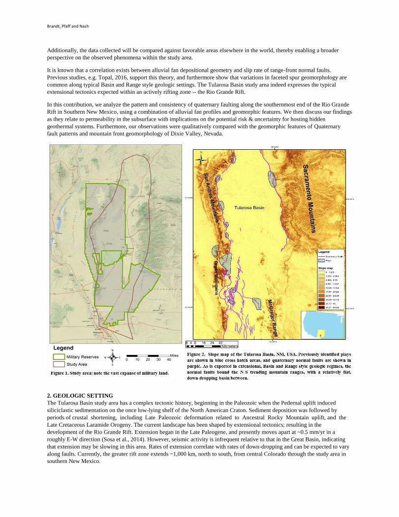
Applied Tectonic Geomorphology to Geothermal Exploration in the Tularosa Basin, New Mexico
Adam W. Brandt, Brian Pfaff and Greg Nash
Energy & Geoscience Institute, University of Utah, 423 Wakara Way, Suite 300, Salt Lake City, Utah 84108
[email protected]; [email protected]; [email protected]
Keywords: hidden geothermal systems, blind geothermal systems, exploration, tectonic geomorphology, permeability, Tularosa,
New Mexico
ABSTRACT
The Tularosa Basin in south-central New Mexico, the focus of an on-going geothermal play fairway analysis project, has been
undergoing extensional deformation for the past ~30 million years, creating a geologic environment that may contain blind
geothermal systems. The structural geology of this region is similar to the rest of the Basin and Range, so in determining
structural favorability for hosting hidden geothermal systems it is useful to compare this area with known geothermal resource
areas. Specifically, this paper details tectonic geomorphology of alluvial fans within the study area and then compared it to that of
Dixie Valley, Nevada; arguably the most prolific geothermal system in the Basin and Range. The Rio Grande Rift runs north to
south through the study area and is presently extending at a rate of ~0.5mm/yr, thus creating accommodation space for alluvium
to fan out into down-dropping basins. To facilitate this study, 10 m DEM data was integrated into a Geographic Information
Systems (GIS) program and used to analyze alluvial fan geo-morphometry and quaternary faulting within the proximity of plays
identified in Phase I of the geothermal play fairway modelling research project funded by the U.S. DOE Geothermal
Technologies Office under contract #DE-EE0006730 (Figure 1). The morphology of alluvial fans is directly associated with base
level drops triggered by basin-bounding normal fault offset. By classifying fault segments as having relatively younger and more
frequent seismic activity, conclusions about subsurface permeability can be made, which provides critical information about the
potential for a productive geothermal system and improve the play fairway model.
1. INTRODUCTION
Alluvial fans are semi-conical depositional landforms along mountain piedmonts (Sanchez & Nunez, 2015). Their size and shape
have variability, depending on local geology, regional tectonic activity and climate. In actively extending tectonic regimes, such
as the Agri intermountain basin in southern Italy or the Great Basin of western America, periods of increased tectonic movement,
on scales >10,000 years, cause steeply dipping normal faults along mountain ranges to increase in seismicity. This means more
accommodation space for alluvial fans, and more frequent and intense earthquakes inducing fractures and creating permeability
in the subsurface (Giano, 2011; Harvey, 2005; Topal, 2016). By analyzing the geometry of alluvial fans as they are presently, we
can reconstruct the seismic & tectonic history to infer subsurface permeability, a critical element to productive geothermal
systems.
When a surface locality experiences a shift in climate, from arid to temperate for example, erosion increases proportionally; thus
increasing the deposition of alluvium into sedimentary basins and forming larger alluvial fans. This has a significant spatial and
temporal effect on the evolution of alluvial fans. However, if the local climate has been relatively consistent in a certain region,
then tectonic activity may be the primary control on deposition/erosion of alluvial fans. While changes in climate, on time scales
of 100 to 10,000 years, can significantly affect alluvial fan deposition and erosion, regional tectonics can be the primary control
in unique geological regions such as intercontinental rift zones (Harvey, 2005). All modern, active alluvial fans are the
consequence of climatic and tectonic factors that change over time. Alluvial fan geomorphology can lend significantly to the
understanding of long term fault behavior and seismic activity (Topal, 2016; Anderson, 2000).
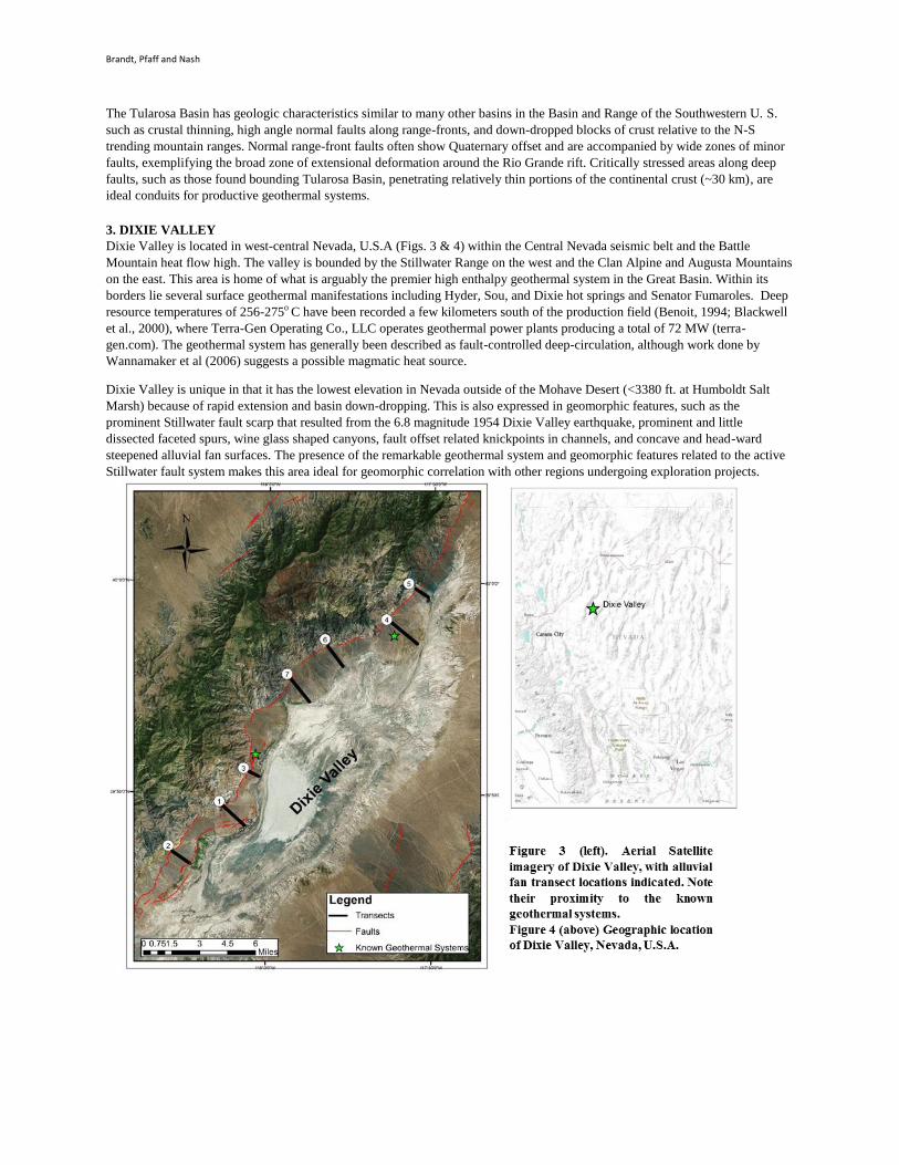
In this contribution, we analyzed alluvial fans proximal to plays identified in Phase 1 of this study (Figure 2), along an
intercontinental rift zone, The Rio Grande Rift, in Southern New Mexico, USA. In Phase 1, a play fairway analysis was
conducted using three risk segments composed of entirely pre-existing datasets; namely: heat, groundwater, and permeability
(Nash, 2016). That analysis produced multiple high to low priority plays around the rim of the Tularosa Basin, shown in Figure 2.
This study was done to refine the permeability risk segment and to help categorize the geologic structural setting within 1 mile of
those pre-determined plays. Qualitative and quantitative geomorphic indices were calculated for 50 alluvial fans, drainage basins,
and faceted spurs to help better understand slip rates along quaternary faults and, therefore, subsurface fracture networks
providing pathways for geothermal fluids. Furthermore, our results were compared with similar geomorphic indices of alluvial
fans in close proximity to productive geothermal systems in Dixie Valley, Nevada. This helps validate the interpretations made
about the relative significance of alluvial fan geometry correlating with fracture permeability in the deep subsurface. This work
also aids in geothermal conceptual model development by adding constraints to upflow/outflow areas in a deep geothermal
system. The ultimate goal is to evaluate the potential risk and uncertainty of a site for productive geothermal power generation.
Brandt, Pfaff and Nash
Additionally, the data collected will be compared against favorable areas elsewhere in the world, thereby enabling a broader
perspective on the observed phenomena within the study area.
It is known that a correlation exists between alluvial fan depositional geometry and slip rate of range-front normal faults.
Previous studies, e.g. Topal, 2016, support this theory, and furthermore show that variations in faceted spur geomorphology are
common along typical Basin and Range style geologic settings. The Tularosa Basin study area indeed expresses the typical
extensional tectonics expected within an actively rifting zone -- the Rio Grande Rift.
In this contribution, we analyze the pattern and consistency of quaternary faulting along the southernmost end of the Rio Grande
Rift in Southern New Mexico, using a combination of alluvial fan profiles and geomorphic features. We then discuss our findings
as they relate to permeability in the subsurface with implications on the potential risk & uncertainty for hosting hidden
geothermal systems. Furthermore, our observations were qualitatively compared with the geomorphic features of Quaternary
fault patterns and mountain front geomorphology of Dixie Valley, Nevada.
2. GEOLOGIC SETTING
The Tularosa Basin study area has a complex tectonic history, beginning in the Paleozoic when the Pedernal uplift induced
siliciclastic sedimentation on the once low-lying shelf of the North American Craton. Sediment deposition was followed by
periods of crustal shortening, including Late Paleozoic deformation related to Ancestral Rocky Mountain uplift, and the
Late Cretaceous Laramide Orogeny. The current landscape has been shaped by extensional tectonics; resulting in the
development of the Rio Grande Rift. Extension began in the Late Paleogene, and presently moves apart at ~0.5 mm/yr in a
roughly E-W direction (Sosa et al., 2014). However, seismic activity is infrequent relative to that in the Great Basin, indicating
that extension may be slowing in this area. Rates of extension correlate with rates of down-dropping and can be expected to vary
along faults. Currently, the greater rift zone extends ~1,000 km, north to south, from central Colorado through the study area in
southern New Mexico.
Brandt, Pfaff and Nash
The Tularosa Basin has geologic characteristics similar to many other basins in the Basin and Range of the Southwestern U. S.
such as crustal thinning, high angle normal faults along range-fronts, and down-dropped blocks of crust relative to the N-S
trending mountain ranges. Normal range-front faults often show Quaternary offset and are accompanied by wide zones of minor
faults, exemplifying the broad zone of extensional deformation around the Rio Grande rift. Critically stressed areas along deep
faults, such as those found bounding Tularosa Basin, penetrating relatively thin portions of the continental crust (~30 km), are
ideal conduits for productive geothermal systems.
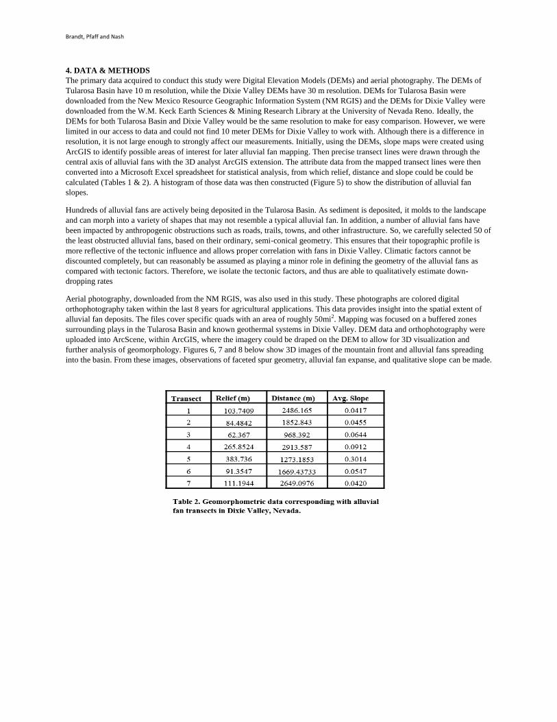
3. DIXIE VALLEY
Dixie Valley is located in west-central Nevada, U.S.A (Figs. 3 & 4) within the Central Nevada seismic belt and the Battle
Mountain heat flow high. The valley is bounded by the Stillwater Range on the west and the Clan Alpine and Augusta Mountains
on the east. This area is home of what is arguably the premier high enthalpy geothermal system in the Great Basin. Within its
borders lie several surface geothermal manifestations including Hyder, Sou, and Dixie hot springs and Senator Fumaroles. Deep
resource temperatures of 256-275o C have been recorded a few kilometers south of the production field (Benoit, 1994; Blackwell
et al., 2000), where Terra-Gen Operating Co., LLC operates geothermal power plants producing a total of 72 MW (terra-
gen.com). The geothermal system has generally been described as fault-controlled deep-circulation, although work done by
Wannamaker et al (2006) suggests a possible magmatic heat source.
Dixie Valley is unique in that it has the lowest elevation in Nevada outside of the Mohave Desert (<3380 ft. at Humboldt Salt
Marsh) because of rapid extension and basin down-dropping. This is also expressed in geomorphic features, such as the
prominent Stillwater fault scarp that resulted from the 6.8 magnitude 1954 Dixie Valley earthquake, prominent and little
dissected faceted spurs, wine glass shaped canyons, fault offset related knickpoints in channels, and concave and head-ward
steepened alluvial fan surfaces. The presence of the remarkable geothermal system and geomorphic features related to the active
Stillwater fault system makes this area ideal for geomorphic correlation with other regions undergoing exploration projects.
Brandt, Pfaff and Nash
4. DATA & METHODS
The primary data acquired to conduct this study were Digital Elevation Models (DEMs) and aerial photography. The DEMs of
Tularosa Basin have 10 m resolution, while the Dixie Valley DEMs have 30 m resolution. DEMs for Tularosa Basin were
downloaded from the New Mexico Resource Geographic Information System (NM RGIS) and the DEMs for Dixie Valley were
downloaded from the W.M. Keck Earth Sciences & Mining Research Library at the University of Nevada Reno. Ideally, the
DEMs for both Tularosa Basin and Dixie Valley would be the same resolution to make for easy comparison. However, we were
limited in our access to data and could not find 10 meter DEMs for Dixie Valley to work with. Although there is a difference in
resolution, it is not large enough to strongly affect our measurements. Initially, using the DEMs, slope maps were created using
ArcGIS to identify possible areas of interest for later alluvial fan mapping. Then precise transect lines were drawn through the
central axis of alluvial fans with the 3D analyst ArcGIS extension. The attribute data from the mapped transect lines were then
converted into a Microsoft Excel spreadsheet for statistical analysis, from which relief, distance and slope could be could be
calculated (Tables 1 & 2). A histogram of those data was then constructed (Figure 5) to show the distribution of alluvial fan
slopes.
Hundreds of alluvial fans are actively being deposited in the Tularosa Basin. As sediment is deposited, it molds to the landscape
and can morph into a variety of shapes that may not resemble a typical alluvial fan. In addition, a number of alluvial fans have
been impacted by anthropogenic obstructions such as roads, trails, towns, and other infrastructure. So, we carefully selected 50 of
the least obstructed alluvial fans, based on their ordinary, semi-conical geometry. This ensures that their topographic profile is
more reflective of the tectonic influence and allows proper correlation with fans in Dixie Valley. Climatic factors cannot be
discounted completely, but can reasonably be assumed as playing a minor role in defining the geometry of the alluvial fans as
compared with tectonic factors. Therefore, we isolate the tectonic factors, and thus are able to qualitatively estimate down-
dropping rates
Aerial photography, downloaded from the NM RGIS, was also used in this study. These photographs are colored digital
orthophotography taken within the last 8 years for agricultural applications. This data provides insight into the spatial extent of
alluvial fan deposits. The files cover specific quads with an area of roughly 50mi2. Mapping was focused on a buffered zones
surrounding plays in the Tularosa Basin and known geothermal systems in Dixie Valley. DEM data and orthophotography were
uploaded into ArcScene, within ArcGIS, where the imagery could be draped on the DEM to allow for 3D visualization and
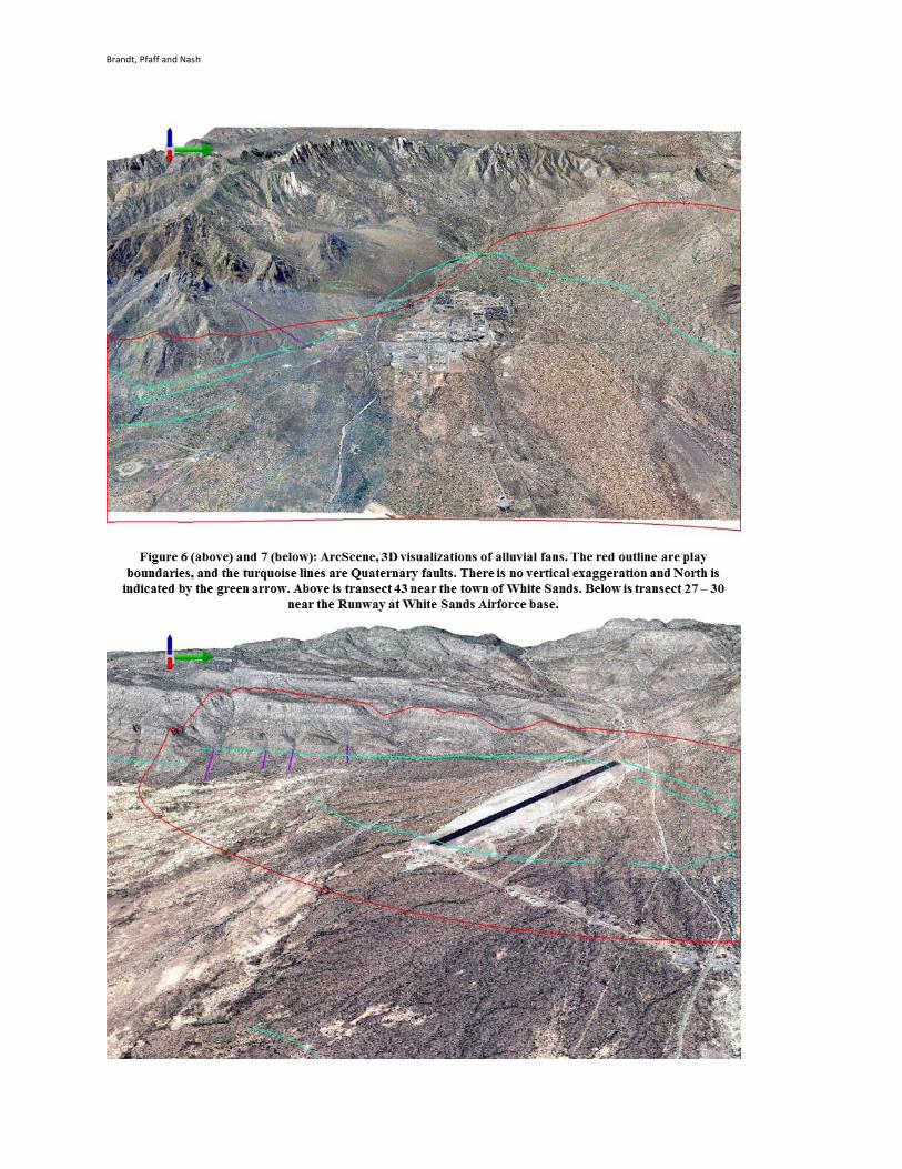
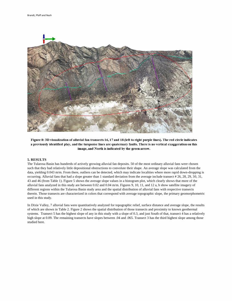
further analysis of geomorphology. Figures 6, 7 and 8 below show 3D images of the mountain front and alluvial fans spreading
into the basin. From these images, observations of faceted spur geometry, alluvial fan expanse, and qualitative slope can be made.
Brandt, Pfaff and Nash
Figure 5. Histogram for geomorphometric values of topographic slope along the central axis of alluvial fans.
0
5
10
15
20
25
Co
un
t
Slope
Histogram of Alluvial Fan Slope Values
Brandt, Pfaff and Nash
Brandt, Pfaff and Nash
5. RESULTS
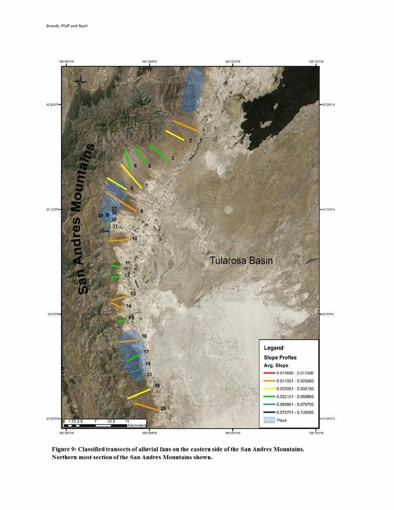
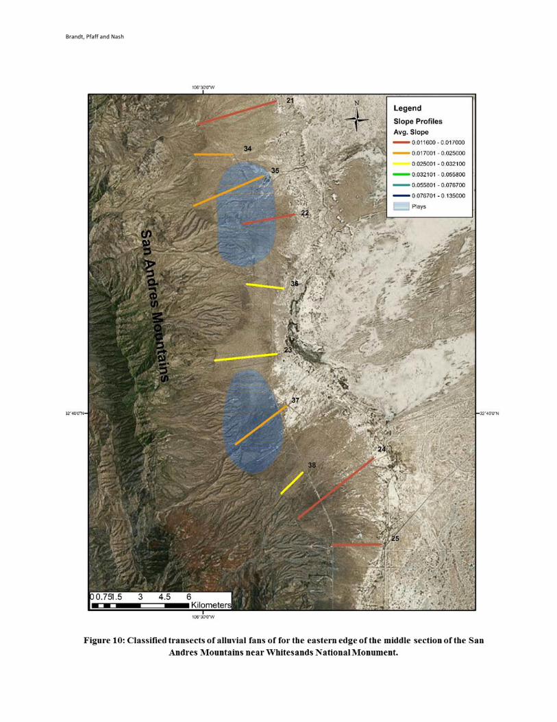
The Tularosa Basin has hundreds of actively growing alluvial fan deposits. 50 of the most ordinary alluvial fans were chosen
such that they had relatively little depositional obstructions to convolute their shape. An average slope was calculated from the
data, yielding 0.043 m/m. From there, outliers can be detected, which may indicate localities where more rapid down-dropping is
occurring. Alluvial fans that had a slope greater than 1 standard deviation from the average include transect # 26, 28, 29, 30, 31,
43 and 46 (from Table 1). Figure 5 shows the average slope values in a histogram plot, which clearly shows that more of the
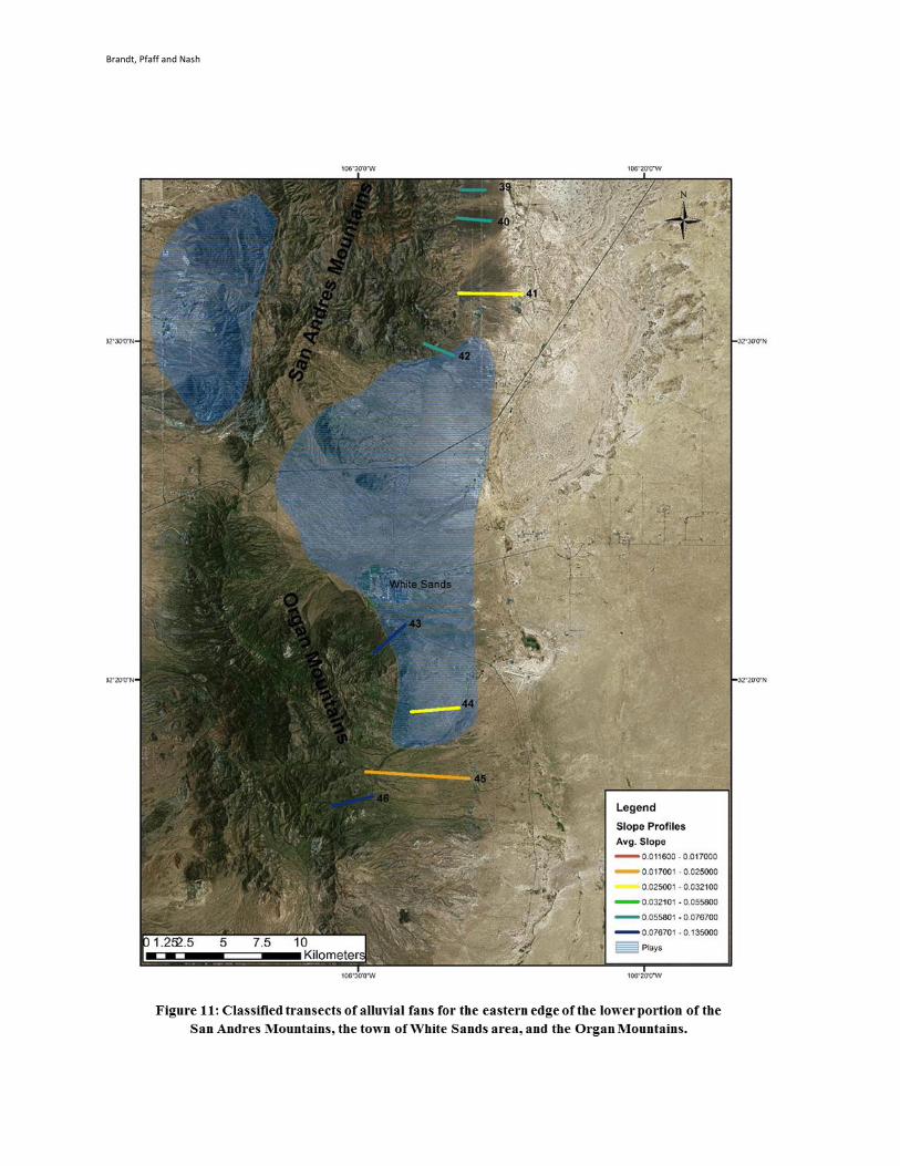
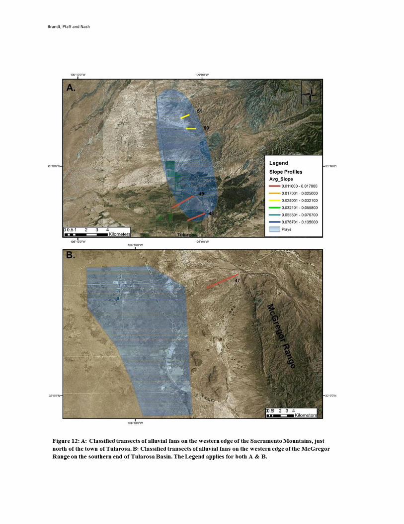
alluvial fans analyzed in this study are between 0.02 and 0.04 m/m. Figures 9, 10, 11, and 12 a, b show satellite imagery of
different regions within the Tularosa Basin study area and the spatial distribution of alluvial fans with respective transects
therein. Those transects are characterized in colors that correspond with average topographic slope, the primary geomorphometric
used in this study.
In Dixie Valley, 7 alluvial fans were quantitatively analyzed for topographic relief, surface distance and average slope, the results
of which are shown in Table 2. Figure 2 shows the spatial distribution of those transects and proximity to known geothermal
systems. Transect 5 has the highest slope of any in this study with a slope of 0.3, and just South of that, transect 4 has a relatively
high slope at 0.09. The remaining transects have slopes between .04 and .065. Transect 3 has the third highest slope among those
studied here.
Brandt, Pfaff and Nash
Brandt, Pfaff and Nash
Brandt, Pfaff and Nash
Brandt, Pfaff and Nash
Brandt, Pfaff and Nash
6. CONCLUSION
If a transect of the central axis of an alluvial fan has a relatively high slope, then the basin must be down-dropping at a faster rate
along that segment that on segments proximal to low-sloping fans. When a segment along a fault has a complex nature, that is, it
steps-over, turns, terminates, etc. it is known that the bedrock around that fault gets fractured, creating permeability in the deep
subsurface. The results in this study show that there is considerable variability in the slope of alluvial fans throughout the
Tularosa Basin and Dixie Valley. From these variations in geomorphometric values, we can identify and constrain with
reasonable uncertainty, segments along range-front quaternary faults that have relatively faster slip rates and therefore more
permeability than others.
The analogous Dixie Valley alluvial fan geomorphology is valid because it is similar tectonic regime and the alluvial fans’
surface geometry are similar. Historic record of the slip rates along faults is highly uncertain on long time scales (~10,000 years)
because of the limitations to how deep trenching can expose a fault zone. Historical tectonic evolution of the areas is a better way
to understand the fault behavior over time, and is best interpreted from geomorphology. Alluvial fan geometry are just one of
many possible geomorphometrics, another common metric is faceted spur geometry, which can be summarized as simple shapes
like triangle or trapezoid. In future work, a quantitative analysis of faceted spur geometry would provide additional insight into
fault behavior, and increase the probability of accurate interpretations. On longer time periods, Anderson (2000) shows that
geomorphometrics like faceted spur and alluvial fan geometry are better for making long term interpretations about fault
behavior. This is crucial for understanding subsurface permeability and discovering hidden geothermal systems.
In conclusion, the geomorphometrics of alluvial fans in Dixie Valley and the Tularosa Basin both showed a lot of variability.
Generally speaking, one would expect fans with steep slopes where relatively rapid basin down-dropping exists. The Dixie
Valley fans with steeper slopes are close, within a mile of the known geothermal systems in the area, where there’s enough
subsurface permeability to allow for deep groundwater circulation. This correlation translates to the Tularosa Basin, where we
observed steeper sloping fans near previously identified plays. This may help to weigh the prioritization of plays in future phases
of research. It is only through drilling geothermal wells to verify if the blind geothermal system exists, that the results of this
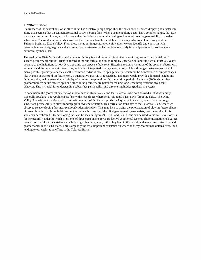
study can be validated. Steeper sloping fans can be seen in Figures 9, 10, 11 and 12 a, b, and can be used to indicate levels of risk
for permeability at depth; which is just one of three components for a productive geothermal system. These qualitative risk values
do not directly reflect the existence of a hidden geothermal system, rather they lend to the overall understanding of structure and
geomechanics in the subsurface. This is arguably the most important constraint on where and why geothermal systems exist, thus
lending to our exploration efforts in the Tularosa Basin.
Brandt, Pfaff and Nash
REFERENCES
Anderson, J.G., and DePolo, C.M.: Estimating the slip rates of normal faults in the Great Basin, USA. Basin Research, 12 (2000),
227-240.
Benoit, D.: Review of geothermal power generation projects in the Basin and Range Province. GRC Bulletin, (1993), 173-178.
Blackwell, D.D., Golan, B., and Benoit, D.: Temperatures in the Dixie Valley, Nevada geothermal system. Geothermal
Resources Council Transactions, 24 (2000), 223-228.
Giano, S.I.: Quaternary alluvial fan systems of the Agri inermontane basin (southern Italy) and climatic controls. Geologica
Carpathica, 62 (2011), 65-76.
Harvey, A.M., Mather, A.E., and Stokes, M.: Alluvial fans: geomorphology, sedimentology, dynamics – introduction. A review
of alluvial-fan research. Geological Society, London, Special Publications, 251 (2005), 1-7
Nash, G.D., and Johnson, G.W.: Conceptualization and Implementation of a tectonic geomorphology study for geothermal
exploration in the Great Basin, U.S.A.. Transactions of the Geothermal Resources Council, 27 (2003), 663-667.
Nash, G.D., Bennett, C.R., Barker, B.J., Moore, J.N., Swanson, M.B.N., Brandt, A., and Simmons, S.: A comparison of two
geothermal play fairway modelling methods as applied to the Tularosa Basin, New Mexico and Texas. Proceedings,
41st Workshop on Geothermal Reservoir Engineering, Stanford University, Stanford, CA, (2016).
Sanchez-Nunez, J.M., Macias, J.L., Saucedo, R., Zamorano, J.J., Novelo, D., Mendoza, M.E., and Torres-Hernandez, J.R.:
Geomorphology, internal structure and evolution of alluvial fans at Motozintla, Chiapas, Mexico. Geomorphology, 230
(2015), 1-12.
Topal, S., Keller, E., Bufe, and A., Kocyigit, A.: Tectonic geomorphology of a large normal fault: Aksehir fault, SW Turkey.
Geomorphology, 259 (2016), 55-69.
Wannamaker, P.E., Doerner, W.M., and Hasterok, D.P.: Possible magmatic Input to the Dixie Valley Geothermal Field, and
implications for district-scale resource exploration, Inferred from magnetotelluric (MT) resistivity surveying.
Proceedings, 31st Workshop on Geothermal Reservoir Engineering, Stanford University, Stanford, CA. 30 (2006),
471-476.