Embed Size (px)
Citation preview
Appendix J-2
BITS Alternative 1 Narragansett Report of Findings for
Freshwater Wetlands Delineations
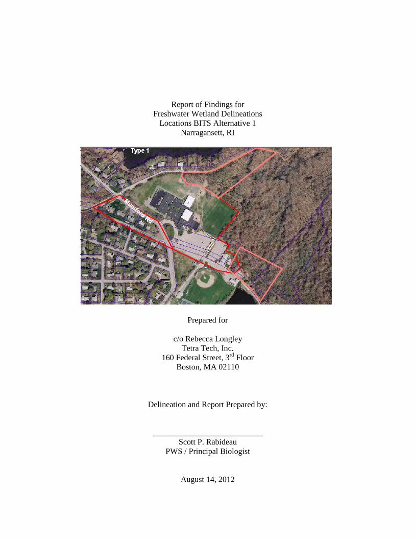
Report of Findings for Freshwater Wetland Delineations
Locations BITS Alternative 1 Narragansett, RI
Prepared for
c/o Rebecca Longley
Tetra Tech, Inc. 160 Federal Street, 3rd Floor
Boston, MA 02110
Delineation and Report Prepared by:
___________________________ Scott P. Rabideau
PWS / Principal Biologist
August 14, 2012
2
Introduction Natural Resource Services, Inc. (NRS) has completed the freshwater wetland de-lineations within the above referenced property. This field work was done in accordance with the delineation standards outlined in Appendix 4, Rules and Regulations Governing the Protection and Management of Freshwater Wetlands in the Vicinity of the Coast. NRS has marked the limit of the coastal feature as defined in the RI Coastal Resources Management Program (CRMP). This coastal feature falls under the administrative au-thority of the RI Coastal Resources Management Council (CRMC). This report will explain what resource areas have been identified on the above referenced property. Based upon these classifications, the CRMC requires regulatory setbacks from the established coastal feature. The regulatory section of this report will explain what buffer zones and setbacks are required. Geographic Information Systems (GIS) graphics are included in the appendix of this report. While this is not to be considered a survey, it is a reasonable approximation of the site conditions which can be used for preliminary planning purposes. This report has been prepared for you in fulfillment of your authorization to pro-ceed. Do not hesitate to contact NRS if you have any questions or require additional cop-ies of this report. Existing Conditions The tax assessor’s map for the Town of Narragansett depicts the project areas within A.P. B-2 lot 8 and A.P. B lot 4, situated north of Route 1A and east of Mumford Road. The locations in question are comprised of both forested upland and wetland por-tions. This area appears to have been historically altered as evident from the presence of ditches and old cart paths. However, historic aerial photographs show that this area has not been previously developed. The wetlands to the north of the access road entering the community center are directly connected to Pettaquamscutt Cove to the north. There is a river that flows to the cove to the north with an associated area of wetland. Pettaquamscutt Cove is classified by the CRMP as Type 1 Waters. Type 1 Waters are defined as conservations areas and are afforded the highest level of protection by the CRMP (CRMP, Section 200.1). There-fore, these wetlands will are classified as ‘contiguous freshwater wetlands’ and specific regulations will apply. There is a pond south of the access road that is also hydrological-ly connected to Pettaquamscutt Cove, however the construction of the road and commu-nity center provide a separation and for this reason the pond is classified as a ‘tributary wetland’ and different regulations will apply. In addition, it is important to note that the entire area is within the Narrow River Special Area Management Plan and classified as ‘Lands of Critical Concern’. This plan was developed to classify and aid in the protection of the Narrow River estuary and wa-
3
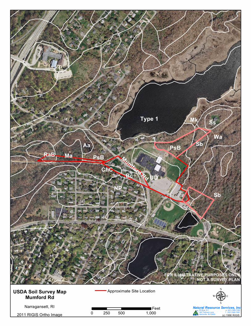
tershed. Additional regulations may apply to the proposed project to help protect this ar-ea. The Rhode Island Soil Survey lists seven (7) soil series within the area. The fol-lowing table lists the soil types and describes there approximate location.
Soil Name Approximate Location Soil Type
Bc- Birchwood South of Mumford Road. Non-hydric sandy loam soil.
Mk- Matunuck In the area south of Pettaq-uamscutt Cove.
Hydric soil with high or-ganic matter content.
Np- Newport-Urban Area west of Mumford Road. Non-hydric urbanized soil.
PsB- Poquonock North and east of Narragansett Elementary School.
Non-hydric loamy fine sand soil.
Sb- Scarboro Majority of wetland area on east sides of each project area. Hydric, mucky-sandy loam.
Ss- Sudbury Upland island northeast of Riv-erside Drive.
Non-hydric, sandy loam soil.
UD- Udorthents Mapped in area of elementary school and baseball field. Non-hydric urbanized soil.
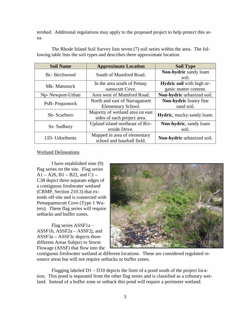
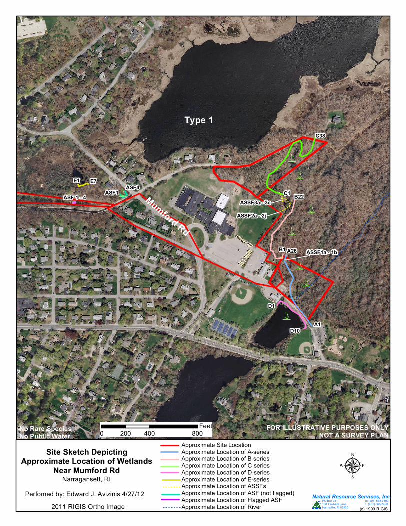
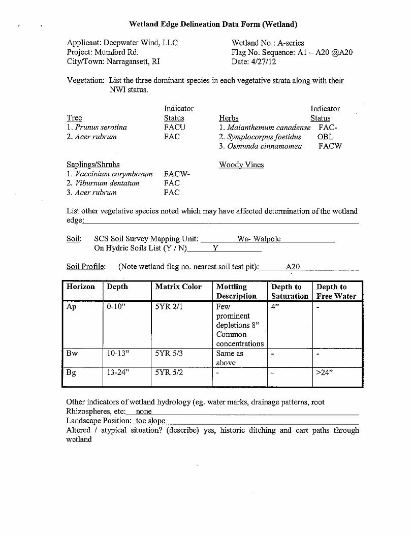
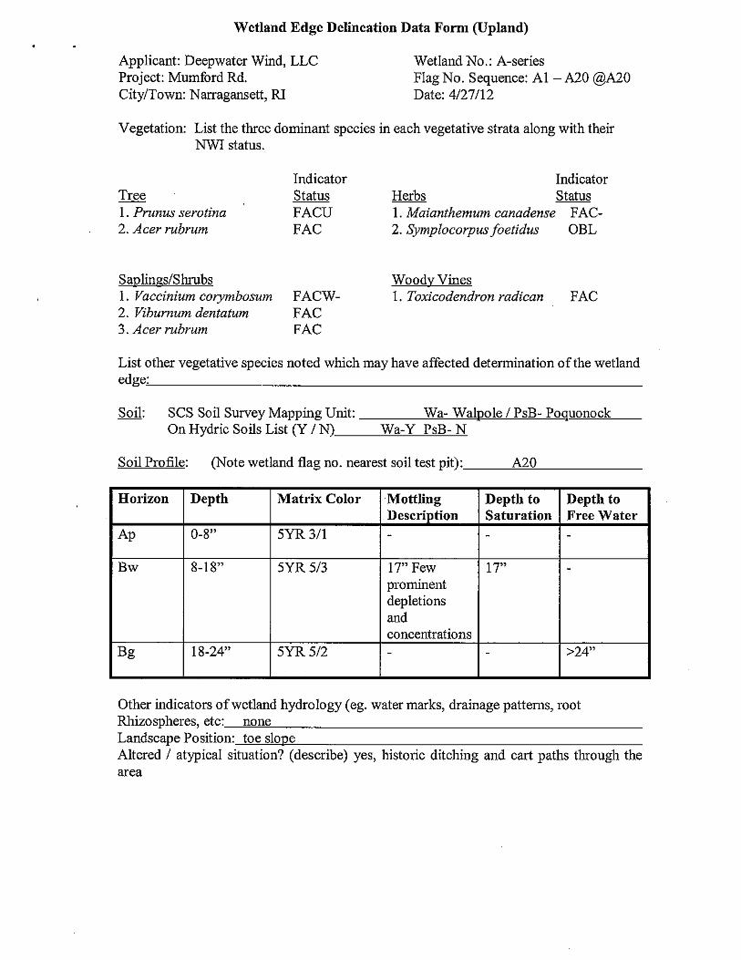
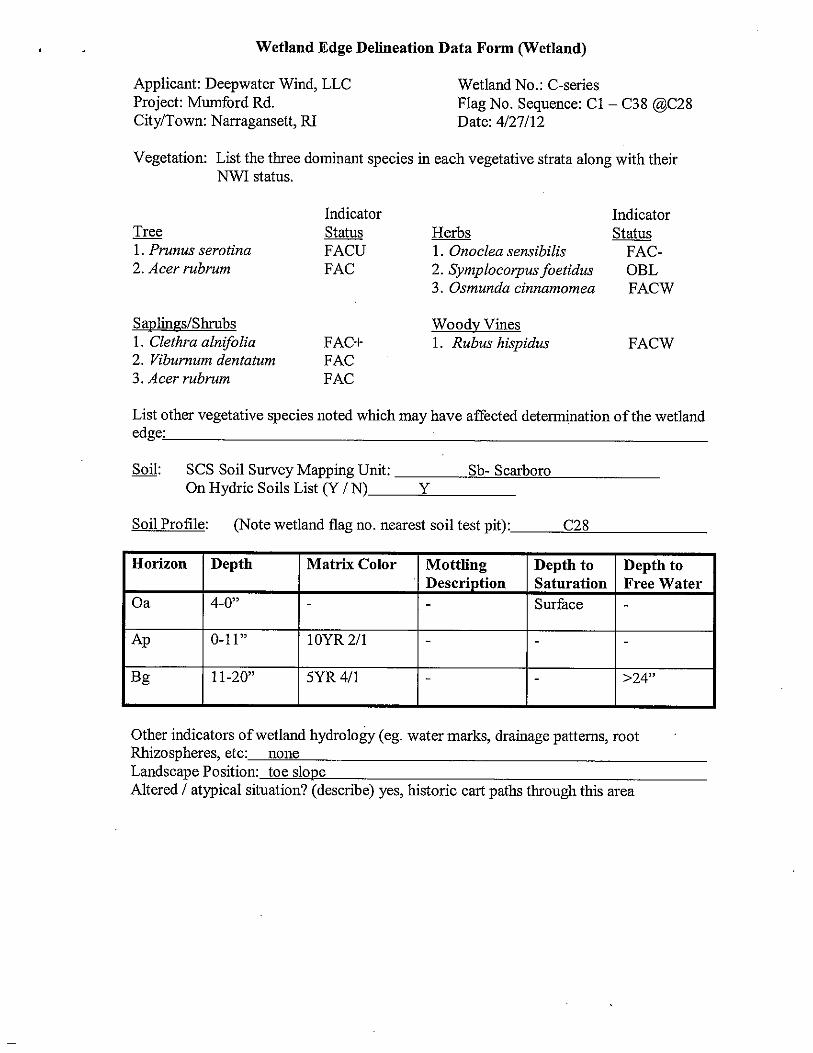
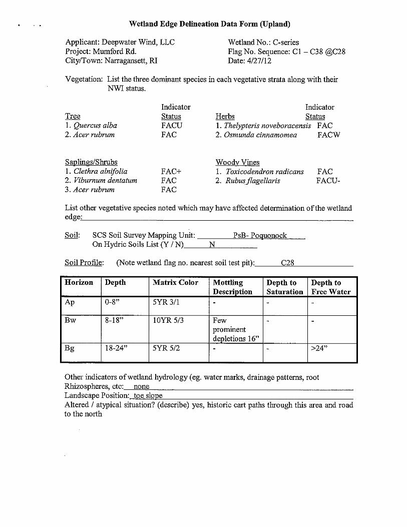
Wetland Delineations I have established nine (9) flag series on the site. Flag series A1 – A26, B1 – B22, and C1 – C38 depict three separate edges of a contiguous freshwater wetland (CRMP, Section 210.3) that ex-tends off-site and is connected with Pettaquamscutt Cove (Type 1 Wa-ters). These flag series will require setbacks and buffer zones. Flag series ASSF1a – ASSF1b, ASSF2a – ASSF2j, and ASSF3a – ASSF3c depicts three different Areas Subject to Storm Flowage (ASSF) that flow into the contiguous freshwater wetland at different locations. These are considered regulated re-source areas but will not require setbacks or buffer zones. Flagging labeled D1 – D10 depicts the limit of a pond south of the project loca-tion. This pond is separated from the other flag series and is classified as a tributary wet-land. Instead of a buffer zone or setback this pond will require a perimeter wetland.
4
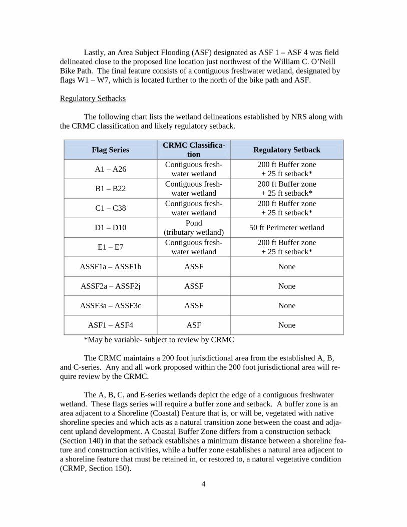
Lastly, an Area Subject Flooding (ASF) designated as ASF 1 – ASF 4 was field delineated close to the proposed line location just northwest of the William C. O’Neill Bike Path. The final feature consists of a contiguous freshwater wetland, designated by flags W1 – W7, which is located further to the north of the bike path and ASF. Regulatory Setbacks The following chart lists the wetland delineations established by NRS along with the CRMC classification and likely regulatory setback.
Flag Series CRMC Classifica-tion Regulatory Setback
A1 – A26 Contiguous fresh-water wetland
200 ft Buffer zone + 25 ft setback*
B1 – B22 Contiguous fresh-water wetland
200 ft Buffer zone + 25 ft setback*
C1 – C38 Contiguous fresh-water wetland
200 ft Buffer zone + 25 ft setback*
D1 – D10 Pond (tributary wetland) 50 ft Perimeter wetland
E1 – E7 Contiguous fresh-water wetland
200 ft Buffer zone + 25 ft setback*
ASSF1a – ASSF1b ASSF None
ASSF2a – ASSF2j ASSF None
ASSF3a – ASSF3c ASSF None
ASF1 – ASF4 ASF None
*May be variable- subject to review by CRMC The CRMC maintains a 200 foot jurisdictional area from the established A, B, and C-series. Any and all work proposed within the 200 foot jurisdictional area will re-quire review by the CRMC. The A, B, C, and E-series wetlands depict the edge of a contiguous freshwater wetland. These flags series will require a buffer zone and setback. A buffer zone is an area adjacent to a Shoreline (Coastal) Feature that is, or will be, vegetated with native shoreline species and which acts as a natural transition zone between the coast and adja-cent upland development. A Coastal Buffer Zone differs from a construction setback (Section 140) in that the setback establishes a minimum distance between a shoreline fea-ture and construction activities, while a buffer zone establishes a natural area adjacent to a shoreline feature that must be retained in, or restored to, a natural vegetative condition (CRMP, Section 150).
5
The width of the buffer zone is determined from Table 9-1 of the Narrow River Special Area Management Plan (SAMP). This states that a 200 foot buffer zone and ad-ditional 25 foot setback will be required in areas of ‘Critical Concern’ and relief will from this regulation will require a Special Exception and a Variance. Additional on-site wastewater treatment system (OWTS) setbacks will also apply. However, please note the buffer zones determined should be interpreted as appro-priate guidance only and that for commercial development, the CRMC will review each case individually and may require additional buffer zone requirements as stated in the excerpt below from the CRMP (Section 150, E., 4.) Coastal Buffer Zone Requirements for all Commercial and Industrial develop-ment and activities subject to the requirements of Section 300.8, Section 300.13, or Sec-tion 320: Coastal Buffer Zones shall be determined on a case-by-case basis by the Coun-cil. Table 2a may be used as appropriate guidance. However, depending on the activity proposed and its potential impacts on coastal resources, the Council may require a Coastal Buffer Zone with a width greater than that found in the Table 2a. The D-series wetland meets the definition of a pond and will require a 50 foot pe-rimeter wetland. The three ASSFs are regulated resource areas but will not require buffer zones or setbacks. In addition, the ASF (GPS located only) will not require a buffer zone or setback but is also a regulated resource area. There is a direct prohibition on the alteration of tributary wetlands (D-series) and contiguous wetlands to Type 1 Waters (A, B, and C-series). However, the CRMC may permit such a project as a special exception so long as it is determined that the project serves as a compelling public purpose which provides benefits to the public as a whole as opposed to individual or private interests (CRMP, Section 130). Summation The purpose of this work was to help you determine the regulatory issues, relative to the CRMC regulations, involved with the potential alteration to the above mentioned project locations. It appears that the majority of the areas available are within the buffer zone areas or setback areas required at these locations. Permitting will be required from the CRMC to work within these areas. These regulations can be somewhat complicated and are dependent on location and extent of the proposed work.

6
Appendix
PsB SbWa
SsMk
Sb
UDBcChC
NP
Mumford Rd
Type 1
RaB Ma PsBAa
USDA Soil Survey MapMumford RdNarragansett, RI
FOR ILLUSTRATIVE PURPOSES ONLYNOT A SURVEY PLAN
0 500 1,000250Feet
µApproximate Site Location
(c) 1990 RIGIS
Natural Resource Services, Inc.PO Box 311 p: (401) 568-7390180 Tinkham Lane f: (401) 568-7490Harrisville, RI 028302011 RIGIS Ortho Image
Mumford Rd
Type 1
A1
A26B1
B22C1
C38
ASSF2a - 2j
ASSF3a - 3c
ASSF1a - 1b
\
\
\
\
\
\
D1
D10
\
\ASF1ASF4
E1 E7
ASF 1 - 4
Site Sketch Depicting Approximate Location of Wetlands
Near Mumford RdNarragansett, RI
FOR ILLUSTRATIVE PURPOSES ONLYNOT A SURVEY PLAN0 400 800200
Feet
µApproximate Site LocationApproximate Location of A-seriesApproximate Location of B-seriesApproximate Location of C-seriesApproximate Location of D-seriesApproximate Location of E-seriesApproximate Location of ASSFsApproximate Location of ASF (not flagged)Approximate Location of Flagged ASFApproximate Location of River (c) 1990 RIGIS
Natural Resource Services, Inc.PO Box 311 p: (401) 568-7390180 Tinkham Lane f: (401) 568-7490Harrisville, RI 02830
No Rare SpeciesNo Public Water
2011 RIGIS Ortho ImagePerfomed by: Edward J. Avizinis 4/27/12
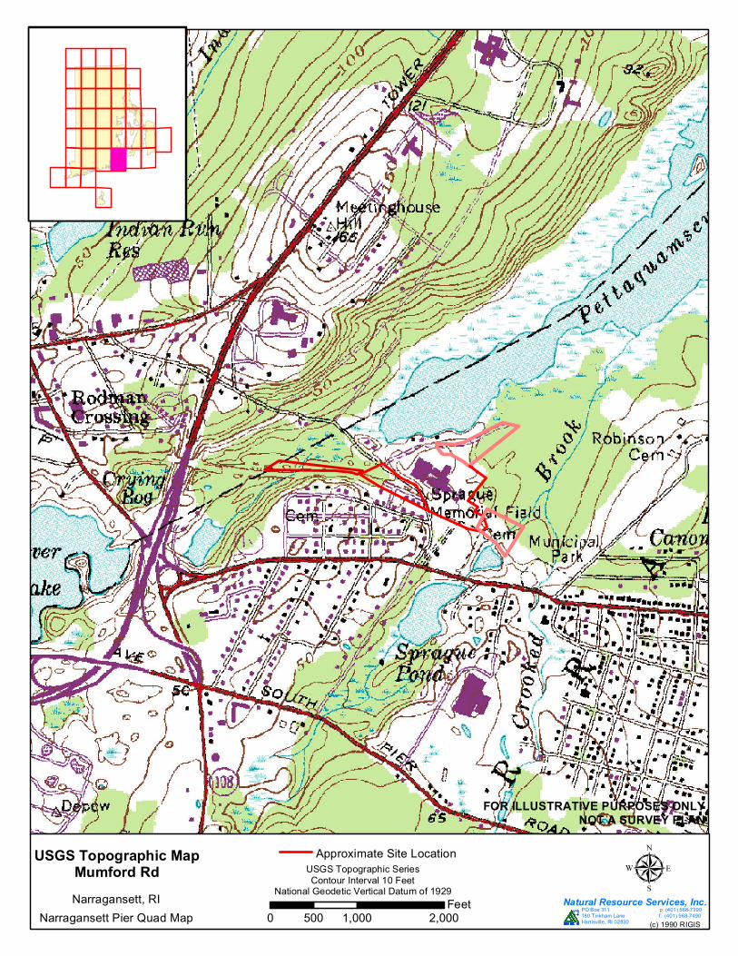
USGS Topographic MapMumford RdNarragansett, RI
FOR ILLUSTRATIVE PURPOSES ONLYNOT A SURVEY PLAN
0 1,000 2,000500Feet
µApproximate Site Location
USGS Topographic SeriesContour Interval 10 Feet
National Geodetic Vertical Datum of 1929
Narragansett Pier Quad Map (c) 1990 RIGIS
Natural Resource Services, Inc.PO Box 311 p: (401) 568-7390180 Tinkham Lane f: (401) 568-7490Harrisville, RI 02830
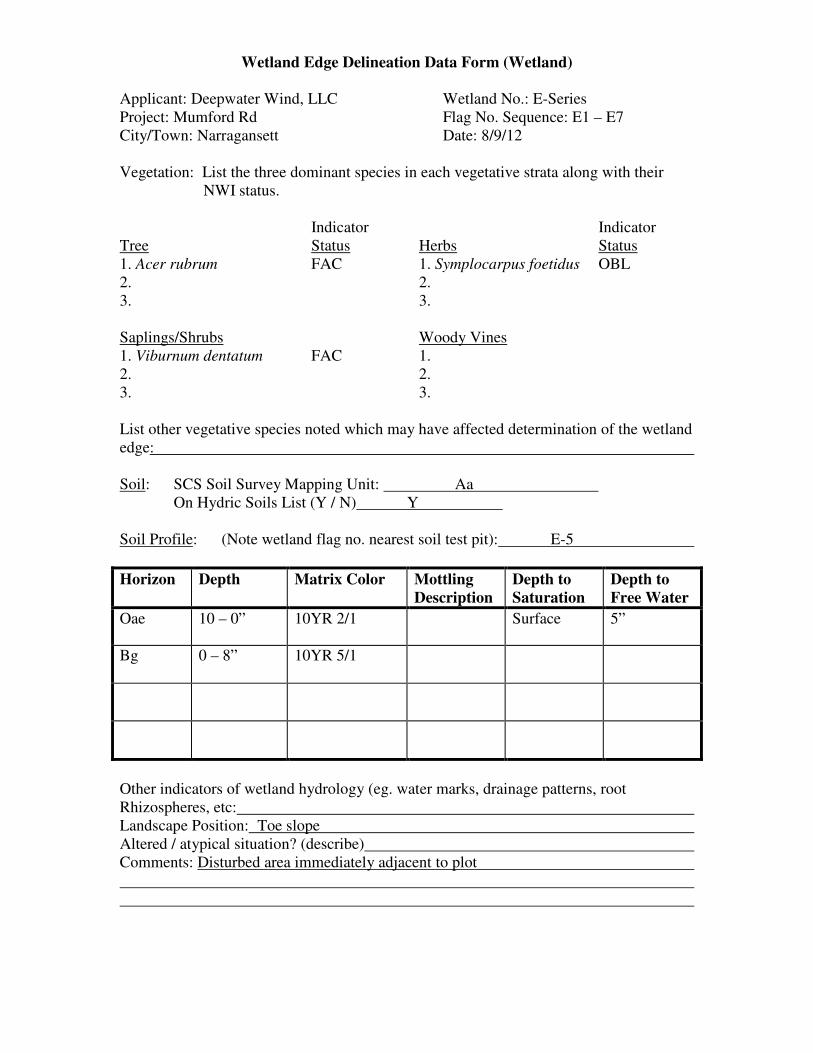
Wetland Edge Delineation Data Form (Wetland)
Applicant: Deepwater Wind, LLC Wetland No.: E-Series
Project: Mumford Rd Flag No. Sequence: E1 – E7
City/Town: Narragansett Date: 8/9/12
Vegetation: List the three dominant species in each vegetative strata along with their
NWI status.
Indicator Indicator
Tree Status Herbs Status
1. Acer rubrum FAC 1. Symplocarpus foetidus OBL
2. 2.
3. 3.
Saplings/Shrubs Woody Vines
1. Viburnum dentatum FAC 1.
2. 2.
3. 3.
List other vegetative species noted which may have affected determination of the wetland
edge:
Soil: SCS Soil Survey Mapping Unit: Aa
On Hydric Soils List (Y / N) Y
Soil Profile: (Note wetland flag no. nearest soil test pit): E-5
Horizon Depth Matrix Color Mottling
Description
Depth to
Saturation
Depth to
Free Water
Oae 10 – 0” 10YR 2/1 Surface 5”
Bg
0 – 8” 10YR 5/1
Other indicators of wetland hydrology (eg. water marks, drainage patterns, root
Rhizospheres, etc:
Landscape Position: Toe slope
Altered / atypical situation? (describe)
Comments: Disturbed area immediately adjacent to plot
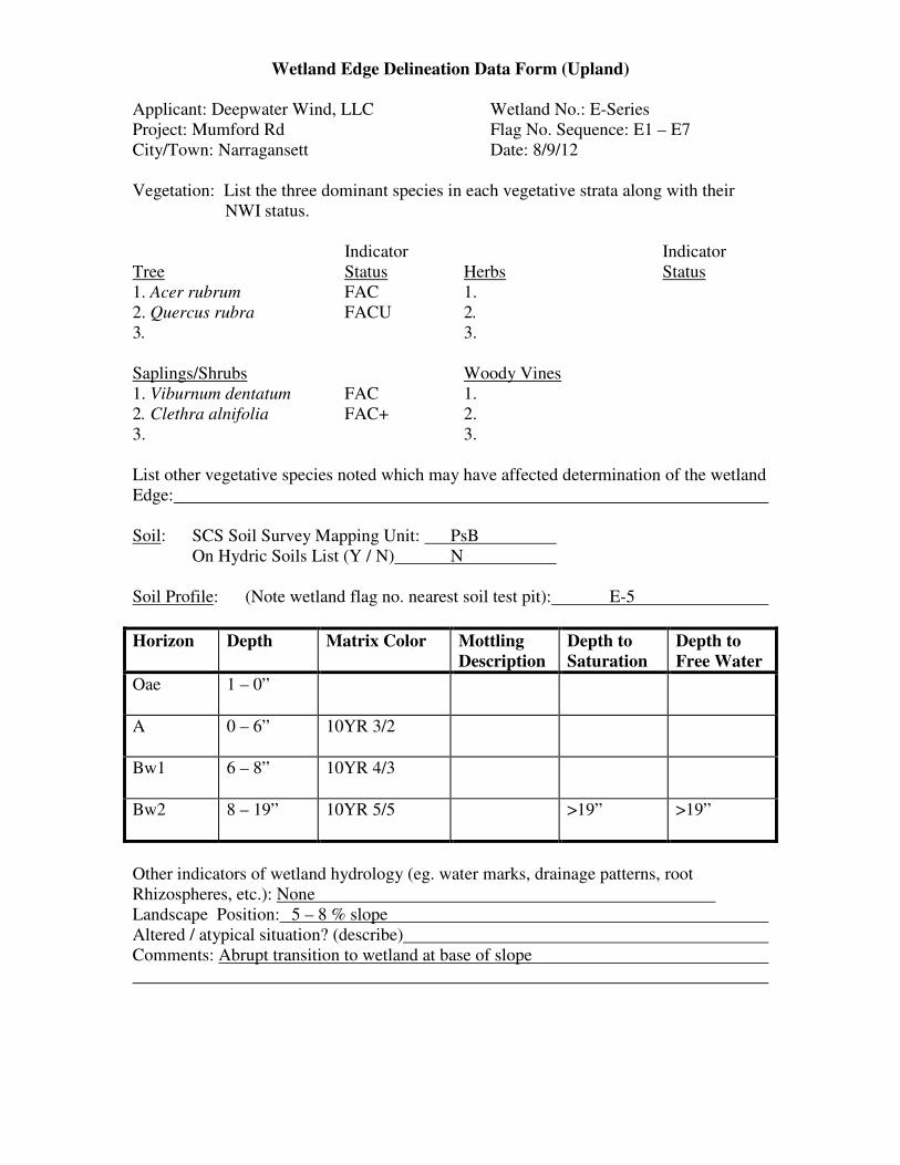
Wetland Edge Delineation Data Form (Upland)
Applicant: Deepwater Wind, LLC Wetland No.: E-Series
Project: Mumford Rd Flag No. Sequence: E1 – E7
City/Town: Narragansett Date: 8/9/12
Vegetation: List the three dominant species in each vegetative strata along with their
NWI status.
Indicator Indicator
Tree Status Herbs Status
1. Acer rubrum FAC 1.
2. Quercus rubra FACU 2.
3. 3.
Saplings/Shrubs Woody Vines
1. Viburnum dentatum FAC 1.
2. Clethra alnifolia FAC+ 2.
3. 3.
List other vegetative species noted which may have affected determination of the wetland
Edge:
Soil: SCS Soil Survey Mapping Unit: PsB
On Hydric Soils List (Y / N) N
Soil Profile: (Note wetland flag no. nearest soil test pit): E-5
Horizon Depth Matrix Color Mottling
Description
Depth to
Saturation
Depth to
Free Water
Oae
1 – 0”
A
0 – 6” 10YR 3/2
Bw1 6 – 8” 10YR 4/3
Bw2
8 – 19” 10YR 5/5 >19” >19”
Other indicators of wetland hydrology (eg. water marks, drainage patterns, root
Rhizospheres, etc.): None
Landscape Position: 5 – 8 % slope
Altered / atypical situation? (describe)
Comments: Abrupt transition to wetland at base of slope


