Embed Size (px)
Citation preview

Appendix C: Water Chemistry QA/QC Field Method Precision
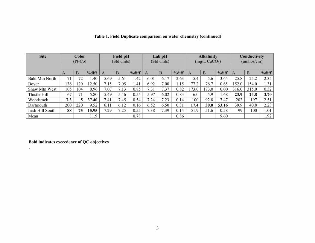
Water chemistry sampling precision was quantified as relative percent difference (RPD) between field duplicates. Field duplicate comparisons are presented in Table 1. The QAPP outlined precision and accuracy objectives for field and laboratory duplicates. However, a wider RPD range should be applied to field duplicates than laboratory duplicates for seasonal pools. Field duplicates are highly variable due to the shallow, easily disturbed bottom and biologically rich nature of the pools. As a result, these field duplicates reflect the range of variability for each parameter and determines the representativeness of a sample at a given time in a seasonal pool. Field duplicates objectives were exceeded for the following parameters: color, alkalinity, conductivity, magnesium, chloride and aluminum. In addition, field duplicate and laboratory duplicate objectives for low level samples are typically based on an absolute difference between samples, not as a percentage.
Laboratory Analysis Precision
The laboratory duplicates presented in Table 2 were used to determine precision. Laboratory duplicate means were within QC objectives. However, one alkalinity duplicate for Hampshire Hill on 06-04-1999 was 17% different. The duplicate value was not included in the final data set. It was determined to be inconsistent with all other results for this pool. Laboratory anion duplicates were not performed on specified seasonal pool samples. Instead, laboratory duplicates performed concurrently within the same analytical run have been used to determine precision. Laboratory Analysis Accuracy
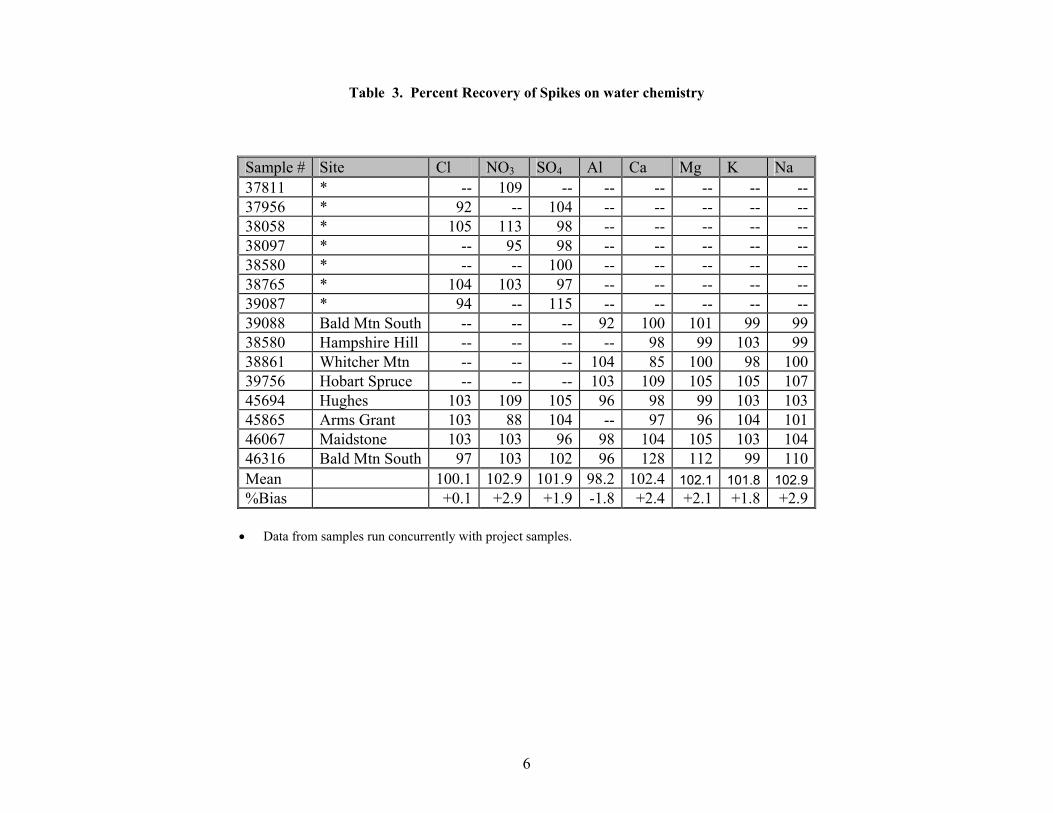
Accuracy is expressed as percent recovery or percent bias and is determined from the analysis of quality control reference samples that differ from the calibration standard. Due to very low anion concentrations, accuracy of the anion analysis was determined by calculating percent bias of internal spike standards. During 1999, these standards were analyzed concurrently with the water samples. In 2000, these were calculated directly from seasonal pool samples. See Table 3 for percent recovery results. The mean % recovery and the % bias were within QC objectives for all parameters.
1
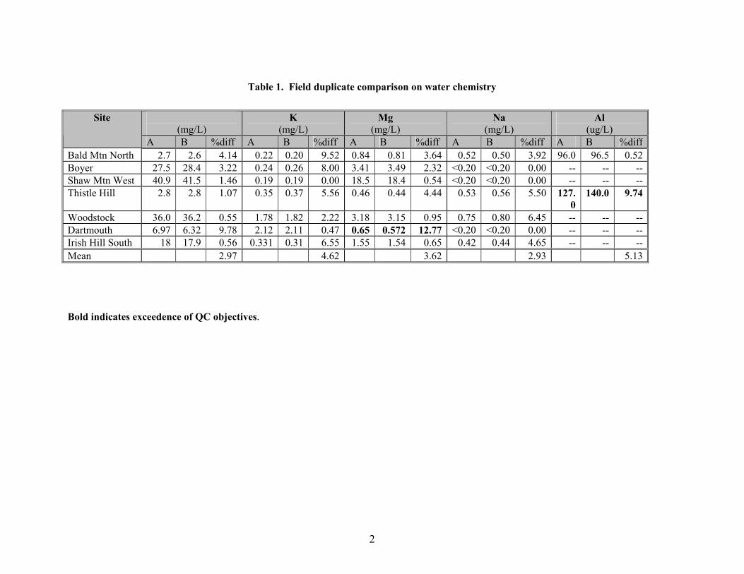
Ca (mg/L)
K (mg/L)
Mg (mg/L)
Na (mg/L)
Al (ug/L)
Site
A B %diff A B %diff A B %diff A B %diff A B %diffBald Mtn North 2.7 2.6 4.14 0.22 0.20 9.52 0.84 0.81 3.64 0.52 0.50 3.92 96.0 96.5 0.52Boyer 27.5 28.4 3.22 0.24 0.26 8.00 3.41 3.49 2.32 <0.20 <0.20 0.00 -- -- --Shaw Mtn West 40.9 41.5 1.46 0.19 0.19 0.00 18.5 18.4 0.54 <0.20 <0.20 0.00 -- -- --Thistle Hill 2.8 2.8 1.07 0.35 0.37 5.56 0.46 0.44 4.44 0.53 0.56 5.50 127.
0140.0 9.74
Woodstock 36.0 36.2 0.55 1.78 1.82 2.22 3.18 3.15 0.95 0.75 0.80 6.45 -- -- --Dartmouth 6.97 6.32 9.78 2.12 2.11 0.47 0.65 0.572 12.77 <0.20 <0.20 0.00 -- -- --Irish Hill South 18 17.9 0.56 0.331 0.31 6.55 1.55 1.54 0.65 0.42 0.44 4.65 -- -- --Mean 2.97 4.62 3.62 2.93 5.13
Table 1. Field duplicate comparison on water chemistry
2
Bold indicates exceedence of QC objectives.
3
Table 1. Field Duplicate comparison on water chemistry (continued)
Color (Pt-Co)
Field pH (Std units)
Lab pH (Std units)
Alkalinity (mg/L CaCO3)
Conductivity (umhos/cm)
Site
A B %diff A B %diff A B %diff A B %diff A B %diff Bald Mtn North 71 72 1.40 5.69 5.61 1.42 6.01 6.17 2.63 5.4 5.6 3.64 25.8 25.2 2.35Boyer 136 120 12.50 7.15 7.05 1.41 6.92 7.00 1.15 77.2 76.7 0.65 152.0 154.0 1.31Shaw Mtn West 105 104 0.96 7.07 7.13 0.85 7.31 7.37 0.82 173.0 173.0 0.00 316.0 315.0 0.32Thistle Hill 67 71 5.80 5.49 5.46 0.55 5.97 6.02 0.83 6.0 5.9 1.68 23.9 24.8 3.70Woodstock 7.3 5 37.40 7.41 7.45 0.54 7.24 7.23 0.14 100 92.8 7.47 202 197 2.51Dartmouth 200 220 9.52 6.11 6.12 0.16 6.52 6.50 0.31 17.4 30.0 53.16 39.9 40.8 2.23Irish Hill South 88 75 15.95 7.29 7.25 0.55 7.38 7.39 0.14 51.9 51.6 0.58 99 100 1.01Mean 11.9 0.78 0.86 9.60 1.92
Bold indicates exceedence of QC objectives .
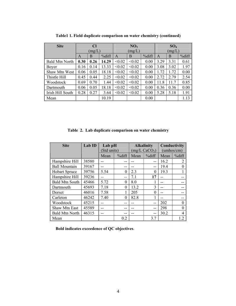
Table1 1. Field duplicate comparison on water chemistry (continued)
Cl (mg/L)
NO3 (mg/L)
SO4 (mg/L)
Site
A B %diff A B %diff A B %diffBald Mtn North 0.30 0.26 14.29 <0.02 <0.02 0.00 3.29 3.31 0.61Boyer 0.16 0.14 13.33 <0.02 <0.02 0.00 3.08 3.02 1.97Shaw Mtn West 0.06 0.05 18.18 <0.02 <0.02 0.00 1.72 1.72 0.00Thistle Hill 0.45 0.44 2.25 <0.02 <0.02 0.00 2.72 2.79 2.54Woodstock 0.69 0.70 1.44 <0.02 <0.02 0.00 11.8 11.7 0.85Dartmouth 0.06 0.05 18.18 <0.02 <0.02 0.00 0.36 0.36 0.00Irish Hill South 0.28 0.27 3.64 <0.02 <0.02 0.00 5.28 5.18 1.91Mean 10.19 0.00 1.13
Table 2. Lab duplicate comparison on water chemistry
Lab pH (Std units)
Alkalinity (mg/L CaCO3)
Conductivity (umhos/cm)
Site Lab ID
Mean %diff Mean %diff Mean %diff Hampshire Hill 38580 -- -- -- -- 16.2 2 Ball Mountain 39167 -- -- -- -- 19.4 0 Hobart Spruce 39756 5.54 0 2.3 0 19.3 1 Hampshire Hill 39236 -- -- 7.1 17 -- -- Bald Mtn South 45466 5.72 0 8.0 1 -- -- Dartmouth 45693 7.18 0 13.2 3 -- -- Dorset 46016 7.58 1 205 0 -- -- Carleton 46242 7.40 0 82.8 1 -- -- Woodstock 45215 -- -- -- -- 202 0 Shaw Mtn East 45589 -- -- -- -- 298 0 Bald Mtn North 46315 -- -- -- -- 30.2 4 Mean 0.2 3.7 1.2
Bold indicates exceedence of QC objectives.
4
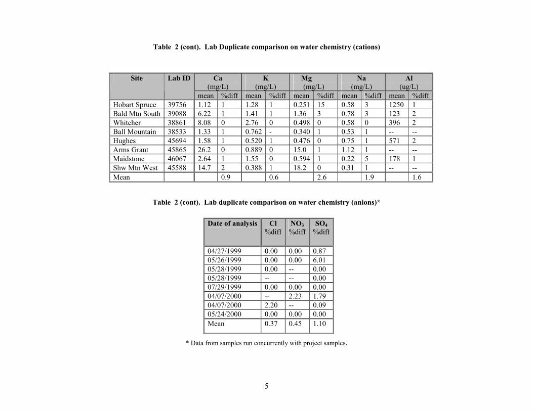
Table 2 (cont). Lab Duplicate comparison on water chemistry (cations)
Table 2 (cont). Lab duplicate comparison on water chemistry (anions)*
Ca (mg/L)
K (mg/L)
Mg (mg/L)
Na (mg/L)
Al (ug/L)
Site Lab ID
mean %diff mean %diff mean %diff mean %diff mean %diffHobart Spruce 39756 1.12 1 1.28 1 0.251 15 0.58 3 1250 1 Bald Mtn South 39088 6.22 1 1.41 1 1.36 3 0.78 3 123 2Whitcher 38861 8.08 0 2.76 0 0.498 0 0.58 0 396 2Ball Mountain 38533 1.33 1 0.762 - 0.340 1 0.53 1 -- --Hughes 45694 1.58 1 0.520 1 0.476 0 0.75 1 571 2Arms Grant 45865 26.2 0 0.889 0 15.0 1 1.12 1 -- --Maidstone 46067 2.64 1 1.55 0 0.594 1 0.22 5 178 1Shw Mtn West 45588 14.7 2 0.388 1 18.2 0 0.31 1 -- --Mean 0.9 0.6 2.6 1.9 1.6
Date of analysis Cl %diff
NO3 %diff
SO4 %diff
04/27/1999 0.00 0.00 0.8705/26/1999 0.00 0.00 6.0105/28/1999 0.00 -- 0.0005/28/1999 -- -- 0.0007/29/1999 0.00 0.00 0.0004/07/2000 -- 2.23 1.7904/07/2000 2.20 -- 0.0905/24/2000 0.00 0.00 0.00Mean 0.37 0.45 1.10
* Data from samples run concurrently with project samples.
5
6
Table 3. Percent Recovery of Spikes on water chemistry
Sample # Site Cl NO3 SO4 Al Ca Mg K Na 37811 * -- 109 -- -- -- -- -- --37956 * 92 -- 104 -- -- -- -- --38058 * 105 113 98 -- -- -- -- --38097 * -- 95 98 -- -- -- -- --38580 * -- -- 100 -- -- -- -- --38765 * 104 103 97 -- -- -- -- --39087 * 94 -- 115 -- -- -- -- --39088 Bald Mtn South -- -- -- 92 100 101 99 9938580 Hampshire Hill -- -- -- -- 98 99 103 9938861 Whitcher Mtn -- -- -- 104 85 100 98 10039756 Hobart Spruce -- -- -- 103 109 105 105 10745694 Hughes 103 109 105 96 98 99 103 10345865 Arms Grant 103 88 104 -- 97 96 104 10146067 Maidstone 103 103 96 98 104 105 103 10446316 Bald Mtn South 97 103 102 96 128 112 99 110Mean 100.1 102.9 101.9 98.2 102.4 102.1 101.8 102.9%Bias +0.1 +2.9 +1.9 -1.8 +2.4 +2.1 +1.8 +2.9
• Data from samples run concurrently with project samples.

Appendix D
Northern White Cedar Swamp Site Reports
1

2
Northern White Cedar Swamps of Vermont Vermont Agency of Natural Resources, 2003
SITE NAME: Martell Swamp TOWN: Woodbury MAPS: Cabot, VT 7.5' U.S.G.S. topographic map LOCATION: 1,250 meters northwest of Nichols Pond in Woodbury SOURCE OF INFORMATION: Site visits on 6/8/99, 6/10/99, 6/15/99, 7/1/99, and 9/27/99 by E. Sorenson and J. Rykken OWNERSHIP: Private. No access without permission of landowner. SIGNIFICANCE:
1. State-significant (B-ranked) example of a northern white cedar swamp. 2. Population of the rare moss Calliergon richardsonii.
PHYSICAL SETTING: The 22 hectare (54 acre) Martell Swamp is located in a rather steep sided basin with drainage to the north. A stream originates approximately 900 meters to the south of the swamp and flows through the swamp in a northerly direction, draining into Nichols Brook and eventually the Lamoille River. Martell Swamp occurs in an area underlain by the Waits River formation, bedrock with calcium-rich schists and phyllites. SURROUNDING LANDSCAPE CONDITION: Martell Swamp is located in a large area of forest (approximately 15 square kilometers) that is unfragmented by paved or gravel roads. This forested block is actively managed for timber products and roads are narrow and not maintained in the winter. There has been some timber harvesting along the north edges of the swamp and approximately 1 ha of the swamp has also been cut. VEGETATION: The southern end of Martell Swamp has very little evidence of recent human disturbance and has a 75 to 80 percent closed canopy dominated by mature northern white cedar (Thuja occidentalis) with lesser amounts of balsam fir (Abies balsamea), black ash (Fraxinus nigra), and yellow birch (Betula alleghaniensis). The average diameter at breast height of cedar trees is about 40 cm, and there many leaning trees, a typical condition in mature cedar swamps. Most of the trees grow on the well developed hummocks. Shrub cover is only about 10 percent cover and is made up primarily of Canada honeysuckle (Lonicera canadensis), mountain holly (Nemopanthus mucronatus), mountain maple (Acer spicatum), and tree species regeneration. The herb layer covers about 30 percent and includes naked miterwort (Mitella nuda), cinnamon fern (Osmunda cinnamomea), common wood sorrel (Oxalis acetocella), and three-seeded sedge (Carex trisperma). Bryophyte cover is high (80%) and includes stair-step moss (Hylocomnium splendens) and shaggy moss (Rhytidiadelphus triquetrus) on hummocks, the liverwort Bazzania trilobata on old stumps and rotting wood, and Calliergon cordifolium and Fissidens sp. In wet hollows. The northern end of Martell Swamp is in very different condition, with heavy logging to its margin and an area of about one hectare in which the canopy of cedar has been mostly removed. Approximately 20 percent canopy remains in this small cut, dominated by small diameter cedar and lesser amounts of black ash and red maple (Acer rubrum). The shrub layer has responded to the increased light conditions and covers nearly 30 percent and includes tree species regeneration as well as speckled alder (Alnus incana), Canada honeysuckle, red-osier dogwood (Cornus sericea), and wild raisin (Viburnum cassinoides).
3
Additional shrub species here that are associated with the logging disturbance include raspberry (Rubus idaeus) and willow (Salix sp.). Similarly, herb density has exploded as a result of the increased light conditions and occupies approximately 95 percent cover. Typical herbs of cedar swamps are present, but a host of additional species not commonly found in undisturbed cedar swamps are dominant, including purple-stemmed aster (Aster puniceus), rice cut-grass (Leersia oryzoides), arrow-leaved tearthumb (Polygonum sagittatum), Joe-pye weed (Eupatorium maculatum), marsh purslane (Ludwigia palustris), common cattail (Typha latifolia), and woolgrass (Scirpus cyperinus). Typical mosses occur in the area that has been harvested, but also the rare moss Calliergon richardsonii occurs here in the wet hollows. It is unknown how widespread this species is in the swamp and whether it will persist in the open areas created by recent logging. PHYSICAL AND CHEMICAL CHARACTERISTICS: The organic soils in the swamp are well-decomposed, but still include abundant wood fragments. Organic soil depths range from over 125 cm at the south end of the swamp to 50 cm at the north end. The presence of wood fragments throughout the profile indicates that the wetland has been forested for a long time, likely several thousand years. The surface water pH was consistent throughout the swamp at 6.4, as was the conductivity (60µS). MACROINVERTEBRATE USE: (July 1, 1999)–J. Rykken Impaired site (southern end is less disturbed). This cedar swamp lies in a narrow valley and is associated with a stream, so I did find some aquatic microhabitats to sample. The northern end of this swamp has been logged fairly recently, the southern end is more intact. The stream flowing through the valley divides into many braided channels within the swamp. Three sites were sampled for aquatic macroinvertebrate: two barely-flowing channels were sampled in the northern end of the swamp; a 0.6 m x 0.6 m hollow at the base of a large boulder in an intact part of the cedar swamp; and in a slow-flowing channel at the southern end of the swamp, just north of a large, open sedge-shrub marsh. Sampling was purely qualitative, and consisted of multiple sweeps with a D-frame net. This site allowed the collection of a considerable number of diverse aquatic insects as it consisted of a stream channel with riffles, pools and hollows. The taxa list for this swamp is presented below in Table 1, divided into the four areas sampled.
The communities collected from the four sites showed some signs of preference based on habitat suitability, i.e riffle beetles were found exclusively in stream riffles. More orders typically associated with flowing waters were found here than found at seasonal pools. Mosquitoes found with regularity at the seasonal pools were not collected probably due to the summer sampling period or flowing waters. The dominant community were dipterans and most of these were non-biting midges.
4

MANAGEMENT RECOMMENDATIONS: Martell Swamp is an exemplary cedar both for the excellent condition of the southern part of the swamp and for the very high quality, unfragmented landscape in which it occurs. The patch cuts at the northern end of the swamp have resulted in establishment of a suite of species that are uncharactristic of cedar swamps. Although no invasive exotic plants were observed, the potential for introduction is clear. It is recommended that there be no further timber harvesting in the swamp or an adjacent 50 meter buffer in order to maintain the high quality of the southern portion and allow the northern portion to mature. If logging in the swamp is a specific interest of the landowner, it is recommended that it occur only during well frozen soil conditions and that selective harvesting methods be used that maintain at least 50 percent canopy cover.
5
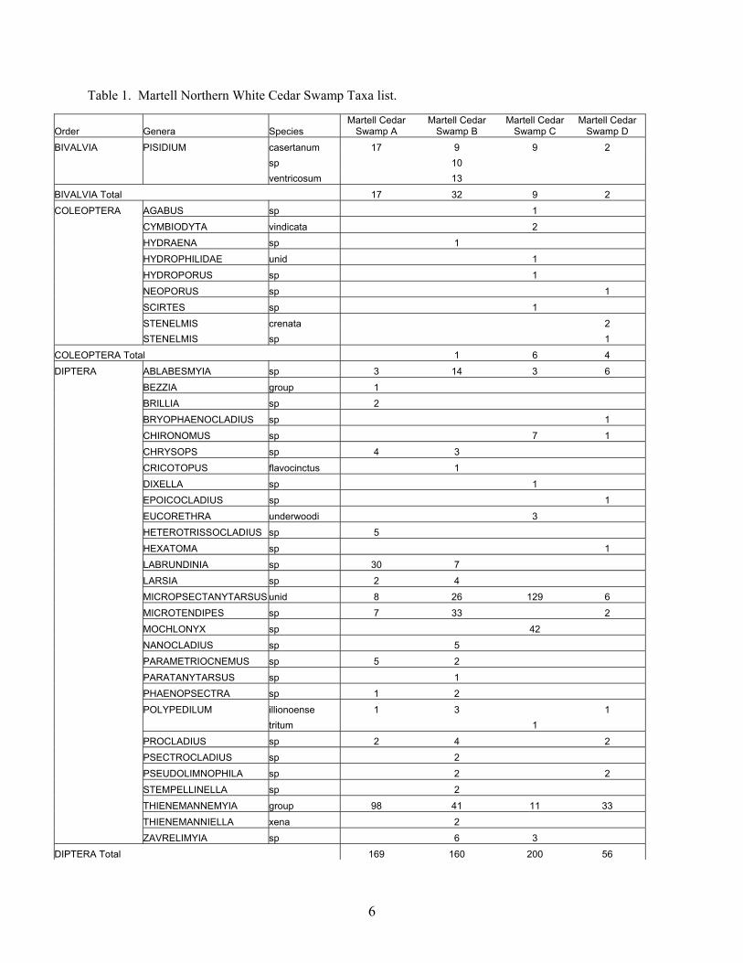
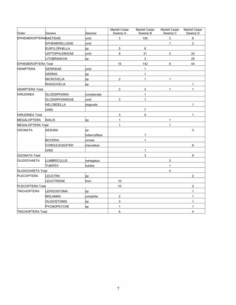
Table 1. Martell Northern White Cedar Swamp Taxa list.
Order Genera Species Martell Cedar
Swamp A Martell Cedar
Swamp B Martell Cedar
Swamp C Martell Cedar
Swamp D BIVALVIA PISIDIUM casertanum 17 9 9 2 sp 10 ventricosum 13 BIVALVIA Total 17 32 9 2 COLEOPTERA AGABUS sp 1 CYMBIODYTA vindicata 2 HYDRAENA sp 1 HYDROPHILIDAE unid 1 HYDROPORUS sp 1 NEOPORUS sp 1 SCIRTES sp 1 STENELMIS crenata 2 STENELMIS sp 1 COLEOPTERA Total 1 6 4 DIPTERA ABLABESMYIA sp 3 14 3 6 BEZZIA group 1 BRILLIA sp 2 BRYOPHAENOCLADIUS sp 1 CHIRONOMUS sp 7 1 CHRYSOPS sp 4 3 CRICOTOPUS flavocinctus 1 DIXELLA sp 1 EPOICOCLADIUS sp 1 EUCORETHRA underwoodi 3 HETEROTRISSOCLADIUS sp 5 HEXATOMA sp 1 LABRUNDINIA sp 30 7 LARSIA sp 2 4 MICROPSECTANYTARSUS unid 8 26 129 6 MICROTENDIPES sp 7 33 2 MOCHLONYX sp 42 NANOCLADIUS sp 5 PARAMETRIOCNEMUS sp 5 2 PARATANYTARSUS sp 1 PHAENOPSECTRA sp 1 2 POLYPEDILUM illionoense 1 3 1 tritum 1 PROCLADIUS sp 2 4 2 PSECTROCLADIUS sp 2 PSEUDOLIMNOPHILA sp 2 2 STEMPELLINELLA sp 2 THIENEMANNEMYIA group 98 41 11 33 THIENEMANNIELLA xena 2 ZAVRELIMYIA sp 6 3 DIPTERA Total 169 160 200 56
6
Order Genera Species Martell Cedar
Swamp A Martell Cedar
Swamp B Martell Cedar
Swamp C Martell Cedar
Swamp D EPHEMEROPTERA BAETIDAE unid 3 100 3 8 EPHEMERELLIDAE unid 1 2 EURYLOPHELLA sp 5 8 LEPTOPHLEBIIDAE unid 8 31 5 24 LITOBRANCHA sp 3 20 EPHEMEROPTERA Total 16 142 9 54 HEMIPTERA GERRIDAE unid 1 GERRIS sp 1 MICROVELIA sp 2 1 1 RHAGOVELIA sp 1 HEMIPTERA Total 2 3 1 1 HIRUDINEA GLOSSIPHONIA complanata 1 GLOSSIPHONIIDAE unid 3 1 HELOBDELLA stagnalis 1 UNID 7 HIRUDINEA Total 3 9 1 MEGALOPTERA SIALIS sp 1 1 MEGALOPTERA Total 1 1 ODONATA AESHNA sp 3 tuberculifera 1 BOYERIA vinosa 1 CORDULEGASTER maculatus 6 UNID 1 ODONATA Total 3 9 OLIGOCHAETA LUMBRICULUS variegatus 3 TUBIFEX tubifex 1 OLIGOCHAETA Total 4 PLECOPTERA LEUCTRA sp 2 LEUCTRIDAE imm 10 PLECOPTERA Total 10 2 TRICHOPTERA LEPIDOSTOMA sp 1 MOLANNA uniophila 2 1 OLIGOSTOMIS sp 3 1 PYCNOPSYCHE sp 1 1 TRICHOPTERA Total 6 4
7
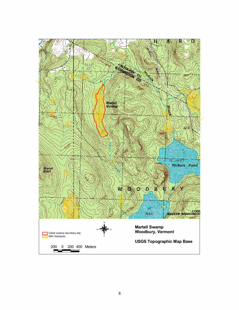
Martell SwampWoodbury, Vermont
USGS Topographic Map Base
N
EW
S
200 0 200 400 Meters
NWI WetlandsCedar swamp boundary.shp
8
Northern White Cedar Swamps of Vermont Vermont Agency of Natural Resources, 2003
SITE NAME: Berlin Mall Cedar Swamp TOWN: Berlin MAPS: Bare West, VT 7.5' U.S.G.S. topographic map LOCATION: Between Route 62 and the Berlin Mall SOURCE OF INFORMATION: Site visits on 6/9/99, 6/19/99, 6/22/99, and 9/28/99 by R. Popp, J. Kellogg, K. Lenorovitz, J. Rykken, and E. Sorenson OWNERSHIP: Private. No access without permission of landowner. SIGNIFICANCE: A small, highly disturbed northern white cedar swamp. PHYSICAL SETTING: This six acre fragment of northern white cedar swamp is surrounded by a large paved parking lot and a four lane limited access roadway (Route 62). The swamp receives stormwater runoff from these paved areas and drains to the north through culverts and natural streams into the Stevens Branch. This swamp fragment lies south of Route 62, which splits the cedar swamp from the remaining portion to the north of the road. There is an approximately 50 foot long strip of mineral soil fill that extends into the swamp from the north side. Berlin Mall Swamp occurs in an area underlain by the Waits River formation, bedrock with calcium-rich schists and phyllites. SURROUNDING LANDSCAPE CONDITION: The area surrounding the swamp is highly fragmented by paved roads and commercial and light industrial development. The swamp itself has been bisected by Route 62, which has also changed drainage patterns. VEGETATION: Although this small cedar swamp is surrounded by development, there are parts of the swamp interior that still look very much like most undisturbed swamps in remote settings. The shady interior is dominated by northern white cedar (Thuja occidentalis) with lesser amounts of balsam fir (Abies balsamea), red spruce (Picea rubens), and yellow birch (Betula alleghaniensis), and the moss covered hummocks and hollows prevail in the swamp interior. Many typical herbs are presnt in the swamp, including cinnamon fern (Osmunda cinnamomea), three-seeded sedge (Carex trisperma), dwarf raspberry (Rubus pubescens), golden saxifrage (Chrysosplenium americanum), water avens (Geum rivale). Typical mosses are also present, including Sphagnum warnstorfii, Sphagnum russowii, stair-step moss (Hylocomnium splendens), and the wet hollow species Calliergon cordifolium. There are many differences from this swamp and undisturbed examples, however. The altered hydrology has created areas of open marsh on the western end of the swamp. In the areas that are still cedar swamp, many of the hollows are especially wet and some have no vegetation. There are several species present that are atypical of cedar swamps and reflect the altered hydrology, including frondose beggar's ticks (Bidens frondosa), rice cutgrass (Leersia oryzoides), common duckweed (Lemna minor), and tussock sedge (Carex stricta), and the liverwort Aneura pinguis. Another species that is not typical of cedar
9

swamps is the moss Sphagnum teres. This species is characteristic of mineral-rich fens and may be here at the Berlin Mall Swamp because of the very high conductivity associated with runoff and the generally open canopy conditions. PHYSICAL AND CHEMICAL CHARACTERISTICS: There is only a thin layer (25 cm) of well decomposed organic soils in this swamp. This overlies gleyed silty soil. Surface water pH was 7.2 on September 28, 1999 and conductivity ranged from 480µS to 720µS in the small swamp. MACROINVERTEBRATE USE: This is an impaired site. We found only the part of the swamp south of Route 62. This part of the swamp had no standing/flowing water, so we were not able to sample aquatic macroinvertebrates. There were “hollow” areas under exposed roots that had stained leaves to suggest they had held pools of water earlier in the year, but even these were dry on our visit. We found a dried stream channel at the south end of the swamp, which we may also have been able to sample earlier in the spring. MANAGEMENT RECOMMENDATIONS: Although highly disturbed, this small swamp still contributes to the diversity of habitats for plants in this area. The small swamp also provides habitat for several species of nesting birds, including Swamp Sparrow, Song Sparrow, White-throated Sparrow, Winter Wren, Black-capped Chickadee, Veery, and Solitary Vireo. Activities that will help to maintain this swamp include avoiding any future filling in the swamp or clearing of the reamaining forested buffer, establishing forested buffer in any locations possible, and pre-treating stormwater before it reaches the swamp.
10

Berlin Mall Cedar SwampBerlin, Vermont
USGS Topographic Map Base
N
EW
S
200 0 200 400 Meters
NWI WetlandsCedar swamp boundary.shp
11
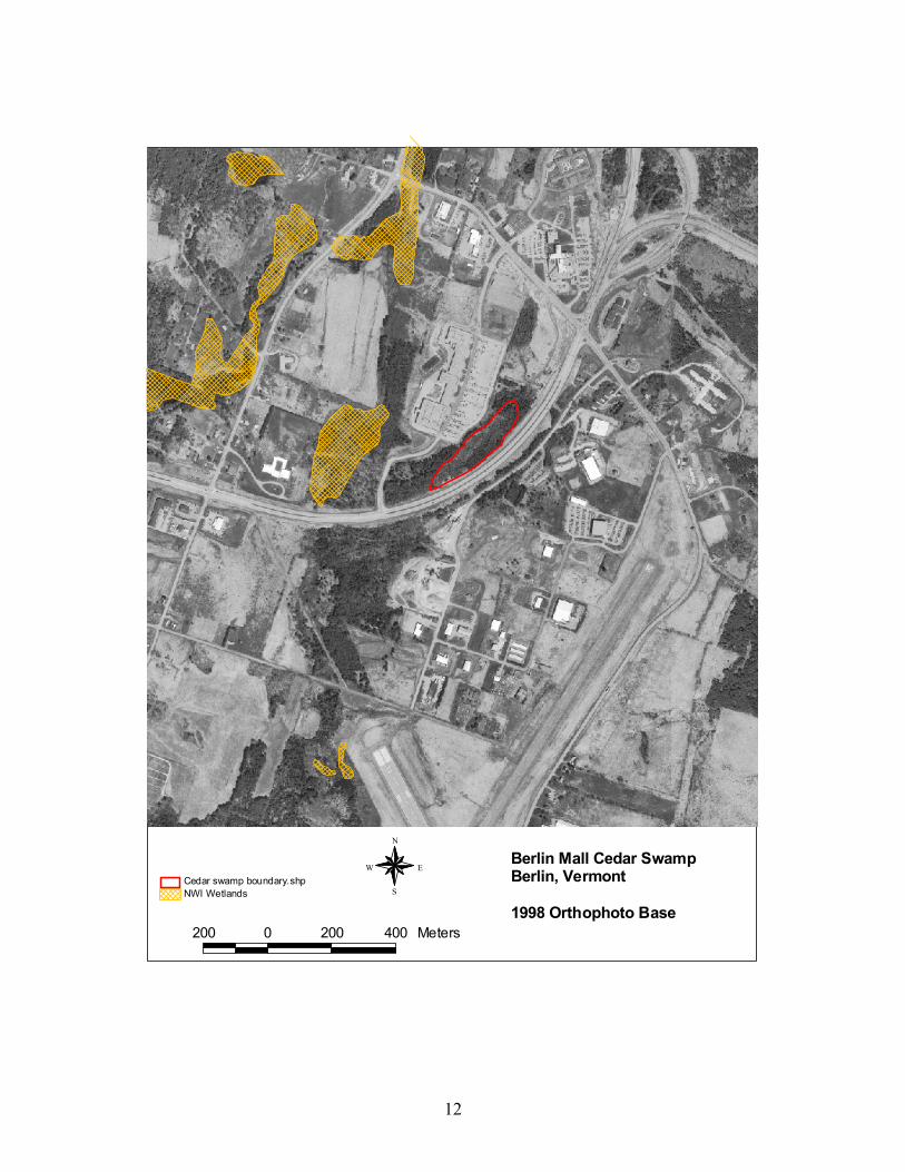
Berlin Mall Cedar SwampBerlin, Vermont
1998 Orthophoto Base
N
EW
S
200 0 200 400 Meters
NWI WetlandsCedar swamp boundary.shp
12
Northern White Cedar Swamps of Vermont Vermont Agency of Natural Resources, 2003
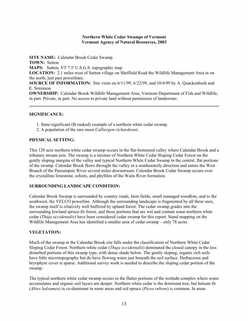
SITE NAME: Calendar Brook Cedar Swamp TOWN: Sutton MAPS: Sutton, VT 7.5' U.S.G.S. topographic map LOCATION: 2.1 miles west of Sutton village on Sheffield Road the Wildlife Management Area in on the north, just past powerlines. SOURCE OF INFORMATION: Site visits on 6/11/99, 6/22/99, and 10/4/99 by A. Quackenbush and E. Sorenson OWNERSHIP: Calendar Brook Wildlife Management Area, Vermont Department of Fish and Wildlife, in part. Private, in part. No access to private land without permission of landowner. SIGNIFICANCE:
1. State-significant (B-ranked) example of a northern white cedar swamp. 2. A population of the rare moss Calliergon richardsonii.
PHYSICAL SETTING: This 120 acre northern white cedar swamp occurs in the flat-bottomed valley where Calendar Brook and a tributary stream join. The swamp is a mixture of Northern White Cedar Sloping Cedar Forest on the gently sloping margins of the valley and typical Northern White Cedar Swamp in the central, flat portions of the swamp. Calendar Brook flows throught the valley in a southeasterly direction and enters the West Branch of the Passumpsic River several miles downstream. Calendar Brook Cedar Swamp occurs over the crystalline limestone, schists, and phyllites of the Waits River formation. SURROUNDING LANDSCAPE CONDITION: Calendar Brook Swamp is surrounded by country roads, farm fields, small managed woodlots, and to the southwest, the VELCO powerline. Although the surrounding landscape is fragmented by all these uses, the swamp itself is relatively well buffered by upland forest. The cedar swamp grades into the surrounding lowland spruce-fir forest, and those portions that are wet and contain some northern white cedar (Thuja occidentalis) have been considered cedar swamp for this report. Stand mapping on the Wildlife Management Area has identified a smaller area of cedar swamp – only 78 acres. VEGETATION: Much of the swamp at the Calendar Brook site falls under the classification of Northern White Cedar Sloping Cedar Forest. Northern white cedar (Thuja occidentalis) dominated the closed canopy in the less disturbed portions of this swamp type, with dense shade below. The gently sloping, organic rich soils have little microtopography but do have flowing water just beneath the soil surface. Herbaceous and bryophyte cover is sparse. Additional survey work is needed to describe the sloping cedar portion of the swamp. The typical northern white cedar swamp occurs in the flatter portions of the wetladn complex where water accumulates and organic soil layers are deeper. Northern white cedar is the dominant tree, but balsam fir (Abies balsamea) in co-dominant in some areas and red spruce (Picea rubens) is common. In areas
13
unaffected by recent logging, canopy cover is approximately 85 percent. All of these tree species as well as black ash (Fraxinus nigra) are present in the tall and short shrub layers. Other shrub species include mountain holly (Nemopanthus mucronatus), Canada honeysuckle (Lonicera canadensis), mountain maple (Acer spicatum), and alder-leaved buckthorn (Rhamnus alnifolia). Common wood sorrel (Oxalis acetocella) dominates the herb layer in many areas, along with the typical boreal herbs, goldthread (Coptis trifolia), naked miterwort (Mitella nuda), twinflower (Linnaea borealis), creeping snowberry (Gaultheria hispidula), and bunchberry (Cornus canadensis). Bryophytes carpet the hummocks and all but a fraction of the hollows, where there is shallow standing water. The dominant species are shaggy moss (Rhytidiadelphus triquetrus) and stairstep moss (Hylocomnium splendens) that together covered 80 percent of the swamp floor in the plot. A total of 18 species of mosses and liverworts were recorded in the 200 square meter plot, one of which is the rare moss of cedar swamp hollows, Calliergon richardsonii. There has been considerable logging in Calendar Brook Swamp in the past 10 to 20 years and no mature areas of swamp were observed. Several small emergent marshes occur along Calendar Brook in the swamp, the result of past beaver activity. PHYSICAL AND CHEMICAL CHARACTERISTICS: The organic soils in the swamp range from only 25 cm in the marginal sloping portions to 65 cm in the more central portion of the swamp. The soils are well decomposed but with wood fragments throughout the profile. The organic soil is underlain by gleyed silty, fine sand. Surface water pH was 6.2 and conductivity was 110µS. MANAGEMENT RECOMMENDATIONS: Calendar Brook Cedar Swamp is sufficiently large to include areas that are actively managed for wildlife habitat and timber and also areas that allowed to mature. There are currently two areas of cedar swamp identified in the management plan for which there will be no active management. If these areas are sufficiently large, this combination of active and passive management will benefit both those wildlife species that utilize mature swamp conditions and those that utilize more early successional swamp conditions. As most of this Wildlife Management Area is a winter deer yard, the current management plan calls for uneven aged management in the portions of the swamp and in all of the adjacent lowland spruce-fir forest on state-owned land.
14
Calendar Brook SwampSutton, Vermont
USGS Topographic Map Base
N
EW
S
200 0 200 400 Meters
NWI WetlandsCedar swamp boundary.shp
15

16
Northern White Cedar Swamps of Vermont Vermont Agency of Natural Resources, 2003
SITE NAME: Mollys Brook Swamp TOWN: Cabot MAPS: Cabot, VT 7.5' U.S.G.S. topographic map LOCATION: large wetland complex along Mollys Brook, west of U.S. Route 2, and between South Cabot and East Cabot SOURCE OF INFORMATION: Site visits on 6/10/99, 6/17/99, and 9/28/99 by B. Engstrom and E. Sorenson OWNERSHIP: Private. No access without permission of landowner. SIGNIFICANCE:
1. State-significant (B-ranked) example of a northern white cedar swamp. 2. Populations of the uncommon plants large yellow lady's-slipper (Cypripedium calceolus var.
pubescens) and mountain fly-honeysuckle (Lonicera villosa). PHYSICAL SETTING: This 125 acre swamp along Mollys Brook includes areas of alder swamp, beaver impoundment, and shallow marsh resulting from past beaver activity. Mollys Brook flows southwest through the swamp and into Mollys Falls Pond about 1.25 miles to the southwest. Mollys Brook flows into the Winooski River in Marshfield. The 2,200 to 2,300 foot hills surrounding Mollys Brook Swamp are granitic – the northern part of the Knox Mountain pluton. However, the calcium-bearing rocks of the Waits River formation surround the Knox Mountain pluton, and the source of the till in the Mollys Brook Swamp watershed includes both granite and this more calcium-rich bedrock. SURROUNDING LANDSCAPE CONDITION: As is typical of many of the cedar swamps in the Northern Vermont Piedmont biophysical region, Mollys Brook Swamp is surrounded by paved and gravel roads, agricultural lands, managed woodlots, and rural residential development. A considerable area of the eastern side of the swamp has been cleared of trees for use as pasture and for a powerline that runs along Route 2. There is a buffer of upland forest on the western side of the swamp, but much of this has been selectively, but heavily logged in recent years. VEGETATION: Typical Northern White Cedar Swamp occurs in the much of the swamp, with the Northern White Cedar Sloping Cedar Forest variant occurring on the gently sloping margins of the swamp. The typical northern white cedar swamp has a canopy cover of approximately 80 percent, strongly dominated by northern white cedar (Thuja occidentalis), with lesser amounts of balsam fir (Abies balsamea) and black ash (Fraxinus nigra). The tall shrub layer is sparse, composed of tree species regeneration, along with speckled alder (Alnus incana) and winterberry (Ilex verticillata). The short shrub layer (under 1.25 m) includes these same species, as well as alder-leaved buckthorn (Rhamnus alnifolia), red-osier dogwood (Cornus sericea), bristly black current (Ribes lacustre), Canada honeysuckle (Lonicera canadensis), and mountain maple (Acer spicaturm). This swamp has high species richness, with 65 vascular and bryophyte species identified in the 200 square meter plot – the majority of these are herbs. Herbaceous cover is 60
17
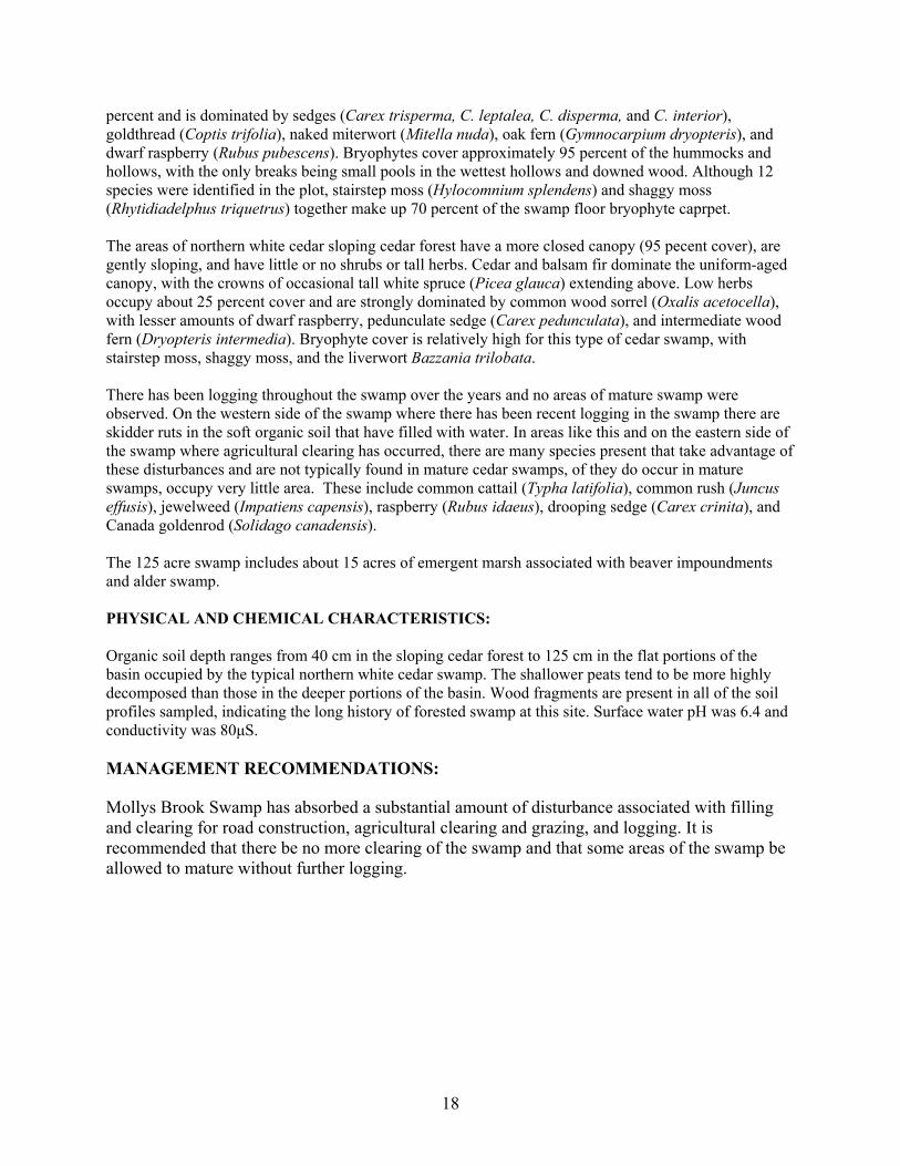
percent and is dominated by sedges (Carex trisperma, C. leptalea, C. disperma, and C. interior), goldthread (Coptis trifolia), naked miterwort (Mitella nuda), oak fern (Gymnocarpium dryopteris), and dwarf raspberry (Rubus pubescens). Bryophytes cover approximately 95 percent of the hummocks and hollows, with the only breaks being small pools in the wettest hollows and downed wood. Although 12 species were identified in the plot, stairstep moss (Hylocomnium splendens) and shaggy moss (Rhytidiadelphus triquetrus) together make up 70 percent of the swamp floor bryophyte caprpet. The areas of northern white cedar sloping cedar forest have a more closed canopy (95 pecent cover), are gently sloping, and have little or no shrubs or tall herbs. Cedar and balsam fir dominate the uniform-aged canopy, with the crowns of occasional tall white spruce (Picea glauca) extending above. Low herbs occupy about 25 percent cover and are strongly dominated by common wood sorrel (Oxalis acetocella), with lesser amounts of dwarf raspberry, pedunculate sedge (Carex pedunculata), and intermediate wood fern (Dryopteris intermedia). Bryophyte cover is relatively high for this type of cedar swamp, with stairstep moss, shaggy moss, and the liverwort Bazzania trilobata. There has been logging throughout the swamp over the years and no areas of mature swamp were observed. On the western side of the swamp where there has been recent logging in the swamp there are skidder ruts in the soft organic soil that have filled with water. In areas like this and on the eastern side of the swamp where agricultural clearing has occurred, there are many species present that take advantage of these disturbances and are not typically found in mature cedar swamps, of they do occur in mature swamps, occupy very little area. These include common cattail (Typha latifolia), common rush (Juncus effusis), jewelweed (Impatiens capensis), raspberry (Rubus idaeus), drooping sedge (Carex crinita), and Canada goldenrod (Solidago canadensis). The 125 acre swamp includes about 15 acres of emergent marsh associated with beaver impoundments and alder swamp. PHYSICAL AND CHEMICAL CHARACTERISTICS: Organic soil depth ranges from 40 cm in the sloping cedar forest to 125 cm in the flat portions of the basin occupied by the typical northern white cedar swamp. The shallower peats tend to be more highly decomposed than those in the deeper portions of the basin. Wood fragments are present in all of the soil profiles sampled, indicating the long history of forested swamp at this site. Surface water pH was 6.4 and conductivity was 80µS. MANAGEMENT RECOMMENDATIONS: Mollys Brook Swamp has absorbed a substantial amount of disturbance associated with filling and clearing for road construction, agricultural clearing and grazing, and logging. It is recommended that there be no more clearing of the swamp and that some areas of the swamp be allowed to mature without further logging.
18
Molly's Brook SwampCabot, Vermont
USGS Topographic Map Base
N
EW
S
200 0 200 400 Meters
NWI WetlandsCedar swamp boundary.shp
19