Embed Size (px)
Citation preview

APPENDIX B Project Description
B1 Alternatives Formulation and Screening Details
NLIP Phase 4a Landside Improvements Project DEIS/DEIR USACE and SAFCA B1-1 Alternatives Formulation and Screening Details
APPENDIX B1 ALTERNATIVES FORMULATION AND SCREENING DETAILS
This appendix contains more detailed information on the alternatives evaluation process that was summarized in Chapter 2.0, “Alternatives,” of this EIS/EIR.
1.1 INTRODUCTION
This appendix describes the alternatives that were considered to provide additional flood risk reduction to the Natomas Basin consistent with the project objectives described in Chapter 1.0, “Introduction and Statement of Purpose and Need” of this EIS/EIR. The Phase 4a Project builds upon the analyses provided in the Local Funding EIR, Phase 2 EIR and SEIR, Phase 2 EIS, and Phase 3 DEIS/DEIR. Three alternatives for the Sacramento River east levee were evaluated at an equal level of detail in this EIS/EIR:
► No-Action Alternative, ► Proposed Action (Adjacent Levee), and ► Raise and Strengthen Levee in Place (RSLIP) Alternative.
Although they provide contrasting advantages and disadvantages, each of the alternatives is considered feasible based on relevant economic, environmental, social, technological, and legal factors. Each of the action alternatives (i.e., the alternatives other than “No-Action”) under consideration was formulated to feasibly accomplish the basic objectives of the project as discussed in Chapter 1.0, “Introduction and Statement of Purpose and Need,” of this EIS/EIR. In particular, the action alternatives both would achieve early compliance to meet requirements for certification of FEMA 100-year flood risk reduction criteria and are compatible with construction of additional components to meet 200-year flood risk reduction criteria for urban areas.
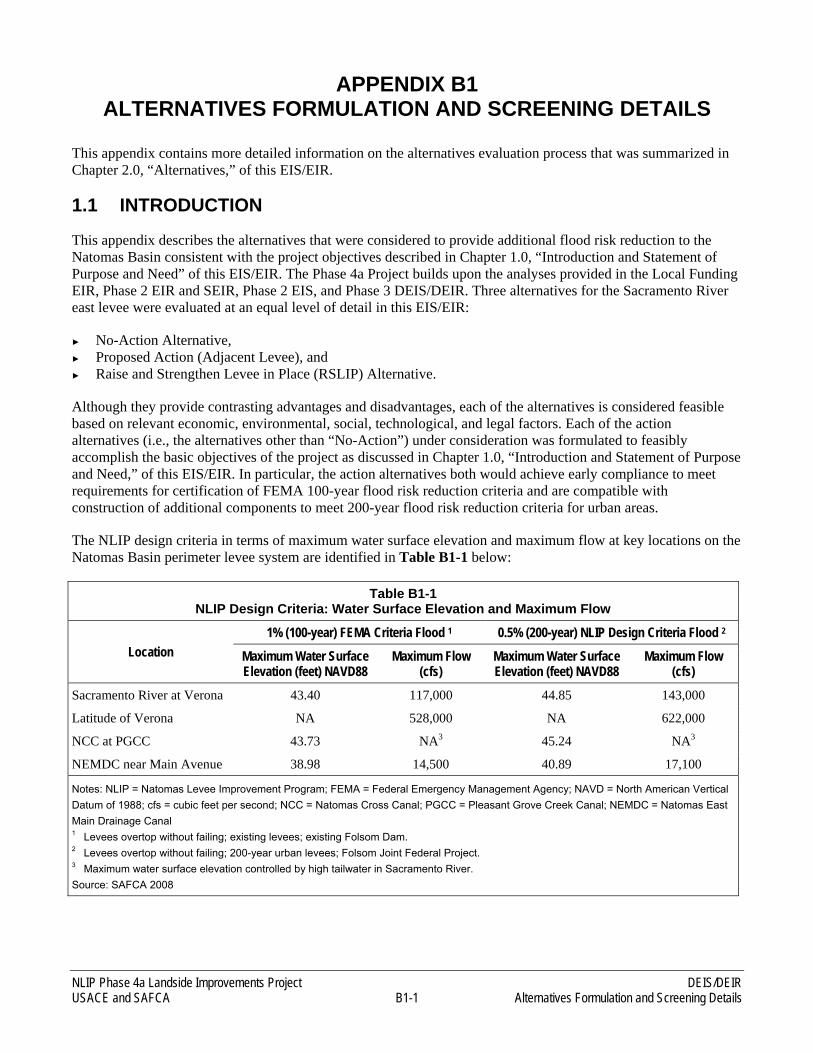
The NLIP design criteria in terms of maximum water surface elevation and maximum flow at key locations on the Natomas Basin perimeter levee system are identified in Table B1-1 below:
Table B1-1 NLIP Design Criteria: Water Surface Elevation and Maximum Flow
Location 1% (100-year) FEMA Criteria Flood 1 0.5% (200-year) NLIP Design Criteria Flood 2
Maximum Water Surface Elevation (feet) NAVD88
Maximum Flow (cfs)
Maximum Water Surface Elevation (feet) NAVD88
Maximum Flow (cfs)
Sacramento River at Verona 43.40 117,000 44.85 143,000
Latitude of Verona NA 528,000 NA 622,000
NCC at PGCC 43.73 NA3 45.24 NA3
NEMDC near Main Avenue 38.98 14,500 40.89 17,100
Notes: NLIP = Natomas Levee Improvement Program; FEMA = Federal Emergency Management Agency; NAVD = North American Vertical Datum of 1988; cfs = cubic feet per second; NCC = Natomas Cross Canal; PGCC = Pleasant Grove Creek Canal; NEMDC = Natomas East Main Drainage Canal 1 Levees overtop without failing; existing levees; existing Folsom Dam. 2 Levees overtop without failing; 200-year urban levees; Folsom Joint Federal Project. 3 Maximum water surface elevation controlled by high tailwater in Sacramento River. Source: SAFCA 2008
DEIS/DEIR NLIP Phase 4a Landside Improvements Project Alternatives Formulation and Screening Details B1-2 USACE and SAFCA
The action alternatives include components that could avoid or substantially lessen one or more of the significant effects. In addition, because the combination of components themselves could cause differing levels of significant effects, the alternatives include criteria for combining components to substantially lessen the impacts from construction of the alternatives.
1.1.1 NEPA/CEQA REQUIREMENTS FOR EVALUATION OF ALTERNATIVES
1.1.1.1 NEPA REQUIREMENTS
The NEPA Council on Environmental Quality Regulations (40 Code of Federal Regulations 15012.14) for EIS requirements are briefly described in Chapter 1.0, “Introduction and Statement of Purpose and Need,” of this EIS/EIR.
1.1.1.2 CEQA REQUIREMENTS
The CEQA requirements for an EIR (as noted in the California Code of Regulations [CCR] Section 15126.6[a] of the State CEQA Guidelines) are briefly described in Chapter 1.0, “Introduction and Statement of Purpose and Need,” of this EIS/EIR.
2.1 ALTERNATIVES FORMULATION
SAFCA, in coordination with USACE, formulated the Proposed Action and a reasonable range of project alternatives that would achieve the specific project objectives through the following steps:
► identification of the deficiencies in the Natomas levee system that must be addressed to provide at least 100-year flood risk reduction as quickly as possible;
► identification of the deficiencies in the Natomas levee system that must be addressed to provide 200-year flood risk reduction;
► identification of feasible remedial measures to address the deficiencies;
► determination of the likely environmental impacts of the remedial measures;
► development of a reasonable range of flood damage reduction alternatives for implementing the remedial measures; and
► identification of measures to ensure that each alternative would improve aviation safety, minimize impacts on significant cultural resource sites, and enhance habitat values.
Alternatives screening for the overall NLIP has been undertaken by SAFCA in a systematic manner through several environmental documents as described later in this appendix. A description of the flood risk reduction measures that SAFCA considered for developing alternatives is provided below.
2.1.1 TYPES OF FLOOD RISK REDUCTION MEASURES CONSIDERED
Designing effective flood risk reduction measures is an iterative process that involves identifying, evaluating, and comparing measures and preliminary alternatives to develop a reasonable range of final alternative plans for consideration by decision makers and the general public. For the NLIP Landside Improvements Project, engineering measures were developed and considered that alone or in various combinations would address the project objectives.
NLIP Phase 4a Landside Improvements Project DEIS/DEIR USACE and SAFCA B1-3 Alternatives Formulation and Screening Details
The engineering measures that were considered for the Phase 4a Project must meet several criteria. First, the design selected must adequately improve performance of the levee so that certification is possible. Generally, the requirements are to provide a sufficient height of levee raise so that the levee height is adequate, levee stability meets levee design criteria, and/or seepage through or beneath the levee is reduced to acceptable levels. Measures considered are described below.
2.1.1.1 LEVEE RAISE
A levee raise may be necessary to meet the 200-year flood protection standard required by the State for urbanized areas, such as the Natomas Basin.
For the Phase 4a Project, a levee raise is possible, using either of two engineering design methods to meet flood risk reduction criteria compatible with the engineering design selected for the Phase 2 and 3 Projects: raising and strengthening the existing levees in their current alignments (raise and strengthen levee in place) or constructing a new larger levee adjacent to the existing levee (adjacent levee). In all reaches, the final levee configuration would be designed to meet the USACE criteria of a 20-foot-wide minimum crown, a 3-to-1 horizontal-to-vertical (3H:1V) waterside slope, and a 3H:1V landside slope.
Raise and Strengthen Levee in Place
A levee raise-in-place would require the existing levee footprint would be widened at its base on one or both sides. While the levee footprint (its base) size may not be substantially altered, mitigation for loss of habitat would be required by various regulatory agencies. Where the widening results in filling waters of the United States, including wetlands, mitigation, generally at a 1:1 replacement ratio, would be required. Where the widening occurs on the landside or waterside and trees that provide habitat or are otherwise protected exist, the mitigation requirement is to plant replacement woodlands. In some instances, irrigation and drainage ditches and canals exist at the toe of the levee, and would require relocation. Widening of the existing levee may require the purchase of additional easements and/or rights-of-way, including areas for utilities and planting/replacement woodlands and other habitats. Proper construction of the widened levee may require excavation of a keyway trench in the foundation area at the toe of the levee.
Adjacent Levee (Preferred)
An adjacent levee is proposed in lieu of modifying the existing Sacramento River east levee, which has substantial structural and vegetation encroachments along its waterside. The adjacent levee raise would involve constructing a new landside embankment adjoining the Sacramento River east levee. The concept of an adjacent levee is that the levee prism would be shifted landward, such that much of the vegetation on the waterside of the existing levee is less likely to need to be cleared for levee operation and maintenance. This design reduces the vegetation removal on the waterside, but requires excavation of additional suitable material to build the adjacent structure. The irrigation and drainage ditches and canals that exist at the toe of the levee may require relocation farther to the landside. Construction of an adjacent levee may also require the purchase of additional easements and/or rights-of-way, including right-of-way for utilities and planting of replacement woodlands and other habitats. Proper construction of the adjacent levee foundation often requires excavation of an inspection trench in the foundation soils. Because the Natomas Basin’s natural levees have been augmented by human efforts, it is possible to find buried prehistoric features at considerable depth in the landside footprint. Where additional levee height is required, the adjacent levee height would be greater than that of the existing levee. Where additional levee height is not required, the adjacent levee height would be the same as the existing levee.
A trench, usually 6 feet deep and 12 feet wide at the base, is constructed at the base of the levee to allow visible inspection for shallow foundation conditions and the presence of buried utilities. In some instances, relocation of irrigation and drainage ditches and canals may be necessary to construct the inspection trench. In addition to the inspection trench, the landside toe of the existing levee, within the footprint of the new adjacent levee, would be
DEIS/DEIR NLIP Phase 4a Landside Improvements Project Alternatives Formulation and Screening Details B1-4 USACE and SAFCA
stripped to a depth of approximately 1 foot to remove vegetative matter and topsoil material from the adjacent levee foundation.
2.1.1.2 SEEPAGE REMEDIATION
Pre-NLIP existing seepage remediation in the Natomas Basin has primarily addressed through-seepage. Through-seepage is the movement of water through the levee itself, when high-flow conditions, and/or wind and wave action exist on the waterside of the levee. Through-seepage may be addressed by construction of cutoff walls through the levee prism or a drained stability berm on the landside slope. The cutoff walls provide a low-permeability barrier to water flow through the levee. Underseepage occurs below the levee prism, and is caused by the buildup of water pressure in the subsurface foundation soils, when high river stages are present on the waterside of the levees. This pressure can be great enough to force water through the earthen foundation layers under the levee. The water finds a pathway of less resistance and exits at the landside ground surface. Excessive underseepage gradients can be corrected through the use of cutoff walls, seepage berms, and relief wells, which are discussed below. Current construction methods can correct underseepage and be compatible with the underseepage improvement methods employed for Phase 2 and 3 Project construction.
Cutoff Walls
Cutoff walls use specialized earthen materials (often bentonite clay) that are installed into the center of the levee. Successful construction of cutoff walls often requires a 24 hours per day/7 days a week (24/7) construction schedule so that the cutoff wall material keeps its proper consistency. Specialized equipment allows the cutoff walls to reach deep into the subsurface, to depths of 120 feet. Often the levee crown is “degraded,” meaning that it is excavated to create a wider platform so that the construction equipment can install the cutoff wall. An inspection trench, usually 6-feet deep and 12-feet wide at the base with 1H:1V side slopes, is constructed at the base of the levee to allow visible inspection of the levee foundation area. In some instances, relocation of irrigation and drainage ditches and canals may be necessary to construct the levee improvements.
Of the three seepage remediation methods, fully penetrating cutoff walls are generally preferred because they are the least costly (particularly if a soil-bentonite mix is feasible and the depth of wall is less than 85 feet); are the most reliable under uncertain hydraulic and geotechnical conditions (e.g., water surface elevations above design and variations in foundation soil conditions); and, when combined with an adjacent levee, minimize construction disturbance outside the levee footprint.
Due to the long history of natural and human-enhanced levee buildup in the Natomas Basin, it is not unusual to find conditions of underseepage to depths greater than the maximum feasible construction depth of a cutoff wall. In those cases, a seepage berm and/or relief wells may be used to protect against underseepage.
Seepage Berms
Seepage berms are wide, shallow features with relatively flat surface slopes graded to drain landward. They are typically constructed using material excavated from borrow sites. In some cases, a 1- to 1.5-foot-thick drainage layer consisting of sand or drainrock encapsulated in geotextile fabric is placed on the ground below the seepage berm. Seepage berms may extend up to 500 feet landside of the toe of the levee or the adjacent levee. In areas of limited space, the seepage berms are constructed with relief wells at the landside toe of the seepage berms.
Constructing seepage berms rather than cutoff walls avoids the deep ground-disturbing work that may adversely affect cultural resources that may be present, while still achieving flood damage reduction objectives. It is possible to construct a seepage berm using specialized equipment that minimizes vibration and pressure on the immediate subsurface environment. This construction method is often used where sensitive historical features may be expected near the ground surface, and relief wells are omitted. A seepage berm without relief wells
NLIP Phase 4a Landside Improvements Project DEIS/DEIR USACE and SAFCA B1-5 Alternatives Formulation and Screening Details
extends the levee footprint farther landside and depending upon land use, may require relocation of permanent structures or take affected agricultural land out of production, as well as other environmental impacts.
Relief Wells
Relief wells are controlled artificial springs that relieve the confined water pressures to safe values. This reduces potential for the removal of soil via piping or internal erosion caused by the uplift pressures beneath elements of the levee or beneath landward soil next to the levee. Relief wells are usually spaced about 50–150 feet apart to allow water to flow without pumping during times of high water table. Piezometers are used as a tool to verify relief well performance by measuring the hydrostatic pressure between the wells. Because relief wells may only flow on an intermittent basis sometimes several years apart, it is necessary to conduct regular maintenance of relief wells to ensure that they perform properly.
Bank Erosion
Bank erosion poses either a high or moderate risk to the stability of the Sacramento River east levee at several locations upstream and downstream of Interstate 5 (I-5) where river flows and waves generated by boat wakes have weakened and undercut portions of the bank supporting the levee. The adjacent levee design would address the potential instability created by these bank erosion processes by enlarging the levee section and moving the levee foundation landward away from the eroding bank. These bank erosion processes could also be addressed by installing rock rivetments or other engineered structures along the eroding banks so as to reduce further erosion and protect the foundation of the levee (as proposed for the RSLIP Alternative).
3.1 ALTERNATIVES CONSIDERED, BUT ELIMINATED FROM FURTHER CONSIDERATION
Numerous alternatives have been considered by USACE and SAFCA to reduce flood risk in the Natomas Basin. Many alternatives have been evaluated and eliminated from further consideration as part of preparing the following previous environmental documents:
► Environmental Impact Report on Local Funding Mechanisms for Comprehensive Flood Control Improvements for the Sacramento Area, State Clearinghouse No. 2006072098 (SAFCA 2007a) (Local Funding EIR);
► Environmental Impact Report on the Natomas Levee Improvement Program, Landside Improvements Project, State Clearinghouse No. 2007062016 (SAFCA 2007b) (Phase 2 EIR);
► Environmental Impact Statement for 408 Permission and 404 Permit to Sacramento Area Flood Control Agency for the Natomas Levee Improvement Project (USACE 2008) (Phase 2 EIS);
► Supplement to the Environmental Impact Report on the Natomas Levee Improvement Program, Landside Improvements Project––Phase 2 Project, State Clearinghouse No. 2007062016 (SAFCA 2009) (Phase 2 SEIR); and
► Draft Environmental Impact Statement/Draft Environmental Impact Report on the Natomas Levee Improvement Program, Phase 3 Landside Improvements Project, State Clearinghouse No. 2008072060 (USACE and SAFCA 2009) (Phase 3 DEIS/DEIR).
The alternatives analyses from these documents, from which this EIS/EIR is tiered, are hereby incorporated by reference, and these documents are available to the public at SAFCA’s office at 1007 7th Street, 7th Floor, Sacramento, California. Three alternatives that could contribute to addressing the Natomas Basin’s flood problems and needs were reviewed and eliminated from further consideration in the Local Funding EIR, Phase 2
DEIS/DEIR NLIP Phase 4a Landside Improvements Project Alternatives Formulation and Screening Details B1-6 USACE and SAFCA
EIR, and Phase 2 EIS. These eliminated alternatives, the prior discussions of which are hereby incorporated by reference, are summarized as follows:
► Yolo Bypass Improvements–This measure would involve lengthening the Fremont Weir and widening the Yolo Bypass to increase the amount of flood water conveyed through the bypass and reduce the amount of flood water conveyed through the Sacramento River channel downstream of the weir. This alternative was eliminated because (1) it would be too costly for SAFCA to implement; (2) even following implementation of this alternative, some levee height increases and substantial seepage, underseepage, and slope stability remediation would still be required for the Natomas perimeter levee system requiring, adding to the costs of the bypass alternative; (3) the bypass improvements would lie outside of SAFCA’s jurisdiction and would require Federal, state, and local cooperation and funding; and (4) the project objective of restoring 100-year flood risk reduction to the Natomas Basin could not be achieved as quickly as possible using the Proposed Action. (Considered and eliminated in Phase 2 EIS.)
► Reduced Natomas Urban Levee Perimeter–This alternative would involve construction of a cross levee running east to west across the Natomas Basin along an alignment north of Elkhorn Boulevard to protect existing developed areas in the City and County of Sacramento. This alternative was eliminated because (1) it is inconsistent with current Federal and state authorizations and would strand Federal, state, and local investments already made in improving the Natomas Cross Canal (NCC) south levee and Sacramento River east levee pursuant to past Congressional authorization; (2) it would result in the need to raise State Route (SR) 99/70 or otherwise protect SR 99/70 from flooding; (3) it would divide Reclamation District (RD) 1000 and disrupt several portions of the Natomas Basin irrigation and drainage system and require reconfiguration of these systems; (4) it would present significant barriers to achieving the goals of the Natomas Basin Habitat Conservation Plan (NBHCP); (5) it would have substantially greater costs than other alternatives without achieving any additional flood damage reduction benefit; 6) it would not protect existing residential, commercial and industrial development in the Sutter County portion of the Basin north of the cross levee; and (7) it would leave a portion of the Basin currently planned for development by Sutter County (i.e., Sutter Pointe Specific Plan mixed-use development project) outside the urban levee perimeter and likely cause Sutter County to exercise its rights under SAFCA’s joint exercise of powers agreement to prevent the expenditure of Consolidated Capital Assessment District funds on this measure. (Considered and eliminated in Local Funding EIR and Phase 2 EIS.)
► Construction of a New Setback Levee–This alternative would involve construction of a 5-mile long levee along the northern reaches of the Sacramento River east levee parallel to the existing levee alignment but set back from the existing alignment by 500–1,000 feet. This alternative was eliminated as infeasible because (1) the presence of waterside residences along the existing levee from the southern end of Reach 2 of the Sacramento River east levee (north of Riego Road) in the north to the American River north levee in the south, and the need to maintain access to these residences from Garden Highway; (2) the proximity of the Sacramento River east levee to the Airport, and the need to prevent project features from increasing potential hazards to aviation safety; and (3) the possibility that utility relocations (power poles) and flood damage reduction measures could encroach into surface slopes of runway approach zones. (Considered and eliminated in Phase 2 EIR and Phase 2 EIS.)
Two additional alternatives were considered for the Phase 3 DEIS/DEIR but were eliminated from further consideration. These alternatives, as well as the rationale for eliminating them from further consideration, are described in the following subsections.
3.1.1 NO-ACTION ALTERNATIVE—AIRPORT COMPARTMENT LEVEE
The Phase 2 EIS evaluated and eliminated from further consideration the No-Action Alternative—Airport Compartment Levee Alternative. The prior discussion of this alternative, which is hereby incorporated by reference, is summarized as follows.
NLIP Phase 4a Landside Improvements Project DEIS/DEIR USACE and SAFCA B1-7 Alternatives Formulation and Screening Details
With no authorization for the subsequent project phases (Phase 3, 4a, and 4b Projects), which are part of the overall NLIP, SAFCA would not provide the Natomas Basin with at least a 100-year level of flood risk reduction by the end of 2010 and would not be able to facilitate achieving a 200-year level of protection by the end of 2012. Federal and state floodplain regulations would effectively prevent new development in most of the Natomas Basin. The Airport would either be compelled to operate within its existing footprint, abandoning its current plans for expansion and modernization, or, alternatively, the Airport may construct its own limited flood damage reduction structure (i.e., a ring levee) to protect existing facilities and its expansion area. As of December 31, 2007, the leases for rice production on fields north of the Airport expired and were not renewed; hence, rice production has been discontinued on these fields to reduce wildlife hazards to aviation safety. These leases will not be renewed.
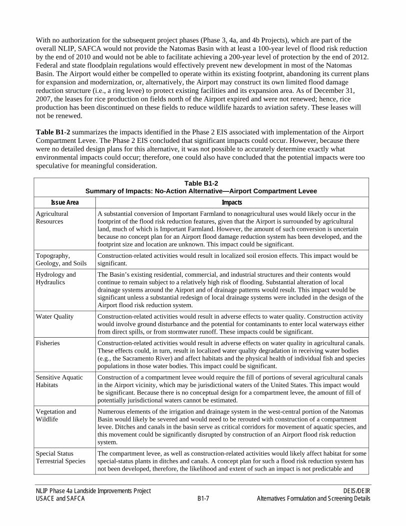
Table B1-2 summarizes the impacts identified in the Phase 2 EIS associated with implementation of the Airport Compartment Levee. The Phase 2 EIS concluded that significant impacts could occur. However, because there were no detailed design plans for this alternative, it was not possible to accurately determine exactly what environmental impacts could occur; therefore, one could also have concluded that the potential impacts were too speculative for meaningful consideration.
Table B1-2 Summary of Impacts: No-Action Alternative—Airport Compartment Levee
Issue Area Impacts Agricultural Resources
A substantial conversion of Important Farmland to nonagricultural uses would likely occur in the footprint of the flood risk reduction features, given that the Airport is surrounded by agricultural land, much of which is Important Farmland. However, the amount of such conversion is uncertain because no concept plan for an Airport flood damage reduction system has been developed, and the footprint size and location are unknown. This impact could be significant.
Topography, Geology, and Soils
Construction-related activities would result in localized soil erosion effects. This impact would be significant.
Hydrology and Hydraulics
The Basin’s existing residential, commercial, and industrial structures and their contents would continue to remain subject to a relatively high risk of flooding. Substantial alteration of local drainage systems around the Airport and of drainage patterns would result. This impact would be significant unless a substantial redesign of local drainage systems were included in the design of the Airport flood risk reduction system.
Water Quality Construction-related activities would result in adverse effects to water quality. Construction activity would involve ground disturbance and the potential for contaminants to enter local waterways either from direct spills, or from stormwater runoff. These impacts could be significant.
Fisheries Construction-related activities would result in adverse effects on water quality in agricultural canals. These effects could, in turn, result in localized water quality degradation in receiving water bodies (e.g., the Sacramento River) and affect habitats and the physical health of individual fish and species populations in those water bodies. This impact could be significant.
Sensitive Aquatic Habitats
Construction of a compartment levee would require the fill of portions of several agricultural canals in the Airport vicinity, which may be jurisdictional waters of the United States. This impact would be significant. Because there is no conceptual design for a compartment levee, the amount of fill of potentially jurisdictional waters cannot be estimated.
Vegetation and Wildlife
Numerous elements of the irrigation and drainage system in the west-central portion of the Natomas Basin would likely be severed and would need to be rerouted with construction of a compartment levee. Ditches and canals in the basin serve as critical corridors for movement of aquatic species, and this movement could be significantly disrupted by construction of an Airport flood risk reduction system.
Special Status Terrestrial Species
The compartment levee, as well as construction-related activities would likely affect habitat for some special-status plants in ditches and canals. A concept plan for such a flood risk reduction system has not been developed, therefore, the likelihood and extent of such an impact is not predictable and
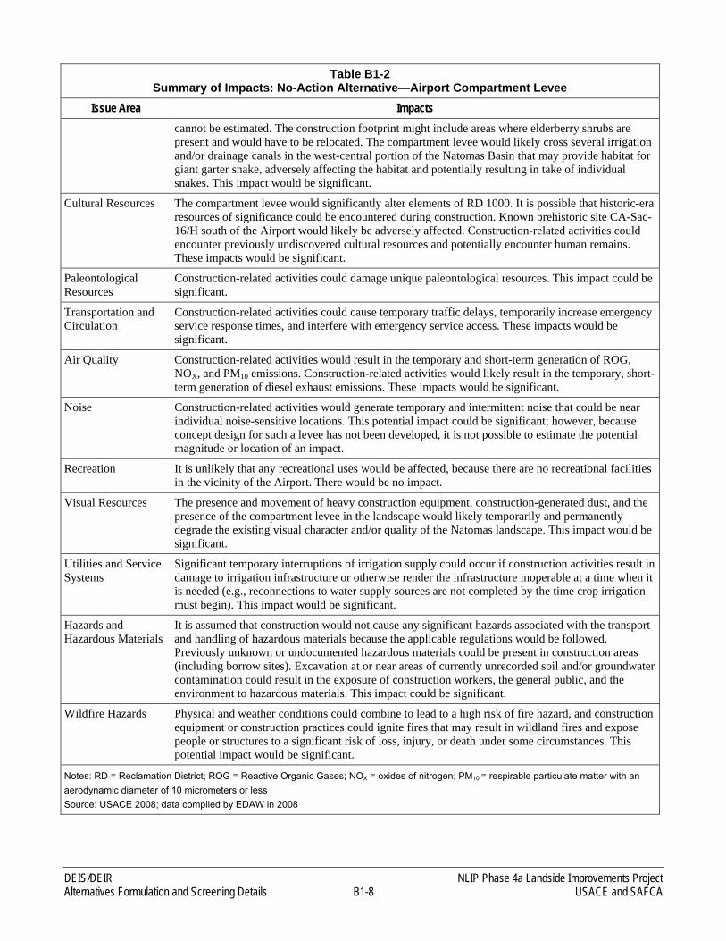
DEIS/DEIR NLIP Phase 4a Landside Improvements Project Alternatives Formulation and Screening Details B1-8 USACE and SAFCA
Table B1-2 Summary of Impacts: No-Action Alternative—Airport Compartment Levee
Issue Area Impacts cannot be estimated. The construction footprint might include areas where elderberry shrubs are present and would have to be relocated. The compartment levee would likely cross several irrigation and/or drainage canals in the west-central portion of the Natomas Basin that may provide habitat for giant garter snake, adversely affecting the habitat and potentially resulting in take of individual snakes. This impact would be significant.
Cultural Resources The compartment levee would significantly alter elements of RD 1000. It is possible that historic-era resources of significance could be encountered during construction. Known prehistoric site CA-Sac-16/H south of the Airport would likely be adversely affected. Construction-related activities could encounter previously undiscovered cultural resources and potentially encounter human remains. These impacts would be significant.
Paleontological Resources
Construction-related activities could damage unique paleontological resources. This impact could be significant.
Transportation and Circulation
Construction-related activities could cause temporary traffic delays, temporarily increase emergency service response times, and interfere with emergency service access. These impacts would be significant.
Air Quality Construction-related activities would result in the temporary and short-term generation of ROG, NOX, and PM10 emissions. Construction-related activities would likely result in the temporary, short-term generation of diesel exhaust emissions. These impacts would be significant.
Noise Construction-related activities would generate temporary and intermittent noise that could be near individual noise-sensitive locations. This potential impact could be significant; however, because concept design for such a levee has not been developed, it is not possible to estimate the potential magnitude or location of an impact.
Recreation It is unlikely that any recreational uses would be affected, because there are no recreational facilities in the vicinity of the Airport. There would be no impact.
Visual Resources The presence and movement of heavy construction equipment, construction-generated dust, and the presence of the compartment levee in the landscape would likely temporarily and permanently degrade the existing visual character and/or quality of the Natomas landscape. This impact would be significant.
Utilities and Service Systems
Significant temporary interruptions of irrigation supply could occur if construction activities result in damage to irrigation infrastructure or otherwise render the infrastructure inoperable at a time when it is needed (e.g., reconnections to water supply sources are not completed by the time crop irrigation must begin). This impact would be significant.
Hazards and Hazardous Materials
It is assumed that construction would not cause any significant hazards associated with the transport and handling of hazardous materials because the applicable regulations would be followed. Previously unknown or undocumented hazardous materials could be present in construction areas (including borrow sites). Excavation at or near areas of currently unrecorded soil and/or groundwater contamination could result in the exposure of construction workers, the general public, and the environment to hazardous materials. This impact could be significant.
Wildfire Hazards Physical and weather conditions could combine to lead to a high risk of fire hazard, and construction equipment or construction practices could ignite fires that may result in wildland fires and expose people or structures to a significant risk of loss, injury, or death under some circumstances. This potential impact would be significant.
Notes: RD = Reclamation District; ROG = Reactive Organic Gases; NOX = oxides of nitrogen; PM10 = respirable particulate matter with an aerodynamic diameter of 10 micrometers or less Source: USACE 2008; data compiled by EDAW in 2008
NLIP Phase 4a Landside Improvements Project DEIS/DEIR USACE and SAFCA B1-9 Alternatives Formulation and Screening Details
For the reasons provided in the Phase 2 EIS (listed below), this alternative was not carried forward for further evaluation in the Phase 3 DEIS/DEIR, nor is it carried forward for further evaluation in this EIS/EIR:
► construction of a separate levee around the Airport would be under the responsibility and jurisdiction of another agency (Sacramento County Airport System [SCAS]), over which SAFCA would have no jurisdiction, and would require a lengthy process that is completely separate from the Proposed Action;
► the timeline for that process is unknown and there are no design plans that would enable an accurate evaluation of potential environmental impacts; and
► the action would require SCAS to prepare a separate CEQA (and potentially NEPA) environmental compliance document.
In addition to those reasons provided in the Phase 2 EIS, design plans are not available for this alternative, thus preventing USACE and SAFCA from accurately evaluating its potential impacts; implementation of the Airport Compartment Levee would not meet any of the goals and objectives of the project; the residents, residences, and businesses within the Natomas Basin would not receive flood risk reduction; implementation of the Airport Compartment Levee would only protect the Airport; and SCAS has not proposed such a project and, therefore, this alternative is not considered a reasonable alternative.
3.1.2 CULTURAL RESOURCES IMPACT REDUCTION ALTERNATIVE
The Phase 3 Project’s Proposed Action included construction primarily of deep cutoff walls in the Sacramento River east levee Reaches 5A–9B, which would require excavation and placement of slurry at great depths along these reaches. The Sacramento River east levee has the potential to contain buried and undiscovered cultural resources that are difficult to detect by inspecting the ground surface. The Proposed Action under the Phase 3 Project, therefore, has the potential to result in significant and unavoidable impacts to known prehistoric resources, previously unidentified cultural resources, and interred human remains. Unlike other resources, the magnitude of potential impacts on previously undiscovered cultural resources and interred human remains is harder to discern because there are few feasible ways to investigate the presence of these resources within the footprint of deep cutoff walls proposed for construction along the Sacrament River east levee. Deep cutoff walls require excavation into strata that are currently beneath existing levees. Because of the potential magnitude of these impacts, the Phase 3 DEIS/DEIR analyzed an alternative means of remediating seepage along the Sacramento River east levee to determine if it would be possible to reduce impacts on cultural resources. This alternative consisted of construction of a 500-foot-wide seepage berm on the landside of the levee instead of construction of deep cut-off walls. The analysis of this alternative concluded that while a berm may reduce impacts on any resources identified adjacent to the Sacramento River east levee, it would dramatically increase the potential for impacts on undiscovered cultural deposits as well as other resources, and thus was eliminated.
Construction of a 500-foot-wide seepage berm rather than primarily deep cutoff walls in these reaches would avoid the deep ground disturbing work associated with cultural resource impacts while still achieving flood damage reduction objectives. Construction of a 500-foot-wide seepage berm would have more than doubled the borrow material requirement for the Sacramento River east levee Reaches 5A–9B component of the Phase 3 Project’s Proposed Action from approximately 1.8 million cubic yards (cy) to 3.8 million cy.
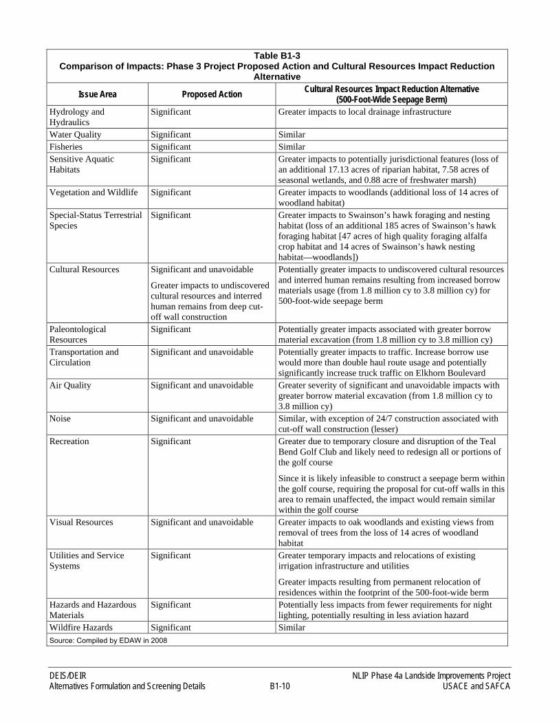
Table B1-3 compares impacts for the Proposed Action under the Phase 3 Project and the Cultural Resources Impact Reduction Alternative. Impacts to cultural resources and aviation safety hazards would be reduced by the construction of a 500-foot-wide berm. Of the 16 issue areas analyzed, impacts on ten of the issue areas were considered to be more severe with the Cultural Resources Impact Reduction Alternative. Approximately four impacts were determined to be generally similar. One impact was reduced (“24/7” noise associated with construction of deep cut-off walls) and one impact potentially less impacted by construction of a seepage berm.
DEIS/DEIR NLIP Phase 4a Landside Improvements Project Alternatives Formulation and Screening Details B1-10 USACE and SAFCA
Table B1-3 Comparison of Impacts: Phase 3 Project Proposed Action and Cultural Resources Impact Reduction
Alternative
Issue Area Proposed Action Cultural Resources Impact Reduction Alternative (500-Foot-Wide Seepage Berm)
Hydrology and Hydraulics
Significant Greater impacts to local drainage infrastructure
Water Quality Significant Similar Fisheries Significant Similar Sensitive Aquatic Habitats
Significant Greater impacts to potentially jurisdictional features (loss of an additional 17.13 acres of riparian habitat, 7.58 acres of seasonal wetlands, and 0.88 acre of freshwater marsh)
Vegetation and Wildlife Significant Greater impacts to woodlands (additional loss of 14 acres of woodland habitat)
Special-Status Terrestrial Species
Significant Greater impacts to Swainson’s hawk foraging and nesting habitat (loss of an additional 185 acres of Swainson’s hawk foraging habitat [47 acres of high quality foraging alfalfa crop habitat and 14 acres of Swainson’s hawk nesting habitat—woodlands])
Cultural Resources Significant and unavoidable
Greater impacts to undiscovered cultural resources and interred human remains from deep cut-off wall construction
Potentially greater impacts to undiscovered cultural resources and interred human remains resulting from increased borrow materials usage (from 1.8 million cy to 3.8 million cy) for 500-foot-wide seepage berm
Paleontological Resources
Significant Potentially greater impacts associated with greater borrow material excavation (from 1.8 million cy to 3.8 million cy)
Transportation and Circulation
Significant and unavoidable Potentially greater impacts to traffic. Increase borrow use would more than double haul route usage and potentially significantly increase truck traffic on Elkhorn Boulevard
Air Quality Significant and unavoidable Greater severity of significant and unavoidable impacts with greater borrow material excavation (from 1.8 million cy to 3.8 million cy)
Noise Significant and unavoidable Similar, with exception of 24/7 construction associated with cut-off wall construction (lesser)
Recreation Significant Greater due to temporary closure and disruption of the Teal Bend Golf Club and likely need to redesign all or portions of the golf course
Since it is likely infeasible to construct a seepage berm within the golf course, requiring the proposal for cut-off walls in this area to remain unaffected, the impact would remain similar within the golf course
Visual Resources Significant and unavoidable Greater impacts to oak woodlands and existing views from removal of trees from the loss of 14 acres of woodland habitat
Utilities and Service Systems
Significant Greater temporary impacts and relocations of existing irrigation infrastructure and utilities
Greater impacts resulting from permanent relocation of residences within the footprint of the 500-foot-wide berm
Hazards and Hazardous Materials
Significant Potentially less impacts from fewer requirements for night lighting, potentially resulting in less aviation hazard
Wildfire Hazards Significant Similar Source: Compiled by EDAW in 2008
NLIP Phase 4a Landside Improvements Project DEIS/DEIR USACE and SAFCA B1-11 Alternatives Formulation and Screening Details
Because the Cultural Resources Impact Reduction Alternative would have resulted in a net increase in the number, intensity, and severity of environmental impacts compared to the Phase 3 Project Proposed Action, and because implementation of the 500-foot-wide seepage berm would have resulted in the permanent displacement of residences and temporary closure, disruption, and redesign of portions or all of the Teal Bend Golf Club, it was eliminated from further consideration, and thus was not carried forward for detailed analysis in the Phase 3 DEIS/DEIR.
Although this alternative was eliminated for the Phase 3 Project due to the reasons cited above, 500-foot-wide seepage berms are being analyzed in this EIS/EIR as part of the Phase 4a Project Proposed Action to represent the worst-case scenario (see Section 2.3.1 of this EIS/EIR) for the following reasons:
1) it is anticipated that at least one very large cultural site may require avoidance (CA-Sac-16/H); and
2) additional previously undiscovered cultural resource sites may be present (surveys are on-going) that could require this measure.
The locations and widths of the seepage berms would be determined during final engineering design. The use of seepage berms would take into the consideration overall impacts to resources and whether residences, heritage oak trees, or other sensitive resources would be affected. SAFCA would employ measures to minimize the project footprint to avoid these resources to the extent feasible, under levee design and seepage remediation performance requirements.
3.1.3 ALTERNATIVES CONSIDERED IN PREVIOUS ENVIRONMENTAL ANALYSES AND INCORPORATED BY REFERENCE IN THIS EIS/EIR
This section describes the alternatives analysis performed in previous documents from which this EIS/EIR is tiered. The alternatives analyses from the documents listed below are incorporated by reference, herein. This material is summarized here to summarize the scope of analysis that has already been performed, and thus to also show which alternatives have been eliminated from further analysis or rejected by previous analyses.
3.1.3.1 ALTERNATIVES CONSIDERED IN THE ENVIRONMENTAL IMPACT REPORT FOR LOCAL FUNDING MECHANISMS FOR COMPREHENSIVE FLOOD CONTROL IMPROVEMENTS FOR THE SACRAMENTO AREA (SAFCA 2007A)
The Proposed Action is funded, in part, by funding sources developed as a result of the creation of new assessment districts. SAFCA analyzed the environmental effects of this action to create new assessment districts in the Local Funding EIR (SAFCA 2007a). The project objective used to screen alternatives for this project was the identification and creation of a source of funding that would allow SAFCA to provide 100-year flood risk reduction for developed areas within SAFCA’s jurisdiction, and to lay groundwork for creation of 200-year flood risk reduction over time (SAFCA 2007a: 7-2).
► Proposed Project. The proposed project alternative consisted of creation of an assessment district and a development fee program to fund improvements along the portions of Sacramento and American Rivers within SAFCA’s jurisdiction. This alternative was determined to provide sufficient funds for project objectives (SAFCA 2007a: 3-1).
► No Project (Alternative 1). In this alternative, SAFCA considered the impact of neither creating nor seeking new funding mechanisms for flood damage reduction. This would limit flood damage reduction projects to current efforts to provide 100-year flood risk reduction along the American River and the South Sacramento Streams Group and thus would not meet project objectives (SAFCA 2007a: 7-2).
DEIS/DEIR NLIP Phase 4a Landside Improvements Project Alternatives Formulation and Screening Details B1-12 USACE and SAFCA
► No New Public Funding; Private Levees in Natomas (Alternative 2). This alternative assumed the same conditions as the No-Project Alternative but looked at the probable effect of private levee construction for residential development projects (SAFCA 2007a: 7-2). This alternative was eliminated because it would increase projected flood damages without a commensurate reduction in flood risk (SAFCA 2007a: 7-7).
► Natomas 100-Year Protection (Alternative 3). SAFCA analyzed the impacts associated with creation of one new assessment district which would provide only 100-year flood risk reduction to the Natomas Basin, and would use funding raised through existing Capital Assessment District Number 3 to provide the local share of the cost of completing improvements to provide 100-year flood risk reduction to the lower American River and South Sacramento Streams Group areas (SAFCA 2007a: 7-2). This alternative was eliminated because it would fail to provide groundwork for the creation of 200-year protection over time (SAFCA 2007a: 7-8).
► Reduced Natomas Levee Perimeter (Alternative 4). Under this alternative, SAFCA considered construction of a new levee across the Natomas Basin in lieu of improving the south levee of the NCC and the upper reach of the east levee of the Sacramento River. This alternative would have reduced the project footprint and would have excluded the northern undeveloped portion of the Basin both from flood risk reduction and the assessment districts to be created (SAFCA 2007a: 7-2). This alternative was eliminated because it would have a much larger footprint than proposed improvements in the Natomas Basin (SAFCA 2007a: 7-11), and it would be subject to potential veto by RD 1000 (SAFCA 2007a: 7-12).
This document analyzed the ability of these alternatives to meet the project objectives and determined that only the proposed project would meet project goals (SAFCA 2007a: 7-14). In addition, the Local Funding EIR analyzed the environmental effects of the various alternatives and concluded that Alternative 3 was the environmentally superior alternative. Alternative 3 would have eliminated or reduced a range of significant effects associated with creation of a new assessment district; however, it was not selected because it would not meet the important project objective of laying the groundwork for 200-year flood risk reduction. The proposed project alternative was selected because it would meet all of the project objectives.
3.1.3.2 ALTERNATIVES CONSIDERED IN THE ENVIRONMENTAL IMPACT REPORT FOR THE NATOMAS LEVEE IMPROVEMENT PROGRAM, LANDSIDE IMPROVEMENTS PROJECT (SAFCA 2007B)
In the Phase 2 EIR, SAFCA analyzed construction of flood damage reduction measures required to protect the Natomas Basin at a program level, and a project level for the Phase 2 Project (SAFCA 2007b). This range of alternatives for the program presented in this Phase 2 EIR is incorporated by reference. The project objectives used to screen alternatives consisted of developing 100-year flood risk reduction in the Natomas Basin as quickly as possible, developing 200-year flood risk reduction over time, and ensuring that new development in Sacramento’s floodplains does not substantially increase the risk of flooding (SAFCA 2007b: 6-2). Project-specific objectives included reducing hazards to aviation safety in the vicinity of the Sacramento International Airport, and enhancing habitat values in the Natomas Basin for giant garter snake, Swainson’s hawk, and other special-status species (SAFCA 2007b: 6-2).
► Construct an Adjacent Setback Levee along the Sacramento River East Levee. This alternative was analyzed as the proposed project, carried forward in the EIR as Alternative 1. This project consisted of constructing an adjacent setback levee on the Sacramento River east levee. Other improvements included levee raising and seepage remediation on the Sacramento River east levee, the NCC south levee, and the Pleasant Grove Creek Canal (PGCC) west levee. Other project components included improvements to major irrigation and drainage infrastructure, habitat creation and management, and right-of-way acquisition (SAFCA 2007b: 6-6, 6-7). This alternative was determined to meet project objectives (SAFCA 2007a: 6-7).
► Raise Levee in Place with a 1,000-Foot Levee Setback in the Upper 1.4 Miles along the Sacramento River East Levee. This alternative would have provided a location for a substantial amount of tree planting on the waterside of the levee, contributing to offsetting mitigation for the loss of trees that could have been
NLIP Phase 4a Landside Improvements Project DEIS/DEIR USACE and SAFCA B1-13 Alternatives Formulation and Screening Details
removed along the existing levee to meet USACE criteria. This alternative was eliminated because it was unlikely that the new setback levee would provide 100-year flood risk reduction per USACE criteria (SAFCA 2007a: 6-11).
► Construct an Adjacent Setback Levee with a 500-Foot Levee Setback in the Upper 1.4 Miles along the Sacramento River East Levee. This alternative was evaluated because it would provide the opportunity for partially offsetting the loss of landside tree groves through the establishment of new riparian plantings in the levee setback area as well as woodland plantings on the landside of the adjacent setback levee. This alternative was eliminated because it would require substantially greater quantities of borrow material with greater impacts on important farmland and transportation and circulation (SAFCA 2007b: 6-19, 6-20).
► No-Project Alternative—No Flood Control Improvements in Natomas. Consideration of a no-project alternative is required under CEQA. Under this alternative, it was assumed that the Natomas Basin flood damage reduction system would not be improved. This alternative was eliminated because it would not meet project objectives (SAFCA 2007b: 6-14).
► No SAFCA Levee Improvements—Private Levees in Natomas. This alternative was analyzed assuming no SAFCA project providing flood risk reduction in the Basin, thus causing private developers to separately fund individual flood risk reduction in the form of private compartment levees that would protect new developments. This was eliminated because it would only partially meet the first objective of providing 100-year flood risk reduction and it would potentially lead to increased fragmentation of habitat for special-status species (SAFCA 2007b: 6-15).
The proposed project was identified as the environmentally superior alternative after all alternatives were compared relative to their foreseeable effects (SAFCA 2007b: 6-25). The proposed project was selected for implementation.
3.1.3.3 ALTERNATIVES CONSIDERED IN THE DRAFT ENVIRONMENTAL IMPACT STATEMENT/DRAFT ENVIRONMENTAL IMPACT REPORT FOR THE NATOMAS LEVEE IMPROVEMENT PROGRAM PHASE 3 LANDSIDE IMPROVEMENTS PROJECT (USACE AND SAFCA 2009)
In the Phase 3 DEIS/DEIR, SAFCA analyzed construction of flood damage reduction measures required to protect the Natomas Basin at a project level for the Phase 3 Project (USACE and SAFCA 2009). This range of alternatives for the program presented in the Phase 3 DEIS/DEIR is incorporated by reference.
► No-Action Alternative—Under NEPA, the expected future without-project conditions; under CEQA, the existing condition at the time the notice of preparation was published (July 18, 2008), as well as what would be reasonably expected to occur in the foreseeable future (two scenarios) if the Phase 3 Project were not approved.
► Proposed Action—Construction of an adjacent setback levee along the Sacramento River east levee and improvements to the PGCC west levee and the NEMDC west levee from Elkhorn Boulevard to Northgate Boulevard.
► Levee Raise-in-Place Alternative—Raising of the Sacramento River east levee in place and improvements to the PGCC west levee and the NEMDC west levee from Elkhorn Boulevard to Northgate Boulevard.
The Proposed Action and one action alternative (the Levee Raise-in-Place Alternative) were developed for consideration for the Phase 3 Project with a focus on improvements to the Sacramento River east levee (Reaches 5A–9B). Phase 3 Project improvements to the PGCC west levee, the NEMDC west levee, and landscape and irrigation/drainage system modifications would be similar under the Proposed Action and the Levee Raise-in-Place Alternative.
DEIS/DEIR NLIP Phase 4a Landside Improvements Project Alternatives Formulation and Screening Details B1-14 USACE and SAFCA
Development of the Proposed Action and the Levee Raise-in-Place Alternative included substantial planning based on consideration of effects on wetlands and other waters of the United States, woodlands, giant garter snake habitat, and other habitats. Accordingly, levee improvements were designed to avoid or minimize such effects where practicable and feasible. However, several agricultural canals or portions of canals and small seasonal wetlands exist near the levee toe along the Sacramento River east levee, PGCC west levee, and NEMDC west levee. These would require filling under either the Proposed Action or the Levee Raise-in-Place Alternative because their proximity to the existing levees places them within the expanded landside levee footprint or adjacent maintenance access under the Proposed Action and the Levee Raise-in-Place Alternative. Similarly, portions of several woodland groves extend into the proposed footprint of the flood damage reduction features along the landside of the Sacramento River east levee under the Proposed Action and the Levee Raise-in-Place Alternative and would need to be removed and/or relocated. Consequently, effects on wetlands and other waters of the United States and on other habitats along the landside of the levees were very similar for the Proposed Action and the Levee Raise-in-Place Alternative, and the same compensation strategies were proposed for unavoidable effects.
The Levee Raise-in-Place Alternative differed from the Proposed Action in that it would result in the (1) removal of waterside trees along the Sacramento River east levee to conform with USACE guidance regarding levee encroachments, and (2) loss of waters of the United States due to the implementation of erosion control improvements along the waterside toe of Sacramento River east levee. These effects would require a different compensation strategy than for the Proposed Action because, under the Proposed Action, these actions would not occur on the waterside of the levee.
In terms of flood risk reduction system design, the Proposed Action and the Levee Raise-in-Place Alternative differed in terms of how they would achieve the required levee height increases along the Sacramento River east levee. Therefore, the differences between the Proposed Action and the Levee Raise-in-Place Alternative, including effects on habitats, were the result of these Sacramento River east levee design differences.
4.1 ALTERNATIVES CARRIED FORWARD FOR EVALUATION IN THIS EIS/EIR
The following alternatives are carried forward for detailed analysis in this EIS/EIR and are described in detail in Chapter 2.0, “Alternatives”:
► No-Action Alternative—Under NEPA, the expected future without-project conditions; under CEQA, the existing condition at the time the notice of preparation was published (March 27, 2009), as well as what would be reasonably expected to occur in the foreseeable future (two scenarios) if the Phase 4a Project were not approved.
► Proposed Action—An adjacent levee would be constructed along the Sacramento River east levee, raised in Reaches 10–11B and at the same height as the existing levee in Reaches 12–15; and, where required, cutoff walls, seepage berms, and relief wells would be installed for seepage remediation. A cutoff wall would be installed for additional seepage remediation in Reach 4B. In two locations, the NCC south levee would be raised, a cutoff wall would be installed, and existing pumps would be modified or replaced to reflect raising the discharge pipes above the 200-year design flood elevation. The Riverside Canal would be relocated and extended. Parcels within the Fisherman’s Lake Area would be the primary source of soil borrow for Phase 4a Project construction; those parcels excavated for borrow material would be reclaimed as agricultural land, grassland, or managed marsh depending on their location and existing land use. Wells would be constructed to provide a water supply for habitat features.
► RSLIP Alternative—The Sacramento River east levee would be raised in place in Reaches 10–12 and strengthened in place in Reaches 12–15 and seepage remediation and erosion control measures would be implemented. The RSLIP Alternative would be the same as described for the Proposed Action except for the
NLIP Phase 4a Landside Improvements Project DEIS/DEIR USACE and SAFCA B1-15 Alternatives Formulation and Screening Details
method of levee raising and rehabilitation, the extent of levee degrade to construct cutoff walls, and extent of encroachment removal along the Sacramento River east levee.
The above three alternatives are described in detail in Chapter 2.0, “Alternatives.” The Proposed Action and the RSLIP Alternative were developed for consideration with a focus on improvements to the Sacramento River east levee (Reaches 10–15). Phase 4a Project improvements to the NCC south levee, relocation and extension of the Riverside Canal, and modifications to the landscape and irrigation/drainage system would be similar under the Proposed Action and the RSLIP Alternative.
As noted above, the Proposed Action and the RSLIP Alternative would use differing methods to achieve the required levee height increases along the Sacramento River east levee for flood damage reduction. Therefore, the differences between the Proposed Action and the RSLIP Alternative, including effects on habitats, are the result of these differences in design of the Sacramento River east levee. These effects are more fully described in Chapter 4.0, “Environmental Consequences and Mitigation Measures,” of this EIS/EIR.
DEIS/DEIR NLIP Phase 4a Landside Improvements Project Alternatives Formulation and Screening Details B1-16 USACE and SAFCA
REFERENCES
Sacramento Area Flood Control Agency. 2007a (February). Final Environmental Impact Report on Local Funding Mechanisms for Comprehensive Flood Control Improvements for the Sacramento Area. State Clearinghouse No. 2006072098. Prepared by EDAW, Sacramento, CA.
———. 2007b (November). Final Environmental Impact Report on the Natomas Levee Improvement Program Landside Improvements Project. State Clearinghouse No. 2007062016. Prepared by EDAW, Sacramento, CA.
———. 2008 (June 17). Supplemental Report for the Design Water Surface Profile for the Natomas Levee Improvement Program. Prepared by MBK Engineers, Sacramento, CA.
———. 2009 (January). Final Supplement to the Environmental Impact Report on the Natomas Levee Improvement Program, Landside Improvements Project––Phase 2 Project. State Clearinghouse No. 2007062016. Prepared by EDAW, Sacramento, CA.
SAFCA. See Sacramento Area Flood Control Agency.
USACE. See U.S. Army Corps of Engineers.
U.S. Army Corps of Engineers. 2008 (November). Final Environmental Impact Statement for 408 Permission and 404 Permit to Sacramento Area Flood Control Agency for the Natomas Levee Improvement Project, Sacramento, CA. Prepared by EDAW, Sacramento, CA.
U.S. Army Corps of Engineers and Sacramento Area Flood Control Agency. 2009 (February). Draft Environmental Impact Statement/Draft Environmental Impact Report on the Natomas Levee Improvement Program Phase 3 Landside Improvements Project. State Clearinghouse No. 2007062016. Prepared by EDAW, Sacramento, CA.
B2 NEPA and/or CEQA Standards and Checklist
Applicable to the Elkhorn Borrow Area
NLIP Phase 4a Landside Improvements Project DEIS/DEIR USACE and SAFCA B2-1 NEPA and/or CEQA Standards and Checklist Applicable to Borrow Areas Used by the Phase 4a Project
APPENDIX B2 NEPA AND/OR CEQA STANDARDS AND CHECKLIST
APPLICABLE TO BORROW AREAS USED BY THE PHASE 4A PROJECT
This appendix reviews the standards that apply to preparation of NEPA and/or CEQA documents, and provides USACE and SAFCA with a tool for determining whether subsequent project-related activities within borrow areas used by the Phase 4a Project (described in Chapter 2.0, “Alternatives,” of this EIS/EIR) will require further environmental documentation under either NEPA or CEQA. An environmental checklist is provided to identify the appropriate level of documentation for satisfying NEPA and/or CEQA.
SAFCA has developed this checklist concept as a tool to maximize flexibility for screening and selecting specific borrow sites within the proposed borrow areas for use during Phase 4a Project construction and, potentially subsequent project phases. While SAFCA has identified several properties within the proposed borrow areas from which borrow may be removed, ongoing investigations will be required to determine the most suitable location(s) for excavating borrow. Therefore, there is insufficient information for some of the proposed borrow sites to make a final selection of specific properties in this EIS/EIR. Accordingly, this checklist will be used to inform USACE and/or SAFCA to determine if specific borrow sites proposed within the EIS/EIR have been analyzed at a sufficient level of detail in this EIS/EIR, under NEPA and/or CEQA, or if further environmental review is required. If further environmental review and analysis is required, this checklist will help guide USACE and SAFCA in determining the appropriate level of NEPA and/or CEQA compliance.
Under NEPA, a supplemental environmental impact statement (supplemental EIS) is required when changes in the proposed action are “relevant to environmental concerns,” (40 Code of Federal Regulations [CFR] Section 1502.9[1][i]), or when there are “significant new circumstances or information relevant to environmental concerns and bearing on the proposed action or its impacts” (40 CFR Section 1502.9[1][ii]). In general, this means that a supplemental EIS is required if new and potentially significant impacts that were not previously disclosed or identified in a public NEPA document are identified in association with a subsequent activity. Courts have further interpreted this requirement to indicate that when new mitigation measure(s) are identified that would reduce some of the impacts of a Federal action subject to NEPA, an SEIS is required if that measure itself would result in new significant impacts that were not previously disclosed in the EIS (National Wildlife Federation v. Marsh 721 F.2d 767, [11th Cir.] 1983).
USACE NEPA regulations incorporate the Council on Environmental Quality standard to determine when a supplemental EIS is required (33 CFR Section 230.13):
Environmental Impact Statement (EIS). (b) Supplements. A supplement to the draft or final EIS should be prepared whenever required as discussed in 40 CFR 1502.09(c).
The USACE NEPA regulations, however, provide that “District commanders may also publish periodic factsheets and/or other supplemental information documents on long-term or complex EISs to keep the public informed on the status of the proposed action” (33 CFR Section 230.13[d]). USACE will use this standard to screen subsequent activities, if they are subject to NEPA.
1. TIERING FROM PROGRAM-LEVEL ANALYSIS UNDER CEQA
The following rules from CEQA and the State CEQA Guidelines provide for screening subsequent project activities in a program through the use of a checklist to determine if the project activities have received sufficient CEQA review, or if another CEQA compliance document is required. CEQA and the State CEQA Guidelines
DEIS/DEIR NLIP Phase 4a Landside Improvements Project NEPA and/or CEQA Standards and Checklist Applicable B2-2 USACE and SAFCA to Borrow Areas Used by the Phase 4a Project
specify the criteria for determining whether additional environmental review is required and, if so, what form of additional environmental document is appropriate.
► Where a program EIR has been prepared for a series of related actions and activities (in this case, the Phase 2 EIR [SAFCA 2007], the Phase 3 DEIS/DEIR [USACE and SAFCA 2009], and this EIS/EIR), the lead agency may use a checklist to determine whether subsequent site-specific activities, such as the use of a specific property as a borrow site, were covered in the prior EIR(s) (State CEQA Guidelines California Code of Regulations [CCR] Section 15168[c][4]; see also CCR Sections 15152[d] and [f]).
► If the lead agency determines that none of the conditions specified in State CEQA Guidelines CCR Section 15162, discussed below, that trigger the need for a subsequent EIR or negative declaration have occurred and no new effects could occur or no new mitigation is required, the lead agency may approve the activity. No additional environmental document is required. (State CEQA Guidelines CCR Section 15168[c]][2]).
► Pursuant to State CEQA Guidelines CCR Section 15162, if the lead agency determines that any of the following conditions have occurred, either a supplemental or subsequent EIR shall be prepared:
• Substantial changes to the project, substantial changes in circumstances, or new information show either new significant effects or a substantial increase in the severity of previously identified significant effects; or
• New information shows that mitigation measures or alternatives which were previously identified as infeasible, and would substantially reduce the severity of one or more significant effects, are now found to be feasible, but the project proponent declines to adopt them; or
• New information shows that considerably different mitigation measures or alternatives from those analyzed in the prior EIR(s) would substantially reduce the severity of one or more significant effects, are now found to be feasible, but the project proponent declines to adopt them.
► If any of the State CEQA Guidelines CCR Section 15162 conditions described above are present, but only minor changes or revisions to a previous EIR are required, the lead agency may prepare a supplement to the EIR. The supplemental EIR shall focus only on those changes or revisions that are necessary to make the previous study adequate and shall be circulated as a draft and final supplemental EIR (State CEQA Guidelines CCR Section 15163).
► If the lead agency determines that a subsequent activity requires some minor technical changes or revisions to a previously completed EIR or negative declaration, but none of the conditions described below require either a supplemental or a subsequent EIR, the lead agency may prepare an addendum to the EIR or negative declaration and attach the addendum to the final EIR or adopted negative declaration. No public circulation is required (State CEQA Guidelines CCR Section 15164).
► In some circumstances, a subsequent negative declaration may be warranted (see State CEQA Guidelines CCR Section 15152[g]).
2. CEQA CHECKLIST FOR SCREENING SUBSEQUENT SELECTION OF BORROW SITES
This checklist will be used to review impacts applicable to specific properties within the identified borrow areas that would be used by the Phase 4a Project, once they are proposed for use, for the purpose of determining whether and what additional CEQA environmental review is required. The checklist involves a three-step process for determining whether a specific borrow site has been sufficiently analyzed, or if the use of the borrow site

NLIP Phase 4a Landside Improvements Project DEIS/DEIR USACE and SAFCA B2-3 NEPA and/or CEQA Standards and Checklist Applicable to Borrow Areas Used by the Phase 4a Project
would require preparation of a new CEQA compliance document. The checklist also can provide guidance to USACE for determining the appropriate NEPA compliance document, if needed.
First, SAFCA will review the impacts that were identified as “less than significant” in the checklist below and fill out the checklist accordingly. If the use of the borrow site would contribute to these impacts, SAFCA will determine whether the contribution of borrow site operations would result in a significant impact. If a new significant impact would result, a supplemental or subsequent EIR will be required and prepared.
Next, for impacts that the checklist shows previously analyzed and disclosed as “significant,” and for which SAFCA identified and adopted mitigation measures that would reduce those impacts to less-than-significant levels, SAFCA will determine whether the borrow site operations would contribute to those impacts. If the borrow site operations contribute to those impacts, but implementation of the mitigation measures and environmental commitments identified in the Phase 2 EIR (SAFCA 2007), the Phase 3 DEIS/DEIR (USACE and SAFCA 2009), and this EIS/EIR, which were previously adopted and incorporated into the project, would mitigate that contribution to a less-than-significant level, the borrow site’s contribution to those impacts will not trigger the need to prepare a new CEQA compliance document. If the use of the borrow site would cause these impacts to become significant impacts even after implementation of identified mitigation, SAFCA will prepare the appropriate CEQA compliance document, as described above.
SAFCA will also use the checklist to determine if the borrow site operations would contribute to identified significant and unavoidable impacts. If the borrow site operations cause or contribute to any of the previously analyzed and disclosed significant or potentially significant and unavoidable impacts, SAFCA will determine if the borrow site’s contribution was included when calculating the severity of the impact. If the borrow site’s contribution to that impact was included in the impacts previously analyzed in the Phase 2 EIR (SAFCA 2007), the Phase 3 DEIS/DEIR (USACE and SAFCA 2009), or this EIS/EIR, no new CEQA compliance document will be required. If the borrow site’s contribution was not included in the impacts analyzed in the aforementioned documents, a new EIR, EIR addendum, or potentially a mitigated negative declaration would be required and prepared.
Finally, SAFCA will use the checklist to determine if the use of the proposed borrow sites would result in new impacts that were not previously disclosed in the aforementioned documents or would affect resources that were not identified when analyzing previously disclosed impacts. If so, SAFCA would prepare the appropriate CEQA compliance document, as described above.
Borrow Area Checklist
ENVIRONMENTAL SETTING
Designated borrow site APN(s):______________________________________________________________
Land use types within designated borrow site Does the site include:
Developed land Agricultural land Orchards Grassland Non-Riparian Woodlands Riparian Woodland/Scrub Williamson Act Land (in a preserve or under contract)
Information from surveys: Does the site include:
Cultural Resources Wetlands Special-Status Species Suitable Habitat for Special-Status Species Recognized Environmental Conditions
DEIS/DEIR NLIP Phase 4a Landside Improvements Project NEPA and/or CEQA Standards and Checklist Applicable B2-4 USACE and SAFCA to Borrow Areas Used by the Phase 4a Project
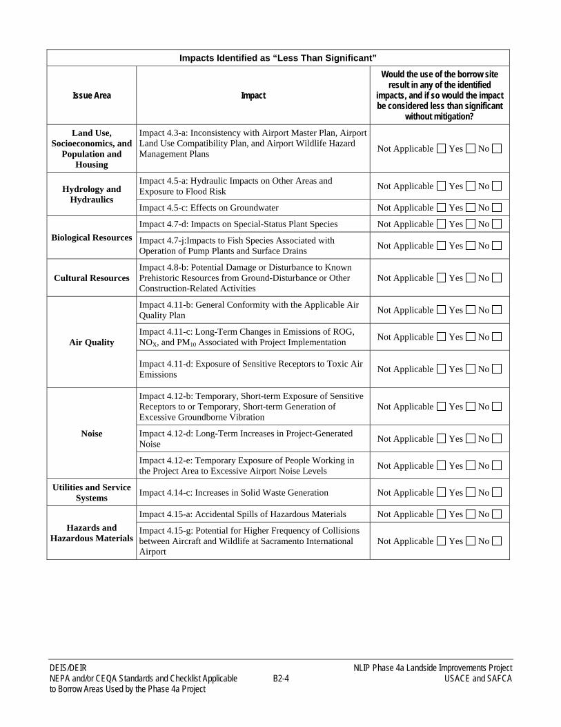
Impacts Identified as “Less Than Significant”
Issue Area Impact
Would the use of the borrow site result in any of the identified
impacts, and if so would the impact be considered less than significant
without mitigation?
Land Use, Socioeconomics, and
Population and Housing
Impact 4.3-a: Inconsistency with Airport Master Plan, Airport Land Use Compatibility Plan, and Airport Wildlife Hazard Management Plans Not Applicable Yes No
Hydrology and Hydraulics
Impact 4.5-a: Hydraulic Impacts on Other Areas and Exposure to Flood Risk Not Applicable Yes No
Impact 4.5-c: Effects on Groundwater Not Applicable Yes No
Biological Resources Impact 4.7-d: Impacts on Special-Status Plant Species Not Applicable Yes No
Impact 4.7-j:Impacts to Fish Species Associated with Operation of Pump Plants and Surface Drains Not Applicable Yes No
Cultural Resources Impact 4.8-b: Potential Damage or Disturbance to Known Prehistoric Resources from Ground-Disturbance or Other Construction-Related Activities
Not Applicable Yes No
Air Quality
Impact 4.11-b: General Conformity with the Applicable Air Quality Plan Not Applicable Yes No
Impact 4.11-c: Long-Term Changes in Emissions of ROG, NOX, and PM10 Associated with Project Implementation Not Applicable Yes No
Impact 4.11-d: Exposure of Sensitive Receptors to Toxic Air Emissions Not Applicable Yes No
Noise
Impact 4.12-b: Temporary, Short-term Exposure of Sensitive Receptors to or Temporary, Short-term Generation of Excessive Groundborne Vibration
Not Applicable Yes No
Impact 4.12-d: Long-Term Increases in Project-Generated Noise Not Applicable Yes No
Impact 4.12-e: Temporary Exposure of People Working in the Project Area to Excessive Airport Noise Levels Not Applicable Yes No
Utilities and Service Systems Impact 4.14-c: Increases in Solid Waste Generation Not Applicable Yes No
Hazards and Hazardous Materials
Impact 4.15-a: Accidental Spills of Hazardous Materials Not Applicable Yes No
Impact 4.15-g: Potential for Higher Frequency of Collisions between Aircraft and Wildlife at Sacramento International Airport
Not Applicable Yes No
NLIP Phase 4a Landside Improvements Project DEIS/DEIR USACE and SAFCA B2-5 NEPA and/or CEQA Standards and Checklist Applicable to Borrow Areas Used by the Phase 4a Project
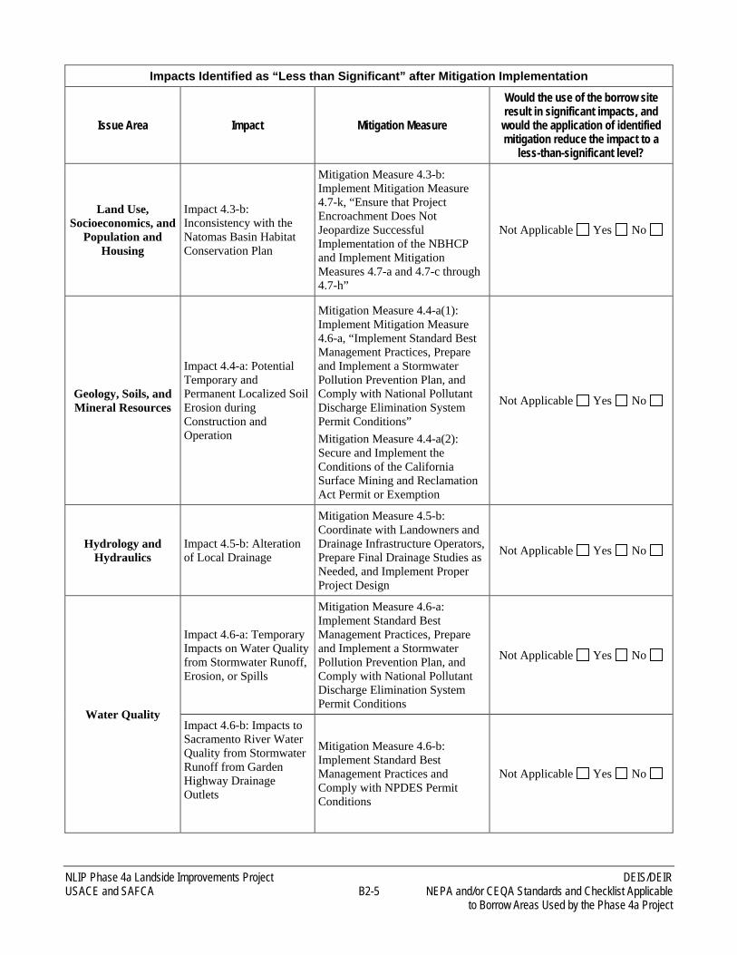
Impacts Identified as “Less than Significant” after Mitigation Implementation
Issue Area Impact Mitigation Measure
Would the use of the borrow site result in significant impacts, and
would the application of identified mitigation reduce the impact to a
less-than-significant level?
Land Use, Socioeconomics, and
Population and Housing
Impact 4.3-b: Inconsistency with the Natomas Basin Habitat Conservation Plan
Mitigation Measure 4.3-b: Implement Mitigation Measure 4.7-k, “Ensure that Project Encroachment Does Not Jeopardize Successful Implementation of the NBHCP and Implement Mitigation Measures 4.7-a and 4.7-c through 4.7-h”
Not Applicable Yes No
Geology, Soils, and Mineral Resources
Impact 4.4-a: Potential Temporary and Permanent Localized Soil Erosion during Construction and Operation
Mitigation Measure 4.4-a(1): Implement Mitigation Measure 4.6-a, “Implement Standard Best Management Practices, Prepare and Implement a Stormwater Pollution Prevention Plan, and Comply with National Pollutant Discharge Elimination System Permit Conditions” Mitigation Measure 4.4-a(2): Secure and Implement the Conditions of the California Surface Mining and Reclamation Act Permit or Exemption
Not Applicable Yes No
Hydrology and Hydraulics
Impact 4.5-b: Alteration of Local Drainage
Mitigation Measure 4.5-b: Coordinate with Landowners and Drainage Infrastructure Operators, Prepare Final Drainage Studies as Needed, and Implement Proper Project Design
Not Applicable Yes No
Water Quality
Impact 4.6-a: Temporary Impacts on Water Quality from Stormwater Runoff, Erosion, or Spills
Mitigation Measure 4.6-a: Implement Standard Best Management Practices, Prepare and Implement a Stormwater Pollution Prevention Plan, and Comply with National Pollutant Discharge Elimination System Permit Conditions
Not Applicable Yes No
Impact 4.6-b: Impacts to Sacramento River Water Quality from Stormwater Runoff from Garden Highway Drainage Outlets
Mitigation Measure 4.6-b: Implement Standard Best Management Practices and Comply with NPDES Permit Conditions
Not Applicable Yes No
DEIS/DEIR NLIP Phase 4a Landside Improvements Project NEPA and/or CEQA Standards and Checklist Applicable B2-6 USACE and SAFCA to Borrow Areas Used by the Phase 4a Project
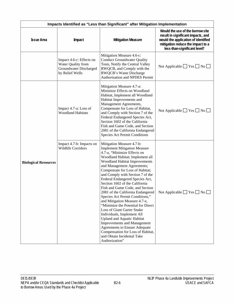
Impacts Identified as “Less than Significant” after Mitigation Implementation
Issue Area Impact Mitigation Measure
Would the use of the borrow site result in significant impacts, and
would the application of identified mitigation reduce the impact to a
less-than-significant level?
Impact 4.6-c: Effects on Water Quality from Groundwater Discharged by Relief Wells
Mitigation Measure 4.6-c: Conduct Groundwater Quality Tests, Notify the Central Valley RWQCB, and Comply with the RWQCB’s Waste Discharge Authorization and NPDES Permit
Not Applicable Yes No
Biological Resources
Impact 4.7-a: Loss of Woodland Habitats
Mitigation Measure 4.7-a: Minimize Effects on Woodland Habitat, Implement all Woodland Habitat Improvements and Management Agreements, Compensate for Loss of Habitat, and Comply with Section 7 of the Federal Endangered Species Act, Section 1602 of the California Fish and Game Code, and Section 2081 of the California Endangered Species Act Permit Conditions
Not Applicable Yes No
Impact 4.7-b: Impacts on Wildlife Corridors
Mitigation Measure 4.7-b: Implement Mitigation Measure 4.7-a, “Minimize Effects on Woodland Habitat; Implement all Woodland Habitat Improvements and Management Agreements; Compensate for Loss of Habitat; and Comply with Section 7 of the Federal Endangered Species Act, Section 1602 of the California Fish and Game Code, and Section 2081 of the California Endangered Species Act Permit Conditions,” and Mitigation Measure 4.7-e, “Minimize the Potential for Direct Loss of Giant Garter Snake Individuals, Implement All Upland and Aquatic Habitat Improvements and Management Agreements to Ensure Adequate Compensation for Loss of Habitat, and Obtain Incidental Take Authorization”
Not Applicable Yes No
NLIP Phase 4a Landside Improvements Project DEIS/DEIR USACE and SAFCA B2-7 NEPA and/or CEQA Standards and Checklist Applicable to Borrow Areas Used by the Phase 4a Project
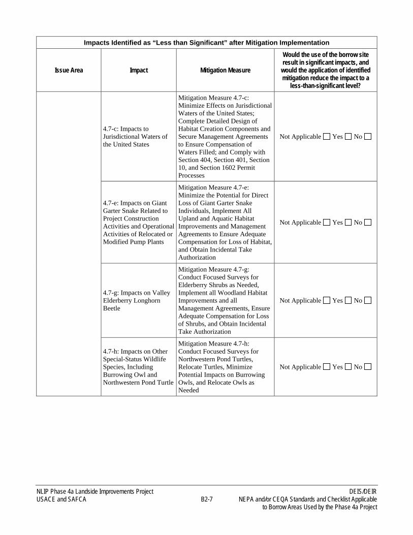
Impacts Identified as “Less than Significant” after Mitigation Implementation
Issue Area Impact Mitigation Measure
Would the use of the borrow site result in significant impacts, and
would the application of identified mitigation reduce the impact to a
less-than-significant level?
4.7-c: Impacts to Jurisdictional Waters of the United States
Mitigation Measure 4.7-c: Minimize Effects on Jurisdictional Waters of the United States; Complete Detailed Design of Habitat Creation Components and Secure Management Agreements to Ensure Compensation of Waters Filled; and Comply with Section 404, Section 401, Section 10, and Section 1602 Permit Processes
Not Applicable Yes No
4.7-e: Impacts on Giant Garter Snake Related to Project Construction Activities and Operational Activities of Relocated or Modified Pump Plants
Mitigation Measure 4.7-e: Minimize the Potential for Direct Loss of Giant Garter Snake Individuals, Implement All Upland and Aquatic Habitat Improvements and Management Agreements to Ensure Adequate Compensation for Loss of Habitat, and Obtain Incidental Take Authorization
Not Applicable Yes No
4.7-g: Impacts on Valley Elderberry Longhorn Beetle
Mitigation Measure 4.7-g: Conduct Focused Surveys for Elderberry Shrubs as Needed, Implement all Woodland Habitat Improvements and all Management Agreements, Ensure Adequate Compensation for Loss of Shrubs, and Obtain Incidental Take Authorization
Not Applicable Yes No
4.7-h: Impacts on Other Special-Status Wildlife Species, Including Burrowing Owl and Northwestern Pond Turtle
Mitigation Measure 4.7-h: Conduct Focused Surveys for Northwestern Pond Turtles, Relocate Turtles, Minimize Potential Impacts on Burrowing Owls, and Relocate Owls as Needed
Not Applicable Yes No
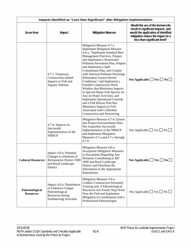
DEIS/DEIR NLIP Phase 4a Landside Improvements Project NEPA and/or CEQA Standards and Checklist Applicable B2-8 USACE and SAFCA to Borrow Areas Used by the Phase 4a Project
Impacts Identified as “Less than Significant” after Mitigation Implementation
Issue Area Impact Mitigation Measure
Would the use of the borrow site result in significant impacts, and
would the application of identified mitigation reduce the impact to a
less-than-significant level?
4.7-i: Temporary Construction-related Impacts to Fish and Aquatic Habitats
Mitigation Measure 4.7-i: Implement Mitigation Measure 4.6-a, “Implement Standard Best Management Practices, Prepare and Implement a Stormwater Pollution Prevention Plan, Prepare and Implement a Spill Containment Plan, and Comply with National Pollutant Discharge Elimination System Permit Conditions,” and Implement a Feasible Construction Work Window that Minimizes Impacts to Special-Status Fish Species for Any In-Water Activities, and Implement Operational Controls and a Fish Rescue Plan that Minimizes Impacts to Fish Associated with Cofferdam Construction and Dewatering
Not Applicable Yes No
4.7-k: Impacts on Successful Implementation of the NBHCP
Mitigation Measure 4.7-k: Ensure that Project Encroachment Does Not Jeopardize Successful Implementation of the NBHCP and Implement Mitigation Measures 4.7-a and 4.7-c through 4.7-h
Not Applicable Yes No
Cultural Resources
Impact 4.8-a: Potential Changes to Elements of Reclamation District 1000 and Rural Landscape District
Mitigation Measure 4.8-a: Incorporate Mitigation Measures to Documents Regarding Any Elements Contributing to RD 1000 and Rural Landscape District and Distribute the Information to the Appropriate Repositories
Not Applicable Yes No
Paleontological Resources
Impact 4.9-a: Disturbance of Unknown Unique Paleontological Resources during Earthmoving Activities
Mitigation Measure 4.9-a: Conduct Construction Personnel Training and, if Paleontological Resources Are Found, Stop Work Near the Find and Implement Mitigation in Coordination with a Professional Paleontologist
Not Applicable Yes No
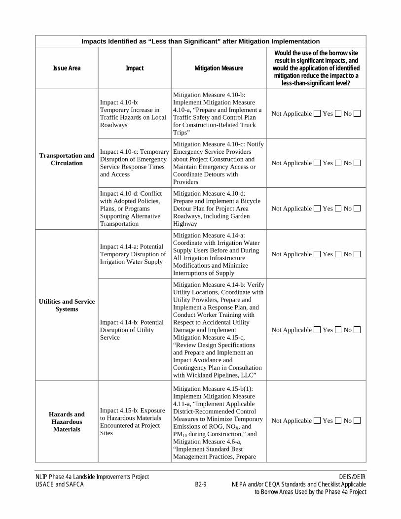
NLIP Phase 4a Landside Improvements Project DEIS/DEIR USACE and SAFCA B2-9 NEPA and/or CEQA Standards and Checklist Applicable to Borrow Areas Used by the Phase 4a Project
Impacts Identified as “Less than Significant” after Mitigation Implementation
Issue Area Impact Mitigation Measure
Would the use of the borrow site result in significant impacts, and
would the application of identified mitigation reduce the impact to a
less-than-significant level?
Transportation and Circulation
Impact 4.10-b: Temporary Increase in Traffic Hazards on Local Roadways
Mitigation Measure 4.10-b: Implement Mitigation Measure 4.10-a, “Prepare and Implement a Traffic Safety and Control Plan for Construction-Related Truck Trips”
Not Applicable Yes No
Impact 4.10-c: Temporary Disruption of Emergency Service Response Times and Access
Mitigation Measure 4.10-c: Notify Emergency Service Providers about Project Construction and Maintain Emergency Access or Coordinate Detours with Providers
Not Applicable Yes No
Impact 4.10-d: Conflict with Adopted Policies, Plans, or Programs Supporting Alternative Transportation
Mitigation Measure 4.10-d: Prepare and Implement a Bicycle Detour Plan for Project Area Roadways, Including Garden Highway
Not Applicable Yes No
Utilities and Service Systems
Impact 4.14-a: Potential Temporary Disruption of Irrigation Water Supply
Mitigation Measure 4.14-a: Coordinate with Irrigation Water Supply Users Before and During All Irrigation Infrastructure Modifications and Minimize Interruptions of Supply
Not Applicable Yes No
Impact 4.14-b: Potential Disruption of Utility Service
Mitigation Measure 4.14-b: Verify Utility Locations, Coordinate with Utility Providers, Prepare and Implement a Response Plan, and Conduct Worker Training with Respect to Accidental Utility Damage and Implement Mitigation Measure 4.15-c, “Review Design Specifications and Prepare and Implement an Impact Avoidance and Contingency Plan in Consultation with Wickland Pipelines, LLC”
Not Applicable Yes No
Hazards and Hazardous Materials
Impact 4.15-b: Exposure to Hazardous Materials Encountered at Project Sites
Mitigation Measure 4.15-b(1): Implement Mitigation Measure 4.11-a, “Implement Applicable District-Recommended Control Measures to Minimize Temporary Emissions of ROG, NOX, and PM10 during Construction,” and Mitigation Measure 4.6-a, “Implement Standard Best Management Practices, Prepare
Not Applicable Yes No
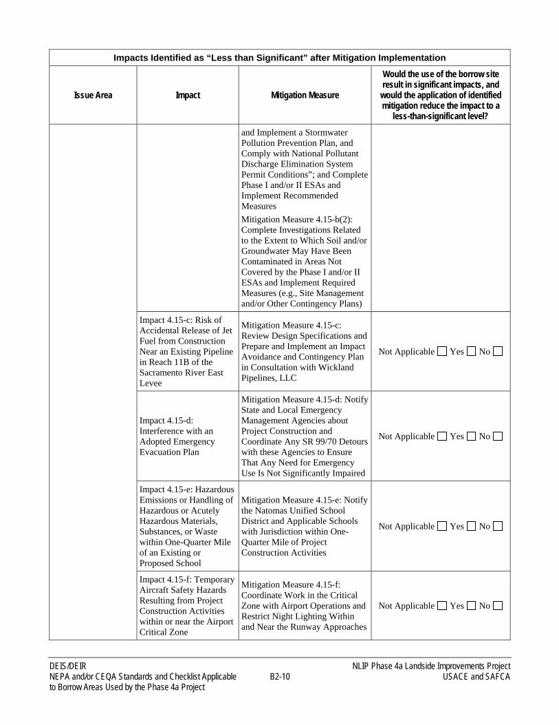
DEIS/DEIR NLIP Phase 4a Landside Improvements Project NEPA and/or CEQA Standards and Checklist Applicable B2-10 USACE and SAFCA to Borrow Areas Used by the Phase 4a Project
Impacts Identified as “Less than Significant” after Mitigation Implementation
Issue Area Impact Mitigation Measure
Would the use of the borrow site result in significant impacts, and
would the application of identified mitigation reduce the impact to a
less-than-significant level? and Implement a Stormwater Pollution Prevention Plan, and Comply with National Pollutant Discharge Elimination System Permit Conditions”; and Complete Phase I and/or II ESAs and Implement Recommended Measures Mitigation Measure 4.15-b(2): Complete Investigations Related to the Extent to Which Soil and/or Groundwater May Have Been Contaminated in Areas Not Covered by the Phase I and/or II ESAs and Implement Required Measures (e.g., Site Management and/or Other Contingency Plans)
Impact 4.15-c: Risk of Accidental Release of Jet Fuel from Construction Near an Existing Pipeline in Reach 11B of the Sacramento River East Levee
Mitigation Measure 4.15-c: Review Design Specifications and Prepare and Implement an Impact Avoidance and Contingency Plan in Consultation with Wickland Pipelines, LLC
Not Applicable Yes No
Impact 4.15-d: Interference with an Adopted Emergency Evacuation Plan
Mitigation Measure 4.15-d: Notify State and Local Emergency Management Agencies about Project Construction and Coordinate Any SR 99/70 Detours with these Agencies to Ensure That Any Need for Emergency Use Is Not Significantly Impaired
Not Applicable Yes No
Impact 4.15-e: Hazardous Emissions or Handling of Hazardous or Acutely Hazardous Materials, Substances, or Waste within One-Quarter Mile of an Existing or Proposed School
Mitigation Measure 4.15-e: Notify the Natomas Unified School District and Applicable Schools with Jurisdiction within One-Quarter Mile of Project Construction Activities
Not Applicable Yes No
Impact 4.15-f: Temporary Aircraft Safety Hazards Resulting from Project Construction Activities within or near the Airport Critical Zone
Mitigation Measure 4.15-f: Coordinate Work in the Critical Zone with Airport Operations and Restrict Night Lighting Within and Near the Runway Approaches
Not Applicable Yes No
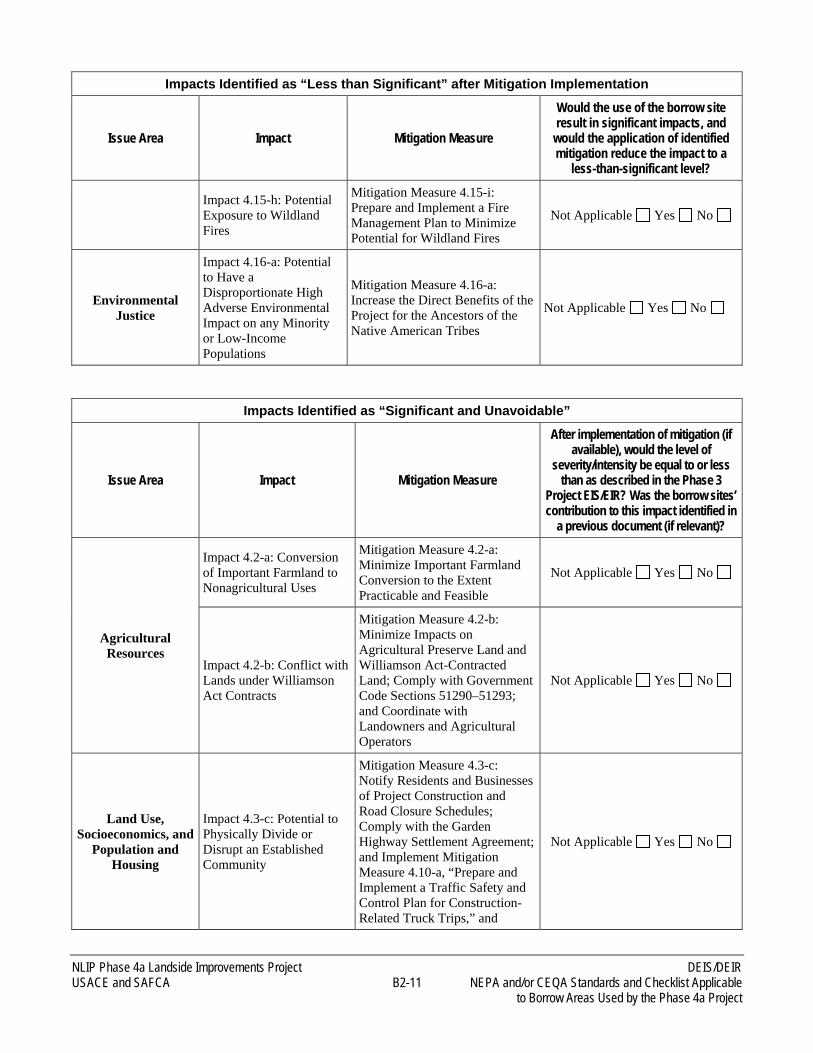
NLIP Phase 4a Landside Improvements Project DEIS/DEIR USACE and SAFCA B2-11 NEPA and/or CEQA Standards and Checklist Applicable to Borrow Areas Used by the Phase 4a Project
Impacts Identified as “Less than Significant” after Mitigation Implementation
Issue Area Impact Mitigation Measure
Would the use of the borrow site result in significant impacts, and
would the application of identified mitigation reduce the impact to a
less-than-significant level?
Impact 4.15-h: Potential Exposure to Wildland Fires
Mitigation Measure 4.15-i: Prepare and Implement a Fire Management Plan to Minimize Potential for Wildland Fires
Not Applicable Yes No
Environmental Justice
Impact 4.16-a: Potential to Have a Disproportionate High Adverse Environmental Impact on any Minority or Low-Income Populations
Mitigation Measure 4.16-a: Increase the Direct Benefits of the Project for the Ancestors of the Native American Tribes
Not Applicable Yes No
Impacts Identified as “Significant and Unavoidable”
Issue Area Impact Mitigation Measure
After implementation of mitigation (if available), would the level of
severity/intensity be equal to or less than as described in the Phase 3
Project EIS/EIR? Was the borrow sites’ contribution to this impact identified in
a previous document (if relevant)?
Agricultural Resources
Impact 4.2-a: Conversion of Important Farmland to Nonagricultural Uses
Mitigation Measure 4.2-a: Minimize Important Farmland Conversion to the Extent Practicable and Feasible
Not Applicable Yes No
Impact 4.2-b: Conflict with Lands under Williamson Act Contracts
Mitigation Measure 4.2-b: Minimize Impacts on Agricultural Preserve Land and Williamson Act-Contracted Land; Comply with Government Code Sections 51290–51293; and Coordinate with Landowners and Agricultural Operators
Not Applicable Yes No
Land Use, Socioeconomics, and
Population and Housing
Impact 4.3-c: Potential to Physically Divide or Disrupt an Established Community
Mitigation Measure 4.3-c: Notify Residents and Businesses of Project Construction and Road Closure Schedules; Comply with the Garden Highway Settlement Agreement; and Implement Mitigation Measure 4.10-a, “Prepare and Implement a Traffic Safety and Control Plan for Construction-Related Truck Trips,” and
Not Applicable Yes No
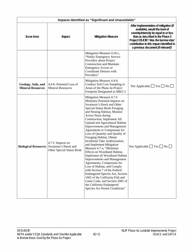
DEIS/DEIR NLIP Phase 4a Landside Improvements Project NEPA and/or CEQA Standards and Checklist Applicable B2-12 USACE and SAFCA to Borrow Areas Used by the Phase 4a Project
Impacts Identified as “Significant and Unavoidable”
Issue Area Impact Mitigation Measure
After implementation of mitigation (if available), would the level of
severity/intensity be equal to or less than as described in the Phase 3
Project EIS/EIR? Was the borrow sites’ contribution to this impact identified in
a previous document (if relevant)? Mitigation Measure 4.10-c, “Notify Emergency Service Providers about Project Construction and Maintain Emergency Access or Coordinate Detours with Providers”
Geology, Soils, and Mineral Resources
4.4-b: Potential Loss of Mineral Resources
Mitigation Measure 4.4-b: Conduct Soil Core Sampling in Areas of the Phase 4a Project Footprint Designated as MRZ-3
Not Applicable Yes No
Biological Resources 4.7-f: Impacts on Swainson’s Hawk and Other Special Status Birds
Mitigation Measure 4.7-f: Minimize Potential Impacts on Swainson’s Hawk and Other Special-Status Birds Foraging and Nesting Habitat, Monitor Active Nests during Construction, Implement All Upland and Agricultural Habitat Improvements and Management Agreements to Compensate for Loss of Quantity and Quality of Foraging Habitat, Obtain Incidental Take Authorization, and Implement Mitigation Measure 4.7-a, “Minimize Effects on Woodland Habitat, Implement all Woodland Habitat Improvements and Management Agreements, Compensate for Loss of Habitat, and Comply with Section 7 of the Federal Endangered Species Act, Section 1602 of the California Fish and Game Code, and Section 2081 of the California Endangered Species Act Permit Conditions”
Not Applicable Yes No
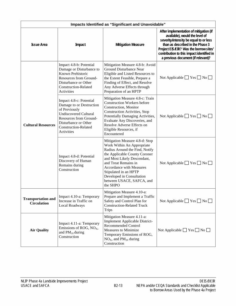
NLIP Phase 4a Landside Improvements Project DEIS/DEIR USACE and SAFCA B2-13 NEPA and/or CEQA Standards and Checklist Applicable to Borrow Areas Used by the Phase 4a Project
Impacts Identified as “Significant and Unavoidable”
Issue Area Impact Mitigation Measure
After implementation of mitigation (if available), would the level of
severity/intensity be equal to or less than as described in the Phase 3
Project EIS/EIR? Was the borrow sites’ contribution to this impact identified in
a previous document (if relevant)?
Cultural Resources
Impact 4.8-b: Potential Damage or Disturbance to Known Prehistoric Resources from Ground-Disturbance or Other Construction-Related Activities
Mitigation Measure 4.8-b: Avoid Ground Disturbance Near Eligible and Listed Resources to the Extent Feasible, Prepare a Finding of Effect, and Resolve Any Adverse Effects through Preparation of an HPTP
Not Applicable Yes No
Impact 4.8-c: Potential Damage to or Destruction of Previously Undiscovered Cultural Resources from Ground-Disturbance or Other Construction-Related Activities
Mitigation Measure 4.8-c: Train Construction Workers before Construction, Monitor Construction Activities, Stop Potentially Damaging Activities, Evaluate Any Discoveries, and Resolve Adverse Effects on Eligible Resources, if Encountered
Not Applicable Yes No
Impact 4.8-d: Potential Discovery of Human Remains during Construction
Mitigation Measure 4.8-d: Stop Work Within An Appropriate Radius Around the Find, Notify the Applicable County Coroner and Most Likely Descendant, and Treat Remains in Accordance with Measures Stipulated in an HPTP Developed in Consultation between USACE, SAFCA, and the SHPO
Not Applicable Yes No
Transportation and Circulation
Impact 4.10-a: Temporary Increase in Traffic on Local Roadways
Mitigation Measure 4.10-a: Prepare and Implement a Traffic Safety and Control Plan for Construction-Related Truck Trips
Not Applicable Yes No
Air Quality
Impact 4.11-a: Temporary Emissions of ROG, NOX, and PM10 during Construction
Mitigation Measure 4.11-a: Implement Applicable District-Recommended Control Measures to Minimize Temporary Emissions of ROG, NOX, and PM10 during Construction
Not Applicable Yes No
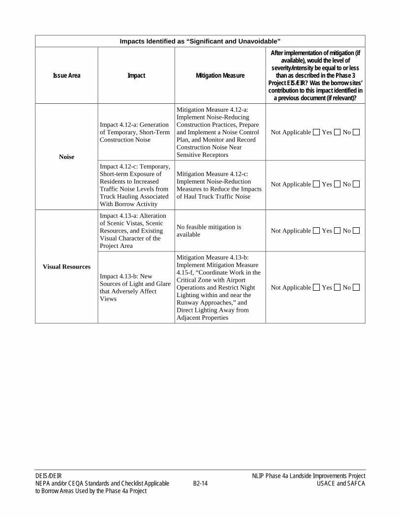
DEIS/DEIR NLIP Phase 4a Landside Improvements Project NEPA and/or CEQA Standards and Checklist Applicable B2-14 USACE and SAFCA to Borrow Areas Used by the Phase 4a Project
Impacts Identified as “Significant and Unavoidable”
Issue Area Impact Mitigation Measure
After implementation of mitigation (if available), would the level of
severity/intensity be equal to or less than as described in the Phase 3
Project EIS/EIR? Was the borrow sites’ contribution to this impact identified in
a previous document (if relevant)?
Noise
Impact 4.12-a: Generation of Temporary, Short-Term Construction Noise
Mitigation Measure 4.12-a: Implement Noise-Reducing Construction Practices, Prepare and Implement a Noise Control Plan, and Monitor and Record Construction Noise Near Sensitive Receptors
Not Applicable Yes No
Impact 4.12-c: Temporary, Short-term Exposure of Residents to Increased Traffic Noise Levels from Truck Hauling Associated With Borrow Activity
Mitigation Measure 4.12-c: Implement Noise-Reduction Measures to Reduce the Impacts of Haul Truck Traffic Noise
Not Applicable Yes No
Visual Resources
Impact 4.13-a: Alteration of Scenic Vistas, Scenic Resources, and Existing Visual Character of the Project Area
No feasible mitigation is available Not Applicable Yes No
Impact 4.13-b: New Sources of Light and Glare that Adversely Affect Views
Mitigation Measure 4.13-b: Implement Mitigation Measure 4.15-f, “Coordinate Work in the Critical Zone with Airport Operations and Restrict Night Lighting within and near the Runway Approaches,” and Direct Lighting Away from Adjacent Properties
Not Applicable Yes No
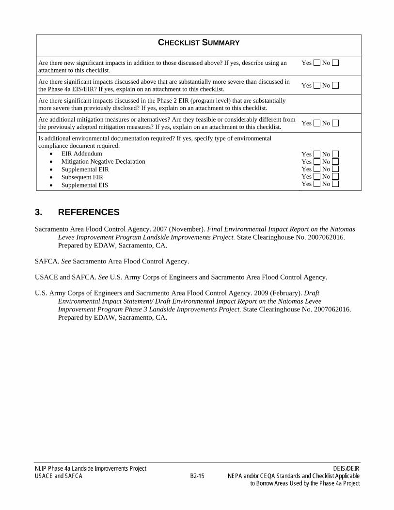
NLIP Phase 4a Landside Improvements Project DEIS/DEIR USACE and SAFCA B2-15 NEPA and/or CEQA Standards and Checklist Applicable to Borrow Areas Used by the Phase 4a Project
CHECKLIST SUMMARY
Are there new significant impacts in addition to those discussed above? If yes, describe using an attachment to this checklist.
Yes No
Are there significant impacts discussed above that are substantially more severe than discussed in the Phase 4a EIS/EIR? If yes, explain on an attachment to this checklist. Yes No
Are there significant impacts discussed in the Phase 2 EIR (program level) that are substantially more severe than previously disclosed? If yes, explain on an attachment to this checklist.
Are additional mitigation measures or alternatives? Are they feasible or considerably different from the previously adopted mitigation measures? If yes, explain on an attachment to this checklist. Yes No
Is additional environmental documentation required? If yes, specify type of environmental compliance document required:
• EIR Addendum • Mitigation Negative Declaration • Supplemental EIR • Subsequent EIR • Supplemental EIS
Yes No Yes No Yes No Yes No Yes No
3. REFERENCES
Sacramento Area Flood Control Agency. 2007 (November). Final Environmental Impact Report on the Natomas Levee Improvement Program Landside Improvements Project. State Clearinghouse No. 2007062016. Prepared by EDAW, Sacramento, CA.
SAFCA. See Sacramento Area Flood Control Agency.
USACE and SAFCA. See U.S. Army Corps of Engineers and Sacramento Area Flood Control Agency.
U.S. Army Corps of Engineers and Sacramento Area Flood Control Agency. 2009 (February). Draft Environmental Impact Statement/ Draft Environmental Impact Report on the Natomas Levee Improvement Program Phase 3 Landside Improvements Project. State Clearinghouse No. 2007062016. Prepared by EDAW, Sacramento, CA.
B3 Documents Incorporated By Reference
(Cover and Title Pages Only)
November 2006
Volume I: Programmatic Evaluation of the Proposed Funding Mechanisms
Volume II: Project-Level Evaluation of Natomas Cross Canal South Levee Phase 1 Improvements
State Clearinghouse # 2006072098
Draft Environmental Impact Report onLocal Funding Mechanisms for Comprehensive Flood
Control Improvements for the Sacramento Area
Prepared for:

Prepared by:
EDAW2022 J Street
Sacramento, CA 95814
Contact:
Roberta Childers Project Manager
Phone (916) 414-5800
November 2006
Prepared for:
Sacramento Area Flood Control Agency 1007 Seventh Street, 7th Floor
Sacramento, CA 95814
Contact:
John A. Bassett Director of Engineering Phone (916) 874-7606
Fax (916) 874-8289
Draft Environmental Impact Report on
Local Funding Mechanisms for Comprehensive FloodControl Improvements for the Sacramento Area
06110058.0111/14/06
Volume I: Programmatic Evaluation of the Proposed Funding Mechanisms
Volume II: Project-Level Evaluation of Natomas Cross Canal South Levee Phase 1 Improvements
State Clearinghouse # 2006072098
February 2007
Programmatic Evaluation of the Proposed Funding Mechanisms
Project-Level Evaluation of Natomas Cross Canal South LeveePhase 1 Improvements
State Clearinghouse # 2006072098
Final Environmental Impact Report onLocal Funding Mechanisms for Comprehensive Flood
Control Improvements for the Sacramento AreaResponses to Comments and Revisions to the Draft EIR
Prepared for:
Prepared by:
EDAW2022 J Street
Sacramento, CA 95814
Contact:
Roberta ChildersProject Manager
Phone (916) 414-5800
February 2007
Prepared for:
Sacramento Area Flood Control Agency1007 Seventh Street, 7th Floor
Sacramento, CA 95814
Contact:
John A. BassettDirector of EngineeringPhone (916) 874-7606
Fax (916) 874-8289
Final Environmental Impact Report on
Local Funding Mechanisms for Comprehensive FloodControl Improvements for the Sacramento Area
Responses to Comments and Revisions to the Draft EIR
06110058.012/2/07
Programmatic Evaluation of the Proposed Funding Mechanisms
Project-Level Evaluation of Natomas Cross Canal South LeveePhase 1 Improvements
State Clearinghouse # 2006072098
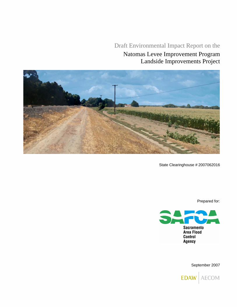
September 2007
State Clearinghouse # 2007062016
Draft Environmental Impact Report on theNatomas Levee Improvement Program
Landside Improvements Project
Prepared for:
Prepared by:
EDAW2022 J Street
Sacramento, CA 95811
Contact:
Roberta Childers Project Manager
Phone (916) 414-5800
September 2007
Prepared for:
Sacramento Area Flood Control Agency 1007 7th Street, 7th Floor
Sacramento, CA 95814
Contact:
John A. Bassett Director of Engineering Phone (916) 874-7606
Fax (916) 874-8289
Draft Environmental Impact Report on the
Natomas Levee Improvement ProgramLandside Improvements Project
06110058.0109.14.07
State Clearinghouse # 2007062016
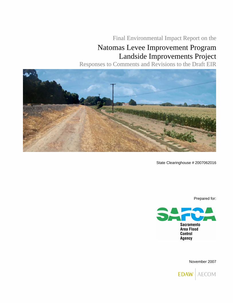
November 2007
State Clearinghouse # 2007062016
Final Environmental Impact Report on theNatomas Levee Improvement Program
Landside Improvements ProjectResponses to Comments and Revisions to the Draft EIR
Prepared for:
Prepared by:
EDAW2022 J Street
Sacramento, CA 95811
November 2007
Prepared for:
Sacramento Area Flood Control Agency 1007 7th Street, 7th Floor
Sacramento, CA 95814
Contact:
John A. Bassett Director of Engineering Phone (916) 874-7606
Fax (916) 874-8289
Final Environmental Impact Report on the
Natomas Levee Improvement ProgramLandside Improvements Project
Responses to Comments and Revisions to the Draft EIR
06110058.0111.19.07
State Clearinghouse # 2007062016

June 2008
408 Permission and 404 Permit to Sacramento Area Flood Control Agencyfor the Natomas Levee Improvement Project, Sacramento, CA
Draft Environmental Impact Statement

Prepared by:
EDAW2022 J Street
Sacramento, CA 95811
Contact:
Phil DunnPrincipal-in-Charge
(916) 414-5800
June 2008
Prepared for:
U.S. Army Corps of EngineersSacramento District
1325 J StreetSacramento, CA 95814
Contact:
Elizabeth HollandPlanning Division
(916) 557-6763
Draft Environmental Impact Statement
06110058.0106.04.08
408 Permission and 404 Permit to Sacramento Area Flood Control Agencyfor the Natomas Levee Improvement Project, Sacramento, CA
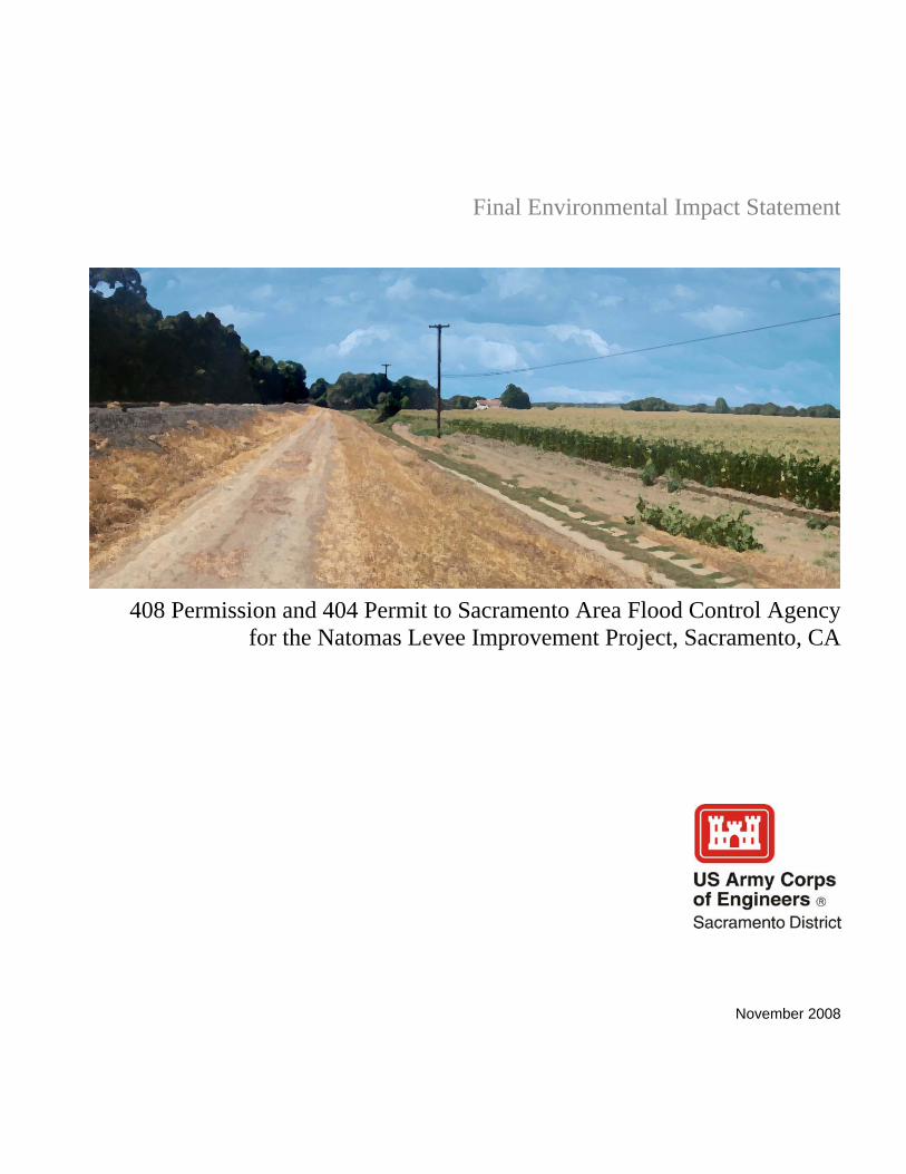
November 2008
408 Permission and 404 Permit to Sacramento Area Flood Control Agencyfor the Natomas Levee Improvement Project, Sacramento, CA
Final Environmental Impact Statement
Prepared by:
EDAW2022 J Street
Sacramento, CA 95811
Contact:
Francine DunnNEPA Task Leader
(916) 414-5840
November 2008
Prepared for:
U.S. Army Corps of EngineersSacramento District
1325 J StreetSacramento, CA 95814
Contact:
Elizabeth HollandPlanning Division
(916) 557-6763
Final Environmental Impact Statement
06110058.0111.04.08
408 Permission and 404 Permit to Sacramento Area Flood Control Agencyfor the Natomas Levee Improvement Project, Sacramento, CA

November 2008
State Clearinghouse # 2007062016
DraftSupplement to the Environmental Impact Report on the
Natomas Levee Improvement ProgramLandside Improvements Project—Phase 2 Project
Prepared for:

Prepared by:
EDAW2022 J Street
Sacramento, CA 95811
Contact:
David RaderProject Manager
Phone (916) 266-4908
November 2008
Prepared for:
Sacramento Area Flood Control Agency1007 7th Street, 7th Floor
Sacramento, CA 95814
Contact:
John A. BassettDirector of EngineeringPhone (916) 874-7606
Fax (916) 874-8289
DraftSupplement to the Environmental Impact Report on the
Natomas Levee Improvement ProgramLandside Improvements Project—Phase 2 Project
06110058.0111.12.08
State Clearinghouse # 2007062016

January 2009
State Clearinghouse # 2007062016
FinalSupplement to the Environmental Impact Report on the
Natomas Levee Improvement ProgramLandside Improvements Project—Phase 2 Project
Prepared for:
Prepared by:
EDAW2022 J Street
Sacramento, CA 95811
Contact:
David RaderProject Manager
Phone (916) 266-4908
January 2009
Prepared for:
Sacramento Area Flood Control Agency1007 7th Street, 7th Floor
Sacramento, CA 95814
Contact:
John A. BassettDirector of EngineeringPhone (916) 874-7606
Fax (916) 874-8289
FinalSupplement to the Environmental Impact Report on the
Natomas Levee Improvement ProgramLandside Improvements Project—Phase 2 Project
06110058.01
State Clearinghouse # 2007062016