Embed Size (px)
Citation preview
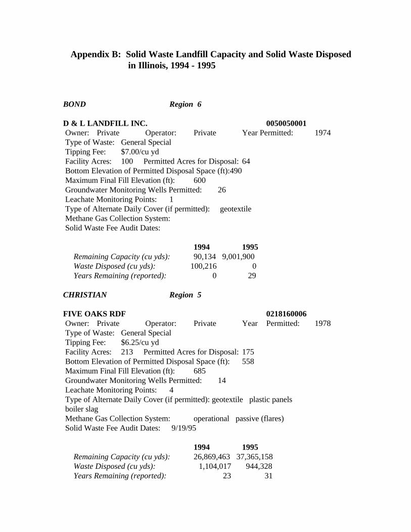
Appendix B: Solid Waste Landfill Capacity and Solid Waste Disposed in Illinois, 1994 - 1995
BOND Region 6
D & L LANDFILL INC. 0050050001 Owner: Private Operator: Private Year Permitted: 1974 Type of Waste: General Special Tipping Fee: $7.00/cu yd Facility Acres: 100 Permitted Acres for Disposal: 64 Bottom Elevation of Permitted Disposal Space (ft):490 Maximum Final Fill Elevation (ft): 600 Groundwater Monitoring Wells Permitted: 26 Leachate Monitoring Points: 1 Type of Alternate Daily Cover (if permitted): geotextile Methane Gas Collection System: Solid Waste Fee Audit Dates:
1994 1995 Remaining Capacity (cu yds): 90,134 9,001,900 Waste Disposed (cu yds): 100,216 0 Years Remaining (reported): 0 29
CHRISTIAN Region 5
FIVE OAKS RDF 0218160006 Owner: Private Operator: Private Year Permitted: 1978 Type of Waste: General Special Tipping Fee: $6.25/cu yd Facility Acres: 213 Permitted Acres for Disposal: 175 Bottom Elevation of Permitted Disposal Space (ft): 558 Maximum Final Fill Elevation (ft): 685 Groundwater Monitoring Wells Permitted: 14 Leachate Monitoring Points: 4 Type of Alternate Daily Cover (if permitted): geotextile plastic panels boiler slag Methane Gas Collection System: operational passive (flares) Solid Waste Fee Audit Dates: 9/19/95
1994 1995 Remaining Capacity (cu yds): 26,869,463 37,365,158 Waste Disposed (cu yds): 1,104,017 944,328 Years Remaining (reported): 23 31
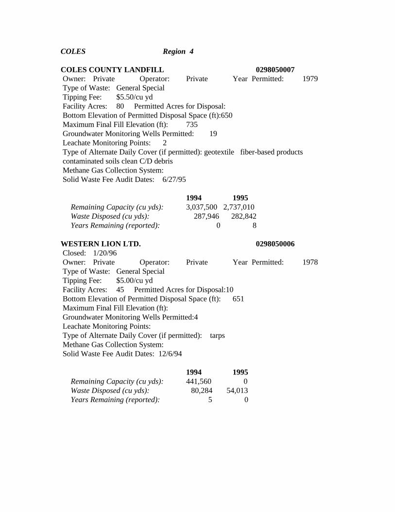
COLES Region 4
COLES COUNTY LANDFILL 0298050007 Owner: Private Operator: Private Year Permitted: 1979 Type of Waste: General Special Tipping Fee: $5.50/cu yd Facility Acres: 80 Permitted Acres for Disposal: Bottom Elevation of Permitted Disposal Space (ft):650 Maximum Final Fill Elevation (ft): 735 Groundwater Monitoring Wells Permitted: 19 Leachate Monitoring Points: 2 Type of Alternate Daily Cover (if permitted): geotextile fiber-based products contaminated soils clean C/D debris Methane Gas Collection System: Solid Waste Fee Audit Dates: 6/27/95
1994 1995 Remaining Capacity (cu yds): 3,037,500 2,737,010 Waste Disposed (cu yds): 287,946 282,842 Years Remaining (reported): 0 8
WESTERN LION LTD. 0298050006 Closed: 1/20/96 Owner: Private Operator: Private Year Permitted: 1978 Type of Waste: General Special Tipping Fee: $5.00/cu yd Facility Acres: 45 Permitted Acres for Disposal:10 Bottom Elevation of Permitted Disposal Space (ft): 651 Maximum Final Fill Elevation (ft): Groundwater Monitoring Wells Permitted:4 Leachate Monitoring Points: Type of Alternate Daily Cover (if permitted): tarps Methane Gas Collection System: Solid Waste Fee Audit Dates: 12/6/94
1994 1995 Remaining Capacity (cu yds): 441,560 0 Waste Disposed (cu yds): 80,284 54,013 Years Remaining (reported): 5 0
COOK Region 2
CID RDF #3 0316000030 Owner: Private Operator: Private Year Permitted: 1979 Type of Waste: General Special Demo Tipping Fee: $11.25/cu yd Facility Acres: 175 Permitted Acres for Disposal: 173 Bottom Elevation of Permitted Disposal Space (ft): 530 Maximum Final Fill Elevation (ft): 746 Groundwater Monitoring Wells Permitted: 38 Leachate Monitoring Points: 13 Type of Alternate Daily Cover (if permitted): dried sewage sludge Methane Gas Collection System: operational active (gas-to-energy) Solid Waste Fee Audit Dates: 8/16/94 7/25/95
1994 1995 Remaining Capacity (cu yds): 2,232,322 2,777,454 Waste Disposed (cu yds): 1,394,518 400,903 Years Remaining (reported): 4 5 CID RDF #4 0310390001 Owner: Private Operator: Private Year Permitted: 1974 Type of Waste: Special Hazardous Tipping Fee: $12.50/cu yd Facility Acres: 115 Permitted Acres for Disposal: 13 Bottom Elevation of Permitted Disposal Space (ft): 555 Maximum Final Fill Elevation (ft): 629 Groundwater Monitoring Wells Permitted: 23 Leachate Monitoring Points: 11 Type of Alternate Daily Cover (if permitted): foam Methane Gas Collection System: Solid Waste Fee Audit Dates:
1994 1995 Remaining Capacity (cu yds): 1,210,040 1,209,445 Waste Disposed (cu yds): 30 0 Years Remaining (reported): 0 33
LAND & LAKES #3 0316000034 Owner: Private Operator: Private Year Permitted: 1978 Type of Waste: General Special Tipping Fee: $11.50/cu yd Facility Acres: 53 Permitted Acres for Disposal: Bottom Elevation of Permitted Disposal Space (ft): Maximum Final Fill Elevation (ft): Groundwater Monitoring Wells Permitted: 21 Leachate Monitoring Points: Type of Alternate Daily Cover (if permitted): geotextile Methane Gas Collection System: Solid Waste Fee Audit Dates: 9/6/95
1994 1995 Remaining Capacity (cu yds): 6,439,910 5,932,937 Waste Disposed (cu yds): 796,836 707,872 Years Remaining (reported): 8 9
LAND & LAKES/DOLTON 0310690003 Owner: Private Operator: Private Year Permitted: 1975 Type of Waste: General Special Tipping Fee: $11.50/cu yd Facility Acres: 68 Permitted Acres for Disposal:52 Bottom Elevation of Permitted Disposal Space (ft): 545 Maximum Final Fill Elevation (ft): 627 Groundwater Monitoring Wells Permitted: 13 Leachate Monitoring Points: Type of Alternate Daily Cover (if permitted): Methane Gas Collection System: Solid Waste Fee Audit Dates: 11/15/94
1994 1995 Remaining Capacity (cu yds): 810,998 565,662 Waste Disposed (cu yds): 378,547 372,450 Years Remaining (reported): 2 2
SEXTON #2 0318170002 Owner: Private Operator: Private Year Permitted: 1975 Type of Waste: General Demo Tipping Fee: $11.10/cu yd Facility Acres: 72 Permitted Acres for Disposal: 55 Bottom Elevation of Permitted Disposal Space (ft): 370 Maximum Final Fill Elevation (ft): 710 Groundwater Monitoring Wells Permitted: 9 Leachate Monitoring Points: 25 Type of Alternate Daily Cover (if permitted): geotextile foam shredded tires Methane Gas Collection System: planned active (gas-to-energy) Solid Waste Fee Audit Dates: 6/13/95
1994 1995 Remaining Capacity (cu yds): 5,312,630 4,786,236 Waste Disposed (cu yds): 1,557,063 1,326,369 Years Remaining (reported): 4 3
SWANCC BALEFILL 0318050005 Owner: Public Operator: Public Year Permitted: 1991 Type of Waste: General Tipping Fee: N/A Facility Acres: 410 Permitted Acres for Disposal: 142 Bottom Elevation of Permitted Disposal Space (ft): 720 Maximum Final Fill Elevation (ft): 830 Groundwater Monitoring Wells Permitted: 32 Leachate Monitoring Points: 6 Type of Alternate Daily Cover (if permitted): geotextile tarps Methane Gas Collection System: planned active (gas-to-energy) Solid Waste Fee Audit Dates:
1994 1995 Remaining Capacity (cu yds): 37,950,000 37,950,000 Waste Disposed (cu yds): 0 0 Years Remaining (reported): 0 0
WINNETKA MUNICIPAL 0313330001 Closed: 3/31/94 Owner: Public Operator: Public Year Permitted: 1974 Type of Waste: General Tipping Fee: private use only Facility Acres: Permitted Acres for Disposal: Bottom Elevation of Permitted Disposal Space (ft): Maximum Final Fill Elevation (ft): Groundwater Monitoring Wells Permitted: 12 Leachate Monitoring Points: Type of Alternate Daily Cover (if permitted): Methane Gas Collection System: Solid Waste Fee Audit Dates:
1994 1995 Remaining Capacity (cu yds): 0 0 Waste Disposed (cu yds): 8,289 0 Years Remaining (reported): 0 0
DEKALB Region 1
DEKALB COUNTY LANDFILL INC. 0378020001 Owner: Private Operator: Private Year Permitted: 1974 Type of Waste: General Special Tipping Fee: $8.55/cu yd restricted to county Facility Acres: 245 Permitted Acres for Disposal: 64 Bottom Elevation of Permitted Disposal Space (ft): 840 Maximum Final Fill Elevation (ft): 945 Groundwater Monitoring Wells Permitted: 17 Leachate Monitoring Points: 2 Type of Alternate Daily Cover (if permitted): geotextile biodegradable plastic panels Methane Gas Collection System:operational active (gas-to-energy) Solid Waste Fee Audit Dates: 12/13/94
1994 1995 Remaining Capacity (cu yds): 4,719,155 4,477,735 Waste Disposed (cu yds): 278,285 288,143 Years Remaining (reported): 21 19
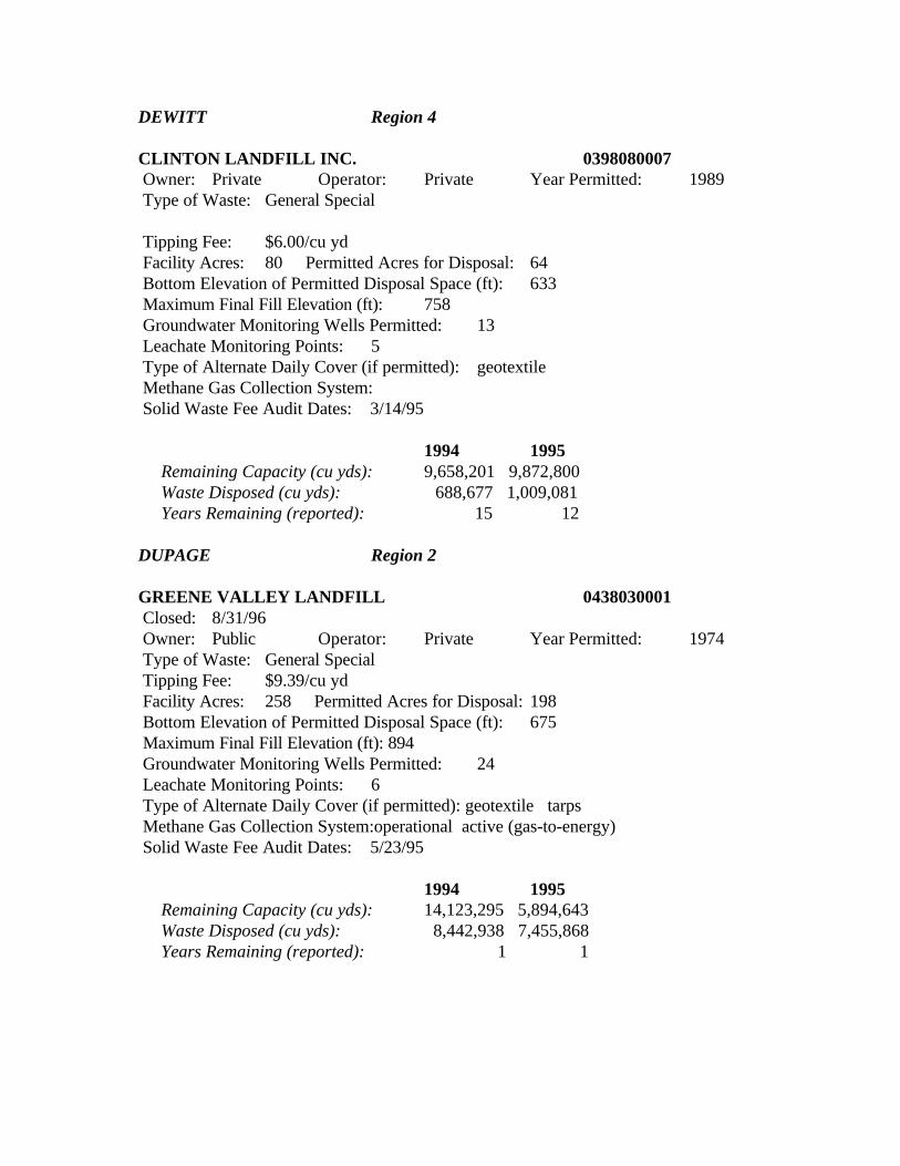
DEWITT Region 4
CLINTON LANDFILL INC. 0398080007 Owner: Private Operator: Private Year Permitted: 1989 Type of Waste: General Special
Tipping Fee: $6.00/cu yd Facility Acres: 80 Permitted Acres for Disposal: 64 Bottom Elevation of Permitted Disposal Space (ft): 633 Maximum Final Fill Elevation (ft): 758 Groundwater Monitoring Wells Permitted: 13 Leachate Monitoring Points: 5 Type of Alternate Daily Cover (if permitted): geotextile Methane Gas Collection System: Solid Waste Fee Audit Dates: 3/14/95
1994 1995 Remaining Capacity (cu yds): 9,658,201 9,872,800 Waste Disposed (cu yds): 688,677 1,009,081 Years Remaining (reported): 15 12
DUPAGE Region 2
GREENE VALLEY LANDFILL 0438030001 Closed: 8/31/96 Owner: Public Operator: Private Year Permitted: 1974 Type of Waste: General Special Tipping Fee: $9.39/cu yd Facility Acres: 258 Permitted Acres for Disposal: 198 Bottom Elevation of Permitted Disposal Space (ft): 675 Maximum Final Fill Elevation (ft): 894 Groundwater Monitoring Wells Permitted: 24 Leachate Monitoring Points: 6 Type of Alternate Daily Cover (if permitted): geotextile tarps Methane Gas Collection System:operational active (gas-to-energy) Solid Waste Fee Audit Dates: 5/23/95
1994 1995 Remaining Capacity (cu yds): 14,123,295 5,894,643 Waste Disposed (cu yds): 8,442,938 7,455,868 Years Remaining (reported): 1 1
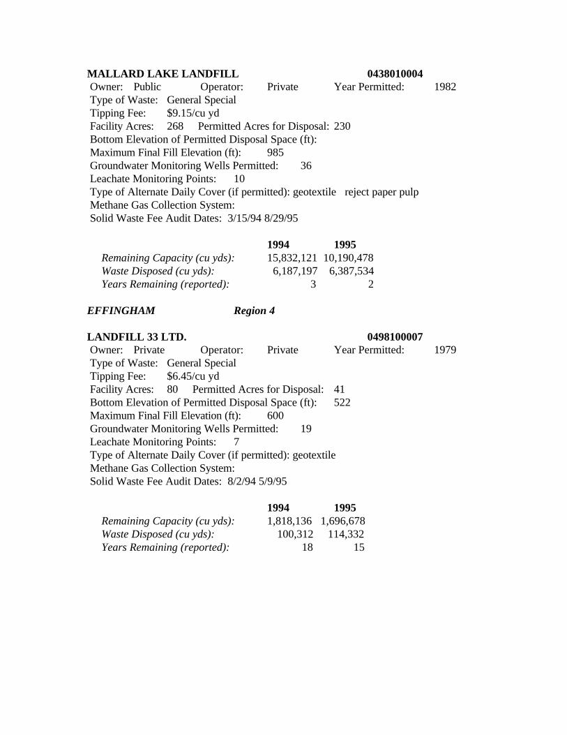
MALLARD LAKE LANDFILL 0438010004 Owner: Public Operator: Private Year Permitted: 1982 Type of Waste: General Special Tipping Fee: $9.15/cu yd Facility Acres: 268 Permitted Acres for Disposal: 230 Bottom Elevation of Permitted Disposal Space (ft): Maximum Final Fill Elevation (ft): 985 Groundwater Monitoring Wells Permitted: 36 Leachate Monitoring Points: 10 Type of Alternate Daily Cover (if permitted): geotextile reject paper pulp Methane Gas Collection System: Solid Waste Fee Audit Dates: 3/15/94 8/29/95
1994 1995 Remaining Capacity (cu yds): 15,832,121 10,190,478 Waste Disposed (cu yds): 6,187,197 6,387,534 Years Remaining (reported): 3 2
EFFINGHAM Region 4
LANDFILL 33 LTD. 0498100007 Owner: Private Operator: Private Year Permitted: 1979 Type of Waste: General Special Tipping Fee: $6.45/cu yd Facility Acres: 80 Permitted Acres for Disposal: 41 Bottom Elevation of Permitted Disposal Space (ft): 522 Maximum Final Fill Elevation (ft): 600 Groundwater Monitoring Wells Permitted: 19 Leachate Monitoring Points: 7 Type of Alternate Daily Cover (if permitted): geotextile Methane Gas Collection System: Solid Waste Fee Audit Dates: 8/2/94 5/9/95
1994 1995 Remaining Capacity (cu yds): 1,818,136 1,696,678 Waste Disposed (cu yds): 100,312 114,332 Years Remaining (reported): 18 15
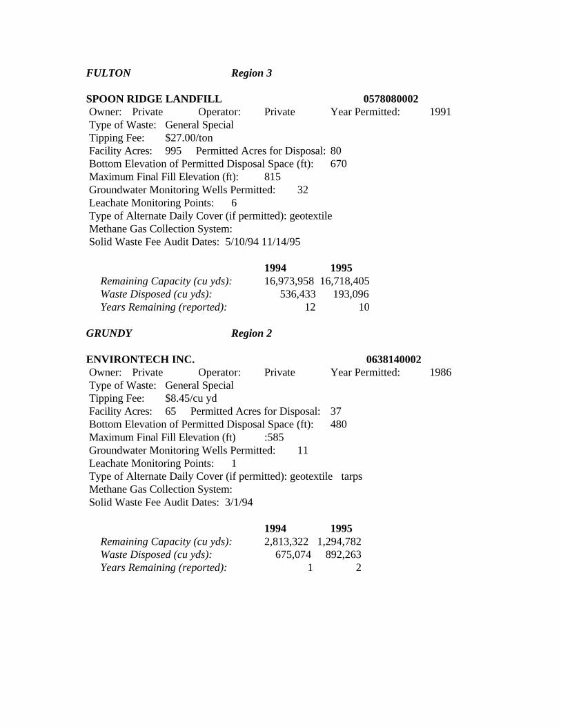
FULTON Region 3
SPOON RIDGE LANDFILL 0578080002 Owner: Private Operator: Private Year Permitted: 1991 Type of Waste: General Special Tipping Fee: $27.00/ton Facility Acres: 995 Permitted Acres for Disposal: 80 Bottom Elevation of Permitted Disposal Space (ft): 670 Maximum Final Fill Elevation (ft): 815 Groundwater Monitoring Wells Permitted: 32 Leachate Monitoring Points: 6 Type of Alternate Daily Cover (if permitted): geotextile Methane Gas Collection System: Solid Waste Fee Audit Dates: 5/10/94 11/14/95
1994 1995 Remaining Capacity (cu yds): 16,973,958 16,718,405 Waste Disposed (cu yds): 536,433 193,096 Years Remaining (reported): 12 10
GRUNDY Region 2
ENVIRONTECH INC. 0638140002 Owner: Private Operator: Private Year Permitted: 1986 Type of Waste: General Special Tipping Fee: $8.45/cu yd Facility Acres: 65 Permitted Acres for Disposal: 37 Bottom Elevation of Permitted Disposal Space (ft): 480 Maximum Final Fill Elevation (ft) :585 Groundwater Monitoring Wells Permitted: 11 Leachate Monitoring Points: 1 Type of Alternate Daily Cover (if permitted): geotextile tarps Methane Gas Collection System: Solid Waste Fee Audit Dates: 3/1/94
1994 1995 Remaining Capacity (cu yds): 2,813,322 1,294,782 Waste Disposed (cu yds): 675,074 892,263 Years Remaining (reported): 1 2
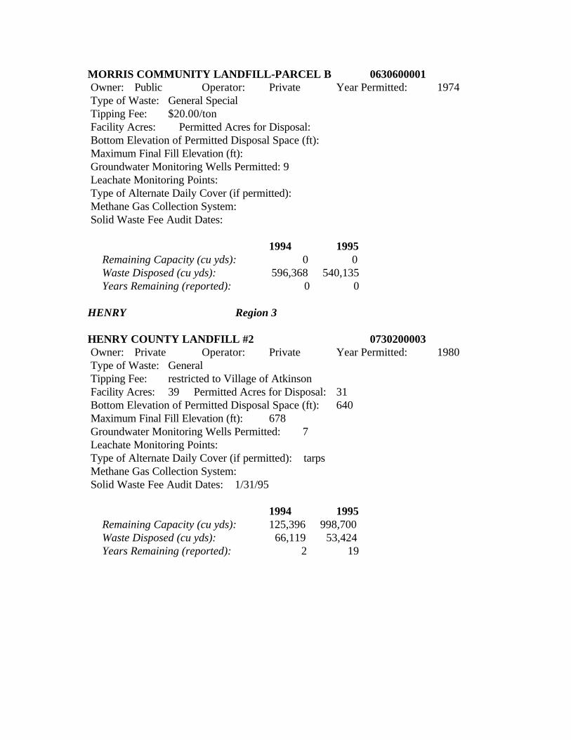
MORRIS COMMUNITY LANDFILL-PARCEL B 0630600001 Owner: Public Operator: Private Year Permitted: 1974 Type of Waste: General Special Tipping Fee: $20.00/ton Facility Acres: Permitted Acres for Disposal: Bottom Elevation of Permitted Disposal Space (ft): Maximum Final Fill Elevation (ft): Groundwater Monitoring Wells Permitted: 9 Leachate Monitoring Points: Type of Alternate Daily Cover (if permitted): Methane Gas Collection System: Solid Waste Fee Audit Dates:
1994 1995 Remaining Capacity (cu yds): 0 0 Waste Disposed (cu yds): 596,368 540,135 Years Remaining (reported): 0 0
HENRY Region 3
HENRY COUNTY LANDFILL #2 0730200003 Owner: Private Operator: Private Year Permitted: 1980 Type of Waste: General Tipping Fee: restricted to Village of Atkinson Facility Acres: 39 Permitted Acres for Disposal: 31 Bottom Elevation of Permitted Disposal Space (ft): 640 Maximum Final Fill Elevation (ft): 678 Groundwater Monitoring Wells Permitted: 7 Leachate Monitoring Points: Type of Alternate Daily Cover (if permitted): tarps Methane Gas Collection System: Solid Waste Fee Audit Dates: 1/31/95
1994 1995 Remaining Capacity (cu yds): 125,396 998,700 Waste Disposed (cu yds): 66,119 53,424 Years Remaining (reported): 2 19
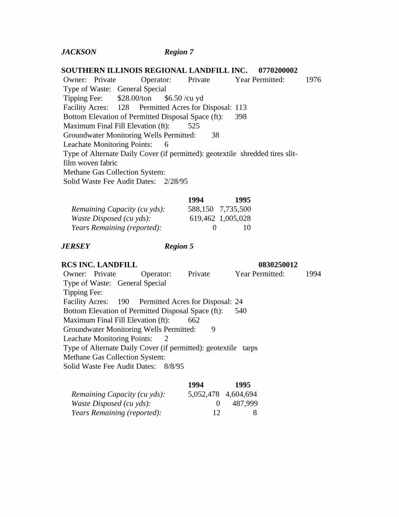
JACKSON Region 7
SOUTHERN ILLINOIS REGIONAL LANDFILL INC. 0770200002 Owner: Private Operator: Private Year Permitted: 1976 Type of Waste: General Special Tipping Fee: $28.00/ton $6.50 /cu yd Facility Acres: 128 Permitted Acres for Disposal: 113 Bottom Elevation of Permitted Disposal Space (ft): 398 Maximum Final Fill Elevation (ft): 525 Groundwater Monitoring Wells Permitted: 38 Leachate Monitoring Points: 6 Type of Alternate Daily Cover (if permitted): geotextile shredded tires slit- film woven fabric Methane Gas Collection System: Solid Waste Fee Audit Dates: 2/28/95
1994 1995 Remaining Capacity (cu yds): 588,150 7,735,500 Waste Disposed (cu yds): 619,462 1,005,028 Years Remaining (reported): 0 10
JERSEY Region 5
RCS INC. LANDFILL 0830250012 Owner: Private Operator: Private Year Permitted: 1994 Type of Waste: General Special Tipping Fee: Facility Acres: 190 Permitted Acres for Disposal: 24 Bottom Elevation of Permitted Disposal Space (ft): 540 Maximum Final Fill Elevation (ft): 662 Groundwater Monitoring Wells Permitted: 9 Leachate Monitoring Points: 2 Type of Alternate Daily Cover (if permitted): geotextile tarps Methane Gas Collection System: Solid Waste Fee Audit Dates: 8/8/95
1994 1995 Remaining Capacity (cu yds): 5,052,478 4,604,694 Waste Disposed (cu yds): 0 487,999 Years Remaining (reported): 12 8
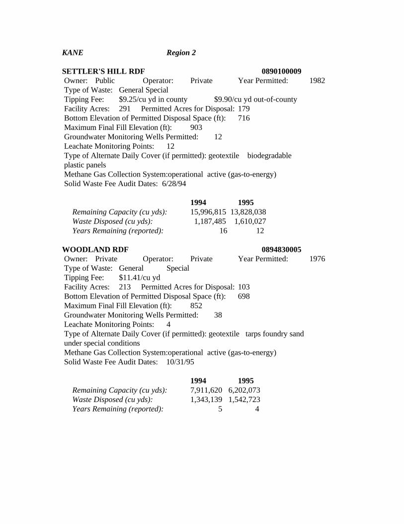
KANE Region 2
SETTLER'S HILL RDF 0890100009 Owner: Public Operator: Private Year Permitted: 1982 Type of Waste: General Special Tipping Fee: $9.25/cu yd in county $9.90/cu yd out-of-county Facility Acres: 291 Permitted Acres for Disposal: 179 Bottom Elevation of Permitted Disposal Space (ft): 716 Maximum Final Fill Elevation (ft): 903 Groundwater Monitoring Wells Permitted: 12 Leachate Monitoring Points: 12 Type of Alternate Daily Cover (if permitted): geotextile biodegradable plastic panels Methane Gas Collection System:operational active (gas-to-energy) Solid Waste Fee Audit Dates: 6/28/94
1994 1995 Remaining Capacity (cu yds): 15,996,815 13,828,038 Waste Disposed (cu yds): 1,187,485 1,610,027 Years Remaining (reported): 16 12 WOODLAND RDF 0894830005 Owner: Private Operator: Private Year Permitted: 1976 Type of Waste: General Special Tipping Fee: $11.41/cu yd Facility Acres: 213 Permitted Acres for Disposal: 103 Bottom Elevation of Permitted Disposal Space (ft): 698 Maximum Final Fill Elevation (ft): 852 Groundwater Monitoring Wells Permitted: 38 Leachate Monitoring Points: 4 Type of Alternate Daily Cover (if permitted): geotextile tarps foundry sand under special conditions Methane Gas Collection System:operational active (gas-to-energy) Solid Waste Fee Audit Dates: 10/31/95
1994 1995 Remaining Capacity (cu yds): 7,911,620 6,202,073 Waste Disposed (cu yds): 1,343,139 1,542,723 Years Remaining (reported): 5 4
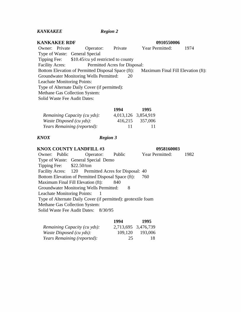
KANKAKEE Region 2
KANKAKEE RDF 0910550006 Owner: Private Operator: Private Year Permitted: 1974 Type of Waste: General Special Tipping Fee: $10.45/cu yd restricted to county Facility Acres: Permitted Acres for Disposal: Bottom Elevation of Permitted Disposal Space (ft): Maximum Final Fill Elevation (ft): Groundwater Monitoring Wells Permitted: 20 Leachate Monitoring Points: Type of Alternate Daily Cover (if permitted): Methane Gas Collection System: Solid Waste Fee Audit Dates:
1994 1995 Remaining Capacity (cu yds): 4,013,126 3,854,919 Waste Disposed (cu yds): 416,215 357,006 Years Remaining (reported): 11 11
KNOX Region 3
KNOX COUNTY LANDFILL #3 0958160003 Owner: Public Operator: Public Year Permitted: 1982 Type of Waste: General Special Demo Tipping Fee: $22.50/ton Facility Acres: 120 Permitted Acres for Disposal: 40 Bottom Elevation of Permitted Disposal Space (ft): 760 Maximum Final Fill Elevation (ft): 840 Groundwater Monitoring Wells Permitted: 8 Leachate Monitoring Points: 1 Type of Alternate Daily Cover (if permitted): geotextile foam Methane Gas Collection System: Solid Waste Fee Audit Dates: 8/30/95
1994 1995 Remaining Capacity (cu yds): 2,713,695 3,476,739 Waste Disposed (cu yds): 109,120 193,006 Years Remaining (reported): 25 18
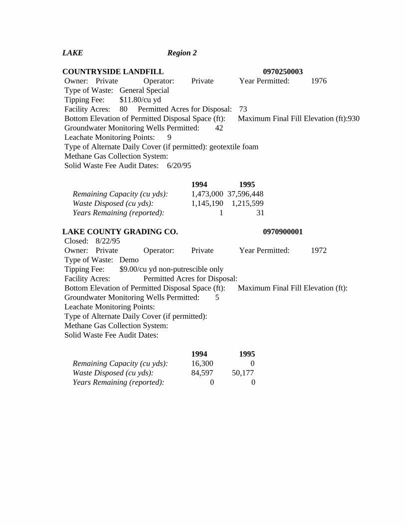
LAKE Region 2
COUNTRYSIDE LANDFILL 0970250003 Owner: Private Operator: Private Year Permitted: 1976 Type of Waste: General Special Tipping Fee: $11.80/cu yd Facility Acres: 80 Permitted Acres for Disposal: 73 Bottom Elevation of Permitted Disposal Space (ft): Maximum Final Fill Elevation (ft):930 Groundwater Monitoring Wells Permitted: 42 Leachate Monitoring Points: 9 Type of Alternate Daily Cover (if permitted): geotextile foam Methane Gas Collection System: Solid Waste Fee Audit Dates: 6/20/95
1994 1995 Remaining Capacity (cu yds): 1,473,000 37,596,448 Waste Disposed (cu yds): 1,145,190 1,215,599 Years Remaining (reported): 1 31
LAKE COUNTY GRADING CO. 0970900001 Closed: 8/22/95 Owner: Private Operator: Private Year Permitted: 1972 Type of Waste: Demo Tipping Fee: $9.00/cu yd non-putrescible only Facility Acres: Permitted Acres for Disposal: Bottom Elevation of Permitted Disposal Space (ft): Maximum Final Fill Elevation (ft): Groundwater Monitoring Wells Permitted: 5 Leachate Monitoring Points: Type of Alternate Daily Cover (if permitted): Methane Gas Collection System: Solid Waste Fee Audit Dates:
1994 1995 Remaining Capacity (cu yds): 16,300 0 Waste Disposed (cu yds): 84,597 50,177 Years Remaining (reported): 0 0
LAND & LAKES/WHEELING 0978120004 Closed: 5/30/95 Owner: Private Operator: Private Year Permitted: 1981 Type of Waste: Demo Tipping Fee: $9.01/cu yd non-putrescible only Facility Acres: Permitted Acres for Disposal: Bottom Elevation of Permitted Disposal Space (ft): Maximum Final Fill Elevation (ft): Groundwater Monitoring Wells Permitted: 7 Leachate Monitoring Points: Type of Alternate Daily Cover (if permitted): Methane Gas Collection System: Solid Waste Fee Audit Dates:
1994 1995 Remaining Capacity (cu yds): 0 0 Waste Disposed (cu yds): 34,161 0 Years Remaining (reported): 0 0 WINTHROP HARBOR/BFI #1 - PHASE B 0978020001 Owner: Private Operator: Private Year Permitted: 1980 Type of Waste: General Special Tipping Fee: $10.20/cu yd Facility Acres: 178 Permitted Acres for Disposal: 10 Bottom Elevation of Permitted Disposal Space (ft): 689 Maximum Final Fill Elevation (ft): 810 Groundwater Monitoring Wells Permitted: 50 Leachate Monitoring Points: 2 Type of Alternate Daily Cover (if permitted): geotextile tarps Methane Gas Collection System: planned active (gas-to-energy) Solid Waste Fee Audit Dates: 2/15/95
1994 1995 Remaining Capacity (cu yds): 912,182 294,703 Waste Disposed (cu yds): 39,606 616,830 Years Remaining (reported): 2 0
LASALLE Region 1
OGLESBY MUNICIPAL 0990700001 Closed: 10/1/94 Owner: Public Operator: Public Year Permitted: 1974 Type of Waste: General Tipping Fee: $8.00/cu yd Facility Acres: Permitted Acres for Disposal: Bottom Elevation of Permitted Disposal Space (ft): Maximum Final Fill Elevation (ft): Groundwater Monitoring Wells Permitted: 4 Leachate Monitoring Points: Type of Alternate Daily Cover (if permitted): Methane Gas Collection System: Solid Waste Fee Audit Dates: 1994 1995 Remaining Capacity (cu yds): 0 0 Waste Disposed (cu yds): 6,498 0 Years Remaining (reported): 0 0
PERU MUNICIPAL #2 0990850002 Closed: 4/4/94 Owner: Public Operator: Public Year Permitted: 1973 Type of Waste:General Special Tipping Fee:$8.00/cu yd Facility Acres: Permitted Acres for Disposal: Bottom Elevation of Permitted Disposal Space (ft): Maximum Final Fill Elevation (ft): Groundwater Monitoring Wells Permitted: 8 Leachate Monitoring Points: Type of Alternate Daily Cover (if permitted): Methane Gas Collection System: Solid Waste Fee Audit Dates:
1994 1995 Remaining Capacity (cu yds): 0 0 Waste Disposed (cu yds): 49,485 0 Years Remaining (reported): 0 0
STATES LAND IMPROVEMENT CORP. #2 0990800017 Owner: Private Operator: Private Year Permitted: 1983 Type of Waste: General Special Tipping Fee: $8.50/cu yd Facility Acres: 38 Permitted Acres for Disposal: 25 Bottom Elevation of Permitted Disposal Space (ft): 529 Maximum Final Fill Elevation (ft): 584 Groundwater Monitoring Wells Permitted: 9 Leachate Monitoring Points: 2 Type of Alternate Daily Cover (if permitted): geotextile tarps Methane Gas Collection System: Solid Waste Fee Audit Dates: 6/14/94
1994 1995 Remaining Capacity (cu yds): 576,423 354,724 Waste Disposed (cu yds): 251,014 153,608 Years Remaining (reported): 2 2
LEE Region 1
DIXON/GROP LANDFILL #2 1038010002 Owner: Public Operator: Private Year Permitted: 1980 Type of Waste: General Special Tipping Fee: $6.60/cu yd Facility Acres: 60 Permitted Acres for Disposal: 41 Bottom Elevation of Permitted Disposal Space (ft): 745 Maximum Final Fill Elevation (ft): 859 Groundwater Monitoring Wells Permitted: 15 Leachate Monitoring Points: 3 Type of Alternate Daily Cover (if permitted): geotextile shredded tires fabrisoil tarps indigenous material foundry sand wood chips petroleum- contaminated soil C/D debris Methane Gas Collection System:operational passive (flares) Solid Waste Fee Audit Dates: 6/7/94
1994 1995 Remaining Capacity (cu yds): 4,560,200 2,638,536 Waste Disposed (cu yds): 541,471 706,773 Years Remaining (reported): 8 4
LIVINGSTON Region 4
LIVINGSTON LANDFILL 1058210002 Owner: Private Operator: Private Year Permitted: 1978 Type of Waste: General Special Tipping Fee: $6.35/cu yd Facility Acres: 240 Permitted Acres for Disposal: 115 Bottom Elevation of Permitted Disposal Space (ft): 640 Maximum Final Fill Elevation (ft): 785 Groundwater Monitoring Wells Permitted: 11 Leachate Monitoring Points: 14 Type of Alternate Daily Cover (if permitted): geotextile shredded tires tarps paper pulp dried sewage sludge Methane Gas Collection System: Solid Waste Fee Audit Dates: 3/8/94
1994 1995 Remaining Capacity (cu yds): 4,254,861 3,019,555 Waste Disposed (cu yds): 1,418,286 2,126,447 Years Remaining (reported): 3 1 STREATOR AREA LANDFILL #3 1054900003 Owner: Private Operator: Private Year Permitted: 1993 Type of Waste: General Special Tipping Fee: $6.00/cu yd Facility Acres: 240 Permitted Acres for Disposal: 87 Bottom Elevation of Permitted Disposal Space (ft): 638 Maximum Final Fill Elevation (ft): 785 Groundwater Monitoring Wells Permitted: 12 Leachate Monitoring Points: 13 Type of Alternate Daily Cover (if permitted): geotextile Methane Gas Collection System: Solid Waste Fee Audit Dates: 11/7/95
1994 1995 Remaining Capacity (cu yds): 4,210,136 3,257,690 Waste Disposed (cu yds): 7,991 567,292 Years Remaining (reported): 25 6
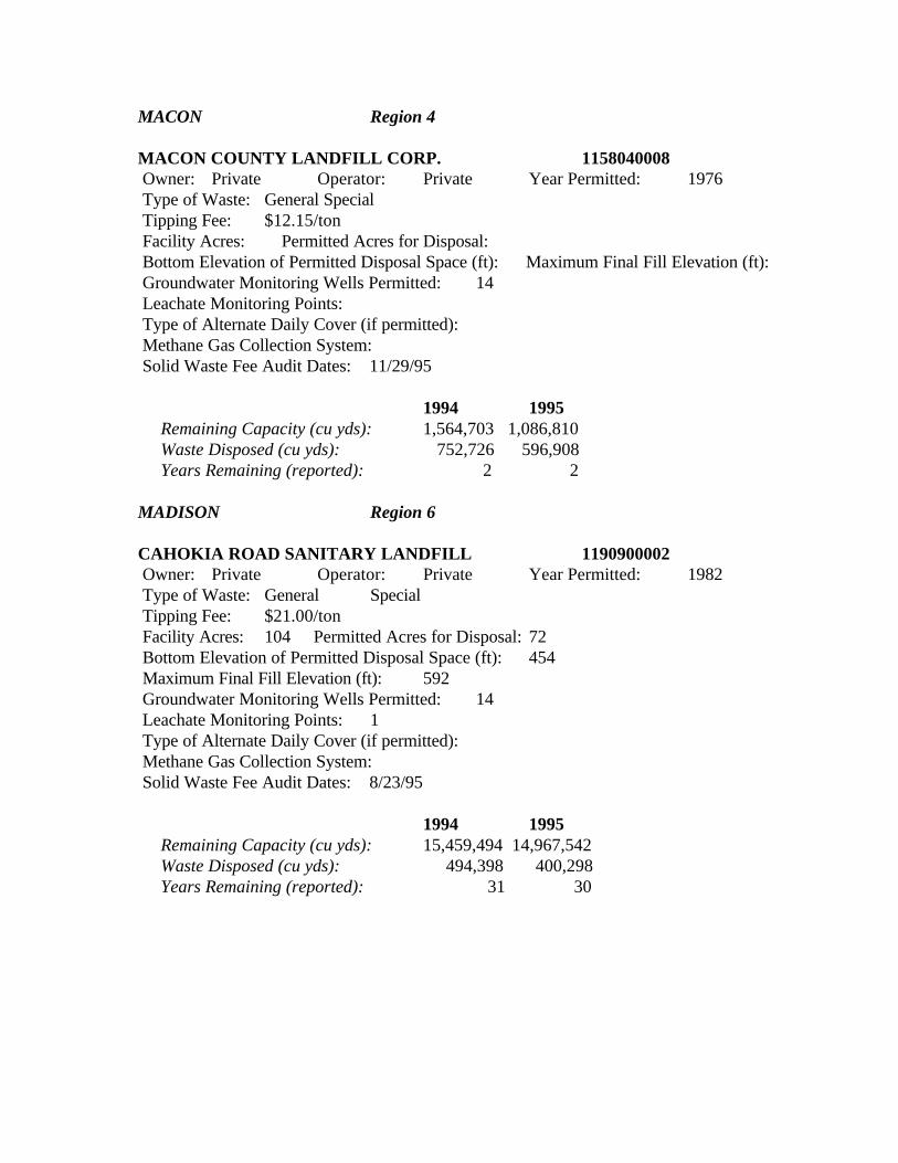
MACON Region 4
MACON COUNTY LANDFILL CORP. 1158040008 Owner: Private Operator: Private Year Permitted: 1976 Type of Waste: General Special Tipping Fee: $12.15/ton Facility Acres: Permitted Acres for Disposal: Bottom Elevation of Permitted Disposal Space (ft): Maximum Final Fill Elevation (ft): Groundwater Monitoring Wells Permitted: 14 Leachate Monitoring Points: Type of Alternate Daily Cover (if permitted): Methane Gas Collection System: Solid Waste Fee Audit Dates: 11/29/95
1994 1995 Remaining Capacity (cu yds): 1,564,703 1,086,810 Waste Disposed (cu yds): 752,726 596,908 Years Remaining (reported): 2 2
MADISON Region 6
CAHOKIA ROAD SANITARY LANDFILL 1190900002 Owner: Private Operator: Private Year Permitted: 1982 Type of Waste: General Special Tipping Fee: $21.00/ton Facility Acres: 104 Permitted Acres for Disposal: 72 Bottom Elevation of Permitted Disposal Space (ft): 454 Maximum Final Fill Elevation (ft): 592 Groundwater Monitoring Wells Permitted: 14 Leachate Monitoring Points: 1 Type of Alternate Daily Cover (if permitted): Methane Gas Collection System: Solid Waste Fee Audit Dates: 8/23/95
1994 1995 Remaining Capacity (cu yds): 15,459,494 14,967,542 Waste Disposed (cu yds): 494,398 400,298 Years Remaining (reported): 31 30
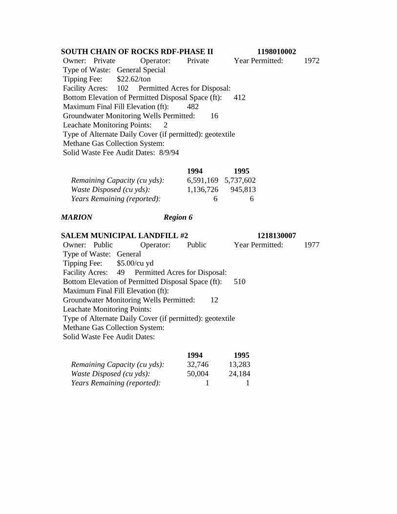
SOUTH CHAIN OF ROCKS RDF-PHASE II 1198010002 Owner: Private Operator: Private Year Permitted: 1972 Type of Waste: General Special Tipping Fee: $22.62/ton Facility Acres: 102 Permitted Acres for Disposal: Bottom Elevation of Permitted Disposal Space (ft): 412 Maximum Final Fill Elevation (ft): 482 Groundwater Monitoring Wells Permitted: 16 Leachate Monitoring Points: 2 Type of Alternate Daily Cover (if permitted): geotextile Methane Gas Collection System: Solid Waste Fee Audit Dates: 8/9/94
1994 1995 Remaining Capacity (cu yds): 6,591,169 5,737,602 Waste Disposed (cu yds): 1,136,726 945,813 Years Remaining (reported): 6 6
MARION Region 6
SALEM MUNICIPAL LANDFILL #2 1218130007 Owner: Public Operator: Public Year Permitted: 1977 Type of Waste: General Tipping Fee: $5.00/cu yd Facility Acres: 49 Permitted Acres for Disposal: Bottom Elevation of Permitted Disposal Space (ft): 510 Maximum Final Fill Elevation (ft): Groundwater Monitoring Wells Permitted: 12 Leachate Monitoring Points: Type of Alternate Daily Cover (if permitted): geotextile Methane Gas Collection System: Solid Waste Fee Audit Dates:
1994 1995 Remaining Capacity (cu yds): 32,746 13,283 Waste Disposed (cu yds): 50,004 24,184 Years Remaining (reported): 1 1
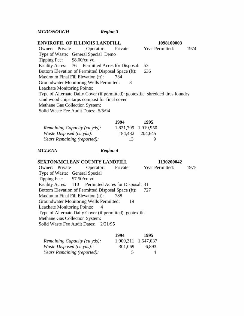
MCDONOUGH Region 3
ENVIROFIL OF ILLINOIS LANDFILL 1098100003 Owner: Private Operator: Private Year Permitted: 1974 Type of Waste: General Special Demo Tipping Fee: $8.00/cu yd Facility Acres: 76 Permitted Acres for Disposal: 53 Bottom Elevation of Permitted Disposal Space (ft): 636 Maximum Final Fill Elevation (ft): 734 Groundwater Monitoring Wells Permitted: 8 Leachate Monitoring Points: Type of Alternate Daily Cover (if permitted): geotextile shredded tires foundry sand wood chips tarps compost for final cover Methane Gas Collection System: Solid Waste Fee Audit Dates: 5/5/94
1994 1995 Remaining Capacity (cu yds): 1,821,709 1,919,950 Waste Disposed (cu yds): 184,432 204,645 Years Remaining (reported): 13 9 MCLEAN Region 4
SEXTON/MCLEAN COUNTY LANDFILL 1130200042 Owner: Private Operator: Private Year Permitted: 1975 Type of Waste: General Special Tipping Fee: $7.50/cu yd Facility Acres: 110 Permitted Acres for Disposal: 31 Bottom Elevation of Permitted Disposal Space (ft): 727 Maximum Final Fill Elevation (ft): 788 Groundwater Monitoring Wells Permitted: 19 Leachate Monitoring Points: 4 Type of Alternate Daily Cover (if permitted): geotextile Methane Gas Collection System: Solid Waste Fee Audit Dates: 2/21/95
1994 1995 Remaining Capacity (cu yds): 1,900,311 1,647,037 Waste Disposed (cu yds): 301,069 6,893 Years Remaining (reported): 5 4
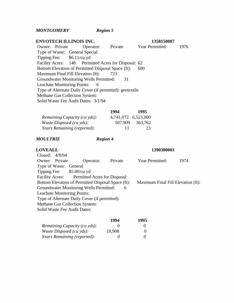
MONTGOMERY Region 5
ENVOTECH ILLINOIS INC. 1358150007 Owner: Private Operator: Private Year Permitted: 1976 Type of Waste: General Special Tipping Fee: $6.11/cu yd Facility Acres: 148 Permitted Acres for Disposal: 62 Bottom Elevation of Permitted Disposal Space (ft): 600 Maximum Final Fill Elevation (ft): 723 Groundwater Monitoring Wells Permitted: 31 Leachate Monitoring Points: 6 Type of Alternate Daily Cover (if permitted): geotextile Methane Gas Collection System: Solid Waste Fee Audit Dates: 3/1/94
1994 1995 Remaining Capacity (cu yds): 4,741,072 6,523,000 Waste Disposed (cu yds): 507,909 363,762 Years Remaining (reported): 11 23
MOULTRIE Region 4
LOVEALL 1390300001 Closed: 4/8/94 Owner: Private Operator: Private Year Permitted: 1974 Type of Waste: General Tipping Fee: $5.00/cu yd Facility Acres: Permitted Acres for Disposal: Bottom Elevation of Permitted Disposal Space (ft): Maximum Final Fill Elevation (ft): Groundwater Monitoring Wells Permitted: 6 Leachate Monitoring Points: Type of Alternate Daily Cover (if permitted): Methane Gas Collection System: Solid Waste Fee Audit Dates:
1994 1995 Remaining Capacity (cu yds): 0 0 Waste Disposed (cu yds): 18,908 0 Years Remaining (reported): 0 0
OGLE Region 1
BFI-DAVIS JUNCTION LANDFILL 1418210001 Closed: 5/4/95 Owner: Private Operator: Private Year Permitted: 1975 Type of Waste: General Special Tipping Fee: $39.00/ton Facility Acres: 63 Permitted Acres for Disposal: Bottom Elevation of Permitted Disposal Space (ft): 712 Maximum Final Fill Elevation (ft): 785 Groundwater Monitoring Wells Permitted: 21 Leachate Monitoring Points: 8 Type of Alternate Daily Cover (if permitted): geotextile Methane Gas Collection System: planned active (gas-to-energy) Solid Waste Fee Audit Dates:
1994 1995 Remaining Capacity (cu yds): 164,318 0 Waste Disposed (cu yds): 338,705 87,150 Years Remaining (reported): 0 0
ROCHELLE MUNICIPAL LANDFILL #2 1418030020 Owner: Public Operator: Private Year Permitted: 1974 Type of Waste: General Special Tipping Fee: $21.32/ton Facility Acres: 81 Permitted Acres for Disposal: Bottom Elevation of Permitted Disposal Space (ft): 807 Maximum Final Fill Elevation (ft): 873 Groundwater Monitoring Wells Permitted: 14 Leachate Monitoring Points: 6 Type of Alternate Daily Cover (if permitted): tarps Methane Gas Collection System: Solid Waste Fee Audit Dates: 3/7/95
1994 1995 Remaining Capacity (cu yds): 3,278,194 3,554,400 Waste Disposed (cu yds): 266,194 137,591 Years Remaining (reported): 12 19
PEORIA Region 3
PEORIA CITY/COUNTY LANDFILL 1438160002 Owner: Public Operator: Private Year Permitted: 1975 Type of Waste: General Special Tipping Fee: $14.03/ton Facility Acres: 152 Permitted Acres for Disposal: 102 Bottom Elevation of Permitted Disposal Space (ft): 612 Maximum Final Fill Elevation (ft): 692 Groundwater Monitoring Wells Permitted: 22 Leachate Monitoring Points: 6 Type of Alternate Daily Cover (if permitted): Fabrisoil dried sewage sludge Methane Gas Collection System: planned active (gas-to-energy) Solid Waste Fee Audit Dates: 8/22/95
1994 1995 Remaining Capacity (cu yds): 1,799,376 1,340,582 Waste Disposed (cu yds): 660,818 722,838 Years Remaining (reported): 3 2
PEORIA DISPOSAL CO. #1 1438120003 Owner: Private Operator: Private Year Permitted: 1974 Type of Waste: Special Hazardous Tipping Fee: Individually assessed based on waste stream Facility Acres: 90 Permitted Acres for Disposal: 72 Bottom Elevation of Permitted Disposal Space (ft): 536 Maximum Final Fill Elevation (ft): 670 Groundwater Monitoring Wells Permitted: 23 Leachate Monitoring Points: 7 Type of Alternate Daily Cover (if permitted): foam Methane Gas Collection System: Solid Waste Fee Audit Dates: 11/10/94
1994 1995 Remaining Capacity (cu yds): 1,667,293 1,597,371 Waste Disposed (cu yds): 84,045 65,305 Years Remaining (reported): 18 24
PIKE Region 5
PIKE COUNTY LANDFILL INC. 1498160001 Owner: Private Operator: Private Year Permitted: 1975 Type of Waste: General Special Tipping Fee: $5.25/cu yd Facility Acres: 77 Permitted Acres for Disposal: 69 Bottom Elevation of Permitted Disposal Space (ft): 693 Maximum Final Fill Elevation (ft): 836 Groundwater Monitoring Wells Permitted: 11 Leachate Monitoring Points: 6 Type of Alternate Daily Cover (if permitted): geotextile Methane Gas Collection System: Solid Waste Fee Audit Dates: 9/13/94
1994 1995 Remaining Capacity (cu yds): 291,978 9,362,000 Waste Disposed (cu yds): 323,020 274,458 Years Remaining (reported): 0 35
RANDOLPH Region 6
RANDOLPH COUNTY LANDFILL INC. 1570600001 Closed: 4/20/95 Owner: Private Operator: Private Year Permitted: 1974 Type of Waste: General Tipping Fee: $6.00/cu yd Facility Acres: Permitted Acres for Disposal: Bottom Elevation of Permitted Disposal Space (ft): Maximum Final Fill Elevation (ft): Groundwater Monitoring Wells Permitted: 7 Leachate Monitoring Points: Type of Alternate Daily Cover (if permitted): Methane Gas Collection System: Solid Waste Fee Audit Dates:
1994 1995 Remaining Capacity (cu yds): 194,158 194,158 Waste Disposed (cu yds): 87,700 0 Years Remaining (reported): 3 0
ROCK ISLAND Region 3
QUAD CITIES LANDFILL 1610400007 Owner: Private Operator: Private Year Permitted: 1981 Type of Waste: General Special Tipping Fee: $7.00/cu yd Facility Acres: 411 Permitted Acres for Disposal: 172 Bottom Elevation of Permitted Disposal Space (ft): 720 Maximum Final Fill Elevation (ft): 775 Groundwater Monitoring Wells Permitted: 43 Leachate Monitoring Points: 9 Type of Alternate Daily Cover (if permitted): Methane Gas Collection System: planned active (gas-to-energy) Solid Waste Fee Audit Dates: 9/20/94
1994 1995 Remaining Capacity (cu yds): 13,725,163 16,744,660 Waste Disposed (cu yds): 663,674 689,902 Years Remaining (reported): 3 25
UPPER ROCK ISLAND COUNTY LANDFILL 1618100014 Owner: Private Operator: Private Year Permitted: 1981 Type of Waste: General Special Tipping Fee: $7.25/cu yd Facility Acres: 179 Permitted Acres for Disposal: 97 Bottom Elevation of Permitted Disposal Space (ft): 552 Maximum Final Fill Elevation (ft): 742 Groundwater Monitoring Wells Permitted: 14 Leachate Monitoring Points: 18 Type of Alternate Daily Cover (if permitted): geotextile foam shredded tires tarps foundry sand wood chips compost Methane Gas Collection System: Solid Waste Fee Audit Dates: 6/21/94
1994 1995 Remaining Capacity (cu yds): 138,400 18,363,000 Waste Disposed (cu yds): 616,087 558,843 Years Remaining (reported): 0 33
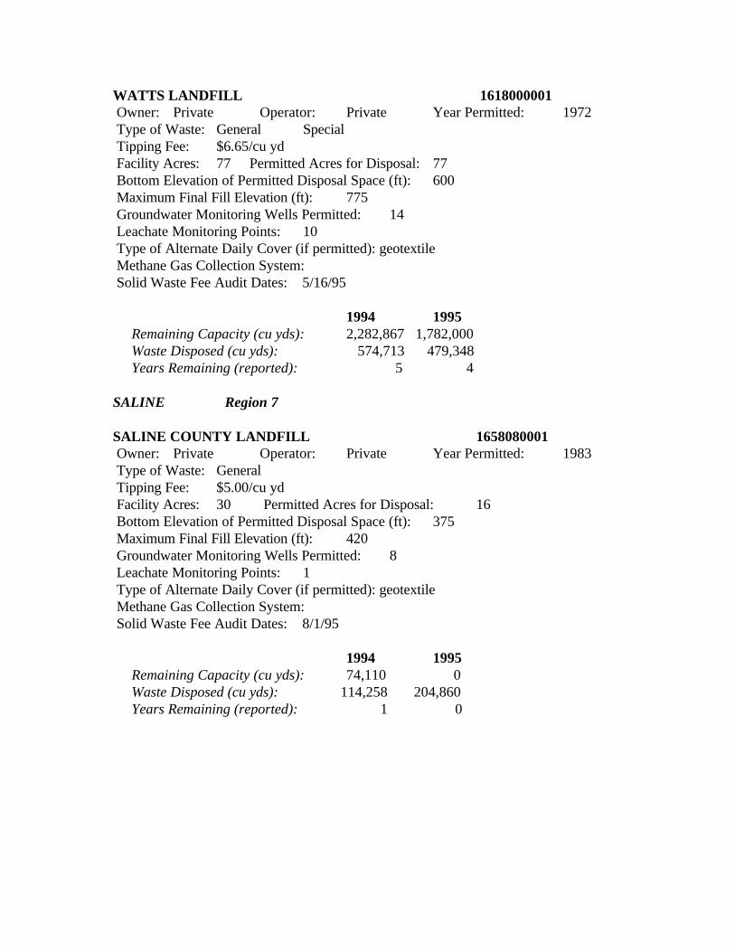
WATTS LANDFILL 1618000001 Owner: Private Operator: Private Year Permitted: 1972 Type of Waste: General Special Tipping Fee: $6.65/cu yd Facility Acres: 77 Permitted Acres for Disposal: 77 Bottom Elevation of Permitted Disposal Space (ft): 600 Maximum Final Fill Elevation (ft): 775 Groundwater Monitoring Wells Permitted: 14 Leachate Monitoring Points: 10 Type of Alternate Daily Cover (if permitted): geotextile Methane Gas Collection System: Solid Waste Fee Audit Dates: 5/16/95
1994 1995 Remaining Capacity (cu yds): 2,282,867 1,782,000 Waste Disposed (cu yds): 574,713 479,348 Years Remaining (reported): 5 4
SALINE Region 7
SALINE COUNTY LANDFILL 1658080001 Owner: Private Operator: Private Year Permitted: 1983 Type of Waste: General Tipping Fee: $5.00/cu yd Facility Acres: 30 Permitted Acres for Disposal: 16 Bottom Elevation of Permitted Disposal Space (ft): 375 Maximum Final Fill Elevation (ft): 420 Groundwater Monitoring Wells Permitted: 8 Leachate Monitoring Points: 1 Type of Alternate Daily Cover (if permitted): geotextile Methane Gas Collection System: Solid Waste Fee Audit Dates: 8/1/95
1994 1995 Remaining Capacity (cu yds): 74,110 0 Waste Disposed (cu yds): 114,258 204,860 Years Remaining (reported): 1 0
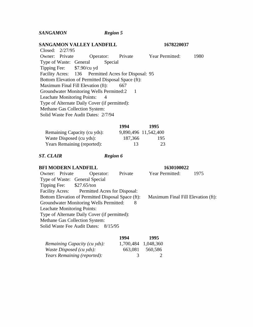
SANGAMON Region 5
SANGAMON VALLEY LANDFILL 1678220037 Closed: 2/27/95 Owner: Private Operator: Private Year Permitted: 1980 Type of Waste: General Special Tipping Fee: $7.90/cu yd Facility Acres: 136 Permitted Acres for Disposal: 95 Bottom Elevation of Permitted Disposal Space (ft): Maximum Final Fill Elevation (ft): 667 Groundwater Monitoring Wells Permitted:2 1 Leachate Monitoring Points: 4 Type of Alternate Daily Cover (if permitted): Methane Gas Collection System: Solid Waste Fee Audit Dates: 2/7/94
1994 1995 Remaining Capacity (cu yds): 9,890,496 11,542,400 Waste Disposed (cu yds): 187,366 195 Years Remaining (reported): 13 23
ST. CLAIR Region 6
BFI MODERN LANDFILL 1630100022 Owner: Private Operator: Private Year Permitted: 1975 Type of Waste: General Special Tipping Fee: $27.65/ton Facility Acres: Permitted Acres for Disposal: Bottom Elevation of Permitted Disposal Space (ft): Maximum Final Fill Elevation (ft): Groundwater Monitoring Wells Permitted: 8 Leachate Monitoring Points: Type of Alternate Daily Cover (if permitted): Methane Gas Collection System: Solid Waste Fee Audit Dates: 8/15/95
1994 1995 Remaining Capacity (cu yds): 1,700,484 1,048,360 Waste Disposed (cu yds): 663,081 560,586 Years Remaining (reported): 3 2
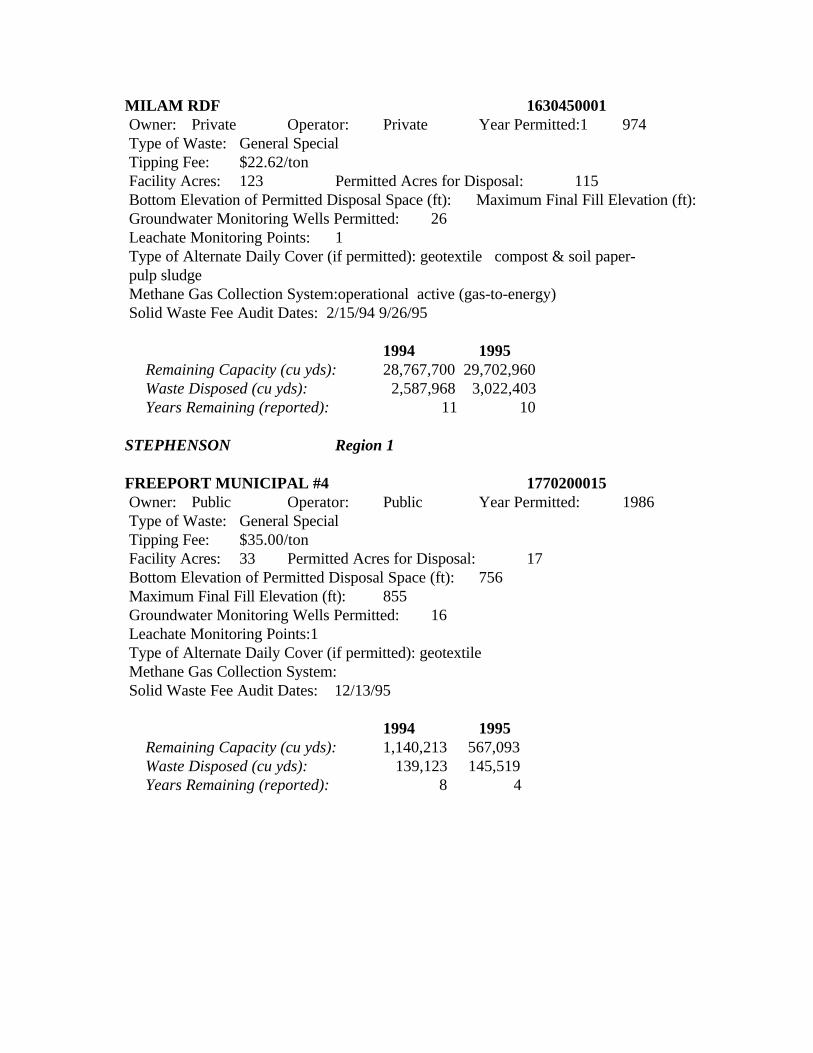
MILAM RDF 1630450001 Owner: Private Operator: Private Year Permitted:1 974 Type of Waste: General Special Tipping Fee: $22.62/ton Facility Acres: 123 Permitted Acres for Disposal: 115 Bottom Elevation of Permitted Disposal Space (ft): Maximum Final Fill Elevation (ft): Groundwater Monitoring Wells Permitted: 26 Leachate Monitoring Points: 1 Type of Alternate Daily Cover (if permitted): geotextile compost & soil paper- pulp sludge Methane Gas Collection System:operational active (gas-to-energy) Solid Waste Fee Audit Dates: 2/15/94 9/26/95
1994 1995 Remaining Capacity (cu yds): 28,767,700 29,702,960 Waste Disposed (cu yds): 2,587,968 3,022,403 Years Remaining (reported): 11 10
STEPHENSON Region 1
FREEPORT MUNICIPAL #4 1770200015 Owner: Public Operator: Public Year Permitted: 1986 Type of Waste: General Special Tipping Fee: $35.00/ton Facility Acres: 33 Permitted Acres for Disposal: 17 Bottom Elevation of Permitted Disposal Space (ft): 756 Maximum Final Fill Elevation (ft): 855 Groundwater Monitoring Wells Permitted: 16 Leachate Monitoring Points:1 Type of Alternate Daily Cover (if permitted): geotextile Methane Gas Collection System: Solid Waste Fee Audit Dates: 12/13/95
1994 1995 Remaining Capacity (cu yds): 1,140,213 567,093 Waste Disposed (cu yds): 139,123 145,519 Years Remaining (reported): 8 4
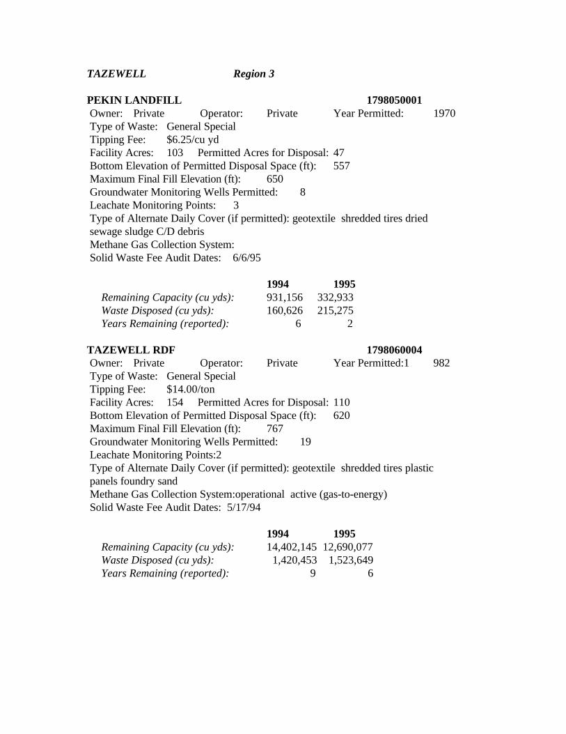
TAZEWELL Region 3
PEKIN LANDFILL 1798050001 Owner: Private Operator: Private Year Permitted: 1970 Type of Waste: General Special Tipping Fee: $6.25/cu yd Facility Acres: 103 Permitted Acres for Disposal: 47 Bottom Elevation of Permitted Disposal Space (ft): 557 Maximum Final Fill Elevation (ft): 650 Groundwater Monitoring Wells Permitted: 8 Leachate Monitoring Points: 3 Type of Alternate Daily Cover (if permitted): geotextile shredded tires dried sewage sludge C/D debris Methane Gas Collection System: Solid Waste Fee Audit Dates: 6/6/95
1994 1995 Remaining Capacity (cu yds): 931,156 332,933 Waste Disposed (cu yds): 160,626 215,275 Years Remaining (reported): 6 2 TAZEWELL RDF 1798060004 Owner: Private Operator: Private Year Permitted:1 982 Type of Waste: General Special Tipping Fee: $14.00/ton Facility Acres: 154 Permitted Acres for Disposal: 110 Bottom Elevation of Permitted Disposal Space (ft): 620 Maximum Final Fill Elevation (ft): 767 Groundwater Monitoring Wells Permitted: 19 Leachate Monitoring Points:2 Type of Alternate Daily Cover (if permitted): geotextile shredded tires plastic panels foundry sand Methane Gas Collection System:operational active (gas-to-energy) Solid Waste Fee Audit Dates: 5/17/94
1994 1995 Remaining Capacity (cu yds): 14,402,145 12,690,077 Waste Disposed (cu yds): 1,420,453 1,523,649 Years Remaining (reported): 9 6
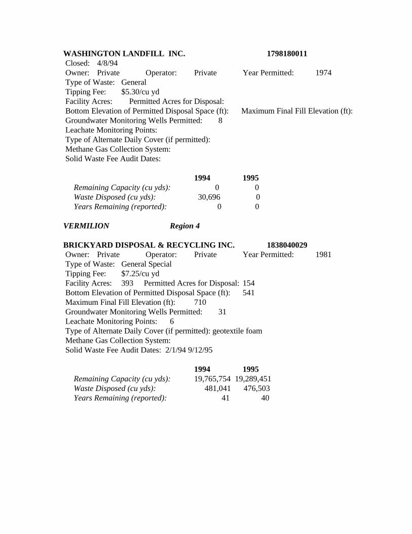
WASHINGTON LANDFILL INC. 1798180011 Closed: 4/8/94 Owner: Private Operator: Private Year Permitted: 1974 Type of Waste: General Tipping Fee: $5.30/cu yd Facility Acres: Permitted Acres for Disposal: Bottom Elevation of Permitted Disposal Space (ft): Maximum Final Fill Elevation (ft): Groundwater Monitoring Wells Permitted: 8 Leachate Monitoring Points: Type of Alternate Daily Cover (if permitted): Methane Gas Collection System: Solid Waste Fee Audit Dates:
1994 1995 Remaining Capacity (cu yds): 0 0 Waste Disposed (cu yds): 30,696 0 Years Remaining (reported): 0 0
VERMILION Region 4
BRICKYARD DISPOSAL & RECYCLING INC. 1838040029 Owner: Private Operator: Private Year Permitted: 1981 Type of Waste: General Special Tipping Fee: $7.25/cu yd Facility Acres: 393 Permitted Acres for Disposal: 154 Bottom Elevation of Permitted Disposal Space (ft): 541 Maximum Final Fill Elevation (ft): 710 Groundwater Monitoring Wells Permitted: 31 Leachate Monitoring Points: 6 Type of Alternate Daily Cover (if permitted): geotextile foam Methane Gas Collection System: Solid Waste Fee Audit Dates: 2/1/94 9/12/95
1994 1995 Remaining Capacity (cu yds): 19,765,754 19,289,451 Waste Disposed (cu yds): 481,041 476,503 Years Remaining (reported): 41 40
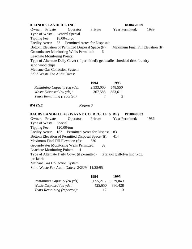
ILLINOIS LANDFILL INC. 1830450009 Owner: Private Operator: Private Year Permitted: 1989 Type of Waste: General Special Tipping Fee: $8.00/cu yd Facility Acres: 53 Permitted Acres for Disposal: Bottom Elevation of Permitted Disposal Space (ft): Maximum Final Fill Elevation (ft): Groundwater Monitoring Wells Permitted: 6 Leachate Monitoring Points: Type of Alternate Daily Cover (if permitted): geotextile shredded tires foundry sand wood chips Methane Gas Collection System: Solid Waste Fee Audit Dates:
1994 1995 Remaining Capacity (cu yds): 2,533,000 548,550 Waste Disposed (cu yds): 367,586 353,611 Years Remaining (reported): 7 2
WAYNE Region 7
DAUBS LANDFILL #3 (WAYNE CO. REG. LF & RF) 1918040003 Owner: Private Operator: Private Year Permitted: 1986 Type of Waste: Special Tipping Fee: $20.00/ton Facility Acres: 183 Permitted Acres for Disposal: 83 Bottom Elevation of Permitted Disposal Space (ft): 414 Maximum Final Fill Elevation (ft): 530 Groundwater Monitoring Wells Permitted: 32 Leachate Monitoring Points: 4 Type of Alternate Daily Cover (if permitted): fabrisoil griffolyn linq 5-oz. ipc fabric Methane Gas Collection System: Solid Waste Fee Audit Dates: 2/23/94 11/28/95
1994 1995 Remaining Capacity (cu yds): 3,655,215 3,329,049 Waste Disposed (cu yds): 425,650 386,428 Years Remaining (reported): 12 13
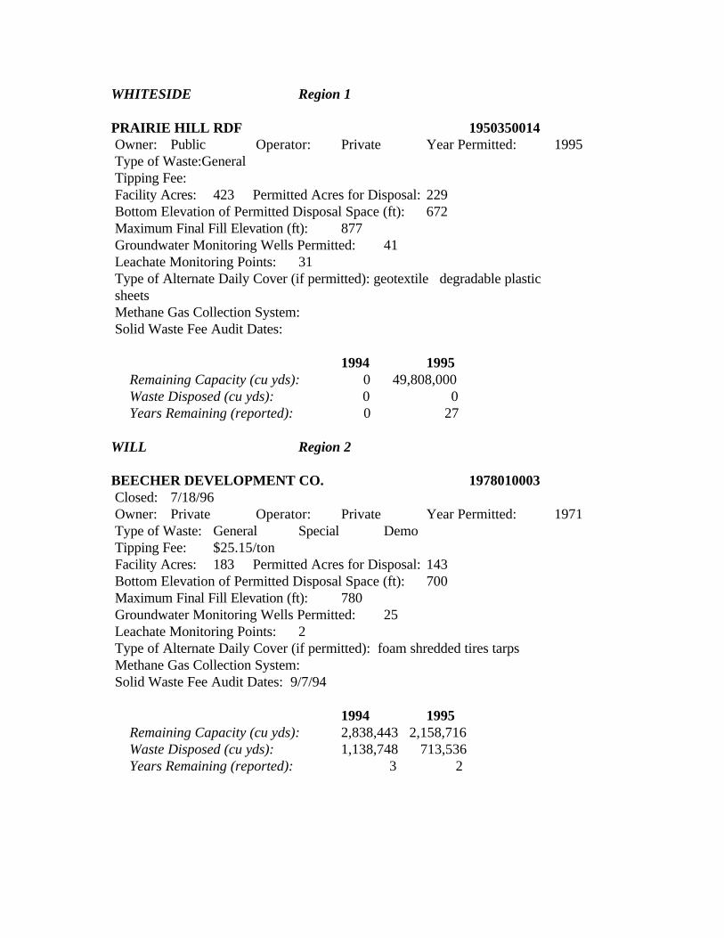
WHITESIDE Region 1
PRAIRIE HILL RDF 1950350014 Owner: Public Operator: Private Year Permitted: 1995 Type of Waste:General Tipping Fee: Facility Acres: 423 Permitted Acres for Disposal: 229 Bottom Elevation of Permitted Disposal Space (ft): 672 Maximum Final Fill Elevation (ft): 877 Groundwater Monitoring Wells Permitted: 41 Leachate Monitoring Points: 31 Type of Alternate Daily Cover (if permitted): geotextile degradable plastic sheets Methane Gas Collection System: Solid Waste Fee Audit Dates:
1994 1995 Remaining Capacity (cu yds): 0 49,808,000 Waste Disposed (cu yds): 0 0 Years Remaining (reported): 0 27
WILL Region 2
BEECHER DEVELOPMENT CO. 1978010003 Closed: 7/18/96 Owner: Private Operator: Private Year Permitted: 1971 Type of Waste: General Special Demo Tipping Fee: $25.15/ton Facility Acres: 183 Permitted Acres for Disposal: 143 Bottom Elevation of Permitted Disposal Space (ft): 700 Maximum Final Fill Elevation (ft): 780 Groundwater Monitoring Wells Permitted: 25 Leachate Monitoring Points: 2 Type of Alternate Daily Cover (if permitted): foam shredded tires tarps Methane Gas Collection System: Solid Waste Fee Audit Dates: 9/7/94
1994 1995 Remaining Capacity (cu yds): 2,838,443 2,158,716 Waste Disposed (cu yds): 1,138,748 713,536 Years Remaining (reported): 3 2
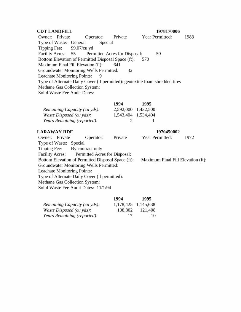
CDT LANDFILL 1978170006 Owner: Private Operator: Private Year Permitted: 1983 Type of Waste: General Special Tipping Fee: $9.07/cu yd Facility Acres: 55 Permitted Acres for Disposal: 50 Bottom Elevation of Permitted Disposal Space (ft): 570 Maximum Final Fill Elevation (ft): 641 Groundwater Monitoring Wells Permitted: 32 Leachate Monitoring Points: 9 Type of Alternate Daily Cover (if permitted): geotextile foam shredded tires Methane Gas Collection System: Solid Waste Fee Audit Dates:
1994 1995 Remaining Capacity (cu yds): 2,592,000 1,432,500 Waste Disposed (cu yds): 1,543,404 1,534,404 Years Remaining (reported): 2 1
LARAWAY RDF 1970450002 Owner: Private Operator: Private Year Permitted: 1972 Type of Waste: Special Tipping Fee: By contract only Facility Acres: Permitted Acres for Disposal: Bottom Elevation of Permitted Disposal Space (ft): Maximum Final Fill Elevation (ft): Groundwater Monitoring Wells Permitted: Leachate Monitoring Points: Type of Alternate Daily Cover (if permitted): Methane Gas Collection System: Solid Waste Fee Audit Dates: 11/1/94
1994 1995 Remaining Capacity (cu yds): 1,178,425 1,145,638 Waste Disposed (cu yds): 108,802 121,408 Years Remaining (reported): 17 10
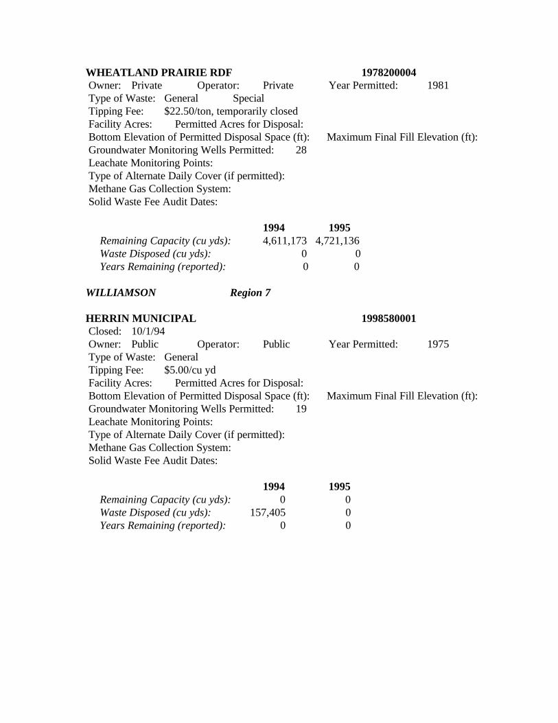
WHEATLAND PRAIRIE RDF 1978200004 Owner: Private Operator: Private Year Permitted: 1981 Type of Waste: General Special Tipping Fee: $22.50/ton, temporarily closed Facility Acres: Permitted Acres for Disposal: Bottom Elevation of Permitted Disposal Space (ft): Maximum Final Fill Elevation (ft): Groundwater Monitoring Wells Permitted: 28 Leachate Monitoring Points: Type of Alternate Daily Cover (if permitted): Methane Gas Collection System: Solid Waste Fee Audit Dates:
1994 1995 Remaining Capacity (cu yds): 4,611,173 4,721,136 Waste Disposed (cu yds): 0 0 Years Remaining (reported): 0 0
WILLIAMSON Region 7
HERRIN MUNICIPAL 1998580001 Closed: 10/1/94 Owner: Public Operator: Public Year Permitted: 1975 Type of Waste: General Tipping Fee: $5.00/cu yd Facility Acres: Permitted Acres for Disposal: Bottom Elevation of Permitted Disposal Space (ft): Maximum Final Fill Elevation (ft): Groundwater Monitoring Wells Permitted: 19 Leachate Monitoring Points: Type of Alternate Daily Cover (if permitted): Methane Gas Collection System: Solid Waste Fee Audit Dates:
1994 1995 Remaining Capacity (cu yds): 0 0 Waste Disposed (cu yds): 157,405 0 Years Remaining (reported): 0 0
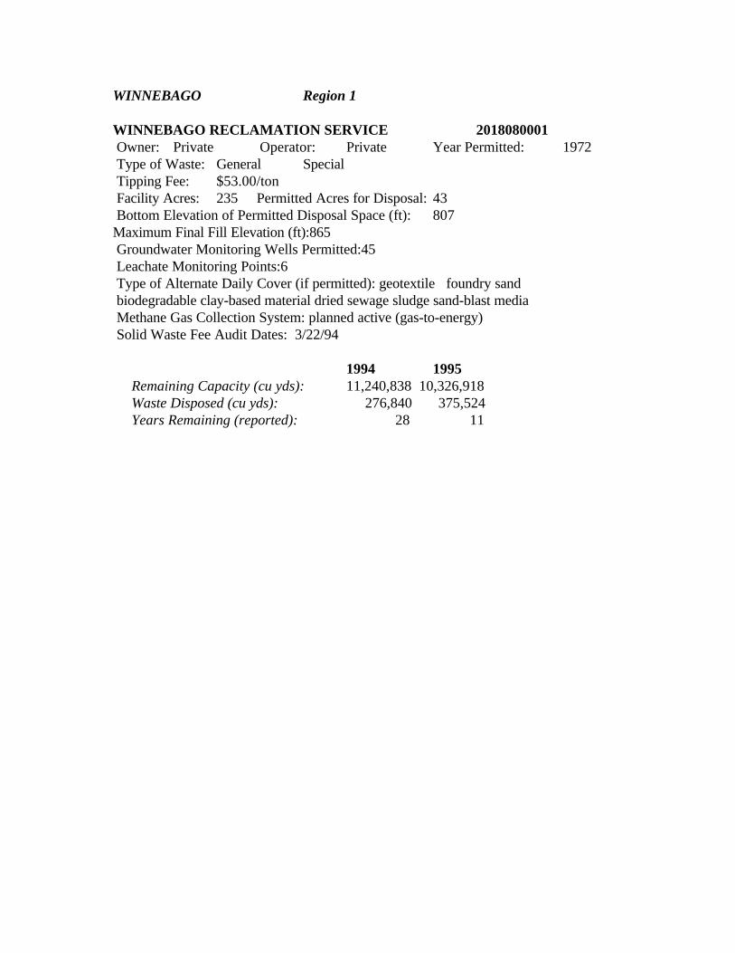
WINNEBAGO Region 1
WINNEBAGO RECLAMATION SERVICE 2018080001 Owner: Private Operator: Private Year Permitted: 1972 Type of Waste: General Special Tipping Fee: $53.00/ton Facility Acres: 235 Permitted Acres for Disposal: 43 Bottom Elevation of Permitted Disposal Space (ft): 807 Maximum Final Fill Elevation (ft):865 Groundwater Monitoring Wells Permitted:45 Leachate Monitoring Points:6 Type of Alternate Daily Cover (if permitted): geotextile foundry sand biodegradable clay-based material dried sewage sludge sand-blast media Methane Gas Collection System: planned active (gas-to-energy) Solid Waste Fee Audit Dates: 3/22/94
1994 1995 Remaining Capacity (cu yds): 11,240,838 10,326,918 Waste Disposed (cu yds): 276,840 375,524 Years Remaining (reported): 28 11