Embed Size (px)
Citation preview
This article was downloaded by: [UOV University of Oviedo]On: 27 October 2014, At: 04:21Publisher: RoutledgeInforma Ltd Registered in England and Wales Registered Number: 1072954 Registered office:Mortimer House, 37-41 Mortimer Street, London W1T 3JH, UK
Azania: Archaeological Research in AfricaPublication details, including instructions for authors and subscriptioninformation:http://www.tandfonline.com/loi/raza20
An Early Christian extra-mural settlement atQasr IbrimP. J. Rose aa McDonald Institute for Archaeological Research, University of CambridgePublished online: 29 Jul 2009.
To cite this article: P. J. Rose (2004) An Early Christian extra-mural settlement at Qasr Ibrim, Azania:Archaeological Research in Africa, 39:1, 69-76, DOI: 10.1080/00672700409480388
To link to this article: http://dx.doi.org/10.1080/00672700409480388
PLEASE SCROLL DOWN FOR ARTICLE
Taylor & Francis makes every effort to ensure the accuracy of all the information (the “Content”)contained in the publications on our platform. However, Taylor & Francis, our agents, and ourlicensors make no representations or warranties whatsoever as to the accuracy, completeness, orsuitability for any purpose of the Content. Any opinions and views expressed in this publicationare the opinions and views of the authors, and are not the views of or endorsed by Taylor &Francis. The accuracy of the Content should not be relied upon and should be independentlyverified with primary sources of information. Taylor and Francis shall not be liable for anylosses, actions, claims, proceedings, demands, costs, expenses, damages, and other liabilitieswhatsoever or howsoever caused arising directly or indirectly in connection with, in relation to orarising out of the use of the Content.
This article may be used for research, teaching, and private study purposes. Any substantialor systematic reproduction, redistribution, reselling, loan, sub-licensing, systematic supply, ordistribution in any form to anyone is expressly forbidden. Terms & Conditions of access and usecan be found at http://www.tandfonline.com/page/terms-and-conditions
Axania ~ I X 2004
An Eurb Cbristiun extra-murul settlement ut Qasr Ibrim
P.J. Rose
McDonald Institute far Archaeological Research, University of Cam bridge
Abstract
Aerialphotographs of Qasr Ibrim recently discovered in the archives of the EgyptExploration Society throw new light on activity in the immediate environs of thefortress. As well as the cemeteries already known andpublished, they demonstrate thepresence ofa walledarea immediately below the North- west Bastion, extending to the cliffedge. The interior ofthis area has been heavily dug over. Nothing was recordedabout this area in thesurveys ofhe 1930s or 1960s, neither do earb travellers to thesite record signijicant information about it. This article willdiscuss the evidence for the remains visible ji-om thephotographs, andputforwardsome tentativesuggestions as to theirpurpose anddating
Kgtwords: Nubia, Christian-period, Qdsr Ibrim, Fortzfication
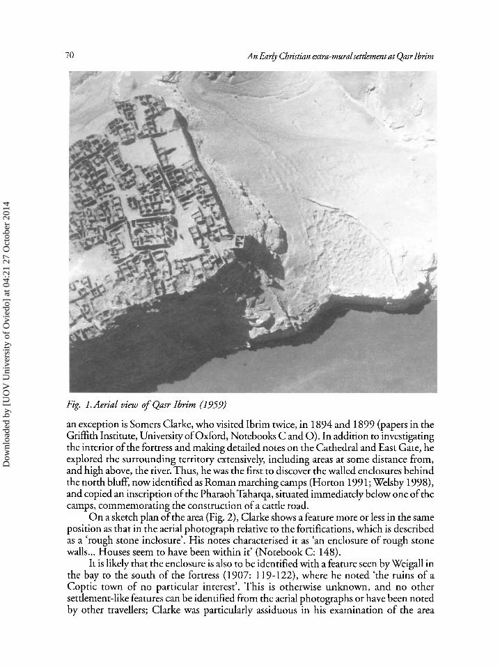
Recently, two previously unpublished aerial photographs of Qasr Ibrim came to light in the Egypt Exploration Society archives' . They were taken in 1959, and in addition to showing the interior of the fortress much as it was when abandoned in 1812, they also show the parts of the terraces closest to the fortress to its north and south, where the Post-Meroitic cemeteries 192 and 193 were situated (Mills 1982). Even a brief inspec- tion of the photographs shows that there are features other than the cemeteries visible on the terraces; it is one of these that the following paper will discuss,
One of the most conspicuous features on the aerial photograph, which covers the southern part of the fortress and the terrain to its south, is an enclosure close to the cliff edge on the plateau below the south-west fortifications (Fig. 1). This has elicited almost no comment from travellers visiting the area in the 19th and early 20th centuries, nor from archaeologists who surveyed or worked at the site before it was flooded. However,
' John Alexander, of course, directed excavations at Qasr Ibrim from 1980-86. This paper is in grateful recognition ofhis constant encouragement and enthusiasm which he has shown to the author in her work at Qasr Ibrim and elsewhere since then.
Dow
nloa
ded
by [
UO
V U
nive
rsity
of
Ovi
edo]
at 0
4:21
27
Oct
ober
201
4
An Early Christian extra-rnurulsettlernent at Qasr Ibrim
Fig 1. Aerial view of Qmr Ibrirn (1959)
an exception is Somers Clarke, who visited Ibrim twice, in 1894 and 1899 (papers in the Grifith Institute, University of Oxford, Notebooks C and 0). In addition to investigating the interior of the fortress and malung detailed notes on the Cathedral and East Gate, he explored the surrounding territory extensively, including areas at some distance from, and high above, the river. Thus, he was the first to discover the walled enclosures behind the north bluff, now identified as Roman marching camps (Horton 199 1; Welsby 1998), and copied an inscription of the PharaohTaharqa, situated immediately below one of the camps, commemorating the construction of a cattle road.
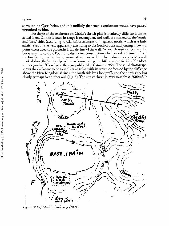
On a sketch plan of the area (Fig. 2), Clarke shows a feature more or less in the same position as that in the aerial photograph relative to the fortifications, which is described as a ‘rough stone inclosure’. His notes characterised it as ‘an enclosure of rough stone walls ... Houses seem to have been within it’ (Notebook C: 148).
It is likely that the enclosure is also to be identified with a feature seen by Weigall in the bay to the south of the fortress (1907: 119-122), where he noted ‘the ruins of a Coptic town of no particular interest’. This is otherwise unknown, and no other settlement-like features can be identified from the aerial photographs or have been noted by other travellers; Clarke was particularly assiduous in his examination of the area
Dow
nloa
ded
by [
UO
V U
nive
rsity
of
Ovi
edo]
at 0
4:21
27
Oct
ober
201
4
PJ Roe 71
surrounding Qasr Ibrim, and it is unlikely that such a settlement would have passed unnoticed by him.
The shape of the enclosure on Clarke’s sketch plan is markedly different from its actual form. On the former, its shape is rectangular, and walls are marked on the ‘south‘ and ‘west’ sides (according to Clarke’s assessment of magnetic north, which is a little adrift), that on the west apparently extending to the fortifications and joining them at a point where a feature protrudes from the line of the wall. No such feature exists in reality, but it may indicate the Podium, a distinctive construction which stood out visually from the fortification walls that surrounded and covered it. There also appears to be a wall marked along the ‘north’ edge of the enclosure, along the cliff top above the New Kingdom shrines (marked ‘F’ on Fig. 2; these are published in Caminos 1968). The aerial photograph shows the enclosure to be roughly triangular, with its west side formed by the cliff edge above the New Kingdom shrines, the south side by a long wall, and the north side, less clearly, perhaps by another wall (Fig. 3). The area enclosed is, very roughly, c. 2000m’. It
Fig. 2. Part of Chrke? sketch map (185’4)
Dow
nloa
ded
by [
UO
V U
nive
rsity
of
Ovi
edo]
at 0
4:21
27
Oct
ober
201
4
72 An Early Christian extra-muralsettlement at Qasrlbrim
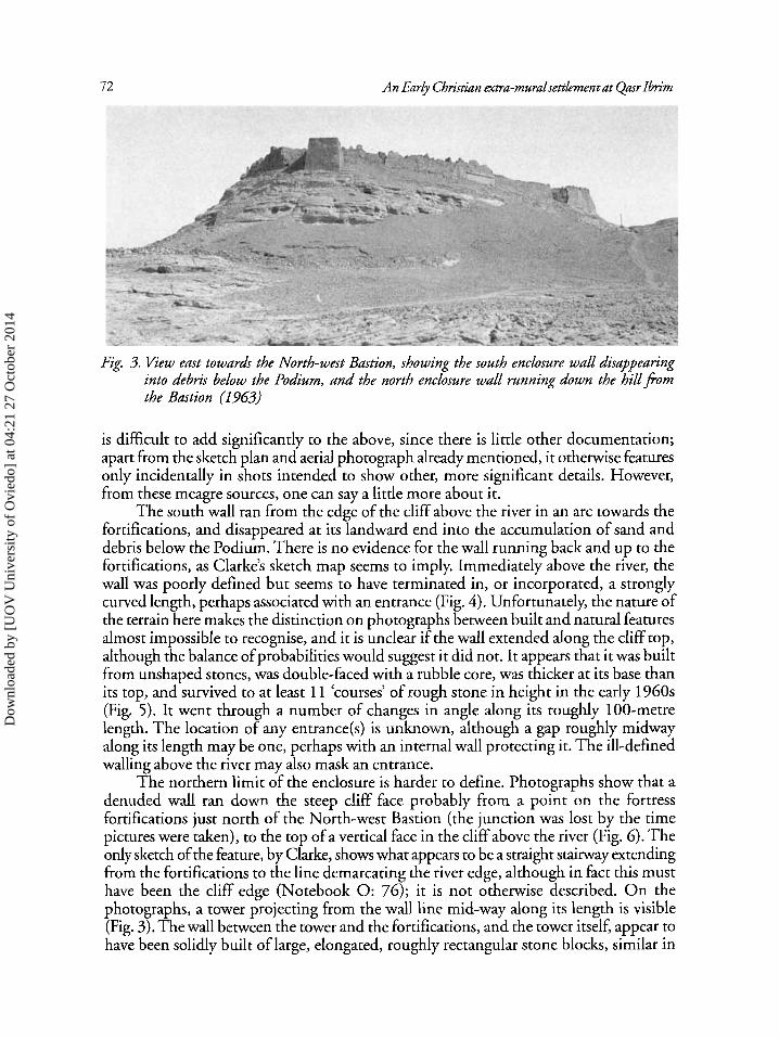
Fig. 3. View east towards the North-west Bastion, showing the south enclosure wall disappearing into debris below the Podium, and the north enclosure wall running down the hillfiom the Bastion (1963)
is difficult to add significantly to the above, since there is little other documentation; apart from the sketch plan and aerial photograph already mentioned, it otherwise features only incidentally in shots intended to show other, more significant details. However, from these meagre sources, one can say a little more about it.
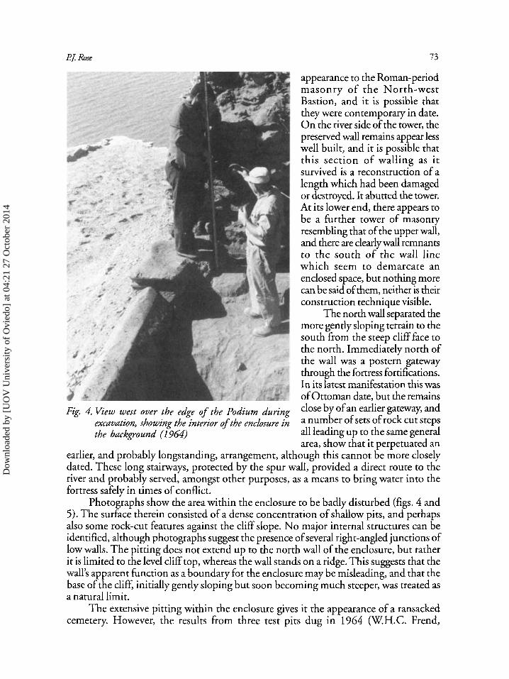
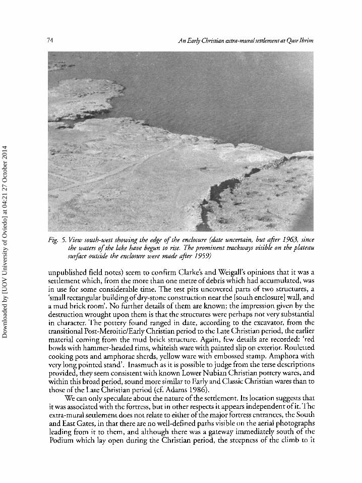
The south wall ran from the edge of the cliff above the river in an arc towards the fortifications, and disappeared at its landward end into the accumulation of sand and debris below the Podium. There is no evidence for the wall running back and up to the fortifications, as Clarke’s sketch map seems to imply. Immediately above the river, the wall was poorly defined but seems to have terminated in, or incorporated, a strongly curved length, perhaps associated with an entrance (Fig. 4). Unfortunately, the nature of the terrain here makes the distinction on photographs between built and natural features almost impossible to recognise, and it is unclear if the wall extended along the cliff top, although the balance ofprobabilities would suggest it did not. It appears that it was built from unshaped stones, was double-faced with a rubble core, was thicker at its base than its top, and survived to at least 11 ‘courses’ of rough stone in height in the early 1960s (Fig. 5) . It went through a number of changes in angle along its roughly 100-metre length. The location of any entrance(s) is unknown, although a gap roughly midway along its length may be one, perhaps with an internal wall protecting it. The ill-defined walling above the river may also mask an entrance.
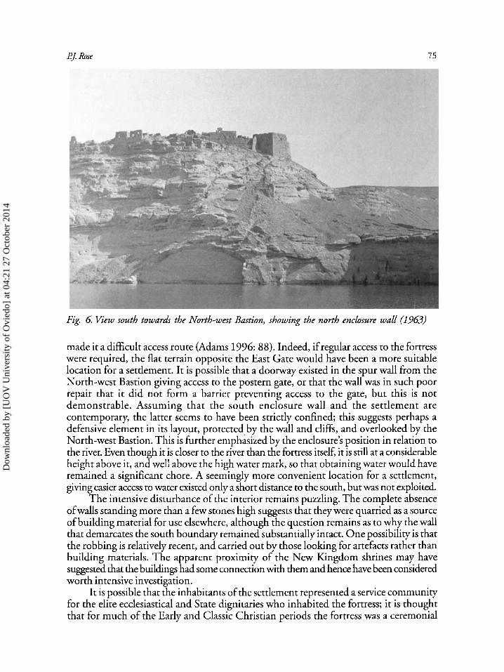
The northern limit of the enclosure is harder to define. Photographs show that a denuded wall ran down the steep cliff face probably from a point on the fortress fortifications just north of the North-west Bastion (the junction was lost by the time pictures were taken), to the top of a vertical face in the cliff above the river (Fig. 6). The only sketch of the feature, by Clarke, shows what appears to be a straight stairway extending from the fortifications to the line demarcating the river edge, although in fact this must have been the cliff edge (Notebook 0: 76); it is not otherwise described. O n the photographs, a tower projecting from the wall line mid-way along its length is visible (Fig. 3). The wall between the tower and the fortifications, and the tower itself, appear to have been solidly built of large, elongated, roughly rectangular stone blocks, similar in
Dow
nloa
ded
by [
UO
V U
nive
rsity
of
Ovi
edo]
at 0
4:21
27
Oct
ober
201
4
121. Rose 7 3
appearance to the Roman-period masonry of the North-west Bastion, and it is possible that they were contemporary in date. O n the river side of the tower, the preserved wall remains appear less well built, and it is possible that this section of walling as it survived is a reconstruction of a length which had been damaged or destroyed. It abutted the tower. At its lower end, there appears to be a further tower of masonry resembling that of the upper wall, and there are clearly wall remnants to the south of the wall line which seem to demarcate an enclosed space, but nothing more can be said of them, neither is their construction technique visible.
The north wall separated the more gently sloping terrain to the south from the steep cliff face to the north. Immediately north of the wall was a postern gateway through the fortress fortifications. In its latest manifestation this was of Ottoman date, but the remains 'lose gatmay and a number of sets of rock all leading up to the same general area, show that it perpetuated an
earlier, and probably longstanding, arrangement, although this cannot be more closely dated. These long stairways, protected by the spur wall, provided a direct route to the river and probably served, amongst other purposes, as a means to bring water into the fortress safely in times of conflict.
Photographs show the area within the enclosure to be badly disturbed (figs. 4 and 5) . The surface therein consisted of a dense concentration of shallow pits, and perhaps also some rock-cut features against the cliff slope. No major internal structures can be identified, although photographs suggest the presence of several right-angled junctions of low walls. The pitting does not extend up to the north wall of the enclosure, but rather it is limited to the level cliff top, whereas the wall stands on a ridge. This suggests that the wall's apparent function as a boundary for the enclosure may be misleading, and that the base of the cliff, initially gently sloping but soon becoming much steeper, was treated as a natural limit.
The extensive pitting within the enclosure gives it the appearance of a ransacked cemetery. However, the results from three test pits dug in 1964 (W.H.C. Frend,
Fig. 4. View west over the edge of the Podium during excavation, showing the interior ofthe enclosure in the background (1364)
Of an
Dow
nloa
ded
by [
UO
V U
nive
rsity
of
Ovi
edo]
at 0
4:21
27
Oct
ober
201
4
74 An Ear& Christian extra-muralsettlement at Qasr Ibrim
Fig. 5. f iew south-west showing the edge of the enclosure (date uncertain, but afier 1963, since the waters of the lake have begun to rise, The prominent trackways visible on the plateau surface outside the enclosure were made aJer 1959)
unpublished field notes) seem to confirm Clarke’s and Weigall’s opinions that it was a settlement which, from the more than one metre of debris which had accumulated, was in use for some considerable time. The test pits uncovered parts of two structures, a ‘small rectangular building of dry-stone construction near the [south enclosure] wall, and a mud brick room’. No hrther details of them are known; the impression given by the destruction wrought upon them is that the structures were perhaps not very substantial in character. The pottery found ranged in date, according to the excavator, from the transitional Post-MeroitidEarly Christian period to the Late Christian period, the earlier material coming from the mud brick structure. Again, few details are recorded: ‘red bowls with hammer-headed rims, whiteish ware with painted slip on exterior. Rouletted cooking pots and amphorae sherds, yellow ware with embossed stamp. Amphora with very long pointed stand’. Inasmuch as it is possible to judge from the terse descriptions provided, they seem consistent with known Lower Nubian Christian pottery wares, and within this broad period, sound more similar to Early and Classic Christian wares than to those of the Late Christian period (cf. Adams 1986).
We can only speculate about the nature of the settlement. Its location suggests that it was associated with the fortress, but in other respects it appears independent of it. The extra-mural settlement does not relate to either of the major fortress entrances, the South and East Gates, in that there are no well-defined paths visible on the aerial photographs leading from it to them, and although there was a gateway immediately south of the Podium which lay open during the Christian period, the steepness of the climb to it
Dow
nloa
ded
by [
UO
V U
nive
rsity
of
Ovi
edo]
at 0
4:21
27
Oct
ober
201
4
PJ Rose 75
Fig. 6 Kew south towards the North-west Bastion, showing the north enclosure wall (1963)
made it a difficult access route (Adams 1996: 88). Indeed, if regular access to the fortress were required, the flat terrain opposite the East Gate would have been a more suitable location for a settlement. It is possible that a doorway existed in the spur wall from the North-west Bastion giving access to the postern gate, or that the wall was in such poor repair that it did not form a barrier preventing access to the gate, but this is not demonstrable. Assuming that the south enclosure wall and the settlement are contemporary, the latter seems to have been strictly confined; this suggests perhaps a defensive element in its layout, protected by the wall and cliffs, and overlooked by the North-west Bastion. This is further emphasized by the enclosure’s position in relation to the river. Even though it is closer to the river than the fortress itself, it is still at a considerable heighr above it, and well above the high water mark, so that obtaining water would have remained a significant chore. A seemingly more convenient location for a settlement, giving easier access to water existed only a short distance to the south, but was not exploited.
The intensive disturbance of the interior remains puzzling. The complete absence of walls standing more than a few stones high suggests that they were quarried as a source of building material for use elsewhere, although the question remains as to why the wall that demarcates the south boundary remained substantially intact. One possibility is that the robbing is relatively recent, and carried out by those looking for artefacts rather than building materials. The apparent proximity of the New Kingdom shrines may have suggested that the buildings had some connection with them and hence have been considered worth intensive investigation.
It is possible that the inhabitants of the settlement represented a service community for the elite ecclesiastical and State dignitaries who inhabited the fortress; it is thought that for much of the Early and Classic Christian periods the fortress was a ceremonial
Dow
nloa
ded
by [
UO
V U
nive
rsity
of
Ovi
edo]
at 0
4:21
27
Oct
ober
201
4
76 An Early Christian extra-muralsettlement at Qmr Ibrim
centre with little in the way of an ‘ordinary’ population (Adams 1996: 3,6). It may, on the other hand, have been a temporary shelter for those visiting Qasr Ibrim, whether in the capacity of pilgrims or perhaps as traders or other travellers needing a safe stopping point for the night, in the manner of a caravanserai or khan. Whether this could be the ‘Lower Ibrim’ mentioned in an Old Nubian text (Browne 1991: 45) is unknown, but the settlement in the enclosure appears too small, and its location too awkward, to house a substantial, long-term population.
References
Adams, W.Y. 1986. Ceramic Industries of Medieval Nubia. (2 vols). Lexington: Kentucky University Press.
Adams, W.Y. 1996. Qasr Ibrim - The Late Christian Period. (Egypt Exploration Society, 59& Excavation Memoir). London: Egypt Exploration Society.
Browne, G.M. 1991. Old Nubian Zxtsfiom Qasr Ibrim III. (Texts from Excavations, 12‘h Memoir). London: Egypt Exploration Society.
Caminos, R. 1968. The Shrines and Rock-inscriptions o f Ibrirn. (Archaeological Survey of Egypt, 32”d Memoir). London: Egypt Exploration Society.
Horton, M. 1991. ‘Mrica in Egypt: new evidence from Qasr Ibrim’, in W.V. Davies (ed.), Egypt and Ajkca: Nubiafiom Prehistory to Ishm. London: British Museum Press.
Mills, A.J. 1982. The Cemeteries of Qmr Ibrim. (Egypt Exploration Society, 51’‘ Excavation Memoir). London: Egypt Exploration Society.
Weigall, A. 1907. A Report on the Antiquities of Lower Nubia (the First Cataract to the Sudan Frontier) and their Condition in 1906-7. Oxford: Oxford University Press.
Welsby, D. 1998. ‘Roman military installations along the Nile south of the First Cataract’, ArchPoLogie du Nil Moyen 8: 157-82.
Dow
nloa
ded
by [
UO
V U
nive
rsity
of
Ovi
edo]
at 0
4:21
27
Oct
ober
201
4