Embed Size (px)
Citation preview
DTIC FILE COPYETL-0566
AD-A223 749
The Landforms ofGranitic Rocks:An Annotated Bibliography
Judy Ehlen
DTIC.:; ELECTE I..,,,. JUN28. IM
May 1990
Approved for public release; distribution is unlimited.
U.S. Army Corps of EngineersEngineer Topographic LaboratoriesFort Belvoir, Virginia 22060-5546
,( 0 044
0
Destroy this report when no longer needed.Do not return it to the originator.
The findings in this report are not to be construed as an officialDepartment of the Army position unless so designated by otherauthorized documents.
The citation in this report of trade names of commercially availableproducts does not constitute official endorsement or approval of theuse of such products.
REPORT DOCUMENTATION PAGE JO AMpp 181OW .. @7044 UN
ieto of WWed9W A2 tO i i~g e9 IP ornI1e (IttiO W "#sow*~ %rO4C@ 0tomee a"mo~e 6:2p es08" VAee sin 0%160 Pawwwt UsiwM ftna *ilUW&"ft "I11
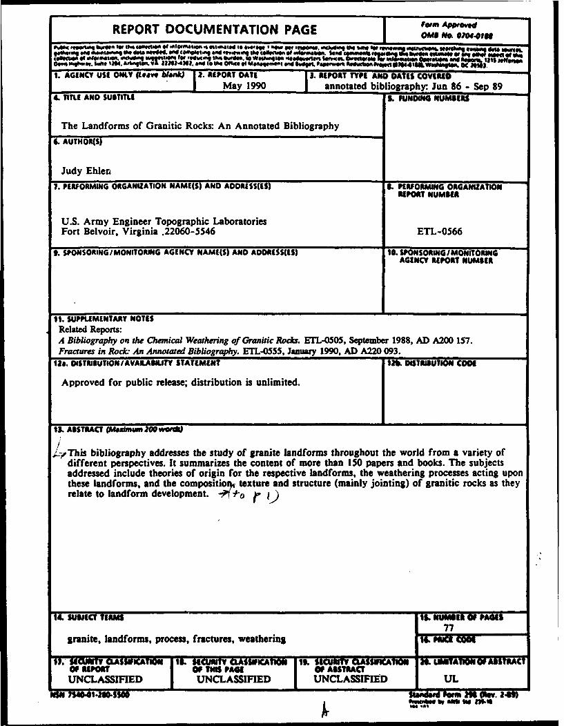
1. AGENCY USE ONLY (Leavt blankJ 2. REPORT DATE 3. REPORT TYPE AND OATES CCOVEI May 1990 annotated bibliography: Jun 86 - Sep 89
4. TITLE AND SUBTITLE S. FUNDING NUMBERS
The Landforms of Granitic Rocks: An Annotated Bibliography
6. AUTHOR(S)
Judy Ehler,
7. PERFORMING ORGANIZATION NAME(S) AND ADDRESS(ES) I. PERFORMING ORGANIZATIONREPORT NUMBER
U.S. Army Engineer Topographic LaboratoriesFort Belvoir, Virginia .22060-5546 ETL-0566
g. SPONSORING/MONITORING AGENCY NAME(S) AND ADDRESS(ES) 10. SPONSORING/MONITORING
11. SUPPLEMENTARY NOTESRelated Reports:A Bibliography on the Chemical Weathering of Granitic Roc*s. ETL-0505, September 1988, AD A200 157.Fractures in Rock An Annotated Bibliography. ETL-0555, January 1990, AD A220 093.
12a. DISTRIlUTION/AVAlABNlT'Y STATEMENT t12b DISTRIBUTION CODE
Approved for public release; distribution is unlimited.
I&3 ABSTRACT (Mfalnum 20 womW
,_/ iThis bibliography addresses the study of granite landforms throughout the world from a variety ofdifferent perspectives. It summarizes the content of more than 150 papers and books. The subjectsaddressed include theories of origin for the respective iandforms, the weathering processes acting uponthese iandforms, and the compositiotf texture and structure (mainly jointing) of granitic rocks as theyrelate to landform development. ,
14. SUWEI TERMS 15. M"14 Of PAdiS77
granite, landforms, process, fractures, weathering 16. PWrIC Moo
11. CUWRITV CLASS* ICUMT CLASSIVICATIO 11It. SECURITY ASSIWCAT1U U. ft ITMATIONf ABSTRACTOF MPOWllr Of TI A1 OF AITRAC rUNCLASSIFED 7 UNCLASSIFIED UTNCLASSIF1ED UL
r ~ ~ WW W No "0t Moelt
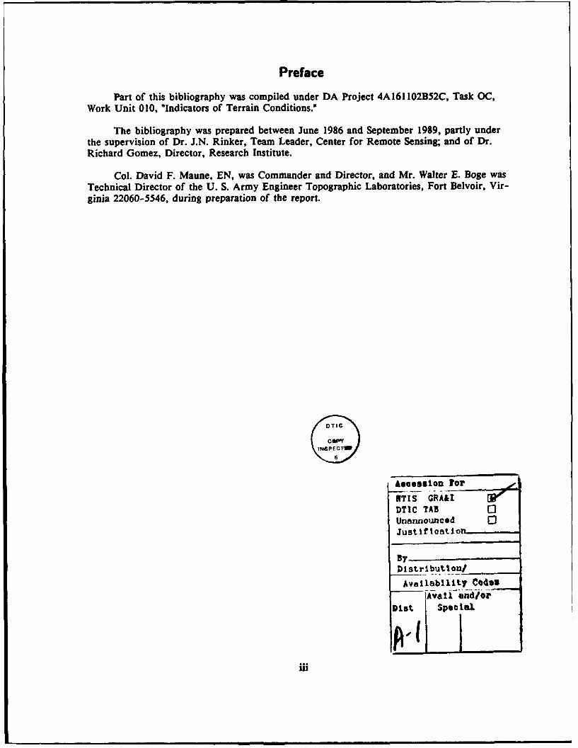
Preface
Part of this bibliography was compiled under DA Project 4A161102B52C, Task OC,Work Unit 010, "Indicators of Terrain Conditions."
The bibliography was prepared between June 1986 and September 1989, partly underthe supervision of Dr. J.N. Rinker, Team Leader, Center for Remote Sensing; and of Dr.Richard Gomez, Director, Research Institute.
Col. David F. Maune, EN, was Commander and Director, and Mr. Walter E. Boge wasTechnical Director of the U. S. Army Engineer Topographic Laboratories, Fort Belvoir, Vir-ginia 22060-5546, during preparation of the report.
DTGLeassilon Tor
NTiSi GRA&IDTIC TAB [3Unannounced 03Justificatio
ByDistribution/
Avalability CodesAvail and/or
Dist specialPAU,
Introduction
This annotated bibliography presents summaries of more than 150 papers and booksabout landforms composed of granitic rock. The subjects addressed include theories of origin,processes of formation, weathering processes, and the geological and structural properties ofgranites as they affect landform development. Many different types of granite landforms,including tors, tafoni, boulders, and inselbergs, are addressed, with the exception of graniteplains.
The bibliography is an outgrowth of a long-term study that attempts to identify differ-ent rock types on aerial imagery by determining their characteristic patterns. Granitic rockswere selected for study for the following reasons: r,
Lic)!
1) they are relatively common; ,
2) their image patterns are fairly well understood and documented; . -
3) they form distinctive landform assemblages that should be readily identifi- i - /able from imagery; and
4) they have equally distinctive fracture patterns that can serve as an aid toidentification.
The study of the rock characteristics and fracture patterns also complements research on fluidflow in fractures and fracture flow networks as well as on the identification of fracture pat-terns at depth. Granitic rocks are of particular interest with respect to fractures in relation totheir potential as repositories for toxic and nuclear waste. In addition, many studies of frac-tures in rock, whether simply for gaining an understanding of how fractures initiate andpropagate or for more practical applications, are done using granitic rocks.' Because, as willbecome clear below, fractures tend to control landfo,. in granitic rocks, the study of granitelandforms is highly relevant to many similar applications, civil and military. In addition tothose mentioned above, such applications include cross-country mobility, location of groundwater sources, location of engineering materials (sand, gravel, etc.) and site selection for engi-neering structures, such as dams.
The geologic literature on granites worldwide is huge. Granites have always attractedattention, partly because of their mode of origin and what they can tell us of processes oc-cuffing deep within the crust, but mainly because they are typically highly mineralized.Granites, or their metamorphic aureoles, are major sources of copper, tin, silver, gold, andmany other valuable commodities. They are naturally highly radioactive, particularly at depth,and are thus sources of heat and geothermal energy. They have been used for centuries asbuilding materials and in the construction of monuments, so much so that any coarse-grainedrock used by the building trade is called granite regardless of its true identity.
1 Douke, PJ., 2ms, O.V., Hodshami, D.P. ad lvmmovtM, U. 1962. An appreo to pIedtic at wmor flow maddimudle hwamept mog bsttwed wreek. In v I ltki h, 000 . - f A
Procesdih of a Nudwes Ma Ageny Woadhop (Otwa, Oad). Prt: Ofornitsm 1semisCo-opwason ad Dwop smt, pp. IS-106 b. m umanhof paactpka( appletlos.
The study of granite landforms has fascinated people for over 150 years and the num-ber of published papers on the subject is very large. Much of the early literature was obser-vational or descriptive. MacCulloch (1814), for instance, describes the peculiar effects ofweathering on some Cornish tors2 and Ormerod (1859, 1869) is concerned with the origin ofrock basins. Geomorphological interest seems to have waned in the latter part of the 19thcentury and first half of the 20th century, but Linton's 1955 paper on the origin of torsforced new interest and much controversy, and can perhaps be defined as the beginning ofmodern interest in the subject.
Three main theories of origin for granite landforms have been suggested. These are:1) the two-stage theory, which involves deep, sub-surface, chemical weathering followed by(probably periglacial) removal of the weathered debris; (2) the theory of pediplanation (paral-lel retreat) followed by rejuvenation; and (3) the periglacial theory involving frost action andsolifluction. The two-stage theory was proposed by Handley in 1952 with reference to tors inTanganyika (modern Tanzania). Twidale and Mueller (1988), however, state that Hassenfratzwas the first to suggest a two-stage origin for granite landforms in his 1791 paper *Surl'arrangement de plusieurs gros blocs de differentes pierres que l'on observe dans lesmontagnes" published in Annales de Chimie. Regardless of when it was initially proposed, thetheory was "popularised" by Linton in his 1955 paper. The pediplanation theory was firstespoused by Davis in 1933 for granite domes in the Mohave Desert in California. King (1958,1966, 1975), who has applied this theory extensively in southern Africa, is the most forcefulmodern proponent. The periglacial theory was published in 1930 by Albers with reference toDartmoor in southwest England, but he attributes its first application to R.N. Worth in his1898 paper "Some phases of Devonian detrital geology" published in the Transactions of thePlymouth Institution. Palmer and Radley (1961) have applied this theory to the granite tors ofDartmoor using their knowledge of the gritstone tors in Yorkshire in northeast England.
All three theories have received support from other workers as well. The two-stagetheory is supported by, among others, Ruxton and Berry (1959), Eden and Green (1971), Jahn(1974), Twidale and Bourne (1975a), Dyke (1976) and Twidale and Mueller (1988), whereasMabbutt (1952), Ollier and Tuddenham (1961), Rahn (1966) and Ojany (1969) support King'stheory, and Palmer and Neilson (1962) support the periglacial theory. Demek (1964) supportsthe two-stage hypothesis for granitic landforms, but prefers the periglacial theory of Palmerand Radley (1961) for landforms composed of metamorphic rock.
There has been much controversy, some of it quite acrimonious, over these three theo-ries. Most of the controversy was between King and Linton; much of it was initiated byKing. King cannot accept the two-stage hypothesis because he sees no evidence of deepchemical weathering associated with the granite landforms with which he is familiar (1966,1975). Since the mid-1960's, however, most workers use combinations of these theories toexplain the landforms in granitic rocks. The vehemence of earlier exchanges has disappearedand cooler heads advance the concept of convergence (White, 1945) or equifinality (ertal-lanffy, 1950), i.e. that different processes operating on forms of different origins can producethe same result.3 These include Brunsden (1964), Cunningham (1965, 1968), Leigh (1970),
* * local name in souShwuat 3nglad hr a premet, usually IslebSud, mck outcrap. The wod i derived how
a Cornis wod mmaing tower.
Sert nanelf .J. vn. 1010. An melat of gode alnst Oho. ]4fltl .Jooal f. the PhfUlmhvofLdg* Val. 1.pp. 184-145.
2
Thomas (1974), Selby (1977a), Brook (1978), Oilier (1978b), and Gerrard (1984). 4 The con-cept of a structural origin for granite landforms has also received renewed attention, particu-larly in the work of Twidale in Australia (1964, 1973, 1982b). He advocates a theory of com-pressional jointing that is not dissiiiiiar to theories presented earlier concerning sheeting andexfoliation (Gilbert, 1904; Bain, 1923). Another interesting theory is that presented by Selby(1972) for Antarctic tors which involves salt crystallization.
As implied above, interest in granites and granite landforms exists worldwide. In Brit-ain, where much research on this subject has been done, granite landforms have been studiedby Waters (1957), Brunsden and Gerrard (1970), Gerrard (1978, 1982) and Ehlen (1989b), allof whom worked on Dartmoor in southwest England. Wagner (1913), King (1949, 1958, 1966,1975), Mabbutt (1952), Jeje (1973, 1974), Thomas (1965), Thorp (1967a, 1967b), and Pye etal. (1984) and Pye et al. (1986) have studied various aspects of granite landforms in Africa. InAustralia, Ollier (1965, 1978b), Oilier and Tuddenham (1961), and Twidale (1964, 1980, 1981,1982a, 1982b, 1986) are the major researchers in the study of granite landforms. The HongKong granites were studied by Ruxton and Berry (1957, 1959) and those in Singapore byTschang (1961). In the United States, Gilbert (1904), Davis (1933), Willis (1934), White (1944,1945), Wahrhaftig (1965) and Cunningham (1969, 1971) have published on the subject. Demek(1964) worked in Czechoslovakia, and Jahn (1974) and Dumanowski (1964, 1968) in Poland.Granitic rocks in cold climates were studied by Oen in Greenland (1965), by Selby (1972) andDerbyshire (1972) in Antarctica, and by Dyke (1976) in the Canadian Arctic.
There is also a large body of literature on the weathering of granitic rocks, much ofwhich relates weathering processes to landform development and evolution; such papers aretherefore included here. Oilier (1984) provides good general discussions of physical andchemical weathering as well as specific information on granitic rocks. His bibliography is agood source for additional reading. A more recent survey of papers on the chemical weath-ering of granitic rocks is provided by Ehlen and Gerrard (1988). Early work on the physicalweathering of granitic rocks was done by Blackwelder. He investigated exfoliation (1925), fire(1926) and insolation (1933) as possible weathering agents.' Ollier (1971) discusses a numberof different hypotheses for the origin of spheroidal forms, and also addresses induced frac-ture as a form of physical weathering (Oilier, 1978a). Crickmay (1935) in the southern Appa-lachians and Blank (1951b) in Texas conclude that the main process acting on granitic rocks isgranular disintegration. Granular disintegration is often cited as the major cause for tafoni aswell (Dragovich, 1969; Bradley et al., 1978). Kesel (1977) cited sheeting and spalling as themajor process in central Arizona. Crystal growth, usually salt or ice, is a common form ofphysical weathering. Palmer and Radley (1961) and Palmer and Neilson (1962) suggest freeze/thaw is largely responsible for gritstone and granite tors in England, and Kelly and Zumberge(1961) found salt weathering in conjunction with freeze/thaw was the major process formingtors in the Dry Valleys of Antarctica. King (1949, 1966, 1975), of course, strongly advocatesphysical processes for the origin of granite landforms in southern Africa, as does Mabbutt(1952).
A number of authors have addressed relations between the mineralogical and texturalcharacteristics of granitic rocks and their landforms because these factors play important roles
4 Gerrd, AJ.W. 1964. Multipie werkiag hypothbe and equlft&nlty in psomoepholg: Comment on reget icleby Haine-Young and Petch. Transctions of the Institute of British Geommhere. vol. 9. pp. 364-e66.
6 Blackwelder, Z. 1926. Fir wa a= Met in rock weethering. Jaural of Golo. vol. 35, pp. 154-140; and Blsckw dr,3. 19n. The Wsolation hypothees of rock wathering. American Journal of Science vol. 26. pp. 97-113.
3
in determining the resistance of rocks to weathering. Certain minerals are more resistant ioweathering than others because of their compositions, thermal expansion characteristics and/-or compressibilities (Ehlen and Zen, 1986).6 For example, mafic rinerals, such as biotite,weather relatively rapidly whereas minerals with low iron and mignesium contents or withnone at all, such as quartz and feldspar, are much more resistant. Mafic minerals are moremobile and the chemical bonds in these minerals are more easily broken. These types of con-siderations help explain why areas underlain by the more mafic granitic rocks, such as dioriteor tonalite, often occur at lower elevations and have less relief than nearby areas composed ofgranite or granodiorite. This also helps explains why inselbergs are composed of granites andgneisses, a metamorphic rock similar in composition to granite, rather than of diorites orquartz diorites.
Lithologic or petrographic boundaries commonly coincide with landform boundaries.Such relations were found by Demek (1964) who worked in the Bohemian granites, Eggler etal. (1969) who studied the Sherman granite in the western U.S.A., Jeje (1973) in Nigeria andOilier (1978b) who worked on granites in the Namib Desert. Hack (1966), King (1975) andBrook (1978), on the other hand, found no relation between landform and lithology. Duma-nowski (1964, 1968) in Poland, Brook (1978) and Robb (1979) in South Africa and Pye et al.(1986) in Kenya have identified relations between granite landforms and the potassium feld-spar content of the rocks that form them. The inselbergs tend to have high potassium feldsparcontents whereas rocks in areas without inselbergs tend to be low in potassium feldspar.Ehlen's (1 989b) work on Dartmoor in southwest England further substantiates these relationsin that the larger, more massive tors have more potassium feldspar in the ground mass andalso contain more large potassium feldspar megacrysts.
Rock texture may be important with respect to landform development as well. Gibbons(1981), Pye et al. (1984) and Ehlen (1989a; 1989b) identified significant relations betweentexture and resistance to weathering. They found porphyritic granites are more resistant thannon-porphyritic granites. Megacrysts in granitic rocks are usually composed of potassiumfeldspar, so this textural evidence supports conclusions based on the lithologic data. Pye(1986) has summarized much of the data relating rock texture and landform.
The relation between joints and granite landforms is mentioned in a general way inmany papers, but details are seldom provided, except with reference to sheeting joints. Jointsare usually described as controlling the general outline of the landform by allowing water intothe rock, thus becoming the locations for chemical weathering. Jones (1859), Bain (1923),King (1949, 1966), Linton (1955), Waters (1957), Brunsden (1964), Feininger (1969), Thomas(1974), Twidale and Bourne (1976, 1978) and Pye et al. (1984) are examples. Many workers,including Ormerod (1859, 1869), Wagner (1913), Mabbutt (1952), Thomas (n.d.), Twidale(1964, 1982b), Cunningham (1971) and Brook (1978), point out that certain landforms aredefined in terms of jvint spacing, e.g. domes develop only where joints are very widelyspaced. Most papers referring to joint spacing, however, merely state that horizontal spacingincreases with depth or give ranges in spacing values for vertical joints (Jahns, 1943; Kies-linger, 1960; Oen, 1965; Twidale, 1973; Lee et at., 1979).
Only Gerrard (1974, 1978, 1982) and Ehlen (1989a, 1989b), however, have specificallyaddressed the importance of jointing in the evolution of granite landforms. Gerrard (1974)showed that weathering along joints is responsible for the initial compartments or domes on
6 shift, J. Md Zen, E. 1NS. PeMoraph or aff ctnointgin the Bdem Sere, 8tiflwer W Coe, Mn-tans. mnal of G20o.a Vol. 94, pp. 576-4.
4
Dartmoor in southwest England in that the drainage net is controlled by the major regionalfractures. Tors develop on the domes as a result of 'secondary" jointing. This jointing iscaused by stress release within compartments on the domes and results from further, morelocalized weathering and stream incision. In a later paper (1978), he showed that ton arelocated where differential physical and chemical weathering can have occurred and where theweathered material could be removed. In other words, tors occur where joints are closelyspaced in comparison to the rest of the dome, but not so closely spaced that everything isweathered and removed. Using mean joint spacing data, Ehlen (1989) has identified possiblepathways and restrictions in the evolution and development of granite landforms definedaccording to topographic position.
One cannot study the landforms developed in granitic rocks as isolated individuals; eachsuite has a history and each individual has evolved from something and will probably evolveinto something else before it disappears. An understanding of the weathering characteristicsof granitic rocks is thus integral to an understanding of the shapes of landforms composed ofthese rocks. Likewise, there is a general consensus that joint patterns probably control land-form shape, and that other factors, such as mineralogy, grain size and rock texture, also playimportant roles in this relationship. In addition, there is some evidence that certain combina-tions of characteristics lead to specific types of landforms in certain environments. Moreover,an understanding of the range in forms and their variations and possible origins provides aframework for evaluating any specific suite of granite landforms, most of which probablyevolved in climates different from those of the present day. Study of such characteristics isone way to gain an understanding of landform evolution which cannot practically be observedas it occurs. This bibliography brings together the results of research done over the past 175years on all these subjects. The papers are written by people from many parts of the worldwith different backgrounds and different perspectives, so each paper included providesunique insight into the puzzle that is the development of landforms in granitic rocks.
All references cited in the annotations are included in this bibliography except whenthe citation is given in a footnote. In addition, all papers are in English or contain a summaryin English. Finally, unless other rock types are specified, all papers refer to granite. Key-words are given for each paper.
5
Albers, G. 1930. Notes on the tors and the clitter of Dartmoor. Transactions of the Devonshire
Association for the Advancement of Science. Literature and Art, vol. 62, pp. 373-378.
Keywords: boulders, weathering, frost action, southwest England
Most tors exhibit pseudobedding as well as vertical fissures but the latter are far lesscommon.7 Most also have vertical slopes. Scree occurs at the bases of outcrops, becomingone-foot thick blocks of clitter down slope. When there are only a few blocks, they lie flat onthe surface, but when there are many, they are horizontal, vertical or inclined, i.e. they dipback into the slope. Theories of clitter emplacement by ice-rafting and by sliding down snowslopes are discounted, and Worth's (1898)8 suggestion that solifluction is in part responsible issupported. The author expands on Worth's theory by adding the concept of "pushing down byfrost produced regelation" (p. 377). He cannot refute that the ton may be pre-Pleistocene, butbelieves they are mainly Pleistocene in origin. He believes the tors were split into slabs byfrost action. Differences between granite and aureole tors are noted.
Bain, A.D.N. 1923. The formation of inselbergs. Geological Magazine, vol. 60, pp. 97-101.
Keywords inselbergs, granite gneiss, theory, jointing, Nigeria
The purpose of the article is to show, from a study of Nigerian inselbergs, that thealternating wet and dry climate of the Sudan is favorable to inselberg formation. Existingtheories of formation are listed. Two types of inselbergs occur. 1) dome-shaped, steep-sided,unscaleable ones formed of coarse-textured, porphyritic granite gneiss, and 2) less perfectlyshaped, scaleable ones formed of other types of gneiss. Three main factors control formation:climate, jointing and the nature of the rock. Good jointing occurs only on a very large scale.Chemical weathering occurs along joints, but between joints only exfoliation occurs. Weath-ered debris is removed during the wet season, leaving a fresh surface to be attacked. Vegeta-tion keeps moisture available in the dry season for further chemical weathering. This resultsin long, narrow valleys with steep-sided ridges between. The same procedure occurs alongcross joints, eventually producing isolated inselbergs. The nature of the rock is least impor-tant, but uniformity of texture and the absence of foliation lead to more perfect inselbergs.Rock surfaces are often rough. Exfoliation is caused by diurnal temperature changes. Theslabs vary between 1 and 5 feet thick. Horizontal joints also play a part.
7As e " o , -te Is haea at rek oucP, aWpaa deulyed Irm a ormia word a e.CUttw rlo to Iarge deta&hed bo M. the o nac of the somA, thnat mua eaer dow aP fom a t. Pawd-obeddfl. ,oh a loca tun, atm to a teem of homtttl Jaklalg ia whch theos ar adoe* spe ed vy wavy md-m - tm had a nfaeo.
Ii. Worth. . Sme pbaoute Dovenm deft ga Oa. sain dtt'Plhu. o page umbmr.
6
Bakker, J. P. 1960. Some observations in connection with recent Dutch investigations aboutgranite weathering and slope development in different climates and climate changes. Zeit-schrift fir Geomorphologie, Supplement 1, pp. 69-92.
Keywords: clay, weathering, climate, soils, rock basins
This article revolves around two questions: 1) How does spheroidal weathering, prede-termined at some depth, proceed in different climates? and 2) What are the final clay weath-ering products in different climates? Chapman and Greenfield's (1949) theory of concentricexfoliation is summarized and accepted. Schermerhorn (1959)9 found that woolsacks (roundedboulders) only occur where potassium feldspar is abundant, and generally where it formsmegacrysts. He also found that woolsacks are typical forms in areas where relief is low. Threeweathering periods are defined. The first is a red-yellow weathering, similar to the red-yellow U.S. podzols, where kaolinite predominates and the climate is Koppen's Cw, CFa orCXa.10 This was probably early Pliocene. The second period probably began in late Plioceneand continued into the first interglacial. It consists of red-yellow profiles, which can occurbeside bleached profiles, that are illite dominated. The climate was Mediterranean. The thirdperiod is characterized by grayish-brown and brown, illite-dominated soils in Western Eu-rope. Thus it follows that ultimate weathering products differ and depend on climate andvegetation. Acid and alkaline weathering products from granite are different, the formerhaving a much larger clay fraction. The author indicates that rock basins form under alkalineconditions.
Barton, D. C. 1916. Notes on the disintegration of granite in Egypt. Journal of Geology, vol.
24, pp. 382-393.
Keywords. Egypt, weathering, exfoliation, disintegration
Massive granular disintegration with accompanying kaolinization, which decreases withdepth, is the norm in the Aswan region. The main type of present-day disintegration is exfo-liation, although loosening of fragments from roughened surfaces and spalling also occur. Therock is a red, coarse, porphyritic granite. Joints are comparatively far apart; where they areclose together, less exfoliation is evident. Nearby fine-grained granite is much less affectedand is heavily jointed. The rate of disintegration is much slower than stated by previousworkers. Disintegration is greater further north, at Luxor, Karnak and Cairo, on statues andpyramids. These suggest a rate of I to 0.5 cm in 5000 years. Disintegration is due to moisture.
9 Schermrorn, LJ.G. 1969. Igneous. motamornhic and ore mology of the Castro Daire-Sao Pedro do Sul-Kataormdon (Northn Portundl. Unpublished thebs, Ametedam, University of Amsterdam, no pap numbers.
10 Cw is a China-type cimate, characteuistlc of a tropical monsoon region, where ummer temperatus are about thesame a those of a tropical rainforest and rainfal Is high. CIa& and Owe climates an characterized by hot humid sum-mere and modeately cool winter.
7
Bisdom, E. B. A. 1967a. The role of micro-crack systems in the spheroidal weathering of an
intrusive granite in Galicia (NW Spain). Geologie en Mijnbouw, vol. 46, pp. 333-340.
Keywords: Spain, granite, weathering, microcracks, flaking
Pressure release is generally accepted as the cause of large-scale sheeting and domeformation, but its relation to scaling and flaking is unknown. Chapman and Greenfield (1949)suggested dilation due to hydrolysis, oxidation and carbonation, and Schattner (1961)11 sug-gested decreasing strength away from cooling centers. The granite, a coarse-grained, biotite-hornblende granite, was separated into zones ranging from unweathered rock with only struc-tural microcracks to weathered material with released scales. Structural microcracks in zone 1can be distinguished from weathering microcracks in zones 2 and 3 by the absence of ironoxide and by their straightness and their angular intersections. Microcracks occur in twoways: 1) directed toward the core and 2) parallel to the outer surface. The scales themselvesare filled with sinuous microcracks arranged as overlapping discoids. Boulders becomes con-centric because weathering is most intense on corners. The following distinction in terminol-ogy is proposed: "Spheroidal weathering thus applies to the arrangement of scales and flakesaround the boulder, and concentric banding to the crack system involved" (p. 357). Concentricbanding disappears toward the center of a disintegrated boulder because the cracks within thescales continue to enlarge. These results are supported neither by Schattner's theory nor, atthis scale, by pressure release theories.
_ 1967b. Micromorphology of a weathered granite near the Ria de Arosa (NW Spain).
Leidse Geologische Mededefingen, vol. 37, pp. 33-67.
Keyword= Spain, weathering, microcracks, clay, granite
The purpose of this study is to obtain insight into weathering phenomena at the micro-scopic scale. The rock is a coarse-grained, biotite-hornbleade granite, forms tors and is post-tectonic and late Hercynian in age. The climate is humid temperate with cool summers. Ini-tially, weathering proceeds mainly along joints. The weathering environment in closed jointsis reducing. Weathered material along joints is finer-grained. Bisdom (1967a) is summarized.Weathering stages in saprolite are described. The more coarsely grained the granite, the largerare the boulders produced. An oscillating water table chiefly affects secondary minerals alongjoints, not in the weathered material adjacent. Soils are described. Saprolite can be separatedfrom colluvium in this area on the basis of heavy minerals. Gibbsite occurs only in the finestfractions whereas kaolinite is ubiquitous. Gibbsite results from weathering of the plagioclase,and kaolinite, from weathering of biotite. Feldspars weather along microcracks. The ways inwhich feldspar, biotite and mu. ovite are thought to weather are discussed. Kaolinite andmetahalloysite are the most common clar minerals. The fabrics of the weathering profiles aredescribed using Brewer's (1964) system. 2 There is more clay in weathering profiles affectedby oscillating water tables. Greater thicknesses of saprolite occur in coarser-grained rocks.
Sc1 hutn, I. 1961. Weathernphae n the aytallim ott Sishaii tI Iw ght oeferms m HoOe, 5jllgidthe lmareh Council at Irel. vol. 10 0, pp. 247-206.
12 Brew, IL 1964. Faric and hdinmi Analys at Sal. Nw York: John Wiley and Sam, Inc., 410 pp.
8
Blackwelder, E. 1925. Exfoliation as a phase of rock weathering. Journal of Geology, vol. 33,
pp. 793-806.
Keywords: exfoliation, chemical weathering
Exfoliation is most common in granitoid igneous rocks. Existing theories are summa-rized. Blackwelder's observations indicate it is not a simple process. It is tensional, as indi-cated by the fact that the cracks are concentric around the boulder. The chief causes, tradi-tionally, are considered to be daily or hourly temperature changes produced by insolation andheat radiation. Existing theories are discussed and most are discarded. The author concludesthat exfoliation results from chemical decay in moist environments, where hydration andoxidation are favored.
Blank, H. R. 1951a. "Rock doughnuts," a product of granite weathering. American Journal of
Science, vol. 249, pp. 822-829.
Keywords: Texas, rock basins, erosion
Rock basins or weathering pits are common and are attributed to the chemical actionsof water and organic matter and wind removal of debris by most authors. Doughnuts occuron decided slopes and most are associated with joints. There is no compositional differencebetween the ring and the pit in the center. Doughnuts are rare in comparison to weatheringpits. Possible origins are discussed and most are discarded, but he concludes that differentialerosion caused by sheet floods could be the cause.
, 1951b. Exfoliation and weathering on granite domes in central Texas. Texas Journal
of Science, vol. 3, pp. 376-390.
Keywords: domes, exfoliation, Texas, granular disintegration
The granite consists of pink potassium feldspar, white plagioclase, biotite and quartz. Itis porphyritic, and forms domes. Domes are thought to be formed by exfoliation, commonlybelieved to result from pressure release upon removal of overburden. The author shows thatgranular disintegration is also important to dome formation. Talus is generally absent at thebases of domes. This is attributed to in situ granular disintegration; the granular debris iswashed down slope and away from the domes. Exfoliation plays a major role in the formationof some weathering pits. Relative rates of exfoliation vs. granular disintegration determine thelandform surface. Faster exfoliation results in imbricate sheets, such as Yosemite, whereasfaster granular disintegration results in few detached boulders and a deeply pitted and dis-sected surface. Variations in stress in a granite body could determine which process is para-mount.
9
Bradley, W. C., Hutton, J. T. and Twidale, C. R. 1978. Role of salts in development of gra-
nitic tafoni, South Australia. Journal of Geology, vol. 86, pp. 647-654.
Keywords: Australia, tafoni, salt weathering
Tafoni are enlarged inward and upward by flaking and granular disintegration. Thecause is unknown, but salt weathering is "popular." The purpose of the paper is to evaluaterelations between salt weathering and tafoni. The climate in the study area is semi-arid withhot summers, mild winters and 30-60 cm of rain per year. There appear to be two sets ofmicrofractures: one unoriented, crossing, going around grains and filled with clay and ironoxide, and the other, subparallel to the ceiling or wall and cross cutting the first set, but withno filling. Flakes are no more altered than solid rock, but sulphur and chlorine are moreabundant in flakes. Halite and gypsum are probably the minerals present. The authors con-clude that the mechanism of salt weathering is crystal growth. Fluid inclusions in the graniteare thought to be the source of the salts.
Brook, G. A. 1978. A new approach to the study of inselberg landscapes. Zeitschrift fir Geo-
morphologie, Supplement 31, pp. 138-160.
Keywords: inselbergs, joint control, South Africa, theory, potassium metasomatism
An inselberg is defined as "...a residual upland in any rock type which stands in isola-tion above the general level of the surrounding plains" (p. 139). Bornhardts, conical hills andboulder hills may or may not be inselbergs. Bornhardts form in unjointed rock (or wherejoints are filled and closed) and their shape is controlled by secondary sheeting joints. Born-hardts are separated into domes, whalebacks and turtlebacks. Sheeting structures are poorlydeveloped in conical hills, which are mantled by loose blocks and controlled by closed,steeply-dipping joints. Boulder hills have both vertical and horizontal joints, usually havemassive cores, and are of two types: castle koppies or tos. Chemical weathering is concen-trated at the junction between the pediment and the inselberg. There are two major theoriesof origin: 1) that inselbergs are residuals of pediplanation and 2) Linton's two cycle theory.Brook formulates a new theory, assuming rejeuvenation of streams, that allows both theoriesand their combination in different circumstances. In the Johannesburg-Pretoria dome, insel-bergs are restricted to potassium metasomatized rocks; elsewhere inselbergs occur in younger,potassium-rich rocks. Inselbergs are larger and more frequent where metasomatism has sealedthe joints. The bases of inselbergs do not represent lithologic contacts, but are probablyboundaries in rock fissility, i.e they mark zones where fracture density changes. Fracturepatterns control the regolith profile as well as inselberg form and shape.
Brunner, F. K. and Scheldegger, A. E. 1973. Exfoliation (abstract). Rock Mechanics, vol. 5,
pp. 43-62.
Keywords: exfoliation, theory, tension fracture
Exfoliation is usually preglacial and is independent of primary structures. Plate thick-ness increases with depth and ordered orientation is lost at about 50 m. The stress relief theo-ry is shown to be unsuitable. The authors present a model of tension fracture by inducedtensional stress, which explains the parallelism with the surface, the increase in spacing withdepth and the disappearance at depth.
10
Brunsden, D. 1964. The origin of decomposed granite on Dartmoor. In Dartmoor Essays, ed-ited by I.G. Simmons, Exeter, Devonshire Association for the Advancement of Science, Lit-erature and Art, pp. 97-116.
Keywords: southwest England, chemical weathering, pneumatolysis, frost action, saprolite
Three possible origins have been espoused for the origin of growan (saprolite): 1) deepchemical weathering, 2) frost shattering and solifluction, and 3) pneumatolysis. Brunsden hasfound evidence of all three, often in the same section, and the paper discusses how this canoccur. The chemical decomposition of granite is described and weathering zones are dis-cussed. Joint spacing varies from I to 20 feet. Physical weathering does not produce growan,but makes the granite more susceptible to chemical decomposition. The alteration processesare described. The growan is probably not all the same age: that associated with pneumatolysisis Late Carboniferous-Permian in age; frost-shattered deposits and head are Pleistocene; andchemically-weathered granite is probably Tertiary.
Brunsden, D. and Gerrard, J. 1970. The physical environment of Dartmoor. In Dartmoor, A
New Study, edited by C. Gill, Newton Abbot, David and Charles, pp. 21-53.
Keywords: weathering, soils, joint spacing, southwest England, climate
Dartmoor, as well as the surrounding area, consists of bevelled erosion surfaces. Thereare four types of rocks: 1) contact rocks; 2) the giant granite, which forms most of the highareas; 3) the blue granite, which is visible mainly in quarries; and 4) aplite veins and dikes.Tin is found on Dartmoor, but copper is common only around the edges. Tin and copperlodes run east-west and lead lodes run north-south. Contacts between granite and countryrock are usually sharp. Vertical joints are abundant and occur with all orientations. There aretwo main erosion surfaces, one at 1900-1700 feet and the other at 1650-1500 feet, in additionto other less important ones at lower elevations. The highest shorelines around Dartmoor arebetween 680 and 700 feet. Structures that control landscape evolution are 1) fault zones thatcontrol the outline of Dartmoor, 2) vertical joints that divide the rocks into blocks at 1-20foot intervals, and 3) curved or horizontal joints that run parallel to the land surface. Thereare three weathering zones: 1) an upper disturbed soil zone containing mineral fragments, 2) aresidual layer of pale decomposed rock, and 3) bedrock in the form of angular joint blocks.The authors state that sheeting joints form as erosion removes the upper material, allowingthe rock below to fracture perpendicular to the direction of stress release. These joints controlthe shapes of the tors. Evidence of Pleistocene frost action consists of frost-shattered out-crops, frost-produced soil layers and small scale benched landforms. Tor formation theoriesare summarized. There are two types of soils: peaty and brown earths. Peaty soils form whererainfall is in excess of 80 inches per year and on slopes greater than 15 degrees. Peat is mostcommon between 1800-1500 feet in the north and 1550-1200 feet in the south. Where peat ismore than 16 inches thick, the soils are called peaty gley soils. Peaty-gleyed podzols occur onhillslopes (Hexworthy Series). Valley bogs and peaty groundwater gley soils occur where thereis excess ground water, but are usually thin (Laployd Series). The brown earths comprise theMoretonhampstead Series. The soils of Dartmoor reflect the activities of man, i.e. vegetationand forest clearance. The Hexworthy Series probably developed from forest brown earths.The climate of Devon is oceanic. Average rainfall on Dartmoor is 60 inches per year, but 100inches per year is common. Maximum rainfall occurs in January and minimum rainfall, inJune. Average daily maximum and minimum temperatures for Princetown are 5.6 and 10.6
11
degrees, respectively, for January and 10.0 and 17.2 degrees, respectively, for July. Prevailingwinds are west-southwest. Snow is common on the moor, lying 15-20 days on open moorlandand 30 days on the summits. The raven is the most common bird. A general summary of bird,mammal and insect life is given. Much of the geology and geomorphology sections of thispaper are repeats of parts of Brunsden (1968).
Caine, N. 1967. The tors of Ben Lomond, Tasmania. Zeitschrift fir Geomorphologie, vol. 11,
pp. 418-229.
Keywords: Tasmania, dolerite, chemical weathering, frost action
The purpose of the paper is to evaluate the Tasmanian tors in light of the two opposingtheories of origin. The tors are dolerite and occur on summits, at breaks in slope, and onvalley sides. Valleyside tors are most common. The area was glaciated and is affected by frostaction today. Most tors are peripheral to the highland and consist of blocks 2-4 m high and Im across. They are usually less than 6 m high and the highest are valleyside tors. Jointing iscolumnar and the tors are angular. There is no evidence that periglacial processes producedtors, only that they reworked existing residuals. Caine suggests that summit and break-in-slope tors result from chemical decomposition and that valley side tors result from postglacialfrost action.
Chapman, C. A. 1958. Control of jointing by topography. Journal of Geology, vol. 66, pp.
552-558.
Keywords: Maine, topography, joint control, sheeting joints
Joint patterns and distribution in Acadia National Park are largely controlled by surfaceconditions. The rock is massive, coarse, hornblende granite. Both vertical and sheeting jointsare more abundant on hilltops and higher slopes than on glaciated valley sides. Joints are lesscommon on broad, rounded hilltops than on narrow, sharp ones. There are generally two tothree sets of well-formed joints and one to three sets of poorly-developed joints. The domi-nant joints are those favorably oriented to lateral expansion directions. The sliding downslope of sheeting layers releases pressure and allows joints parallel and perpendicular to thedirection of movement to open. Joints are truncated by sheeting, indicating they opened aftersheeting occurred and thus are surficial features. Joints tend to turn and parallel cliff faces.Sheeting and topography allow favorably oriented joints to open. Many other incipient joints,not properly oriented, remain closed, thus no joint study truly reflects what is really there orwhat the proper relations between joints are. The fact that the best-developed joints in oneoutcrop are less prominent elsewhere reflects local conditions. The typical joint pattern is twomutually perpendicular sets parallel and perpendicular to slope and two additional sets thatcross them diagonally.
12
Chapman, C. A. and Rioux, R. L. 1958. Statistical study of topography, sheeting and jointing
in granite, Acadia National Park, Maine. American Journal of Science, vol. 256, pp. 111-127.
Keywords: Maine, topography, joint control, sheeting joints
The paper attempts to interrelate jointing and sheeting with the topographic effects ofstream and glacial erosion. The rock is petrographically uniform and medium grained. Thereare both biotite and hornblende granites; the hornblende variety is more resistant. The area isglaciated and ice movement was parallel to present valley trends. Slope measurements frommaps were plotted on stereonet equivalents. Sheeting roughly conforms to present topography.It conforms least at low elevations where it is less steep than the slope. Most of the sheetingis preglacial, but some is parallel to ice-cut surfaces, indicating glacial or postglacial age. Thefact that sheeting surfaces are more closely spaced on ridge tops than on ice-cut slopes favorsthe unloading hypothesis. When sheeting and slope diagrams are compared (the sheeting dia-gram representing preglacial topography), a change in valley trend of 25 degree as well asincreased asymmetry are shown. The results of this study show that joints partly control to-pography and topography partly controls jointing. Valley walls parallel major joint sets.
Chapman, R. W. and Greenfield, M. A. 1949. Spheroidal weathering of igneous rocks. Ameri-
can Journal of Science, vol. 247, pp. 407-429.
Keywords: theory, chemical weathering, exfoliation
The purpose of the paper is to clear up confusion among exfoliation, spheroidal weath-ering and similar terms and processes. The first part of the paper describes the developmentof theories concerning spheroidal weathering. Two hypotheses are generally accepted:l) swell-ing and spalling caused by hydration, carbonation and oxidation, and 2) swelling and spallingcaused by the intense heat of forest and brush fires. The former is more common. The secondpart of the paper describes the results of a microscopic study of spheroidal boulders, two ofwhich were basalts and one, a granite. The main differences between inner, relatively un-weathered granite core and weathered outer shell are I) more feldspar and less quartz arepresent in the outer shell, 2) more intensely altered orthoclase occurs in the outer shell and3) sericite increases in the outer shell. The intensity of alteration in all three samples increasesoutward from the center more or less regularly. The new minerals in the rocks indicate theaddition of oxygen, water and possibly carbon dioxide during weathering. The new mineralsare lighter, indicating an increase in volume.
Clayton, R. W. 1956. Linear depressions (Bergfussniederungen) in savannah landscapes. Geo-
graphical Studies, vol. 3, pp. 102-126.
Keywords: microrelief, west Africa, gneiss, chemical weathering, inselbergs
The purpose of this paper is to evaluate hypotheses for the origin of linear depressionssurrounding inselbergs. The inselbergs are in garnet-hornblende gneiss and are castle koppies.The depressions have no influence on "...the rate or steepness of retreat of the mountainslopes" (p. 105). The presence of rotted rock in the depressions suggests they are areas wheremoisture is retained in the debris and thus zones of more thorough, nearer-surface chemical
13
weathering. The moisture is derived from seepage through fractures in the rock and weath-ered material. The rock at the inselberg foot where the depression is located is the only rottedbit; the rest of the inselberg is solid.
Conca, J. L. and Astor, A. M. 1987. Capillary moisture flow and the origin of cavernous
weathering in dolerites of Bull Pass, Antarctica. Geology, vol. 15, pp. 151-154.
Keywords: Antarctica, dolerite, chemical weathering
The paper presents a mathematical model for the forms produced by cavernous weath-ering. The authors show that the actual shapes produced are controlled by spatial variations inpermeability resulting from a silica coating on the rock. The variations in permeability inturn control variations in moisture flow and thus weathering and form.
Crickmay, G. W. 1935. Granite pedestal rocks in the southern Appalachian piedmont. Journal
of Geology, vol. 43, pp. 745-758.
Keywords: Appalachians, pedestal rocks, theory
Granitic outcrops in the Appalachian Piedmont are of three types: monadnocks, flatrocks and disintegration boulders. The latter are most common and are associated with well-developed pedestal rocks. Pedestal rocks consist of a cap and a base of the same materialusually of porphyritic granite. They also occur, however, in equigranular granite, graniteaugen gneiss and granite gneiss. All occur on upland surfaces with deep saprolite near aresof recent dissection. The caps are usually solid, fresh rock and the pedestals are friable andcrumbly. In most cases, jointing has little to do with the form. Crickmay believes they resultfrom a combination of exfoliation, which occurs mainly on the cap, and granular disintegra-tion, which acts mainly on the pedestal.
Cunnlngham, F. F. 1965. Tor theories in the ight of South Pennine evidence. East Midland
Geographer, vol. 3, pp. 424-433.
Keywords: northern England, Millstone Grit, theory, chemical weathering, frost action
The purpose of the paper is to evaluate the two opposing theories of the origin of torswith respect to gritstone tort.12 The theories are discussed with respect to landscape devel-opment, tor form, siting of ton, and the distribution and significance of the tors. Cunning-ham finds neither of the existing theories to be satisfactory. One area (Mother Cap Moor) isdescribed in detail and from this, he develops a theory of origin combining aspects of thetheories of Linton (1955) and Palmer and his co-workers (1961, 1962).
is Grit@%me i a vW Ceoe-moSred qUmW mdeMMS.
14
• 1968. The significance of Caribbean evidence in the elucidation of tors. Caribbean
Journal of Science, vol. 8, pp. 187-196.
Keywords: Caribbean, theory, equifinality
Tors occur in three general topographic positions worldwide: on summits, along breaksin slope and in front of scarps. The chief mechanism of tor destruction appears to be pene-tration along horizontal joints or bedding planes. Theories of tor formation are discussed indetail, i.e. the two-cycle theory, that they are remnants of scarp retreat or that they are Ter-tiary but have been sub-aerial for most of their lives. The second theory involves periglacialprocesses. Cunningham points out that all tors do not originate in the same way.
• 1969. The Crow Tors, Laramie Mountains, Wyoming, USA. Zeitschrift far Geomor-
phologie, vol. 13, pp. 56-74.
Keywords: Wyoming, theory, landforms, equifinality
Four main theories of origin have been espoused for tors: 1) tors formed according tothe two-cycle theory, 2) tors as unconsumed remnants of an incomplete erosion cycle involv-ing rejuvenation, i.e. chemical weathering is not required, 3) tors as remnants of scarp retreatin periglacial conditions, and 4) tors formed in tropical conditions that are sub-aerial featuresthroughout their existence (these have karren or lapies). Tors originate in different ways andare examples of convergence, i.e. disparate processes producing the same landform. The torsoccupy two types of sites: on or near summits and on spurs. Most of the Sherman granite isunaltered. The general geology of the area is described. Medium-sized tors (up to 50 feet inheight) are roughly rectangular and have a multiple woolsack form. Horizontal joints predom-inate and are spaced about 6 feet apart. Large tors (more than 100 feet in height) are crudedomes with sheeting joints. The tops of large tors are often castellated. Cunningham proposesa theory for the origin of these tors.
_ 1971. The Silent City of Rocks, a bornhardt landscape in the Cotterrel Range, South
Idaho, USA. Zeitschrift ir Geomorphologie, vol. 15, pp. 405-429.
Keywords: Idaho, landforms, bornhardts
The general geology and geologic history of southeast Idaho is described. The rock inthe Silent City is coane-grained hornblende granite. Many of the features in the area arebornhardts and bornhardt remnants. Bornhardts and tors are different features, the formerbeing dome shaped with domical joints and the latter being rectangular with horizontal jointsas the dominant type. The area is one of significant relief changes and there is much rottedrock; the amount of relief suggests the cause of rotting was pneumatolysis rather than deepchemical weathering. Fins occur where vertical joints are dominant. Duricrust and rock basinsare common. The latter are independent of jointing and are associated with the older, thickerduricrust.
15
Davis, W. M. 1933. Granitic domes of the Mohave Desert, California. Transactions of the San
Diego Society of Natural History, vol. 7, pp. 211-258.
Keywords: Mojave Desert, landforms, domes, theory, California
Lawson's (1915) theory of erosion is discussed and modified. 4 Once original slopesare worn back to the proper declivity (about 35 degrees for granite), they retreat parallel tothemselves and result in an inclined rock floor covered by detritus. The final result will be abedrock platform covered by debris with a symmetrical, low rock ridge at the crest. If theoriginal shape is oval or round, only a pinnacle will be left. The rock floor has a hyperbolicprofile, indicating the surface is merely transportational, not erosional. Once the scarp pro-duces too little debris, sheetfloods begin to erode the detritus, eventually producing a concavesurface. Desert domes are lowered most at their crests. Forms on other rocks differ fromgranite forms because they have less homogeneous structure and disintegrate differently. Ex-amples of the various kinds and stages of degradation are described.
Dearman, W. R. and Baynes, F. J. 1978. A field study of the basic controls of weatheringpatterns in the Dartmoor granite. Proceedings of the Ussher Society, vol. 4, pp. 192-203.
Keywords: chemical weathering, joint spacing, frost action, engineering, southwest England
Three weathering processes have affected the Dartmoor granite: hydrothermal alteration,chemical weathering and frost shattering. The geology and geomorphology are briefly summa-rized and field-based grading criteria for identifying effective weathering processes are pre-sented. The field evidence is from quarries. The probable weathering sequence is 1) the initialpresence of granulated and tectonic joints, dikes and veins, 2) hydrothermal alteration includ-ing kaolinization, accompanied by de-stressing and development of sheeting joints, 3) chemi-cal weathering following zones of previous hydrothermal alteration and closely-spaced joints,and 4) Pleistocene erosion, frost shattering and solifluction. It is relatively easy to determinethe dominant process, but the precise effects of each process are much more difficult to de-termine.
Dearman, W.R., Baynes, F.J. sad Irfan, T.Y. 1978. Engineering grading of weathered gran-
ite. Engineering Geology, vol. 12, pp. 345-374.
Keyword. engineering, weathering, classification
Granites are classified according to texture and grain size and there are three subdivi-sions: alkali granites, adamellites and granodiorites. The purpose of weathering is to achievestability under surface conditions. Weathering processes on granite are described. The type ofweathering product depends on climate. Existing weathering classification schemes are dis-cussed. The authors present their own, highly detailed classification, based on modificationsof existing schemes, but place more emphasis on engineering properties.
14 Lawsa, A.C. 1916. The epigm proW. of the duet. Univendty of CWfaei Pubikatom, Bulletin of he Deneat-
ofGOAD". val. 9, pp. 23-48.
16
Demek, J. 1964. Castle koppies and tors in the Bohemian Highland (Czechoslovaka). Biulteyn
Peryglacjainy, vol. 14, pp. 195-216.
Keywords: Czechoslovakia, theory, landform, weathering, composition, grain size
There are two types of castle koppies and tors: those that are formed of rock that isdifferent from surrounding rocks and those that are composed of the same materials as sur-rounding rocks. They occur on summits or on the upper parts of slopes. Tors are simplysmaller versions of castle koppies. Sandstone and granite forms are rounded, but in otherrocks, forms are more angular. Variations in depth and degree of rotting result from differ-ences in composition and texture as well as variations in joint spacing. Tors occur where thegreatest denudation took place. Rounded forms occur in coarse-grained granite whereas formsare more angular in fine-grained granites. Different forms on the same boulder are attributedto different climates of weathering: rounded forms are attributed to hot, humid Tertiaryclimates and more angular forms are attributed to Pleistocene periglacial climates. He attrib-utes granite tors to the two-stage theory and sedimentary and metamorphic tors to the one-stage theory. The latter involves unequal retreat and back-wearing of frost-riven cliffs. Torsand castle koppies are the remnants of these cliffs.
Derbyshire, E. 1972. Tors, rock weathering and climate in southern Victoria Land, Antarcti-ca. In Polar Geomorphology, edited by R.J. Price and D.E. Sugden, Institute of British Geog-raphers Special Publication No. 4, pp. 93-105.
Keywords: Antarctica, sandstone, dolerite, theory, weathering
The climate in the dry valleys is now arid periglacial. The andforms are of two types:those formed under arid periglacial conditions and those formed by periodically increasedrun-off. Salt weathering, frost action and thermal contraction are now the dominant weather-ing processes with wind as the main transport agent. The tors are sandstone and dolerite; bothform angular tors. Dolerite summit tors, however, can be rounded. Chemical weathering doesoccur in the area, but physical weathering is the dominant process. The author suggests twotheories: (1) that chemical weathering and physical weathering have alternated over time and(2) that chemical weathering is continuous, albeit slow, and occurs in drier locations, andfrost weathering occurs in areas where moisture accumulates. Derbyshire believes the secondtheory best fits the field evidence. Neither Palmer and Neilson's (1962) nor Linton's (1955)theories fit the evidence, and Palmer and Radley's (1961) suggestion that different shapesevolve under different climates is nullified.
Dixon, J.C. and Young, R.W. 1981. Character and origin of deep arenaceous weathering
mantles on the Bega Batholith, Southeastern Australia. Catena, vol. 8, pp. 97-109.
Keywords: Australia, physical weathering, chemical analyses, joint spacing, composition
The paper investigates the proposition that arenization, not knolinization, is the charac-teristic mode of weathering for granitic rocks in humid, temperate climates. There are twolandform assemblages on the batholith rolling terrain with few outcrops except along streamvalleys and higher, steeper plateaus and hills dotted with torfields. Weathering extends to at
17
least 13 m and the mantle tends to be continuous. Most mantles are in situ, as are the soils,which are about 0.5 m deep. Weathering does not increase or decrease as joints are ap-proached or down slope on exposures or inward; this is evidence for disaggregation/areniza-tion rather than for chemical weathering. They measured some joint spacings and found themeans are significantly different and that spacing is wider in the torless areas than in theareas with tors. Differences in mineralogy are very important. Tor rock is much higher inquartz, and mantle parent rock is high in mafics. Also, potassium feldspar dominates in thetors, and plagioclase in the mantles. Tors are developed on granite, and the weathered mantleis developed on granodiorite. The alteration of biotite to chlorite and of plagioclase to seri-cite, in addition to the presence of shatter cracks, some of which are filled, indicates hydro-thermal alteration occurred. Hydrothermal alteration opened pathways for weathering solu-tions which explains why weathering is so pervasive; it used these ubiquitous, tiny cracks foringress. "In short, arenization on the Bega Batholith seems to be most readily promoted by amineralogy which responds rapidly to the movement of weathering solutions through a finenetwork of cracks" (p. 105). Expansion of biotite is considered the most important factorleading to disintegration. Plagioclase weathering is variable. Clay, mainly kaolinite, increasestoward the surface of the mantle, indicating a subaerial weathering, rather than hydrothermal,origin. The authors refute Ollier's (1965) suggestion that terrain of this type is relict and theresult of deep weathering. They believe the mantles were formed during valley incision andthat they are still forming today.
Douglass, P.M. and Volght, B. 1969. Anisotropy of granites: A reflection of microscopic fab-
ric. Geotechnique, vol. 19, pp. 376-398.
Keywords: microcracks, structure, joint orientations
Rocks are only homogeneous in a statistical sense. Most are considered linearly-iso-tropic, but studies on whether they really are or not are few. The results of this study indi-cate anisotropy is not universal, but is very likely, and that modifications should be made forisotropic analyses. Their results also suggest microfracture orientation is non-random. Micro-fracture orientations are concentrated parallel to rift and grain; no other structural element is.
Dragovich, D. 1969. The origin of cavernous surfaces (tafoni) in granitic rocks of South Aus-
tralia. Zeitschrit fir Geomorphologie, vol. 13, pp. 163-181.
Keywords: Australia, tafoni, origin, weathering
The paper discusses the causes of initiation of tafoni. The rocks in the area are varied.All but porphyritic microgranites appear equally susceptible to cavernous weathering. Thereare two types of tafoni basal and sidewall. The former enlarge primarily by flaking and areassociated with joints and the latter enlarge by disaggregation. Tafoni can be initiated undertwo conditions: I) *ben weathering does not act uniformly, or 2) when there are significantinequalities in the rock. Most tafoni are at or near ground level. They are initiated at pointsof mineralogical weakness where moisture can concentrate. They are formed by pround levelweathering.
18
Dumanowski, B. 1964. Problem of the development of slopes in granitoids. Zeitschrift fir
Geomorphologie, Supplement 5, pp. 30-40.
Keywords: slopes, joint spacing, chemical weathering, landform, composition
Granite slopes in a number of areas are described. General joint spacing figures aregiven. Chemical weathering is enhanced by unequal grain size and closely-spaced joints. Thequantitative proportions of specific minerals is also important; for instance, the more potas-sium feldspar there is, the more resistant the rock. Straight-line and concave slopes are mostcommon in dry regions, whereas convex-concave slopes dominate in humid regions. Localconditions produce the details. Steps are common in all climates, but the effect of structuredecreases with increasing humidity.
, 1968. Influence of petrographical differentiation in granitoids on landforms. Geo-
graphica Polonica, vol. 14, pp. 93-98.
Keywords: composition, fractures, geologic structure
The thesis of this paper is that structure, not climate, controls landforms. According tomost people, influences on the development of regolith and landform in decreasing order ofimportance are: fractures, grain size, composition. Dumanowski discusses these influenceswith respect to specific areas, and concludes that this order of importance is not true in allareas. Rocks with high plagioclase content weather more rapidly.
Dyke, A.S. 1976. Tors and associated weathering phenomena, Somerset Island, District of
Franklin. Geological Survey of Canada, Paper 76-1B, pp. 209-216.
Keywords: Arctic, gneiss, theory, weathering
The purpose of the paper is to provide initial information on distribution, characteris-tics and formation of tors in the central Arctic. Tors occur on all bedrock types - gneiss,gabbro, granite, quartzite, chert, and carbonates - and on summits and valley sides. They arenot randomly distributed. Tors on gneiss often occur in linear associations, parallel to folia-tion and jointing. Tors on carbonates and sandstones are only briefly discussed. The tors arethought to result from subaerial physical and chemical weathering combined with periglacialmass movement.
Dzuly=skl, St. and Kotarba, A. 1979. Solution pans and their bearing on the development of
pediments and tors in granites. Zeitschril l ir Geomorphologie, vol. 23, pp. 172-191.
Keywords: rock basins, Mongolia, landform development, chemical weathering
The rock exposures are formed of slabs ranging from several tons of centimeters to onemeter thick separated by sheeting joints; vertical joints are rare and widely spaced. The tonare all surrounded by sloping, bare rock pediments and are not randomly distributed. Pan
19
depth is controlled by sheet thickness. The pans are related to dissolution in standing water.The formation of pans may be the most effective factor in degradation of rock surfaces. Thepan-forming processes also shape tors; armchairs, for instance, continually eat away at thesides while pans eat down from the top. Because pans develop on, at most, gentle slopes,steep slopes can be left standing. Pediments can be formed by the down-wearing of pans.
Eden, M.J. 1971. Some aspects of weathering and landforms in Guyana (formerly British
Guiana). Zeitschrif ir Geomorphologie, vol. 15, pp. 181-198.
Keywords: Guyana, chemical weathering, etch planation, theory
The landscape of Guyana is described and the author concludes it is the product ofdeep weathering rather than parallel retreat. The surfaces upon which the landforms are de-veloped are considered stripped rather than rock cut. The process described is called etchplanation.
Eden, M.J. and Green, C.P. 1971. Some aspects of granite weathering and tor formation on
Dartmoor, England. Geografiska Annaler, vol. 53, pp. 92-99.
Keywords: chemical weathering, theory, tors, saprolite, southwest England
The origin of the growan or saprolite is crucial to the understanding of the origin oftors as suggested by Linton (1955) and Palmer and Neilson (1962). Both theories regard torsas relict; Linton considers them relicts of Tertiary chemical weathering and later stripping,and Palmer and Neilson consider them relicts of Pleistocene frost shattering and solifluction.Growan samples, soil material above in situ growan and china clay samples were analyzed.The high feldspar content and persisting rock texture suggest limited chemical weathering ofgrowan. The study does support a weathering origin for the growan, but not deep, tropicalweathering. Seismic and other data suggest localization of deep weathering near river valleys,as the principle determinant of tor formation and distribution.
Eggler, D.H. and Larmon, E.E. 1967. Relationship of topography to bedrock type: Example ofthe use of geophysical and petrographic methods in geomorphology. Geological Society ofAmerica Abstracts with Program, p. 54.
Keywords: composition, chemical weathering, Colorado, Wyoming, saprolite
One facies of the Sherman Granite, a coarse, red granite, shows development of deepgrus (saprolite), while another facies, quartz monzonite, forms ton. The red coloring is hema-tite, and petrography and clay mineral analyses suggest the grus formed by shattering as ex-panding clays developed in biotite that was previously expanded by the growth of hematite.
20
Eggler, D.H., Larson, E.E., and Bradley, W.C. 1969. Granites, grusses and the Sherman Ero-sion Surface, southern Laramie Range, Colorado-Wyoming. American Journal of Science, vol.267, pp. 510-522.
Keywords: Colorado, Wyoming, composition, chemical weathering, saprolite
Topography in the Laramie Range is closely related to bedrock type. The authors con-clude that the Sherman surface in its type area is associated almost exclusively with one gran-ite (Trail Creek), because this granite disintegrates rapidly and totally to grus (saprolite) un-der the expanding effects of altering biotite. High temperature alteration prepared the granitefor later exploitation. The grus is up to 200 feet thick and is, for the most part, in situ. Theother granite, the Cap Rock quartz monzonite, forms a park land topography with tor clus-ters. Grain size in the Trail Creek granite varies widely and shows a relation to mineralogy.Study of the clays shows three weathering stages. The initial Precambrian alteration wascaused by oxidation.
Ehlen, J. 1989a. Significant geomorphic and petrographic relations with joint spacing in theDartmoor granite, southwest England. Abstracts of Papers and Posters, Second InternationalConference on Geomorphology (Frankfurt/Main, FRG), Mainstrasse, FRG, Geooeko-Verlag,p. 83.
Keywords: landform, joint spacing, southwest England, rock texture
Statistically significant relations were idenit-fi.d between rock texture, grain size, rela-tive relief, landform type and joint spacing. The most important significant relations iden-tified are that mean joint spacing is different in different landforms, increases with increas-ing numbers of megacrysts and is generally wider in porphyritic rocks, generally decreaseswith increasing relative relief, and increases from valleyside to spur to summit landforms. Inaddition, summit landforms tend to have the greatest number of megacrysts. These relationssuggest that valleyside landforms cannot evolve into summit or spur landforms as one mightthink they would.
• 1989b. Geomorphic. Petrographic and Structural Relationships in the Dartmoor Gran-ite, Southwest England. Unpublished Ph.D. thesis, Birmingham, England, University of Bir-mingham, 2 volumes, 408 pp.
Keywords: landform, joint spacing, southwest England, rock texture, grain size, composition
The purpose of this study was to evaluate geomorphic, petrographic and structuralcharacteristics of the Dartmoor granites. Data obtained in the field from 58 sample sites wascompared to that obtained using air photo interpretation procedures using statistical and nu-merical procedures. Study of joint and lineation orientations indicated that it highly likelythat the same joint sets are visible at both ground and image scales, but that different indi-viduals are seen at each, suggesting that the joint sets are regional in nature and tectonic inorigin.
21
Multivariate analysis allowed the 58 sample sites to be separated into five groups withdistinctive combinations of characteristics in terms of landform, composition, rock texture,joint spacing and grain size. The five groups are also spatially distinct. Analysis of the jointspacing frequency distributions for each group showed that most of the groups were signifi-cantly different from each other with respect to joint spacing. The results of the multivariateanalysis were also compared to the air photo analysis; individual clusters tend to occur pre-dominantly in the same landform category on each photo mosaic. A new landform classifica-tion, defining landforms with respect to grain size, topographic position, rock texture compo-sition and joint spacing was derived.
Ehlen, J. and Gerrard, A.J.W. 1988. A bibliography of the chemical weathering of granitic
rocks. Fort Belvoir, Virginia: U.S. Army Engineer Topographic Laboratories, ETL-0505, 25 p.
Keywords: chemical weathering
This bibliography lists many of the papers in the international published geological,geomorphological and soils literature that discuss the chemical weathering of rocks considered"non-soluble." Emphasis is placed on granitic rocks.
Exley, C.S. 1961. A note on greisening in the Bodmin Moor granite. Geological Magazine,
vol. 98, pp. 427-430.
Keywords: southwest England, alteration, greisenization
Many tors have ridged or corrugated surfaces, some of which are due to differentialerosion of aplites and/or tourmaline veins. Others are caused by tiny veins of micaceous ma-terial in association with extensively altered feldspar, i.e. incompletely greisened granite. Thegreisen is resistant to chemical weathering and thus forms ridges. Greisenization occurredwhile the granite was still hot.
. 1976. Observations on the formation of kaolinite in the St. Austell granite, Corn-
wall. Clay Minerals, vol. 11, pp. 51-63.
Keywords: southwest England, hydrothermal alteration, clay
The paper investigates suggestions that secondary mica is an intermediate product be-tween feldspar and clay and that plagioclase rather than potassium feldspar is the majorsource. The rocks used are fluorite granites, late lithionite granites and early lithionite gran-ites. The latter are highly altered. Slices were taken of each rock at intervals away from thevein. Feldspar crystals, or their pseudomorphs, were used for analysis. X-ray was used toanalyze crushed mineral fractions, but there were problems with too strong reflections forsome feldspar peaks and with background reflections (the grains were cemented to glassplates). The results are thus considered to be more qualitative than quantitative. Whole rockanalyses were done by flame photometry and atomic absorption. Potassium oxide tends todecrease with increasing alteration for all three rock types and sodium oxide tends to decrease
22
in two. Calcium oxide increases slightly, then remains constant in the fluorite granites and inlate lithionite granites. In potassium feldspar, as feldspar decreases, mica increases and thenappears to level off with increasing kaolinite. There is no montmorillinite. In plagioclase,montmorillinite and kaolinite increase in a general way as feldspar and mica decrease. Exleyassumes mica replaces plagioclase and is in turn replaced by clay. He later describes the re-sults as trends. His results indicate that clays form from secondary alteration products of po-tassium feldspars, as well as directly from plagioclase. Using the reaction curves of Hemleyand Jones (1964),15 a temperature of 325 degrees with I kb pressure is hypothesized. Al-teration occurs with a decrease in temperature and in the ratio of activities of the potassiumand hydrogen ions.
Fairbridge, R.W. 1977. Note on bornhardt formation - The King-Twidale exchange. Zeit-
schrift fur Geomorphologie, vol. 21, p. 368.
Keywords: theory, landform, chemical weathering
This is a one-page note discussing the King-Twidale arguments. Fairbridge suggeststhat chemical weathering is continuous and that because clays from weathering of feldspar arecarried away, silica becomes concentrated. This eventually produces a series of low rises andsaucer-shaped depressions. Base level is lowered and bornhardts result in association withsilcrete.
Farmin, R. 1937. Hypogene exfoliation in rock masses. Journal of Geology, vol. 45, pp. 625-
635.
Keywords: exfoliation, theory, unloading
The accepted interpretation for exfoliation is that it *...is caused by volume changesresulting from chemical attack on the rock by moisture during weathering3 (p. 625). Exfolia-tion is generally considered the product of mechanical weathering; spheroidal weathering, onthe other hand, is considered the result of chemical weathering. Farmin treats the feature asstructural, regardless of process. Various theories - insolation, chemical weathering, concen-tric weathering around solidification nuclei, and dilation resulting from unloading - are dis-cussed. He accepts the last theory because it is the only one that could be operative in allcases.
Feininger, T. 1969. Pseudokarst on quartz diorite, Colombia. Zeitschrift fir Geomorphologie,vol. 13, pp. 287-296.
Keywords: quartz diorite, Colombia, pseudokarst, piping
1 Hemley, JJ. and Jone, W.R. 1964. Chemical aspects of hydrothermal alteration with emphasia on hydrogen meta-
somatism. Zczoic Gel vol. 9, pp 638-69.
23
A karst-like topography occurs on quartz diorite. Neither solution nor collapse aredominant processes, however. The rock is uniform, medium grained and equigranular.Pseudokarst only occurs where local relief is 50 m or less. Slopes range from 20-35 degreesand the climate is humid tropical. The rock is highly weathered with thick saprolite. Weather-ing occurs by the action of ground water along joints, and the size of residual boulders de-pends on joint spacing. Boulder size and abundance increase with depth. Weathering of sur-rounding metamorphic rocks results in few boulders because weathering proceeds along folia-tion planes as well as along joints. Erosion is by landsliding, creep and slope wash; the slopewash is least effective and the effect of the other two is proportional to local relief. The axesof the pseudokarst depressions form a dendritic pattern, similar to drainage, and there is ahole in the bottom of each depression. The depressions are related to piping; the pipes cap-ture the drainage in valley bottoms and pseudokarst develops.
Ford, T.D. 1962. The dolomite tors of Derbyshire. East Midland Geographer, vol. 3, pp. 148-
153.
Keywords: dolomite, north-central England, landform
The tors occur between the elevations of 900 and 1100 feet and are not confined tohorizontal beds; dip is up to 15 degrees. They vary from isolated pinnacles up to 50 feet tallto castellated escarpments 200 feet high and 0.5 miles long. The tors consist of large blocksseparated by open joints. Talus occurs at the bases and breakdown/decalcification only occurson the lower, damper parts of the tors. They are angular with only very slight rounding. Thetors are postglacial.
Fritz, S.J. 1988. A comparative study of gabbro and granite weathering. Chemical Geology,
vol. 68, pp. 275-290.
Keywords: gabbro, North Carolina, chemical weathering
The chemical weathering characteristics of granite and gabbro are compared to assessthe stability of common minerals. The author studied weathering rinds. Granite rinds rangefrom 10-70 cm thick. Solution channels connect centers of alteration (biotite and plagioclase);the channels parallel the fresh rock contact. Coalescing channels produce individual rindlets.There is no plagioclase in the outer rindlets. The best indicators of granite weathering areweight percent water and the amount of clay; both increase with increasing weathering (kao-linization). The gabbro is characterized by many thin rindlets, usually about 1 cm thick.These rindlets are low in clay. There is little depletion or enrichment of major oxides; plagio-clase is relatively stable. The gabbro weathers to goethite rather than to kaolinite; the processis limonitization rather than kaolinization. The more calcic plagioclase of the gabbro shouldbe more susceptible than the granite plagioclase. This is not the case, however, because thegabbro biotite is so much more susceptible than the granite biotite, i.e. the order of stabilityis different. Fritz suggests the ratio FeO/Fe2O is a better indicator of chemical weatheringthan sodium or calcium depletions. Rinds develop as microcracks become solution channels.Microcracks cease to propagate when they touch a void. Weathered granite has more voidspace than weathered gabbro so there are fewer channels and thus thicker rinds.
24
Gerrard, A.J.W. 1969. Mystery of the Dartmoor tors. Geographical Magazine, pp.'606-609.
Keywords: joint spacing, chemical weathering, theory, frost action, southwest England
The Dartmoor granite is usually cut by two vertical joint sets and one horizontal jointset. The appearance of the rock is thus controlled by joint spacing; lamellar tors have fewvertical joints and closely-spaced horizontal joints, whereas massive ones have well-developedvertical joints and fewer horizontal joints. The two-stage and periglacial theories of tor for-mation are summarized. Joint spacing controls the effectiveness of chemical weathering. Theeffect of frost action depends particularly on joint intensity; where joints are parallel to thesteepest slope, large faces develop. Tors located on summits may result primarily from chemi-cal weathering, whereas those on valley sides may result primarily from frost action.
_ 1974. The geomorphological importance of jointing in the Dartmoor granite. InProgress in Geomorphology, edited by E.H. Brown and R.S. Waters, Institute of British Geog-raphers Special Publication No. 7, pp. 39-50.
Keywords: joint type, southwest England, joint orientation, landform classification, theory
The paper begins with a general description of joints in granite, and Dartmoor granitesin particular. There are two types of horizontal joints: 1) primary, "normal, stress-releasejoints corresponding to Cloos' L joints, which are often mineralized and 2) secondary, dila-tion (compressional) joints caused by removal of overburden in association with developingtopography. The second type are the pseudobeds. Orientation work on vertical joints by pre-vious workers is summarized. Gerrard shows north-south and east-west as the preferred di-rections, which are considered to be primary. Primary joints would control landform develop-ment, particularly drainage patterns. Details of the groups of tors are controlled by the joint-controlled drainage blocks with compressional domes between. There are three types of tors:summit, valley side/spur and emergent. Summit tors occur where relative relief is more than100 m within a horizontal distance of 800 m. Average slope angle is probably important aswell. Joints must be open to be exploited by weathering; the opening of the joints as thelandscape developed could result from downcutting into the domes by rejuvenated streams.This would allow the most intense jointing in summit areas, which is the case, and jointswould tend to open parallel or perpendicular to the contours. Generally, the predominantjoint directions in non-summit tors follow this pattern.
. 1978. Tors and granite landforms of Dartmoor and eastern Bodmin Moor. Proceed-
ings of the Ussher Society, vol. 4, pp. 204-210.
Keywords: southwest England, landform classification, joint spacing
This paper is concerned with the detailed relations between individual tors. Statistically,emergent tors are smaller, have gentler slopes at their bases, and are different from valleyside/spur and summit tors. The height difference between valley side/spur and summit tors isnot statistically significant. Differences in maximum slope between valley side/spur tors andthe other types is significant, but not between summit and emergent tors. The intensity ofhorizontal jointing differs between the three landform types. Vertical joints are more widely
25
spaced on emergent tors than on summit or valley side/spur tors; the difference is significant.Weathering along variably-spaced vertical joints would produce a variable weathering frontand thus different tor shapes. The weathering front is nearer the surface on summits anddeeper near slope bases. Valley side/spur and summit tors occur where the joints are closer,the weathering front more variable and where surface processes are sufficiently intense toremove weathered material. Emergent tors may be chance exposures.
• 1982. Granite structures and landforms. In Papers in Earth Studies, Lovatt Lec-tures - Worcester, edited by B.A. Adlam, C.R. Fenn and L. Morris, Norwich, Geo AbstractsLtd., pp. 69-105.
Keywords: structure, joint spacing, southwest England, rock strength
The purpose of the paper is to view characteristics of granite with respect to theirphysico-chemical and mechanical nature. Granite structures, including sheeting joints,A-tents, laminae, vertical joints, headings, microfractures, microcracks and rift and grain arediscussed briefly. Unloading as the cause of sheeting joints is difficult to test because thesame arguments can be used for unloading and for primary structures. Most people acceptunloading, but the corollary is that many vertical joints would then have to be secondary.Vertical joints are usually tension fractures. Microfractures are feather joints. Irfan andDearman (197 8)16 define seven types of microcracks. Rift is the easiest splitting direction;grain is at right angles to rift and is the second easiest splitting direction. Both are indepen-dent of flow lines and sheeting, and are parallel to fluid inclusions and microfracture concen-trations. Various aspects of granite jointing, including orientation, spacing, joint surfaces,aperture thickness, infill material, water and continuity are discussed. Fracture spacing isprobably the most important factor defining granite landscapes. Rocks with discontinuousfractures are stronger than ones with continuous fractures. Landforms reflect the interactionbetween rock strength and geomorphic processes. Relations between the physical properties ofjointed rock and the characteristics of joints can be analyzed three ways: the finite elementmethod of mathematical modeling, the construction of physical models, and observations ofbehavior in the field. Strength of joint surfaces can be addressed in terms of unit stiffnessacross and along the joint and shear stress along the joint. In eastern Bodmin Moor, the torsform a rectilinear pattern; the east-west alignment of tors is favored by narrower joint spac-ing in this direction. The three types of tors represent a continuum in evolution. Landscapeand tor evolution is discussed, as described in Gerrard (1974).
Gibbons, C.L.M.H. 1981. Tors in Swaziland. Geographical Journal, vol. 147, pp. 72-78.
Keywords: Swaziland, grain size, landform
The purpose of the paper is to describe the distribution, nature and origin of the 2171tors in the area. Air photos, topographic maps and Landsat imagery were used to map thetors. The highest density is on the youngest, coarsest granite, density is low on fine-grainedgranites. Spheroidal forms are most common on medium-grained rock and large, rectangular
16 Irn, T.Y. and Dearman, W.R. 178. ,ngneuing petropaphy O a weatawsd gSanIte in Conawal, SngAnd. Shur
tat, Joumal of Ensin..inr G0oo". vol. 11, pp. 233-244.
26
tors are most common on the coarse-grained granites. Tors are smaller where the rocks arewell jointed. There is a strong correlation between joint and tor alignments, and the densesttor concentrations are found in heavily faulted and jointed areas. The distribution and mor-phology of the tors does not appear to be related to topographic factors (relief, valley incisionor slope retreat). The most important factors are large scale geologic structures and rock tex-ture.
Gilbert, G.K. 1904. Domes and dome structure of the High Sierra. Geological Society of
America Bulletin, vol. 15, pp. 29-36.
Keywords: landform, sheeting joints, theory, California
There are two general theories for the origin of sheeting structures: I) that they areoriginal (primary) structures or 2) that the structures are subsequent to form and are causedby some reaction with the surface. Sheeting appears to be limited to a shallow depth, notmore than 100 feet. This, in addition to the facts that I) sheeting conforms to surface expres-sion, 2) the structure of one mass is independent of others, and 3) the sheeting planes do notcross joints, indicating they are younger than the joints, indicates theory 2 is probably thecorrect one. Sheeting only develops in massive rock. There is no relation between verticaljoint planes and topography. The author appears to be saying that joints and sheeting tend tooccur separately and that domes survive because there are few to no vertical joints providingaccess for weathering and eventual destruction. Three theories of origin are discussed; insola-tion, the expansive forces of weathering, and dilation due to unloading. Gilbert concludesthat there is not enough evidence to make a choice between the different theories. Rounding,however, is caused by flaking along partings.
Hack, J.T. 1966. Circular patterns and exfoliation in crystalline terrane, Grandfather Moun-
tain area, North Carolina. Geological Society of America Bulletin, vol. 77, pp. 975-996.
Keyword: North Carolina, circular pattern, sheeting joints, joint spacing, gneiss
The circular forms were first observed on air photos and are believed to be erosional,usually resulting from sheeting or exfoliation. The patterns are defined by arcuate drainageand vegetation lines, domical features and basin-shaped hollows. They average 2500 feet indiameter. The features cross lithologic boundaries. The rocks are mainly gneissic, but somegranitic rocks occur. Several circular features are described in detail. The radii of curvaturein particular areas are similar. The features are classed as domes, basins, and rings or partialrings. There is no relation between rings and original structural features. Size, density andform vary with rock type. Study of other areas suggests circular features such as these arecharacteristic of crystalline rock and are uncommon on steeply-dipping sediments; circularpatterns on sediments with other attitudes are unlike these features. These features are prob-ably controlled by secondary structural features such as joints, and exfoliation is the mostlikely cause for the fractures that lead to their formation. In this area, joint patterns cannotbe related to landform. Sheeting generally parallels slope, but also cannot be related to partic-ular topographic characteristics. Sheeting dips less than slope and local slope strikes andsheeting strikes are discordant; any relation between slope and sheeting is confined to theshallowest sheeting, although dip directions generally correspond. Hack discusses the open/
27
closed joint situation and concludes that the manner in which tectonic joints open is probablydependent on sheeting. Rings and basins probably result from large spalls and domes are re-lated to sheeting.
Handley, J.R.F. 1952. The geomorphology of the Nzega area of Tanganyika with special ref-erence to the formation of granite tors. 19th International Geological Congress (Algiers), vol.21, pp. 201-210.
Keywords: Tanzania, landform, theory
The characteristics of the granite in comparison with those of more fissile and beddedrocks plus factors governing erosion are the dominant influences on tor formation. Tors areassociated with three erosion surfaces. On the African Surface (the oldest), tors occur only onsummits and drainage divides. On the younger surfaces, tors occur in valley bottoms and onvalley sides and consist of low, rounded whaleback ridges or rounded boulders. Tor slopes aresteep, never less than 30 degrees. Pinnacles and needles occur. Boulder tors are associatedwith joints. Tafoni and rock basins are present and there is little talus or debris. Granite isthe most suitable rock for tors because of the wide joint spacing and its resistance to me-chanical weathering. Weathering occurs along joints. An explanation for spheroidal forms isgiven. The author believes tors form as a result of streams cutting their channels in the sur-rounding grus, removing it, and leaving the tors upstanding. Handley is thus espousing thetwo-cycle theory several years before Linton published his work.
Harriss, R.C. and Adams, J.A.S. 1966. Geochemical and mineralogical studies on the weath-
ering of granitic rocks. American Journal of Science, vol. 264, pp. 146-173.
Keywords: chemical weathering, soil, clay, southeast United States, granodiorite
This paper addresses the geochemistry and mineralogy of granite weathering profilesemphasizing cation movement, soil-water equilibrium and the biogeochemical implications.The five soil profiles were located in Georgia and Oklahoma. The petrography of the twogranites and the granodiorite is described. Only kaolinite occurs in the Georgia profile where-as kaolinite, illite and montmorillinite occur in Oklahoma. The relative mobilities and distri-butions of the various elements are described. Study of soil-water equilibrium shows theGeorgia granodiorite soil is in equilibrium and is a mature soil whereas the Oklahoma granitesoils are not in equilibrium and thus are immature.
Hitchcock, H.D. 1967-68. The origins of the surface relief in the area of Carnmenellis,
Cornwall. Transactions of the Royal Geological Society of Cornwall, vol. 20, pp. 152-162.
Keywords: southwest England, joint orientations, erosion surfaces, pseudobedding
The study attempts to determine the extent of denudational surfaces on the Carnme-nellis pluton and their altitudes. Surfaces are defined as those with less than two-degreeslopes. One-quarter of the area was classed as erosion surface with two main Leights: 600 and
28
700 feet. Hitchcock suggests the dome is symmetrical and was not much higher than the pres-ent summit. The highest point is not in the center of the dome, but central to the river heads.As it is likely that only one type of granite (with variants) comprises the pluton, it is unlikelythat compositional variations could have controlled development of the drainage pattern. Ma-jor joint directions are south-southwest/north-northeast, which are related to mineral lodes,and west-northwest/east-southeast, which are related to flow structures and megacryst align-ments. Valleys do not follow the zones of most frequent joints. Joints ease access for weath-ering agents to the granite, but do not affect river flow directions. Pseudobeds are not hori-zontal, but parallel to slope.
Holman, W.R. 1976. The origin of sheeting joints: A hypothesis. Unpublished Ph.D. thesis,
University of California at Los Angeles, 75 pp.
Keywords: sheeting joints, theory, microcracks
This thesis focuses on the influence of topography on sheeting. Topography is moreamenable to analysis than other possible influencing factors. Holman models various loadconditions and finds that "...only a large near surface expansion with fractures according tothe maximum-principal-strain criterion, which is not generally accepted, produces the ob-served pattern of sheeting" (p. 5). Tension fractures originate only near convex ridge crestswhereas those due to compression occur first beneath valleys; sheeting commonly originateson dome flanks. The release of grain-scale residual strain by microcracking is suggested asthe mechanism. Sheet thickness is unrelated to topographic slope.
Huber, N.K. 1987. "The Role of Joints." In The Geologic Story of Yosemite National Park,
Reston, Virginia, U.S. Geological Survey Bulletin 1595, pp. 30-35.
Keywords: sheeting, landform, California, joint spacing
This is a simple explanation of the role of joints in shaping the landscape of YosemiteNational Park written for the layman. Huber describes joints as the most important structuresin forming the landscape. The joint patterns and different types of joints are described atregional and outcrop scales. Composition, grain size and rock texture are portrayed as havingan important influence on joint spacing. These effects are illustrated with specific examples.Sheeting joints and unloading are discussed and examples are given.
Hurault, J. 1967. L'Erosion regressive dans les regions tropicales humides et ia genese desinselberg granitiques (summary in English). Institut Geographique National, Etudes de Photo-interpretation No. 3, 68 p.
Keywords: Africa, air photos, climate, sheeting joints
In the same climate, different processes work simultaneously depending on the natureof the rock. This study addresses granitic rocks in the humid tropics. Subsurface weatheringprobably plays a role in shaping domes. Hurault defines fractures as regional and continuous
29
and joints as local and discontinuous. Curved joints are considered secondary and have norelation to the true distribution of joints. Where joint and fracture directions do not coincide,drainage follows fractures and inselbergs follow the joints. Four morphologic systems areidentified. Sheeting joints are considered secondary effects associated with arid climates. In-selbergs never occur where there are three joint directions in the tropics; this is not true inarid regions, suggesting the latter are not of the same origin.
Jahn, A. 1974. Granite tors in the Sudetan Mountains. In Progress in Geomorphology, editedby E.H. Brown and R.S. W,,ters, Institute of British Geographers Special Publication No. 7,pp. 53-61.
Keywords: Poland, landform, theory
Tors occur all over the Sudetan massif, but characteristically occur on convex landforms(ridges), often rising from convex breaks in slope. There are three tor forms - table-hills;towers; and rounded, loose blocks - which occur in different areas, and there are two typesof granite - equigranular and porphyritic. The weathering product is comparable to Dartmoorgrowan (saprolite). Tor shape is associated with fracture pattern. Tors occur in the hardergranite, i.e. shape correlates with local structure. Jahn accepts Linton's (1955) two-cycle theo-ry for the formation of these tors. The author believes deep weathering occurred in late Ter-tiary and that stripping was periglacial. Absence of a vegetative cover assisted stripping. Torsincrease in age upslope. The number of tors increases with increasing valley network density.Tors are not considered residual hills, but forms developed on residual hills.
Jahas, R.H. 1943. Sheet structure in granites: Its origin and use as a measure of glacial ero-
sion in New England. Journal of Geology, vol. 51, pp. 71-98.
Keywords: New England, sheeting joints, glacial erosion, gneiss, quartz monzonite
Sheeting tends to conform to the granite surface, except on slopes, particularly southslopes, where slope is greater than sheeting dip. This is due to the oversteepening of theseslopes by glacial plucking. The characteristics of sheet structure are closely related to theamount of glacial erosion. The rocks include granite, granite gneiss and quartz monzonite.Sheeting is similar in all three, as well as in anorthosites, paragneisses and all other intrusiverocks of intermediate and acid composition. As depth increases, sheeting becomes progres-sively thicker, more horizontal and less irregular. Sheeting is best developed on the most mas-sive rocks and the least jointed granites are the most thinly and regularly sheeted. The qua-quaversal dips of sheet structure are independent of primary structures. Sheeting does notconform to the original shape of the intrusion. Sheet structure not only parallels the surfacesof hills, but also hollows and valleys. Sheeting extends at least to depths of 320 feet. Sheetingfractures are flat to undulatory. Theories of origin are discussed and Jahns concludes that themost probably cause is dilation upon release of primary confining pressure. Sheeting is pre-glacial, but "secondary, post-glacial sheets parallel to the new land surface also exist; theseare of minor importance. '...Sheeting broadly controls topography when denudation is rela-tively slow and long continued but is reoriented when strongly concentrated erosion by wateror ice creates relatively rapid topographic changes (p. 84). The greatest amount of granite isremoved by glacial plucking and abrasion where the rocks are intricately jointed. There ap-pears to be a quantitative consistency between thickness of sheets and depth. Sheeting varieswith mineralogy and texture.
30
Jeje, L.K. 1973. Inselbergs' evolution in a humid tropical environment The example of South
Western Nigeria. Zeitschrift fur Geomorphologie, vol. 17, pp. 194-225.
Keywords: Nigeria, composition, joint spacing, landform, chemical weathering
Most authors working in semi-arid and subtropical areas believe inselbergs are formedby pediplanation and exfoliation or pediplanation and parallel slope retreat whereas workersin the humid tropics espouse differential weathering and multicyclic erosion. This paper ad-dresses the effects of structural variation on inselberg development in the humid tropics. Airphotos were used. Granite or gneiss forms 85% of the inselbergs. The granites are coarsegrained, porphyritic and poorly jointed. Granite inselbergs are usually elongate and symmetri-cal, and are larger and higher than gneiss ones. Castle koppies occur only in granite. Althoughgranite occupies only 15% of the area, more inselbergs are composed granite than of otherrock types. Inselbergs occur where structural conditions permit rather than where pedimenta-tion would favor their existence. Granite inselbergs mark petrographic boundaries. The struc-tural control is provided by spatial variation in joint distribution. The contiguity of differentlandforms can only be explained as the result of deep chemical weathering. Jeje concludes theinselbergs were formed by differential weathering and erosion and that they are pre-Tertiaryin age. Inselberg destruction is related to the opening of tight joints, unloading and exfolia-tion, and to the development of gullies. Rock basins form on weaker intrusions or wherejoints converge. Basal sapping is common on all inselbergs. Surface run-off and gulleying aremore important to inselberg destruction than weathering. Rates of destruction are slow.
. 1974. Effects of rock composition and structure on landform development The ex-ample of the Idanre Hills of western Nigeria. Journal of Tropical Geography, vol. 39, pp.43-53.
Keywords: Nigeria, joint spacing, joint control, chemical weathering, gneiss
This paper illustrates the influences of rock composition and structure on landform anddrainage characteristics. Air photos were used. Joint patterns and orientations are described.Different patterns occur in different areas and are associated with different types of land-forms. Drainage is joint controlled and stream density and frequency correspond to jointdensity and frequency, this is a statistical correlation. Gneisses are highly susceptible tochemical weathering because of foliation, steepness of dip and compositional variations.Granites are less so and depth of weathering corresponds to joint density and pattern; theweathering front would thus be highly irregular. Diorites weather more easily than granitesbecause of their composition.
31

Jones, T.R. 1859. Sketches from Note-Books: No. 1 - Notes on some granite tors. The Geol-
ogist, vol. 2, pp 301-312.
Keywords: southwest England, weathering, rock basins, landform classification
Jones identifies three landform types in the Dartmoor granites: 1) tors - irregularlyprominent masses of rudely-heaped rock fragments, 2) cheesewrings - regularly piled heapsor pillars, and 3) logan stones.1 7 The joint patterns in quarries near Haytor on the easternside of Dartmoor are described as they relate to future landforms of the above descriptions.Weathering occurs along joints, forming distinct rounded blocks. Ormerod (1859) is quotedextensively on the origin of rock basins. Jones says rock basins rarely occur where verticaljoints are well developed.
Kaminenl, D.C. and Dugal, J.J.B. 1982. A study of rock alteration in the Eye-Dashwa Lakes
Pluton, Atikokan, Northwestern Ontario. Chemical Geology, vol. 36, pp. 35-57.
Keywords: Canada, hydrothermal alteration, drill cores
The authors looked at degree of alteration, grain size, mineralogy and fracture fill indrill cores from a granite pluton that also contains leucogranite-granodiorite and syenodiorite.Color change to pink is related to degree of alteration; deep pink means much alteration andintense fracturing, whereas grey rock is relatively unfractured and unaltered. Least alteredrocks are high in CaO and the most altered are high in magnesia. Calcium is removed fromplagioclase and iron from biotite. The later migrates to fractures to produce the pink color.The alteration is hydrothermal; a model is presented. The minerals produced by alterationmay retard radionuclide migration because they have lower porosity and permeability andhigher sorption capacity. Also, if the heat produced by stored waste causes similar alteration,then the stored waste could provide its own barrier.
Kelly, W.C. and Zumberge, J.H. 1961. Weathering of a quartz diorite at Marble Point,
McMurdo Sound, Antarctica. Journal of Geology, vol. 69, pp. 433-466.
Keywords: quartz diorite, Antarctica, physical weathering, salt weathering
Samples of a fine-grained quartz diorite, ranging from fresh to the crumbled weatheredfraction, were collected to evaluate the efficacy of chemical weathering. Because the rock isbare, surface temperatures are higher than air temperatures. As a result, freeze/thaw cyclesdetermined from air temperature data do not necessarily apply to rock surfaces. The rock ishydrothermally altered. Bulk composition remains relatively constant throughout the weather-ing cycle and no clay is formed, hence there is a lack of chemical weathering. Salt has beenadded to the more weathered samples by sea spray. Chemical analyses are provided. Disinte-gration must therefore be physical, and they suggest freeze/thaw accompanied by salt crystal-lization is the cause.
17 A gm slow b a alance rok tut mvm.
32
Kesel, R.H. 1977. Some aspects of the geomorphology of inselbergs in central Arizona, USA.
Zeitschrift fir Geomorphologie, vol. 21, pp. 119-146.
Keywords: Arizona, inselbergs, morphology, schist, weathering
This paper addresses the morphology of inselbergs and attempts to determine the pro-cesses that give rise to them. Of the nine inselbergs studied, seven are granite and two areschist. The term "inselberg" is restricted to erosional remnants resulting from subaerial pro-cesses. Air photos were used in the analysis. Slope profiles on granite consist of segmentsseparated by breaks in slope whereas schist profiles are smoother. Granite slopes are alsomuch steeper and may be stepped (joint controlled). The piedmont angle is much sharper ongranite (11.7 degrees vs. 3 degrees). Granite pediments are also slightly steeper than schistones, and are longer. Particle size analysis was conducted on the surficial debris. Plagioclase,and to a lesser extent, biotite, are lost in the breakdown of the granite; the plagioclase lossresults from chemical weathering. Uplift followed by quiescence or slowed stream cuttingappear to be essential to inselberg formation. Physical weathering is dominant and is primari-ly by sheeting and spalling. Although slopes are less steep, material is moved down slopemore rapidly on schists, probably because particle size is smaller; surface roughness is alsolower on schist. Kesel shows lateral planation is not the cause of pedimentation.
Kiesilnger, A. 1960. Residual stress and relaxation in rocks. Proceedings of the 21st Interna-
tional Geological Congress (Norden), part 18, pp. 270-276.
Keywords: sheeting joints, stress release
All rocks have been compressed some time in their history and when the stress is re-leased, the rocks *relax* very slowly, so that residual stress remains. Sheeting is parallel to thesurface, independent of petrofabrics, extends to depths of 40-50 m and cannot occur injointed rock. The surface that sheeting parallels is not necessarily the present one. Rift, grain,hardway, etc., (quarrymen's terms),extend only to 40-50 m depth as well; they also resultfrom relaxation of residual stress.
King, L. C. 1949. A theory of bornhardts. Geographical Journal, vol. 112, pp. 83-87.
Keywords: inselbergs, theory, Africa, pediplanation
All existing theories of inselberg formation were evaluated in the field and found want-ing. King thus states that
Briefly, no single thing, structure or process is responsible for thedevelopment of bornhardts. Bornhardts are due to the twin pro-cesses of pediplanation (scarp retreat and pedimentation) actingupon suitable rock types, following a geological history which in-volves stream rejuvenation. (p. 83)
All forms from tors to domes are classed as bornhardts. Bornhardts occur only in plutonicigneous or metamorphic rock, usually of acid composition. The rocks must be moderately
33
resistant to chemical weathering. Margins are erosional, not petrographic boundaries. Al-though curved joints are not essential to formation, they exercise considerable influence onexternal form. The normal, subrectangular joint systems of these rocks exert considerableinfluence on nature and distribution. Bornhardts are found only where there is evidence oftwo cycles of erosion. Pediments occur at the bases of almost all African bornhardts. Profilesare concave and water action is the dominant process. The bornhardt cycle is a pediplanationcycle consisting of three stages: 1) In youth, stream incision, followed by pedimentation andscarp retreat, produces a jumble of bornhardts and castle koppies. 2) By maturity, manybornhardts have disappeared, leaving a wide pediplain, but those that remain are imposing.Where jointing exerts powerful control, castle koppies occur. 3) In old age, an extensivepediplain occurs, with rubbly boulder piles.
. 1958. Correspondence on the problem of tors. Geographical Journal, vol. 124, pp.
289-291.
Keywords: theory, southwest England
King's response to Linton: There are two kinds of tors: skyline and subskyline. Linton'sbasal platforms could not be such because they are too smooth. Joint spacing is not adequatefor differential sw.surface weathering. Subsoil development and subsequent exhumation aretherefore unnectsiary. Skyline tors are residuals on old age surfaces. Subskyline tors are theresult of later erosion cycles. They do not have pediments and occur as the result of deepchemical weathering and exhumation resulting from redissection of the land surface. Kingpostulates that the present skyline tors throughout Britain are residuals on a "master" erosionsurface. The skyline tors are probably early Tertiary, and the subskyline tors are probablyLate Tertiary at the earliest. This suggests Pleistocene activity was minor.
Linton's reply to King: Linton differentiates ridge and valley side tors, but believesthey have the same origin, differing only in age, degree of exhumation and later modifica-tion. Skyline tors are older and have been more affected by periglacial processes. He sees noevidence in Britain that they are formed by the action of surface water. He completely dis-counts King's master erosion surface.
. 1966. The origin of bornhardts. Zeitschrift fir Geomorphologie, vol. 10, pp. 97-98.
Keywords: inselbergs, theory, scarp retreat, rejuvenation
King accepts a theory of origin for the bornhardts that consists of two erosion cycles,but does not believe that deep weathering is either necessary or likely. Stream incision alongjoints is the cause of many bornhardts in Central Africa and Brazil. The 1000-1500 footheight of bornhardts greatly surpasses the known depth of weathering. In addition, joints areusually closed at depths greater than 300 feet and cores show no weathering. Bornhardts areformed by scarp retreat in rejuvenated landscapes. Boundaries disregard structure. Once cre-ated, shape is a function of the rock material. Destruction occurs by granular disintegrationand guileying. Pre-weathering followed by rejuvenation may explain minor subskyline torswhere relief is small, but it cannot explain large fields.
34
. 1975. Bornhardt landforms and what they teach. Zeitschrift fir Geomorphologie,
vol. 19, pp. 299-318.
Keywords: inselbergs, Africa, theory, pedimentation
Not all inselbergs are bornhardts; the former are residual hills on an old age plain ofdenudation and the latter occur below the level of the erosion surface. Boundaries are ero-sional, not petrographic, and bornhardts are independent of climate. They are virtually im-penetrable by water, so do not decompose readily to regolith. Wasting is by scaling and spall-ing and grus is not common. Bare, domed crests and smooth rock faces are characteristic. Thequality of the rock governs the appearance of bornhardts, whereas the waste mantle providescontrol for ordinary hills. Igneous granites seldom form true bornhardts as these granites aretoo weak. Joint distribution and occurrence are important to the bornhardt shape. King dis-counts the Linton theory for these reasons: I) known depth of weathering and regolith thick-ness are too little to account for bornhardt type, 2) bornhardts do not show the effects ofchemical alteration, 3) vertical downwearing is required to remove regolith, but this theoryhas been supplanted by that of scarp retreat and pedimentation, 4) bornhardts are not at-tacked from below by chemical weathering, 5) weathering is supposed to occur along joints,but bornhardts owe their existence to the absence )f extensive joint networks, and are char-acterized by curved joints that develop as the bornhardt develops in the open air (older jointsystems are sealed); true bornhardts are different in origin from tors and castle koppies,which can develop where rocks are well jointed, and 6) rock mechanics teaches that born-hardts cannot be formed of discrete blocks. Bornhardts differ from ordinary hills in the pre-cipitous nature of their bare rock surfaces, the absence of waste mantle, and the contrastbetween their steep slopes and the gentle slopes of surrounding plains. They develop bystream incision and valley side slope evolution in tough, unweathered rock after uplift. Fur-ther evolution is dominated by scarp retreat and progressive widening of pediments. Threefactors thus govern the appearance of bornhardts: l) suitable bedrock and structure, 2) suffi-cient relief, and 3) the stage of the current erosion cycle. Once established, bornhardts evolveby parallel retreat. King does allow that rock basins, tafoni, and other similar fractures areformed by chemical weathering, but only at a late stage.
Kranz, R.L. 1979. Crack growth and development during creep of Barre Granite. Interna-tional Journal of Rock Mechanics and Mining Science and Geomechanics Abstracts, vol. 16,pp. 23-35.
Keywords: microcracks, fractures, experimental, propagation
The purpose of the paper is to understand how cracks grow and interact in a rock un-der constant stress as a function of time and to relate this to the common creep curve. Kranzdefines his terms, then describes the experimental procedure. The cracks were produced inthe rock and analyzed using scanning electron microscopy (SEM). There were distinct differ-ences between cracks in stressed and unstressed rock. Micas and minerals next to micas weremost cracked for both. Almost all cracks were tensile. The crack aspect ratio distributionshifts to lower values with increasing stress and time. Cracks appear to close down to anequilibrium value once stress is removed. Stress and time tend to increase crack length. Load-ing induces new cracks and makes old cracks grow. The number of cracks increases withstress until creep begins when they appear to decrease in number. Crack orientation tends tochange over time, moving to + 45 degrees to stress direction. Creep theories are discussed.
35
New cracks do develop under constant stress. Under constant strain, growth is limited by therate of stress applied, but under creep, the controlling factor is the rate at which corrosioncan decrease crack tip strength. The presence of cleavage planes can change everything.
Lee, F.T., Miller, D.R. and Nichols, T.C., Jr. 1979. The relation of stresses in granite andgneiss near Mount Waldo, Maine, to structure, topography, and rockbursts. 20th U.S. Sympo-sium on Rock Mechanics (Austin, Texas), pp. 663-669.
Keywords: sheeting joints, Maine, stress, joint spacing
The purpose of this paper was to identify rock properties that promote rockbursts. Thegranite plutons intrude eugeosynclinal metasedimentary rocks. Sheeting is well developed andvertical joints are rare. Sheets are 3-20 cm thick, increasing to 3 m and greater at depths of7-15 m. Subhorizontal shear zones are associated with upper levels of sheeting. Sheeting isconsidered to result from unloading because it cuts the youngest igneous rocks in the area(dikes) and affects glaciated and unglaciated terrains equally. Horizontal stresses are greaterthan can be explained by rock load and magnitude differences occur between sheets; thegreater the block size, the greater the stress. Stresses in the mountain site are much greaterthan in the valley site, which surprised the authors because this is contrary to conventionalanalyses. The bedrock adjusted to erosional loading changes by strain relief, which decreasesinward. They state
The tendency for these rocks to relax was restrained by an inter-locking fabric of anisotropic mineral grains, cohesion betweengrains, shear stresses along fractures, and stiffness variations amongdifferent rock types...Sheeting is a consequence of the slow upwardexpansion (decompression) brought about by erosional unloading(p. 666).
The depth at which sheeting occurs varies and is controlled by in situ stress magnitudes,stress concentrations due to topography, rock strength and deformation properties (includingjointing and foliation) and the effects of ground water. The latter can explain why stress isless in the confined valley site, because rock properties including tensile and compressivestrength, hardness and crystallographic control of fractures can be affected by small amountsof water. Water can extend sheeting fractures.
Leese, C.E. 1932. The rock basins on the tors of Cheesewring and Roughtor. 118th Annual
Report of the Royal Geological Society of Cornwall, pp. 219-226.
Keywords: southwest England, rock basins, weathering, vegetation
Rock basins on Cheesewring and at Roughtor on Bodmin Moor are described. Leeseattributes them to the action of vegetation, water and wind. Lichens pit the surface first, thentemperature changes, attrition by wind- and water-borne particles and the chemical action ofwater enlarge the pits to form basins, and mosses move in. The lichens break down the feld-spars by producing carbon dioxide.
36
Leigh, C.H. 1970. Tors of subsurface origin. The Australian Geographer, vol. 11, pp. 288-290.
Keywords: Australia, joint spacing, chemical weathering, theory
Not all tors are of the same origin. These tors occur in areas of intermediate joint spac-ing (4-20 feet). Where spacing is less than 4 feet, corestones develop and where it is morethan 20 feet, domes and whalebacks occur. Tor size corresponds to the zone of "correct" spac-ing and block size to the intensity of jointing. Tor height is restricted by the depth of weath-ering. Subsurface extent of exposure and degree of weathering are also important. Two torgroups are described. Stripping of weathered mantle is by stream incision and slope retreat.Tors occur on valley sides and summits. Destruction is slow and occurs by collapse andgranular disintegration and spheroidal weathering.
Leonard, R.J. 1929. Polygonal cracking in granite. American Journal of Science, vol. 18, pp.
487-492.
Keywords: Arizona, polygonal cracking, weathering
Polygonal jointing is normally attributed to cooling, but recently has been shown toresult from weathering as well. The granite outcrops are castellated, typical of arid regions.There is some rounding, but the aspect is generally blocky. Faces of large blocks and outcropsshow polygonal cracking. The rock is varnished and/or case hardened. Cracks average 1-2inches in width and depth. The cracks have rough surfaces. As weathering proceeds, the lessresistant material behind the polygons disintegrates and polygonal slabs fall away. The impor-tant factors in induration probably are 1) infiltration of silica from solutions circulating alongjoints and local granulation and 2) solution and recrystallization of quartz on joint surfaces.The cracks are probably primary and have been opened and widened by weathering.
Linton, D.L. 1952. The significance of ton in glaciated lands. International Geographical Un-
ion Proceedings, 8th General Assembly (Lisbon), 17th International Congress, pp. 143-147.
Keywords theory, glaciation
The ton in southwest England are described and "nominated" as the type for ton ingeneral. Ton are being destroyed and modified by present day atmospheric weathering. "Thetrue tor is an upstanding rock feature which is firmly anchored in bedrock at the base"(p. 144). Exhumation of tors is due largely to the activity of rejuvenated streams. Exhumedtors in glaciated areas could not have been overridden by ice.
. 1955. The problems of ton. The Geographical Journal, vol. 121, pp. 470-487.
Keywords: southwest England, theory, joint spacing, chemical weathering
Atmospheric weathering is in the process of destroying ton and there is no evidence ithad a hand in forming them. The tors are in situ and their shape is controlled by the jointpattern. The most likely origin is subsurface rock rotting by acidulated ground water along
37
joints. Because parts of tors are shaped like corestones, the process could be the same. This isa two-stage process: 1) rotting, and 2) exhumation by stripping. Chemical weathering worksmainly downward, but to a limited extent, it works upward from pseudobeds as well. Manytors look as if they are formed by this process, but there is direct evidence of such origin inTwo Bridges quarry on Dartmoor in addition to that in other areas. Topographic and struc-tural factors control tor location. They occur in four positions: 1) on summits, 2) on gentleslopes leading to summits, 3) on breaks in slope along valley sides, and 4) on spurs. They allrise from flat or gently sloping surfaces. All occur in positions where movement of ground-water is deficient, but joint spacing is probably the main factor. The areas of closely-spacedjointing are the norm where complete rotting takes place; some clitter would necessarily bethe corestones from these areas. Pseudobedding probably does not act as the surface of thebasal platform, except possibly locally, and the regional surface is probably controlled by thewater table. The surface may be irregular where joints were closely spaced, but would besmooth where widely-spaced joints occur. Tor height is determined by the difference be-tween the original surface and the water table. This explains why the highest tors are in spurend positions. Definitions are given. As list of tors on other rock types and in other areas isgiven. The most common rock types are granite, gritstone and arkose. The lptest possible datefor rock rotting is the latest inter-glacial, but it could have been much earlier, i.e. late Ter-tiary when the climate was warmer. The last glacial episode is the probable time of exhuma-tion, although exhumation is probably ongoing for valley side tors. The distribution of tors iscontrolled by the distribution of suitably massively jointed rocks.
. 1964. The origin of the Pennine tors - An essay in analysis. Zeitschrift fir Geomor-
phologie, vol. 8, pp. 5-24.
Keywords: northeast England, sandstone, theory, weathering
The paper is a critique of Palmer and Radley's (1961) paper on the Pennine ton inYorkshire in which they denounce Linton's two-cycle theory. Palmer and Radley's (1961)paper and ideas are summarized. Their arguments are considered under five headings: geo-graphical distribution, time relationships, relationships to slope phenomena, forms, and anal-ogies with cold climate forms. Linton seems to be saying that because tors occur in areas notglaciated during the Pleistocene, Palmer and Radley's requirements for permafrost and peri-glacial conditions cannot be met. With respect to time, he agrees that the tos were formed inlate Quaternary, but he does not accept that any tors survived actual glacial overriding. Justbecause tos are associated with periglacial features does not mean they were formed by peri-glacial processes. He completely rejects Palmer and Radley's thesis that ton are formed byfrost action and that rounding is subsequent and results from atmospheric weathering; thecharacteristics of the open joints are those of chemical weathering, not frost action. Theforms of the Pennine tos are not at all like those being formed today by frost action. Hesums up: argument 1 is undecided in the Pennines, but against them elsewhere; argument 2 isbased on unproven assertions; arguments 3 and 4 are misinterpretations of field evidence; andargument 5 does not even bear scrutiny. This leaves their point that there is no deep weather-ing in the Pennines, which Linton also demolishes. He concludes that his two-cycle theory isthe best explanation for the Pennine tons. He shows how scarp edge tors can form using histheory.
38
Lister, L.A. 1973. The microgeomorphology of granite hills in northeastern Rhodesia. InSymposium on Granites, Gneisses and Related Rocks, edited by L.A. Lister, Geological Societyof South Africa Special Publication No. 3, pp. 157-161.
Keywords: southern Africa, micromorphology, inselbergs
The study addresses three inselbergs. The joints are secondary and have been filled.Joints are uncommon in the dome centers and become more common toward the margins. Thesurfaces are covered with pans and gullies. Many pans have raised rings on their edges, as dosome of the gullies (levees). There is no difference in composition between levee/ring andfeature. It is suggested erosion was retarded in these areas due to lichen cover. "Mudcrack"granite also occurs - joint blocks about I m across with raised edges and depressions in thecenters. Pans occur on the higher, relatively unjointed bits and the "mudcracks* on lower,jointed flanks. Gullies occur mainly on upper slopes, dying out on the steep lower slopes.They are mainly on south-facing slopes. Drainage channel morphology is described. Channelsusually do not follow joints.
Mabbutt, J.A. 1952. A study of granite relief from South-West Africa. Geological Magazine,
vol. 89, pp. 87-96.
Keywords: Namibia, inselbergs, joint control, sheeting joints, domes
Mabbutt's conclusions are in line with King's (1949). Climate is semi-arid. The rock isa grey, porphyritic biotite granite that is homogeneous. Aplites follow primary jointing. Theinselbergs are actively developing at the present time and are in the youthful stage. Primarystructures do not affect individual hills, except that they control the general layout of theinselberg groups. Hill profiles are controlled by sheeting and sub-rectangular jointing. Theappearance of sheets, which may be lens-shaped, supports the dilation theory. Sheets do notoccur where vertical jointing is close. Domes develop where sheeting occurs tors, where ver-tical jointing is prominent. Most domes exhibit "...several differently centered plating sys-tems..." (p. 91). Dome destruction is by plating followed by granular disintegration as a resultof chemical weathering. Vertical joints tend to develop on steep whaleback shoulders. Whale-backs are peripheral to domes and flat domes peripheral to whalebacks. Tors develop whereplates are widely spaced and vertical joints develop and coincide with steeper faces. Platesmay have concave lower surfaces. Talus fringes most domes and tors. A granite dome cycle ofdevelopment is presented.
MacCulloch, J. 1814. On the granite tors of Cornwall. Transactions of the Geological Society,
vol. 2, pp. 66-78.
Keywords: landform, chemical weathering, southwest England
Several tors in Devon and Cornwall - the Logging Stone, Cheesewring and Vixen Tor -are described. The rounding of tor blocks is caused by the chemical action of air and water.The spheroidal forms result from primary shape imparted around cooling centers (assumingthe granite is igneous).
39
Moeyersons, J. 1977. Joint patterns and their influence on the form of granitic residuals in
NE Nigeria. Zeitschrift fur Geomorphologie, vol. 21, pp. 14-25.
Keywords: Nigeria, joint distribution, weathering
There are two types of residual granite hills in the area: 1) saprolite covered hills and2) bare rock domes, castle koppies and tors with deep weathering pockets. The joint patternis cuboidal. One set of curved joints flattens with increasing depth and a second flattens up-ward. The second set is less curved than the first. These joints are not caused by pressurerelease because they link up with the other joint sets and are not related to topography. Thisindicates structural control of the hills. Saprolite is separated from solid rock by joint planesas are weathering zones. Horizontal joints are virtually absent from the deep weatheringpockets. With reference to cuboidal joints, weathering penetrates most rapidly to where hori-zontal joints cross each other. Where horizontal joints are convex, weathering penetrates moreslowly because density is higher on top of the hills. The curved joints will guide water away.
Nossin, J.J. and Levelt, T.W.M. 1967. Igneous rock weathering on Singapore Island. Zeit-
schrift fir Geomorphologie, vol. 11, pp. 14-35.
Keywords: Singapore, chemical weathering, gabbro, clay, soil
The rocks in question are gabbro and granodiorite. Chemical weathering is deep andrapid and the regolith is 10-20 m thick. The purpose of the paper is to compare weatheringprocesses on the two rock types. The granodiorite is heavily jointed. Weathering on horizontaljoints is both upward and downward. Clay content, resulting from the decay of feldspar,increases away from fresh rock and corestones as does the heavy mineral content. The claysare kaolinite and gibbsite; as the later decreases downward from corestones, secondary forma-tion of kaolinite from gibbsite is assumed. Gibbsite occurs throughout the profile. The gabbrois peripheral to the granodiorite and varies in composition from gabbro to norite. It has beenmetamorphosed. Clay content increases upward from the weathering front. Grain size of allminerals decreases away from fresh rock. The dominant clay is kaolinite; gibbsite is absentexcept very close to fresh rock and corestones. The sandiness of the regolith depends on theamount of quartz in the rock.
Nur, A. and Simmons, G. 1970. The origin of small cracks in igneous rocks. International
Journal of Rock Mechanics and Mining Science, vol. 7, pp. 307-314.
Keywords: microcracks, fractures, quartz
The paper attempts to determine the origin of microcracks and to see if they can beinduced by drilling. The authors define microcracks as equal to or shorter than characteristicgrain dimensions and state that microcracks are associated with grain boundaries. Mathemat-ical models are used to show that differential thermal expansion and differential compress-ibility are a possible source for microcracks and that such cracks should be expected in thepresence of quartz because of its properties. With respect to induced cracks, they determinethat cracks only occur close to the stress at which discing occurs.
40
Oberlander, T.D. 1972. Morphogenesis of granitic boulder slopes in the Mojave Desert, Cali-
fornia: Journal of Geology, vol. 80, pp. 1-20.
Keywords: California, theory, boulder-clad slopes, quartz monzonite
Granite landscapes in the southwestern United States are unlike landscapes on othermaterials. According to previous workers, boulder-clad slopes do not change through time; asthese slopes retreat, new boulders are uncovered and the process continues ad infinitum untilthere is nothing left. Oberlander, however, believes there is evidence of recent stripping andthat boulder-clad slopes are transitional, resulting from changes begun in the Late Tertiary.The rock is an even-grained, equigranular quartz monzonite (average grain size 2-3 mm).Although jointing is well developed, boulders predominate; sheeting, however, dominates inlarge, massive outcrops. Desert varnish is ubiquitous and case hardening, which even pene-trates closed joints, is common, although it is being removed under the present climatic con-ditions. Massive outcrops have only remnants of case hardening. Scaling occurs on fresh rock;granular disintegration, on chemically weathered surfaces. Joint density does not appear dif-ferent on pediments and massive outcrops. There does not appear to be a transition betweenboulders and blocks becoming boulders. Oberlander believes boulder-clad slopes evolve tomulticonvex exfoliating domes. "The surface boulders are corestones exposed by erosion andreflect joint-controlled subsurface chemical weathering..." (p. 8). Once the boulders are ex-posed, further decay is greatly retarded, which explains why there is no transition betweensurface and subsurface forms. Studies show subsurface weathering is not occurring to depthswhere decomposed granitic rocks exist, indicating a change in climate. Weathering profiles aredescribed and discussed. Differences in degree of weathering in boulders is indicative ofwhere they came from in the weathered mantle; fresh boulders come from greater depths.Erosion/stripping began in the late Tertiary and was initiated by deterioration of the vegeta-tive cover due to changing climate (becoming dryer). Domes are undecayed Tertiary hills, notresiduals due to wider joint spacing.
Oen, I.S. 1965. Sheeting and exfoliation in the granites of Sermersoq, South Greenland. Med-delelser om Gronland, Kommissionen for Videnskabelige Undersogelser I. Gronland, vol. 179,pp. 8-36.
Keywords: Greenland, sheeting joints, theory, glaciation
The geomorphological history of the area is summarized. The differences betweenlarge-scale sheeting and small-scale exfoliation are discussed. Oen considers sheeting second-ary and recognizes the existence of similar primary structures, but does not give them aname. The characteristics of sheeting in the study area are: 1) it is dependent on glacial geo-morphological forms, 2) it extends to depths beyond which weathering and insolation areeffective, 3) it is unrelated to primary granite structures, 4) there are no displacements or sillsalong the sheets, 5) well-developed sheeting exists only in rocks "...poor in pre-existing openjoints..." (p. 12) and 6) thickness increases from a few decimeters to 2 meters with depth.Sheeting is parallel to glaciated valley walls and also parallels the surface in the bottoms ofbroad valleys and cirques; in general, it parallels the land surface. It is best developed wherethere is high relief. Because not all such areas have sheeting, it must have developed afterglacial sculpture was completed. "The only discernable relation between sheeting and otherjointing in the granite seems to be that they tend to exclude each other" (p. 18). In areaswithout pronounced relief, sheeting and vertical joints occur together, but neither is well
41
developed. Because sheeting occurs in many rock types, it cannot be attributed to texturaf orcompositional characteristics of the rocks. Sheeting only seems to occur in other rocks, how-ever, near granite massifs, usually post-tectonic. Oen suggests such sheeted granites as theserepresent an early stage in disintegration. This implies the later opening of vertical joints andthe rounding of joint blocks by weathering. The cause is probably dilation, which operateshand in hand with weathering. Hypotheses of origin are discussed and discarded. The authorsuggests a new theory, i.e. that the mass deficiency of granites due to their lower densityresults in gravitational forces that cause the granite to rise, which in turn generates verticalcompression. As uplift slows or ceases, decompression occurs and sheeting results. This theoryallows sheeting to develop only once unless the uplift occurs again in a similar manner, i.e.uplift cannot be a continuous process. Small-scale exfoliation, such as the development ofsheeting in quarries, would result from release of small residual stresses. Such stresses aregreater than what would result from unloading. If erosion is sufficiently rapid, decompressioncould occur slowly and sheeting would never develop. Stoping is a likely method of emplace-ment for granites that develop sheeting in this manner, because they would remain free ofopen joints.
Ojany, F.F. 1969. The inselbergs of eastern Kenya with special reference to the Ukambani
area. Zeitschrift fir Geomorphologie, vol. 13, pp. 196-206.
Keywords: Kenya, inselbergs, theory, pediplanation
The paper describes inselbergs in Kenya. In East Africa, inselbergs occur mainly in aridand semi-arid areas. They are all below 6000 feet in elevation and occur on all rock types.Because they occur on all erosion surfaces except Gondwana, it is assumed that they areformed by current processes; lateral planation is the mechanism. Downwearing is slow. Deepchemical weathering (more than 25 feet) is active at the bases of all inselbergs and occurs inthe wet season. Ojany accepts King's proposed theory of origin (i.e. scarp retreat and pedipla-nation) and proposes an inselberg cycle: 1) initial stage: uplift; 2) youth: river incision is dom-inant, inselbergs are large with flat tops; 3) maturity: pediplanation is dominant, individualinselbergs are being broken up into parts, and bare rock faces develop on granitic inselbergs;and 4) old age: pediments are dominant in the landscape, relief is low, tors develop as residu-als in granitic rock, and weathering is mechanical.
Ollier, C.D., 1965, Some features of granite weathering in Australia. Zeitschrift fir Geo-
morphologie, vol. 9, pp. 285-304.
Keywords: Australia, weathering
The paper describes features of Australian granites and attempts to ascribe them to thetype of weathering that formed them. Bore holes indicate that more than 400 feet of weath-ered material can be present over fresh rock. Weathering is most intense near the surface anddecreases with depth. Where joints are closely spaced, weathering is uniform, but where jointspacing is wide, spheroidal weathering is most common. A field classification for degree ofweathering is proposed. The different degrees of weathering do not always occur in regularorder, i.e. fresh corestones can be found in fully weathered regolith. Transitional fringes be-tween degrees of weathering, however, are usually absent. Sheeting occurs in the more mas-
42
sive exposures, is due to unloading and is a mechanical process. Exfoliation occurs below theground surface and flaking occurs above; the two processes can be distinguished by the pres-ence of exfoliation on the bottoms of corestones where flaking cannot occur. Granular disin-tegration always occurs in association with case hardening. There are two types of granitelandscapes: 1) an abundance of outcrops, pavements and tors and 2) rounded hills and valesof low relief with only occasional outcrops. The former occurs in areas of fresh rock and thelatter in areas of deep regolith. Surface weathering is not as significant to landscape evolutionas erosion of the regolith. Not all altered granite can necessarily be attributed to deep weath-ering, particularly as depth increases (900 feet of rotten granite is reported for the SnoweyMountains).
Many variations of granite scenery appear to reflect the type andintensity of former deep weathering and the degree of removal orpreservation of the regolith, and are largely independent of presentclimate (p. 301-302).
- 1967. Spheroidal weathering, exfoliation and constant volume alteration. Zeitschrift
fur Geomorphologie, vol. 11, pp. 103-108.
Keywords: exfoliation, theory, spheroidal weathering
Exfoliation and spheroidal weathering are different. Exfoliation occurs on two scales:massive, where it is called sheeting and is presumably caused by unloading, and small scale,where it is called flaking and is due to expansion during weathering. Expansion is possiblycaused by temperature change, foreign substances (frost, salt, rootlets) and/or chemicalchanges. Flaking only affects exposed boulders and does not continue below ground level.Spheroidal weathering produces completely concentric shells. It is most common on hard rockswith good jointing, especially granite and basalt. Shells are millimeters or centimeters thickand are usually uniform in one area. The evidence, particularly undeformed joint patterns,suggests there is no volume alteration with spheroidal weathering. Ollier suggests spheroidalweathering is caused by hydrolysis in the saturated zone below the water table. Alterationoccurs rhythmically, producing concentric shells. Hydrolysis produces lower density, greatervolume minerals, so to maintain constant volume, the "excess" must be removed in solution.The author discuses work by others that suggests volume change as the cause of spheroidalweathering, and concludes it does not constitute proof'. Flaking could occur all around smallboulders. Boulders produced at depth by spheroidal weathering probably would change pro-cess once exhumed and lead to confusion.
_ . 1971. Causes of spheroidal weathering. Earth-Science Reviews, vol. 7, pp. 127-141.
Keywords: spheroidal weathering, theory
Exfoliation includes flaking, spalling and spheroidal weathering. Definitions of thethree types are given in Ollier (1965, 1967). Flaking and spalling are surface phenomena.Inner shells on spheroidally weathered boulders are more nearly spherical than outer ones.Possible causes include: expansion, unloading, constant volume alteration, Liesegang processes,microcracks and miscellaneous special cases. Each hypothesis is discussed. The Liesegang
43
hypothesis involves: "...periodic precipitation zones obtained from diffusion of soluble sub-stances that form a slightly soluble precipitate" (p. 136). The microcrack theory is that de-scribed by Bisdom (1967). The author comes to no conclusion with respect to causes.
. 1978a. Induced fracture and granite landforms. Zeitschrift fur Geomorphologie, vol.
22, pp. 249-257.
Keywords: induced failure, corestones, pedestal rocks
Corestones are produced by weathering along joints, especially at intersections. Core-stones occasionally rest on boulders with fresh, straight cracks that are not joints. The stressis comparable to uniaxial compression and the strength of an exposed corestone is less thanthat of embedded rock. Induced fracture occurs in the supporting rock/corestone in pedestalrocks. Highest stress occurs where the two corestones are in contact, and pestle-shaped boul-ders can result. Possible mechanisms of induced failure include stress fatigue and stress corro-sion (weathering occurs more rapidly when the material is under stress).
. 1978b. Inselbergs of the Namib Desert, processes and history. Zeitschrift fir Geo-
morphologie, Supplement 31, pp. 161-176.
Keywords: inselbergs, Namibia, equifinality, mantle planation
The paper describes weathering processes on the stony desert north of the Kuiseb Riverand outlines the geomorphic history of the region. Processes in evidence include unloading,flaking, granular disintegration and dirt cracking. Solution and wind erosion are minor. Nei-ther salt weathering nor spheroidal weathering are in evidence. There is no evidence of deepchemical weathering. Weathering occurs only on protruding bits and the desert is virtually aplain cut across fresh rock. Inselbergs develop best on resistant rock with low fissility wheretopographic and geologic boundaries coincide. Neither scarp retreat nor stripping appear to bethe cause of the inselbergs (the former because geologic and topographic boundaries coincideand the latter because there is no evidence of chemical weathering). Ollier suggests Mabutt's(1966) theory of mantle planaton18 as a third cause of inselberg formation, supportingSelby's (1977) concept of convergent landforms (equifinality). The geologic and geomorphichistories of the area are summarized. The author is attempting to prove that the stony desertis an old, exhumed plain and not the product of present-day processes. The latter are merelyremoving upstanding features and making the plain flatter.
. 1983. Weathering or hydrothermal alteration? Catena, vol. 10, pp. 57-59.
Keywords: hydrothermal alteration, chemical weathering, Australia
This paper is a comment on an earlier paper by Dixon and Young (1981). Oilier statesDixon and Young chose a hydrothermal origin for alteration of the Bega Batholith, whereas
18 Mabutt, JLA. 16. Mwate-eotroMhd pm.*im of pedimmis. vol. 64. pp. U3-91.
44
he believes it is due to chemical weathering. Weathering depends on mineralogy, not tempera-ture, and the most weatherable mineral is the weak link. Differences in terrain are thus de-pendent on the amount of the weakest mineral in the rock. He refutes their evidence asequally likely under weathering. Hydrothermal alteration should be evidenced by geochemicalindicators, including increase in the economic metals, as well as in sulphur, chlorine, andfluorine content, among other similar elements and should be accompanied by mineralization.Neither of these conditions apply to the Bega Batholith. Hydrothermal alteration is rare andchemical weathering is common, so the latter should be accepted unless the former is proved.
__ 1984. Weathering, 2nd edition. London: Longman, 270 p.
Keywords: weathering
This is a general book covering all aspects of weathering. There are, however, extensivediscussions of the weathering of granitic rocks, and granites are used as examples in manychapters.
Oilier, C.D. and Tuddenham, W.G. 1961. Inselbergs of central Australia. Zeitschrift fir Geo-
morphologie, vol. 5, pp. 257-276.
Keywords: inselbergs, Australia, sedimentary rocks, parallel retreat
There are only three inselbergs in the central Australian area - Ayers Rock, MountOlga and Mount Conner. The paper describes them and attempts to deduce origin. AyersRock and Mount Olga consist of uniform, but different, rock and Mount Conner, of horizon-tal sediments of different hardness. Mount Conner has a quartzite cap and consists of inter-bedded sandstone and siltstone. It has two sets of widely-spaced vertical joints. The dominantweathering process is bouldery disintegration. Insolation cleaving also occurs. Talus is present.Ayers Rock is formed of coarse, arkose grit with rare conglomerate bands. It is massive withno joints. The dominant weathering process is spalling of flakes averaging 1 inch by 1 foot.Some unloading occurs as well as caving. There is no talus. Mount Olga consists of massiveconglomerate formed of pebbles of resistant rock 9-15 inches across. The massif is separatedinto joint-controlled blocks. Joints are mainly vertical and are present only in valleys. Thedominant process is unloading. There is a thin veneer of debris. All three inselbergs evolvedby parallel retreat and are remnants on an old erosion surface. Chemical weathering occurs onAyers Rock whereas thermal expansion and contraction are prominent on Mounts Olga andConner. Weathering is responsible for Ayers Rock and Mount Olga, whereas on MountConner, erosion and slope development are responsible for the shape. There is no evidence ofdeep chemical weathering. The authors accept King's (1948) theory of bornhardt developmentin principle, but with restrictions.
45
Onodero, T.F., Yoshlnaka, R. and Oda, M. 1974. Weathering and its relation to mechanicalproperties of granite. Advances in Rock Mechanics. Proceedings of the Third InternationalConference. International Society for Rock Mechanics, vol. 2, pp. 71-78.
Keywords: Japan, weathering, microcracks, engineering
The paper evaluates the effects of physical and chemical weathering on the mechanical/engineering properties of the rock. The authors conclude that, even in saprolite, chemicalweathering is minor. The only useful chemical parameter they identified was the ferrous/ferric ratio in biotite; as the ratio increases so does porosity. With respect to physical weath-ering, they show that increases in porosity are related to increasing microcrack density andsuggest this is due to decreased bonding between minerals. They also show: Shore hardnessdecreases with increasing microcrack density; the static and dynamic Young's moduli decreasewith increasing porosity; the residual strain ratio increases with increasing porosity andmicrocrack density; apparent cohesion decreases rapidly with increasing porosity; and that thevalue of 3-4% porosity appears to be crucial.
Ormnerod, G.W. 1859. On the rock basins in the granite of the Dartmoor district, Devonshire.
Quarterly Journal of the Geological Society of London, vol. 15, pp. 16-29.
Keywords: rock basins, southwest England, chemical weathering
The paper is a study of rock basins on Dartmoor. The basins occur in a central beltbetween the east-west-trending part of the Dart Valley and the headwaters of the RiversTavy and Teign, an area that includes about 1/3 of the moor. The locations of a number ofbasins are described as well as details of some basins. Details are given in tables. Possibleorigins are discussed. Ormerod ascribes the origin to enlargement of cavities or hollows bywater percolating through the rock. Rock basins tend to occur where the rocks are slabby andwhere vertical jointing is poorly developed.
. 1869. On some of the results arising from the bedding, joints and spheroidal struc-ture of the granite on the eastern side of Dartmoor, Devonshire. Quarterly Journal of theGeological Society of London, vol. 25, pp. 273-280.
Keywords: southwest England, landforms, structure
This paper presents the author's observations on horizontal and vertical joints and sphe-roidal structures on Dartmoor. General joint trends, dips and patterns are discussed. Torshape is joint-controlled. Individual tors were probably one mass of granite at one time. Thegranite in the northern part of the moor is described as being harder and more crystallinethan elsewhere and spheroidal masses appear to be best developed in the northeastern part ofthe moor.
46
Pain, C.F. and Oilier, C.D. 1981. Geomorphology of a Pliocene granite in Papua N4ew
Guinea. Zeitschrift fir Geomorphologie, vol. 25, pp. 249-258.
Keywords: New Guinea, landform, chemical weathering
The paper addresses landscape evolution on young granites. The area consists of steep-sided, V-shaped valleys with narrow ridge crests. The main drainage pattern is dendritic withjoint-controlled tributaries. There are few outcrops; most are on valley bottoms. The presenceof kaolinite, halloysite and gibbsite in soils on side slopes and crests indicates chemicalweathering. Most typical granite landforms are absent. The slopes are weathering controlledand the key process is stream downcutting in bedrock. This suggests the possibility of asteady-state landscape that is time-independent. As the erosion rate just about equals theuplift rate, this situation should continue for some time.
Palmer, J. and Neilson, R.A. 1962. The origin of granite tors on Dartmoor, Devonshire. Pro-
ceedings of the Yorkshire Geological Society, vol. 33, pp. 315-340.
Keywords: southwest England, theory, joint spacing, frost action, solifluction
The purpose of the paper is to explain the tors of Dartmoor. Previous work is summa-rized. Albers (1930) was the first to suggest periglacial origin. Both types of decay, physicaland chemical, are generally recognized as occurring. Growan (saprolite) cannot be due tochemical weathering because it contains no clay, and the authors consider it to be solifluctiondeposits. The incoherent granite results from pneumatolysis. Bore hole data show the graniteconsists of layers of normal granite and decomposed or kaolinized granite to a depth of 140feet. This sequence and depth cannot be explained by percolating ground water because thewater table has always been high under valley floors. Tors occupy the most resistant parts ofthe granite and where kaolinized granite occurs, there are no tors. Rotten granite occursmainly in valleys. Decomposition is associated with mineralization and is thus probably lateCarboniferous or Permian whereas valley formation cannot be earlier than Tertiary. Rottengranite was probably never present near existing tors. Core stones do exist, but not near tors,so there is probably no association between rotten granite and tors. Clitter is too angular, andoften too large, to result from chemical weathering. It occurs on slopes of more than 5 de-grees where soil creep is not possible, and the movement of blocks is thus probably due tosolifluction. Stone and vegetation scallops and stone stripes are evidence of solifluction as areantiplanation terraces and boulder fans. Tor shapes and the joint patterns that control themare described. Rounding of tor blocks is due to post-glacial atmospheric weathering, chieflychemical weathering. Lamellar tors are more rounded than massive tors because of theirclosely spaced pseudobedding planes. Because core stones are lacking and because atmosphericweathering can account for rounding, they believe the tofs have a periglacial origin. Thereare three stages in the process: 1) loss of soil from hilltops and the tops of hillsides by soli-fluction, 2) frost action on the granite acting primarily on joints and partings, and 3) downslope movement of blocks. Tors are best developed on intermediate slopes. The effects offrost action and the down slope movement of blocks depend particularly on the intensity ofjointing. Avenues probably result from removal of more closely jointed but not decayedgranite, and small gaps are probably caused by frost action resulting from nivation assisted bysolifluction.19 The three-stage process has not gone to completion; if it had, there would be
19 Avenue in a loca term for a wide pp on the ctet of b ill between two elougate outaoW.
47
no tors. Tors are particularly scarce west of Widecombe and south of the Dart; this is due'tovariations within the granite. The blue granite, for instance, does not give rise to tots. Palmerand Neilsen believe the basal surface is the downward limit of frost action and periglacialprocesses, not the downward limit of chemical weathering. The position of ton around hill-tops would ensure early Pleistocene exhumation. Deep weathering profiles may have existed,but there is no evidence for them. This theory allows development of fresh tors through suc-cessive glaciations until slopes reached the point where solifluction was difficult. There is,however, no known evidence for this.
Palmer, J. and Radley, J. 1961. Gritstone tors of the English Pennines. Zeitschrift fir Geo-
morphologie, vol. 5, pp. 37-52.
Keywords: northern England, sandstone, theory, landform
Tors are indicators and products of climatic change. Composition and joint patterns inthe Millstone Grit in the English Pennines are comparable to those of granite. The beds aregently dipping and are 15-100 feet thick. There are large shale interbeds. Tors occur mainlyon the Lower Grit, especially the Kinderscout Grit. These units are well jointed, massive,have calcite cement and show current bedding. Tors occur on summits and near free faces atbreaks in slope and their shapes are controlled by current bedding, joints and the resistanceof the cement. They never stand alone on level areas, but are either surrounded by peat orrise from bare rock platforms. Problems with Linton's (1955) theory with respect to thesetors are that 1) there is no evidence of deep chemical weathering in the Pennines, 2) the torsare not related to any exhumation process and are not corestones, and 3) the tors are similarto cold weather forms in other parts of the world. The authors believe the tos are chiseledout of free faces. Because the tors fringe known glaciated areas and because they could notsurvive glaciation, a periglacial origin is implied. In addition, because the tos are being de-stroyed today and many are surrounded by peat, they must date between the last glacialmaximum and the present. "The open joints exhibited in every free-face are usually clean andunweathered and are the product of frost splitting" (p. 47). Vertical joints are more importantthan horizontal joints. Tors were isolated from the free faces along joint planes, most ofwhich have been rounded and fretted by subsequent atmospheric denudation.
Peng, S. and Johnson, A.M. 1972. Crack growth and faulting in cylindrical specimens ofChelmsford granite. International Journal of Rock Mechanics and Mining Science, Vol. 9, pp.37-86.
Keywords: fractures, microcracks, experimental work, Massachusetts
The paper begins with a brief, clear discussion of fracture theory in which the authorsshow that neither the Coulomb nor Griffith theories can predict fracture orientation. Theorydoes correctly predict that growth occurs near (but not at) the ends of pre-existing cracks andis not in the plane of the pre-existing crack. The process of fracture is studied by a combina-tion of experimental and laboratory work. A very detailed and precise fabric study of thegranite, which included identifying different types of microcracks, measuring them, andevaluating them with reference to rift, grain and hardway, is presented. The planes are alsoidentified petrographically. Different types of stress are studied on the samples. A lengthy
48
discussion of the methodology/technique developed for measuring stress follows, is well asthe experimental results. The results indicate that no matter what kind of stress is placed onthe specimen, crack growth occurs parallel to rift. Crack patterns and densities are identifiedin the stressed specimens, but are not related to initial crack patterns or distributions. A theo-ry of faulting called beam buckling is then proposed and derived mathematically. This theoryfits the experimental results better than either the Coulomb or Griffith theories.
Pullan, R.A. 1959. Tors. The Scottish Geological Magazine, vol. 75, pp. 51-55.
Keywords: landform, northeast England, weathering, theory
The term buttress is defined. Three types of tors are described: 1) large massive torsrising from flat summits or low hills attributed to deep chemical weathering, 2) small, residu-al tors rising from flat benches attributed to periglacial frost shattering and removal of debrisby snow melt or solifluction, and 3) tors of variable size rising from hillsides with slopes of10 degrees or more attributed to buttress isolation by retreat of slopes on all sides under peri-glacial conditions. Type 1 is Linton's (1955) type of tor, type 3 is Palmer's (1961) type andtype 2 is probably a variant of Palmers. Pullan does not accept Linton's genetic definitionand believes that any type of differential weathering is all that is required for tor formation.He believes weathering is usually composite. Removal of debris is by mass movement and iscontrolled by slope inclination. He does not accept a two-stage origin for valleyside tors. Be-cause tors are destroyed by backwashing, valleyside tors are short lived whereas summit torscan be very old.
Purves, W.D. 1973. Engineering implications of granite weathering. In Symposium on Gran-ites. Gneisses and Related Rocks, edited by L.A. Lister, Geological Society of South AfricaSpecial Publication No. 3, pp. 163-166.
Keywords: southern Africa, engineering, chemical weathering, joint fill
Stability problems are rare when building on granite, but leakage along joints is oftenencountered. The purpose of this paper is to investigate the material that fills these joints -its origin, permeability and significance to dam building. The study area is along the LesapeRiver south/southwest of Rusape in Rhodesia. Observation of the material in the joints indi-cates that it probably formed as a result of percolating water. Material was removed and ana-lyzed microscopically. Weathering begins with the development of microcracks and proceedsin the order biotite and plagioclase, more microcracking, more biotite weathering accom-panied by decomposition of plagioclase, and finally, slight alteration of potassium feldspar.Quartz was not weathered, and was merely reduced in size by fracturing. Chemical examina-tion indicated leaching would occur more rapidly in vertical joints. The clay fraction was alsoexamined and was found to consist mainly of kaolinite (also in the fine sand fraction) andsome gibbsite. Permeability measurements of these materials indicate serious leakage wouldoccur through these filled joints and that the joints must be sealed prior to construction.
49
Pye, K. 1986. Mineralogical a, I textural controls on the weathering of grmnitoid rock. Catena,vol. 13, pp. 47-57.
Keywords: southern Africa, composition, texture, fractures, weathering
This paper reviews the effects of petrographic characteristics on weathering, mainlywith reference to Africa. Pye shows that rocks high in quartz and potassium feldspar tend tobe more resistant than rocks richer in plagioclase and biotite. The more resistant rocks formhighs in areas of greater relief. Some chemical analyses are presented. The effect of texture isevaluated and found wanting with respect to granites. Theoretically, fine-grained rocksshould weather more readily than coarse-grained ones because there are more grain boundarycracks, but openness is apparently more important than number. The degree of grain inter-locking may also be important; granite grains are only moderately interlocking, however.Microcracks are very important in that they in'rease permeability (i.e., they allow greateringress) and thus allow more chemical reaction at exposed mineral surfaces.
Pye, K., Goudle, A.S. and Thomas, D.S.G. 1984. A test of petrological control in the devel-opment of bornhardts and koppies on the Matopos Batholith, Zimbabwe. Earth Surface Pro-cesses and Land forms, vol. 9, pp. 455-467.
Keywords: Zimbabwe, inselbergs, composition, grain size, chemistry, rock texture
The paper tests the hypothesis that there are significant petrologic differences betweenbornhardts and castle koppies by analysis of grain size, mineralogy and chemistry. The Mato-pos granite is medium to coarse grained and sometimes porphyritic. There were no significantdifferences in average grain size, chemistry or mineralogy between the two landforms. Thereis a significant difference in the numb r of phenocrysts more than 1 cm long, however, born-hardts contain the larger phenocrysts. The authors do not believe this could account for thegreater resistance to weathering in bornhardts, but that "porphyriticness! is frequently associ-ated with weathering resistance for other reasons. Joint spacing exerts control on individuallandforms. The bornhardts are metasomatized, and they believe this is why they are so resis-tant.
Plye, K., Goodie, A.S. and Watson, A. 1986. Petrological influence on differential weatheringand inselberg development in the Kora area of central Kenya. Earth Surface Processes andLandforms, vol. 11, pp. 41-52.
Keywords: petrology, Kenya, landform, migmatite, metasomatism, gneiss
The purpose of this paper is to further examine the hypothesis that a relationship existsbetween potassium content, feldspar composition, weathering resistance and inselberg devel-opment. The rock is mainly granitoid gneiss, but other rock types occur as well. Inselbergsare preferentially located on the granitoid migmatites. Rock hardness is not significantly dif-ferent between rock types. Migmatite, quartz-feldspar gneiss and granoblastites have highersilica and K20. There are significant differences in chemical composition with the inselberg-forming rocks which are classified as adamellites or granite whereas other rock types aremore mafic. The same is true when classification is based on normative plagioclase to ortho-
50
clase. The authors identify statistically significant relations between differences in k 20 andnormative orthoclase for migmatites vs. quartz-feldspar gneiss samples, as well as betweenmean normative orthoclase contents for inselberg-forming and inter-inselberg migmatites. Theresults thus support the idea of preferential inselberg development in potassium-rich rocks.They suggest finally that jointing may play a part as well, in that metasomatism was moreactive in the migmatites and joints were filled, making these rocks stronger.
Raeside, J.D. 1949. The origin of the schist tors in central Otago. New Zealand Geographer,
vol. 5, pp. 72-76.
Keywords: New Zealand, schist, theory
Climatic differences had no part in tor formation in central Otago, New Zealand, al-though climate controls weathering. The tors are features of a fossil plain and were overlainby sedimentary rocks subsequently eroded. The rounded shape of tors is attributed to winderosion.
Rahn, P.H. 1966. Inselbergs and nickpoints in Southwestern Arizona. Zeitschrift fir Geomor-
phologie, vol. 10, pp. 217-225.
Keywords: inselbergs, Arizona, lateral planation
This paper discusses the cause(s) of nickpoints at the bases of inselbergs. Nineteen theo-ries have been put forward. Rahn notes that nickpoints appear to be caused by lateral plana-tion and that there seems to be a relation between size of detritus and the magnitude of thebreak in slope, i.e. nickpoints are associated with large debris. Basalt and granite are the mostcommon rocks in the area. Granite debris is bimodal. Mode rather than mean is used. Erosioncould not be measured, so lateral planation is addressed in terms of the presence or absenceof streams. Results show the break in slope is greater when a stream is present and thatbreaks in slope are maintained by large debris after the stream has migrated away.
Rice, C.M. 1973. Chemical weathering of the Carnmeneilis granite. Mineralogical Magazine,
vol. 39, pp. 429-447.
Keywords: southwest England, chemical weathering, soil, geochemistry
The soil profile evaluated is in a quarry in the Carnmenellis pluton where the granite isrelatively fresh. The purpose of the paper is to study weathering from a geochemical perspec-tive. Most of the elements were determined using wet chemistry,2e but x-ray and spectrog-raphy were also used. Three horizons and one sub-horizon identified in the field are also dis-tinct chemically. Generally, however, there is very little chemical change in the soil relativeto fresh rock, indicating the soil is juvenile. There is also little mineralogical change, exceptthat there is considerable redistribution within horizons. Gibbite is present in a D sub-
20 l.mDtOI diaibutiom deumdd by his procedure may be uplet (Zer, o communieatlms, 1986).
I
horizon and kaolinite is present throughout (and in the fresh rock). The fine fraction is alsoanalyzed. There is little change as grain size decreases except that biotite is replaced by chlo-rite and that gibbsite occurs throughout the C horizon as well as the D horizon. The clays areprobably pseudomorphs after feldspar. Kaolinite is the main clay in all but the D horizonwhere gibbsite predominates. All elements show significant changes with grain size. Traceelement concentrations are high in the weathered material because they normally reside in theleast stable minerals. The evidence suggests the clays result from weathering, and that theyare now the stable phases. The profile is in a sense inverted, because the D horizon is moreweathered than it should be relative to those above it. It is either the remnant of an earlier,truncated profile or the result of more reactive fluids and primarily lateral movement throughthe soil.
Robb, L.J. 1979. The distribution of granitophile elements in Archean granites of the EasternTransvaal, and their bearing on geomorphological and geological features of the area. Johan-nesburg, South Africa, University of the Witwatersrand, Economic Geology Research UnitInformation Circular 129, 14 p.
Keywords: composition, feldspar, topography, trend surface analysis, South Africa
The purpose of the paper is to show a relationship between composition and topographyusing contour maps and trend surface analysis. The latter supports previous work on fraction-al crystallization. There are six different granitic rock types, the major portion of which ispotassic. The granophile elements are K2 0, Na2O, boron, rubidium and strontium. In discuss-ing relations between grain size/texture and rate of weathering, Robb indicates that the con-tradictory evidence available suggests these factors are not decisive. There are two types oftopography, each of which corresponds to a specific rock type: 1) high relief and undulatingterrain with porphyritic granite and 2) flat, low-lying terrain with tonalite. High K20 contentcorresponds to the higher, rougher topography, indicating potassic rocks are more resistant toweathering than sodic ones. Rubidium is like K2O, but this is probably because rubidiumassociates with K.0 rather than with other elements. Boron is highly variable in the granite,but has a smooth distribution in the tonalite and NaO exhibits an inverse relation, but not asgood as K20, with topography. The presence of a high, finer-grained, more porous, less po-tassic granodiorite in the area shows that composition is dominant only if porosity is an inde-pendent variable. Trend surface analysis supports previous work showing that the graniteformed by fractional crystallization inward with respect to potassium, rubidium and Boron;plagioclase and strontium are relatively uniform throughout.
Roth, ES. 1965. Temperature and water content as factors in desert weathering. Journal of
Geology, vol. 73, pp. 454-468.
Keywords: deserts, weathering, thermal changes, moisture, California, quartz monzonite
The purpose of the paper is to evaluate the effects of thermal changes and moisturecontent on desert weathering in the field. A quartz monzonite boulder was used. Temperaturemeasurements, both surface and internal, were taken for six months at monthly intervals athourly intervals for 24 hours. The maximum temperature difference was 24 degrees. Thethermal gradient in the outer I foot of rock varied from 15 degrees in October to 4 degrees
52
in December. The calculated maximum thermal expansion at the surface was 0.02%; at adepth of 1 foot, it was 0.008%. Moisture content was determined by destroying the boulderand weighing samples before and after slow oven drying. This study confirms previous resultsconcerning temperature, i.e. that thermal changes in themselves cannot cause weathering, andshows that moisture is present, increasing with depth, even in arid environments.
Ruxton, B.P. and Berry, L. 1957. Weathering of granite and associated erosional features in
Hong Kong. Geological Society of America Bulletin, vol. 68, pp. 1263-1292.
Keywords: Hong Kong, chemical weathering
The paper presents the results of a field study of local granite weathering and erosionalfeatures. Most of the granite is weathered to depths in excess of 30 m. A and B soil horizonsare only superficially present. The most striking feature of the profiles is the mixture of solidrock and residual debris throughout. The profiles are separated into four zones according tothe percentage of solid rock: zone 1, 0%; zone 2, more than 50%; zone 3, 50-90%; and zone 4,more than 90%. Biotite is the first mineral to decompose, followed by plagioclase, then ortho-clase. At that point the rock breaks down to platy fragments forming grus (saprolite). Plagio-clase completes decomposition first, followed by orthoclase, when the grus becomes silty sand.Mica flakes can outlast orthoclase. Quartz remains virtually unaltered. Spheroidal weatheringstages are defined. The four weathering zones can be further defined by addition of thespheroidal weathering stages. The fresh rock is a medium-grained (1-5 mm), light grey, bio-tite granite with variations in texture. Two sets of vertical joints are universally present withjoint spacing ranging from 0.5-12 m. Sheeting joints also occur. The weathering zones andthe development of profiles are described. The sequence from least to most resistant is coarseporphyritic granite, coarse-grained granite, medium-grained granite, fine-grained granite,granite porphyry dikes. Joint spacing generally increases with coarseness, as does porosity."Subsurface water containing, or in association with, atmospheric gases is then the primecause of chemical weathering* (p. 1274). Weathering thus works inward from the surface anddecreases with depth. Weathering is most active in the vadose zone and the lowest level of thewater table acts as a base level for weathering. There are three explanations for weatheredmaterial occurring below the lowest water table: 1) initial irregularities before an integratedwater circulation was established, 2) the presence of fractures and shatter belts, and 3) achange in the level of the water table. Four field areas are described. Conditions in the Pleis-tocene and earlier were probably conducive to deep weathering. The authors accept a two-stage process to explain the weathering profiles: a period of deep chemical weathering fol-lowed by erosion initiated by deforestation. Erosional characteristics and processes are de-scribed.
and . 1959. The basal rock surface on weathered granitic rocks. Proceedings
of the Geologist's Association, vol. 70, pp. 285-290.
Keywords: basal surface, joint type
The purpose of the paper is to redefine Linton's term "basal platform" to "basal sur-face., Basal surfaces are not necessarily restricted by the water table. Where sheeting jointsare prominent, are confined to or are open near the surface, the dip of the sheets controls
53
water movement and the sheets become the basal surface. With blocky jointing, the watertable is likely to coincide with the basal surface and in shatter zones, the control is the limitsof an adequate mixture of air and gas. Basal surfaces can be exhumed; the presence of abun-dant, in situ corestones is the proof. In Hong Kong, the basal surface is up to 300 feet deep.Some pediments may be basal surfaces.
_ and . 1961a. Weathering profiles and geomorphic position on granite in two
tropical regions. Revue de Geomorphologie Dynamique, vol. 12, pp. 16-31.
Keywords: landform, theory, Africa, Hong Kong
Angular breaks between straight segments characterize slopes in arid regions whereasthose in humid regions have curved inflexions between smooth, flowing segments. Contrastsare greatest on granites. Vegetation density, weathering depth and the role of mass movementin denudation differ as well. The humid tropical weathering profiles of Hong Kong are de-scribed (as in Ruxton and Berry, 1957). The purpose of the paper appears to be the compari-son of landform development and weathering in the two types of areas, but this is ratherunclear. Climate is considered largely responsible for the difference in emphasis of the vari-ous agents of denudation, *...the most significant of which is believed to be the relative im-portance of lateral mechanical eluviation at the foot of hillslopes on granite in semi-arid andsavannah regions* (p. 23). "Chemical weathering is most rapid on the hillslope where the sub-surface water flows strongest and is most frequently replenished and most intense on the footslopes where the water lingers longest" (p. 24). Back-wearing is dominant where the drainagenet is widely spaced, i.e. in arid regions. The greater the rainfall, the more relief is required.Parallel retreat is inherent to tropical climates. Subsurface climate changes continuallythrough the geomorphic cycle.
and . 1961b. Notes on faceted slopes, rockfans and domes in the east-central
Sudan. American Journal of Science, vol. 259, pp. 194-206.
Keywords: Sudan, slopes, gneiss, landform, unloading
This paper attempts to describe certain minor landform features, as well as sheeting.Two batholiths were studied, one gneissic with granite and the other granite. Domes aredominant on the gneiss and rock ribs and buttresses are dominant on the granite. Slopes arefaceted. Angular breaks between facets are greatest on the gneiss. Sheeting appears to be in-dependent of rock structure and sheets terminate against steeply dipping joints that parallelcontours. Rock fans are described; they do not appear to be formed by lateral cutting as sug-gested by others. As a residual hill is stripped, the dome form appears to extend downward,i.e. the dome form results as debris is removed and not replaced. In the core of a compart-ment, unloading produces domes, but on the margins, unloading produces rock fans. *Unload-ing and mass wasting are dominant in the dome-like portion, weathering and erosion aredominant between the buttress and plinth angle, and water transport is dominant on the clayplain" (p. 204). These landforms are better developed on gneiss. The effective depth of waterpenetration in granite is often limited to the depth of unloading.
54
Seeburger, D.A. and Zoback, M.D. 1982. The distribution of natural fractures and joints atdepth in crystalline rock. Journal of Geophysical Research, vol. 87, pp. 5517-5534.
Keywords: fractures, boreholes, joint spacing, orientation, quartz monzonite, sandstone,granodiorite, California, South Carolina
The study analyzes various characteristics of fractures in boreholes. These are: whetherstatistically significant orientations can be identified, whether the number of joints and/ororientations vary with depth, whether frequency and orientation vary locally, and what rela-tionship, if any, exists between observed fractures and regional stress and geologic history ofthe area. Fractures in boreholes tend to occur in clusters. The technique used is based on thesmoothness of the borehole wall; dark patterns appear where planar features occur. There aretwo disadvantages to the technique: 1) only a small portion of a fracture is observed and ori-entation may thus be highly inaccurate and 2) because the borehole is vertical, vertical frac-tures are excluded. Data from wells drilled in the Mohave Desert in California show sand-stone is much less densely fractured than quartz monzonite, that fracture density may bedecreasing with depth (150-200 m) and that fracture density does not increase toward the SanAndreas fault. There is no decrease in fracture density with depth in the South Carolinawells, each about 1/4 km deep, but horizontal joints tended to occur in the upper 300 m. Therocks are granodiorite. Orientations showed little consistency and surface measurements bySecor (1980)21 support this. The third area is also in California near the San Andreas fault;it is in quartz monzonite. The holes are only about 220 m deep. Again, there is no tendencyfor fracture density to decrease with depth and there is also no increase toward the San An-dreas. With respect to the latter, the authors state that the closest wells in the two Californiaareas are 2 km from the fault, but also that there is no tendency for fractures to be alignedparallel to the fault. Overall, there was only a slight tendency for density to decrease withdepth; most fractures were steeply dipping, not horizontal; fracture orientation was consistentthroughout the holes, but varied considerably from hole to hole, indicating little/no relationwith regional stress; and that surface fracture patterns "...are probably a good indication offractures in the upper kilometer of the crust" (p. 5533).
Segall, P., and Pollard, D.D. 1983a. From joints and faults to photo lineaments. In Proceed-ings of the 4th International Conference on Basement Tectonics (Norway), edited by 1. Ram-berg and R.H. Gabrielson, Denver, Colorado, Basement Tectonics Committee Inc., pp. 11-20.
Keywords: fractures, air photos, California, lineaments
The paper addresses, micro- and macroscopically, fractures and air photo lineaments inthe Sierra Nevada. The purpose is to determine the nature and origin of ground fractures, toillustrate the relations between ground data and air photo lineaments and to determine ifground displacements between lineaments are apparent with respect to lineaments. They usethe air photo lineaments of Lockwood and Lydon (1975).22 There are three fracture do-mains, generally unrelated to lithology. All joints are dilational in origin. The fractures are
21 Secor, D.T. 100. Geologcal Jstudio In an area of induced nlsmicity at Monticello Reseryoir. South Carolina. FirstTechnical Roport, Contract 14-08-0001-19124, U.S. Geological Survey, Raston, Virginia.
23 Lockwood, J.P. and Lydon, PA. 19M5. Geoloeic Man of the Mount Abbot uadranad. Central Sierra Nevada.Caifornia. scale 162,500. Reston, Virginia: U.S. Geological Survey, Geological Quadrangle Map GQ-11S.
55
mainly joints in one area and mainly faults in the other, although sheared filling that is com-positionally the same in both areas indicates the small faults began life as joints. By measur-ing displacement of aplite dikes across the gullies that form the lineaments, the authors deter-mined that the same relations occur at air photo scale. Lineaments and fractures are parallel.They suggest, because the air photo patterns of the two types of fractures are virtually iden-tical, that interpretation of type of fracture should be made on the basis of field work as itcannot always be done from photos.
and . 1983b. Joint formation in granitic rocks of the Sierra Nevada. Geologi-
cal Society of America Bulletin, vol. 94, pp. 563-575.
Keywords: fractures, California, granodiorite, stress
One purpose of the paper is to provide data on joints in granitic rocks. The second is toshow that by measuring displacement across a joint, direct information on strain is obtainedand that combined with density measurement, this allows constraints to be put on the initialstress environment. The data is at outcrop scale and the rock is granodiorite. The joints wereformed as dilational fractures. Some were filled with epidote and chlorite and some under-went minor shear later. To determine strain, joint aperture was measured perpendicular to thejoints along traverse. Joint spacing is variable. Small, filled hairline cracks were not measured.The strain/stress calculations give results comparable to those from experimental data. Theauthors show that long joints restrain the growth of short joints such that short joints ceasepropagating when less than half as long as the long one. As long joints grow, they interactwith other long joints further and further away. This produces large numbers of short jointsand few long ones. They also suggest that the reason joint spacing is not uniform in graniticrocks is because there is no mechanical constraint, such as bedding planes, on them.
Selby, M.J. 1972. Antarctic tors. Zeitschrift fir Geomorphologie, Supplement 13, pp. 73-96.
Keywords: Antarctic, theory, joint spacing, salt weathering, dolerite, quartz monzonite
The purpose of the paper is to describe Antarctic ton and to show that they are active-ly being formed by differential mechanical weathering (salt crystallization). McMurdo Oasis iscomposed of metamorphic rocks intruded by acid plutonic rocks. Chemical weathering doesoccur in the soils, although physical weathering is dominant. The outlines of the ton are con-trolled by joints, but detailed sculpture results from weathering. Ton in dolerite, granite andquartz monzonite were studied. "The key to tor fonrmation is the more vigorous weathering ofthe inter-tor zone than the joint blocks of the ton (p. 82). Inter-tor zones ar more closelyjointed. Weathering is responsible for the tors. The major effect of chemical weathering is toproduce desert varnish which protects the tos. Freeze-thaw is unlikely as a cause, as is cli-matic change, leaving alt crystallization, for which there is evidence, as the most likely ori-gin.
56
_ 1977a. Bornhardts of the Namib Desert. Zeitschrift fir Ceomorphologie, vol. 21, pp.
1-13.
Keywords: Namibia, inselbergs, theory
The thesis of this paper is that the Namib bornhardts are produced according to King's(1949, 1966) hypothesis of lateral planation/pedimentation/parallel scarp retreat and that atleast two processes can produce bornhardts. The other process is differential weathering. Therocks are porphyritic biotite granites. The bornhardts are typical and jointing is the dominantcontrol on their form. There is no chemically weathered regolith. The climate of the area hasprobably been stable since the Miocene; there are indications of higher rainfall during lateCenozoic, but this climate would have been semi-arid at its wettest. Selby's argument forequifinality appears to be based more on the absence of chemical weathering than on any-thing else.
. 1977b. On the origin of sheeting and laminae in granitic rocks: The evidence from
Antarctica, the Namib Desert and the Central Sahara. Madoqua, vol. 10, pp. 171-179.
Keywords: sheeting joints, laminae, Antarctica, Africa, theory
In general, sheeting transgresses other joints and dikes. Joint spacing becomes greaterwith depth and averages 0.3-8 m. Sheets are nearly parallel. There are two theories of origin:primary and secondary. On Dartmoor in southwest England, topography on the edges of themoor is Quaternary and the sheets are Cenozoic, so the unloading hypothesis is unacceptable.Sheeting in Quaternary glaciated valleys, however, does result from unloading. It appearsmore likely that sheeting is caused by initial compressive stress. "Laminae are scale, flake,flaggy or plate-like skins or shells of rock which are formed closely parallel to the surface ofan outcrop" (p. 174). They are commonly 1-5 cm thick. They appear to develop in conformityto the surface. They occur in many rock types and climates and thus probably result from avariety of processes. Because laminae are thinner at their edges, they produce concavities. Asecondary origin for sheeting is probable for both areas studied. Lamination is physical, notchemical, but the precise cause(s) could not be identified. Chemical weathering may reducethe effectiveness of the laminae-forming processes and the ubiquitousness of laminae suggestsit could be due to inherent properties in the rock, such as in-built stress.
Shaler, N.S. 1869. Notes on the concentric structure of granitic rocks. Proceedings of the
Boston Society of Natural History, vol. 12, pp. 289-293.
Keywords sheeting joints, insolation, concentric structure
Concentric structures occur where vertical joints are uncommon, and the concentricstructures provide access for weathering agents. The essential feature of sheeting joints istheir curvature. Concentric structure is surficial, confined to the upper 4 or 5 feet. Insolationis the most likely cause; both seasonal and diurnal temperature changes. It is also possible thatthe separations result from chemical decay, but this is unlikely because chemical decay is notevident and the scales formed by such action are only 1-2 inches thick whereas the sheets are1-3 feet thick. Dome-like forms are the result of this concentric structure.
57
Sugden, D.E. 1968. The selective glacial erosion in the Cairngorm Mountains, Scotland.
Transactions of the Institute of British Geographers, vol. 45, pp. 79-92.
Keywords: glacial erosion, Scotland, joint spacing
This paper explains how obviously glaciated features, such as U-shaped valleys, canexist side by side, with equally obviously unglaciated features such as tors. Sugden's thesis isthat the Cairngorm Mountains were covered by an ice sheet, not eroded by valley glaciers,and that differential ice movement within the glacier caused the existing landform pattern,i.e. that in some areas the ice moved, producing valleys, and in others, it was stationary,leaving pre-glacial tors undamaged.
Sagden, D.E. and Watts, S.H. 1977. Tors, felsenmeer, and glaciation in northern Cumberland
Peninsula, Baffin Island. Canadian Journal of Earth Sciences, vol. 14, pp. 2817-2823.
Keywords: Cana'la, glaciation, landform, Arctic
The purpose of the paper is to test two hypotheses of glacial landscape development onBaffin Island. The theories are: 1) that cold-based ice protects highs, whereas warm-based icein valleys erodes - this is called selective linear erosion, and 2) that there are three verticallydistributed weathering zones indicative of glaciated valleys and unglaciated highs. The pres-ence of erratics and the shapes of the tors (they are like roche moutinees and are oriented)suggest glaciation on highlands. Sugden and Watts see a progression in tor shape from glacial-ly modified at lower elevations to unmodified on uplands. This suggests tors are not neces-sarily indications of the absence of glaciation. The authors see no reason why tors could notsurvive if the ice was cold based.
Tardy, Y., Bocquler, G., Paquet, H., and MIlot, G. 1973. Formation of clay from granite
and its distribution in relation to climate and topography. Geoderma, vol. 10, pp. 271-284.
Keywords: clay, weathering, climate, topography
The paper presents the view that "...in regions where the relief is not pronounced, theclimatic influence could be characterized by a chain of geochemical phenomena, more or lesstemporary in character, but different in extent" (p. 272). This is done by looking at the dis-tribution of secondary minerals, the weathering of primary minerals and the geochemistry ofions in solution. The topographic sequence from humid tropical to arid tropical is gibbsite,kaolinite, montmorillinite. The sequence proceeds in a down slope direction, i.e. in wettesttropics both uplands and lowlands have gibbsite; with alternating seasons, kaolinite occursupslope, montmorillinite down slope, etc. The weathering sequences for both feldspars andbiotite are given. The order of appearance of secondary minerals in these sequences is thesame regardless of climate; however, the particular clay mineral derived from the particularprimary mineral and its retention varies with climate. Secondary minerals within primaryminerals are at different stages than those in fissures and the stages will be staggered frommineral to mineral and rock to rock. Decuse the minerals are not the same throughout agiven rock, it is assumed that the composition of solutions also differs. Secondary minerals inprimary minerals are more siliceous. High relief slows the secondary progression because so-lutions go through more rapidly.
58
Ternan, J.L. and Williams, A.G. 1979. Hydrological pathways and granite weathering onDartmoor. In Geographical Approaches to Fluvial Processes, edited by A.F. Pitty, Norwich,Geo Abstracts Ltd, pp. 5-30.
Keywords: hydrology, southwest England, weathering, water chemistry
The purpose of the study is to measure water quality in a spatial sequence in a small,western Dartmoor catchment in southwest England to establish rates of decomposition and toidentify controlling factors. Genera! geology, relief, climate, vegetation, soils and hydrogeol-ogy are summarized. Probably the most significant weathering process on Dartmoor is hy-drolysis of feldspars which are converted to kaolinite. Water samples were collected alongtransects in grassland, bracken and forest and from springs. Throughfall and stemflow werealso measured. Silicon content, as a measure of chemical weathering, was determined for allsamples. Most of the water on Dartmoor comes from intermittent springs and seepages. Theresults indicate chemical weathering is presently occurring on Dartmoor. Kaolinite is pro-duced by slow circulating, deep springs and gibbsite from shallower, freely-draining springs.
Thomas, M.F. n.d. Granite relief, a review with examples from Australia and New Zealand.
Paper given at British Geomorphological Research Group meeting, 15 p.
Keywords: New Zealand, Australia, landform, theory
The paper attempts to describe 'universal" characteristics of granite terrain. Models oflandform development are based on the following premises: I) that patterns reflect compart-mentization, 2) that positive and negative relief forms reflect fracture patterns and perhapsjoint frequencies and mineralogical differences in the rock, and 3) that structural imprint is afunction of deep differential weathering followed by stripping. It is also generally assumedthat weathering is more rapid below ground than above. Both study areas are of the "basinand tort type with fresh granite forming basin floors and tors at all elevations. Deeply weath-ered regolith occurs in both areas and both are assumed to result from the two-stage process.Thomas concludes that 1) except in arid and cold climates, deep weathering should be consid-ered continuous, not periodic, 2) some form of crisis, not necessarily just tectonic, is prob-ably required for extensive stripping, 3) where extensive stripping has occurred, it should notbe viewed as *final,* 4) tors are poor indications of past history, 5) fracture patterns com-monly exert control, but joint frequency may have only limited influence, 6) widely-spacedjoints give rise to "dome and cleft" topography, 7) basin and tor patterns may be indicative ofdeep weathering and an undulating weathering front, 8) highly irregular weathering fronts,on the other hand, may produce moderate to high relief and stepped topography, 9) Ocontinu-ous denudation over well-jointed granites under conditions of moderate relief (less than 80m) and a humid climate is likely to produce a multi-convex terrain with deeply weatheredinterfluves and occasional tore (p. 11) and 10) the significance of ton depends on their dis-tribution and setting.
59
* 1965. Some aspects of the geomorphology of domes and ton in Nigeria. Zeitschrift
fur Geomorphologie, vol. 9, pp. 63-81.
Keywords: Nigeria, inselbergs, theory, landforms
Definitions of the various landforms are presented. Tors and castle koppies are differ-entiated on the basis of whether or not they result from subaerial collapse (koppies). Thepurpose of the paper is to consider the evolution and formation of inselberg domes. Thomasassumes the weathering pattern gives rise to the dome form with exfoliation being subsequentand sympathetic. "...The development of rock domes in humid tropical climates can be re-garded as a result of the operation of chemical and mechanical processes on a basically cuboi-dal form, under conditions where the speed of ground water weathering is greater than therate of denudation of the land surtace" (p. 65). This process requires the governance of aprimary joint system. The fact that unsheeted domes exist indicates sheeting is secondary toform. Also the fact that domes and ton coexist indicates they result from the same process.Large domes could be produced by a prolonged period of uplift with multiple alternatingperiods of deep weathering and stripping, whereas small domes could result from one deepweathering period and one stripping period. Thomas does not believe exfoliation/sheeting isthe primary process responsible for dome destruction and suggests that destruction resultsfrom collapse caused by the opening of previously closed vertical joints as the dome islowered. The dome slowly becomes surrounded by talus and turns into a castle koppie whichsoon decays. Domes are thus more common than castle koppies because they last longer. Thepattern and density of vertical joints thus controls destruction. Because few domes are man-tled by waste, he accepts basal sapping only as a minor, short-term process in dome forma-tion/destruction. An ideal cycle of bornhardt evolution is presented and related landforms arediscussed. Ruwares can be either pre-domes (emergent) or destroyed dome remnants. Tors areviewed as ephemeral, appearing and disappearing as parts of the ideal cycle and dependent onthe rate of stripping; they require rapid stripping. This implies that boulders on rounded sur-faces could be tor bits rather than exhumed corestones let down vertically or rounded sheetremnants. Dome distribution is structurally controlled.
.1974. Granite landforms A review of some recurrent problems in interpretation. InProgress in Geomorphology, edited by E.H. Brown and R.S. Waters, Institute of British Geog-raphers Special Publication No. 7, pp. 13-35.
Keywords: theory, landform development
The paper is more or less a synthesis of previous concepts concerning granite land-scapes, development and evolution. Widely accepted premises in the study of granite land-forms include: i) spatial arrangement and relief development are controlled by structure(composition, texture and fractures); the resulting pattern is ellipsoidal with rectilinear com-partments, 2) fractures can result from initial emplacement and crystallization, later as dias-trophism and/or relief development. 3) granites are under stress, 4) sheeting results fromstress relaxation, 5) variations in joint frequency, together with composition and texture,produce distinctive landforms, 6) susceptibility to chemical decay provides the key to under-standing granite relief patterns, 7) regoliths are deep and irregular and result from responseto structural weakness, 8) tors and domes result from regolith stripping, 9) differential weath-ering favors landform persistence and accentuation, 10) the two-stage hypothesis, i.e. long
60
weathering periods interrupted by short stripping episodes, is considered to result from cli-mate changes, and 11) the depth and character of regoliths are affected by climate and timeas well as rock properties. These points are discussed in terms of: the nature and influence ofstructural controls; the distribution, character and interpretation of granite regoliths; periodic-ity in weathering and regolith removal; the occurrence of basin forms; the development ofspheroidal and domical forms; and the identification and interpretation of granite landformsystems. The simple two-stage hypothesis cannot account for all granite landscapes. Thomasadds three additional premises to the above on the basis of the analysis in this paper.1) weathering penetration should be regarded as continuous and probably depends more onrates of surface denudation than on variations in rock decay, 2) exposure of tors and core-stones may occur under constant conditions as a function of differential erosion, and 3) gran-ite landscapes are in a continual state of evolution.
. 1976. Criteria for the recognition of climatically induced variations in granite land-forms. In Geomorphology and Climate, edited by E. Derbyshire, London, John Wiley andSons, pp. 411-445.
Keywords: climate, jointing, landform
The paper attempts to "...substantiate claims for the recognition of climatogenic formsand deposits within areas of granitoid rocks" (p. 412). The author begins with a general dis-cussion of granites and their characteristics, including jointing. He separates horizontal jointsfrom sheeting and states that in some cases sheeting is not independent of climate. Depth ofalteration may have nothing to do with climate, and depth and degree are not always related.A prolonged period of tropical or near-tropical conditions is required to produce highly kao-linized residues, longer than that available in interglacial periods. Penetration of weathering ismuch slower than surface denudation. He concludes this part by stating that granite weather-ing should be regarded as continuous through geologic time. Granite landforms are commonlyexhumed from beneath regolith and should be described in terms of the degree of removal.The abrupt transition from waste-covered slopes to bare rock may be related to stabilitywithin denudation systems. Excellent definitions of tors, domes and koppies are given. Land-forms can be structural or the product of convergent processes. Six possible origins for tonare listed as well as criteria that need to be addressed in determining the "orrect origin.Minor surface landforms are discussed. Thomas lists three types of granite landform systems:I) multiconvex (dome), 2) multi-concave (basin-form), and 3) planate surfaces containingresiduals (inselberg landscapes). The origins of individual mesoscale features (ton, domes)may be different from those of the total landscape. He concludes that "... few granite land-forms can be unambiguously associated with closely-defined climatic environments (p. 440).The reasons are: I) structural and mineralogical characteristics give rise to similar featureswherever granites occur, 2) few geomorphological processes can be climatically proscribedand 3) different processes produce similar forms.
61
_ 1978. The study of inselbergs. Zeitschrift fir Geomorphologie, Supplement 31, pp.
1-41.
Keywords: inselbergs, theory
There are two opposing models of inselberg development 1) "...the reduction of theland surface and formation of inselbergs by differential weathering and erosion..." (p. 4) and2) "...denudation brought about by lateral planation with the formation of inselbergs as ero-sional residuals" (p. 4). The paper attempts to show that these theories are not necessarilymutually exclusive and that there are additional hypotheses as well. Definitions of inselbergsare discussed. Inselbergs appear in all climates. The mineralogic effect on inselberg develop-ment has not been adequately tested, and neither has the effect of joint frequency. Born-hardts may be more common in the deeper parts of the more ancient intrusions. Too littleattention has been paid to inselbergs as part of a landscape; most studies are of individuals orsmall groups. Deep weathering (30-60 m) is often associated with inselberg landscapes. Born-hardts appear to be limited to a certain range of petrographic and structural environments.Field evidence for the development of low domes (less than 50 m tall) within an in situ rego-lith is overwhelming. What appears to be most important, however, "...is a difference inweathering stage between the nascent dome and its matrix" (p. 22). Thomas believes that re-peated or continuous weathering of foot slopes is adequate to explain the very large born-hardts and that pediplanation need not be invoked. He lists a number of ways deep weather-ing can affect inselberg development. The greater the lithologic and structural controls, themore likely it is that similar forms will occur in any/all environment(s). As these controlslessen, climate may become highly influential. If this is true, large bornhardts would be inde-pendent of climate, but smaller tors might not be.
Thorp, M.B. 1967a. Joint patterns and the evolution of landforms in the Jarawa granite mas-sif, northern Nigeria. In Liverpool Essays in Geography, edited by R.W. Steel and R. Lawton,London, Longman, pp. 65-83.
Keywords: Nigeria, air photos, rock texture, joint spacing, landforms
The relation between joints and landform evolution and deep weathering and regolithstripping are shown in the Jarawa Hills, Nigeria. Scarps usually coincide with geological con-tacts. The rocks are hornblende-biotite granite and biotite granite. Three types of landformassemblage are described: 1) the relation between the relief hierarchy and joint dimension,2) the relation between enclosed basins and joints, and 3) landforms resulting from removalof deeply weathered regolith. Joints are of two types, master and minor, and there is muchmore variation in the latter. 'Often the joint frequency is related to rock texture, the smallerthe crystals the closer the joint network' (p. 70). Becuse joints are virtually the only meansof ingress for water into granite, they are the most intensely weathered bits, giving rise todifferential denudation. Master joints form areas of positive and negative relief. Three relief/joint hierarchies are identified: 1) the smallest scale in which topography and joint patternsare discordant, 2) medium scale controlled by master joints (positive/negative relief), and 3)large scale 'microrelief" controlled by minor joints. The suggested origin for the enclosedbasins is that they were nodes of deep weathering at master joint junctions where the regolithwas subsequently removed; they do not result from differential weathering and erosion ondifferent rock types.
62
• 1967b. Closed basins in Younger Granite Massifs, northern Nigeria. Zeitschrift fir
Geomorphologie, vol. 11, pp. 459-480.
Keywords: Nigeria, joint control, landform, rock texture, pztrography
The general geology of the area is described. Thorp attributes lower resistance to ero-sion in the older rocks, which are igneous and metamorphic, to texture and mineralogy. Thepurpose of the paper is to describe closed basins, which result from differential weatheringand erosion. The basins occur in three situations: 1) on the older rocks which are less resis-tant, 2) on less resistant granites within the Younger Granites, and 3) where fracture patternsare favorable.
Thorpe, R. 1979. Characterization of discontinuities in the Stripa Granite - Time-scale heaterexperiment. Lawrence Berkeley Laboratory (LBL) for the U.S. Department of Energy,LBL-7083, University of California, Berkeley, 107 p.
Keywords: Sweden, boreholes, fractures, statistics
The paper is one of a pair describing related experiments at different scales. The ex-periments are concerned with discontinuities in granite as part of a larger study about nuclearwaste disposal. The study area is an abandoned mine and the work is cooperative betweenSweden and LBL. The experiment *...is designed to simulate the interactive thermal effects ofan array of waste canisters over a period of 12 years" (p. 5). The overall objective is to evalu-ate far-field effects of heating on rock to improve modelling capabilities. Vertical displace-ment, temperature, stress-strain and in situ fluid pressure were measured in bore holes. Frac-tures were mapped at 20:.1 scale on the drift floor and from core. Thorpe determined the datasets were comparable by comparing frequencies. He also determined that the frequencies were2-3 times less than actual frequencies, because only fractures longer than 0.3 m and openfractures were measured. Average frequency was six per meter and maximum frequency wasfourteen per meter. Four major, through-going fractures were identified. All data were com-bined and analyzed statistically. Four joint sets were identified. Orientation, size, spacing(lognormal) and infilling were studied. Past stress environment and on-going deformation arediscussed. The author concludes that the methodology is adequate and sound, but that more,perhaps more detailed, work, is required to improve the statistical analysis.
TschangIHsl-Lln. 1961. The pseudokarren and exfoliation forms of granite on Pulau Ubin,
Singapore. Zeitschrift fir Geomorphologie, vol. 5, pp. 302-312.
Keywords: Singapore, microrelief, exfoliation, pseudokarren
Pseudokarren occur at all altitudes and in all types of climates as long as it is wet. OnPulau Ubin they tend to occur on slopes greater than 60 degrees and never on slopes less than28 degrees; this suggests they are formed by rainwash. Deep, narrow pseudokarren are associ-ated with rough, angular ribs and shallow, wide pseudokarren with smooth, rounded ribs.They usually occur on surfaces devoid of joints. Exfoliation, on the other hand, occurs onslopes less than 40 degrees. Exfoliation forms are usualy interrupted by joints and normallydO not coexist with pseudokarren. Exfoliation is probably caused by chemical weathering. Ex-foliation forms, like pseudokarren, usually do not occur in association with joints.
63
Twidale, C.R. 1964. A contribution to the general theory of domed inselbergs, conclusions,derived from observations in South Australia. Transactions and Papers of the Institute ofBritish Geographers, vol. 34, pp. 91-113.
Keywords: Australia, inselbergs, systematic joints, sheeting joints, weathering
The nature of the joint pattern determines the type of landform. Although joints strikein many directions, only some orientations are significant with respect to landform. Twidaleappears to be saying that only joints that occur in obvious sets can be significant; orientedcrystals are also important. The orientation of joints is tectonic. An example of greaterweathering and closer spacing in a valley is contrasted to that of surrounding hills. Breaks inslope are for the most part due to differential weathering. Slope steepness is related to jointplanes which guide weathering. Inselbergs are structural features. In South Australia, mechan-ical weathering is more important than chemical. The greater resistance of inselbergs can onlyrarely be attributed to mineralogy or texture. Sheeting is discussed; the degree of curvaturedecreases with depth. Twidale says sheeting is not primary and that it usually transgresses thesubrectangular joint pattern. The origin of sheeting is discussed at length; he prefers the radi-al compression theory. Coarse grain size is related to rapid disintegration of joint blocks.
___ 1973. On the origin of sheet jointing. Rock Mechanics, vol. 5, pp. 163-187.
Keywords: sheeting joints, theory
The purpose of the paper is to look at suggested origins for sheeting because of dis-crepancies that exist in the literature; e.g. inselbergs are compressional landforms yet sheetingjoints, which are characteristics of inselbergs, are attributed to decompression. Sheeting ischaracteristic of massive rock - not necessarily unjointed, but without open joints - andusually parallels the land surface. Generally, sheet thickness increases with depth and sheetingcuts across other structures, i.e. sheets post-date consolidation. There are two general theoriesof origin: 1) sheeting is primary and controls the land surface or 2) sheeting is secondary andforms in response to surface conditions. The latter is the prevailing view. Twidale describesand discusses the various theories under these two headings and concludes that particulartheories may well apply in different areas, but "...the best general explanation is that involv-ing lateral compression, induced either through metasomatism, faulting, or horizontal stresses,either relict or modern" (p. 183).
. 1980. The origin of bornhardts. Journoj of the Geological Society of Australia, vol.27, pp. 195-208.
Keywords: inselbergs, theory
Twidale describes variations in the bornhardt form and defines them as '...bald. domi-cal, steep-sided hills.... Most...are developed in granites or gneisses.... (p. 195). The bounda-ries of bornhardts are usually not geological in nature. There are two major theories of origin:scarp retreat and the two-stage model He discusses the two theories in terms of the follow-inS: distribution (relationship to drainage, fracture-controlled margins, and occurrence in
64
multicyclic landscapes), weathering and minor landforms (weathered granite beneath plains,incipient domes, subsurface initiation of minor forms and scarpfoot depressions), steppedbornhardts, age, and bornhardts in sedimentary settings. All the evidence discussed tends tosupport the two-stage model rather than scarp retreat. Scarp retreat could explain more if thedefinition were less restrictive, i.e. if some structural control were allowed.
_ 1981. Granitic inselbergs: domed, block-strewn and castellated. Geographical Jour-
nal, vol. 147, pp. 54-71.
Keywords: inselbergs, theory, domes, castle koppies, nubbins
There are three types of inselbergs: 1) bornhardts - steep-sided, bald, domical hills,2) nubbins - roughly conical hills consisting of a jumble of large boulders with steep slopesand 3) castle koppies, otherwise known as tors, which are hills bounded by essentially verticalcliffs comprised of large blocks in situ that are typically angular and unweathered. The paperdiscusses whether these are separate forms or if they are genetically related. The origin ofbornhardts is discussed, as in Twidale (1980), but slightly expanded with reference to hiscompressional theory. Nubbins are considered domes whose outer shells have been brokendown by radial fractures. They appear to be particularly common in warm, wet, seasonallyhumid regions, are being destroyed in arid regions and are formed by subsurface weathering.Castle koppies are the least common of the three types. Many are located on the crests oflarge-radius domes. Domes are viewed as the penultimate stage of weathering. Castle koppiesand nubbins develop earlier; the former occurring on what will be large domes, and the latteron what will be small ones. In addition, koppies tend to develop either while exposed or inthe shallow subsurface, whereas nubbins develop in the deep subsurface. Nubbins haveweathered over their entire surfaces whereas koppies have come mainly under marginal at-tack.
. 1982a. The evolution of bornhardts. American Scientist, vol. 70, pp. 268-276.
Keywords: inselbergs, theory
This article is written for the layman. Alternative theories of bornhardt evolution arediscussed. The paper is a highly polished, well-reasoned exposition of the author's ideas asdiscussed in earlier, more scientific publications.
. 1982b. Granite Landforms. New York, Elsevier, 372 p.
Keywords: landform, microrelief, weathering
The book presents most of what Twidale has published in his papers over the years. Inthe first part, the characteristics and weathering of granite are described. Major landformsare discussed in depth in part 2 (boulders, inselbergs, all-slopes topography) and minor land-forms, in part 3. The latter include rock basins, pedestals, doughnuts, runnels, flared slopes,platforms, scarp foot depressions, grooves, tafoni, cracks and displaced slabs. The book iswell illustrated with photos and drawings.
65
_ 1986. Granite landform evolution: Factors and implications. Geologische Rundschau,
vol. 75, pp. 769-779.
Keywords: chemical weathering, equifinality, azonal, landform
The purpose of the paper is to show that granite landforms are azonal. They are etchforms that are developed within the regolith at the weathering front by percolating groundwaters. They are later exposed (or exposure can occur at the same time as formation) and canthen be modified by surficial processes. Twidale also states that similar landforms occur onother rocks including basalts. The climate that controls formation (in association with struc-ture) is the climate within the regolith.
Twidale, C.R. and Bourne, J.A. 1975a. The subsurface initiation of some minor granite land-
forms. Journal of the Geological Society of Australia, vol. 22, pp. 477-484.
Keywords: microrelief, weathering, Australia
Most workers believe most minor granite landforms are formed by epigene weatheringprocesses, but these forms may be initiated subsurface. Part of the evidence for this is theassociation between these minor landforms and others that are "known* to originate subsur-face, such as flared slopes and platforms/benches. Rillen, gutters and grooves are virtually thesame thing, but occur on decreasing slopes, i.e. rillen occur on very steep slopes and grooves,on very gentle slopes. The paper consists mainly of examples where incipient gnammas, rillenand tafoni have been found on buried granite surfaces thought, because of the pitting, tohave been the weathering front. The regolith on these surfaces was excavated for constructionpurposes.
and . 1975b. Episodic exposure of inselbergs. Geological Society of AmericaBulletin, vol. 86, pp. 1473-1481.Keywords: inselbergs, Australia, microrelief
King has questioned the two-stage hypothesis on the basis of normal depth of weather-ing vs. height of inselberg, i.e. he believes too much weathered material would have to beproduced and removed to account for inselberg size. The purpose of this paper is to presentevidence of episodic exposure that would solve this problem. Evidence cited for episodicexposure includes flared slopes, stepped side slopes (benches/platforms) and tafoni. Theseforms can develop under other conditions, "but where the forms discussed occur in linear,vertically restricted, horizontal or near-horizontal bands, they possibly reflect former zones ofintense weathering at or near old hill-plain junctions' (p. 1475). A chronology for exposurebased on inselberg proximity to erosion surfaces is presented. The authors do not believe thatvertical structural variations (joint density or petrography) could be the cause(s) of the plat-forms.
66
and 1976. The shaping and interpretation of large residual granite boulders.
Journal of the Geological Society of Australia, vol. 23, pp. 371-381.
Keywords: microrelief, boulders, Australia, origin
Granite boulders were corestones and their size and shape varies with the original jointpattern and spacing. This is the only structural control on boulder shape and size. The sameminor features develop on boulders as develop on inselbergs. Platforms/benches are not re-lated to horizontal or near-horizontal joints. Many minor landforms, whether on boulders orinselbergs, are etch forms initiated below ground level at the weathering front during morethan one geomorphic phase. They may, of course, be altered by epigene processes after expo-sure.
and . 1978. Bornhardts. Zeitschrift fir Geomorphoogie, Supplement 31, pp.
111-137.
Keywords: inselbergs, structure, joint control
Most investigators accept bornhardts as structural forms, but questions still exist withreference to morphology, climatic significance and age. Structure is discussed under the fol-lowing headings: tectonic setting, petrology, jointing and faulting. Although inselberg bound-aries are broadly joint controlled, the steep side slopes are not. Orthogonal joint patterns aredominant in castle koppies and sheeting joints in domes. Climate is discussed with referenceto distribution and scarp retreat. The authors conclude that structure is most important withclimate and time/age becoming important only when structure allows.
Twidale, C.R. and Mueller, J.E. 1988. Etching as a process of landform development. Profes-
sional Geographer, vol. 40, pp. 379-391.
Keywords: landform, process, chemical weathering
The authors cite earlier work supporting the concept of a two-stage theory of landformdevelopment. Hassenfratz in 1791 is credited with initially proposing the theory with respectto the southern Massif of central France. Such forms-etch forms-.re azonal and occur inmany types of rock. They are more common in stable shield lands than in areas that are tec-tonically active. The purpose of the paper is to correct the lack of recognition of etch formsin North America. The two-stage process is described and is determined to be doubly azonal,i.e. with respect to both climate and lithology. Recognition of etch forms requires preserva-tion of patches of regolith nearby. Some forms can be traced from surface exposure to sub-surface. The authors recommend a conservative approach to identification. The distribution ofmajor and minor etch forms throughout the world is described. Major forms include born-hardts and plains; minor forms include corestones and flared slopes.
67
Twidale, C.R. and Sved, G. 1978. Minor granite landforms associated with the release of
compressive stress. Australian Geographical Studies, vol. 16, pp. 161-174.
Keywords: microrelief, Australia, origin
Most minor granite landforms are formed by weathering; some, such as A-tents, how-ever, are caused by release of compressive stress. There are two types, angular and arched.The slabs of the latter are slightly curved convex upward. Angular A-tents tend to occurmidslope whereas arched A-tents occur on hilicrests as well. Possible origins are discussed andthe conclusion is that release of compressive stress is the only logical explanation.
van der Merwe, C.R. and Weber, H.W. 1963. The clay minerals of South African soils devel-oped from granite under different climatic conditions. South African Journal of AgriculturalScience, vol. 6, pp. 411-454.
Keywords: South Africa, soil, weathering, clay
The purpose of the paper was to 1) identify the clay minerals in soils developed ongranite under different climatic conditions, 2) study the weathering of clay minerals in thesoil-forming processes and 3) evaluate the effect of temperature on clay mineral formationduring the rainy season. The soils of six different regions were analyzed, with multiple pro-files in each region. The profiles are described in some detail, in tabular form as well as tex-tually. The authors conclude that the profiles, although from a common parent, vary consid-erably. Illite dominates at the hot, dry end and kaolinite dominates at the wetter end of thespectrum.
The mature soils, derived from granite under a rainfall of less than500 mm in the summer rainfall region of South Africa, have illiteas principal clay mineral. Under a precipitation of approximately500 mm soil kaolin replaces illite as dominant clay mineral. In soils,developed from granite under a summer rainfall of 500 to 800 mm,illite and its associates occur as remnants in their clays and at about900 mm are entirely absent in mature soils. (p. 450)
With reference to summer vs. winter rainfall, the authors conclude that chemical weatheringand leaching are more intense under low winter rainfall than under low summer rainfall. Thesummer rainfall soil contains only kaolinite and the winter one contains soil kaolin and kao-linite as well as other clays.
Wagner, P.A. 1913. Negative spheroidal weathering and jointing in a granite of SouthernRhodesia. Transactions and Proceedings of the Geological Society of South Africa, vol. 15,pp. 155-163.
Keywords: Zimbabwe, landform, jointing
The Greystone Hills comprise a small stock within a large area of older 8neisose, foli-ated granite. Petrography and texture are described; both are uniform. There is, however,much variation in landform type, and Wagner attributes this to jointing. There are three types
68
of joints: sheeting, orthogonal and spheroidal. Landforms are classified by joint type: 1) thosein which sheeting joints are dominant, with or without spheroidal joints, 2) those in whichorthogonal joints are equal in dominance to sheeting joints, and 3) those in which the threejoint types are equally dominant. With respect to type 1, slope and relative relief appear tocontrol whether bare, tall knobs/domes or lower, boulder-strewn hills result from weathering.Where there are orthogonal joints, one tends to find huge, regularly-shaped boulders piled ina confused manner on the periphery so that the surface is irregular and rugged. Pockets ofsandy soil develop and support trees and shrubs. The second part of the paper addressesnegative spheroidal weathering or, in other words, the development of tafoni. Wagner dis-counts wind erosion, weathering of basic xenoliths, and weathering of orbicular patches anddecides flaking is the cause. The flaking is associated with joint type 3. Cavity shape and sizedepend on the shape of the original curvilinear fracture, joint spacing, and the presence orabsence of well-defined joints.
Wahrhaftlg, C. 1965. Stepped topography of the southern Sierra Nevada, California. Geologi-
cal Society of America Bulletin, vol. 76, pp. 1165-1189.
Keywords: California, landform, chemical weathering, lithology, sheeting joints
Stepped topography in the Sierra Nevada occurs only in association with granite. Thesteps are thought to be individual joint blocks and are caused by differential weathering anderosion. Previous work and the general geology of the area are summarized. Although or-thogonal joints exist (spaced 2-10 feet apart), sheeting joints are dominant. They parallel theland surface. The metamorphic rocks in the area are more resistant than the granites andgenerally rise above them. Most of the area of stepped topography was never glaciated. Thetreads and risers are described. Buried granite weathers much more rapidly than exposedgranite, so once granite is exposed, a step is likely to form. This explains why the pattern ofsteps is random; it results from chance exposure. Gruss is formed primarily by the weatheringof biotite, not plagioclase. Wahrhaftig discusses alternate hypotheses, including fault control,lithologic control, and parallel retreat, but discards them all.
Waters, RS. 1952. Pseudo-bedding in the Dartmoor granite. Transactions of the Royal Soci-
ety of Cornwall, vol. 18, pp. 456-462.
Keywords: pseudobedding, southwest England, theory
One of the most striking features of Dartmoor in southwest England is the coincidenceof the slope of the land surface and the dip of the pseudobedding. Worth (1930) believedpseudobeds are primary structures near the roof, i.e. they reflect undulations in the overlyingcountry rock, which implies little denudation, but the work of Brammall and Groves indicatestoo much denudation has occurred for this to be true.23 In addition, Worth's (1930) explana-tion would require all valleys to be structural and to have been so throughout geologic time.Waters suggests pseudobeds are due to load release resulting from Tertiary fluvial erosion andvalley development, in accordance with Farmin (1937) and Jahn (1947).
25 Bramull, A. 192?. Noes cm flmure-pbommn and lide-tread in the Dmtmar Granite. Tranentiona of the Roa
O.olcrcal Society of Comnwall W. 1. pp. 1-27; mnd Grov , A.W. 19s. The unroonlag of the Datwmoor Granite and
She distributlio of Its detrltm In he sdimmeata of lother. Egland . Oum, ei,, Journal of the Geological Soiety oflndm. vol. 37, pp. 62-96.
69
_ 1957. Differential weathering and erosion on oldlands. Geographical Journal, vol.
123, pp. 503-513.
Keywords: southwest England, joint spacing, theory, joint orientation, chemical weathering
Differential weathering and erosion are processes by which the surface adapts to struc-ture. Differential weathering at intermediate levels, i.e. in terms of landscape evolution andlandscape modification, has been overlooked. Basins and tors are ubiquitous on Dartmoor insouthwest England. Valleys tend to be series of basins. Particularly in the north, the topogra-phy tends to be a series of positive ridges and negative valleys, i.e. upstanding or depressedlineaments, trending north-northeast or north-northwest. Where positive lineaments meet,there are tors, and basins occur where negatives ones meet. The joints are the controllingstructures and joint spacing is the significant factor. Basins should therefore have moreclosely spaced joints. Circumstantial evidence is given. Joint orientations in tors are highlyvaried and do not correspond to the above orientations, however. The basins could not havebeen formed by fluvial erosion, and may possibly be due to periglacial processes. Chemicalweathering "prepared" the granite for easy removal by other processes.
Whitaker, C.R. 1974. Split boulder. The Australian Geographer, vol. 12, pp. 562-563.
Keywords: boulders, microrelief, Australia
Boulders can be split as a result of chemical weathering and the removal of overburden.They can also be split by dousing in water after being heated to high temperatures (fire) orby lightning. Two examples of split porphyritic granite boulders in Australia are given.
White, W.A. 1944. Geomorphic effects of indurated veneers on granites in the southeastern
states. Journal of Geology, vol. 52, pp. 333-339.
Keywords: southeast United States, case hardening, microrelief
Case hardening has not been noted previously in humid regions. It appears to be thesame as that in dryer regions. The veneers
...appear as dark, hardened layers on the surfaces of unjointedgranite exposures that are undergoing granular disintegration; andboth seem to result from the deposition of iron oxide in the inter-stices between the partially disaggregated mineral grains. (p. 333)
It is thought that water containing insoluble hematite is drawn by capillary rise to the dryerouter surface of the rock. It evaporates and the hematite seals cracks in the surface, forminga hardened veneer. White believes that weather pits (pans) are caused by the breeching of theveneer by lichens and mosses. Pedestal rocks are also attributed to breeched veneers.
70
_ 1945. Origin of granite domes in the southeastern Piedmont. Journal of Geology,
vol. 53, pp. 276-282.
Keywords: southeast United States, domes, theory, sheeting joints, soil
White does not believe the domes of the southeast piedmont result from exfoliation, butthat they are formed by granular disintegration brought about by chemical weathering. Hefinds little evidence for exfoliation in the area; and some of the evidence he presents is, how-ever, questionable. He attributes the evidence he finds to quarrying. White shows that soilsformed over unjointed granites (i.e. dome-forming granites) are differeLt from those overjointed granites. His evidence for granular disintegration, other than the presence of sandy,grussy soils, is poor, but his conclusion is most interesting: he believes granite domes shouldbe regarded "...as the expected form wherever nonjointed homogeneous rocks are subjected tothe attack of any non-directional agency of denudation" (p. 282). The agency would dependupon climate, but the resultant dome form would be the same (equifinality).
Whitlow, R. and Shakesby, R.A. 1988. Bornhardt micro-geomorphology: form and origin ofmicro-valleys and rimmed gutters, Domboshava, Zimbabwe. Zeitschrift fir Geomorphologie,vol. 32, pp. 179-194.
Keywords: Zimbabwe, microrelief, landform, chemical weathering, lichen
The paper presents the results of a quantitative study of small valleys and the guttersthat feed them on a granite dome. The results are based mainly on cross section measure-ments. The morphology suggests that the micro-valleys result from subsurface weatheringfollowed by exhumation rather than by subaerial processes as previously proposed. Theauthors suggest even relatively shallow burial (no more than I m) would be adequate if thedepressions retained moisture. The gutters, on the other hand, are considered recent and ofsubaerial origin. They form through active chemical weathering in non-joint controlled lineardepressions caused by seepage flow in association with biological weathering caused by li-chens. The rims result from silica deposition and are best developed on gutters draining veg-etated micro-valleys. The authors state that the silica comes from silica-rich rain water, butapparently did not analyze the rain water.
Williams, A.G., Terman, L. and Kent, M. 1986. Some observations on the chemical weathering
of the Dartmoor granite. Earth Surface Processes and Landforms, vol. 11, pp. 557-574.
Keywords: southwest England, chemical weathering
The paper presents observations from different approaches to chemical weathering. Theauthors develop a geochemical budget, study mineralogy to identify pertinent reactions anduse chemical data to determine the stable phases. They studied the upper part of the NaratorBasin in the southwest part of Dartmoor in southwest England. There are two soil types:stagnopodzols on the plateau with a continuous iron pan at about 35 cm and brown podzolson hillslopes, often showing a fragipan at 70-90 cm. Samples were collected weekly for ayear. The authors show active chemical weathering in an intense leaching environment. Rela-tive ion mobility is calcium : sodium • magnesium > silica z potassium. Low potassium
71
mobility is due to production of kaolinite or adsorption onto clay colloids. Plagioclase andorthoclase are the two dominant minerals being weathered and kaolinite is the stable phase inthe regolith. There are spatial and temporal variations, however, with gibbsite becoming sta-ble under extremely wet flushing conditions. Clay content is very low in the soils (4.5% aver-age) and only the A horizon has more than 70% sand. There is greater weathering near thesurface. The clay minerals are kaolinite and illite; chlorite is only present in the surface hori-zons. Plagioclase accounts for 74% of the weathering, orthoclase for 16% and biotite for 10%.This is also the sequence for speed of weathering. Overall chemical denudation rates areabout 5 mm/1000 yrs. In the Narrator basin, the total is about 6.5 mm, so chemical weather-ing is about three times greater than mechanical. Hydrolysis is the most significant process.The extremes invoked by Linton (1955) and others to produce the Dartmoor tors are thus notnecessary; only minor variations in present conditions are needed because chemical weatheringis active and continuing.
Willis, B. 1934. Inselbergs. Annals of the Association of American Geographers, vol. 24, pp.
123-129.
Keywords: inselbergs, lithology
Willis describes inselbergs in general and the type called bornhardt in particular. Born-hardt slopes are joint- or schistosity-controlled and summits are controlled by spalling. Born-hardts are restricted to granite, granite-gneiss, or metamorphic rocks intruded by granites andhave little to no talus. Inselbergs survive because they are so resistant to erosion. Conditionsthat favor inselberg development are: 1) rock type as above, 2) vertical jointing or schistosityto facilitate decomposition, 3) a warm, humid climate and 4) notable ut !ift. Most inselbergssurvive repeated geomorphic cycles, which in fact may be necessary to their development.The African ones described by Bornhardt are pre-Jurassic, and all may be very old.
Wolff, R.G. 1967. Weathering of Woodstock granite, near Baltimore, Maryland. AmericanJournal of Science, vol. 265, pp. 106-117.
Keywords: Maryland, weathering, quartz monzonite, water chemistry
The paper attempts to a...document and correlate the water chemistry and mineralogicchanges occurring under natural weathering conditions in a quartz monzonite..." (p. 106).Chemical and modal analyses are presented. The former show little alteration in the samplesequence. Halloysite was the major clay mineral in the saprolite. Wolff found enrichment inK 2 0 and water. The former results from the stability of potassium feldspar and the latterfrom hydration of biotite.
72
Worth, R.H. 1930. Address of the President The physical geography of Dartmoor. Transac-tions of the Devonshire Association for the Advancement of Science, Literature and Art, vol.62, pp. 49-115.
Keywords: southwest England, tors, joint orientation
A physical description of Dartmoor in southwest England is provided, and vegetation,peat, hills and valleys, china clay, tinners' influence, tors, border hills, streams and rivers,climate and geology are discussed briefly. The contours of Dartmoor are those of the uppersurface of the original pluton. Valleys represent eroded synclines in the country rock. Evi-dence for this includes 1) coincidence of pseudobedding with hillside slopes (vertical jointsand pseudobeds are primary and result from cooling); 2) inclusions, of two types, one a fine-grained granite and the other fragments of country rock; 3) patches of country rock overlyingthe granite; and 4) the presence of a chilled, red felsite. China clay forms only very near thesurface of the granite, and Worth implies the origin is pneumatolytic. Tos owe their exist-ence to their resistance to weathering and to the pseudobeds. Usually two sets of verticaljoints, perpendicular to each other, are present. Worth appears to support the idea of snow-rafting as the origin of the clitter fields, and freeze-thaw is described as the cause of rockbasins. All rock basins are in coarsely-porphyritic granite. Slopes on the metamorphic rocksof the aureole are steeper than slopes on granites. The author considers the joints to be oflocal origin and so highly varied in orientation that statistical analysis is impractical.
73