Embed Size (px)
Citation preview

Alpine research in the region of Obergurgl
2
Alpine research in the region of Obergurgl
3
Alpine research in the region of Obergurgl
Alpine research in the region of Obergurgl
Volume 1: Glaziale und periglaziale Lebensräume im Raum ObergurglEva-Maria Koch, Brigitta Erschbamer (eds.) ISBN 978-3-902719-50-8
Volume 2: An den Grenzen des Waldes und der menschlichen SiedlungEva-Maria Koch, Brigitta Erschbamer (eds.) ISBN 978-3-902811-40-0
The area around Obergurgl is one of the main regions of high alpine research in Tyrol and a perfect location for courses and excursions of the University of Innsbruck and other international institutions and organisations. Since the Alpine Research Centre Obergurgl was founded by Prof. Wolfgang Burger in 1951, numerous research projects of different disciplines have been carried out and several investigations are still in progress. The individual projects range from studies of weather conditions in the high alpine region, habitat characteristics of glaciers, glacier forelands, bogs and meadows to studies in cultural heritage and al-pine history. The Alpine Research Centre compiled all of these data with the help of numerous experts and has published four books. This booklet wants to give some basic information on the centre and the research performed in it and can also work as an overview for the book publications.
All four books are available through innsbruck university press (iup) and amazon. They can also be purchased at the University Cen-tre Obergurgl, the office of Ötztal Tourism in Obergurgl and at local shops. To this point the books have been written in German. However, all chapters include abstracts in English.
For further information on books, research, events or contacts please visit the homepage of the Alpine Research Centre Obergurgl: http://www.uibk.ac.at/afo/
Contents
Volume 4: Forschung am Blockgletscher – Methoden und ErgebnisseNikolaus Schallhart, Brigitta Erschbamer (eds.)ISBN 978-3-902936-58-5
Volume 3: Klima, Wetter, Gletscher im WandelEva-Maria Koch, Brigitta Erschbamer (eds.) ISBN 978-3-902811-89-9
History of Obergurgl 6
The beginning of mountaineering 7
Skiing tourism in Obergurgl 8
Geology und geomorphology of the area around Obergurgl 9
Long-term monitoring of the Tyrolean glaciers 10
Glaciers around Obergurgl 11
Reconstruction of the glacier retreat in the ‘Gurgler’ Valley 12
The history of the ‘Vernagtferner’ –Glacier advances and lake outbursts in the last millennium 13
Life on snow and ice 14
Faunal succession on glacier moraines 15
Plant succession in the glacier foreland 16
Microclimate and biotemperatures at the 1971 moraine of the ‘Rotmoosferner’ glacier foreland 17
High alpine river habitat ‘Rotmoos’ 18
Rock glaciers 19
Rock glacier ‘Äußeres Hochebenkar’ 20
Rock glacier ‘Äußeres Hochebenkar’ (2) 21
Rock glacier ‘Äußeres Hochebenkar’ (3) 22
Lichens and mosses around Obergurgl 23
Stone pine forests and dwarf shrub heaths 24
Forest and treeline research 25
The actual vegetation of the agricultural landscape 26
The naming of landscapes and fields 27
The hydrographic regime of the ‘Ötztaler Ache’ 28
The fauna of the ‘Ötztaler Ache’ 29
Dendrochronological research around Obergurgl 30
Archaeological findings around Obergurgl 31
Temperature and precipitation at the weather station Obergurgl, 1953-2011 32
Microclimatic monitoring around Obergurgl 33
List of authors 34

4 5
Alpine research in the region of Obergurgl

6
Alpine research in the region of Obergurgl
7
Alpine research in the region of Obergurgl
Obergurgl is a district of the municipality of Sölden in the inner Ötz Valley. It is situated at 1927 m a.s.l., which makes it the highest village with a church in Austria. The first documented reference of the toponym ‘Gurgl’ dates back to 1250 and can be traced to “Heberhardus von Gurgele”, a vassal of the South Tyrolean lords of ‘Montalban’.Around 1760, Obergurgl was a community inhabited by about 200 people, most of which lived on livestock farming and weaving. An article in the ‘Tiroler Boten’ from 1821 states that almost all farmers of the Ötz Valley produced linen and loden and traded flax with the ‘Passeier’ Valley in South Tyrol. The demand on these local products decreased in the 19th century, leading to a dramatic emigration and leaving the community of Obergurgl with no more than 39 people in 1910. The population in the region started to increase when the Alps were discovered as a recreational space and the Ötz Valley was put on the map for tourists and mountaineers.
Photo from Obergurgl around 1928 (dated by the priest of Gurgl, Dr. Josef Hrbata in 1986); Nowadays, the hous-es on the upper left side are home of the University Centre and the Alpine Research Centre (Tyrolean State Museum Fer-dinandeum, Postcard collection ‘Obergurgl’).
“Schönwieshütte 2340m mit Gaisberg- und Rotmoos-Gletscher bei Ober-Gurgl – Tirol”; Mountain lodge ‘Schönwieshütte’ near Obergurgl at 2340 m a.s.l., against the backdrop of the ‘Gaisberg’- and ‘Rotmoos’ glaciers.Postcard published by Lohmann and Aretz, Ötztaler Alpenverlag, (Tyrolean State Museum Ferdinandeum, Postcard collection ’Rotmoostal’).
Excerpt from: “Glaziale und periglaziale Lebensräume im Raum Obergurgl”;Chapter 1: “Historisches zum Thema Gletscher, Gletschervorfeld und Obergurgl” by Wolfgang Meixner and Gerhard Siegl
History of Obergurgl
Mountaineering in the Ötz Valley is inseparably linked to personali-ties like Adolf Trientl and Franz Senn. The two priests were not only pioneers in alpine path construction but also figure heads of alpine tourism since they frequently accommodated mountaineers in their rectories in Gurgl (from 1857 to 1864) and Vent (from 1860 to 1872).With the first mountaineers travelling to the valley, many locals found work as mountain guides and burden bearers and it did not take long until the first mountain lodges and guest houses were built: the ‘Hochjochhospitz’ and the ‘Samoarhütte’ were established by Josef Grüner from Sölden in the years 1871/72 and 1877/78, and the building of the ‘Ramolhaus’ was initiated by Martin Scheiber from Gurgl in 1881/83. In the summer of 1875, up to 400 travellers and mountaineers visit-ed Obergurgl and the first guest houses were opened in the early 1880s. The number of guests steadily increased with more than 2000 visitors in 1904. The first hotel, the ‘Edelweiss’, was founded by Martin Scheiber, who developed it from an old farm house, which indicates the region’s transition from an agriculture- towards a tourism-based economy.
Excerpt from: “Glaziale und periglaziale Lebensräume im Raum Obergurgl”;Chapter 1: “Historisches zum Thema Gletscher, Gletschervorfeld und Obergurgl” by Wolfgang Meixner and Gerhard Siegl
“Gasthaus zum Edelweis“. Guest house Edelweiss. Part of a drawing, around 1900, picture provided by Hotel Edelweiss & Gurgl
The beginning of mountaineering

8
Alpine research in the region of Obergurgl
9
Alpine research in the region of Obergurgl
Around 1900 the first skiers visited the Ötz Valley and it did not take long until the ‘Ski-Club Gurgl’ was founded on 10th January, 1911. Its first chairman was Jakob Gstrein, commonly called ‘Krumpns Joggl’. The region received a boost in publicity after the crash landing of the Swiss scientist and balloonist Auguste Piccard at the ‘Gurgler Ferner’ on 27th August, 1931. This event considerably facilitated the promi-nence of Obergurgl as a ski resort, for it was only five months after the crash that the first international ‘Piccard’ ski race took place on the ‘Festkogel’ on 10th January, 1932.During World War II, tourism in Obergurgl almost completely stop-ped but tourism infrastructure was revived and expanded only a few months after the war and the first ski lift of the Ötz Valley opened in Obergurgl on 14th March, 1948. Six years later a skilift was built from the ‘Gaisberg’ (2.050 m a.s.l.) to the ‘Hohen Mut’ (2.669 m a.s.l.). It was the highest one in Austria at the time. The boom of travelling that set in in the second half of the 20th century facilitated Obergurgl’s development from a small mountain village to a centre of mountaineering and skiing. In 2001, around 420 people lived in Obergurgl permanently. Currently about 4.500 guest beds are available in Obergurgl-Hochgurgl and more than 120.000 tourists visit the region per year.
“Auf dem Rotmoos-Gletscher bei Ober-Gurgl, Abfahrt vom Rotmoosjoch 3135 m, Ötztal – Tirol”; On the ‘Rotmoos’ glacier near Obergurgl, downhill run from the ‘Rotmoosjoch’ 3135 m a.s.l.;Postcard from 1939; published by Lohmann and Aretz, Ötztaler Alpenverlag, private property
Excerpt from: “Glaziale und periglaziale Lebensräume im Raum Obergurgl”; Chapter 1: “Historisches zum Thema Gletscher, Gletschervorfeld und Obergurgl” by Wolfgang Meixner and Gerhard Siegl
Skiing tourism in Obergurgl
The area of Obergurgl is highly diverse from a geological point of view because basement rocks of the Ötztal-Stubai Complex and the Schneeberg Complex are exposed. The Ötztal-Stubai Complex com-prises paragneiss and mica schists. The Schneeberg Complex consists of coarse mica schists with centimeter-large phenocrysts of garnet and hornblende, amphibolite and marble can also be found. During the Ice Age, the landscape around Obergurgl was shaped morphologically by huge glaciers. Traces of the glacial activity such as U-shaped valleys, cirque lakes, rock drumlins, glacial striations and moraines are common.
Excerpt form: “Glaziale und periglaziale Lebensräume im Raum Obergurgl”;Chapter 2: “Geologie und Geomorphologie von Obergurgl und Umgebung” by Karl Krainer
Schist with hornblende (Schneeberg Complex, Rotmoos Valley)
Geology und geomorphology of the area around Obergurgl
Schist with garnet and hornblende with layers of marble (Schneeberg Complex, Rotmoos Valley)
The Rotmoos Valley is a good example for a glacial U-shaped valley. (all photos: K. Krainer)
Garnet embedded in schist (Schneeberg Complex, Rotmoos Valley)

10
Alpine research in the region of Obergurgl
11
Alpine research in the region of Obergurgl
Currently approximately 3 % of the Tyrolean territory is covered by glaciers. Around 1850, after the end of the Little Ice Age, the glaciers lost more than 50 % of their area. The glacier changes are recorded by annual length monitoring on 54 glaciers and mass balance mea-surements on five glaciers. Between 1901 and 2008, the tempera-ture during the ablation season (May to September) increased by 1.6 °C. In the same period, winter accumulation (October to April) showed no significant trends. The reaction of glaciers to changing climate conditions differs in timing and magnitude in relation to their topographic properties. The measurement of length changes shows a general glacier retreat, interrupted by advances in the 1920s and 1980s. The mass balance measurements show an increase in mass loss during the last decades.
Glaciers (red) cover 3 % of the area of Tyrol (blue). Annual changes in length were measured on 54 glaciers (green), the mass balance is recorded on five glaciers (black). Glaciated areas are shown on a digital elevation model by Jarvis et al. (2006).
Excerpt from: “Klima, Wetter, Gletscher im Wandel”;Chapter 2: “Langzeitmonitoring von Gletschermassenbilanzen und –längenänderungen in Tirol” by Andrea Fischer and Lea Hartl
Long-term monitoring of the Tyrolean glaciers
Glaciological mass balance programs comprise measurements of ablation at gauges and accumulation at snow shafts (photo: A. Fischer)
Map of the ‘Hintereisferner’, the position of snow shafts (squares) and ablation gauges (dots) as well as the glacial extent in ~1850 (dashed line) and the extents from 1953 to 2003 (solid lines)
áN
The Alpine Research Centre Obergurgl is located in the centre of one of the most glaciated areas in the Alps. The glaciers have been sub-ject to scientific research for more than 100 years. The observed for-mer and recent glacier changes visualize the corresponding changes of climate and allow an interpretation of the relationship between glacier and climate.
The glaciers surrounding Obergurgl reached their last maxi-mum extension around 1850, at the end of the Little Ice Age. After 1850, the glacier continuously retreated and their maxi- mum area of extension has been reduced by almost 50 %. Since the beginning of climate measurements in Obergurgl in1953, the annual mean of the air temperature increased by 1.2 °C, while precipitation and snow conditions do not display any significant trends in the same period.
Excerpt from: ”Glaziale und periglaziale Lebensräume im Raum Obergurgl“;Chapter 3: ”Klima und Gletscher in Obergurgl“ by Andrea Fischer
Depth of the snow in Obergurgl from 1953 to 2006
Glaciers around Obergurgl
Retreat of the ‘Gaisbergferner’ (‘Ferner’ is a local expression for glacier) from 1952 to 2009 and a diagram of a typical glacier, describing the mass balance and displaying accumulation- and ablation zone (‘Nähr- and Zehrgebiet’) and the equilibrium line (‘Gleichgewichtslinie’) (photo: A. Fischer)

12
Alpine research in the region of Obergurgl
13
Alpine research in the region of Obergurgl
Glacier boundaries and contour lines of several historical maps of the catchment ‘Pegel Obergurgl’ were digitalised and analysed to obtain information about changes in ice thickness and glacial extension. By generating digital terrain models of the glacier surfaces using GIS, it was possible to determine the amount of ice lost during the obser-vation period from 1991 to 1997. Other historical sources about the ‘Gurgler Ferner’ can be used to further increase the temporal and spatial precision of the data in the area of the glacial tongue.Except for short periods of glacial expansion, the results show a steady retreat of the glaciers in the area under study. These findings correspond with the worldwide trend (IPCC 2007) and are supported by numerous studies from the Alpine region.
Excerpt from: ”Klima, Wetter, Gletscher im Wandel“;Chapter 5: ”Das Potential historischer Karten zur Rekonstruktion des Gletscherrückgangs im Gurgler Tal“ by André Baumeister
Reconstruction of the glacier retreat in the ‘Gurgler’ Valley
‘Atlas Tyrolensis’ from 1774 (source: Tyrolean Federal Archive)
Third Tyrolean geographical survey of 1870-73 (source: Tyrolean Federal Archive)
Spatial extent of the ‘Gurgler Ferner’ from 1850 to 2009
The advances and maximum extents of the ‘Vernagtferner’ (south-west of Obergurgl near Vent) have been traced historically over the last millennium and the retrieved material and conducted measure-ments have been brought together to form a state of knowledge on
the glacial development of the ‘Vernagtfer-ner’. Maximal extents of the glacier occurred in medieval times (around AD 1300) and in the historically well documented periods of AD 1600, 1680, 1772 and 1845. The dra-matic advances of the ‘Vernagtferner’ hap-pened synchronously with advances of other Alpine glaciers but were rather exceptional – not only regarding its advance speed and range but also in respect to repeated forma-tion of an ice lake and its outbursts, which had severe consequences for the local com-munity.
Excerpt from: ”Klima, Wetter, Gletscher im Wandel“;Chapter 4: ”Zur Geschichte des Vernagtferners – Gletschervorstöße und Seeausbrüche“ by Kurt Nicolussi
The ‘Vernagtferner’ and the proglacial lake, 9th July 1601 (adapted from Abraham Jäger). Watercoloured pen and ink drawing, 220 x 525 mm (Tyrolean State Museum Ferdinandeum). This is the oldest known illustration of a glacier worldwide (Nicolussi 1993).
The history of the ‘Vernagtferner’ –
Glacier advances and lake outbursts in the last millennium
Length variations of the ‘Vernagtferner’, the ‘Aletsch’ Glacier, the ‘Mer de Glace’ and the Lower ‘Grindelwald’ Glacier during the last ~500 years. The measurements relate to the maximum extents of the glaciers during the Little Ice Age. Reference series: Aletsch Glacier: Holzhauser et al. 2005, ‚Gletscherberichte‘ 1881-2002; Mer de Glace: Nussbaumer et al. 2007; Lower Grindelwald Glacier: Zumbühl et al. 1983

14
Alpine research in the region of Obergurgl
15
Alpine research in the region of Obergurgl
Glaciers are not mere chunks of ice but ecosystems providing habitats below, in and on the ice. Living conditions are harsh and characterised by repeated freeze-thaw cycles, high UV-radiation and low nutrient levels. During early summer, snow algae containing UV-protective pigments – known as ‘red snow’ – are flourishing on the surface of the snow. Once the snow pack melts so called cryoconite holes (water filled cylindrical depressions which are formed by melting processes of dark matter) occur at the surface. These cryoconite holes harbour communities consisting mainly of viruses, bacteria, algae, fungi and – depending on the geographical position – also metazoa.
Water bear Hypsibius klebelsbergi Mihelčič, (Dastych et al. 2003)
Excerpt from: ”Glaziale und periglaziale Lebensräume im Raum Obergurgl“;Chapter 10: ”Leben auf Schnee und Eis“ by Birgit Sattler, Daniel Remias, Cornelius Lütz, Hieronymus Dastych and Roland Psenner
Life on snow and ice
Chlamydomonas cf. nivalis (Chlamydomo-nadales) from the Rotmoos Valley; this species causes the ‘red snow’ (Foto: D. Remias)
Cryoconite hole with exceptional shape(Foto: B. Sattler)
To find out how an ecosystem can develop on barren ground and how long this process takes, the glacier foreland of the Rotmoos valley has been investigated over years. The first colonisers are almost exclusively predatory beetles, spiders and harvestmen. Herbivores and decomposers appear later. On 30 years old moraines springtails, mites, pot worms and larvae of butterflies and beetles are present. Midges and millipedes follow later on. Other groups appear after 90 years of soil formation once an organic layer has developed. The major factors affecting faunal succession are soil formation and vegetation development along the chronosequence, temperature and moisture exert additional small-scale influences. Models show that the pioneer communities in the glacier foreland react strongly to climate change.
Excerpt from: ”Glaziale und periglaziale Lebensräume im Raum Obergurgl“;Chapter 7: ”Die tierische Besiedlung von Gletschermoränen“ by Eva-Maria Koch and Rüdiger Kaufmann
Predatory colonisers in recently deglaciated areas: a ground beetle (Nebria jockischii, a) and a harvestman (Mitopus glacialis, b)
Faunal succession on glacier moraines
The chronosequence of the Rotmoos Valley with the terminal moraine (‘End-moräne’, dated 1858) in the foreground and the glacier extent in 2004 in the background
A Barber pitfall trap poured-in-place – a good example for the labour-intensive sampling in the Rotmoos Valley (all photos: R. Kaufmann)
a
b

16
Alpine research in the region of Obergurgl
17
Alpine research in the region of Obergurgl
Glacial retreat induces the exposure of uncolonised bare ground, which allows for a study of the development of plant populations and communities from the very beginning. Colonisation processes are affected by abiotic factors – such as altitude, microtopography, grain size of substrate and humidity – and biotic factors – such as seed availability, germination ability, growth potential and interac-tions. With increasing distance from the glacier, vegetation diversity and vegetation cover increase: Pioneer stages close to the glacier can develop into early successional stages at 40 to 50 year old moraines and into initial grasslands at 150 years old moraines.
Excerpt from: ”Glaziale und periglaziale Lebensräume im Raum Obergurgl“;Chapter 6: ”Pflanzliche Sukzession im Gletschervorfeld“ by Brigitta Erschbamer, Georg Gärtner, Roman Türk and Fabian Nagl
Plant succession in the glacier foreland
Pioneer plants on recently deglaciated areas: a) Saxifraga aizoides and b) Saxifraga oppositifolia (photos: F. Nagl)
Pioneer moss on dry, sandy and coarse substrate: Racomitrium canescens subsp. canescens(photo: G. Gärtner)
Solorina spongiosa is a lichen with green algae and cyanobacteria as symbionts, enabling fixation of atmospheric nitrogen (photo: R. Türk)
a
b
Glacier forelands are often seen as inhospitable areas, since abiotic conditions are expected to hamper colonisation. One of these factors are low temperatures. However, biotemperatures in plant cushions can differ strongly from the ambient air temperatures. The glacier foreland of the ‘Rotmoosferner’ is one of the long-term ecological research sites in Obergurgl where temperatures are recorded throughout the year. Since 1996 soil surface temperatures have been measured on bare ground moraines of the glacier stage 1971. Air and soil temperatures, air humidity and temperatures of plant cushions are recorded during the growing season. Furthermore, the duration of the growing season, temperature extremes and means are shown and possible effects on plants are discussed.
Excerpt from: ”Klima, Wetter, Gletscher im Wandel“;Chapter 8: ”Mikroklima und Biotemperaturen auf der 1971er Moräne des Rotmoosferner-Gletschervorfeldes (Obergurgl, Ötztal)“ by Brigitta Erschbamer
Microclimate and biotemperatures
at the 1971 moraine of the ‘Rotmoosferner’ glacier foreland
Study site in the glacier foreland of the ‘Rotmoosferners’ on the moraine of the glacier stage of 1971 (photo: B. Erschbamer 2012)
Temperatures on the surface of the 1971 moraine: annual mean (black), absolute maxima (orange) and minima (blue) in the period 1997-2011. Data are missing for 2007 since data loggers failed.

18
Alpine research in the region of Obergurgl
19
Alpine research in the region of Obergurgl
Alpine river systems are fed by glacial ice melt, snow melt and ground-water. They share common features (e.g. steep gradients, high flow velocities and dynamics) but each source and unique local conditions produce a characteristic discharge regime and physical and chemical environment. The distribution of snow, ice and groundwater springs varies spatially from stream to catchment scale, resulting in stream segments with characteristics, reflecting the different runoff sources. The alpine freshwater ecosystems – although species poorer compared to freshwaters at lower elevations – are rich in specialists which are strongly adapted to the extreme environmental parameters.
Excerpt from: ”Glaziale und periglaziale Lebensräume im Raum Obergurgl“;Chapter 8, part 1: ”Hochalpine Flusslandschaft Rotmoos“ by Leopold Füreder
The ‘Rotmoosache’ – a typical high alpine river (photo: L. Füreder)
High alpine river habitat ‘Rotmoos’
Chironomid larvae of the genus Diamesa are well known inhabitants of alpine rivers
Mayflies of the genus Rhithrogena have a flattened body and lateral gills forming some kind of sucker cup
The mayfly Baetis alpinus is laterally flat-tened for a streamlined shape
Rock glaciers are giant monuments formed from ice and stone. De-spite of their impressive appearance rock glaciers are often neglect-ed, while, in fact, they are amongst the most common permafrost formations in the Alps.They are lobate- to tongue-shaped bodies composed of permanent-ly frozen unconsolidated material that slowly moves downhill. The body of frozen permafrost is covered by an up to several meters thick and seasonally unfrozen layer of debris. Rock glaciers are character-ised by a striking morphology with a steep front and steep sides and a commonly coarse-grained surface often displaying a pronounced morphology of ridges and furrows.Rock glaciers can be classified into three types: active rock glaciers contain ice and gradually move downhill, inactive rock glaciers also contain ice but do no longer move, and fossil or relict rock glaciers do not contain ice or move. 3145 rock glaciers have been identified in Tyrol and 421 are in the catchment area of the river ‘Ötztaler Ache’. Amongst them is the rock glacier ‘Äußeres Hochebenkar’ one of the most intensively stu-died rock glaciers in the world.
Excerpt from: “Forschung am Blockgletscher – Methoden und Ergebnisse”;Chapter 1: “Blockgletscher: Einführung” by Karl KrainerChapter 2: “Blockgletscher in den Ötztaler und Stubaier Alpen” by Karl Krainer
Schematic representation of a rock glacier with its characteristic features
Rock glaciers
The active rock glacier ‘Inneres Reichen-kar’ (western ‘Stubaier’ Alps) (2006)
Fels = stoneLawinenschnee / Eis = snow of avalanches / ice
Wurzelzone = upper part of the rock glacierHangschutt = rubble
transversale Rücken und Vertiefungen = ridges and furrowsgrobblockige Schuttlage an der Oberfläche = coarse-grained surface
steile Stirn & steile Flanken = steep front & steep sidesBlockgletscherquelle = rock glacier outflow

20
Alpine research in the region of Obergurgl
21
Alpine research in the region of Obergurgl
The rock glacier ‘Äußeres Hochebenkar’, one of the largest rock gla-ciers in the Tyrolean Alps (1550 m in length and 0.4 km² surface ar- ea), is a tongue-shaped, active rock glacier located in a small north-west facing cirque about 4 km SSW of Obergurgl. Since 1938, flow velocity has been monitored on its surface. This collection of data has made the ‘Äußeres Hochebenkar’ one of the rock glaciers to be monitored for the longest period in scientific history.Unsurprisingly, the investigation methods have changed since then. While the measurements of features on the glacier surfaces were conducted via tachymetry, data is now acquired through differential GPS. Areal information was gained via terrestrial and later aerial or-thophotos, while today digital elevation models are developed from airborne laserscanning.With a mean annual movement of more than 0.8 m during the last 10 years the rock glacier ‘Äußeres Hochebenkar’ is fairly fast moving. It is particularly noteworthy that the surface of the rock glacier dis-plays faster and slower moving areas. Local movement rates for the fast moving patches can reach up to 2 m per year. Although the monitoring of surface flow velocity is strongly an- chored in the history surrounding the ‘Hochebenkar’, it is by far not the only kind of research conducted…
Excerpt from: “Forschung am Blockgletscher – Methoden und Ergebnisse”;Chapter 3: “Der aktive Blockgletscher im Äußeren Hochebenkar” by Karl KrainerChapter 7: “Blockgletscherbewegungen im Äußeren Hochebenkar 1953-2010 – eine Methodenkombination aus digitaler Photo-grammetrie und Airborne Laserscanning” by Christoph Klug
The active rock glacier ‘Äußeres Hocheben- kar’ (view from north) (photo: Jakob Abermann)
Rock glacier ‘Äußeres Hochebenkar’
Mean annual horizontal movement rates of the rock glacier ‘Äußeres Hochebenkar’, 2009–2010
In contrast to vegetated or snow-covered areas, radiation at the surface of a rock glacier is quite unique due to the low reflectivi-ty of ice and rock at low wavelengths. Therefore, depending on the snow cover, reflectivity strongly differs between the winter and summer months. Measurements in 2012 revealed a mean an-
nual air temperature of -0.6 °C, while soil tem-perature in 15 cm depth was 0.7 °C. The warm- est month on the rock glacier was August with 9 °C, the coldest February with a mean air temperature of -12.3 °C.An equally distinct, seasonal dynamic can be ob-served in regard to rock glacial discharge, which is influenced by temperature, precipitation, and snow cover. Recently, glacial outflows were re-searched in regard to their microfloral and chem-ical set-up, which revealed astonishing results…
Excerpt from: “Forschung am Blockgletscher – Methoden und Ergebnisse”;Chapter 5: “Meteorologische Strahlungsverhältnisse am Blockgletscher Äußeres Hochebenkar” by Lea Hartl and Andrea FischerChapter 6: “Blockgletscherabflüsse im Äußeren Hochebenkar – Hydrologie, Wasserchemie und Kieselalgen” by Ulrike Nickus, Karl Krainer, Hansjörg Thies and Monica Tolotti
Rock glacier ‘Äußeres Hochebenkar’ (2)
Solar radiation on rock glacier ‘Äußeres Hochebenkar’ at Dezember 21st 2012 (win-ter solstice) in Wh/m². The contour of the rock glacier is marked in black.
15-minute values of the outflow of the ‘Hochebenkar‘ river (2,220 m a.s.l.) in l/s (above); daily sum of precipita-tion in Obergurgl in mm/day (midd-le) and calculated daily mean air temperature (°C, below) in 2,700 m a.s.l. between 1.6.2012 and 5.10.2012

22
Alpine research in the region of Obergurgl
23
Alpine research in the region of Obergurgl
Lichens and mosses are prominent parts of the coniferous belt and the subalpine dwarf shrub zone around Obergurgl. More common and widely distributed species of terrestrial mosses and lichens can be found in the famous ‘Zirbenwald’ (stone pine forest, Pinus cembra), while specialists cover tree barks (e.g. the macrolichen Letharia vulpinaon stone pine) or rock surfaces (e.g. Ophioparma ventosa). In acidic fens like the ‘Zirbenwaldmoor’ Sphagnum mosses and brown mosses (e.g. Warnstorfia, Straminergon) are dominant. The ‘Gurgler Heide’ is characterized by terrestrial fruticose lichens (e.g. Flavocetraria,Alectoria) and reindeer lichens (Cladonia species).Specific habitats for mosses are lumps of herbivore dung covered by Splachnaceae or snow beds where the arctic-alpine Polytrichastrum sexangulare can be found together with the foliose lichen Solorina crocea.
Excerpt from: ”An den Grenzen des Waldes und der menschlichen Siedlung“;Chapter 7: ”Zur Diversität der Flechten und Moose der subalpinen Stufe im Raum Obergurgl“ by Georg Gärtner and Wolfgang Hofbauer
Epilithic crustose and fruticose lichens: Ophioparma ventosa (centre), Dimelaena oreina (at the lower left) and Melanelia hepatizon (dark, at the right side of the picture)
Lichens and mosses around Obergurgl
Letharia vulpina on stone pine
Vulpicida pinastri (yellow) and Parmeliopsisambigua (grey green) on larch bark(all photos: G. Gärtner)
‘Heideflechte’ Icmadophila ericetorum and ‘Schönes Haarmützenmoos’ Polytrichum= Polytrichastrum formosum
The outflows of some rock glaciers displayed high concentrations of heavy metals, which seems to influence the species composition of the local diatom populations. This was revealed by comparing rock glacier outflows of the ‘Hochebenkar’ rock glacier, where no heavy metals were found, the ‘Krummgampen’ rock glaciers, whose out-flows show high concentrations of heavy metals, and adjacent rivers without rock glacial influence.The extreme conditions on active rock glaciers hamper their colonisa-tion by plants. It is not surprising that fossil rock glaciers (those which do not contain ice and no longer move) carry far more vegetation than active rock glaciers. However, some plants have learned to cope with the harsh condi-tions on rock glaciers. Vegetation surveys have shown that the plant species composition on active rock glaciers consists predominantly of alpine and nival pioneer plants and that species compositions in con-trol plots in close proximity to the glacial surface differ significantly.
Excerpt from: “Forschung am Blockgletscher – Methoden und Ergebnisse”;Chapter 6: “Blockgletscherabflüsse im Äußeren Hochebenkar – Hydrologie, Wasserchemie und Kieselalgen” by Ulrike Nickus, Karl Krainer, Hansjörg Thies and Monica TolottiChapter 8: “Die Besiedelung des Blockgletschers Äußeres Hochebenkar im Vergleich zur angrenzenden Vegetation” by René Graß-mair and Brigitta Erschbamer
Electron-microscopical photograph of the diatom species Psammothidium marginu-latum Grunow (A, interior of the raphe valve) and Psammothidium acidoclinatum Lange-Bertalot (B, exterior of the raphe valve). Both species can be found in the outflows of the ‘Krummgampen‘ rock gla-cier and rivers close to the ‘Hochebenkar’ rock glacier. (photos: Nicola Angeli; MUSE, Trento, Italy)
Rock glacier ‘Äußeres Hochebenkar’ (3)
Typical plant species on rock glaciers. A – Cerastium uniflorum, B – Saxifraga bryoi-des, C – Veronica alpina, D – Silene acaulis ssp. exscapa, E – Minuartia sedoides, F – Androsace al-pina, G – Geum reptans, H – Ranunculus glacialis, I – Oxyria digyna. (photos: R. Graßmair 2009–2010)

24
Alpine research in the region of Obergurgl
25
Alpine research in the region of Obergurgl
Research started when the protection function of forests was di- minished in the first half of the 20th century due to earlier anthropo-genic reductions of the forested area in the timberline ecotone. For afforestation projects in high elevation no suitable reference cases from comparable regions were available. Consequently the appro-priate measurements had to be developed. One of the results of this work was the development of a Wind-Snow-Ecogram which sup-ports practical forestry in the spatial and temporal organization of afforestation projects in the timberline ecotone. Later, research interests shifted and mainly addressed the sequestra-tion of carbon in the soil and biomass of forests at the timber line. This is particularly relevant nowadays since carbon sequestration is directly related to greenhouse gas emissions.
Excerpt from: ”An den Grenzen des Waldes und der menschlichen Siedlung“;Chapter 5: “Wald- und Waldgrenzforschung in Obergurgl – Vergangenheit und Zukunft” by Robert Jandl, Andreas Schindlbacher, Silvio Schüler and Dieter Stöhr
Obergurgl in 1920 (left) and 2007 (right); a greater extent of pine stone forests in 2007 can be observed (photo 1920: Alpine Research Centre Obergurgl, photo 2007: R. Jandl)
Forest and treeline research
Proportions of different land use types in the Gurgler Valley around 1950 (source: Friedel 1961)
Afforestation at high altitudes is very important to maintain barrier forests (photo: L. Weißenbacher)
Stone pine forests (Pinus cembra) and dwarf shrub heaths are characteristic plant communities in the subalpine zone of the inner Ötz valley. According to tree crown cover and altitude, two vari-ants of the stone pine forest can be distinguished: one with Oxalis acetosella (higher tree crown cover, ≤ 2060 m a.s.l.) and the other one with Loiseleuria procumbens (lower tree crown cover, ≥ 2100 m a.s.l). The dwarf shrub heaths can be differentiated by canopy height and microrelief: Loiseleuria procumbens-lichens communities are the most wind-exposed ones and Rhododendron-Vaccinium communitiesare frequently found on sites with snow protection in winter. With the exception of the wind-exposed Loiseleurio-Cetrarietum, significant changes were detected in the dwarf shrub communities from 2000 to 2008, probably caused by global climate change, atmospheric nitrogen deposition and skiing.
Excerpt from: ”An den Grenzen des Waldes und der menschlichen Siedlung“;Chapter 4: ”Lärchen-Zirbenwälder und Zwergstrauchheiden“ by Roland Mayer and Brigitta Erschbamer
Stone pine forests and dwarf shrub heaths
Stone pine forest (photo: R. Mayer)
Creeping dwarf shrub communities grow together with lichens (photo: R. Mayer)
Tall-growing dwarf shrub communities are dominated by rusty leaved alprose Rhodo-dendron ferrugineum (photo: R. Mayer)
Stone pine forest with high tree cover southwest of Obergurgl (photo: B. Erschbamer)
26
Alpine research in the region of Obergurgl
27
Alpine research in the region of Obergurgl
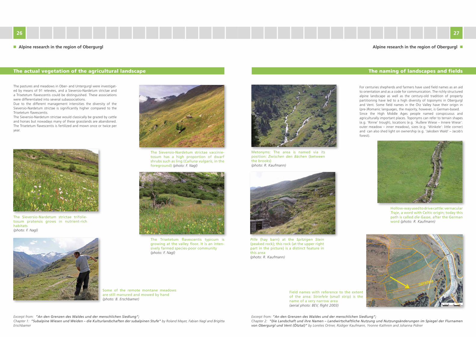
For centuries shepherds and farmers have used field names as an aid to orientation and as a code for communication. The richly structured alpine landscape as well as the century-old tradition of property partitioning have led to a high diversity of toponyms in Obergurgl and Vent. Some field names in the Ötz Valley have their origin in (pre-)Romanic languages, the majority, however, is German-based. Since the High Middle Ages people named conspicuous and agriculturally important places. Toponyms can refer to terrain shapes (e.g. ‘Rinne’ trough), locations (e.g. ‘Äußere Wiese – Innere Wiese‘: outer meadow – inner meadow), sizes (e.g. ‘Winkele‘: little corner) and can also shed light on ownership (e.g. ‘Jakoben Wald‘ – Jacob’s forest).
Excerpt from: ”An den Grenzen des Waldes und der menschlichen Siedlung“;Chapter 2: ”Die Landschaft und ihre Namen – Landwirtschaftliche Nutzung und Nutzungsänderungen im Spiegel der Flurnamen von Obergurgl und Vent (Ötztal)“ by Lorelies Ortner, Rüdiger Kaufmann, Yvonne Kathrein and Johanna Pidner
Metonyms: The area is named via its position: Zwischen den Bächen (between the brooks) (photo: R. Kaufmann)
The naming of landscapes and fields
Hollow-way used to drive cattle: vernacular Traje, a word with Celtic origin; today this path is called die Gasse, after the German word (photo: R. Kaufmann)
Pille (hay barn) at the Spitzigen Stein (peaked rock); this rock (at the upper right part in the picture) is a distinct feature in this area (photo: R. Kaufmann)
Field names with reference to the extent of the area: Striefele (small strip) is the name of a very narrow area (aerial photo: BEV, flight 2003)
The pastures and meadows in Ober- and Untergurgl were investigat- ed by means of 91 relevées, and a Sieversio-Nardetum strictae and a Trisetetum flavescentis could be distinguished. These associations were differentiated into several subassociations. Due to the different management intensities the diversity of the Sieversio-Nardetum strictae is significantly higher compared to the Trisetetum flavescentis.The Sieversio-Nardetum strictae would classically be grazed by cattle and horses but nowadays many of these grasslands are abandoned. The Trisetetum flavescentis is fertilized and mown once or twice per year.
Excerpt from: ”An den Grenzen des Waldes und der menschlichen Siedlung“;Chapter 1: ”Subalpine Wiesen und Weiden – die Kulturlandschaften der subalpinen Stufe” by Roland Mayer, Fabian Nagl and Brigitta Erschbamer
The actual vegetation of the agricultural landscape
The Sieversio-Nardetum strictae vaccinie-tosum has a high proportion of dwarf shrubs such as ling (Calluna vulgaris, in the foreground) (photo: F. Nagl)
The Sieversio-Nardetum strictae trifolie-tosum pratensis grows in nutrient-rich habitats (photo: F. Nagl)
Some of the remote montane meadows are still manured and mowed by hand (photo: B. Erschbamer)
The Trisetetum flavescentis typicum is growing at the valley floor. It is an inten- sively farmed species-poor community (photo: F. Nagl)

28
Alpine research in the region of Obergurgl
29
Alpine research in the region of Obergurgl
The ‘Ötztaler Ache’ is one of the last hydrologically intact glacial and mountain streams in Tyrol. The water quality is nearly untainted. The existing hydrological regime and the glacial influence lead to a specific biotic environment. The Ötztaler Ache is mainly colonised by organisms which are adapted to the special conditions of mountain streams such as different species of algae, fish and macrozooben-thos. Low flow velocities and reduced turbidity and bedload mobility characterize the ‘Ötztaler Ache’ during winter. These conditions facilitate the growth of diatoms and other algae. The bottom of the water body is colonized by Turbellaria, insects and their larvae. The fish of the ‘Ötztaler Ache’ have to deal with an enormous selection pressure due to the extreme conditions. Therefore the number of species is quite low. Mostly there are river trouts (Salmo trutta fario) in the water body, at the mouth of the river even graylings (Thymallus thymallus) and some bullheads (Cottus gobbio). Additionally,alien species such as rainbow trout (Oncorhynchus mykiss) and brook trout (Salvelinus fontinalis) were released into some parts of the river.
Excerpt from: ”Klima, Wetter, Gletscher im Wandel“;Chapter 6: ”Die Ötztaler Ache – Die Lebewelt der Ötztaler Ache“ by Daniel Erhart
Larvae of stoneflies of the genus Perla can be found in the ‘Ötztaler Ache’ (photo: Arge Limnologie)
The fauna of the ‘Ötztaler Ache’
Another typical coloniser is the river trout (photo: W. Mark)
The ‘Ötztaler Ache’ (catchment area 894 km²) is one of the largest tributaries of the Inn River in Tyrol. The hydrological regime has been under observation since the foundation of the Hydrographical Service in Austria in 1893/94. The first water gauge was installed in 1897. Only few of the historical gauges are still being operated today. The monitoring includes parameters such as water level, discharge, and temperature, as well as the suspended load and bed load transport. The aim of this long-term study is to identify trends and variations that might be caused by climate change and other parameters. The data is also used for statistical analysis, planning of watershed management and flood forecasting. The latter is strongly based on the application of rainfall-runoff-models.
Excerpt from: ”Klima, Wetter, Gletscher im Wandel“;Chapter 6: ”Die Ötztaler Ache – Das hydrographische Regime der Ötztaler Ache“ by Wolfgang Gattermayr
The hydrographic regime of the ‘Ötztaler Ache’
The catchment area of the ‘Ötztaler Ache’ with the main river and the bigger tributary rivers (tiris 2013)
The water gauge ‘Vent/Rofenache’; Mea-surements comprise water level (with RA-DAR and a pressure probe), surface flow velocity (with RADAR), water temperature, suspended sediments (with a turbidity probe), and bedload (with a geophone).All data are measured continuously, recorded on site and transmitted via GPRS (photo: Hydrographical Service Tyrol)

30
Alpine research in the region of Obergurgl
31
Alpine research in the region of Obergurgl
There is proof for human presence in the area of Obergurgl and the surrounding valleys for the early Mesolithic – from the first half of the 10th millennium BPcal – onward, when the main focus of human activity was hunting. This kind of land use seems to continue through-out the Neolithic and until the Bronze Age. Agriculture was more and more established in the lowlands and greater alpine valleys. With the beginning of the Copper Age, around 6300 BPcal, alpine grasslands were gradually used as pastures. By means of pollen diagrams, a further intensification of this kind of land use can be confirmed for the Bronze Age. This is also proven by a number of sheepcotes and shepherd huts, which are partly connected with radiocarbon dates starting in the middle Bronze Age. Findings from the Iron Ages and Roman times up to the first written records in the middle of the 13th century AD confirm a continuous agricultural use until the present day.
Excerpt from: ”An den Grenzen des Waldes und der menschlichen Siedlung“;Chapter 3: ”Zum archäologischen Fundbild in Obergurgl“ von Alexander Zanesco
Findings from the ‘Beilstein’: Neolithic and Bronze Aged arrowheads (all photos: A. Zanesco)
Archaeological findings around Obergurgl
View to the ‘Beilstein’ (centre) and Obergurgl (behind); viewing direction: northeast
Excavations at the ‘Beilstein’; viewing direction: south
The stone pine forest near Obergurgl was one of the first areas of dendrochronological research in Austria. Dendrochronological methods were used to analyse cores from living stone pine trees (Pinus cembra) from the ‘Obergurgler Zirbenwald’ and subfossil logs found in the peat of the ‘Zirbenwaldmoor’ and the small peat bogs below the ‘Gurgler Alm’. The analysis of cores from living trees of the ‘Obergurgler Zirbenwald’ verifies the expected accordance of tree ring growth and summer temperature evolution (June-July-August average). Tree ring series established for 36 subfossil samples from the ‘Zirbenwaldmoor’ cover the time period between ca. 100 and ca. 1300 AD. In contrast to the subfossil samples of the ‘Zirbenwaldmoor’ the temporal distri-bution of 23 wood samples from the peat bogs below the ‘Gurgler Alm’ is to some extent related to the Holocene treeline evolution.
Excerpt from: ”An den Grenzen des Waldes und der menschlichen Siedlung“;Chapter 6: ”Jahresringuntersuchungen an rezentem und subfossilem Holzmaterial aus dem Raum Obergurgl“ by Kurt Nicolussi and Andrea Thurner
Dendrochronological research around Obergurgl
Results of the examination of recent pine samples from the stone pine forest in Obergurgl: Comparison of temperature data (mean of temperature of June, July and August, JJA) calculated via annual rings (black) and measured data (red; HISTALP Data)
The ‘Gurgler Alm’ (all photos: K. Nicolussi)
The ‘Obergurgler Zirbenwaldmoor’

32
Alpine research in the region of Obergurgl
33
Alpine research in the region of Obergurgl
In July 2000, nine treeless monitoring sites were established and equipped with data loggers in the vicinity of Obergurgl from the sub-alpine zone (1964 m a.s.l.) to the alpine and the subnival zone (2793 m a.s.l.) as part of the ecological long-term monitoring project. Air temperature and relative air humidity 2 m above the ground as well as soil temperature and soil moisture in 10 cm depth are measured. At the highest altitude the absolute minimum of air temperature was at -30.0 °C. The absolute minimum of the soil temperature was monitored at the ‘Gurgler Heide’ at 2255 m a.s.l. (-11.2 °C). The lowest number of days with snow cover was also found at this site. During the timeframe of 11 years the snow melt date in spring has significantly shifted forwards by approximately 1.2 days per year.
Excerpt from: ”Klima, Wetter, Gletscher im Wandel“;Chapter 7: ”Das Mikroklima waldfreier Standorte in der subalpinen, alpinen und subnivalen Stufe in Obergurgl“ by Lea Hartl, Rüdiger Kaufmann, Nikolaus Schallhart and Brigitta Erschbamer
Monthly mean air temperatures at the different sites, averaged over the period 2000-2011; Monitoring site 1 is the lowest situated site (1964 m a.s.l.), site 8 is the highest situated site (2793 m a.s.l.)
Microclimatic monitoring around Obergurgl
Smoothed data of soil temperature (blue graph) at site 1 of the whole measuring period; the red dots display periods with constant soil temperature, revealing iso-lating snow covers
The weather station in Obergurgl has been operated since 1953. It is located at an altitude of 1938 m a.s.l. next to the Alpine Research Centre / University Centre (11° 01.5’ E, 46° 52’ N). The weather station is equipped with various devices of the Austrian meteorological service ZAMG (Zentralanstalt für Meteorologie und Geodynamik) and measures air and soil temperature, air pressure and humidity, precipitation, wind speed and direction and radiation.
Excerpt from: ”Klima, Wetter, Gletscher im Wandel“;Chapter 1: ”Temperatur und Niederschlag an der Wetterstation Obergurgl, 1953-2011“ by Michael Kuhn, Ekkehard Dreiseitl and Markus Emprechtinger
Temperature and precipitation at the weather station Obergurgl, 1953-2011
Monthly means of temperature (above) and mean monthly sums of precipitation (below) in the period 1953-2011 and of 1953 in detail; The daily sums of precipitation are repre-sented by green columns (left scale), the monthly sums and their addition over a year are represented by increments (right scale).
The weather station of the ZAMG next to the Alpine Research Centre Obergurgl (photo: E.-M. Koch)

34
Alpine research in the region of Obergurgl
35
Alpine research in the region of Obergurgl
Krainer Karl University of InnsbruckInstitute of GeologyInnrain 52, A-6020 [email protected]
Kuhn Michael University of InnsbruckInstitute of Meteorology and GeophysicsInnrain 52, A-6020 [email protected]
Lütz Cornelius University of InnsbruckInstitute of BotanySternwartestraße 15, A-6020 [email protected]
Mayr RolandUniversity of Innsbruck Institute of Botany Sternwartestraße 15, 6020 Innsbruck [email protected]
Meixner Wolfgang University of InnsbruckInstitute of History and European EthnologyInnrain 52, A-6020 [email protected]
Nagl FabianRegional Government of TyrolDepartment of Environmental ProtectionEduard-Wallnöfer-Platz 3, A-6020 [email protected]
Nickus UlrikeUniversity of InnsbruckInstitute of Meteorology and GeophysicsInnrain 52, A-6020 [email protected]
Nicolussi Kurt University of InnsbruckInstitute of GeographyInnrain 52, A-6020 [email protected]
Ortner LoreliesUniversity of InnsbruckInstitute of German Philology Innrain 52, A-6020 Innsbruck [email protected]
Pidner Johanna Université de BourgogneUFR Langues et CommunicationDépartement d‘allemand2, Bd Gabriel, F-21000 [email protected]
Psenner Roland University of InnsbruckInstitute of EcologyTechnikerstraße 25, A-6020 [email protected]
Remias DanielUniversity of InnsbruckInstitute of PharmacyInnrain 80-82, A-6020 [email protected]
Sattler BirgitUniversity of InnsbruckInstitute of EcologyTechnikerstr. 25, A-6020 [email protected]
Schallhart Nikolaus University of InnsbruckAlpine Research Centre ObergurglSternwartestraße 15, A-6020 [email protected]
Schindlbacher Andreas Federal Research and Training Centre for Forests, Natural Hazards and Landscape (BFW)Seckendorff-Gudent-Weg 8 , A-1131 Wien [email protected]
Schüler Silvio Federal Research and Training Centre for Forests, Natural Hazards and Landscape (BFW)Seckendorff-Gudent-Weg 8 , A-1131 Wien [email protected]
Siegl Gerhard University of InnsbruckInstitute of History and European EthnologyInnrain 52, A-6020 [email protected]
List of authors
Baumeister André University of BochumInstitute of GeographyUniversitätsstraße 150, D-44780 [email protected]
Dastych Hieronymus Zoological Institute and Zoological Museum Hamburg Martin-Luther-King-Platz 3, D-20146 [email protected]
Dreiseitl EkkehardUniversity of InnsbruckInstitute of Meteorology and GeophysicsInnrain 52, A-6020 [email protected]
Emprechtinger Markus University of InnsbruckInstitute of Meteorology and GeophysicsInnrain 52, A-6020 [email protected]
Erhard Daniel Regional Government of Tyrol Department of Water Management Herrengasse 1-3, A-6020 [email protected]
Erschbamer Brigitta University of InnsbruckInstitute of BotanySternwartestraße 15, A-6020 [email protected]
Fischer Andrea Austrian Academy of SciencesInstitute of Interdisciplinary Mountain ResearchTechnikerstraße 21a, A-6020 [email protected]
Füreder Leopold University of InnsbruckInstitute of EcologyTechnikerstraße 25, A-6020 [email protected]
Gärtner Georg University of Innsbruck Institute of Botany Sternwartestraße 15, 6020 A-Innsbruck [email protected]
Gattermayr Wolfgang Regional Government of TyrolDepartment of Water Management Herrengasse 1-3, A-6020 [email protected]
Graßmair RenéOberdorf 15, Top 18A-6074 [email protected]
Hartl Lea University of Innsbruck Alpine Research Centre Obergurgl Gaisbergweg 3, A-6456 Obergurgl [email protected]
Hofbauer Wolfgang Fraunhofer Institute for Building PhysicsFraunhoferstraße 10, D-83626 Valley [email protected]
Jandl Robert Federal Research and Training Centre for Forests, Natural Hazards and Landscape (BFW)Seckendorff-Gudent-Weg 8 , A-1131 Wien [email protected]
Kathrein Yvonne University of Innsbruck Institute of German Philology Innrain 52, A-6020 Innsbruck [email protected]
Kaufmann Rüdiger University of InnsbruckInstitute of EcologyTechnikerstraße 25, A-6020 [email protected]
Klug ChristophUniversity of InnsbruckInstitute of GeographyInnrain 52, A-6020 [email protected]
Koch Eva-MariaIrstea Grenoble - Ecosystèmes montagnardsDomaine Universitaire2, rue de la PapeterieF-38 400 Saint-Martin-d’Hè[email protected]
List of authors

36
Alpine research in the region of Obergurgl
37
Alpine research in the region of Obergurgl
Thanks to
4 c
Blau > C 100 / M 55 Gelb > Y 100 / M 12
» Ötztal tourism (branch Obergurgl-Hochgurgl)» Tyrolean State Museums» Federal State of Tyrol (division “Landesentwicklung und Zukunftsstrategie”)» Photo Lohmann GmbH» Arge Limnologie» Hotel Edelweiss and Gurgl» Wolfgang Mark, University of Innsbruck, Institute of Zoology
Contact
University of InnsbruckInnrain 52, A-6020 Innsbruck
Alpine Research Centre ObergurglSternwartestraße 15, A-6020 InnsbruckGaisbergweg 3, A-6456 Obergurgl
Concept & CoordinationAlpine Research Centre ObergurglNikolaus Schallhart
ProofreadingEva-Maria MüllerUniversity of GiessenLudwigsplatz 11, D-35390 Giessen
Graphic & DesignUniversity of Innsbruck, Public relations officeWalli Catharina
List of authors
Stöhr Dieter Regional Government of TyrolState Forestry Service Bürgerstraße 36, A-6020 Innsbruck [email protected]
Thies HansjörgUniversity of InnsbruckInstitute of GeologyInnrain 52, A-6020 [email protected]
Thurner AndreaUniversity of Innsbruck Institute of Geography Innrain 52, A-6020 Innsbruck [email protected]
Tolotti MonicaIASMA Research and Innovation Centre,Sustainable Agro-ecosystems and Bioresources DepartmentEdmund Mach Foundation,Via E. Mach 1, I-38010 S. Michele all’[email protected]
Türk Roman University of Salzburg Department of Organismic BiologyResearch group: Ecology, Biodiversity and Evolution of plants Hellbrunnerstraße 34, A-5020 [email protected]
Zanesco AlexanderUniversity of Innsbruck Institute of Archeology Langer Weg 11, A-6020 Innsbruck [email protected]

39
Alpine research in the region of Obergurgl
38

© B
fÖ 2
01
5