Embed Size (px)
Citation preview

Spitfire Materials Limited | ABN 40 125 578 743 130 Stirling Highway, North Fremantle WA 6159 | Locked Bag 4, North Fremantle WA 6159 | Australia
Tel +61 (0)8 6215 0090 | Fax +61 (0)8 6215 0091 www.spitfirematerials.com
ASX RELEASE – 26 MAY 2017
ALICE RIVER GOLD PROJECT, QUEENSLAND – KEY TENEMENT GRANTED AND EXPLORATION UPDATE
KEY POINTS
Key Exploration Licence, EPM26266, granted over the central 15km of the Alice River shear zone, providing contiguous coverage over the eight granted Mining Leases.
Significant due diligence completed at the Alice River Gold Project, including field reconnaissance, orientation sampling, confirmation of historical sampling results and validation of the extensive historical database.
Preliminary modelling has defined an initial Exploration Target which will be the focus of a maiden 5,000m Reverse Circulation drilling program planned for July 2017.
A detailed aeromagnetic survey over the priority area has been contracted to Thompson Aviation and is scheduled to commence in late June.
Spitfire Materials Limited (ASX: SPI) is pleased to provide an update on recent and upcoming exploration activities at the Alice River Gold Project in North-East Queensland, one of two highly prospective Australian gold projects being acquired under its conditional share sale and purchase agreement to acquire unlisted gold exploration company, Admiral Gold Limited (ASX Announcement, 27 March 2017). The key tenement EPM 26626, which covers approximately 35km of the prospective Alice River Shear Zone – including the central 15km strike zone that contains around 12 major gold prospects – was granted on 8 May 2017, for a term of five years. Admiral Gold has completed significant due diligence on the Alice River Gold Project, including field reconnaissance, orientation sampling, confirmation of historical sampling results and validation of the extensive historical database. Preliminary modelling has resulted in the reporting of an initial advanced Exploration Target¹ under the JORC 2012 code, consisting of 1.47Mt to 2.21Mt at an average grade of 2.4 to 3.6 g/t Au, for a total of 105,000oz to 250,000oz Au.¹ Extrapolation and modelling of mineralised structures/veins was completed to a depth of 120m, with the targeted zones remaining open at depth and along strike. Exploration Target¹: The potential quantities and grades are conceptual in nature and there has been insufficient exploration to date to define a Mineral Resource. It is not certain that further exploration will result in the determination of a Mineral Resource under the “Australasian Code for Reporting of Exploration Results, Mineral Resources and Ore Reserves, the JORC Code” (JORC 2012). The Exploration Target is not being reported as part of any Mineral Resource or Ore Reserve.

SPI ASX Release | A l ice R iver Gold Explorat ion Update Page 2 of 46
A drilling program including RC and diamond drilling is currently being planned for the four top-priority prospects that lie on granted Mining Leases within EPM 26626. Detailed information on the proposed acquisition of Admiral and the key terms of its farm-in agreements is set out in the Company’s ASX Announcement of 27th March 2017. ALICE RIVER GOLD JOINT VENTURE
The Alice River Gold Project is located 270km west of Cooktown, or 470km north-west of Cairns in NE Queensland at the southern end of the Savanah Province. The project encompasses eight Exploration Permits for Minerals (EPMs) and eight granted Mining Leases (MLs), for a total of 808km2 (see Table 1 and Figure 1). The tenements are held by Tinpitch Pty Ltd.
Table 1: Alice River Gold Project Tenements
Figure 1: Project Location Showing the Exploration Permits (EPM)
Tenement Tenement No. Count Area (km2)
EPM 14312, 14313, 15359, 15360 15409, 15410, 16301 and 26266 8 808
ML 2901, 2902, 2907, 2908, 2957, 2958, 3010 & 3011 8 59

SPI ASX Release | A l ice R iver Gold Explorat ion Update Page 3 of 46
Regional Geology The Alice River Project lies within the southern part of the Savanah Province, which runs along the eastern side of the Cape York Peninsula. In the north and west, the Proterozoic Holyroyd Metamorphics form a belt of sedimentary and igneous rocks (greenschist to amphibolite facies). These older rocks have been intruded by Late Silurian to Early Devonian Granitoids (e.g. Imooy Granite). NW-trending rhyolitic to andesitic dykes (up to 30m wide and several kilometres long) are also present and associated with the main NW shear zones that host the gold mineralisation. Detailed geological descriptions of the regional geology are compiled in Kettlewell (2004) and Duck (2006). Gold mineralisation was discovered at several prospects associated with the NW shear zone, such as Alice Queen, One Mile, Peninsula King, Big Blow, German Jack, Julie Anne, Posie, Jerry Dodds, The Shadows, Eureka, Airstrip and Taylors. Mineralisation The Alice River Gold Project lies within the Alice-Palmer Structural Zone. The gold mineralisation in the Alice River area is focused along regional NW shear zones. The shear zones are largely hosted within the Imooya Granite, a pale grey to white mica-biotite leucogranite (commonly referred in the old reports as an adamellite), of the Siluro-Devonian Kintore Supersuite. At the northern end of the project, the shears intersect gneisses and schists of the Sugarbag Creek Quartzite, which forms the lower part of the Mesoproterozoic Holroyd Metamorphics. The gold-bearing shear zones extend episodically for around a 50km strike length. Gold mineralisation is focused in small linear zones (e.g. Alice Queen has a strike length of approximately 125m). The gold mineralisation is generally hosted in quartz veins, and minor quartz breccias, up to 10m wide in places. Gold often occurs as both fine free-gold in quartz or interstitial within arsenopyrite and stibnite. Green-white quartz-sericite-epidote alteration zones extend for 70m around the mineralised veins at the Peninsula King and Alice Queen deposits, but generally the quartz veins display narrow alteration selvages. The weathered (oxide) zones at surface are around 10m to 20m deep. Minor pyrite and other fine-grained sulphides (e.g. arsenopyrite, stibnite) are present as narrow bands in laminated quartz veins and disseminated within the quartz breccias. The NW-trending quartz veins are sub-vertical to steeply-dipping (approximately 80 degrees to the south-west in places). There are other sub-parallel quartz veins, some of which are mineralised, while some are barren. The gold mineralising fluids probably focused into dilatational structural zones (e.g. fault jogs, cross- faults and shears) within the adamellite, forming zones of stockwork veins and also mineralised breccias. For example, the gold mineralisation at Alice Queen occurs as a series of echelon N to NNW trending dilatational structures. Style of Mineralisation Two genetic gold models are considered for Alice River: Intrusive Related Gold Systems (IRGS) and Orogenic Gold.

SPI ASX Release | A l ice R iver Gold Explorat ion Update Page 4 of 46
IRGS – Alice River mineralisation has many similarities to “Intrusive Related Gold Systems” (IRGS). Larkin (2013) noted that: “The Alice River gold deposits display diagnostic IRGS geological, geochemical, structural and tectonic characteristics. These include a back-arc basin tectonic setting, metallogenic flavour (gold, arsenopyrite, stibnite, silver, tin and tungsten, plus minor base metals), alteration (quartz-sericite-epidote-chlorite), proximity to a source granitic pluton, and an extensive history of small-scale gold mining”. Possible analogies include:
Northern Australia – Ravenswood (~3Moz), Cardross (~0.5Moz); and North America – Dublin Gulch (~2Moz), Pogo (~5.6Moz) and possibly Fort Knox (~9.2Moz). Orogenic Gold – Gold mineralization at Alice River has a strong structural control and is similar in many ways to gold mineralisation in the nearby Charter Towers region (see Kreuzer et al. 2007). The Charters Towers gold camp hosts over one hundred gold deposits of various sizes, making up a total of over 6Moz. The host rocks are a similar type and age (Palaeozoic Granitoids) and gold mineralisation is similarly hosted in quartz veins. The auriferous quartz veins are high grade (average production was around 30 g/t Au), and the larger deposits lie in areas of structural dilation (fault intersections, fault jogs and breccia zones). Other examples of this style of mineralisation are Donlin Creek (~31.7Moz) in North America and Croydon (~1.6Moz) in Northern Australia. Exploration History The Alice River Gold Project has had a long history of over 100 years of prospecting and exploration work. A brief summary of the main programs are included below. Additional details of this phase of work are summarised in Kettlewell (2004), Duck (2006) and Larkin (2013). 1903 – Gold was discovered at the Alice River Gold Field by John Dickie in 1903. Mining between
1903 and 1909 produced ~82kg gold from ~2,420 tonnes of ore. Total gold production up to 1917 was reported as 93.3 kg.
1970s to Early 1980s – Regional exploration work for gold and base metals was completed by Consolidated Mining Industries Ltd., Anaconda (Australia), and Bamboo Creek Holding Ltd.
1987 to 1990 – Cyprus Gold Australia took out the tenement area over the Alice River Gold Project area and completed regional geochemical sampling programs, ground magnetics, IP & VLF-EM geophysical surveys, costeaning, RAB, Airtrack and RC drilling programs. Cyprus worked at a number of different prospects including Alice Queen, One Mile, Eight Mile, Peninsula King, German Jack, Big Blow, Julie Anne etc.
1991 to 1995 – Cyprus joint ventured the project to Beckstar (subsidiary of Goldminco). Beckstar completed additional drilling programs, costeaning and resource estimation work. Golden Plateau acquired an option to purchase 50% of the project in 1993 and completed additional drilling. Subloo International acquired Beckstar in 1994 and carried out further drilling, costeaning and several resource estimations of the main gold deposits.
1996 to 1998 – Subloo International and Goldminco completed soil sampling, geophysical surveys, costeaning and drilling at several prospects.
1999 to 2001 – A total of 2,745oz gold was produced from 36,000 tonnes of ore by Beckstar. Production ceased due to a number of issues, including very low historical gold prices.
2001 – Tinpitch acquired the project.
SPI ASX Release | A l ice R iver Gold Explorat ion Update Page 5 of 46
2013 – Alice River Gold Pty Ltd acquired Tinpitch. Several non-JORC compliant “resource estimations” were reported by the historical companies, but
Admiral Gold does not believe these historical “resource estimates” can be reported in accordance with the current JORC 2012 Code. Until further verification drilling is completed, Admiral Gold considers the Alice River gold mineralisation to be an Exploration Target, under the JORC 2012 code.
Database Validation
Drill-hole data from a database supplied by consultancy group White Geoscience Pty Ltd has been validated from historical hard copy and digital data. Historical drilling consisted of Airtrack (open hole rotary percussion with a top-hole hammer), Reverse Circulation Percussion (RC) and Diamond Core drill holes, completed between 1987 and 1995.
White Geoscience entered the data into an Access database directly from original drilling reports, assay lab reports and historical statutory reports submitted to the Queensland Department of Natural Resources and Mines. The full drill-hole database includes 469 holes for a total of 18,294.7m drilling and 8,322 assays. Airtrack drilling makes up 41.4%, RC drilling makes up 43% and diamond drilling makes up 15.6% of the total metres drilled. Hole depths range from 10m to 196m, with an average depth of 39m. Data from the drill holes have been digitally captured and verified by Trepanier Pty Ltd and White Geoscience Pty Ltd.
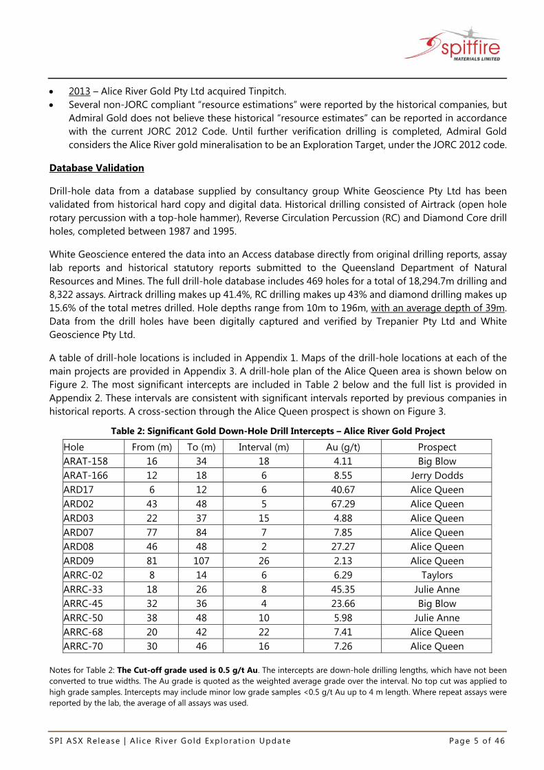
A table of drill-hole locations is included in Appendix 1. Maps of the drill-hole locations at each of the main projects are provided in Appendix 3. A drill-hole plan of the Alice Queen area is shown below on Figure 2. The most significant intercepts are included in Table 2 below and the full list is provided in Appendix 2. These intervals are consistent with significant intervals reported by previous companies in historical reports. A cross-section through the Alice Queen prospect is shown on Figure 3.
Table 2: Significant Gold Down-Hole Drill Intercepts – Alice River Gold Project
Hole From (m) To (m) Interval (m) Au (g/t) Prospect ARAT-158 16 34 18 4.11 Big Blow ARAT-166 12 18 6 8.55 Jerry Dodds ARD17 6 12 6 40.67 Alice Queen ARD02 43 48 5 67.29 Alice Queen ARD03 22 37 15 4.88 Alice Queen ARD07 77 84 7 7.85 Alice Queen ARD08 46 48 2 27.27 Alice Queen ARD09 81 107 26 2.13 Alice Queen ARRC-02 8 14 6 6.29 Taylors ARRC-33 18 26 8 45.35 Julie Anne ARRC-45 32 36 4 23.66 Big Blow ARRC-50 38 48 10 5.98 Julie Anne ARRC-68 20 42 22 7.41 Alice Queen ARRC-70 30 46 16 7.26 Alice Queen
Notes for Table 2: The Cut-off grade used is 0.5 g/t Au. The intercepts are down-hole drilling lengths, which have not been converted to true widths. The Au grade is quoted as the weighted average grade over the interval. No top cut was applied to high grade samples. Intercepts may include minor low grade samples <0.5 g/t Au up to 4 m length. Where repeat assays were reported by the lab, the average of all assays was used.

SPI ASX Release | A l ice R iver Gold Explorat ion Update Page 6 of 46
Figure 2: Drill-hole Location Plan, Alice Queen deposit

SPI ASX Release | A l ice R iver Gold Explorat ion Update Page 7 of 46
Figure 3: Example Cross-Section through Alice Queen deposit
Historical Exploration Data Airtrack, RC and Diamond Drill Hole data from a range of different prospects were used for the Alice River Gold Exploration Target estimations completed by White Geoscience for Tinpitch Pty Ltd in 2016, using Geosoft Target software. This work also included a review of the historical literature and geological plans and, where available, the drill hole lithological logs and historic cross-sections. Historical drilling was completed at a number of prospects at Alice River, which has allowed preliminary modelling of the main prospects. The capture and validation of Alice River drill data has allowed the preliminary modelling and an estimation of an initial Exploration Target, based on the main prospects below: 1. Alice Queen – One Mile (ML 2901, ML 3010).
2. Peninsula King – Big Blow – German Jack (ML 2902, ML 2908, ML 3011).
3. Julie Anne (ML 2957).
4. Posie (EPM 26266).
SPI ASX Release | A l ice R iver Gold Explorat ion Update Page 8 of 46
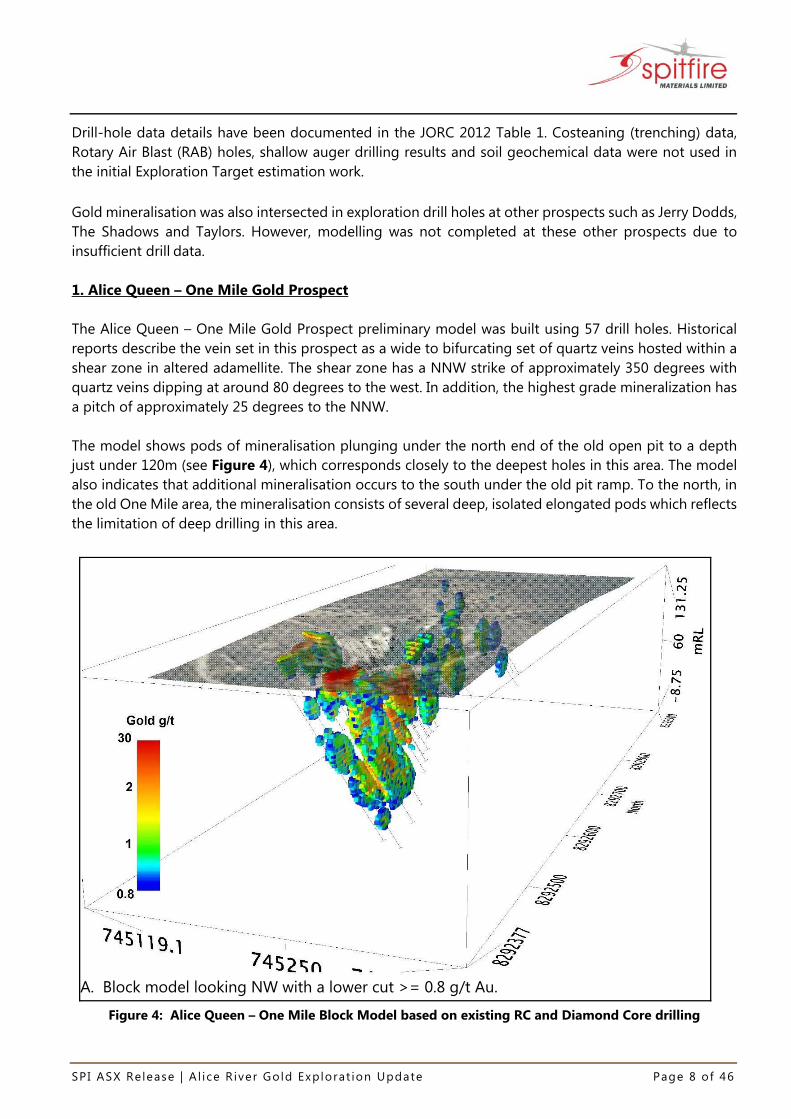
Drill-hole data details have been documented in the JORC 2012 Table 1. Costeaning (trenching) data, Rotary Air Blast (RAB) holes, shallow auger drilling results and soil geochemical data were not used in the initial Exploration Target estimation work. Gold mineralisation was also intersected in exploration drill holes at other prospects such as Jerry Dodds, The Shadows and Taylors. However, modelling was not completed at these other prospects due to insufficient drill data. 1. Alice Queen – One Mile Gold Prospect The Alice Queen – One Mile Gold Prospect preliminary model was built using 57 drill holes. Historical reports describe the vein set in this prospect as a wide to bifurcating set of quartz veins hosted within a shear zone in altered adamellite. The shear zone has a NNW strike of approximately 350 degrees with quartz veins dipping at around 80 degrees to the west. In addition, the highest grade mineralization has a pitch of approximately 25 degrees to the NNW. The model shows pods of mineralisation plunging under the north end of the old open pit to a depth just under 120m (see Figure 4), which corresponds closely to the deepest holes in this area. The model also indicates that additional mineralisation occurs to the south under the old pit ramp. To the north, in the old One Mile area, the mineralisation consists of several deep, isolated elongated pods which reflects the limitation of deep drilling in this area.
A. Block model looking NW with a lower cut >= 0.8 g/t Au.
Figure 4: Alice Queen – One Mile Block Model based on existing RC and Diamond Core drilling

SPI ASX Release | A l ice R iver Gold Explorat ion Update Page 9 of 46
2. Peninsula King – Big Blow – German Jack Gold Prospect Model
The Peninsula King – Big Blow – German Jack Gold Prospect model was built using 70 drill holes (see Figure 5). The mineralisation in this prospect is described as being hosted within a set of narrow quartz veins within altered adamellite. The vein set has a NW strike of approximate 330 degrees and a near- vertical dip. A closer examination of drill-hole sections, both perpendicular and parallel to the strike, along with simple strike-dip grid sections indicated that the highest grade mineralisation has a pitch of approximately 5 to 10 degrees to the south. Like Alice Queen – One Mile, the shallow pitch of higher grade mineralisation probably explains why step-out drilling on the NE-SW section lines often failed to intersect down-dip continuations of the mineralisation. The Peninsula King – Big Blow – German Jack model displays a series of long narrow lenses of mineralisation plunging south under the Big Blow area (Figure 5). The modelling suggests that the narrow mineralisation zone may continue at depth southwards under the Big Blow area and further south. There is limited deep drilling in this area to confirm this, as the previous exploration in this area only consisted of surface geochemistry and patchy follow-up shallow drilling.
A. Block model looking NW with a lower cut >= 0.6g/t Au.
Figure 5: Peninsula King – Big Blow – German Jack

SPI ASX Release | A l ice R iver Gold Explorat ion Update Page 10 of 46
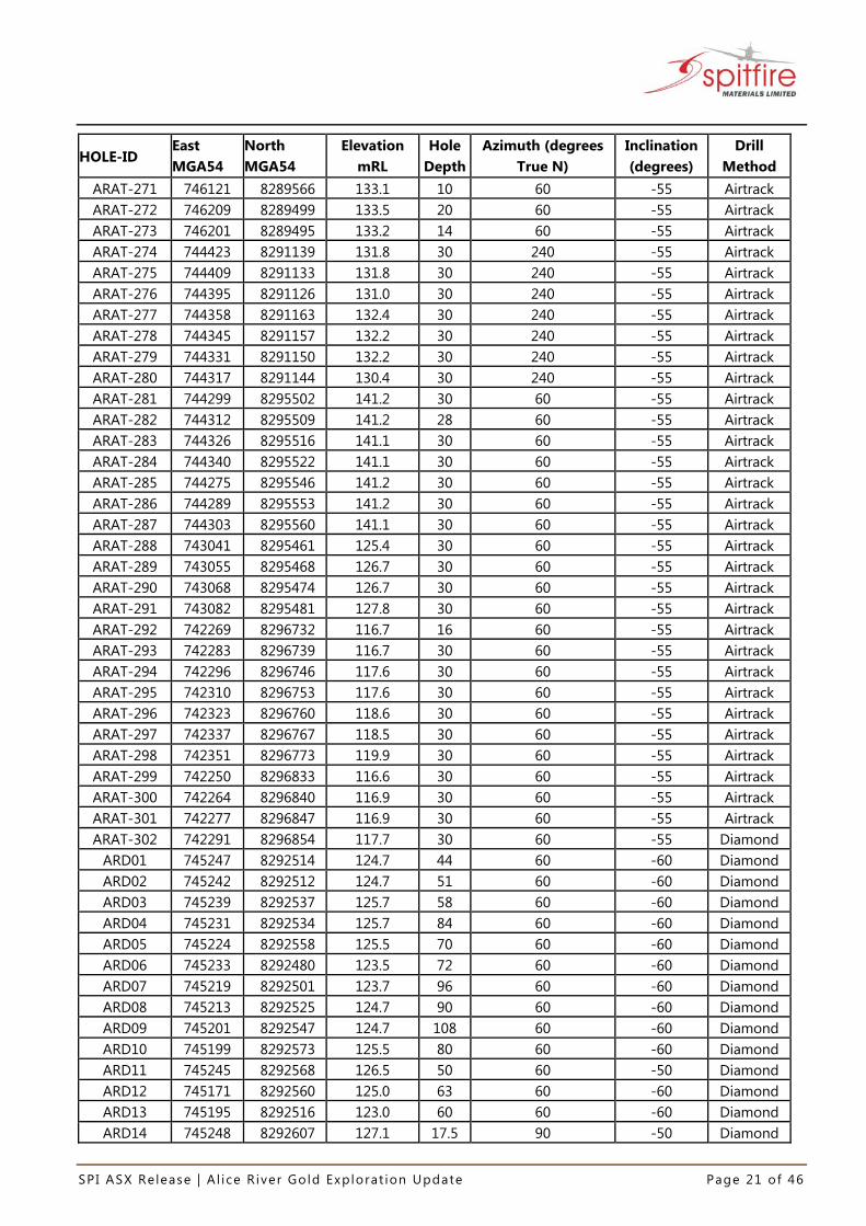
3. Julie Anne Prospect Model
The Julie Anne model was built using 36 drill holes (see Figure 6). The prospect is described as a long (+150 m strike), quartz vein (<3 m width) with splays, hosted within adamellite. An examination of the drill-hole data and available lithological logs indicated that the main part of the vein system has a NW strike of approximate 305 degrees and a near vertical dip. A closer examination of drill-hole sections, indicated that the best mineralisation may have a shallow pitch of approximately 10 degrees to the south. The Julie Anne model shows an irregular shaped body, or amalgamated pods of mineralisation (the shape of the mineralised zone appears to be indicative of the intersection of several structural orientations and/or possible control by the dolerite noted in the old logs. This area requires a structural interpretation to determine the true controls on mineralisation. It was also noted that the area to the NE of the main zone has not been drilled and that the small pods of deep mineralisation on the NE side of the model may indicate that mineralisation continues or is repeated at depth in this area.
A. Block model looking NNE with a lower cut >= 0.5g/t Au.
Figure 6: Julie Anne Prospect Block Model
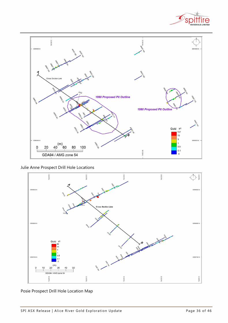
4. Posie Gold Prospect The Posie model was built using 23 drill holes (see Figure 7). This prospect is located in the northern part of the Alice River Shear Zone (see Figure 1). The prospect is described as a set of discontinuous quartz stockworks with some wider quartz veins. The system is hosted within a sheared hematitic granite. The veins and stockwork parallel the granite-metamorphics contact with a NW strike of approximate 310 degrees and have a near-vertical dip.

SPI ASX Release | A l ice R iver Gold Explorat ion Update Page 11 of 46
A closer examination of drill-hole sections indicated that the best gold mineralisation may have a very shallow pitch of approximately -5 degrees to the south, within the mineralised plane, although this is difficult to verify without further drilling. The area is also covered by a granite eluvium which was partly strip-mined in the past to a depth of 1m to 1.5m. The Posie models display another irregular shape body of mineralization, where two “en-echelon” pods of mineralisation appear to step down with depth, north-west of the shallower main body (Figure 7). The drilling is limited in the northwestern area and all the current holes are inclined to the northeast. This may be an area of future exploration focus.
A. Block model with a lower cut >= 0.5g/t Au, looking SE.
Figure 7: Posie Prospect Block Model and Grade Shells
Exploration Potential In generating an initial exploration target, the existing mineralisation has been considered on only four of the main prospects. The original drilling (see Appendix 3) was located on local grid patterns of 20m by 10m over areas often restricted by the size of the original Mining Leases. The drill-hole database contains 469 holes with an average drill-hole depth of 39m. Approximately 22% of all drill-hole intercepts occur beyond 50m down-hole, indicating significant upside in tonnage below known mineralization. Only 2% of the significant drill intercepts outside of the Alice-Queen – One Mile target area occur below 50m downhole, and only 104 drill holes out of 469 occur have ended below 50m. It is clear there is significant potential for additional gold mineralisation below 50m depth. It is expected that a substantial work program focused on extensional drilling both along strike and down-dip will provide a significant resource base.

SPI ASX Release | A l ice R iver Gold Explorat ion Update Page 12 of 46
The distribution of gold mineralisation and the spatial trends of the high-grade gold zones can be observed in the preliminary modelling work undertaken in Geosoft Target software by White Geoscience. (see Figures 4 to 7). The clearest example can be seen at the Alice Queen Prospect, where a high-grade gold zone is evident within the NNW-trending and steeply west-dipping plane of gold mineralisation. This high-grade gold zone pitches at around 25 to 30 degree to the NNW, within the plane. The down-pitch extensions of this zone have not been drilled and represent a high-priority drill target area, which is shown in Figure 8 below. There are also a number of other down-dip and along strike target areas that could also be drill tested at other prospects.
Figure 8: 3D Section at Alice Queen Looking East and Showing Potential Target Area for Future Drilling. Blue shell = 1.0 g/t Au, red shell = 2.5 g/t Au.
On a more regional scale, the Alice River Gold Project has not had any systematic exploration work since Cyprus-Beckstar held the ground in the late 1990’s. There also doesn’t appear to have been any analysis of the data in 3D, nor any structural studies to understand the controls on mineralisation. Exploration work since the Cyprus-Beckstar era has focused on only a handful of prospects, with the objective of quickly defining shallow ore zones for small-scale mining by open pit. None of this work attempted to understand the style, genesis, true geometry, size and extent of the gold mineralisation. The previous exploration and mining work was essentially focused along the Alice River Shear Zone, in particular on the main fault splay within this zone. However, there are several other sub-parallel fault splays and structural zones of interest which have not been explored. In addition, concealed mineralisation may exist under areas of deep weathering and alluvial cover, and exploration for these targets requires a different exploration approach. The Alice River Gold Project area is clearly fertile in gold. The deposits which have been focused on historically are small, but contain high grades and have not been adequately explored for depth continuations, strike continuations and repetitions along sub-parallel fault splays.
Drill Target Area

SPI ASX Release | A l ice R iver Gold Explorat ion Update Page 13 of 46
Alice River Gold Exploration Target 2017
The potential quantity (tonnage) and quality (grade) of the Alice River Gold Initial Exploration Target reported herein is conceptual in nature. There has been insufficient exploration work to determine a Mineral Resource (JORC 2012) and there is no certainty that further exploration work will result in the determination of a Mineral Resource. The preliminary modelling of gold mineralisation focused on the gold assays from the 469 historical drill holes drilled at Alice River. Block modelling using kriging methods was completed using a range of different cut-off grades and modelling parameters. A range of potential tonnages and grades were then calculated using these block models. These results are based on the areas previously drilled and did not include any of the potential gold mineralisation targets or predicted extensions, as shown in Figure 8 above. After reviewing the block models in 3D, Spitfire Materials believes that an additional 50% of the initial modelled tonnages can be included in the calculation of the initial Exploration Target to account for the high-priority target zones that are likely to deliver additional mineralization, such as the target zone shown in Figure 8. At many of the prospects at Alice River, the mineralization is open down-dip and along strike and therefore there is a high probability to discover additional zones of mineralization with further drilling. Spitfire Materials therefore considers that the Alice River Gold mineralisation constitutes a conceptual initial Exploration Target of: 1.297 to 2.172 million tonnes with an average grade of 2.49 to 3.66g/t Au for a total of
105,000 to 250,000 ounces
Table 1: Alice River Exploration Target for the four main prospect areas
Prospect Modelled Tonnes
Min
Modelled Tonnes
Max
Modelled Au Grade (g/t) Min
Modelled Au Grade (g/t) Max
*Total Tonnage Range
Range Total Oz Au
Alice Queen – One Mile with Pit Removed
548,517 904,433 2.63 3.84 822, 775 to 1,356,650
69,579 to 167,509
Peninsula King-Big Blow-German Jack
175,906 323,983 2.05 3.14 263,858 to 485,975
17,393 to 49,066
Julie Anne 65,608 86,733 3.86 4.86 98,412 to 130,100 12,215 to 20,331
Posie 74,953 132,761 1.74 2.48 112,429 to 199,142
6,290 to 15,880
TOTAL 864,984 1,447,911 2.49 3.66 1,297,475 to 2,171,867
105,476 to 252,786 (Rounded to 105,000
to 250,000Oz *Estimated Additional Tonnage is simply 50% of the Modelled Tonnes. See Exploration Potential section for justification. Exploration Target¹: The potential quantities and grades are conceptual in nature and there has been insufficient exploration to date to define a Mineral Resource. It is not certain that further exploration will result in the determination of a Mineral Resource under the “Australasian Code for Reporting of Exploration Results, Mineral Resources and Ore Reserves, the JORC Code” (JORC 2012). The Exploration Target is not being reported as part of any Mineral Resource or Ore Reserve.

SPI ASX Release | A l ice R iver Gold Explorat ion Update Page 14 of 46
Future Exploration Plans The following work is planned to advance the Alice River Gold Project. 2017 fieldwork will consist of: Ground-truthing of drill collar positions with a differential GPS; Aeromagnetic survey to define detailed structural geology and to identify prospective alteration
zones; Initial 5,000m drilling program of the advanced targets (4500m RC; 500m diamond); Soil/Auger sampling in new target areas; Geological mapping and structural interpretations; Trenching/costeaning in new target areas; Further resource and exploration RC Drilling of new targets +5000m; Resource delineation drilling to define Mineral Resources under JORC 2012; and Ore mineralogy and metallurgical studies. MORE INFORMATION For further information please contact: Russell Hardwick Director/Secretary Tel: 0417 714 292 Email: [email protected] Alice River Gold Project
Competent Person’s Statement
The information in this announcement relating to Exploration Targets, Exploration Results and Mineral Resources is based on information compiled by the Company’s proposed Managing Director, Mr John young, a competent person, who is a Member of the Australian Institute of Mining and Metallurgy. Mr Young has sufficient experience relevant to the style of mineralisation and to the type of activity described to qualify as a competent person as defined in the 2012 Edition of the “Australasian Code for Reporting of Exploration Results, Mineral Resources and Ore Reserves.” Mr Young has disclosed to the Company that he is a substantial shareholder in the Company and a major shareholder in Admiral Gold Limited (holding 11.76%). Mr Young consents to the inclusion in this announcement of the matters based on his information in the form and content in which it appears. REFERENCES Duck B H (2006) Geological Overview of the Alice River Gold Project, 47 pp.
Kreuzer O P et al. (2007) Ore controls in the Charters Towers goldfield, NE Australia: Constraints from geological, geophysical and numerical analyses. Ore Geology Reviews 32, p 37-80.
Kettlewell D (2004) Assessment of Alice River Project, Kettlewell & Associates, 124 pp. Larkin C J (2013) Information Memorandum Alice River Gold Project, 40 pp.

SPI ASX Release | A l ice R iver Gold Explorat ion Update Page 15 of 46
APPENDIX 1
Collar Co-ordinates Reverse Circulation Drilling – Alice River database
Appendix 1 – Drill Hole Location Details
HOLE-ID East MGA54
North MGA54
Elevation mRL
Hole Depth
Azimuth (degrees True N)
Inclination (degrees)
Drill Method
ARAT-001 746242 8290068 125.4 30 60 -61 Airtrack ARAT-002 745031 8293035 130.0 18 60 -59 Airtrack ARAT-003 745126 8293061 130.2 20 60 -58 Airtrack ARAT-004 745172 8292973 126.0 15 60 -59 Airtrack ARAT-005 745187 8292815 125.9 20 60 -59.5 Airtrack ARAT-006 745196 8292819 125.9 12 60 -59 Airtrack ARAT-007 745200 8292822 126.4 15 60 -58 Airtrack ARAT-008 745207 8292825 126.4 20 60 -59 Airtrack ARAT-009 745219 8292830 125.3 20 60 -60 Airtrack ARAT-010 745225 8292833 125.3 20 60 -59 Airtrack ARAT-011 745233 8292837 125.6 12 60 -59.5 Airtrack ARAT-012 745240 8292839 125.6 24 60 -61 Airtrack ARAT-013 745068 8292758 124.3 20 240 -58 Airtrack ARAT-014 744999 8292670 125.8 16 240 -57.5 Airtrack ARAT-015 745219 8292776 127.3 16 60 -60.5 Airtrack ARAT-016 745242 8292676 128.3 18 60 -61 Airtrack ARAT-017 745046 8292473 120.8 18 240 -61.5 Airtrack ARAT-018 745159 8292472 121.4 16 240 -60 Airtrack ARAT-019 745092 8292440 120.9 21 240 -58 Airtrack ARAT-020 745083 8292381 121.3 18 60 -57 Airtrack ARAT-021 745130 8292294 122.7 18 60 -62 Airtrack ARAT-022 745315 8292217 123.0 18 60 -62 Airtrack ARAT-023 745318 8292246 122.1 16 240 -63 Airtrack ARAT-024 745409 8292096 123.9 16 60 -59 Airtrack ARAT-025 745339 8292066 125.9 16 60 -56 Airtrack ARAT-026 745294 8291987 126.2 20 60 -60.5 Airtrack ARAT-027 745411 8291604 138.1 16 60 -60.5 Airtrack ARAT-028 745646 8291319 140.8 18 240 -57 Airtrack ARAT-029 745639 8291315 141.4 14 240 -60 Airtrack ARAT-030 745633 8291312 141.4 18 240 -58 Airtrack ARAT-031 745627 8291309 141.5 20 240 -58.5 Airtrack ARAT-032 745524 8291201 138.1 21 240 -60 Airtrack ARAT-033 745736 8291308 139.3 30 240 -60 Airtrack ARAT-034 745723 8291302 139.3 20 240 -58 Airtrack ARAT-035 745714 8291298 140.2 20 240 -60 Airtrack ARAT-036 745673 8291277 141.3 30 240 -58.5 Airtrack ARAT-037 745785 8291222 138.2 30 240 -57 Airtrack ARAT-038 745743 8291201 138.6 30 240 -60 Airtrack ARAT-039 745811 8291235 138.1 30 240 -60 Airtrack ARAT-040 745798 8291229 138.4 30 240 -60 Airtrack

SPI ASX Release | A l ice R iver Gold Explorat ion Update Page 16 of 46
HOLE-ID East MGA54
North MGA54
Elevation mRL
Hole Depth
Azimuth (degrees True N)
Inclination (degrees)
Drill Method
ARAT-041 745772 8291216 138.3 30 240 -60 Airtrack ARAT-042 745760 8291210 138.3 20 240 -60 Airtrack ARAT-043 745751 8291205 138.3 20 240 -61 Airtrack ARAT-044 745730 8291194 138.6 30 240 -61 Airtrack ARAT-045 745607 8291133 134.5 30 240 -62 Airtrack ARAT-046 745594 8291126 131.9 22 240 -62 Airtrack ARAT-047 745585 8291122 131.9 30 240 -60 Airtrack ARAT-048 745574 8291116 131.9 18 240 -62 Airtrack ARAT-049 745566 8291112 132.1 22 240 -62 Airtrack ARAT-050 745557 8291108 132.1 21 240 -61.5 Airtrack ARAT-051 745540 8291099 130.1 20 60 -59 Airtrack ARAT-052 745514 8291088 130.6 21 60 -61 Airtrack ARAT-053 745505 8291081 131.4 30 240 -61 Airtrack ARAT-054 745860 8291205 138.7 20 240 -60 Airtrack ARAT-055 745851 8291200 138.7 30 240 -59 Airtrack ARAT-056 745837 8291193 138.7 20 240 -61 Airtrack ARAT-057 745829 8291189 138.3 20 240 -60 Airtrack ARAT-058 745820 8291185 138.3 30 240 -61 Airtrack ARAT-059 745778 8291163 137.7 20 240 -60 Airtrack ARAT-060 745767 8291158 136.0 26 240 -60 Airtrack ARAT-061 745757 8291153 125.2 20 240 -60 Airtrack ARAT-062 745748 8291149 136.0 20 240 -59.5 Airtrack ARAT-063 745717 8291133 135.5 20 240 -61 Airtrack ARAT-064 745709 8291129 133.0 20 240 -59.5 Airtrack ARAT-065 745700 8291124 133.0 28 240 -61.5 Airtrack ARAT-066 745688 8291118 133.0 30 240 -58 Airtrack ARAT-067 745666 8291107 132.7 20 60 -60 Airtrack ARAT-068 745667 8291108 132.7 20 240 -59 Airtrack ARAT-069 745659 8291103 132.7 20 240 -59 Airtrack ARAT-070 745650 8291099 130.2 14 240 -60 Airtrack ARAT-071 745638 8291093 130.2 20 60 -60 Airtrack ARAT-072 745638 8291093 130.2 26 240 -61 Airtrack ARAT-073 745873 8291156 139.0 23 240 -59 Airtrack ARAT-074 745863 8291151 138.3 30 240 -61 Airtrack ARAT-075 745741 8291090 131.6 20 240 -55 Airtrack ARAT-076 745724 8291081 131.6 18 60 -58 Airtrack ARAT-077 745724 8291081 131.6 30 240 -59 Airtrack ARAT-078 745652 8291045 128.3 23 60 -58 Airtrack ARAT-079 745662 8291050 128.6 20 60 -60 Airtrack ARAT-080 745671 8291054 128.6 20 60 -60 Airtrack ARAT-081 745680 8291059 128.6 20 60 -61 Airtrack ARAT-082 745601 8291030 126.8 30 60 -61 Airtrack ARAT-083 745907 8291118 138.1 30 240 -60 Airtrack ARAT-084 745895 8291112 137.6 30 240 -60 Airtrack ARAT-085 745882 8291105 137.6 20 240 -60 Airtrack ARAT-086 745873 8291101 137.6 28 240 -59 Airtrack

SPI ASX Release | A l ice R iver Gold Explorat ion Update Page 17 of 46
HOLE-ID East MGA54
North MGA54
Elevation mRL
Hole Depth
Azimuth (degrees True N)
Inclination (degrees)
Drill Method
ARAT-087 745834 8291081 134.3 20 240 -58 Airtrack ARAT-088 745763 8291045 130.6 18 60 -61.5 Airtrack ARAT-089 745755 8291041 130.6 20 240 -66 Airtrack ARAT-090 745750 8291039 130.6 15 240 -58 Airtrack ARAT-091 745738 8291032 128.2 20 60 -62.5 Airtrack ARAT-092 745707 8290962 125.6 30 240 -60 Airtrack ARAT-093 745743 8290925 125.3 24 240 -58 Airtrack ARAT-094 745733 8290919 125.3 18 240 -58 Airtrack ARAT-095 745725 8290916 125.3 18 240 -61 Airtrack ARAT-096 745717 8290911 124.9 20 240 -59.5 Airtrack ARAT-097 745709 8290907 124.7 20 240 -61 Airtrack ARAT-098 745582 8290843 123.1 18 240 -60 Airtrack ARAT-099 745659 8290829 123.3 18 60 -60 Airtrack ARAT-100 745666 8290833 123.3 18 60 -58 Airtrack ARAT-101 745864 8290986 128.7 15 240 -51.5 Airtrack ARAT-102 745857 8290982 128.7 30 240 -51 Airtrack ARAT-103 745823 8290965 126.8 15 60 -51 Airtrack ARAT-104 745831 8290968 126.8 20 60 -51 Airtrack ARAT-105 745811 8290959 126.8 20 60 -48 Airtrack ARAT-106 745801 8290954 126.5 20 60 -50 Airtrack ARAT-107 745859 8290927 125.9 30 240 -51 Airtrack ARAT-108 745875 8290936 126.2 18 240 -51 Airtrack ARAT-109 745887 8290941 126.2 20 240 -53 Airtrack ARAT-110 745860 8290927 125.9 20 60 -53 Airtrack ARAT-111 745933 8290854 124.7 30 240 -52 Airtrack ARAT-112 745916 8290846 124.0 30 240 -50 Airtrack ARAT-113 746115 8290447 124.1 22 60 -50 Airtrack ARAT-114 746127 8290453 123.9 20 60 -50 Airtrack ARAT-115 746138 8290459 124.2 20 60 -50 Airtrack ARAT-116 746149 8290466 124.2 20 60 -52 Airtrack ARAT-117 746161 8290470 124.2 20 60 -50 Airtrack ARAT-118 746172 8290476 124.2 20 60 -52 Airtrack ARAT-119 746188 8290424 124.3 30 60 -51 Airtrack ARAT-120 746222 8290363 124.5 30 60 -50 Airtrack ARAT-121 746169 8290308 123.7 30 60 -53 Airtrack ARAT-122 746182 8290315 123.7 20 60 -52 Airtrack ARAT-123 746232 8290368 124.5 30 60 -51 Airtrack ARAT-124 746318 8290300 124.4 20 60 -49 Airtrack ARAT-125 746326 8290304 124.4 20 60 -49 Airtrack ARAT-126 746352 8290262 125.3 20 60 -54 Airtrack ARAT-127 746363 8290267 124.7 20 60 -51 Airtrack ARAT-128 746382 8290233 125.0 30 60 -49 Airtrack ARAT-129 746429 8290162 125.0 30 60 -50 Airtrack ARAT-130 746445 8290170 125.0 30 60 -50 Airtrack ARAT-131 746575 8290124 125.3 30 240 -48.5 Airtrack ARAT-132 746559 8290117 125.2 30 240 -49.5 Airtrack
SPI ASX Release | A l ice R iver Gold Explorat ion Update Page 18 of 46
HOLE-ID East MGA54
North MGA54
Elevation mRL
Hole Depth
Azimuth (degrees True N)
Inclination (degrees)
Drill Method
ARAT-133 746543 8290053 125.4 30 240 -48 Airtrack ARAT-134 746527 8290045 125.2 30 240 -49 Airtrack ARAT-135 746146 8290131 125.3 23 240 -51 Airtrack ARAT-136 746302 8290596 129.1 30 240 -51 Airtrack ARAT-137 746241 8290677 129.5 30 240 -47 Airtrack ARAT-138 746098 8290715 123.5 30 240 -50 Airtrack ARAT-139 746075 8290896 129.1 30 240 -50 Airtrack ARAT-140 746059 8290906 127.9 18 60 -40 Airtrack ARAT-141 746115 8290835 128.4 25 240 -60 Airtrack ARAT-142 745998 8290942 128.0 30 240 -53 Airtrack ARAT-143 746007 8290780 123.0 30 240 -49 Airtrack ARAT-144 745997 8290997 132.1 30 240 -53 Airtrack ARAT-145 746038 8291073 138.2 30 240 -48.5 Airtrack ARAT-146 745661 8290996 126.1 22 240 -47 Airtrack ARAT-147 745648 8290989 125.8 30 240 -47.5 Airtrack ARAT-148 745501 8290913 123.5 24 240 -49 Airtrack ARAT-149 745764 8291267 138.9 12 240 -46 Airtrack ARAT-150 745759 8291265 138.9 25 240 -46.5 Airtrack ARAT-151 745168 8292943 124.9 20 60 -46.5 Airtrack ARAT-152 745150 8292907 124.0 30 60 -46 Airtrack ARAT-153 745249 8292844 125.6 18 60 -48 Airtrack ARAT-154 745102 8292609 126.1 30 60 -50 Airtrack ARAT-155 745147 8292631 126.5 24 60 -48 Airtrack ARAT-156 745451 8291733 135.4 22 60 -47 Airtrack ARAT-157 745699 8291234 140.2 30 240 -45 Airtrack ARAT-158 746412 8290209 125.2 36 240 -53 Airtrack ARAT-159 746293 8290315 124.7 30 60 -49 Airtrack ARAT-160 746233 8290562 125.6 30 240 -50 Airtrack ARAT-161 746217 8290554 124.0 30 240 -50 Airtrack ARAT-162 746202 8290546 124.0 30 240 -50 Airtrack ARAT-163 747001 8288962 127.6 10 190 -50 Airtrack ARAT-164 746998 8288957 127.6 30 190 -50 Airtrack ARAT-165 746970 8288983 126.4 30 190 -50 Airtrack ARAT-166 746923 8288997 125.8 30 10 -50 Airtrack ARAT-167 746910 8289029 125.8 20 200 -50 Airtrack ARAT-168 746904 8289024 126.0 20 200 -50 Airtrack ARAT-169 746295 8290373 123.8 20 240 -50 Airtrack ARAT-170 746130 8290788 126.9 32 210 -55 Airtrack ARAT-171 746116 8290781 126.9 22 240 -52 Airtrack ARAT-172 746110 8290887 130.7 30 240 -52 Airtrack ARAT-173 746080 8290871 127.7 30 60 -50 Airtrack ARAT-174 745561 8291165 136.3 30 240 -51 Airtrack ARAT-175 745548 8291157 134.2 30 240 -50 Airtrack ARAT-176 745534 8291151 134.6 32 240 -53 Airtrack ARAT-177 745461 8291224 139.1 30 60 -51 Airtrack ARAT-178 745477 8291233 139.8 22 60 -49 Airtrack

SPI ASX Release | A l ice R iver Gold Explorat ion Update Page 19 of 46
HOLE-ID East MGA54
North MGA54
Elevation mRL
Hole Depth
Azimuth (degrees True N)
Inclination (degrees)
Drill Method
ARAT-179 745489 8291238 139.4 30 60 -48 Airtrack ARAT-180 745685 8291277 141.3 32 240 -48 Airtrack ARAT-181 745610 8291300 141.5 30 240 -51 Airtrack ARAT-182 745660 8291326 140.3 32 240 -50 Airtrack ARAT-183 745659 8291268 141.3 30 240 -51 Airtrack ARAT-184 745409 8291420 140.2 30 60 -49 Airtrack ARAT-185 745425 8291426 140.4 30 60 -47 Airtrack ARAT-186 745242 8292018 126.6 22 240 -50 Airtrack ARAT-187 745229 8292014 126.6 22 240 -51 Airtrack ARAT-188 745284 8292322 121.2 30 60 -54 Airtrack ARAT-189 745020 8292296 122.8 30 240 -51 Airtrack ARAT-190 745035 8292303 122.8 30 240 -52 Airtrack ARAT-191 744371 8291151 132.4 32 240 -56 Airtrack ARAT-192 744365 8291098 128.8 16 60 -52 Airtrack ARAT-193 744383 8291107 129.2 33 240 -55 Airtrack ARAT-194 744846 8291830 129.5 16 240 -50 Airtrack ARAT-195 744888 8292288 123.6 36 240 -56 Airtrack ARAT-196 744525 8292116 129.0 30 240 -53 Airtrack ARAT-197 744510 8292108 129.0 22 240 -53 Airtrack ARAT-198 744554 8292244 127.1 30 117 -55 Airtrack ARAT-199 744565 8292233 127.1 30 117 -55 Airtrack ARAT-200 744869 8292828 121.5 27 60 -55 Airtrack ARAT-201 745167 8292311 122.4 30 60 -55 Airtrack ARAT-202 745179 8292317 122.4 30 60 -55 Airtrack ARAT-203 745192 8292323 122.4 30 60 -55 Airtrack ARAT-204 746657 8290608 130.7 30 240 -55 Airtrack ARAT-205 746644 8290602 130.7 30 240 -55 Airtrack ARAT-206 746629 8290593 129.1 30 240 -60 Airtrack ARAT-207 746683 8290621 131.1 30 240 -58 Airtrack ARAT-208 746670 8290615 131.1 30 240 -55 Airtrack ARAT-209 745981 8291155 139.5 30 240 -57 Airtrack ARAT-210 745969 8291149 139.5 30 240 -58 Airtrack ARAT-211 745956 8291142 139.5 26 240 -58 Airtrack ARAT-212 745944 8291136 139.5 36 240 -57 Airtrack ARAT-213 745931 8291130 139.5 30 240 -56 Airtrack ARAT-214 744054 8291292 134.6 30 240 -57 Airtrack ARAT-215 744040 8291286 134.2 30 240 -56 Airtrack ARAT-216 744030 8291272 134.2 30 240 -58 Airtrack ARAT-217 744016 8291266 133.0 30 240 -58 Airtrack ARAT-218 744335 8291196 133.9 22 240 -57 Airtrack ARAT-219 744370 8291163 132.4 24 264 -55 Airtrack ARAT-220 745133 8291583 136.0 20 60 -55 Airtrack ARAT-221 745140 8291586 136.0 30 60 -55 Airtrack ARAT-222 745156 8291594 136.3 12 60 -57 Airtrack ARAT-223 745102 8291210 141.2 30 240 -56 Airtrack ARAT-224 745088 8291203 140.8 30 240 -56 Airtrack

SPI ASX Release | A l ice R iver Gold Explorat ion Update Page 20 of 46
HOLE-ID East MGA54
North MGA54
Elevation mRL
Hole Depth
Azimuth (degrees True N)
Inclination (degrees)
Drill Method
ARAT-225 745076 8291197 139.9 31.5 240 -53 Airtrack ARAT-226 745061 8291190 139.5 29.5 240 -57 Airtrack ARAT-227 745114 8291217 141.2 18 240 -54 Airtrack ARAT-228 745114 8291216 141.2 26 240 -55 Airtrack ARAT-229 746284 8290311 124.7 30 60 -56 Airtrack ARAT-230 746268 8290330 124.6 32 60 -52 Airtrack ARAT-231 746282 8290393 123.5 30 240 -48 Airtrack ARAT-232 746265 8290411 123.7 30 240 -52 Airtrack ARAT-233 746236 8290476 123.3 35 240 -51 Airtrack ARAT-234 744066 8295194 137.9 10 240 -50 Airtrack ARAT-235 745260 8290892 123.9 30 240 -47 Airtrack ARAT-236 745227 8290872 122.8 30 196 -49 Airtrack ARAT-237 745239 8290950 124.8 30 250 -51.5 Airtrack ARAT-238 745235 8290973 125.6 23 260 -50 Airtrack ARAT-239 746918 8288986 126.2 38 12 -49.5 Airtrack ARAT-240 746825 8289090 126.5 36 190 -50 Airtrack ARAT-241 746776 8289132 127.1 36 190 -50 Airtrack ARAT-242 746724 8289149 129.9 32 350 -50 Airtrack ARAT-243 746681 8289182 131.2 30 350 -50 Airtrack ARAT-244 756663 8283221 150.6 32 206 -55 Airtrack ARAT-245 756645 8283237 151.2 30 206 -55 Airtrack ARAT-246 756616 8283277 151.8 30 26 -55 Airtrack ARAT-247 756676 8283015 154.6 16 26 -55 Airtrack ARAT-248 756676 8283026 153.4 10 26 -55 Airtrack ARAT-249 756678 8283031 153.4 30 26 -55 Airtrack ARAT-250 756682 8283046 153.4 16 26 -55 Airtrack ARAT-251 756688 8283060 152.2 10 26 -55 Airtrack ARAT-252 756692 8283065 152.2 20 26 -55 Airtrack ARAT-253 756702 8283070 151.8 30 26 -55 Airtrack ARAT-254 756709 8283083 150.7 30 26 -55 Airtrack ARAT-255 749573 8286691 132.2 30 240 -55 Airtrack ARAT-256 749560 8286685 132.2 30 240 -55 Airtrack ARAT-257 749547 8286679 132.2 30 240 -55 Airtrack ARAT-258 749534 8286672 133.2 20 240 -55 Airtrack ARAT-259 749524 8286667 133.2 30 240 -55 Airtrack ARAT-260 749511 8286661 134.2 30 240 -55 Airtrack ARAT-261 749549 8286735 131.4 30 240 -55 Airtrack ARAT-262 749536 8286728 132.1 30 240 -55 Airtrack ARAT-263 749523 8286722 132.8 30 240 -55 Airtrack ARAT-264 749510 8286716 133.7 30 240 -55 Airtrack ARAT-265 749497 8286709 133.7 30 240 -55 Airtrack ARAT-266 749484 8286703 134.4 30 240 -55 Airtrack ARAT-267 746257 8290053 125.0 30 60 -60 Airtrack ARAT-268 746274 8290037 125.0 30 60 -60 Airtrack ARAT-269 746099 8289555 133.3 30 60 -55 Airtrack ARAT-270 746112 8289561 133.2 14 60 -55 Airtrack
SPI ASX Release | A l ice R iver Gold Explorat ion Update Page 21 of 46
HOLE-ID East MGA54
North MGA54
Elevation mRL
Hole Depth
Azimuth (degrees True N)
Inclination (degrees)
Drill Method
ARAT-271 746121 8289566 133.1 10 60 -55 Airtrack ARAT-272 746209 8289499 133.5 20 60 -55 Airtrack ARAT-273 746201 8289495 133.2 14 60 -55 Airtrack ARAT-274 744423 8291139 131.8 30 240 -55 Airtrack ARAT-275 744409 8291133 131.8 30 240 -55 Airtrack ARAT-276 744395 8291126 131.0 30 240 -55 Airtrack ARAT-277 744358 8291163 132.4 30 240 -55 Airtrack ARAT-278 744345 8291157 132.2 30 240 -55 Airtrack ARAT-279 744331 8291150 132.2 30 240 -55 Airtrack ARAT-280 744317 8291144 130.4 30 240 -55 Airtrack ARAT-281 744299 8295502 141.2 30 60 -55 Airtrack ARAT-282 744312 8295509 141.2 28 60 -55 Airtrack ARAT-283 744326 8295516 141.1 30 60 -55 Airtrack ARAT-284 744340 8295522 141.1 30 60 -55 Airtrack ARAT-285 744275 8295546 141.2 30 60 -55 Airtrack ARAT-286 744289 8295553 141.2 30 60 -55 Airtrack ARAT-287 744303 8295560 141.1 30 60 -55 Airtrack ARAT-288 743041 8295461 125.4 30 60 -55 Airtrack ARAT-289 743055 8295468 126.7 30 60 -55 Airtrack ARAT-290 743068 8295474 126.7 30 60 -55 Airtrack ARAT-291 743082 8295481 127.8 30 60 -55 Airtrack ARAT-292 742269 8296732 116.7 16 60 -55 Airtrack ARAT-293 742283 8296739 116.7 30 60 -55 Airtrack ARAT-294 742296 8296746 117.6 30 60 -55 Airtrack ARAT-295 742310 8296753 117.6 30 60 -55 Airtrack ARAT-296 742323 8296760 118.6 30 60 -55 Airtrack ARAT-297 742337 8296767 118.5 30 60 -55 Airtrack ARAT-298 742351 8296773 119.9 30 60 -55 Airtrack ARAT-299 742250 8296833 116.6 30 60 -55 Airtrack ARAT-300 742264 8296840 116.9 30 60 -55 Airtrack ARAT-301 742277 8296847 116.9 30 60 -55 Airtrack ARAT-302 742291 8296854 117.7 30 60 -55 Diamond
ARD01 745247 8292514 124.7 44 60 -60 Diamond ARD02 745242 8292512 124.7 51 60 -60 Diamond ARD03 745239 8292537 125.7 58 60 -60 Diamond ARD04 745231 8292534 125.7 84 60 -60 Diamond ARD05 745224 8292558 125.5 70 60 -60 Diamond ARD06 745233 8292480 123.5 72 60 -60 Diamond ARD07 745219 8292501 123.7 96 60 -60 Diamond ARD08 745213 8292525 124.7 90 60 -60 Diamond ARD09 745201 8292547 124.7 108 60 -60 Diamond ARD10 745199 8292573 125.5 80 60 -60 Diamond ARD11 745245 8292568 126.5 50 60 -50 Diamond ARD12 745171 8292560 125.0 63 60 -60 Diamond ARD13 745195 8292516 123.0 60 60 -60 Diamond ARD14 745248 8292607 127.1 17.5 90 -50 Diamond

SPI ASX Release | A l ice R iver Gold Explorat ion Update Page 22 of 46
HOLE-ID East MGA54
North MGA54
Elevation mRL
Hole Depth
Azimuth (degrees True N)
Inclination (degrees)
Drill Method
ARD15 745228 8292608 127.1 45 90 -50 Diamond ARD16 745241 8292589 127.1 25 90 -50 Diamond ARD17 745241 8292484 123.5 56.5 60 -60 Diamond ARD18 745249 8292460 123.5 55 60 -60 Diamond ARD19 745224 8292557 125.5 77.9 60 -60 Diamond ARD20 745242 8292566 126.5 48 60 -60 Diamond BBD1 746346 8290232 125.5 56.6 60 -63 Diamond
GPD01 745240 8292498 124.7 74.4 60 -60 Diamond GPD02 745241 8292530 125.7 59.5 60 -60 Diamond GPD03 745239 8292551 126.5 71.3 60 -60 Diamond GPD04 745215 8292554 125.5 26.5 60 -60 Diamond GPD05 745251 8292543 125.7 32 60 -60 Diamond GPD06 745224 8292571 125.5 80.4 60 -60 Diamond OMD1 745246 8292733 128.5 69.7 60 -58 Diamond OMD2 745227 8292640 127.7 67.1 242 -60 Diamond OMD3 745232 8292769 125.5 73.5 60 -60 Diamond PDH01 742324 8296762 118.6 39.6 61 -60 Diamond
PDH02A 742232 8296823 116.2 57.7 63 -70 Diamond PDH03 742222 8296817 116.0 98.3 6 -90 Diamond PDH04 742245 8296829 116.6 73.2 6 -90 Diamond PDH05 742302 8296750 117.6 69.1 61 -60 Diamond PDH06 742354 8296779 119.9 27.8 241 -60 Diamond PDH07 742266 8296807 116.6 38.6 47 -60 Diamond PDH08 742142 8296918 115.8 70 41 -60 Diamond PDH09 742076 8297258 116.4 29.5 66 -60 Diamond PDH10 742056 8297123 115.1 30.3 61 -60 Diamond PDH11 740844 8298702 125.4 42.3 35 -60 Diamond
PDH11A 740848 8298705 125.3 18.3 35 -60 Diamond PDH12 741773 8297586 119.7 33.3 57 -60 Diamond PDH13 741724 8297593 118.8 74.8 53 -60 Diamond PDH14 740995 8298648 121.9 30.3 35 -60 Diamond PDH15 740846 8298707 125.3 49 35 -60 Diamond PDH16 740072 8299052 121.3 37.8 101 -60 Diamond PKD1 746284 8290449 125.5 113.6 238 -60 Diamond POD1 742265 8296841 116.9 31 240 -60 Diamond ARD21 745253 8292528 125.7 41 60 -60 RC
ARRC-01 746527 8290101 125.2 54 240 -60.75 RC ARRC-02 746369 8290243 125.0 36 60 -61 RC ARRC-03 746335 8290281 124.7 42 60 -61 RC ARRC-04 746201 8290407 124.6 60 60 -61 RC ARRC-05 746231 8290395 124.2 48 60 -61 RC ARRC-06 746210 8290384 124.7 54 60 -61 RC ARRC-07 746205 8290437 124.3 54 60 -60 RC ARRC-08 746196 8290460 123.8 60 60 -61 RC ARRC-09 746181 8290480 123.7 60 60 -61 RC ARRC-10 746249 8290376 124.2 54 60 -61 RC

SPI ASX Release | A l ice R iver Gold Explorat ion Update Page 23 of 46
HOLE-ID East MGA54
North MGA54
Elevation mRL
Hole Depth
Azimuth (degrees True N)
Inclination (degrees)
Drill Method
ARRC-11 746253 8290350 124.6 66 60 -60 RC ARRC-12 746287 8290340 124.3 66 60 -61 RC ARRC-13 746305 8290321 124.4 48 60 -63 RC ARRC-14 746306 8290377 123.5 60 240 -60 RC ARRC-15 746294 8290399 123.5 52 240 -60 RC ARRC-16 746275 8290417 123.7 54 240 -60 RC ARRC-17 746295 8290427 124.4 54 240 -60 RC ARRC-18 746311 8290435 125.4 30 240 -61 RC ARRC-19 746323 8290441 125.4 30 240 -61 RC ARRC-20 746257 8290435 123.4 72 240 -61 RC ARRC-21 746293 8290454 125.5 90 240 -60 RC ARRC-22 746259 8290464 124.2 72 240 -61 RC ARRC-23 746260 8290463 124.2 54 60 -58 RC ARRC-24 746250 8290482 125.0 60 240 -61 RC ARRC-25 746276 8290495 125.0 60 240 -61 RC ARRC-26 746231 8290505 123.2 54 240 -58 RC ARRC-27 746253 8290516 126.0 54 240 -60 RC ARRC-28 746226 8290669 129.5 78 240 -62 RC ARRC-29 746170 8290696 127.8 42 240 -60 RC ARRC-30 746141 8290737 127.5 42 240 -60 RC ARRC-31 745877 8290826 124.1 30 60 -59 RC ARRC-32 745890 8290832 124.1 54 60 -59 RC ARRC-33 745854 8290870 124.6 30 60 -60 RC ARRC-34 745867 8290876 124.7 30 60 -60 RC ARRC-35 745924 8291109 138.1 30 240 -60 RC ARRC-36 745587 8291067 128.2 60 240 -62 RC ARRC-37 745543 8291433 140.8 30 60 -60 RC ARRC-38 745220 8292721 127.9 42 60 -59 RC ARRC-39 745238 8292729 128.5 30 60 -59 RC ARRC-40 746293 8290398 123.5 36 60 -58 RC ARRC-41 746235 8290618 127.5 36 240 -61 RC ARRC-42 745003 8292288 122.9 30 240 -59 RC ARRC-43 746425 8290215 124.9 92 240 -55 RC ARRC-44 746370 8290215 125.4 70 60 -55 RC ARRC-45 746347 8290232 125.5 80 60 -55 RC ARRC-46 746335 8290253 125.3 80 60 -55 RC ARRC-47 746317 8290410 124.4 100 240 -55 RC ARRC-48 746274 8290472 124.2 66 240 -55 RC ARRC-49 745974 8290819 123.2 72 240 -55 RC ARRC-50 745872 8290851 124.1 80 60 -55 RC ARRC-51 745840 8290862 124.6 100 60 -60 RC ARRC-52 745832 8290886 125.0 60 60 -60 RC ARRC-53 745816 8290906 125.0 100 60 -55 RC ARRC-54 745786 8291167 137.7 80 240 -55 RC ARRC-55 745798 8291229 138.4 100 240 -55 RC ARRC-56 745340 8292256 122.1 80 240 -55 RC

SPI ASX Release | A l ice R iver Gold Explorat ion Update Page 24 of 46
HOLE-ID East MGA54
North MGA54
Elevation mRL
Hole Depth
Azimuth (degrees True N)
Inclination (degrees)
Drill Method
ARRC-57 745220 8292666 127.3 80 60 -55 RC ARRC-58 745196 8292819 125.9 110 60 -55 RC ARRC-59 745220 8292005 126.6 36 -30 -90 RC ARRC-60 746092 8290906 129.1 80 240 -55 RC ARRC-61 746277 8290446 124.4 70 240 -60 RC ARRC-62 746415 8290155 125.0 80 60 -55 RC ARRC-63 745909 8290787 122.5 150 60 -60 RC ARRC-64 745864 8290819 123.3 150 60 -60 RC ARRC-65 745818 8290852 123.9 150 60 -60 RC ARRC-66 745773 8290884 124.5 150 60 -60 RC ARRC-67 745224 8292612 126.2 70 60 -60 RC ARRC-68 745239 8292563 126.5 70 60 -60 RC ARRC-69 745242 8292537 125.7 70 60 -60 RC ARRC-70 745250 8292512 124.7 70 60 -60 RC ARRC-71 745258 8292487 124.7 70 60 -60 RC ARRC-72 745265 8292465 124.7 70 60 -60 RC ARRC-73 745269 8292410 121.8 90 60 -60 RC ARRC-74 746310 8290213 125.3 150 60 -60 RC ARRC-75 746334 8290170 124.6 150 60 -60 RC ARRC-76 746384 8290140 124.8 150 60 -60 RC ARRC-77 745174 8292589 125.8 154 60 -60 RC ARRC-78 745227 8292587 127.1 70 60 -60 RC ARRC-79 745189 8292541 124.1 148 60 -60 RC ARRC-80 745199 8292490 123.7 148 60 -60 RC ARRC-81 745220 8292445 121.5 118 60 -60 RC ARRC-82 744190 8295588 130.4 30 60 -60 RC ARRC-83 744204 8295594 141.4 30 60 -60 RC ARRC-84 744218 8295601 141.5 30 60 -60 RC ARRC-85 744231 8295607 141.5 30 60 -60 RC ARRC-86 744273 8295517 141.2 30 60 -60 RC ARRC-87 744287 8295524 141.2 30 60 -60 RC ARRC-88 744301 8295531 141.2 30 60 -60 RC ARRC-89 744314 8295538 141.1 30 60 -60 RC ARRC-90 744328 8295544 141.1 30 60 -60 RC ARRC-91 744342 8295551 140.9 30 60 -60 RC ARRC-92 744229 8295385 141.2 30 60 -60 RC ARRC-93 744243 8295392 141.2 30 60 -60 RC ARRC-94 744256 8295398 141.2 30 60 -60 RC ARRC-95 744270 8295405 141.2 30 60 -60 RC ARRC-96 744284 8295412 141.2 30 60 -60 RC ARRC-97 746286 8290257 125.2 136 60 -60 RC ARRC-98 746262 8290189 123.5 196 60 -58 RC ARRC-99 746317 8290161 124.1 178 60 -70 RC
JA01 745880 8290855 124.7 39 60 -50 RC JA02 745862 8290901 125.1 56.1 195 -60 RC JA03 745873 8290879 124.7 29 150 -60 RC

SPI ASX Release | A l ice R iver Gold Explorat ion Update Page 25 of 46
HOLE-ID East MGA54
North MGA54
Elevation mRL
Hole Depth
Azimuth (degrees True N)
Inclination (degrees)
Drill Method
JA04 745854 8290869 124.6 36 60 -60 RC PPH17 742238 8296825 116.2 30 64 -60 RC PPH18 742224 8296819 116.0 80 64 -70 RC PPH19 742225 8296841 116.4 60 61 -60 RC PPH20 742256 8296795 116.2 60 47 -60 RC PPH21 742282 8296786 116.6 35 42 -60 RC PPH22 742297 8296766 117.4 50 41.5 -60 RC PPH23 742079 8297298 117.3 45 56 -60 RC PPH24 742116 8297268 117.3 60 236 -60 RC PPH25 742058 8297170 115.4 60 56 -60 RC PPH26 742071 8297088 115.0 40 56 -60 RC SDH01 744288 8295523 141.2 66 60 -60 RC SDH02 744328 8295544 141.1 60 220 -60 RC SDH03 744341 8295526 141.1 79.1 220 -60 RC SDH04 744368 8295514 141.0 63.1 220 -60 RC

SPI ASX Release | A l ice R iver Gold Explorat ion Update Page 26 of 46
Appendix 2 – Significant Gold Intervals (>0.5 g/t Au Lowercut)
Hole_ID Depth_From Depth_To Interval Width Grade g/t Au
ARAT-001 0 4 4 1 ARAT-002 0 2 2 1.94 ARAT-002 6 8 2 1.91 ARAT-003 10 12 2 0.54 ARAT-004 12 14 2 0.56 ARAT-005 10 12 2 0.95 ARAT-007 0 15 15 0.65 ARAT-008 4 14 10 0.69 ARAT-009 4 6 2 0.76 ARAT-010 10 14 4 1.02 ARAT-012 8 10 2 0.65 ARAT-015 4 14 10 0.72 ARAT-016 4 18 14 1.14 ARAT-022 0 8 8 0.76 ARAT-023 2 16 14 0.79 ARAT-031 16 18 2 0.52 ARAT-032 2 4 2 2.34 ARAT-037 8 12 4 2.15 ARAT-037 26 28 2 0.55 ARAT-040 18 20 2 1.16 ARAT-046 14 22 8 1.02 ARAT-049 6 8 2 0.94 ARAT-050 10 12 2 1.09 ARAT-057 10 12 2 0.53 ARAT-060 6 12 6 1.54 ARAT-065 26 28 2 2.03 ARAT-067 14 16 2 0.62 ARAT-068 0 2 2 0.96 ARAT-073 4 6 2 1.15 ARAT-073 12 14 2 0.54 ARAT-074 0 2 2 1 ARAT-074 6 8 2 0.66 ARAT-076 10 12 2 5 ARAT-082 20 22 2 0.58 ARAT-105 6 8 2 1.36 ARAT-106 4 6 2 0.54 ARAT-106 14 18 4 0.83 ARAT-107 8 10 2 0.75 ARAT-111 14 16 2 0.58 ARAT-112 18 22 4 0.79 ARAT-119 12 16 4 2.5

SPI ASX Release | A l ice R iver Gold Explorat ion Update Page 27 of 46
Hole_ID Depth_From Depth_To Interval Width Grade g/t Au
ARAT-120 4 6 2 0.52 ARAT-123 24 30 6 0.54 ARAT-125 4 8 4 1.4 ARAT-126 0 2 2 0.58 ARAT-126 6 16 10 2.37 ARAT-127 0 8 8 4.85 ARAT-128 10 12 2 0.79 ARAT-129 16 18 2 0.52 ARAT-139 6 18 12 1.46 ARAT-140 2 10 8 0.66 ARAT-144 10 12 2 0.64 ARAT-149 8 12 4 0.69 ARAT-150 0 2 2 0.9 ARAT-150 6 25 19 0.69 ARAT-151 2 4 2 0.72 ARAT-152 16 22 6 1.03 ARAT-157 6 16 10 0.76 ARAT-158 16 34 18 4.11 ARAT-159 0 2 2 6.88 ARAT-160 16 18 2 1.29 ARAT-165 20 24 4 0.79 ARAT-166 12 18 6 8.55 ARAT-166 28 30 2 0.76 ARAT-169 2 6 4 0.66 ARAT-169 16 20 4 0.76 ARAT-170 8 10 2 0.59 ARAT-170 26 32 6 1.28 ARAT-191 8 12 4 1.45 ARAT-191 22 28 6 1.57 ARAT-230 12 16 4 1.86 ARAT-231 0 2 2 1.9 ARAT-231 16 20 4 0.82 ARAT-232 2 10 8 1.5 ARAT-236 12 14 2 0.58 ARAT-239 32 34 2 0.54 ARAT-241 22 24 2 0.53 ARAT-242 26 28 2 0.94 ARAT-244 8 16 8 0.76 ARAT-245 12 16 4 0.57 ARAT-250 8 10 2 0.9 ARAT-255 20 22 2 1.01 ARAT-255 28 30 2 0.57 ARAT-268 18 22 4 0.6

SPI ASX Release | A l ice R iver Gold Explorat ion Update Page 28 of 46
Hole_ID Depth_From Depth_To Interval Width Grade g/t Au
ARAT-275 26 28 2 0.64 ARAT-276 16 18 2 0.62 ARAT-277 20 26 6 1.08 ARAT-282 22 28 6 4.79 ARAT-283 0 2 2 0.63 ARAT-294 0 2 2 2.54 ARAT-298 0 6 6 0.61 ARAT-300 24 28 4 1.91 ARAT-301 0 6 6 1.51 ARAT-301 14 16 2 0.54 ARAT-301 26 28 2 0.7 ARAT-302 2 6 4 0.65
ARD01 16 18 2 10.1 ARD01 22 32 10 2.3 ARD02 36 40 4 1.07 ARD02 43 48 5 67.29 ARD03 5.5 8.5 3 0.71 ARD03 22 37 15 4.88 ARD03 46 50 4 0.91 ARD04 38 56 18 1.94 ARD05 28 30 2 0.88 ARD05 43 56 13 1.86 ARD05 59 66 7 0.75 ARD06 26 28 2 0.79 ARD06 65 67 2 6.25 ARD07 20 21 1 3.05 ARD07 25 26 1 0.88 ARD07 65 67 2 10.83 ARD07 77 84 7 7.85 ARD08 46 48 2 27.27 ARD08 61 63 2 2.98 ARD08 67 84 17 2.56 ARD09 47 48 1 0.8 ARD09 81 107 26 2.13 ARD10 62 66 4 0.83 ARD10 70 76 6 0.87 ARD11 9 21 12 1.4 ARD12 44 45 1 0.95 ARD13 16 26 10 0.75 ARD13 43 48 5 1.71 ARD14 4.5 5.8 1.3 1.14 ARD14 8.1 14.1 6 1.25 ARD15 35 42 7 2.67

SPI ASX Release | A l ice R iver Gold Explorat ion Update Page 29 of 46
Hole_ID Depth_From Depth_To Interval Width Grade g/t Au
ARD16 13 18 5 1.34 ARD17 6 12 6 40.67 ARD17 17 18 1 0.93 ARD17 48 53 5 7.6 ARD18 43 49 6 1.05 ARD19 37 53 16 1.65 ARD19 59 60 1 0.84 ARD19 70 72 2 0.65 ARD20 17.5 31 13.5 1.09 ARD20 34 36 2 0.69 ARD20 42 44 2 1.12 ARD21 17 21 4 1.82 ARD21 24 30 6 3.49
ARRC-01 22 24 2 0.66 ARRC-01 32 38 6 2.04 ARRC-02 8 14 6 6.29 ARRC-03 8 10 2 1.08 ARRC-03 16 20 4 0.68 ARRC-04 22 28 6 2.58 ARRC-04 44 46 2 0.61 ARRC-04 50 52 2 0.63 ARRC-06 28 34 6 1.9 ARRC-06 50 52 2 0.73 ARRC-10 20 22 2 1.76 ARRC-10 34 36 2 2.04 ARRC-11 12 14 2 1.94 ARRC-11 34 36 2 0.66 ARRC-11 48 50 2 0.71 ARRC-11 62 64 2 1.09 ARRC-12 14 20 6 0.65 ARRC-12 24 28 4 1.13 ARRC-12 34 36 2 0.52 ARRC-12 48 50 2 0.8 ARRC-13 44 46 2 1.06 ARRC-14 26 28 2 1.3 ARRC-15 0 6 6 1.04 ARRC-15 10 16 6 0.83 ARRC-15 22 24 2 4.19 ARRC-15 46 48 2 0.52 ARRC-16 0 2 2 1.23 ARRC-16 8 10 2 0.6 ARRC-16 14 20 6 5.33 ARRC-17 0 12 12 1.43

SPI ASX Release | A l ice R iver Gold Explorat ion Update Page 30 of 46
Hole_ID Depth_From Depth_To Interval Width Grade g/t Au
ARRC-20 0 8 8 3.33 ARRC-20 20 22 2 1.45 ARRC-22 2 10 8 1.07 ARRC-22 50 52 2 0.57 ARRC-23 2 14 12 1.07 ARRC-24 6 12 6 0.85 ARRC-24 18 20 2 1.47 ARRC-26 48 50 2 1.16 ARRC-27 12 24 12 0.66 ARRC-30 8 10 2 2.46 ARRC-30 16 20 4 0.61 ARRC-30 26 34 8 1.19 ARRC-32 46 54 8 2.87 ARRC-33 18 26 8 45.35 ARRC-34 0 2 2 1.01 ARRC-36 32 34 2 0.68 ARRC-37 20 22 2 0.55 ARRC-38 2 8 6 1.04 ARRC-38 34 38 4 0.75 ARRC-39 2 8 6 0.48 ARRC-39 14 16 2 0.86 ARRC-40 6 16 10 1.61 ARRC-43 70 76 6 0.86 ARRC-44 34 36 2 0.52 ARRC-45 32 36 4 23.66 ARRC-45 42 46 4 2.76 ARRC-46 22 24 2 0.62 ARRC-47 78 80 2 0.78 ARRC-49 22 24 2 0.84 ARRC-49 28 30.5 2.5 0.55 ARRC-50 38 48 10 5.98 ARRC-51 60 64 4 5.3 ARRC-54 44 46 2 0.85 ARRC-54 54 56 2 0.5 ARRC-57 46 50 4 2.68 ARRC-57 54 60 6 3.36 ARRC-58 12 22 10 0.97 ARRC-58 28 30 2 0.5 ARRC-58 50 60 10 1.96 ARRC-58 80 88 8 1.43 ARRC-60 76 80 4 1.52 ARRC-61 3 4 1 0.81 ARRC-61 8 10 2 0.6

SPI ASX Release | A l ice R iver Gold Explorat ion Update Page 31 of 46
Hole_ID Depth_From Depth_To Interval Width Grade g/t Au
ARRC-61 14 16 2 0.58 ARRC-61 28 30 2 0.58 ARRC-62 38 40 2 2.05 ARRC-67 48 56 8 1.15 ARRC-68 6 8 2 3.52 ARRC-68 20 22 2 0.64 ARRC-68 26 36 10 17.66 ARRC-68 40 42 2 4.36 ARRC-68 54 58 4 5.09 ARRC-69 6 18 12 1.17 ARRC-69 22 38 16 2.61 ARRC-70 16 18 2 1.96 ARRC-70 30 46 16 7.26 ARRC-70 50 52 2 0.8 ARRC-71 2 4 2 1 ARRC-71 14 16 2 5.16 ARRC-71 22 24 2 1.24 ARRC-72 0 2 2 1.46 ARRC-72 6 14 8 1.45 ARRC-72 18 20 2 0.64 ARRC-74 62 68 6 6.96 ARRC-74 84 90 6 0.75 ARRC-74 104 106 2 0.56 ARRC-75 10 20 10 0.86 ARRC-75 68 70 2 0.56 ARRC-75 76 78 2 0.52 ARRC-75 94 96 2 0.54 ARRC-75 100 102 2 0.72 ARRC-75 106 108 2 2.08 ARRC-76 68 70 2 0.7 ARRC-76 78 84 6 0.78 ARRC-77 20 24 4 3.67 ARRC-77 28 30 2 1.07 ARRC-77 130 138 8 0.98 ARRC-78 48 52 4 0.64 ARRC-79 0 6 6 4.07 ARRC-79 68 72 4 0.55 ARRC-79 102 126 24 1.72 ARRC-80 34 36 2 3.29 ARRC-80 54 56 2 2.52 ARRC-80 68 72 4 4.78 ARRC-80 90 96 6 1.48 ARRC-80 102 106 4 1.46

SPI ASX Release | A l ice R iver Gold Explorat ion Update Page 32 of 46
Hole_ID Depth_From Depth_To Interval Width Grade g/t Au
ARRC-80 122 126 4 2.01 ARRC-81 42 44 2 1.6 ARRC-81 60 62 2 0.53 ARRC-81 70 72 2 0.82 ARRC-81 86 88 2 1.73 ARRC-88 14 16 2 4.36 ARRC-97 52 54 2 0.62 ARRC-98 114 116 2 0.77 ARRC-98 142 146 4 0.83 ARRC-98 156 164 8 0.62 ARRC-99 96 98 2 5.06 ARRC-99 104 106 2 0.5 ARRC-99 120 124 4 0.65 ARRC-99 136 144 8 0.65
BBD1 13.6 15.6 2 0.87 BBD1 20.6 21.6 1 5.67 BBD1 25.6 26.6 1 0.65 BBD1 30.6 31.6 1 1.21 BBD1 45.6 47.6 2 0.56
GPD01 35 37 2 1.82 GPD01 44 45 1 2.25 GPD01 52 58 6 1.27 GPD01 61 62 1 0.66 GPD02 25 26 1 0.67 GPD02 32.2 42.7 10.5 2.73 GPD03 14.3 16 1.7 1.13 GPD03 22 39 17 2.09 GPD03 61 63 2 1.47 GPD04 10.8 13 2.2 1.93 GPD05 3.4 26 22.6 1.53 GPD06 26 27 1 0.54 GPD06 34 59 25 1.9 GPD06 64 68 4 0.84 JA01 10 12 2 6.46 JA01 19 21 2 1.43 JA03 20 22 2 1.52 JA04 24 33 9 3.75
OMD1 0 1 1 0.57 OMD1 5 8 3 0.82 OMD1 18.7 21.7 3 0.47 OMD1 24.7 27.7 3 0.81 OMD1 47.7 49.7 2 0.59 OMD1 65.7 67.7 2 0.56

SPI ASX Release | A l ice R iver Gold Explorat ion Update Page 33 of 46
Hole_ID Depth_From Depth_To Interval Width Grade g/t Au
OMD2 26.7 28.7 2 0.76 OMD2 56.7 67.1 10.4 0.83 OMD3 3 4 1 0.54 OMD3 33.5 44.5 11 1.11 OMD3 50.5 51.5 1 1.35 PDH01 0 1 1 0.77
PDH02A 30 38 8 0.82 PDH02A 46 48 2 26.1 PDH04 0.5 4.4 3.9 7.33 PDH04 27.2 31.2 4 0.6 PDH04 42.2 46.2 4 4.67 PDH07 9.4 12.4 3 2.4 PDH07 21.4 24.4 3 3.64 PDH07 28.4 35.4 7 0.75 PDH08 0 1 1 3.04 PDH08 52 54 2 0.73 PDH12 19.3 23.3 4 4.09 PDH13 43 45 2 0.69 PDH14 14.3 16.7 2.4 1.16 PDH15 34 40 6 1.19 POD1 0 4.5 4.5 16.57 POD1 22.5 26.5 4 11.52 PPH17 18 20 2 1.01 PPH18 44 54 10 0.52 PPH19 2 6 4 1.82 PPH19 40 42 2 0.65 PPH19 46 48 2 0.65 PPH20 42 46 4 2.13 PPH21 30 34 4 1.1 PPH22 26 28 2 1.41 PPH25 12 16 4 2.63 PPH26 16 18 2 2.3 SDH02 49 51 2 0.88
SDH03 47 48 1 0.82
NOTES Cut-off grade used is 0.5 g/t Au Intercepts are down-hole drilling lengths, which have not been converted to true widths Au grade is quoted as the weighted average grade over the interval No top cut was applied to high grade samples Intercepts may include minor low grade samples <0.5 g/t Au up to 4 m length Where repeat assays were reported by the lab, the average of all assays was used.

SPI ASX Release | A l ice R iver Gold Explorat ion Update Page 34 of 46
Appendix 3 – Drill Hole Plans
Alice Queen – One Mile Area Drill hole locations

SPI ASX Release | A l ice R iver Gold Explorat ion Update Page 35 of 46
Peninsula King – Big Blow – German Jack Drill hole Locations
SPI ASX Release | A l ice R iver Gold Explorat ion Update Page 36 of 46
Julie Anne Prospect Drill Hole Locations Posie Prospect Drill Hole Location Map

SPI ASX Release | A l ice R iver Gold Explorat ion Update Page 37 of 46
JORC Code, 2012 Edition – Table 1 – Alice River Gold Exploration Target Section 1 Sampling Techniques and Data (Criteria in this section apply to all succeeding sections.)
Criteria JORC Code explanation Commentary Sampling techniques
Nature and quality of sampling (eg cut channels, random chips, or specific specialised industry standard measurement tools appropriate to the minerals under investigation, such as down hole gamma sondes, or handheld XRF instruments, etc). These examples should not be taken as limiting the broad meaning of sampling.
Include reference to measures taken to ensure sample representivity and the appropriate calibration of any measurement tools or systems used.
Aspects of the determination of mineralisation that are Material to the Public Report.
In cases where ‘industry standard’ work has been done this would be relatively simple (eg ‘reverse circulation drilling was used to obtain 1 m samples from which 3 kg was pulverised to produce a 30 g charge for fire assay’). In other cases more explanation may be required, such as where there is coarse gold that has inherent sampling problems. Unusual commodities or mineralisation types (eg submarine nodules) may warrant disclosure of detailed information.
The Alice River Gold Exploration Target has been estimated from drill sample data collected by historical exploration companies between 1987 and 1998. Drilling programs included Rotary Air Blast (RAB), Airtrack (open hole rotary percussion with a top hole hammer), Reverse Circulation Percussion (RC) and diamond core drilling techniques. Only Airtrack, RC and Diamond Core Drill Hole data were used for the Alice River Gold Exploration Target estimations carried out by White Geoscience Pty Ltd, for Alice River Gold Pty Ltd (ARG). Drill hole data includes 469 holes for a total of 18,294.7 m drilling, and 8,322 assay samples. Rotary Air Blast (RAB and shallow) Auger drill samples were not used in the Exploration Target estimation. Shallow costeaning (trenching) data was also not used.
The historical drilling programs were completed by Cyprus, Beckstar (subsidiary of Goldminco), Golden Plateau and Subloo International between 1987 and 1998. ARG has not completed any drilling programs to date.
Samples were collected by field staff employed by Cyprus, Beckstar, Goldminco, Golden Plateau and Subloo International during the period 1987 to 1998.
Drill data used for the Alice River Gold Exploration Target estimation was compiled into a new Access database by White Geoscience and verified against historical drilling reports, laboratory reports and exploration reports.
The spacing of drill hole collars is variable. The gold mineralisation within the Alice River Gold Exploration Target has generally been defined by drill holes on a cross- section line spacing, roughly perpendicular to the strike of the mineralised zones, of 12.5 m to 50 m, with an average on-section spacing of 12.5 to 50 m.
Drill holes were oriented to return the best intersections of the mineralisation. The majority of the drill holes were oriented roughly perpendicular to strike (strike = 330), angled 55 to 70 degrees dip towards 060 degrees, in order to intersect the steeply WSW dipping ore zones at a high angle.
Diamond drill core was typically NQ size, however some larger diameter core was also collected (HQ).
Reverse Circulation (RC) percussion drilling was generally carried out using a 4.5 inch RC bit hammer with samples air lifted to surface for sampling.

SPI ASX Release | A l ice R iver Gold Explorat ion Update Page 38 of 46
Criteria JORC Code explanation Commentary Airtrack drilling was carried out using a track mounted rotary percussion drill rig with
a top hole hammer. No information on the bit size or hole diameter was recorded in the historic logs or reports.
Diamond drill core was generally cut in half using a diamond saw. Core was sampled on geological intervals (generally 0.5 m to 2 m). Sample weights of approximately 1.0 to 3.0 kg were crushed, dried and pulverised by the Lab, to produce a 50 g pulp sample for analysis by Fire Assay (Au) with AAS finish.
RC and Airtrack sample chips were processed on site to obtain 2 m composite samples from which approximately 2 – 3 kg was taken, then pulverised (at the laboratory) to produce either a 30g or a 50g charge for analysis by Fire Assay (Au) with AAS finish.
Selective high-grade samples were also assayed by screen fire assay methods. Assay laboratories used for the assaying include Tetchem Labs, Analabs and ALS. Some historical resource estimations were reported by previous companies, but
White Geoscience do not believe the historical “resource estimates” can be reported in accordance with the current JORC 2012 Code. White Geoscience considers that the Alice River gold mineralisation to be an Advanced Exploration Target.
Drilling techniques
Drill type (eg core, reverse circulation, open-hole hammer, rotary air blast, auger, Bangka, sonic, etc) and details (eg core diameter, triple or standard tube, depth of diamond tails, face-sampling bit or other type, whether core is oriented and if so, by what method, etc).
Historical Airtrack, RC and Diamond drilling data was utilised to estimate the Alice River Gold Exploration Target (see above). A total of 469 holes were captured for a total advance of 18,294.7 m drilling. Airtrack drilling makes up 41.4%, RC drilling makes up 43% and diamond drilling makes up 15.6% of the total m drilled.
Hole depths range from 10 m to 196 m. Several campaigns of drilling were undertaken by the historical companies, between
1987 and 1998. Company drilling rigs and professional drilling contractors were used by
the historical exploration companies.Drill sample recovery
Method of recording and assessing core and chip sample recoveries and results assessed.
Measures taken to maximise sample recovery and ensure representative nature of the samples.
Whether a relationship exists between sample recovery and grade and whether sample bias may have occurred due to preferential loss/gain of fine/coarse material.
A majority of the diamond drilling recoveries were recorded and most recoveries were reported to be greater than 90%.
For the Airtrack and RC drilling, the overall recoveries are assumed to be adequate. These competent Palaeozoic host rocks (quartz veins in granite) would typically
recover well with all the drilling techniques used (Airtrack, RC and Diamond drilling). However, there were some minor sample recovery problems noted in the historical reports when drilling encountered faulted/fractured ground.

SPI ASX Release | A l ice R iver Gold Explorat ion Update Page 39 of 46
Criteria JORC Code explanation Commentary The results discussed herein are exploration results only, and no allowance is made
for recovery losses that may impact future mining.Logging Whether core and chip samples have been geologically
and geotechnically logged to a level of detail to support appropriate Mineral Resource estimation, mining studies and metallurgical studies.
Whether logging is qualitative or quantitative in nature.
The geological logging was appropriate for the style of drilling and the lithologies encountered.
Geological logs are available for most holes. However, logging was often rudimentary and some logs were not recorded or not included in the reports.
Logging is qualitative, with the exception of some quantitative logging of sulphide, Core (or costean, channel, etc) photography.
The total length and percentage of the relevant intersections logged.
quartz veining and alteration content. Drill hole logging data was entered into the Alice River Gold database directly
from historical drilling reports and assay reports. Diamond core was logged for lithological, structural, alteration, mineralization
and veining. No geotechnical logs are available. No routine photography of drill core is available. Some diamond drill core is stored on site at the Alice River Gold Project and can be
re-logged and photographed in the future.Sub-sampling techniques and sample preparation
If core, whether cut or sawn and whether quarter, half or all core taken.
If non-core, whether riffled, tube sampled, rotary split, etc and whether sampled wet or dry.
For all sample types, the nature, quality and appropriateness of the sample preparation technique.
Quality control procedures adopted for all sub-sampling stages to maximise representivity of samples.
Measures taken to ensure that the sampling is representative of the in situ material collected, including for instance results for field duplicate/second-half sampling.
Whether sample sizes are appropriate to the grain size of the material being sampled.
Diamond drill core was generally cut in half using a diamond saw or splitter. Core was largely sampled on geological intervals, between 0.5 m and 2 m. However, some rare sample lengths up to 5.5 m were recorded. Sample weights of approximately 1 to 3 kg were crushed, dried and pulverised (by the Lab) to produce a 50 g pulp sample for analysis by Fire Assay (Au) with AAS finish.
RC drill chips were split on site to obtain 2 m samples from which approximately 2 to 4 kg was collected, then pulverised (at the laboratory) to produce a 30 or 50g charge for analysis by Fire Assay (Au) with AAS finish. For some RC holes, Cyprus composited the 2 m intervals at the top of the hole into a 10 m composite sample, and on one occasion, one 40 m composite was made.
RC samples were collected on the rig using a cyclone (from the drill rig) and then split by the field team to obtain a 2-4 kg sample. The splitting method is not known (riffle splitter, spear, secondary cyclone, etc.).
Airtrack samples were generally 2 m, and collected at the hole collar and split by the field team to obtain a sample. The splitting method is not known (riffle splitter, spear, etc.).
Some sample contamination and/or dilution is likely to have occurred with this

SPI ASX Release | A l ice R iver Gold Explorat ion Update Page 40 of 46
Criteria JORC Code explanation Commentary style of drilling.
In many drill holes, only part of the hole was sampled and assayed. Several intervals not considered to be mineralized by field staff, were not sampled and assayed. Details of the laboratory preparation of samples were not always recorded. For the samples sent to Analabs, samples were dried and finely pulverised as per the standard method used at the time.
Quality of assay data and laboratory tests
The nature, quality and appropriateness of the assaying and laboratory procedures used and whether the technique is considered partial or total. For geophysical tools, spectrometers, handheld XRF instruments, etc, the parameters used in determining the analysis including instrument make and model, reading times, calibrations factors applied and their derivation, etc.
Some duplicates were submitted in some sample batches to the laboratories. No standards or certified reference materials were reported. QAQC measures are assumed to be as per standard industry practice for the time.
Internal laboratory QAQC checks and repeats were reported by the laboratory in many cases. A review of the internal laboratory QAQC by White Geoscience suggests the laboratory was performing within acceptable limits.
Nature of quality control procedures adopted (eg standards, blanks, duplicates, external laboratory checks) and whether acceptable levels of accuracy (ie lack of bias) and precision have been established.
QAQC data was difficult to locate and was not compiled into a separate digital database by White Geoscience.
A number of high grade gold assays were repeated using screen fire assay methods and returned similar/acceptable results.
Verification of sampling and assaying
The verification of significant intersections by either independent or alternative company personnel.
The use of twinned holes. Documentation of primary data, data entry procedures,
data verification, data storage (physical and electronic) protocols.
Discuss any adjustment to assay data.
The Chief Geologist for White Geoscience has visited the project in the field and confirmed the location of some drill collars and areas of historical gold mining with a standard GPS.
Some diamond drill cores in core trays were also located on site. However, Airtrack, RC and RAB samples could not be found.
White Geoscience’s geologists have verified the digital database from the historical drilling reports and/or original laboratory reports. Digital data has been compiled from quality scanned tables and plans included in the historical statutory reports.
The drill sample assay data has been captured by White Geoscience and entered into a new Alice River Gold Access database. This database was imported into Geosoft Target 3D software for modelling, after compilation and validation in ArcGIS software.
No twinned holes have been drilled to verify sampling and assaying.

SPI ASX Release | A l ice R iver Gold Explorat ion Update Page 41 of 46
Criteria JORC Code explanation Commentary Location of data points
Accuracy and quality of surveys used to locate drill holes (collar and down-hole surveys), trenches, mine workings and other locations used in Mineral Resource estimation.
Specification of the grid system used. Quality and adequacy of topographic control.
The drill holes were drilled on a local grid, sub-parallel to strike (orientated at 330 degrees). Most drill hole collars were surveyed using a standard GPS, differential GPS or by a surveyor. Drill hole maps were created by the historical companies and later geo-referenced by White Geoscience to MGA Grid, zone 54, GDA94 datum. Drill collars are believed to be accurate to +/-5 m on the local grid.
Some drill collar locations were checked in the field using a standard GPS, and found to be within 15 m for easting and northing MGA coordinates. Collar survey accuracy is considered to be +/- 15 m for easting, northing and elevation coordinates.
The Co-ordinate system used in the new database compiled by White Geoscience is MGA zone 54, GDA94 Datum.
Downhole survey measurements were collected for some diamond drill holes using a standard downhole camera. For many of the shallow holes, only one top of hole survey was completed at the collar position, noting the azimuth and dip at the start of the hole.
Data spacing and distribution
Data spacing for reporting of Exploration Results.
The spacing of drill hole collars is variable. The gold mineralisation within the Alice River Gold Exploration Target has generally been defined by drill holes on a cross- section line spacing, roughly perpendicular to the strike of the mineralised zones, of
Whether the data spacing and distribution is sufficient to establish the degree of geological and grade continuity appropriate for the Mineral Resource and Ore Reserve estimation procedure(s) and classifications applied.
Whether sample compositing has been applied.
12.5 m to 50 m, with an average on-section spacing of 12.5 to 50 m. RC and Airtrack sampling is generally on 2 m intervals down hole. Diamond drill sampling was generally 0.5 to 2 m down hole, but up to 5.5 m. Some sample compositing was carried out on site within some of the RC holes. For
example in some RC holes, Cyprus composited the 2 m intervals at the top of the hole into a 10 m composite, and on one occasion, one 40 m composite was made.
For the modelling and exploration target estimation work by White Geoscience, all drill hole sample intervals were composited down to 1 m.
No judgement has been made on whether the drill density is sufficient to calculate a Mineral Resource.
Orientation of data in relation to geological structure
Whether the orientation of sampling achieves unbiased sampling of possible structures and the extent to which this is known, considering the deposit type.
If the relationship between the drilling orientation and the orientation of key mineralised structures is
Exploration drilling is generally perpendicular to mineralized bodies or shear zone. No orientation based sampling bias has been identified by White Geoscience at the
Alice River Gold Exploration Target in the data at this point.

SPI ASX Release | A l ice R iver Gold Explorat ion Update Page 42 of 46
Criteria JORC Code explanation Commentary considered to have introduced a sampling bias, this should be assessed and reported if material.
Sample security
The measures taken to ensure sample security. No chain of custody was documented by the historical companies. The chain of custody is assumed to be as per industry best practice for the time.
Audits or reviews
The results of any audits or reviews of sampling techniques and data.
A review of the historical sampling techniques is not possible. There has been no external audit or review of the database compiled by White
Geoscience or processes to estimate the Exploration Target.

SPI ASX Release | A l ice R iver Gold Explorat ion Update Page 43 of 46
Section 2 Reporting of Exploration Results
(Criteria listed in the preceding section also apply to this section.)
Criteria JORC Code explanation Commentary Mineral tenement and land tenure status
Type, reference name/number, location and ownership including agreements or material issues with third parties such as joint ventures, partnerships, overriding royalties, native title interests, historical sites, wilderness or national park and environmental settings.
The security of the tenure held at the time of reporting along with any known impediments to obtaining a licence to operate in the area.
The Alice River Gold Project is secured by 27 tenements (>67 square km), including 8 granted Mining Leases (MLs), 11 ML applications, and 8 Exploration Permits for Minerals (EPMs).
All tenements are in good standing.
Exploration done by other parties
Acknowledgment and appraisal of exploration by other parties.
A summary of previous exploration is included below. 1903 - Gold mining commenced at Alice River Gold Project. 1903 to 1917 - Production of 3244 oz Au at grade of around 38 g/t. 1987 to 1998 - Cyprus, Beckstar, Golden Plateau, Goldminco and Subloo
International completed regional geochemical sampling programs, rock chip sampling, RAB/auger drilling, airtrack drilling, ground magnetic surveys, IP & VLF- EM geophysical surveys, costeaning programs and numerous drilling programs (RC and diamond drilling). A number of historical non-JORC resource estimations were reported. The drilling data from the period is considered to be of high-quality.
1999 to 2000 - A total of 2745 oz gold was produced from 36,000 t of ore by Beckstar.
2001 - Beckstar entered into Administration in 2001 and Tinpitch acquired the project.
2012 - Tinpitch entered into administration. 2013 - Alice River Gold (ARG) acquired Tinpitch from the administrator.
ology Deposit type, geological setting and style of mineralisation.
The Alice River Gold Project lies within the Alice-Palmer Structural Zone. The gold mineralisation in the Alice River area is focused along regional NW shear zones. The shear zones are largely hosted within the Imooya Granite, a pale grey to white mica-biotite leucogranite (commonly referred in the old reports as an adamellite), of the Siluro-Devonian Kintore Supersuite. At the north end of the project the

SPI ASX Release | A l ice R iver Gold Explorat ion Update Page 44 of 46
Criteria JORC Code explanation Commentary shears intersect gneisses and schists of the Sugarbag Creek Quartzite, which forms the lower part of the Mesoproterozoic Holroyd Metamorphics.
The gold-bearing shear zones extend episodically for approximately 50 km strike length. The gold mineralisation is generally hosted in quartz veins, and minor quartz breccias, up to 10 m wide in places. Gold mineralisation is focused in linear pods around 50 to 150 m strike length.
Gold often occurs as both fine free-gold in quartz or interstitial within arsenopyrite and stibnite. Green-white quartz-sericite-epidote alteration zones extend 50-70 m around the mineralised veins some deposits but generally the quartz veins display narrow alteration selvages. The weathered (oxide) zones at surface are around 10 to 20 m deep.
Minor pyrite and other fine-grained sulphides (e.g. arsenopyrite, stibnite) are present as narrow bands in laminated quartz veins and disseminated with the quartz breccias. The NW-trending quartz veins are sub-vertical to steeply dipping (approximately 80 degrees to the southwest in places). There are other sub-parallel quartz veins, some of which are mineralized, while some are barren.
The gold mineralising fluids probably focused into dilatational structural zones (e.g. fault jogs, cross faults and shears) within the adamellite, forming zones of stockwork veins and also mineralised breccias.
Two gold genetic models are considered – intrusive related gold systems (IRGS) and Orogenic Gold. More research work is required.
Drill hole Information
A summary of all information material to the understanding of the exploration results including a tabulation of the following information for all Material drill holes: o easting and northing of the drill hole collar o elevation or RL (Reduced Level – elevation above
sea level in metres) of the drill hole collar o dip and azimuth of the hole o down hole length and interception depth o hole length.
If the exclusion of this information is justified on the basis that the information is not Material and this
The Alice River Gold Exploration Target has been estimated from drill sample data collected by historical exploration companies between 1987 and 1998. Drilling programs included Rotary Air Blast (RAB), Airtrack, Reverse Circulation (RC) and diamond drilling techniques. Only Airtrack, RC and Diamond Drill Hole data were used for the Alice River Gold Exploration Target estimations carried out by White Geoscience, which includes 469 holes for a total of 18,294.7 m drilling, and 8,322 assay samples. RAB and Auger drill samples were not used in the Exploration Target estimation.
A table of drill hole collar details has been provided within this report. Drill hole location maps for the key gold prospects modelled also accompany
this report.

SPI ASX Release | A l ice R iver Gold Explorat ion Update Page 45 of 46
Criteria JORC Code explanation Commentary exclusion does not detract from the understanding of the report, the Competent Person should clearly explain why this is the case.
Significant mineralized drill intercepts also accompany this report.
Data aggregation methods
In reporting Exploration Results, weighting averaging techniques, maximum and/or minimum grade truncations (eg cutting of high grades) and cut-off grades are usually Material and should be stated.
Where aggregate intercepts incorporate short lengths of high grade results and longer lengths of low grade
The mineralized drill intersections are reported as down hole intervals and were not converted to true widths. Where gold repeats were recorded, the average of all the samples was used. The drill intercepts reported were calculated using a 0.5 g/t Au cut-off grade. Gold grade for the intercept was calculated as a weighted average grade. Up to 4 m (down hole) of internal “waste” (< 0.5 g/t Au) was included in some cases.
results, the procedure used for such aggregation should be stated and some typical examples of such aggregations should be shown in detail.
The assumptions used for any reporting of metal equivalent values should be clearly stated.
Where available sample recoveries were used to weight assay values, elsewhere 100% sample recovery was assumed.
For the 3D modelling, high grade top cutting has been applied to the sample data >30 g/t. Where assay repeats were recorded, the average of all repeats was used as the single assay value.
Metal equivalent values are not reported in this report.Relationship between mineralisation widths and intercept lengths
These relationships are particularly important in the reporting of Exploration Results.
If the geometry of the mineralisation with respect to the drill hole angle is known, its nature should be reported.
If it is not known and only the down hole lengths are reported, there should be a clear statement to this effect (eg ‘down hole length, true width not known’).
The drilling was planned on local grid lines oriented perpendicular to the strike of the main shear zone.
Drill holes were oriented to return the best intersections of the mineralization, and drilled in a perpendicular manner. The majority of the drill holes were oriented roughly perpendicular to strike (strike = 330), angled 55 to 70 degrees dip towards 060 degrees, in order to intersect the steeply WSW dipping ore zones at a high angle.
The mineralised intercepts quoted in the report are close to being perpendicular, but are not true widths.
Diagrams Appropriate maps and sections (with scales) and tabulations of intercepts should be included for any significant discovery being reported These should include, but not be limited to a plan view of drill hole collar locations and appropriate sectional views.
See diagrams in body of report.
Balanced reporting
Where comprehensive reporting of all Exploration Results is not practicable, representative reporting of both low and high grades and/or widths should be practiced to avoid misleading reporting of Exploration
Due to the age of the historical drilling, drill sampling and assaying (1987 to 1998), White Geoscience do not believe any of the previously reported resource estimates can be reported as Mineral Resources under the current 2012 JORC Code.
White Geoscience considers the Alice River Gold mineralisation to be an Advanced

SPI ASX Release | A l ice R iver Gold Explorat ion Update Page 46 of 46
Criteria JORC Code explanation Commentary Results. Exploration Target under the JORC 2012 code.
It is uncertain that further exploration work at Alice River will lead to the reporting of a Mineral Resources, in accordance with the requirements of the JORC 2012 Code.
Other substantive exploration data
Other exploration data, if meaningful and material, should be reported including (but not limited to): geological observations; geophysical survey results; geochemical survey results; bulk samples – size and method of treatment; metallurgical test results; bulk density, groundwater, geotechnical and rock characteristics; potential deleterious or contaminating substances.
The Alice River Gold Project includes a wide range of additional historical exploration data including regional stream sediment geochemical data, soil sample and rock chip data, geological mapping data, RAB/auger drilling data, ground magnetics, IP and VLF-EM geophysical survey data and costean data. Much of this data has been captured by White Geoscience into a new Alice River GIS database. The interpretation of this data is on-going.
No density measurements were reported by the historical exploration companies. Beckstar used an SG of 2.5 for resource estimations in 1990, then modified this to 2.65 for a second resource estimation in 1991.
Metallurgical tests of selected mineralised samples including bottle roll cyanide leach tests were conducted by Golden Plateau in 1994, Goldminco in 1999, and by Tinpitch in 2005 and 2006. Gravity concentration tests were also carried out by Goldminco in 1999. Bottle roll cyanide leach testing work produced variable results. Some ore samples returned low recoveries, whilst other samples produced high recoveries up to 90%. Further metallurgical work is warranted.
Further work The nature and scale of planned further work (eg tests for lateral extensions or depth extensions or large-scale step-out drilling).
Diagrams clearly highlighting the areas of possible extensions, including the main geological interpretations and future drilling areas, provided this information is not commercially sensitive.
Spitfire Materials Limited plan to conduct further exploration work including a drilling program to: 1) explore for lateral and down dip continuance of the known Alice River mineralization zones; 2) better define the Alice River Gold Exploration Target reported herein; 3) explore other exploration targets within the tenement area.
Further metallurgical work is also planned.