Embed Size (px)
Citation preview
ALDI DISTRIBUTION CENTREPreliminary Draft Major Development Plan
Site 218 Orion Road - Jandakot AirportMarch 2014

© Urbis Pty Ltd ABN 50 105 256 228 All Rights Reserved. No material may be reproduced without prior permission. You must read the important disclaimer appearing within the body of this report. URBIS
Australia Asia Middle East urbis.com.au
URBIS STAFF RESPONSIBLE FOR THIS REPORT WERE:
Director Ray Haeren Associate Director Tim Dawkins Consultant Dane Gaunt Job Code PA-0905 Report Type Preliminary Draft Major Development Plan for Public Comment
TABLE OF CONTENTS
URBIS DRAFT MAJOR DEVELOPMENT PLAN - JANDAKOT AIRPORT - DISTRIBUTION CENTRE - 19MARCH2014
Executive Summary ................................................................................................................................i
Introduction ............................................................................................................................................ 1
1 Legislative Framework ............................................................................................................... 3
1.1 Airports Act 1996 ......................................................................................................................... 3
2 Site Characteristics .................................................................................................................... 5
2.1 Site Location ............................................................................................................................... 5
2.2 Jandakot Airport Lease ................................................................................................................ 5
2.3 Existing Development and Surrounding Uses .............................................................................. 7
3 Development Objectives ............................................................................................................ 9
3.1 Need and Justification ................................................................................................................. 9
3.2 Contribution to Economic Development ......................................................................................10 3.2.1 Employment ...............................................................................................................................10 3.2.2 Other Economic Benefits ............................................................................................................11
4 Proposed Development ............................................................................................................ 13
4.1 ALDI Distribution Centre .............................................................................................................13 4.1.1 Warehouse .................................................................................................................................13 4.1.2 Office .........................................................................................................................................14 4.1.3 Ancillary Components .................................................................................................................15 4.1.4 Signage ......................................................................................................................................16
4.2 Site layout and Design ................................................................................................................16
4.3 Landscaping ...............................................................................................................................16 4.3.1 Relationship to Conservation Precinct 1A ...................................................................................16
5 Site Conditions and Servicing ................................................................................................. 18
5.1 Environmental ............................................................................................................................18 5.1.1 protection of the conservation precinct. Environmental Protection and Biodiversity Act 1999 .......18
5.2 Heritage .....................................................................................................................................19
5.3 Contamination ............................................................................................................................19
5.4 Geotechnical ..............................................................................................................................20 5.4.1 Risk Mitigation ............................................................................................................................20
5.5 Services .....................................................................................................................................21 5.5.1 Water Supply ..............................................................................................................................21 5.5.2 Power .........................................................................................................................................21 5.5.3 Telecommunications ...................................................................................................................21 5.5.4 Gas ............................................................................................................................................21 5.5.5 Sewerage ...................................................................................................................................21 5.5.6 Drainage ....................................................................................................................................21
6 Access and Traffic Management ............................................................................................. 22
6.1 Existing Road Network ...............................................................................................................22
6.2 Future Road Connectivity ...........................................................................................................22
6.3 Estimated Traffic Generation and Flow .......................................................................................22
6.4 Truck Parking and Manoeuvring .................................................................................................24
6.5 Public Transport .........................................................................................................................25
7 Jandakot Airport Master Plan .................................................................................................. 26
7.1 Consistency With Jandakot Airport Master Plan 2009 .................................................................26
URBIS DRAFT MAJOR DEVELOPMENT PLAN - JANDAKOT AIRPORT - DISTRIBUTION
CENTRE - 19MARCH2014
7.1.1 Non Aviation Development ......................................................................................................... 30
7.2 Environment Strategy ................................................................................................................. 31 7.2.1 Relevant Environmental Considerations ..................................................................................... 31 7.2.2 Management Plans..................................................................................................................... 32
8 Consistency with State and Local Government Planning ...................................................... 33
8.1 State Planning Framework.......................................................................................................... 33 8.1.1 Draft State Planning Strategy ..................................................................................................... 33 8.1.2 Directions 2031 and Beyond ....................................................................................................... 33 8.1.3 Outer Metropolitan Perth – Sub-Regional Strategy ...................................................................... 34 8.1.4 Metropolitan Region Scheme ...................................................................................................... 34
8.2 State Planning Policies ............................................................................................................... 34 8.2.1 State Planning Policy No 2: Environment and Natural Resources ............................................... 34 8.2.2 State planning policy No. 3: Urban Growth and Settlement ......................................................... 34 8.2.3 State Planning Policy No.4.2: Activity Centres for Perth and Peel................................................ 35 8.2.4 State Planning Policy 5.3: Jandakot Airport Vicinity ..................................................................... 35 8.2.5 Draft State Planning Policy 5.3: Jandakot Airport Vicinity ............................................................ 36
8.3 Economic and Employment Lands Strategy: Non-Heavy Industrial: Perth Metropolitan and Peel Regions ...................................................................................................................................... 36
8.4 Western Australian Draft State Aviation Strategy ........................................................................ 36
8.5 Local Planning Framework ......................................................................................................... 37 8.5.1 City of Cockburn Local Commercial and ACTIVITIES Centres Strategy ...................................... 37 8.5.2 City of Cockburn Town Planning Scheme No.3 ........................................................................... 37 8.5.3 Land Use .................................................................................................................................... 38 8.5.4 Development Standards ............................................................................................................. 38 8.5.5 Local Planning Policies ............................................................................................................... 38
9 Noise and Flight Path Impacts ................................................................................................. 40
9.1 Lighting Restrictions ................................................................................................................... 40
9.2 Air Traffic Control Tower Line of Sight......................................................................................... 41
9.3 Effect on Flight Paths ................................................................................................................. 41
9.4 Building Generated Windshear ................................................................................................... 41
9.5 Bird and Animal Hazard Management......................................................................................... 41
9.6 Navigation Aids .......................................................................................................................... 41
9.7 Public Safety Zones.................................................................................................................... 41
9.8 Impact of Airport Noise on Site ................................................................................................... 42
9.9 Noise Generated from Proposal .................................................................................................. 42
9.10 Airspace Requirements .............................................................................................................. 42
10 Consultation ............................................................................................................................. 43
11 Approvals ................................................................................................................................. 44
11.1 Approval Sought ......................................................................................................................... 44
11.2 Approval Process ....................................................................................................................... 44 11.2.1 Development .............................................................................................................................. 44 11.2.2 Controlled Airspace .................................................................................................................... 44
12 Summary ................................................................................................................................... 45
TABLE OF CONTENTS
URBIS DRAFT MAJOR DEVELOPMENT PLAN - JANDAKOT AIRPORT - DISTRIBUTION CENTRE - 19MARCH2014
Appendix A Proposal Plans
Appendix B Certificate of Title and Easement Documentation
Appendix C Transport Assessment
Appendix D Vehicle Manoeuvring Diagram
FIGURES:
Figure 1 – Location plan ........................................................................................................................... 5
Figure 2 – Cadastral Plan – Jandakot Airport and Site .............................................................................. 6
Figure 3 – Site Aerial Photo (Flown October 2013) ................................................................................... 7
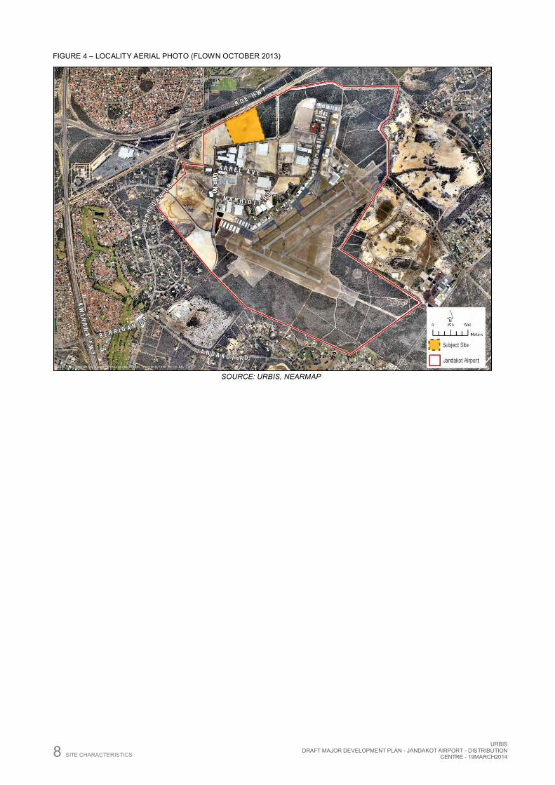
Figure 4 – Locality Aerial Photo (Flown October 2013) ............................................................................. 8
Figure 5 – Regional Linkages and Connections ...................................................................................... 12
Figure 6 – Estimated Typical Weekday Traffic Movements from the Proposed Development .................. 23
Figure 7 – Jandakot Airport Master Plan 2009 Map ................................................................................ 30
Figure 8 – Jandakot Airport Obstacle Limitation Surface ......................................................................... 40
TABLES:
Table 1 – Compliance with Major Development Plan Requirements.......................................................... 3
Table 2 – Site 218 Lot Title Details ........................................................................................................... 6
Table 3 – Surrounding Land Uses ............................................................................................................ 7
Table 4 – Building Areas ........................................................................................................................ 13
Table 5 – Existing Traffic Volumes ......................................................................................................... 22
Table 6 – Estimated typical weekday traffic generated from the proposed development.......................... 23
Table 7 – Impact on Major Surrounding Roads – Interim Scenario (2018) ............................................... 24
Table 8 – Impact on Major Surrounding Roads – Full Operation Scenario (2031) ................................... 24
Table 9 – Consistency of Proposal with Jandakot Airport Master Plan Objectives ................................... 27
Table 10 – Environmental Contrasts Mapping ........................................................................................ 31
Table 11 – Land Use Table – Mixed Business Zone ............................................................................... 38
Table 12 – Acceptable Noise Levels....................................................................................................... 42

URBIS DRAFT MAJOR DEVELOPMENT PLAN - JANDAKOT AIRPORT - DISTRIBUTION
CENTRE - 19MARCH2014
URBIS DRAFT MAJOR DEVELOPMENT PLAN - JANDAKOT AIRPORT - DISTRIBUTION CENTRE - 19MARCH2014 EXECUTIVE SUMMARY i
Executive Summary
Jandakot Airport Holdings Pty Ltd (JAH) plans to develop a Distribution Centre at Jandakot Airport on behalf of ALDI Foods Pty Ltd (ALDI). This Major Development Plan has been prepared in accordance with the requirements of the Airports Act 1996 for the purpose of a Distribution Centre at Jandakot Airport. For the purposes of the Airports Act 1996, the Distribution Centre comprises the construction of a new building that is not wholly or principally for use as a passenger terminal; and the cost of construction exceeds $20 million. Therefore the Distribution Centre is classified as a ‘major airport development’. Accordingly, the development cannot be carried out except in accordance with this Major Development Plan.
ALDI have an agreement with Jandakot Airport Holdings Pty Ltd to acquire a long term ground sub-lease to a 13.5 hectare site known as ‘site 218’ located on Orion Road, subject to a number of conditions. The site will be used for the purpose of a Distribution Centre which will be the central handling point for the ALDI Store network in Western Australia and will co-ordinate deliveries to all outlets. The internal building area of the Distribution Centre is 48,851 m2 and replicates the form and function of the five other Distribution Centres across Australia, consisting of the following elements:
A general goods warehouse with separate loading docks for goods-in (19 docks), goods-out (25 docks) and cool handling (17 docks with capacity to expand to 22)
A perishable goods warehouse (cool, refrigerated and frozen) A refuse facility Manoeuvring areas and temporary truck parking On-site overnight truck parking areas Truck wash-down area A refuelling station A single storey office (incorporating the ALDI State head office), and Staff and visitor car parking.
Once fully operational, the Distribution Centre will support a store network of 60 to 70 outlets within the metropolitan area, and hinterland regional centres as far as Geraldton to the north and Albany to the south. Following the 16-18 month construction period, once operational at full capacity, the Distribution Centre could employ up to 300 staff (including staff associated with the administrative functions of the head office) all of which are new jobs into the economy. A number of additional indirect jobs are anticipated to be created to support and service the Distribution Centre. More broadly the Distribution Centre will under pin the network of 60 to 70 ALDI Stores, which will directly employ more than 1,000 staff.
The development is proposed on a 13.5 hectare bespoke parcel of land that has been defined to meet the specific requirements of the ALDI Distribution Centre, and in consideration of the Jandakot Airport Master Plan 2009. The location sits in the north-west corner of Jandakot Airport within the mixed business precinct, well clear of the airside services that are the predominate use of the Airport. The subject land has already been cleared and is development ready with all services available, as expected within a quality business park. The site has significant separation from any sensitive land use, thus ensuring the required 24 hour operation can occur without impacting any existing or future uses in the locality.
Overall, the proposal is an example of modern transport and logistics development, and takes advantage of the exceptional location and convenient access to the state road network. The development is shown to be consistent with the established principles of the Jandakot Master Plan 2009 and meets all of the statutory requirements of the Airports Act 1996. The function and operation of the Distribution Centre is proven through the five existing facilities across Australia, having been adapted for the location, to include the specific requirements to maintain safe operation of the airport and established character of the commercial development precinct.
The proposed Distribution Centre demonstrates clear compliance with the requirements of the Jandakot Airport Master Plan 2009. ALDI have been working closely with Jandakot Airport Holdings Pty Ltd to ensure the development is in accordance with the requirements of their lease, the Airports Act 1996 and the Jandakot Master Plan 2009. The site is located within the commercial development precinct identified under the Master Plan, is well removed from the airside activities and will not be required for aviation purposes.
ii EXECUTIVE SUMMARY
URBIS DRAFT MAJOR DEVELOPMENT PLAN - JANDAKOT AIRPORT - DISTRIBUTION
CENTRE - 19MARCH2014
This Major Development Plan has been prepared in consultation with key stakeholders and the general public through targeted engagement, as well as the public comment requirements specified under the Airports Act 1996.
URBIS DRAFT MAJOR DEVELOPMENT PLAN - JANDAKOT AIRPORT - DISTRIBUTION CENTRE - 19MARCH2014 INTRODUCTION 1
Introduction This Major Development Plan has been prepared in support of the development of the ALDI Distribution Centre within the Jandakot Airport Commercial Precinct. The Distribution centre will be developed in a single stage and will meet the foreseeable requirements for ALDI’s distribution network in Western Australia.
ALDI is a ‘hard discount’ supermarket operation in Australia with a business model that limits operating costs to ensure the lowest possible price for its range of award winning exclusive brand products. ALDI has been operating on the east coast of Australia since 2001, with over 320 stores in operation.
The Distribution Centre consists of two key components, being a warehouse and an office. The Warehouse incorporates ambient storage and cold storage areas, as well as ancillary plant and servicing areas. The office supports the operation and function of the warehouse, as well as the head office that oversees the administration of ALDI’s store network. Integral to the operation and function of the site is truck manoeuvring, and providing access to the loading docks. All truck movements are via a single consolidated access point onto Orion Road, at the south-east corner of the site. Car parking is provided for all staff (non-commercial vehicles) by a second independent crossover onto Orion Road. The remainder of the site that is not covered by buildings or used for vehicle manoeuvring or parking is predominantly used for stormwater management and landscaping.
This Major Development Plan has been prepared in accordance with the Airports Act 1996, Jandakot Airport Master Plan 2009 and is consistent with the design guidelines, reflecting the general high standard of development expected throughout the area.
ALDI investigated a number of locations to establish their Distribution Centre, however the location at Jandakot Airport was eventually chosen, largely due to the locational advantages associated with efficient connections into the regional road network. In addition, there is a close affinity with the values and vision set out in the Jandakot Airport Master Plan 2009 and the location provides the opportunity to be part of an extremely high quality mixed business precinct with a diverse range of complementary users. The value that has been invested into Jandakot Airport by Jandakot Airport Holdings is clearly evident, and it provides a solid footing for a successful long term outcome. Ultimately, ALDI’s long term objectives are closely aligned with that of the Jandakot Airport Holdings and the objectives of their Master Plan.

2 INTRODUCTION
URBIS DRAFT MAJOR DEVELOPMENT PLAN - JANDAKOT AIRPORT - DISTRIBUTION
CENTRE - 19MARCH2014
URBIS DRAFT MAJOR DEVELOPMENT PLAN - JANDAKOT AIRPORT - DISTRIBUTION CENTRE - 19MARCH2014 LEGISLATIVE FRAMEWORK 3
1 Legislative Framework This section sets out the statutory framework that governs the development of the land within the Jandakot Airport and the mandatory requirements to be addressed by this Major Development Plan.
1.1 AIRPORTS ACT 1996 The Airports Act 1996 (the Act) and associated Regulations are Commonwealth legislation that is responsible for the regulation of ownership, management and conduct of major Australian airports. Part 5 of the Act sets out the requirements for land use, planning and building controls.
In accordance with the Act, all ‘major airport development’ requires a ‘Major Development Plan’. Section 89 of the Act sets out all those activities defined as major airport development. The proposed development subject of the draft MDP is determined to be ‘major airport development’ by pursuant to Section 89(1)(e):
Constructing a new building, where:
(i) The building is not wholly or principally for use as a passenger terminal; and
(ii) The cost of construction exceeds $20 million or such higher amount as is prescribed;”
The cost of construction of the proposed ALDI Distribution Centre is in the order of $80 million, thereby exceeding the $20 million threshold and triggering the requirement for a Major Development Plan (MDP).
Section 90 of the Act states that no major airport developments shall be carried out unless in accordance with an approved MDP. The matters to be addressed by the MDP are set out under Section 91 of the Act and are summarised the checklist provided at Table 4:
TABLE 1 – COMPLIANCE WITH MAJOR DEVELOPMENT PLAN REQUIREMENTS
ACT REF MAJOR DEVELOPMENT PLAN REQUIREMENT SECTION OF THIS MDP MATTER IS ADDRESSED
91(1)(a) The proponents objectives for the development 3
91(1)(b) The extent to which the development will meet the future needs of civil aviation uses of the Airport and other users of the Airport
3.1
91(1)(c) A detailed outline of the proposed development 4
91(1)(ca) Whether or not the development is consistent with the Airport’s lease for the airport
2.2
91(1)(d) Whether or not the development is consistent with the final master plan for Jandakot Airport
6
91(1)(e) If the development could affect noise exposure levels at the airport and the effect the proposed development would have on noise exposure levels
8.1 and 8.2
91(1)(ea) If the development could affect flight paths at the airport— the effect that the development would be likely to have on those flight paths
8.3
4 LEGISLATIVE FRAMEWORK
URBIS DRAFT MAJOR DEVELOPMENT PLAN - JANDAKOT AIRPORT - DISTRIBUTION
CENTRE - 19MARCH2014
ACT REF MAJOR DEVELOPMENT PLAN REQUIREMENT SECTION OF THIS MDP MATTER IS ADDRESSED
91(1)(f) the proponents plans, developed following consultation with airport users, for managing aircraft noise intrusion in areas forecast to be subject to exposure above the significant ANEF levels (having regard for AS 2021-2000)
N/A – the development sits outside the identified ANEF
contours
91(1)(g) an outline of the approvals that the proponent has sought, is seeking or proposes to seek under Division 5 or Part 12 in respect of elements of the development
10.1
91(1)(ga) The likely affect the proposed development would have on:
Traffic flows at the airport and surrounding the airport 5.6
Employment levels at the Airport, and 3.2.1
The local and regional economy and community, including an analysis of how the proposed development fits within the local planning schemes for commercial and retail development in the adjacent area
3.2.2
91(1)(h) An assessment of environmental impacts that might reasonably be expected to be associated with the development
5.1
91(1)(j) the proponents plans for ameliorating or preventing identified environmental impacts
5.1
91(1)(k) if the plan relates to a sensitive development—the exceptional circumstances that the proponent claims will justify the development of the sensitive development at the airport
N/A – the proposal is not for the purpose of a sensitive
development.
91(1)(l) such other matters (if any) as are specified in the regulations N/A
91(4) The proponents plan must demonstrate the extent of the consistency with planning schemes in force under a law of the State where the Airport is location; and identity and justify any inconsistencies
7
As demonstrated by the above checklist, this MDP addresses all of the required matters above in accordance with Section 91 of the Act.
URBIS DRAFT MAJOR DEVELOPMENT PLAN - JANDAKOT AIRPORT - DISTRIBUTION CENTRE - 19MARCH2014 SITE CHARACTERISTICS 5
2 Site Characteristics
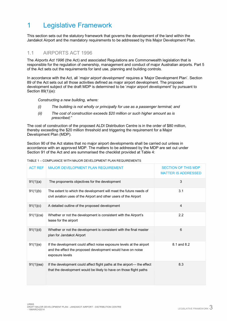
2.1 SITE LOCATION As depicted in Figure 1 below, Jandakot Airport is situated approximately 15 km south of the City of Perth, 13 km east of the Port of Fremantle (measured in a straight line), and in total occupies an area of 622 hectares. The proposed site that is subject to this Major Development Plan is 13.56 hectares and is located in the northern portion of the wider airport area, well clear of airside activities, within the Jandakot Non-Aviation Development Area. The site is located on Orion Road and has access to Roe Highway via Karel Avenue. The site has excellent access to the broader metropolitan road network, including the Kwinana Freeway.
FIGURE 1 – LOCATION PLAN
Source: Urbis, Navteq
2.2 JANDAKOT AIRPORT LEASE Jandakot Airport is Federal land leased for 50 years, with an option to extend the lease by 49 years in accordance with the Airports Act 1996 (the Act) and regulations made thereunder. Jandakot Airport Holdings Pty Ltd (JAH) currently holds the lease outlined above. The lease was executed on 1 July 1998 and therefore as at 2013, there are 84 years remaining to run on the ground lease. The term of the lease is for a period of 50 years with an option of a further 49 years, exercisable by the lessee. The principle condition of the lease is that the lessee must comply with all legislation relating to the Airport site, including the Act. The initial Lease period will expire on 30 June 2048.
ALDI has acquired the ground sub-lease to the subject site, which is a bespoke parcel that has been created to meet the specific needs of an ALDI Distribution Centre. The subject site is known as site 218 Orion Road, Jandakot Airport. The subject site is 135,573 m2.

6 SITE CHARACTERISTICS
URBIS DRAFT MAJOR DEVELOPMENT PLAN - JANDAKOT AIRPORT - DISTRIBUTION
CENTRE - 19MARCH2014
The proposed development is for a lawful purpose and it is not inconsistent with using the airport as an airport in accordance with clause.3.1 (b)(i) of the Airports Act 1996. Further, the proposed development will employ quality standards reasonably expected of such an airport in Australia as required by Cl.13.1(c).
FIGURE 2 – CADASTRAL PLAN – JANDAKOT AIRPORT AND SITE
SOURCE: MCMULLEN NOLAN GROUP, URBIS
The subject site is identified by a red border in Figure 2, and is bound by Orion Road to the south, a bushland conservation area to the east, the Gas Pipeline easement to the north, and ‘development ready’ land within the Commercial Precinct to the west. The subject site is referred to as ‘site 218’ for the purpose of the agreement between ALDI and Jandakot Airport Holdings.
The site is currently vacant, having recently been cleared in 2011/12 in preparation for development. The site has now been graded and stabilised to create a level lot, fully serviced and ready for commercial development. No previous development approvals have been granted over the site. The site directly abuts an easement for a Gas Pipeline to the north. The existing batter adjacent to the easement will be maintained as there are no changes to site levels against the easement as part of this proposal. Access to the easement will also be maintained in its current form.
TABLE 2 – SITE 218 LOT TITLE DETAILS
LOT PLAN/DIAGRAM VOL/FOLIO AREA REGISTERED PROPRIETOR
Part Lot 301 P301022 2228/470 135,573 m2 Commonwealth of Australia
A copy of the Certificate of Title and Easement is attached at Appendix B.
SUBJECT SITE (SITE 218)
JANDAKOT AIRPORT
URBIS DRAFT MAJOR DEVELOPMENT PLAN - JANDAKOT AIRPORT - DISTRIBUTION CENTRE - 19MARCH2014 SITE CHARACTERISTICS 7
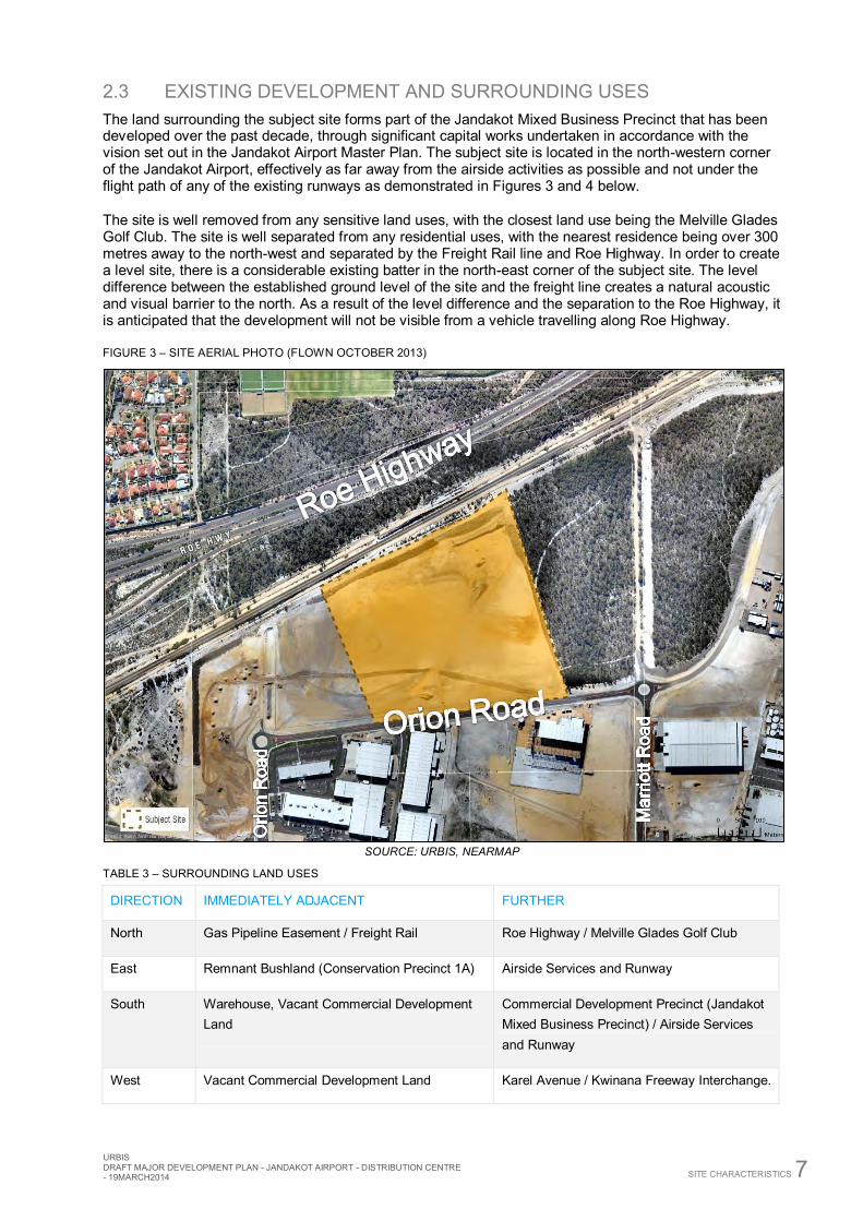
2.3 EXISTING DEVELOPMENT AND SURROUNDING USES The land surrounding the subject site forms part of the Jandakot Mixed Business Precinct that has been developed over the past decade, through significant capital works undertaken in accordance with the vision set out in the Jandakot Airport Master Plan. The subject site is located in the north-western corner of the Jandakot Airport, effectively as far away from the airside activities as possible and not under the flight path of any of the existing runways as demonstrated in Figures 3 and 4 below.
The site is well removed from any sensitive land uses, with the closest land use being the Melville Glades Golf Club. The site is well separated from any residential uses, with the nearest residence being over 300 metres away to the north-west and separated by the Freight Rail line and Roe Highway. In order to create a level site, there is a considerable existing batter in the north-east corner of the subject site. The level difference between the established ground level of the site and the freight line creates a natural acoustic and visual barrier to the north. As a result of the level difference and the separation to the Roe Highway, it is anticipated that the development will not be visible from a vehicle travelling along Roe Highway.
FIGURE 3 – SITE AERIAL PHOTO (FLOWN OCTOBER 2013)
SOURCE: URBIS, NEARMAP
TABLE 3 – SURROUNDING LAND USES
DIRECTION IMMEDIATELY ADJACENT FURTHER
North Gas Pipeline Easement / Freight Rail Roe Highway / Melville Glades Golf Club
East Remnant Bushland (Conservation Precinct 1A) Airside Services and Runway
South Warehouse, Vacant Commercial Development Land
Commercial Development Precinct (Jandakot Mixed Business Precinct) / Airside Services and Runway
West Vacant Commercial Development Land Karel Avenue / Kwinana Freeway Interchange.
8 SITE CHARACTERISTICS
URBIS DRAFT MAJOR DEVELOPMENT PLAN - JANDAKOT AIRPORT - DISTRIBUTION
CENTRE - 19MARCH2014
FIGURE 4 – LOCALITY AERIAL PHOTO (FLOWN OCTOBER 2013)
SOURCE: URBIS, NEARMAP

URBIS DRAFT MAJOR DEVELOPMENT PLAN - JANDAKOT AIRPORT - DISTRIBUTION CENTRE - 19MARCH2014 DEVELOPMENT OBJECTIVES 9
3 Development Objectives ALDI is seeking to establish a Distribution Centre to support their Western Australian store network, which is planned to reach 60 to 70 outlets. The Distribution Centre is required to provide a central logistics base to co-ordinate and stage the handling of products and merchandise, for distribution to the broader store network.
ALDI’s principle objective is to maintain a business model that limits operating costs to ensure that the lowest possible price for its products can be passed onto its customers. The operation of the Distribution Centre and its relationship with the store network is clearly a critical part of ensuring operational costs are minimised. On this basis, the primary drivers of the Distribution Centre are safety and efficiency, without sacrificing quality or the length of its useful life.
The Distribution Centre operates on a basic goods-in, goods-out basis. The ‘goods-in’ are deliveries (orders) received from ALDI’s suppliers, managed and controlled at one end of the Distribution Centre. The goods-out service is managed by ALDI’s fleet of trucks, with consignments based on the specific order requirements of each individual store. The operation of the Distribution Centre (both goods-in and goods-out) will occur 24 hours a day, seven days a week.
There is a requirement for the site to have unconstrained access to the regional road network, enabling a highly efficient reach to the store network. Accordingly, a relatively central location to provide a good proximity to the entire store network as well as excellent access and connectivity, was the primary driver in the decision to establish the Distribution Centre at Jandakot Airport.
3.1 NEED AND JUSTIFICATION Jandakot Airport commenced operation in 1963, and currently supports a wide range of air services, including flight training schools, the Royal Flying Doctor Service, Department for Fire and Emergency Services, WA Police and many other general aviation uses. In more recent times the land within the airport lease area has evolved into a more diverse precinct, with the development of a significant portion of the site for non-aviation purposes. Jandakot Airport represents a highly strategic location for transport-based uses that can operate without impacting on the core operations of the airside services undertaken at the airport.
The State Government’s planning framework identifies Jandakot Airport as a ‘Specialised Centre’, intended to ‘focus on regionally significant economic or institutional activities that generate many work and visitor trips, which therefore require a high level of transport accessibility’. Specifically, the Jandakot Specialised Centre is identified as having a primary function of ‘Aviation and Logistic Services’. The proposed development of the Distribution Centre is strongly aligned with this objective.
The Jandakot Master Plan 2009 was developed with the principle of enabling the diversification of the Airport, acknowledging that ‘the development of non-aviation land is critical to the future delivery of aviation and environment outcomes on the Airport as the non-aviation land provides a strategic diversity of income to secure the sustainability of the Airport. The development will be guided by sound on-airport and off-airport planning principles’.
The vision for Jandakot Airport, as set out in the approved 2009 Master Plan, is ‘to successfully develop and manage Jandakot Airport as a strategically significant aviation hub with a supporting business campus’. The vision is supported by specific development objectives that seek to ensure that proposed land uses and all resultant built form:
Integrates and has consideration for the aviation requirements, development strategy and conservation issues on the Airport
Respects and integrates the current regional and local planning schemes and local governments surrounding the Airport with the non-aviation land uses and the Airport
Supports the economic development of the region by providing a significant range of jobs for the local area
Uses the latest ‘best practice’ planning solutions Ensures a pleasant working environment for the visitors and workers at the Airport.

10 DEVELOPMENT OBJECTIVES
URBIS DRAFT MAJOR DEVELOPMENT PLAN - JANDAKOT AIRPORT - DISTRIBUTION
CENTRE - 19MARCH2014
The land on which the ALDI Distribution Centre is proposed was specifically developed as a commercial estate, pursuant to the Master Plan to facilitate warehouse and storage developments. The resultant ALDI Distribution Centre responds strongly to vision and development objectives established under the Master Plan. Overall the proposal will positively contribute to the commercial precinct within Jandakot Airport, complement the existing range of uses, support a diverse working population and provide a high quality built form. The proposed development will not impact the future operating capacity of the airport.
3.2 CONTRIBUTION TO ECONOMIC DEVELOPMENT
3.2.1 EMPLOYMENT The Jandakot Airport Master Plan 2009 recognises that non-aviation development is vital in ensuring the ongoing financial viability of the Airport, putting the land to productive use that takes advantage of the locational attributes and in particular commercial and logistical development. If this non-aviation use of land can improve the viability of aviation services without compromising their safe and effective operation into the future, it can be considered a prudent and responsible use of surplus airport land.
In 2006, the State Government adopted State Planning Policy 5.3 Jandakot Airport Vicinity (SPP 5.3). SPP 5.3 acknowledges the importance of Jandakot Airport as an element of transport infrastructure that services the State and that there is scope for it to be developed further – both for aviation and non-aviation uses.
Located centrally within Perth’s southern suburbs, Jandakot Airport is an ideal employment destination with easy access to a broad range of suburbs, incorporating diversified demographics (and skillsets) due to its location on the Kwinana Freeway and Roe Highway.
In the Department of Planning’s Outer Metropolitan Sub-Regional Structure Plan, Jandakot is located in the South-West Sub-Region, which has an employment self-sufficient rate of 60%, as opposed to the desired 70%. Depending on population growth, this sub-region required 87,000 to 113,000 jobs by 2031 to achieve the desired employment self-sufficiency rate. Consistent with this objective, Jandakot Airport is identified as a key employment generating area, with potential to add to its contribution to local employment and the economic development of the State.
The employment benefits of the proposed Distribution Centre originate from:
Construction jobs – the construction cost for the facility is estimated at approximately $80 million with a construction period of 16 – 18 months. This investment will generate approximately 90 direct jobs.
Direct Jobs – in the order of 300 staff will eventually be employed at the site, including in the office components, once fully operational (with approximately 100 to 150 staff working at any single time).
Indirect Jobs – in addition to direct employment, a number of jobs can be expected to be created in the broader economy as suppliers to the new facility. Jobs created will be as diverse as cleaning, office supplies, goods-in deliveries, mechanical repairs for the vehicle fleet, etc.
Of particular significance in this instance is the expectation that jobs created will be genuinely new employment opportunities rather than a transfer of jobs or relocation of employment from an older facility. More significant is the fact that the Distribution Centre will be the backbone of a State-wide network of ALDI stores, which will employ on average around 15 staff each and many more indirectly. The ALDI Western Australia head office incorporated in the proposed development will elevate the status of Jandakot as a genuine option for establishing a business, providing a further catalyst for the development of new business opportunities in the locality.
In summary, the proposed Distribution Centre will:
Create several hundred jobs during construction, and in its ongoing operation Provide additional employment in the south-west sub-region and assist in achieving employment
self-sufficiency goals set out in various State Government documents, Provide a range of full time and part time jobs accessible to the local workforce, Support additional employment at stores across the State and many more indirectly.
URBIS DRAFT MAJOR DEVELOPMENT PLAN - JANDAKOT AIRPORT - DISTRIBUTION CENTRE - 19MARCH2014 DEVELOPMENT OBJECTIVES 11
3.2.2 OTHER ECONOMIC BENEFITS In addition to the significant employment benefits discussed above we expect the facility to provide a number of other economic benefits for the local area and broader region including:
Providing local employment to the south-west sub-region and support to the wider retail sector across the State, as well as a diverse range of local services and suppliers. This will increase sub-regional employment self-sufficiency, as well as assist in the economic development of the State
Increased sub-regional employment self-sufficiency will provide the nearby community increased access to employment, with shorter commute times to other centres
Providing additional business and personal tax revenue for the Commonwealth and State Enhancing Western Australia’s reputation as a safe and desirable place for foreign investment Providing an important “anchor tenant” for the Jandakot precinct that could stimulate further
economic activity in the area Being a complementary land use in the Jandakot Airport mixed business precinct, with a similar
level of intensity, visual presence and with no negative impact on the prioritised aviation uses. Assisting in meeting the employment and development intensity targets under the City of
Cockburn Local Commercial and Activities Centres Strategy. Ensuring minimal noise or visual impact on any residences through its location in a business
estate, and shielded from communities through major transport links and buffering land uses, such as golf estates
Facilitating freight traffic on higher level roads, with efficient road access to other distribution locations such as Perth Airport, Kewdale Inter Modal, Canning Vale, and Fremantle Port. It will also assist the State government to realise a genuine return on investment in terms of the infrastructure provision (for example East Link) and assist in the justification of the business case for infrastructure upgrades and new projects (for example Roe Highway Stage 8)
Triggering the development of several dozen new stores across the city and State, both freestanding and in centre redevelopments, underpinning retail and construction jobs
Enhancing opportunities for a wide range of local suppliers to access the ALDI distribution network.
Will not detrimentally impact or compete with any surrounding local businesses as the development does not include any retail operations.
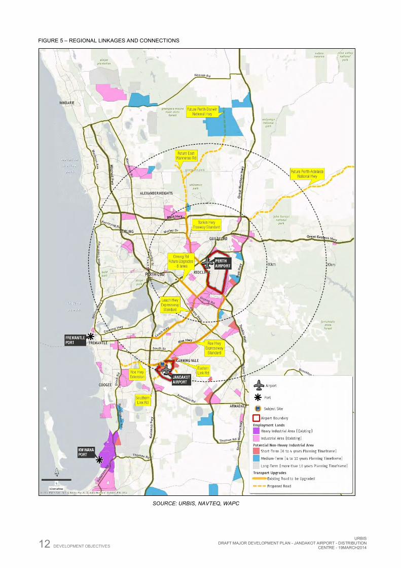
Figure 5 provides a spatial context of the site at a metropolitan scale, identifying the regional road network as well as the existing and potential future industrial areas.
12 DEVELOPMENT OBJECTIVES
URBIS DRAFT MAJOR DEVELOPMENT PLAN - JANDAKOT AIRPORT - DISTRIBUTION
CENTRE - 19MARCH2014
FIGURE 5 – REGIONAL LINKAGES AND CONNECTIONS
SOURCE: URBIS, NAVTEQ, WAPC
URBIS DRAFT MAJOR DEVELOPMENT PLAN - JANDAKOT AIRPORT - DISTRIBUTION CENTRE - 19MARCH2014 PROPOSED DEVELOPMENT 13
4 Proposed Development
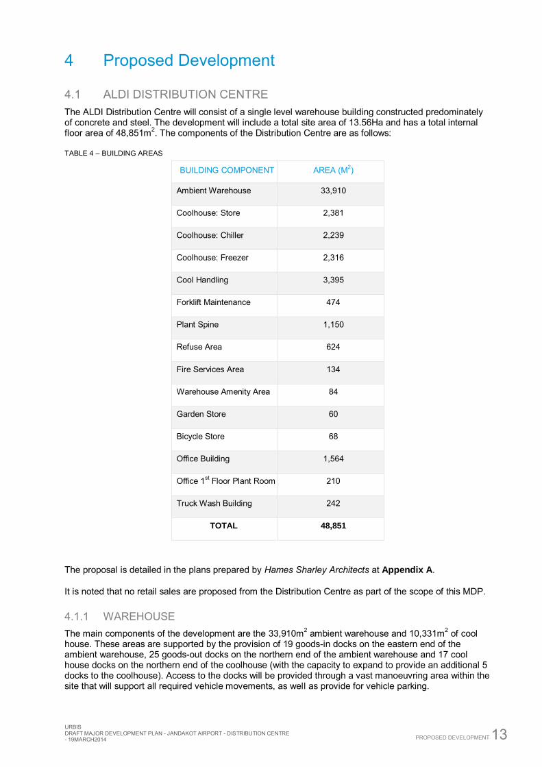
4.1 ALDI DISTRIBUTION CENTRE The ALDI Distribution Centre will consist of a single level warehouse building constructed predominately of concrete and steel. The development will include a total site area of 13.56Ha and has a total internal floor area of 48,851m2. The components of the Distribution Centre are as follows:
TABLE 4 – BUILDING AREAS
BUILDING COMPONENT AREA (M2)
Ambient Warehouse 33,910
Coolhouse: Store 2,381
Coolhouse: Chiller 2,239
Coolhouse: Freezer 2,316
Cool Handling 3,395
Forklift Maintenance 474
Plant Spine 1,150
Refuse Area 624
Fire Services Area 134
Warehouse Amenity Area 84
Garden Store 60
Bicycle Store 68
Office Building 1,564
Office 1st Floor Plant Room 210
Truck Wash Building 242
TOTAL 48,851
The proposal is detailed in the plans prepared by Hames Sharley Architects at Appendix A.
It is noted that no retail sales are proposed from the Distribution Centre as part of the scope of this MDP.
4.1.1 WAREHOUSE The main components of the development are the 33,910m2 ambient warehouse and 10,331m2 of cool house. These areas are supported by the provision of 19 goods-in docks on the eastern end of the ambient warehouse, 25 goods-out docks on the northern end of the ambient warehouse and 17 cool house docks on the northern end of the coolhouse (with the capacity to expand to provide an additional 5 docks to the coolhouse). Access to the docks will be provided through a vast manoeuvring area within the site that will support all required vehicle movements, as well as provide for vehicle parking.
14 PROPOSED DEVELOPMENT
URBIS DRAFT MAJOR DEVELOPMENT PLAN - JANDAKOT AIRPORT - DISTRIBUTION
CENTRE - 19MARCH2014
Typically, 26m B-doubles and 19m semi-trailers are used for all transport operations (inbound and outbound). Goods-in operations are typically limited to 6:00am to 2:00pm, whilst goods-out operations occur across a longer period of the day, up to 24 hours. A dedicated access (ingress and egress) for all heavy vehicles is proposed, which will provide full movement onto Orion Road.
A control gate is located approximately 90 metres inside the property boundary, with two inbound lanes provided for the stacking of up to 6 B-doubles on site before the control point, ensuring that the Distribution Centre can handle a number of deliveries arriving at the same time. ALDI provides all suppliers with time-slot allocations, which generally ensures that deliveries are staggered, to allow unloading and handling to be undertaken in an efficient manner.
The key routes that the heavy vehicles associated with the Distribution Centre will use are:
Roe Highway, via Orion Road and Karel Avenue; Kwinana Freeway, via Roe Highway; Kwinana Freeway, via Orion Road, Karel Avenue and Berrigan Drive; and Ranford Road, via Orion Road, and a future eastern link road.
The appointed traffic engineers, Transcore, have assessed the internal road network (as outlined above) and confirmed that a 27.5m B-double truck can traverse all roads and intersections required to access the desired routes. Accordingly no upgrades are required to facilitate the safe and efficient access of the maximum design vehicle associated with the Distribution Centre.
4.1.2 OFFICE The proposed development will also provide for 1,564 m2 of office floor area over a single level. The office will provide for the administrational activities associated with the operation of the Distribution Centre, the coordination of goods requirements for the ALDI store network throughout Western Australia, and will function as the headquarters for WA operations.
The office building will provide a high quality built form and act as the ‘front door’ for the development. The office has been designed to provide a direct connection with the warehouse, as well as projecting a large proportion of building out beyond the warehouse, to enable glazing to the north to create a high quality internal environment with natural light and thermal comfort. The entire southern (street facing) façade of the office building is glazed to provide an open and inviting appearance from the street.
An independent access point is provided to a staff/visitor area at the front of the office building, with the crossover located over 100 metres to the west of the heavy vehicle access. 250 car bays are provided on the site, which is more than sufficient to cover the busiest time of year (lead up to Christmas). The car parking area will be landscaped to a higher standard than the general periphery of the site, with the inclusion of trees to provide shade. In addition to the car parking bays provided, 34 bicycle parking bays and associated end-of-trip facilities are provided. Bike lanes are provided throughout the Jandakot Mixed Business Precinct, including along Orion Road to the entry of the site. This connects into the wider regional bike path network, including quality bike paths provided along the Kwinana Freeway and Roe Highway. Accordingly, a high provision of end-of-trip facilities is proposed to enable staff to ride if they choose. Such end of trip facilities include two sets of male and female change rooms, staff lockers, showers and drying racks.
The detailing and appearance of the office building, combined with high quality landscaping to the staff/visitor parking, will create an amenable development outcome and provide a contrast to the scale and appearance of the remainder of the warehouse building.
URBIS DRAFT MAJOR DEVELOPMENT PLAN - JANDAKOT AIRPORT - DISTRIBUTION CENTRE - 19MARCH2014 PROPOSED DEVELOPMENT 15
4.1.3 ANCILLARY COMPONENTS The proposed development will include a range of ancillary functions required to support the ongoing operation of the Distribution Centre. An important component of the facility is the truck wash and refuelling station.
Refuelling
As ALDI own and operate their entire fleet of vehicles, the refuelling facility is critical to the day to day running of the Distribution Centre. The fuel storage is aboveground and will be fully bunded. Depending on the final design, the batter may require minor earth working and retaining to provide a flat pad for the installation of the storage tanks and to protect the embankment. The Distribution Centre will be serviced by a fleet of approximately 30 trucks at maturity of the Jandakot region (60 to 70 stores). The majority of trucks will be 19 metre semi-trailers, with a smaller number (3-4) being B-Double trucks. Each truck will re-fuel 1 to 1.5 times per day on average. The total estimated fuel volume pumped from the on-site for re-fuelling will be approximately 150,000 litres per month at maturity.
Groundwater monitoring will be regularly undertaken to confirm the mitigation processes are effective.
Truck Wash
The truck wash will recycle 85% of water used, with a monthly average demand estimated at 130kL at maturity. Water Harvesting will be investigated as part of the detailed documentation of the facility, and if feasible, could be allocated to the truck wash. The truck wash contains number of settlement tanks including petrol and oil interceptor trap to remove contaminates prior to re-use. . The discharge to authority drain will be treated sewer with the petrol, oil and sediment having been filtered. The truck wash process will be within a closed system to mitigate the potential of any contaminants entering the soil or groundwater. The settlement tanks and oil, petrol interceptor trap will be cleaned by a maintenance contractor approximately every 4 months.
Groundwater monitoring will be regularly undertaken to confirm the mitigation processes are effective.
Vehicle Maintenance and Servicing
Vehicle maintenance and servicing undertaken on site will be limited to ‘dry maintenance’ (minor repairs and servicing), with all heavy truck maintenance occurring off-site. A small forklift maintenance area is proposed in the south west corner of the ambient warehouse. Other ancillary areas include the plant area, pump room, refuse area, fire and irrigation tanks.
Refuse
A refuse area is provided between the goods-in and goods-out docks. The refuse area is a crucial activity in ALDI’s day-to-day activity and closely relates to the Ambient Warehouse and Cool House. Therefore the proposed refuse is conveniently located relevant to these areas, whilst maintaining separation from the office to avoid any odour impacts that may be detectable in the immediate vicinity of the refuse area.
Typical waste includes:
Food items approaching use by date including fruit and vegetables, dairy products, frozen goods and possibly meat products.
Damaged goods Cardboard, plastic wrapping, etc Waste associated with warehouse and office Garden Equipment Store
Control of hygiene, cleaning, odour and vermin is essential to the refuse area and to ALDI’s operations and is therefore maintained to the highest standard, with collections on a twice weekly basis under normal operations.
16 PROPOSED DEVELOPMENT
URBIS DRAFT MAJOR DEVELOPMENT PLAN - JANDAKOT AIRPORT - DISTRIBUTION
CENTRE - 19MARCH2014
4.1.4 SIGNAGE Two pylon signs are proposed to the frontage of the site. One sign is a 6 metre high directional sign at the entry to the staff/visitor parking area, and the other is a 12 metre high directional sign located at the truck entrance to the site. Three illuminated building signs are proposed, each measuring 2.4 metres by 2.0 metres; two signs to be located on the south west corner of the building and another on the warehouse in the vicinity to the entry to the office. A smaller sign is also proposed for the portico entry to the office building, to assist with way finding and creating a clear entry point.
4.2 SITE LAYOUT AND DESIGN The spatial arrangement of the site is carefully designed to provide for the needs of ALDI in the safest and most efficient manner possible, as well as ensuring a quality street appeal for ALDI head office.
The facility has been orientated in a manner that ensures that the loading docks, refuelling, wash down and truck parking areas are not located between the building and the street. For the most part, the Distribution Centre building screens the activities behind, thereby provide a high quality interface with the public realm. The only exception is the fire services, which are located in front of the south-west corner of the building; in accordance with the statutory requirement of the Department of Fire and Emergency Services.
The office component provides a clearly defined entry to the south, whilst still having exposure to the northerly aspect of the site to facilitate good thermal comfort and natural light. The office also provides good visual coverage both internally over the goods-in, and externally over the front car park and truck access and marshalling area.
The site layout is intended to mitigate potential impacts associated with strong weather events by orientation away from prevailing winds and protection gained from the bunded land to the rear (north). The prevailing winds for Perth suburbs are generally a morning easterly (warm) throughout the drier months, with typically a south west (cool) breeze through the afternoon. Inclement weather through the winter months is typically from the north-west to south-west, and therefore, the best potential to both dock areas is provided by the batter area which is up to ten metres high on the northern and eastern boundaries.
Stormwater is retained on site and managed through swales and drainage basins in accordance with the specification of the Jandakot Airport Design Guidelines.
4.3 LANDSCAPING The landscape design for the ALDI Distribution Centre references the site’s location within the Perth area and has been prepared in accordance with the Jandakot Airport Landscape Design Guidelines. It makes use of locally endemic species in its bushland planting, buffer planting and garden beds, reflecting that of its neighbouring conservation site. Species will be initially chosen from approved lists, suitable to the location and intended use. Where necessary, proposed supplement species will be similar to those found in the neighbouring conservation site, or those locally native and based on site requirements.
The landscape plan responds to the need for water sensitive design through the implementation of water wise principles. This includes the introduction of drainage swales along roadsides, minimal turf areas, and drought tolerant planting that requires little to no water once established. It is a low maintenance landscape that provides space for staff to work and recreate, whilst also meeting key environmental needs.
4.3.1 RELATIONSHIP TO CONSERVATION PRECINCT 1A Potential risks to the conservation precinct include weed invasion and diseases, groundwater depletion, rubbish dumping and injury or causing the death of native fauna. These risks have been mitigated through the design and implementation of the Construction Environmental Management Plan (CEMP), specifically:
URBIS DRAFT MAJOR DEVELOPMENT PLAN - JANDAKOT AIRPORT - DISTRIBUTION CENTRE - 19MARCH2014 PROPOSED DEVELOPMENT 17
To prevent the introduction of weeds and diseases to the bushland during the construction period all imported plant stock, mulch, soil and the like should be certified weed-free.
The selection of low-water use plants, the use of permeable paving materials and the harvesting of stormwater for irrigation purposes will minimise the landscape’s requirements for bore water, and assist in recharging groundwater.
The existing fencing at the boundary between the site and the conservation precinct restricts human access to the bushland, will prevent rubbish from being dumped or blowing in, as well as assist in preventing the spread of weeds. The fencing will also assist in containing fauna within the boundaries of the conservation precinct.
18 SITE CONDITIONS AND SERVICING
URBIS DRAFT MAJOR DEVELOPMENT PLAN - JANDAKOT AIRPORT - DISTRIBUTION
CENTRE - 19MARCH2014
5 Site Conditions and Servicing
5.1 ENVIRONMENTAL In June 2012 environmental consultant group ENV Australia was commissioned by JAH to undertake a Preliminary Site Inspection (PSI) for Precinct 4, to assess environmental conditions and constraints.
The report notes that prior to 2011, the site had been undeveloped with a cover of native vegetation. However, subsequent development works associated with the creation of the mixed business precinct have resulted in the removal of all remnant vegetation from the subject site. The site remains cleared of all significant vegetation. As such the proposed ALDI Distribution Centre does not propose any clearing or vegetation removal and therefore will not have any adverse impacts on the vegetation qualities of the subject site. The adjacent land parcel to the east comprises a conservation area, which consists of remnant native vegetation that is in good condition.
The DEC’s ‘Potentially Contaminating Activities, Industries and Land Uses’ guideline document lists a number of common contaminants associated with various industries, activities and land uses. However, due to the site never having been developed or used prior to the site works that commenced in 2011, the potential for soil contamination can be discounted.
The ENV report conducted in 2012 found that there are no potential environmental impacts for the subject site and that the land is suitable for the development of mixed business land uses.
No significant impacts are expected as a result from the construction or operation of the proposed development. The site has already been cleared (under EPBC 209/4796) and does not constitute fauna habitat. A Construction Environmental Management Plan (CEMP) will be required as a condition of building approval. The CEMP will address issues including:
acid sulphate soil management associated with excavation and dewatering erosion and sediment control noise dust waste management soil disposal hazardous materials management onsite hydrocarbon management and refuelling; and vehicle/plant servicing.
5.1.1 PROTECTION OF THE CONSERVATION PRECINCT. ENVIRONMENTAL PROTECTION AND BIODIVERSITY ACT 1999
The Environmental Protection and Biodiversity Act 1999 (EPBC Act) provides a level of protection for matters of national environmental significance. Specifically the EPBC Act protects the environmental qualities on Commonwealth land; and regulates the actions of Commonwealth departments and agencies that may have significant environmental impacts. Jandakot Airport is located on land leased from the Commonwealth and therefore is subject to the Provisions of the EPBC Act.
The Jandakot Airport Master Plan 2009 and Environment Strategy have included a rigorous assessment of the environmental qualities of the subject land and set out the planning framework to reflect the findings. EPBC referral 2009/4796 (Jandakot Airport Expansion, Commercial Development and Clearance of Native Vegetation, WA) was approved with conditions by the then Minister for Environment, Water, Heritage and Arts in March 2010. This approval allows for clearing and commercial development as detailed in the Master Plan 2009, and includes the ALDI development site.
The works detailed within this MDP are consistent with EPBC 2009/4796 conditions of approval in that:
No clearing (outside of what has occurred in preparation for lot development) is required.
The area cleared for the purpose of undertaking works detailed within this MDP, along with other areas cleared for development elsewhere on the airport, will not exceed 167 ha.
URBIS DRAFT MAJOR DEVELOPMENT PLAN - JANDAKOT AIRPORT - DISTRIBUTION CENTRE - 19MARCH2014 SITE CONDITIONS AND SERVICING 19
No clearing of remnant or regrowth vegetation within other precincts (including Conservation Precincts) is required.
All clearing has occurred under a Construction Environment Management Plan (CEMP) that has been approved by the Environment Minister.
Figure 7 of the Environment Strategy indicates that the subject site is not located within an area containing any vegetation.
As the current Master Plan has taken the environmental qualities of the site into account, including the requirement to conserve the most important areas of vegetation, it is considered that a further environmental assessment and report will not be required. Ultimately, the MDP is consistent with the approved Jandakot Airport Master Plan 2009 and therefore in accordance with the intended development outcome for the site.
5.2 HERITAGE No indigenous or European heritage sites are recorded within the site boundary. There are however, surrounding sites in the wider locality of heritage significance and are listed on the City of Cockburn Municipal Inventory specifically:
Dutch Windmill Jandakot Hall Jandakot School and Farm Quarters, and Jandakot Wool Scours
The proposed Distribution Centre is not located within close proximity and does have any visual connection with any of these places.
5.3 CONTAMINATION The Contaminated Sites Act 2003 (CS Act) aims to provide transparent and up to date information on contamination within Western Australia. The Act is administered by the Department of Environment Regulation (DER) (formally the Department of Environment and Conservation). DER classify sites as reported to them within one of seven classifications, being:
Report not substantiated Possibly contaminated – investigation required Not contaminated – unrestricted use Contaminated – restricted use Contaminated – remediation required Remediated – restricted use Decontaminated
Contamination is defined as the existence of substances at levels above that of background concentrations that present a risk to human health or the environment.
Jandakot Airport is no longer listed on the WA Contaminated Sites Database. The contaminated Site which was the basis of the initial listing has been remediated. The WA Department of Environment Regulation advised 20/11/13 that, on the basis of evidence provided to and reviewed by DER, the site has been decontaminated and has been removed from the Contaminated Sites Database.
Being Commonwealth Land, any existing (known and potential) and future contaminated sites will be managed under the Airports (Environmental Protection) Regulations 1997 and documented within the Airport’s Contaminated Sites Register. Further, the Environmental Scientists conducting the investigations concluded that no evidence was obtained from a site walkover or review of historic aerial photographs to indicate the potential for contamination at the site, particularly as it was undeveloped native vegetation until 2011.

20 SITE CONDITIONS AND SERVICING
URBIS DRAFT MAJOR DEVELOPMENT PLAN - JANDAKOT AIRPORT - DISTRIBUTION
CENTRE - 19MARCH2014
5.4 GEOTECHNICAL It is noted that the site is generally level, and will simply need to be shaped to facilitate the development of the Distribution Centre. No significant excavation is required, with the exception of the trenching for the sewer and the underground stormwater soak wells.
A detailed geotechnical study has been undertaken on the subject site to:
Determine subsurface soil and groundwater conditions Recommend suitable footings Recommendations for design of temporary and permanent slopes Provide a site classification and/or recommendations to improve the classification Provide parameters for retaining structures Provide a subgrade California Bearing ratio for pavement thickness design Provide site preparation and compaction criteria Assess suitability of excavated material for re-use as fill Design permeability values for on-site disposal of stormwater by infiltration Provide an assessment of Acid Sulphate Soils and other environmental issues
The key findings with the geotechnical study are as follows:
Soil
The area is underlain by Bassendean Sand, overlaying Guildford Formation. It is noted that the soil profile encountered from cone penetration testing to a depth of 6.2 metres was sand or sand fill, with some discrete layers of cobble sized coffee rock, however this was not present as intact rock.
Groundwater
The Perth Groundwater Atlas identifies the maximum groundwater level to be between RL 23m to RL 25m AHD. The current earth worked level is around RL 28m AHD. Groundwater was encountered in all the CPT holes which measured between 4.3 m to 5.35 m below ground surface, providing support to the Groundwater Atlas data. The Perth Groundwater Atlas (Second Edition 2004) provides groundwater contours that indicate groundwater moving north-west across the site. Groundwater is not expected to influence the proposed development.
Acid Sulphate Soils
The Department of Environment and Regulation’s Acid Sulphate Soils (ASS) risk mapping indicates that the site is classified as a moderate to low risk of occurrence. Additionally, coffee rock is generally associated with the presence of ASS. There is an underlying assumption that ASS are manageable in the majority of cases. Therefore, the identification of ASS is not expected to limit development, rather requires monitoring, with a contingency in place in the event of ASS being encountered. A CEMP will be required to be developed and implemented as a condition of building approval, which will address issues management of Acid Sulphate Soils.
Site Classification
The assessment of the site in accordance with AS2870 (2011) concluded that the site represents a ‘Class A’ site.
5.4.1 RISK MITIGATION A Construction Environmental Management Plan (CEMP) will be required to be developed and implemented as a condition of building approval, which will address management factors that will have the potential to impact groundwater quality, including hazardous material management, waste management and acid sulphate soil management. ALDI will be required to develop an Operational Environmental Management Plan (OEMP) prior to occupation of the new facility that will demonstrate how potential risks to groundwater quality will be managed.
URBIS DRAFT MAJOR DEVELOPMENT PLAN - JANDAKOT AIRPORT - DISTRIBUTION CENTRE - 19MARCH2014 SITE CONDITIONS AND SERVICING 21
5.5 SERVICES
5.5.1 WATER SUPPLY The location of the proposed development will allow for direct connection to the existing water main, located along Orion Road. This water main provides for a 150mm diameter water connection for both combined domestic and fire water services. An existing connection point is available to the main at the western end of the Orion Road frontage to the subject site.
5.5.2 POWER The subject site allows for the direct connection of the proposed Distribution Centre development to the existing underground power located in Orion Drive. In terms of allocated usage, the Jandakot Airport Leasing and Development Guidelines provide for 200kva per hectare. This equates to approximately 2,700kva for the subject site; exceeding the requirements for the ALDI Distribution Centre which is 1,500kva.
JAH are providing two new 1000kVA transformers at the existing substation (No. 13 located near the southeast boundary site 218), which will be connected to the Distribution Centre by an underground feed.
5.5.3 TELECOMMUNICATIONS The proposed development will be connected to the existing telecommunications infrastructure provided by Telstra in Orion Road. There is an existing telecommunications pit at the front boundary of the subject site which will provide a connection to the Distribution Centre.
5.5.4 GAS The proposed development is capable of connection to the existing high pressure gas main running along Orion Road. Atco Gas has advised that the network is capable of supplying 3,700 mj/hr at 100kpa, which meets ALDI’s requirements. An existing connection point is available midway along the front boundary of the subject site.
5.5.5 SEWERAGE The subject site has access to two separate sewer connections from the existing sewer main located in Orion Road. Both existing connections are 150mm and discharge into a 225mm main on the southern side of Orion Road prior to further discharging to a pump station, eastward on Marriot Road.
5.5.6 DRAINAGE The proposed drainage has been designed to meet the applicable stormwater retention standards set out in the Jandakot Leasing and Development Guidelines:
Earthworks design should allow for a 1:20 year stormwater occurrence to be retained and disposed of on site, without ponding.
Earthworks design should allow for a 1:100 year storm event to be retained and disposed of onsite, without any buildings being flooded.
The sands at the site are considered suitable for on-site disposal of stormwater by infiltration, using soakwells or soakage basins.
22 ACCESS AND TRAFFIC MANAGEMENT
URBIS DRAFT MAJOR DEVELOPMENT PLAN - JANDAKOT AIRPORT - DISTRIBUTION
CENTRE - 19MARCH2014
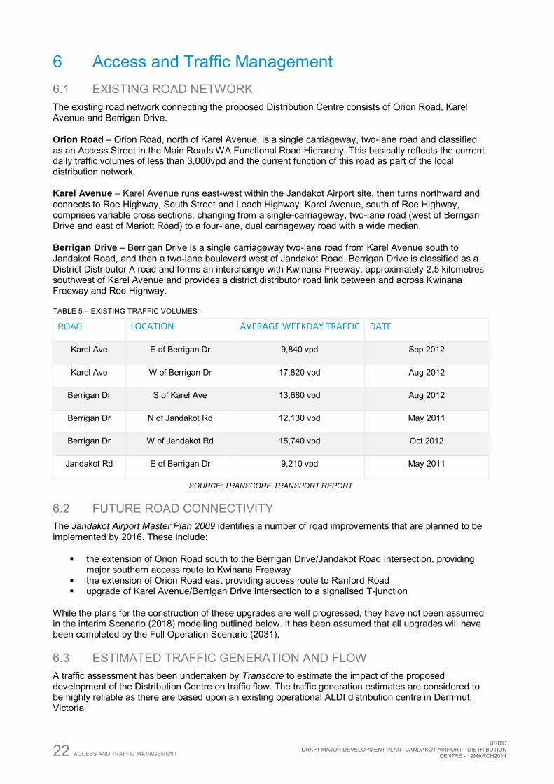
6 Access and Traffic Management 6.1 EXISTING ROAD NETWORK The existing road network connecting the proposed Distribution Centre consists of Orion Road, Karel Avenue and Berrigan Drive.
Orion Road – Orion Road, north of Karel Avenue, is a single carriageway, two-lane road and classified as an Access Street in the Main Roads WA Functional Road Hierarchy. This basically reflects the current daily traffic volumes of less than 3,000vpd and the current function of this road as part of the local distribution network.
Karel Avenue – Karel Avenue runs east-west within the Jandakot Airport site, then turns northward and connects to Roe Highway, South Street and Leach Highway. Karel Avenue, south of Roe Highway, comprises variable cross sections, changing from a single-carriageway, two-lane road (west of Berrigan Drive and east of Mariott Road) to a four-lane, dual carriageway road with a wide median.
Berrigan Drive – Berrigan Drive is a single carriageway two-lane road from Karel Avenue south to Jandakot Road, and then a two-lane boulevard west of Jandakot Road. Berrigan Drive is classified as a District Distributor A road and forms an interchange with Kwinana Freeway, approximately 2.5 kilometres southwest of Karel Avenue and provides a district distributor road link between and across Kwinana Freeway and Roe Highway.
TABLE 5 – EXISTING TRAFFIC VOLUMES
ROAD LOCATION AVERAGE WEEKDAY TRAFFIC DATE
Karel Ave E of Berrigan Dr 9,840 vpd Sep 2012
Karel Ave W of Berrigan Dr 17,820 vpd Aug 2012
Berrigan Dr S of Karel Ave 13,680 vpd Aug 2012
Berrigan Dr N of Jandakot Rd 12,130 vpd May 2011
Berrigan Dr W of Jandakot Rd 15,740 vpd Oct 2012
Jandakot Rd E of Berrigan Dr 9,210 vpd May 2011
SOURCE: TRANSCORE TRANSPORT REPORT
6.2 FUTURE ROAD CONNECTIVITY The Jandakot Airport Master Plan 2009 identifies a number of road improvements that are planned to be implemented by 2016. These include:
the extension of Orion Road south to the Berrigan Drive/Jandakot Road intersection, providing major southern access route to Kwinana Freeway
the extension of Orion Road east providing access route to Ranford Road upgrade of Karel Avenue/Berrigan Drive intersection to a signalised T-junction
While the plans for the construction of these upgrades are well progressed, they have not been assumed in the interim Scenario (2018) modelling outlined below. It has been assumed that all upgrades will have been completed by the Full Operation Scenario (2031).
6.3 ESTIMATED TRAFFIC GENERATION AND FLOW A traffic assessment has been undertaken by Transcore to estimate the impact of the proposed development of the Distribution Centre on traffic flow. The traffic generation estimates are considered to be highly reliable as there are based upon an existing operational ALDI distribution centre in Derrimut, Victoria.
URBIS DRAFT MAJOR DEVELOPMENT PLAN - JANDAKOT AIRPORT - DISTRIBUTION CENTRE - 19MARCH2014 ACCESS AND TRAFFIC MANAGEMENT 23
It is noted that the proposal has been assessed on an interim (2018) and full operation (2031) timescale, as the operation of the facility will be graduated as ALDI stores open across the distribution network. As has been the case with ALDI’s entry into other markets in Australia, the store network will take some time to develop to the planned operation level of the Distribution Centre. As such, data has been modelled to simulate the ALDI operation in year 2018 with an assumed scale of operation at about 25% of the full operational scenario.
The traffic that will be generated by the proposed development would comprise three components as shown in Table 6 below.
TABLE 6 – ESTIMATED TYPICAL WEEKDAY TRAFFIC GENERATED FROM THE PROPOSED DEVELOPMENT
VEHICLE TYPE TRIP GENERATION ON A TYPICAL WEEKDAY
2018 (INTERIM SCENARIO) 2031 (FULL OPERATION SCENARIO)
Freight traffic (i.e. heavy vehicle traffic) 36 152
Employee traffic (light vehicles) 100 400
Visitor traffic (light vehicles) 11 42
TOTAL 147 594
SOURCE: TRANSCORE TRANSPORT REPORT
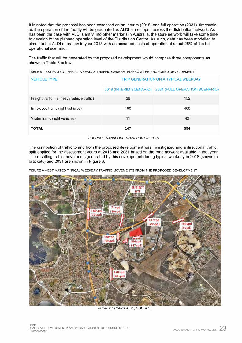
The distribution of traffic to and from the proposed development was investigated and a directional traffic split applied for the assessment years at 2018 and 2031 based on the road network available in that year. The resulting traffic movements generated by this development during typical weekday in 2018 (shown in brackets) and 2031 are shown in Figure 6.
FIGURE 6 – ESTIMATED TYPICAL WEEKDAY TRAFFIC MOVEMENTS FROM THE PROPOSED DEVELOPMENT
SOURCE: TRANSCORE, GOOGLE
24 ACCESS AND TRAFFIC MANAGEMENT
URBIS DRAFT MAJOR DEVELOPMENT PLAN - JANDAKOT AIRPORT - DISTRIBUTION
CENTRE - 19MARCH2014
The estimated traffic generation outlined in Figure 6, has been assessed to determine the impact on the existing flows (Table 5) under the Interim Scenario, and is illustrated in Table 7.
TABLE 7 – IMPACT ON MAJOR SURROUNDING ROADS – INTERIM SCENARIO (2018)
ROAD LOCATION AVERAGE WEEKDAY TRAFFIC
LEVEL OF INCREASE EXISTING DEVELOPMENT
Karel Ave E of Berrigan Dr 9,840 vpd 147 vpd 1.5%
Karel Ave W of Berrigan Dr 17,820 vpd 98 vpd <1.0%
Berrigan Dr S of Karel Ave 13,680 vpd 49 vpd <1.0%
SOURCE: TRANSCORE TRANSPORT REPORT
Transcore has developed a strategic EMME transport model for the airport precinct for year 2031, which provides daily traffic forecast for the Jandakot Airport internal road system as well as major external routes to and from the precinct.
The estimated traffic generation outlined in Figure 6, has been assessed to determine the impact on the forecast flows at 2031, and is illustrated in Table 8.
TABLE 8 – IMPACT ON MAJOR SURROUNDING ROADS – FULL OPERATION SCENARIO (2031)
ROAD LOCATION AVERAGE WEEKDAY TRAFFIC
LEVEL OF INCREASE EMME FORECAST DEVELOPMENT
Karel Ave E of Berrigan Dr 14,359 vpd 486 vpd 3.4%
Karel Ave W of Berrigan Dr 32,332 vpd 338 vpd ~1.0%
Berrigan Dr S of Karel Ave 18,804 vpd 148 vpd <1.0%
Orion Rd N of Karel Ave 5,981 vpd 486 vpd 8.1%
Orion Rd Fronting site (W) 4,661 vpd 486 vpd 10.4%
Orion Rd Fronting site (W) 4,661 vpd 108 vpd 2.3%
SOURCE: TRANSCORE TRANSPORT REPORT
Considering both the interim scenario (year 2018) and the assessment year 2031 scenario it is concluded that the proposed ALDI distribution centre would not have significant impact on the operation of Jandakot Airport’s road network or the immediately surrounding road network generating a fraction of future traffic on the relevant roads.
A detailed Transport Report is attached at Appendix C.
6.4 TRUCK PARKING AND MANOEUVRING The trucks in ALDI’s distribution fleet are parked on site when not in service. All trucks are parked in one of the docks located along the northern portion of the site, ready to be loaded for the next service delivery. The number of loading docks has been designed to ensure that all vehicles can be accommodated (parked) on site while not in service.
URBIS DRAFT MAJOR DEVELOPMENT PLAN - JANDAKOT AIRPORT - DISTRIBUTION CENTRE - 19MARCH2014 ACCESS AND TRAFFIC MANAGEMENT 25
All vehicles associated with Goods-in are required to request a time slot from ALDI to ensure the deliveries arrive at time when there is sufficient warehouse staff available to unload the goods. The control gate is located well within the property boundary and allows stacking of up to 6 B-doubles. Beyond the control gate there is room for temporary parking/layover of at least 8 trucks. Therefore, all vehicles associated with the Distribution Centre can be accommodated on site, which will eliminate any on-street parking or layover.
On site manoeuvring has been reviewed during the design process, with the swept paths for movement scenarios being tested for the relevant vehicles accessing the site (27.5m B-Double, 19.0m Semi-Trailers, and emergency service vehicles). Design modifications (kerb locations, pavement markings) have been undertaken to ensure all required manoeuvres can be safely achieved.
A vehicle manoeuvring diagram has been prepared and is attached at Appendix D.
6.5 PUBLIC TRANSPORT There is currently a lack of public transport within the subject locality; however there is provision due to the expansion of the Jandakot Airport Mixed Business Precinct to increase the services in the area, in the form of a dedicated bus route or through modification/extension of the existing routes operating in the vicinity. In order to facilitate this type of service, the Public Transport Authority has outlined that:
Internal road network must meet the minimum standard required to accommodate bus movements;
The demand for public transport service must reach critical level; Eastern road connection to Ranford Road needs to be constructed to provide a through link to
residential areas east of Jandakot Airport
26 JANDAKOT AIRPORT MASTER PLAN
URBIS DRAFT MAJOR DEVELOPMENT PLAN - JANDAKOT AIRPORT - DISTRIBUTION
CENTRE - 19MARCH2014
7 Jandakot Airport Master Plan Section 69 of the Airports Act 1996 requires each airport to produce a Master Plan to be submitted and approved by the Minister. The Jandakot Airport Master Plan 2009 (the Master Plan) was approved by the Federal Minister for Infrastructure and Regional Development on 9 March 2010. Generally, the Master Plan provides the framework for the future development of the Airport, taking into account aviation operations, the environment, non-aviation land use, services infrastructure and access.
Specifically, the purpose of the Master Plan is to:
Establish the strategic direction for efficient and economic development at the airport over the planning period of the plan
Provide for the development of additional uses of the Airport site
Indicate to the public the intended uses of the Airport site
Provide improved environmental outcomes within the Airport
Reduce potential conflicts between uses of the Airport site and to ensure that uses of the Airport site are compatible with the areas surrounding the Airport
Ensure that all Airport operations are undertaken in accordance with the relevant environmental legislation and standards
Ensure that the development of the Airport is compatible with the surrounding area
Promote the continual improvement of environmental management at the Airport
The Master Plan generally determines the strategic framework for the Airport for a period of 20 years and may be reviewed every 5 years.
7.1 CONSISTENCY WITH JANDAKOT AIRPORT MASTER PLAN 2009 A key aspect of the Airports Act 1996 and the Master Plan is to ensure that development within the commercial precincts does not conflict with aviation operations and can satisfy the requirements of the Environment Strategy. The Master Plan takes a view of a 20 year time horizon.
The ‘Airport Vision’, as stated at section 2.1 of Master Plan is as follows:
‘Jandakot Airport Holding’s vision is to successfully development and manage Jandakot Airport as a strategically significant aviation hub with a supporting business campus’.
This proposal adheres to this vision in that is it constitutes a development proposal that will work towards the creation of the business campus that will have a logistics focus and be compatible with the aviation uses.
The Master Plan also sets out a number of objectives, with the objectives that are relevant to this MDP are addressed in Table 9 below.
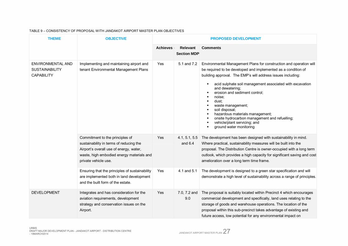
URBIS DRAFT MAJOR DEVELOPMENT PLAN - JANDAKOT AIRPORT - DISTRIBUTION CENTRE - 19MARCH2014 JANDAKOT AIRPORT MASTER PLAN 27
TABLE 9 – CONSISTENCY OF PROPOSAL WITH JANDAKOT AIRPORT MASTER PLAN OBJECTIVES
THEME
OBJECTIVE PROPOSED DEVELOPMENT
Achieves Relevant
Section MDP
Comments
ENVIRONMENTAL AND SUSTAINABILITY CAPABILITY
Implementing and maintaining airport and tenant Environmental Management Plans
Yes 5.1 and 7.2 Environmental Management Plans for construction and operation will be required to be developed and implemented as a condition of building approval. The EMP’s will address issues including:
acid sulphate soil management associated with excavation and dewatering;
erosion and sediment control; noise; dust; waste management; soil disposal; hazardous materials management; onsite hydrocarbon management and refuelling; vehicle/plant servicing; and ground water monitoring
Commitment to the principles of sustainability in terms of reducing the Airport’s overall use of energy, water, waste, high embodied energy materials and private vehicle use.
Yes 4.1, 5.1, 5.5 and 6.4
The development has been designed with sustainability in mind. Where practical, sustainability measures will be built into the proposal. The Distribution Centre is owner-occupied with a long term outlook, which provides a high capacity for significant saving and cost amelioration over a long term time frame.
Ensuring that the principles of sustainability are implemented both in land development and the built form of the estate.
Yes 4.1 and 5.1 The development is designed to a green star specification and will demonstrate a high level of sustainability across a range of principles.
DEVELOPMENT Integrates and has consideration for the aviation requirements, development strategy and conservation issues on the Airport.
Yes 7.0, 7.2 and 9.0
The proposal is suitably located within Precinct 4 which encourages commercial development and specifically, land uses relating to the storage of goods and warehouse operations. The location of the proposal within this sub-precinct takes advantage of existing and future access, low potential for any environmental impact on
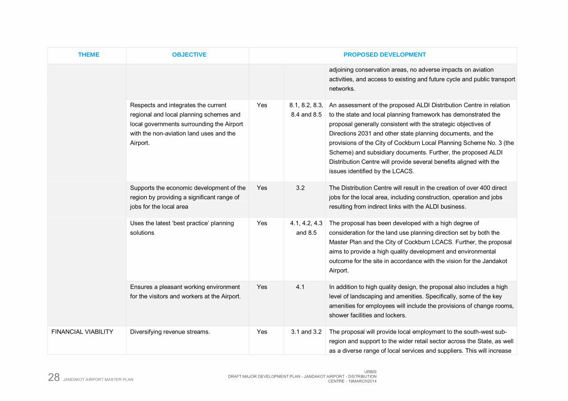
28 JANDAKOT AIRPORT MASTER PLAN
URBIS DRAFT MAJOR DEVELOPMENT PLAN - JANDAKOT AIRPORT - DISTRIBUTION
CENTRE - 19MARCH2014
THEME
OBJECTIVE PROPOSED DEVELOPMENT
adjoining conservation areas, no adverse impacts on aviation activities, and access to existing and future cycle and public transport networks.
Respects and integrates the current regional and local planning schemes and local governments surrounding the Airport with the non-aviation land uses and the Airport.
Yes 8.1, 8.2, 8.3, 8.4 and 8.5
An assessment of the proposed ALDI Distribution Centre in relation to the state and local planning framework has demonstrated the proposal generally consistent with the strategic objectives of Directions 2031 and other state planning documents, and the provisions of the City of Cockburn Local Planning Scheme No. 3 (the Scheme) and subsidiary documents. Further, the proposed ALDI Distribution Centre will provide several benefits aligned with the issues identified by the LCACS.
Supports the economic development of the region by providing a significant range of jobs for the local area
Yes 3.2 The Distribution Centre will result in the creation of over 400 direct jobs for the local area, including construction, operation and jobs resulting from indirect links with the ALDI business.
Uses the latest ‘best practice’ planning solutions
Yes 4.1, 4.2, 4.3 and 8.5
The proposal has been developed with a high degree of consideration for the land use planning direction set by both the Master Plan and the City of Cockburn LCACS. Further, the proposal aims to provide a high quality development and environmental outcome for the site in accordance with the vision for the Jandakot Airport.
Ensures a pleasant working environment for the visitors and workers at the Airport.
Yes 4.1 In addition to high quality design, the proposal also includes a high level of landscaping and amenities. Specifically, some of the key amenities for employees will include the provisions of change rooms, shower facilities and lockers.
FINANCIAL VIABILITY Diversifying revenue streams. Yes 3.1 and 3.2 The proposal will provide local employment to the south-west sub-region and support to the wider retail sector across the State, as well as a diverse range of local services and suppliers. This will increase
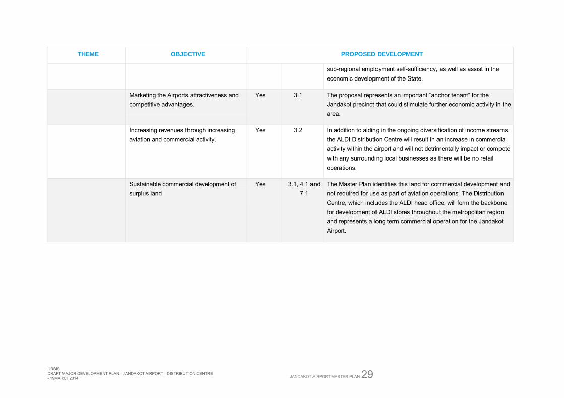
URBIS DRAFT MAJOR DEVELOPMENT PLAN - JANDAKOT AIRPORT - DISTRIBUTION CENTRE - 19MARCH2014 JANDAKOT AIRPORT MASTER PLAN 29
THEME
OBJECTIVE PROPOSED DEVELOPMENT
sub-regional employment self-sufficiency, as well as assist in the economic development of the State.
Marketing the Airports attractiveness and competitive advantages.
Yes 3.1 The proposal represents an important “anchor tenant” for the Jandakot precinct that could stimulate further economic activity in the area.
Increasing revenues through increasing aviation and commercial activity.
Yes 3.2 In addition to aiding in the ongoing diversification of income streams, the ALDI Distribution Centre will result in an increase in commercial activity within the airport and will not detrimentally impact or compete with any surrounding local businesses as there will be no retail operations.
Sustainable commercial development of surplus land
Yes 3.1, 4.1 and 7.1
The Master Plan identifies this land for commercial development and not required for use as part of aviation operations. The Distribution Centre, which includes the ALDI head office, will form the backbone for development of ALDI stores throughout the metropolitan region and represents a long term commercial operation for the Jandakot Airport.
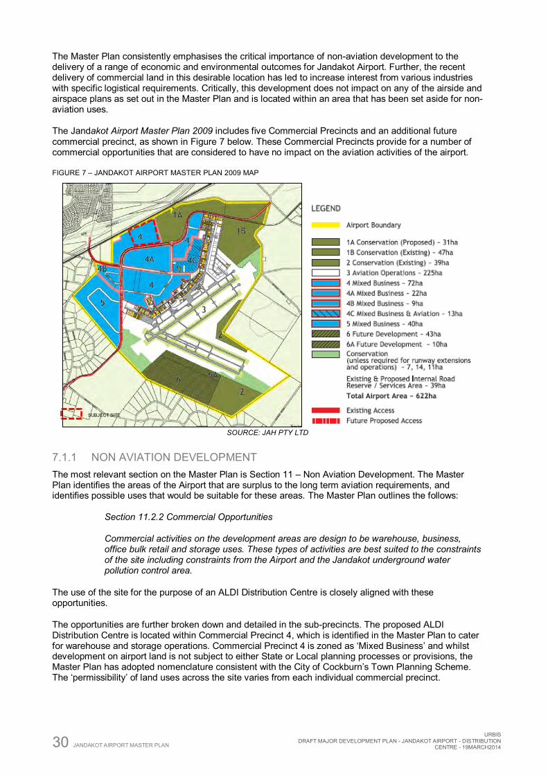
30 JANDAKOT AIRPORT MASTER PLAN
URBIS DRAFT MAJOR DEVELOPMENT PLAN - JANDAKOT AIRPORT - DISTRIBUTION
CENTRE - 19MARCH2014
The Master Plan consistently emphasises the critical importance of non-aviation development to the delivery of a range of economic and environmental outcomes for Jandakot Airport. Further, the recent delivery of commercial land in this desirable location has led to increase interest from various industries with specific logistical requirements. Critically, this development does not impact on any of the airside and airspace plans as set out in the Master Plan and is located within an area that has been set aside for non-aviation uses.
The Jandakot Airport Master Plan 2009 includes five Commercial Precincts and an additional future commercial precinct, as shown in Figure 7 below. These Commercial Precincts provide for a number of commercial opportunities that are considered to have no impact on the aviation activities of the airport.
FIGURE 7 – JANDAKOT AIRPORT MASTER PLAN 2009 MAP
SOURCE: JAH PTY LTD
7.1.1 NON AVIATION DEVELOPMENT The most relevant section on the Master Plan is Section 11 – Non Aviation Development. The Master Plan identifies the areas of the Airport that are surplus to the long term aviation requirements, and identifies possible uses that would be suitable for these areas. The Master Plan outlines the follows:
Section 11.2.2 Commercial Opportunities
Commercial activities on the development areas are design to be warehouse, business, office bulk retail and storage uses. These types of activities are best suited to the constraints of the site including constraints from the Airport and the Jandakot underground water pollution control area.
The use of the site for the purpose of an ALDI Distribution Centre is closely aligned with these opportunities.
The opportunities are further broken down and detailed in the sub-precincts. The proposed ALDI Distribution Centre is located within Commercial Precinct 4, which is identified in the Master Plan to cater for warehouse and storage operations. Commercial Precinct 4 is zoned as ‘Mixed Business’ and whilst development on airport land is not subject to either State or Local planning processes or provisions, the Master Plan has adopted nomenclature consistent with the City of Cockburn’s Town Planning Scheme. The ‘permissibility’ of land uses across the site varies from each individual commercial precinct.
SUBJECT SITE
URBIS DRAFT MAJOR DEVELOPMENT PLAN - JANDAKOT AIRPORT - DISTRIBUTION CENTRE - 19MARCH2014 JANDAKOT AIRPORT MASTER PLAN 31
The proposal for the ALDI Distribution Centre is consistent with the intended development for Commercial Precinct 4.The land use permissibility table outlined in Appendix B of the Master Plan does not list ‘Distribution Centre’. However, the alternative land use definition of ‘Warehouse’ is a ‘P’ (as-of-right) use. On this basis it is considered that the Distribution Centre should be considered a ‘P’ use on the subject site and does not compromise the ultimate development of the airport in the short or long term.
Overall, the proposed Distribution Centre demonstrates an extremely high level of consistency with the intent for the precinct, Mixed Business zone and overall requirements of the Jandakot Master Plan 2009.
7.2 ENVIRONMENT STRATEGY The purpose of the Environment Strategy is to ensure Jandakot Airport meets the environmental management requirements of the Airports Act 1996. The current Environment Strategy for Jandakot Airport was approved by the Federal Minister for Infrastructure, Transport, Regional Development and Local Government on 9 March 2010. Broadly, the Environment Strategy identifies areas within Jandakot Airport which are considered to have environmental significance and designated these areas as conservation under the Master Plan. Further, Jandakot Airport also has an Environmental management System in place which was approved in 2004 and certified to the international standard 14001.
The Jandakot Airport Master Plan 2009 and Environment Strategy have included a rigorous assessment of the environmental qualities of the subject land and set out the planning framework to reflect the findings. EPBC referral 2009/4796 (Jandakot Airport Expansion, Commercial Development and Clearance of Native Vegetation, WA) was approved with conditions by the then Minister for Environment, Water, Heritage and Arts in March 2010. This approval allows for clearing and commercial development as detailed in the Master Plan 2009 and includes the ALDI development site.
The works detailed within this MDP are consistent with EPBC 2009/4796 conditions of approval in that:
No clearing (outside of what has occurred in preparation for lot development) is required.
The area cleared for the purpose of undertaking works detailed within this MDP, along with other areas cleared for development elsewhere on the airport, will not exceed 167 ha.
No clearing of remnant or regrowth vegetation within other precincts (including Conservation Precincts) is required.
7.2.1 RELEVANT ENVIRONMENTAL CONSIDERATIONS The Jandakot Airport Environment Strategy maps a large number of environmental constrains across the airport in figure 5 to 12. We have reviewed and identified the relevance of each of these issues to the subject site:
TABLE 10 – ENVIRONMENTAL CONTRASTS MAPPING
FIGURE IN ENVIRONMENT STRATEGY RELEVANCE TO SUBJECT SITE
Figure 5: Wetlands No wetland mapped within the vicinity of the subject site.
Figure 6 Jandakot Underground Water Pollution Control Area
No Priority Water Source Protection Mapped over the subject site
Figure 7 Vegetation Communities No vegetation communities mapped over the subject site
Figure 8 Vegetation Condition No vegetation condition mapped over the subject site (site is cleared of all vegetation)
Figure 9 Rare and Priority Flora No rare or engaged flora mapped over subject site (site is cleared of all vegetation)
32 JANDAKOT AIRPORT MASTER PLAN
URBIS DRAFT MAJOR DEVELOPMENT PLAN - JANDAKOT AIRPORT - DISTRIBUTION
CENTRE - 19MARCH2014
FIGURE IN ENVIRONMENT STRATEGY RELEVANCE TO SUBJECT SITE
Figure 10 Dieback Affected Areas No dieback affected areas mapped within the vicinity of the subject site.
Figure 11 Ecological Linkage No ecological linkage mapped within the vicinity of the subject site.
Figure 12 Carnaby’s Cockatoo Foraging and Roosting Habitat
Subject site mapped as Foraging Habitat, however, the site is now cleared of all vegetation.
In summary, none of the mapped environmental constraints across the airport have any relevant to the subject site or proposed use.
7.2.2 MANAGEMENT PLANS Each of the tenants at Jandakot Airport is responsible to comply with the JAH Environment Strategy. The Environment Strategy 2009 has expanded previous requirements for only high risk tenants to provide Environment Management Plans (EMPs), so that all tenants at Jandakot Airport are now required to prepare up to four kinds of EMPs – as relevant to the proposed Distribution Centre:
Clearing Environmental Management Plan (NOT REQUIRED)
Construction Environmental Management Plan (REQUIRED)
Operational Environmental Plan (REQUIRED)
Demolition Environmental Management Plan (NOT REQUIRED)
A Construction Environmental Management Plan (CEMP) will be prepared as part of the Building Permit Application and will be required to be implemented during the construction phase. An Operational Environmental Management Plan (OEMP) will be required prior to Occupation, and will be required to be implemented on an on-going basis once construction has been completed. Both the CEMP and OEMP will be prepared in accordance with the Environment Strategy and include relevant reporting requirements, included a requirement for incident reporting. Importantly, as no clearing or demolition are proposed as part of this MDP, no Management Plans are required relating to these activities. The specific requirements for both of the aforementioned management plans will be provided by JAH as part of the Development Application or compliance with conditioned thereto.
The Environment Strategy identifies the key areas of concern associated with environmental risk from the activities of non-aviation tenants as:
Fuel and oil storage and usage; Energy and water usage; Domestic wastewater disposal Vehicle washdown Fire control
These matters will be address in the Construction Environmental Management Plan and Operational Environmental Plan.
URBIS DRAFT MAJOR DEVELOPMENT PLAN - JANDAKOT AIRPORT - DISTRIBUTION CENTRE - 19MARCH2014 CONSISTENCY WITH STATE AND LOCAL GOVERNMENT PLANNING 33
8 Consistency with State and Local Government Planning
Jandakot Airport is a ‘Commonwealth Place’, and accordingly is covered by Commonwealth legislation, not State legislation. The Airports Act 1996 sets out how planning controls operate over these sites with respect to both airside services as well as the landside services (peripheral land adjoining the airside area). Whilst the subject site is not intended to be used for the purposes of aviation, it is impacted upon by the operations of the airport, and therefore the Act provides the head of power that guides the co-ordination of land uses in areas affected by the operations of the Airport.
It is however important to note that pursuant to the Airports Act 1996, the prevailing planning framework (Jandakot Airport Master Plan 2009) guiding development on the Airport must respect and support the principles outlined in State and Local planning legislation. On this basis, an outline of the key components of the State and Local Government planning framework are provided.
8.1 STATE PLANNING FRAMEWORK
8.1.1 DRAFT STATE PLANNING STRATEGY The Draft State Planning Strategy was released in 2012 and sets out a broad framework for the integration and coordination of strategic planning across various State, Regional and Local jurisdictions, to the year 2050. The Draft State Planning Strategy provides a vision, set of principles, strategic goals and strategic directions by which sustained prosperity will be delivered.
The Strategy anticipates an increase in the State’s population from the current of 2.4 million people to between 3.5 million and 5.4 million by 2056. The Strategy is broad in nature, setting the following broad principles:
Community: Enable diverse, affordable, accessible and safe communities Economy: Facilitate trade, investment, innovation, employment and community betterment Environment: Conserve the State’s natural assets through sustainable development Infrastructure: Ensure infrastructure supports development Regional Development: Build the competitive and collaborative advantages of the regions Governance: Build community confidence in development processes and practices
The Draft State Planning Strategy does not outline any specific plans for the Perth Metropolitan Region; rather identifies the big picture objectives. Importantly, it does identify the need to provide an integrated transport network. Specifically the Draft Strategy seeks to provide for a coordinated freight logistics and transport network incorporating road, rail, air and sea transport. In general, the proposed development is highly consistent with the draft State Planning Strategy.
The proposal is consistent with the Draft State Planning Policy, and does not compromise its general intent.
8.1.2 DIRECTIONS 2031 AND BEYOND Directions 2031 and Beyond - Spatial Framework for Perth and Peel (Directions 2031) was released by the Western Australian Planning Commission (WAPC) in August 2010. This is the highest level strategic spatial plan establishing a vision for the future expansion of the Perth and Peel area, which is expected to grow from 1.65 million people to 2.2 million people by 2031.
In response to the predicted population growth, Directions 2031 sets out to provide a framework in which to plan for the provision of the required land supply, services and infrastructure (physical and social) to facilitate a consolidated and high quality form of urban expansion. Directions 2031 identifies the major employment centres across the metropolitan area and the key transportation linkages between them.
34 CONSISTENCY WITH STATE AND LOCAL GOVERNMENT PLANNING
URBIS DRAFT MAJOR DEVELOPMENT PLAN - JANDAKOT AIRPORT - DISTRIBUTION
CENTRE - 19MARCH2014
Jandakot Airport is identified as a ‘specialised activity centre’ and located within the ‘South-West Sub-Region’ under Directions 2031. Generally, specialised centres are centres that have strong specialised roles based around major institutions or airports. The logistical roles performed by these centres are some of the most important and high level in the metropolitan area. It is therefore important that the centres have a form that optimises a dynamic and robust mix of uses within places of overall high amenity and infrastructure provision.
The proposal is consistent with Directions 2031 and Beyond in that it furthers the role of Jandakot Airport as a Specialised Activity Centre by providing a logistical role consistent with its aviation/industry focus.
8.1.3 OUTER METROPOLITAN PERTH – SUB-REGIONAL STRATEGY The Draft Outer Metropolitan Perth and Peel Sub-Regional Strategy is a subsidiary document that supports Directions 2031 vision by an additional level of detail. The Sub-Regional Strategy provides a framework for delivering the objectives of Directions 2031, outlining important activity centres, key transportation linkages and specific areas for development and intensification based on the projected levels of population growth and highlights key development opportunities. The subject site is located within the ‘South-East’ sub-region. This sub-region is anticipated to grow from the current population of 170,000 by 58,000 people, resulting in a total population of 228,000 people by 2031.
Jandakot Airport is identified as a specialised centre in recognition of the strategic significance of its aviation functions as well as its non-aviation operations and associated land uses that contribute to local employment and the economic development of the State. The proposal directly works towards to achievement of the objectives of the Other Metropolitan Sub-Regional Strategy through its significant contribution to employment and economic development. .
8.1.4 METROPOLITAN REGION SCHEME The subject land is reserved for Public Purpose: Commonwealth Government under the Metropolitan Region Scheme (MRS). The MRS reserves land for broad purposes, however it does not determine specific land use permissibility.
The Jandakot Airport is located within a ‘Public Purpose – Commonwealth Government’ reserve of the Metropolitan Region Scheme (MRS). The proposal is consistent with the requirements of the Metropolitan Region Scheme in that it does not reduce the operational capacity of the airport, and is consistent with the types of uses commonly co-located at airports.
8.2 STATE PLANNING POLICIES The following State Planning Policies are considered to be relevant to the development of the subject site.
8.2.1 STATE PLANNING POLICY NO 2: ENVIRONMENT AND NATURAL RESOURCES
State Planning Policy No. 2 (SPP2) sets out the principles and considerations which apply to the sustainable use and development of resources in Western Australia. The SPP identifies the key principles in integrating ecological, economic and social considerations which should be taken into account in development, whilst balancing the need to protect the air, land and water resources within the State.
This policy is high level, however, the development does not contravene the objectives and intent of the policy.
8.2.2 STATE PLANNING POLICY NO. 3: URBAN GROWTH AND SETTLEMENT State Planning Policy No. 3 (SPP 3) sets out the principles and considerations which apply to planning for urban growth and settlements in Western Australia. The overall aim of the policy is to facilitate sustainable patterns of urban growth and settlement, by outlining the requirements of sustainable settlements and communities and the broad policy in accommodating urban growth and change.
URBIS DRAFT MAJOR DEVELOPMENT PLAN - JANDAKOT AIRPORT - DISTRIBUTION CENTRE - 19MARCH2014 CONSISTENCY WITH STATE AND LOCAL GOVERNMENT PLANNING 35
The proposal works to further the objectivities of this policy in that it is assisting in the creation of sustainable communities by creating a significant number of jobs an established area of the south metropolitan area and underpins a significant network or retail stores that is growing the State’s economic base. It is also assists in maximising the effective use of the existing and future infrastructure, most particular the regional road network and service infrastructure.
8.2.3 STATE PLANNING POLICY NO.4.2: ACTIVITY CENTRES FOR PERTH AND PEEL
State Planning Policy 4.2 (SPP4.2) was developed in response to regional planning for the activity centres network, specifically in order to implement Directions 2031. SPP4.2 provides guidance on the distribution, function, land use, broad urban design principles and accessibility (transport) of activity centres. The Policy replicates the hierarchy of centres as outlined in Directions 2031, however the Policy is focused on retail centres and limited reference is made to development within industrial or commercial centres.
The Policy is focused on the controlling commercial uses in industrial zones. In particular the Policy states:
Offices, unless incidental to or servicing industrial developments, should not be located on land zoned for industry under the region or local planning schemes
The encroachment of bulky goods retail into residential and industrial zones should be avoided
Shops and office development should only be permitted on land zoned ‘Industrial’ under region and local planning schemes where:
shops provide a local convenience service predominantly for people employed in the locality and are confined to a local centre
offices are ancillary to the predominant industrial use of the premises or are confined to a local or small-scale centre that services industrial developments
The policy also outlines the functions and characteristics of ‘specialised centres’. Specifically, table 1 of this policy identifies the ‘primary function’ of the Jandakot Airport Specialised Centre as being ‘aviation and logistic services’. Additionally the policy states that ‘Specialised centres focus on regionally significant economic or institutional activities that generate many work and visitor trips, which therefore require a high level of transport accessibility’.
The use of the subject site for the purpose of a distribution is a intended under the policy.
8.2.4 STATE PLANNING POLICY 5.3: JANDAKOT AIRPORT VICINITY The purpose of SPP 5.3 is to manage the use of land which is, or may in the future, be affected by aircraft noise associated with movements at Jandakot Airport; and thereby protect the airport from encroachment by incompatible land use and development.
The policy applies to two main areas, the:
‘Core Area’ – defined by the 20 ANEF contour ‘Frame Area’ – defined by the area bounded by Roe Highway, Ranford Road, Warton Road,
Armadale Road and Kwinana Freeway (excluding the land within the 20 ANEF contour).
The Policy provides guidance regarding building site acceptability within various Australian Noise Exposure Forecast (ANEF) areas. Specifically, the Policy provides guidance in relation to noise sensitive premises land uses within specific ANEF ranges, as well as limiting rezoning, subdivision and development that would result in additional residential dwellings.
36 CONSISTENCY WITH STATE AND LOCAL GOVERNMENT PLANNING
URBIS DRAFT MAJOR DEVELOPMENT PLAN - JANDAKOT AIRPORT - DISTRIBUTION
CENTRE - 19MARCH2014
The subject site is located within the Frame Area, however, due to the nature of the use not being of a ‘noise-sensitive’ nature, the policy has no direct application. Further Appendix 1 of the policy identifies that ‘Industry, warehouse, storage, transport depot’ uses (including any ancillary components such as office) are ‘Acceptable’ in both the Core and Frame areas. As such it can be concluded that the proposal is strongly compliant with this policy.
8.2.5 DRAFT STATE PLANNING POLICY 5.3: JANDAKOT AIRPORT VICINITY A draft State Planning Policy 5.3 (draft SPP 5.3) was released for public comment in July 2013, and once adopted will replace the existing SPP5.3. There are no substantive changes to the policy that relate to the proposed land use, and overall the draft policy represents a refinement to the existing policy. It is worth noting that the draft policy maintains Appendix 1 which identifies that ‘Industry, warehouse, storage, transport depot’ uses (including any ancillary components such as office) are ‘Acceptable’ in both the Core and Frame areas. As such it can be concluded that the proposal is strongly compliant with this policy.
8.3 ECONOMIC AND EMPLOYMENT LANDS STRATEGY: NON-HEAVY INDUSTRIAL: PERTH METROPOLITAN AND PEEL REGIONS
The Economic and Employment Lands Strategy is one of the key documents guiding industrial development in Western Australia. The document identifies and de-constrains land suitable for industrial activity in the long term, facilitating industrial land use development. Figure 5 provides a summary of the land identified under the strategy.
The Economic and Employment Land Strategy, released by the WAPC in conjunction with LandCorp, the Department of State Development and the Department of Environment and Conservation in April 2012, provides the vital framework to ensure ongoing economic growth and sustainability for the Perth and Peel regions, and Western Australia as a whole.
Specifically the strategy identifies the areas, type and locations of general and light industrial land required over the next 20 years, identifies and evaluates the suitability of locations for new general and light industrial estates, and develops a strategy to facilitate the delivery of industrial land to assist in the restoration of the Government’s long-term general and light industrial land bank.
Jandakot Airport is identified as being in the 0 to 4 year development pipeline. The study breaks down the delivery of the area, identifying 65ha available as at 2009, an additional 45ha available between 2009 to 2015 and a further 40ha available between 2015 to 2025.
The creation of land at Jandakot Airport for industrial/commercial uses is encouraged by the Economic and Employment Lands Strategy. The development of the subject site for a distribution centre will assist in the delivery of this important economic and employment land in line with the timeframes set out in the strategy.
8.4 WESTERN AUSTRALIAN DRAFT STATE AVIATION STRATEGY The Western Australian State Aviation Strategy is the first developed for WA in response to the growing economic and social development of the state and proposes a suite of actions in collaboration with airports, airlines and the resources and energy sector to ensure adequate services continue to meet the State’s demands. The strategy was developed by the Department of Transport in conjunction with key government agencies.
The strategy outlines the scale and growth of both Perth airport and WA regional airport’s infrastructure, providing findings and actions to assimilate development with the projected forecasts. The strategy identifies the need to provide a more coordinated approach to airport planning and outlines the State Government’s requirement to engage and cooperate with Perth Airport, other major airports and the resources industry in coordinating aviation infrastructure planning across the State’s aviation network, as well as the introduction of a policy and regulatory framework.
URBIS DRAFT MAJOR DEVELOPMENT PLAN - JANDAKOT AIRPORT - DISTRIBUTION CENTRE - 19MARCH2014 CONSISTENCY WITH STATE AND LOCAL GOVERNMENT PLANNING 37
Jandakot Airport is identified as being subject to SPP 5.3 which is the primary planning instrument for land use control in the vicinity of Jandakot Airport. The strategy identifies the lack of State Government involvement in aviation activity and airports’ airside infrastructure development plans for Jandakot. It is outlined that Jandakot Airport is one of the busiest airports in Australia in need of further co-ordination with Perth Airport for improved efficiency. This heavy utilisation has led to the Department of Planning and Department of Transport undertaking a preliminary investigation to identify a suitable site for the development of a second Perth metropolitan general aviation airport, even though it is anticipated that it will not be required for around 50 years.
The development of the subject site for the intended purpose does not compromise the intent of the Western Australian State Aviation Strategy, as the land has been demonstrated to be surplus to the long term aviation requirements of the airport.
8.5 LOCAL PLANNING FRAMEWORK Whilst the local planning framework has no formal control or jurisdiction over development within the Jandakot Airport, an assessment of the broad planning parameters has been undertaken to demonstrate that the proposed ALDI Distribution Centre is generally consistent with the provisions of the City of Cockburn Local Planning Scheme No. 3 (the Scheme) and subsidiary documents, particularly as they relate to commercial and retail development.
8.5.1 CITY OF COCKBURN LOCAL COMMERCIAL AND ACTIVITIES CENTRES STRATEGY
The City of Cockburn’s Local Commercial and Activities Centres Strategy (LCACS) sets out the strategic planning framework for the planning and development of the City’s activity centres over the next 15 years. The LCACS was developed in line with the principles from the WAPC’s Directions 2031 and State Planning Policy 4.2 Activity Centres for Perth and Peel, which sets out the activity centre hierarchy. Similarly, the LCACS sets out an activity centre hierarchy for the local government area which also includes other centres such as Industrial and Employment.
The subject site is located within the Jandakot Airport Industrial Area, which is identified under the LCACS as a Strategic Specialised Centre. It is recognised with the LCACS and State Planning Policy 4.2 that Strategic Specialised Centres present unique opportunities for complementary development. Specifically the LCACS has identified development intensity, diversity and employment as the key factors affecting the centres economic performance. Further, the LCACS has identified an employment gap (shortfall) for the Jandakot Airport Centre of 1,953 to 3,568 jobs depending on population growth over the next 20 years.
The proposed ALDI Distribution Centre will provide several benefits aligned with the issues identified by the LCACS. The proposal will aid the intensification of the locality as well as providing for the further diversification of land use activities surrounding the airport with the addition of almost 49,000m2 of floorspace, creating up to 300 new jobs in the Jandakot Strategic Specialised Centre. Importantly, the proposed Distribution Centre is complementary to the overall intent of the Jandakot Strategic Specialised Centre and will make excellent logistical use of the location.
8.5.2 CITY OF COCKBURN TOWN PLANNING SCHEME NO.3 The Jandakot Airport Master Plan 2009 was developed in consultation with the City of Cockburn and was based on the provisions and operation of the City of Cockburn Town Planning Scheme No3 (TPS3). The land uses identified for consideration in each of the commercial precincts of the Master Plan are therefore consistent with the Scheme. The proposed development is located within Precinct 4 which is identified for mixed use business in a park like setting, with land uses such as office, business, bulk retail, show room, warehouse and storage.
The Jandakot Airport Master Plan 2009 is the guiding statutory documents for development on the airport land, and it has adopted the same zoning nomenclature as the City of Cockburn’s TPS3. The subject site is identified as being within the ‘Mixed Business’ zone, and therefore for the purposes of considerations against the City of Cockburn planning framework, the land provision applicable to the Mixed Business zone is the same.
38 CONSISTENCY WITH STATE AND LOCAL GOVERNMENT PLANNING
URBIS DRAFT MAJOR DEVELOPMENT PLAN - JANDAKOT AIRPORT - DISTRIBUTION
CENTRE - 19MARCH2014
8.5.3 LAND USE The City of Cockburn TPS 3 sets out the land use permissibility of each use within the Mixed Business zone. The uses that are most relevant to the proposed ALDI operations are set out below.
The most appropriate definitions that relate to ALDI’s intended purpose for the use of the site is:
Distribution Centre: means land and buildings used for the storage of goods, the breaking down and making up of lots of goods for transfer onto commercial vehicles for distribution to other warehouses, showrooms, shops or other retail outlets, but does not include the display or sales of goods
Warehouse: means premises used to store or display goods and may include sale by
wholesale
TABLE 11 – LAND USE TABLE – MIXED BUSINESS ZONE
LAND USE PERMISSIBILITY
Distribution Centre Not Listed
Warehouse P (Permitted)
On the basis that TPS3 does not apply any land use permissibility for a Distribution Centre or other general development controls, it is believed that Warehouse is the most appropriate definition. If an application was made under TPS3 for Planning Approval involves a “P” use (As-Of-Right), the Council cannot refuse the application by reason of the unsuitability of that use.
8.5.4 DEVELOPMENT STANDARDS The City of Cockburn TPS3 (and subsidiary polices) set out development standards that must be met as part of any development application. Detailed assessment against the applicable development standards is not warranted due to the provisions under the Jandakot Airport Master Plan 2009 and Jandakot City Leasing and Development Guidelines prevail.
8.5.5 LOCAL PLANNING POLICIES The City of Cockburn has a suite of planning policies that apply in a range of circumstances for application made within the City’s boundaries. The following policies will be relevant for the use of the subject site for the purpose of an ALDI Distribution Centre. It is important to note that, unlike the City of Cockburn’s Planning Scheme, the policy provisions are not strictly enforced and variations to any prescribed standards are possible, provided that the purpose and intent of the policy has been addressed.
8.5.5.1 APD71 – INDUSTRIAL DEVELOPMENT This policy outlines supplementary requirements for the development of industrial land which includes both the industrial and mixed business zones. The policy aims to provide for a consistent set of controls focused on the delivery of appropriate built form. These controls provide further guidance on the various considerations required pursuant to the City of Cockburn TPS 3. Again, detailed assessment against the applicable development standards is not warranted due to the provisions set out in the Jandakot Airport Master Plan 2009 and Jandakot City Leasing and Development Guidelines prevailing.
URBIS DRAFT MAJOR DEVELOPMENT PLAN - JANDAKOT AIRPORT - DISTRIBUTION CENTRE - 19MARCH2014 CONSISTENCY WITH STATE AND LOCAL GOVERNMENT PLANNING 39
8.5.5.2 APD72 – SIGNS AND ADVERTISING This policy supplements the requirements of the City of Cockburn TPS3 and the City of Cockburn Local Law under Part VIII – Signs, Hoarding and Bill Posting. The purpose of the policy is to regulate the display of advertising to ensure that the amenity of the surrounding area is not adversely impacted.
Generally, a sign licence and planning approval is required for all advertising signage located on zoned or reserved land. However, given that Jandakot Airport has its own signage application process, including signage design guidelines, it is not considered that a sign licence and planning application is necessary in accordance with this policy or the City of Cockburn TPS3.
8.5.5.3 APD69 – UNIFORM FENCING This policy sets out the requirements for the provision of uniform fencing where the development of land abuts the public domain including roads and public open space. The policy aims to provide guidance for the use of fencing that is visually suitable for the surrounding area. The ALDI Distribution Centre should have regard for these requirements; however fencing requirements for the subject site will be set out under the Jandakot City Leasing and Development Guidelines and the Jandakot City Landscaping Guidelines.
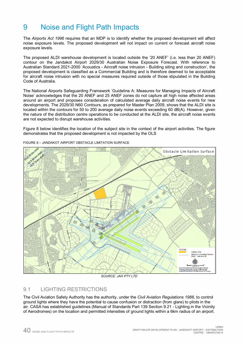
40 NOISE AND FLIGHT PATH IMPACTS
URBIS DRAFT MAJOR DEVELOPMENT PLAN - JANDAKOT AIRPORT - DISTRIBUTION
CENTRE - 19MARCH2014
9 Noise and Flight Path Impacts The Airports Act 1996 requires that an MDP is to identify whether the proposed development will affect noise exposure levels. The proposed development will not impact on current or forecast aircraft noise exposure levels.
The proposed ALDI warehouse development is located outside the ‘20 ANEF’ (i.e. less than 20 ANEF) contour on the Jandakot Airport 2029/30 Australian Noise Exposure Forecast. With reference to Australian Standard 2021-2000 ‘Acoustics - Aircraft noise intrusion - Building siting and construction’, the proposed development is classified as a Commercial Building and is therefore deemed to be acceptable for aircraft noise intrusion with no special measures required outside of those stipulated in the Building Code of Australia.
The National Airports Safeguarding Framework ‘Guideline A: Measures for Managing Impacts of Aircraft Noise’ acknowledges that the 20 ANEF and 25 ANEF zones do not capture all high noise affected areas around an airport and proposes consideration of calculated average daily aircraft noise events for new developments. The 2029/30 N60 Contours, as prepared for Master Plan 2009, shows that the ALDI site is located within the contours for 50 to 200 average daily noise events exceeding 60 dB(A). However, given the nature of the distribution centre operations to be conducted at the ALDI site, the aircraft noise events are not expected to disrupt warehouse activities.
Figure 8 below identifies the location of the subject site in the context of the airport activities. The figure demonstrates that the proposed development is not impacted by the OLS
FIGURE 8 – JANDAKOT AIRPORT OBSTACLE LIMITATION SURFACE
SOURCE: JAH PTY LTD
9.1 LIGHTING RESTRICTIONS The Civil Aviation Safety Authority has the authority, under the Civil Aviation Regulations 1988, to control ground lights where they have the potential to cause confusion or distraction (from glare) to pilots in the air. CASA has established guidelines (Manual of Standards Part 139 Section 9.21 - Lighting in the Vicinity of Aerodromes) on the location and permitted intensities of ground lights within a 6km radius of an airport.
URBIS DRAFT MAJOR DEVELOPMENT PLAN - JANDAKOT AIRPORT - DISTRIBUTION CENTRE - 19MARCH2014 NOISE AND FLIGHT PATH IMPACTS 41
The ALDI development is located outside of the Restricted Light Zones that limit the maximum intensities of ground lights to ensure no interference for pilots approaching to land. All external light fittings and temporary lighting used during the construction of the proposed development will comply with the CASA guidelines. In line with the National Airports Safeguarding Framework ‘Guideline E: Managing the Risks of Distractions to Pilots from Lighting in the Vicinity of Airports’, any proposals for coloured lights will be referred to CASA for detailed guidance.
9.2 AIR TRAFFIC CONTROL TOWER LINE OF SIGHT The Air Traffic Control Tower is required to be sited in a location that enables clear lines of sight, unimpaired by direct or indirect external light sources such as apron lights, car parking lights, surface traffic and street lights and reflective surfaces. JAH has undertaken a review of the Air Traffic Control Tower height in relation to the proposed ALDI development which has an estimated height of 46m AHD. The ALDI development will not compromise the ATC line of sight to any of the aircraft movement areas.
9.3 EFFECT ON FLIGHT PATHS The Act requires an MDP to outline if a development could affect flight paths. The ALDI development will not affect flight paths at Jandakot Airport.
9.4 BUILDING GENERATED WINDSHEAR The methodology described in the National Airports Safeguarding Framework ‘Guideline B: Managing the Risk of Building Generated Windshear and Turbulence at Airports’ was applied to determine whether there was a potential for windshear from the ALDI development to affect aircraft movements. The location of the ALDI building is more than 900m beyond the runway 24R and 30 thresholds and is therefore considered acceptable.
9.5 BIRD AND ANIMAL HAZARD MANAGEMENT JAH is required to monitor and control the presence of birds and animals on, or in the vicinity, of the airport in accordance with Civil Aviation Safety Authority requirements. JAH has a comprehensive Wildlife Hazard Management Plan in place, as well as a Feral Animal Management Plan to address overabundant native species.
The National Airports Safeguarding Framework ‘Guideline C: Managing the Risk of Wildlife Strikes in the Vicinity of Airports’ acknowledges that new land uses in the vicinity of an airport can significantly influence the risk of wildlife hazards to aircraft operations, with food garbage disposal noted as being a high risk wildlife attractant. Management of all waste, including food, will be addressed through an Operational Environmental Management Plan to prevent wildlife being attracted to the ALDI site.
9.6 NAVIGATION AIDS Airservices Australia provides a Non-Directional Beacon (NDB) at Jandakot Airport to facilitate location navigation for aircraft arrivals and departures. In addition, a microwave communication link exists between the Jandakot and Perth Air Traffic Control Towers. These navigation and communication links rely on the transmission of radio waves that must be protected from structures or obstacles that could cause signal refraction or interference. Information will be provided to Airservices Australia to allow an assessment to be made to ensure that the development does not impact on the navigation and communication aids.
9.7 PUBLIC SAFETY ZONES The purpose of a runway safety zone is to identify an area adjacent to the end of a runway where special considerations might be applied to new developments to minimise the risk of damage by aircraft during landing or take off. Currently, neither the Australian Commonwealth Government nor the Western Australian Government requires the provision of a public safety area or runway protection zone at the ends of runways. The National Airports Safeguarding Advisory Group (NASAG) is considering additional
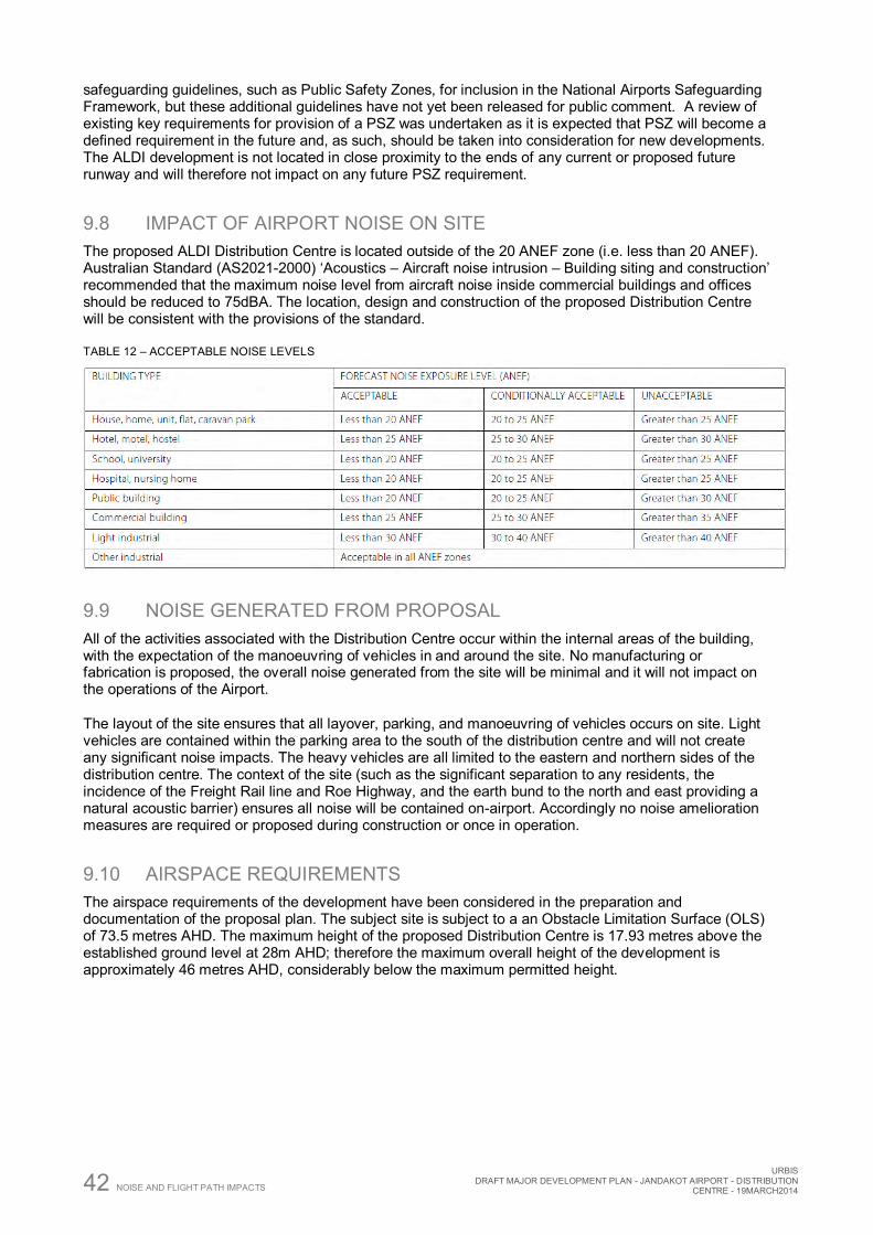
42 NOISE AND FLIGHT PATH IMPACTS
URBIS DRAFT MAJOR DEVELOPMENT PLAN - JANDAKOT AIRPORT - DISTRIBUTION
CENTRE - 19MARCH2014
safeguarding guidelines, such as Public Safety Zones, for inclusion in the National Airports Safeguarding Framework, but these additional guidelines have not yet been released for public comment. A review of existing key requirements for provision of a PSZ was undertaken as it is expected that PSZ will become a defined requirement in the future and, as such, should be taken into consideration for new developments. The ALDI development is not located in close proximity to the ends of any current or proposed future runway and will therefore not impact on any future PSZ requirement.
9.8 IMPACT OF AIRPORT NOISE ON SITE The proposed ALDI Distribution Centre is located outside of the 20 ANEF zone (i.e. less than 20 ANEF). Australian Standard (AS2021-2000) ‘Acoustics – Aircraft noise intrusion – Building siting and construction’ recommended that the maximum noise level from aircraft noise inside commercial buildings and offices should be reduced to 75dBA. The location, design and construction of the proposed Distribution Centre will be consistent with the provisions of the standard.
TABLE 12 – ACCEPTABLE NOISE LEVELS
9.9 NOISE GENERATED FROM PROPOSAL All of the activities associated with the Distribution Centre occur within the internal areas of the building, with the expectation of the manoeuvring of vehicles in and around the site. No manufacturing or fabrication is proposed, the overall noise generated from the site will be minimal and it will not impact on the operations of the Airport.
The layout of the site ensures that all layover, parking, and manoeuvring of vehicles occurs on site. Light vehicles are contained within the parking area to the south of the distribution centre and will not create any significant noise impacts. The heavy vehicles are all limited to the eastern and northern sides of the distribution centre. The context of the site (such as the significant separation to any residents, the incidence of the Freight Rail line and Roe Highway, and the earth bund to the north and east providing a natural acoustic barrier) ensures all noise will be contained on-airport. Accordingly no noise amelioration measures are required or proposed during construction or once in operation.
9.10 AIRSPACE REQUIREMENTS The airspace requirements of the development have been considered in the preparation and documentation of the proposal plan. The subject site is subject to a an Obstacle Limitation Surface (OLS) of 73.5 metres AHD. The maximum height of the proposed Distribution Centre is 17.93 metres above the established ground level at 28m AHD; therefore the maximum overall height of the development is approximately 46 metres AHD, considerably below the maximum permitted height.
URBIS DRAFT MAJOR DEVELOPMENT PLAN - JANDAKOT AIRPORT - DISTRIBUTION CENTRE - 19MARCH2014 CONSULTATION 43
10 Consultation The following were provided a copy of the ‘Exposure Draft’ MDP for comment:
Department of Planning (State) Department of Transport (State) Main Roads Western Australia Public Transport Authority Minister for Planning (State) City of Cockburn
Comments were received from all agencies above, and where appropriate amendments or clarification has been incorporated into the draft MDP.
In accordance with the Act, the draft MDP will be subject to a period of public comment for 60 business days. All submissions made during the formal advertising period will be given due regard. A schedule of submissions, including a summary of the comments and the manner in which they have been addressed, will be included with the draft MDP submitted to the Minister.
Pursuant to section 92 of the Airports Act 1992, prior to the draft MDP being submitted to the Minister, the following will be notified in writing of the intention to do so:
Minister for Planning (State) Department of Planning City of Cockburn City of Melville City of Canning
44 APPROVALS
URBIS DRAFT MAJOR DEVELOPMENT PLAN - JANDAKOT AIRPORT - DISTRIBUTION
CENTRE - 19MARCH2014
11 Approvals
11.1 APPROVAL SOUGHT ALDI is seeking approval from the Minister for Infrastructure and Regional Development, to construct a Distribution Centre on site 218 Orion Road for a cost of approximately $80 million, exceeding the $20 million threshold for the preparation of a Major Development Plan (MDP).
11.2 APPROVAL PROCESS
11.2.1 DEVELOPMENT Development within Jandakot Airport is a two part process; the Minister for Infrastructure and Regional Development consider applications and determines Major Development Plans, whilst the appointed Airport Building Controller is the approving authority for the issue of Building Permits. Jandakot Airport and the Department provide the equivalent functions of a ‘Local Government’ authority for all development on the Airport land. The process is designed to ensure Federal Government oversight of major development on federally leased airport lands.
The MDP is subject to a referral process and takes into account comments from the public, including Local and State planning authorities, in addition to the Civil Aviation Safety Authority and Airservices Australia. The Commonwealth Minister for Infrastructure and Regional Development is responsible for making decisions in respect the MDP. Jandakot Airport Holdings would then provide consent to the proposed development through a Development Application assessed against the Development Guidelines established for the Jandakot Airport.
11.2.2 CONTROLLED AIRSPACE Airspace requirements have been considered when planning the location of the development. The development site is subject to an Obstacle Limitation Surface (OLS) of 73.5 metres AHD. The maximum height of the proposed Distribution Centre is 17.93 metres above the established ground level at 28m AHD; therefore the maximum overall height of the development is approximately 46 metres AHD which will not impact the OLS. The Procedures for Air Navigation Services - Aircraft Operations (PANS-OPS) surface is approximately 126 metres AHD over the ALDI site compared with an estimated maximum building height of 46 metres AHD and therefore the building will not impact the PANS-OPS.
Cranes and equipment to be used during the construction phase will be subject to a Controlled Activity assessment by JAH, with any activities that may result in an intrusion of the prescribed airspace to be further assessed by Airservices and CASA and approved by the Department of Infrastructure in accordance with the Airports (Protection of Air Space) Regulations 1997.
The Airports (Protection of Air Space) Regulations 1997 and the National Airports Safeguarding Framework ‘Guideline F: Managing the Risk of Intrusions into the Protected Operational Airspace of Airports’ acknowledge that intrusions into the operational airspace can result from activities that cause the emission of steam, other gas, dust or other particulate matter, or otherwise cause air turbulence. The ALDI development will operate as a distribution warehouse for goods in and goods out, and there are no proposed activities that could cause an intrusion into operational airspace.
URBIS DRAFT MAJOR DEVELOPMENT PLAN - JANDAKOT AIRPORT - DISTRIBUTION CENTRE - 19MARCH2014 SUMMARY 45
12 Summary This Major Development Plan (MDP) has been prepared to support the proposed Distribution Centre to support the ALDI Store network. This MDP has assessed the proposal against all of the requirements of the Airports Act 1996, and demonstrated clear compliance with the statutory requirements. The proposed Distribution Centre is in accordance with the approved Jandakot Airport Master Plan 2009 and represents a significant investment in the locality that will provide an economic stimulus through the creation of up to 300 new jobs on ALDI’s payroll and many more indirectly. Overall the proposal will contribute to the intended form of development associated with the non-aviation uses intended to occur within the commercial development precinct of Jandakot Airport.

46 SUMMARY
URBIS DRAFT MAJOR DEVELOPMENT PLAN - JANDAKOT AIRPORT - DISTRIBUTION
CENTRE - 19MARCH2014

URBIS DRAFT MAJOR DEVELOPMENT PLAN - JANDAKOT AIRPORT - DISTRIBUTION CENTRE - 19MARCH2014 APPENDICES
Appendix A Proposal Plans
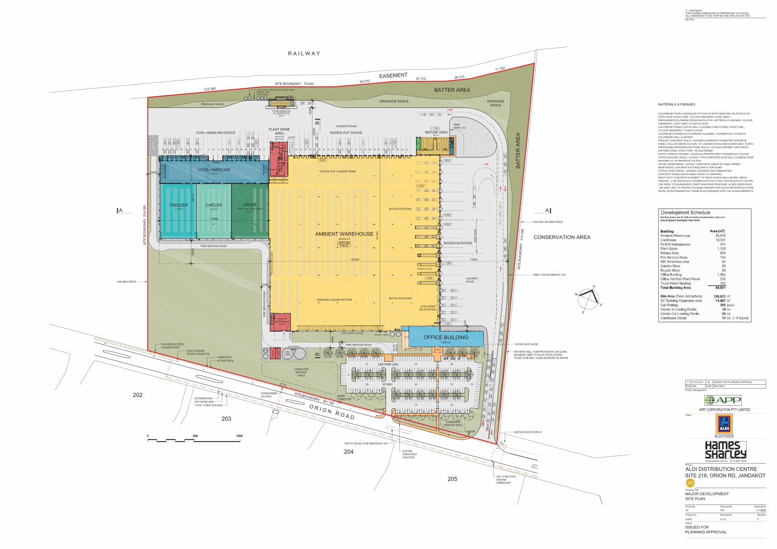
APPENDICES
URBIS DRAFT MAJOR DEVELOPMENT PLAN - JANDAKOT AIRPORT - DISTRIBUTION
CENTRE - 19MARCH2014
Appendix B Certificate of Title and Easement Documentation
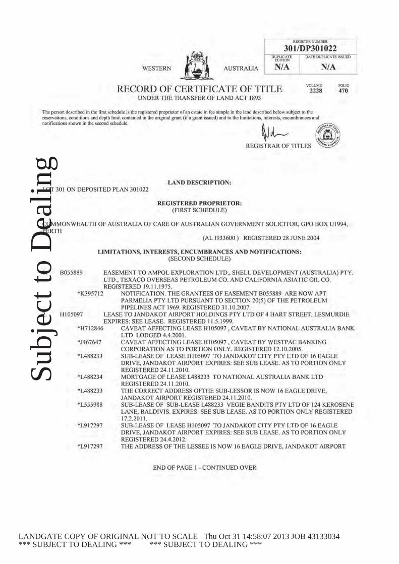
Subj
ect t
o D
ealin
g
LANDGATE COPY OF ORIGINAL NOT TO SCALE Thu Oct 31 14:58:07 2013 JOB 43133034*** SUBJECT TO DEALING *** *** SUBJECT TO DEALING ***

Subj
ect t
o D
ealin
g
LANDGATE COPY OF ORIGINAL NOT TO SCALE Thu Oct 31 14:58:07 2013 JOB 43133034*** SUBJECT TO DEALING *** *** SUBJECT TO DEALING ***
Subj
ect t
o D
ealin
g
LANDGATE COPY OF ORIGINAL NOT TO SCALE Thu Oct 31 14:58:07 2013 JOB 43133034*** SUBJECT TO DEALING *** *** SUBJECT TO DEALING ***
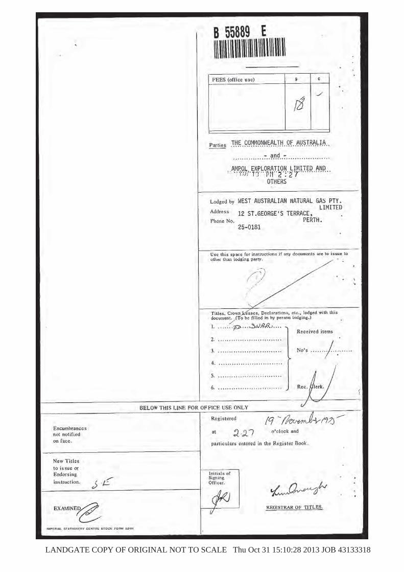
LANDGATE COPY OF ORIGINAL NOT TO SCALE Thu Oct 31 15:10:28 2013 JOB 43133318

LANDGATE COPY OF ORIGINAL NOT TO SCALE Thu Oct 31 15:10:28 2013 JOB 43133318
LANDGATE COPY OF ORIGINAL NOT TO SCALE Thu Oct 31 15:10:28 2013 JOB 43133318
LANDGATE COPY OF ORIGINAL NOT TO SCALE Thu Oct 31 15:10:28 2013 JOB 43133318
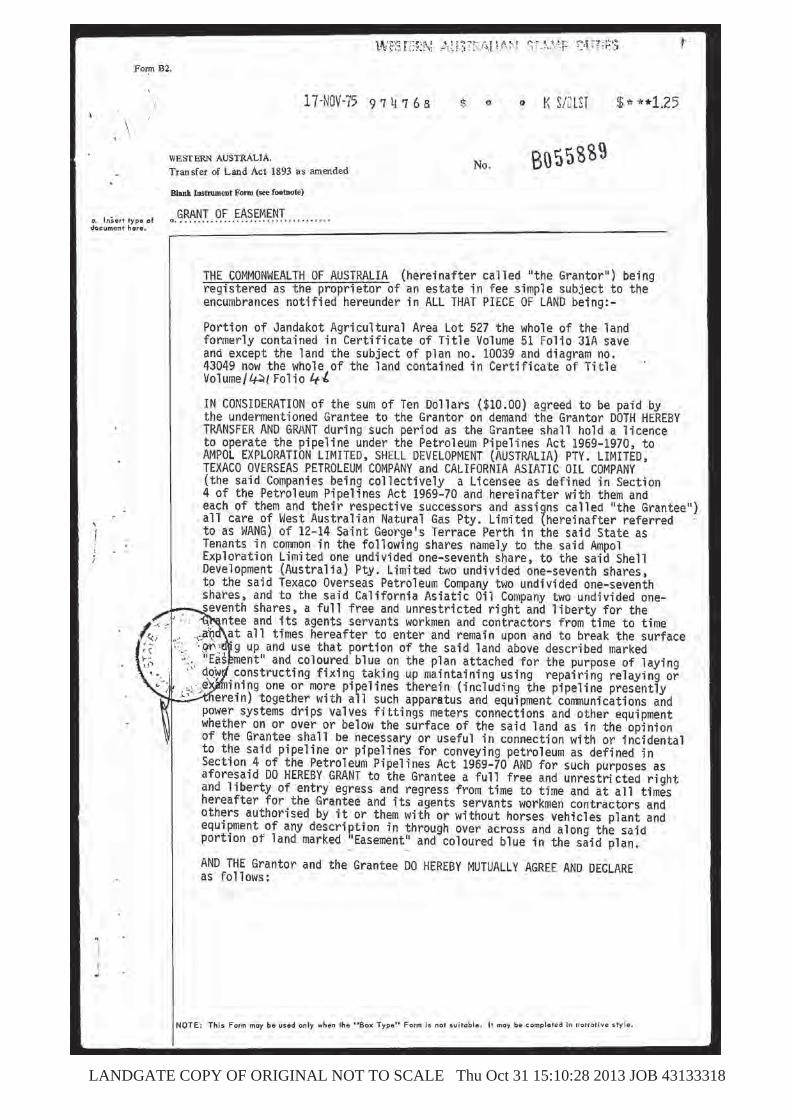
LANDGATE COPY OF ORIGINAL NOT TO SCALE Thu Oct 31 15:10:28 2013 JOB 43133318

LANDGATE COPY OF ORIGINAL NOT TO SCALE Thu Oct 31 15:10:28 2013 JOB 43133318
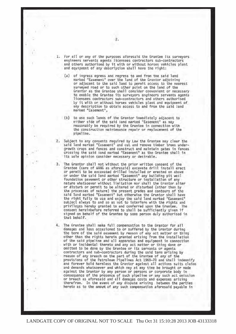
LANDGATE COPY OF ORIGINAL NOT TO SCALE Thu Oct 31 15:10:28 2013 JOB 43133318

LANDGATE COPY OF ORIGINAL NOT TO SCALE Thu Oct 31 15:10:28 2013 JOB 43133318
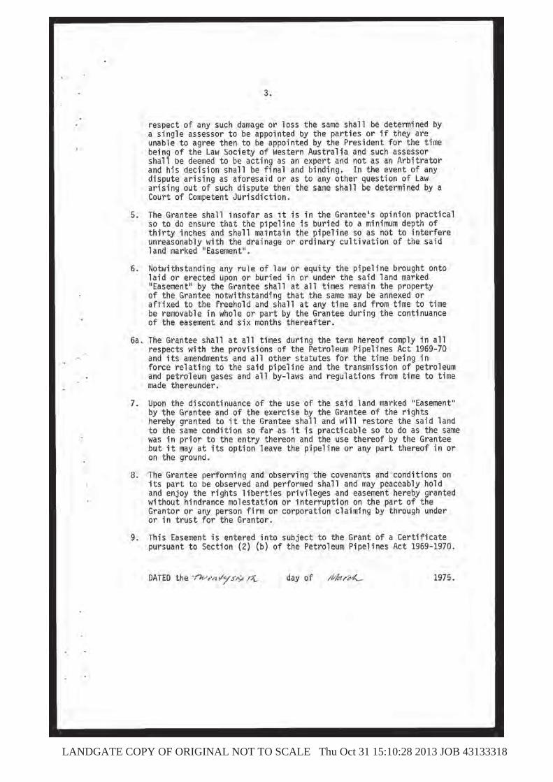
LANDGATE COPY OF ORIGINAL NOT TO SCALE Thu Oct 31 15:10:28 2013 JOB 43133318

LANDGATE COPY OF ORIGINAL NOT TO SCALE Thu Oct 31 15:10:28 2013 JOB 43133318
LANDGATE COPY OF ORIGINAL NOT TO SCALE Thu Oct 31 15:10:28 2013 JOB 43133318

LANDGATE COPY OF ORIGINAL NOT TO SCALE Thu Oct 31 15:10:28 2013 JOB 43133318
URBIS DRAFT MAJOR DEVELOPMENT PLAN - JANDAKOT AIRPORT - DISTRIBUTION CENTRE - 19MARCH2014 APPENDICES
Appendix C Transport Assessment
Proposed ALDI Distribution Centre,
Jandakot Airport
Transport Report for Major
Development Plan
PREPARED FOR: ALDI Foods Pty Ltd March 2014
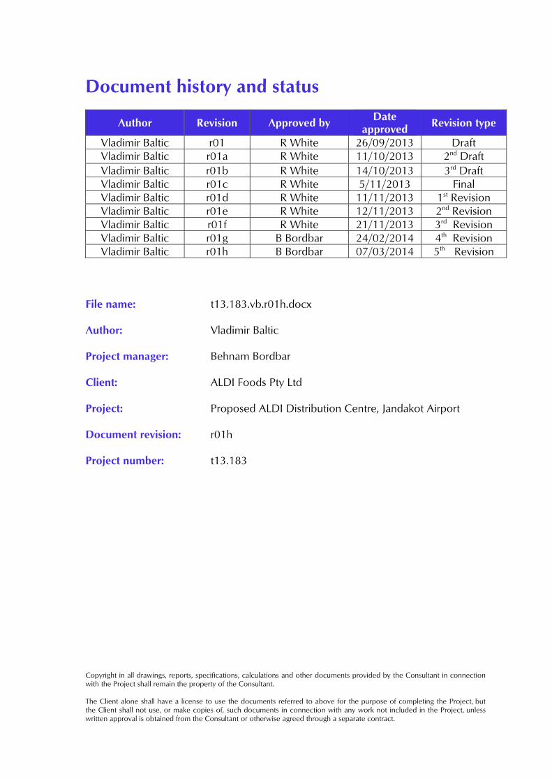
Document history and status
Author Revision Approved by Date
approved Revision type
Vladimir Baltic r01 R White 26/09/2013 DraftVladimir Baltic r01a R White 11/10/2013 2nd Draft
Vladimir Baltic r01b R White 14/10/2013 3rd DraftVladimir Baltic r01c R White 5/11/2013 FinalVladimir Baltic r01d R White 11/11/2013 1st RevisionVladimir Baltic r01e R White 12/11/2013 2nd RevisionVladimir Baltic r01f R White 21/11/2013 3rd RevisionVladimir Baltic r01g B Bordbar 24/02/2014 4th RevisionVladimir Baltic r01h B Bordbar 07/03/2014 5th Revision
File name: t13.183.vb.r01h.docx
Author: Vladimir Baltic
Project manager: Behnam Bordbar
Client: ALDI Foods Pty Ltd
Project: Proposed ALDI Distribution Centre, Jandakot Airport
Document revision: r01h
Project number: t13.183
Copyright in all drawings, reports, specifications, calculations and other documents provided by the Consultant in connection with the Project shall remain the property of the Consultant. The Client alone shall have a license to use the documents referred to above for the purpose of completing the Project, but the Client shall not use, or make copies of, such documents in connection with any work not included in the Project, unless written approval is obtained from the Consultant or otherwise agreed through a separate contract.
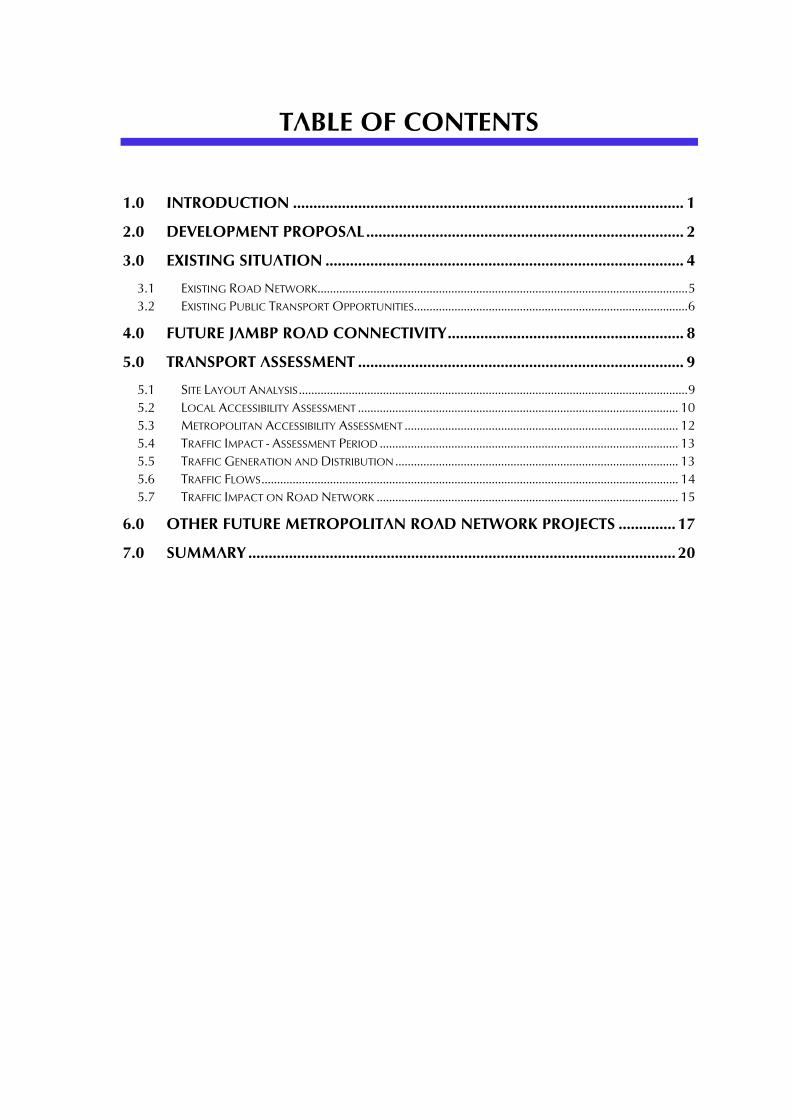
TABLE OF CONTENTS
1.0 INTRODUCTION ................................................................................................ 1
2.0 DEVELOPMENT PROPOSAL .............................................................................. 2
3.0 EXISTING SITUATION ........................................................................................ 4
3.1 EXISTING ROAD NETWORK....................................................................................................................... 5 3.2 EXISTING PUBLIC TRANSPORT OPPORTUNITIES........................................................................................ 6
4.0 FUTURE JAMBP ROAD CONNECTIVITY .......................................................... 8
5.0 TRANSPORT ASSESSMENT ................................................................................ 9
5.1 SITE LAYOUT ANALYSIS ............................................................................................................................. 9 5.2 LOCAL ACCESSIBILITY ASSESSMENT ....................................................................................................... 10 5.3 METROPOLITAN ACCESSIBILITY ASSESSMENT ........................................................................................ 12 5.4 TRAFFIC IMPACT - ASSESSMENT PERIOD ................................................................................................ 13 5.5 TRAFFIC GENERATION AND DISTRIBUTION ........................................................................................... 13 5.6 TRAFFIC FLOWS ...................................................................................................................................... 14 5.7 TRAFFIC IMPACT ON ROAD NETWORK ................................................................................................. 15
6.0 OTHER FUTURE METROPOLITAN ROAD NETWORK PROJECTS .............. 17
7.0 SUMMARY ......................................................................................................... 20
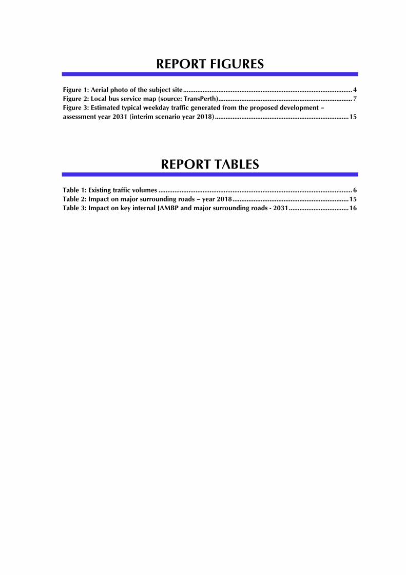
REPORT FIGURES
Figure 1: Aerial photo of the subject site ................................................................................................ 4 Figure 2: Local bus service map (source: TransPerth) ............................................................................ 7 Figure 3: Estimated typical weekday traffic generated from the proposed development –
assessment year 2031 (interim scenario year 2018) ............................................................................ 15
REPORT TABLES
Table 1: Existing traffic volumes .............................................................................................................. 6 Table 2: Impact on major surrounding roads – year 2018 .................................................................. 15 Table 3: Impact on key internal JAMBP and major surrounding roads - 2031 .................................. 16
t13.183.vb.r01h.docx Page 1
1.0 Introduction
This Transport Report has been prepared by Transcore on behalf of APP Corporation Pty Ltd with regard to the proposed ALDI Distribution Centre which is proposed to be located on site 218 Orion Road within Industrial Precinct 4 at Jandakot Airport.
t13.183.vb.r01h.docx Page 2
2.0 Development Proposal
The subject of this report is the proposed ALDI Distribution Centre (hereafter DC) which is intended to service all future ALDI retail stores throughout Western Australia. According to the information provided to Transcore ALDI intends to roll out between 60-70 retail outlets from Geraldton to Albany, with the majority being within the metropolitan area, within the next 10-year period. The proposed DC will handle the supply of goods to all outlets on a daily basis, typically two deliveries per outlet each day. The DC will operate 24 hours a day, 365 days a year at maximum operational level. A typical ALDI DC comprises the following key components:
A general goods warehouse with separate goods-in and goods-out loading docks;
A perishable goods warehouse (cooler and storage) with loading dock; Refuse facility; Temporary truck parking areas; On-site overnight truck parking area; Truck wash-down area; Refuelling station; Single storey corporate office building; and, Staff and visitor car park.
As with the other ALDI DC’s in NSW, QLD and VIC, goods are delivered from various suppliers to the DC each day, which occur at scheduled times predominantly from 6AM to 2PM. Shipments delivering goods to the retail outlets are dispatched during the day and evening. Typically, 26m B-doubles and 19m semi-trailers are used for all transport operations (both inbound and outbound) and as such the location of the DC and its accessibility by heavy vehicle routes plays a critical role in determining the optimum location for the future DC. Once fully operational, the proposed DC will employ up to about 200 staff with corporate offices forming an integral part of the DC site. Hence, a car park of approximately 250 bays for employees and visitors is planned to be accommodated within the site to meet the long term maximum parking needs. The architects for ALDI have presented Transcore with a preferred DC site layout (drawing No: A1.01 Rev P) prepared by Hames Sharley Architects which form the basis for this report. A copy of this plan is attached in Appendix A.
t13.183.vb.r01h.docx Page 3
The development proposal comprises a general goods warehouse and a perishable goods warehouse which are located centrally within the site. The office building and the associated employee/visitor car park are located at the southeast end of the site. The proposed DC site will include two separate vehicular access points on Orion Road. Both crossovers onto Orion Road are proposed to operate as full-movement crossovers. The eastern access, located at the far southeast end of the site, is intended for the exclusive use of freight vehicles (heavy vehicles) and would be controlled by the check point gate. It provides access to the goods receival and dispatch loading docks located along the eastern and northern sides of the two warehouse buildings, including the truck wash-down and refuelling areas. Provision has been made for six (6) trucks to be parked/waiting on the site between the street and the gatehouse to ensure there will be no requirement for parking in the street. The western access point, located approximately 100m west of the eastern access, provides direct access to the staff/visitor car park and as such is intended for passenger and small delivery vehicles only. The development proposal does not propose any modifications to the existing Jandakot Airport Mixed Business Precinct road network.
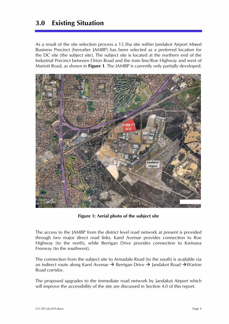
t13.183.vb.r01h.docx Page 4
3.0 Existing Situation
As a result of the site selection process a 13.5ha site within Jandakot Airport Mixed Business Precinct (hereafter JAMBP) has been selected as a preferred location for the DC site (the subject site). The subject site is located at the northern end of the Industrial Precinct between Orion Road and the train line/Roe Highway and west of Mariott Road, as shown in Figure 1. The JAMBP is currently only partially developed.
Figure 1: Aerial photo of the subject site The access to the JAMBP from the district level road network at present is provided through two major direct road links. Karel Avenue provides connection to Roe Highway (to the north), while Berrigan Drive provides connection to Kwinana Freeway (to the southwest). The connection from the subject site to Armadale Road (to the south) is available via an indirect route along Karel Avenue Berrigan Drive Jandakot Road Warton Road corridor. The proposed upgrades to the immediate road network by Jandakot Airport which will improve the accessibility of the site are discussed in Section 4.0 of this report.
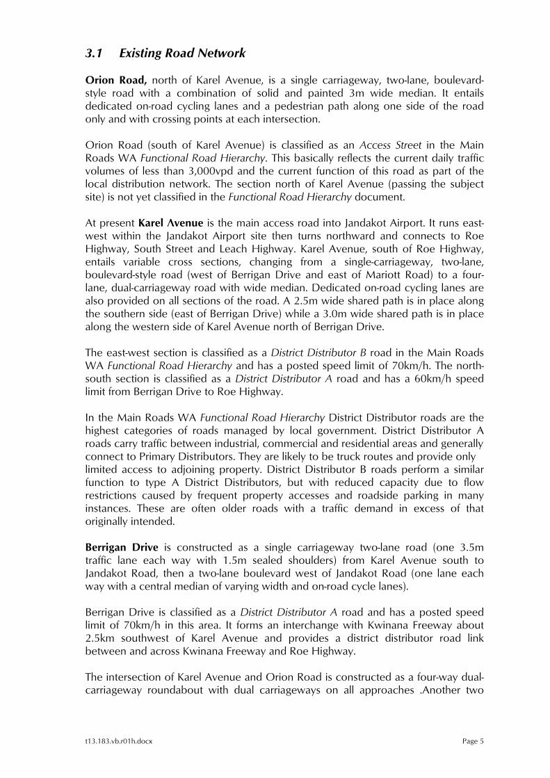
t13.183.vb.r01h.docx Page 5
3.1 Existing Road Network
Orion Road, north of Karel Avenue, is a single carriageway, two-lane, boulevard-style road with a combination of solid and painted 3m wide median. It entails dedicated on-road cycling lanes and a pedestrian path along one side of the road only and with crossing points at each intersection. Orion Road (south of Karel Avenue) is classified as an Access Street in the Main Roads WA Functional Road Hierarchy. This basically reflects the current daily traffic volumes of less than 3,000vpd and the current function of this road as part of the local distribution network. The section north of Karel Avenue (passing the subject site) is not yet classified in the Functional Road Hierarchy document. At present Karel Avenue is the main access road into Jandakot Airport. It runs east-west within the Jandakot Airport site then turns northward and connects to Roe Highway, South Street and Leach Highway. Karel Avenue, south of Roe Highway, entails variable cross sections, changing from a single-carriageway, two-lane, boulevard-style road (west of Berrigan Drive and east of Mariott Road) to a four-lane, dual-carriageway road with wide median. Dedicated on-road cycling lanes are also provided on all sections of the road. A 2.5m wide shared path is in place along the southern side (east of Berrigan Drive) while a 3.0m wide shared path is in place along the western side of Karel Avenue north of Berrigan Drive. The east-west section is classified as a District Distributor B road in the Main Roads WA Functional Road Hierarchy and has a posted speed limit of 70km/h. The north-south section is classified as a District Distributor A road and has a 60km/h speed limit from Berrigan Drive to Roe Highway. In the Main Roads WA Functional Road Hierarchy District Distributor roads are the highest categories of roads managed by local government. District Distributor A roads carry traffic between industrial, commercial and residential areas and generally connect to Primary Distributors. They are likely to be truck routes and provide only limited access to adjoining property. District Distributor B roads perform a similar function to type A District Distributors, but with reduced capacity due to flow restrictions caused by frequent property accesses and roadside parking in many instances. These are often older roads with a traffic demand in excess of that originally intended. Berrigan Drive is constructed as a single carriageway two-lane road (one 3.5m traffic lane each way with 1.5m sealed shoulders) from Karel Avenue south to Jandakot Road, then a two-lane boulevard west of Jandakot Road (one lane each way with a central median of varying width and on-road cycle lanes). Berrigan Drive is classified as a District Distributor A road and has a posted speed limit of 70km/h in this area. It forms an interchange with Kwinana Freeway about 2.5km southwest of Karel Avenue and provides a district distributor road link between and across Kwinana Freeway and Roe Highway. The intersection of Karel Avenue and Orion Road is constructed as a four-way dual-carriageway roundabout with dual carriageways on all approaches .Another two

t13.183.vb.r01h.docx Page 6
single-lane roundabouts are in place west (Orion Road bend) and east (Orion Road/Marriott Road intersection) of the subject site. A turn path analysis was undertaken for these two roundabouts to confirm their geometry is suitable to accommodate the design vehicle of 27.5m B-double. This design vehicle has been used to ensure a robust assessment. The heavy vehicle accessibility of the site is discussed in more detail in section 5.0 of this report. Existing weekday traffic counts on Karel Avenue, Berrigan Drive and Jandakot Road have been obtained from the City of Cockburn and are summarised in Table 1.
Table 1: Existing traffic volumes
Road Location Average weekday traffic Date Karel Ave E of Berrigan Dr 9,840 vpd Sep 2012Karel Ave W of Berrigan Dr 17,820 vpd Aug 2012
Berrigan Dr S of Karel Ave 13,680 vpd Aug 2012Berrigan Dr N of Jandakot Rd 12,130 vpd May 2011Berrigan Dr W of Jandakot Rd 15,740 vpd Oct 2012Jandakot Rd E of Berrigan Dr 9,210 vpd May 2011
3.2 Existing Public Transport Opportunities
There are limited public transport services available at the subject locality at present. The nearest bus stops (bus route 515 operating between Murdoch Station and Berrigan Drive/Turnbury Park Drive) are located on Berrigan Drive, approximately 420m south of Karel Avenue. However, route 515 deviates down Karel Avenue to Compass Road/Eagle Drive several times a day with the closest bus stop located on Karel Avenue approximately 250m east of Marriott Road. The local bus service map is illustrated in Figure 21. It should be noted that Figure 2 does not show the extension of route 515. Once fully developed JAMBP will become a major employment node at this locality. As such, it is possible that the increased demand for public transport service within JAIP may prompt the Public Transport Authority (PTA) to consider providing a service in the form of a dedicated bus route or through modification/extension of the existing routes operating in the vicinity. According to the information provided by PTA the Jandakot Airport authorities would have to approach PTA with the request for provision of public transport service; however, several requisites would have to be met before such service becomes viable. According to the PTA, some of the conditions include the following:
1 The route No. 515 deviation to Compass Road/Eagle Drive is not shown in the bus service map
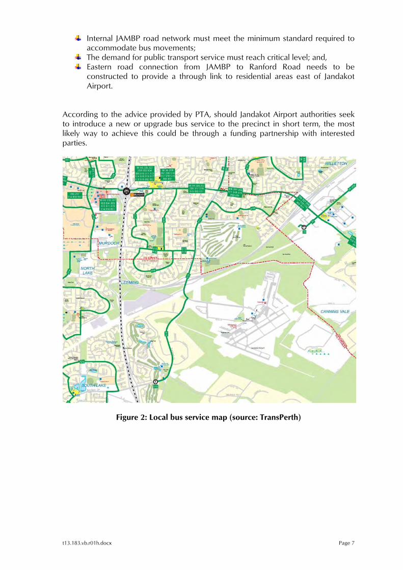
t13.183.vb.r01h.docx Page 7
Internal JAMBP road network must meet the minimum standard required to accommodate bus movements;
The demand for public transport service must reach critical level; and, Eastern road connection from JAMBP to Ranford Road needs to be
constructed to provide a through link to residential areas east of Jandakot Airport.
According to the advice provided by PTA, should Jandakot Airport authorities seek to introduce a new or upgrade bus service to the precinct in short term, the most likely way to achieve this could be through a funding partnership with interested parties.
Figure 2: Local bus service map (source: TransPerth)
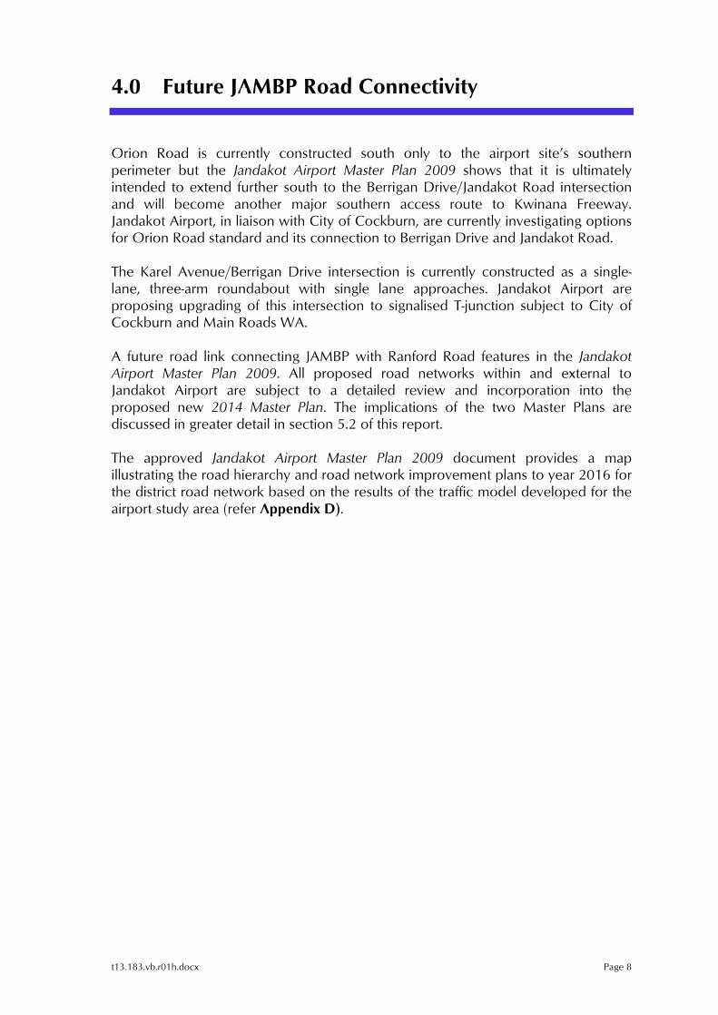
t13.183.vb.r01h.docx Page 8
4.0 Future JAMBP Road Connectivity
Orion Road is currently constructed south only to the airport site’s southern perimeter but the Jandakot Airport Master Plan 2009 shows that it is ultimately intended to extend further south to the Berrigan Drive/Jandakot Road intersection and will become another major southern access route to Kwinana Freeway. Jandakot Airport, in liaison with City of Cockburn, are currently investigating options for Orion Road standard and its connection to Berrigan Drive and Jandakot Road. The Karel Avenue/Berrigan Drive intersection is currently constructed as a single-lane, three-arm roundabout with single lane approaches. Jandakot Airport are proposing upgrading of this intersection to signalised T-junction subject to City of Cockburn and Main Roads WA. A future road link connecting JAMBP with Ranford Road features in the Jandakot Airport Master Plan 2009. All proposed road networks within and external to Jandakot Airport are subject to a detailed review and incorporation into the proposed new 2014 Master Plan. The implications of the two Master Plans are discussed in greater detail in section 5.2 of this report. The approved Jandakot Airport Master Plan 2009 document provides a map illustrating the road hierarchy and road network improvement plans to year 2016 for the district road network based on the results of the traffic model developed for the airport study area (refer Appendix D).
t13.183.vb.r01h.docx Page 9
5.0 Transport Assessment
5.1 Site Layout Analysis
The internal site layout facilitates separation of the freight traffic and loading/unloading operations from the employee and visitor traffic) thus securing a safe operational environment within the site. The vast manoeuvring areas within the site ensure simultaneous and safe movements including loading/unloading and parking operations for a number of delivery and distribution vehicles. The internal access ways and circulation system of the site also enables uninhibited inbound and outbound traffic operations (receival and dispatch of goods) over a 24-hour period. According to the advice provided by ALDI, due to goods receival schedule and providers’ time-slot allocation, the maximum recorded queuing of trucks at the entry gate at existing eastern states ALDI DC’s very rarely exceeds three to four trucks. Therefore, the proposed site design ensures sufficient stacking distance for heavy vehicles between entry check-point (control gate) and Orion Road crossover. The proposed queuing capacity of up to six B-double trucks would ensure minimal potential for disruption of Orion Road traffic operations. In the unlikely event of queue back onto Orion Road the contingency plan is to ‘wave on’ any excess trucks to continue to circulate along the Orion Road/Marriott Road/Karel Avenue route, until the site access is cleared. At this location the terrain is flat and Orion Road entails straight horizontal geometry. Accordingly, the proposed employee/visitor car park access which is located mid-block between the two roundabouts has no sightline issues. The same is true for the heavy vehicle access. The turn path analysis undertaken for the eastern Orion Road crossover (freight traffic access point) confirmed the suitability of the proposed design to accommodate the inbound and outbound movements of freight vehicles. The adopted design vehicle for this particular task was the 27.5m long B-double truck. It should be noted that the proposed DC site plan shows a solid median island on Orion Road being located immediately across the proposed car park crossover. This would effectively restrict the crossover operation to left-in/left-out only. Hence, it is recommended that the existing median island be removed or relocated to a new location so that full-movement access and egress standard of the crossover is ensured. The proposed 250 bay car park would be served well by a single access crossover. Due to anticipated traffic flow through the car park crossover no additional turn facilities on Orion Road are deemed necessary. The proponent acknowledges that the provision of 250 bay car park at the site is less than the requirements stipulated in the relevant parking policies for the
t13.183.vb.r01h.docx Page 10
proposed type of the development. However, it should be noted that the proposed parking provision is based on the parking demand derived from actual data sourced from similar ALDI DCs located in QLD, VIC and NSW, where ALDI has been operating for more than a decade. Accordingly, the proposed 250 bay car park is designed to meet the anticipated parking demand of the DC.
5.2 Local Accessibility Assessment
From the operational standpoint the proposed DC entails ease of access and egress to and from the site including a legible road network that provides for intuitive and efficient movement of semi-trailers and B-doubles. A review of the Main Roads WA Restricted Access Vehicle (RAV) network classification table2 indicates that semi-trailers of up to 20m in length and B-doubles of up to 27.5m in length are classified as largest permitted Network 2 heavy vehicle combinations. More details on prime mover and trailer combinations are provided in the relevant RAV table attached in Appendix E. According to ALDI, 19m semi-trailers and 26m B-doubles will be the largest vehicles moving freight to and from the site. Hence, the abovementioned RAV Network 2 map will provide permitted access routes for these trucks within the Perth metropolitan region and surrounding area. The on-line RAV Mapping Tool available on the Main Roads WA web site provides state-wide coverage maps for all RAV 1-10 Network classes. However, considering that all freight will be transported by 19m semi-trailers and 26m B-doubles the focus of the investigation is limited to permitted roads forming part of Network 2. A review of the RAV Network 2 map in the vicinity of Jandakot Airport Industrial Precinct suggests that all major perimeter roads (access routes to the precinct) are classified as Network 2 with no conditions imposed. These roads include: Berrigan Drive, Jandakot Road and Solomon Drive. Karel Avenue, section from Roe Highway off ramp eastbound to 0.14km west of Orion Road intersection, entails the following network condition: “A current written approval from the Local Government, permitting use of this road, must be carried and produced on demand”. This condition only applies to vehicles larger than 19.0m semi-trailers. Reference to the MRWA Permit Network 2 Road Table Addendum (as at 10 September 2013) indicates that Karel Avenue (section from Mariott Road to just west of Orion Road) also entails the condition “All operators must carry written approval from the LG authority permitting use of the road” (refer RAV map extract presented in Appendix F). This condition only applies to vehicles larger than 19.0m semi-trailers.
2 Source: Main Roads WA Heavy Vehicle Operations Section
t13.183.vb.r01h.docx Page 11
As a result, ALDI will need to apply for the relevant permit with local government for all vehicles larger than 19.0m semi-trailer. However, JAH has initiated procedures to reclassify this section of road to align with the surrounding network. None of the internal JAMBP roads are mapped in the on-line RAV Mapping Tool. This is because Jandakot Airport is under Federal Government jurisdiction. As such, ALDI does not require permission to operate their relevant freight vehicles within JAMBP precinct. The existing road network within the precinct is of high standard, planned and constructed to service a significant industrial/commercial precinct that relies on freight traffic moving goods to and from the precinct. According to the advice provided to Transcore by Jandakot Airport, the internal JAMBP precinct road system has been designed and constructed to accommodate 27.5m B-double vehicles. Nevertheless, the sections of the existing industrial precinct road network forming part of the anticipated access/egress route to and from the subject site were assessed for the movement of the design vehicle (27.5m B-double truck3) to confirm the suitability of relevant internal precinct roads and intersections. The assessment was undertaken using aerial maps and offers a good indication of the suitability of the road infrastructure geometry to accommodate turn movements by the design vehicle. The assessment undertaken by Transcore has confirmed that a typical B-double vehicle of maximum 27.5m length can traverse along the relevant sections of the Karel Avenue/Orion Road/Marriott Road access/egress route, thus satisfying ALDI’s requirements. The relevant turn path plans illustrating the movement of the design vehicle are shown in Appendix B. As part of the review of the 2009 Master Plan Transcore has developed a strategic EMME transport model for the airport precinct for year 2031 (refer Appendix C). Accordingly, it is forecasted that Orion Road (in the vicinity of the subject site) would carry approximately 4,7004 vehicles per day (vpd) for the projected year 2031. As such, it is anticipated that provision of any additional turning facilities at either heavy vehicle or car park crossovers would not be warranted. The proposed road hierarchy and road network improvement plans to year 2016 for the district road network, sourced from the 2009 Jandakot Airport Master Plan document, are presented in Appendix D. It should be noted however that all the road network improvements and their associated timeframes are currently under review for inclusion in the revised 2014 Master Plan.
3 Main Roads WA Restricted Access Vehicle (RAV) Network 2maximum length vehicle combination 4 Traffic volume for Orion Road derived from the latest version of EMME transport model developed by Transcore for the 2014 Master Plan
t13.183.vb.r01h.docx Page 12
5.3 Metropolitan Accessibility Assessment
The RAV Network 2 road system generally provides good metropolitan coverage enabling a multitude of access routes to the subject site from major regional directions. Refer RAV map series attached in Appendix F for illustration purposes. Some of the major access corridors to the JAMBP are listed as follows:
Mitchell Freeway Kwinana Freeway Roe Highway Karel Avenue Orion Road;
Wanneroo Road Morley Drive Tonkin Highway Roe Highway Karel Avenue Orion Road;
Brand Highway Great Northern Highway Roe Highway Karel Avenue Orion Road;
Great Northern Highway Roe Highway Karel Avenue Orion Road;
Toodyay Road Roe Highway Karel Avenue Orion Road;
Great Eastern Highway Roe Highway Karel Avenue Orion Road;
Brookton Highway Albany Highway5 (between Brookton Highway and Armadale Road) Armadale Road Warton Road Jandakot Road Berrigan Drive Karel Avenue Orion Road;
Albany Highway (east of Armadale Road) Armadale Road Warton Road Jandakot Road Berrigan Drive Karel Avenue Orion Road;
South Western Highway Armadale Road Warton Road Jandakot Road Berrigan Drive Karel Avenue Orion Road;
South Western Highway Thomas Road Tonkin Highway Armadale Road Warton Road Jandakot Road Berrigan Drive Karel Avenue Orion Road;
Forrest Highway Kwinana Freeway Berrigan Drive Karel Road Orion Road;
The listed routes are for inbound site access trip sequence. The return trips are performed in reverse order.
5 Condition: “Not to be used as through route unless accessing Brookton Highway or as Condition CV17 (Not to be used as through route. For local delivery and pick up only Driver must carry documentation as proof of local delivery or pick up.

t13.183.vb.r01h.docx Page 13
5.4 Traffic Impact - Assessment Period
The traffic volumes expected to be generated by the proposed Distribution Centre have been estimated using the actual logistics and warehouse operation data sourced from an existing ALDI operation in Derrimut region in VIC. The Derrimut region operation is slightly smaller in size than the maximum operating levels of the WA operation and accordingly the derived data was up scaled to approximate the anticipated scope of the proposed Distribution Centre. The assessment year for the proposed development should involve full construction and activation of the DC centre as well as completion of ALDI store network within WA. The completion of the DC is anticipated in 2016 with another 8 years anticipated for construction and activation of all planned WA outlets. Hence, the full-size operation is likely to be achieved in 2024. As previously discussed, Transcore has developed a strategic EMME transport model for the airport precinct (year 2031) which includes full development of the JAMBP. It is therefore considered prudent to set the DC assessment year in 2031 as it involves ultimate road network set up with associated traffic flows. In order to assess a mid-term impact which would feature full DC construction and partially-developed ALDI stores network an interim scenario has also been developed and tested. This scenario would likely simulate the ALDI operation in year 2018 with an assumed scale of operation at about 25% level of full development and operational scenario.
5.5 Traffic Generation and Distribution
The traffic that will be generated by the proposed development would comprise three components: Freight traffic (i.e. heavy vehicle traffic) – entails the activities associated with stock replenishment and distribution of goods to stores across WA. The three major supply centres that would be sourced are located in Canning Vale, Kewdale and Hazelmere; however, the products will also be sourced from various other locations within and outside the metro area. It is anticipated that ALDI’s WA fleet would likely be in order of 30 trucks consisting of B-doubles, 19m semi-trailers and smaller articulated trucks. Employee traffic (light vehicles) – represent the arrival and departure of employees to and from the site. It is anticipated that a maximum of 200 employees would be using private cars to commute to and from the DC at any given time. By the time the DC is fully constructed and operational and with full maturation of the JAMBP it is likely that more public transport services would become available enabling employees to opt for this service. Car-pooling is another likely alternative to individual car trips that could reduce overall employee traffic volume with high provision of quality end of trip facilities. However, in order to undertake a robust assessment no discount to employee trip generation has applied.
t13.183.vb.r01h.docx Page 14
Visitor traffic (light vehicles) – represent traffic generated by the visitors to the site. In this particular case it has been assumed that this component would represent no more than 10% of total employee traffic. It is anticipated that this type of traffic would be limited to passenger/light vehicles. Hence, it is estimated that the proposed DC would generate approximately 594 daily trips (both inbound and outbound) during a typical weekday in the 2031 assessment year. This trip generation includes 152 freight trips, with the remainder being light vehicles associated with employee and visitor traffic. With respect to the interim scenario (year 2018) it is estimated that approximately 147 total daily trips (both inbound and outbound) would be would be generated, inclusive of 36 freight trips, by the proposed development. With respect to the distribution of traffic to and from the proposed development it is anticipated that directional traffic would be split as follows for the assessment year 2031:
25% of all traffic to/from Kwinana Freeway south/Berrigan Drive/Orion Road direction;
27% of all traffic to/from Kwinana Freeway north/Karel Avenue direction; 12% of all traffic to/from Karel Avenue north direction; 18% of all traffic to/from future East Link direction; and, 18% of all traffic from Roe Highway east/Karel Avenue direction.
With directional split of development-generated traffic for interim scenario (year 2018) estimated as follows:
33% of all traffic to/from Kwinana Freeway south/Berrigan Drive/Orion Road direction;
20% of all traffic to/from Kwinana Freeway north/Karel Avenue direction; 12% of all traffic to/from Karel Avenue north direction; and, 35% of all traffic from Roe Highway east/Karel Avenue direction.
5.6 Traffic Flows
The anticipated new traffic movements generated by the proposed DC have been assigned on the road network within and adjacent to JAMBP. The resulting traffic movements generated by this development during typical weekday in 2031 assessment year as well as 2018 interim scenario (shown in brackets) are shown in Figure 3.
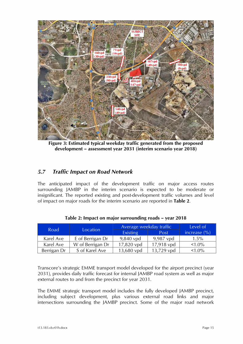
t13.183.vb.r01h.docx Page 15
Figure 3: Estimated typical weekday traffic generated from the proposed
development – assessment year 2031 (interim scenario year 2018)
5.7 Traffic Impact on Road Network
The anticipated impact of the development traffic on major access routes surrounding JAMBP in the interim scenario is expected to be moderate or insignificant. The reported existing and post-development traffic volumes and level of impact on major roads for the interim scenario are reported in Table 2.
Table 2: Impact on major surrounding roads – year 2018
Road Location Average weekday traffic Level of
increase (%) Existing PostKarel Ave E of Berrigan Dr 9,840 vpd 9,987 vpd 1.5%Karel Ave W of Berrigan Dr 17,820 vpd 17,918 vpd <1.0%
Berrigan Dr S of Karel Ave 13,680 vpd 13,729 vpd <1.0%
Transcore’s strategic EMME transport model developed for the airport precinct (year 2031), provides daily traffic forecast for internal JAMBP road system as well as major external routes to and from the precinct for year 2031. The EMME strategic transport model includes the fully developed JAMBP precinct, including subject development, plus various external road links and major intersections surrounding the JAMBP precinct. Some of the major road network
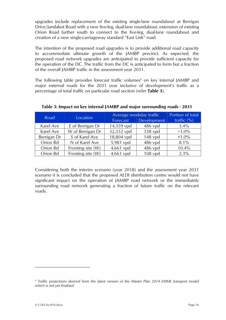
t13.183.vb.r01h.docx Page 16
upgrades include replacement of the existing single-lane roundabout at Berrigan Drive/Jandakot Road with a new five-leg, dual-lane roundabout, extension of existing Orion Road further south to connect to the five-leg, dual-lane roundabout and creation of a new single-carriageway standard “East Link” road. The intention of the proposed road upgrades is to provide additional road capacity to accommodate ultimate growth of the JAMBP precinct. As expected, the proposed road network upgrades are anticipated to provide sufficient capacity for the operation of the DC. The traffic from the DC is anticipated to form but a fraction of the overall JAMBP traffic in the assessment year 2031. The following table provides forecast traffic volumes6 on key internal JAMBP and major external roads for the 2031 year inclusive of development’s traffic as a percentage of total traffic on particular road section (refer Table 3).
Table 3: Impact on key internal JAMBP and major surrounding roads - 2031
Road Location Average weekday traffic Portion of total
traffic (%) Forecast Development Karel Ave E of Berrigan Dr 14,359 vpd 486 vpd 3.4%Karel Ave W of Berrigan Dr 32,332 vpd 338 vpd ~1.0%
Berrigan Dr S of Karel Ave 18,804 vpd 148 vpd <1.0%Orion Rd N of Karel Ave 5,981 vpd 486 vpd 8.1%Orion Rd Fronting site (W) 4,661 vpd 486 vpd 10.4%Orion Rd Fronting site (W) 4,661 vpd 108 vpd 2.3%
Considering both the interim scenario (year 2018) and the assessment year 2031 scenario it is concluded that the proposed ALDI distribution centre would not have significant impact on the operation of JAMBP road network or the immediately surrounding road network generating a fraction of future traffic on the relevant roads.
6 Traffic projections derived from the latest version of the Master Plan 2014 EMME transport model which is not yet finalised
t13.183.vb.r01h.docx Page 17
6.0 Other Future Metropolitan Road Network Projects
The Metropolitan Region Scheme, Peel Region Scheme and Greater Bunbury Region Scheme provide a blueprint for the planned future road network in these regions (refer Appendix G). These region scheme maps include regional road reservations for Primary Regional Roads (Red Roads, which are under the care and control of Main Roads WA) and Other Regional Roads (Blue Roads, which are Crown roads but under local government responsibilities). These plans show the current statutory planning for the long-term road network in these areas. Most but not all of the regional roads reserved in these region schemes have already been built, although many of these regional road reservations identify land requirements for future road upgrades that may be implemented in the longer term. The Main Roads WA web site provides a list of major urban and regional road network upgrade projects currently under construction or planned in the future. Some of these projects may be relevant for the operation of the proposed DC with respect to transport routes and efficiency in the future. The relevant projects including brief description, as presented on the Main Roads WA site, are discussed below. Gateway WA – Perth Airport and Freight Access This significant project involves a major upgrade to the road network surrounding Perth Airport and the freight and industrial hubs of Kewdale and Forrestfield. It focuses primarily on Tonkin Highway, between Great Eastern Highway and Roe Highway, and Leach Highway, between Orrong Road and Perth Airport. The project is currently under construction (refer Appendix H for preliminary concept plan). The scope of this project includes:
A major freeway-to-freeway interchange at Tonkin Highway/Leach Highway, including a new primary access road to the consolidated airport terminal;
A new interchange at Tonkin Highway/Horrie Miller Drive/Kewdale Road;
A new interchange at Leach Highway/Abernethy Road;
Upgrading Leach Highway between Orrong Road and Tonkin Highway to an expressway standard and associated upgrades to local roads and intersections in the Kewdale area;
A principal shared path along Tonkin Highway and Leach Highway;
t13.183.vb.r01h.docx Page 18
Upgrading of the existing Tonkin Highway-Roe Highway interchange to a partial freeway to freeway interchange;
Upgrading Tonkin Highway between Great Eastern Highway and Roe Highway to six lanes; and,
A new interchange at Boud Avenue (subject to further funding negotiations).
Perth to Darwin National Highway The State Government has allocated funding to progress the planning and route investigation of the Perth to Darwin National Highway (PDNH) between Reid Highway and Muchea (refer Appendix I for concept plan). Main Roads WA has completed a strategic road network review and identified the likely PDNH alignments between Reid Highway and Maralla Road. The future PDNH will alleviate traffic pressure on the existing Great Northern Highway and attract freight traffic away from Great Northern Highway to reduce conflict between long-distance large freight vehicles and local and tourism traffic in the Swan Valley and town sites of Bullsbrook and Upper Swan. To achieve this, the PDNH must provide effective access to industrial areas within the Perth metropolitan area. The existing Great Northern Highway will continue to be used by freight vehicles but the volumes will reduce significantly once the future PDNH is constructed. Funding has not been allocated for construction yet. Tonkin Highway Extension Traffic issues have become an emerging concern for the community in the south-eastern corridor of Western Australia, namely the area of Byford within the Shire of Serpentine-Jarrahdale. New opportunities to extend Tonkin Highway south of Thomas Road are being examined to alleviate congestion, reduce travel times and meet the needs of the community. The extension of Tonkin Highway will meet the demands of growth and access in the south-eastern corridor, addressing the rapid urban growth expected to be experienced in the next 10 to 20 years. Roe Highway Extension The Government of Western Australia is committed to the extension of Roe Highway from Kwinana Freeway in Jandakot to Stock Road in Coolbellup. The extension will start at the existing Kwinana Freeway/Roe Highway interchange in Jandakot and head west along or near the existing Metropolitan Region Scheme

t13.183.vb.r01h.docx Page 19
road reserve for approximately 5 km, ending at Stock Road in the vicinity of its current intersection with Forrest Road, Coolbellup. It is anticipated that approvals and clearances required for construction to commence will be obtained by late 2013. However, timing for construction is dependent on funding. A preferred concept design has been developed through a comprehensive community and stakeholder engagement process (refer Appendix J for preferred concept plan). Roe Highway Extension is proposed to be a significant east-west link in the south-west metropolitan transport network, servicing a forecast demand of between 45,000 and 75,000 vehicles per day in 2031 – vehicles that would otherwise be using existing local roads. The extension aims to meet the following objectives:
Complete the key strategic link in Perth’s road network which connects Reid Highway, Great Northern Highway and Great Eastern Highway in the Midland area to Tonkin Highway, Kwinana Freeway and Stock Road;
Improve the efficiency and ease traffic on parallel east-west roads such as South Street and Leach Highway, and also on Kwinana Freeway between Roe and Leach Highways;
Improve safety and reduce traffic congestion within the regional road network;
Provide better access for residents and road users in the cities of Cockburn and Melville to Kwinana Freeway, Bibra Drive, North Lake Road and Stock Road;
Improve access to the Murdoch Activity Centre, including the future Fiona Stanley Hospital;
Provide improved access to the Fremantle Inner Harbour;
Form part of the key freight route to the proposed Outer Harbour and the expanding Kwinana industrial area; and,
Remove trucks from residential areas along Leach Highway between Stock Road and Kwinana Freeway, which will improve safety, reduce noise and improve the general amenity in this area.
t13.183.vb.r01h.docx Page 20
7.0 Summary
Based on the investigation carried out in relation to the ALDI Distribution Centre proposed to be located at site 218 Orion Road within the Jandakot Airport Mixed Business Precinct, it is concluded that:
The subject site enjoys multiple access route choice from major regional
directions via RAV Network 2 road network coverage sufficient to accommodate ALDI’s freight vehicles;
The site accessibility will be improved through proposed additional road network extensions and upgrades including the construction of the East Link road connection to Ranford Road and the South Link road connection to Jandakot Road and Berrigan Drive;
Even though the JAMBP road network is not formally classified as RAV Network 2 by Main Roads, the Industrial Precinct road network has been designed to accommodate RAV Network 2-compliant design vehicles, which is suitable for ALDI’s freight vehicles movement;
The turn path analysis confirmed the suitability of the proposed car park and heavy vehicle access/egress system including internal site driveways for operation of RAV Network 2 class vehicles, which correspond to ALDI’s standard freight vehicle;
The subject site presently suffers from limited public transport coverage; however, there is potential to improve this situation in the long term through increased demand for service or in the short term through funding partnership arrangements with stakeholders; and,
The estimated traffic from the proposed ALDI Distribution Centre can be accommodated by the existing and future surrounding road network.
t13.183.vb.r01h.docx Page 21
Appendix A
PROPOSED ALDI DISTRIBUTION CENTRE SITE PLAN
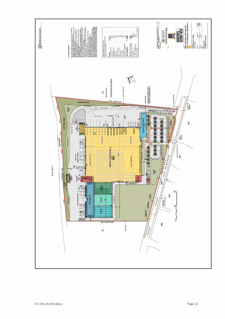
t13.183.vb.r01h.docx Page 22
t13.183.vb.r01h.docx Page 23
Appendix B
TURN PATH PLANS FOR 27.5m B-DOUBLE TRUCKS

t13.183.vb.r01h.docx Page 24

t13.183.vb.r01h.docx Page 25
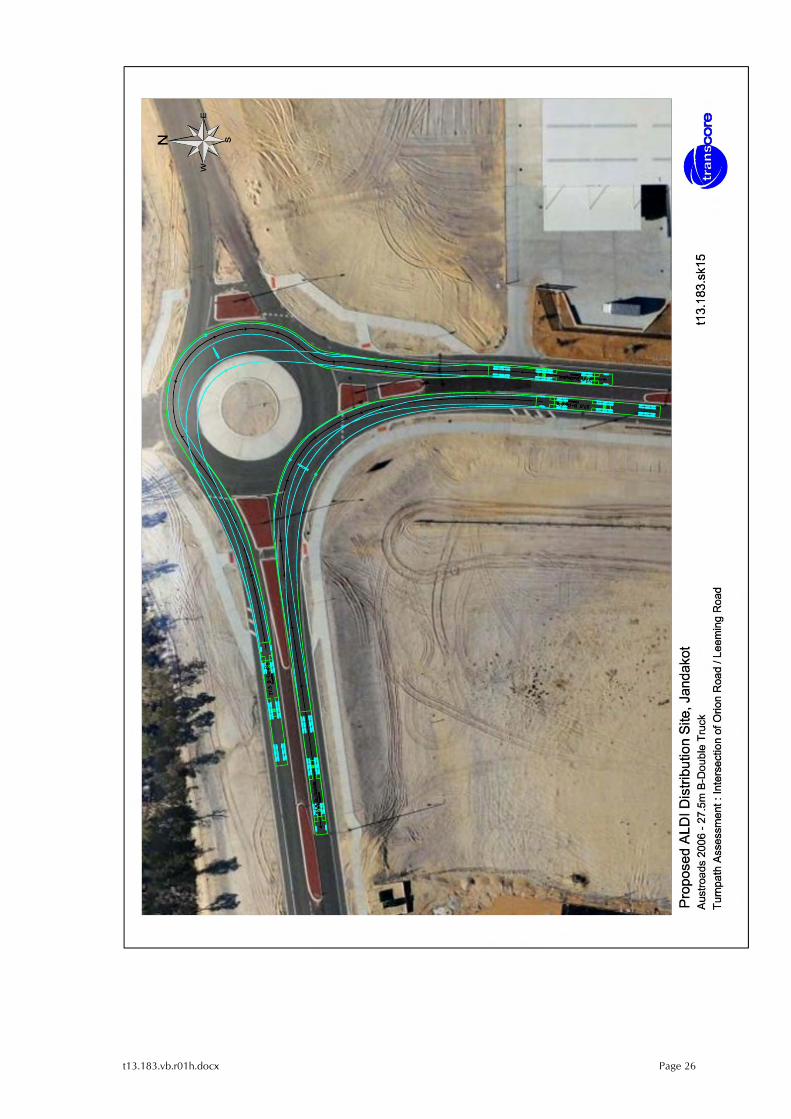
t13.183.vb.r01h.docx Page 26
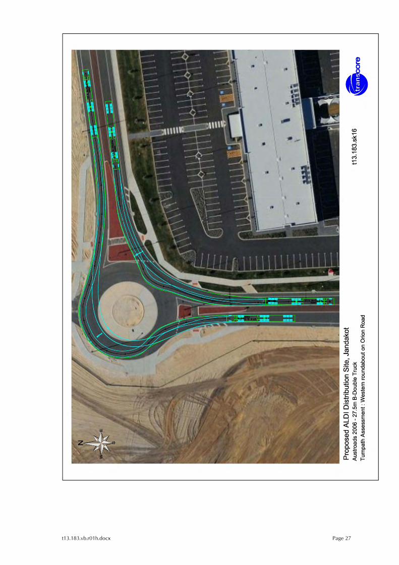
t13.183.vb.r01h.docx Page 27
t13.183.vb.r01h.docx Page 28
Appendix C
JANDAKOT AIRPORT 2009 MASTER PLAN
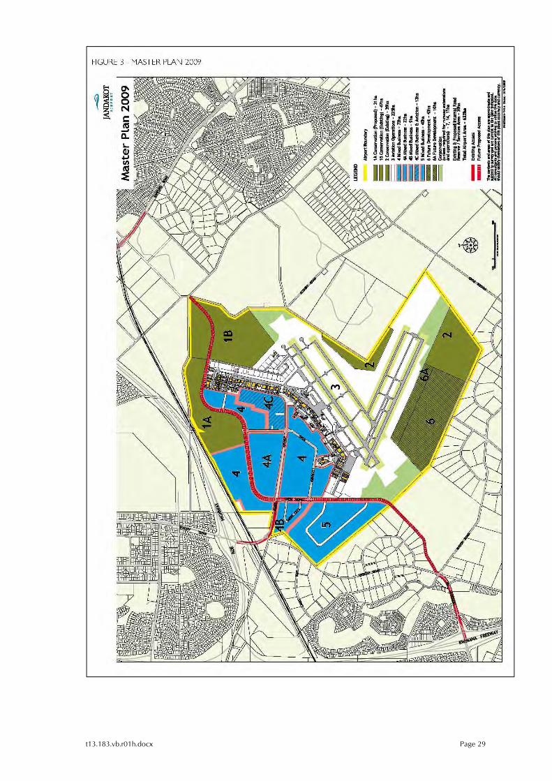
t13.183.vb.r01h.docx Page 29
t13.183.vb.r01h.docx Page 30
Appendix D
JANDAKOT AIRPORT 2009 MASTER PLAN
ROAD HIERARCHY & ROAD UPGRADES TO YEAR 2016

t13.183.vb.r01h.docx Page 31
t13.183.vb.r01h.docx Page 32
t13.183.vb.r01h.docx Page 33
Appendix E
RESTRICTED ACCESS VEHICLE CLASSIFICATION TABLE PRIME MOVER & TRAILER COMBINATIONS
t13.183.vb.r01h.docx Page 34
t13.183.vb.r01h.docx Page 35
t13.183.vb.r01h.docx Page 36
Appendix F
RESTRICTED ACCESS VEHICLE MAP EXTRACTS
t13.183.vb.r01h.docx Page 37
t13.183.vb.r01h.docx Page 38
t13.183.vb.r01h.docx Page 39
t13.183.vb.r01h.docx Page 40
t13.183.vb.r01h.docx Page 41
Appendix G
PERTH METROPOLITAN REGION, PEEL REGION &
GREATER BUNBURY REGION SCHEMES
t13.183.vb.r01h.docx Page 42
t13.183.vb.r01h.docx Page 43
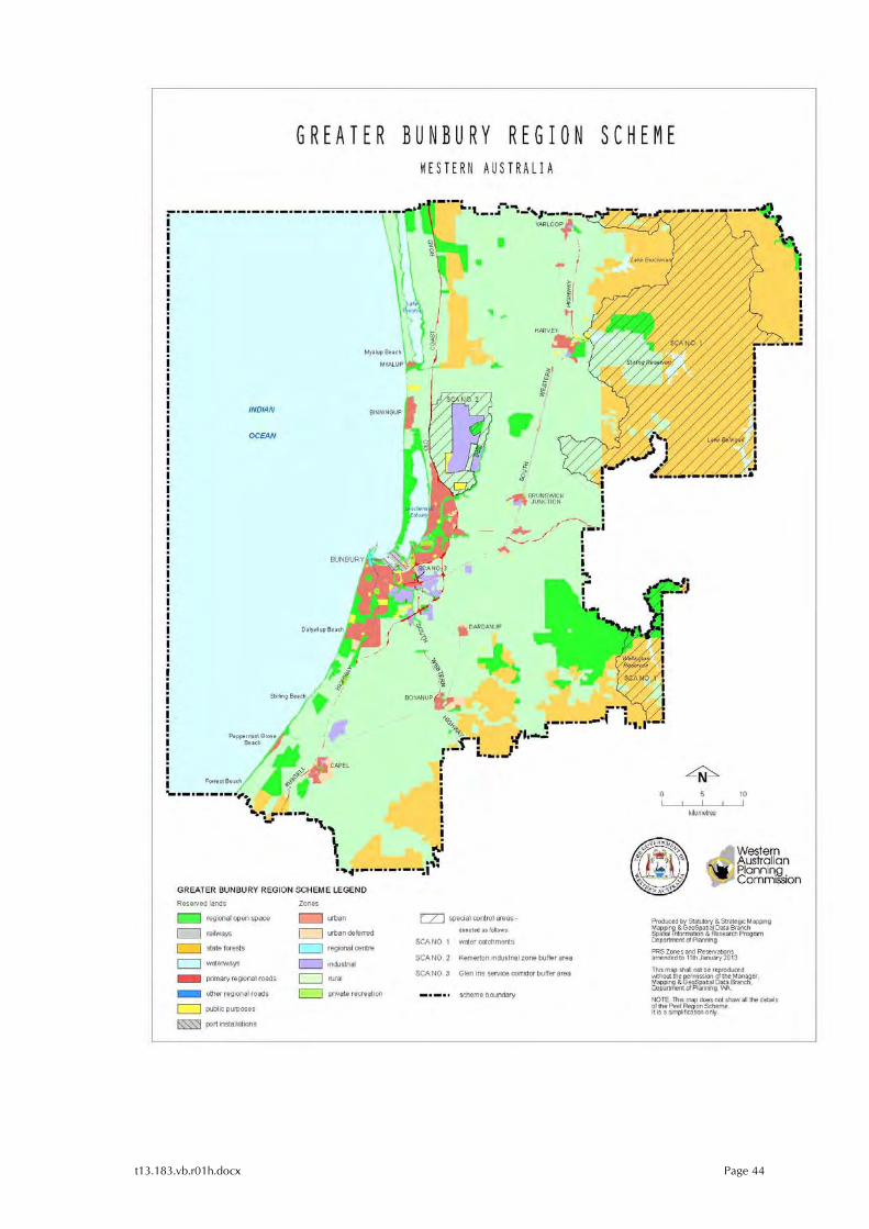
t13.183.vb.r01h.docx Page 44
t13.183.vb.r01h.docx Page 45
Appendix H
GATEWAY WA PROJECT
CONCEPT PLAN (PRELIMINARY)
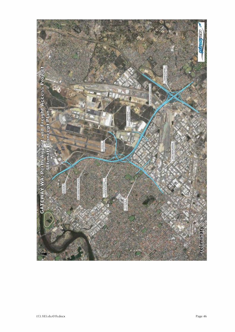
t13.183.vb.r01h.docx Page 46
t13.183.vb.r01h.docx Page 47
Appendix I
PERTH TO DARWIN NATIONAL HIGHWAY PROJECT
CONCEPT PLAN
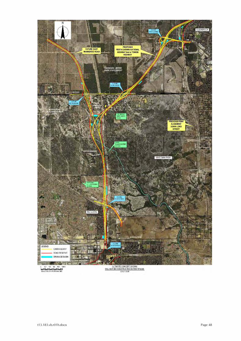
t13.183.vb.r01h.docx Page 48
t13.183.vb.r01h.docx Page 49
Appendix J
ROE HIGHWAY EXTENSION PROJECT
CONCEPT PLAN (PREFERRED)
t13.183.vb.r01h.docx Page 50

APPENDICES
URBIS DRAFT MAJOR DEVELOPMENT PLAN - JANDAKOT AIRPORT - DISTRIBUTION
CENTRE - 19MARCH2014
Appendix D Vehicle Manoeuvring Diagram
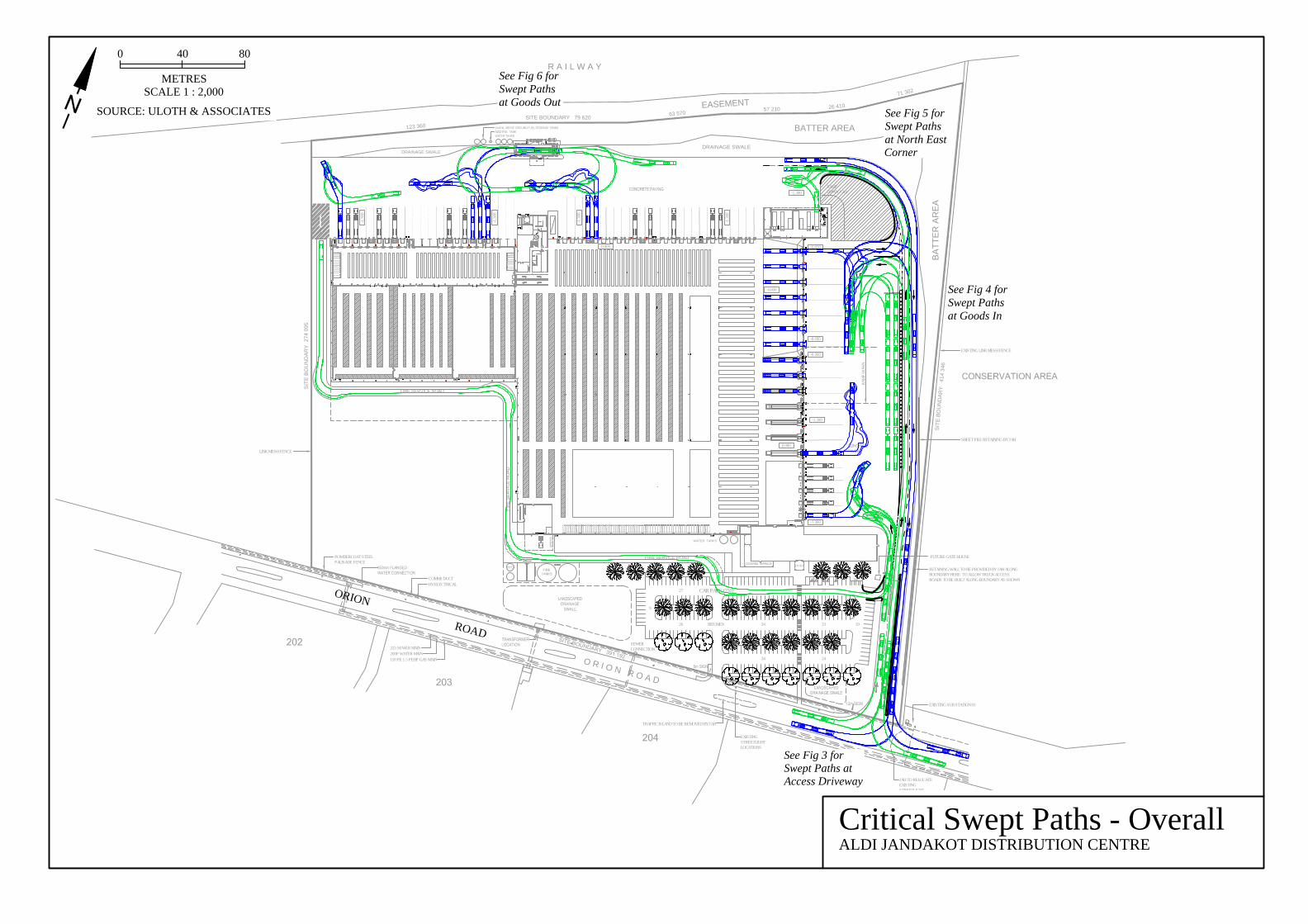
CAR PARK (250)
2434
2334
2034
EA
SE
ME
NT
O
R
I O
N
R
O
A
D
BATTER AREA
R A I L W A Y
123 3
60
SIT
E B
OU
ND
AR
Y 274 095
SIT
E B
OU
ND
AR
Y 414 346
63 5
70
SITE BOUNDARY 79 620
26 4
10
57 210
7
1
3
0
2
TRAFFIC ISLAND TO BE REMOVED BY JAH
RETAINING WALL TO BE PROVIDED BY JAH ALONGBOUNDARY HERE TO ALLOW TRUCK ACCESSROADS TO BE BUILT ALONG BOUNDARY AS SHOWN
FUTURE GATE HOUSE
RAMP
DOW
N
-1.300
-1.30
0
0.000
0.000
0.000
DRAINAGE SWALE
DRAINAGE SWALE
DRAINAGE
SWALE
EXISTING SUB STATION 03
SEWERCONNECTION
HV ELECTRICALCOMMS DUCT
110 PE 1.5 PEHP GAS MAIN200P WATER MAIN225 SEWER MAIN
LINK MESH FENCE
POWDERCOAT STEELPALISADE FENCE
EXISTING LINK MESH FENCE
-1.30
0
-1.30
0
-1.30
0
26
EXISTINGSTREETLIGHTLOCATIONS
JAH TO RELOCATEEXISTINGSTREETLIGHT
BITUMEN 19
27
9
-0.050
-1.300RAMPDOWN 1.3m
WATER TANKS
BA
TT
ER
A
RE
A
SHEET PILE RETAINING BY JAH
Critical Swept Paths - OverallALDI JANDAKOT DISTRIBUTION CENTRE
0 40 80
METRESSCALE 1 : 2,000
SOURCE: ULOTH & ASSOCIATES
See Fig 3 forSwept Paths atAccess Driveway
See Fig 4 forSwept Pathsat Goods In
See Fig 5 forSwept Pathsat North EastCorner
See Fig 6 forSwept Pathsat Goods Out
ORION
ROAD

URBIS DRAFT MAJOR DEVELOPMENT PLAN - JANDAKOT AIRPORT - DISTRIBUTION CENTRE - 19MARCH2014 APPENDICES

APPENDICES
URBIS DRAFT MAJOR DEVELOPMENT PLAN - JANDAKOT AIRPORT - DISTRIBUTION
CENTRE - 19MARCH2014

ALDI DISTRIBUTION CENTREPreliminary Draft Major Development Plan
Site 218 Orion Road - Jandakot AirportMarch 2014